


Abstract
Wildfires are increasingly recognized as environmental disturbances associated with socio-economic transformations in agrarian systems. This study examines the associations between reported wildfire exposure, land-market outcomes, and agrarian inequality in the Malakand Division of northern Pakistan, a region characterized by forest–agriculture interfaces and livelihood dependence on land. The study aims to analyze how different levels of wildfire exposure are associated with land values, ownership patterns, market transactions, inequality, and coping strategies among farming households. A quantitative cross-sectional design was employed using a sample of 400 households selected through multistage sampling. Data were collected through structured questionnaires and analyzed using ANOVA, chi-square tests, multiple and logistic regression, hierarchical regression, and principal component analysis. Results show that reported land values differed significantly across wildfire-exposure categories (F = 48.72, p < 0.001), with directly exposed households reporting the lowest values. Regression analysis identified direct wildfire exposure as the strongest negative statistical predictor of reported land value (β = −0.468, p < 0.001), while directly exposed households had substantially higher odds of reporting land sales (Exp(B) = 6.35). Chi-square results indicate a significant association between wildfire exposure and land transactions (χ2 = 64.82, p < 0.001). Retrospectively reported landholding data show an increase in the Gini coefficient from 0.41 before the reported fire period to 0.53 afterward. The addition of land-transaction variables increased the explained variance in agrarian inequality to 72%, which is consistent with a potential land-market pathway but does not constitute evidence of causal mediation. Coping strategies such as land sale, migration, and borrowing emerged as dominant reported responses among affected households. The study concludes that wildfire exposure is strongly associated with land devaluation, land sales, and greater agrarian inequality. Because the study is cross-sectional and lacks an independently observed pre-fire baseline or causal identification strategy, these findings should not be interpreted as definitive causal effects.
1. Introduction
Wildfires have emerged as one of the most pressing environmental and socio-economic challenges of the 21st century, with far-reaching implications for ecosystems, livelihoods, and market structures [1,2]. Globally, the frequency, intensity, and spatial extent of wildfires have increased significantly over the past decades, largely driven by climate change, land-use transformations, and human interventions [3,4]. According to the Intergovernmental Panel on Climate Change, rising temperatures and prolonged drought conditions have intensified fire regimes across continents, including North America, Australia, Southern Europe, and parts of Africa [5,6,7]. Empirical studies indicate that wildfire activity has doubled in some regions since the 1980s, with substantial economic losses and long-term environmental degradation [8,9]. For instance, Wang, Guan [9] research demonstrates that wildfire-induced vegetation loss alters land productivity and disrupts rural economies, particularly in agrarian societies.
Beyond ecological damage, recent global scholarship has increasingly highlighted the intersection between wildfires and land markets [10]. Wildfires can trigger land devaluation, forced sales, and speculative acquisition, thereby reshaping patterns of land ownership. Studies in regions such as California and Australia show that post-fire landscapes often experience a surge in land transactions, where wealthier actors capitalize on distressed land sales, exacerbating rural inequality [11,12,13]. This phenomenon aligns with broader theories of disaster capitalism, where environmental shocks create opportunities for capital accumulation by advantaged groups [14,15]. Consequently, wildfires are no longer viewed solely as environmental hazards but as socio-economic disruptors that deepen structural inequalities in agrarian settings [16].
In the Asian context, wildfire dynamics are closely intertwined with rapid land-use change, population pressure, and weak regulatory frameworks [17]. Countries such as Indonesia, India, and China have witnessed recurrent fire events linked to deforestation, agricultural expansion, and slash-and-burn practices [18,19,20]. Empirical evidence from Southeast Asia shows that forest fires significantly reduce agricultural productivity while simultaneously increasing land consolidation among commercial actors [21,22,23,24]. Research published in Global Environmental Change indicates that fire-affected regions often undergo shifts in land tenure arrangements, with smallholders losing access to productive land [25,26]. Moreover, haze and smoke from transboundary fires have been associated with adverse health outcomes and labor productivity losses, further marginalizing vulnerable populations [27,28]. In South and East Asia, where agrarian economies remain central to livelihoods, the socio-economic consequences of wildfires extend beyond immediate damage to include long-term transformations in land relations and rural inequality [29,30,31,32].
Within South Asia, the implications of wildfires are particularly pronounced due to the region’s dependence on agriculture and its socio-economic vulnerabilities [33]. Countries like India and Nepal have reported increasing incidences of forest fires, especially in mountainous and semi-arid regions [34,35]. Empirical studies suggest that wildfire exposure reduces crop yields, disrupts local markets, and accelerates rural distress migration [36,37]. In India, research has shown that fire-prone districts experience higher levels of land fragmentation followed by gradual consolidation, often disadvantaging marginal farmers [38]. Similarly, in Nepal, wildfire events have been linked to declining forest-based livelihoods and increased inequality in access to natural resources [39]. These findings underscore the complex relationship between environmental shocks and agrarian structures in South Asia, where institutional capacities to manage disasters and regulate land markets remain limited.
In Pakistan, wildfires have gained increasing attention in recent years, particularly in the northern and northwestern regions characterized by forested landscapes and agrarian communities [40,41]. The provinces of Khyber Pakhtunkhwa and Gilgit-Baltistan have experienced recurrent forest fires, often attributed to climatic variability, human negligence, and land-use conflicts. Empirical evidence from national forestry reports and studies by the Pakistan Forest Institute highlights significant losses in forest cover and biodiversity due to fire incidents [42,43]. However, beyond ecological impacts, emerging research suggests that wildfires also influence rural livelihoods by reducing agricultural productivity, damaging irrigation systems, and altering land values [44,45]. In many cases, affected farmers are compelled to sell their land at lower prices, creating opportunities for land accumulation by local elites or external investors. Despite these observations, systematic empirical research linking wildfires to land market dynamics and agrarian inequality in Pakistan remains scarce [46,47,48].
The issue becomes particularly critical in the districts of Malakand Division, including Swat Valley, Lower Dir, and Buner District. These regions are characterized by a combination of forest resources, subsistence agriculture, and socio-economic vulnerability. In recent years, these districts have witnessed multiple wildfire incidents, resulting in the destruction of forest cover, agricultural land, and local infrastructure. Preliminary evidence from regional reports and media sources indicates that wildfire-affected households often experience income shocks, leading to distress land sales and shifts in land ownership patterns [49]. At the same time, local power structures and unequal access to resources may enable more affluent actors to acquire land at reduced prices, thereby intensifying agrarian inequality. Despite the growing frequency of such events, there is limited empirical research examining how wildfires interact with land markets and social stratification in these specific contexts.
A critical gap in the existing literature lies in the lack of integrated analysis that connects wildfire exposure with land market transformations and agrarian inequality, particularly in developing country contexts like Pakistan. While global and regional studies have explored environmental and economic impacts of wildfires, few have explicitly examined how these events reshape land ownership patterns and exacerbate social inequalities at the micro level. Moreover, existing research in Pakistan has largely focused on ecological and forestry aspects, neglecting the socio-economic dimensions of wildfire impacts. This study addresses this gap by adopting an interdisciplinary approach that combines insights from sociology, economics, and environmental studies to analyze the relationship between wildfires, land markets, and agrarian inequality in Malakand Division.
The novelty of this study lies in its focus on post-wildfire land dynamics and their implications for social inequality in a previously under-researched region. Through examining how wildfire-induced shocks influence land transactions, ownership patterns, and livelihood strategies, the study contributes to a deeper understanding of disaster-driven inequality. Furthermore, it provides empirical evidence that can inform policy interventions aimed at promoting equitable land governance and enhancing resilience among vulnerable agrarian communities.
The motivation for this research stems from the increasing frequency of wildfires in northern Pakistan and their visible yet understudied socio-economic consequences. Understanding these dynamics is crucial for designing effective policies that address not only environmental sustainability but also social justice and rural development. The significance of the study extends to policymakers, development practitioners, and scholars interested in disaster risk reduction, land governance, and agrarian change.
Objectives of the Study
- To examine the association between reported wildfire exposure, land values, and land-market dynamics in Malakand Division.
- To analyze the relationship between wildfire exposure and patterns of land ownership and transfer.
- To assess whether wildfire-related land-market indicators, including reported land-value decline, land sales, and land accumulation, are associated with agrarian inequality.
- To explore the socio-economic coping strategies of affected farming households.
2. Materials and Methods
2.1. Study Paradigm and Design
This study is grounded in the positivist paradigm, which assumes that social reality is objective, measurable, and can be analyzed through empirical observation and statistical techniques [50]. The selection of positivism is particularly appropriate for this research because the core variables wildfire exposure, land market dynamics, and agrarian inequality can be quantified and examined through observable indicators such as land prices, ownership patterns, and income disparities. The study seeks to examine statistical associations between wildfire exposure and socio-economic outcomes. Because the research uses a cross-sectional design, the observed relationships are interpreted as associations rather than definitive causal effects. Although the explanatory design and multivariate analyses help identify patterns consistent with the proposed conceptual framework, temporal ordering and causality cannot be conclusively established [51]. Moreover, given the policy-oriented nature of the research, a positivist approach allows for the generation of statistically robust findings that can inform evidence-based decision-making.
In line with this paradigm, the study adopts a quantitative research approach and employs a cross-sectional explanatory research design. The explanatory design is appropriate because the study goes beyond describing wildfire-related differences and examines how wildfire exposure is statistically associated with land-market outcomes and agrarian inequality. However, the cross-sectional nature of the data requires caution in interpreting these associations as causal effects [52]. A cross-sectional design is justified due to time and resource constraints, allowing data to be collected from a large number of respondents at a single point in time while capturing variations across wildfire-affected and non-affected households [53]. This design also facilitates comparative analysis across different districts [54].
The study is observational and does not employ random assignment, longitudinal follow-up, difference-in-differences estimation, instrumental variables, matching, or another quasi-experimental identification strategy. Consequently, the non-exposed households constitute a descriptive comparison group rather than a formally constructed causal counterfactual. Exposed and non-exposed households may have differed before the reported wildfire events in ways that also influenced subsequent land-market outcomes. Potential differences include land quality, slope and elevation, remoteness, road and market access, irrigation availability, tenure security, previous land values, and local political or social power. Because these factors were not all measured and included in the statistical models, residual confounding cannot be excluded. Moreover, the reported pre-fire landholding information was collected retrospectively during the cross-sectional survey and does not constitute an independently observed baseline. The study therefore estimates statistical associations and group differences rather than causal effects.
2.2. Study Setting, Population, and Target Population
The study is situated in the Malakand Division of Khyber Pakhtunkhwa, with a specific focus on Swat Valley, Lower Dir, and Buner District, which have been purposively selected due to their ecological and socio-economic relevance to wildfire dynamics. These areas lie within forest-agriculture interface zones where human settlements, croplands, and forest resources overlap, making them highly susceptible to wildfire incidents. Empirical evidence from the Pakistan Forest Institute and provincial disaster management reports indicates a rising trend in forest fire occurrences in these districts over the past decade, driven by climatic variability, land-use pressures, and anthropogenic activities [55,56,57]. At the same time, these regions are predominantly agrarian, with livelihoods heavily dependent on land, which makes them particularly vulnerable to environmental shocks that can disrupt both production and land-based wealth [58]. Such characteristics make Malakand Division an analytically appropriate setting for examining how wildfires interact with land markets and contribute to agrarian inequality.
In this study, the term “forest” refers to the natural and semi-natural woodland, scrub-forest, and forest–agriculture interface vegetation occurring in Swat, Lower Dir, and Buner rather than to uniformly dense, closed-canopy forest. In many sampled locations, these forested landscapes are relatively open and heterogeneous, consisting of tree cover interspersed with shrubs, grazing areas, cultivated plots, and rural settlements. These areas are used not only for ecological functions but also for fuel-wood collection, fodder extraction, and seasonal livestock grazing, which makes them highly relevant to agrarian livelihoods and wildfire risk. To improve ecological clarity, a verified list of the dominant tree and woody plant species recorded in the study area has been provided in the Supplementary Table S1, together with representative field photographs of the sampled forest sites the Supplementary Figure S1.
To situate the local study area within internationally available wildfire information, the Global Wildfire Information System (GWIS) was consulted as a contextual source [59] The national GWIS record for Pakistan includes fires occurring across different land-cover types, including agricultural and crop-burning areas; therefore, all satellite-detected fires should not be interpreted as forest wildfires. GWIS also notes that mapped fires may include fires intentionally set for vegetation management.
The present study has a narrower geographical and ecological scope. It examines reported fires affecting woodland, scrub forest, and forest–agriculture interface landscapes in Swat, Lower Dir, and Buner, rather than routine crop-residue burning across Pakistan’s agricultural plains. Figure 1 identifies the three northern study districts and the 24 sampled communities, allowing the location of the study area to be distinguished from the broader national distribution of agricultural and other vegetation fires represented in GWIS. GWIS was used to provide wider spatial context and was not used as the household-level exposure measure.
Figure 1.
Location of the Study Districts and Sampled Communities in Malakand Division, Khyber Pakhtunkhwa, Pakistan. Administrative boundaries are based on the Pakistan Bureau of Statistics (PBS, 2023), while the locations of sampled communities are based on the authors’ survey data (2024).
Routine crop-residue or field-clearing fires were not classified as relevant wildfire exposure solely because burning occurred on cultivated land. Such an event was included only when respondents reported that it extended into, originated from, or materially affected woodland, scrub forest, or the forest–agriculture interface and met the predefined criteria for direct physical damage or indirect livelihood disruption. GWIS detections were not used to assign households to exposure categories because satellite fire locations alone do not establish fire type, household-level damage, or livelihood effects].
Figure 1 presents the geographical location of the study area at three spatial levels: Pakistan, Khyber Pakhtunkhwa Province, and the selected districts within Malakand Division. The main map identifies Swat, Lower Dir, and Buner and shows the locations of the 24 sampled villages, comprising 10 villages in Swat, 8 in Lower Dir, and 6 in Buner. The mapped village locations correspond to the communities included in the multistage sampling procedure. The figure therefore clarifies the spatial distribution of the study sites across the forest–agriculture interface areas of northern Pakistan.
The broader population for this study comprises all farming households residing in wildfire-prone areas of these districts. According to estimates derived from the Pakistan Bureau of Statistics and provincial agricultural records, the total number of farming households in the selected regions is approximately 520,000, including about 220,000 in Swat Valley, 180,000 in Lower Dir, and 120,000 in Buner District [60,61,62,63]. These figures are consistent with district-level agricultural census trends reported in national statistical publications and reflect the dominance of smallholder farming systems in the region. This population is particularly relevant because farming households are directly dependent on land as both a productive asset and a source of socio-economic security; thus, any disruption caused by wildfires is likely to have immediate and long-term implications for land ownership patterns and market participation.
From this broader population, the study defines a more specific target population comprising farming households that have been directly affected by wildfires within the last five years, those engaged in land transactions (such as buying, selling, or leasing land), and households across different landholding categories (small, medium, and large farmers). Based on regional disaster assessments and forestry reports, it is estimated that approximately 30% of farming households around 156,000 have experienced direct or indirect impacts of wildfire events in recent years. This estimate is supported by situational analyses conducted by provincial disaster management authorities and forestry departments, which document the spatial spread and socio-economic impacts of fire incidents in Malakand Division.
2.3. Socio-Economic and Demographic Characteristics of Participants
Table 1 presents the socio-economic and demographic profile of the 400 respondents and illustrates how each background variable is analytically linked to the study of wildfires, land markets, and agrarian inequality. Age distribution reflects variations in labor capacity and decision-making authority, where middle-aged and older farmers are more likely to control land transactions and respond strategically to wildfire shocks. Education levels influence awareness, access to information, and the ability to navigate land markets, making it a critical factor in understanding differential coping strategies. Landholding size serves as the central variable for assessing agrarian inequality, as disparities between small, medium, and large landholders determine vulnerability to land loss or opportunities for land accumulation after wildfire events. Income level indicates the economic resilience of households, where lower-income groups are more prone to distress land sales, thereby linking directly to inequality dynamics. Occupational categories highlight the degree of dependence on agriculture, with full-time farmers being more exposed to wildfire impacts compared to those with diversified income sources. Wildfire exposure functions as the key independent variable, differentiating households based on the severity of impact, which subsequently affects their economic behavior and land-related decisions. Finally, land transaction status captures the outcome variable of interest, providing direct evidence of how wildfire shocks translate into changes in land ownership patterns [64] (see Table 1).
Table 1.
Socioeconomic and Demographic Profile of Participants.
2.4. Sampling Technique and Sample Size
The study employs a multistage sampling technique to ensure both analytical rigor and representativeness in examining the relationship between wildfires, land markets, and agrarian inequality. In the first stage, districts within Malakand Division, namely Swat Valley, Lower Dir, and Buner District, were purposively selected due to their documented incidence of wildfires and their predominantly agrarian economic structures, which make them particularly relevant to the study objectives.
In the second stage, a district-wise list of villages located within wildfire-prone forest–agriculture interface areas was used as the village-level sampling frame. From this frame, 24 villages-10 in Swat, 8 in Lower Dir, and 6 in Buner-were selected through simple random sampling and are geographically presented in Figure 1. The number of villages selected from each district reflected its relative farming population and spatial exposure to wildfire risk. Random selection at the village level reduced the possibility of selecting only highly accessible or severely affected communities.
In the third stage, eligible farming households within each selected village were classified according to landholding size: small farmers owning or operating less than 5 acres, medium farmers owning or operating 5–12 acres, and large farmers owning or operating more than 12 acres. Households were then selected randomly within these landholding strata in proportion to their representation in the selected villages. This procedure ensured the inclusion of households with different levels of land-based economic resources and enabled meaningful comparison of their vulnerability and responses to wildfire shocks.
One respondent was interviewed from each selected household. The respondent was the household head or another adult household member who was directly involved in farming and sufficiently knowledgeable about the household’s land ownership, land transactions, agricultural production, livelihood conditions, and experience of wildfire events. Only one questionnaire was completed per household to avoid duplication of household-level information.
To improve transparency and reproducibility, the survey flow was documented across the initial and replacement stages. A total of 432 eligible farming households were contacted in the selected villages. Of these, 18 households declined to participate, mainly because of time constraints or unwillingness to disclose sensitive financial and land-related information. The remaining 414 households completed the questionnaire, corresponding to a participation response rate of 95.8%. During quality screening, 14 completed questionnaires were excluded because they contained substantial missing information, internally inconsistent responses, or failed the data-verification checks. The resulting final analytical sample comprised 400 usable household questionnaires, representing 92.6% of all eligible households contacted.
Replacement sampling was applied whenever an initially selected household refused participation or submitted a questionnaire that was subsequently judged unusable. Replacement households were selected randomly from the same village and landholding stratum as the original household. This procedure continued until the required final sample of 400 complete and usable observations was obtained, thereby preserving the original district allocation, landholding-stratum proportions, and multistage sampling design.
Wildfire exposure was determined through a screening module administered before the main questionnaire. Respondents were asked whether their household had experienced wildfire-related impacts during the five years preceding the survey. The exposure categories were defined as follows:
2.4.1. Direct Exposure
The wildfire physically reached or burned agricultural land owned or operated by the household or directly damaged crops, trees, irrigation facilities, livestock-related assets, farm structures, or other land-based productive resources.
2.4.2. Indirect Exposure
The household’s land was not physically burned, but its farming activities or livelihoods were affected by nearby wildfires through smoke or ash, interrupted access to forests or farmland, disruption of irrigation or transportation, reduced agricultural productivity, market interruption, or loss of forest-based resources.
2.4.3. No Exposure
The household reported neither direct physical damage nor identifiable indirect livelihood or farming disruption from wildfire during the same five-year period.
These categories were mutually exclusive. Households reporting any physical fire damage were classified as directly exposed, while the indirectly exposed category included only households reporting secondary effects without physical burning of their agricultural land or productive assets. Exposure classification was therefore based on household-level screening responses rather than merely on residence within a wildfire-prone district. Where locally available, reported events were cross-checked against village-level information and records of recent wildfire incidents.
Households were randomly selected before their wildfire-exposure status was determined. The exposure categories were therefore not imposed as predetermined sampling quotas. Of the final 400 households, 220 households (55.0%) were classified as directly exposed, 120 households (30.0%) as indirectly exposed, and 60 households (15.0%) as non-exposed. The unequal group sizes reflect the exposure pattern identified through household-level screening within the selected study areas. Although this procedure reduces the risk of selecting respondents according to a desired exposure category, possible non-response or selection bias cannot be entirely excluded, particularly because some households declined to disclose income, landownership, land-value, or transaction information.
The initial field-survey sample target was estimated using Yamane’s precision-based formula:
where n represents the required sample size, N represents the estimated study population, and e represents the accepted margin of sampling error [65]. With an estimated population of 156,000 farming households and a margin of error of 0.05, the formula produced a sample of approximately 399 households, which was rounded to 400. Yamane’s formula was used only to establish a practical survey target with an acceptable level of sampling precision; it was not treated as the sole justification for the inferential statistical analyses.
n = N/[1 + N(e)2]
Because the study also employs multiple regression, hierarchical regression, and logistic regression, the analytical adequacy of the fixed sample of 400 households was assessed separately through a sensitivity power analysis based on Cohen’s effect-size framework [66,67] At a two-sided significance level of α = 0.05 and statistical power of 0.80, a multiple linear regression with four predictors and N = 400 could detect an overall effect of approximately f2 = 0.030. For the hierarchical regression containing up to six predictors, the corresponding minimum detectable effect was approximately f2 = 0.035. These values are close to Cohen’s threshold for a small regression effect and indicate that the sample was sufficiently sensitive to identify small overall associations in the principal multivariable models.
The binary logistic regression predicting land sale included three predictors and 150 reported land-sale events, providing approximately 50 outcome events per predictor. This exceeds the conventional minimum of 10 events per predictor commonly used to assess the stability of logistic regression estimates [68]. Nevertheless, the power assessment addresses statistical sensitivity only and does not eliminate limitations arising from the observational cross-sectional design, residual confounding, measurement error, or unequal exposure-group sizes. Thus, Yamane’s formula supported the field-survey precision, whereas the sensitivity analysis provided the model-specific justification for the inferential analyses.
The sample was distributed across the three districts, with 160 households selected from Swat, 140 from Lower Dir, and 100 from Buner. District-level allocation reflected the estimated relative distribution of farming households and wildfire risk across the selected study areas. Within each district, the allocated sample was further distributed among the selected villages and landholding strata. This allocation ensured representation of the three districts, different landholding categories, and households with varying levels of wildfire exposure.
Following data collection, all questionnaires underwent manual review and electronic validation before statistical analysis. The dataset was screened for duplicate household records, invalid or out-of-range values, coding errors, logical inconsistencies, and missing responses. Core analytical variables including wildfire exposure, landownership, land value, land transactions, household income, and agricultural production—were not imputed. Questionnaires with substantial missing or inconsistent information on these variables were excluded during quality screening and replaced before construction of the final dataset. Minor missing values on non-core variables occurred in fewer than 2% of observations and were handled through list-wise deletion in the relevant variable-specific analyses. No additional observations were removed from the principal analyses, which used the final 400 household observations (see Table 2).
Table 2.
Sample Frame.
Survey-flow summary: 432 eligible households contacted; 18 refusals; 414 completed questionnaires; 14 questionnaires excluded during quality screening; and 400 observations retained in the final analytical dataset.
2.5. Tool of Data Collection and Procedures
The study employs a structured questionnaire as the primary tool of data collection, as it is most suitable for generating quantifiable and comparable data on socio-economic conditions, wildfire exposure, land transactions, and perceptions of inequality among farming households. Given the study’s objective to statistically examine the relationship between wildfires, land markets, and agrarian inequality, the use of a structured instrument allows for systematic measurement of key variables and facilitates comparison across different socio-economic groups and levels of wildfire impact. The questionnaire is organized into multiple sections, including demographic information, wildfire exposure and its impacts, land ownership and transaction patterns, income and livelihood changes, and perceptions of inequality and market access. This comprehensive structure ensures that all relevant dimensions of the research problem are captured in a coherent and analytically useful manner.
Data are collected through face-to-face interviews conducted by trained enumerators, which is particularly appropriate in the rural context of Swat Valley, Lower Dir, and Buner District, where literacy levels may vary and personal interaction helps improve response accuracy and completeness. The questionnaire is translated into the local language (Pashto) to ensure clarity and cultural relevance, thereby enhancing the reliability of responses. The data collection process spans approximately 25 Days, allowing sufficient time to reach dispersed households and ensure quality data gathering.
Before administering the full questionnaire, the trained enumerators completed a brief household eligibility and wildfire-exposure screening module. The screening confirmed that the selected respondent was an adult household member involved in farming and knowledgeable about household land and livelihood decisions. It also recorded whether the household had experienced direct physical wildfire damage, indirect wildfire-related disruption, or no wildfire-related impact during the preceding five years. Enumerators received standardized instructions and examples for distinguishing direct exposure from indirect exposure to ensure consistent classification across Swat, Lower Dir, and Buner. After the exposure category was established, the same structured questionnaire was administered to all three groups to permit valid comparisons.
To ensure the reliability and validity of the instrument, a pilot study involving 30 respondents is conducted prior to the main survey, enabling refinement of questions and identification of potential ambiguities. Internal consistency is assessed using Cronbach’s Alpha, with a threshold of ≥0.70 indicating acceptable reliability. Content validity is further strengthened through expert review, ensuring that the questionnaire adequately captures the constructs related to wildfire impacts, land market behavior, and agrarian inequality. Ethical considerations are rigorously maintained throughout the study: informed consent is obtained from all participants, confidentiality and anonymity are strictly protected, and respondents are given the right to withdraw at any stage. Special attention is paid to the sensitivity of participants who may have experienced wildfire-related losses, ensuring that the data collection process is respectful and non-intrusive.
2.6. Indexation and Measurement of Variables
Table 3 presents the indexation and measurement of variables used in the study. To improve conceptual clarity and consistency, variables are defined according to their role in specific empirical models rather than being assigned a single fixed status throughout the manuscript. This distinction is necessary because some variables, such as land value decline, self-reported distress-related land sale, and land accumulation, function as explanatory land-market mechanisms in later models, whereas reported post-wildfire land value, land-sale status, agrarian inequality, and coping-strategy adoption serve as outcome variables in separate analyses.
Table 3.
Measurement and Assessment of Variables.
The study therefore follows a sequential analytical structure. Wildfire exposure is treated as the principal explanatory variable. Reported post-wildfire land value is the first major outcome. Land transaction status and land-sale status are then analyzed as market-behavior outcomes associated with wildfire exposure. Subsequently, land-value decline, self-reported distress-related land sale, land accumulation, and income inequality are examined as land-market variables associated with agrarian inequality. Finally, coping-strategy adoption is analyzed as a household response outcome. In this way, land transaction status, self-reported distress-related land sale, land accumulation, and agrarian inequality are treated as analytically distinct but sequentially related constructs rather than as interchangeable variables.
Age and occupation are retained as socio-demographic background characteristics; however, they are not treated as principal control variables in the reported multivariable models because they were not consistently estimated and reported in the main regressions. This revision ensures coherence between the variable table and the empirical models actually presented in the manuscript.
Occupation was measured as the respondent’s primary livelihood activity at the time of the survey and was treated as a nominal categorical variable. The numerical codes—1 = farmer, 2 = laborer, and 3 = business—were used only for data entry and descriptive tabulation; they did not represent an ordinal ranking in which business was assumed to be greater than labor or farming. Occupation was not entered as a continuous or ordinal predictor in the principal regression models reported in the study.
Where respondents engaged in more than one activity, they were classified according to the activity that contributed the largest share of household income or occupied the greatest proportion of their working time during the preceding 12 months. Therefore, a respondent who cultivated land but earned most household income from wage labor was classified as a laborer, while a respondent whose main income came from a shop or other enterprise was classified under business. This classification captured the primary occupation rather than all secondary livelihood activities.
The study acknowledges that this simplified classification does not fully represent occupational plurality, seasonal employment, salaried work, remittances, or combinations of farm and non-farm activities. Future studies should record multiple occupations separately through binary indicators and measure the proportion of income and labor time derived from each activity (see Table 3).
Reported land value was initially recorded in Pakistani rupees per acre. The original PKR-per-acre values were used for the descriptive statistics and one-way ANOVA. For the multiple linear regression, post-wildfire land value was converted into a standardized z-score with a mean of 0 and a standard deviation of 1. Accordingly, the regression coefficient B represents the change in the standardized land-value score associated with a one-unit change in a predictor, whereas β represents the standardized coefficient. No logarithmic transformation of land value was applied.
The pre-fire landholding distribution used to calculate the Gini coefficients was reconstructed from respondents’ retrospective reports collected during the same cross-sectional survey. The post-fire distribution was calculated from landholdings reported at the time of interview. The data were not obtained from cadastral records, transaction registries, or an independently observed longitudinal baseline. Consequently, the pre-fire and post-fire Gini comparison is descriptive and may be affected by recall error and changes unrelated to wildfire exposure.
2.7. Empirical Model Specification
To further improve coherence between the conceptual framework, variable structure, and statistical analysis, Table 4 presents the specification of each empirical model used in the study. The table identifies, for each model, the dependent variable, the main explanatory variables, the covariates included, and the expected relationship. This presentation clarifies that the study proceeds through a sequence of related but distinct models rather than treating all variables as simultaneously dependent and independent.
Table 4.
Specification of Empirical Models.
The analytical sequence begins with the association between wildfire exposure and reported land value, then examines land-market behavior through land transaction status and land-sale status, and subsequently evaluates whether land-market indicators are associated with agrarian inequality. Coping-strategy adoption is analyzed as a separate household-response outcome. This sequence represents the empirical organization of the study and does not imply that all relationships are causally identified (see Table 4).
This specification clarifies the distinction among conceptually related land-market variables. Land transaction status is used only as a descriptive market-outcome variable in the cross-tabulation analysis. Land-sale status is the binary outcome in the sale model. Self-reported distress-related land sale and land accumulation are explanatory land-market variables in the inequality models. Agrarian inequality is the broader distributional outcome. Thus, these variables are treated as separate constructs that represent different stages of the same analytical process rather than as interchangeable measures.
2.8. Analytical Frame Work
Figure 2 presents the sequential analytical framework linking wildfire exposure with changes in land value, land-market behavior, agrarian inequality, and household coping responses. Households are first classified by direct, indirect, or no wildfire exposure, after which ANOVA and multiple regression assess variations in post-wildfire land values. Chi-square and logistic regression examine land transactions and the likelihood of land sales, while changes in land value, distress-related sales, land accumulation, and income inequality are integrated into an Agrarian Inequality Index and analyzed through Gini comparison and multivariate regression. Household coping responses are summarized through principal component analysis and further examined using logistic regression. Income, education, and landholding size are included as key socio-demographic covariates, whereas age and occupation are treated primarily as descriptive background characteristics (see Figure 2).
Figure 2.
Analytical Frame Work and Empirical Model Specification.
2.9. Conceptual Framework and Models of the Study
Figure 3 presents the study’s conceptual framework and the hypothesized relationships among wildfire exposure, land-market dynamics, coping strategies, and agrarian inequality. The framework proposes that direct and indirect wildfire exposure may be associated with lower land values, a greater likelihood of distress land sales, changes in ownership patterns, and land accumulation among better-resourced actors. These land-market variables are conceptualized as a potential pathway connecting wildfire exposure with agrarian inequality. However, the arrows in the framework represent theoretically proposed relationships rather than causal effects established by the cross-sectional analysis. Socio-economic and demographic characteristics, including income, education, and landholding size, are included as covariates that may account for part of the observed variation. Other potentially important confounders such as land quality, slope, remoteness, irrigation access, tenure security, and local power relations were not comprehensively measured and may influence both wildfire exposure and land-market outcomes. The framework should therefore be interpreted as an organizing analytical model rather than a causally identified structural model (see Figure 3).
Figure 3.
Conceptual framework of the hypothesized associations among wildfire exposure, land-market outcomes, coping strategies, and agrarian inequality.
2.10. Data Analysis Techniques
The collected data were coded, entered, and analyzed using IBM SPSS Statistics (Version 26). Both descriptive and inferential statistical techniques were employed in accordance with the study objectives. For Objective 1, one-way analysis of variance was used to compare reported mean land values across direct, indirect, and no-exposure categories, followed by Tukey’s HSD post hoc test. Multiple linear regression was then used to estimate the conditional association between wildfire exposure, selected socio-economic covariates, and reported post-wildfire land values.
For Objective 2, a chi-square test of independence was used to assess the association between wildfire exposure and land-transaction status. Binary logistic regression was used to estimate associations between wildfire exposure, income, landholding size, and the odds of reporting a land sale.
For Objective 3, retrospectively reported pre-fire and post-fire landholding information was used to calculate descriptive Gini coefficients. Multiple regression was employed to examine associations between land-value decline, distress sales, land accumulation, income inequality, and the agrarian inequality index. Hierarchical regression was used only to assess whether the addition of wildfire exposure and land-market variables increased the proportion of explained variance in agrarian inequality beyond the socio-economic variables. It was not used as a formal mediation test. No indirect effect was estimated, and the cross-sectional data do not establish the temporal ordering required to demonstrate mediation.
For Objective 4, which explores socio-economic coping strategies of affected households, Principal Component Analysis (PCA) was conducted to identify underlying dimensions of coping mechanisms, with sampling adequacy assessed through the KMO test and Bartlett’s Test of Sphericity. Subsequently, binary logistic regression was applied to determine the factors influencing the adoption of coping strategies.
All statistical models are interpreted as associational. The non-exposed category was not matched to the exposed groups on pre-fire ecological, geographic, institutional, or market characteristics and therefore does not provide a fully credible causal counterfactual. The models controlled for selected measured characteristics, including income, education, and landholding size, but did not comprehensively adjust for land quality, slope, elevation, remoteness, irrigation access, road access, tenure security, or local power relations. Statistical significance, model fit, and explained variance do not eliminate bias arising from these unmeasured or incompletely measured confounders.
3. Results
Table 5 compares the original, untransformed land values reported in Pakistani rupees per acre across the three wildfire-exposure categories. Directly exposed households reported the lowest mean land value of PKR 185,000 per acre (SD = 32,500), followed by indirectly exposed households at PKR 235,000 per acre (SD = 28,400) and non-exposed households at PKR 310,000 per acre (SD = 35,600). The one-way ANOVA indicates that the unadjusted mean differences among the three exposure groups are statistically significant (F = 48.72, p < 0.001). Tukey’s HSD post hoc tests further show statistically significant pairwise differences among all three groups (p < 0.001).
Table 5.
Differences in Reported Land Values across Wildfire-Exposure Categories: One-Way ANOVA.
These results demonstrate an association between wildfire-exposure category and reported land value. However, they do not establish that wildfire exposure caused the observed differences. The exposure groups may also differ in pre-existing land quality, slope, irrigation access, remoteness, market accessibility, tenure conditions, and other characteristics that influence land prices (see Table 5).
Table 6 presents the multiple linear regression results for the standardized post-wildfire land-value score. Unlike Table 5, which reports the original land values in PKR per acre, the dependent variable in this regression was converted into a z-score before estimation. The model is statistically significant (F = 72.14, p < 0.001) and explains 61% of the variation in the standardized land-value score (R2 = 0.61; adjusted R2 = 0.59).
Table 6.
Variables Associated with Reported Post-Wildfire Land Value: Multiple Linear Regression.
Direct wildfire exposure is negatively associated with the standardized land-value score (B = −0.421, β = −0.468, t = −8.10, p < 0.001). Because the dependent variable was standardized, the B coefficient indicates that direct exposure is associated with a 0.421-standard-deviation lower land-value score, conditional on the other variables included in the model. It does not indicate a reduction of PKR 0.421 per acre. The standardized coefficient suggests that direct wildfire exposure has the largest association with the land-value score among the measured predictors.
Landholding size (B = 0.183, β = 0.205, t = 4.46, p < 0.001), income level (B = 0.156, β = 0.179, t = 4.00, p < 0.001), and education (B = 0.098, β = 0.112, t = 2.97, p = 0.003) are positively associated with the standardized land-value score. Because these variables were entered using their stated ordinal coding, the B coefficients represent changes in the standardized land-value outcome associated with a one-category increase in each predictor.
These coefficients represent conditional statistical associations rather than causal effects. The model does not comprehensively adjust for land quality, slope, elevation, irrigation availability, remoteness, tenure security, road access, or market accessibility, which may influence both wildfire exposure and reported land value (see Table 6).
Table 7 presents the results of the chi-square test examining the association between wildfire exposure and land transaction status, providing strong empirical support for Objective 2 of the study. The cross-tabulation shows clear variation in land transaction patterns across exposure categories. Among households with direct wildfire exposure (N = 220), a substantial proportion engaged in land sales, with 110 households reporting that they sold land. This is markedly higher compared to 30 households in the indirect exposure group and only 10 households in the no-exposure category, out of a total of 150 land sales. This pattern highlights that directly affected households are significantly more likely to sell land, indicating the presence of distress sales driven by wildfire-induced economic shocks. In contrast, land purchases are relatively lower among directly exposed households (25 cases) compared to indirectly exposed (35 cases) and non-exposed households (20 cases), suggesting that households less affected by wildfires are better positioned to acquire land in the post-disaster context. Similarly, the number of households reporting no change in land ownership is higher among indirectly exposed (55) and non-exposed groups (30) compared to directly exposed households (85 out of 220), indicating greater stability among less affected populations.
Table 7.
Association Between Wildfire Exposure and Land Transaction Status (Chi-Square Test).
The chi-square test result (χ2 = 64.82, df = 4, p < 0.001) confirms that the observed differences in land transaction patterns across wildfire exposure categories are statistically significant and not due to chance. Furthermore, the value of Cramer’s V = 0.33 indicates a moderate to strong association between wildfire exposure and land transaction behavior, reinforcing the substantive importance of this relationship. Linking these findings to the study, the results clearly demonstrate that wildfire exposure is a critical driver of land ownership changes, particularly through increased distress land sales among directly affected households. This supports the study’s broader argument that wildfires disrupt land markets by forcing vulnerable farmers to liquidate assets, while less affected or more resourceful households may take advantage of these conditions to acquire land (see Table 7).
The logistic regression results presented in Table 8 provide strong empirical evidence for understanding how wildfire exposure shapes land ownership transitions, particularly the likelihood of distress land sales in the agrarian context of Malakand Division.
Table 8.
Factors Associated with the Odds of Reporting a Land Sale: Logistic Regression. Dependent Variable: Land Sold (1 = Yes, 0 = No).
The coefficient for wildfire exposure (B = 1.85, p < 0.001) indicates a highly significant and positive effect on the probability of land sale. The corresponding odds ratio Exp(B) = 6.35 suggests that households directly exposed to wildfires are more than six times more likely to sell their land compared to those not exposed. This is a substantial effect size and directly supports the study’s central argument that wildfires act as economic shocks that destabilize landholding security. In the context of Swat, Lower Dir, and Buner, where livelihoods are deeply tied to land, such a sharp increase in land sale likelihood reflects distress-driven transactions rather than voluntary market participation.
Similarly, low income (B = 1.42, p < 0.001) emerges as another critical determinant of land sale. The odds ratio Exp(B) = 4.13 indicates that low-income households are over four times more likely to sell their land compared to middle- or high-income households. This result highlights the role of economic vulnerability in shaping post-disaster behavior. In line with the study’s framework on agrarian inequality, poorer households lack the financial resilience to absorb wildfire-induced losses (e.g., crop damage, loss of forest resources), forcing them into land markets under unfavorable conditions.
The variable small landholding size (B = 1.21, p < 0.001) is also statistically significant, with Exp(B) = 3.35, indicating that small farmers are more than three times more likely to sell land compared to medium and large landholders. This finding is particularly important for understanding structural inequality in the study area. Smallholders typically operate at subsistence levels and have limited buffers against shocks; therefore, wildfire exposure translates more quickly into land loss.
Regarding model performance, the Nagelkerke R2 value of 0.61 indicates that approximately 61% of the variation in land sale behavior is explained by the included predictors. This is a relatively high explanatory power for social science research, suggesting that wildfire exposure, income, and landholding size together form a strong predictive framework for understanding land transactions in wildfire-affected areas. Additionally, the Hosmer–Lemeshow test value (p = 0.71) is non-significant, indicating a good model fit, meaning the predicted probabilities align well with observed outcomes. The classification accuracy of 82% further confirms that the model reliably distinguishes between households that sold land and those that did not.
The strong and statistically significant coefficients particularly for wildfire exposure (Exp(B) = 6.35), low income (Exp(B) = 4.13), and small landholding (Exp(B) = 3.35) demonstrate that land sales are largely shaped by interacting vulnerabilities. These results directly fulfill Objective 2 of the study by showing that wildfire exposure significantly influences patterns of land ownership transfer, primarily through distress sales among economically and structurally disadvantaged households (see Table 8).
However, not every reported land sale should be interpreted as wildfire-driven dispossession. Some transactions may represent voluntary market adjustment, migration, inheritance, or movement into off-farm employment. The association is therefore most relevant where respondents identified the transaction as an urgent or involuntary response to wildfire-related financial pressure.
Table 9 presents descriptive Gini coefficients calculated from respondents’ retrospectively reported pre-fire landholdings and their landholdings reported at the time of the survey. The Gini coefficient was considered appropriate because agricultural landholding is a non-negative, rankable resource for which a Lorenz curve can be constructed. Households were ordered from the smallest to the largest landholding, and the cumulative percentage of households was compared with the cumulative percentage of agricultural land owned or operated. The Gini coefficient therefore summarizes the deviation of the observed landholding distribution from the line of perfect equality.
Table 9.
Retrospectively Reported Pre-Fire and Post-Fire Gini Coefficients.
For the overall sample, the Gini coefficient was 0.41 for the retrospectively reported pre-fire distribution and 0.53 for the distribution reported at the time of data collection, representing a descriptive difference of 0.12.
Among directly exposed households, the Gini coefficient differed by 0.14 between the retrospectively reported pre-fire and current distributions. The corresponding descriptive differences were 0.08 among indirectly exposed households and 0.02 among non-exposed households. These patterns indicate greater reported landholding inequality in the current distribution, particularly among directly exposed households.
However, the pre-fire landholding distribution was reconstructed from respondents’ recall during the cross-sectional survey and was not obtained from an independently conducted baseline survey, cadastral records, transaction registries, or an administrative landholding panel. The current distribution was calculated from landholdings reported at the time of the survey. Consequently, the observed differences may be affected by recall error, pre-existing differences among exposure groups, and landholding changes unrelated to wildfire exposure. They should therefore be interpreted as descriptive distributional patterns rather than causal estimates of wildfire-induced inequality (see Table 9).
Table 10 presents the results of the multiple regression analysis examining the determinants of agrarian inequality, and it provides strong empirical support for Objective 3 of the study. The overall model is highly significant (F = 89.33, p < 0.001) and explains a substantial proportion of variation in agrarian inequality (R2 = 0.67; Adjusted R2 = 0.65), indicating that 67% of the changes in the agrarian inequality index are accounted for by the selected predictors. This high explanatory power confirms that land market disruptions following wildfires are central drivers of inequality in the study area.
Table 10.
Variables Associated with the Agrarian Inequality Index: Multiple Regression.
Among the predictors, land value decline emerges as the strongest determinant, with a positive and highly significant coefficient (B = 0.372, β = 0.401, t = 7.75, p < 0.001). This indicates that greater reductions in land value are associated with higher levels of agrarian inequality. In relation to the study, this finding reinforces earlier results showing that wildfire-induced land devaluation disproportionately affects vulnerable farmers, pushing them toward unfavorable market conditions and contributing to unequal land distribution.
Similarly, land accumulation by elites shows a strong and significant positive effect (B = 0.334, β = 0.368, t = 7.59, p < 0.001), suggesting that as wealthier actors acquire more land in the aftermath of wildfires, inequality intensifies. This directly supports the study’s argument regarding post-disaster land concentration, where better-resourced individuals capitalize on distress sales to expand their holdings, thereby widening the gap between large and small landowners.
The variable distress sale is also positively and significantly associated with agrarian inequality (B = 0.298, β = 0.312, t = 5.84, p < 0.001), indicating that forced land sales by affected households contribute substantially to unequal land distribution. This finding links closely with previous results (Objective 2), where directly exposed households were more likely to sell land, highlighting a key mechanism through which wildfire exposure translates into inequality.
Furthermore, income inequality has a significant positive effect (B = 0.217, β = 0.229, t = 5.56, p < 0.001), suggesting that disparities in income further reinforce agrarian inequality. Households with higher income levels are better able to retain or acquire land, while lower-income households face greater vulnerability, thus deepening structural inequalities (see Table 10).
The household income-inequality index is positively associated with the agrarian inequality index (B = 0.217, β = 0.229, t = 5.56, p < 0.001). This association indicates that greater income disparities tend to coexist with greater inequality in land-related economic conditions. However, the coefficient does not imply that income inequality and landholding inequality are identical constructs or that one necessarily causes the other.
Table 11 presents hierarchical regression models used to assess the incremental explanatory contribution of socio-economic characteristics, wildfire exposure, and land-market variables to the agrarian inequality index. The models are nested regression specifications and do not constitute a formal mediation analysis.
Table 11.
Incremental Associations of Wildfire Exposure and Land-Market Variables with Agrarian Inequality. Dependent Variable: Agrarian Inequality Index.
Model 1, which includes income, education, and landholding size, explains 32% of the variation in the agrarian inequality index (R2 = 0.32). Adding wildfire exposure in Model 2 increases the explained variance to 51% (ΔR2 = 0.19, F-change = 85.40, p < 0.001). Adding self-reported distress-related land sale and land accumulation in Model 3 increases the total explained variance to 72% (ΔR2 = 0.21, F-change = 112.30, p < 0.001). These increases show that the additional variable blocks contribute statistically significant explanatory information beyond the variables entered in the preceding models.
In the final model, self-reported distress-related land sale has the largest standardized association with agrarian inequality (β = 0.48, t = 11.20, p < 0.001), followed by wildfire exposure (β = 0.41, t = 9.85, p < 0.001) and land accumulation (β = 0.36, t = 8.40, p < 0.001). These coefficients represent conditional associations and do not establish that the predictors occurred in a particular temporal or causal sequence.
Hierarchical regression does not estimate an indirect effect and therefore cannot demonstrate that land-market variables mediate the relationship between wildfire exposure and agrarian inequality. Formal mediation analysis would require a clearly specified exposure, mediator, and outcome; evidence of temporal ordering; adjustment for relevant confounding; and direct estimation of the indirect effect with an appropriate confidence interval. The present results show only that the inclusion of land-market variables increases the explained variance and is consistent with a potential but unconfirmed land-market pathway (see Table 11).
Table 12 presents the results of the Principal Component Analysis (PCA) conducted to identify the underlying structure of socio-economic coping strategies adopted by farming households, directly addressing Objective 4 of the study. The adequacy of the data for factor analysis is confirmed by a high Kaiser–Meyer–Olkin (KMO) value of 0.81, which exceeds the acceptable threshold of 0.70, indicating that the sample is sufficiently large and the variables are well correlated for reliable factor extraction. Additionally, Bartlett’s Test of Sphericity is significant (p = 0.000), confirming that the correlation matrix is not an identity matrix and that meaningful relationships exist among the variables. Together, these statistics validate the suitability of PCA for analyzing coping strategies in the context of wildfire-affected households.
Table 12.
Factor Analysis of Coping Strategies (Principal Component Analysis).
The factor loadings show that all coping strategy variables load strongly onto a single dominant component, suggesting a coherent coping behavior pattern among respondents. The highest loading is observed for sale of land (0.82), indicating that this is the most prominent coping mechanism adopted by households. Linking this to the study, it reinforces earlier findings (Objectives 1 and 2) where wildfire exposure led to land value decline and increased land sales, suggesting that distress land sale is not only a market outcome but also a survival strategy for affected households. Similarly, migration (0.79) emerges as another major coping strategy, reflecting how households respond to livelihood disruptions by relocating in search of economic opportunities, which aligns with the study’s emphasis on socio-economic vulnerability following wildfires.
The variable borrowing (0.76) also shows a strong loading, indicating that households rely heavily on credit and informal loans to cope with financial shocks caused by wildfires. This supports the argument that wildfire impacts extend beyond immediate physical damage to create longer-term financial stress. Livelihood diversification (0.71) further highlights adaptive behavior, where households attempt to reduce dependence on agriculture by exploring alternative income sources, reflecting resilience strategies within the study context. Lastly, reduced consumption (0.68), although slightly lower, still represents a significant coping mechanism, indicating that households adjust their expenditure patterns to manage income loss.
The extracted factor explains 69% of the total variance, which is relatively high and indicates that these five variables collectively capture a substantial portion of coping behavior among respondents. In relation to the study, this means that wildfire-induced shocks lead to a combination of interrelated strategies rather than isolated responses (see Table 12).
Table 13 presents the results of the logistic regression analysis identifying the determinants of coping strategy adoption among farming households, thereby addressing Objective 4 of the study. The findings indicate that wildfire exposure is the most influential predictor, with a highly significant positive effect (B = 1.663, Exp(B) = 5.27, p < 0.001). This means that households exposed to wildfires are over five times more likely to adopt coping strategies compared to non-exposed households. In relation to the study, this strongly confirms that wildfires act as a major socio-economic shock that compels households to respond through various adaptive mechanisms such as land sale, migration, and borrowing, as previously identified in the factor analysis.
Table 13.
Factors Associated with Coping-Strategy Adoption: Logistic Regression.
Education also shows a positive and statistically significant effect (B = 0.422, Exp(B) = 1.52, p = 0.009), indicating that with each increase in education level, the likelihood of adopting coping strategies increases by about 52%. This suggests that more educated farmers are better equipped to recognize risks and utilize available options to manage wildfire impacts. Linking this to the study, education enhances awareness and access to information, enabling households to engage in more proactive and diversified coping mechanisms.
Similarly, income level has a positive and significant influence (B = 0.534, Exp(B) = 1.71, p = 0.002), meaning that higher-income households are 1.71 times more likely to adopt coping strategies. This reflects the role of financial capacity in enabling households to respond effectively to shocks. In the context of the study, it indicates that economically better-off households can mobilize resources such as investing in diversification or temporary migration while poorer households may have limited coping options and may resort to distress land sales.
In contrast, landholding size shows a negative but significant relationship (B = −0.318, Exp(B) = 0.72, p = 0.031), suggesting that households with larger landholdings are 28% less likely to adopt coping strategies compared to smallholders. This implies that larger landowners are relatively more resilient to wildfire impacts and may not need to rely on reactive coping mechanisms. Linking this to the study, it reinforces the argument of agrarian inequality, where small farmers are more vulnerable and forced into adaptive responses, while larger landholders can absorb shocks more effectively (see Table 13).
4. Discussion
The results of Table 5 demonstrate a clear and statistically significant decline in land values with increasing wildfire exposure in Swat, Lower Dir, and Buner. This finding is consistent with empirical evidence from disaster economics and land market studies, which shows that environmental shocks such as wildfires reduce agricultural productivity, degrade soil quality, and weaken land market demand [69]. For example, studies in wildfire-prone regions of the United States and Southern Europe have similarly reported sharp declines in farmland values following fire events due to perceived risk, reduced fertility, and uncertainty regarding future returns [70,71,72]. In the South Asian context, research on climate-induced shocks also confirms that environmental stressors significantly depress rural land values and increase market volatility [73,74]. Several interconnected mechanisms may explain the lower reported land values observed in wildfire-exposed areas. First, fire may reduce the productive value of agricultural land by destroying standing crops, orchards, trees, soil nutrients, irrigation channels, fencing, livestock shelters, and other farm structures, thereby lowering current output and increasing rehabilitation costs [75,76,77,78,79,80]. Second, where woodland and scrub-forest areas support seasonal grazing, fodder collection, fuel-wood gathering, and other forest-based livelihood activities, fire may reduce access to these complementary resources and consequently diminish the economic value of nearby agricultural holdings [81,82,83]. Third, damage to roads, access paths, water systems, and farm buildings may reduce the usability and marketability of the land. Finally, visible fire damage and the perceived risk of recurrent fires may reduce buyers’ willingness to pay because of uncertainty regarding future productivity, restoration expenses, insurance, and resale prospects. The study did not separately estimate the monetary contribution of crop loss, forage and grazing loss, infrastructure damage, and perceived future risk; therefore, these mechanisms are interpreted as plausible and mutually reinforcing pathways rather than independently tested causal channels. The observed gradient across exposure categories therefore aligns with the theoretical expectation that greater exposure is associated with more severe economic loss, reinforcing the relevance of environmental vulnerability frameworks in agrarian economies.
Table 6 further strengthens this argument by identifying wildfire exposure as the dominant statistical predictor of land value decline even after controlling for socio-economic factors. This is consistent with prior econometric studies highlighting that environmental shocks can outweigh household-level characteristics in shaping asset values [84,85]. However, the positive role of landholding size, income, and education reflects findings from the agrarian resilience literature, where larger and wealthier households are better able to absorb shocks through asset buffers, access to credit, and greater adaptive capacity [86,87]. Similarly, studies in rural Pakistan and India have shown that education enhances risk awareness and market responsiveness, allowing households to reduce their vulnerability to environmental shocks [88,89,90]. These socio-economic differences provide a mechanism through which the same wildfire event may produce unequal land-market outcomes. Larger landowners may distribute losses across several plots, finance land rehabilitation from savings, postpone selling until prices recover, or access formal and informal credit on more favorable terms. In contrast, smallholders may depend on a single damaged plot for food, income, and household security and may therefore lack the financial capacity to wait for ecological or market recovery. Education may also improve access to compensation programs, market information, documentation, and alternative livelihood opportunities. Thus, wildfire exposure appears to interact with pre-existing resource inequalities rather than affecting all households uniformly.
The chi-square results in Table 7 provide strong evidence that wildfire exposure is significantly associated with land-transaction behavior, particularly distress land sales. This aligns with disaster-induced market-distortion theories, which argue that environmental shocks generate forced asset liquidation among vulnerable households [91]. Empirical studies from drought- and flood-affected regions in South Asia show similar patterns, in which distressed households sell land to meet immediate consumption needs or recover losses [92,93]. The observed tendency of non-affected and indirectly affected households to acquire land is consistent with “accumulation by dispossession” frameworks, in which shocks create opportunities for relatively wealthier actors to expand land ownership [94]. The likely transmission mechanism begins with a sudden loss of farm income and an immediate need for cash to finance food, housing repairs, agricultural rehabilitation, debt repayment, healthcare, or migration. Where crop insurance, emergency assistance, and affordable institutional credit are limited, land may become the household’s most valuable and readily saleable asset. Because fire-affected sellers often require money urgently, they may enter negotiations from a weaker bargaining position and accept prices below the land’s longer-term productive value. This imbalance may be intensified in thin rural land markets, where few buyers, limited price information, informal transactions, and unequal local power relations allow resource-rich purchasers to exercise greater bargaining leverage.
The logistic regression results in Table 8 further confirms these dynamics by showing that wildfire exposure, low income, and small landholding size are significantly associated with a higher likelihood of land sales. This is strongly supported by empirical evidence from vulnerability and livelihood studies, which consistently demonstrates that smallholders are disproportionately pushed toward distress sales during crises because of limited savings and weak institutional support [95,96]. Similar findings have been reported in post-disaster land markets in Latin America and South Asia, where economic shocks accelerate land concentration among wealthier groups [97,98]. The combined significance of wildfire exposure, low income, and small landholding suggests a cumulative vulnerability mechanism. Fire-related loss reduces income and agricultural output, while poverty limits access to recovery finance, and small landholdings provide little surplus land or productive diversification with which to absorb the shock. These conditions may shorten the period that a household can maintain consumption without liquidating assets. In contrast, households with cash reserves, diversified earnings, political connections, or access to credit may avoid selling and may instead purchase undervalued plots from distressed households. The resulting transactions therefore reflect unequal financial capacity and bargaining power rather than a neutral exchange between equally positioned market participants. The model’s predictive accuracy supports the relevance of these factors for understanding land-market behavior under environmental stress, although it does not by itself establish causality.
The increase in Gini coefficients in Table 9 provides evidence of greater agrarian inequality following reported wildfire events. This finding is supported by the global literature on climate change and inequality, which shows that environmental shocks tend to amplify pre-existing inequalities in land ownership and rural wealth distribution [99]. Studies in Sub-Saharan Africa and South Asia similarly report that disaster exposure is associated with land concentration and widening rural inequality through distress sales and asset reallocation [100,101,102]. The mechanism is cumulative rather than limited to the initial fire event. When vulnerable households sell part or all of their land at depressed prices, their future productive capacity, collateral base, food security, and ability to transfer assets across generations may also decline. Buyers who already possess greater capital can expand their holdings, benefit from future land-price recovery, and strengthen their economic and social influence. Consequently, a temporary environmental shock may produce a lasting redistribution of land and wealth if land lost under distress cannot later be reacquired. The larger increase in inequality among directly exposed households is consistent with this cumulative process, although pre-existing differences between exposure groups may also contribute to the observed pattern.
An increase in landholding concentration should not automatically be interpreted as a welfare loss. In developing agrarian economies, land transfers may accompany urbanization, migration, off-farm employment, inheritance, or structural transformation toward larger and potentially more productive farms. The welfare implications depend less on concentration alone than on the circumstances under which land changes ownership. Voluntary and adequately compensated sales may improve household opportunities, whereas urgent sales undertaken to finance consumption, debt repayment, or wildfire recovery may represent asset erosion and reduced future livelihood security. Accordingly, the present study’s concern is not land concentration in itself but the observed association between wildfire exposure, self-reported distress sales, and land accumulation among better-resourced purchasers. These findings remain consistent with the wider literature on environmental shocks and unequal asset reallocation.
Table 10 indicates that reported land-value decline, self-reported distress sales, land accumulation, and income inequality are associated with the agrarian inequality index; however, land accumulation is not assumed to be harmful in every circumstance. This is consistent with political-economy perspectives emphasizing how crises can accelerate land concentration through market mechanisms that favor wealthier actors [103]. Empirical studies in agrarian societies also confirm that income inequality reinforces land inequality by enabling capital-rich households to acquire land during periods of distress [104,105]. These relationships may operate through three mutually reinforcing pathways. First, declining land values reduce the wealth of affected owners and weaken their capacity to obtain credit. Second, distress sales transfer productive assets from liquidity-constrained households to buyers with greater financial reserves. Third, land accumulation increases the productive base, rental income, collateral capacity, and market influence of already advantaged groups. This can create a feedback process in which greater wealth facilitates further acquisition, while land loss pushes former smallholders toward tenancy, wage labor, migration, or dependence on informal credit. Agrarian inequality may therefore widen through both the downward mobility of affected smallholders and the upward accumulation of better-resourced purchasers.
Its welfare significance depends on whether transfers were voluntary and adequately compensated or occurred under wildfire-related financial distress and unequal bargaining conditions.
The hierarchical regression results in Table 11 provide important evidence that land-market dynamics constitute a potential explanatory pathway linking wildfire exposure with agrarian inequality. This interpretation is supported by disaster sociology literature, which argues that environmental shocks rarely operate independently but are transmitted through economic and institutional channels [106,107,108]. Studies of climate vulnerability in rural economies similarly show that land markets are an important mechanism through which shocks can become translated into longer-term inequality [109,110]. The increase in explained variance after the addition of land-transaction variables is consistent with the proposition that wildfire exposure is associated with inequality partly through land devaluation, distress selling, and subsequent land accumulation. However, the hierarchical regression does not constitute a formal mediation test, and the cross-sectional data do not establish the temporal order required to confirm mediation. The findings should therefore be interpreted as suggestive of an indirect market pathway rather than as definitive proof that land transactions causally mediate the wildfire–inequality relationship. Other mechanisms including unequal compensation, land-tenure insecurity, differential access to government assistance, and pre-existing market power may also contribute but were not directly measured in the present study.
The PCA results in Table 12 indicate that coping strategies form an interconnected behavioral pattern, with land sale, migration, borrowing, and livelihood diversification emerging as dominant responses. This aligns with livelihood-resilience frameworks, particularly the Sustainable Livelihood Approach, which emphasizes that households adopt multiple, interrelated coping strategies in response to shocks [111]. Empirical studies in climate-affected regions of South Asia also confirm that distress land sales and migration are common responses to environmental stress, particularly among smallholder farmers [112,113]. The coexistence of these strategies suggests that households may move through a sequence of responses rather than select a single coping option. They may initially reduce consumption or borrow money, subsequently diversify employment or migrate, and ultimately sell land when earlier measures become insufficient. Some responses, such as livelihood diversification, may strengthen long-term resilience, whereas others, such as high-cost borrowing, reduced consumption, or distress land sales, may protect short-term survival while worsening long-term vulnerability. Land sale is particularly consequential because it removes the productive asset on which future agricultural recovery depends and may therefore convert temporary wildfire loss into persistent socio-economic disadvantage.
Finally, Table 13 shows that wildfire exposure, income, education, and landholding size significantly predict coping-strategy adoption. This is consistent with vulnerability literature emphasizing that adaptive capacity is shaped by socio-economic endowments [114]. Wealthier and more educated households are more capable of diversifying livelihoods, while poorer households often rely on adverse coping mechanisms such as asset liquidation or migration [115]. The meaning of “coping adoption” must therefore be interpreted carefully because a higher probability of adopting a strategy does not necessarily indicate greater resilience. Higher-income and educated households may adopt planned, reversible, and investment-oriented strategies, whereas resource-poor households may adopt involuntary strategies that erode assets and future earning capacity. The negative association between landholding size and coping adoption may reflect the stronger ability of large landowners to absorb losses without substantially changing their livelihood behavior. Conversely, smallholders may be compelled to respond quickly because even limited damage threatens household consumption and farm continuity.
The observed relationships should nevertheless be interpreted cautiously. Although the regression, logistic regression, and hierarchical models identify statistically significant associations between wildfire exposure, land transactions, and agrarian inequality, the cross-sectional survey design does not establish temporal sequencing or eliminate the possibility of reverse relationships and unmeasured confounding. For example, households with lower pre-existing income, smaller landholdings, insecure tenure, or weaker market access may have been more likely both to experience severe wildfire-related losses and to engage in distress land sales. Moreover, some of the proposed mechanisms including urgent liquidity needs, buyer bargaining power, differential access to credit, and unequal post-fire assistance were not directly measured as separate variables. They should therefore be understood as theoretically and empirically plausible explanations for the observed statistical patterns, rather than as mechanisms conclusively demonstrated by the present data. The findings provide evidence of patterns consistent with the proposed wildfire land market inequality pathway rather than definitive proof of causal effects.
When compared with previous studies, this research aligns with global and regional evidence that environmental shocks are associated with land devaluation, distress sales, and increasing rural inequality. However, it differs in several important ways. First, while most existing studies focus on floods, droughts, or generalized climate variability, this study specifically examines wildfire exposure as a source of land-market disruption in a mountainous agrarian context that remains underexplored in the South Asian literature. Second, unlike many earlier studies that examine land values or livelihood coping separately, this research integrates land-market dynamics, inequality formation, and coping strategies within a single analytical framework.
The study’s principal contribution lies not only in documenting statistical relationships but also in identifying a plausible sequence through which they may be connected. Wildfire-related physical and productive losses can reduce expected returns from land and increase perceived market risk; falling income and urgent recovery costs can create household liquidity constraints; limited access to insurance, affordable credit, or compensation can push vulnerable households toward distress sales; and unequal bargaining power can enable wealthier actors to acquire land at reduced prices. Repeated across households, these transactions may concentrate landownership and transform a short-term environmental disturbance into a longer-term process of agrarian differentiation.
Moreover, this study provides evidence consistent with the role of land markets in transmitting environmental shocks into structural inequality, a process that is less emphasized in prior research. While earlier literature often treats inequality primarily as an outcome of income differences or institutional conditions, the present findings identify distress land sales and land accumulation as important potential mechanisms of inequality formation. At the same time, the results indicate that markets should not be treated as autonomous or neutral institutions. Their distributive effects are likely to depend on access to credit, land-tenure security, availability of emergency support, quality of land-price information, and local power relations. The focus on Swat, Lower Dir, and Buner therefore provides localized evidence from a geopolitically and environmentally sensitive region of Pakistan and contributes new insights to the wider discussion of climate-related agrarian transformation.
5. Conclusions
The findings provide consistent evidence that wildfire exposure is strongly associated with changes in land-market dynamics, agrarian livelihoods, and patterns of inequality in Swat, Lower Dir, and Buner. Across the statistical models, wildfire exposure was associated with lower reported land values, a greater likelihood of distress land sales, and changes in ownership patterns that disproportionately affected economically vulnerable farming households. Given the cross-sectional design, these findings should be interpreted as robust associations rather than definitive causal effects.
The results further demonstrate that land markets do not function independently of environmental shocks; rather, they respond strongly to wildfire-induced pressures. Declining land productivity and asset devaluation push households especially smallholders and low-income farmers towards forced land sales. In contrast, wealthier and larger landholding households are better able to withstand these shocks and, in some cases, expand their land ownership through market opportunities created by distress sales. This pattern is associated with greater land concentration, although concentration alone does not necessarily imply welfare deterioration. The principal concern arises where land transfers are urgent, involuntary, or undertaken under unfavorable terms because of wildfire-related financial pressure.
Socio-economic characteristics such as income, education, and landholding size play an important moderating role in shaping household responses. While better-educated and higher-income households demonstrate greater capacity to adopt adaptive coping strategies, poorer and smaller landholders remain more exposed to adverse outcomes, often relying on negative coping mechanisms such as asset liquidation or migration. These differences reinforce the unequal distribution of vulnerability across rural communities.
Importantly, the study highlights that agrarian inequality is not only a pre-existing condition but is significantly intensified by wildfire events. The observed changes in land distribution patterns indicate that environmental shocks interact with socio-economic structures to accelerate inequality. Distress land transactions and land accumulation by economically stronger actors emerge as key mechanisms through which inequality is reproduced and deepened.
Finally, the analysis of coping strategies shows that affected households adopt a range of responses, including land sales, borrowing, migration, livelihood diversification, and reduced consumption. However, these strategies are unevenly distributed, with vulnerable groups relying more heavily on negative coping responses.
5.1. Policy Implications
The findings of this study suggest important policy directions for reducing the adverse impacts of wildfires on land markets and rural livelihoods in Swat, Lower Dir, and Buner. First, there is a need for targeted wildfire risk management and early warning systems to reduce direct exposure and minimize land value losses in vulnerable communities. Strengthening local disaster preparedness and integrating climate risk into land-use planning can help protect agricultural assets from sudden devaluation. Second, policies should focus on financial protection mechanisms for smallholders and low-income farmers, such as subsidized crop insurance, emergency relief funds, and access to low-interest credit, to prevent distress land sales after wildfire events. Third, land governance reforms are necessary to regulate post-disaster land transactions and prevent exploitative land accumulation by wealthier actors, ensuring that fire-affected households are not forced into disadvantageous market positions. Fourth, investment in rural education, livelihood diversification programs, and skill development can enhance adaptive capacity and reduce dependency on land as the sole source of income. Finally, strengthening community-based resource management and promoting collective coping strategies can help build long-term resilience against environmental shocks.
5.2. Limitations and Future Directions
Several limitations should be considered when interpreting the findings. First, the study is based on cross-sectional survey data collected at one point in time. Consequently, although the statistical analyses reveal significant relationships between wildfire exposure, land-market behavior, and agrarian inequality, they cannot establish definitive causal effects or confirm the temporal ordering of the observed variables. The findings should therefore be interpreted as evidence of associations consistent with the proposed conceptual framework. Unobserved factors, including pre-existing wealth differences, land-tenure insecurity, market accessibility, political influence, and prior exposure to environmental shocks, may also have influenced both wildfire vulnerability and post-fire land outcomes.
Second, the multistage sampling procedure may be affected by sampling and selection bias. The purposive selection of Swat, Lower Dir, and Buner was justified by their wildfire incidence and agrarian characteristics, but it means that the districts were not randomly selected from all wildfire-prone regions of Pakistan. In addition, households that had migrated permanently, become inaccessible after wildfire events, or were unavailable during fieldwork may have been underrepresented. The use of household lists and stratification by landholding size improved representation within the selected villages, but it cannot completely remove the possibility that some highly vulnerable or geographically isolated households were excluded.
Third, the geographical coverage of the study is restricted to three districts of Malakand Division in Khyber Pakhtunkhwa. The findings may not be directly generalizable to other parts of Pakistan with different ecological conditions, land-tenure systems, market structures, governance arrangements, fire regimes, or livelihood patterns. The results are therefore most appropriately understood as context-specific evidence from the forest–agriculture interface of northern Pakistan.
Fourth, land values, wildfire losses, land transactions, pre-fire conditions, and coping strategies were reported by respondents and may therefore be affected by recall error, subjective valuation, or social-desirability bias. The reconstruction of pre-fire land distribution and land values is particularly dependent on respondents’ memory. Although trained enumerators, standardized questions, and local verification were used where possible, measurement error cannot be ruled out.
Fifth, the exposure categories capture direct, indirect, and no reported wildfire exposure, but they do not incorporate precise geospatial measures of fire intensity, burned area, distance from fire boundaries, duration of exposure, or repeated fire events. Future research should combine household surveys with satellite imagery, cadastral records, transaction registries, and longitudinal land-price data. Panel studies following households before and after wildfire events would provide stronger evidence regarding temporal and causal relationships. Comparative research across multiple provinces and ecological zones would also improve external validity, while quasi-experimental approaches, matched comparison designs, and spatial econometric models could help address selection bias and unobserved confounding.
Sixth the questionnaire distinguished reported distress sales from other transactions, the cross-sectional data could not fully capture all motivations for land transfer, transaction prices, bargaining conditions, or whether voluntary sales related to migration, urbanization, inheritance, or off-farm employment ultimately improved household welfare. Future studies should compare voluntary and distress-driven transactions using longitudinal household, land-price, and livelihood data.
Finally, the study did not directly measure the degree of each household’s economic and livelihood dependence on its agricultural land. Although respondents’ primary occupation was recorded, occupational classification alone does not distinguish between households that rely primarily on farming and those that own land but derive most of their income from salaried employment, business, migration, remittances, or other non-farm activities. Some households may also possess inherited land without actively cultivating it. Consequently, households with similar landholding sizes may differ substantially in their vulnerability to wildfire-related land damage or land-value decline. Future research should include a specific land-dependence indicator based on the proportion of household income derived from agriculture, the proportion of household labor devoted to farming, whether the land is actively cultivated or leased out, the contribution of land to household food consumption, and the availability of non-farm income sources. Such measures would permit a more accurate assessment of how actual dependence on land moderates the relationship between wildfire exposure, land transactions, and agrarian inequality.
Supplementary Materials
The following supporting information can be downloaded at https://www.mdpi.com/article/10.3390/fire9080346/s1, Figure S1: Representative Forest–Agriculture Interface Landscapes in the Study Districts; Table S1: Characteristic Tree and Woody Species Reported from the Forest–Agriculture Interface of the Study Region.
Author Contributions
Conceptualization, U.D. and Š.B.; methodology, U.D. and Š.B.; software, U.D. and Š.B.; validation, U.D.; formal analysis, U.D. and Š.B.; investigation, U.D.; resources, U.D.; data curation, U.D.; writing, U.D. and Š.B.; writing—review and editing, U.D. and Š.B.; visualization, U.D. and Š.B.; supervision, Š.B.; project administration, Š.B.; funding acquisition, Š.B. All authors have read and agreed to the published version of the manuscript.
Funding
This research received no external funding.
Institutional Review Board Statement
The study was conducted in accordance with the Declaration of Helsinki and approved by the Institutional Review Board/Ethics Committee of the Department of Sociology, University of Malakand, Pakistan under protocol code Soc/375, approved on 14 April 2026. The study involved human respondents from farming households in Swat, Lower Dir, and Buner Districts, and ethical approval was obtained prior to field data collection.
Informed Consent Statement
Informed consent was obtained from all respondents involved in the study. Before conducting the interviews, participants were informed about the purpose of the research, the voluntary nature of their participation, the confidentiality of their responses, and their right to withdraw from the study at any stage without any consequence.
Data Availability Statement
The data supporting the findings of this study are available from the corresponding author upon reasonable request. However, the data are not publicly available due to privacy and ethical restrictions, as the dataset contains household-level information related to socioeconomic status, wildfire exposure, land ownership, land transactions, income, and livelihood conditions.
Acknowledgments
The authors acknowledge the Department of Sociology, University of Malakand, for academic and administrative support during the study. The authors are also grateful to the farming households of Swat, Lower Dir, and Buner Districts for their cooperation and participation in the survey. Special thanks are extended to the field enumerators, local community representatives, and village elders who assisted in data collection and facilitated access to the study areas. During the preparation of this manuscript, the authors used ChatGPT by OpenAI for assistance in improving only grammar and language of the manuscript.
Conflicts of Interest
The authors declare no conflicts of interest.
References
- Onyedikachukwu, A.M.; Godfrey, O.O. A Critical Analysis of the Causes and Socio-Economic Impacts of Fire Disasters in Main Market, Onitsha, Anambra State, Nigeria. Iconic Res. Eng. J. 2026, 9, 3418–3430. [Google Scholar] [CrossRef] [Scilit]
- Kumar, A.; Ray, T.; Mohanasundari, T.; Jatav, S.S.; Chatterjee, U.; Shekhar, S.; Alam, E.; Islam, M.K. Forest fires and climate change in India: Impacts, adaptive strategies, and pathways for climate action (Sustainable Development Goal-13). Environ. Sci. Eur. 2025, 37, 147. [Google Scholar] [CrossRef] [Scilit]
- Jones, M.W.; Abatzoglou, J.T.; Veraverbeke, S.; Andela, N.; Lasslop, G.; Forkel, M.; Smith, A.J.; Burton, C.; Betts, R.A.; van der Werf, G.R.; et al. Global and regional trends and drivers of fire under climate change. Rev. Geophys. 2022, 60, e2020RG000726. [Google Scholar] [CrossRef] [Scilit]
- Pausas, J.G.; Keeley, J.E. Wildfires and global change. Front. Ecol. Environ. 2021, 19, 387–395. [Google Scholar] [CrossRef] [Scilit]
- IPCC. Climate Change 2021: The Physical Science Basis. Contribution of Working Group I to the Sixth Assessment Report of the Intergovernmental Panel on Climate Change; Masson-Delmotte, V., Zhai, P., Pirani, A., Connors, S.L., Péan, C., Berger, S., Caud, N., Chen, Y., Goldfarb, L., Gomis, M.I., et al., Eds.; Cambridge University Press: Cambridge, UK, 2021; Volume 2, p. 2391. [Google Scholar]
- Cooley, S.; Schoeman, D.; Bopp, L.; Boyd, P.; Donner, S.; Ito, S.i.; Kiessling, W.; Martinetto, P.; Ojea, E.; Racault, M.F.; et al. Oceans and coastal ecosystems and their services. In Climate Change 2022: Impacts, Adaptation and Vulnerability; Cambridge University Press: Cambridge, UK, 2023; pp. 379–550. [Google Scholar]
- Jolly, W.M.; Cochrane, M.A.; Freeborn, P.H.; Holden, Z.A.; Brown, T.J.; Williamson, G.J.; Bowman, D.M. Climate-induced variations in global wildfire danger from 1979 to 2013. Nat. Commun. 2015, 6, 7537. [Google Scholar] [CrossRef] [Scilit] [PubMed]
- Doerr, S.H.; Santín, C. Global trends in wildfire and its impacts: Perceptions versus realities in a changing world. Philos. Trans. R. Soc. B Biol. Sci. 2016, 371, 20150345. [Google Scholar] [CrossRef] [Scilit] [PubMed]
- Wang, D.; Guan, D.; Zhu, S.; Kinnon, M.M.; Geng, G.; Zhang, Q.; Zheng, H.; Lei, T.; Shao, S.; Gong, P.; et al. Economic footprint of California wildfires in 2018. Nat. Sustain. 2021, 4, 252–260. [Google Scholar] [CrossRef] [Scilit]
- Gonçalves, J.; Portela, A.P.; Regos, A.; Sil, Â.; Marcos, B.; Alonso, J.; Honrado, J. Fostering post-fire research towards a more balanced wildfire science agenda to navigate global environmental change. Fire 2025, 8, 51. [Google Scholar] [CrossRef] [Scilit]
- Sun, Y. Wildfire and house prices: A synthetic control case study of Altadena (Jan 2025). arXiv 2025, arXiv:2510.22817. [Google Scholar]
- Rizzo, H.M. Green but Vulnerable: California’s Potential to Transform Disaster Response in the Wake of Climate Change. Env. Env’t L. Pol’y J. 2025, 49, 84. [Google Scholar]
- Coffey, A.E. Heated Housing Politics: Climate Displacement & Struggles for Shelter in a Wildfire-Affected Region. Doctoral Dissertation, The University of Texas at Austin, Austin, TX, USA, 2024. [Google Scholar]
- De la Fuente, A. Climate Shocks and Their Impact on Assets; Occasional Paper for UNDP; United Nations Development Programme: New York, NY, USA, 2007. [Google Scholar]
- Paudel, J. Do environmental disasters affect human capital? The threat of forest fires. Econ. Educ. Rev. 2023, 97, 102463. [Google Scholar] [CrossRef] [Scilit]
- Daraz, U.; Bojnec, Š.; Khan, Y. Socio-economic determinants of human negligence in wildfire incidence: A case study from Pakistan’s peri-urban and rural areas. Fire 2024, 7, 377. [Google Scholar] [CrossRef] [Scilit]
- Chen, B.; Wu, S.; Jin, Y.; Song, Y.; Wu, C.; Venevsky, S.; Xu, B.; Webster, C.; Gong, P. Wildfire risk for global wildland–urban interface areas. Nat. Sustain. 2024, 7, 474–484. [Google Scholar] [CrossRef] [Scilit]
- Goldstein, J.E.; Graham, L.; Ansori, S.; Vetrita, Y.; Thomas, A.; Applegate, G.; Vayda, A.P.; Saharjo, B.H.; Cochrane, M.A. Beyond slash-and-burn: The roles of human activities, altered hydrology and fuels in peat fires in Central Kalimantan, Indonesia. Singap. J. Trop. Geogr. 2020, 41, 190–208. [Google Scholar] [CrossRef] [Scilit]
- Padalia, H.; Mondal, P.P. Spatio-Temporal trends of fire in Slash and Burn Agriculture Landscape: A case study from Nagaland, India. ISPRS Ann. Photogramm. Remote Sens. Spat. Inf. Sci. 2014, 2, 53–59. [Google Scholar] [CrossRef] [Scilit]
- Tang, K.H.D.; Yap, P.-S. A systematic review of slash-and-burn agriculture as an obstacle to future-proofing climate change. In Proceedings of the International Conference on Climate Change; TIIKM: Pita Kotte, Sri Lanka, 2020. [Google Scholar]
- Murdiyarso, D.; Lebel, L. Southeast Asian fire regimes and land development policy. In Terrestrial Ecosystems in a Changing World; Springer: Berlin/Heidelberg, Germany, 2007; pp. 261–271. [Google Scholar]
- Niroula, G.S.; Thapa, G.B. Impacts and causes of land fragmentation, and lessons learned from land consolidation in South Asia. Land Use Policy 2005, 22, 358–372. [Google Scholar] [CrossRef] [Scilit]
- Purnomo, H.; Shantiko, B.; Sitorus, S.; Gunawan, H.; Achdiawan, R.; Kartodihardjo, H.; Dewayani, A.A. Fire economy and actor network of forest and land fires in Indonesia. For. Policy Econ. 2017, 78, 21–31. [Google Scholar] [CrossRef] [Scilit]
- Daraz, U.; Bojnec, Š.; Khan, Y. Governance Failure and Wildfire Escalation: A Multi-Level Analysis of Institutional Preparedness, Corruption, and Emergency Response. Fire 2026, 9, 93. [Google Scholar] [CrossRef] [Scilit]
- Robinson, B.E.; Holland, M.B.; Naughton-Treves, L. Does secure land tenure save forests? A meta-analysis of the relationship between land tenure and tropical deforestation. Glob. Environ. Change 2014, 29, 281–293. [Google Scholar] [CrossRef] [Scilit]
- Carmenta, R.; Zabala, A.; Trihadmojo, B.; Gaveau, D.; Salim, M.A.; Phelps, J. Evaluating bundles of interventions to prevent peat-fires in Indonesia. Glob. Environ. Change 2021, 67, 102154. [Google Scholar] [CrossRef] [Scilit]
- D’Evelyn, S.M.; Jung, J.; Alvarado, E.; Baumgartner, J.; Caligiuri, P.; Hagmann, R.K.; Henderson, S.B.; Hessburg, P.F.; Hopkins, S.; Kasner, E.J.; et al. Wildfire, smoke exposure, human health, and environmental justice need to be integrated into forest restoration and management. Curr. Environ. Health Rep. 2022, 9, 366–385. [Google Scholar] [CrossRef] [Scilit] [PubMed]
- Butler, C.D.; Hanigan, I.C. Air pollution, fires, climate change and health. In Climate Change and Global Health: Primary, Secondary and Tertiary Effects; CABI: Wallingford, UK, 2024; pp. 242–259. [Google Scholar]
- Prabhakar, S.V.R.K. Agricultural land use and its climate change vulnerability in Asia: Moving from vulnerability to resilience. In Agricultural Land Use; Routledge: Abingdon, UK, 2025; pp. 165–181. [Google Scholar]
- Dev, S.M. Climate Change, Rural Livelihoods and Agriculture (Focus on Food Security) in Asia-Pacific Region; Indira Gandhi Institute of Development Research: Mumbai, India, 2011. [Google Scholar]
- Hartje, R. Economic Transformation of Rural Livelihoods in South-East Asia. Doctoral Dissertation, Leibniz University Hannover, Hannover, Germany, 2017. [Google Scholar]
- Khan, Y.; Bojnec, Š.; Daraz, U. Infrastructure, knowledge and climate resilience technologies enhancing food security: Evidence from Northern Pakistan. Sustain. Futures 2025, 10, 100769. [Google Scholar] [CrossRef] [Scilit]
- Chuvieco, E.; Martínez, S.; Román, M.V.; Hantson, S.; Pettinari, M.L. Integration of ecological and socio-economic factors to assess global vulnerability to wildfire. Glob. Ecol. Biogeogr. 2014, 23, 245–258. [Google Scholar] [CrossRef] [Scilit]
- Ranabhat, S.; Pokhrel, A.; Neupane, A.; Singh, B.; Gahatraj, S. Forest fire risk assessment and proposal for fire stations in different geographical regions of Central Nepal. J. For. Livelihood 2022, 21, 46–59. [Google Scholar] [CrossRef] [Scilit]
- Rakkasagi, S.; Goyal, M.K. Are rapid onset drying events escalating forest fires across India’s ecoregions? Environ. Res. Lett. 2025, 20, 064004. [Google Scholar] [CrossRef] [Scilit]
- Narayan, M.; Singh, N.; Solanki, P.; Srivastava, R.K. Impact of extreme events on global food security. In Food Security in a Developing World: Status, Challenges, and Opportunities; Springer: Berlin/Heidelberg, Germany, 2024; pp. 133–152. [Google Scholar]
- McConnell, K.; Whitaker, S.; Fussell, E.; DeWaard, J.; Price, K.; Curtis, K. Effects of Wildfire Destruction on Migration, Consumer Credit, and Financial Distress; Federal Reserve Bank of Cleveland: Cleveland, OH, USA, 2021. [Google Scholar]
- Ravichandran, K. Post-fire Restoration Plan for Sustainable Forest Management. In Ecological Restoration in India: Perspective and Practices; Springer: Berlin/Heidelberg, Germany, 2025; pp. 137–152. [Google Scholar]
- Gautam, N.P.; Bhusal, P.; Raut, N.; Wu, P. Community forestry in Nepal: A review of socioeconomic contribution to forest-dependents in a changing climate. J. For. Nat. Resour. Manag. 2024, 4, 82–99. [Google Scholar] [CrossRef] [Scilit]
- Nafees, M.; Rashid, W.; Sultan, H.; Khan, N.H.; Khurshid, M.; Ali, W.; Bohnett, E. Occurrence, probable causes, and management of forest wildfires in the Northern Highlands of Pakistan. Environ. Chall. 2024, 15, 100930. [Google Scholar] [CrossRef] [Scilit]
- Rafaqat, W.; Iqbal, M.; Kanwal, R.; Weiguo, S. Evaluation of wildfire occurrences in Pakistan with global gridded soil properties derived from remotely sensed data. Remote Sens. 2022, 14, 5503. [Google Scholar] [CrossRef] [Scilit]
- Waseem, K. Urban forestry in Pakistan assessing sustainability based on ecosystem services and nature based solutions. Discov. Environ. 2025, 3, 298. [Google Scholar] [CrossRef] [Scilit]
- Reddy, C.S.; Bird, N.G.; Sreelakshmi, S.; Manikandan, T.M.; Asra, M.; Krishna, P.H.; Jha, C.S.; Rao, P.V.N. Identification and characterization of spatio-temporal hotspots of forest fires in South Asia. Environ. Monit. Assess. 2019, 191, 791. [Google Scholar] [CrossRef] [Scilit] [PubMed]
- Masood, S.; Ahmed, N.; Hussain, M.B. Climate Change Causes, Effects, and Solutions for Agriculture and Food Security of Pakistan. In Climate Change Mitigation and Adaptation to Improve Food Security in South Asia; CRC Press: Boca Raton, FL, USA, 2025; pp. 59–76. [Google Scholar]
- Fahad, S.; Wang, J. Climate change, vulnerability, and its impacts in rural Pakistan: A review. Environ. Sci. Pollut. Res. 2020, 27, 1334–1338. [Google Scholar] [CrossRef] [Scilit] [PubMed]
- Ayaz, M.; Mughal, M. Land inequality and landlessness in Pakistan: Measuring the diverse nature of land disparities. Land Use Policy 2023, 131, 106720. [Google Scholar] [CrossRef] [Scilit]
- Awadhiya, A. Wildfires: Principles, Management Strategies, and Best Practices; CRC Press: Boca Raton, FL, USA, 2025. [Google Scholar]
- Naseer, R.; Chaudhary, M.N. Assessing forest fire likelihood and identification of fire risk zones using maximum entropy-based model in Khyber Pakhtunkhwa, Pakistan. Environ. Monit. Assess. 2025, 197, 281. [Google Scholar] [CrossRef] [Scilit] [PubMed]
- Nasir, G.; Asghar, W.; Anwar, S. Analyzing the Causes of Fire Accidents and Prevention Strategies in Pakistan: Exploring Mitigation Measures. Sustain. Bus. Soc. Emerg. Econ. 2025, 7, 145–158. [Google Scholar] [CrossRef] [Scilit]
- Ali, I.M. A guide for positivist research paradigm: From philosophy to methodology. Idealogy J. 2024, 9, 187–196. [Google Scholar] [CrossRef] [Scilit]
- Ndubuisi, O.G.; Obiorah, C.A.; Ugah, T.A.; Ali, S.E.; Ukandu, O.; Agbakhamen, C.O.; Nesiama, O.; Okoro, P.O.; Babatope, C. An In-depth Exploration of the Research Methodologies Employed in Environmental Science. Int. J. Innov. Hum. Ecol. Nat. Stud. 2025, 13, 73–85. [Google Scholar]
- Ferrara, C.; Salvati, L.; Corona, P.; Romano, R.; Marchi, M. The background context matters: Local-scale socioeconomic conditions and the spatial distribution of wildfires in Italy. Sci. Total Environ. 2019, 654, 43–52. [Google Scholar] [CrossRef] [Scilit] [PubMed]
- Cummings, C.L. Cross-sectional design. In The SAGE Encyclopedia of Communication Research Methods; SAGE Publications Inc.: Thousand Oaks, CA, USA, 2018. [Google Scholar]
- Wang, X.; Cheng, Z. Cross-sectional studies: Strengths, weaknesses, and recommendations. Chest 2020, 158, S65–S71. [Google Scholar] [PubMed]
- Khan, R.S.; Zahidi, F. Pakistan: On the Front Line of Climate Change; IBA Press: Karachi, Pakistan, 2024. [Google Scholar]
- Ali, J.; Benjaminsen, T.A.; Hammad, A.A.; Dick, Ø.B. The road to deforestation: An assessment of forest loss and its causes in Basho Valley, Northern Pakistan. Glob. Environ. Change 2005, 15, 370–380. [Google Scholar] [CrossRef] [Scilit]
- Qasim, M.; Hubacek, K.; Termansen, M. Underlying and proximate driving causes of land use change in district Swat, Pakistan. Land Use Policy 2013, 34, 146–157. [Google Scholar] [CrossRef] [Scilit]
- Daraz, U.; Bojnec, Š.; Khan, Y. Energy-efficient smart irrigation technologies: A pathway to water and energy sustainability in agriculture. Agriculture 2025, 15, 554. [Google Scholar] [CrossRef] [Scilit]
- Artés, T.; Oom, D.; de Rigo, D.; Durrant, T.H.; Maianti, P.; Libertà, G.; San-Miguel-Ayanz, J. A global wildfire dataset for the analysis of fire regimes and fire behaviour. Sci. Data 2019, 6, 296. [Google Scholar] [CrossRef] [Scilit] [PubMed]
- Rana, A.W.; Iqbal, J.; Shazad, M.F.; Haider, S.Z. Model Farm Services Centers in Khyber Pakhtunkhwa: Evaluation and the Way Forward; International Food Policy Research Institute: Washington, DC, USA, 2023. [Google Scholar]
- Rehman, A.; Jingdong, L.; Chandio, A.A.; Hussain, I. Livestock production and population census in Pakistan: Determining their relationship with agricultural GDP using econometric analysis. Inf. Process. Agric. 2017, 4, 168–177. [Google Scholar] [CrossRef] [Scilit]
- Amjad, N.; Abbas, S.G.; Ahmad, T.; Ali, I. Agricultural mechanization statistical database development in pakistan. In Proceedings of the UN-CSAM Regional Workshop on Establishing a Regional Database on Agricultural Mechanization in Asia and the Pacific; United Nations ESCAP-CSAM: Beijing, China, 2014. [Google Scholar]
- Ali, H.; Ali, A.; Begum, F. Utilization of family planning methods among currently married women in Pakistan: Insight from Pakistan Demographic and Health Survey 2017–2018. Health Care Women Int. 2024, 45, 129–143. [Google Scholar] [CrossRef] [Scilit] [PubMed]
- Daraz, U.; Bojnec, Š.; Khan, Y. Synergies between sustainable farming, green technology, and energy policy for Carbon-Free development. Agriculture 2024, 14, 1078. [Google Scholar] [CrossRef] [Scilit]
- Yamane, T. Statistics: An Introductory Analysis; Harper and Row: New York, NY, USA, 1973. [Google Scholar]
- Adger, W.N. Vulnerability. Glob. Environ. Change 2006, 16, 268–281. [Google Scholar] [CrossRef] [Scilit]
- Cohen, J. Statistical Power Analysis for the Behavioral Sciences, 2nd ed.; Lawrence Erlbaum Associates: Hillsdale, NJ, USA, 1988. [Google Scholar]
- Faul, F.; Erdfelder, E.; Buchner, A.; Lang, A.-G. Statistical power analyses using G*Power 3.1: Tests for correlation and regression analyses. Behav. Res. Methods 2009, 41, 1149–1160. [Google Scholar] [CrossRef] [Scilit] [PubMed]
- Gomiero, T. Soil degradation, land scarcity and food security: Reviewing a complex challenge. Sustainability 2016, 8, 281. [Google Scholar] [CrossRef] [Scilit]
- Loomis, J. Do nearby forest fires cause a reduction in residential property values? J. For. Econ. 2004, 10, 149–157. [Google Scholar] [CrossRef] [Scilit]
- Mueller, J.; Loomis, J.; González-Cabán, A. Do repeated wildfires change homebuyers’ demand for homes in high-risk areas? A hedonic analysis of the short and long-term effects of repeated wildfires on house prices in Southern California. J. Real Estate Financ. Econ. 2009, 38, 155–172. [Google Scholar] [CrossRef] [Scilit]
- Richardson, L.A.; Champ, P.A.; Loomis, J.B. The hidden cost of wildfires: Economic valuation of health effects of wildfire smoke exposure in Southern California. J. For. Econ. 2012, 18, 14–35. [Google Scholar] [CrossRef] [Scilit]
- Bernzen, A.; Jenkins, J.C.; Braun, B. Climate change-induced migration in coastal Bangladesh? A critical assessment of migration drivers in rural households under economic and environmental stress. Geosciences 2019, 9, 51. [Google Scholar] [CrossRef] [Scilit]
- Sarker, M.N.I. Livelihood resilience of climate-induced displaced people in south asia: Implications for Bangladesh. In Disaster, Displacement and Resilient Livelihoods: Perspectives from South Asia; Islam, M.R., Ed.; Emerald Publishing Limited: Leeds, UK, 2023. [Google Scholar]
- Luers, A.L. The surface of vulnerability: An analytical framework for examining environmental change. Glob. Environ. Change 2005, 15, 214–223. [Google Scholar] [CrossRef] [Scilit]
- Krishnamurthy, P.K.; Lewis, K.; Choularton, R. A methodological framework for rapidly assessing the impacts of climate risk on national-level food security through a vulnerability index. Glob. Environ. Change 2014, 25, 121–132. [Google Scholar] [CrossRef] [Scilit]
- Khan, Y.; Daraz, U.; Bojnec, Š. Enhancing food security and nutrition through social safety nets: A pathway to sustainable development. Sustainability 2023, 15, 14347. [Google Scholar] [CrossRef] [Scilit]
- Börner, J.; Shively, G.; Wunder, S.; Wyman, M. How do rural households cope with economic shocks? Insights from global data using hierarchical analysis. J. Agric. Econ. 2015, 66, 392–414. [Google Scholar] [CrossRef] [Scilit]
- Quisumbing, A.R.; Kumar, N.; Behrman, J. Do Shocks Affect Men’s and Women’s Assets Differently. A Review of Literature and New Evidence from Bangladesh and Uganda; International Food Policy Research Institute (IFPRI): Washington, DC, USA, 2011. [Google Scholar]
- Barrett, C.B.; Reardon, T.; Webb, P. Nonfarm income diversification and household livelihood strategies in rural Africa: Concepts, dynamics, and policy implications. Food Policy 2001, 26, 315–331. [Google Scholar] [CrossRef] [Scilit]
- Ellis, F. Rural Livelihoods and Diversity in Developing Countries; Oxford University Press: Oxford, UK, 2000. [Google Scholar]
- Ali, A.; Khan, M.Z.; Khan, B.; Ali, G. Migration, remittances and climate resilience: Do financial literacy and disaster risk reduction orientation help to improve adaptive capacity in Pakistan? GeoJournal 2023, 88, 595–611. [Google Scholar] [CrossRef] [Scilit]
- Khan, N.A.; Shah, A.A.; Chowdhury, A.; Wang, L.; Alotaibi, B.A.; Muzamil, M.R. Rural households’ livelihood adaptation strategies in the face of changing climate: A case study from Pakistan. Heliyon 2024, 10, e28003. [Google Scholar] [CrossRef] [Scilit] [PubMed]
- Singh, C.; Rahman, A.; Srinivas, A.; Bazaz, A. Risks and responses in rural India: Implications for local climate change adaptation action. Clim. Risk Manag. 2018, 21, 52–68. [Google Scholar] [CrossRef] [Scilit]
- Irshad, S.M. Disaster Economics, in Economics of Disasters and Climate Change: Risk and Uncertainties; Springer: Berlin/Heidelberg, Germany, 2024; pp. 157–206. [Google Scholar]
- Bohle, H.G.; Downing, T.E.; Watts, M.J. Climate change and social vulnerability: Toward a sociology and geography of food insecurity. Glob. Environ. Change 1994, 4, 37–48. [Google Scholar]
- Carter, M.R.; Little, P.D.; Mogues, T.; Negatu, W. Poverty traps and natural disasters in Ethiopia and Honduras. World Dev. 2007, 35, 835–856. [Google Scholar] [CrossRef] [Scilit]
- Hall, D. Primitive accumulation, accumulation by dispossession and the global land grab. Third World Q. 2013, 34, 1582–1604. [Google Scholar] [CrossRef] [Scilit]
- Chambers, R. Vulnerability, Coping and Policy-Introduction; Institute Development Studies: Brighton, UK, 1989; pp. 1–7. [Google Scholar]
- Deininger, K.; Jin, S. Land sales and rental markets in transition: Evidence from rural Vietnam. Oxf. Bull. Econ. Stat. 2008, 70, 67–101. [Google Scholar] [CrossRef] [Scilit]
- Breglia, G. Land, Housing and Work: The Household Issues in the Post-Disaster. Market Reactions and State Intervention in the Regions Left Behind. Ph.D. Thesis, Gran Sasso Science Institute (GSSI), L’Aquila, Italy, 2020. [Google Scholar]
- He, L.; Aitchison, J.C.; Hussey, K.; Wei, Y.; Lo, A. Accumulation of vulnerabilities in the aftermath of the 2015 Nepal earthquake: Household displacement, livelihood changes and recovery challenges. Int. J. Disaster Risk Reduct. 2018, 31, 68–75. [Google Scholar] [CrossRef] [Scilit]
- Hallegatte, S. Shock Waves: Managing the Impacts of Climate Change on Poverty; World Bank Publications: Washington, DC, USA, 2016. [Google Scholar]
- Ellis, F. Agrarian change and rising vulnerability in rural sub-Saharan Africa. New Political Econ. 2006, 11, 387–397. [Google Scholar] [CrossRef] [Scilit]
- Keerthiratne, S.; Tol, R.S. Impact of natural disasters on income inequality in Sri Lanka. World Dev. 2018, 105, 217–230. [Google Scholar] [CrossRef] [Scilit]
- Rama, M. Addressing Inequality in South Asia; World Bank Publications: Washington, DC, USA, 2014. [Google Scholar]
- De Soto, H. The Mystery of Capital: Why Capitalism Triumphs in the West and Fails Everywhere Else; Basic Books: New York, NY, USA, 2007. [Google Scholar]
- Milanovic, B. The return of “patrimonial capitalism”: A review of Thomas Piketty’s Capital in the twenty-first century. J. Econ. Lit. 2014, 52, 519–534. [Google Scholar] [CrossRef] [Scilit]
- Massey, D.S.; Arango, J.; Hugo, G.; Kouaouci, A.; Pellegrino, A.; Taylor, J.E. Theories of international migration: A review and appraisal. Popul. Dev. Rev. 1993, 19, 431–466. [Google Scholar] [CrossRef] [Scilit]
- Grewal, R.; Dharwadkar, R. The role of the institutional environment in marketing channels. J. Mark. 2002, 66, 82–97. [Google Scholar] [CrossRef] [Scilit]
- Young, O.R. Institutional dynamics: Resilience, vulnerability and adaptation in environmental and resource regimes. Glob. Environ. Change 2010, 20, 378–385. [Google Scholar] [CrossRef] [Scilit]
- Johnstone, P.; Schot, J. Shocks, institutional change, and sustainability transitions. Proc. Natl. Acad. Sci. USA 2023, 120, e2206226120. [Google Scholar] [CrossRef] [Scilit] [PubMed]
- Hertel, T.W.; Elouafi, I.; Ewert, F.; Tanticharoen, M. Building Resilience to Vulnerabilities, Shocks and Stresses; Scientific Group for the UN Food Systems Summit: New York, NY, USA, 2021. [Google Scholar]
- Reardon, T.; Berdegué, J.; Barrett, C.B.; Stamoulis, K. Household income diversification into rural nonfarm activities. In Transforming the Rural Nonfarm Economy: Opportunities and Threats in the Developing World; John Hopkins University Press: Baltimore, MD, USA, 2007; Volume 2, pp. 115–140. [Google Scholar]
- Natarajan, N.; Newsham, A.; Rigg, J.; Suhardiman, D. A sustainable livelihoods framework for the 21st century. World Dev. 2022, 155, 105898. [Google Scholar] [CrossRef] [Scilit]
- Parvez, K.M.; Hasan, R. Spatial land transformation and the psychosocial exposure of climate migrants in southwestern Bangladesh. Geopsychiatry 2026, 3, 100065. [Google Scholar] [CrossRef] [Scilit]
- Sathe, R. Intersecting Inequalities: Climate-Induced Migration and Its Effects on Women Farmers and Agricultural Workers in India; Society for Promoting Participative Ecosystem Management (SOPPECOM): Pune, India, 2025. [Google Scholar]
- Daraz, U.; Khan, Y.; Alsawalqa, R.O.; Alrawashdeh, M.N.; Alnajdawi, A.M. Impact of climate change on women mental health in rural hinterland of Pakistan. Front. Psychiatry 2024, 15, 1450943. [Google Scholar] [CrossRef] [Scilit] [PubMed]
- Williamson, T.; Hesseln, H.; Johnston, M. Adaptive capacity deficits and adaptive capacity of economic systems in climate change vulnerability assessment. For. Policy Econ. 2012, 15, 160–166. [Google Scholar] [CrossRef] [Scilit]
- Brooks, N.; Adger, W.N.; Kelly, P.M. The determinants of vulnerability and adaptive capacity at the national level and the implications for adaptation. Glob. Environ. Change 2005, 15, 151–163. [Google Scholar] [CrossRef] [Scilit]
- Peduzzi, P.; Concato, J.; Kemper, E.; Holford, T.R.; Feinstein, A.R. A simulation study of the number of events per variable in logistic regression analysis. J. Clin. Epidemiol. 1996, 49, 1373–1379. [Google Scholar] [CrossRef] [Scilit] [PubMed]
- Ahmed, S.; Eklund, E. Intersectionality shapes the access to various adaptive resources in climate-vulnerable contexts. Environ. Res. Clim. 2024, 3, 045021. [Google Scholar] [CrossRef] [Scilit]
- Islam, S.N.; Winkel, J. Climate Change and Social Inequality; DESA Working Paper No. 152; United Nations Department of Economic and Social Affairs: New York, NY, USA, 2017; pp. 1–30. [Google Scholar]
- Lemos, M.C.; Agrawal, A.; Eakin, H.; Nelson, D.R.; Engle, N.L.; Johns, O. Building adaptive capacity to climate change in less developed countries. In Climate Science for Serving Society: Research, Modeling and Prediction Priorities; Asrar, G.R., Hurrell, J.W., Eds.; Springer: Dordrecht, The Netherlands, 2013; pp. 437–457. [Google Scholar]
- Ellis, F. Household strategies and rural livelihood diversification. J. Dev. Stud. 1998, 35, 1–38. [Google Scholar] [CrossRef] [Scilit]
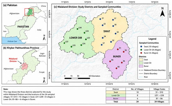
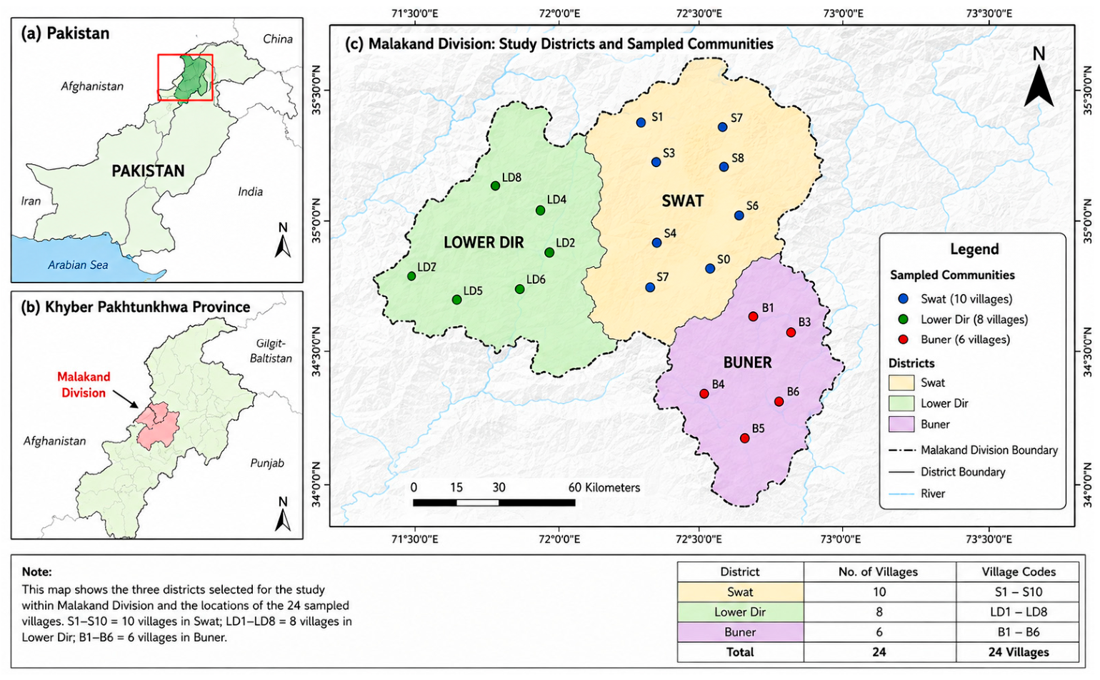
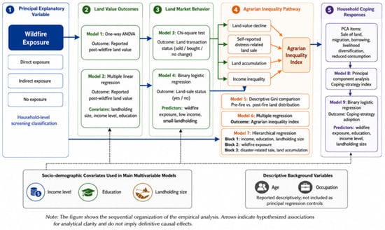
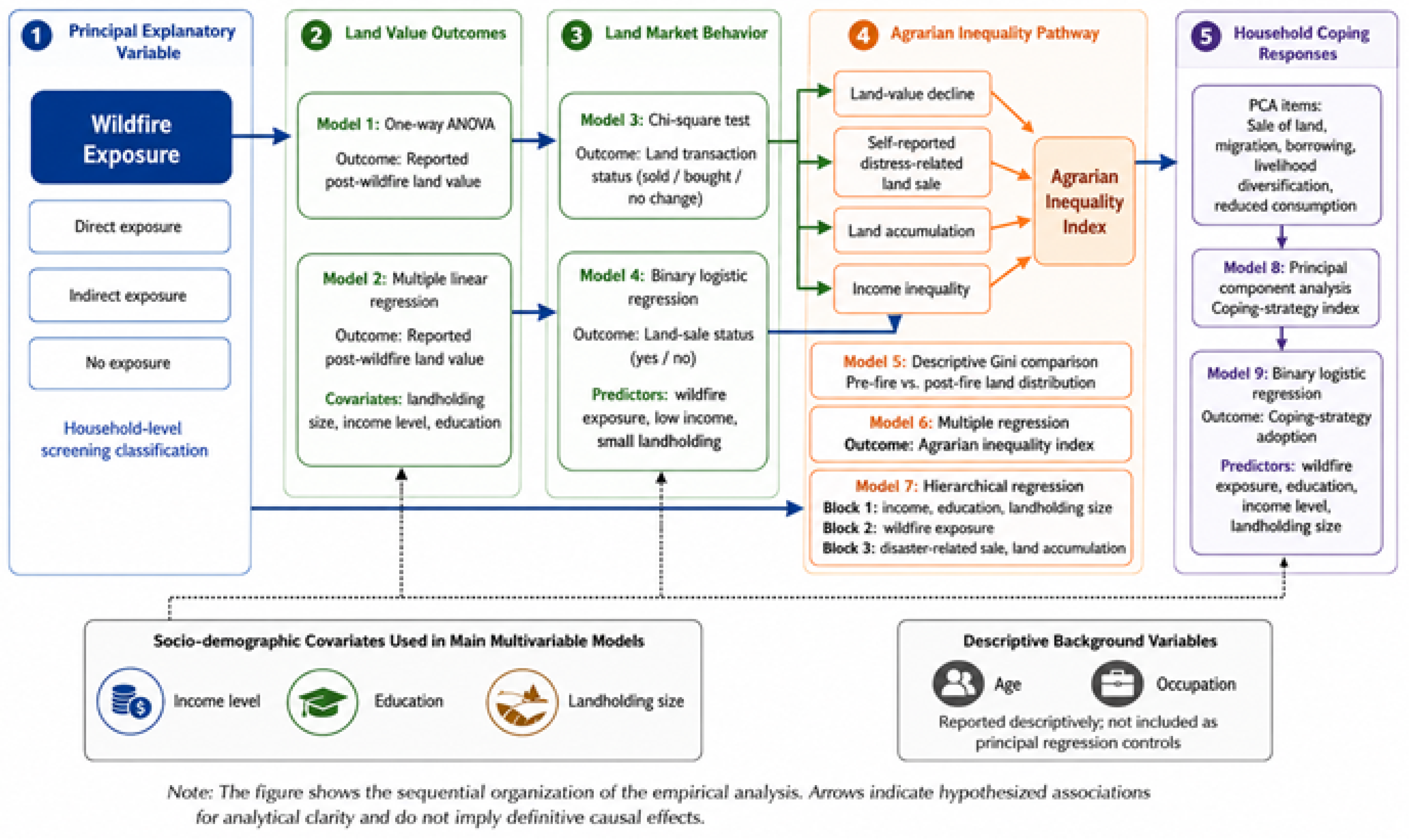
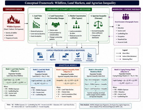
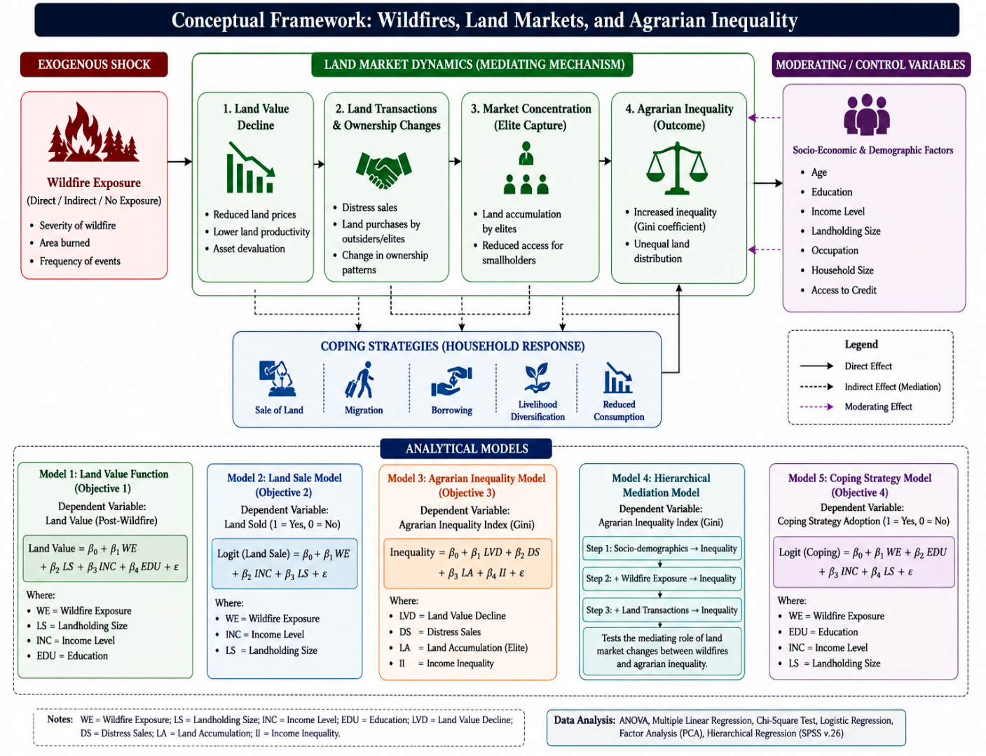

Disclaimer/Publisher’s Note: The statements, opinions and data contained in all publications are solely those of the individual author(s) and contributor(s) and not of MDPI and/or the editor(s). MDPI and/or the editor(s) disclaim responsibility for any injury to people or property resulting from any ideas, methods, instructions or products referred to in the content. |
© 2026 by the authors. Licensee MDPI, Basel, Switzerland. This article is an open access article distributed under the terms and conditions of the Creative Commons Attribution (CC BY) license.