


Abstract
Water from mountain regions is a crucial natural resource because of its major economic, social, and environmental significance. Wildfires may disrupt the normal functioning of the hydrological cycle, limiting water resources for nearby areas and degrading water quality in mountainous regions as contaminants enter water systems from the burning of vegetation and soil. In August 2022, the Serra da Estrela mountain, situated in the Mediterranean biogeographical region, was affected by a large wildfire that consumed 270 km2 of the Serra da Estrela Natural Park, often resulting in severe vegetation burn, although the soil burn severity was low to moderate in most of the area. The research objective is to assess the impact of this wildfire on the hydrogeochemistry of groundwater and surface water in the Manteigas-Covão da Ametade sector of Serra da Estrela in the context of a wildfire with limited soil burn severity. Groundwater and surface water samples were collected from October 2022 to September 2023 and were analyzed for pH, Total Organic Carbon, electrical conductivity, major ions, potentially toxic elements, iron (Fe), and Polycyclic Aromatic Hydrocarbons. A stormy event in mid-September 2022, occurring before the first sampling campaign, removed most of the ash layer and likely caused transient hydrogeochemical changes in streams. However, the analytical results from the sampled waters revealed that the post-wildfire hydrogeochemical effects are not evident. In fact, the hydrogeochemical changes observed in groundwater and surface water appear to be primarily influenced by the regular hydrological behaviour of aquifers and streams. The low to moderate soil burn severity, the high soil hydrophobicity, and the temporal distribution of precipitation explain why the hydrogeochemistry was primarily influenced by groundwater flow paths, the types and weathering of local lithologies, soil types, dilution effects following wet periods, and seasonal changes in the tributaries feeding into streams, rather than by post-wildfire effects. These outcomes provide valuable insights for water resource management and for developing strategies to mitigate wildfire impacts in mountainous environments.
1. Introduction
Water from mountain regions is a vital natural asset due to its significant economic, social, and environmental importance [1]. Hydrological processes, including streamflow resulting from precipitation, the melting of mountain snowpack and glaciers, and groundwater discharge contribute significantly to the availability of water resources for the surrounding areas [2].
Wildfires are a major contributor to the degradation of water quality in some mountainous areas, as contaminants enter hydrological systems primarily through the burning of vegetation and soil—e.g., refs. [3,4,5]. The devastating effects of wildfires also occur after they are extinguished. Approximately 80% of wildfires increase the susceptibility of watersheds to flooding, erosion, landslides, and debris flows, especially when heavy rains and storms occur shortly after the fire events, resulting in both short- and long-term impacts on water supplies [6].
The combustion of vegetation cover during wildfires promotes ash deposition and alters soil properties, including topsoil hydrophobicity, as well as the distribution of nutrients and organic matter in the soil profile. Depending on factors like soil chemistry, texture and moisture content, these changes lead to modifications in the hydrological regime, both in terms of quantity—as shifts in hydrological processes like decreased infiltration and aquifer recharge, increased overland flow, and disturbances in streamflow –, and quality—resulting in hydrochemical alterations due to the mobilization of inorganic and organic substances associated with wildfires [7,8].
Wildfires have the potential to induce alterations in water quality parameters, including pH, total dissolved solids, turbidity, organic carbon content, colour, taste, and odour, as well as concentration of organic and inorganic components such as chloride, sulphate, manganese, and iron [9,10,11].
A wide array of contaminants, including the so-called potentially toxic elements (PTE), and organic substances like dioxins, dibenzofurans, and polycyclic aromatic hydrocarbons (PAH), are generated in the combustion process during a wildfire [12,13,14]. The primary entry of PAH into the environment occurs through the atmosphere, resulting from various combustion processes and pyrolysis sources. These compounds are classified as priority hazardous pollutants by the European Union due to significant environmental concerns related to their mutagenic, carcinogenic, and teratogenic properties—e.g., ref. [15]. Additionally, their long-term persistence, widespread occurrence, capacity for long-range transportation, and tendency to bioaccumulate contribute to their elevated environmental impact [16,17]. Sixteen PAH have been designated priority pollutants by the US Environmental Protection Agency (USEPA) and are listed in the American registry of priority pollutants requiring environmental monitoring [17].
The type of impacted ecosystem influences the hydrogeochemical changes, which are determined by various factors, including the severity and duration of the wildfire, terrain slope, and the amount and intensity of precipitation during post-wildfire rain events [18]. One common hydrological effect of wildfires is the intensification of overland flow, which increases the transport of ash, soil particles, dissolved inorganic and organic compounds, and other materials into nearby streams and lakes, resulting in the alteration of surface water quality [3,18,19]. Moreover, as rainwater infiltrates and percolates through the soil, these compounds may leach out of the ash and burnt topsoil, subsequently affecting surface water and groundwater. This process is particularly significant in coarse-textured soils due to their normally higher hydraulic conductivity.
However, post-wildfire studies on water resources have yielded diverse results, with some findings reporting significant increases, while others document substantial declines in processes such as rainfall interception, overland flow, surface runoff, infiltration, groundwater recharge, aquifer storage, and baseflow [20,21]. In some cases, the impacts appear to be either minimal or temporary. These authors note that although wildfires typically lead to declines in water quality, there are documented cases where wildfire events have led to improvements in water quality, as seen in the study by [22], or have caused negligible effects often attributed to low-severity fires [3,23]. Limited impacts on water quality and even quality enhancements have also been observed in cases of prescribed fire [24,25].
The Serra da Estrela mountain is a strategic area for water resources management in Portugal due to its geological, geomorphological, and climatic characteristics [26]. This region is located in the river Tejo catchment, a major water management territorial unit in Iberia.
The Serra da Estrela Natural Park (SENP), established in 1976 with an area of 888 km2, is one of Portugal’s most significant protected areas, and wildfires are considered major threats to its conservation [27]. Later, in 1993, its most elevated territory was incorporated into the European Council’s network of Biogenetic Reserves. By 2000, the Serra da Estrela significance for nature conservation had already been recognized at an international scale, leading to its integration into the European Union Natura Network. In 2005, the upper part of the mountain was classified as a Ramsar Wetlands site. In July 2020, UNESCO granted the prestigious title of World Geopark to the Estrela region, encompassing the Serra da Estrela Natural Park area and its surrounding territories, covering an area of 2216 km2 [28].
On 6 August 2022, the Serra da Estrela region was affected by a large wildfire that consumed a large area of the SENP [29], with documented environmental impacts, including the extensive destruction of the forest area, decreased greenhouse gas sequestration, increased soil degradation, and erosion vulnerability [29,30,31]. These environmental changes also resulted in substantial economic losses, particularly in terms of firefighting costs, reduced timber availability, and a decline in tourism, thereby affecting the livelihoods of local communities [30].
The main research objective is to assess the impact of the August 2022 wildfire on the hydrogeochemistry of groundwater and surface water in the Manteigas-Covão da Ametade sector of the Serra da Estrela region. Another objective is to understand the main drivers of the hydrogeochemical response to the wildfire in a mountain environment. To achieve these goals, the study examines key physicochemical indicators relevant to evaluating water quality. It is expected that the results will contribute to the understanding of the dynamics of water contamination due to wildfires, also providing valuable insights into the field of mountain hydrology.
2. Characterization of the Study Area
2.1. Physical Setting
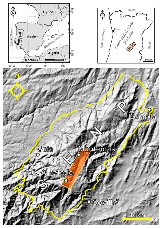
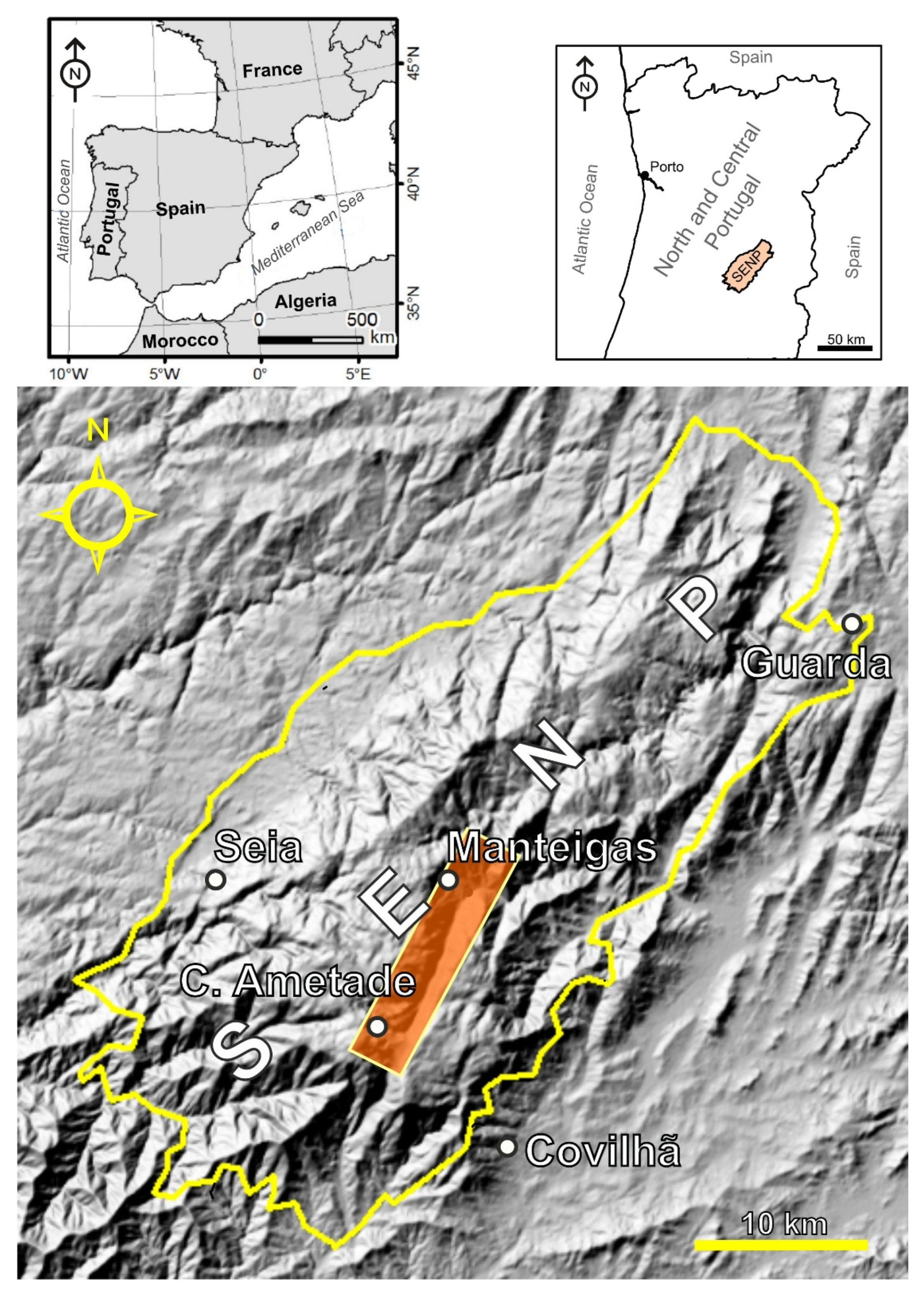
The Serra da Estrela mountain (40°19′18.8″ N; 7°36′46.5″ W), situated in Central Portugal (Figure 1), forms part of the western section of the Central Iberian Ridge, extending 115 km in length and 25 km in width from Guarda to the Serra da Lousã, and hosts the most elevated point on the Portuguese mainland (Alto da Torre, 1993 m a.s.l.). The region is also situated within the Natura 2000 Mediterranean Biogeographical Region, as defined by the European Union’s Natura 2000 network [32].
Figure 1.
Location of Serra da Estrela Natural Park (SENP, Central Portugal) and the study region, highlighted in orange (shaded relief map based on information from the topographic map of Portugal at a scale of 1/25,000).
The regional hydrological is intrinsically linked to its geological and tectonic setting, which exerts a fundamental influence on infiltration, aquifer recharge, groundwater flow pathways, streamflow regimes, and hydrogeochemical patterns. This mountain hydrological system generates strategic water resources, comprising: (i) high quality groundwater stored in unconfined aquifers and used for agricultural irrigation, domestic supply, and the bottling sector; (ii) thermomineral waters circulating in confined aquifers and exploited for therapeutic spa treatments; and (iii) surface waters from the river Zêzere catchment, a major source of water for public supply in several municipalities, notably the city of Lisbon [33]. The sampled points include groundwater from the unconfined aquifers and surface water from the river Zêzere and two of its tributaries.
The regional geological units encompass Variscan granites, metasedimentary rocks, and a sedimentary cover consisting of fluvioglacial and alluvial deposits [34].
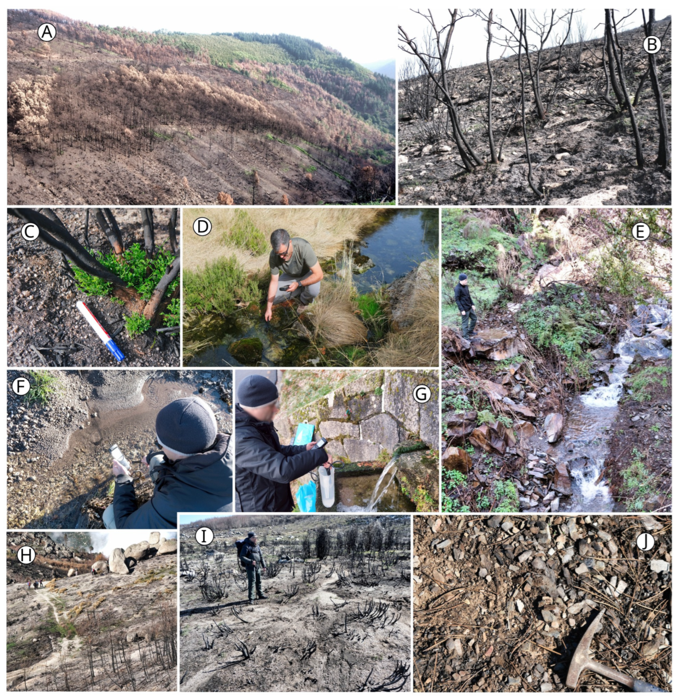
The study region corresponds to the Manteigas-Covão da Ametade Sector, with an area of 44 km2 (Figure 1), encompassing burned and unburned areas (Figure 2). In the burned territory from the August 2022 wildfire, metasedimentary rocks dominate the western and central zones, whereas granitic rocks are more prevalent in the eastern zone. The predominant soil types, according to the World Reference Base for Soil Resources (WRB) and local soil mapping, include Leptosols, Cambisols, Fluvisols, and Regosols.
Figure 2.
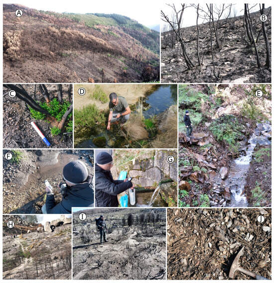
Some aspects of the study area: burned area of maritime pine woodland (A); soil surface after the mid-September stormy period (notice the intense ash removal and soil erosion—(B,C)); water monitoring (S2 and S3 sampling points—figures (D), and (F), respectively); sampling point S4 (E); water sampling at sampling point N4 (G); soil surface at the end of November 2022, with an almost complete remotion of the residual ash (H–J). The water sampling points are described in Section 3.1 and in the Supplementary Materials (Table S1).
The main vegetation types of the Manteigas-Covão da Ametade sector are maritime pine woodland, Genista florida, and Cytisus sp.pl. scrubland, meso-hygrophilous grassland, meso-xerophilous grassland, Nardus stricta grassland, heathland, and Quercus pyrenaica forest [33].
Regional water bodies in Serra da Estrela comprise unconfined and confined aquifers, with groundwater circulation primarily occurring in fractured media, as well as the River Zêzere and its tributaries [35].
According to the Köppen–Geiger climate classification, the regional climate is of the Csb type. It is characterized by warm temperate conditions with dry and warm summers [36]. On the high plateaus of Serra da Estrela, annual rainfall exceeds 2500 mm, while in the foothills it ranges between 1000 and 1200 mm. Temperature decreases by an average of 0.6 °C per 100 m of elevation, which results in an average annual temperature of 3–4 °C on the upper plateau [37].
The Serra da Estrela’s geological and biogeographical significance reflects the combined influence of its distinctive geological heritage (namely, the extensive granitic and glacial geomorphology), the presence of key water resources, and strong altitudinal and climatic gradients. These physical attributes, combined with high-value habitats, biodiversity, and a long history of human interaction with the mountain environment, shape a complex and dynamic system [27].
2.2. Wildfire Characterization
The August 2022 wildfire in Serra da Estrela burned a total area of around 270 km2 within the SENP and its surroundings, affecting the municipalities of Manteigas, Belmonte, Gouveia, Guarda, and Celorico da Beira (district of Guarda). In the SENP, the burned area was approximately 210 km2, accounting for nearly 25% of the protected area [29].
Despite the dominance of maritime pine (Pinus pinaster, 8021 ha burned) and shrubland and scrubland (7158 ha burned), the vegetation affected by the wildfire is varied [38]. Other coniferous trees, such as Pinus nigra, P. sylvestris, and Pseudotsuga menziezii, are important locally (939 ha burned), as are hardwoods, including black oak, holm oak, chestnut, beech, and birch, with 1677 ha of other oaks and 645 ha of other hardwoods burned.
Soil burn severity is a major indicator of potential wildfire impacts on water resources. Post-wildfire observations carried out in this study, as well as the ones reported by [30], indicate that, according to the [39] criteria, the soil burn severity was mostly low to moderate, and no evidence of high severity was found in the sampled locations, even where high vegetation burn severity occurred (causing high vegetation mortality).
According to [30], the area corresponding to unburned/very low soil burn severity was around 34 km2, while low severity corresponded to 139 km2, and moderate severity reached 89 km2. That is, approximately two-thirds of the soil within the wildfire-affected area remained unburned or underwent only very low to low burn severity. During the weeks after the wildfire, a layer of scorched needles or leaves covered the ground surface.
The following soil burn severity indicators [39] were observed:
- Low soil burn severity: most of the organic debris from the O horizon did not burn and remained identifiable in spite of some charring, which gave the soil surface a black or brown colour. In the A horizon, the soil colour and the structure features did not change.
- Moderate soil burn severity: most of the pre-wildfire O horizon organic matter was consumed. Fine roots became charred but were seldom completely burned. In the A horizon, changes in the soil colour and structure were not observed.
The first post-wildfire precipitation consisted of a stormy event in mid-September that caused intense overland flow and removed most of the ash layer, especially on the steeper hillslopes. By late November, subsequent precipitation events had almost completely removed the residual ash. Also, no significant difference was observed in soil hydrophobicity between burned and unburned areas. In fact, there was a strong background hydrophobicity in September 2022, largely due to the intense drought that occurred in the months before the fire [30]. Nevertheless, these authors report a possible increase in subsurface hydrophobicity induced by moderate soil burn severity. It is also worth noting that this storm likely had a transient effect on stream water chemistry, but not on groundwater, as aquifer recharge did not occur during this period.
3. Materials and Methods
3.1. Water Sampling
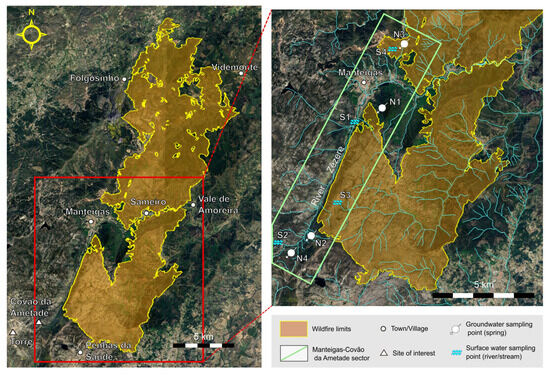
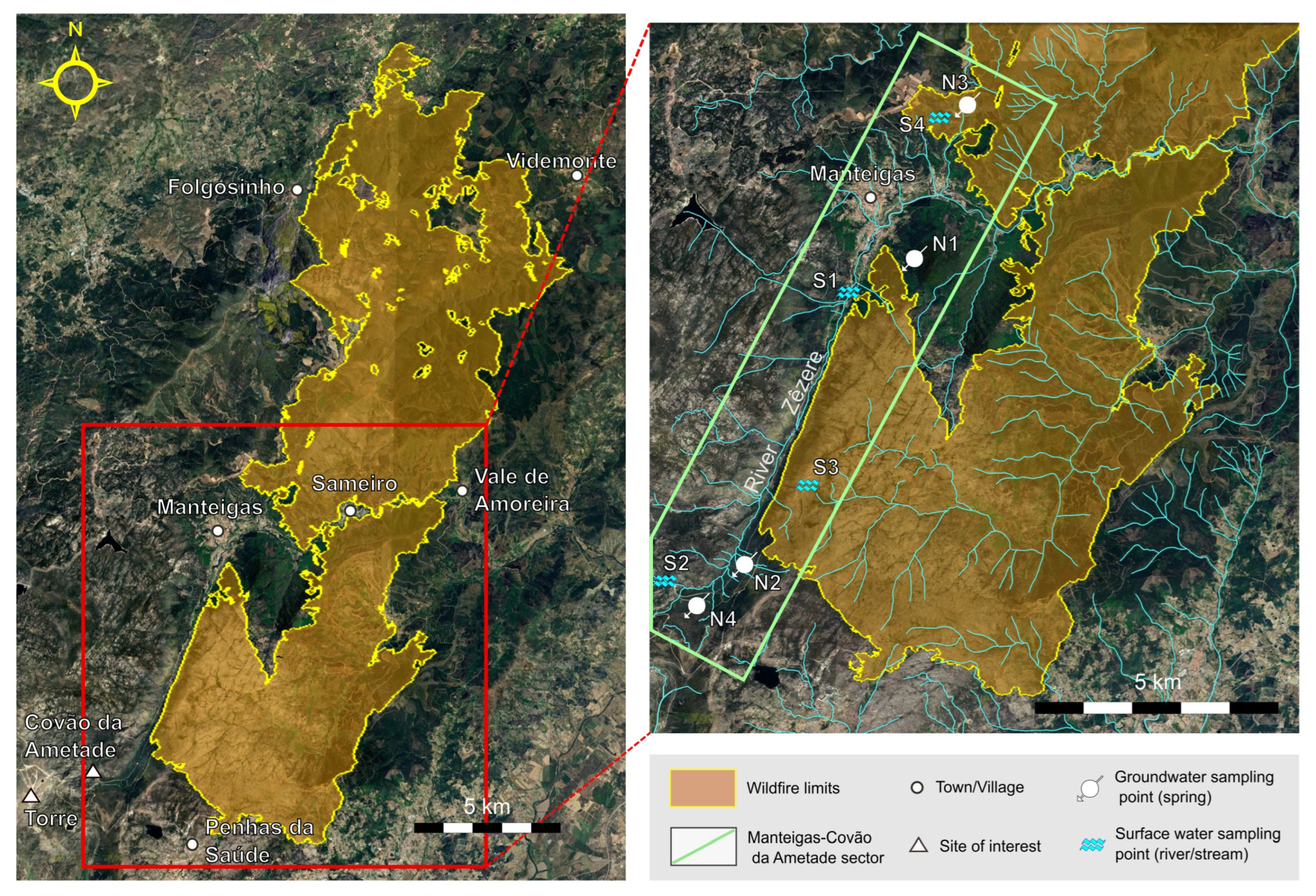
The sampling sites were selected in the Manteigas-Covão da Ametade sector (Figure 3) in areas of low anthropogenic influence, thereby reducing the risk of water contamination from sources other than wildfires. The first sampling campaign was conducted in October 2022, after the mid-September stormy event, with the final campaign taking place in October 2023. A total of seven sampling campaigns were conducted every two months over the course of a year, allowing the assessment of the temporal variation in water characteristics after the wildfire.
Figure 3.
Area of the August 2022 wildfire (left); location of the water sampling points in the Manteigas-Covão da Ametade sector (right). Burned area limits obtained from the Copernicus Emergency Management Service platform (https://mapping.emergency.copernicus.eu/activations/EMSR618/, accessed on 3 July 2025).
The sampled locations encompassed four springs: two in areas potentially affected by the wildfire, that is, adjacent to burned areas and possibly impacted by ash deposition (N1 and N2), one within the area affected by the wildfire (N3), and one in an area not affected by the wildfire (N4). Four streams were also sampled: one with a catchment possibly influenced by the wildfire (S1), one with a catchment not affected by the wildfire (S2) and two with a catchment affected by the wildfire (S3 and S4) (Figure 3).
Streams S3 and S4 did not show permanent flow during the sampling campaigns. S3 had no flow in the first, fourth and fifth campaigns, while S4 had no flow in the first campaign.
This set of springs and streams provided a monitoring network for investigating the influence of the wildfire on groundwater and surface water physicochemical features, including pH, electrical conductivity (EC), total organic carbon (TOC), major ions, potentially toxic elements (PTE), iron (Fe), and the 16 priority PAH. Samples were collected in accordance with [40]. For the determination of PAH, samples were collected in glass amber bottles and refrigerated at 4 °C until laboratory testing. In each campaign and sampling location, the parameters pH, EC, and temperature were measured in situ, using a Hanna Instruments model HI 991300 equipment (Hanna Instruments, Woonsocket, RI, USA).
3.2. Laboratory Analyses
Analytical standards were obtained from Sigma-Aldrich (Steinheim, Germany) or Merck (Darmstadt, Germany). The reference standard mixture containing 16 EPA-PAH (naphthalene, Nap; acenaphthylene, Acy; acenaphthene, Ace; fluorene, Flu; phenanthrene, Phe; anthracene, Ant; fluoranthene, Flt; pyrene, Pyr; benz[a]anthracene, BaA; chrysene, Chr; benzo[b]fluoranthene, BbF; benzo[k]fluoranthene (BkF); benzo[a]pyrene, BaP; dibenz[a,h]anthracene, DahA; benzo[ghi] perylene, BghiP; and indeno[1,2,3-cd]pyrene, Ind) was purchased from Sigma-Aldrich (Steinheim, Germany). Alkalinity was determined by titration, with the results expressed in milligrams per litre of bicarbonate (mg/L HCO3−). The EC and pH in the laboratory were determined using a Crison MultiMeter MM41 multiparameter meter (Crison Instruments, S.A., Alella-Barcelona, Spain). The concentration of the major ions (Na+, K+, Mg2+, Ca2+, Cl−, F−, NO3− e SO42−) was determined through ion chromatography, using a DionexTM Ion chromatography System DX-120/ICS-1000 (Dionex Corporation, Sunnyvale, CA, USA). The TOC value was determined using a Shimadzu TOC-V (TOC-ASI-V)—(Shimadzu Corporation, Kyoto, Japan). The concentration of PTE (Cr, Mn, Ni, Cu, Zn, As, Cd and Pb) was determined using the atomic absorption spectrometry method with the Varian AA240 equipment (Varian, Inc., Palo Alto, CA, USA). The concentrations of Al, Fe, NO2− and NH4+ were obtained using a San-Plus Scalar segmented continuous flow equipment (Skalar Analytical B.V., Breda, The Netherlands). Turbidity is obtained using a Hach 2100N Laboratory Turbidity Meter (Hach Company, Loveland, CO, USA). Colour was analyzed by UV-Vis spectrophotometry using a Shimadzu UV-1601 spectrophotometer (Shimadzu Corporation, Kyoto, Japan).
4. Results and Discussion
Wildfires typically have a significant impact on water quality, with effects largely influenced by factors such as the extent and severity of the soil and vegetation burn, the erosional processes that follow, and the types of contaminants and sediments that are mobilized and transferred to water bodies, especially during post-wildfire rainfall events. Nevertheless, as mentioned by [20], the post-wildfire hydrological system’s response concerning water quality depends on the features and functioning of the burned territory, and, in some cases, it may be negligible.
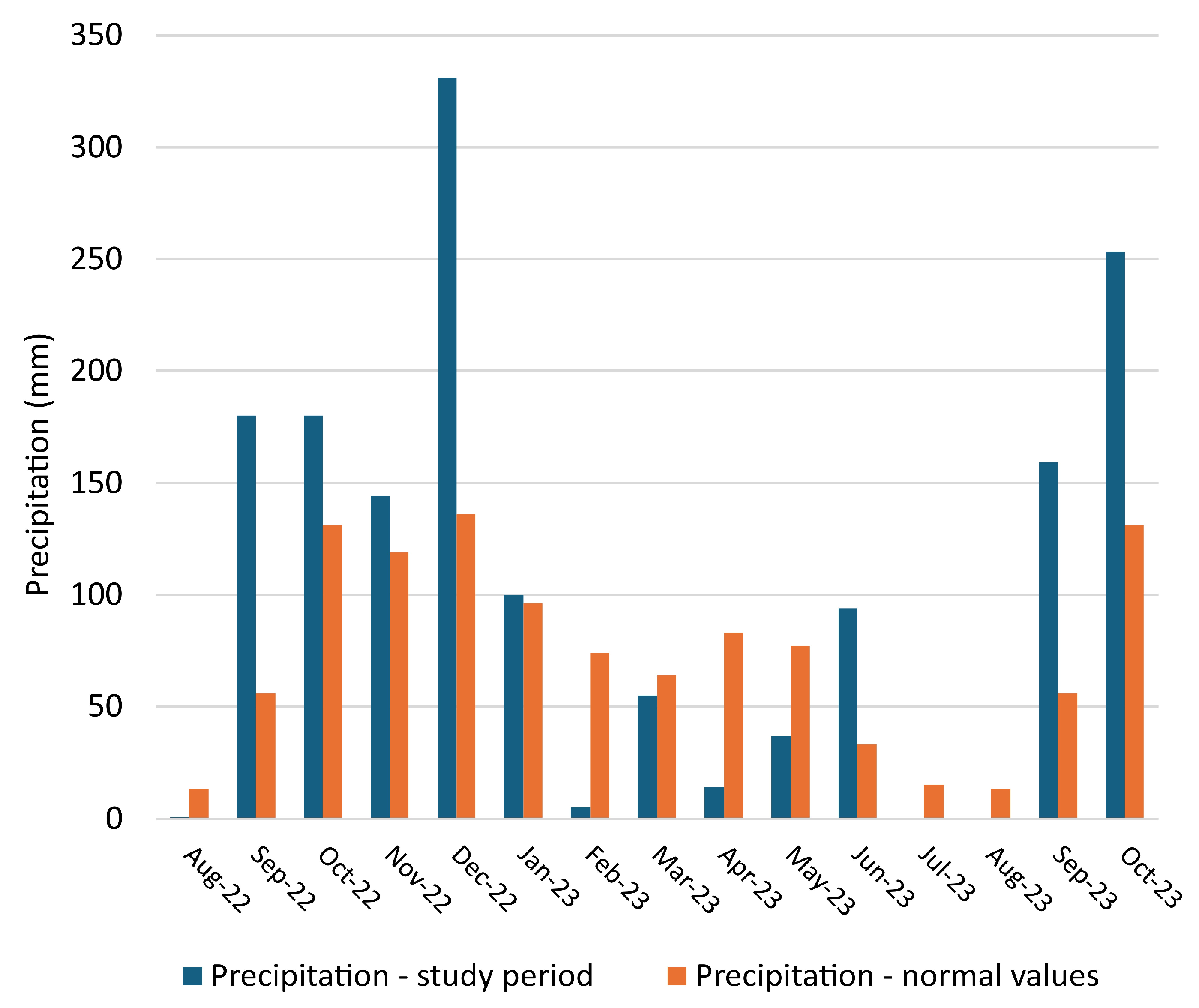
According to [41], by August 2022, mainland Portugal was going through a period of drought, with almost half of the territory classified as being at the severe to extreme level. From September 2022 to December 2022, the precipitation measured at the Guarda Meteorological station, located in the SENP, was higher than the normal values (Figure 4). Nevertheless, no changes in flow were observed in the monitored springs until December 2022. Therefore, the October 2022 groundwater sampling was representative of the pre-wildfire hydrogeochemical conditions because, in this period, infiltration and percolation only affected the topsoil, and recharge or interflow did not occur (see details of the hydrogeological conditions at each spring in Table S1 of the Supplementary Materials). In 2023, precipitation was below normal values except for January and September, maintaining the drought scenario. During heavy precipitation events, from September 2022 to January 2023, overland flow episodes occurred, potentially producing a transitory influence on streams, especially at the beginning of this period. Field observations revealed that extensive overland flow occurred during the stormy event in mid-September 2022, resulting in transient flow in streams S3 and S4, before the first sampling campaign (October 2022).
Figure 4.
Precipitation values at the Guarda station between August 2022 and October 2023 (blue) and normal values (orange) for the period 1981–2010 [42].
Comprehensive parameter values for groundwaters and surface waters are available in the Supplementary Materials: a summary of relevant hydrological characteristics of the studied water points is presented in Table S1; pH, EC, TOC, turbidity and colour are shown in Table S2; major ions concentrations are presented in Table S3; PTE and Fe concentrations are displayed in Table S4; and PAH results are shown in Table S5.
4.1. Water pH
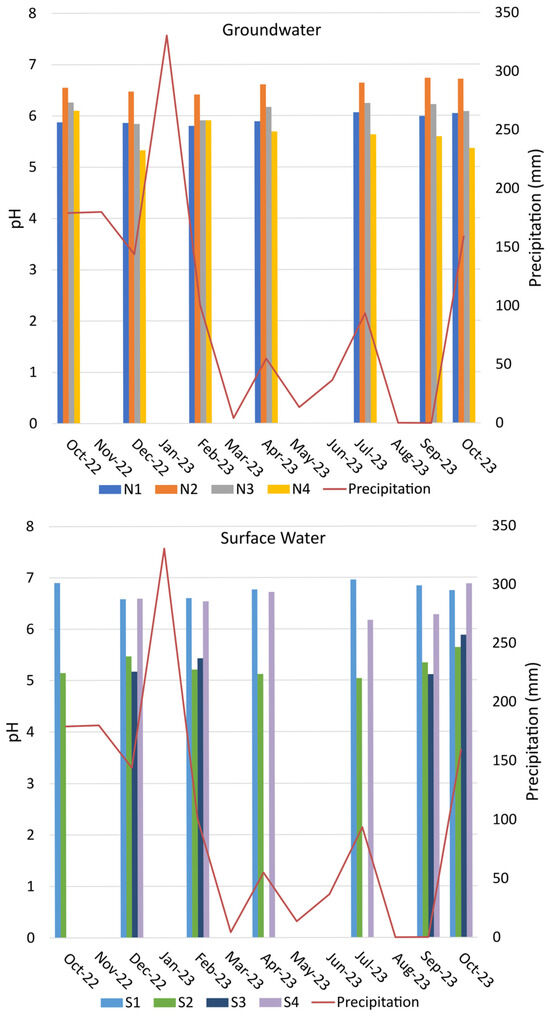
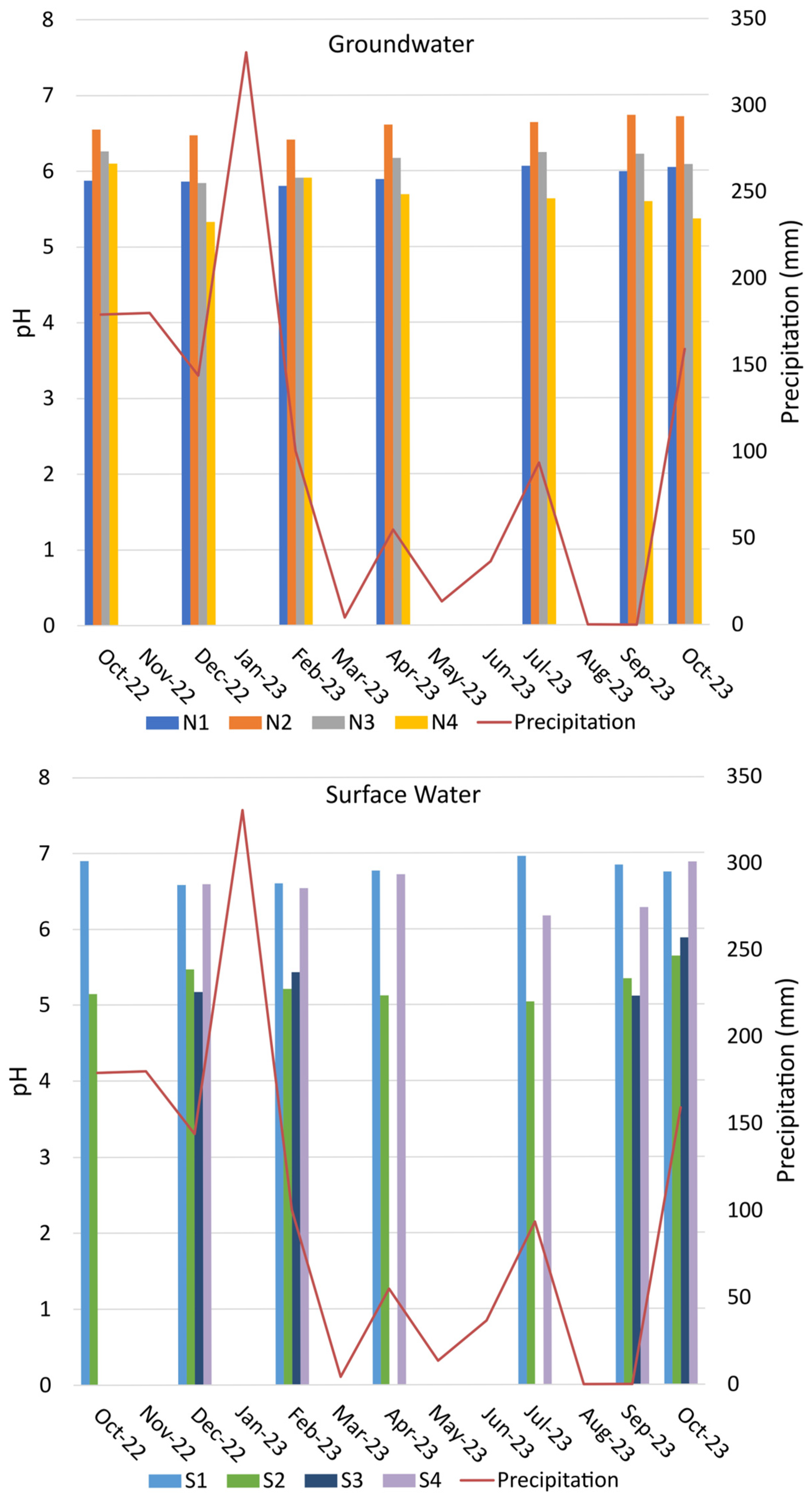
Concerning groundwater and surface water pH (Figure 5), an overall stability is observed with minor fluctuations, but no clear trends. The effect of alkaline ashes on water pH after the first rains, reported in many studies—e.g., refs. [43,44], was not observed (pH values are acidic to nearly neutral, ranging from 5.0, measured in surface water point S2 in July 2023, to 6.9, measured in S1 and S4, in October 2022 and October 2023, respectively). Water pH may also decrease after a wildfire, for example, due to the leaching of organic acids from burned vegetation, although this is a less common effect [45]. Alternatively, it may not show any change [46].
Figure 5.
Measured pH values in groundwater and surface water.
Springs N1 (pH ≈ 5.9) and N2 (pH ≈ 6.6), the ones with a longer hydrogeological circuit, are the most stable. In the case of the N3 spring, located in a burned area, with a short groundwater circuit, a slight decrease in pH was observed in the December 2022 (5.8) and February 2023 (5.9) campaigns relative to the October 2022 campaign (6.3). Nevertheless, this pH evolution is similar to that observed in N4, located in an unburned area.
Likewise, the pH of surface waters does not seem to be influenced by alkaline ashes. The differences in pH (S1 and S4 presenting higher values, normally above 6.5) do not highlight any post-wildfire influence and rather appear to be related to the features of the watersheds rather than to possible wildfire impacts. Thus, the lower pH values measured in S2 (from an unburned area) and S3 (from a burned area) are most likely a result of infiltration and percolation in soils with higher organic matter content and, therefore, more acidic.
4.2. Water Electrical Conductivity
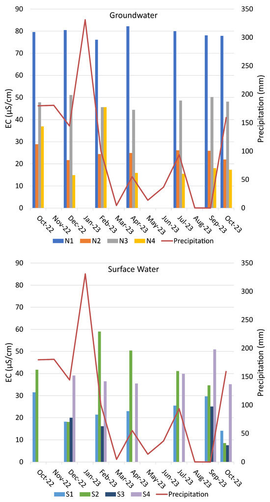
The EC of Serra da Estrela groundwater is typically low, resulting from weak water-rock interaction, as reported by previous studies—e.g., ref. [33]. Anomalous EC values found in the region are due to contamination from road de-icing [35] in groundwater and were not detected in the present study.
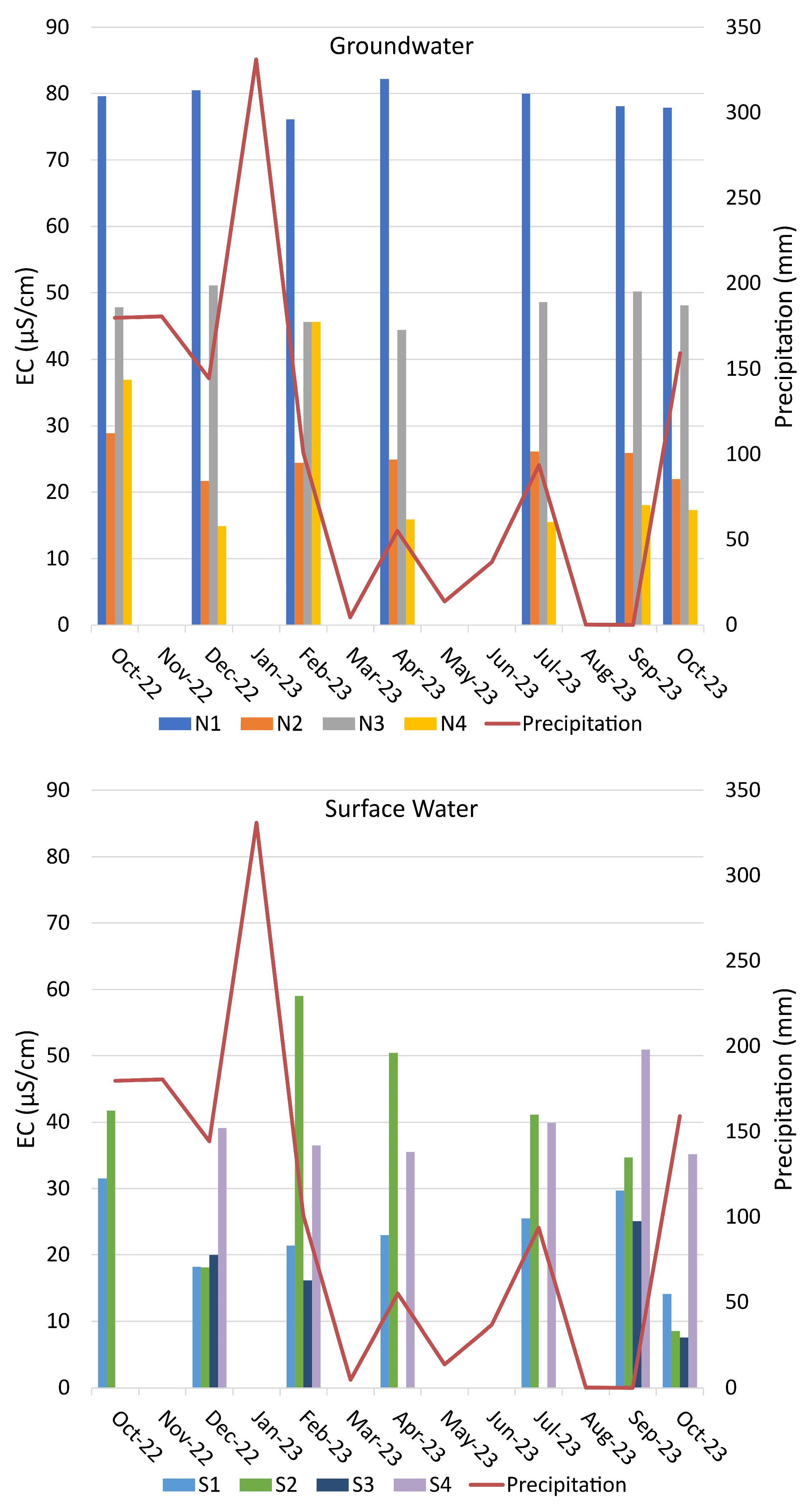
The groundwater EC values (Figure 6) are also closely related to the altitude of springs. The lowest average values were found in N4 (23 µS/cm) and N2 (25 µS/cm), while the highest values were observed in N1 (79 µS/cm). Post-wildfire increases in EC were not observed in any case, namely in N3 (located in a burned area). In the N1 and N2 waters, which are related to deeper and longer flow paths, the values are remarkably stable. The greater variability is found in N4, which is associated with shorter and shallower groundwater circulation.
Figure 6.
Measured electrical conductivity (EC) values in groundwater and surface water.
As for surface water (Figure 6), no evidence of post-fire influence was observed, namely, in December 2022 and February 2023. In all surface water points, the EC fluctuations are limited and seem to result from the regular functioning of the hydrological system. S4, with a catchment located in a burned area, has the highest average EC (40 µS/cm), with values very stable from December 2022 until July 2023, only with a peak in September 2023, approximately one year after the wildfire.
The temporal variability observed in the EC values of S2 may be due to the influence of an important peat area upstream of the sampling point.
The characteristically low groundwater EC reflects minimal water-rock interaction, and no post-wildfire EC increases were detected. Groundwater EC appears primarily controlled by spring altitude, recharge area characteristics, and the geometry of the hydrogeological system. Likewise, in surface water, no post-wildfire impacts were observed, and EC fluctuations remained within the expected range due to natural watershed processes.
4.3. Total Organic Carbon
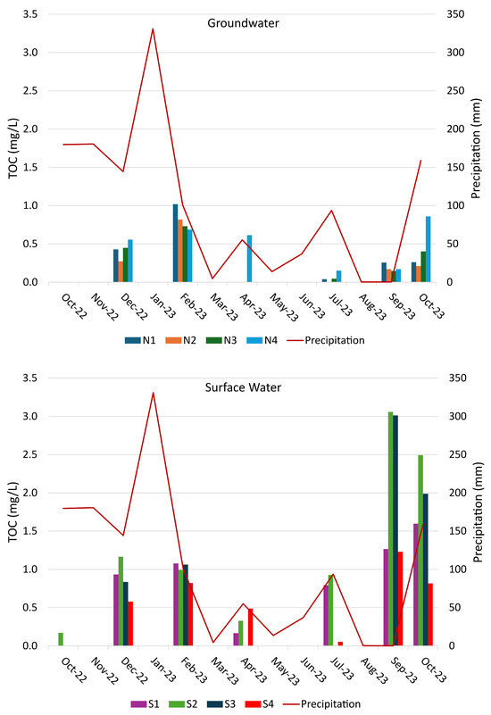
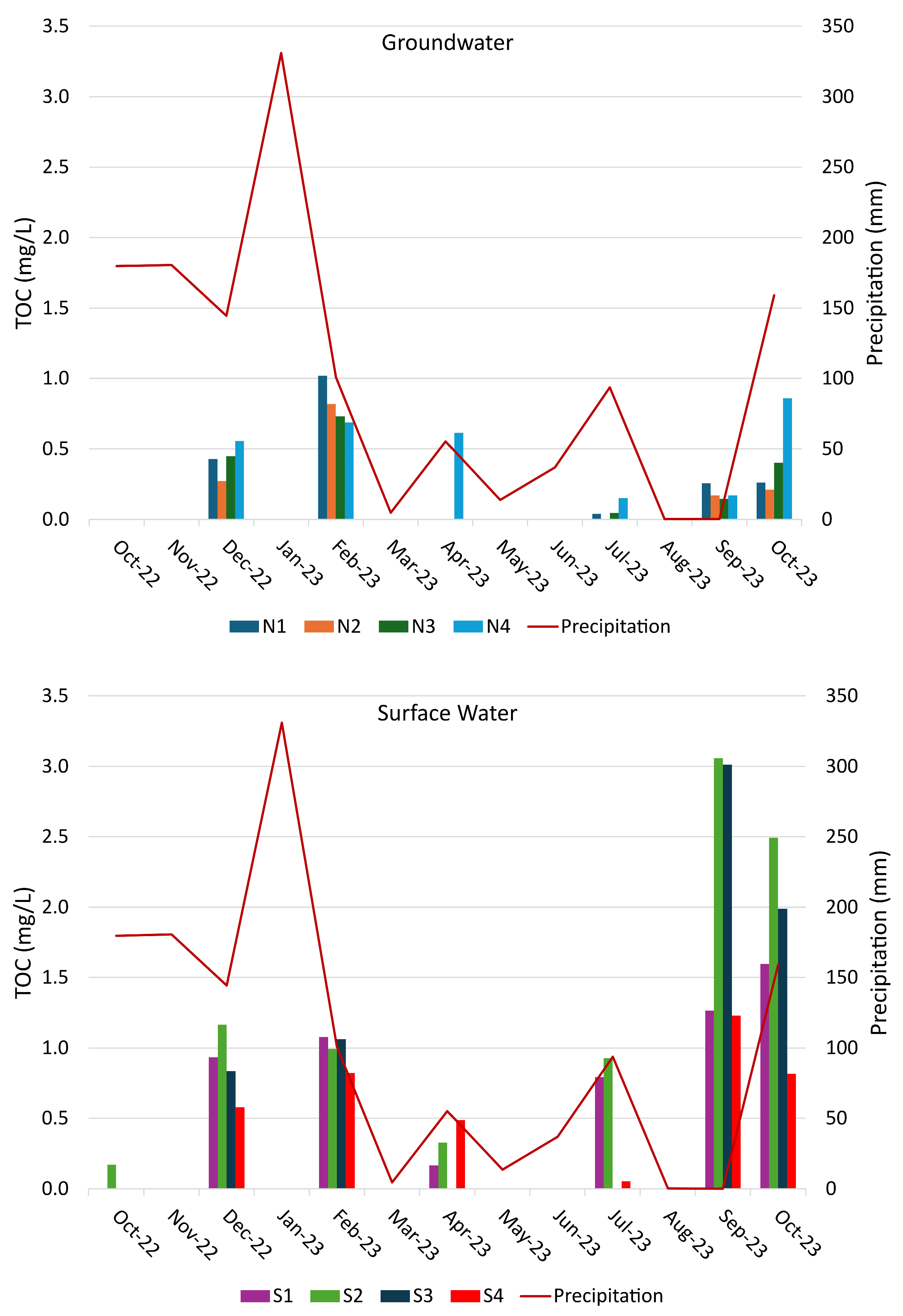
The TOC content is low, with values in groundwater below 0.5 mg/L and values in surface water not exceeding 3.1 mg/L, but shows some fluctuations, in which the possible wildfire influence does not stand out (Figure 7).
Figure 7.
Measured total organic carbon (TOC) values in groundwater and surface water.
In groundwater, values increased from October 2022, peaking in February 2023 in all water points. This trend coincides with the peak in precipitation in January 2023. The source of the TOC is likely to be percolation through the topsoil, which is very rich in humified organic matter (namely, in Umbrisols and Histosols).
Surface water shows a distinct TOC evolution, with a first peak (values less than 1.2 mg/L), which may result from the influence of groundwater circulation, is observed in December 2022 and February 2023; a second, and more evident, peak (with values that reach 3.1 mg/L in S2) occurs in September and October 2023 and may result from the accumulation of decomposing organic matter in streams at the end of the dry season.
The slightly higher TOC values measured in some water points may be explained by their location at higher altitude, where, due to pedoclimatic features, soils are enriched in organic matter, e.g., ref. [33]: N4 is connected to a small sedimentary basin at around 1540 m a.s.l., S2 is influenced by the above-mentioned peat deposit (located at 1620 m a.s.l.), and S3 is also influenced by soil situated at 1400 m a.s.l.
Therefore, the post-wildfire decrease in TOC, which is often observed in groundwater and surface water—e.g., refs. [15,47] and results from the loss of pre-fire soil organic matter in the O and A horizons, does not seem to occur in the study area.
The TOC concentration is low, with some fluctuations, and there is no clear influence from the wildfire that stands out. In this context, a post-wildfire decrease in TOC does not appear to occur within the study area. The slightly elevated TOC levels observed at certain sampling sites can be attributed to their higher altitude, where infiltration and percolation occur through soils with high organic matter content (namely, Umbrisols and Histosols), or to the accumulation of decomposing organic material within stream channels towards the end of the dry season.
4.4. Major Ions
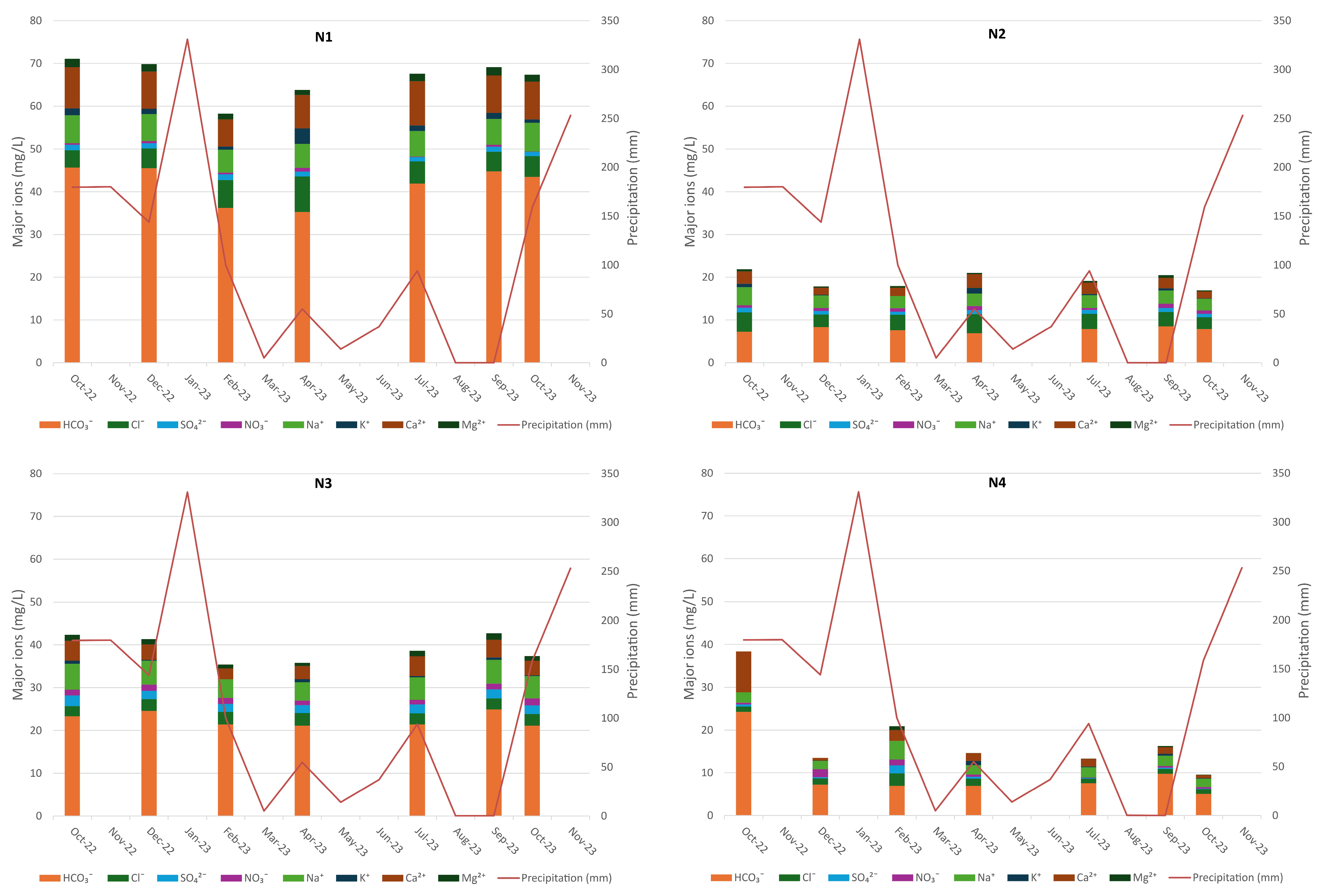
A consistent characteristic of the studied waters is their low mineralization, in agreement with the previously reported low EC values. No discernible wildfire influence is evident, differing from the post-wildfire responses documented in other studies such as [45,48,49]. The observed fluctuations in major ion content (Figure 8) appear to be primarily explained by the specific characteristics of the hydrogeological system of each spring and the catchment stream.
Figure 8.
Major ion concentrations in groundwater (N1–N4 sampling points).
In groundwater, mineralization contrasts between springs and variations over time likely depend on normal water-rock interaction. For example, the higher average mineralization was found in N1 spring (67 mg/L), which has a longer and deeper flow path, mostly through poorly weathered/unweathered granite. The lowest average mineralization was found in N4 (18 mg/L), located in a recharge area at approximately 1540 m a.s.l., and composed of quartz-rich alluvial and fluvioglacial sediments. The intermediate average mineralization found in N3 (39 mg/L) results from a short flow path through weathered metasedimentary rock at a lower altitude.
In N1 and N2 springs, with recharge area limits close to the burned area, the major ion content does not show signs of post-wildfire impact. In the N3 spring, located in a burned area, the average mineralization decreases slightly until February 2023 (from 42 mg/L to 35 mg/L), due to a dilution effect, instead of showing a post-wildfire increase.
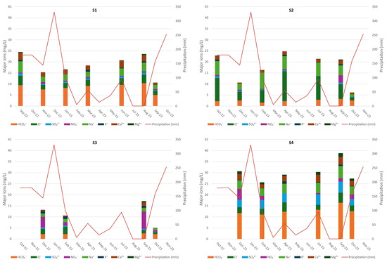
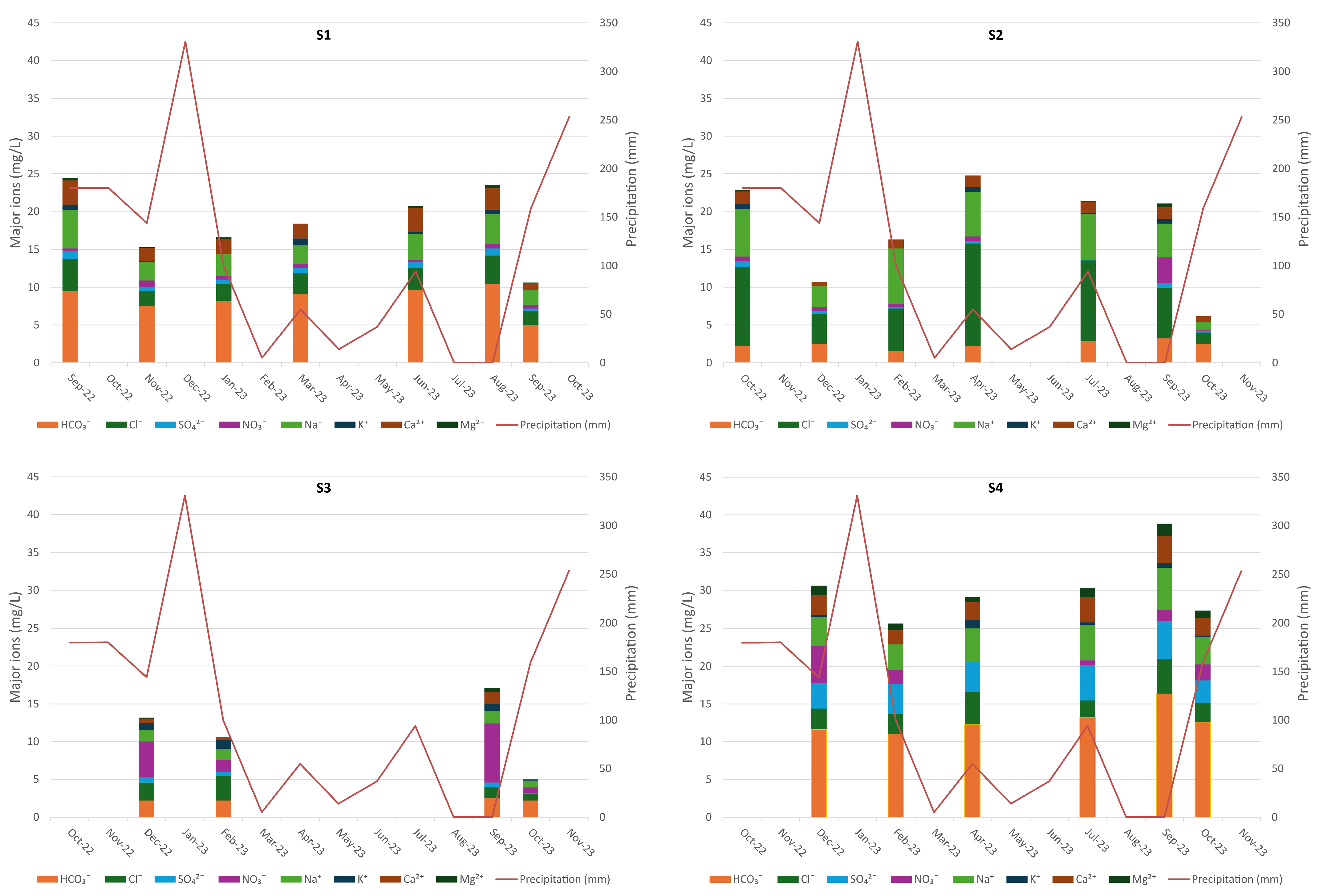
As for surface water, the possible wildfire effect remains imperceptible (Figure 9). In S1, which is representative of the river Zêzere catchment (partially burned), a dilution effect is observed until February 2023 (the average mineralization decreases from 25 mg/L to 17 mg/L). In S2, located in the highest part of the river Zêzere catchment, the fluctuations are more irregular and may be related to the presence of the above-mentioned peat area. In S3 and S4, located in burned areas, the major ion concentrations are low and similar to those of the unburned surface water points, and the fluctuations do not point to a post-wildfire effect.
Figure 9.
Major ion content in surface water (S1–S4 sampling points).
4.5. Potentially Toxic Elements and Iron
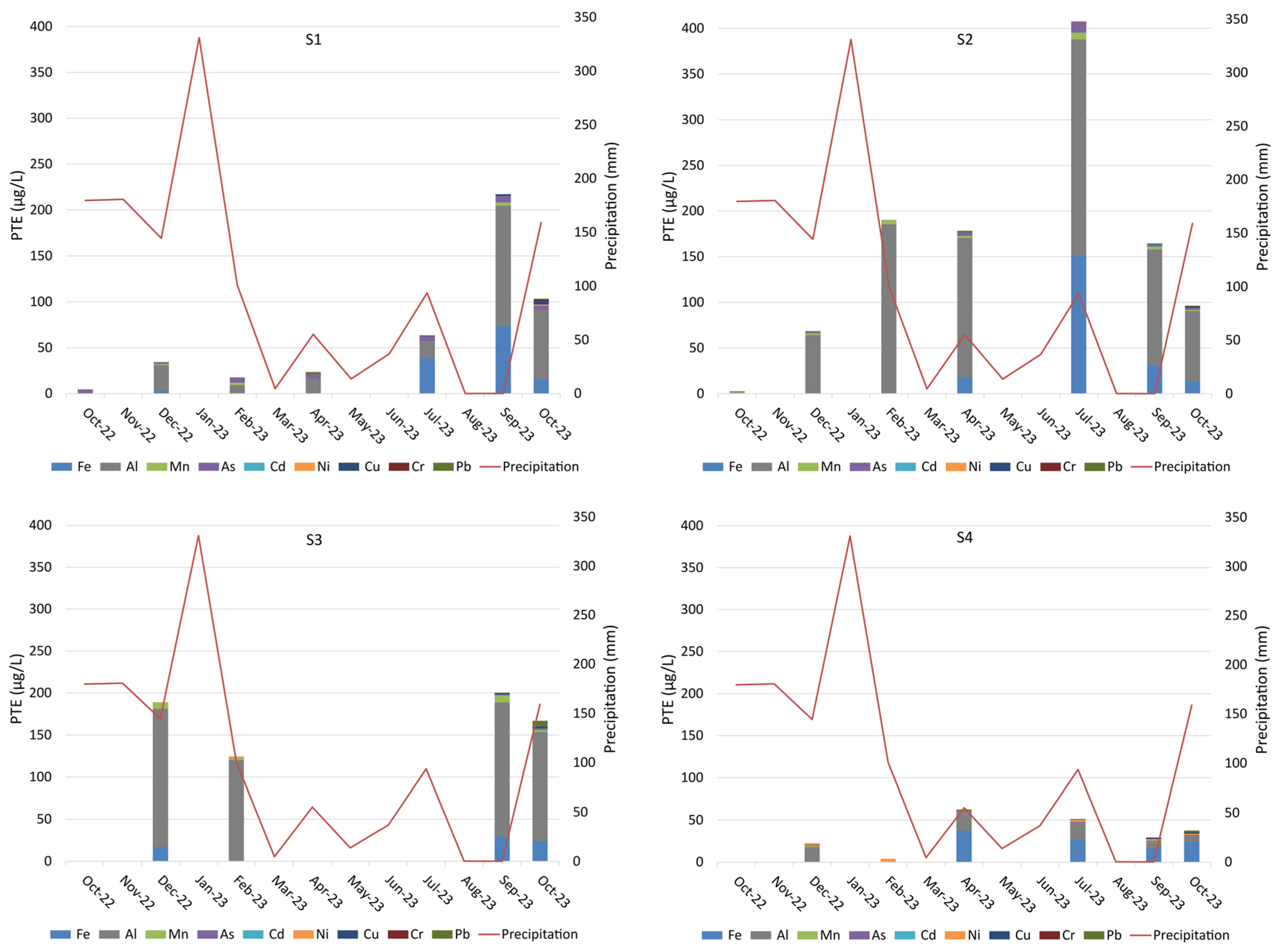
Similarly to the physicochemical features of groundwater and surface water described above, there are no discernible signs of post-wildfire contamination by PTE and Fe. Due to the different and sometimes contradictory trends in the evolution of various elements, it is not possible to distinguish the behaviour of burned areas from that of unburned areas. In most cases, PTE concentrations are very low or negligible, which differs from the patterns described in other studies, such as [50,51].
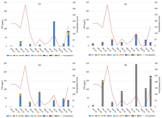
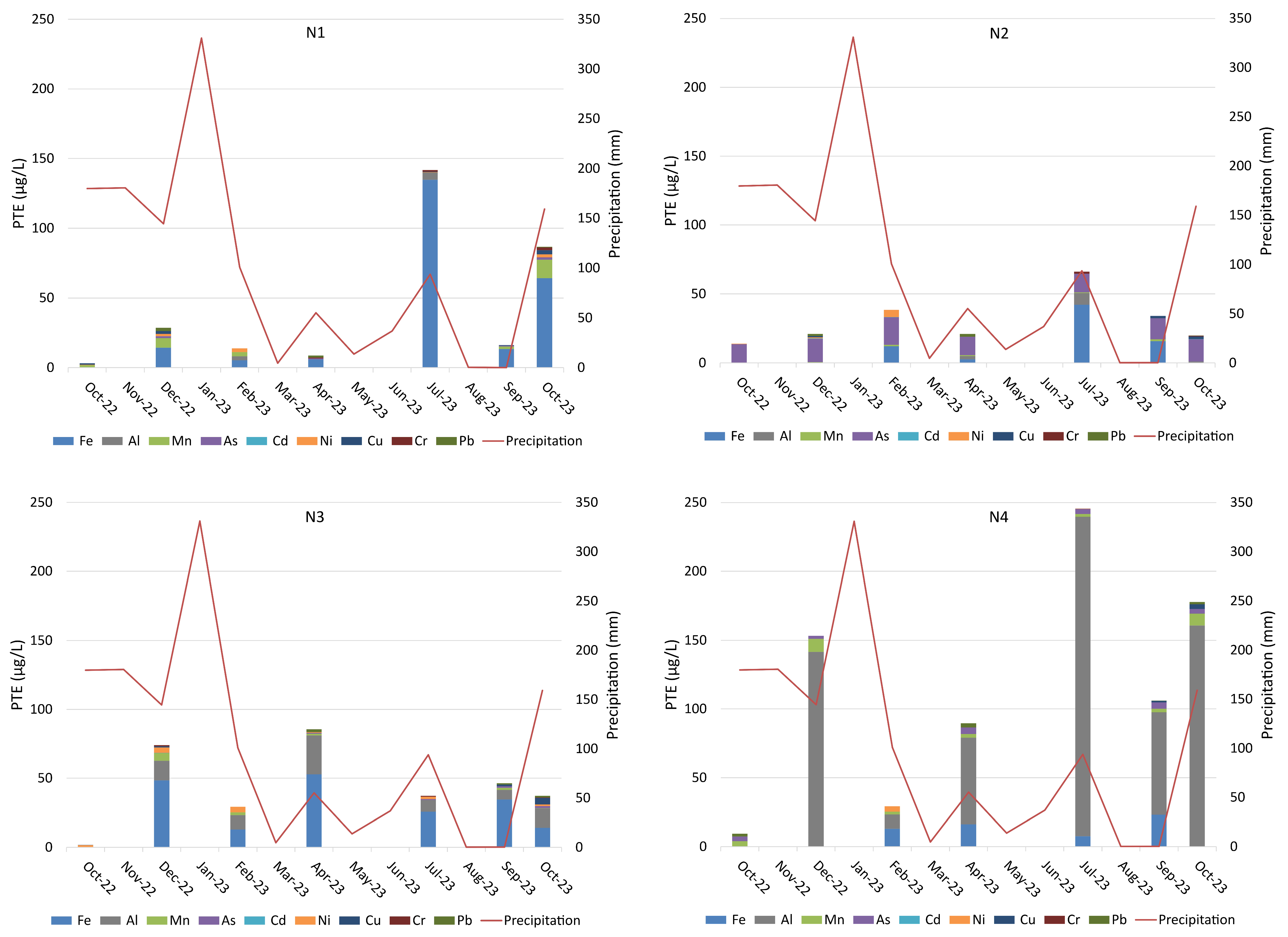
For example, in the N3 spring (Figure 10), located in a burned area, the Mn, Ni, Cu, and Cr concentrations peak in December (and, in the case of Ni, also in February 2023), while this trend is not observed in Fe, Al, As, and Cd. Additionally, the maximum Fe and Al concentrations occur between April and September 2023, during a drought period, at all water points. The relatively high Al contents determined in N4 (unburned area) and N3 (burned area) may be attributed to the weathering of feldspars and phyllosilicates.
Figure 10.
Potentially toxic elements (PTE) and Fe in groundwater (N1–N4 sampling points).
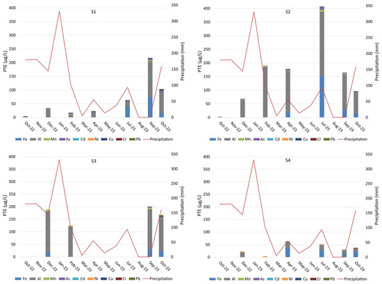
Similar trends in Fe and Al are observed in surface water points (Figure 11). In the remaining PTE, the peak concentrations appear to be distributed throughout the study period, and the influence of wildfire is again not traceable.
Figure 11.
Potentially toxic elements (PTE) and Fe in surface water (S1–S4 sampling points; note that the scale used is different from that in Figure 10).
4.6. Polycyclic Aromatic Hydrocarbons
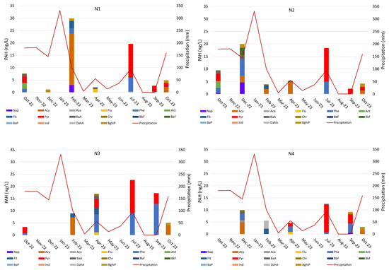
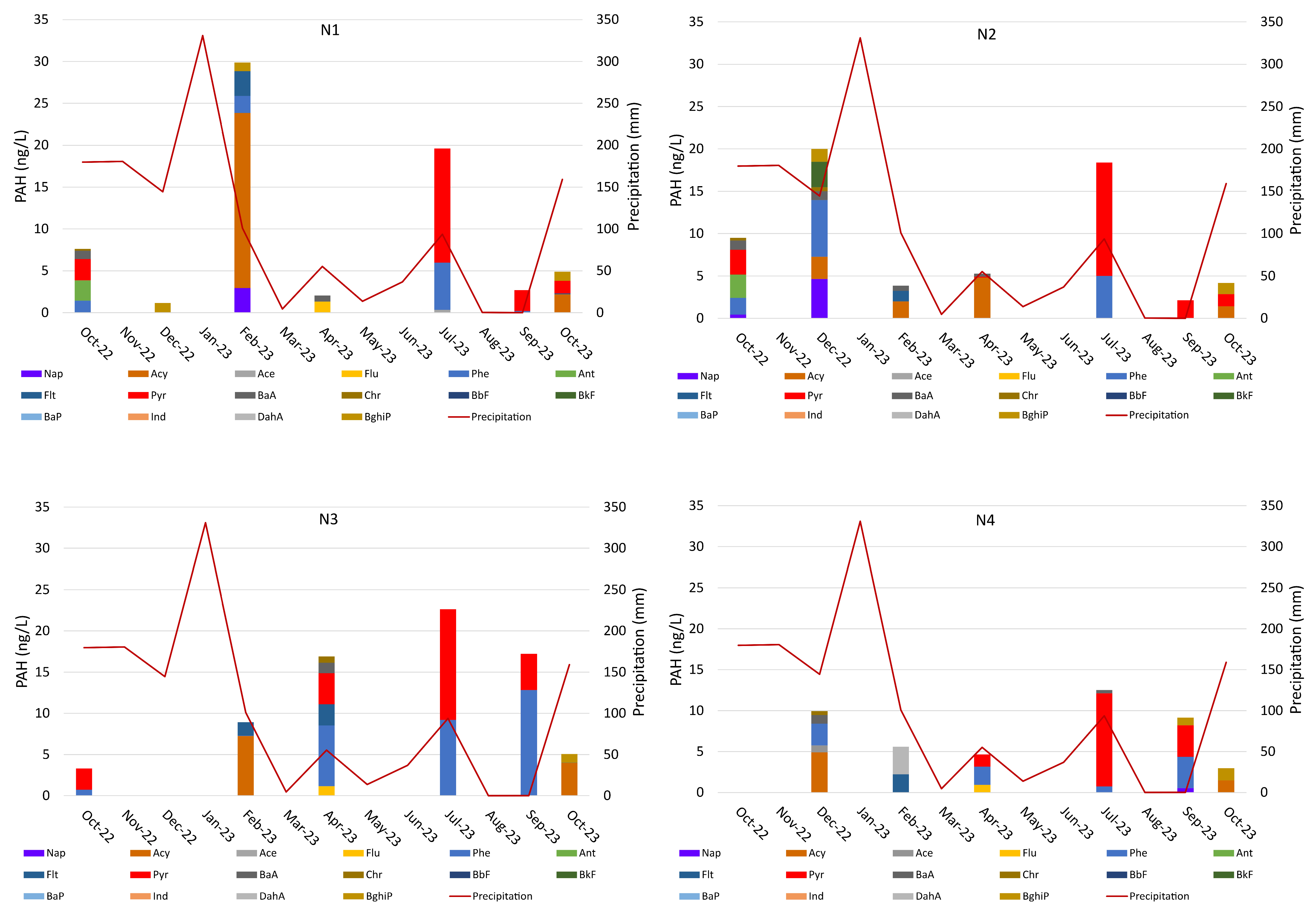
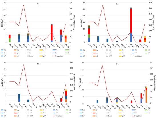
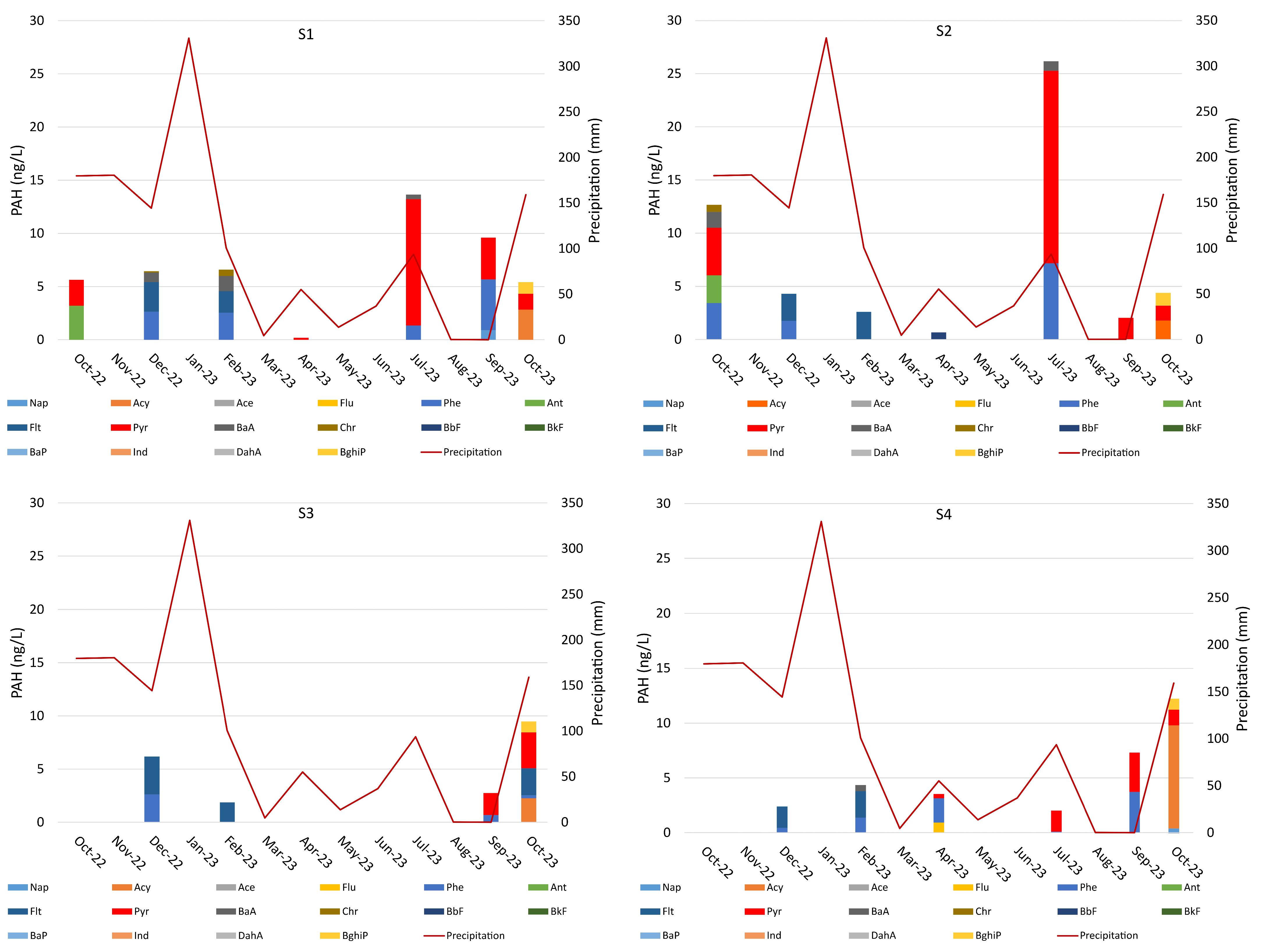
The PAH concentrations in groundwater and surface water are low (under 10 ng/L in most cases) or undetectable, and do not display a distinct wildfire signature. This contrasts with the increase in post-wildfire PAH levels documented in previous research, e.g., refs. [11,50,52]. In groundwater, the most frequent PAH are Phe, followed by Pyr, Acy, BaA, and Crh. In surface water, Phe is, again, the most common PAH, and then Pyr, Acy, Flt, BaA, and Crh.
It should be noted that the overall concentrations and time distribution are quite similar in water points from burned and unburned areas. Indeed, in the N3 spring (burned area) (Figure 12), only Acy shows a peak in the wet season after the wildfire (specifically, 7.24 ng/L in February 2023). In the other springs, the peaks appear in the subsequent sampling campaigns, for instance: 12.83 ng/L of Phe in September 2023; 13.42 ng/L of Pyr in July 2023. The streams (Figure 13) show a similar trend: in S4 (burned area), the highest concentrations of Flt (2.42 ng/L) and BaA (0.55 ng/L) are observed in February 2023. In the remaining PAH, the peaks appear subsequently, for example: 3.72 ng/L of Phe and 3.59 ng/L of Pyr in September 2023). It is also worth noting that the PAH content in samples from S2 may be influenced by the peat area located upstream.
Figure 12.
Polycyclic aromatic hydrocarbons (PAH) in groundwater (N1–N4 sampling points).
Figure 13.
Polycyclic aromatic hydrocarbons (PAH) in surface water (S1–S4 sampling points).
4.7. The Local Drivers of Hydrogeochemistry
Most literature on the impact of wildfire on water chemistry focuses on moderate- to high-severity events, which are commonly associated with significant and long-term effects on aquifers and surface water bodies (e.g., refs. [3,5,10,15,53,54]). Reports of limited effects on water resources remain uncommon, making it particularly important to examine the physical framework and hydrological processes governing the response to the August 2022 Serra da Estrela wildfire.
As reported in Section 4.1, Section 4.2, Section 4.3, Section 4.4, Section 4.5 and Section 4.6, the post-wildfire effects for pH, CE, TOC, major ions, PTEs, Fe, and PAH are not discernible in the analytical results. Indeed, the hydrogeochemical evolution observed for surface water and groundwater following the August 2022 wildfire appears to depend primarily on the normal hydrological functioning of unconfined aquifers and streams.
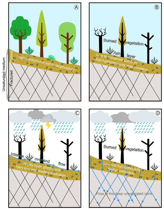
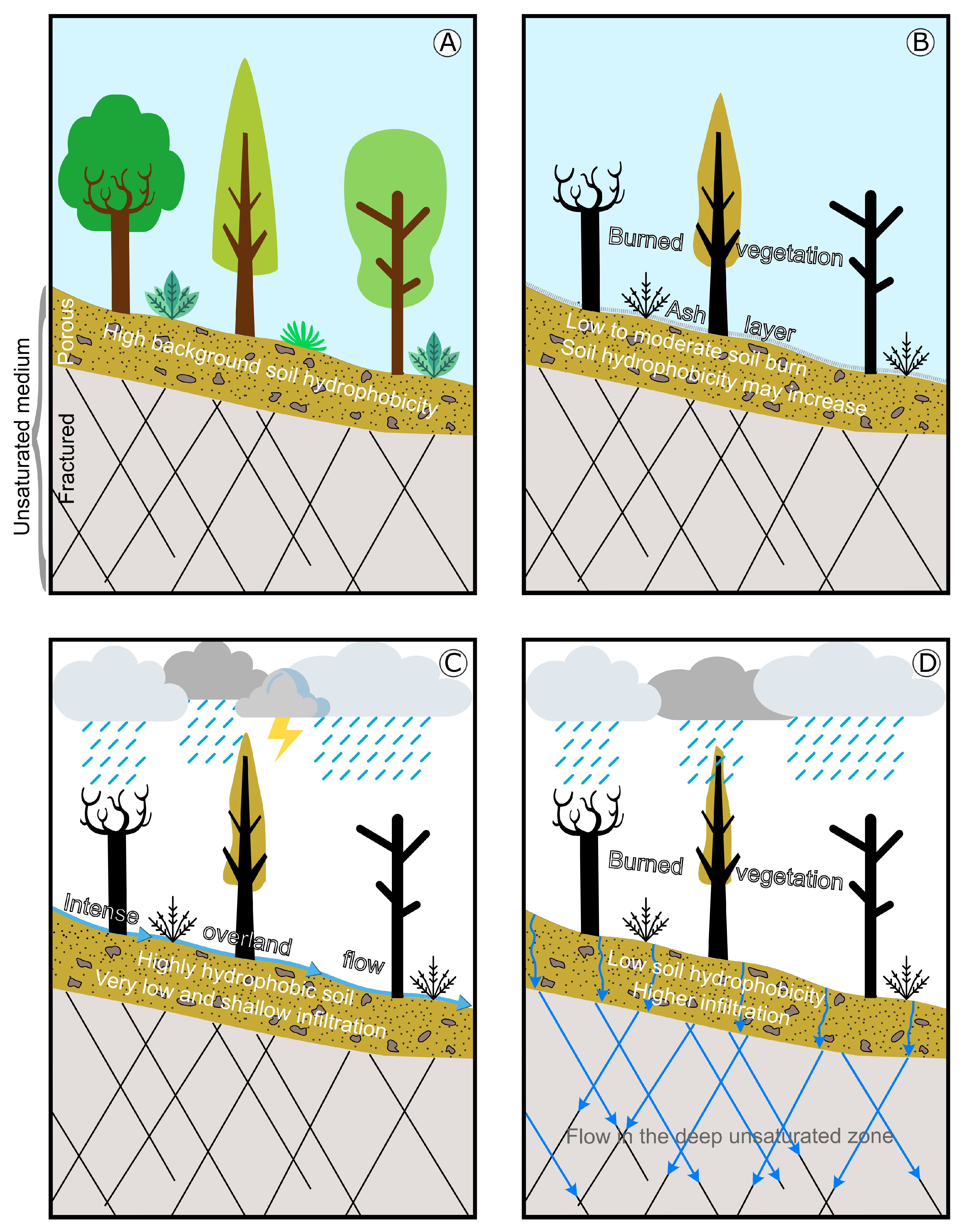
The lack of recognizable hydrogeochemical changes may be attributed to the specific features of this wildfire and their connection to hydrological features and processes, as illustrated in Figure 14. Just prior to the wildfire, in early August 2022, the region experienced persistent drought, which intensified background soil hydrophobicity and likely influenced subsequent hydrological responses (Figure 14A). During the wildfire, despite the often-severe vegetation burning, the severity of soil burning was mostly low to moderate. The early post-wildfire conditions were characterized by the presence of an ash layer and increased soil hydrophobicity (Figure 14B). The first post-wildfire stormy rain episodes in mid-September (prior to any scientific assessments) removed most of the ash layer, the main source of hydrogeochemical changes, due to intense overland flow in a mountainous terrain (Figure 14C), and probably caused a short-term impact on surface water similar to what is described in other studies—e.g., refs. [3,55]. At this stage, the combined effects of severe soil hydrophobicity, steep terrain, and short and intense precipitation events resulted in low and shallow infiltration, effectively restricting aquifer recharge and preventing any major hydrogeochemical impacts on water bodies over the following months. Additional rainfall from October to late November removed the residual ash. Finally, by the time most of the recharge had occurred, between December 2022 and February 2023 (Figure 14D), only minimal traces of the ash layer remained, and, therefore, the charred soil and vegetation could no longer act as a significant source of inorganic and organic contaminants affecting groundwater and surface water bodies.
Figure 14.
Schematic representation of the conditions influencing overland flow, infiltration, and flow in the deep unsaturated zone from early August 2022 until February 2023: pre-wildfire situation (A); early-time post-wildfire conditions (B); mid-September storm event (C); wet season conditions, from December 2022 until February 2023 (D).
Thus, in the research area and during the study period, hydrogeochemistry depended on several environmental factors such as the groundwater flow paths, the occurring bedrock types and their weathering grade [56], soil types, dilution effects after wet periods, changes over time (wet season/dry season) in the tributaries connected to streams, rather than on post-wildfire effects. These findings are in line with the results reported in other studies—e.g., refs. [20,46].
Future research on wildfires in the Serra da Estrela region should include long-term monitoring and modelling of hydrological processes that may be altered under different wildfire severities. It is also essential to evaluate the post-wildfire hydrogeochemical evolution of both inorganic and organic constituents. Further research should investigate how climate change may impact the future frequency and severity of wildfires, as well as the associated hydrological responses. Finally, assessing the long-term implications of wildfires for the availability of high-quality water resources for public supply remains a critical research priority.
5. Concluding Remarks
Water resources from mountain regions are a critical natural resource of major economic, social, and environmental significance. Wildfires disturb the regular hydrologic regime by inducing changes in several hydrological processes like rainfall interception, overland flow, surface runoff, infiltration, percolation, and recharge, and may restrict water supply at the local and regional scale due to the input of contaminants from burned vegetation and soil, thus harming water quality in water bodies. Yet, although wildfires are commonly associated with a decline in water quality, there are cases where their impact is minimal. In some studies, wildfires have even been linked to improvements in water quality or have shown negligible effects.
In August 2022, the Serra da Estrela mountain range was affected by a wildfire that consumed a total area of approximately 270 km2 within the Natural Park and its surroundings, causing significant damage to the vegetation. However, the severity of the soil burning was generally low to moderate in most areas.
The research investigated the extent of hydrogeochemical changes in groundwater (springs) and surface water (streams), in a context where the highest classes of soil burning do not occur. No changes attributed to the wildfire were observed in pH, TOC, EC, major ions, PTE, Fe, and PAH. Indeed, the observed hydrogeochemical stability reflects natural controls related to the geological, geomorphological, hydrological, pedological, and climatic conditions of the mountain environment.
The significance of studying this Serra da Estrela wildfire lies in its analysis of a large-scale event in which the vegetation burn severity was often high, but the soil burn severity remained low to moderate. Additionally, the environmental conditions favouring the rapid removal of the ash layer from September to November 2022 reduced the likelihood of contamination in the local water bodies. Although many studies have documented post-wildfire deterioration in water quality, the temporal evolution of hydrogeochemical parameters in both groundwater and surface water at Serra da Estrela revealed that the hydrogeochemical conditions in groundwater and surface water remained stable. The sole exception was a brief disturbance in stream water associated with the transport of ashes due to intense overland flow during the mid-September storm. Moreover, the contaminant concentrations in the water samples remained within the European Union drinking water standards and the World Health Organization Guidelines for drinking water quality.
Small drinking water systems are particularly vulnerable to rural wildfires, as they often lack the necessary infrastructure and resources to handle sudden changes in water quality. As a result, communities served by these systems face increased risks of waterborne illnesses and long-term health impacts. Protecting public health requires timely water quality monitoring, adaptable treatment strategies, and clear communication with affected populations following wildfire events. These findings have significant implications for the management of water resources and the environmental management of wildfires in mountain regions worldwide. They are also relevant to the decision-making processes of various entities, including local municipalities, the National Civil Protection Authority, the Institute for Nature Conservation and Forests, the Agency for the Integrated Management of Rural Fires, bottled water companies, and the Estrela Geopark.
Supplementary Materials
The following supporting information can be downloaded at: https://www.mdpi.com/article/10.3390/fire9010042/s1, Table S1: Selected features of the sampling points; Table S2: Values of pH, EC, turbidity, TOC and colour determined in all sampling campaigns; Table S3: Values of major ions (mg/L) determined in all sampling campaigns; Table S4: Values of Fe and PTE (µg/L) determined in all sampling campaigns; Table S5: Values of PAH (ng/L) determined in all sampling campaigns.
Author Contributions
Conceptualization, V.M. and J.E.M.; methodology, J.E.M., V.M. and C.M.; validation, V.M., J.E.M., C.M., A.M. and J.R.; formal analysis, V.M., J.E.M., C.M., A.M. and J.R.; investigation, V.M., J.E.M., C.M., A.M. and J.R.; resources, J.E.M. and C.M.; writing—original draft preparation, V.M., J.E.M., C.M., A.M. and J.R.; writing—review and editing, V.M., J.E.M., C.M., A.M. and J.R.; supervision, J.E.M., C.M. and J.R. All authors have read and agreed to the published version of the manuscript.
Funding
This research was funded by national funding awarded by FCT—Foundation for Science and Technology, I.P., projects UIDB/04683/2020 (https://doi.org/10.54499/UIDB/04683/2020), UIDP/04683/2020 (https://doi.org/10.54499/UIDP/04683/2020), and UID/50006/2025—Laboratório Associado para a Química Verde—Tecnologias e Processos Limpos.
Institutional Review Board Statement
Not applicable.
Informed Consent Statement
Not applicable.
Data Availability Statement
The original contributions presented in this study are included in the article and in the Supplementary Materials. Further inquiries can be directed to the corresponding author.
Acknowledgments
The authors thank the anonymous reviewers for their insightful comments and suggestions, which helped improve and clarify this manuscript.
Conflicts of Interest
The authors declare that they have no conflicts of interest.
References
- Viviroli, D.; Weingartner, R. “Water towers”—A global view of the hydrological importance of mountains. In Advances in Global Change Research; Springer: Dordrecht, The Netherlands, 2008; Volume 31, pp. 15–20. [Google Scholar] [CrossRef] [Scilit]
- Somers, L.D.; McKenzie, J.M. A review of groundwater in high mountain environments. WIREs Water 2020, 7, e1475. [Google Scholar] [CrossRef] [Scilit]
- Smith, H.; Sheridan, J.; Lane, J.; Nyman, P.; Haydon, S. Wildfire Effects on Water Quality in Forest Catchments: A Review with Implications for Water Supply. J. Hydrol. 2011, 396, 170–192. [Google Scholar] [CrossRef] [Scilit]
- Liu, Y.; Goodrick, S.; Heilman, W. Wildland fire emissions, carbon and climate: Wildfire–climate interactions. For. Ecol. Manag. 2014, 317, 80–96. [Google Scholar] [CrossRef] [Scilit]
- Mansilha, C.; Carvalho, A.; Guimarães, P.; Marques, J. Water quality concerns due to forest fires: Polycyclic aromatic hydrocarbons (PAH) contamination of groundwater from mountain areas. Toxicol. Environ. Health Part A 2014, 77, 806–815. [Google Scholar] [CrossRef] [Scilit]
- Wildfire Hazards—A National Threat. U.S. Department of the Interior, U.S. Geological Survey Fact Sheet 2006–3015, February 2006. Available online: https://pubs.usgs.gov/fs/2006/3015/2006-3015.pdf (accessed on 1 March 2025).
- Certini, G. Effects of fire on properties of forest soils: A review. Oecologia 2005, 143, 1–10. [Google Scholar] [CrossRef] [Scilit]
- Shakesby, R.A.; Doerr, S.H. Wildfire as a hydrological and geomorphological agent. Earth Sci. Rev. 2006, 74, 269–307. [Google Scholar] [CrossRef] [Scilit]
- Landsberg, J.D.; Tiedemann, A.R. Fire Management. In Drinking Water from Forests and Grasslands: A Synthesis of the Scientific Literature; Dessmeyer, G., Ed.; USDA Forest Service, Southern Research Station: Asheville, NC, USA, 2000; pp. 124–138. [Google Scholar] [CrossRef] [Scilit]
- Neary, D.G.; Ryan, K.C.; DeBano, L.F. Wildland Fire in Ecosystems: Effects of Fire on Soil and Water; General Technical Report RMRS-GTR-42-Vol.4; U.S. Department of Agriculture, Forest Service: Ogden, UT, USA, 2005.
- Mansilha, C.; Duarte, C.G.; Melo, A.; Ribeiro, J.; Flores, D.; Espinha Marques, J. Impact of wildfire on water quality in Caramulo Mountain ridge (Central Portugal). Sustain. Water Resour. Manag. 2019, 5, 319–331. [Google Scholar] [CrossRef] [Scilit]
- Lemieux, P.M.; Lutes, C.C.; Santoianni, D.A. Emissions of organic air toxics from open burning: A comprehensive review. Prog. Energy Combust. Sci. 2004, 30, 1–32. [Google Scholar] [CrossRef] [Scilit]
- Faboya, O.L.; Sojinu, S.O.; Oguntuase, B.J.; Sonibare, O.O. Impact of Forest Fires on Polycyclic Aromatic Hydrocarbon Concentrations and Stable Carbon Isotope Compositions in Burnt Soils from Tropical Forest, Nigeria. Sci. Afr. 2020, 8, e00331. [Google Scholar] [CrossRef] [Scilit]
- Rao, J.N.; Parsai, T. Trends and patterns of polycyclic aromatic hydrocarbons (PAHs) in forest fire-affected soils and water mediums with implications on human health risk assessment. Sci. Total Environ. 2023, 905, 166682. [Google Scholar] [CrossRef] [Scilit]
- Paul, M.J.; LeDuc, S.D.; Lassiter, M.G.; Moorhead, L.C.; Noyes, P.D.; Leibowitz, S.G. Wildfire induces changes in receiving waters: A review with considerations for water quality management. Water Resour. Res. 2022, 58, e2021WR030699. [Google Scholar] [CrossRef] [Scilit]
- Mallah, M.A.; Changxing, L.; Mallah, M.A.; Noreen, S.; Liu, Y.; Saeed, M.; Xi, H.; Ahmed, B.; Feng, F.; Mirjat, A.A.; et al. Polycyclic aromatic hydrocarbon and its effects on human health: An overview. Chemosphere 2022, 296, 133948. [Google Scholar] [CrossRef] [Scilit] [PubMed]
- Keith, L.H. The source of U.S. EPA’s sixteen PAH priority pollutants. Polycycl. Aromat. Compd. 2015, 35, 147–160. [Google Scholar] [CrossRef] [Scilit]
- Sham, C.H.; Tuccillo, M.E.; Rooke, J. Effects of Wildfire on Drinking Water Utilities and Best Practices for Wildfire Risk Reduction and Mitigation; Water Research Foundation Web Report 4482; U.S. Environmental Protection Agency: Washington, DC, USA, 2013.
- Vila-Escale, M.; Vegas-Vilarrúbia, T.; Prat, N. Release of polycyclic aromatic compounds into a Mediterranean creek (Catalonia, NE Spain) after a forest fire. Water Res. 2007, 41, 2171–2179. [Google Scholar] [CrossRef] [Scilit]
- Walvoord, M.A.; Ebel, B.A.; Partridge, T.F.; Rey, D.M.; Rosenberry, D.O. Disparate groundwater responses to wildfire. Wiley Interdiscip. Rev. Water 2025, 12, e70029. [Google Scholar] [CrossRef] [Scilit]
- Murphy, S.F.; Writer, J.H.; McCleskey, R.B.; Martin, D.B. The role of precipitation type, intensity, and spatial distribution in source water quality after wildfire. Environ. Res. Lett. 2015, 10, 084007. [Google Scholar] [CrossRef] [Scilit]
- Giambastiani, B.M.S.; Greggio, N.; Nobili, G.; Dinelli, E.; Antonellini, M. Forest fire effects on groundwater in a coastal aquifer (Ravenna, Italy). Hydrol. Process. 2018, 32, 2377–2389. [Google Scholar] [CrossRef] [Scilit]
- Townsend, S.A.; Douglas, M.M. The effect of a wildfire on stream water quality and catchment water yield in a tropical savanna excluded from fire for 10 years (Kakadu National Park, North Australia). Water Res. 2004, 38, 3051–3058. [Google Scholar] [CrossRef] [Scilit]
- Hahn, G.E.; Coates, T.A.; Latham, R.E.; Majidzadeh, H. Prescribed Fire Effects on Water Quality and Freshwater Ecosystems in Moist-Temperate Eastern North America. Nat. Areas J. 2019, 39, 46–57. [Google Scholar] [CrossRef] [Scilit]
- Lucas-Borja, M.E.; Plaza-Álvarez, P.A.; Gonzalez-Romero, J.; Sagra, J.; Alfaro-Sánchez, R.; Zema, D.A.; Moya, D.; de las Heras, J. Short-term effects of prescribed burning in Mediterranean pine plantations on surface runoff, soil erosion and water quality of runoff. Sci. Total Environ. 2019, 674, 615–622. [Google Scholar] [CrossRef] [Scilit]
- Espinha Marques, J.; Marques, J.M.; Carvalho, A.; Carreira, P.M.; Mansilha, C. Impact of road de-icing on the hydrogeochemistry of groundwater from a mountain area (Serra da Estrela, Central Portugal). Procedia Earth Planet. Sci. 2017, 17, 964–967. [Google Scholar] [CrossRef] [Scilit]
- Instituto da Conservação da Natureza e das Florestas—ICNF. Parque Natural da Serra da Estrela. Instituto da Conservação da Natureza e das Florestas, I.P.: Algés, Portugal. Available online: https://www.icnf.pt/conservacao/rnapareasprotegidas/parquesnaturais/pnserradaestrela (accessed on 16 September 2025).
- Castro, E.; Loureiro, F.; Patrocínio, F.; Gomes, H.; Castel-Branco, J.; Cezar, L.; Fernandes, M.; Azevedo, P. The Estrela UNESCO Global Geopark Territorial Development Strategy: A Holistic Vision for the Twenty-First Century. In Economics and Management of Geotourism; Braga, V., Duarte, A., Marques, C.S., Eds.; Springer: Berlin/Heidelberg, Germany, 2022; pp. 19–46. ISBN 978-3-030-89838-0. [Google Scholar] [CrossRef] [Scilit]
- Instituto da Conservação da Natureza e das Florestas (ICNF). Complexo de incêndios do parque natural da serra da estrela e regiões limítrofes. In Relatório de Estabilização de Emergência Pós-Incêndio (Versão Final); Instituto da Conservação da Natureza e das Florestas, I.P.: Algés, Portugal, 2023. [Google Scholar]
- USAID/USFS. 2022 Portugal Wildfires, Burned Area Emergency Response (BAER) Review; USAID/USFS: Washington, DC, USA, 2022; 83p, Available online: https://www.agif.pt/app/uploads/2023/04/2022-Portugal-Fires-BAER.pdf (accessed on 1 October 2024).
- Soares, E.; David, F.; Rodrigues, P.M.S.M. Challenges for territorial sustainability after forest fires: The case study of the Guarda District. Proceedings 2025, 113, 3. [Google Scholar] [CrossRef] [Scilit]
- Sundseth, K. Natura 2000 in the Mediterranean Region; Wegefelt, S., Ed.; European Commission, Environment Directorate-General, Biodiversity Unit B2: Brussels, Belgium, 2009; 12p, ISBN 978-92-79-11587-5. [Google Scholar] [CrossRef]
- Espinha Marques, J.; Marques, J.M.; Chamine’, H.I.; Carreira, P.M.; Fonseca, P.E.; Monteiro Santos, F.A.; Moura, R.; Samper, J.; Pisani, B.; Teixeira, J.; et al. Conceptualizing a mountain hydrogeologic system by using an integrated groundwater assessment (Serra da Estrela, Central Portugal): A review. Geosci. J. 2013, 17, 371–386. [Google Scholar] [CrossRef] [Scilit]
- Ferreira, N.; Vieira, G. Guia geológico e geomorfológico do Parque Natural da Serra da Estrela. In Locais de Interesse Geológico e Geomorfológico; Instituto da Conservação da Natureza/Instituto Geológico e Mineiro: Lisbon, Portugal, 1999; 112p. [Google Scholar]
- Espinha Marques, J.; Antunes, S.C.; Honrado, J.; Carvalho-Santos, C.; Carreira, P.; Marques, J.; Mansilha, C. Geoethical implications of water pollution by road de-icing: Lessons and way forward in a mountain protected area (Serra da Estrela, Central Portugal). Med. Geosc. Rev. 2021, 3, 349–360. [Google Scholar] [CrossRef] [Scilit]
- AEMET (Agencia Estatal de Meteorología); IM (Instituto de Meteorologia de Portugal). Atlas Climático Ibérico: Temperatura do Ar e Precipitação (1971–2000); AEMET: Madrid, Spain, 2011; 79p. [Google Scholar]
- Mora, C. Climas da Serra da Estrela, Características Regionais e Particularidades Locais Dos Planaltos e do Alto Vale do Zêzere. Ph. D. Thesis, Universidade de Lisboa, Lisbon, Portugal, 2006. [Google Scholar]
- Mendonça, J.M.; Máguas, C.; Pereira, J.M.C.; Fernandes, P.; Viegas, D.X.; Tedim, F.; Keizer, J.; Silva, J.S. Relatório Final—Grupo de Peritos dos Incêndios Rurais (Final Report—Expert Group on Rural Fires) 2023. Available online: https://www.agif.pt/pt/relatorios-nacionais (accessed on 16 September 2025).
- Parson, A.; Robichaud, P.R.; Lewis, S.A.; Napper, C.; Clark, J.T. Field Guide for Mapping Post-Fire Soil Burn Severity; General Technical Report 2010, RMRS-GTR-243; U.S. Department of Agriculture, Forest Service, Rocky Mountain Research Station: Fort Collins, CO, USA, 2010; 49p. Available online: https://www.govinfo.gov/content/pkg/GOVPUB-A13-PURL-gpo2926/pdf/GOVPUB-A13-PURL-gpo2926.pdf (accessed on 24 July 2025).
- ISO 5667-3; Water Quality—Sampling—Part 3: Guidance on the Preservation and Handling of Water Samples. ISO: Geneva, Switzerland, 2003.
- Instituto do Mar e da Atmosfera (IPMA). Boletins Climatológicos 2023. Available online: https://www.ipma.pt/pt/publicacoes/ (accessed on 1 March 2024).
- Instituto do Mar e da Atmosfera (IPMA). Normais Climatológicas—Guarda 2025. Available online: https://www.ipma.pt/pt/oclima/normais.clima/1981-2010/#82 (accessed on 15 March 2024).
- Sánchez-García, C.; Santín, C.; Neris, J.; Sigmund, G.; Otero, X.L.; Manley, J.; González-Rodríguez, G.; Belcher, C.M.; Cerdà, A.; Marcotte, A.L.; et al. Chemical characteristics of wildfire ash across the globe and their environmental and socio-economic implications. Environ. Int. 2023, 178, 108065. [Google Scholar] [CrossRef] [Scilit]
- Jackson, R.; Krishna, K.C.B.; Li, M.; Sathasivan, A.; Senevirathna, L. The influence of recent bushfires on water quality and the operation of water purification systems in regional NSW. Sci. Rep. 2024, 14, 16222. [Google Scholar] [CrossRef] [Scilit] [PubMed]
- Rodríguez-Jiménez, E.; Cruz-Pérez, N.; Koritnik, J.; García-Gil, A.; Ángel Marazuela, M.; Santamarta, J.C. Revealing the Impact of Wildfires on Groundwater Quality: Insights from Sierra de la Culebra (Spain). Chemosphere 2024, 365, 143375. [Google Scholar] [CrossRef] [Scilit]
- Burton, C.A.; Hoefen, T.M.; Plumlee, G.S.; Baumberger, K.L.; Backlin, A.R.; Gallegos, E.; Fisher, R.N. Trace elements in stormflow, ash, and burned soil following the 2009 Station Fire in Southern California. PLoS ONE 2016, 11, e0153372. [Google Scholar] [CrossRef] [Scilit] [PubMed]
- Rodríguez-Cardona, B.M.; Coble, A.A.; Wymore, A.S.; Kolosov, R.; Podgorski, D.C.; Zito, P.; Spencer, R.G.M.; Prokushkin, A.S.; McDowell, W.H. Wildfires lead to decreased carbon and increased nitrogen concentrations in upland arctic streams. Sci. Rep. 2020, 10, 8722. [Google Scholar] [CrossRef] [Scilit]
- Richardson, C.; Montalvo, M.; Wagner, S.; Barton, R.; Paytan, A.; Redmond, M.; Zimmer, M. Exploring the complex effects of wildfire on stream water chemistry: Insights from concentration-discharge relationships. Water Resour. Res. 2024, 60, e2023WR034940. [Google Scholar] [CrossRef] [Scilit]
- Sadler, I.G.; Tronstad, L.M.; Fisher, C.; Hall, R.O., Jr.; Koel, T.M. Yellowstone Wildfires Increased Stream Ion Concentrations and Export. Nitrogen 2024, 5, 1181–1195. [Google Scholar] [CrossRef] [Scilit]
- Banton, O.; St-Pierre, S.; Banton, G.; Laures, N.; Triganon, A. A Review of the Key Impacts of Deforestation and Wildfires on Water Resources with Regard to the Production of Drinking Water. Hydrology 2025, 12, 271. [Google Scholar] [CrossRef] [Scilit]
- Bolan, S.; Sharma, S.; Mukherjee, S.; Gomez Isaza, D.; Rodgers, E.; Zhou, P.; Hou, D.; Scordo, F.; Chandra, S.; Siddique, K.; et al. Wildfires under changing climate, and their environmental and health impacts. J. Soils Sediments 2025, 25, 3173–3197. [Google Scholar] [CrossRef] [Scilit]
- Gorshkov, A.G.; Izosimova, O.N.; Kustova, O.V.; Marinaite, I.I.; Galachyants, Y.P.; Sinyukovich, V.N.; Khodzher, T.V. Wildfires as a Source of PAHs in Surface Waters of Background Areas (Lake Baikal, Russia). Water 2021, 13, 2636. [Google Scholar] [CrossRef] [Scilit]
- Hohner, A.K.; Rhoades, C.C.; Wilkerson, P.; Rosario-Ortiz, F.L. Wildfires Alter Forest Watersheds and Threaten Drinking Water Quality. Acc. Chem. Res. 2019, 52, 1234–1244. [Google Scholar] [CrossRef] [Scilit] [PubMed]
- Cawley, K.M.; Hohner, A.K.; Mckee, G.A.; Omur-Ozbek, P.; Oropeza, J.; Rosario-Ortiz, F. Characterization and spatial distribution of particulate and soluble carbon and nitrogen from wildfire-impacted sediments. J. Soils Sediments 2018, 18, 1314–1326. [Google Scholar] [CrossRef] [Scilit]
- Rhoades, C.; Fegel, T.; Rhea, A.; Heath, J.; Struthers, S.; Willi, K.; Ross, M. Stream Chemistry After Colorado’s Largest Wildfire: Solute-Specific Responses to Ash and Rainstorms. Ecosystems 2025, 28, 55. [Google Scholar] [CrossRef] [Scilit]
- International Society for Rock Mechanics (ISRM). Rock Characterization Testing and Monitoring: ISRM Suggested Methods; Pergamon Press: Oxford, UK, 1981. [Google Scholar]

Disclaimer/Publisher’s Note: The statements, opinions and data contained in all publications are solely those of the individual author(s) and contributor(s) and not of MDPI and/or the editor(s). MDPI and/or the editor(s) disclaim responsibility for any injury to people or property resulting from any ideas, methods, instructions or products referred to in the content. |
© 2026 by the authors. Licensee MDPI, Basel, Switzerland. This article is an open access article distributed under the terms and conditions of the Creative Commons Attribution (CC BY) license.