


Abstract
Drones are being used for agriculture monitoring in many different crops. Nevertheless, the use of drones for green areas’ evaluation is limited, and information is scattered. In this survey, we focus on the collection and evaluation of existing experiences of using drones for turfgrass monitoring. Despite a large number of initial search results, after filtering the information, very few papers have been found that report the use of drones in green areas. Several aspects of drone use, the monitored areas, and the additional ground-based devices for information monitoring are compared and evaluated. The data obtained are first analysed in a general way and then divided into three groups of papers according to their application: irrigation, fertilisation, and others. The main results of this paper indicate that despite the diversity of drones on the market, most of the researchers are using the same drone. Two options for using cameras in order to obtain infrared information were identified. Moreover, differences in the way that drones are used for monitoring turfgrass depending on the aspect of the area being monitored have been identified. Finally, we have indicated the current gaps in order to provide a comprehensive view of the existing situation and elucidate future trends of drone use in turfgrass management.
1. Introduction
In the last several decades, the use of drones for multiple and diverse tasks has increased exponentially. Among these tasks, one of the most common has been monitoring different surfaces as a more flexible alternative to remote sensing based on satellite imagery, which is characterised by a greater resolution [1]. This monitoring is especially important in fields such as agriculture, where the application of new technologies, such as drones and sensors, has created the apparition of precision agriculture, allowing fast and automatic monitoring of the fields [2]. Even though the use of drones in agriculture is widespread, there is a particular type of agriculture, turfgrass production, in which drones are less often used. Turfgrass production consists of the maintenance of green areas, or lawns, in the urban or periurban space and has multiple benefits for the physical and mental health of citizens [3]. These green areas might be split into two big groups: gardening lawns and sports lawns. Multiple studies have indicated the importance of these lawns for the population and how green areas help to reduce atmospheric pollution. Nevertheless, the maintenance of lawns, particularly in arid or semiarid regions, involves several inputs which directly affect their environmental impact [4].
The application of technology in lawns is vital given the high requirements that characterise their maintenance and their need in cities [5]. Drones have been used in lawns mainly to monitor their response to different alternative treatments aimed at improving their quality and to evaluate and detect unseen needs. Nevertheless, drones have not been the sole information source to capture images. Their application coexists with satellite-based remote sensing and ground-based proximal sensing [6].
Considering the broad possible application cases and the variability of target journals, the knowledge generated on this topic is scattered, and it might be challenging to have a general view of the real application of drones in lawn monitoring. Moreover, the unclear identification of sources from images, which also come from ground-based vehicles, and the lack of clear identification of the monitored crop in some cases make it extra difficult for lectors to be informed about the current status of these technologies. Even though multiple surveys have appeared in recent years, none have focused on using drones for turfgrass monitoring. Some surveys focused on the use of drones for agriculture [7,8,9], while others detailed the use of spectral sensing and precision management of turfgrass [10,11]. Thus, a survey focused on the application of drones and unmanned autonomous vehicles (UAVs) in turfgrass monitoring is needed to gain a solid knowledge of the current situation, identify the gaps and current challenges, and point out the expected future trends.
The aim of this paper is to collect and evaluate the current experiences and uses of drones for monitoring turfgrass in lawns. The information was collected and analysed in January and February of 2024, including papers published in journals and conference proceedings, among others. From each document, information about monitored turfgrass using drones and additional information sources has been analysed. Regarding drones, data about used drones or UAVs (model and brand), flying height (the distance from the drone to the ground or turfgrass), periodicity among flights (temporal difference between conducted monitorisation), and used cameras (including the number of bands and to what wavelengths they are sensible) are some of the most important summarised information. Among the turfgrass information, we have analysed data about grass species (if the lawn is composed of a sole species or mixed species and which species are involved), lawn location (geographical location), and types of lawns (according to their use, we differentiate gardening and sports lawns). Concerning the additional information sources, we have outlined the most relevant equipment used in combination with the drones, such as sensors or ground-based cameras. In this survey, the information is initially analysed in a general way. Then, similar papers are joined in order to evaluate in detail the state of the art of each type of application case. Among application cases, we highlight the two most important ones: the control over irrigation or hydric stress (which are related to the efficiency of water use in the lawns) and the use of fertilisers and biostimulants (mainly linked to assessing the optimal dose). Finally, the use of drones for other purposes, such as weed detection (identification of undesired plant species in the lawn), stress evaluation (assessing the grass status altered by ambiental or biological factors beyond irrigation), phenotyping (recognising the different organisms based on their characteristics or aspect), or establishment (evaluating the exit in the initial steps after grass germination before forming the lawn), is analysed.
The rest of the paper is structured as follows; Section 2 describes the methodology followed to collect the papers. The general findings, which also include the filters for whether or not to include them in the survey, are summarised in Section 3. Then, Section 4 focuses on drones used for monitoring irrigation, while Section 5 focuses on monitoring the use of fertilisers and biostimulants. The application of drones for monitoring other aspects of lawns is evaluated in Section 6. Meanwhile, Section 7 establishes the current challenges and future trends in the use of drones for lawn monitoring. Finally, the main conclusions of this survey are presented in Section 8.
2. Materials and Methods
In this section, the methodology followed to find, collect, evaluate, and analyse the current contributions included in this paper is presented. In this study, we conducted a systematic literature search utilising three widely utilised databases: Web of Science (WOS), SCOPUS, and Google Scholar. To conduct the evaluation presented in the paper, the following research questions are considered:
- Which are the most commonly used drones for lawn monitoring?
- Which are the most commonly used cameras for lawn monitoring?
- What are the current uses of drones for lawn monitoring?
- Are drones more used in some sorts of lawns?
- Are drones used differently to monitor different aspects of turfgrass?
- What information sources are combined with drone monitoring to ensure correct lawn monitoring?
The search was centred around specific keywords related to the use of UAVs or drones in turfgrass management, incorporating terms such as “irrigation”, “fertiliser”, “weeds”, “biostimulant”, and “stress”. In order to collect the scattered information to answer these questions, the authors used multiple search engines to search the papers included in this survey. The initial search was conducted with WOS and Scopus.
The search strategy involved applying specific filters for each database. For WOS and SCOPUS, the filters included “Title or Topic”, “Title or Abstract”, and “Title, Keywords, Abstract”, while for Google Scholar, it encompassed “Articles”. Among the identified keywords, the highest number of records (n = 18) were retrieved for “turfgrass UAV” in SCOPUS, employing the filter “Title, Keywords, Abstract”. Subsequently, WOS yielded n = 12 records for the same keyword using the filter “Title or Abstract”. Nonetheless, no records were located either in WOS or in SCOPUS when “fertiliser” or “weeds” were used as the third term.
In contrast, Google Scholar produced varying numbers of documents for each keyword, with the highest count of n = 1300 for “turfgrass UAV” and the lowest count of n = 265 for “turfgrass drone biostimulant”. Figure 1 displays a summary of the literature search results, including the corresponding document counts. This comprehensive search strategy allowed for the identification and comparison of relevant literature across multiple databases, providing insights into the extent of existing research on the specified keywords in the context of turfgrass and UAV applications.
Figure 1.
Total number of documents found in the initial conducted search.
3. Management of Found Results and General Findings
In this section, the details related to how collected papers were processed are given. Moreover, the general findings are provided.
3.1. Filtering the Collected Documents
From the information collected in the Google Scholar search, documents found using the drone or UAV keywords of each topic (irrigation, fertiliser, weeds, biostimulant, and stress) were joined, removing the duplicated cases. The number of papers collected for each topic in the conducted searches is as follows: irrigation, 89 documents; fertiliser, 90 documents; weeds, 67 documents; biostimulant, 86 documents; and stress, 88 documents. Thus, a total of 420 different documents were obtained. Considering that multiple documents appeared in the different searched topics, a total of 268 papers were obtained from these searches, which indicates an overlap of 36.20% in the found papers. This high overlapping in documents with different keywords (irrigation, fertiliser, weeds, biostimulant, and stress) indicates that the content on this topic is quite limited, which is aligned with information obtained in WOS and Scopus. These 268 papers, referred to in this article as found documents, were then downloaded and evaluated to check whether the authors have included drones and used them in lawns.
First, the documents corresponding to the thesis, surveys, and review were removed to avoid the duplication of results with the published papers and conferences. There were a total of 26 theses, 5 of which were totally related to the included topics [8,9,10,11,12], drones and turfgrass, all of them from the USA. Then, 3 theses were linked with drones applied in other crops, and 12 theses were focused on turfgrass, which does not clearly indicate if drones were used. Finally, in the search, there were two theses that were not related to the topics. It must be noted that among the 55 found surveys and reviews, none of them were focused on drones for turfgrass, only 1 was focused on drones (for general agriculture) [13], and 3 of them were focused on precision turfgrass management [14,15,16]. There were four surveys focused on the use of new technologies for agriculture [17,18,19,20] and three about plant nutrition [21,22,23].
After removing the theses, surveys, and reviews, the next step was to determine which documents should be included in the survey. After carefully checking the documents, only 40 corresponded to documents in which the authors used drones to monitor lawns. These documents included conference papers, academic papers, posters, book chapters, and news in specialised magazines. It is important to highlight that 3 papers which seemed to include drones in turfgrass could not be included since it was not possible to access them [24,25,26]. Thus, the total number of included documents in the survey is 37. A flowchart that illustrates the paper selection and exclusion process can be seen in Figure 2.
Figure 2.
Flowchart of the conducted search.
On the one hand, it must be noted that even though some papers dealt with the use of drones for turfgrass monitoring, the images they gathered were obtained with static [27] or handheld devices [28,29,30,31] or by on-ground-vehicles [32,33,34] rather than from cameras on drones. Meanwhile, in other cases, satellite imagery was used [35]. This was a considerable obstacle in the selection of papers. In some cases, even though the authors mentioned the use of remote-sensing imagery, no indication about the used drones or UAVs was provided, and thus, it cannot be ensured that aerial vehicles were used [36,37]. Moreover, some articles focused on developing or adapting new cameras for turfgrass monitoring, but no drones were used [38].
On the other hand, in the results of the search, more than 60 documents that analysed other crops appeared. These other crops included citriculture [39], maize [40,41], wheat [42], beans [43], African eggplant [44], red lettuce [45], barley [46], sugarcane [47,48], vineyard [49], rice [50], chilli [51], cabbage [52], and soybean [53], among others. Finally, it is important to highlight that in some cases, even when the title indicates that the paper focuses on turfgrass images, the acquired images may contain information for other types of areas, such as in Perea-Moreno et al. [54].
3.2. Comparative Analyses of Collected and Filtered Data
A comparative analysis consisting of the documents found and included was conducted. These comparative analyses include aspects such as the number of contributions per year, country, and type of contribution (journal paper, conference paper, book chapter, thesis, etc).
The number of contributions per year can be seen in Figure 3. The information for the year 2024 has not been included in the graphic, since data were collected at the beginning of the year. It can be seen that there is a clear tendency in the evolution of this topic. Concerning the found documents, scattered publications can be found since 2009. Nevertheless, since 2016, this topic has been gaining popularity, with maximum publication rates in 2023 (last year). Nevertheless, the papers that were included focused on real-use drones and turfgrass. The peak of publications was in 2022. Thus, we can conclude that the application of drones in turfgrass has been delayed for a couple of years due to similar topics. This information is crucial, and it might indicate that this is a topic in expansion and that, in the upcoming years, multiple contributions to this area are expected.
Figure 3.
Tendency in the published included and found documents in the search.
Data concerning the global distribution of authors from found and included documents can be seen in Figure 4. While Figure 4a details the location of affiliations of authors in the found documents, Figure 4b summarises the information for the included documents. For assessing the location of affiliations, the following rules were followed: if there are multiple affiliations for the authors in the same paper, the assigned affiliation is that of the majority of the authors; if an equal number of authors have different affiliations, the assigned affiliation is that of the first author. The great majority of the found documents were written by authors with USA affiliations, with 105 documents. The other contributing countries in terms of producing documents are Italy (19 documents), Spain (18 documents), China (15 documents), and India (15 documents). Focusing on the included documents, again, the USA is the country with the greatest number of contributions (20 documents), followed by Italy with 4 documents, Spain with 3 documents, and Turkey and Korea with 2 documents each.
Figure 4.
Affiliation of authors of the (a) found and (b) included documents.
Finally, in Figure 5, we summarised the words contained in the title using a word cloud generator [55]. The top 25 most representative words from the found and included documents can be seen. Some differences are observed between both clouds. In the one from the included documents, it is possible to observe that words such as remote, sensing, unmanned, aerial or imagery appeared more frequently than in the found documents. It is worth highlighting that the keywords “drone” and “UAV” appeared with less frequency than turfgrass in the titles. Another aspect to be mentioned includes the words “review” and “management”, which appeared in the word cloud of found documents and did not appear in the word cloud of the included documents due to the removal of reviews and general documents.
Figure 5.
Word clouds of the found and included documents.
3.3. General Findings
Given the scarcity of publications on turfgrass management, we categorised the obtained documents into three clear classifications—“Irrigation and Water Stress”, “Fertilisers and Biostimulants”, and “Others”—to enhance user comprehension. Within the “Irrigation and Water Stress” category, all documents pertaining to studies on water stress and irrigation utilising drones were included. The category “Fertilisers and Biostimulants” encompassed documents focusing on turfgrass nutrition and quality, specifically addressing fertiliser and biostimulants. Any document not falling into these specified groups was categorised as “Others”. The year 2023 exhibited the highest number of documents (n = 5) in the “Irrigation and Water Stress” category, followed closely (n = 4) by 2021 and 2019. Conversely, no documents were identified under the “Fertilisers and Biostimulants” category for the years 2020, 2022, 2023, and 2024. A comprehensive overview of the annual publication distribution is presented in Figure 6.
Figure 6.
Topics of the included documents from 2016 to 2024.
In the following section, we analyse some of the generally studied aspects for the different categories. First, the drone models used are shown in Figure 7. For enhanced visualisation, the possible differential traits linked to different possible configurations as available cameras, such as the Phantom 4 multispectral or the inclusion of RTK stations, have not been included in this graphic. The most commonly used drone model is the Phantom 4. Then, the Matrice 210, S800 EVO, and Bebop-Pro Thermal from Parrot (Paris, France) are equally used. Some aspects to be highlighted are the inclusion of a tailored drone in one of the studies and the high predominance of the DJI (Shenzhen, China) brand. It must be noted that, in some cases, the authors used more than one drone in the same study. Concerning the flying height, there are no significant great topics in terms of minimum and maximum distances, as seen in Figure 8. The flying height is generally below 100 m, with a few exceptions. The average flying height is greater for irrigation and fertilisation uses.
Figure 7.
Models of the used drones in the included papers. Different colours indicate different manufacturers. Dark blue, DJI; Orange, Parrot; Green, 3D Robotics (Berkeley, CA, USA); Light blue, MikroKopter (Moormerland, Germany); Grey, AgEagle (Wichita, KS, USA); and Black, no information about the manufacturer.
Figure 8.
Flying height of drones in the studies of different categories.
In the context of the established categories, an analysis of turfgrass genera revealed notable frequencies, with the Lolium genus being the most prevalent (n = 4) in the “Irrigation and Water Stress” category. Following closely were the Poa, Stenotaphrum, and Zoysia genera, each with a frequency of three occurrences. In the category of “Fertilisers and Biostimulants”, the Paspalum genus emerged as the most frequently utilised (n = 3), followed by Cynodon, Festuca, Lolium, Poa, and Zoysia genera, each appearing twice. Meanwhile, no specific genus featured prominently in the remaining studies. Figure 9 provides a concise summary of these findings.
Figure 9.
Grass genus used in the included studies.
4. Drones for Monitoring Plant Hydric Stress and Irrigation Performance
In this section, the use of drones for turfgrass monitoring in studies where irrigation or hydric stress is evaluated is compared. First of all, the different drones used, their characteristics, and how drones are used are reviewed. Then, the grass species used and the details of the studies that were conducted are presented. Finally, additional information sources such as in situ or handheld sensors are reported.
4.1. Drones Used
This subsection provides details on drones used for irrigation and hydric stress monitoring. There are two papers in which authors used two drones [56,57], but in the rest of the cases, only one drone was used. The reason for using two drones in [56] is due to the limitations of the bands in each drone and the incapability of changing the camera of selected drones (IRIS+ and S800 EVO). The different drones used are summarised in Figure 10. The most commonly used drones are from DJI, used in more than 60% of cases [24,56,57,58,59,60,61,62,63,64,65,66], followed by 3D Robots with three cases [56,67,68], Parrot [69,70], and eBee X [57,71]. The most commonly used model is the S800 EVO [56,57,58] (more information in [72]) and Matrice 200 (more information in [73]) [24,60,61], followed by the Phantom 4 [63,64] (more information in [74]) and Bebop-Pro Thermal [69,70] (more information in [75]), and AgEagle [57,71] (more information in [76]) which is used twice. There are several models which are only used once: Phantom 2 [65], Matrice 300 RTK [66], Matrice 600 Pro [62], Inspire 2 [59], IRIS+ [56], Solo [67], and X8 [68]. More information on the aforementioned drones can be found in [77,78,79,80,81,82,83]. There is one particular case in which no information about the model of the drone used is provided since the data were captured by an external company (GreenSight) [84].
Figure 10.
Brands and models of drones used in hydric stress monitoring.
Considering the type of drone propulsion system, see Figure 11a, fixed-wing drones are used in only two cases [57,71]. The most commonly used drones are the quadcopters, used up to six times [24,56,59,60,63,64,65,67,69,70], followed by hexacopters, which are selected in five cases [56,57,58,61,62,84], and octocopters [66,68]. It should be noted that the information about propulsion systems has not been provided in all of the papers, and these data come from the manufacturers’ web pages [72,73,74,75,76,77,78,79,80,81,82,83]. Regarding the flying height, indicated in this paper as the distance to the ground, there is a high heterogeneity; see Figure 11b. The average distance to the ground is 52 m. There is a high percentage of cases in which the drones are equal to or below 25 m [56,57,58,64,66,67]. On four occasions, the drones were used at a distance to the ground from 25 to 50 m [57,61,67]. Then, we found some cases in which drones flew at greater heights, 55 m [59], 75 m [57,71], 80 m [60], 100 m [65], 119 m [63], and 120 m [84]. It might be noted that the case with the greater height corresponds to the fixed-wing drone, which an external company provided.
Figure 11.
Additional details of drones used in hydric stress monitoring. (a) Type of drones and (b) distance to the ground (histogram).
In the following, the details of the cameras used for monitoring irrigation are analysed. As in the case of drones, not all the documents provide full information about the details of the cameras used, and manufacturers’ web pages are consulted to provide accurate data. First of all, in Table 1, we describe the cameras used when a camera was used with drones. It must be noted that some of the drones mentioned in the previous paragraphs have their own cameras, such as the DJI Phantom 4. The cameras included in Table 1 correspond to cases in which an additional camera is used. In this table, we have added information related to the sensors used for image obtention and other additional technical notes. One of the most common manufacturers is Cannon (Ōta, Japan), with the PowerShot S100 [56,57,58] and the PowerShot SX260 HS [65] and an additional publication for which no details of the used model are given [68]. It must be noted that in most cases, Canon cameras are modified by adding a filter from Llewellyn Data Processing, allowing the capture of NIR data. The other highlighted manufacturer is AgEagle, with the models MicaSense RedEdge MX [57,71], MicaSense RedEdge-M [44,60,66], and Altum [61,62]. The cameras produced by GoPro (San Mateo, CA, USA) are also used for turfgrass monitoring, including the GoPro Hero 4 [67] and other models [68]. Other manufacturers include FLIR (Wilsonville, OR, USA) [56], Sentera (Saint Paul, MN, USA) [63], Slantrange (San Diego, CA, USA) [24], MAPIR (San Diego, CA, USA) [67], and DJI [60]. The last manufacturers, jointly with AgEagle, provide cameras specialised for drones and have additional bands beyond the RGB included in the Canon cameras, which might have variable resolutions for the different bands. One common sensor type is the Complementary Metal–Oxide–Semiconductor (CMOS), which is included in the Cannon PowerShot S100 camera, among other traditional cameras. Another type of sensor is the Downwelling Light Sensor (DLS) which is used by AgEagle camera manufacturers. Finally, a specific sensor for the longwave infrared (LWIR) sensor is used for FLIR manufacturing.
Table 1.
Summary of cameras used for hydric stress monitoring.
Regarding the quantity of bands utilised in the generated images, an average of four bands is typically employed: see Figure 12. There were four cases that used three bands, including blue and green in all of them, but had different information from the third band, which can include red [68] or near-infrared (NIR) [57,58,65] if filters are used. Three studies included cameras with four bands, including thermal data [69,70] or NIR [59] beyond the RGB bands. There were six studies in which five bands were used. Generally, these bands included RGB + RedEdge + NIR [57,63,64,66,71]. Nevertheless, there were two different cases. In one case, the bands included RGB + NIR + Thermal [84], and the other included green, blue, and NIR and two bands relative to the midwave infrared (MWIR) and longwave infrared (LWIR) [56]. The use of six bands was found in four studies which had information about RGB9RedEdge + NIR data. There was some heterogeneity in the sixth used band, which included, in some cases, the LWIR data [60,61,62], and the other cases included the NarrowRed band [24]. The case in which more bands were used is shown in [67], where seven bands were captured (RGB + RedEdge + NIR + Thermal + LWIR). The band most commonly used beyond blue and green was the NIR, followed by red and redEdge, with 15, 14, and 9 uses each.
Figure 12.
Bands used for hydric stress monitoring. The document names included in the image correspond to the following references: A.P. Bach (2022a) [57], M. Hong (2019) [58], K. Ding (2016) [68], H.M. Fernandez (2019) [65], S.S. Mutlu (2023) [59], P.V. Mauri (2020) [69], Y. Yousfi (2022) [70], M. Hong (2019) [56], C. Wang (2024) [66], A.P. Bach (2022b) [71], K.-B. Ku (2023) [64], R. Kerry (2023) [63], J. Friell (2022) [83], A.P. Bach (2022a) [57], R. Berger (2021) [60], G.B. Rockstad (2024) [61], T. Wang (2021) [24], K. Meza (2023) [62], and J. Zhang (2019) [67].
Regarding the use of software for drone flight planning and image processing, the available information in the documents is limited, see Figure 13. The planning software is detailed only in seven cases, with the most commonly used one being the Mission Planner, which has been used with the Iris+ [56] and the S800EVO [56]. DJI Pilot has been used with the Matrice 210 [61]. Other used software includes AggieAir sUAS [62], DJI Ground Station 4.0 [65], DJI GO [64], and Tower Beta from DroidPlanner [67]. Concerning the drone image processing software, even though the software used has not been indicated in some cases, there is more information. The most commonly used software types are the Pix4D Mapper [24,60,64,67], which enables the creation of accurate 3D models and maps from aerial imagery captured by drones, and ArcGIS [57,61,65,67,71], which is used for remote sensing and Geographic Information Systems (GIS) application, used five times each. Then, two pieces of software stand out with four uses each: Agisoft Metashape [57,61,62,71] and Agisoft Photoscan [56,57,58,65]. It must be noted that both pieces of software are the same; Agisoft Metashape is the current name of the software after the last update. Agisoft Metashape is a self-contained software tool designed to carry out photogrammetric processing on digital images. With fewer users, we can also highlight BreedPix 0.2 as selected in [69,70], used to process digital images with no specific remote- or proximal-sensing functionalities. Other pieces of software used include DroneDeploy [63], which is a specific software used to apply certain corrections and create orthomosaics with images captured with drones, among other uses. Other software is specific to certain manufacturers for the data management of their thermal cameras.
Figure 13.
Image processing and flight planning software used for hydric stress monitoring.
The last analysed parameters from drone flights are the number of flights and their periodicity. These data are summarised in Figure 14. To simplify the information, we have only included the documents which include this information. Most of the papers have less than five flights, the most common number of flights is three [24,61,69,84] followed by five [59,62,63,64]. Other cases include having two flights [71], six flights [70], and seven flights [56]. There are some cases in which a significantly higher number of flights are included, having 12 flights [59] and up to 30 flights [66]. The periodicity of the flights is not directly related to the number of flights and has great variability, from flying weekly [24,57,61,66,84], having two flights per month [56,69,70,71], or having flights monthly [64,67]. There are some cases in which, even though the number of flights is included in the documents, their periodicity is not given, or the distribution of flights over the studied period is not uniform [62]. Finally, there are four cases in which the authors do not provide information about the number or periodicity of drone flights [56,58,60,65,68].
Figure 14.
Number of flights and periodicity for hydric stress monitoring.
4.2. Studied Types of Grasses
In this section, a comprehensive examination of agronomic parameters is provided, encompassing variables such as the selected turfgrass species, the experimental design (distinguishing between real-world and controlled experimental settings), the geographic location or city where the experiments were conducted, and the composition of the turfgrass, classified by either monoculture or mixed-culture configurations. This discussion aims to furnish a thorough overview of turfgrass management practices utilising drone technology.
The investigations into irrigation-related aspects of turfgrass encompassed both sports and gardening lawns. Approximately 72% of all studies focused on sports lawns [59,64,66,67,69,70], with gardening lawns accounting for 36% [56,58,60,62,63,65,71,84]. Notably, specific information regarding the type of lawn was not provided in 45% of the cases, as illustrated in Figure 15. Studies centred on sports lawns dedicated one-third of their experiments to real sports lawns, while a smaller percentage (25%) utilised test samples [56,59,64,66,71]. Conversely, research on gardening lawns exhibited a higher prevalence of studies (75%) conducted on test samples compared to real samples (25%). Additionally, studies that did not specify the type of lawn constituted 40% of experiments involving real samples [24,57,68].
Figure 15.
Types of monitored lawns in terms of use for hydric stress monitoring.
The botanical insights into related turfgrass species prove valuable for ongoing research and development initiatives, suggesting adaptability to diverse climates and parameters conducive to biodiversity. In the realm of irrigation and water stress studies, those focusing on a single species (monoculture) comprised 52% of all investigations [57,58,64,66,68], as illustrated in Figure 16. Predominantly studied genera in monoculture experiments included Agrostis, Poa, Schedonorus, Festuca, Buchloe, Zoysia, and Stenotaphrum. Nonetheless, 23% of studies explored mixed species of turfgrass, with Cynodon, Zoysia, Stenotaphrum, Lolium, and Poa being frequently investigated genera [60,61]. In particular, some studies did not explicitly disclose this botanical information [24,62,65,84].
Figure 16.
Types of monitored lawns in terms of composition for hydric stress monitoring.
The preeminent focus on investigating various facets of turfgrass is notably observed in the United States of America (USA), where approximately 57% of studies within the “Irrigation and Water Stress” category were conducted [24,56,58,61,62,63,67,68,71,84]. Following the USA is Alcalá de Henares in Spain, contributing to 11% of the studies [69,70]. Within the USA, the research was predominantly carried out in cities and states such as California, Georgia, Manhattan, Michigan, North Carolina, North Dakota, Pomona, and Utah. Other countries, including China, Portugal, South Korea, Switzerland, and Turkey, have also been documented for their involvement in turfgrass-related studies [59,60,64,65,66]. A detailed breakdown of the number of documents published from each location, both collectively and by city, is presented in Figure 17.
Figure 17.
Location of monitored lawns for hydric stress monitoring.
4.3. Additional Information Sources
In this section, we summarised the other equipment used in the studies, such as drones, for irrigation or hydric stress monitoring. Among the 18 included studies, complementary information was reported in 13. Two big groups of devices can be differentiated: soil monitoring devices and turfgrass monitoring devices. Concerning the soil parameters, soil moisture is the most studied. For the grass, different crop monitoring equipment is used to evaluate the impact of the hydric stress.
For turfgrass monitoring, two options were found: using visual indexes and using specific devices such as RGB cameras or specific crop monitoring devices to measure vegetation indexes. Quality evaluation by means of rating was conducted in most of the cases following the recommendation set in [99]. This rating varies from 1 to 9 (1 = dead turf, 9 = uniform, green and dense turf, and 6 = minimally acceptable turf) and includes different parameters such as colour, texture, density, and uniformity. The turf quality was measured in [56,57,58,59,71]. Other similar measures include the visual ratings for green cover, set on a scale from 0 to 100%. This has been used in [56,59]. Other parameters, which have been visually assessed in [63], include the dead or discoloured grass as a percentage. Finally, in [62], a specific device was used to measure the grass quality by destructive means, which consisted of measuring the colour of leaves with an Epson Perfection V39 colour scanner (Suwa, Nagano, Japan).
Regarding the RGB cameras used in six cases for image ground-based RGB image acquisition, lightboxes were used in most of the cases. The lightboxes were used with a Nikon (Minato City, Japan) D5000 digital camera to gather images for the grass in three cases [56,57,58] with a lightbox of 0.51 × 0.61 m, while a Canon PowerShot SX620 mounted to a lightbox of 0.6 × 0.5 m was used in [61]. A second option has been the use of cameras held away from the body at arm’s length and pictures being taken straight down. This has been the case with the SONY (Minato City, Japan) DSC-W120, used in two studies [69,70]. SigmaScan Pro 5.0 was used to analyse the generated data [56,57,58]. Concerning the NDVI, it was measured in six cases. There is high heterogeneity in the used devices, with the most commonly used being the GreenSeeker handheld crop in three studies [61,63,70] and the RapidScan CS-45 [56,57,58] in three. Other devices include the FieldScout (Portland, OR, USA) CM1000 [56,58] and FieldScout GreenIndex [63]. The plant canopy temperature was measured in two cases using an infrared thermometer, the Fluke (Everett, Washington, DC, USA) 561 [69,70].
Finally, the soil monitoring parameters include soil moisture and soil temperature. The soil moisture, which has been measured in nine studies, was generally assessed using the TDR devices from FieldScout, such as the TDR 300 [56,57,58,71], with TDR 310 [63], and with TDR 350 [69]. Other examples of soil moisture monitoring devices include the Delta T theta probe [63], Plantae (Madrid, Spain) station sensors [69], and Trime-T3 from IMKO Micromodultechnik GmbH Ettlingen, Germany ) [66]. For the soil temperature measurements, included only in four studies, there is a higher diversity and less information about the devices used. Three papers indicate that digital soil temperature sensors were used [56,58,62], but only two of them indicated the used device, the DT310LAB from GENERAL TOOLS & INSTRUMENTS (New York, NY, USA) [56,58]. The case in which soil temperature was recorded was conducted using soil-encapsulated thermocouples [71].
5. Drones for Monitoring the Fertilisation State of the Grasses
This section examines the comparison of employing drones in monitoring turfgrass, particularly in studies assessing the use of fertilisers and biostimulants. It begins by evaluating various drones, including their features and operational methods. Subsequently, it discusses the types of grass species examined and outlines the specifics of the studies conducted. Lastly, it covers additional data sources like in situ or handheld sensors.
5.1. Drones Used
This subsection outlines the characteristics of the drones employed for monitoring the effect of fertilisers and biostimulants. In this application, there is no case in which the authors used two drones; only one drone was used to monitor each study. The brand and model of the drones used can be seen in Figure 18. Drones manufactured by MikroKopter has been used in one case [100]. Again, most drones are from DJI, and they are used in more than 75% of cases [101,102,103,104,105,106]. The most commonly used models are the S900 [107], used in two cases [103,105], and the Phantom 4 [74], used in [101,104]. There are other models that are only used once: Mavic Mini [106], S1000 [102], and OktoKopter XL [100]; more information on these drones can be found in [108,109,110]. There is one particular case in which no information about the model of the drone used is provided [111].
Figure 18.
Brands and models of drones used in fertilisation monitoring.
Considering the type of drone propulsion system, see Figure 19a, all of the drones used are multirotor. The most commonly used drones are the quadcopters, selected up to three times [101,104,106], followed by hexacopters, which are used in two cases [103,105], and octocopters [100,102], with the same number of application cases. In relation to the flying altitude, again, there is significant variability, as depicted in Figure 19b. The average distance from the ground is 50.75 m. In this case, only two studies used the drone flying at less than 25 m from the ground [104,106]. The drones were used with a distance to the ground of 40 m [101] and 50 m [102,103]. Then, we found two cases in which drones flew at greater heights, 90 m [105] and 100 m [100]. It must be noted that in one study, two flying heights were used [104]. There is one case in which no information about the propulsion system of flying height is provided [111].
Figure 19.
Additional details of drones used in fertilisation monitoring. (a) Type of drones and (b) distance to the ground (histogram).
Next, we examine the specifications of the cameras utilised for irrigation monitoring. Initially, Table 2 provides an overview of the cameras employed when supplementary cameras are utilised alongside drones. It is important to highlight that certain drones, as referenced in the preceding paragraphs, come equipped with their own cameras, such as the DJI Phantom 4. The cameras listed in Table 2 pertain to instances where an additional camera is employed. It is possible to differentiate two groups of used cameras: those specific to drones and the traditional RGB cameras. Traditional cameras include the Canon S100 [89] and Sony Nex 5 [112]. Moreover, in two papers, the authors indicated that RGB cameras were used with no indication of the models [101,106]. Regarding the cameras for drones, which include more bands, MAIA S2 from EOPTICS (Trento, Italy) [103,105], Mini-MCA [100], and ADCMicro [102] were selected. The Tetracam manufacturer employs the Mini-Multispectral Camera Array (Mini-MCA)-type sensor. Another type of sensor mentioned in the table is the Agricultural Digital Camera Micro (ADCMicro), which is used by Tetracam. An average of four bands are used for the number of generated images; see Figure 20. There are three cases in which just RGB images were used [101,104,106]. Then, two studies have four bands, RGB + NIR [102] and RGB + RedEdge [103], and one study has up to nine bands, including two NIR, thermal, and other bands [105]. It must be noted that the information from the bands was not fully available in the papers and has been completed according to the manufacturers’ instructions. Finally, there is one case in which the authors reported the camera used, which has six bands, but no clear information about the band distribution was found.
Table 2.
Summary of cameras used for fertilisation monitoring.
Figure 20.
Bands used for fertilisation monitoring. The document names included in the image correspond to the following references: Z. Bitarafan (2019) [101], J.A. Bush (2021) [104], L. Caturegli (2022) [106], L. Caturegli (2016) [102], A. Baldi (2019) [103], and L. Caturegli (2020) [105].
Regarding the use of software for drone flight planning and image processing, the available information in the documents is limited: see Figure 21. The planning software has not been indicated in any of the papers. Thus, in order to provide a general view, the flight software generally used for the given drones is provided in the graphic. Nevertheless, in some cases, a single picture is taken, which includes the whole area, and no planning is conducted [102,111]. The DJI GO is the software indicated for [101,104], the DJI Fly for [106], the DJI Assistant for [105], and the DJI Pilot for [102]. The drone image processing software is only clearly indicated in five cases. Among these cases, there is a high heterogeneity from tailored software for specific cameras such as MAIA Software [105] and general drone data management software such as DroneDeploy [104] or Pix4Dmapper [101] to software from general remote sensing such as ArcGIS 10.0 [100]. There is a case in which Canopeo, a MATLAB R2020b application for green canopy cover evaluation, has been used [104]. Finally, we found a case in which software for general digital image processing has been used, GIMP 2.10 [106].
Figure 21.
Image processing and flight planning software used for fertilisation monitoring.
The final parameters assessed from drone flights include the count of flights and their frequency. This information is condensed in Figure 22, but only the documents containing this information have been included to streamline the data. The majority of the papers indicate less than two flights; the most common number of flights was one [101,102,106], followed by two [102] and four in [104]. The observed periodicity of flights is yearly [102] or quarterly [104]. Finally, there are three cases in which the authors do not provide information about the number or periodicity of drone flights [100,105,111].
Figure 22.
Number of flights and periodicity for fertilisation monitoring.
5.2. Studied Types of Grasses
The application of fertilisers and biostimulants aims to enhance the overall quality and growth of turfgrass. Our investigation focuses on studies utilising drone technology to assess turfgrass quality. The parameters examined in this category include agronomic factors such as the genus of turfgrass species, experimental conditions (test or real), geographic location, and turfgrass culture configuration. This discussion aims to provide a comprehensive overview of turfgrass management practices utilising drone technology, specifically within the field of fertilisers and biostimulants.
A divergent trend emerged in studies focusing on the application of fertilisers and biostimulants, with a predominant 77.7% of studies omitting explicit mention of the experimental design and lawn type [100,101,102,103,104,105,106,111]. This contrasts sharply with an equal representation of studies involving sports lawns [105], as depicted in Figure 23. Remarkably, only two studies provided specific details about employing test lawns, while such information was generally absent in the majority of cases [105,108].
Figure 23.
Types of monitored lawns for fertilisation monitoring.
Moving to the assessed species, studies concentrating on monoculture constituted only 22% of all investigations [101,108] (Figure 24). A smaller number of studies reported using mixed turfgrass species, while a substantial majority (67%) did not provide information on the diversity of experimental fields concerning turfgrass genera [100,102,104,105,106,111]. Monoculture studies predominantly featured Lolium, Festuca, Poa, and Agrostis, whereas mixed species cases favoured Cynodon, Paspalum, and Schedonorus.
Figure 24.
Types of monitored lawns in terms of composition for fertilisation monitoring.
Finally, we analyse the locations in which these lawns have been studied. When examining studies related to the use of fertilisers and biostimulants, the city of Rottaia in Italy emerges as the most frequently studied location, constituting 44% of all studies in this category (Figure 25) [103]. Specifically, cities such as Pisa, San Piero a Grado, and Tirrenia in Italy contributed significantly [102,103,105,106]. In contrast, states like Kentucky and Nebraska in the USA (22%) [100,104], and cities like Taastrup in Denmark (11%) [101], and Bursa in Turkey (11%) also served as primary research locales for turfgrass-related investigations [111].
Figure 25.
Location of monitored lawns for fertilisation monitoring.
5.3. Additional Information Sources
Among the eight included studies, complementary information was reported in seven. None of them indicate the monitoring of any of the soil parameters of the lawns. The most common additional information related to the turfgrass included RGB information, NDVI, and visual ratings of turfgrass quality.
Regarding the RGB cameras, in [104], a Nikon D750 Digital was used to gather images for the grass. For image acquisition, the camera was held away from the body at arm’s length and pictures were taken straight down. These pictures were then analysed using MATLAB’s Canopeo algorithms. Quality evaluation by means of rating was conducted in four studies. The selected visual rating scales included parameters such as green cover [103,106], turf quality [103,105,106,111], and turf colour [103,105,106,111].
The NDVI was measured in four cases using the GreenSeeker (Zagreb, Croatia) handheld crop sensor in three studies [102,103,105] and the Crop Circle RapidScanTM CS-45 from Holland Scientific (Lincoln, NE, USA) in [100,106]. Finally, the canopy temperatures were measured in just one study [102] with an infrared thermometer (Testo (Titisee-Neustadt, Germany) mod. 825-T2) located 0.8 m from the ground. Nevertheless, the authors did not clearly indicate whether surface temperature refers to the plant canopy temperature or the soil temperature.
6. Drones for Monitoring Other Issues
In this section, the utilisation of drones for monitoring turfgrass in studies focused on diverse issues is analysed. Initially, the discussion focuses on the comparison of different drones, delineating their attributes and operational modalities. Following this, the text delves into the varieties of grass species utilised and provides an overview of the particulars of the studies that were conducted. Lastly, it compares additional data resources, such as in situ or handheld sensors.
6.1. Drones Used
The characteristics of the drones employed for monitoring other types of issues are presented in this subsection. As stated in the irrigation section, in some cases, the authors of the same study used two drones [116]. Moreover, there is a fact only observed in these varied applications; in one case, the authors used a tailored drone for data collection [117]. The brand and model of the drones used can be seen in Figure 26. Again, the most commonly used drones were from DJI, used in more than 75% of cases [116,118,119,120,121,122,123,124], followed by Parrot, which was used once [125] and 3DRobotics [11]. The most commonly used model was the Phantom 4 [74], which was selected in five studies [116,119,120,123,124]. The rest of the models which were only used once are the Inspire 1 FC-350 [116], the Matrice 200 V2 [118], the Matrice 210 [122], the Mavic 2 Pro [121], and the Bebop-Pro Thermal [125] and Iris+ [11]. More information on these drones can be found in [75,77,81,126,127,128].
Figure 26.
Brands and models of drones used in monitoring other issues.
In this subsection, all included drones are characterised by having four rotors, as can be seen in Figure 27a. Concerning the distance to the ground, as in previous cases, there is significant variability, which has been outlined in Figure 27b. The average distance from the ground for these applications is considerably lower than in the previous studies, 35 m. In this case, six studies used drones flying at equal or less than 25 m from the ground [117,119,121,123,124,125]. Drones were used at distances from 25 to 50 m in four cases [11,116,119,120,123]. Then, we found three cases in which drones flew at greater heights, at 60 m [116], 70 m [118], and 80 m [122]. There were three studies in which drones were used at different distances [116,119,123].
Figure 27.
Additional details of drones used in monitoring other issues. (a) Type of drones and (b) distance to the ground (histogram).
In this paragraph, we are going to explore the specifications of the cameras utilised for diverse monitoring. A summary of the cameras used, which are not included in the abovementioned drones, can be seen in Table 3. As in the previous cases, cameras belonging to two different application ranges are found: ones specific to drones and traditional RGB cameras. The GoPro Hero 4 [117] and Canon PowerShot A2500 [11] have been used among traditional cameras. Moreover, in two papers, the authors indicated that RGB cameras are used without the models indicated [119,123]. In addition to these cameras, the Zenmuse X5s, specifically for drones, have been used [122]. Regarding the cameras which include more bands, MicaSense Altum [124], Micasense RedEdge MX [121], Mica-Sense RedEdge-M [120,122], and SlantRange 4P+ were used at least once [118]. It must be emphasised that on some occasions, more than one camera was used with the same drone [122,124] or by using multiple drones [116] in the same study. In this case, there was one camera that uses a Charge Coupled Device (CCD) sensor, the PowerShot A2500. Regarding the quantity of bands present in the generated images, an average of four bands were typically utilised in the studies included in this section; see Figure 28. There exist five cases where solely RGB images were employed [11,117,119,123,125]. Subsequently, one study incorporated four bands, consisting of RGB + NIR [116], while the other three studies encompassed five bands, RGB + RedEdge + NIR [118,120,121]. Finally, there were two cases in which authors included six bands [122,124] having RGB + RedEdge + NIR + Thermal. Again, it must be stated that information regarding the bands was not consistently available in the papers and was supplemented based on the manufacturers’ specifications.
Table 3.
Summary of cameras used for monitoring other issues.
Figure 28.
Bands for monitoring other issues. The document names included in the image correspond to the following references: T. Wang (2022) [118], J. Zhang (2021) [119], M.A. Moreno-Armendáriz (2019) [123], J.F. Marin (2021) [125], J.C. Booth (2021) [11], Y.C. Lee (2021) [116], T. Wang (2022) [118], W.L. Groover (2020) [120], D. Koo (2022) [121], E. Steiner (2020) [122], and G. Rockstad (2020) [124].
Regarding the use of software for drone flight planning and image processing, the available information in the documents is limited; see Figure 29. The planning software is indicated in only two of the documents included. The used software includes the PiX4Dcapture [116], the DroneDeploy [119], and PixHawk Mini Mission Planner [11]. The drone image processing software is clearly indicated in only eight cases. Among these cases, there is a high heterogeneity. The most commonly used one is the Pix4Dmapper [116,118,119,120,121,122], followed by ArcGIS software [120,121,124], and one designed for general remote sensing, Agisoft Metashape [118,124]. There are two software used once. On the one hand, SlantView [118] is a piece of agricultural software created for analysing multispectral images acquired from drones or alternative sensors. On the other hand, the Field Analyser [117], a piece of software capable of quantifying the percentage of green cover and other indexes, is used once.
Figure 29.
Image processing and flight planning software used for monitoring other issues.
The last parameter evaluated from drone flights consists of their frequency and number of flights. These data are summarised in Figure 30. Only the documents containing this information have been included to simplify the data visualisation. The majority of the papers indicate three flights or less. In two studies, the number of flights was one [123,125]. A total of two flights are included in [118,121], and two flights are included in [11]. A larger number of flights include using the drones 7 times [120], 12 times [122], 16 times [117], and 33 times [116]. Neither the number of flights nor their periodicity were directly indicated in two studies [119,124]. The flight frequencies of found studies are two-week periods [120], monthly [116,117,118,122], or annual [11,121].
Figure 30.
Number of flights and periodicity for monitoring other issues.
6.2. Studied Types of Grasses
Within the “Others” category, encompassing studies unrelated to irrigation, fertilisers, and biostimulants, we analysed studies where the use of drones explored turfgrass management. In this context, the parameters scrutinised include agronomic factors like the most studied genus of turfgrass species, experimental conditions (test or real), geographic location, and turfgrass culture configuration. This discussion endeavours to thoroughly explore turfgrass management practices employing drone technology, excluding the specific focus on fertilisers and biostimulants.
A parallel observation was made in studies falling under the “Others” category, where 45% of the investigations did not provide information on the utilisation of sports or gardening lawns, as illustrated in Figure 31. Nevertheless, a discernible difference in distribution was noted, with a higher proportion of studies focusing on sports lawns (36%) [11,118,120,125] compared to gardening lawns (18%) [116,117]. Notably, one-third of the studies on sports lawns were conducted on real turfgrass grounds [11,118,125], while all studies related to gardening lawns were executed on real turfgrass lawns [116,117]. These distinct patterns underscore the variability in reporting experimental details and the differing emphasis on real turfgrass grounds across the categories of fertilisers, biostimulants, and other miscellaneous studies.
Figure 31.
Types of monitored lawns in terms of use for monitoring other issues.
For this heterogeneous group of research, monoculture studies overwhelmingly represented 72% of all investigations [11,116,117,118,119,120,121,125], with studies on mixed species comprising 18% [122] (Figure 32). Cynodon and Zoysia emerged as the most prominent genera, followed by Paspalum, Stenotaphrum, and Agrostis in monoculture cases. Festuca was frequently employed in studies involving mixed cultures. Nonetheless, 9% of cases did not disclose agronomic information on turfgrass diversity [123]. Figure 32 provides a comprehensive visualisation of these trends. These findings underscore the diverse botanical strategies employed in various categories of turfgrass studies.
Figure 32.
Types of monitored lawns in terms of composition for monitoring other uses.
Regarding the location of the studied lawns, in the case of other studies related to turfgrass, a prevailing trend is observed with a dominant focus on USA cities, contributing to 45% of all cases (Figure 33). Specifically, turfgrass studies were conducted in cities and states such as Alabama, Dallas, Florida, and Virginia [11,117,118,120,121]. The remaining studies originated from Wageningen in the Netherlands, Incheon in South Korea, Alcalá de Henares in Spain, Zurich in Switzerland, and Mexico City in Mexico, each representing 9% individually [116,122,123]. Nevertheless, one study did not specify a particular region [119].
Figure 33.
Location of monitored lawns for monitoring other issues.
6.3. Additional Information Sources
Additional information has been collected in four studies [117,118,121,124], less than 50% of the studies included. The most common additional information for monitoring the turfgrass was the NDVI and the use of ground-based cameras. None of this third group of studies has measured soil parameters. In [120], soil samples were collected to analyse the presence of nematodes, but no measures of soil moisture or temperature were conducted. Concerning the turfgrass, no measures of plant canopy temperature were carried out.
Visual evaluation of turfgrass quality is the simplest measure and has been used in [117,118]. In 20 studies, several experts were asked to follow the National Turfgrass Evaluation Standard, ranging from 1 to 9, but in [118], no information was provided about the visual rating of turfgrass quality beyond the indication that the evaluated aspect was the colour. Regarding the use of a lightbox for ground-based image acquisition, it has been reported in three cases [117,118,124]. The sizes of the lightbox were given only in two cases, and they were very similar in size, with an area of 0.6 × 0.5 m in [118] and 0.61 × 0.61 m in [117]. The cameras used are only indicated in [118], where a Canon PowerShot G16 with a resolution of 4000 × 3000 was used. The software used for image analyses is identified in one case. The authors used the Turf Analyser [117], which is specific for turfgrass quality evaluation.
The use of NDVI was only reported in two cases. In [124], the GreenSeeker handheld was used to gather NDVI information from the ground. Meanwhile, in [121], the Crop Circle ACS-430 from Holland Scientific, which generates multiple vegetation indexes with three measurement channels of 670 nm, 730 nm, and 780 nm, was used.
7. Current Challenges and Future Trends
In this section, we are going to identify the current challenges in the use of drones for monitoring turfgrass and the expected future trends. Nevertheless, before going into detail, we will delve into the obtained information to provide responses to the questions that moved this paper and were stated in the methodology.
7.1. Questions That Motivated the Survey
After deeply analysing the included papers, the scattered knowledge is updated and comprehensively compared. Thus, it is possible to provide accurate responses to the questions that motivated the survey.
7.1.1. Which Are the Most Commonly Used Drones for Lawn Monitoring?
The collected data indicate that a clear band and model are preferred for turfgrass monitoring. The preferred band is DJI (used in more than 70% of the cases), with a special predilection for the Phantom 4, the last model of the Phantom series. The Phantom series is characterised by a good price–quality relation compared to DJI drones, which are included in other cases. Other highly used DJI models are the Matrice and Inspire series and the professional drones (S800, S900, and S1000). We can highlight 3DRobotics, Parrot, eBee X, and MikroKopter from other brands. The high impact of DJI drones in turfgrass monitoring is equivalent to what was reported in a recent survey for agriculture [131]. It is important to highlight that only two cases of fixed-wing drones were identified, and among multirotor drones, the quadcopters were clearly used with more frequency than hexacopters and octocopters. This tendency coincides with the results of a recent survey on drones for agriculture [132].
7.1.2. Which Are the Most Commonly Used Cameras for Lawn Monitoring?
Based on the obtained and analysed data, we can affirm that there is a clear preference for including infrared information. The main reason is that NIR data need to be obtained to calculate spectral indices such as NDVI. Nevertheless, the studies pointed out two main ways of obtaining this information. On the one hand, specific cameras for vegetation monitoring, which already include these bands, can be used and are the preferred approach. Concerning this type of camera, the most commonly used one is the MicaSense RedEdge-M, followed by the MicaSense RedEdge MX and the MicaSense Altum, pointing out the clear predilection from AgEagle brands compared with others such as Hiphen, Tetracam, SAL Engineering, and EOPTIS. Special sensors such as the DLS 2, Min-MCA, and ADC Micro are used in these cases. In some cases, special sensors such as these are required for some bands. On the other hand, modifying traditional RGB cameras by adding filters is also reported as a low-cost option if the acquisition of new equipment is not feasible. In the RGB cameras framework, the most commonly used one is the Canon PowerShot S100, which includes a CMOS sensor.
7.1.3. What Are the Current Uses of Drones for Lawn Monitoring?
Even though drones are used less in turfgrass than in other agricultural fields, multiple uses have been reported. The most common uses of drones for lawn monitoring are related to irrigation and hydric stress evaluations. This finding stands to reason, given the high economic and environmental cost of turfgrass irrigation in warm and dry regions. The second use of drones in lawns, according to a number of reported studies, is to assess the effect of fertilisers. At this point, it is important to highlight that the use of biostimulants for evaluation is marginal, even with the increase in the popularity of these products in recent years. Other uses, although not as numerous as irrigation or fertilisation, are weed detection and stress monitoring from both biotic (diseases and pests) and abiotic (temperature and herbicides) factors. Finally, other anecdotic uses encompass establishing monitoring and phenotyping grass species.
7.1.4. Are Drones More Used in Some Sorts of Lawns?
The data obtained pointed out a devastating fact: most of the studies do not indicate which types of grasses are being monitored. Among those who have reported this information, 65% of them focused on sports lawns, and only 35% studied turfgrass for gardening lawns. We have to indicate that even though sports turfgrass represents an important economic sector, the surface of sports turfgrass is marginal compared with gardening turfgrass in the world. Focusing on each type of lawn, it has been observed that data gathered in sports lawns correspond in most cases to real lawns, while the gardening turfgrass studied with drones corresponds to test plots. Most of the studies were conducted in monospecific lawns concerning the type of lawn in terms of grass species.
7.1.5. Are Drones Used Differently for Monitoring Different Aspects of Turfgrass?
To answer this question, data about flying height and the number of flights and their periodicity are examined for the different applications. Regarding the flying height, there are some differences among the collected data. The average flying height is about 50 m for irrigation and fertilisation issues. Nevertheless, the distance to the ground decreases to 35 m for other issues. The main reason is that for weeds and diseases, the required resolution of cm/pixel needs to be more accurate in order to identify affected spots or different plants. Regarding the number of flights and their periodicity, there are important differences. While for irrigation monitoring, a minimum of two flights are included in the studies, the application cases for other issues include one flight in a great number of the studies (from 25 to 60%). While in studies focused on irrigation, the minimum periodicity was weekly (or lesser), the periodicity in fertilisation was quarterly or annually, with no studies including weekly or monthly flights. The minimum periodicity for the other studies was a two-week period. Thus, we can confirm that drones are being used differently for the diverse monitored aspects. Nevertheless, this fact does not indicate that the selected periodicities are the best ones to observe the studied effects.
7.1.6. What Information Sources Are Combined with Drone Monitoring for Correct Lawn Monitoring?
The use of additional information sources is not homogeneous nor used in all the studies. Nevertheless, some general conclusions about the additional information sources can be drawn. We can distinguish two studied mediums in the additional information sources: the soil and the grass. According to the included studies, there are three main ways of assessing grass status. The first one is the visual ratings, which include the grass quality rating. This rating evaluates multiple aspects of the lawns, such as turfgrass colour, density, uniformity, etc. Other indexes encompass the percentage of green cover or the percentage of dead and discoloured grass. The second way to evaluate the turfgrass is the use of ground-based cameras. These cameras are used with a lightbox in several cases to ensure optimal and uniform image acquisition. The third option is the use of specific crop monitoring devices, both active and passive, to measure the NDVI, among which the GreenSeeker handheld and Crop Circle RapidScan CS-45 are the ones more often employed. Finally, two additional punctual measures are used, including the turfgrass canopy temperature using infrared thermometers and the measurement of the colour of leaves with a colour scanner. Focusing on the soil, it was only studied in irrigation and hydric stress studies. The most studied feature was soil moisture, which was mainly monitored with TDR devices. Meanwhile, the soil temperature was studied only in three cases and evaluated using DT310LAB or encapsulated thermocouples.
7.1.7. General Analysis
The results of this comprehensive survey highlight the nascent yet underexplored potential of drones in turfgrass monitoring. The dominance of DJI drones, particularly the Phantom 4, and the preference for multirotor platforms, specifically quadcopters, reflect not only the operational ease and commercial accessibility of these systems but also their technical robustness. These attributes have positioned them as the default technology for turfgrass monitoring. Likewise, the widespread use of the MicaSense RedEdge-M, driven by its ability to capture essential spectral data, underscores the growing reliance on infrared imaging to assess turfgrass health, particularly in identifying hydric stress and monitoring fertilisation effects. Furthermore, IR cameras are essential for plant vegetation indices studies, particularly for calculating the NDVI, due to the unique way plants interact with light. Other reasons for their dominance include lower atmospheric interference and soil background, making them more reliable for consistent vegetation monitoring. However, these technological applications remain narrowly focused, with relatively few studies addressing critical aspects such as weed detection, pest management, or the role of biostimulants.
The concentration of studies on sports lawns and the lack of geographical diversity in research reveal significant limitations that challenge the generalisability of the current findings. In particular, the low frequency of drone flights in many studies compromises the accuracy of temporal data, especially in complex, mixed-lawn environments where diverse phytosociological interactions influence turfgrass dynamics. This narrow research scope reflects broader systemic issues, such as underfunding more comprehensive, regionally diverse studies and an emphasis on high-profile applications like sports turf, which attract greater institutional and commercial attention. Addressing these limitations will require targeted efforts to expand research beyond affluent regions and prestigious applications, ensuring a more balanced and globally relevant understanding of drone-assisted turfgrass monitoring.
A bibliometric analysis of the existing literature is warranted to better understand the patterns observed in this survey. Such an analysis could shed light on the influence of national policies, funding mechanisms, and institutional priorities that shape the global research landscape. The dominance of wealthier countries, such as the United States and several European nations, is likely attributable to robust agricultural technology sectors, government and private-sector funding, and the presence of leading drone manufacturers like DJI. These factors create an environment conducive to frequent and advanced research. In contrast, regions with less access to such resources—particularly developing nations—are underrepresented, not due to a lack of interest but because of limited technological and financial support. Institutional dominance by research universities and agricultural centres with access to specialised facilities further amplifies these disparities, reinforcing the need for a more inclusive, globally distributed research effort.
Amplifying research into underrepresented regions and applications, such as pest and weed management, would enhance the global relevance of drone technology in turfgrass management. Increasing the frequency of drone flights and integrating ground-based sensors could significantly improve data collection’s precision and real-time nature, particularly in soil quality assessments, which are critical for managing turfgrass health. Additionally, cross-institutional collaborations and international funding initiatives could foster a more inclusive research environment, while policy frameworks that prioritise sustainability and innovation will be essential in shaping the next phase of drone-assisted turfgrass monitoring. The integration of AI into drone systems, coupled with multifunctional capabilities, is poised to revolutionise the field, escalating monitoring networks and enabling real-time, adaptive decision-making that could transform turfgrass management practices worldwide.
7.2. Current Challenges
After evaluating the collected information, we have identified the following gaps and challenges in the field of turfgrass monitoring with drones and UAVs:
7.2.1. The Creation of More Studies in Diverse Application Cases and Regions Should Be Encouraged
On the one hand, the different use cases among studied turfgrass features and problems (hydric stress, fertilisation, diseases, etc.) have not been homogeneous, and thus, the obtained data might overrepresent tendencies given by a certain use. There is an urgent need to increase the number of studies in areas with fewer studies, such as pests, weeds, and diseases, as well as the effect of biostimulants, phenotyping, and plant establishment. On the other hand, the polarised distribution of studies, most of which are in the USA, might introduce a bias in the generated knowledge. The application of drones for the surveillance of turfgrass in other regions with different climatic characteristics should be encouraged. Notably, none of the included studies were conducted in the southern hemisphere.
7.2.2. The Number of Flights Must Be Increased in the Studies to Provide Accurate Data
A considerable number of studies provided data on flights that were less than three, even studies with only one flight. These data do not constitute solid results, particularly when applied lawn treatments. The physiological turfgrass condition might vary due to environmental conditions, and more exhaustive data must be generated for its correct evaluation. It is essential for mixed lawns, where different phytosociological interactions appear. Moreover, previous weather conditions such as rain, dew or frost greatly affect the punctual aspect of a lawn.
7.2.3. The Combination of Drones and Ground-Based Sensors Should Be Boosted
While several studies have combined drones and punctual ground-based data, very few studies have combined the data gathering of drones with ground-based sensors. These sensors allow for real-time monitoring, which can be an early warning system that triggers the need to conduct a drone flight. This combination is critical in hydric stress monitoring since the alteration of soil parameters precedes changes in turfgrass quality.
7.2.4. The Use of Drones Must Be Moved to Real Fields Rather than Test Plots
The application of drones in small regions of research facilities cannot be extrapolated to the real monitoring of sports and gardening lawns. Thus, in order to have information about the requirements of drones for real lawn monitoring, which are larger and include other plant species and urban furniture, more studies are needed. Some of the expected changes might include the flying height (it will not be possible to fly at low heights due to obstacles) and increased energy requirements due to larger areas to be evaluated. Moreover, the results obtained in terms of accuracy and found relations cannot be applied since small plots are not equivalent to large lawns.
7.2.5. Fix-Wing Drones Are Significantly Underused Compared with Quadcopters
Most of the studies are using the same type of drone. Even though it might be positive in terms of comparing the results, the lack of diversity can provoke limitations in the out-puts and the generation of monopolies. The use of fixed-wing drones is extremely limited in two studies in the USA. These drones allow higher heights and cover greater distances in less time, which will be required for real lawn monitoring. Even though their price is higher, for the future smart cities framework, it should be possible to have this sort of drone to ensure the correct management of green areas.
7.2.6. Most of the Drones Are Using Cameras with No or Marginal Use of Other Sensors
There is an overwhelming use of cameras with drones. Regardless of whether they are RGB or multispectral cameras, the diversity of equipment used for information gathering in the drone is extremely limited. There is only one case in which Crop Circle RapidScanTM CS-45 has been used and a few cases in which thermal sensors are equipped. These sensors can provide valuable information, have a lower cost than specialised cameras, and must be considered in monitoring plans. In general-purpose monitoring, LiDAR sensors are a valuable information source that can be combined with images. Nevertheless, in this case, no use of LiDAR was detected. The LiDar might provide accurate information about turfgrass heigh and mowing needs or about the presence of ween plants.
7.2.7. Regulation and Economic Barriers Prevent the Extended Use of Drones
The bureaucratic barriers in terms of restricting limitations, required permissions, and insurance are stopping the use of drones. Moreover, these barriers are different among countries or even regions, which creates difficulties in standardising processes and information exchange among scholars. Several counties are waiting for updated regulations for the small drones and UAVs used in cities to extend their possible applications and even combine different functions. This fact, together with the cost of the drones, is stopping the generalisation of this technology compared to satellite remote sensing.
7.2.8. Limitations of the Current Research
In the previous paragraphs, we have highlighted some of the deficiencies and limitations encountered in the current application of drones for turfgrass monitoring. Following is a general analysis of the limitations of this survey.
Even though the search for this survey has been conducted to avoid any bias regarding location, publication date, or publication source, after analysing downloaded documents, we can affirm that different biases in the information have been found. First of all, there is an extremely high percentage of documents (more than 50%) written by researchers from the USA. This is a clear limitation in the current research since the particularities of other countries are not correctly represented. These particularities might be caused by different problems, climates, regulations, or used plant species. A second limitation in the current research is the predominant use of multirotor drones. The fact that there is just one case of fixed-wing drones can have an impact on our conversations since these drones are generally used to cover larger areas. Thus, the monitorisation of real scenarios characterised by large dimensions such as public urban gardens and golf courses is marginal in the literature. These are the cases in which the use of drone technology can provide great advantages, but they are not well represented in the survey. Most of the included cases are linked to the experiments conducted in research organisations.
Finally, it is worth mentioning that there are two identified limitations in this survey. On the one hand, three papers have not been included due to the inability to access their content. These papers were not published under open access, nor do the authors have a licence to access them. On the other hand, and for the sake of conciseness, considering the motivation questions, no bibliographic analyses have been conducted. Thus, co-authorship, co-citation, or institution analyses have not been performed since the main aim of this survey was to clearly identify the current research, current challenges, and future trends in the use of drones for turfgrass monitoring.
7.3. Future Trends
The expected future trends are based on the identified gaps and existing evolution in similar technological fields detailed in this subsection.
7.3.1. Integration of Drones with Turfgrass Management Vehicles and Irrigation Equipment
Using drones in turfgrass management can be considered the first level of the drone technological revolution in turfgrass management. In this initial level, we can identify three different steps. This evolution could be achieved in the upcoming 5 years on average.
Incorporating drone data in the daily management of lawns will include the integration of drones with vehicles and equipment. The simplest way of integrating drones is the use of generated images and spectral indexes by the greenkeepers for the distribution of irrigation to optimise water efficiency, the application of treatments for minimising phytosanitary product use, and providing indications to operators of mowers. This can be identified as the first step in fully integrating drones in turfgrass management. To reach this initial step, which is currently reached in some regions, it will be necessary to demonstrate the economic and ecological benefits of the adaptable use of resources to the greenkeepers. Thus, they will be willing to use the drone’s information in their daily management. The second necessary action is to ensure access to drone data for the greenkeepers. It can be achieved by two paths: (i) having more specialised companies that offer drones as a service, and (ii) having drones and drone pilots on the staff. If drones are integrated with a low frequency, the first option will have more benefits. Nevertheless, the second option would be recommended if drone data are planned and actualised periodically.
The second step for integrating drones will be achieved when the information is directly communicated from the drones to the rest of the vehicles and devices. Thus, it would be possible for drones to update information in the vehicles with the acquired data automatically after landing or during the flight. To reach this integration level, regulatory and technological changes will be necessary. First, a standard for communication machine-to-machine will be required considering the framework and particularities of this case in which both machines are moving. This standard needs to ensure that the communication between the drone and vehicles or devices (irrigation system) can be attained during flight without modifying the flying velocity of the drone or the vehicle. It can be based on the existing communication standards of vehicular networks. Several currently published papers point to drone-to-vehicle communication [133,134], but their application in real cases is limited and must be boosted. Additional technological need is linked to the effect of energy consumption of this communication during the drone flight on the drone’s battery. Thus, communication after landing can be a preliminary step to ensure that the flying time is not significantly reduced due to communication. Finally, some legal regulations might be needed to allow autonomous, semiautonomous, or manned terrestrial vehicles to modify their planned treatment or actions based on data gathered by the drone without the confirmation of the greenkeeper. This is particularly important in the use of phytosanitary treatments.
A last step linked to phytosanitary treatments is using drones to remotely apply phytosanitary products based on GPS position and preexisting maps, which will improve the efficiency and efficacy of these treatments. As mentioned above, this will require a change in the existing regulations, which limit the application of phytosanitary treatments with drones; other experts are pointing to this interesting topic for farm monitoring [135].
7.3.2. Inclusion of Drones with Multiple Functions in Monitoring Networks and GIS for the Green Areas’ Management
Including drones in the monitoring networks for green areas’ management can be considered the second level of the drone technological revolution in turfgrass and green areas’ management. In this second level, we can identify two different steps. According to the maturity stage of technology, we can foresee that this level can be achieved over the next 10 years.
This trend includes two different drone functionalities in the framework of smart cities, where sensor networks are deployed for continuous monitoring. In this case, the sensors will be used to monitor green areas using the drones as a mobile node.
On the one hand, drones can communicate with ground-based sensors, facilitating information exchange, collection, and transmission along the network. It can be considered the first step in including drones in monitoring networks. This information exchange can help to communicate with isolated nodes and provide valuable information to be joined with the drone data about the turfgrass conditions. To reach this future scenario, research should be focused on the communication technologies and standards that allow information exchange between a mobile flying gateway and nodes that are ground-deployed, as conducted in [136]. Moreover, these heterogeneous networks’ routing and fault-tolerance algorithms need to be proposed, simulated, and tested. Some proposals can be found in the literature [137,138], but no real experiences have been conducted yet. As mentioned above, the impact of this communication on the battery lifetime and the maximum flying distance must be considered. Thus, research on lighter and more energy-efficient drones and cameras is necessary, as well as experiences in wireless in-flight charging [139,140].
On the other hand, the drone can be a platform for additional monitoring devices thanks to the miniaturisation of sensors and the improved drone capabilities in terms of loading capacity and battery efficiency. This will allow the complete integration of drones in monitoring networks, which have an active monitoring role beyond mere communication. Some recent examples propose these systems [141,142]. Thus, the drones will be able to provide information beyond radiometric data, such as information on atmosphere pollution and temperature. This sort of heterogeneous network composed of nodes and drones will also facilitate the integration of diverse data into GIS solutions, which is a groundbreaking innovation in how drones are used in turfgrass management and how we understand the role of lawns in urban areas. More research is needed in drone design to integrate multiple sensors without affecting their flying autonomy to reach this integration level.
7.3.3. Incorporation of Artificial Intelligence (AI) in Multiple Facets of Drone Use in Turfgrass Monitoring
Incorporating AI in drones for turfgrass management can be considered the third and last level of the drone technological revolution in green areas’ management. At this last level, we can identify two general applications. The application of AI in drone management will lead to an automatization of image acquisition, making the use of drones more flexible. Thus, the periodicity between the measured data is expected to decrease, providing more reliable information. Moreover, automating the flights will strongly reduce the image acquisition costs and might overcome the current economic and bureaucratic barriers. According to the development of AI in vehicles, this incorporation of automation into daily life is not expected to be seen in this degree of incorporation of drones for another 15 years.
Possible automatizations might include automatic flying at a specific time after ensuring that meteorological conditions are favourable. Nevertheless, the revolution might arrive when AI is joined to the heterogeneous network since it can automatically trigger a flight, given a certain value in the sensors of the heterogeneous network. The required research to reach this level of automatization in terms of the integration of data is currently being undertaken. Nevertheless, research on autonomous flying will require new research and technological development to ensure autonomous and riskless flying and a legal framework. Thus, international and national airspace and data privacy regulations and demonstrations of technology’s safety are crucial. Moreover, the adaptation and integration of insurance to this new framework and identifying responsibility in the case of damages must be studied and evaluated in the subsequent years. These issues are currently being studied for autonomous terrestrial vehicles [143,144]. Recent surveys have analysed the state of the art of AI applied for drone control [145,146].
The other facet in which AI can revolutionise turfgrass management with drones is the automatic processing of images during the flight. This can lead not only to automatically applying the treatments described above but also to modifying the flight parameters according to the results to increase the spatial resolution of certain areas. It might be especially important where abnormal results are obtained, and a focused study is needed, for example, to identify a disease of a weed plant and to define and apply the best treatment. The possibility of automatically changing the flying height along the surveillance is extremely practical in order to have a balance between resolution and required energy and time. An additional possibility of real-time data analysis will include the automatic updating of irrigation requirements for the sprayers in the green area, which will be in accordance with the vegetation indexes and expected weather. The required research and legal framework to reach this revolution are the same as described in the paragraph above.
8. Conclusions
The use of new drones is common in precision agriculture. Nonetheless, their use in green areas’ monitoring has been marginal compared with other crops. The knowledge about using drones in turfgrass monitoring is scarce and scattered. Thus, the mission of this survey is to collect and analyse existing studies in which drones have been used for turfgrass monitoring.
A thorough examination of the data elucidates a pronounced preference for DJI drones, particularly the Phantom 4, as the predominant choice among multirotor drones. Concerning cameras, a discernible inclination exists towards those integrating infrared capabilities, notably exemplified by the MicaSense RedEdge-M. Predominantly, drones are enlisted for the assessment of irrigation and the effects of fertilisers on lawns. The majority of investigations are conducted in sports lawns. The identified gaps and challenges in turfgrass monitoring with drones and UAVs have covered the following. There is a need to encourage the creation of more studies across diverse application cases and regions, particularly focusing on areas with fewer studies, such as pests, weeds, diseases, and the effects of biostimulants. The number of flights in studies should be increased to provide more accurate data, particularly in mixed lawns where various phytosociological interactions occur. Thirdly, the combination of drones with ground-based sensors warrants promotion. Moreover, applying drones in real field tests rather than test plots is imperative for a more comprehensive understanding of their requirements.
Finally, future trends include incorporating drone data into daily lawn management. Furthermore, drones with multiple functions are poised to enhance monitoring networks in smart cities, revolutionising turfgrass management. Additionally, the integration of AI promises automated image acquisition, reduced costs, and enhanced data analysis, enabling real-time updates to irrigation requirements and adaptive flight parameters, marking a transformative shift in turfgrass monitoring practices.
Author Contributions
Conceptualisation, L.P. and J.L.; methodology, L.P.; software, A.A.; validation, S.S. and J.L.; formal analysis, A.A.; investigation, M.Z.-E. and A.I.-P.; resources, S.S. and J.L.; data curation, A.A.; writing—original draft preparation, L.P., A.A., M.Z.-E. and A.I.-P. writing—review and editing, L.P., S.S. and J.L.; visualisation, S.S. and J.L.; supervision, S.S. and J.L.; project administration, S.S. and J.L.; funding acquisition, S.S. and J.L. All authors have read and agreed to the published version of the manuscript.
Funding
This work has been funded by the “Ministerio de Economía y Competitividad” through the Project TED2021-131040B-C31, and by the “Generalitat Valenciana” through the “Programa Investigo” project INVEST/2022/467.
Data Availability Statement
Data are available upon request.
Conflicts of Interest
The authors declare no conflicts of interest.
References
- Inoue, Y. Satellite-and drone-based remote sensing of crops and soils for smart farming–a review. Soil Sci. Plant Nutr. 2020, 66, 798–810. [Google Scholar] [CrossRef] [Scilit]
- Raj, R.; Kar, S.; Nandan, R.; Jagarlapudi, A. Precision agriculture and unmanned aerial Vehicles (UAVs). In Unmanned Aerial Vehicle: Applications in Agriculture and Environment; Springer: Cham, Switzerland, 2020; pp. 7–23. [Google Scholar]
- Marques da Costa, E.; Kállay, T. Impacts of Green Spaces on Physical and Mental Health; URBACT: Paris, France, 2020. [Google Scholar]
- Serba, D.D.; Hejl, R.W.; Burayu, W.; Umeda, K.; Bushman, B.S.; Williams, C.F. Pertinent Water-Saving Management Strategies for Sustainable Turfgrass in the Desert US Southwest. Sustainability 2022, 14, 12722. [Google Scholar] [CrossRef] [Scilit]
- Carrow, R.N.; Krum, J.M.; Flitcroft, I.; Cline, V. Precision turfgrass management: Challenges and field applications for mapping turfgrass soil and stress. Precis. Agric. 2010, 11, 115–134. [Google Scholar] [CrossRef] [Scilit]
- Oerke, E.-C.; Mahlein, A.-K.; Steiner, U. Proximal sensing of plant diseases. Detection and Diagnostics of Plant Pathogens; Springer: Dordrecht, The Netherlands, 2014; pp. 55–68. [Google Scholar]
- Chávez, J.L.; Torres-Rua, A.F.; Woldt, W.E.; Zhang, H.; Robertson, C.C.; Marek, G.W.; Wang, D.; Heeren, D.M.; Taghvaeian, S.; Neale, C.M. A decade of unmanned aerial systems in irrigated agriculture in the Western US. Appl. Eng. Agric. 2020, 36, 423–436. [Google Scholar] [CrossRef] [Scilit]
- Bach, A.P. Establishing Tall Fescue Using Drip Irrigation and Protective Covers. Doctoral Dissertation, Kansas State University, Manhattan, KS, USA, 2021. [Google Scholar]
- Hong, M. Evaluating Small Unmanned Aerial Systems for Detecting Drought Stress in Turfgrass. Doctoral Dissertation, South China Agricultural University, Guangzhou, China, 2019. [Google Scholar]
- Cheung, K.H. Monitoring Irrigation Level in Turfgrass by Unmanned Aerial System (UAS); University of California: Davis, CA, USA, 2020. [Google Scholar]
- Booth, J.C.; Sullivan, D.; Askew, S.A.; Kochersberger, K.; McCall, D.S. Investigating targeted spring dead spot management via aerial mapping and precision-guided fungicide applications. Crop Sci. 2021, 61, 3134–3144. [Google Scholar] [CrossRef] [Scilit]
- Henderson, C.A. Identification of Disease Stress in Turfgrass Canopies Using Thermal Imagery and Automated Aerial Image Analysis. Doctoral Dissertation, Virginia Tech, Blacksburg, VA, USA, 2021. [Google Scholar]
- Aliloo, J.; Abbasi, E.; Karamidehkordi, E.; Parmehr, E.G.; Canavari, M. Dos and Don’ts of using drone technology in the crop fields. Technol. Soc. 2024, 76, 102456. [Google Scholar] [CrossRef] [Scilit]
- Xie, C.; Yang, C. A review on plant high-throughput phenotyping traits using UAV-based sensors. Comput. Electron. Agric. 2020, 178, 105731. [Google Scholar] [CrossRef] [Scilit]
- Bell, G.E.; Kruse, J.K.; Krum, J.M. The evolution of spectral sensing and advances in precision turfgrass management. Turfgrass Biol. Use Manag. 2013, 56, 1151–1188. [Google Scholar]
- Carlson, M.G.; Gaussoin, R.E.; Puntel, L.A. A review of precision management for golf course turfgrass. Crop Forage Turfgrass Manag. 2022, 8, e20183. [Google Scholar] [CrossRef] [Scilit]
- Touil, S.; Richa, A.; Fizir, M.; Argente Garcia, J.E.; Skarmeta Gomez, A.F. A review on smart irrigation management strategies and their effect on water savings and crop yield. Irrig. Drain. 2022, 71, 1396–1416. [Google Scholar] [CrossRef] [Scilit]
- Rakhmatulin, I.; Kamilaris, A.; Andreasen, C. Deep neural networks to detect weeds from crops in agricultural environments in real-time: A review. Remote Sens. 2021, 13, 4486. [Google Scholar] [CrossRef] [Scilit]
- Holzinger, A.; Keiblinger, K.; Holub, P.; Zatloukal, K.; Müller, H. AI for life: Trends in artificial intelligence for biotechnology. New Biotechnol. 2023, 74, 16–24. [Google Scholar] [CrossRef] [Scilit] [PubMed]
- Ayaz, M.; Ammad-Uddin, M.; Sharif, Z.; Mansour, A.; Aggoune, E.-H.M. Internet-of-Things (IoT)-based smart agriculture: Toward making the fields talk. IEEE Access 2019, 7, 129551–129583. [Google Scholar] [CrossRef] [Scilit]
- Raza, I.; Zubair, M.; Zaib, M.; Khalil, M.H.; Haidar, A.; Sikandar, A.; Abbas, M.Q.; Javed, A.; Liaqat, M.; Ain, A. Precision nutrient application techniques to improve soil fertility and crop yield: A review with future prospect. Int. Res. J. Educ. Technol. 2023, 5, 109–123. [Google Scholar]
- Kulhánek, M.; Asrade, D.A.; Suran, P.; Sedlář, O.; Černý, J.; Balík, J. Plant Nutrition—New Methods Based on the Lessons of History: A Review. Plants 2023, 12, 4150. [Google Scholar] [CrossRef] [Scilit]
- Gleń-Karolczyk, K.; Boligłowa, E.; Filipiak-Florkiewicz, A.; Florkiewicz, A.; Luty, L. The Effect of Biopreparations and Biostimulants on the Chemical Composition and Microorganisms Associated with Verticillium Wilt of Horseradish Roots (Armoracia rusticana Gaertn.). Appl. Sci. 2021, 11, 680. [Google Scholar] [CrossRef] [Scilit]
- Wang, T.; Chandra, A.; Meeks, M.; Genovesi, D. UAV remote sensing-based phenotyping to evaluate drought stress in turfgrass. In Proceedings of the 2021 ASABE Annual International Virtual Meeting, Online, 12–16 July 2021; p. 1. [Google Scholar]
- Vines, P.L.; Zhang, J. High-throughput plant phenotyping for improved turfgrass breeding applications. Grass Res. 2022, 2, 1. [Google Scholar] [CrossRef] [Scilit]
- Saxena, P.; Bhandari, S.; Fuertes, B.; Sriram, V. Estimating health of hybrid bermudagrass managed by soil moisture sensors using remote sensing technology. In Proceedings of the Autonomous Air and Ground Sensing Systems for Agricultural Optimization and Phenotyping VII, Orlando, FL, USA, 3–7 April 2022; pp. 150–159. [Google Scholar]
- Jones, T.S.; Logan, B.A.; Reblin, J.S.; Bombard, D.M.; Ross, B.P.; Allen, D.W.; Marrs, J.K.; Hutyra, L.R. Stress-induced changes in photosynthesis and proximal fluorescence emission of turfgrass. Environ. Res. Commun. 2023, 5, 111005. [Google Scholar] [CrossRef] [Scilit]
- Badzmierowski, M.J.; McCall, D.S.; Evanylo, G. Using hyperspectral and multispectral indices to detect water stress for an urban turfgrass system. Agronomy 2019, 9, 439. [Google Scholar] [CrossRef] [Scilit]
- Gómez de Barreda, D.; Azcárraga, C.; Pornaro, C.; Macolino, S. Performance of turf-type bermudagrass cultivars in the upper and lower limits of the European transition zone. Agron. J. 2022, 114, 3544–3553. [Google Scholar] [CrossRef] [Scilit]
- Roberson, T.L.; Badzmierowski, M.J.; Stewart, R.D.; Ervin, E.H.; Askew, S.D.; McCall, D.S. Improving soil moisture assessment of turfgrass systems utilizing field radiometry. Agronomy 2021, 11, 1960. [Google Scholar] [CrossRef] [Scilit]
- Jin, X.; Bagavathiannan, M.; McCullough, P.E.; Chen, Y.; Yu, J. A deep learning-based method for classification, detection, and localization of weeds in turfgrass. Pest Manag. Sci. 2022, 78, 4809–4821. [Google Scholar] [CrossRef] [Scilit] [PubMed]
- Houtz, D.; Horvath, L.; Schwank, M. Vehicle Mounted L-Band Radiometer for Remote Sensing of Turfgrass Soil Moisture. In Proceedings of the IGARSS 2023—2023 IEEE International Geoscience and Remote Sensing Symposium, Pasadena, CA, USA, 16–21 July 2023; pp. 4824–4827. [Google Scholar]
- Haghverdi, A.; Reiter, M.; Singh, A.; Sapkota, A. Hybrid bermudagrass and tall fescue turfgrass irrigation in central California: II. Assessment of NDVI, CWSI, and canopy temperature dynamics. Agronomy 2021, 11, 1733. [Google Scholar] [CrossRef] [Scilit]
- Kabir, M.S.N.; Chung, S.O.; Jang, B.E.; Kim, Y.J.; Lee, G.J.; Lee, K.H.; Okayasu, T.; Inoue, E. Variable fertilizer recommendation for grass production by image–based growth status. J. Fac. Agric. Kyushu Univ. 2019, 64, 145–155. [Google Scholar] [CrossRef] [Scilit]
- Mauri, P.V.; Parra, L.; Mostaza-Colado, D.; Garcia, L.; Lloret, J.; Marin, J.F. The combined use of remote sensing and wireless sensor network to estimate soil moisture in golf course. Appl. Sci. 2021, 11, 11769. [Google Scholar] [CrossRef] [Scilit]
- Hahn, D.S.; Roosjen, P.; Morales, A.; Nijp, J.; Beck, L.; Velasco Cruz, C.; Leinauer, B. Detection and quantification of broadleaf weeds in turfgrass using close-range multispectral imagery with pixel-and object-based classification. Int. J. Remote Sens. 2021, 42, 8035–8055. [Google Scholar] [CrossRef] [Scilit]
- Hahn, D.; Roosjen, P.; Nijp, J.; Leinauer, B. Object based image analysis of high resolution multi-spectral imagery for classifying and quantifying weeds in turfgrass areas. In Proceedings of the ASA, CSSA and SSSA International Annual Meetings (2019), San Antonio, TX, USA, 10–13 November 2019. [Google Scholar]
- Smeesters, L.; Verbaenen, J.; Schifano, L.; Vervaeke, M.; Thienpont, H.; Teti, G.; Forconi, A.; Lulli, F. Wide-Field-of-View Multispectral Camera Design for Continuous Turfgrass Monitoring. Sensors 2023, 23, 2470. [Google Scholar] [CrossRef] [Scilit]
- Hussain, S.B.; Karagiannis, E.; Manzoor, M.; Ziogas, V. From Stress to Success: Harnessing Technological Advancements to Overcome Climate Change Impacts in Citriculture. Crit. Rev. Plant Sci. 2023, 42, 345–363. [Google Scholar] [CrossRef] [Scilit]
- Ouhaddou, R.; Meddich, A.; Ikan, C.; Lahlali, R.; Ait Barka, E.; Hajirezaei, M.-R.; Duponnois, R.; Baslam, M. Enhancing Maize Productivity and Soil Health under Salt Stress through Physiological Adaptation and Metabolic Regulation Using Indigenous Biostimulants. Plants 2023, 12, 3703. [Google Scholar] [CrossRef] [Scilit]
- Jermthaisong, P.; Kingpaiboon, S.; Chawakitchareon, P.; Kiyoki, Y. Nitrogen fertilizer recommendation for waxy corn measured by canopy reflectance using UAV imaging passive sensor. Int. J. Geoonform. 2020, 16, 71–86. [Google Scholar]
- Walsh, O.S.; Shafian, S.; Marshall, J.M.; Jackson, C.; McClintick-Chess, J.R.; Blanscet, S.M.; Swoboda, K.; Thompson, C.; Belmont, K.M.; Walsh, W.L. Assessment of UAV based vegetation indices for nitrogen concentration estimation in spring wheat. Adv. Remote Sens. 2018, 7, 71–90. [Google Scholar] [CrossRef]
- Lipovac, A.; Bezdan, A.; Moravčević, D.; Djurović, N.; Ćosić, M.; Benka, P.; Stričević, R. Correlation between Ground Measurements and UAV Sensed Vegetation Indices for Yield Prediction of Common Bean Grown under Different Irrigation Treatments and Sowing Periods. Water 2022, 14, 3786. [Google Scholar] [CrossRef] [Scilit]
- Mwinuka, P.R.; Mbilinyi, B.P.; Mbungu, W.B.; Mourice, S.K.; Mahoo, H.; Schmitter, P. The feasibility of hand-held thermal and UAV-based multispectral imaging for canopy water status assessment and yield prediction of irrigated African eggplant (Solanum aethopicum L). Agric. Water Manag. 2021, 245, 106584. [Google Scholar] [CrossRef] [Scilit]
- Pallottino, F.; Pane, C.; Figorilli, S.; Pentangelo, A.; Antonucci, F.; Costa, C. Greenhouse application of light-drone imaging technology for assessing weeds severity occurring on baby-leaf red lettuce beds approaching fresh-cutting. Span. J. Agric. Res. 2020, 18, 7. [Google Scholar] [CrossRef] [Scilit]
- Näsi, R.; Viljanen, N.; Kaivosoja, J.; Alhonoja, K.; Hakala, T.; Markelin, L.; Honkavaara, E. Estimating biomass and nitrogen amount of barley and grass using UAV and aircraft based spectral and photogrammetric 3D features. Remote Sens. 2018, 10, 1082. [Google Scholar] [CrossRef] [Scilit]
- Chen, D.; Zhou, W.; Yang, J.; Ao, J.; Huang, Z.; Shen, H. Effects of seaweed extracts on the growth, physiological activity, cane yield and sucrose content of sugarcane in China. Front. Plant Sci. 2021, 12, 659130. [Google Scholar] [CrossRef] [Scilit]
- Girolamo-Neto, C.D.; Sanches, I.D.A.; Neves, A.K.; Prudente, V.H.R.; Körting, T.S.; Picoli, M.C.A.; Aragão, L.E.O.e.C.d. Assessment of texture features for bermudagrass (cynodon dactylon) detection in sugarcane plantations. Drones 2019, 3, 36. [Google Scholar] [CrossRef] [Scilit]
- Magni, S.; Sportelli, M.; Grossi, N.; Volterrani, M.; Minelli, A.; Pirchio, M.; Fontanelli, M.; Frasconi, C.; Gaetani, M.; Martelloni, L. Autonomous mowing and turf-type bermudagrass as innovations for an environment-friendly floor management of a vineyard in coastal tuscany. Agriculture 2020, 10, 189. [Google Scholar] [CrossRef] [Scilit]
- Zhu, J.; Wang, K.; Deng, J.; Harmon, T. Quantifying nitrogen status of rice using low altitude UAV-mounted system and object-oriented segmentation methodology. In Proceedings of the International Design Engineering Technical Conferences and Computers and Information in Engineering Conference, San Diego, CA, USA, 30 August–2 September 2009; pp. 603–609. [Google Scholar]
- Islam, N.; Rashid, M.M.; Wibowo, S.; Wasimi, S.; Morshed, A.; Xu, C.; Moore, S. Machine learning based approach for Weed Detection in Chilli field using RGB images. In Proceedings of the The International Conference on Natural Computation, Fuzzy Systems and Knowledge Discovery, Xi’an, China, 1–3 August 2020; pp. 1097–1105. [Google Scholar]
- Ong, P.; Teo, K.S.; Sia, C.K. UAV-based weed detection in Chinese cabbage using deep learning. Smart Agric. Technol. 2023, 4, 100181. [Google Scholar] [CrossRef] [Scilit]
- Ribeiro, B.; de Sousa, D.L.; Silva, M.d.P.P.; da Silva Sousa, W.; de Oliveira, L.B.T.; da Trindade Lessa, B.F.; Brunno, J.; Souza, C. Aerial survey and glyphosate-resistant weeds control before soybean seeding. Aust. J. Crop Sci. 2024, 18, 29–36. [Google Scholar]
- Perea-Moreno, A.-J.; Aguilera-Ureña, M.-J.; Meroño-De Larriva, J.-E.; Manzano-Agugliaro, F. Assessment of the potential of UAV video image analysis for planning irrigation needs of golf courses. Water 2016, 8, 584. [Google Scholar] [CrossRef] [Scilit]
- WordCloudGenerator. Free Word Cloud Generator. Available online: https://www.freewordcloudgenerator.com/generatewordcloud (accessed on 20 February 2024).
- Hong, M.; Bremer, D.J.; van der Merwe, D. Thermal imaging detects early drought stress in turfgrass utilizing small unmanned aircraft systems. Agrosyst. Geosci. Environ. 2019, 2, 1–9. [Google Scholar] [CrossRef] [Scilit]
- Bach, A.P.; Bremer, D.J.; Lavis, C.C.; Keeley, S.J. Effects of drip irrigation and cultivation methods on establishment of seeded tall fescue. Crop Forage Turfgrass Manag. 2022, 8, e20154. [Google Scholar] [CrossRef] [Scilit]
- Hong, M.; Bremer, D.J.; van Der Merwe, D. Using small unmanned aircraft systems for early detection of drought stress in turfgrass. Crop Sci. 2019, 59, 2829–2844. [Google Scholar] [CrossRef] [Scilit]
- Mutlu, S.S.; Sönmez, N.K.; Çoşlu, M.; Türkkan, H.R.; Zorlu, D. UAV-based imaging for selection of turfgrass drought resistant cultivars in breeding trials. Euphytica 2023, 219, 83. [Google Scholar] [CrossRef] [Scilit]
- Berger, R.; Bily, D.; Desgranges, C.; Steiner, E. Plant Stress on Sports Turf; Pitchcare: Shropshire, UK, 2021; p. 148. [Google Scholar]
- Rockstad, G.B.; Austin, R.E.; Gouveia, B.T.; Carbajal, E.M.; Milla-Lewis, S.R. Assessing unmanned aerial vehicle-based imagery for breeding applications in St. Augustinegrass under drought and non-drought conditions. Crop Sci. 2024, 64, 496–510. [Google Scholar] [CrossRef] [Scilit]
- Meza, K.; Torres-Rua, A.F.; Hipps, L.; Kustas, W.P.; Gao, R.; Christiansen, L.; Kopp, K.; Nieto, H.; Burchard-Levine, V.; Martín, M.P. Spatial estimation of actual evapotranspiration over irrigated turfgrass using sUAS thermal and multispectral imagery and TSEB model. Irrig. Sci. 2023, 1–24. [Google Scholar] [CrossRef] [Scilit]
- Kerry, R.; Ingram, B.; Hammond, K.; Shumate, S.R.; Gunther, D.; Jensen, R.R.; Schill, S.; Hansen, N.C.; Hopkins, B.G. Spatial Analysis of Soil Moisture and Turfgrass Health to Determine Zones for Spatially Variable Irrigation Management. Agronomy 2023, 13, 1267. [Google Scholar] [CrossRef] [Scilit]
- Ku, K.-B.; Mansoor, S.; Han, G.D.; Chung, Y.S.; Tuan, T.T. Identification of new cold tolerant Zoysia grass species using high-resolution RGB and multi-spectral imaging. Sci. Rep. 2023, 13, 13209. [Google Scholar] [CrossRef] [Scilit]
- Fernandez, H.M.; Martins, F.M.; Valín, M.I.; Pedras, C.M.; Lança, R.M.; Lopes, G.A. The remote sensing approach to assess the water demand in landscapes in the Southern of Portugal. Rev. Geama 2019, 5, 4–9. [Google Scholar]
- Wang, C.; Zhu, K.; Bai, Y.; Li, C.; Li, M.; Sun, Y. Response of Stomatal Conductance to Crop Water Stress In Buffalograss: Observation with Uav Thermal Infrared Imagery. Agric. Water Manag. 2024, 292, 108661. [Google Scholar] [CrossRef] [Scilit]
- Zhang, J.; Virk, S.; Kenworthy, K. Applications of unmanned aerial vehicle based imagery in turfgrass field trials. Front. Plant Sci. 2019, 10, 429695. [Google Scholar] [CrossRef] [Scilit] [PubMed]
- Ding, K.; Raheja, A.; Bhandari, S.; Green, R.L. Application of machine learning for the evaluation of turfgrass plots using aerial images. In Proceedings of the Autonomous Air and Ground Sensing Systems for Agricultural Optimization and Phenotyping, Baltimore, MD, USA, 18–19 April 2016; pp. 84–96. [Google Scholar]
- Mauri, P.V.; Yousfi, S.; Parra, L.; Lloret, J.; Marín, J.F. The usefulness of drone imagery and remote sensing methods for monitoring turfgrass irrigation. In Proceedings of the International Conference on Advanced Intelligent Systems for Sustainable Development, Tangier, Morocco, 21–26 December 2020; pp. 913–923. [Google Scholar]
- Yousfi, S.; Marín, J.; Parra, L.; Lloret, J.; Mauri, P.V. Remote sensing devices as key methods in the advanced turfgrass phenotyping under different water regimes. Agric. Water Manag. 2022, 266, 107581. [Google Scholar] [CrossRef] [Scilit]
- Bach, A.P.; Bremer, D.J.; Lavis, C.C.; Keeley, S.J. Establishing seeded tall fescue with covers and drip irrigation methods. Int. Turfgrass Soc. Res. J. 2022, 14, 441–449. [Google Scholar] [CrossRef] [Scilit]
- DJI. Spreading Wings S800. Available online: https://www-v1.dji.com/es/spreading-wings-s800.html (accessed on 22 February 2024).
- DJI. Matrice 200 Series. Available online: https://www.dji.com/es/support/product/matrice-200-series (accessed on 22 February 2024).
- DJI. Phantom 4. Available online: https://www.dji.com/es/support/product/phantom-4 (accessed on 22 February 2024).
- Parrot. Parrot Bebop-Pro Thermal; Parrot: Paris, France, 2024. [Google Scholar]
- AgEagle. SenseFLY. Available online: https://ageagle.com/drones/ebee-x/ (accessed on 22 February 2024).
- DJI. Phantom 2. Available online: https://www.dji.com/es/phantom-2/info (accessed on 23 February 2024).
- Enterprise, D. Matrice 300 RTK. Available online: https://enterprise.dji.com/es/matrice-300 (accessed on 23 February 2024).
- DJI. Matrice 600 Pro. Available online: https://www.dji.com/es/matrice600/info (accessed on 22 February 2024).
- DJI. Inspire 2. Available online: https://www.dji.com/es/inspire-2 (accessed on 22 February 2024).
- ExpertDrones. 3DR IRIS+. Available online: https://www.expertdrones.com/alldrones/3dr-iris-915-mhz (accessed on 22 February 2024).
- DroneReview. 3DR Solo. Available online: http://dronereview.com/3dr-solo/ (accessed on 23 February 2024).
- UAVSystems. 3D Robotics X8+. Available online: https://uavsystemsinternational.com/products/3d-robotics-x8 (accessed on 23 February 2024).
- Friell, J.; Straw, C. Comparing ground-based and aerial data at field scale during dry down on golf course fairways. Int. Turfgrass Soc. Res. J. 2022, 14, 377–384. [Google Scholar] [CrossRef] [Scilit]
- MicaSence. RedEdge-MX. Available online: https://support.micasense.com/hc/en-us/sections/4419868463383-RedEdge-MX (accessed on 23 February 2024).
- MicaSence. RedEdge-M. Available online: https://support.micasense.com/hc/en-us/sections/4420305003415-RedEdge-M-Legacy (accessed on 22 February 2024).
- MicaSence. Altum. Available online: https://ageagle.com/dronesensors/altum-pt-camera/ (accessed on 22 February 2024).
- Parrot. Parrot Sequoia; Parrot: Paris, France, 2024. [Google Scholar]
- Canon. Canon PowerShot S100. Available online: https://www.canon.co.uk/support/consumer/products/cameras/powershot/s-series/powershot-s100.html?type=manuals (accessed on 22 February 2024).
- Canon. PowerShot SX260 HS. Available online: https://www.canon.co.uk/support/consumer/products/cameras/powershot/sx-series/powershot-sx260-hs.html?type=manuals (accessed on 23 February 2024).
- DJI. ZENMUSE X5S. Available online: https://www.dji.com/es/zenmuse-x5s/info (accessed on 23 February 2024).
- DJI. Zenmuse H20T. Available online: https://store.dji.com/es/product/zenmuse-h20t-and-dji-care-plus?vid=111321 (accessed on 23 February 2024).
- GoPro. Hero 4; GoPro: San Mateo, CA, USA, 2024. [Google Scholar]
- MAPIR. Survey2 RGB. Available online: https://www.mapir.camera/en-gb/products/survey2-camera-visible-light-rgb (accessed on 23 February 2024).
- MAPIR. Survey2 NIR. Available online: https://www.mapir.camera/products/survey2-camera-infrared (accessed on 23 February 2024).
- Sentera. High-Precision Single Sensor. Available online: https://sentera.com/hardware/sensors/single/ (accessed on 22 February 2024).
- AMTechs. SlantRange 4P+; AMTechs: Tokyo, Japan, 2024. [Google Scholar]
- Fr FLIR. VUE PRO R 336. Available online: https://www.flir.eu/products/vue-pro-r/?vertical=suas&segment=oem (accessed on 22 February 2024).
- Bell, G.; Martin, D.; Wiese, S.; Dobson, D.; Smith, M.; Stone, M.; Solie, J. Vehicle-mounted optical sensing: An objective means for evaluating turf quality. Crop Sci. 2002, 42, 197–201. [Google Scholar] [CrossRef] [Scilit]
- Krienke, B.; Ferguson, R.B.; Schlemmer, M.; Holland, K.; Marx, D.; Eskridge, K. Using an unmanned aerial vehicle to evaluate nitrogen variability and height effect with an active crop canopy sensor. Precis. Agric. 2017, 18, 900–915. [Google Scholar] [CrossRef] [Scilit]
- Bitarafan, Z.; Rasmussen, J.; Westergaard, J.C.; Andreasen, C. Seed yield and lodging assessment in red fescue (Festuca rubra L.) sprayed with trinexapac-ethyl. Agronomy 2019, 9, 617. [Google Scholar] [CrossRef] [Scilit]
- Caturegli, L.; Corniglia, M.; Gaetani, M.; Grossi, N.; Magni, S.; Migliazzi, M.; Angelini, L.; Mazzoncini, M.; Silvestri, N.; Fontanelli, M. Unmanned aerial vehicle to estimate nitrogen status of turfgrasses. PLoS ONE 2016, 11, e0158268. [Google Scholar] [CrossRef] [Scilit]
- Baldi, A.; Caturegli, L.; Gaetani, M.; Brandani, G.; Pardini, A.; Grossi, N.; Magni, S.; Orlandini, S.; Volterrani, M. A comparison of remote and proximity sensing tecniques in the monitoring of nitrogen status of turfgrasses. In Proceedings of the 2019 IEEE International Workshop on Metrology for Agriculture and Forestry (MetroAgriFor), Portici, Italy, 24–26 October 2019; pp. 344–349. [Google Scholar]
- Bush, J.A.; Henning, J.C.; Teutsch, C.D. Green Canopy Cover Percentage as a Method for Quantifying Andropogon virginicus (Broomsedge) Reduction through Fertilizer Applications in a Cool Season Hay Production System. In Proceedings of the The XXIV International Grassland Congress, Virtual, 25–29 October 2021. [Google Scholar]
- Caturegli, L.; Gaetani, M.; Volterrani, M.; Magni, S.; Minelli, A.; Baldi, A.; Brandani, G.; Mancini, M.; Lenzi, A.; Orlandini, S. Normalized Difference Vegetation Index versus Dark Green Colour Index to estimate nitrogen status on bermudagrass hybrid and tall fescue. Int. J. Remote Sens. 2020, 41, 455–470. [Google Scholar] [CrossRef] [Scilit]
- Caturegli, L.; Sportelli, M.; Pirchio, M.; Sciusco, G.; Volterrani, M.; Tucci, M.; Magni, S.; Minelli, A.; Fontanelli, M.; Frasconi, C. Hot Foam and Nitrogen Application to Promote Spring Transition of “Diamond” Zoysiagrass (Zoysia matrella (L.) Merr.) Overseeded with Perennial Ryegrass (Lolium perenne L.). Agronomy 2022, 12, 1049. [Google Scholar] [CrossRef] [Scilit]
- DJI. S900. Available online: https://www.dji.com/es/404?from=/es/spreading-wings-s900 (accessed on 22 February 2024).
- DJI. Mavic Mini. Available online: https://store.dji.com/es/product/mavic-mini (accessed on 22 February 2024).
- DJI. S1000. Available online: https://www-v1.dji.com/es/spreadingwings-s1000.html (accessed on 22 February 2024).
- Mikrokopter. ARF-OktoXL 6S12. Available online: https://wiki.mikrokopter.de/en/ArfOktoXL-6S12 (accessed on 22 February 2024).
- Zere Taskin, S.; Bilgili, U. Using Sewage Sludge as Alternative Fertilizer: Effects on Turf Performance of Perennial Ryegrass. Sustainability 2023, 15, 13597. [Google Scholar] [CrossRef] [Scilit]
- SONY. NEX-5. Available online: https://www.sony.co.uk/electronics/support/e-mount-body-nex-5-series/nex-5/manuals (accessed on 22 February 2024).
- Tetracam. Mini-MCA. Available online: https://www.tetracam.com/Products-Mini_MCA.htm (accessed on 22 February 2024).
- Tetracam. ADCMicro. Available online: https://www.tetracam.com/Products-ADC_Micro.htm (accessed on 22 February 2024).
- Engineering, S. MAIA S2. Available online: https://www.salengineering.it/public/en/p/maia.asp (accessed on 22 February 2024).
- Lee, Y.C.; Kang, J.O.; Oh, S.J. Drone Image based Time Series Analysis for the Range of Eradication of Clover in Lawn. J. Korean Soc. Surv. Geod. Photogramm. Cartogr. 2021, 39, 211–221. [Google Scholar]
- Whitman, B.; Iannone, B.V.; Kruse, J.K.; Unruh, J.B.; Dale, A.G. Cultivar blends: A strategy for creating more resilient warm season turfgrass lawns. Urban Ecosyst. 2022, 25, 797–810. [Google Scholar] [CrossRef] [Scilit]
- Wang, T.; Chandra, A.; Jung, J.; Chang, A. UAV remote sensing based estimation of green cover during turfgrass establishment. Comput. Electron. Agric. 2022, 194, 106721. [Google Scholar] [CrossRef] [Scilit]
- Zhang, J.; Maleski, J.; Jespersen, D.; Rains, G. Unmanned aerial system-based weed mapping in sod production using a convolutional neural network. Front. Plant Sci. 2021, 12, 702626. [Google Scholar] [CrossRef] [Scilit] [PubMed]
- Groover, W.L.; Lawrence, K.S. Plant health evaluations of and colonized bermudagrass using remote sensing. J. Nematol. 2020, 52, 1–13. [Google Scholar] [CrossRef] [Scilit] [PubMed]
- Koo, D.; Vahidi, M.; Gonçalves, C.G.; Peppers, J.M.; Shafian, S.; Askew, S.D. Does NDVI Consistently Assess Plant Response to Herbicides? Virginia Tech: Blacksburg, VA, USA, 2022. [Google Scholar]
- Steiner, E.; Berger, R.; Desgranges, C.; Weiss, R. Use of Drones and Remote Sensing Technologies for the Early Detection of Plant Stress on Sports Fields; CABI Digital Library: Wallingford, UK, 2020. [Google Scholar]
- Moreno-Armendáriz, M.A.; Calvo, H.; Duchanoy, C.A.; López-Juárez, A.P.; Vargas-Monroy, I.A.; Suarez-Castañon, M.S. Deep green diagnostics: Urban green space analysis using deep learning and drone images. Sensors 2019, 19, 5287. [Google Scholar] [CrossRef] [Scilit]
- Rockstad, G.; Austin, R.; Yu, X.; Melgar, E.M.C.; Dunne, J.C.; Miller, G.L.; Jespersen, D.; Milla-Lewis, S.R. Evaluation of UAV-Based Imagery for Drought Stress Traits in St. Augustinegrass. In Proceedings of the ASA, CSSA and SSSA International Annual Meetings (2020), Virtual, 8–11 November 2020. [Google Scholar]
- Marin, J.F.; Mostaza-Colado, D.; Parra, L.; Yousfi, S.; Mauri, P.V.; Lloret, J. Comparison of performance in weed detection with aerial RGB and thermal images gathered at different height. In Proceedings of the ICNS 2021, Dulles, VA, USA, 20–22 April 2021. [Google Scholar]
- DJI. Inspire 1 FC-350. Available online: https://www.dji.com/es/support/product/inspire-1 (accessed on 22 February 2024).
- DJI. Matrice 210 V2. Available online: https://www.dji.com/es/matrice-200-series-v2 (accessed on 22 February 2024).
- DJI. Mavic 2. Available online: https://www.dji.com/es/support/product/mavic-2 (accessed on 22 February 2024).
- DJI. PowerShot A2500. Available online: https://www.canon.co.uk/support/consumer/products/cameras/powershot/a-series/powershot-a2500.html?type=manuals (accessed on 22 February 2024).
- GoPro. GoPro Hero 3; GoPro: San Mateo, CA, USA, 2024. [Google Scholar]
- Su, J.; Zhu, X.; Li, S.; Chen, W.-H. AI meets UAVs: A survey on AI empowered UAV perception systems for precision agriculture. Neurocomputing 2023, 518, 242–270. [Google Scholar] [CrossRef] [Scilit]
- Kumar, S.P.; Subeesh, A.; Jyoti, B.; Mehta, C. Applications of Drones in Smart Agriculture. In Smart Agriculture for Developing Nations: Status, Perspectives and Challenges; Springer: Cham, Switzerland, 2023; pp. 33–48. [Google Scholar]
- Chughtai, O.; Nawaz, N.; Kaleem, Z.; Yuen, C. Drone-Assisted Cooperative Routing Scheme for Seamless Connectivity in V2X Communication. IEEE Access 2004, 12, 17369–17381. [Google Scholar] [CrossRef] [Scilit]
- He, Y.; Huang, F.; Wang, D.; Zhang, R.; Gu, X.; Pan, J.A. NOMA and MRC enabled framework in drone-relayed vehicular networks: Height/trajectory optimization and performance analysis. IEEE Internet Things J. 2023, 10, 22305–22319. [Google Scholar] [CrossRef] [Scilit]
- Hafeez, A.; Husain, M.A.; Singh, S.P.; Chauhan, A.; Khan, M.T.; Kumar, N.; Chauhan, A.; Soni, S.K. Implementation of drone technology for farm monitoring & pesticide spraying: A review. Inf. Process. Agric. 2023, 10, 192–203. [Google Scholar]
- Goodrich, P.; Betancourt, O.; Arias, A.C.; Zohdi, T. Placement and drone flight path mapping of agricultural soil sensors using machine learning. Comput. Electron. Agric. 2023, 205, 107591. [Google Scholar] [CrossRef] [Scilit]
- Cicek, C.T.; Koç, Ç.; Gultekin, H.; Erdoğan, G. Communication-aware drone delivery problem. IEEE Trans. Intell. Transp. Syst. 2024, 25, 9168–9180. [Google Scholar] [CrossRef] [Scilit]
- Gad, G.; Farrag, A.; Fadlullah, Z.M.; Fouda, M.M. Communication-efficient federated learning in drone-assisted IoT networks: Path planning and enhanced knowledge distillation techniques. In Proceedings of the 2023 IEEE 34th Annual International Symposium on Personal, Indoor and Mobile Radio Communications (PIMRC), Toronto, ON, Canada, 5–8 September 2023; pp. 1–7. [Google Scholar]
- Wang, J.; Liang, Z.; Zhang, Z. Communication-free power control algorithm for drone wireless in-flight charging under dual-disturbance of mutual inductance and load. IEEE Trans. Ind. Inform. 2023, 20, 3703–3714. [Google Scholar]
- Hanif, A.; Doroslovački, M. Operating a Battery-limited Drone Swarm in 6G Network by Joint Power Transfer and Radar Imaging. IEEE Trans. Aerosp. Electron. Syst. 2024, 60, 5201–5210. [Google Scholar] [CrossRef] [Scilit]
- Bakirci, M. Smart city air quality management through leveraging drones for precision monitoring. Sustain. Cities Soc. 2024, 106, 105390. [Google Scholar] [CrossRef] [Scilit]
- Leal, V.G.; Silva-Neto, H.A.; da Silva, S.G.; Coltro WK, T.; Petruci JF, D.S. AirQuality Lab-on-a-Drone: A Low-Cost 3D-Printed Analytical IoT Platform for Vertical Monitoring of Gaseous H2S. Anal. Chem. 2023, 95, 14350–14356. [Google Scholar] [CrossRef] [Scilit]
- Suhariyanto, D.; Usman, R.; Marlin, S.; Kurnia, M.T.; Balogun, S.A.; Ghazali, I. Autonomous Vehicles: From Technology to Law and Regulation. Eng. Sci. Lett. 2024, 3, 62–67. [Google Scholar] [CrossRef] [Scilit]
- Suganya, S.; Prema, E. Examining the legality of artificial intelligence in driverless vehicles and its impact on road traffic laws-comparative analysis. Int. J. Intellect. Prop. Manag. 2023, 13, 430–445. [Google Scholar] [CrossRef] [Scilit]
- Caballero-Martin, D.; Lopez-Guede, J.M.; Estevez, J.; Graña, M. Artificial Intelligence Applied to Drone Control: A State of the Art. Drones 2024, 8, 296. [Google Scholar] [CrossRef] [Scilit]
- Raivi, A.M.; Huda, S.A.; Alam, M.M.; Moh, S. Drone routing for drone-based delivery systems: A review of trajectory planning, charging, and security. Sensors 2023, 23, 1463. [Google Scholar] [CrossRef] [Scilit] [PubMed]

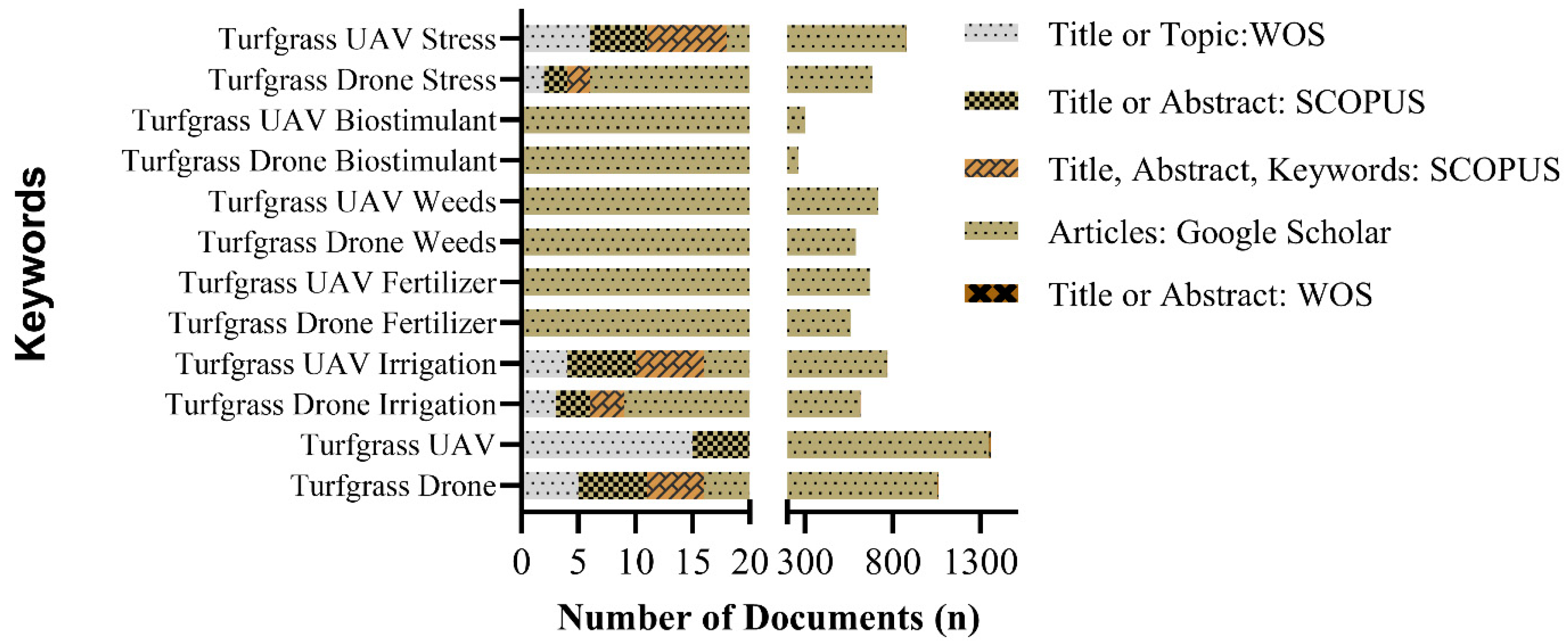

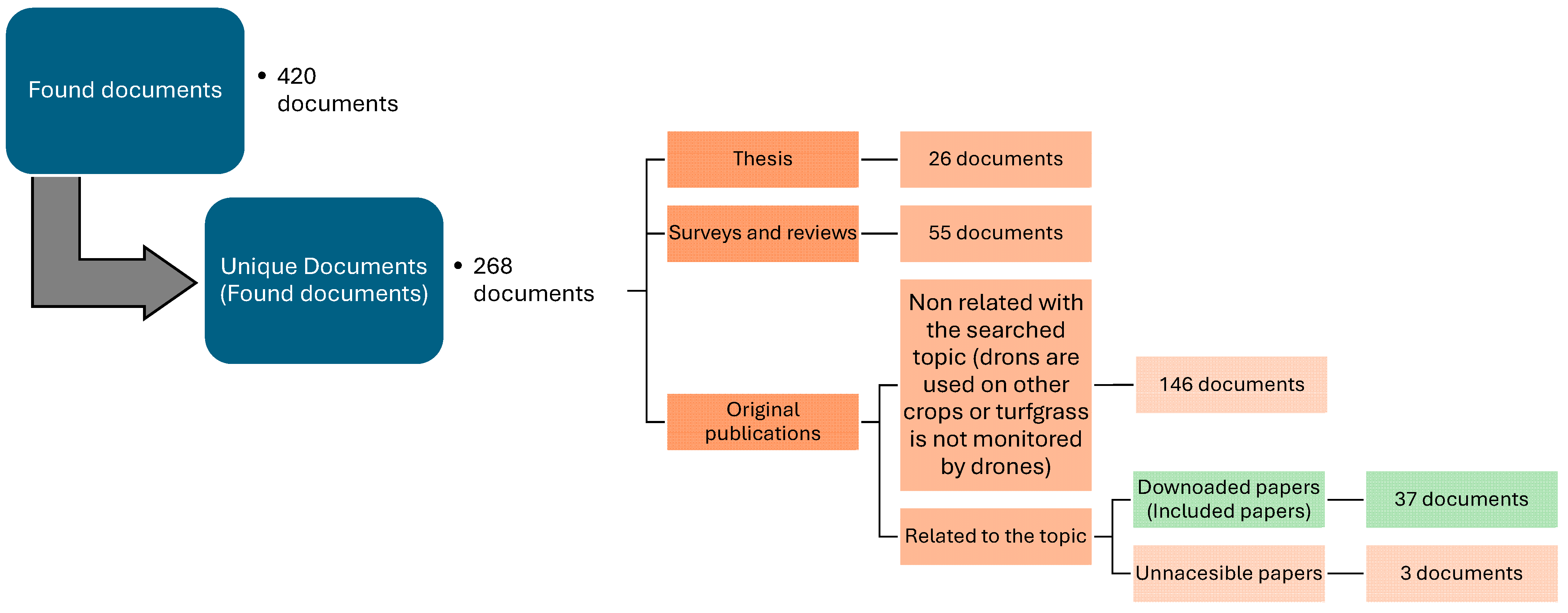

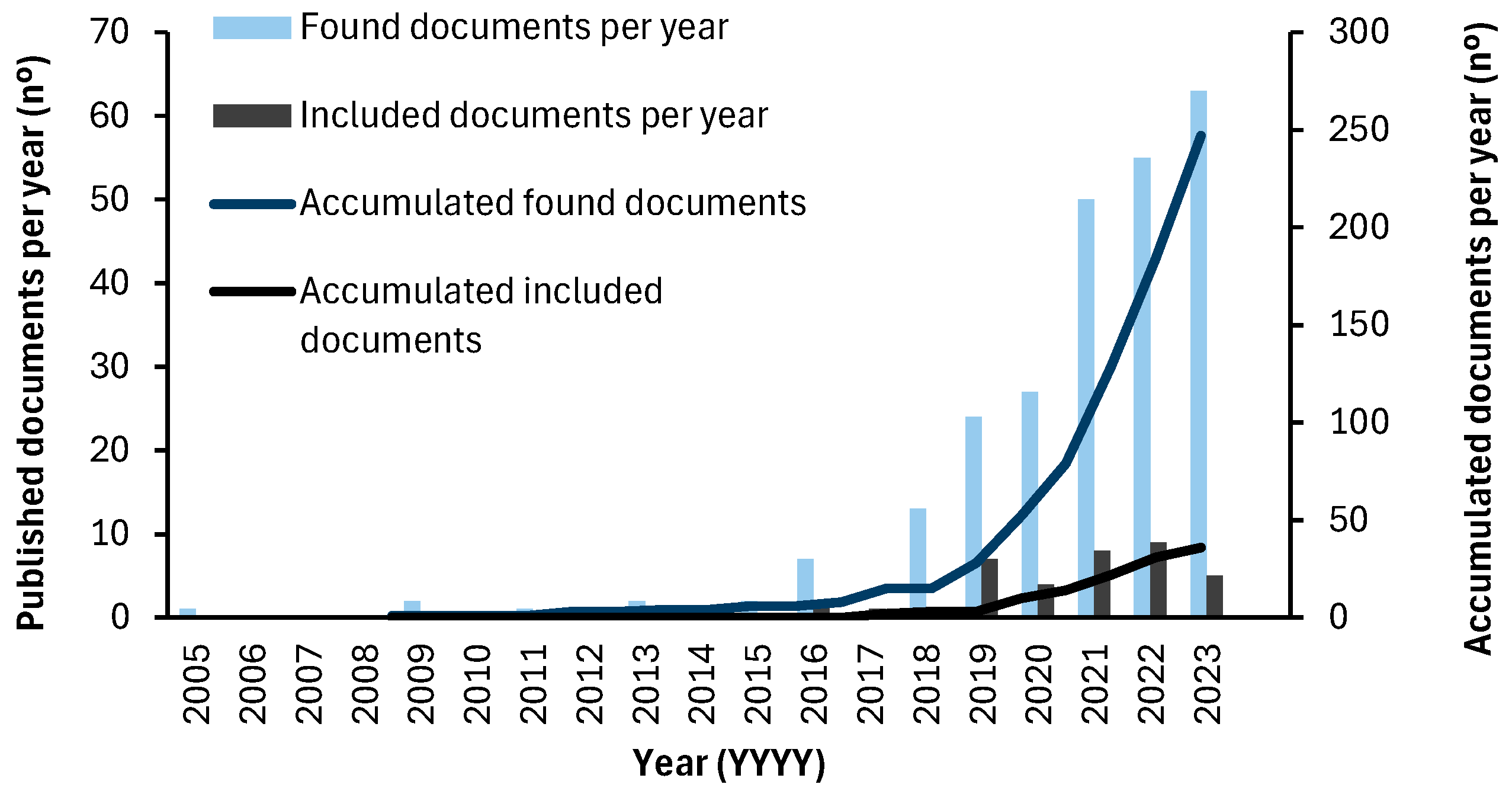

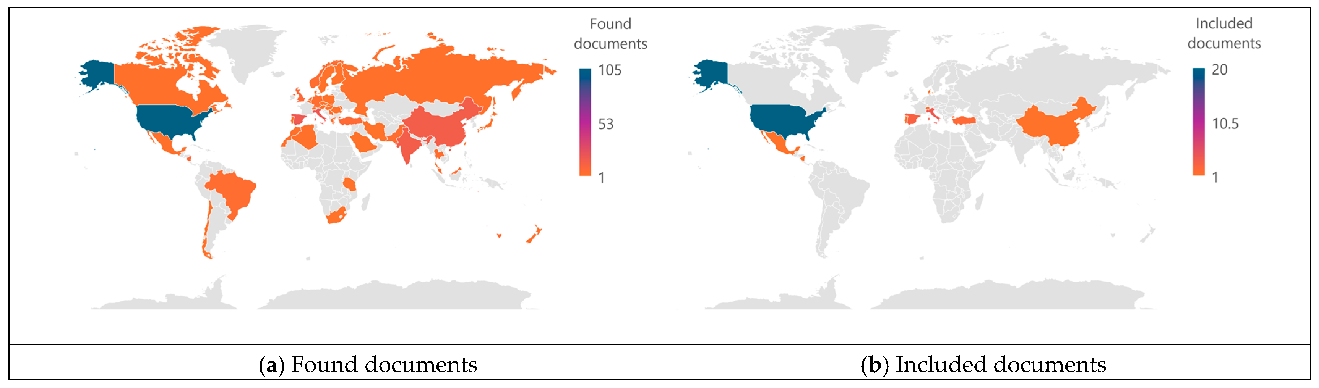

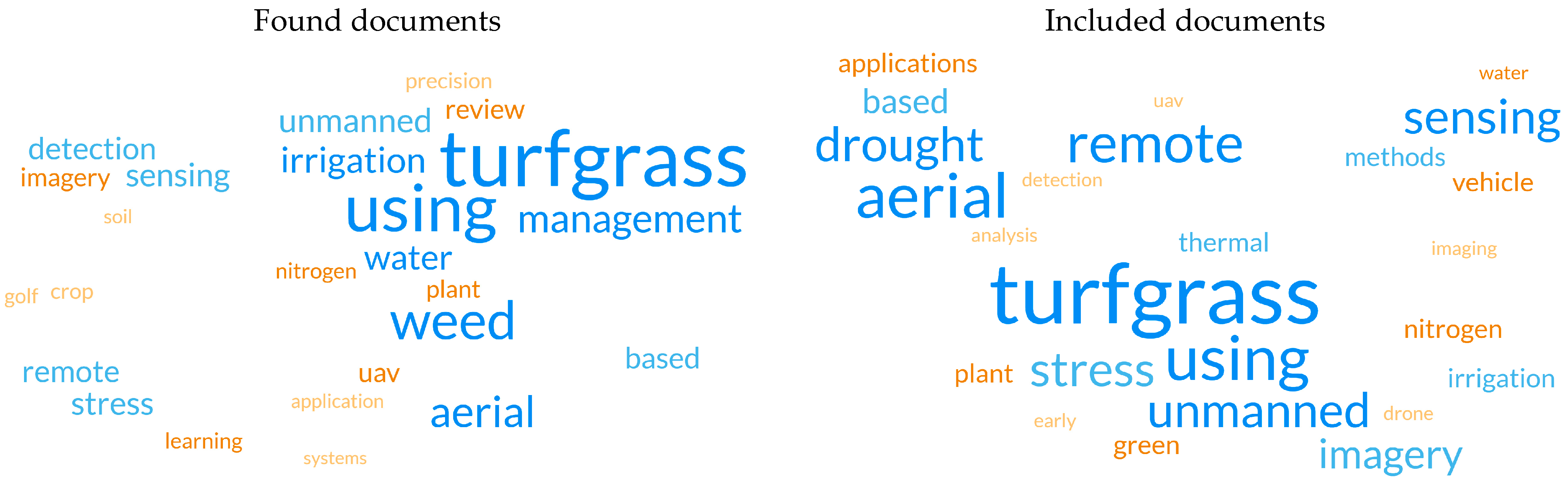

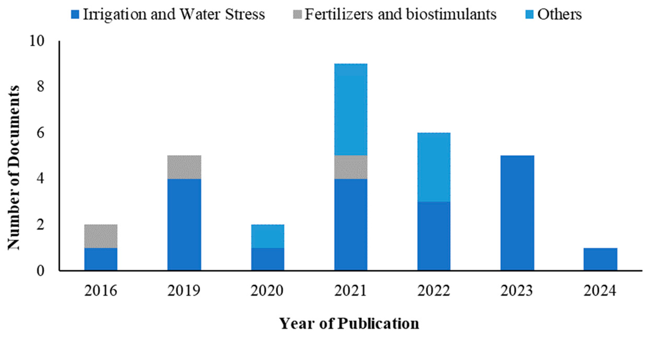

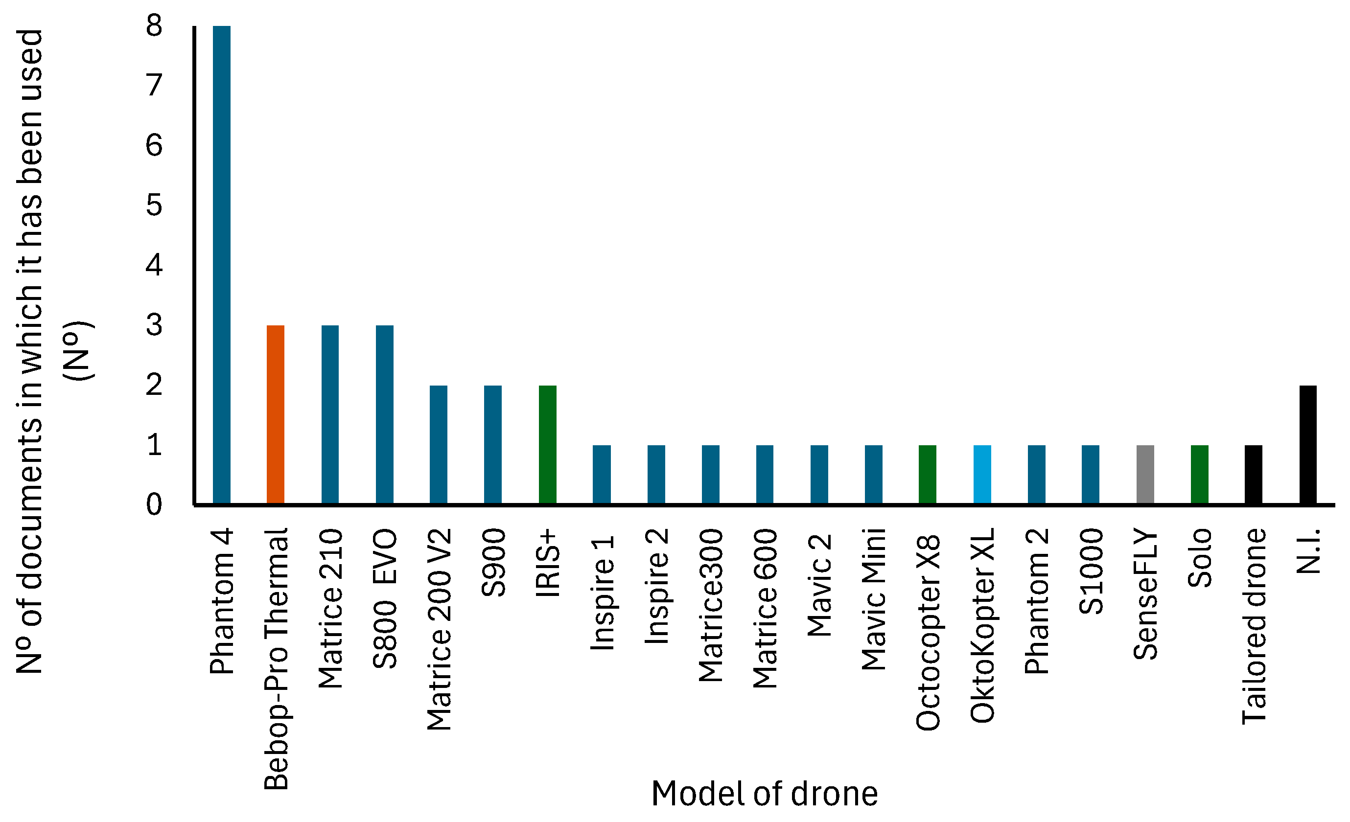

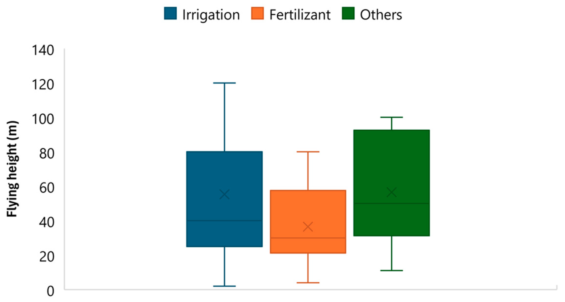

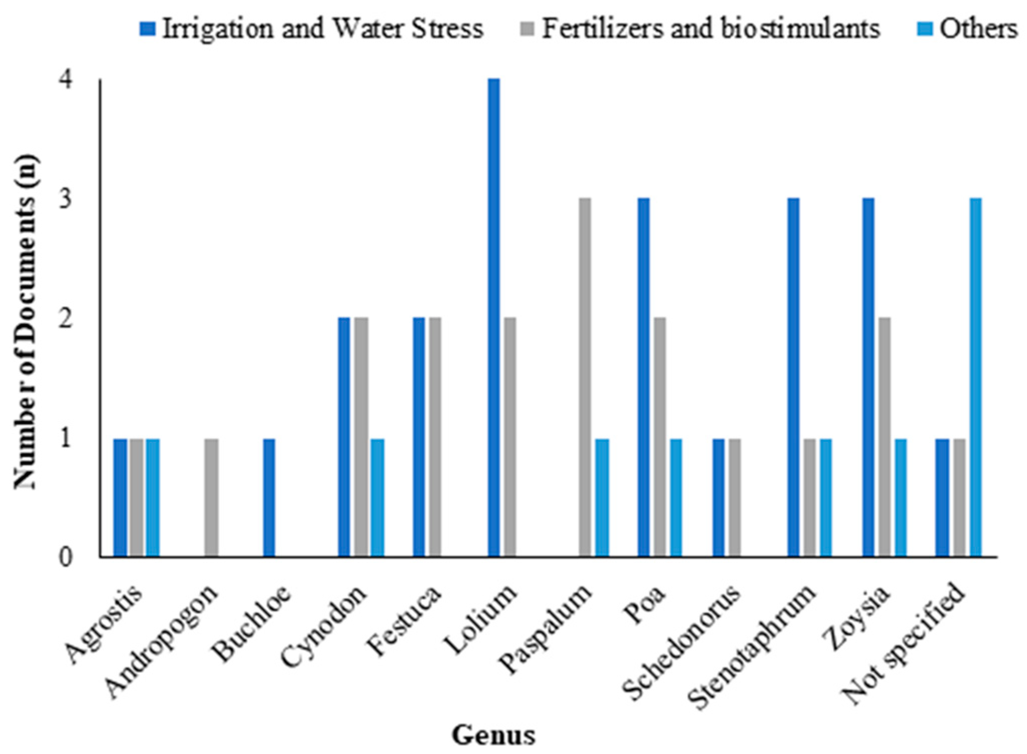

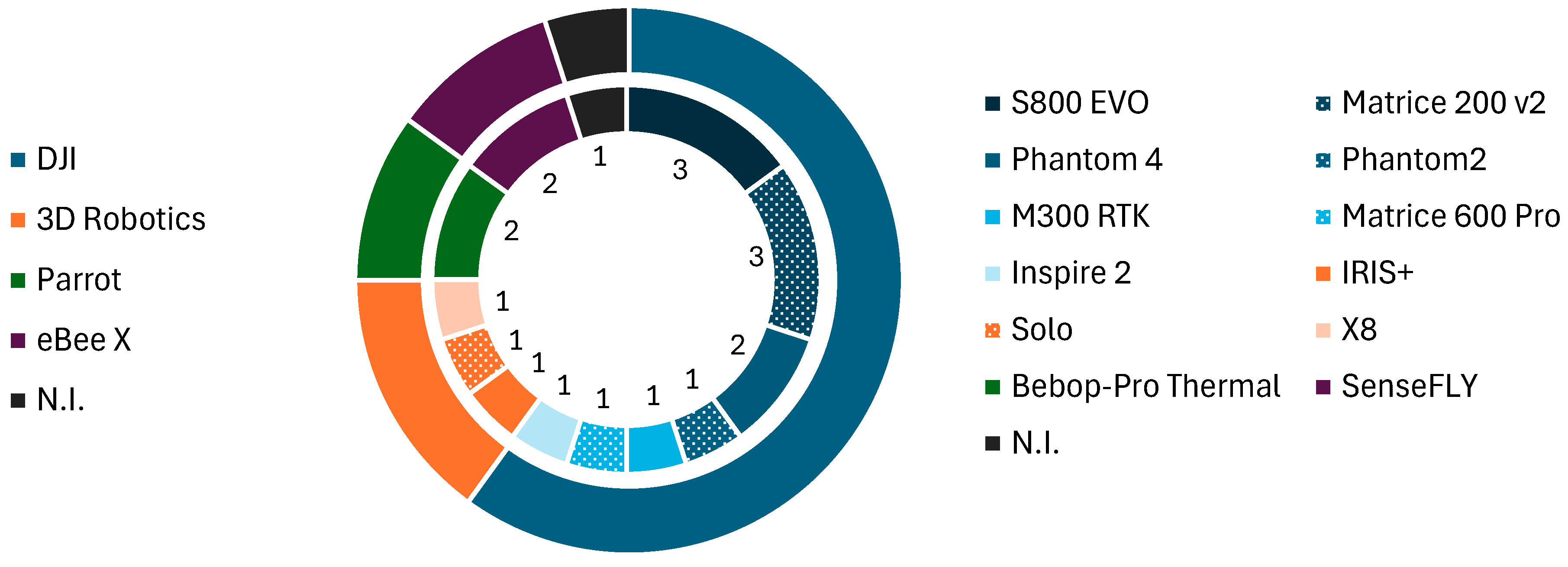

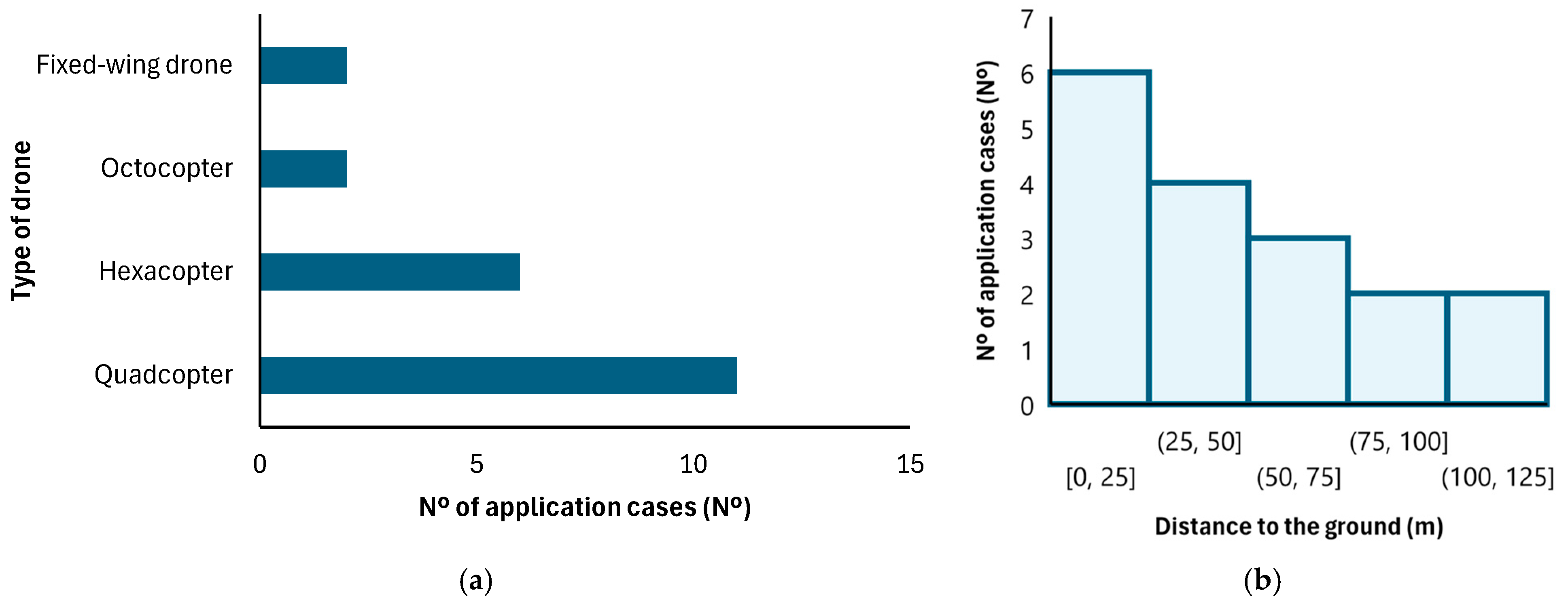

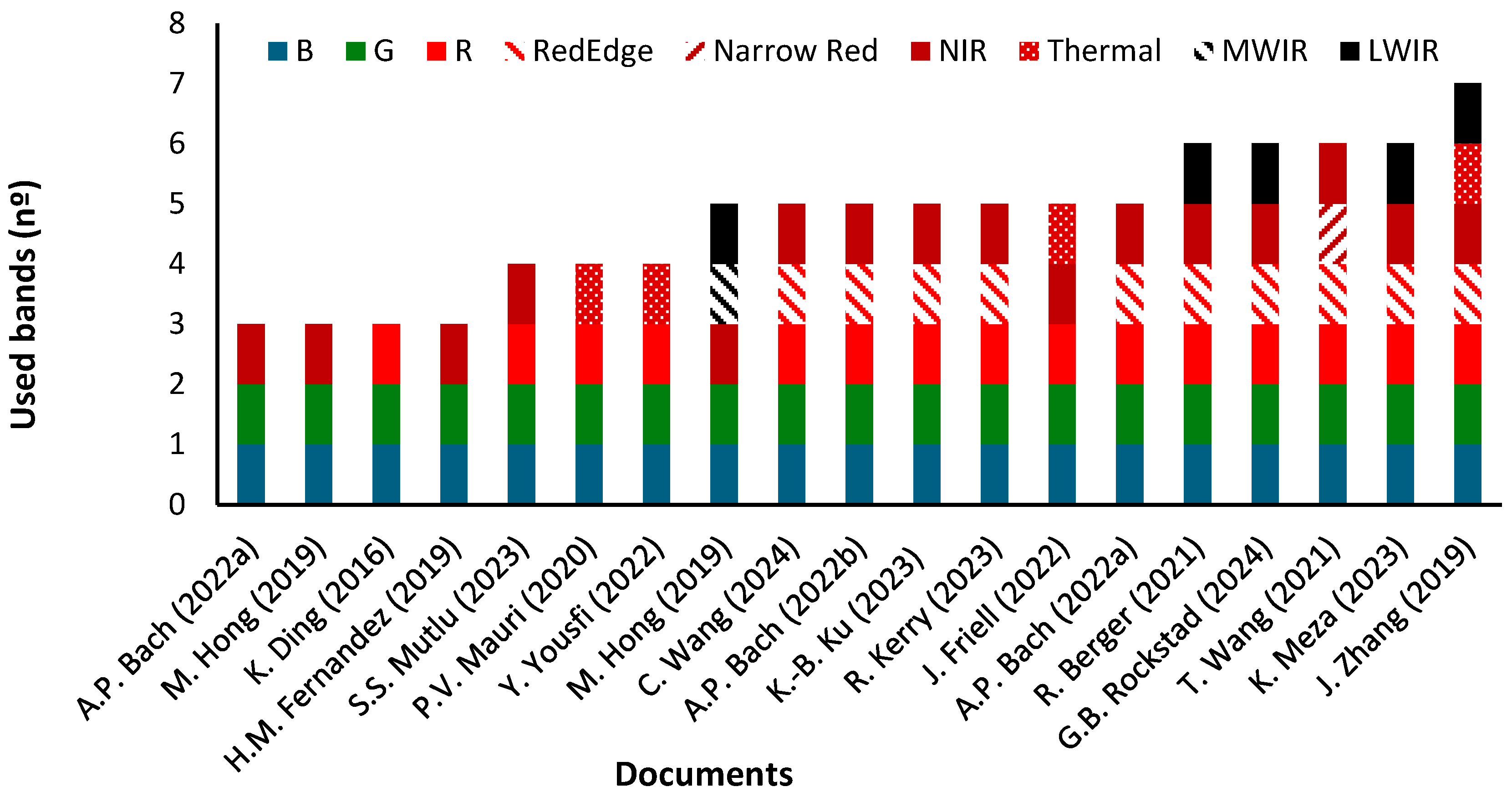

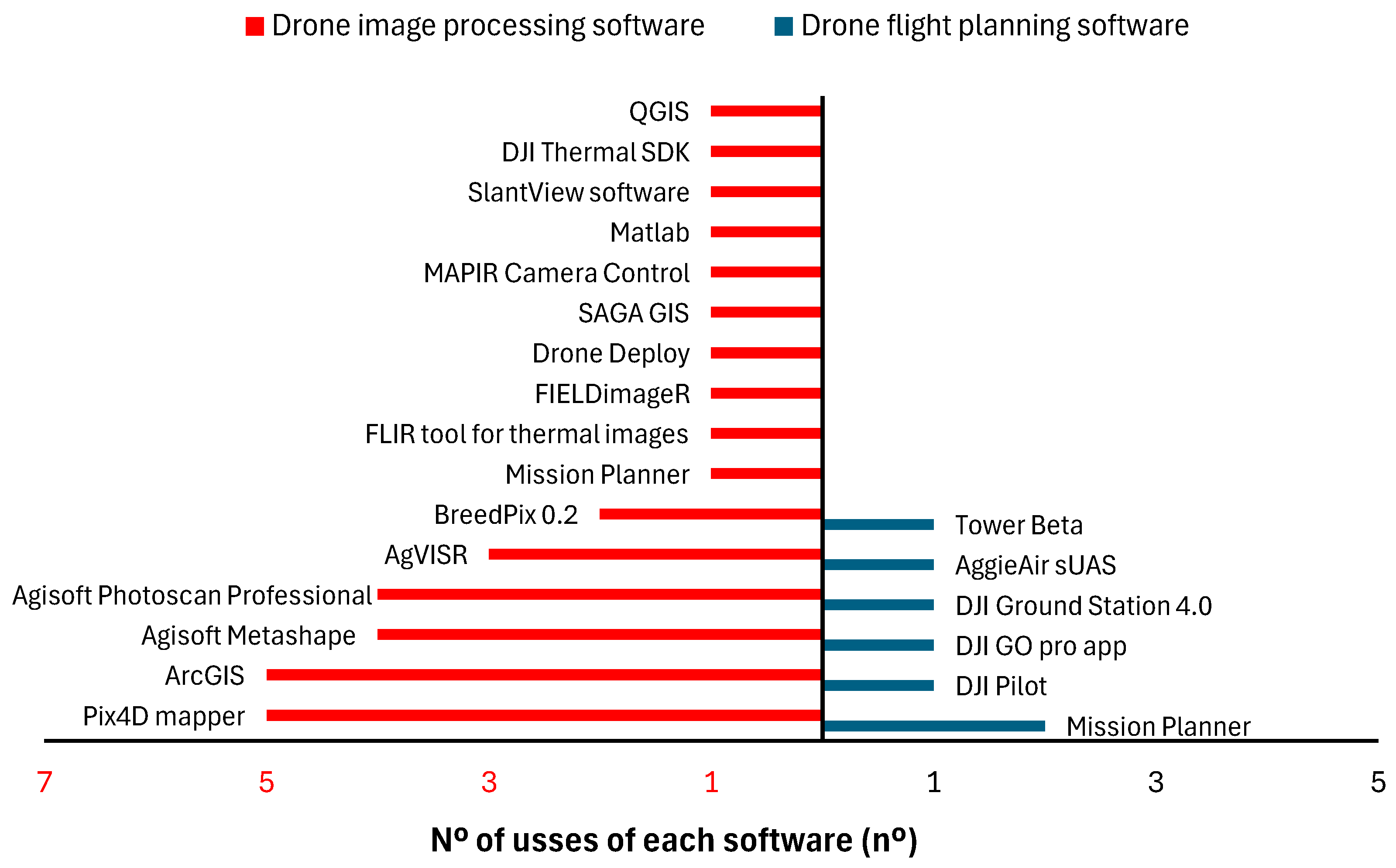

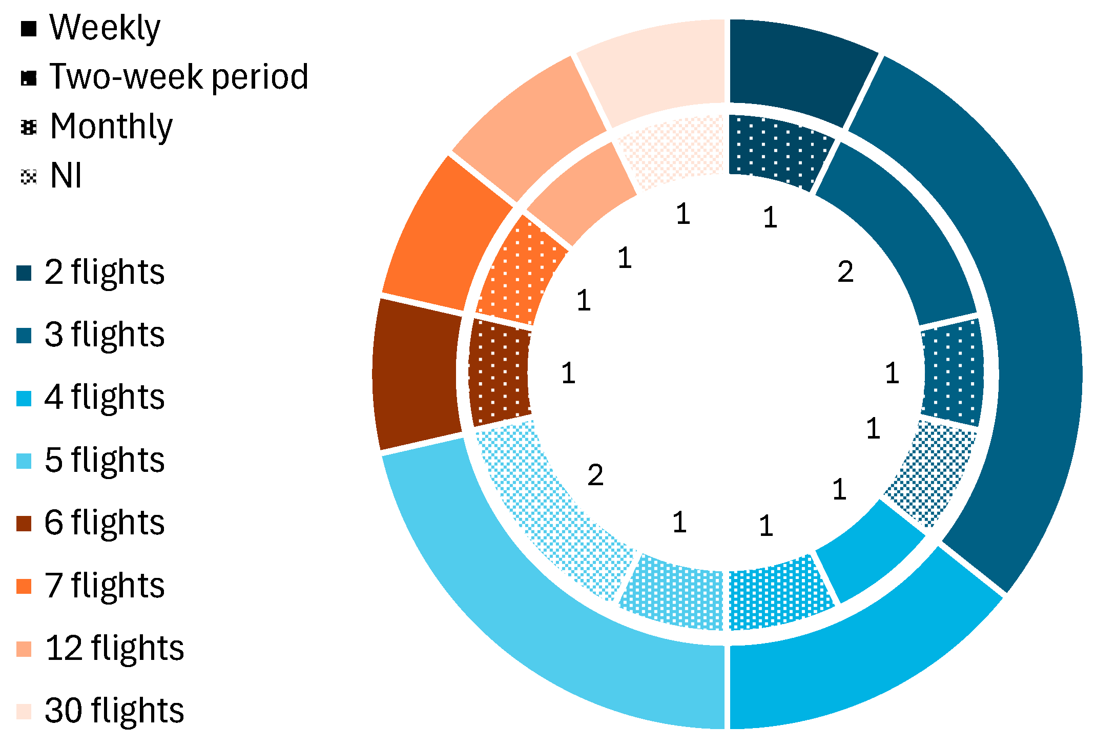

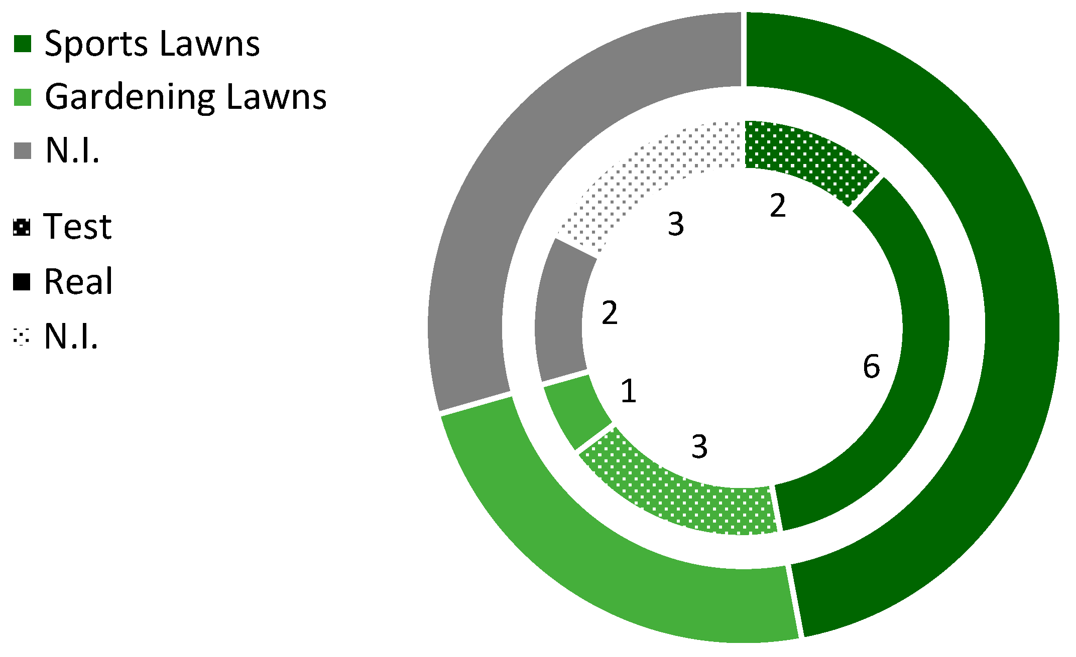

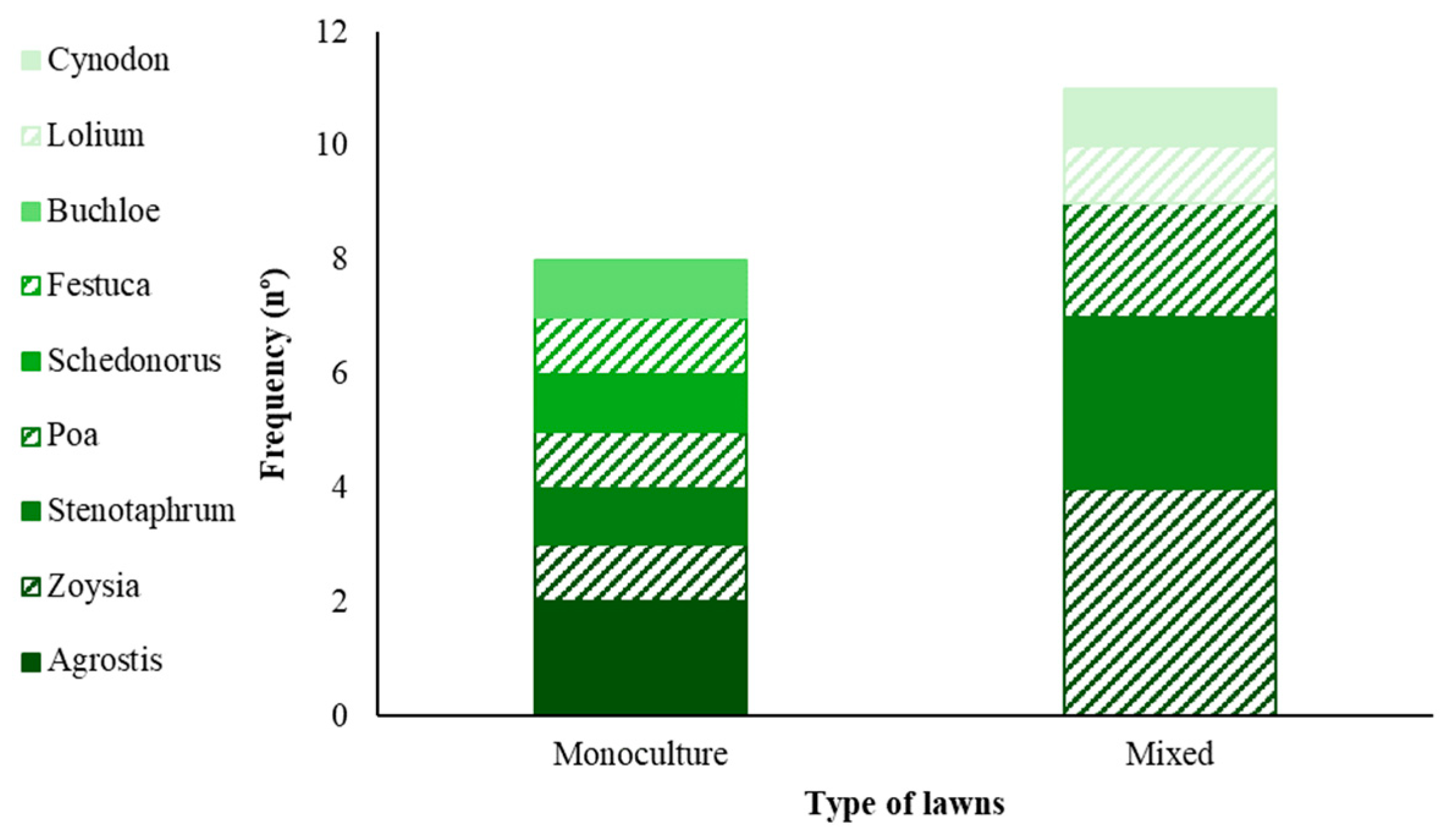

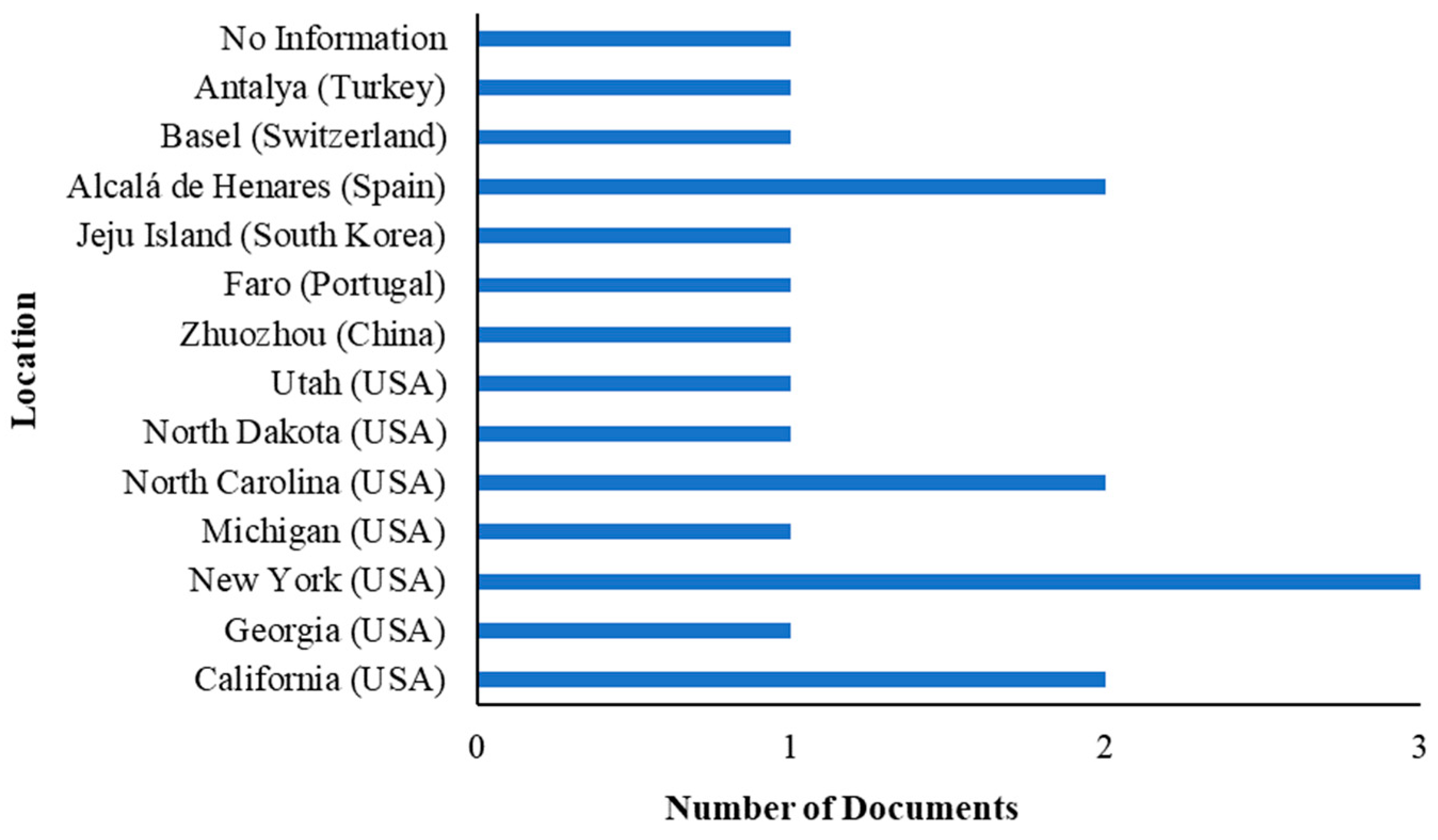

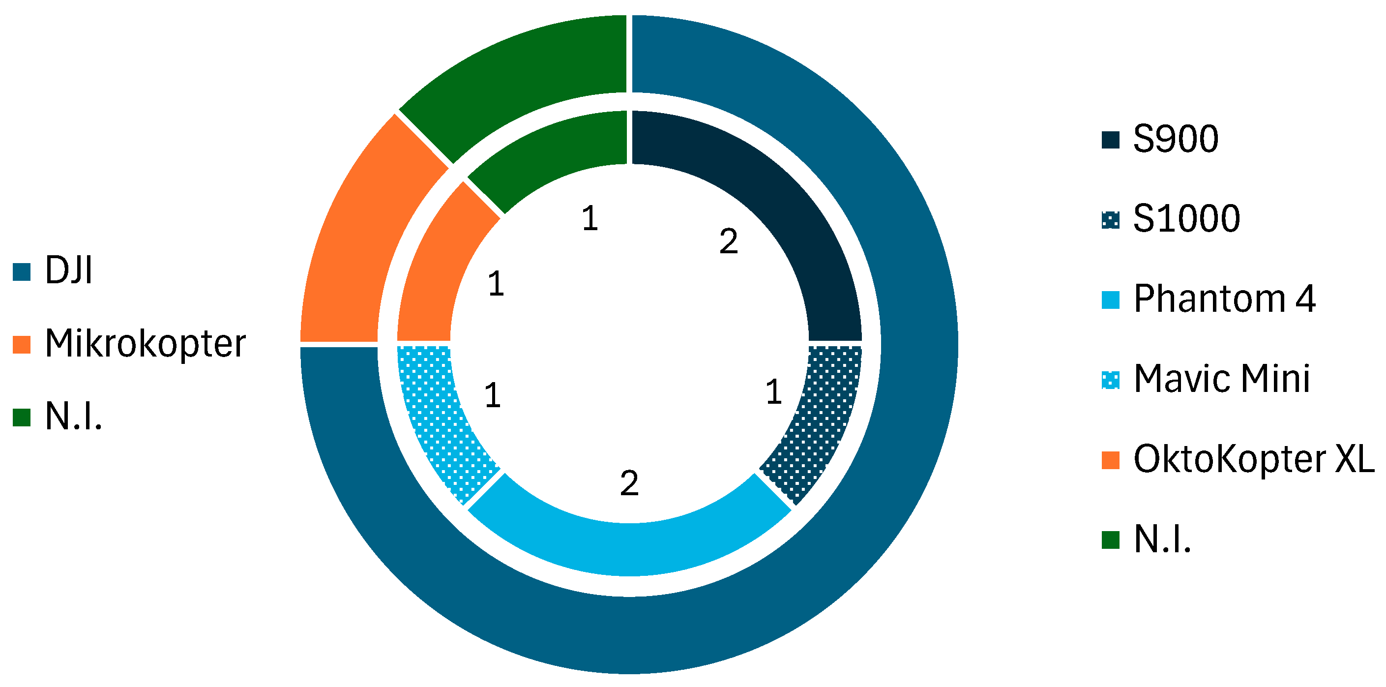

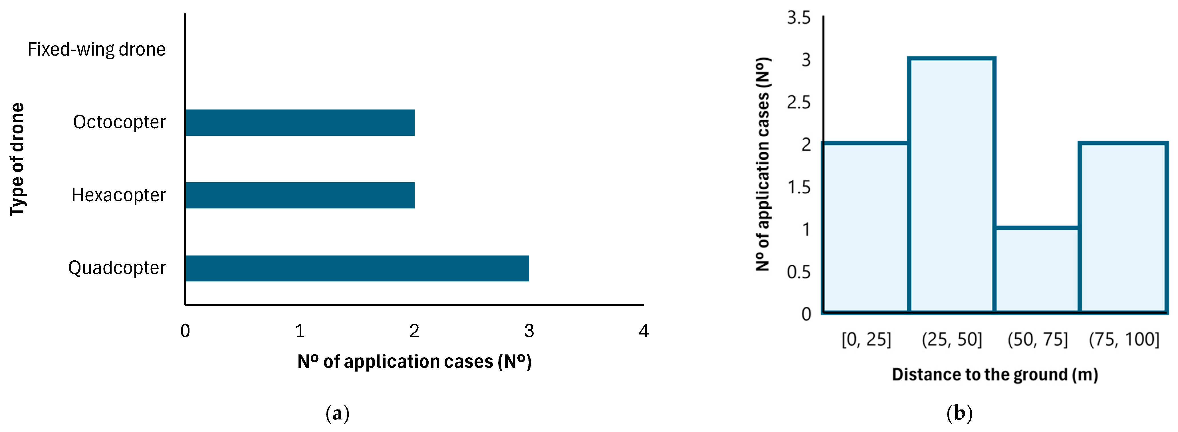

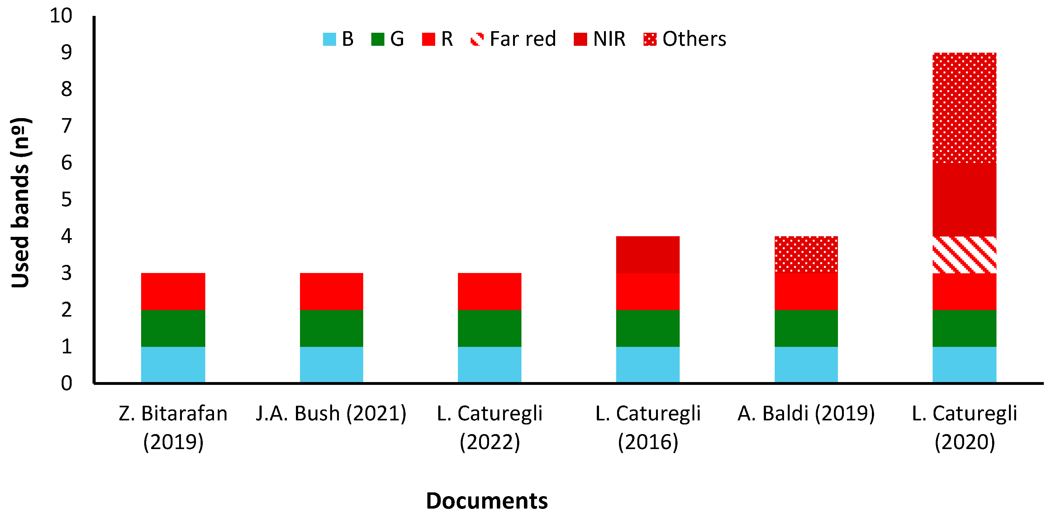

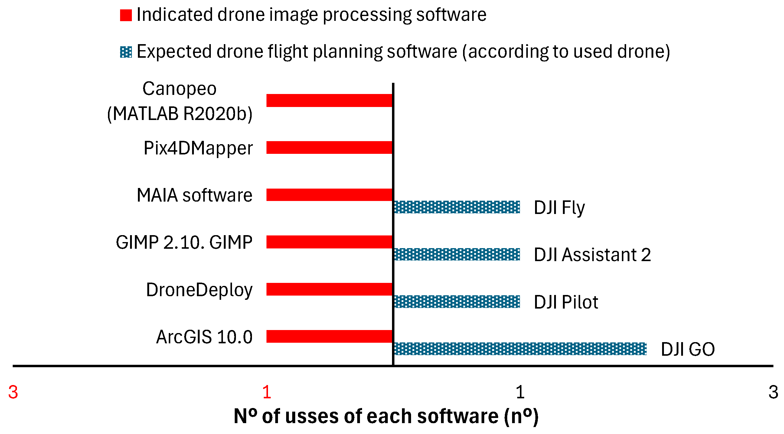

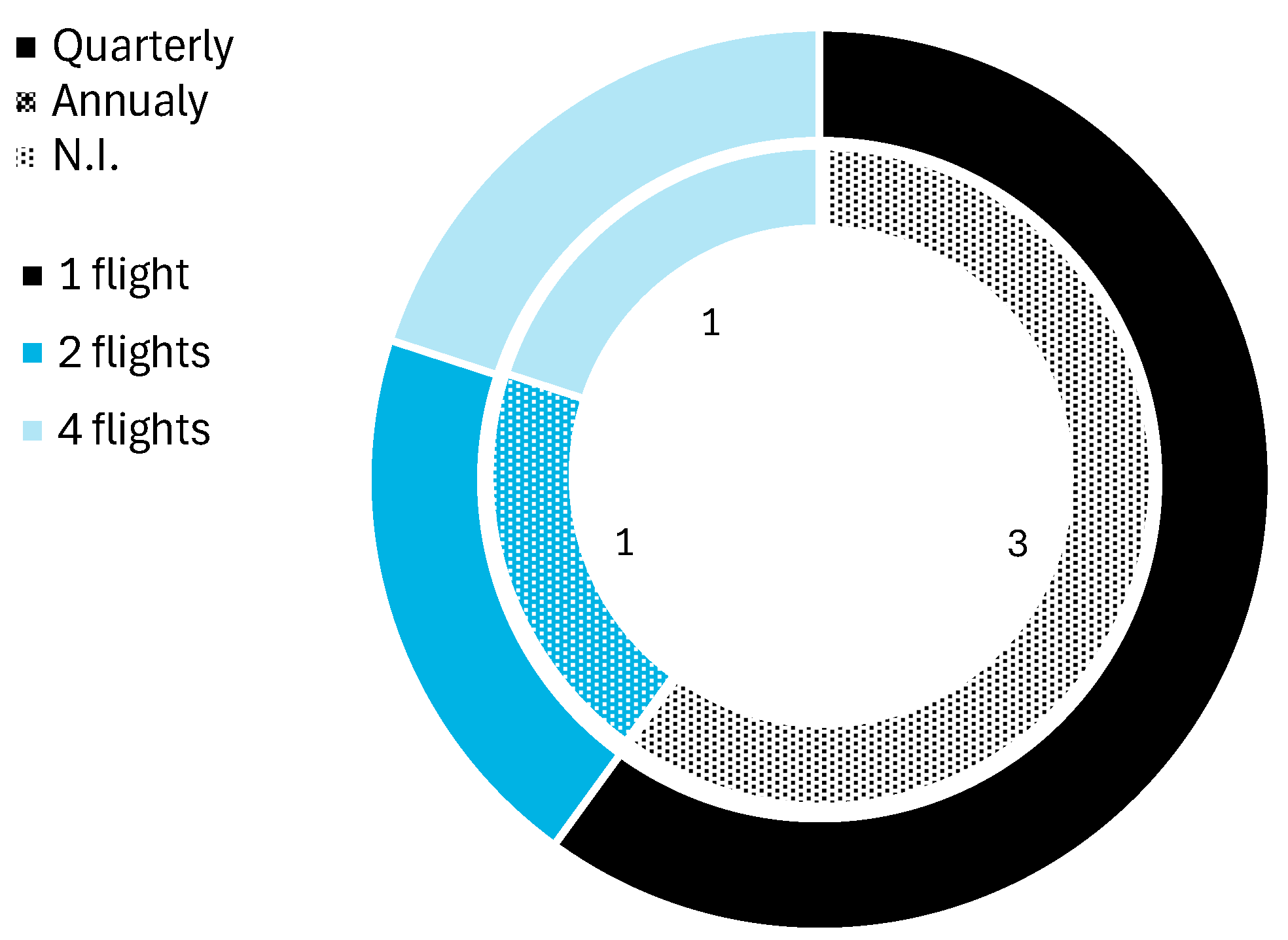

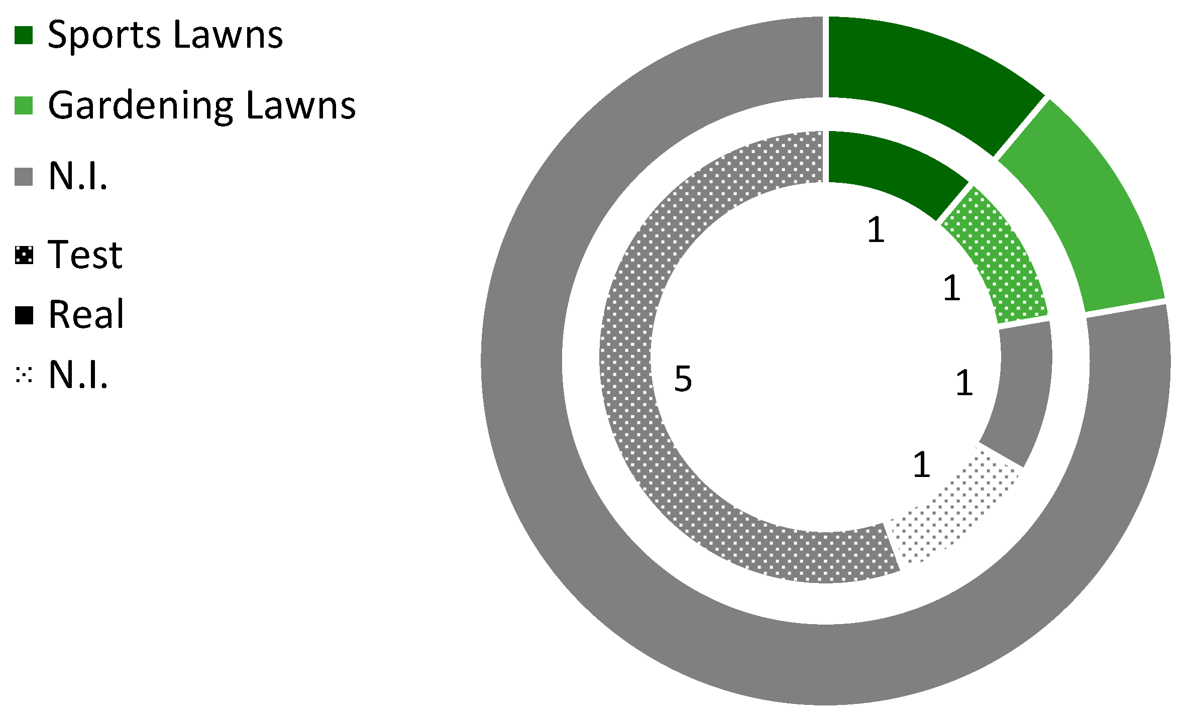

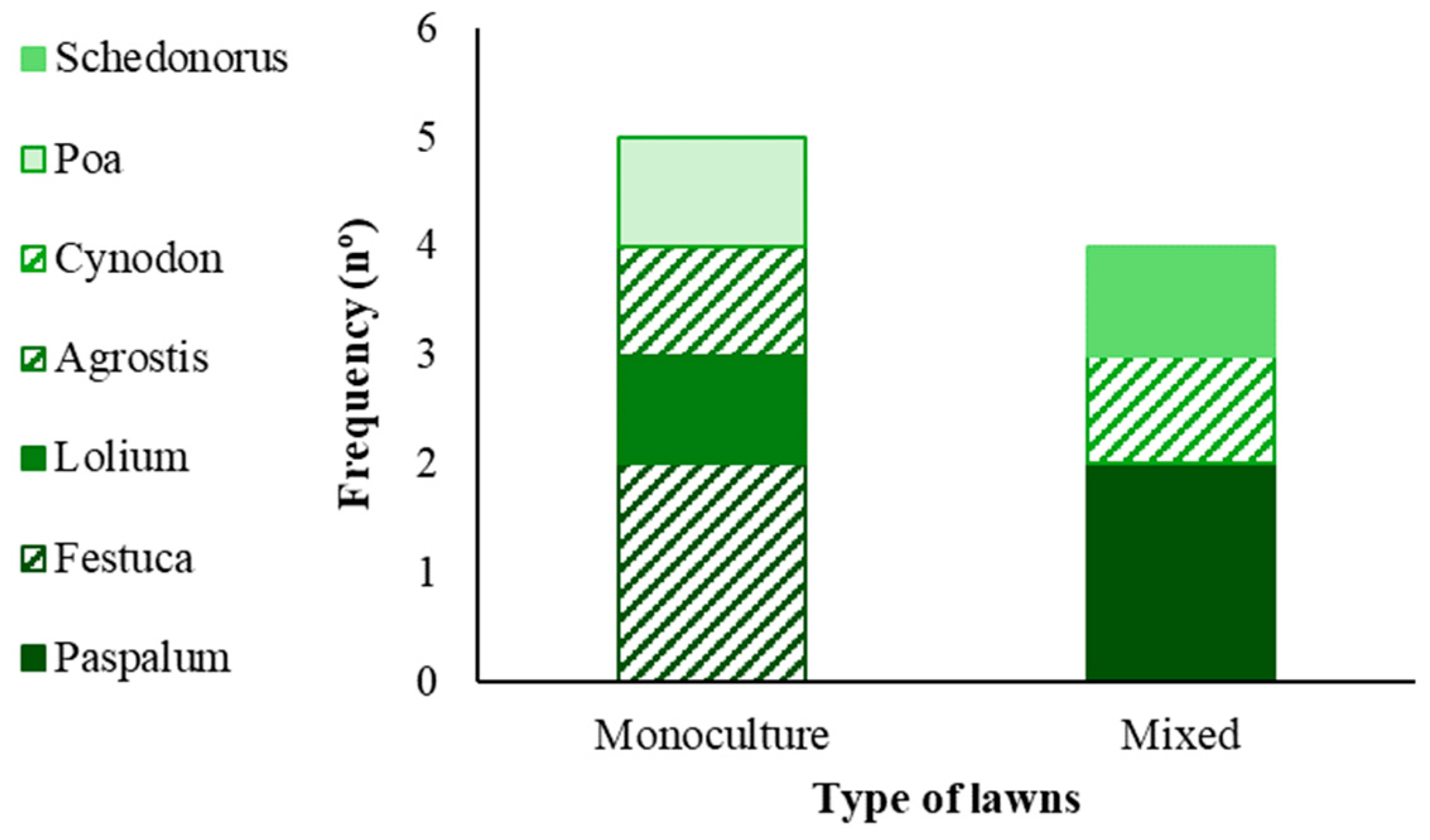

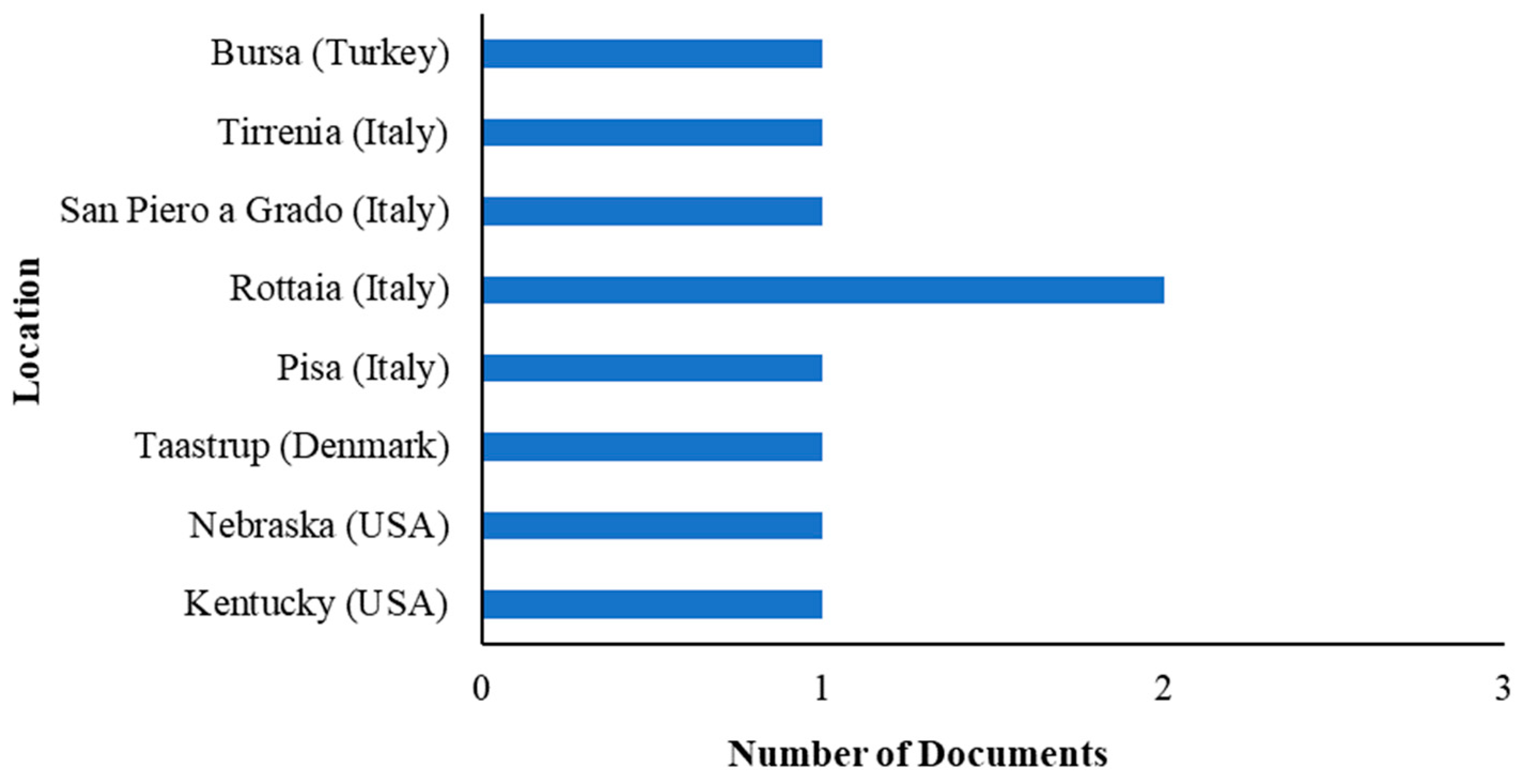

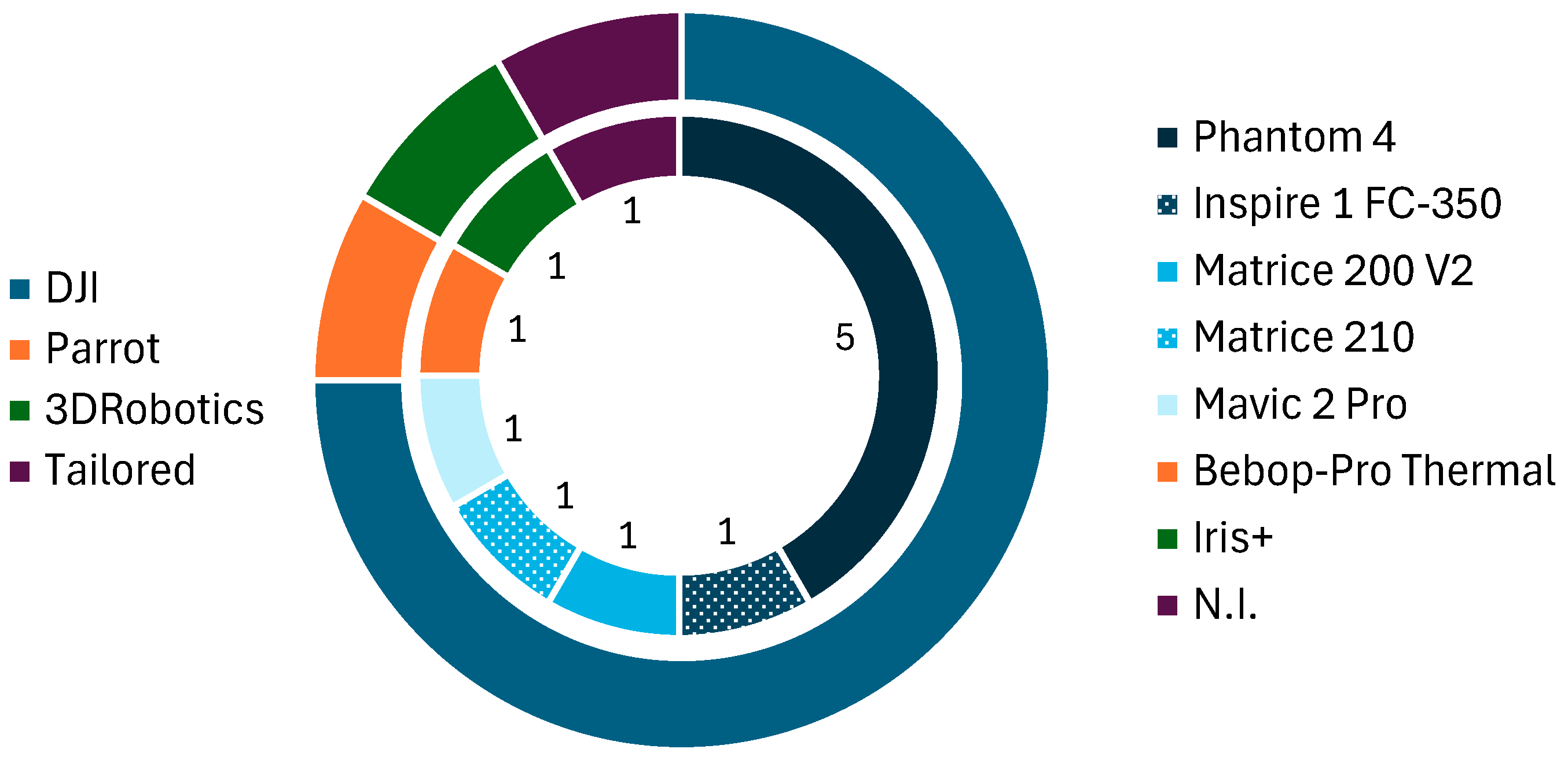

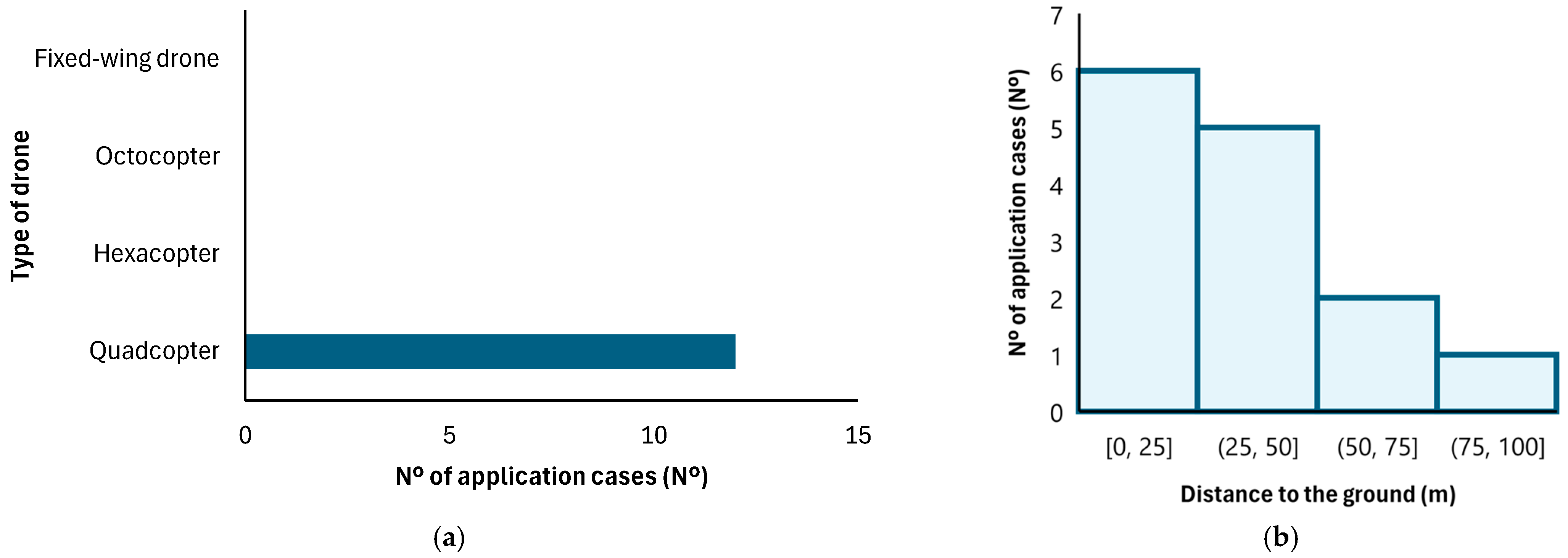

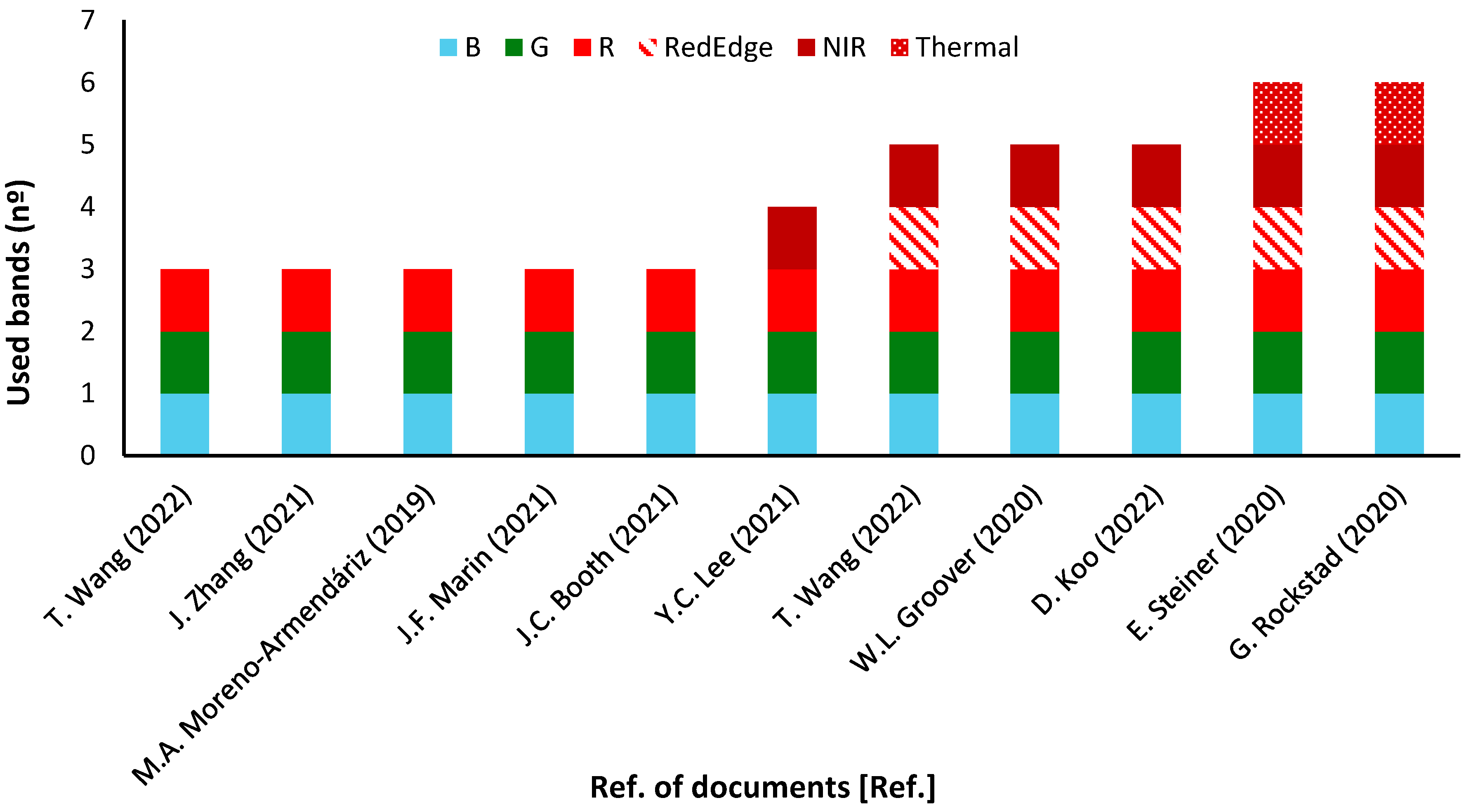

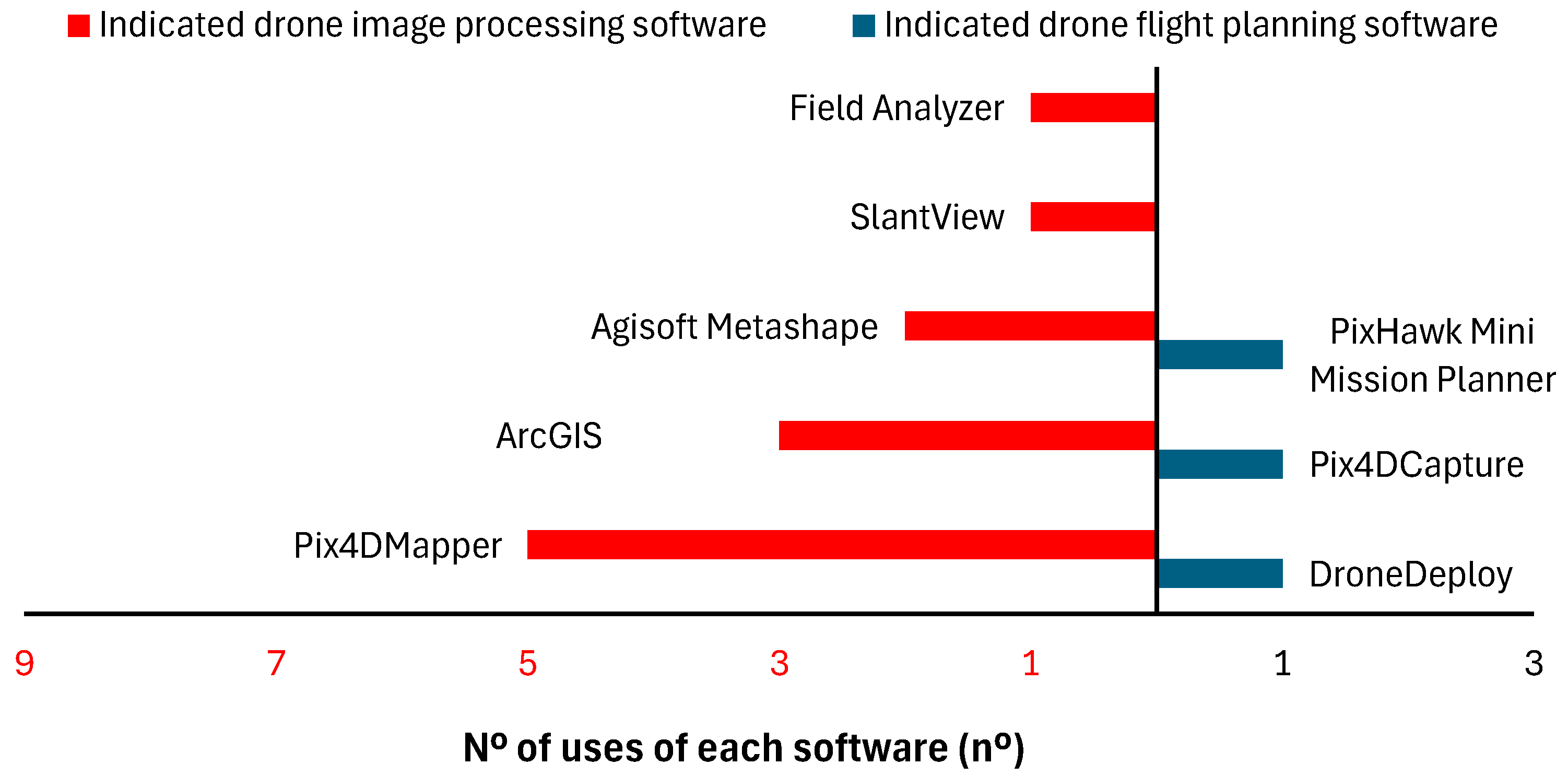

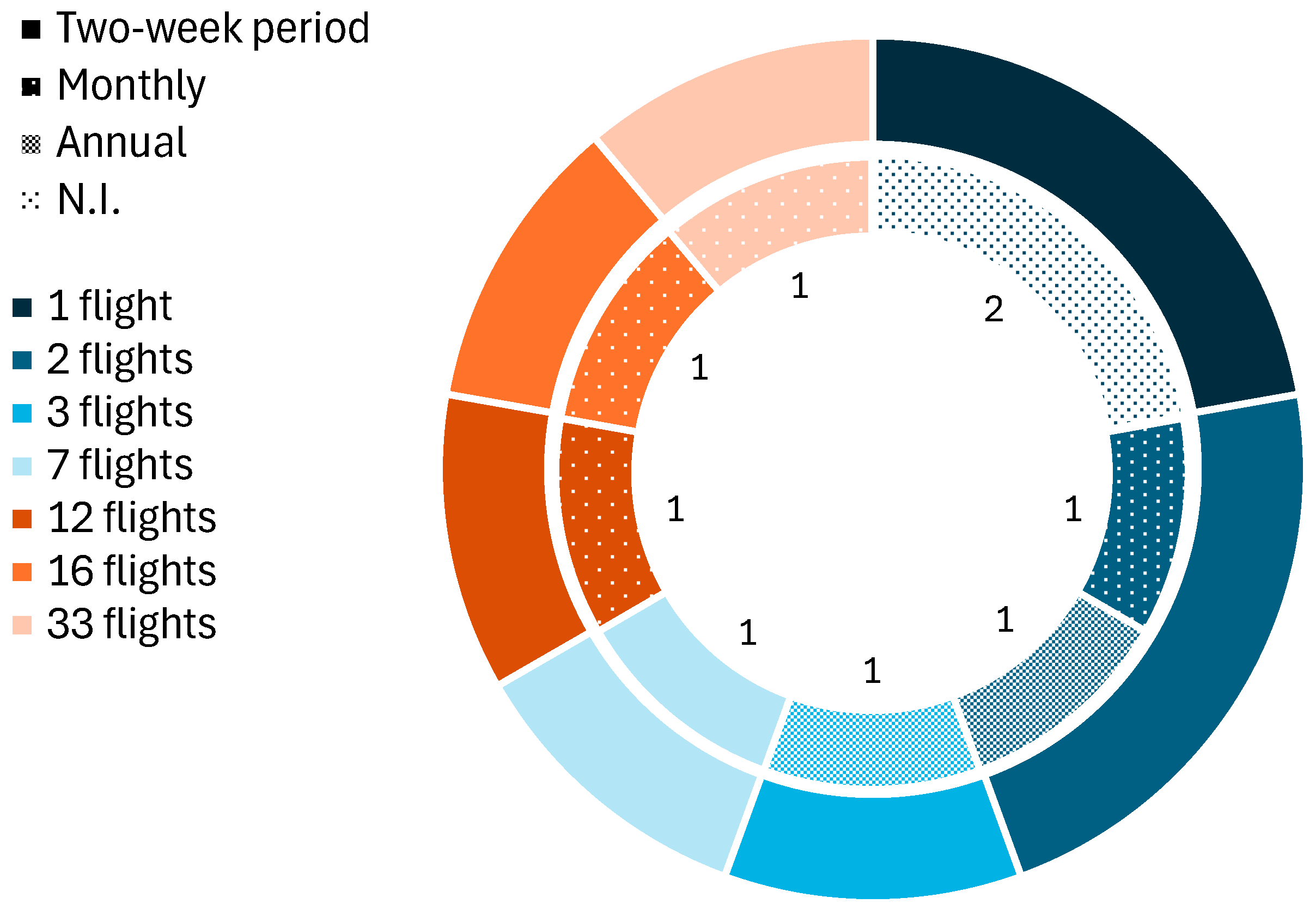

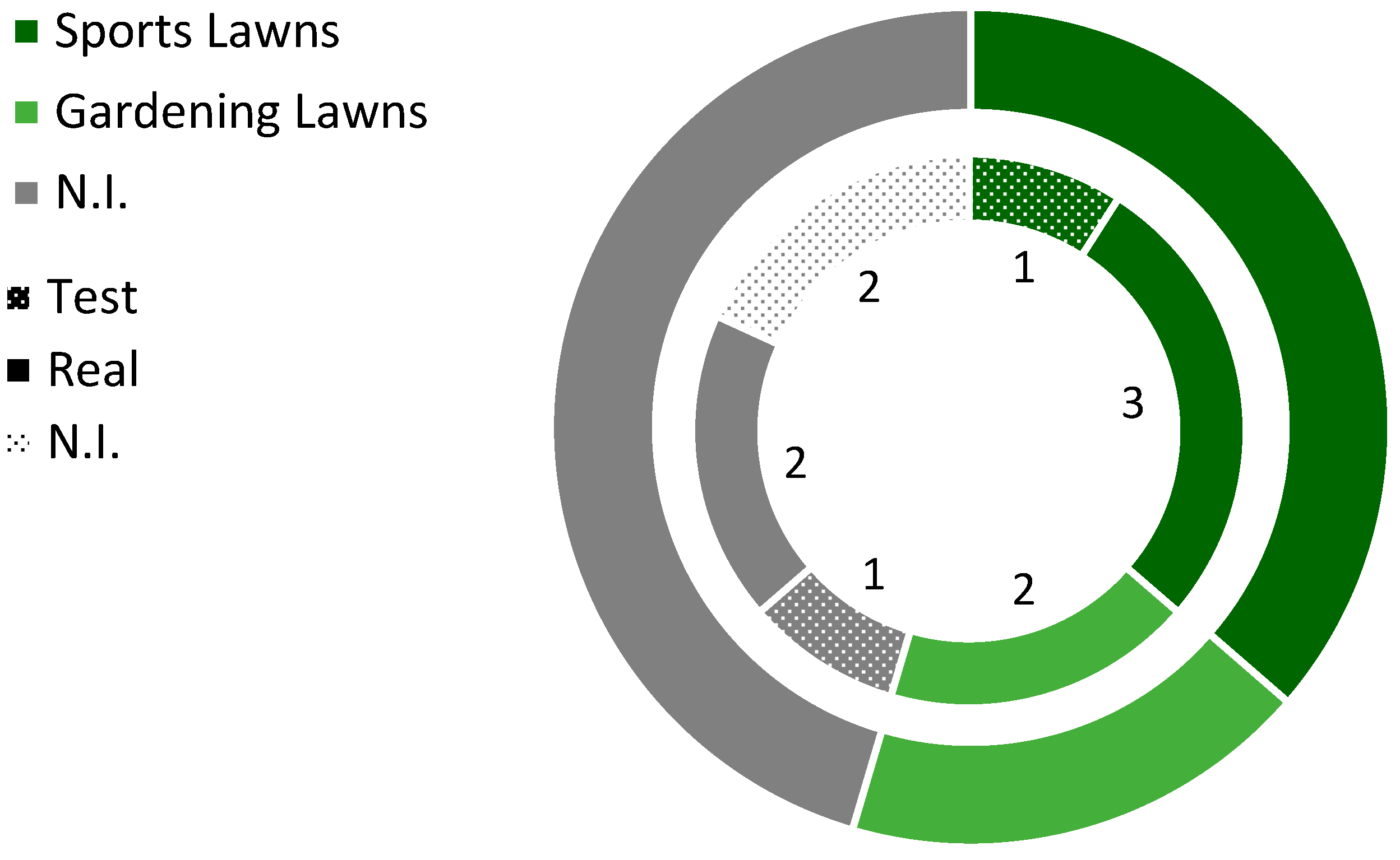

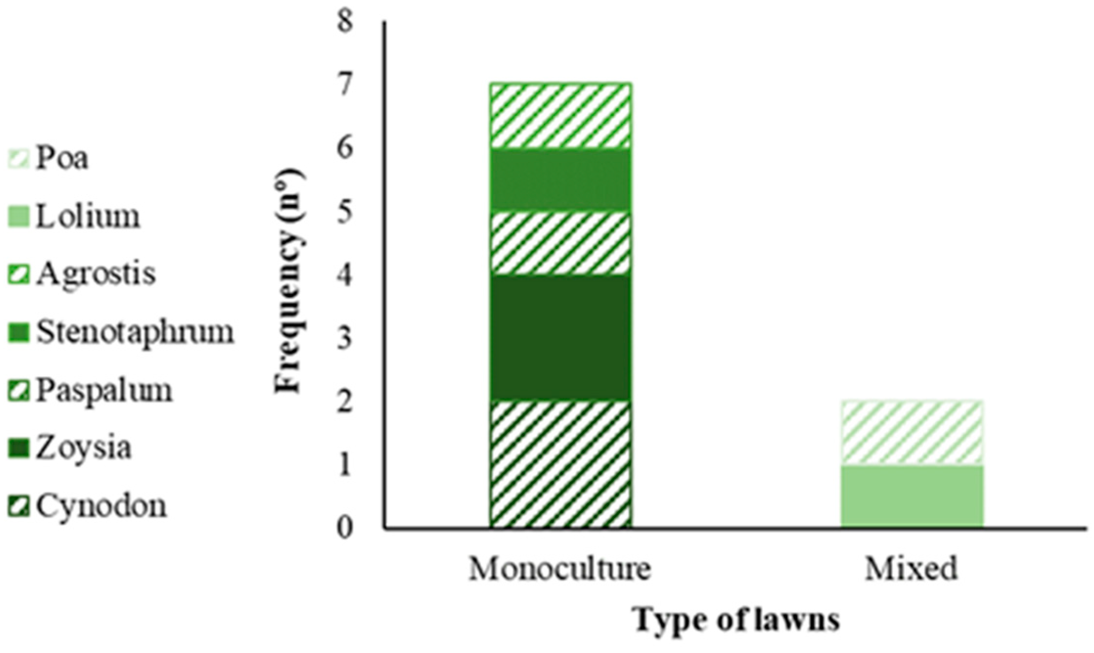

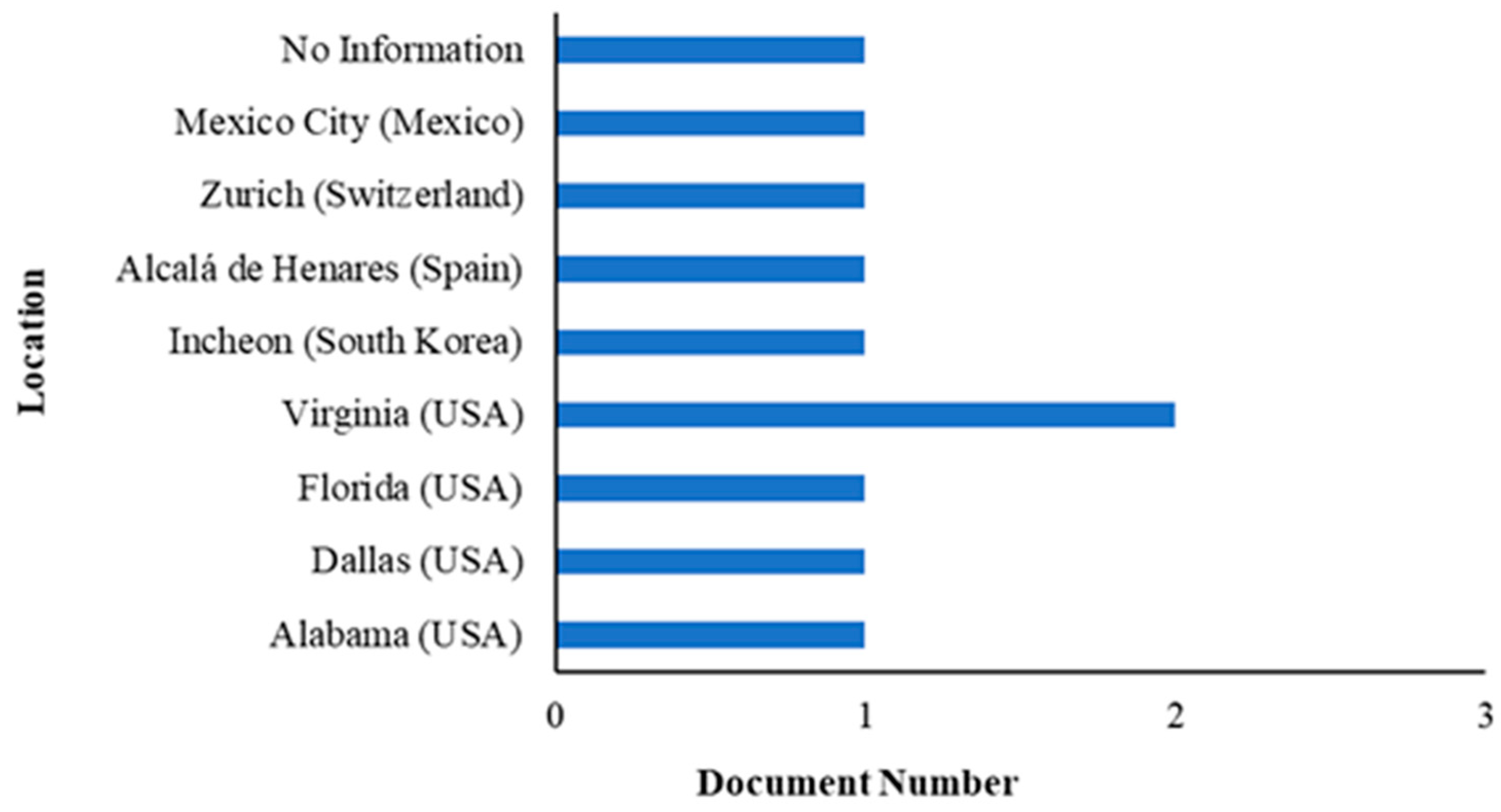

Disclaimer/Publisher’s Note: The statements, opinions and data contained in all publications are solely those of the individual author(s) and contributor(s) and not of MDPI and/or the editor(s). MDPI and/or the editor(s) disclaim responsibility for any injury to people or property resulting from any ideas, methods, instructions or products referred to in the content. |
© 2024 by the authors. Licensee MDPI, Basel, Switzerland. This article is an open access article distributed under the terms and conditions of the Creative Commons Attribution (CC BY) license (https://creativecommons.org/licenses/by/4.0/).