


Abstract
Crowd mass disasters occur over a relatively short time, and rescue operations in disasters, such as earthquakes, are challenging because of people’s behavior, type, or location. Therefore, it is essential to devise means and methods to manage such problems to minimize the consequences as much as possible. During disasters, rescue operations should be conducted in a timely conducted to save people’s lives. Otherwise, losses and consequences are severe, and if there are no proper rescuing operation models, the situation worsens, and the consequences are devastating. In particular, the allocation and coordination of limited rescue resources have a critical impact on response times and the number of lives saved. This paper aims to develop an Agent-Based Simulation (ABS) model for rescuing operations in crowd-mass disasters with six main intelligent agents. The proposed model explicitly represents the interactions among victims, rescuers, command-and-control entities, transportation assets, road networks, and affected infrastructure within a GIS-based urban environment. The developed model is based on an enhanced approach to improve rescue agents’ tasks allocation operations that enable modeling and simulation to make critical decisions for people to be rescued in a crowded mass disaster. Our task-allocation mechanism incorporates dynamic accessibility of roads, time-dependent rescue capacity, and context-aware prioritization of victims. Three related task-allocation strategies from the literature are used as baselines under identical scenarios, and performance is compared in terms of average rescue time and number of rescued victims. Results show that the proposed model achieves more efficient and robust rescue operations in most simulated experiments.
1. Introduction
This paper addresses the impact of a natural disaster, specifically an earthquake, encompassing aspects such as injuries, destruction of residential areas, and the occurrence of significant casualties arising from seismic activity [1]. Contemporarily, it is vital that urban smart systems are developed; in particular, decision-support tools are needed that can explicitly represent the dynamic interaction between victims, rescuers, infrastructure, and the built environment, under strong time pressure and uncertainty. Thus, the use of simulators provides an opportunity to analyze various approaches for decision-making optimization and crisis management, while ultimately reducing losses [2]. Therefore, an effective alternative to traditional decision-making approaches can be the use of an agent-based simulation model for search and rescue operations during earthquake disasters.
This study focuses on supporting decision-making during the immediate aftermath of an earthquake, when initial damage assessments, partial situational awareness, and time-critical constraints are available. The proposed Agent-Based Simulation (ABS) framework is not intended to predict earthquake impacts before the event occurs. Instead, it is designed to operate once the earthquake has taken place, using available post-event information to assist in coordinating search and rescue operations under uncertainty. In this context, the simulation is conceived as a fast or near-real-time decision-support tool, capable of guiding rescue teams by dynamically evaluating task allocation strategies as conditions evolve.
ABSs are widely used to simulate collapsed buildings, casualties, search and rescue teams, and damage to urban infrastructure [3]. Thus, ABSs can address issues related to complex systems by emphasizing agent interactions and decomposing the system into subcomponents of the environment and other interacting entities [4]. Agent-Based Simulation (ABS) is particularly suitable in this context because it allows for the exploration of alternative coordination and task-allocation strategies before deployment, and enables systematic verification, validation, and sensitivity analysis.
Task allocation is a key aspect of coordinating agents in ABS model [5]. Appropriate task allocation is crucial to ensure effective execution of tasks in environments affected by natural disasters. Thus, proposing an approach that can adequately address task allocation uncertainties is particularly pertinent for decision-making in crowd search and rescue (CSAR) operations in crisis-prone areas [6]. In this context, task allocation must account for limited resources, survival time windows, physical accessibility constraints (e.g., blocked or partially blocked roads, damaged buildings), and the evolving information available about victims’ locations and conditions. Moreover, earthquakes are characterized by uncertain origins and conditions, which must be taken into account when allocating CSAR tasks [7]. In traditional CSAR models for disaster-prone areas, task allocation is often based on consistent and fully known information about the environment, whereas, in reality, CSAR operations are usually large-scale and subject to significant uncertainties. Assuming perfect coordination in such uncertain environments leads to essentially unrealistic situations [8]. Among the main challenges in planning rescue operations is the presence of uncertain conditions, which critically affect both initial planning and its subsequent execution. Despite the findings of numerous previous studies, there is still no solution capable of fully meeting the comprehensive and stringent requirements of real-time task allocation in environments affected by natural disasters [9]. Furthermore, many existing post-earthquake search and rescue models rely on simplified operational assumptions, such as homogeneous agent behavior, deterministic task parameters, or static risk representations. These assumptions tend to underestimate the variability of real disaster environments and may lead to optimistic performance predictions. In practice, individual agents are exposed to different levels of risk, uncertainty, and resource constraints during task execution, which directly affects decision-making quality. While several studies have partially addressed task allocation or coordination under uncertainty, limitations remain in jointly capturing heterogeneous agent risks, uncertainty-aware decision processes, and coherent global coordination. In this context, the present study proposes an agent-based framework that explicitly integrates uncertainty into task allocation while linking local agent decisions with global operational objectives, thereby improving the realism and robustness of post-earthquake rescue simulations.
A mass-crowd disaster typically occurs suddenly and can happen anywhere. To prevent such events, widespread awareness of prevention and safety measures is crucial [10]. Consequently, it is essential to develop strategies and methodologies for effectively managing these situations and minimizing their impact [11]. ABS plays a pivotal role by enabling flexible actions to achieve specific objectives [12]. For ABS models to be truly autonomous, responsive, and proactive, agents must possess effective perception and information-gathering capabilities, analytical abilities, and cooperative behavior. In addition, they should be able to communicate, collaborate, and negotiate with other agents [13]. An ABS model comprises multiple intelligent agents that interact with each other and with their environment. These agents can be designed to address complex problems that are difficult or impossible to solve using a single agent or with traditional centralized approaches, especially in large-scale systems [14].
ABS modeling has been widely applied to centralized disaster problem-solving in the context of crowd-mass disaster management—a multifaceted task characterized by uncertainty and conflicting information. ABS modeling supports the coordination and strategic planning of large-scale collaboration among agents, including inter-agent communication, decision-making, and cooperative behavior [13]. In this work, the notions of proactive behavior and strategic planning refer to anticipatory and adaptive decision-making within the post-earthquake response phase. Agents proactively adjust task priorities and coordination strategies based on evolving information, rather than relying on static or purely reactive rules. Moreover, ABS modeling leverages the fusion of information and knowledge to analyze disaster systems of this nature. This approach involves extracting feedback from agents to enable sensing, coordination, decision-making, and action, all aimed at achieving specific objectives. These capabilities are particularly relevant in environments characterized by distributed, unpredictable, and ambiguous control processes. ABS models typically consist of a heterogeneous set of agents, each with distinct goals, objectives, and limited resources during system operation. Consequently, ABS modeling exhibits several key characteristics: (i) robust and dependable communication: agents engage in prioritized communication that ensures interoperability; (ii) enhanced situational awareness: ABS models foster a deeper understanding of the operational environment; (iii) improved collective understanding of the situation: agents jointly interpret and represent complex scenarios; (iv) superior resource tracking: the system effectively monitors and manages available resources to support decision-making; and (v) enhanced interaction with the environment: agents dynamically perceive and act upon their surroundings [15].
Simulations in crisis management, supply chain dynamics, and collective behavior are conducted across diverse disciplines. Within disaster management, numerous studies have applied ABS, several of which are reviewed in this paper. A study by [16] presents a comprehensive review of ABS for large-scale emergency response. It classifies existing ABS implementations into a taxonomy based on their usage and identifies opportunities for enhancing ABS effectiveness in emergency situations. The survey covers a wide range of ABS applications, from predicting the outcomes of different response strategies to optimizing resource allocation during crises, thereby highlighting the versatility and utility of ABS in managing complex emergency scenarios. The authors also discuss various implementation approaches and the integration of ABS with other technologies, emphasizing the importance of simulation as a tool for improving emergency preparedness and response. In another study [17], a novel evacuation model was developed to simulate tsunami scenarios and estimate casualties, contributing to the potential survival of approximately 90% of the at-risk population. This model, implemented in the NetLogo environment, uses GIS data for spatial analysis and employs algorithms from gaming and artificial intelligence to navigate evacuees. Its effectiveness was validated through a case study in Arahama, Miyagi Prefecture, where simulations showed a mean evacuation rate of 82.1%, consistent with historical data. This alignment underscores the model’s potential for analyzing individual behavior and its critical role in future evacuation planning and shelter demand assessment. Moreover, a study by [18] discusses an indoor evacuation system supported by Google Glass to provide real-time, personalized evacuation routes during emergencies. It proposes a participatory ABS architecture that integrates Google Glass, smartphones, and an agent-based social simulator with indoor tracking services. The system aims to improve communication and evacuation efficiency by using wearable technology to guide individuals to safety, thereby addressing challenges in understanding crowd behavior and managing emergency response. The paper details the system’s design, implementation, and evaluation in a real-life scenario, highlighting its potential for enhancing safety management in complex indoor environments.
An important study by [19] develops an ABS system for post-earthquake operations under uncertain conditions. It proposes a method for dynamic task allocation and collaboration among agents using GIS and MAS, explicitly accounting for uncertainty in natural hazard information during decision-making. The system aims to improve efficiency in urban search and rescue (USAR) operations by combining the Contract Net Protocol (CNP) and interval-based TOPSIS, with decision-making weights calculated using AHP. Simulation results for Tehran’s District 3 show that this approach can significantly reduce operational time and human fatalities in USAR scenarios, highlighting the importance of incorporating uncertainty into task allocation to enhance disaster management systems. In addition, a study by [20] presents an Agent-based Crowd Simulation and Analysis framework designed to support emergency evacuation strategies during mass gatherings, with a focus on the Hajj pilgrimage. It integrates AnyLogic simulation software with external optimization modules to evaluate different evacuation strategies. The framework models large crowds in real-scale environments, simulates complex crowd behaviors, and assesses evacuation strategies through case studies. The authors compare various evacuation strategies, including random and genetic algorithm-based approaches, to optimize evacuation times and enhance public safety and security during mass gatherings. Furthermore, a study by [21] reviews crowd modeling and simulation research related to the Hajj, underscoring the growing challenges of managing this mass gathering due to overcrowding, which can lead to congestion, lost pilgrims, stampedes, and fatalities. It emphasizes the benefits of simulation for preparing and deploying effective crowd management plans, enabling authorities to intervene before critical situations arise. The authors adopt a systematic literature review framework, including a PRISMA flow diagram, to analyze and synthesize findings from various studies on Hajj crowd management strategies. The paper discusses the significance of the Hajj as a mass gathering event, the complexity of crowd management, the potential for unexpected problems, and the role of different modeling techniques in improving crowd management. A study by [22] presents a model for predicting individual evacuation behavior during hurricanes, integrating dynamic environmental changes and personal decision-making processes. The authors use ABS to model key components of effective disaster management, capturing quantitative relationships among evacuation decisions, demographics, and risk perception. Case studies for Hurricanes Irma, Michael, and Dorian are used to perform “what if” analyses that can support government agencies in formulating disaster management policies. The study offers a comprehensive simulation framework that combines cognitive decision-making and data-driven approaches to improve the prediction of evacuation behavior in disaster scenarios. Moreover, a study by [23] explores the use of ABS to design public spaces that can prevent crowd disasters, using the 2014 Shanghai Bund waterfront incident as a case study. It highlights the importance of analyzing spatial layouts in high-density situations to improve crowd safety and compares different spatial configurations and crowd management solutions. The simulation results show that relatively simple crowd control measures can significantly improve safety. The study provides general recommendations for the design and management of urban public spaces in dense environments and demonstrates the potential of computational approaches for assessing crowd safety. In addition, a study by [24] proposes a mathematical programming approach for planning humanitarian logistics in the aftermath of a large fire accident. It focuses on rescue, relief, and rehabilitation operations in traffic-congested, densely populated cities. The research develops a network model to optimize the transportation of relief resources, considering factors such as traffic density, road conditions, and alternative routes. The model seeks to minimize response time and costs while ensuring efficient distribution of relief items. Using the 2019 chemical explosion-fed fire in Dhaka, Bangladesh, as a case study, the article also examines the causes of such disasters and suggests preventive measures. It emphasizes the importance of pre-disaster planning, preparedness, and government intervention in effective disaster management. A study by [25] addresses disaster risk management (DRM) by developing an agent-based model that integrates dynamic human behaviors into DRM measures, with a focus on casualty reduction. The model is tested on a debris-flow event in Longchi Town, China, using the early warning system (EWS) and other DRM measures as examples. The findings indicate that an effective EWS can reduce casualties by around 30%, but its credibility is critical to its impact. While EWS performance can be improved through complementary measures, the study shows that negative interactions among measures may slightly reduce overall effectiveness. The authors advocate an evidence-based approach to DRM, which is particularly valuable for resource-limited, less developed countries, and highlight the importance of credible early warning systems and agent-based models in improving DRM strategies. Additionally, a study by [26] proposes a comprehensive framework that integrates Agent-Based Modeling and Simulation (ABMS) with optimization techniques to enhance population sheltering strategies during crises. The authors introduce a generic conceptual metamodel that supports the regulation of population movements and the evacuation of vulnerable individuals, using geospatial data to simulate realistic scenarios. The framework is demonstrated through a flooding case study in Trèbes, in southern France, showing how local authorities can use the developed tools to support decision-making in crisis management. The study underscores the importance of coupling ABMS with optimization to design coherent and efficient sheltering plans, and it stresses the need for modular and reusable solutions in crisis management systems. In this regard, a recent study by [27] develops an integrated agent-based framework for designing emergency evacuation procedures in buildings using Building Information Modeling (BIM). The framework includes data collection, building model development, and evacuation simulation, implemented using Revit and MassMotion. Applied to a multi-story commercial building in Iran, the study evaluates evacuation safety under different scenarios with varying numbers of floors and stair configurations. The results indicate that optimal evacuation performance is achieved with two separate staircases per floor, and show that parameters such as maximum density, vision time, and agent count are crucial design considerations. The study further suggests that these parameters can be used to build a control system based on decision tree and automated work-breakdown structure methods. Finally, a recent study by [28] presents a comprehensive analysis of multi-agent modeling of crowd dynamics under bombing-attack scenarios. It highlights the importance of understanding crowd behavior in public spaces during violent terrorist incidents to minimize casualties. The research employs an agent-based model to simulate evacuation processes and optimize preventive management strategies. Key findings include the critical role of unobstructed escape routes, effective control of external areas, and timely intervention against attackers in improving evacuation efficiency and reducing casualties. The study provides valuable insights for public security agencies seeking to prevent and manage violent terrorist incidents in public places.
The primary objective of this paper is to develop and rigorously evaluate a dynamic ABS model that supports CSAR operations in the aftermath of an earthquake. The proposed framework aims to assist decision-makers by enabling rapid evaluation of task-allocation and coordination strategies under uncertainty, rather than pre-event damage prediction. Through a real-world case study, the model demonstrates its potential as a practical and operational decision-support tool for post-earthquake rescue management. Specifically, the proposed ABS model (i) represents CSAR agents and the urban environment using geospatial data, (ii) implements the task-allocation approach within a dynamic, earthquake-driven context, and (iii) embeds a clear validation strategy through benchmark scenarios from the literature and using performance metrics (e.g., response time, number of rescued victims). A real-world case study is employed to (i) demonstrate the reproducibility of the approach through detailed reporting of GIS data sources, parameter tables, decision rules, and simulation settings, and (ii) provide evidence that the proposed ABS-based CSAR framework constitutes a credible and practically useful decision-support tool for post-earthquake operations.
2. The Proposed Model and Methodology
2.1. Proposed Dynamic ABS Model
The proposed dynamic ABS model for CSAR operations is shown in Figure 1, which consists of a set of groups including independent agents, main central agent, central agent for rescuers and central agent for searchers, rescue agents, search agents and injured agents.
Figure 1.
The proposed dynamic ABS model.
The agents under consideration represent independent entities that possess mobility capabilities and are able to assess the environment and examine the status of their neighbors. Each agent represents a physical entity involved in search and rescue operations, performing several functions related to planning and decision-making. Importantly, all agents are independent and rational; therefore, they can communicate directly and have full authority to declare their participation parameters in bids or intervals. Moreover, all five agents are spatial, meaning that they operate in a two-dimensional space and are distributed across a georeferenced environment. In the proposed model, injury prevention involves collaborative efforts among four types of agents. Consequently, coordination among multiple agents is required for the successful completion of search and rescue operations within the environment. Each agent has a specific responsibility, as described below:
- Main central agent (MCA): Responsible for (1) receiving the tasks from the central agent for searchers and rescuers agents; (2) announcing the assigned task to the central agent for searchers and rescue agents; (3) sorting the tasks and the rescuing agents that are responsible for the requested task as two-dimensional to finding the winner rescue agents (i.e., the proposed task allocation approach).
- Central Agent for Searchers (CAS): Responsible for (1) receiving the tasks from search agents, (2) sorting them in order of priority, (3) sending them to the MCA, and (4) receiving search task allocation from the MCA.
- Central Agent for Rescuers (CAR): Responsible for (1) receiving the tasks from rescue agents, (2) sorting them in order of priority, (3) sending them to the MCA, and (4) receiving rescue task allocation (the winner) from the MCA.
- Search Agents (SA): Responsible for (1) searching the environment and finding the disaster area (i.e., the tasks), (2) determining the degree of risk for each obtained task, and (3) sending all tasks to the CAS.
- Rescue Agents (RA): Responsible for (1) providing the CAR with the tasks it can allocate, (2) calculating the total costs for all combined tasks, and (3) providing medical services and transferring the injured to the hospital.
- Injured Agents (IA): Remaining in the environment is not advisable, as this will change the crucial condition. Thus, to ensure more accurate results, the simulator system makes use of additional parameters and maps. Nevertheless, for numerous scenarios, making use of additional parameters and criteria often leads to the problem being complicated. Thus, the present study tried simulating search group performance, alongside the medical team and rescue group, in modeling the earthquake environment. There are two vital issues that need to be considered in the course of designing ABS similar to search and rescue operations. The first is preparing the environment of simulation which has been damaged by the earthquake. The second step is to design agents and establish relationships between the agents.
2.2. Methodology of the Proposed Model
In this section, three main parts for implementing the proposed model are required. The first part consists of preparing the data where a GIS system was employed for the preparation of data to calculate the area’s rate of damage, and to simulate the agent-based system which comprises agent locating in the environment. The second aspect is the definition of characteristics as well as implementation of the proposed task allocation approach amongst agents, which is the main contribution in this phase. Finally, the specification of statistics to obtain system status and examine the proposed simulation model’s capability. The methods employed in implementing each of the sections are described below. All phases that were used for creating and implementing the proposed simulation model have been summarized in Figure 2.
Figure 2.
Implementation parts of the proposed simulation model.
From an operational perspective, the ABS model is intended to be initialized using pre-event baseline GIS data, including building footprints, structural characteristics, road networks, and population distribution. Following an earthquake, these datasets can be rapidly enriched with partial post-event information, such as preliminary damage reports, emergency call data, field observations from first responders, and remote sensing products. The model is designed to function under incomplete and uncertain inputs by incorporating risk levels and probabilistic task parameters. As additional information becomes available, the simulation can be iteratively updated and re-executed in a fast-time mode, enabling near-real-time support for search and rescue coordination.
2.2.1. Phase 1: Data Preparation
This section is aimed at predicting building vulnerability as well as the number of persons injured in an earthquake. An applied methodology by [29] has been used in this section, as it provides a structural vulnerability estimation at the four failure levels—which are slight, moderate, extensive, and complete. Based on a building’s characteristic alongside an earthquake’s magnitude in the location of a building, it is appropriate to classify the buildings according to their failure level. This methodology comprises four main phases: the input phase being the seismic hazard assumption, development of building inventory, human vulnerability and building development and implementations, and GIS-based result production. Input of the model includes building material, height of the building, construction year of the building, fault distance, fragility curves, and parcel maps; also, in calculating the number of persons injured, the population of each building was used.
Subsequent to the occurrence of the earthquake, structural damage vulnerability was used in developing a human vulnerability model, and data was collected based on human structural mortality. For the model implementation, it is necessary to establish the population of inhabitants living on the construction site as at the period of the earthquake. Based on the results of the structural damage assessment, the number of affected people is estimated using the human loss model proposed in [29], as expressed in Equation (1). This model estimates three levels of human casualties at the building-block (zone) level: Uninjured, Injured, and Dead. The estimation is based on the interaction between the exposed population and the distribution of building damage states within each block. Let P denote the total population within a given building block, and B the total number of buildings in that block. The vector represents the population–building exposure input to the model. Structural damage is classified into three aggregated damage states, Slight, Moderate, and Extensive + Complete, which are derived from the building damage assessment results. These damage states are represented as a vector containing the number of buildings in each category for a given block. The coefficient matrix in Equation (1) represents empirically derived human loss coefficients, calibrated using post-earthquake survey data from the Bam earthquake (Iran). Each coefficient quantifies the proportion of the exposed population expected to fall into a specific casualty level given a particular structural damage state. The model thus computes the number of uninjured, injured, and dead individuals by linearly combining the population exposure with the building damage distribution. This approach allows the spatial estimation of human casualties across different building blocks while accounting for both population density and structural vulnerability.
The model thus computes the number of uninjured, injured, and dead individuals by linearly combining the population exposure with the building damage distribution. This approach allows for the spatial estimation of human casualties across different building blocks while accounting for both population density and structural vulnerability.
2.2.2. Phase 2: The Proposed Task Allocation Method
The method proposed in this phase is not precise for an actual situation or subject, however, because of the encompassed uncertainties, it is suitable to search and rescue operations after the occurrence of an earthquake. In this section, the method presented is based on uncertainties in the environment in the course of task assignment as well as the establishment of collaboration among agents. Thus, this proposed method can be employed for the allocation of tasks alongside agent collaboration. Figure 3 depicts the assigning process of a set of tasks to that of rescue agents, regardless of the presence of uncertainty in the provided information. It is important to state that the method proposed is generic and thus is dependent on interactivity among two set of agents, namely group A and B, wherein group A denotes MCA and group B denotes the remaining agents (such as CAS, CAR, SA, and RA), respectively. In this scenario, group A can be assumed to possess a set of tasks, while still being able to select a set of group B for the same tasks.
Figure 3.
Proposed task allocation approach.
Assuming that the environment comprises a set of tasks (such as uncertain and precise task characteristics) and the dispersion of agents across, a description of the proposed approach is given according to the following steps.
Step 1: Receive the tasks and arrange the priority
Initially, MCA, which is represented by Group A, will receive the tasks from Group B (i.e., CAS and SA) after prioritizing the tasks that exist. Typically, the performance of the tasks ought to be done according to priority. For example, in the course of a natural disaster, the priority assigned to saving someone injured would be based on several factors. Four parameters, including the number of injuries, victim injury severity, operation duration, as well as infrastructure priority, are all defined intermittently for each task. Prediction models for earthquakes are used in creating an initial list of tasks. Due to the non-availability of accuracy in the information provided regarding the number of injuries, injury severity, operation duration, as well as infrastructure priority, after the characteristic values are obtained, there is a need to convert the numbers into intervals according to the opinion of experts. Thus, the calculation of the number of victims is done in individual blocks (for example, X is calculated). Thereafter, in creating the interval values as well as uncertainty simulation in the data environment (for example, 30% of the information is uncertain), there was a need to randomly create the first and second interval values between [X, X + 30%X] and [X − 30%X, X]. Moreover, in this phase, the higher scoring tasks are based on the TOPSIS method [30], which the TOPSIS method refers to as a genetic fuzzy method used for the decision-making process of agents, as well as in determining the weight of decisions for modeling linguistic variables in persons who are disabled and were rescued from an earthquake. The parameter weight of the number of injuries, alongside victim injury severity, operation duration, and infrastructure priority as obtained by the TOPSIS method was reported as 0.35, 0.2, 0.31 and 0.14, respectively.
Step 2: Announcing the tasks
After the ordering of the tasks by MCA (Group A), the MCA is set to be an auctioneer. After that, the MCA (Group A) will announce its own tasks and their features to Group B (i.e., CAR and RA). Two essential factors need to be considered in the selection of a combination of rescue agents during the bid conducting, namely: spatial distance, and free agent absence for the search and rescue operations. There is a need to assign each task to an agent at a proportional distance level; the failure to observe this would lead to excess movement of the agents, as well as a wasted time of operation, coupled with the disturbance of the unified agent distribution. Thence, the spatial condition ought to be defined for the participating CAR and RA in the bidding of tasks at a speculated distance (for example, 1 km away from the point of duty). Consequently, in environments prone to crisis, the number of duties is most times above the number of persons in a search and rescue team. Thence, free agents are always unavailable in such regions for tender participation. Thus, task performance by search agents takes a longer period to accomplish, whereas a task is not allocated to rescue agents unless they are duty-free. To solve this issue, there is no definition of a free condition as a Boolean for the agents. Comprehensively, this infers the unavailability of free agents in the bidding area, where the task is held amongst non-free agents, thus requiring a certain period of time for them to finish their duty. In such a scenario, the agents winning over the tender have less time to get their duty completed and are thus superior with regard to specific parameters comprising the energy of an agent, the status of the route, task runtime by agents, and the level of risk for agents. In this study to hold any bid, about 1 km of distance per task was put into consideration as a range for agent selection. Firstly, this represents the attempt to assign tasks to free agents within the range of 1 km. Therefore, if no free agent exists, the busy agents will perform the allocation.
Step 3: Auction phase
The proposed approach refers to an essential technique of coordination for the assigning of tasks as well as the establishment of sources of collaboration between agents. Four steps of the proposed approach include: task(s) recognition, announcement of task(s), receiving offers, and allocating tasks. After task features are received, tasks are announced by Group A to the rescuing agents (i.e., CAR and RA), which are of type B. Further, there is an estimation of risk level, reduction in energy, and condition of route by each of the rescuing agents, in accordance with the assigned task’s characteristics, comprising location, and afterwards sending the corresponding tasks (can be more than one task) with the total cost of the combination of the corresponding tasks to the MCA (Group A). Then, MCA sorts the tasks and the rescuing agents that are responsible for the requested task as a two-dimensional array [10]. After preparing a 2D array, the MCA (Group A) will assign high-priority tasks by applying the proposed task allocation approach to a set of rescuing agents that have won the job. Then the task alongside all listed agents is eliminated by the MCA, and allocation of tasks will proceed with the free agents already existing. Afterwards, the process of allocation continues by assigning low priority tasks, whereas the gradual allocation of the remaining tasks takes place. Based on this strategy, the rescue agent (Group B) is responsible for the provision of local optimality, while Group A, which is the central agent, takes care of the global optimality by finding the winner rescue agents that will perform all the tasks. The following provides a more detailed explanation of the improved winner determination mechanism.
The criterion in question can either maximize utility (cost) or minimize the time taken to complete all tasks. The primary goal of Combinatorial Auctions is to maximize the auctioneer’s benefit by selecting the most suitable set of winning bids (winners). The challenge lies in determining the winning bids that will effectively carry out the tasks, known as the Winner Determination Problem. The WDP is a complex and NP-complete problem in combinatorial auctions, equivalent to a weighted set packing problem.
Where the main objective of the WDP in reverse combinatorial auctions is to obtain the maximum benefit for the auctioneer by determining the appropriate set of winning bids with minimum cost. To reach this objective, the bids and their corresponding tasks have been formulated into 2D Array A(m×n) as shown in Table 1, taking into consideration that each sell will be 1 if the bidder has solved the corresponding task or 0 otherwise. After preparing the 2D array, the overall steps of the proposed approach are outlined below, while the flowchart of the proposed approach is described in Figure 4.
Table 1.
Formulated array.
Figure 4.
Flowchart of the proposed approach.
Step 1: Re-ordering the array according to the tasks in increasing order. If there is more than one bid that has solved the same task set, take the lowest cost and remove the others, since these bids will never generate the optimal solution.
Step 2: Re-ordering the array according to the bids (i.e., the bid that solves the most tasks is the first). Considering the bids that solved the most frequent task to be left side bids (LSB), the other bids will be right side bids (RSB). After the first two steps, the array will be as shown in Table 2.
Table 2.
Re-ordered array.
Step 3: Based on the prepared array, there are two cases to find the winner bidders:
Step 3.1 (Case 1): If the bids that solved the last task are located in LSB in the repeated array, these bids will be a part of the solution. Let Bls = {Bls1, Bls2 … Blsn} be the set of bids that solved the least task located in LSB. Let Brc = {Brc1, Brc2 … Brcn} be the complement bids of Bls in RSB.
The following sup-steps are to solve the winning bidders for Case 1:
Step 3.1.1: Set solution (Sn) = {}
Step 3.1.2: For each Bls, find Brc (i.e., the complement bids from RSB).
Step 3.1.3: If Bls1 ∪ Brc1 found all tasks, Then Bls1 ∪ Brc1 will be a solution to be saved in Sn.
Step 3.1.4: In case, Bls1 ∪ Brc1 found some tasks, take the combination of Bls1 and Brc1 then find the complement with the remaining bids in Brc.
Step 3.1.5: Repeat the previews steps for the next Bls.
Step 3.2 (Case 2): if the bids that solved the last task are located in RSB in the repeated array, these bids will also be a part of the solution. Let Brs = {Brs1, Brs2 … Brsn} be the set bids that solved the least task located in RSB. Let Blc = {Blc1, Blc2 … Blcn} be the complement bids of Brs in LSB.
The following sub-steps are to solve the winning bidders for Case 2:
Step 3.2.1: Set solution (Sn) = {}.
Step 3.2.2: For each Brs, find Blc (i.e., the complement bids from LSB).
Step 3.2.3: Find the complement of {Brs1 ∪ Blc1} from {RSB − Brs1}.
Step 3.2.4: If {Brs1 ∪ Blc1} ∪ {RSB − Brs1} found all tasks, Then {Brs1 ∪ Blc1} ∪ {RSB − Brs1} will be a solution to be saved in Sn.
Step 3.2.5: In case, {Brs1 ∪ Blc1} ∪ {RSB − Brs1} found some tasks, take the combination of {Brs1 ∪ Blc1} ∪ {RSB − Brs1} then find the complement with the remaining bids in Brsn.
Step 3.2.6: Repeat the previews steps for the next Brs.
2.2.3. Phase 3: The Statistics of the Proposed Simulation Model
An appropriate model simulator is supposed to ensure the system is controlled instantaneously. Therefore, consideration of the statistics should be done in reflecting the momentary status of the model. As presented in Table 3, the statistics of the developed search and rescue simulator model were defined for each available agent to generate results for the process of simulation as well as to ascertain the proposed method capability instantaneously.
Table 3.
Defined agents statistics.
To evaluate the performance of the proposed model, a comparative analysis was conducted using two benchmark approaches: the Nearest Neighborhood Rescuing (NNR) algorithm [31], and the agent-based model proposed by Hooshangi and Alesheikh [19]. The NNR algorithm was intentionally selected as a baseline heuristic rather than a realistic operational strategy. It represents a distance-based dispatch rule that assigns rescuers to the nearest risk building without considering task priorities such as injury severity, building collapse probability, or dynamic uncertainty. Although simplistic, this type of rule is commonly used in the literature as a lower-bound reference to evaluate the added value of more advanced decision-making mechanisms. In contrast, the method proposed by Hooshangi and Alesheikh [19] represents a state-of-the-art and realistic benchmark, as it incorporates dynamic task allocation, uncertainty modeling, and multi-criteria decision-making using AHP, TOPSIS, and contract-net protocols. The inclusion of this method ensures a fair comparison with an advanced and widely cited approach in post-earthquake USAR modeling. Therefore, the comparative framework intentionally spans two levels of methodological complexity: (i) a simple distance-based heuristic (NNR) used as a baseline reference, and (ii) an advanced agent-based decision-making model [19], enabling a balanced and meaningful assessment. The proposed model has been applied to a real case study to justify its performance and effectiveness. Three experiments have been conducted on three specific cases to validate the performance of the proposed model via numerical simulation, alongside a comparison with the two benchmark approaches. The NNR algorithm relies exclusively on the calculation of spatial proximity between rescuers and risk buildings using the Euclidean distance metric, as expressed in Equation (2):
The objective of the NNR approach is to define the rescuing path for each rescuer by iteratively assigning the nearest unvisited risk building. Algorithm 1 summarizes the pseudocode of the NNR algorithm used in this study to determine the rescuers’ paths starting from their initial positions.
| Algorithm 1: Nearest Neighborhood Rescuing Algorithm |
| 1: Rb = list of risk building indexed by n 2: N = range (RB) // (the number of Risk Building) 3: NR = Number of rescuers 4: for i = 1 to NR do 5: Di = empty list of distances 6: Pathi = empty list 7: for n = 1 to N do 8: calculate the Euclidean distance between the rescuer Ri and RB[n] (=di,n) 9: add di,n to D 10: end for 11: Find the RB with minimum Euclidean distance with the rescuer Ri 12: RBnear,i = nearest_neighbours 13: add RBnear,i to the Pathi 14: remove RBnear,i from RB // (Risk building list) 15: return Pathi End for |
For each rescuer, the Euclidean distance to all remaining risk buildings is computed, and the building with the minimum distance is selected as the next destination. Once assigned, the selected building is removed from the list of risk buildings to avoid reassignment. This process is repeated independently for each rescuer until all risk buildings have been assigned or no remaining buildings are available. The NNR algorithm does not incorporate task prioritization, uncertainty handling, or dynamic reallocation mechanisms; decisions are solely based on spatial proximity. As such, it serves as a baseline reference to highlight the limitations of distance-only strategies in post-earthquake rescue operations. An illustrative example of the nearest unvisited risk buildings considered during the assignment process is shown in Figure 5. The gray area represents risk buildings that have not yet been visited by the rescuers.
Figure 5.
Nearest unvisited risk buildings during the NNR assignment process.
The comparison with the agent-based model proposed by Hooshangi and Alesheikh [19] is conducted within a methodological equivalence framework, rather than through a strict re-implementation under identical computational conditions. This choice is motivated by the fact that agent-based USAR models are highly sensitive to implementation-specific design decisions, stochastic initialization, and platform-dependent execution details, which are often not fully reproducible from published descriptions alone. Both models share a common conceptual foundation in post-earthquake urban search and rescue simulation. In particular, they rely on: (i) a preliminary assessment of building damage and human vulnerability to generate rescue demands; (ii) a spatially explicit environment in which agents are distributed over a geo-referenced urban area; (iii) a hierarchical yet distributed organization of agents, including coordination, search, rescue, and medical roles; (iv) task allocation mechanisms based on negotiation, auctions, or contract-net-inspired protocols; and (v) explicit consideration of uncertainty affecting task prioritization, agent availability, and operational duration. In the reference model [19], building damage and casualty estimation are derived from a vulnerability-based approach, and task allocation is achieved through multi-criteria decision-making techniques (AHP, TOPSIS) embedded within a contract-net protocol under uncertainty. Similarly, the proposed model follows the same high-level logic of (i) environment preparation, (ii) agent initialization, (iii) dynamic task allocation under uncertainty, and (iv) system-level performance evaluation, while introducing alternative mechanisms to improve robustness, adaptability, and decision efficiency. The comparative analysis therefore focuses on system-level outcomes, such as rescue efficiency, task completion dynamics, and overall operational performance, rather than on identical agent trajectories or micro-level behavioral equivalence. This approach is consistent with common practices in the agent-based modeling literature, where comparisons between independently developed models are typically conducted at the level of shared principles and observable performance indicators, rather than exact computational reproducibility. Finally, it is acknowledged that differences in implementation details, stochastic processes, and simulation platforms may influence numerical outcomes. These limitations are inherent to cross-model comparisons and are explicitly recognized in this study.
2.3. Implementation of the Proposed Model in the MAS-Based CSAR Model
The UML sequence diagram (see Figure 6) illustrates the dynamic interactions among the agents in the proposed ABS-based CSAR model. The User represents the simulation trigger or environmental initiation. Search Agents (SAs) first explore the affected environment to identify disaster sites and assess risks for each task. They send this information to the Central Agent for Searchers (CAS), which sorts the tasks by priority and forwards them to the Main Central Agent (MCA).
Figure 6.
UML sequence diagram of agent interactions in the proposed CSAR ABS model.
The MCA functions as the primary decision-making hub, announcing prioritized tasks to the Central Agent for Rescuers (CAR) and Rescue Agents (RAs) for bidding. Each RA and CAR evaluates task feasibility based on energy levels, travel distance, route conditions, and agent availability, and submits a bid back to the MCA. The MCA then applies the proposed two-dimensional task allocation approach to assign tasks to the most suitable rescuing agents, ensuring global optimization for resource utilization.
After task allocation, RAs interact with Injured Agents (IAs) to provide medical services and transport them to hospitals. The IAs update their health status in response to the RA intervention, creating a feedback loop for ongoing decision-making. MCA continuously updates its task list, removing completed assignments and reallocating remaining tasks to available agents. This sequence diagram captures the temporal order of messages and decisions, illustrating both inter-agent communication and decision-making logic required for dynamic CSAR operations. It also highlights how autonomous agents interact, bid, and collaborate under uncertainty, enabling simulation-based validation and performance assessment of the ABS model.
3. Case Study
3.1. Environment
In order to assess the capability of the proposed model, it was applied to evaluate seismic risk within a densely built historic district of the Old City, as shown in Figure 7. The study area corresponds to the largest and most populated of the four traditional quarters, located in the northeastern part of the Old City. It extends from the eastern gate area, along the northern boundary of the central religious precinct, and westward toward the main northern access route. The district covers approximately 320,000 m2 and accommodates a population exceeding 25,000 inhabitants.
Figure 7.
Location of the case study: (a) map of the Old City’s quarters, (b) location of the Muslim Quarter, available online: https://fr.wikipedia.org/wiki/Fichier:Jerusalem_Muslim_Quarter_map.jpg. (accessed on 15 October 2025).
According to a report by the Jerusalem Institute for Political Studies [32], the Old City covers approximately 870,000 m2, of which about 450,000 m2 are used for residential purposes, 270,000 m2 for religious and educational institutions, 75,000 m2 for commercial activities, 50,000 m2 for antiquities, and 26,000 m2 remain unused. The report indicates that the Old City includes approximately 6187 residential units, unevenly distributed among its four historic quarters. The total population of the Old City is estimated at around 35,000 residents, with notable spatial variation in population density between quarters.
The population density in some of the Old City is among the highest. The most densely populated area is the Muslim Quarter, where the population density (only in residential areas) reaches 158 inhabitants per 1000 m2; in the Christian Quarter, there were about 85 inhabitants per 1000 m2; in the Armenian—60 inhabitants per 1000 m2; and in the Jewish Quarter—80 inhabitants per 1000 m2.
The author of the report points out, “Because the Old City has been a place inhabited for thousands of years, it was built layer upon layer, which does not guarantee the stability of the buildings. When external factors such as earthquakes, flooding, sewage, and water intrusion are added to it, the undermining of the foundations of houses increases”. Moreover, most buildings in the Muslim Quarter suffer from neglect of maintenance, which is reflected in the penetration of moisture in the rainy season, swelling of the walls, and the collapse and persistence of moisture in the apartments.
The Old City is considered a seismic region with its location on multiple faults. Apart from the structural vulnerability, there is an increase in most of the district’s vulnerability by the rapid urbanization growth. The environment’s type of building depicts a highly seismic area, and it is a common belief among seismologists that there might be an occurrence of a strong earthquake in the future.
In this section, a GIS system was employed for preparing data, for software data entry as well as creating a simulation environment. Two important aspects are needed for the preparation of a simulating environment for search and rescue operations, comprising the simulation of an earthquake-damaged environment as well as the agent dispersion. The primary data used in the application comprises population, fault distance, block maps, materials for building, location of agents, building height, and building’s construction year. The main location of the agent that is injured is in accordance with the damage to the building, whereas the evaluation of population loss, as well as the search agent group location, medical groups, and the rescue groups, was generated randomly from four vector maps.
3.2. Simulation Tool
The successful implementation of the proposed dynamic ABS model relies on appropriate software and technological infrastructure, including simulation platforms, libraries, and programming environments. AnyLogic 8.9 was employed for the implementation, leveraging its integrated GIS capabilities to accurately represent the operational environment. The GIS module in AnyLogic supports importing shapefiles and geospatial data, allowing the simulation of roads, buildings, and green areas within the Muslim Quarter, which provides a realistic spatial context for agent interactions and task allocation. In the model, teams are represented by individual agents whose capabilities reflect those of the corresponding real-world groups. To reduce computational complexity while maintaining realistic population dynamics, each agent represents a population block rather than a single individual [33]. Multiple agent types are modeled within AnyLogic, including the Main Central Agent (MCA), Central Agent for Searchers (CAS), Central Agent for Rescuers (CAR), Search Agents (SAs), Rescue Agents (RAs), and Injured Agents (IAs). The Process Modeling Library is used to structure the workflow of MCA, CAS, and CAR agents, including task entry, task prioritization via FIFO queues, resource allocation through Seize and Release blocks, processing delays, and task disposal using Sink blocks. To model complex behaviors of rescuers and searchers, state charts are used to define time-driven actions, transitions, and dynamic events that cannot be fully captured through discrete event modeling alone. The Pedestrian Library is employed to simulate the movement of people inside buildings, enabling realistic crowd interactions and evacuation dynamics. Agents are initialized with parameters, variables, and indicators that govern perception, decision-making, and interaction, and custom Java code is implemented to execute the task-allocation logic. Agents perceive a portion of the environment, periodically update their knowledge, and communicate directly with other agents through message passing. For instance, when a Search Agent identifies a disaster area and assesses the risk of a task, it informs the CAS agent with all relevant task details, ensuring coordinated decision-making. By integrating GIS data, process modeling, state charts, and pedestrian dynamics within AnyLogic, the framework provides a realistic and reproducible simulation environment for evaluating post-earthquake CSAR operations and task-allocation strategies under spatial and operational constraints.
4. Simulating the Proposed Model
4.1. Model Parameters
In this section, the parameters of the proposed dynamic ABS model and their assigned values are reported, as summarized in Table 4. The data regarding population, buildings, and apartments in the simulated environment were collected from statistical sources relevant to the study area, such as the Jerusalem Institute for Political Studies [32], to ensure realistic representation of the Muslim Quarter. The population within buildings was assumed to follow a uniform distribution between 10 and 30 individuals per apartment, reflecting variability in household sizes. Regarding mobility parameters, the speed of search and rescue vehicles is not modeled as a fixed or constant value. An initial speed of 90 km/h was defined as a starting parameter representing an upper-bound emergency response capability under ideal conditions, as commonly adopted in the literature for exploratory simulation studies. In practice, the effective speed of agents evolves dynamically during the simulation. The model integrates both GIS map data, used to represent the road network and routing constraints, and the AnyLogic Road Traffic Library, which explicitly simulates traffic flow dynamics, congestion, priority rules, and agent-based vehicle behavior. As a result, vehicle speeds are continuously adjusted based on road capacity, congestion levels, blocked or damaged routes, and local urban constraints. Consequently, although the initial speed parameter is set to 90 km/h, the actual operational speed is significantly reduced in narrow streets, congested areas, and damaged infrastructure, ensuring realistic agent behavior. The chosen initial value therefore represents a compromise between maximum emergency mobility and the strong constraints imposed by the urban environment. Future work will include a systematic sensitivity analysis to evaluate the impact of different initial speed assumptions on system performance and response outcomes.
Table 4.
Parameters and values of Muslim Quarter environment.
4.2. Environment in AnyLogic
The environment of the Muslim Quarter before the earthquake was established in AnyLogic software as shown in Figure 8. The red building refers to the CAS agent, the blue one represents the CAR agent, and finally, the green buildings depict the buildings in the Muslim Quarter. And the dots represent the populations inside the building in the Muslim quarter. Moreover, AnyLogic allows for generating this environment using a GIS map and providing all information regarding primary and secondary routes.
Figure 8.
Built environment before the earthquake in the Muslim Quarter.
As for Figure 9, it shows the environment after the disaster. We can see that search operations are triggered just after the earthquake occurs (vehicles in black color). In addition, we can see that the color of the building will change according to their vulnerability and damage assessment. The green color indicates slight damage, yellow color indicates moderate damage, orange color indicates extensive damage, and the red color indicates completely destroyed buildings.
Figure 9.
Built environment after the earthquake in the Muslim Quarter.
The color of the population changes accordingly as well, where the green color indicates uninjured people, yellow color indicates injured people, and the red color indicates dead people. It is worth noting that the developed interface allows the user to trigger the earthquake event by clicking on the bottom “earthquake!”.
To model each intelligent agent in the AnyLogic software, the parameters and variables are summarized as shown in Table 5. In addition, the methods for each agent and communication protocols between agents used in AnyLogic are also described in Table 6.
Table 5.
Description of parameters and variables for each agent developed in AnyLogic.
Table 6.
Description of methods and communication protocols between agents developed in AnyLogic.
Figure 10 provides an AnyLogic Finite State Machine (i.e., state charts) representation of the behavior of a searcher/rescue agent. An instance of a searcher/rescue agent follows the logic modeled in its state chart. Firstly, a searcher/rescuer agent is in the state “atCenter”, when a task is assigned to it by its main agent, it gets ready (state “preparing”) to go out (state “movingToAreas”) and do the task (state “searching” or “rescuing” for searcher or rescuer respectively). When it finishes the task, it communicates with its main agent to inquire if there are another task to be assigned to it. If there is still a task, the agent will go back to the state “movingToAreas” and follows the same process; otherwise, the agent will go back to the state “movingToCenter” and then return to the center (state “atCenter”).
Figure 10.
State chart of: (a) searcher, and (b) rescuer agents.
5. Results and Discussions
To justify the performance and effectiveness of the proposed model, this section has been divided into two sections. Firstly, three experiments have been conducted on three specific cases to show the performances of the proposed model. Secondly, to justify the effectiveness of the proposed approach, a comparative experiment has been conducted against two approaches: the Nearest Neighborhood Rescuing (NNR) as described before, and the approach proposed [19]. For the performance of the proposed model, three experiments have been conducted for the Muslim Quarter case study. Experiment No.1 applied to a low number of searchers and rescuers, Experiment No.2 applied to a medium number of searchers and rescuers and Experiment No.3 applied to the large number of searchers and rescuers. The main objective of the conducted experiments is to provide simulation results to validate the proposed model. The outputs report the set of agents performance indicators that were considered as mentioned in Table 3.
To account for the stochasticity inherent in agent behaviors and task allocation processes, each experiment was replicated 50 times. This replication ensures that the reported results are statistically robust and not driven by random variations in agent interactions or environmental conditions. Performance indicators were aggregated across replications, and mean values, along with variability measures, are presented to provide a reliable assessment of the model’s effectiveness under different scenarios.
5.1. Experiment No.1: Low Number of Searchers and Rescuers
In this experiment, the number of searchers is considered to be equal to 50 and the number of rescuers are considered to equal 50. Figure 11 shows the set of performance indicators computed with respect to this experiment.
Figure 11.
Key performance indicators for Experiment No.1.
As we can see, all rescuers and searchers are engaged. Also, the numbers of injured people and dead people are high (1256, 470 respectively over about 25,000 population). This can be explained by the number of rescuers being insufficient to rescue all injured people in time. Accordingly, the average distance traveled by the searchers and rescuers is important as they must travel a lot so that they can cover the damaged area and help injured people. In addition, the average duration of all tasks is important for both searchers and rescuers. The reason is that the number of tasks is very large, and the available resources are not sufficient to perform all these tasks quickly. Finally, the range of variation in tasks’ duration for both searchers and rescuers increases linearly due to the fact that there is a huge number of tasks in the queue waiting for the resource to be treated.
5.2. Experiment No.2: Medium Number of Searchers and Rescuers
In this experiment, the number of searchers is considered to equal 100, and the number of rescuers is considered to equal 100. Figure 12 shows the set of performance indicators computed with respect to this experiment.
Figure 12.
Key performance indicators for Experiment No.2.
As we can see, all rescuers and searchers are engaged. Also, the numbers of injured people and dead people are low compared to Experiment No.1 (1173 and 302 respectively over a population of about 25,000). This can be explained by the number of rescuers being relatively more important and thus we can rescue more injured people. Accordingly, the average distance traveled by the searchers and rescuers is also important, as they must travel a lot so that they can cover the damaged area and help injured people. In addition, the average duration of all tasks is lower than in Experiment No.1 for both searchers and rescuers. The reason is that the number of tasks is very large, yet we have more available resources to perform all these tasks quickly. Finally, the range of variations in task duration for both searchers and rescuers increases linearly but is less important than in Experiment No.1, since fewer tasks are in the queue waiting for the resource to be treated compared to Experiment No.1.
5.3. Experiment No.3: Large Number of Searchers and Rescuers
In this experiment, the number of searchers is considered to equal 200, and the number of rescuers are considered to equal 200. Figure 13 shows the set of performances computed with respect to this experiment.
Figure 13.
Key performance indicators for Experiment No.3.
As we can observe, all rescuers and searchers are engaged. In addition, the numbers of injured and dead people decreased compared to Experiments No.1 and No.2 (967 and 256 respectively over a population of about 25,000). This can be explained by the number of rescuers being significant and important, and thus we can rescue a significant number of injured people. Accordingly, the average distance traveled by the searchers and rescuers is also important as they must travel a lot so that they can cover the damaged area and help injured people. In addition, the average duration of all tasks is lower than in Experiments No.1 and No.2 for both for searchers and rescuers. The reason is that the number of tasks is large, yet we have more available resources (400 in total, 200 for searchers and 200 for rescuers in this experiment) to perform all these tasks quickly. Finally, the range of variations in task duration for both searchers and rescuers increases linearly but is much less important than in Experiments No.1 and No.2, since fewer tasks are in the queue waiting for the resource to be treated compared to Experiments No.1 and No.2.
Finally, as a combined simulation result, the damage assessment regarding population, the average distance traveled by searchers and rescuers, and the average duration of tasks of searchers and rescuers in each experiment were obtained as shown in Figure 14, Figure 15 and Figure 16. The following figures depict the variation in performance indicators mentioned before for each experiment under consideration.
Figure 14.
Damage assessment regarding population for each experiment.
Figure 15.
Average distance traveled by searchers and rescuers for each experiment.
Figure 16.
Average duration of tasks of searching and rescuing for each experiment.
5.4. Comparative Study and Sensitivity Analysis
Regarding the proposed model effectiveness, an experiment evaluated the proposed model via numerical simulation alongside comparing the approach against two approaches: the Nearest Neighborhood Rescuing (NNR) method as described before, and with a recent model proposed by [19]. The quantitative evaluation of the proposed model is essential for examining their capabilities regarding the duration of rescuing operations and the number of dead people. Table 7 presents the results of the simulation for each approach and for different numbers of rescuing agents.
Table 7.
Comparison of the proposed model with the NNR method and the Hooshangi and Alesheikh model.
As indicated in Table 7, by increasing the number of rescue teams, there is a reduction in the rescuing operation duration, as well as the number of dead people, for each approach: the proposed model, the NNR method, and the Hooshangi and Alesheikh model. Thus, the least number of dead people, as well as the shortest operation duration, is linked to Scenario No. 16. Consequently, in the proposed model, the rescuing operation duration for diverse scales reached a minimum of 685 min, and a maximum of 1510 min with an average of 972.8 min, which is a shorter duration than the others approaches (i.e., the NNR method and the Hooshangi and Alesheikh model). Therefore, average results at diverse scales provide an indication of time improvement for rescuing operations due to uncertainty reflection in assigning tasks, by an average of 49.16% compared to the NRR method and 32.65% compared to the Hooshangi and Alesheikh model. Moreover, there was a decrease in the number of dead people from the proposed model compared to the NRR approach and the Hooshangi and Alesheikh model based on diverse scales by a minimum of 41, maximum of 53 and an average of 38.1 persons, respectively. To account for the stochastic nature of agent-based simulations, Figure 17 includes variability intervals representing the dispersion of results across 50 replications for each approach. These intervals provide a visual measure of performance variability, allowing a clearer assessment of the robustness and consistency of the models beyond mean values. Thus, it is possible to witness a better performance by the proposed model as compared to the conventional NNR method, and the Hooshangi and Alesheikh model, where for all evaluation parameters, the proposed model’s evaluation is deemed superior. While some individual replications or specific scenarios may occasionally show better performance for the model of Hooshangi and Alesheikh [19], the overall distribution of results consistently favors the proposed model. The results further demonstrate a significant degree of success regarding the reduction in time spent on performing assigned tasks, alongside the number of dead people. This is because the NNR method does not take into consideration damage assessment, as it considers the injured who are closer. The people who are inside risk buildings such as completely destroyed/destroyed/or damaged buildings are more vulnerable, and they have more need to be saved by the rescuers. As a core result obtained in this experiment, reflecting uncertainty and damage assessment in task assignment as in the proposed model reduces the duration of rescuing operations and thus reduces the number of dead people.
Figure 17.
Results of the comparative study and sensitivity analysis.
6. Conclusions and Perspectives
A spatial simulation model for simulating post-earthquake CSAR operations and modeling processes, as well as interactions related to natural hazards, was developed. The simulation model provides a user-controlled toolkit to examine the interactions between search and rescue groups. The results of this phase enable appropriate decisions to deal with the crisis during an earthquake or the simulation of earthquake conditions. Significant results were obtained in the field of establishing coordination among the search and rescue groups of agents. The performance of the proposed model was justified in three different cases, with a small, medium, and large number of searcher and rescuer agents.
In addition, the effectiveness of the proposed model was justified through numerical results. The proposed model performed better than the NNR method and the Hooshangi and Alesheikh model in terms of the duration of rescuing operations (972.8 min on average) and the number of dead people (321 individuals on average). Comparing the results of the proposed model with the NNR method and the Hooshangi and Alesheikh model, the results showed that taking uncertainty in task allocation into account can improve the duration of the rescue operations by 49.16% for the NRR method and 32.65% for the Hooshangi and Alesheikh model. In addition, it decreased the number of dead people by 10.61% on average for the NNR method and 2.5% on average for the Hooshangi and Alesheikh model. Therefore, the proposed model showed a better performance than the NNR method and the Hooshangi and Alesheikh model. Despite the inherent challenges in managing and predicting post-earthquake operations, the findings from this paper suggest that the approach to management and coordination is largely predictable. Although the proposed agent-based simulation model demonstrates promising results for post-earthquake CSAR operations, several limitations should be acknowledged. First, the model relies on a set of assumptions regarding agent behavior, initial mobility parameters, and decision-making rules, which, although grounded in the literature, may not fully capture the complexity and heterogeneity of real-world emergency response actions. Second, the casualty estimation and structural damage assessment models are based on empirically derived coefficients calibrated from historical post-earthquake data. While this approach provides a validated and computationally efficient framework, the transferability of these coefficients to different urban contexts, building typologies, and socio-demographic conditions may introduce uncertainties in the results. Third, the simulation environment does not explicitly account for real-time information delays, communication failures, or evolving command-and-control strategies that often occur during large-scale disaster response operations. Additionally, behavioral factors such as panic, fatigue, and learning effects among responders are represented in a simplified manner. Fourth, the model has been validated using a single case study (the Old city of Jerusalem), which features dense historic structures and narrow streets. As such, the model’s performance in regions with different urban layouts, building standards, and population distributions remains to be tested. This limitation highlights the need for cross-case studies to evaluate the model’s general applicability. Despite these limitations, the study demonstrates that agent-based modeling can effectively simulate behaviors exhibited by diverse human groups, capturing general trends in social phenomena, including cooperation during search and rescue operations. Future research will focus on extending the model to new urban environments with varying road networks, building types, and population characteristics to assess its robustness and generalizability. Additionally, further work will include enhanced behavioral modeling, context-specific calibration of casualty coefficients, integration of real-time data, and comprehensive sensitivity and robustness analyses. Furthermore, future developments may explore the integration of advanced machine learning and deep learning algorithms within the simulation tool to enhance decision-support capabilities and optimize search and rescue strategies [34]. By leveraging data-driven approaches, the model could dynamically learn from simulated or real post-disaster scenarios to improve task allocation, prioritization of intervention zones, prediction of victim survivability, and real-time coordination among agents. Such intelligent optimization mechanisms would contribute to more adaptive and resilient CSAR operations under uncertainty. In addition, the developed modeling framework could be extended beyond post-earthquake rescue scenarios to address other disaster management challenges, such as large-scale evacuation planning and crowd management [35]. Applying the proposed approach to evacuation problems would enable the analysis of pedestrian dynamics, bottleneck formation, route optimization, and emergency logistics, thereby broadening the applicability of the model to comprehensive disaster risk management and urban resilience planning.
Author Contributions
Conceptualization, J.A., S.R., Y.-H.C., A.A. and I.Z.; methodology, J.A., S.R., Y.-H.C., A.A. and I.Z.; software, J.A., S.R., Y.-H.C., A.A. and I.Z.; validation, J.A., S.R., Y.-H.C., A.A. and I.Z.; formal analysis, J.A., S.R., Y.-H.C., A.A. and I.Z.; investigation, J.A., S.R., Y.-H.C., A.A. and I.Z.; resources, J.A., S.R., Y.-H.C., A.A. and I.Z.; data curation, J.A., S.R., Y.-H.C., A.A. and I.Z.; writing—original draft preparation, J.A., S.R., Y.-H.C., A.A. and I.Z.; writing—review and editing, J.A., S.R., Y.-H.C., A.A. and I.Z.; visualization, J.A., S.R., Y.-H.C., A.A. and I.Z.; supervision, J.A., S.R., Y.-H.C., A.A. and I.Z.; project administration, J.A., S.R., Y.-H.C., A.A. and I.Z. All authors have read and agreed to the published version of the manuscript.
Funding
This research received no external funding.
Institutional Review Board Statement
Not applicable.
Informed Consent Statement
Not applicable.
Data Availability Statement
The raw data supporting the conclusions of this article will be made available by the authors on request.
Conflicts of Interest
The authors declare no conflicts of interest.
References
- Vecere, A.; Monteiro, R.; Ammann, W.J. Comparative Analysis of Existing Tools for Assessment of Post-Earthquake Short-Term Lodging Needs. Procedia Eng. 2016, 161, 2217–2221. [Google Scholar] [CrossRef] [Scilit]
- Piccione, A.; Pellegrini, A. Agent-based Modeling and Simulation for Emergency Scenarios: A Holistic Approach. In Proceedings of the IEEE/ACM 24th International Symposium on Distributed Simulation and Real Time Applications (DS-RT), Prague, Czech Republic, 14–16 September 2020; pp. 1–9. [Google Scholar] [CrossRef] [Scilit]
- Grinberger, A.Y.; Felsenstein, D. Dynamic agent based simulation of welfare effects of urban disasters. Comput. Environ. Urban Syst. 2016, 59, 129–141. [Google Scholar] [CrossRef] [Scilit]
- Dorri, A.; Kanhere, S.S.; Jurdak, R. Multi-Agent Systems: A Survey. IEEE Access 2018, 6, 28573–28593. [Google Scholar] [CrossRef] [Scilit]
- Capezzuto, L.; Tarapore, D.; Ramchurn, S.D. Anytime and Efficient Multi-agent Coordination for Disaster Response. SN Comput. Sci. 2021, 2, 165. [Google Scholar] [CrossRef] [Scilit]
- Hooshangi, N.; Alesheikh, A.; Panahi, S.L.M. Urban search and rescue (USAR) simulation system: Spatial strategies for agent task allocation under uncertain conditions. Nat. Hazards Earth Syst. Sci. 2021, 21, 3449–3463. [Google Scholar] [CrossRef] [Scilit]
- Yu, J.; Zhang, C.; Wen, J.; Li, W.; Liu, R.; Xu, H. Integrating multi-agent evacuation simulation and multi-criteria evaluation for spatial allocation of urban emergency shelters. Int. J. Geogr. Inf. Sci. 2018, 32, 1884–1910. [Google Scholar] [CrossRef] [Scilit]
- Hooshangi, N.; Alesheikh, A.A. Agent-based task allocation under uncertainties in disaster environments: An approach to interval uncertainty. Int. J. Disaster Risk Reduct. 2017, 24, 160–171. [Google Scholar] [CrossRef] [Scilit]
- Ishihara, Y.; Sugawara, T. Multi-agent task allocation based on the learning of managers and local preference selections. Procedia Comput. Sci. 2020, 176, 675–684. [Google Scholar] [CrossRef] [Scilit]
- Abusalama, J.; Razali, S.; Choo, Y.H. An enhanced approach for solving winner determination problem in reverse combinatorial auctions. Indones. J. Electr. Eng. Comput. Sci. 2022, 28, 934–945. [Google Scholar] [CrossRef] [Scilit]
- Tuladhar, G.; Yatabe, R.; Dahal, R.K.; Bhandary, N.P. Disaster risk reduction knowledge of local people in Nepal. Geoenviron. Disasters 2015, 2, 5. [Google Scholar] [CrossRef] [Scilit]
- Ribeiro, L.; Karnouskos, S.; Ribeiro, L.; Lee, J.; Strasser, T.; Colombo, A.W. Smart Agents in Industrial Cyber–Physical Systems. Proc. IEEE 2016, 104, 1086–1101. [Google Scholar] [CrossRef] [Scilit]
- Adams, N.; Field, M.; Gelenbe, E.; Hand, D.; Jennings, N.; Leslie, D.; Nicholson, D.; Ramchurn, S.; Rogers, A. The ALADDIN Project: Intelligent Agents for Disaster Management. In Proceedings of the First International Joint Conference on Autonomous Agents and Multiagent Systems Part 3 AAMAS 02, Benicàssim, Spain, 7–8 January 2008; p. 1405. [Google Scholar]
- Rocha, J.; Boavida-Portugal, I.; Gomes, E. Introductory Chapter: Multi-Agent Systems. In Multi-Agent Systems; InTech: Rang-du-Fliers, France, 2017; p. 45. [Google Scholar] [CrossRef] [Scilit]
- Khalil, K.M.; Abdel-Aziz, M.; Nazmy, T.T.; Salem, A.-B.M. Multi-Agent Crisis Response systems—Design Requirements and Analysis of Current Systems. In Proceedings of the Fourth International Conference on Intelligent Computing and Information Systems, Cairo, Egypt, 18–22 March 2009; p. 6. [Google Scholar]
- Hawe, G.I.; Coates, G.; Wilson, D.T.; Crouch, R.S. Agent-based simulation for large-scale emergency response: A survey of usage and implementation. ACM Comput. Surv. 2012, 45, 1–51. [Google Scholar] [CrossRef] [Scilit]
- Mas, E.; Suppasri, A.; Imamura, F.; Koshimura, S. Agent-based Simulation of the 2011 Great East Japan Earthquake/Tsunami Evacuation: An Integrated Model of Tsunami Inundation and Evacuation. J. Nat. Disaster Sci. 2012, 34, 41–57. [Google Scholar] [CrossRef] [Scilit]
- Sánchez, J.M.; Carrera, Á.; Iglesias, C.Á.; Serrano, E. A Participatory Agent-Based Simulation for Indoor Evacuation Supported by Google Glass. Sensors 2016, 16, 1360. [Google Scholar] [CrossRef] [Scilit]
- Hooshangi, N.; Alesheikh, A. Developing an Agent-Based Simulation System for Post-Earthquake Operations in Uncertainty Conditions: A Proposed Method for Collaboration among Agents. SPRS Int. J. Geo-Inform. 2018, 7, 27. [Google Scholar] [CrossRef] [Scilit]
- Mahmood, I.; Haris, M.; Sarjoughian, H. Analyzing Emergency Evacuation Strategies for Mass Gatherings using Crowd Simulation And Analysis framework. In Proceedings of the 2017 ACM SIGSIM Conference on Principles of Advanced Discrete Simulation—SIGSIM-PADS ’17, Singapore, 24–26 May 2017; pp. 231–240. [Google Scholar] [CrossRef] [Scilit]
- Owaidah, A.; Olaru, D.; Bennamoun, M.; Sohel, F.; Khan, N. Review of Modelling and Simulating Crowds at Mass Gathering Events: Hajj as a Case Study. J. Artif. Soc. Soc. Simul. 2019, 22, 9. [Google Scholar] [CrossRef] [Scilit]
- Lee, S.; Jain, S.; Ginsbach, K.; Son, Y.-J. Dynamic-data-driven agent-based modeling for the prediction of evacuation behavior during hurricanes. Simul. Model. Pract. Theory 2021, 106, 102193. [Google Scholar] [CrossRef] [Scilit]
- Liu, Y.; Kaneda, T. Using agent-based simulation for public space design based on the Shanghai Bund waterfront crowd disaster. Artif. Intell. Eng. Des. Anal. Manuf. 2020, 34, 176–190. [Google Scholar] [CrossRef] [Scilit]
- Das, K.; Lashkari, R.S.; Khan, A.R. A Humanitarian Logistics-Based Planning for Rescue and Relief Operation After a Devastating Fire Accident. Oper. Supply Chain Manag. Int. J. 2020, 14, 51–61. [Google Scholar] [CrossRef] [Scilit]
- Wu, S.; Lei, Y.; Yang, S.; Cui, P.; Jin, W. An Agent-Based Approach to Integrate Human Dynamics Into Disaster Risk Management. Front. Earth Sci. 2022, 9, 818913. [Google Scholar] [CrossRef] [Scilit]
- Laatabi, A.; Gaudou, B.; Hanachi, C.; Stolf, P. Coupling ABMS with optimization for population sheltering Coupling agent-based simulation with optimization to enhance population sheltering. In Proceedings of the 19th Information Systems for Crisis Response and Management Conference (ISCRAM 2022), Tarbes, France, 22–25 May 2022; pp. 116–132. [Google Scholar]
- Mirzaei-Zohan, S.A.; Gheibi, M.; Chahkandi, B.; Mousavi, S.; Khaksar, R.Y.; Behzadian, K. A new integrated agent-based framework for designing building emergency evacuation: A BIM approach. Int. J. Disaster Risk Reduct. 2023, 93, 103753. [Google Scholar] [CrossRef] [Scilit]
- Ding, N.; Fan, Z.; Zhu, X.; Lin, S.; Wang, Y. Multi-agent modeling of crowd dynamics under bombing attack cases. Front. Phys. 2024, 11, 1200927. [Google Scholar] [CrossRef] [Scilit]
- Mansouri, B.; Hosseini, K.A.; Nourjou, R. Seismic Human Loss Estimation in Tehran Using Gis. In Proceedings of the 14th World Conference on Earthquake Engineering, Beijing, China, 12–17 October 2008; pp. 1–8. [Google Scholar]
- Sang, T. Multi-Criteria Decision Making and Task Allocation in Multi-Agent Based Multi-Criteria Decision Making and Task Allocation in Multi-Agent Based Rescue Simulation. Ph.D. Thesis, Saga University, Saga, Japan, 2013. [Google Scholar]
- Sun, S.; Huang, R. An Adaptive k-Nearest Neighbor Algorithm. In Proceedings of the 2010 7th International Conference on Fuzzy Systems and Knowledge Discovery, Yantai, China, 10–12 August 2010; pp. 91–94. [Google Scholar]
- Kimchi, Y. 77 Percent of the Population of Old Jerusalem Are Muslims; Jerusalem Institute for Political Studies: Jerusalem, Israel, 2021. [Google Scholar]
- Attajer, A.; Darmoul, S.; Chaabane, S.; Riane, F.; Sallez, Y. Benchmarking Simulation Software Capabilities Against Distributed Control Requirements: FlexSim vs. AnyLogic. In Service Oriented, Holonic and Multi-Agent Manufacturing Systems for Industry of the Future; Springer: Cham, Switzerland, 2021; pp. 520–531. [Google Scholar]
- Attajer, A.; Mecheri, B.; Hadbi, I.; Amoo, S.N.; Bouchnita, A. Sustainable supply chain strategies for modular-integrated construction using a hybrid multi-agent–deep learning approach. Sustainability 2025, 17, 5434. [Google Scholar] [CrossRef] [Scilit]
- Abusalama, J.; Razali, S.; Choo, Y.H.; Attajer, A. Agent-based simulation model for evacuation operations in fire disasters. Int. J. Simul. Process Model. 2025, 22, 127–145. [Google Scholar] [CrossRef] [Scilit]
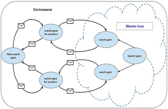
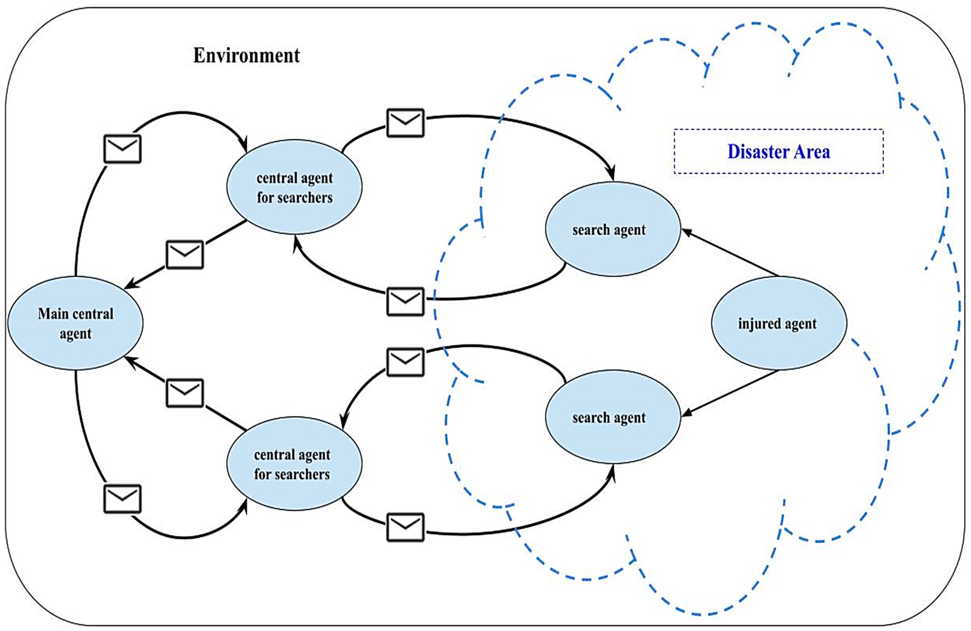
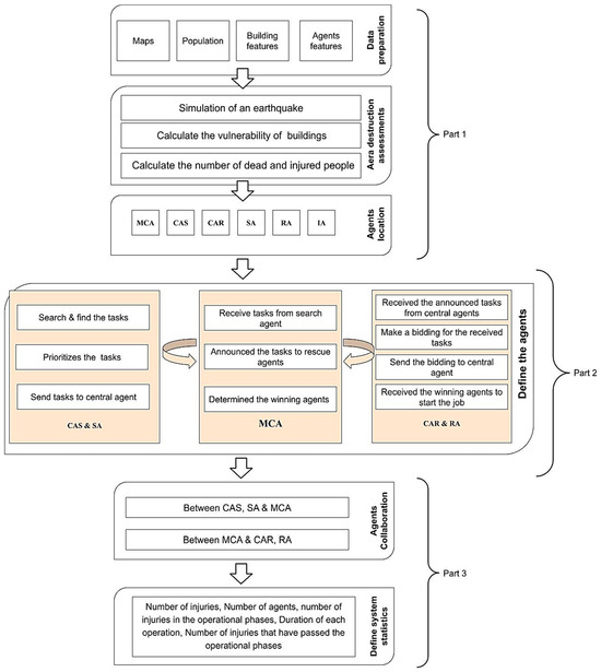
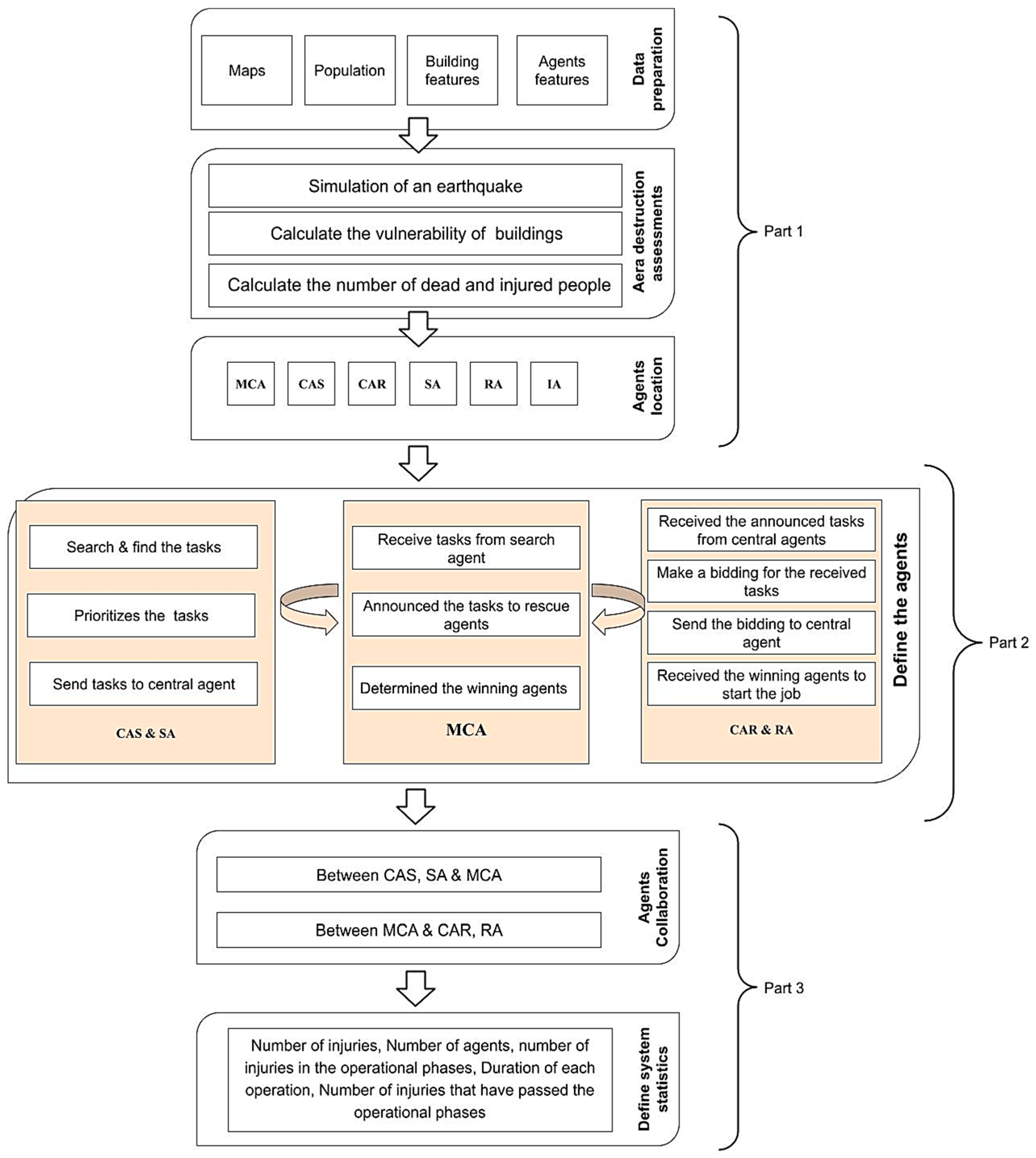
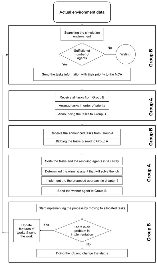
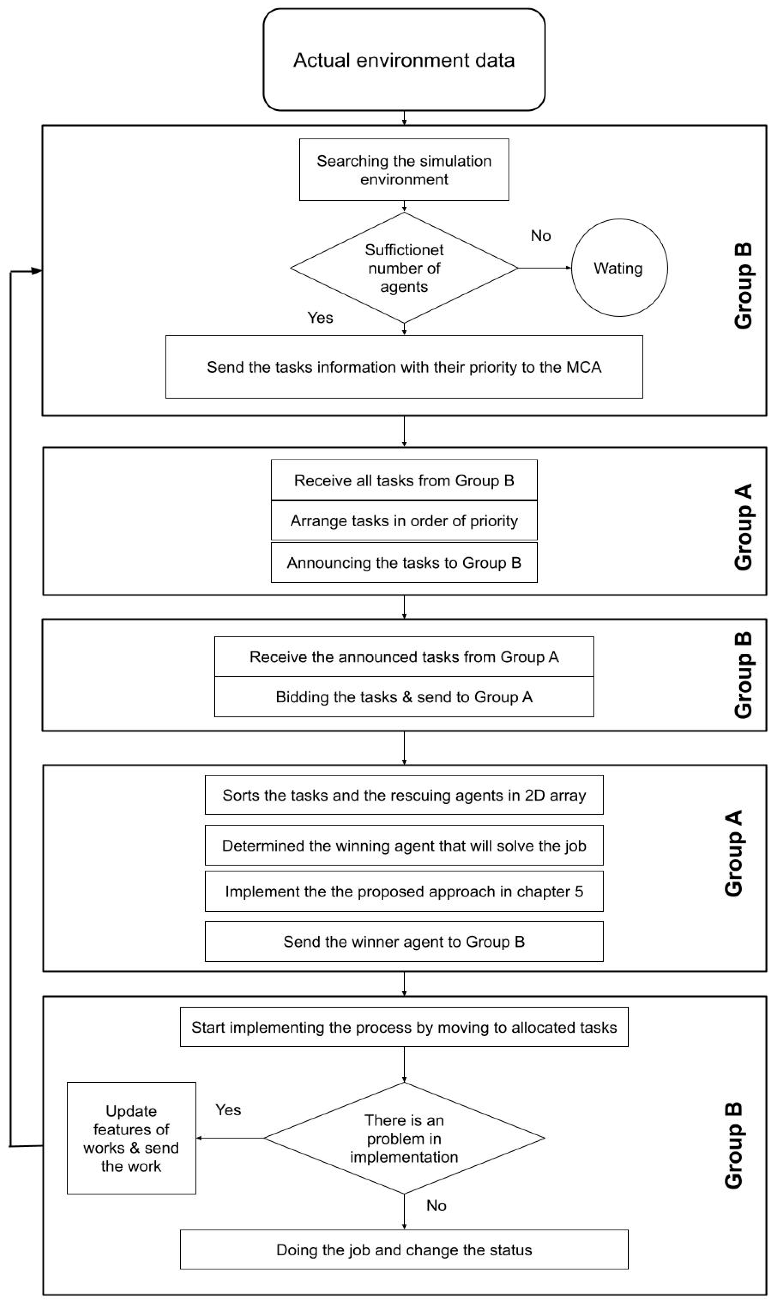
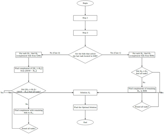
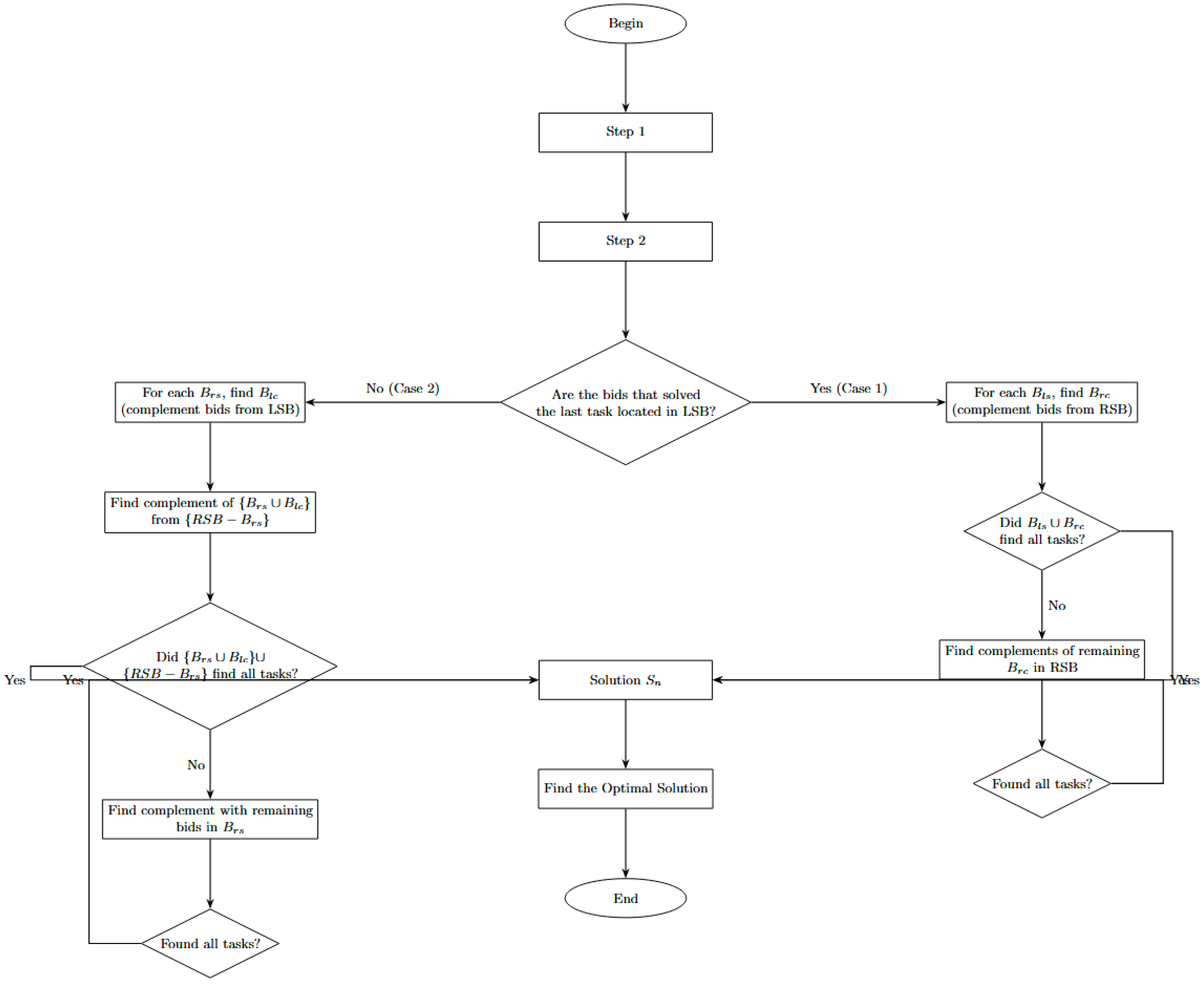
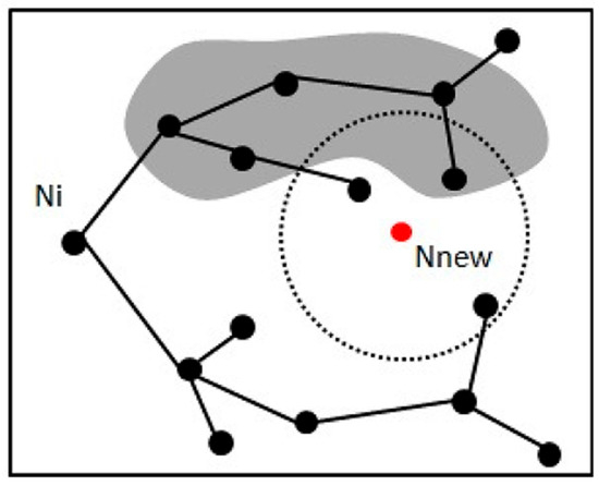
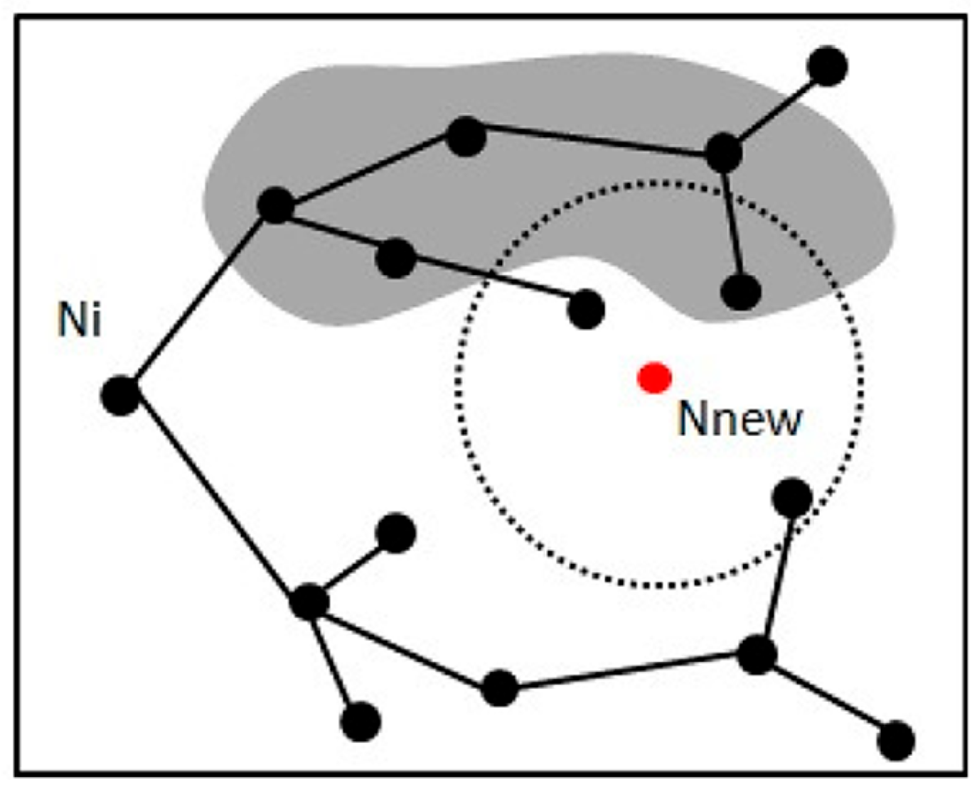
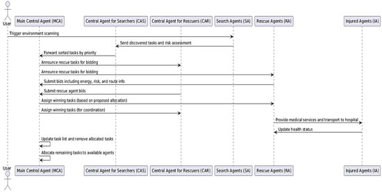
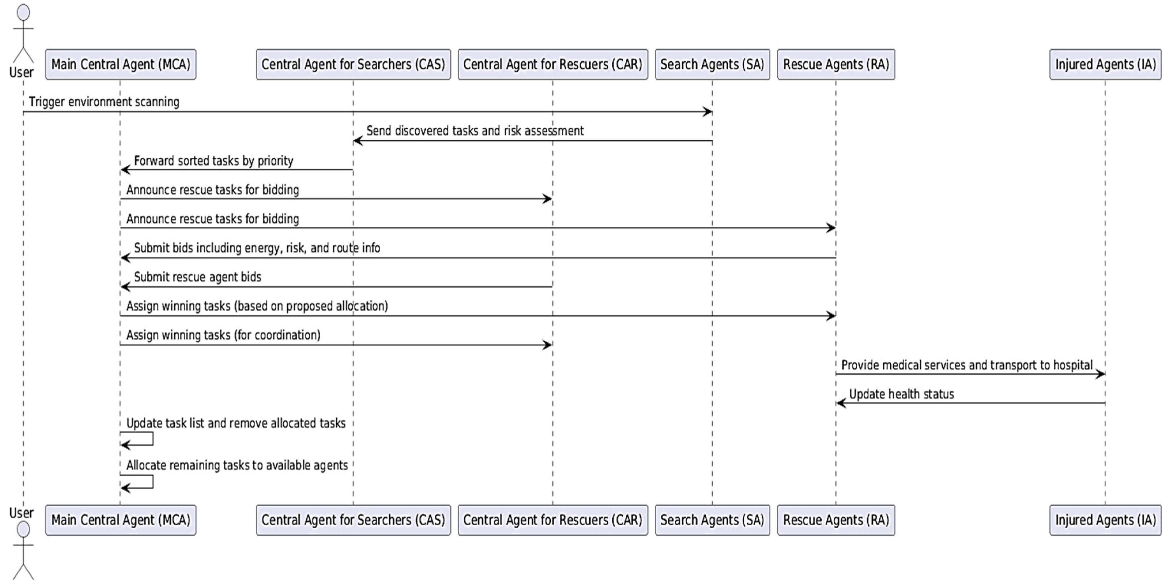
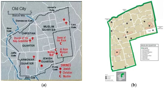
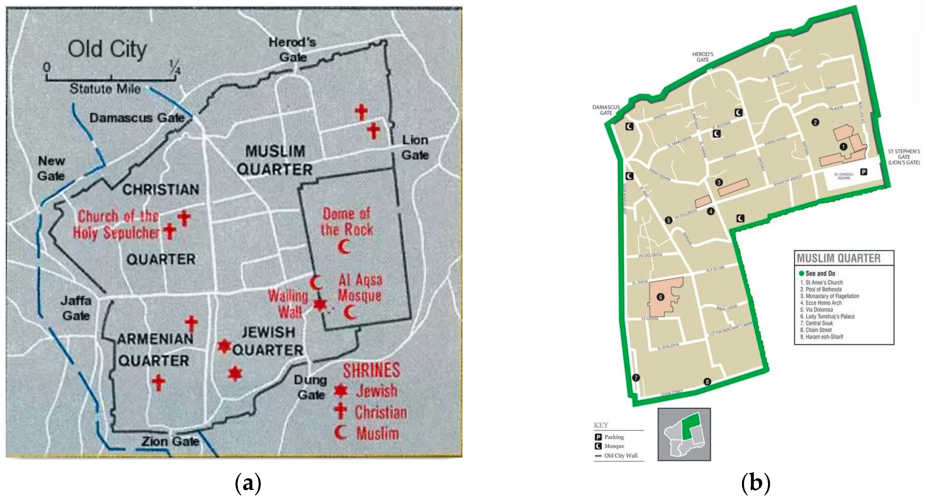
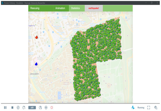
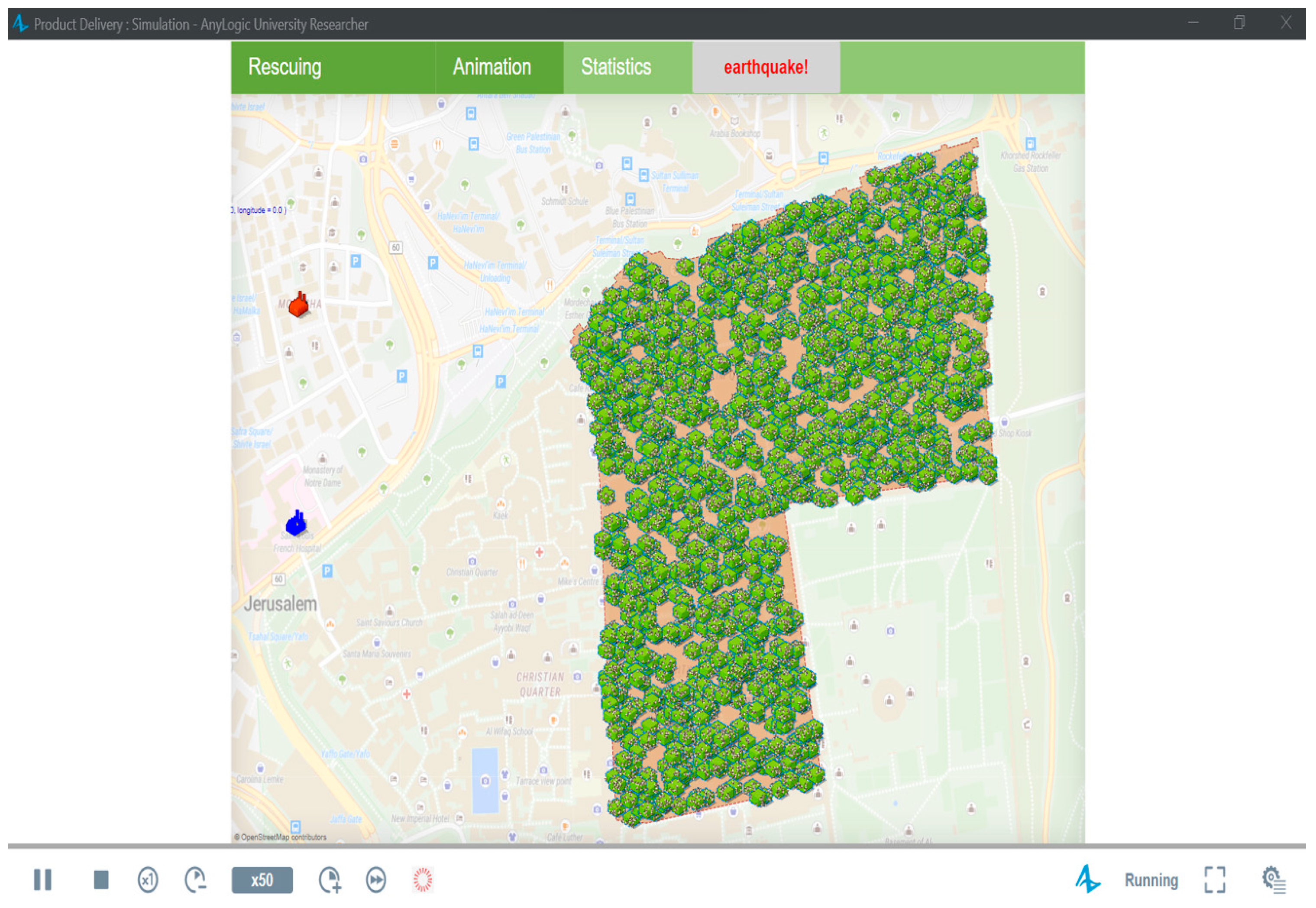
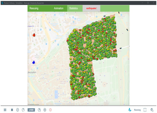
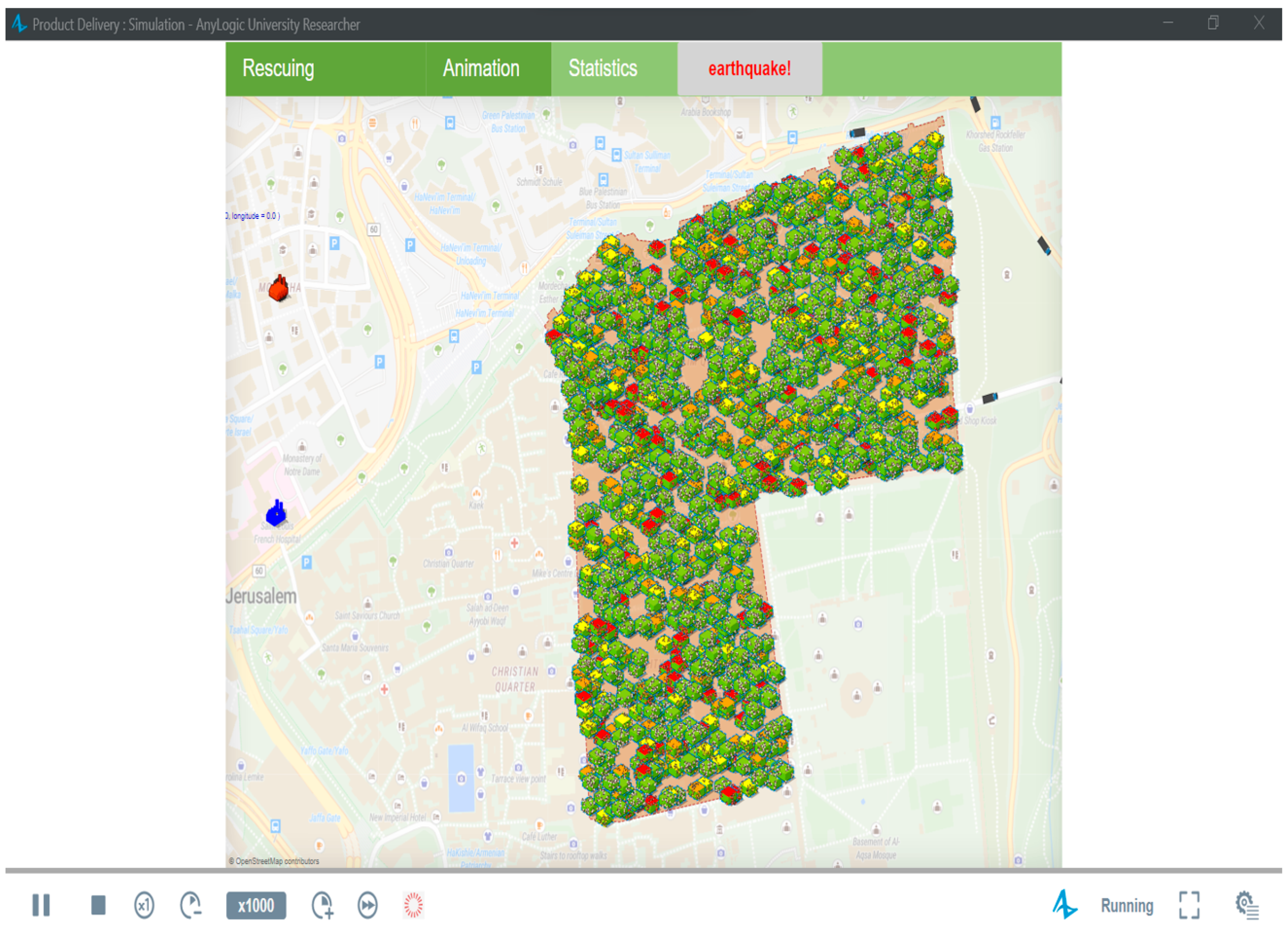
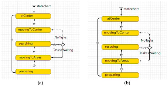
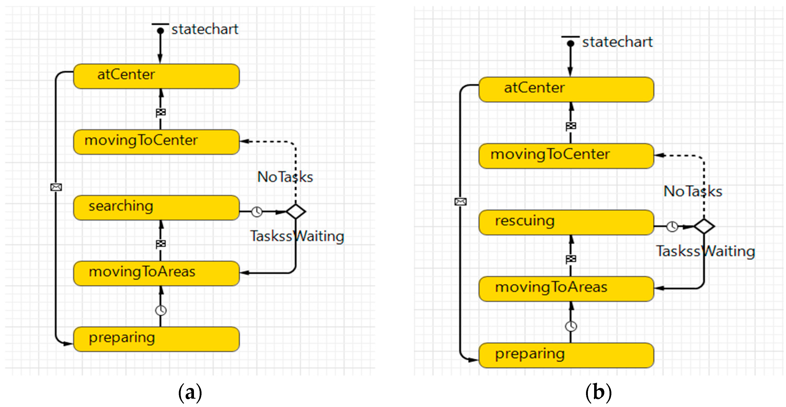
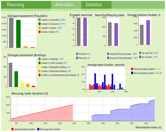
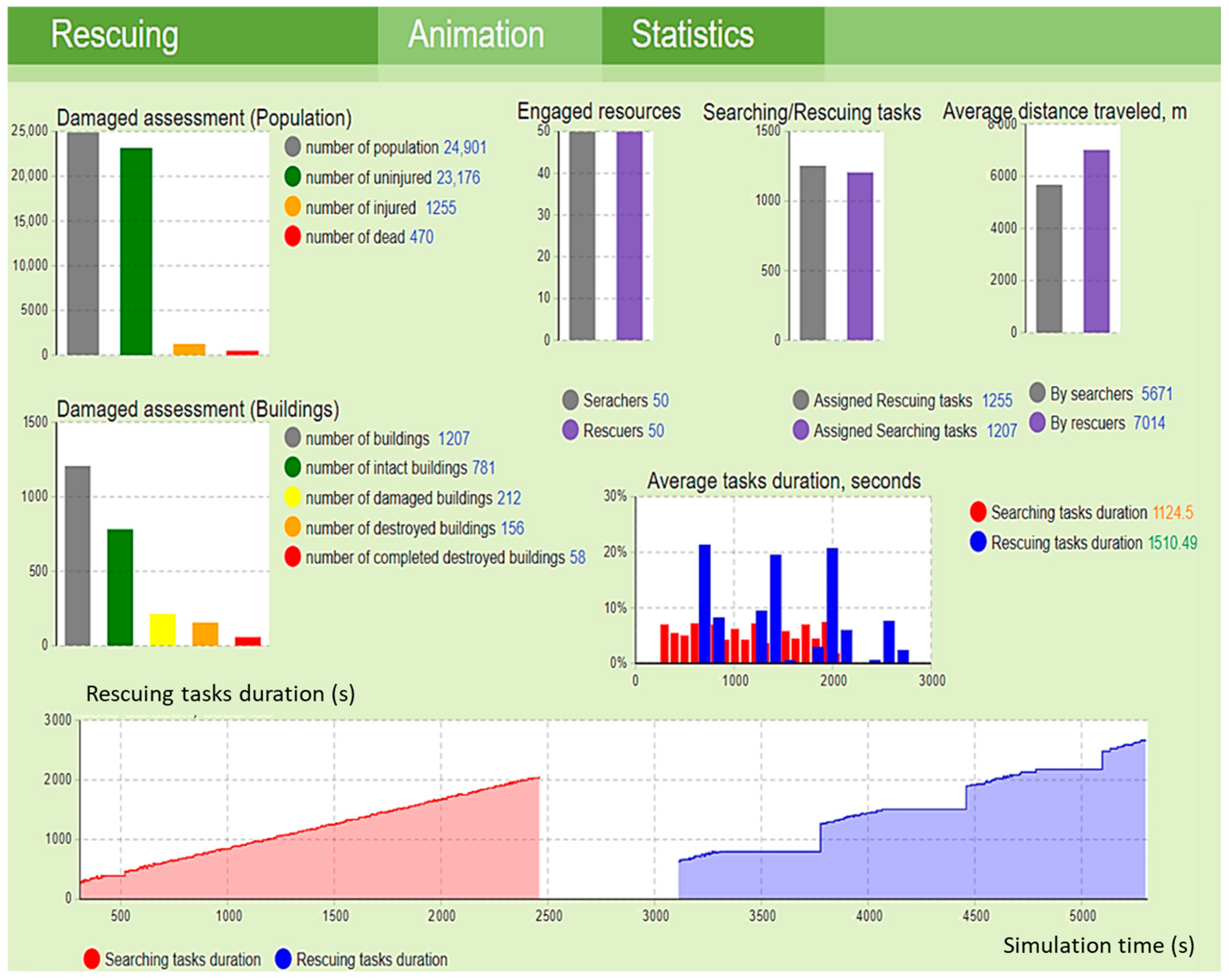
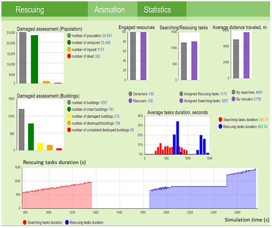
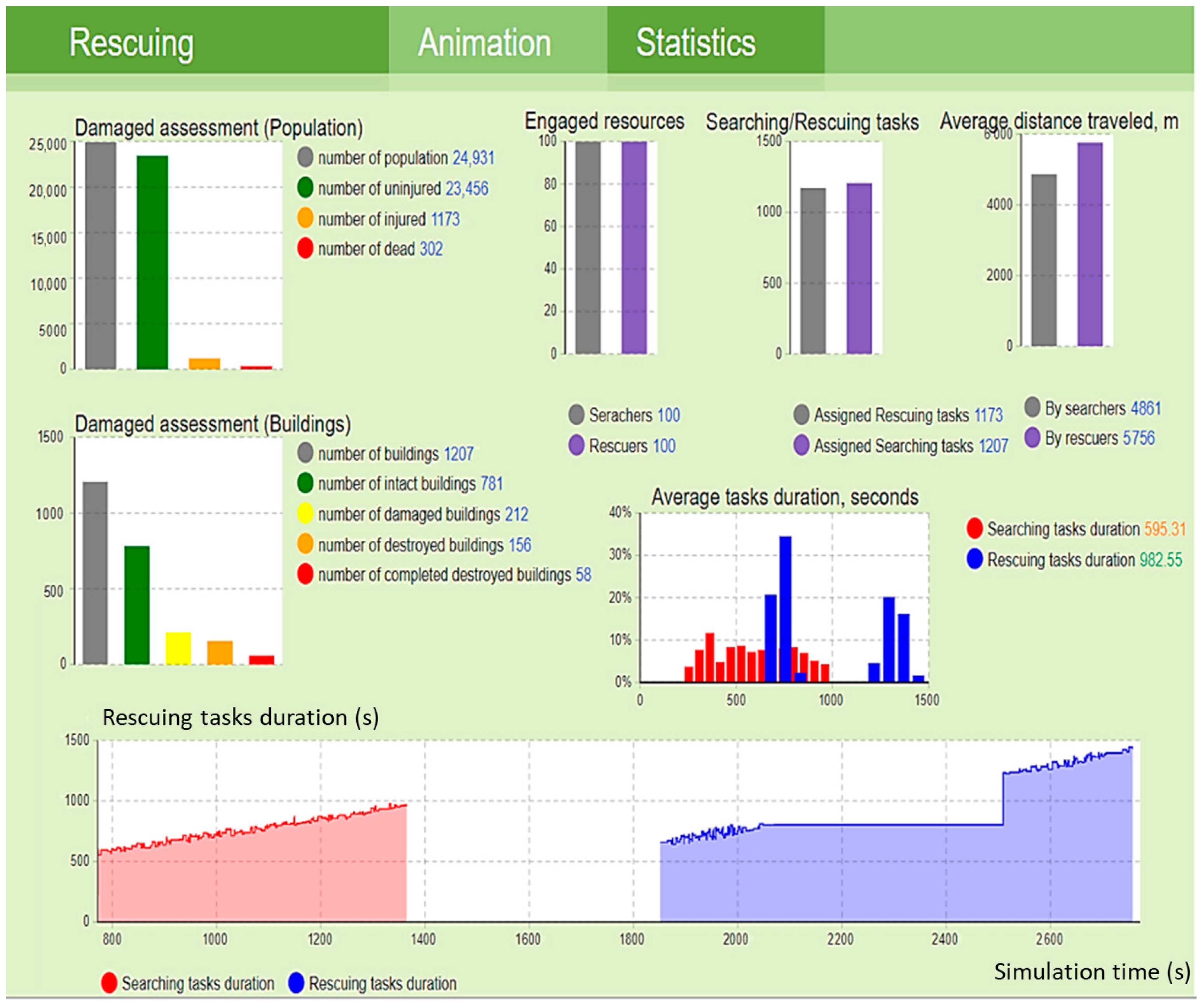
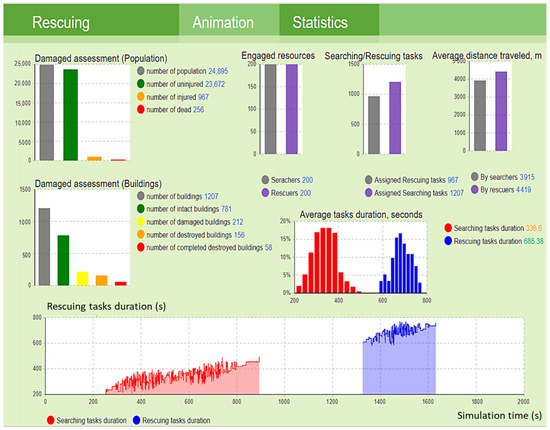
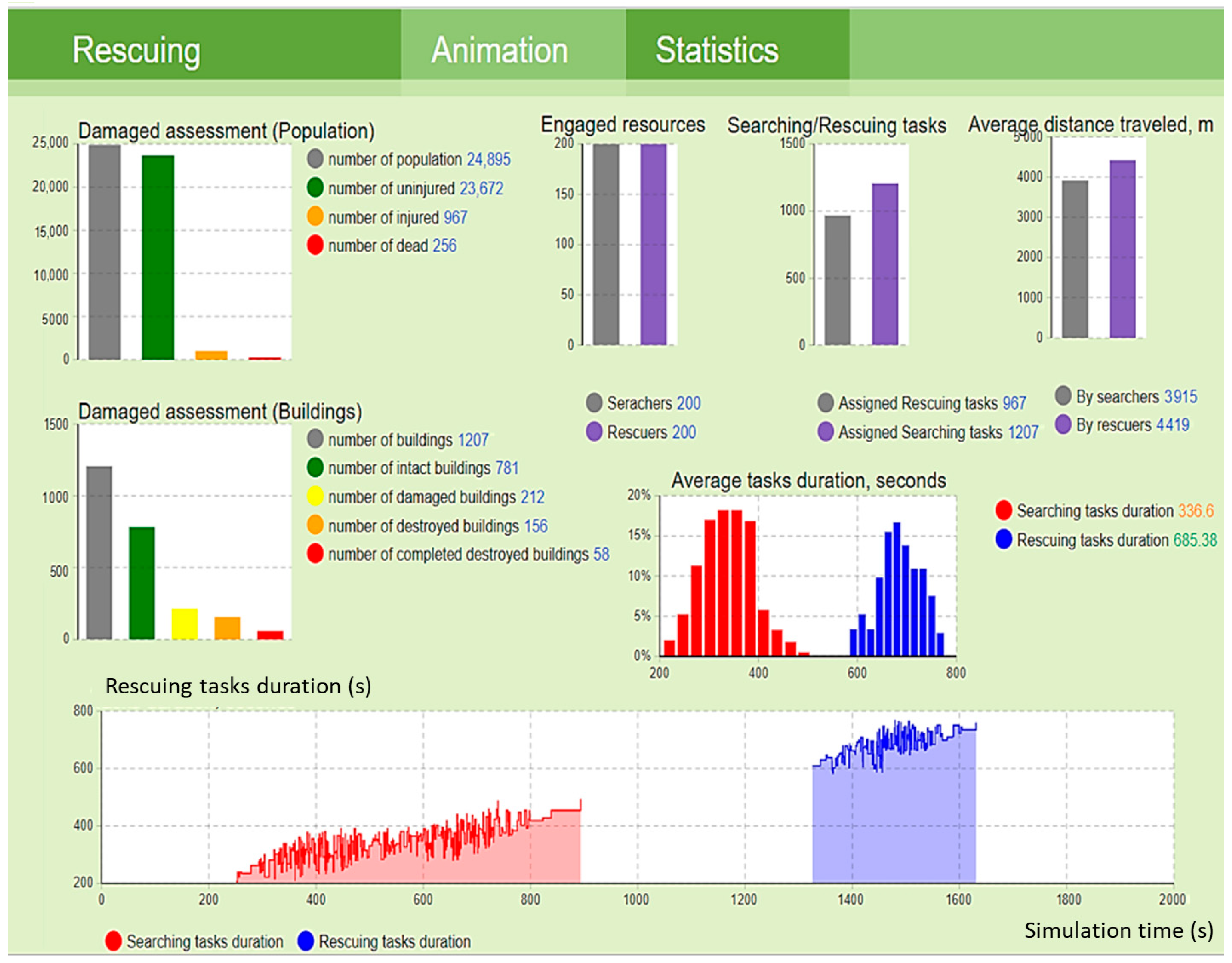
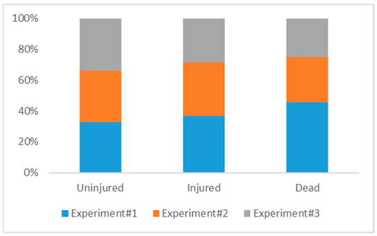
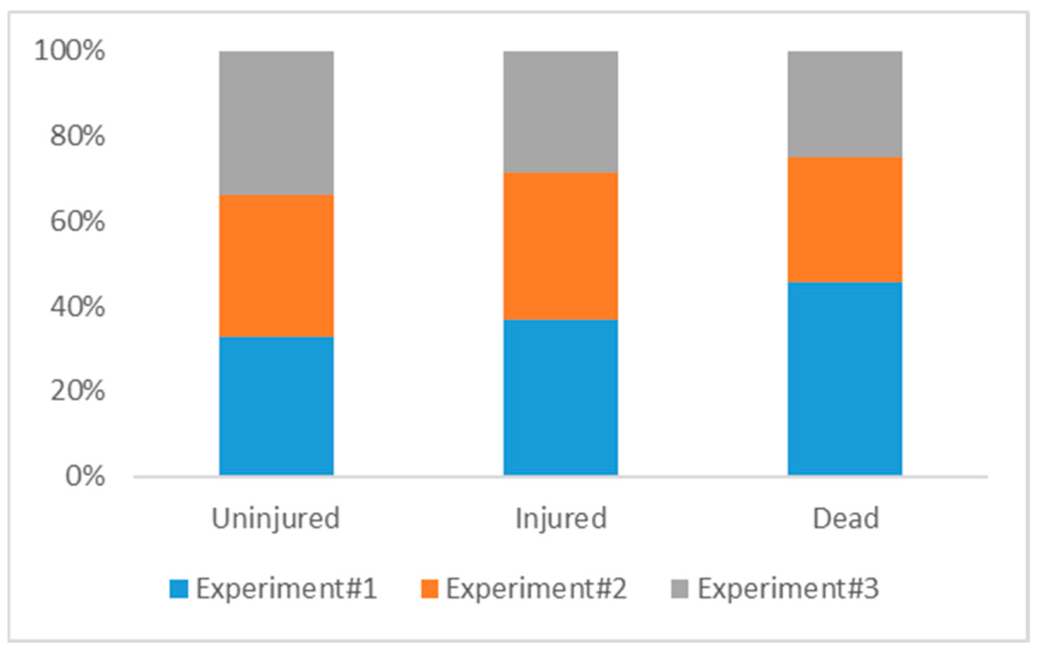
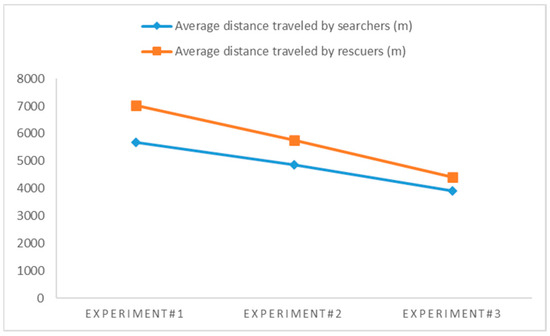
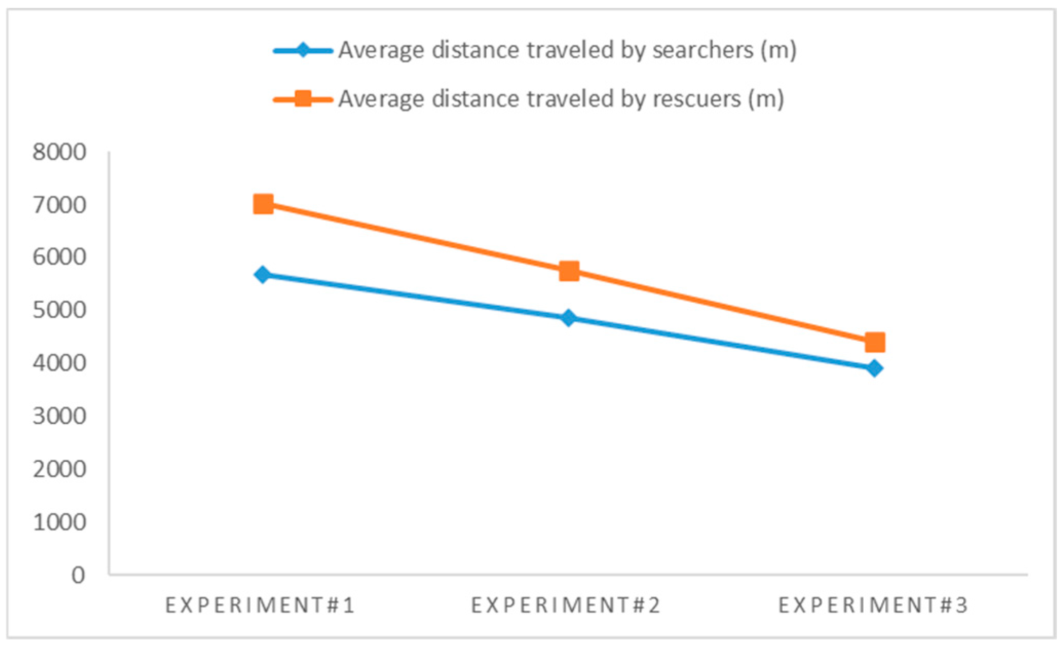
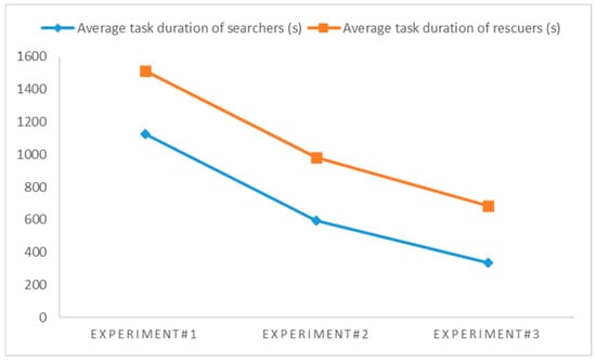
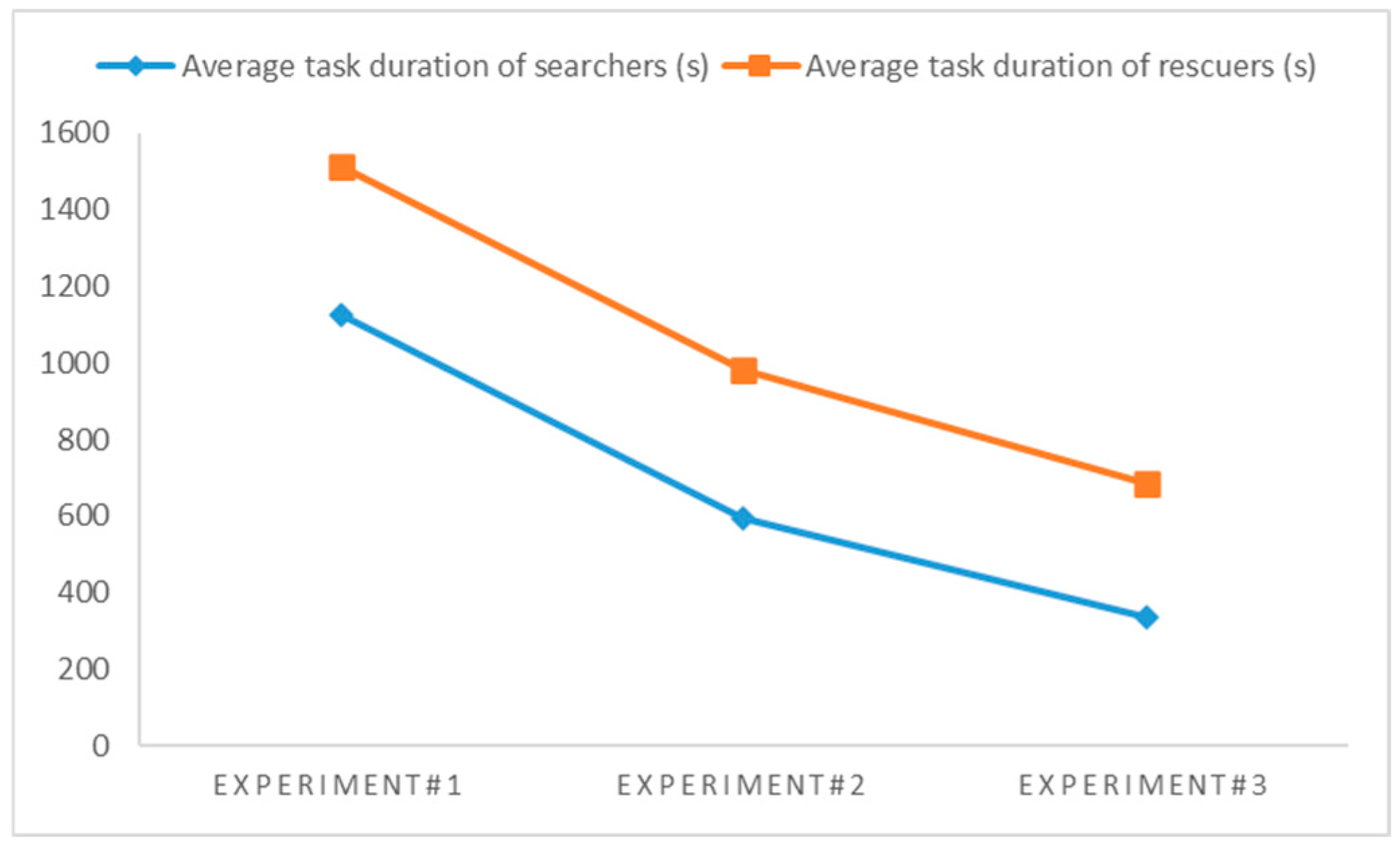
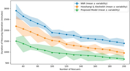
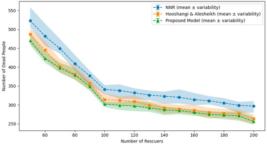
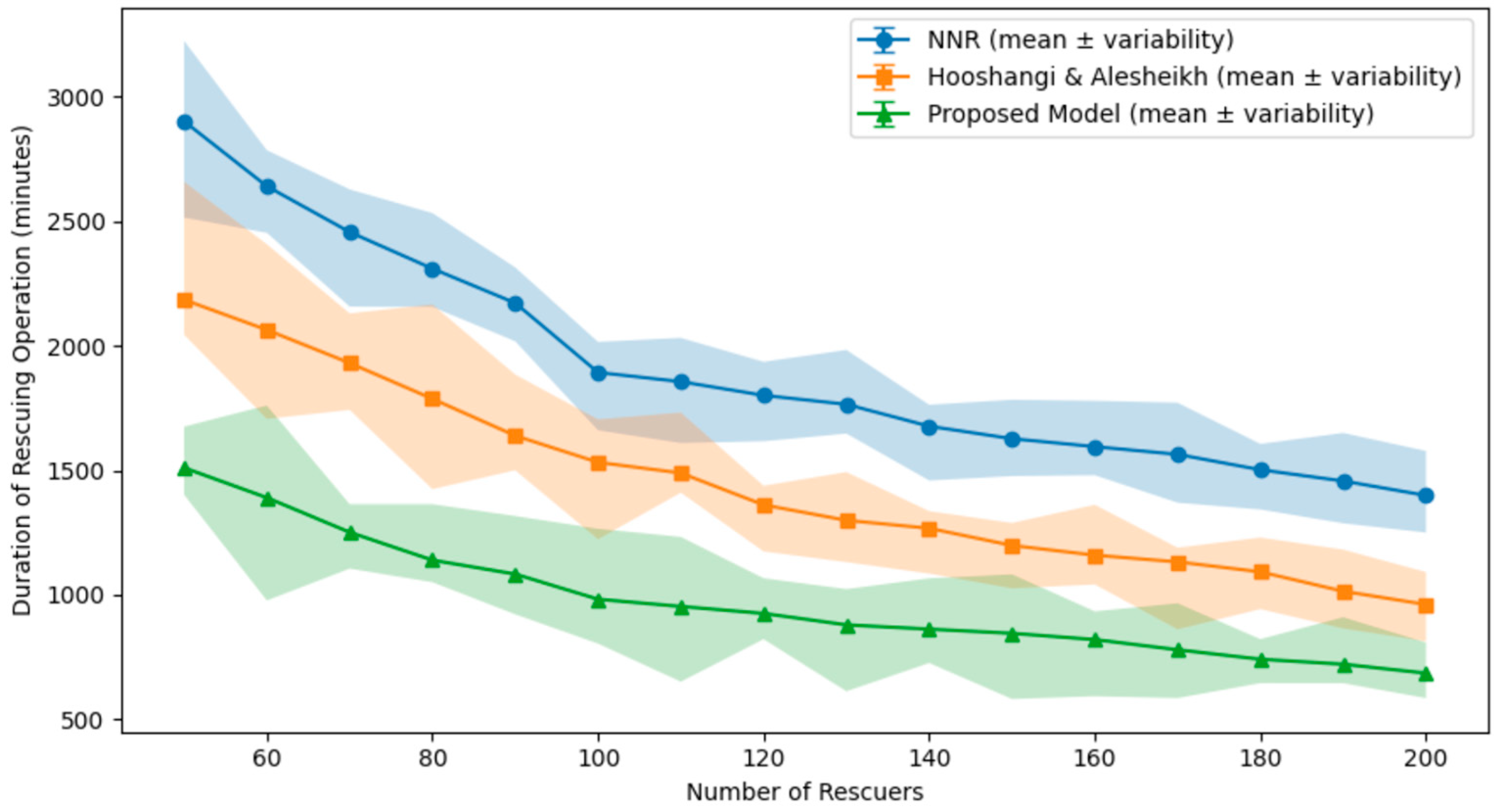
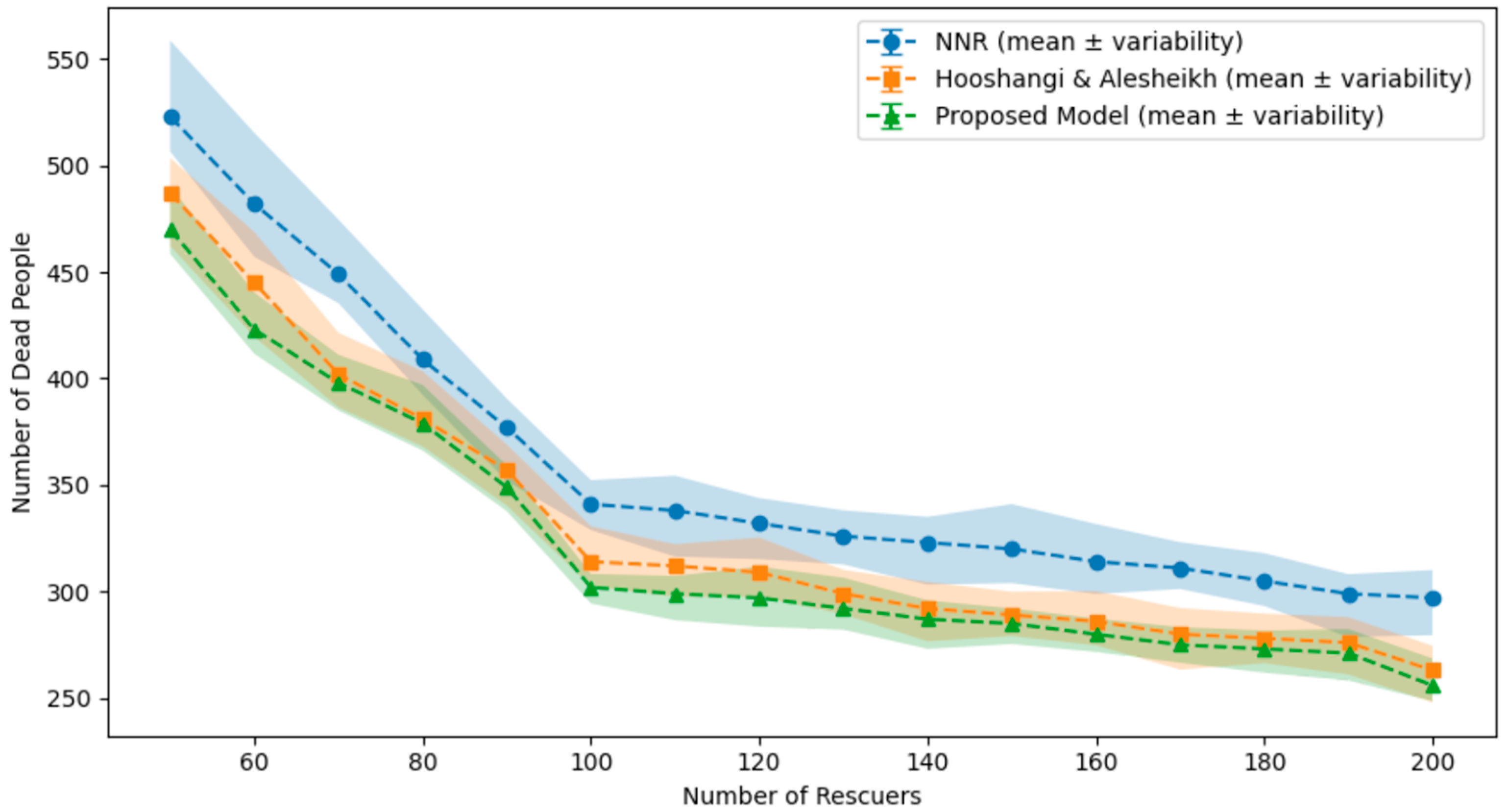

Disclaimer/Publisher’s Note: The statements, opinions and data contained in all publications are solely those of the individual author(s) and contributor(s) and not of MDPI and/or the editor(s). MDPI and/or the editor(s) disclaim responsibility for any injury to people or property resulting from any ideas, methods, instructions or products referred to in the content. |
© 2026 by the authors. Licensee MDPI, Basel, Switzerland. This article is an open access article distributed under the terms and conditions of the Creative Commons Attribution (CC BY) license.