


Abstract
The Eddy Covariance station provides observations of agrometeorological variables and surface energy fluxes, collected from 2019 to 2022, in a citrus orchard located in the Souss-Massa plain, Morocco. The present dataset comprises measurements recorded via a set of aboveground and subsurface sensors. The aboveground setup consistently measures air temperature, relative humidity, wind speed, net radiation, and precipitation. Additionally, the subsurface setup continuously tracks soil temperature, moisture, and electrical conductivity at depths from 5 to 80 cm, along with soil heat flux. Moreover, these setups enable the measurement of turbulent fluxes (sensible and latent heat). Given the limited availability of long-term agrometeorological data in semi-arid regions of the Mediterranean, this paper addresses a critical data gap by providing a reliable agrometeorological dataset. The latter consists of two types of data: 30 min interval files and high-frequency files (20 Hz, i.e., one measurement every 50 ms). The processing of this data involved Card Convert, MATLAB EC-Pack, and Excel, with data quality control performed by removing outliers and excluding nighttime fluxes. The dataset is organized in a table and provided in a .csv format with standard metadata. It is designed for a wide range of applications, including evapotranspiration modeling, satellite product validation, agroclimatic monitoring, determining crop irrigation requirements, precision irrigation planning, and water management. Additionally, the dataset can be reused for crop and hydrological model calibration, as well as soil moisture and crop stress prediction using machine learning algorithms.
Dataset: DOI: 10.17632/rg4yb8m5sf.1; direct URL to data: https://data.mendeley.com/datasets/rg4yb8m5sf/1.
Dataset License: CC-BY 4.0
1. Summary
There has been a clear imbalance between water supply and demand across the Mediterranean. Different anthropogenic and natural factors have significantly contributed to this imbalance, including climate change, prolonged droughts, population growth, groundwater over-pumping, and agricultural intensification [1,2,3]. Precipitation in this region has an irregular spatio-temporal distribution, which has further exacerbated water shortages [4,5,6]. Over the last decade, climate change and ongoing pressure on water resources have increased challenges for Mediterranean countries, including Morocco [7,8,9,10].
The Souss-Massa region is one of the most important agricultural zones in Morocco, serving as the national breadbasket and a critical area for food security [11,12,13,14,15]. Given its ideal climate and fertile soils, this region contributes nearly 85% of Morocco’s vegetable exports and half of its citrus exports [11,16,17]. However, the area is classified as semi-arid to arid; it receives limited precipitation (about 200 mm yearly), yet evapotranspiration can reach nearly 2000 mm [11]. Therefore, monitoring agrometeorological parameters is highly important for implementing sustainable agricultural practices. Monitoring provides scientists and farmers with vital information regarding crop development, irrigation strategies, and water requirements to minimize losses [18]. Given the limited availability of long-term agrometeorological data in semi-arid Mediterranean regions, this study addresses a critical data gap by providing a reliable dataset.
The Eddy Covariance (EC) technique has emerged as a fundamental tool for monitoring these agrometeorological parameters, providing precise, high-frequency measurements of energy and mass exchanges across Mediterranean agroecosystems [19]. Recent research has utilized EC to reveal significant irrigation inefficiencies, such as 52% water loss via deep percolation in citrus orchards, leading to the development of tailored irrigation protocols for the Souss-Massa region [14]. Beyond direct measurement, EC serves as the primary benchmark for validating remote sensing evapotranspiration products like PMLv2 and SAFER, which are essential for scaling field observations to regional management [20,21]. In complex Mediterranean landscapes, progress has been made in refining EC data processing by adapting gap-filling methods to account for wind direction and topographic heterogeneity [22]. Furthermore, integrating EC with sap flow sensors has advanced the partitioning of evapotranspiration into soil evaporation and plant transpiration, uncovering how tree capacitance regulates water use in species like olive and citrus [23,24]. These studies also highlight the role of orchards as significant carbon sinks, fixing up to 3855 kg CO2/ha/year, thereby linking water management to climate mitigation [25]. Ultimately, the synergy between EC measurements and satellite-driven models like SEBAL or METRIC-EEFlux offers a robust framework for improving water productivity in these water-scarce environments [26,27].
2. Study Site and Data Description
2.1. Study Site
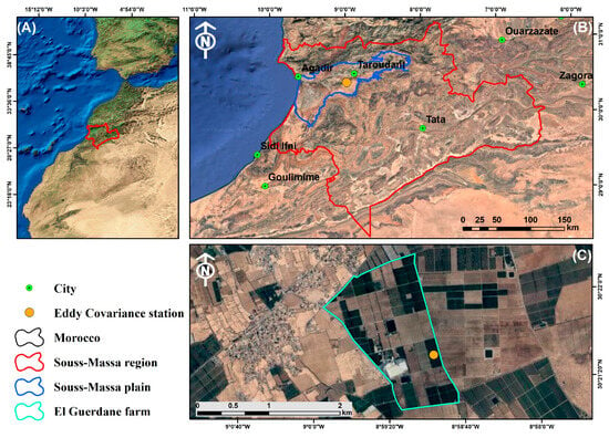
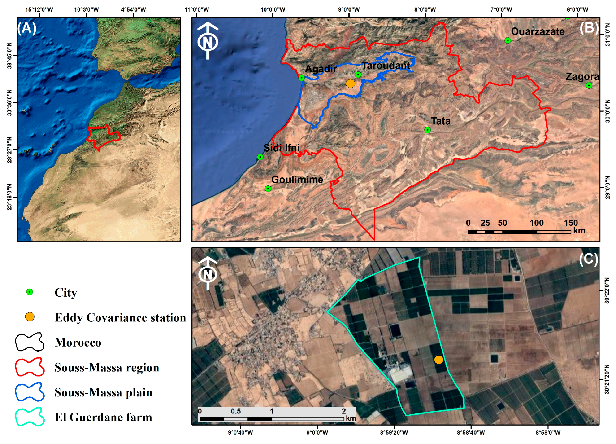
The dataset was collected in a commercial citrus orchard (30°21′29″ N; 8°58′57″ W and 208 m a.s.l), located in the El Guerdane area within the Souss Massa plain, a semi-arid region in central Morocco, using an Eddy Covariance system installed on a 6 m tower (Figure 1).
Figure 1.
Location of the Souss-Massa region (A), the Souss-Massa plain (B), and the El Guerdane farm monitoring site with the Eddy Covariance tower (C).
The citrus orchard consists of two plots of the clementine Esbal variety: one is 16 years old, with a density of 1000 trees/ha and a spacing of 2 m between trees and 5 m between rows, while the second plot is 3 years old with a density of 1500 trees/ha and a spacing of 1 m between trees and 5 m between rows [28]. The orchard periodically undergoes several practices, including tree pruning, pest management, and soil tillage, to ensure good orchard performance. The orchard’s soil is loamy sand with 80% of sands, 10% loam, and 10% clay. The field capacity (θFC) and the wilting point (θWP) of the loamy sand soil are respectively 0.15 m3/m3 and 0.06 m3/m3 [15].
2.2. Data Description
The dataset provides continuous, high-temporal-resolution agrometeorological and surface energy flux measurements for the period 2019–2022, offering valuable insights into soil–plant–atmosphere interactions in data-scare Mediterranean areas (Table 1).
Table 1.
Data Summary.
The present dataset, with half-hourly measurements and daily aggregation, includes:
- i.
- Agrometeorological variables: Air temperature, relative humidity, rainfall, canopy and bare soil temperature, soil temperature, soil electrical conductivity, volumetric water content, and the computed actual (ETa) and reference evapotranspiration (ET0) derived from the measured meteorological data.
- ii.
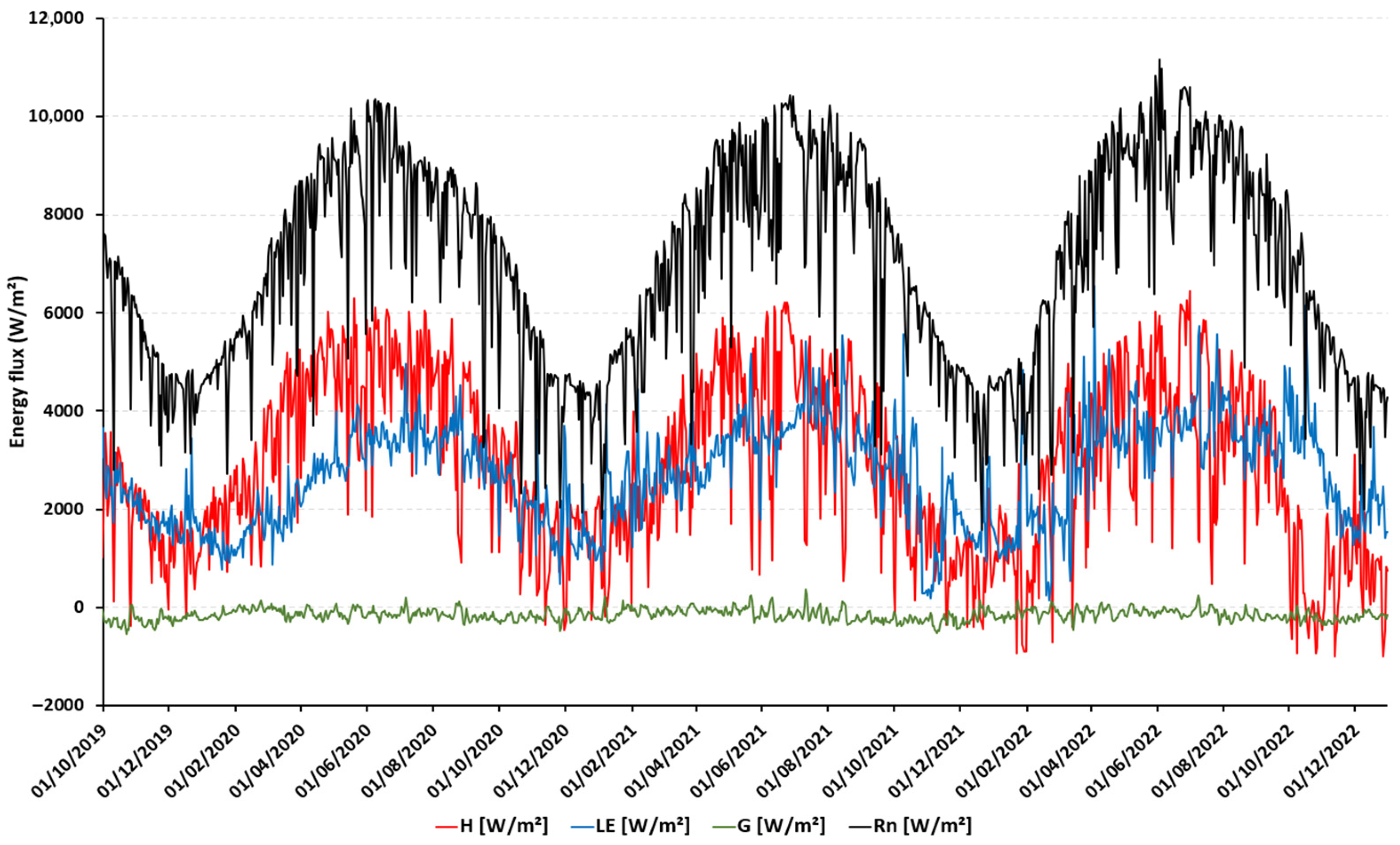
- Surface energy fluxes: Net radiation (Rn), latent heat flux (LE), sensible heat flux (H), and ground heat flux (G) (Figure 2).Figure 2. Daily surface energy balance components (2019–2022).
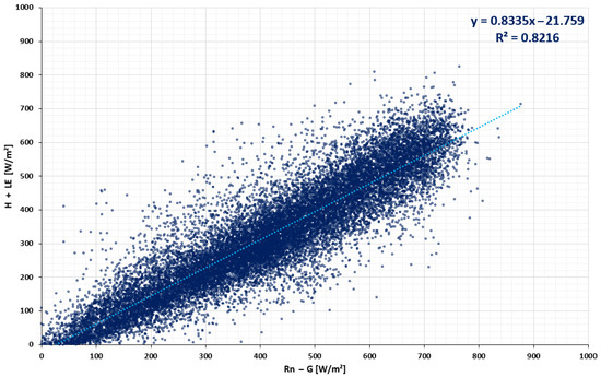
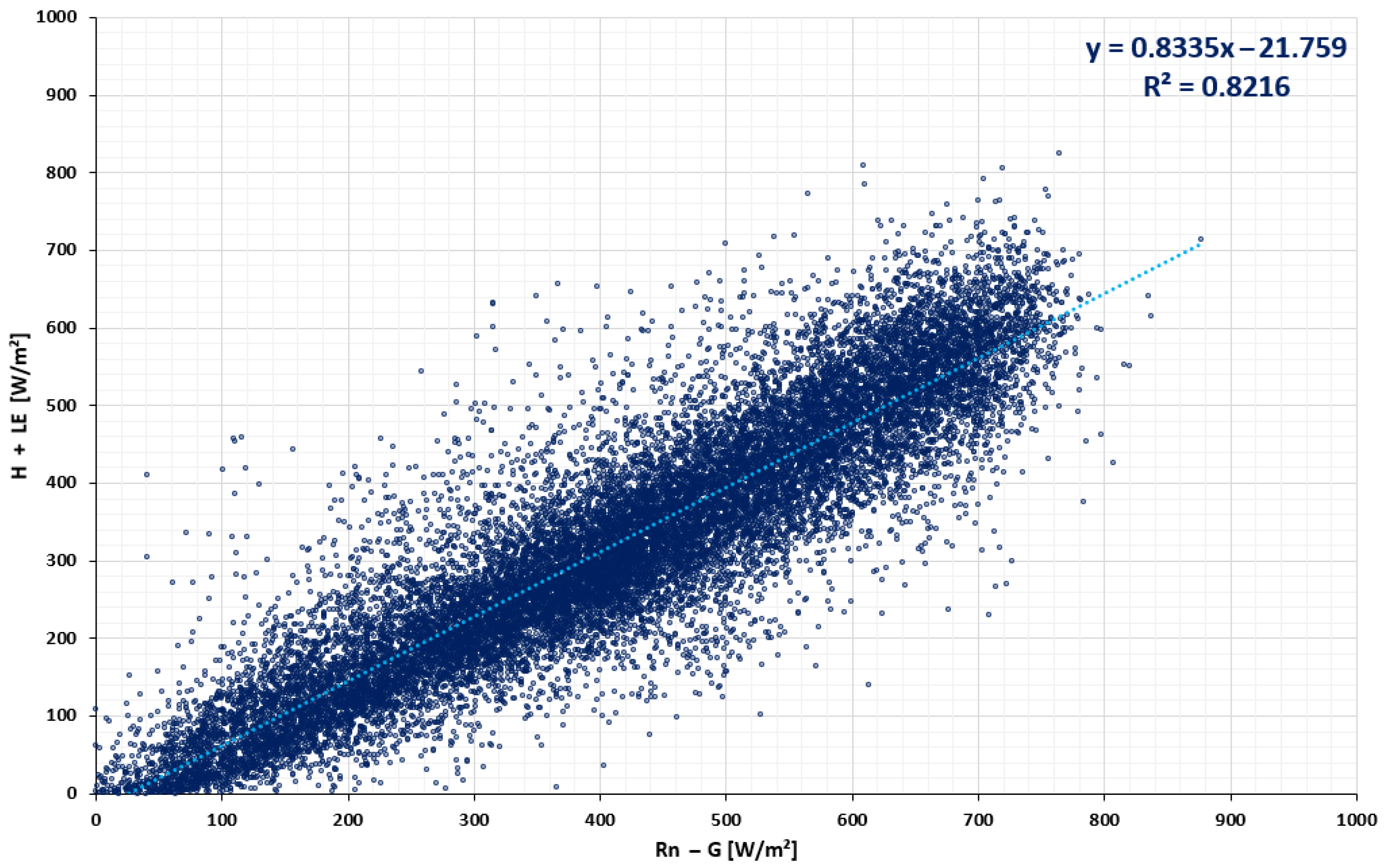
Summaries of the data at 30 min intervals provide a clear, consistent record that can be used to understand evapotranspiration dynamics, crop water demand, and energy balance in semi-arid agriculture (Figure 2). The energy balance has been carefully checked and has given a high degree of accuracy, with a coefficient of determination (R2) of 0.81. (Figure 3), which demonstrates the quality and reliability of the data for both scientific and applied research purposes.
Figure 3.
Surface energy balance closure (2019–2022).
The surface energy balance closure (EBC) for the study period was evaluated by regressing turbulent fluxes (H + LE) against available energy (Rn − G). The resulting closure ratio (CR ≈ 0.82) indicates a high degree of energy accountancy, consistent with high-frequency 20 Hz Eddy Covariance measurements. This level of closure aligns well with similar Mediterranean studies, such as those by Testi et al. [29] in Spanish olive orchards and Cava et al. [30] in Italian short vegetation, where EBR typically ranges from 0.75 to 0.85. The residual imbalanced energy (≈18%) is likely attributed to the heterogeneous soil moisture distribution under the drip irrigation system and the influence of the surrounding mountainous topography on local advection.
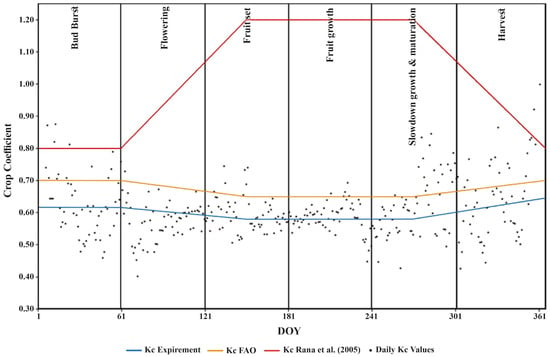
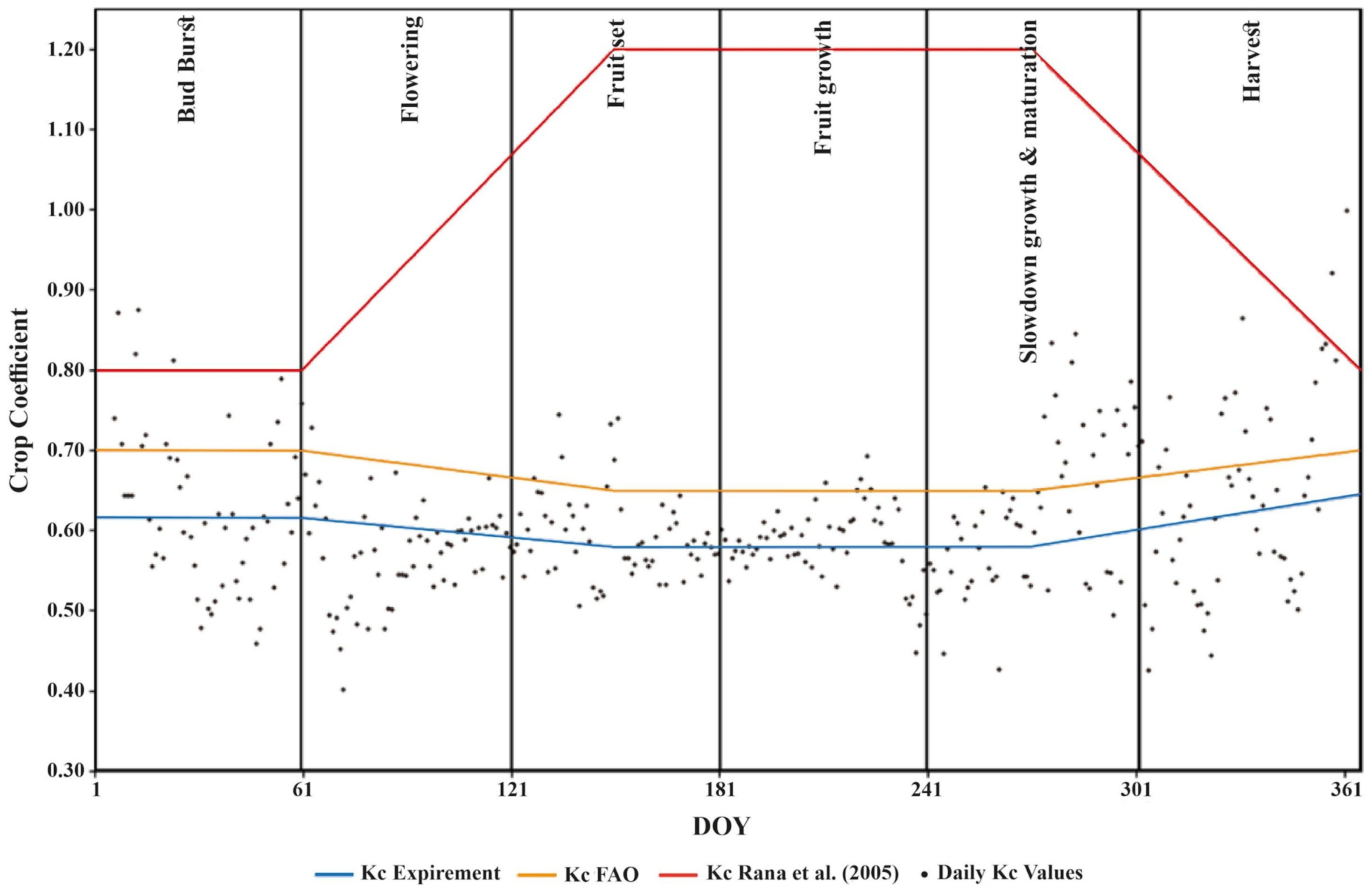
Additionally, this agrometeorological dataset served as a reliable basis for calculating the actual Kc for the clementine Esbal variety. This coefficient varies throughout the irrigation season (initial, crop development, mid, and late season), taking into account the crop type, leaf area, plant height, and phenological stage, to adjust the ET0 for a specific crop. The actual Kc values were calculated as the ratio between ETa derived from the Eddy Covariance system and ET0 computed from site agrometeorological parameters, according to the single crop coefficient (Figure 4) [31]:
Figure 4.
Daily actual Kc values and their derived stage average for clementine crop developed in 2023 by Abou Ali et al. [14], compared to the values from the FAO-56 paper and Rana et al. [31,32].
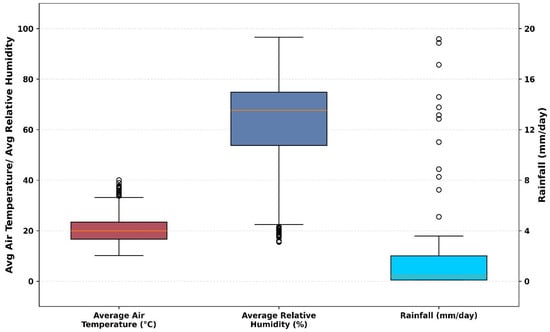
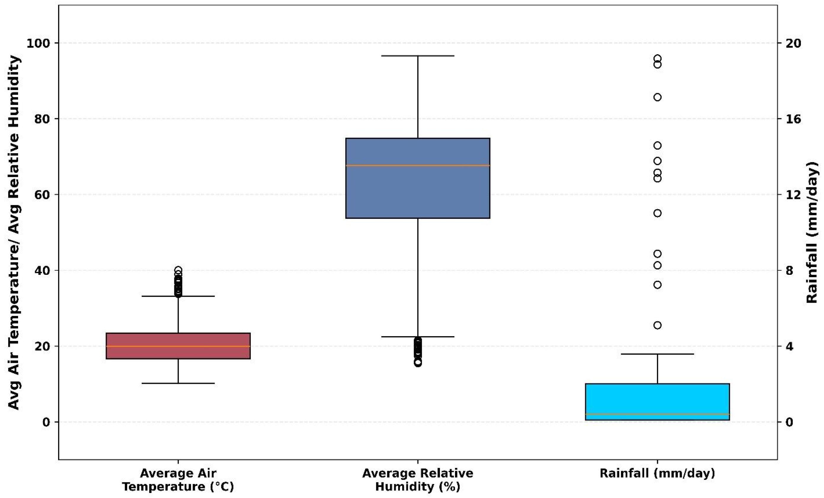
These boxplots (Figure 5) provide a concise statistical summary of the site’s climatology over the study period (n = 1192 days). Air temperature remains relatively stable with a median of approximately 20 °C, while relative humidity shows high variability (interquartile range from 55% to 75%), reflecting the influence of the nearby mountain ranges on moisture retention. The rainfall distribution is highly skewed, with most days recording zero precipitation (median ≈ 0 mm/day), punctuated by several extreme storm events reaching nearly 20 mm/day as indicated by the outliers. This visualization highlights the semi-arid climate of this region characterized by consistent thermal conditions and sporadic, high-intensity rainfall pulses.
Figure 5.
Statistical distribution of climatological parameters: air temperature, relative humidity, and rainfall.
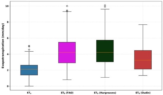
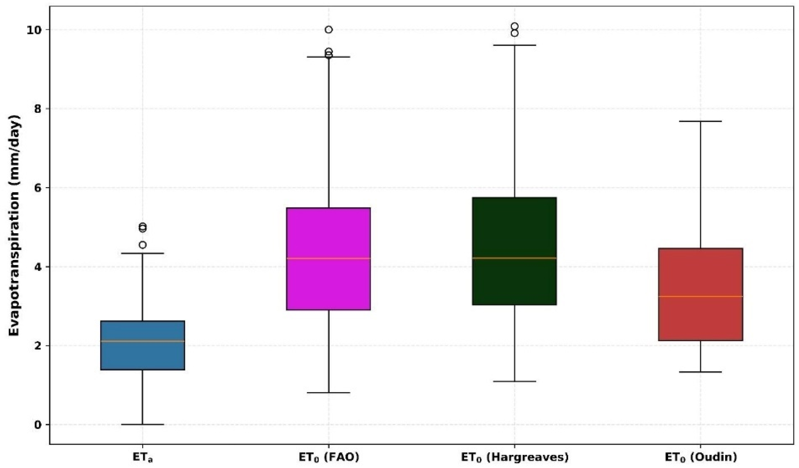
This boxplot (Figure 6) compares the statistical distribution of ETa against ET0 over the study period. The ETa (median ≈ 2.1 mm/day) is consistently lower than the potential atmospheric demand, reflecting the water-limited conditions of the site. Among the reference models, FAO-56 and Hargreaves show high agreement in their median values (≈4.2 mm/day). In contrast, the Oudin method produces more conservative estimates with lower variability, aligning more closely with the ETa magnitude. This comparison highlights that while FAO-56 is the standard, simpler empirical models like Oudin may offer a more tempered representation of evaporative demand in this specific regional morphology.
Figure 6.
Comparison of actual evapotranspiration (ETa) and reference evapotranspiration (ET0).
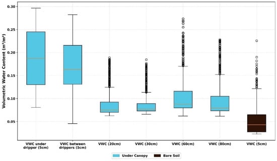
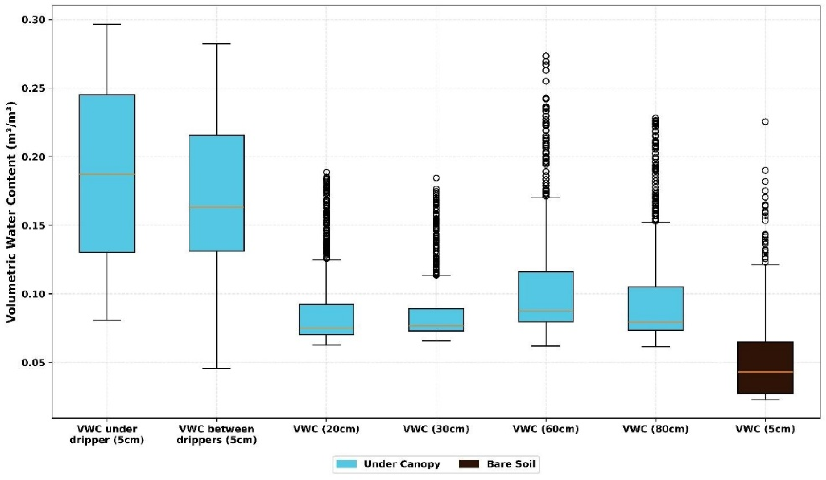
The boxplot in Figure 7 illustrates the vertical distribution of volumetric water content (VWC) measurement points. The highest moisture levels and variability are observed at the 5 cm surface layer under and between drippers (medians ≈ 0.16–0.19 m3/m3), directly reflecting the influence of irrigation pulses. In contrast, the bare soil (5 cm) remains significantly drier (median < 0.05 m3/m3), highlighting the impact of canopy shading and localized water application. At deeper profiles (20 to 80 cm), VWC stabilizes at lower values, though the 60–80 cm layers show numerous potential upper outliers, likely indicating deep percolation events during heavy rainfall. This confirms a highly heterogeneous soil moisture profile driven by the irrigation system and canopy architecture.
Figure 7.
Spatial and vertical distribution of volumetric water content (VWC).
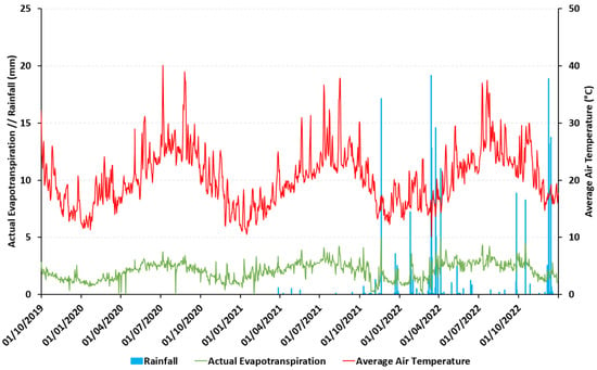
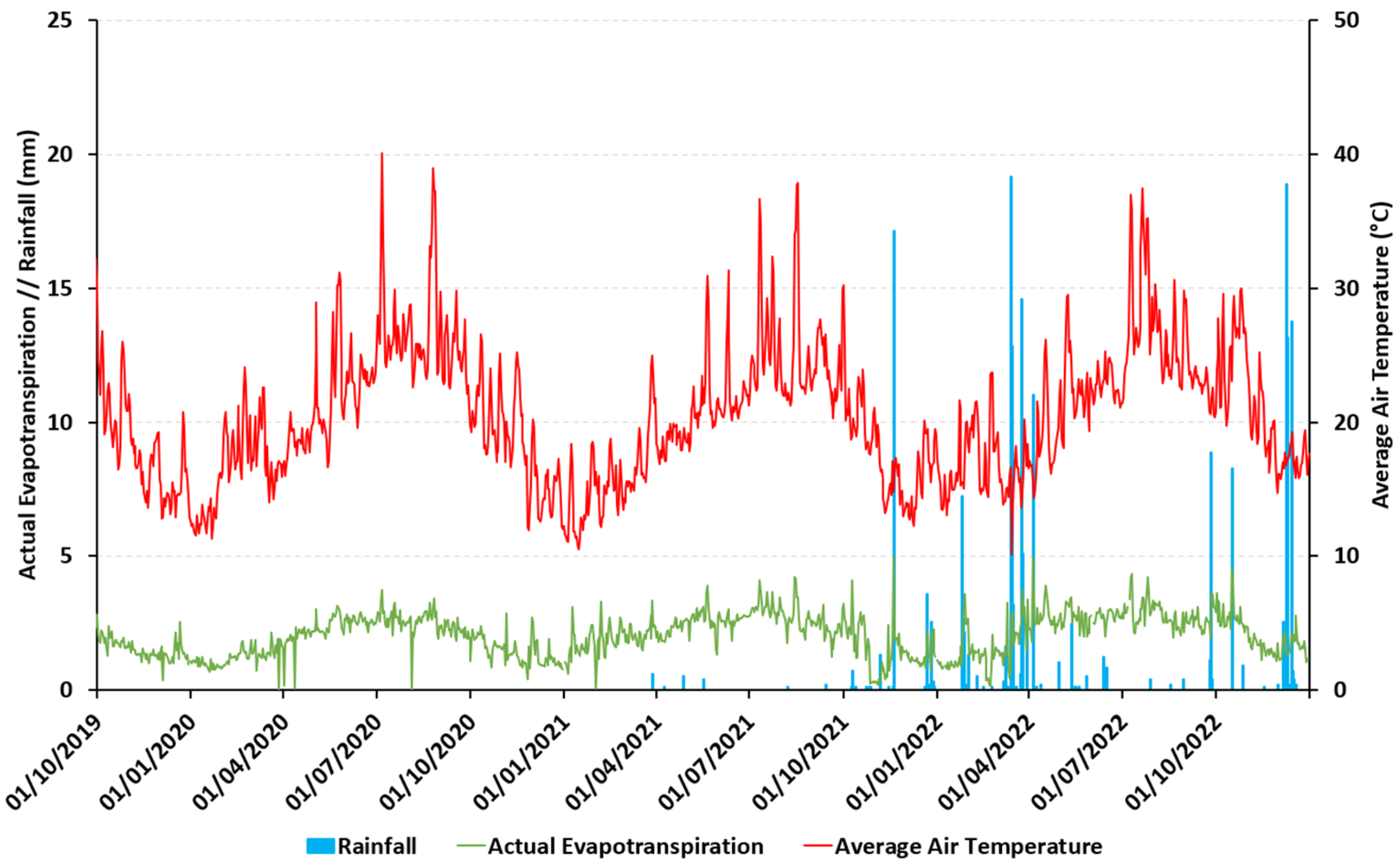
This time-series (Figure 8) provides a comprehensive overview of the climatic and evaporative trends from September 2019 through 2022. The air temperature exhibits a strong seasonal signal, with summer peaks frequently exceeding 35 °C and winter lows around 10 °C. Actual evapotranspiration (ETa) remains relatively stable (mostly < 5 mm/day), but shows visible synchronicity with rainfall pulses recorded from March 2021 onwards. Notably, ETa spikes immediately follow significant rainfall events, such as those in early 2022, highlighting the site’s rapid surface response to water input. This figure demonstrates the transition from a thermally−driven to a moisture-pulse-driven evaporative regime in this semi-arid environment.
Figure 8.
Daily time-series of air temperature, actual evapotranspiration (ETa), and rainfall.
3. Methods
3.1. Experimental Design and Data Collection
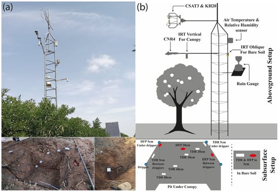
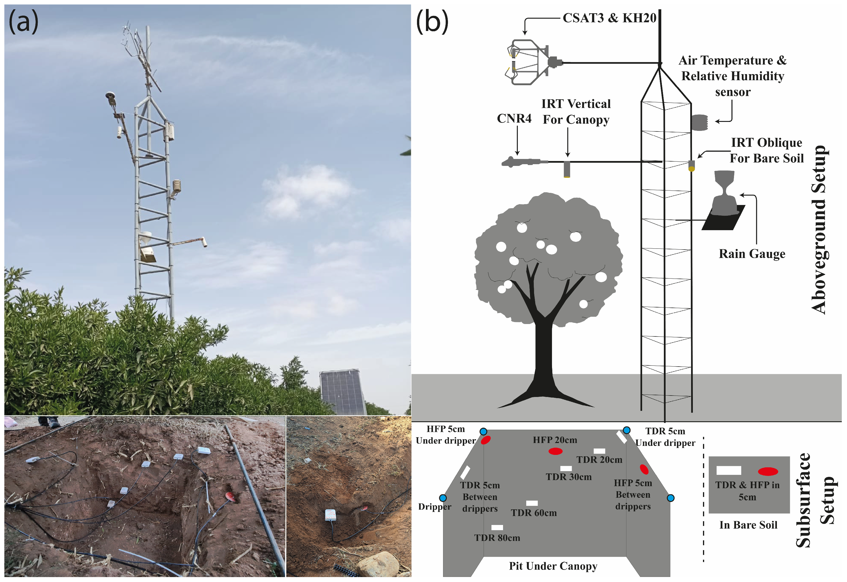
The system consists of two setups (Figure 9); the first is an aboveground setup mounted to the tower, comprising a CSAT3 measuring three-dimensional wind speed and direction, coupled with a KH20 for high-frequency water vapor measurement. In addition to a CS215 air temperature and relative humidity sensor, a rain gauge is also attached to the tower to record precipitation. Similarly, CNR4 is used for downward and upward shortwave and longwave radiation measurement, alongside two SI-111 IRTs: one measuring canopy temperature, and the other measuring bare soil temperature. A subsurface setup is also implemented, consisting of four Hukseflux HFPs: three under the canopy, two at 5 and one at 20 cm, and another in bare soil at 5 cm. In addition, seven embedded TDR sensors are employed, including six under the canopy at various depths, ranging from 5 to 80 cm below the ground surface, and one in bare soil at 5 cm.
Figure 9.
(a) Photos of the Eddy Covariance system; (b) illustrations of the Eddy Covariance system.
The monitoring system continuously records data with periodic retrieval of measurements. The station is monitored continually to ensure consistent operation. Thus, the experimental design represents an excellent monitoring framework of soil moisture, energy fluxes, and other significant agrometeorological parameters in semi-arid environments, supporting both the scientific community and the management and control of irrigation water use.
Using a Scientific Campbell CR3000 data logger (Campbell Scientific, Inc., Logan, UT, USA), the data is continuously recorded at two levels: a high-frequency (20 Hz) measurement of air vapor and wind speed, while other variables are recorded at half-hour intervals. Periodically, data is retrieved either manually from an SD card or tele-transmitted in real-time to a distant server, to ensure continuous access to data and remote monitoring of the station’s well-functioning. The raw data is stored in .dat files and consists of two types: 20 Hz files representing high-frequency surface energy flux and wind speed data, and a file for the remaining variables collected every 30 min.
3.2. Data Processing and Quality Control
The raw field data underwent a structured preprocessing and cleaning workflow. High-frequency (20 Hz) data was converted from TOB1 format and processed using EC Pack in MATLAB R2016a to derive 30 min estimates of sensible (H) and latent (LE) heat flux. Meteorological data (30 min intervals) was converted to ASCII format for integration.
To ensure the repeatability and reliability of the daily totals presented in this study, a secondary post-processing QC protocol was implemented based on the following specific criteria:
Physical Range Limits: All parameters were screened against physically plausible boundaries (e.g., relative humidity within 0–100%, and solar radiation not exceeding the solar constant).
Spike Detection (Despiking): Non-physical outliers in the daily energy sums were identified using a 30-day moving window filter. Values deviating by more than $\pm3$ standard deviations from the local mean were flagged as spikes.
Precipitation Masking: Due to the known sensitivity of the KH20 ultraviolet hygrometer to moisture, flux data (H and LE) recorded during and immediately after precipitation events was excluded to avoid artifacts caused by signal attenuation from window wetting.
Gap Filling: The resulting gaps from the QC screening were filled using linear interpolation for isolated missing daily values, ensuring a continuous time series for the four-year analysis.
Maintenance: Sensors were manually cleaned and leveled every 20 days to prevent bias from dust or biological debris.
After obtaining the cleaned flux dataset (H, LE, and supporting meteorological variables), the postprocessing involves computing ETa and ET0 as presented in Table 2.
Table 2.
Actual and reference evapotranspiration equations.
- where
- ETa = Actual evapotranspiration (mm/day);
- ET0 = Reference evapotranspiration (mm/day);
- LE = Latent heat flux (MJ/m2/day);
- λ = Latent heat of vaporization;
- Rn = Net radiation at crop surface (MJ/m2/day);
- G = Soil heat flux (MJ/m2/day);
- T = Mean daily air temperature at 2 m height (°C);
- U2 = Wind speed at 2 m height (m/s);
- es = Saturation vapor pressure (kPa);
- ea = Actual vapor pressure (kPa);
- Δ = Slope of vapor pressure curve (kPa/°C);
- γ = Psychrometric constant (kPa/°C);
- Tmean = Mean daily air temperature (°C);
- Tmax, Tmin = Daily maximum and minimum temperatures (°C);
- Ra = Extraterrestrial radiation (MJ/m2/day).
4. User Notes
4.1. Value of Data
The present dataset provides continuous, high-resolution measurements of latent and sensible heat fluxes, net radiation, soil moisture, and key meteorological variables, enabling a high-resolution characterization of evapotranspiration dynamics and soil–plant–atmosphere interactions. Crucially, this 1192-day record has already demonstrated its practical utility by providing the empirical basis for adjusting Kc coefficients for clementine crops, effectively refining FAO-56 dual crop coefficient recommendations to match localized semi-arid drip-irrigation responses [1,14,31]. Beyond this specific application, the dataset’s 20 Hz resolution serves as a robust ground-truth resource for refining the physical realism of hydrological models such as AquaCrop, CropWat, SEBAL, and METRIC in Mediterranean climates. Furthermore, the dataset enables the direct validation of satellite-derived climate variables—including precipitation, surface temperature, and soil moisture—by providing a continuous terrestrial benchmark to correct errors caused by atmospheric interference [33,34]. This high-frequency database also supports the immediate training of machine and deep learning models to predict crop water requirements and stress indicators under fluctuating environmental conditions [35,36,37]. Finally, these data provide the necessary evidence for agroclimatic zoning and drought monitoring, guiding sustainable irrigation scheduling in data-scarce regions [38,39].
4.2. Limitations
The four-year dataset (2019–2022) reflects several specific technical and environmental constraints. First, the KH20 ultraviolet hygrometer is sensitive to precipitation; signal attenuation due to water droplets on the sensor windows required filtering and gap-filling of H and LE data during rainy periods, which may introduce higher uncertainty for these specific events. Second, the TDR soil moisture sensors provide high-accuracy point measurements (six under the canopy and one in bare soil), but these may not fully represent the total spatial variability of soil water content across the wider study area. Finally, a perfect energy balance closure (Rn − G = H + LE) was not achieved, a common discrepancy in flux studies that underscores the complexity of surface–atmosphere interactions even in well-maintained agricultural sites.
Author Contributions
Conceptualization, H.A.-I., M.H., A.C. (Abdelwahed Chaaou), M.E.H., A.A.A. and L.B.; methodology, Y.A.-B. and L.B.; software, H.A.-I., A.C. (Adnane Chakir) and S.E.H.; validation, H.A.-I. and A.C. (Adnane Chakir); formal analysis, H.A.-I., A.C. (Abdelwahed Chaaou) and A.A.A.; investigation, H.A.-I., M.H., A.C. (Abdelwahed Chaaou), M.E.H., A.A.A. and A.C. (Adnane Chakir); resources, M.H., Y.A.-B. and L.B.; data curation, H.A.-I., A.A.A. and A.C. (Adnane Chakir); writing—original draft preparation, H.A.-I., M.H., A.C. (Abdelwahed Chaaou) and M.E.H.; writing—review and editing, H.A.-I., M.H., A.C. (Abdelwahed Chaaou), M.E.H., A.A.A., A.C. (Adnane Chakir), Y.A.-B., K.B., A.S., I.E., S.T. (Soufiane Taia), S.E.H., A.R., A.L., S.B., A.T., S.I., H.A., E.F., I.A.L., R.E.M., M.A.E.K., F.A., S.S., S.T. (Sokaina Tadoumant), B.M., S.G., C.A., H.A.M., H.M. and L.B.; supervision, M.H. and L.B.; project administration, L.B.; funding acquisition, M.H. and L.B. All authors have read and agreed to the published version of the manuscript.
Funding
This work was supported by the Moroccan Ministry of Higher Education, Scientific Research and Innovation, the OCP Foundation, and the CNRST through the APRD research program (GEANTech).
Institutional Review Board Statement
Not applicable.
Informed Consent Statement
Not applicable.
Data Availability Statement
Data contained within the study can be found using the link https://data.mendeley.com/datasets/rg4yb8m5sf/1, accessed on April 2026; further inquiries can be directed at the corresponding author.
Acknowledgments
The authors express their sincere gratitude to the DAK farm managers and staff for their continuous support throughout the experiment. They are also grateful to the IRD representation in Morocco for their support. The authors also thank the LMI team for their support and guidelines. Their gratitude is also extended to ABHSM and ORMVA-SM for their advice.
Conflicts of Interest
The authors declare no conflicts of interest.
Abbreviations
The following abbreviations are used in this manuscript:
| TDR | Time Domain Reflectometer |
| HFP | Heat Flux Plate |
| IRT | Infrared Radiometer |
| CNR4 | 4-Component Net Radiometer |
| CSAT3 | 3-D Sonic Anemometer |
| KH20 | Krypton Hygrometer 20 Hz |
| ET0 | Reference Evapotranspiration |
| ETa | Actual Evapotranspiration |
| Rn | Net Radiation |
| LE | Latent Flax Flux |
| H | Sensible Heat Flux |
| G | Ground Heat Flux |
| RH | Relative Humidity |
| Kc | Crop Coefficient |
| SEBAL | Energy Balance Algorithm for Land |
| METRIC | Mapping Evapotranspiration at High Resolution with Internalized Calibration |
| BRU | Bulk Rename Utility |
| ASCII | American Standard Code for Information Interchange |
| TOB1 | Table-Oriented Binary 1 |
References
- Anderson, R.G.; Jin, Y.; Goulden, M.L. Assessing Regional Evapotranspiration and Water Balance across a Mediterranean Montane Climate Gradient. Agric. For. Meteorol. 2012, 166–167, 10–22. [Google Scholar] [CrossRef] [Scilit]
- Boudhar, A.; Baba, W.M.; Marchane, A.; Ouatiki, H.; Bouamri, H.; Hanich, L.; Chehbouni, A. Water Resources Monitoring Over the Atlas Mountains in Morocco Using Satellite Observations and Reanalysis Data. In Remote Sensing of African Mountains: Geospatial Tools Toward Sustainability; Springer: Cham, Switzerland, 2022; pp. 157–170. [Google Scholar] [CrossRef] [Scilit]
- Attar, O.; Leone, M.; De Girolamo, A.M.; Bouchaou, L.; Brouziyne, Y.; El Khalki, E.M.; Berrouch, H.; Taia, S.; Hssaisoune, M.; Ait Brahim, Y. Modelling Water Scarcity and Water Footprint of Agricultural Crops: A Case from a Semi-Arid Region in Morocco. J. Hydrol. Reg. Stud. 2025, 59, 102455. [Google Scholar] [CrossRef] [Scilit]
- Cramer, W.; Guiot, J.; Fader, M.; Garrabou, J.; Gattuso, J.P.; Iglesias, A.; Lange, M.A.; Lionello, P.; Llasat, M.C.; Paz, S.; et al. Climate Change and Interconnected Risks to Sustainable Development in the Mediterranean. Nat. Clim. Change 2018, 8, 972–980. [Google Scholar] [CrossRef] [Scilit]
- El Hafyani, M.; Essahlaoui, A.; Fung-Loy, K.; Hubbart, J.A.; Van Rompaey, A. Assessment of Agricultural Water Requirements for Semi-Arid Areas: A Case Study of the Boufakrane River Watershed (Morocco). Appl. Sci. 2021, 11, 10379. [Google Scholar] [CrossRef] [Scilit]
- El Hafyani, M.; Essahlaoui, N.; Essahlaoui, A.; Mohajane, M.; Van Rompaey, A. Generation of Climate Change Scenarios for Rainfall and Temperature Using SDSM in a Mediterranean Environment: A Case Study of Boufakrane River Watershed, Morocco. J. Umm Al-Qura Univ. Appl. Sci. 2023, 9, 436–448. [Google Scholar] [CrossRef] [Scilit]
- Ouraich, I.; Dudu, H.; Tyner, W.E.; Cakmak, E.H. Agriculture, Trade, and Climate Change Adaptation: A Global CGE Analysis for Morocco and Turkey. J. N. Afr. Stud. 2019, 24, 961–991. [Google Scholar] [CrossRef] [Scilit]
- Abdelmajid, S.; Mukhtar, A.; Baig, M.B.; Reed, M.R. Climate Change, Agricultural Policy and Food Security in Morocco. In Emerging Challenges to Food Production and Security in Asia, Middle East, and Africa: Climate Risks and Resource Scarcity; Springer: Cham, Switzerland, 2021; pp. 171–196. [Google Scholar] [CrossRef] [Scilit]
- Almulla, Y.; Ramirez, C.; Joyce, B.; Huber-Lee, A.; Fuso-Nerini, F. From Participatory Process to Robust Decision-Making: An Agriculture-Water-Energy Nexus Analysis for the Souss-Massa Basin in Morocco. Energy Sustain. Dev. 2022, 70, 314–338. [Google Scholar] [CrossRef] [Scilit]
- Dafouf, S.; Lahrach, A.; Tabyaoui, H.; El Hafyani, M.; Benaabidate, L. Meteorological Drought Assessment in the Ziz Watershed (South East of Morocco). Ecol. Eng. Environ. Technol. 2022, 23, 243–263. [Google Scholar] [CrossRef] [Scilit]
- Choukr-Allah, R.; Nghira, A.; Hirich, A.; Bouchaou, L. Water Resources Master Plan for Sustainable Development of the Souss-Massa River Basin. In Handbook of Environmental Chemistry; Springer: Cham, Switzerland, 2016; Volume 53, pp. 1–26. [Google Scholar] [CrossRef] [Scilit]
- Hssaisoune, M.; Bouchaou, L.; N’da, B.; Malki, M.; Abahous, H.; Fryar, A.E. Isotopes to Assess Sustainability of Overexploited Groundwater in the Souss–Massa System (Morocco). Isot. Environ. Health Stud. 2017, 53, 298–312. [Google Scholar] [CrossRef] [Scilit]
- Hssaisoune, M.; Bouchaou, L.; Sifeddine, A.; Bouimetarhan, I.; Chehbouni, A. Moroccan Groundwater Resources and Evolution with Global Climate Changes. Geosciences 2020, 10, 81. [Google Scholar] [CrossRef] [Scilit]
- Abou Ali, A.; Bouchaou, L.; Er-Raki, S.; Hssaissoune, M.; Brouziyne, Y.; Ezzahar, J.; Khabba, S.; Chakir, A.; Labbaci, A.; Chehbouni, A. Assessment of Crop Evapotranspiration and Deep Percolation in a Commercial Irrigated Citrus Orchard under Semi-Arid Climate: Combined Eddy-Covariance Measurement and Soil Water Balance-Based Approach. Agric. Water Manag. 2023, 275, 107997. [Google Scholar] [CrossRef] [Scilit]
- Abou Ali, A.; Bouchaou, L.; Hssaisoune, M.; Aqil, S.; Brouziyne, Y. Exploring the Effect of Different Irrigation Levels on Fruit Quality in a Commercial Drip Irrigated Clementine Orchard under Semi-Arid Climate Conditions. Irrig. Sci. 2024, 43, 533–547. [Google Scholar] [CrossRef] [Scilit]
- Ait Hou, M.; Grazia, C.; Malorgio, G. Food Safety Standards and International Supply Chain Organization: A Case Study of the Moroccan Fruit and Vegetable Exports. Food Control 2015, 55, 190–199. [Google Scholar] [CrossRef] [Scilit]
- Bakas, K.; Saddik, A.; Dliou, A.; Hssaisoune, M.; El Hachemy, S.; Ait-Ichou, H.; El Hafyani, M.; Labbaci, A.; Bouchaou, L. UAV-Based Citrus Tree Segmentation, Counting and Yield Estimation Using Lightweight Deep Learning Approaches. Smart Agric. Technol. 2025, 12, 101618. [Google Scholar] [CrossRef] [Scilit]
- Guemouria, A.; Chehbouni, A.; Belaqziz, S.; Epule Epule, T.; Ait Brahim, Y.; El Khalki, E.M.; Dhiba, D.; Bouchaou, L. System Dynamics Approach for Water Resources Management: A Case Study from the Souss-Massa Basin. Water 2023, 15, 1506. [Google Scholar] [CrossRef] [Scilit]
- Motisi, A.; Rossi, F.; Consoli, S.; Papa, R.; Minacapilli, M.; Rallo, G.; Cammalleri, C.; D’Urso, G. Eddy Covariance and Sap Flow Measurement of Energy and Mass Exchanges of Woody Crops in a Mediterranean Environment. Acta Hortic. 2011, 951, 121–127. [Google Scholar] [CrossRef] [Scilit]
- Manyari, Y.; Kharrou, M.H.; Simonneaux, V.; Khabba, S.; Jarlan, L.; Ezzahar, J.; Er-Raki, S. Accuracy Assessment of Remote Sensing-Derived Evapotranspiration Products Against Eddy Covariance Measurements in Tensift Al-Haouz Semi-Arid Region, Morocco. Atmosphere 2024, 16, 1407. [Google Scholar] [CrossRef] [Scilit]
- Salamanca Lopez, K.A.; João, G.A.; Acioli Imbuzeiro, H.M.; Vanella, D.; Consoli, S.; Longo Minnolo, G.; Pires, G.F.; Oliveira-Júnior, J.F.D. Evaluating a Simple Algorithm for an Evapotranspiration Retrieval Energy Balance Model in Mediterranean Citrus Orchards. Water 2025, 17, 3286. [Google Scholar] [CrossRef] [Scilit]
- Zitouna-Chebbi, R.; Prévot, L.; Chakhar, A.; Marniche-Ben Abdallah, M.; Jacob, F. Observing Actual Evapotranspiration from Flux Tower Eddy Covariance Measurements within a Hilly Watershed: Case Study of the Kamech Site, Cap Bon Peninsula, Tunisia. Atmosphere 2018, 9, 68. [Google Scholar] [CrossRef] [Scilit]
- Cammalleri, C.; Rallo, G.; Agnese, C.; Ciraolo, G.; Minacapilli, M.; Provenzano, G. Combined Use of Eddy Covariance and Sap Flow Techniques for Partition of ET Fluxes and Water Stress Assessment in an Irrigated Olive Orchard. Agric. Water Manag. 2013, 120, 89–97. [Google Scholar] [CrossRef] [Scilit]
- Markos, N.; Radoglou, K. Estimation of Ecosystem Evapotranspiration in a Robinia pseudoacacia L. Plantation with the Use of the Eddy Covariance Technique and Modeling Approaches. Water Supply 2021, 21, 2553–2568. [Google Scholar] [CrossRef] [Scilit]
- Maestre-Valero, J.F.; Testi, L.; Jiménez-Bello, M.A.; Castel, J.R.; Intrigliolo, D.S. Evapotranspiration and Carbon Exchange in a Citrus Orchard Using Eddy Covariance. Irrig. Sci. 2017, 35, 397–408. [Google Scholar] [CrossRef] [Scilit]
- Barguache, H.; Ezzahar, J.; Elfarkh, J.; Khabba, S.; Er-Raki, S.; Dantec, V.L.; Kharrou, M.H.; Aouade, G.; Chehbouni, A. Analyzing the Impact of Area of Interest (AOI) Size and Endmember Selection on Evapotranspiration (ET) Estimation through a Contextual Model (SEBAL). Int. J. Appl. Earth Obs. Geoinf. 2025, 139, 104514. [Google Scholar] [CrossRef] [Scilit]
- Nisa, Z.; Khan, M.S.; Govind, A.; Marchetti, M.; Lasserre, B.; Magliulo, E.; Manco, A. Evaluation of SEBS, METRIC-EEFlux, and QWaterModel Actual Evapotranspiration for a Mediterranean Cropping System in Southern Italy. Agronomy 2021, 11, 345. [Google Scholar] [CrossRef] [Scilit]
- El Hafyani, M.; Saddik, A.; Hssaisoune, M.; Labbaci, A.; Tairi, A.; Abdelfadel, F.; Bouchaou, L. Weeds Detection in a Citrus Orchard Using Multispectral UAV Data and Machine Learning Algorithms: A Case Study from Souss-Massa Basin, Morocco. Remote Sens. Appl. Soc. Environ. 2025, 38, 101553. [Google Scholar] [CrossRef] [Scilit]
- Testi, L.; Villalobos, F.J.; Orgaz, F. Evapotranspiration of a Young Irrigated Olive Orchard in Southern Spain. Agric. For. Meteorol. 2004, 121, 1–18. [Google Scholar] [CrossRef] [Scilit]
- Cava, D.; Contini, D.; Donateo, A.; Martano, P. Analysis of Short-Term Closure of the Surface Energy Balance above Short Vegetation. Agric. For. Meteorol. 2008, 148, 82–93. [Google Scholar] [CrossRef] [Scilit]
- Allen, R.G.; Pereira, L.S.; Raes, D.; Smith, M. Crop Evapotranspiration-Guidelines for Computing Crop Water Requirements-FAO Irrigation and Drainage Paper 56; FAO: Rome, Italy, 1998.
- Rana, G.; Katerji, N.; De Lorenzi, F. Measurement and Modelling of Evapotranspiration of Irrigated Citrus Orchard under Mediterranean Conditions. Agric. For. Meteorol. 2005, 128, 199–209. [Google Scholar] [CrossRef] [Scilit]
- Taia, S.; Scozzari, A.; Erraioui, L.; Kili, M.; Mridekh, A.; Haida, S.; Chao, J.; El Mansouri, B. Comparing the Ability of Different Remotely Sensed Evapotranspiration Products in Enhancing Hydrological Model Performance and Reducing Prediction Uncertainty. Ecol. Inform. 2023, 78, 102352. [Google Scholar] [CrossRef] [Scilit]
- Benaly, M.A.; Kharrou, M.H.; Bouras, E.H.; Brouziyne, Y.; Brih, A.; Beniaich, A.; Chehbouni, A.; Bouchaou, L. Assessing Maize Water Productivity and Management Strategies with AquaCrop under Semi-Arid Conditions in Morocco. Front. Agron. 2025, 7, 1736967. [Google Scholar] [CrossRef] [Scilit]
- Chandel, N.S.; Chakraborty, S.K.; Rajwade, Y.A.; Dubey, K.; Tiwari, M.K.; Jat, D. Identifying Crop Water Stress Using Deep Learning Models. Neural Comput. Appl. 2021, 33, 5353–5367. [Google Scholar] [CrossRef] [Scilit]
- Katimbo, A.; Rudnick, D.R.; Zhang, J.; Ge, Y.; DeJonge, K.C.; Franz, T.E.; Shi, Y.; Liang, W.Z.; Qiao, X.; Heeren, D.M.; et al. Evaluation of Artificial Intelligence Algorithms with Sensor Data Assimilation in Estimating Crop Evapotranspiration and Crop Water Stress Index for Irrigation Water Management. Smart Agric. Technol. 2023, 4, 100176. [Google Scholar] [CrossRef] [Scilit]
- Lucarini, A.; Cascio, M.L.; Marras, S.; Sirca, C.; Spano, D. Artificial Intelligence and Eddy Covariance: A Review. Sci. Total Environ. 2024, 950, 175406. [Google Scholar] [CrossRef] [Scilit]
- Sivakumar, M.V.K.; Gommes, R.; Baier, W. Agrometeorology and Sustainable Agriculture. Agric. For. Meteorol. 2000, 103, 11–26. [Google Scholar] [CrossRef] [Scilit]
- Srivastav, A.L.; Dhyani, R.; Ranjan, M.; Madhav, S.; Sillanpää, M. Climate-Resilient Strategies for Sustainable Management of Water Resources and Agriculture. Environ. Sci. Pollut. Res. 2021, 28, 41576–41595. [Google Scholar] [CrossRef] [Scilit]

Disclaimer/Publisher’s Note: The statements, opinions and data contained in all publications are solely those of the individual author(s) and contributor(s) and not of MDPI and/or the editor(s). MDPI and/or the editor(s) disclaim responsibility for any injury to people or property resulting from any ideas, methods, instructions or products referred to in the content. |
© 2026 by the authors. Licensee MDPI, Basel, Switzerland. This article is an open access article distributed under the terms and conditions of the Creative Commons Attribution (CC BY) license.