


Abstract
To address the challenges of immature theories and technologies for ecological restoration in high-altitude mining areas, this study focuses on the Jiangcang mining area at an altitude of 3850 m, aiming to develop an effective and comprehensive ecological restoration model. Through on-site investigation and diagnosis, a site-specific approach was adopted, incorporating topography restoration following natural terrain, on-site screening of mine waste for cover soil materials, soil improvement with bulk blending fertilizer, mixed sowing of native grass species, slope stability analysis using Bishop’s method, and environmental monitoring. The results showed that the restored area reached 9303 mu. The soil structure and holding capacity of coal gangue and waste soil were effectively improved, and the artificial soil exhibited good fertility. Vegetation coverage exceeded 90%, outperforming that of the surrounding natural grassland. Surface water quality met the Grade II standard, and all slope safety factors exceeded 1.20, indicating that potential geological hazards were significantly eliminated. These findings suggest that this integrated ecological restoration model successfully restored ecosystem functions in the mining area, providing a replicable and scalable “Jiangcang model” for addressing ecological restoration challenges in high-altitude mining regions, with substantial ecological, social, and economic benefits.
1. Introduction
The ecological environment of alpine and cold regions is highly fragile, and ecological problems caused by resource exploitation, together with ecological restoration and governance technologies, have become major challenges of concern to both engineering practice and academic research [1,2,3]. The Jiangcang Mining Area is one of the largest open-pit coal mines on the Qinghai–Tibet Plateau [4]. The mining area has an average elevation of approximately 4000 m and is located within the core water conservation zone of the Datong River, a first-order tributary of the Yellow River. The integrity of its ecosystem plays an irreplaceable role in maintaining the overall ecological security, climate regulation capacity, and water supply functions of the Qilian Mountains. However, excessive coal exploitation and overdevelopment have resulted in severe degradation of alpine meadow and wetland ecosystems, alteration of natural hydrological systems, accumulation of stripped materials, and frequent geological hazards such as landslides. Therefore, exploring comprehensive ecological restoration models for the Jiangcang Mining Area is an urgent task [5,6]. This also represents a practical requirement for territorial ecological restoration based on the principle of “integrated protection and systematic restoration” [7]. At present, numerous studies have achieved significant progress in ecological reconstruction and quality evaluation [8], relationships between soil nutrients and vegetation restoration [9], construction of reconstructed geomorphic layers [10], and permafrost layer reconstruction technologies [11]. However, these studies are generally independent from each other, and integrated ecological restoration models capable of guiding overall mining area restoration remain limited. For ecological restoration and management of alpine and cold-region coal mining areas, previous researchers have proposed new approaches based on geological engineering methods, including artificial ecological geological layers suitable for alpine environments, such as artificial “coal seam roof layers”, artificial “soil foundation layers”, artificial “soil matrix layers”, and artificial “permafrost layers” [12]. Other studies have investigated the integrated coupling between artificial ecological geological layers and original geological formations [13], the hydraulic connectivity characteristics of rivers, lakes, wetlands, meadows, and waste-rock dumps before and after mining area environmental restoration [14], as well as restoration models involving reconstructed surface micro-hydrological units, ecological water interception and drainage systems, and soil water-retention and moisture-preservation systems [15].
However, these studies are generally independent from each other, and integrated ecological restoration models capable of guiding overall mining area restoration remain limited. In high-altitude mining areas, restoration is further challenged by freeze–thaw cycles, a short growing season, lack of available topsoil, and the high cost and secondary disturbance of external soil transportation. Therefore, this study addresses three key questions: (1) how to reshape unstable slopes and disturbed landforms into stable, near-natural terrain; (2) how to reconstruct soil and vegetation using locally screened waste-rock materials and organic amendments when external topsoil is unavailable; and (3) how to maintain and evaluate restoration through long-term monitoring and dynamic management. To answer these questions, this study proposes a multi-layer coupled ecological and environmental restoration model integrating geomorphic reconstruction, geological hazard elimination, soil reconstruction, vegetation reconstruction, and water and soil quality monitoring and evaluation. Compared with existing models [10,11,12,13,14,15], the novelty of this model lies in three aspects: the coupling of six coordinated components, the use of locally screened waste-rock fine materials amended with sheep manure and bulk blended fertilizer, and a dynamic supplementary seeding and fertilization threshold forming a closed-loop “restoration–monitoring–optimization” mechanism. This multi-element coordinated and multi-scale interactive restoration strategy is consistent with the current transition of mining ecological restoration from single-factor treatment toward integrated restoration [16]. Among these measures, the combined application of sheep manure and bulk blended fertilizer has been demonstrated to significantly improve soil organic carbon, available nutrients, and microbial activity in alpine mining areas and optimize microbial community structures [17,18], providing important references for the soil improvement strategy adopted in this study.
2. Overview of the Study Area and Diagnosis of Ecological and Environmental Problems
2.1. Overview of the Study Area
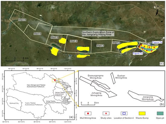
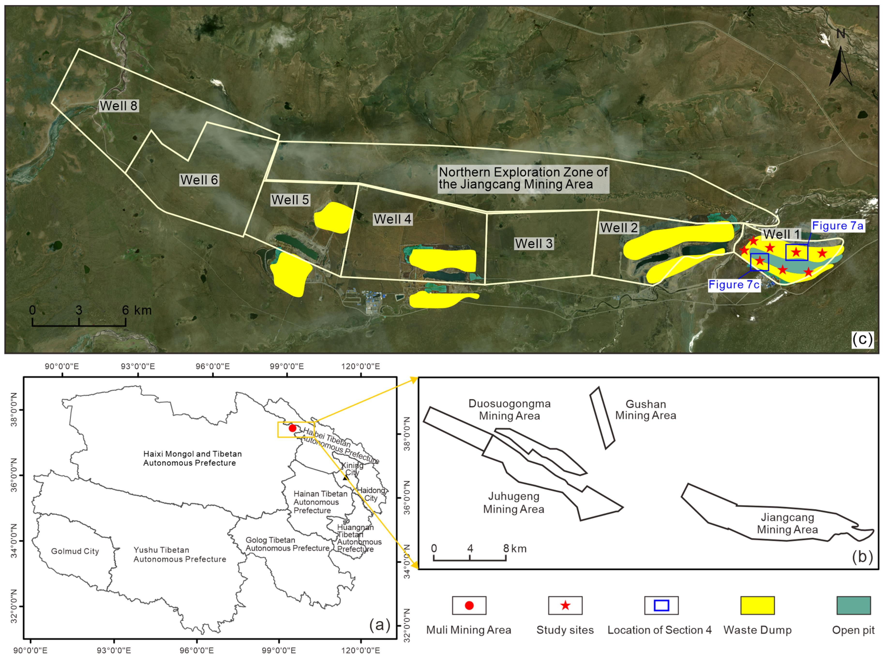
The Jiangcang Mining Area is located within the water conservation area and ecological security barrier zone of the Qilian Mountains region [19] and belongs to a typical plateau continental climate zone [8,20]. The main open-pit mine has a length of 1.25 km, a width of approximately 0.43 km, and a depth of 172 m, with an excavation volume of approximately 27.162 million m3. The water depth accumulated in the open pit reaches 52.44 m, with an underwater storage volume of 3.5106 million m3. The total volume of waste-rock dumps distributed on the northern and southern sides of the open pit is approximately 29.96 million m3. The northern waste-rock dump has a vertical height of approximately 55 m, covers an area of approximately 0.52 km2, and has a total volume of approximately 21.91 million m3. The southern waste-rock dump has a vertical height of 36–40 m, covers an area of approximately 0.42 km2, and has a total volume of approximately 8.05 million m3 (Figure 1). The original alpine meadow wetland ecosystem has been completely altered. The original groundwater flow field and surface runoff pathways have been disrupted, resulting in the substantial loss of key ecosystem services, including water conservation, carbon sequestration, and biological habitat functions, and causing severe ecological degradation.
Figure 1.
(a) Location of the Muli Mining Area in Qinghai Province. (b) Distribution of the four constituent mining areas within the Muli Mining Area, including the Jiangcang, Juhugeng, Gushan, and Duosuogongma mining areas. (c) Remote-sensing image of the Jiangcang Mining Area.
2.2. Diagnosis and Analysis of Ecological and Environmental Problems
The open-pit mine and waste-rock dumps have formed artificial geomorphic barriers, dividing the natural surface landscape into an artificial “pit–hill” opposing pattern and fragmenting previously continuous wildlife habitats and migration corridors. As a result, the ecosystem has become spatially isolated and fragmented. The mining slopes surrounding the open pit are steep, with exposed bedrock. Physical weathering has generated fractures within the bedrock, resulting in unstable rock masses around the pit, where local stability is relatively poor. Large amounts of waste materials accumulated on the permafrost layer near the open pit have developed extensive tensile cracks under settlement and freeze–thaw processes, forming unstable slopes with potential landslide hazards. The northern slope of the open pit is a reverse slope, where the slope inclination is opposite to the bedding inclination. The slope mainly consists of mudstone and siltstone with layered fracture structures. The bedding orientation is opposite to the slope orientation, and the intersection angle between them is relatively large, resulting in relatively stable slope conditions. In contrast, the southern slope is a bedding-controlled slope, where the slope orientation is consistent with the bedding orientation. The bedding dip angle ranges from 27° to 46°, while the slope angle is smaller than the bedding dip angle. The slope is mainly composed of carbonaceous mudstone and fine silty sandstone. Due to the well-developed joints and fractures within the rock mass, planar sliding along bedding planes may easily occur, resulting in relatively poor slope stability. A local microclimate has developed within the open pit, causing significant increases in temperature and evaporation. Compared with natural areas, the seasonal thawing depth, water content, and temperature of soils on the surrounding benches have increased significantly, which has greatly affected the soil properties and ecological hydrological characteristics of the mining area and increased the risk of geological hazards such as thermo-karst collapse and thaw-induced slope instability in open-pit mining slopes. Waste-rock accumulation has altered the energy balance of the original permafrost layer, and seasonal frozen soil has also developed within the waste-rock dumps. During winter soil freezing, water continuously migrates toward the freezing front at the bottom of the waste-rock dump. Over time, large amounts of ground ice accumulate within the frozen layer [21,22]. During the warm season, as air temperature increases, the frozen layer gradually thaws from top to bottom. Because melted water from surface ice cannot effectively infiltrate downward, the water content of the upper soil layer increases rapidly. Combined with frost heave effects, soil strength decreases, resulting in shallow creep landslides within the waste-rock dumps.
The dominant vegetation types in the mining area are alpine swamp meadow grasses and alpine meadow vegetation. The grassland quality within the mining area is relatively poor, and the ecological environment is highly vulnerable and prone to degradation. Excavation activities and waste-rock accumulation have caused severe damage to the original meadow vegetation [23]. The soil within the waste-rock dumps is mainly composed of mixed waste materials, characterized by high gravel content, steep slopes, and severe soil erosion. These conditions have resulted in low survival rates and poor vegetation coverage after subsequent revegetation efforts. The coal seams exploited in the mining area are located below the groundwater table. The groundwater aquifer mainly consists of siltstone layers, with fractured groundwater as the dominant type. The unit water yield is less than 0.1 L/(s·m), and the hydraulic connection between groundwater and surface water bodies is relatively weak. Groundwater recharge mainly occurs from the surrounding wetland areas through atmospheric precipitation and surface runoff migrating along bedding planes and structural fractures. Groundwater has limited influence on the water storage within the open pit. Water accumulated in the open pit mainly originates from atmospheric precipitation. The Quaternary surface strata in the mining area are relatively flat, and the permafrost layer provides partial isolation between surface water and groundwater. Due to the weak hydraulic connection between groundwater and surface water, favorable surface drainage conditions exist, and only a small amount of water accumulates within the open pit.
In summary, coal mining activities have created an artificial “one pit and two hills” geomorphic structure, resulting in several major ecological and environmental problems, including rock slope instability caused by well-developed fractures, creep deformation risks of waste-rock dumps induced by freeze–thaw cycles and tensile cracking, destruction and occupation of original alpine meadow ecosystems, severe soil erosion caused by gravel-rich mixed waste materials, and the formation of permanent or seasonal water accumulation zones due to precipitation-dependent pit water and isolation between surface water and groundwater by the permafrost layer. These ecological problems interact and couple with each other, ultimately leading to ecosystem fragmentation and degradation of ecological functions.
3. Materials and Methods
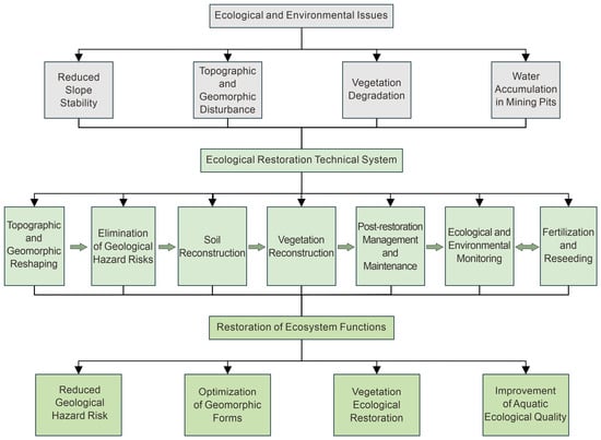
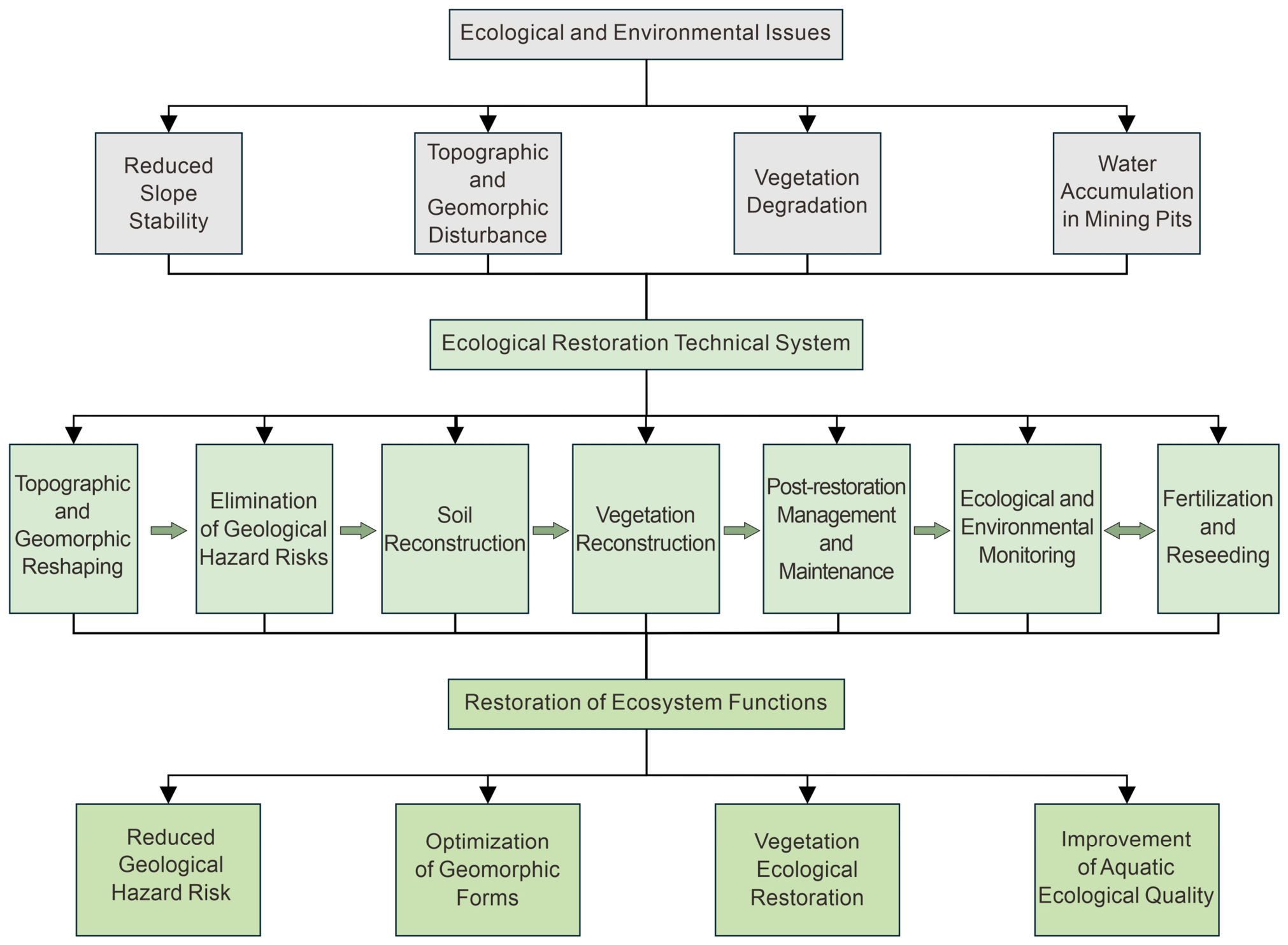
In response to the multifaceted ecological degradation observed in the Jiangcang Mining Area—including slope instability, landform disruption, alpine meadow degradation, and persistent pit lake formation—a comprehensive, integrated restoration strategy was implemented, synergizing engineered interventions with natural recovery processes. The restoration followed a phased logic of “stabilizing the geological environment first, improving the ecological substrate second, and restoring ecological functions last.” Accordingly, landform reconstruction and geohazard elimination were implemented first to restore spatial stability; soil reconstitution and vegetation reestablishment were then conducted to improve ecological restoration conditions; and post-intervention management, ecological monitoring, and supplementary seeding and fertilization were finally applied to establish a closed-loop “restoration–monitoring–optimization” dynamic feedback mechanism. As illustrated in Figure 2, the restoration framework comprises six interdependent components: geohazard mitigation, landform reconstruction, soil reconstitution, vegetation reestablishment, post-intervention maintenance and monitoring, and water–soil quality surveillance. Specifically, geohazard mitigation employed staged slope flattening, toe buttressing, and phased mass unloading; landform reconstruction ensured topographic continuity with the adjacent natural landscape; soil reconstitution utilized screened fine-grained waste rock amended with sheep manure and bulk blended fertilizer; vegetation reestablishment was achieved through polycultural sowing of indigenous grass species adapted to alpine conditions; post-restoration management included targeted supplementary seeding, precision fertilization, and strict grazing exclusion; and water–soil quality was assessed at regular intervals using standardized protocols. These coordinated actions yielded four principal ecological outcomes: elimination of imminent geohazards, restoration of geomorphic integrity, recovery of native vegetation cover, and enhancement of aquatic ecosystem health. Collectively, this phased, process-oriented approach—grounded in the integration of engineering rigor and ecological principles—facilitated the progressive recovery and functional stabilization of the alpine mining ecosystem (Figure 2).
Figure 2.
Technology roadmap of the integrated ecological restoration model in the Jiangcang Mining Area.
3.1. Geomorphic Reconstruction
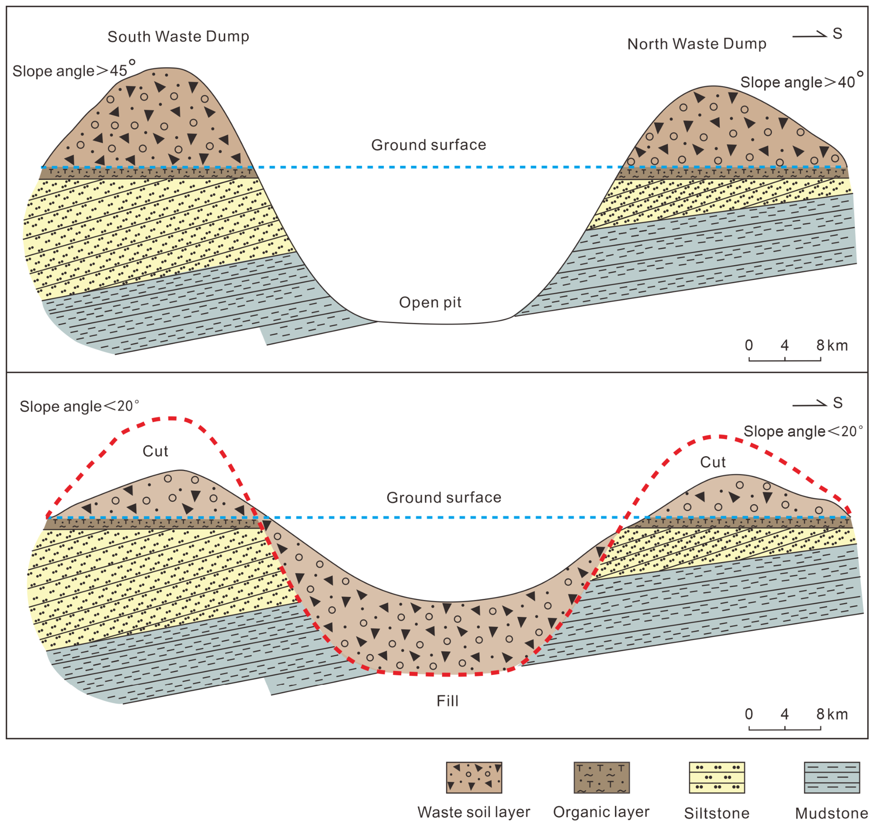
The existing construction access roads within the treatment area were utilized to conduct staged slope reduction on the southern and northern waste-rock dumps from the distal to proximal areas. As illustrated in Figure 3, the upper panel presents the pre-restoration topography, showing that the southern and northern waste-rock dumps formed steep slopes surrounding the open pit, with slope angles exceeding 45° and 40°, respectively. The lower panel presents the reconstructed topography following slope cutting and backfilling. Excavated waste materials generated during slope reduction were transported to the bottom of the open pit for staged compaction and backfilling. During the restoration process, secondary ecological disturbance was minimized. Through staged slope reduction, slope surface modification, and terrain improvement, favorable site conditions were established for subsequent ecological restoration measures. Following reconstruction, the slope angles were reduced to less than 25°, resulting in a geomorphic landscape compatible with the surrounding natural terrain (Figure 3).
Figure 3.
Schematic diagram of geomorphic reconstruction in the Jiangcang Mining Area.
Considering the lithological characteristics of the mining area and the height of waste-rock accumulations, the International Society for Rock Mechanics (ISRM) recommended safety factor range of 1.10–1.30 was adopted [24]. At representative locations within the waste-rock dump, in situ tests were conducted using a CLD-2 static cone penetrometer. The cone penetration resistance (Ps) was measured with a variation of ±0.5. The internal friction angle was subsequently estimated using the empirical relationship (1) applicable to the coal gangue waste material in the study area, with an estimated error of ±0.25. Based on the specified safety factor requirements, the natural angle of repose was then determined, with an error of ±0.25 (Table 1). From a reliability perspective, the upper-bound safety factor of 1.30 was adopted, indicating that the slope angle of the reconstructed terrain should be less than 25°.
Table 1.
Tabulation of slope gradient for slope shaping.
From the perspective of reliability, the maximum safety factor value of 1.30 was selected. The results indicated that the reconstructed terrain slope gradient should be less than 25°.
3.2. Elimination of Geological Hazard Risks
A geological hazard investigation and assessment were conducted for the waste-rock dumps surrounding the open pit. Engineering measures, including slope cutting, toe reinforcement, and staged unloading, were implemented to eliminate potential geological hazards. The stability of the reconstructed slopes was evaluated using the Bishop method to ensure the overall stability of the treated waste-rock dumps.
3.2.1. Determination of Safety Factor
Considering the lithological conditions of the mining area and the height of waste-rock accumulations, the slope stability analysis was performed according to Load Combination I for Grade II slope safety conditions. Based on relevant industry standards and extensive experimental studies on similar slopes [25,26], the safety factor was set as 1.20.
3.2.2. Determination of Strength Parameters
According to field investigations, the waste-rock dump materials mainly consist of mixed materials including carbonaceous mudstone and siltstone above the coal seam roof, Quaternary loose deposits, and coal gangue. Laboratory tests determined that the unit weight of waste-rock materials in the mining area was 2.05 t/m3, with an internal friction angle of 24–27° and cohesion ranging from 0 to 0.2 kPa. The geological attitudes of representative exposed strata in the open pit were statistically measured. The dip directions and dip angles were recorded as follows: stratum 1: 4°∠46°, stratum 2: 3°∠27°, stratum 3: 3°∠28°, and stratum 4: 4°∠37°. The physical and mechanical properties of the rocks from the boreholes were further statistically analyzed. According to Equation (2), the weighted elastic modulus (E), weighted Poisson’s ratio (μ), and weighted strength (σi) of each stratum were calculated using thickness-weighted averaging (Table 2).
Table 2.
Rock mechanics parameters.
In the formula, P sequentially takes the values of E, μ and σi; hj denotes the thickness of each sub-layer (in meters), and Pj refers to the corresponding laboratory measured value of each sub-layer. The thickness data of each sub-layer and the test data are derived from the borehole core logging and rock physico-mechanical test reports at the detailed exploration stage of the mining area.
The engineering rock masses in the mining area can be classified into two major categories: a moderately hard rock group and a soft rock group, and the overall rock mass integrity is relatively poor. According to the Standard for Engineering Classification of Rock Masses (GB/T 50218-2014 [27]) and the method of Zhu et al. (2012) [28], the engineering rock masses in the mining area were comprehensively classified as Grade V rock mass.
On this basis, referring to the empirical statistical range of the modulus ratio (MR) proposed by Hoek and Diederichs (2006) [29], and considering the lithological characteristics of the mining area, which are dominated by interbedded siltstone and carbonaceous mudstone, a representative value of MR = 300 was adopted for the rock mass in this mining area. Meanwhile, based on field engineering geological surveys and rock mass quality classification results, the geological strength index (GSI) was taken as 40, corresponding to a fractured rock mass with well-developed structural planes. Considering that blasting is used in open-pit mining and that slope unloading and relaxation are significant, the disturbance factor D was taken as 1.0, corresponding to a heavily disturbed state. Based on these parameters, the generalized Hoek–Brown strength criterion was used to reduce the rock mass strength (Equations (3)–(5)), and the equivalent mechanical parameters of the rock mass used for slope stability analysis were obtained (Table 3).
Table 3.
Comparison of calculated values of slope parameters.
The values of GSI, D, and MR were set as 40, 1, and 300, respectively, for calculation.
The uniaxial compressive strength of the rock mass was calculated as follows:
The estimated rock modulus was calculated as follows:
The rock mass modulus was calculated as follows:
After parameter reduction, the rock mass strength was adjusted to correspond with the recommended rock mass strength values obtained using the BQ classification method, and the Grade V rock mass parameters were retained (Table 3).
3.2.3. Bishop Method-Based Slope Stability Analysis
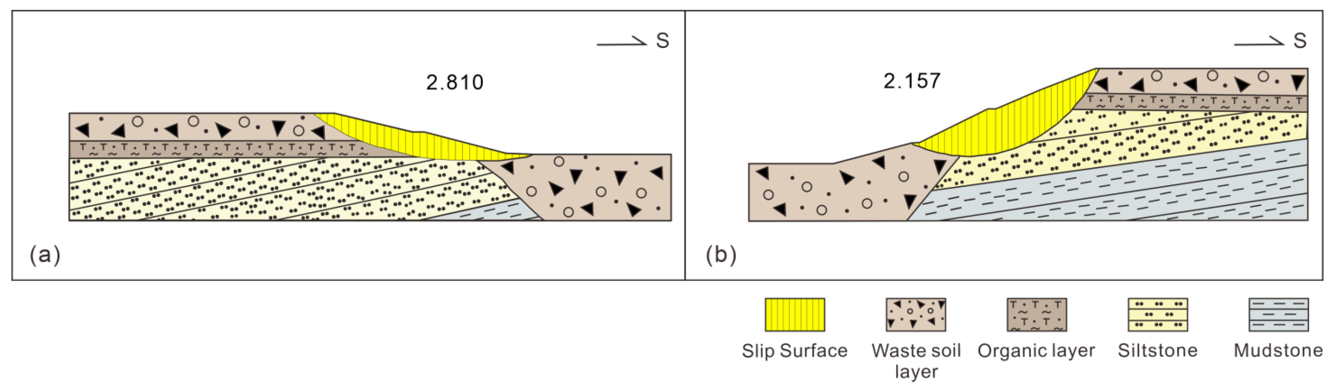
Based on the cross-sectional parameters, representative profiles were selected to calculate the safety factors of the treated northern and southern slopes. The calculated safety factors after restoration were 2.157 and 2.810 for the northern and southern slopes, respectively, both satisfying the stability requirements (Figure 4). Previous studies have demonstrated that reinforcement measures based on anchoring techniques can effectively improve rock slope stability [30,31]. In this study, the combined treatment strategy of slope reduction, load removal, and toe backfilling also achieved satisfactory stabilization effects.
Figure 4.
(a) Calculation results of safety factors for the south slopes after treatment. (b) Calculation results of safety factors for the north slopes after treatment.
3.3. Soil Reconstruction
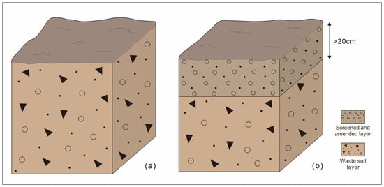
Topsoil coverage is an effective approach for vegetation reconstruction in open-pit mines and waste-rock dumps [32]. However, the Jiangcang Mining Area is located in a high-altitude and cold environment, where the cost of transporting external topsoil required for vegetation restoration is extremely high. Moreover, excavation of external soil resources may cause secondary disturbance to other grassland ecosystems. Therefore, sub-clay, mudstone, and other fine-grained and granular materials obtained from the locally screened waste-rock materials generated during slope reduction in the northern and southern waste-rock dumps were used as surface soil cover. An excavator equipped with a rotary vibrating screening bucket was used to screen fine-grained waste-rock materials. Materials with particle sizes ≤20 mm were transported and stored at designated soil storage sites. After completion of preliminary engineering measures, including geomorphic reconstruction and geological hazard elimination, the screened materials were evenly spread over areas requiring vegetation restoration. After spreading, the surface was compacted using a tractor-towed roller weighing 50–80 kg. The bulk density was controlled within the range of 1.3–1.8 g/cm3, providing suitable soil conditions for vegetation growth (Figure 5). Previous studies have demonstrated that soil reconstruction technologies based on solid waste-derived materials can effectively improve soil physical structures in mining areas, and layered reconstruction can restore soil porosity to levels close to natural conditions [33,34]. The waste-rock screening and soil-covering approach adopted in this study is consistent with this concept.
Figure 5.
Soil reconstruction profile. (a) Original waste soil layer before reconstruction; (b) Reconstructed soil profile, consisting of a screened and amended layer with a thickness greater than 20 cm overlying the waste soil layer.
3.4. Vegetation Reconstruction
3.4.1. Soil Improvement
Considering the geological characteristics of the Jiangcang Mining Area, a 5 cm layer of sheep manure was evenly applied onto the topsoil layer with a thickness greater than 20 cm. Mechanical or manual deep tillage was then conducted at a depth of 10–20 cm to fully mix the topsoil and sheep manure, forming an improved soil layer. Bulk blending fertilizer was subsequently evenly applied onto the improved soil layer (>20 cm thickness), followed by shallow tillage at a depth of 5 cm to create a suitable surface layer for grass establishment and ecological restoration. According to the soil fertilization requirements (Table 4), each mu of improved soil required 167 m3 of screened topsoil, 33 m3 of sheep manure, and 750–1000 kg of bulk blending fertilizer. Previous studies have shown that the combined application of sheep manure and bulk blending fertilizer can significantly increase soil organic carbon, available nutrients, and microbial activity in alpine mining areas, while optimizing microbial community structures [18,35,36]. The contents of organic carbon, total nitrogen, and total potassium in alpine mining waste materials are significantly lower than those in natural meadow soils. Increasing bulk blending fertilizer input can effectively improve their physicochemical properties [33,37,38], providing an important reference for determining the fertilizer application ratio used in this study.
Table 4.
Quality standard of bulk blended fertilizer (BB fertilizer).
3.4.2. Selection and Combination of Grass Species
The mining area selected grass species suitable for alpine environments, including Elymus nutans, Poa pratensis, Poa crymophila, and Festuca sinensis [39]. These species were mixed and sown at a rate of 15–20 kg/mu with a ratio of 1:1:1:1. Seed quality was required to meet or exceed Grade III standards of national or local regulations (Table 5). Previous studies have demonstrated that mixed-species grasslands are more effective than single-species grasslands in improving ecosystem productivity, carbon storage, and soil fertility [40], providing a theoretical basis for the mixed sowing strategy adopted in this study.
Table 5.
Seed quality standards.
Through quadrat surveys of vegetation coverage and annual regrowth conditions in different areas of the mining site, the vegetation density in the soil-covering and revegetation areas exceeded 2000 individuals/m2, and vegetation coverage exceeded 90%, which was higher than that of surrounding natural vegetation. The growth performance of Elymus nutans and Festuca sinensis on shaded slopes was poorer than that on sunny slopes [44]. Based on optimization feedback, and under the conditions of ensuring soil-cover thickness and fertilization requirements, the recommended grass species combination for similar alpine mining areas is Elymus nutans, Poa pratensis, Poa crymophila, and Festuca sinensis. The recommended seeding rate is 10–15 kg/mu, with a mixing ratio of 2:2:2:1 on sunny slopes and 2:1:1:1 on shaded slopes.
3.4.3. Grass Seeding and Revegetation
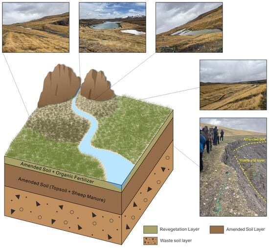
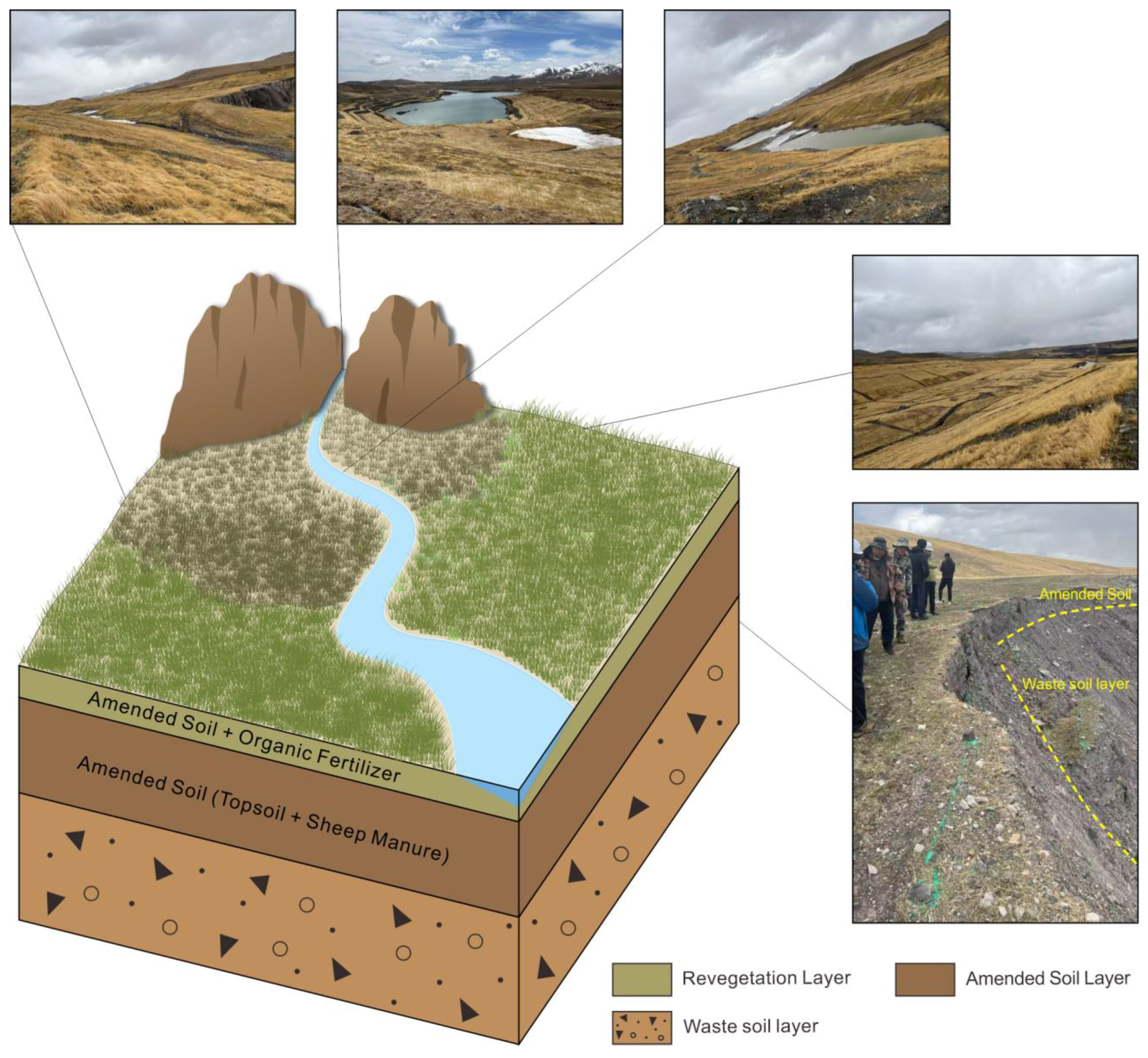
According to the geomorphic characteristics of the revegetation area, the restoration zones were divided into two major types: slope areas and flat areas [10]. Artificial seeding was adopted on slopes. Large-scale flat areas, including waste-rock dump platforms, roads, and coal storage yards, were seeded using large machinery, while smaller flat areas were restored using a combination of rotary tillers and manual seeding. The seeding process followed the procedures of seed mixing → soil harrowing → sowing → soil compaction → nonwoven fabric covering [45]. Seeding activities were required to be completed within the appropriate growing season for alpine regions. Drainage ditches were constructed on slopes, while interception ditches were installed along the boundaries of catchment areas. The interception and drainage systems were connected to discharge runoff into surrounding wetlands, preventing water damage in revegetated areas (Figure 6).
Figure 6.
Schematic diagram of the improved soil layer.
3.5. Post-Restoration Management
Post-restoration vegetation recovery was maintained through measures including fencing, grazing prohibition, ecological monitoring, and management. For slope areas where the annual emergence rate was less than 1000 individuals or where vegetation coverage was below 50% in the second year, and for flat areas where the annual emergence rate was less than 1200 individuals or vegetation coverage was below 50% in the second year, supplementary seeding and fertilization were conducted in the following year. These measures aimed to improve soil structure, enhance soil water and nutrient retention capacity, and increase seed emergence rates [46].
3.6. Water Quality Measurement Methods and Instruments
The monitored water types included surface water, open-pit water, and groundwater. Surface water was sampled at three fixed sections: the upstream section of the Jiangcang Mining Area, the downstream section of the Jiangcang Mining Area, and the section 1 km downstream of the confluence of the Jiangcangqu River into the Datong River. Open-pit water was sampled from the Jiangcang No. 1 Open Pit. Groundwater was sampled from the monitoring well at the Jiangcang No. 1 Open Pit. At each fixed section or well, samples were collected once per day for three consecutive days. No additional parallel field samples were collected.
The determination methods and corresponding instruments for various indicators of surface water, open-pit water and groundwater are specified as follows.
pH was measured by the glass electrode method (GB 6920-86 [47]) using a PHS-3C pH meter (JC-0029). Dissolved oxygen (DO) was determined by the iodometric method (GB 7489-87 [48]) using a 25 mL burette. The permanganate index (CODMn) was determined by the acidic potassium permanganate method (GB 11892-89 [49]) using an HH-6 constant-temperature water bath (QT-22). Five-day biochemical oxygen demand (BOD5) was measured by the dilution and seeding method (HJ 505-2009 [50]) using a TS606-G/4-i biochemical incubator (JC-0120). Chemical oxygen demand (COD) was determined by the dichromate method (HJ 828-2017 [51]) using a 25 mL burette. Total phosphorus (TP) was measured by the ammonium molybdate spectrophotometric method (GB 11893-89 [52]) using a TU-1901 double-beam UV-Vis spectrophotometer (JC-0024). Fluoride (F−) was determined by ion chromatography (HJ 84-2016 [53]) using an ICS-1100 ion chromatograph (JC-0340).
For heavy metals, As and Hg were determined by atomic fluorescence spectrometry (HJ 694-2014 [54]) using an AFS-830 double-channel atomic fluorescence spectrophotometer (JC-0009, JC-0010). Cd, Pb, Zn, and Cu were determined by inductively coupled plasma mass spectrometry (ICP-MS, HJ 700-2014 [55]) using an ICP-MS X Series 2 instrument (JC-0244).
For groundwater, total dissolved solids (TDS) were measured by the gravimetric method (GB/T 5750.4-2023 [56]) using an AL204-IC Mettler Toledo electronic balance (JC-0034). Turbidity was measured by the portable turbidimeter method using a 2100 P portable turbidimeter (JC-0420). Color was measured by the platinum–cobalt standard colorimetric method (GB 11903-89 [57]) using a 50 mL stoppered colorimetric tube. Total hardness was determined by the EDTA method (GB 7477-87 [58]) using a 25 mL burette.
4. Results
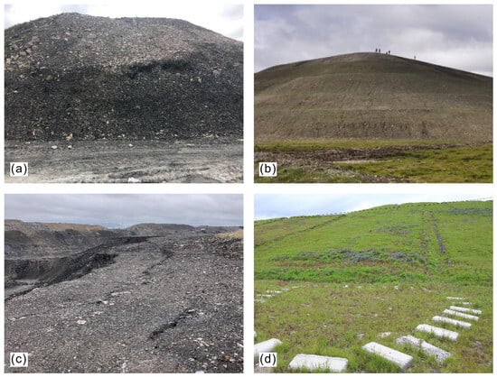
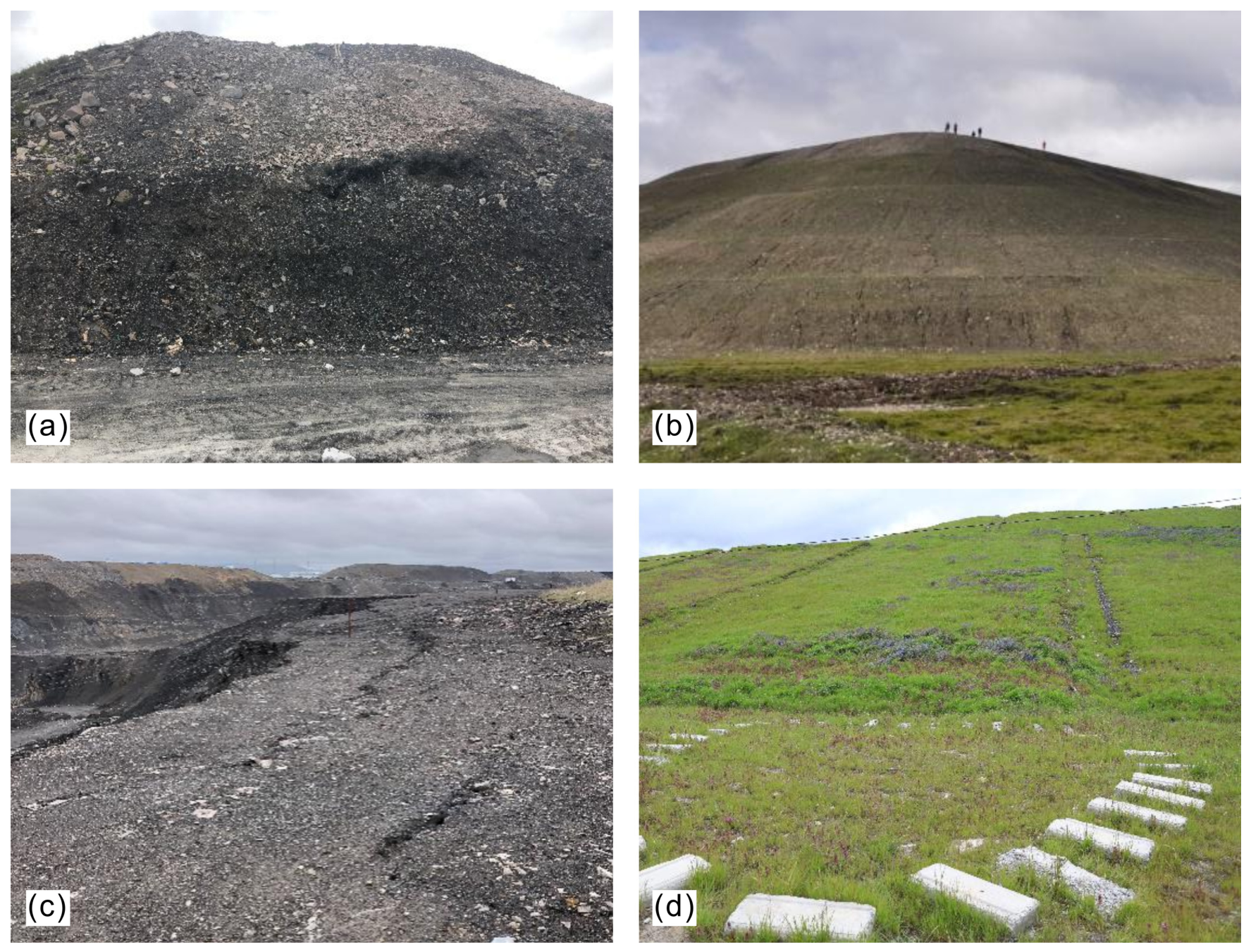
Ecological restoration in fragile alpine regions requires comprehensive consideration of the recovery status of multiple environmental components, including soil, vegetation, and water systems [33,59]. This study compares the slope gradients, slope safety factors, soil structure, soil organic matter content, and vegetation coverage before and after restoration in the study area (Table 6). Following treatment using geomorphic reconstruction techniques, the slope gradient was reduced to less than 25° and was made consistent with the surrounding natural terrain. Before restoration, the slope gradients of the waste-rock dump ranged from 40° to 70°; after restoration, the slope gradient was controlled within 25° through staged slope reduction. Following restoration, the safety factors of the southern and northern slopes of the waste-rock dump were 2.81 and 2.157, respectively, both exceeding the required safety factor of 1.20. These results indicate that the overall slope stability after restoration meets the safety requirements and that geological hazard risks have been effectively controlled. Following soil improvement, the organic matter content increased and the physical structure of the soil was improved, providing favorable soil substrate conditions for vegetation recovery. Vegetation coverage exceeded 90%, representing a 10.0% increase compared with the surrounding native grassland, while vegetation density exceeded 2000 plants/m2, surpassing the supplementary seeding threshold and indicating a favorable vegetation recovery status (Figure 7). Previous studies have shown that soil moisture, soil organic carbon, and available nitrogen are key environmental factors driving vegetation recovery in alpine mining areas [3,60]. The improvement of soil physicochemical properties in the restored area therefore provided favorable site conditions for vegetation reconstruction.
Table 6.
Comparison of key indicators before and after ecological restoration in the Jiangcang mining area.
Figure 7.
Comparison chart before and after treatment. (a) The abandoned ore pile before restoration. (b) The slope after restoration, after topography reshaping and vegetation recovery. (c) The open-pit mining area before restoration. (d) The vegetation-restored slope after ecological restoration.
The water quality of three monitoring sections, including the upstream section of Jiangcangqu Mining Area, the downstream section of Jiangcangqu Mining Area, and the section after the confluence of Jiangcangqu River into the Datong River, all reached Class II surface water quality standards, indicating excellent water quality. The pH values of the monitoring sections range from 8.45 to 8.54, and the dissolved oxygen concentrations range from 6.41 mg/L to 6.50 mg/L, both of which meet the Class II criteria specified in the Environmental Quality Standards for Surface Water (GB 3838-2002 [61]). The permanganate index (CODMn), 5-day biochemical oxygen demand (BOD5), chemical oxygen demand (COD), total phosphorus (TP) and fluoride (F−) all satisfy the Class I criteria. Specifically, the CODMn values are 1.9 mg/L, 2.0 mg/L and 2.0 mg/L, respectively, the BOD5 values are all 0.5 mg/L, and the COD values are 4.0 mg/L, 4.0 mg/L and 6.0 mg/L, respectively, all of which are far lower than the Class II standard limits (CODMn ≤ 4 mg/L, BOD5 ≤ 3 mg/L, COD ≤ 15 mg/L). These results indicate that the organic pollution in the water body is extremely slight and the biodegradable organic load is very low. The worst-case Water Quality Index (WQI) of the three sections all falls into Class II, and the water quality category is mainly constrained by pH and dissolved oxygen, while all other indicators are at the Class I level. The environmental quality of the restored surface water is excellent. After completion of ecological restoration, systematic monitoring was conducted on surface water, mine pit water, and groundwater quality. The results showed that all monitored water quality parameters remained within normal ranges, with no abnormal fluctuations detected. The quality of surface water and mine pit water met the relevant assessment requirements (Table 7), while groundwater monitoring results indicated that all parameters satisfied evaluation criteria, and no pollution risks were identified (Table 8). These results demonstrate that the ecological restoration measures effectively improved and maintained the water environmental quality of the mining area. Sampling and testing of 11 soil indicators showed that pH, arsenic (As), mercury (Hg), copper (Cu), lead (Pb), zinc (Zn), chromium (Cr), cadmium (Cd), and nickel (Ni) concentrations were significantly lower than the national standard limits, indicating no risk of heavy metal contamination. Previous studies have shown that soil microorganisms, including bacteria and fungi, can effectively immobilize heavy metal ions through mechanisms such as biosorption and biomineralization, thereby reducing their environmental mobility [62,63]. This mechanism may represent one of the reasons why heavy metal concentrations in the restored area remained within safe levels. Although fluoride showed slight enrichment in the soil, the restoration model effectively reduced its leaching risk. Sulfide concentrations remained within the normal range compared with background values, indicating that the soil ecological environment had gradually stabilized. Through vegetation reconstruction and waste-rock dump stabilization, atmospheric environmental monitoring showed that total suspended particulate (TSP) concentrations ranged from 43 to 103 μg/m3. The 24 h average concentrations were all below the Class I functional zone limit of 120 μg/m3, indicating generally excellent air quality. Dust problems caused by mining activities were effectively controlled, and atmospheric environmental quality was significantly improved compared with conditions before restoration. The regulatory functions of the ecosystem were gradually restored. Aboveground biomass increased by 46.64% in alpine meadow steppe, 20.91% in alpine meadow, 26.43% in alpine steppe, 9.49% in alpine desert steppe, and 30.60% in temperate grassland compared with pre-restoration conditions. In contrast, temperate desert grassland showed a decrease of 8.59%.
Table 7.
Physicochemical parameters and water quality classes of surface water and open-pit water after ecological restoration in the Jiangcang mining area.
Table 8.
Physicochemical parameters and water quality classes of groundwater after ecological restoration in the Jiangcang mining area.
For the four major ecological and environmental problems in the Jiangcang Mining Area, including geomorphic disturbance, slope instability, vegetation and meadow degradation, and obstruction of the original hydrological system, this study established an integrated systematic restoration model consisting of six coordinated components: geomorphic reconstruction, elimination of geological hazard risks, soil reconstruction, vegetation reconstruction, post-restoration management with supplementary seeding and fertilization, and water and soil quality monitoring. The monitoring results demonstrated that the treated slopes achieved stable conditions, and geological hazard risks were effectively eliminated, providing favorable site conditions for vegetation restoration. Fine-grained soil materials obtained through waste-rock screening were improved using sheep manure and bulk blending fertilizer. After soil amendment, vegetation exhibited vigorous growth and performed better than the surrounding natural grasslands. Surface water quality reached Class II standards, with no excessive accumulation risk of heavy metals in soils. Although localized slight enrichment of fluoride was observed, the overall environmental risk remained controllable. Atmospheric environmental quality was superior to the standards for Class I functional zones. These results verify the effectiveness of the progressive restoration pathway of “diagnosis of ecological problems → optimization of site conditions → vegetation reconstruction and ecosystem recovery → hydrological regulation and maintenance of ecological functions.” This integrated approach successfully promoted the comprehensive recovery of ecosystem functions in the mining area. Traditional restoration practices for alpine mining areas mostly rely on foreign soil transportation, single grass species application and localized slope protection, which are associated with high costs for foreign soil procurement and transportation, high risks of secondary ecological damage, low vegetation survival rates, frequent reseeding demands and elevated overall restoration expenses. The technical system proposed in this study significantly reduces the full life-cycle restoration cost and delivers superior economic rationality.
5. Discussion
5.1. Uncertainty and Potential Sources of Error
Although the integrated restoration measures produced favorable ecological and engineering outcomes, several uncertainties should be considered. First, the slope stability analysis was based on representative cross-sections and a limited number of geotechnical parameters. The Bishop method involves a simplified representation of the potential failure mechanism, while parameters such as cohesion, internal friction angle, unit weight, and rock mass strength may vary spatially because of lithological heterogeneity, weathering, fractures, freeze–thaw processes, and differences in waste-rock composition. The parameters used in this study were derived from field and laboratory investigations and adjusted according to the adopted rock-mass classification. However, they cannot fully represent the spatial variability of the entire waste-rock dumps. Therefore, the calculated safety factors should be regarded as representative estimates rather than absolute values of slope stability.
Second, ecological monitoring results may be affected by spatial and temporal variability. Vegetation restoration in alpine mining areas is strongly influenced by slope aspect, soil thickness, moisture, temperature, and the short growing season. In this study, Elymus nutans and Festuca sinensis performed less well on shaded slopes than on sunny slopes, indicating that local environmental conditions can influence vegetation recovery even under the same restoration measures. In addition, vegetation coverage and plant density may vary with season, climate, and post-restoration management. Water and soil quality measurements may also be influenced by sampling location and seasonal hydrological variation. Therefore, long-term and multi-site monitoring is needed to further verify the persistence of the observed restoration effects.
5.2. Interpretation of Variations in Restoration Results
The observed differences among restoration indicators do not necessarily indicate inconsistent restoration performance but mainly reflect differences in site conditions and ecological responses. The post-restoration safety factors of the southern and northern slopes were 2.810 and 2.157, respectively. Although both exceeded the required value of 1.20, the difference reflects the different geological and geometric conditions of the two slopes. The southern slope was previously identified as a bedding-controlled slope, whereas the northern slope represented a reverse-slope configuration. Therefore, their final stability responses after slope reduction, unloading, and toe backfilling were not identical.
Vegetation recovery also showed spatial variation. Although overall vegetation coverage exceeded 90% and was about 10% higher than that of surrounding natural grassland, individual species performed differently between sunny and shaded slopes. This variation is likely related to differences in solar radiation, temperature, soil moisture, and species-specific environmental tolerance. The use of different species ratios for sunny and shaded slopes therefore represents an adaptive response to site heterogeneity.
Differences in aboveground biomass among vegetation types further indicate that ecosystem recovery was not spatially uniform. Biomass increased by 46.64% in alpine meadow steppe, 20.91% in alpine meadow, 26.43% in alpine steppe, 9.49% in alpine desert steppe, and 30.60% in temperate grassland, whereas temperate desert grassland decreased by 8.59%. These differences may be associated with initial vegetation conditions, soil development, water availability, and differences in plant community composition. Therefore, restoration effectiveness should be evaluated using multiple indicators rather than a single vegetation parameter.
Differences among water-quality results are also expected because of variations in water sources, hydrological connectivity, residence time, and interactions with reconstructed soils and waste materials. In the Jiangcang Mining Area, groundwater and surface water have relatively weak hydraulic connectivity, while open-pit water is mainly derived from atmospheric precipitation, providing a basis for the observed differences among water bodies.
5.3. Role of Ecological Restoration in Sustainable Development
The ecological restoration model contributes to sustainable development by improving resource efficiency and reducing secondary environmental disturbance. In particular, screened fine-grained waste-rock materials were used as surface soil-cover materials, reducing dependence on external topsoil and avoiding additional disturbance caused by soil excavation and transportation. This approach promotes the transition of mine waste from simple disposal toward resource utilization.
The restoration strategy also integrates landform reconstruction, slope stabilization, soil improvement, vegetation restoration, and environmental monitoring. These measures improve site stability and ecological conditions while establishing a feedback mechanism of “restoration–monitoring–optimization” through supplementary seeding and fertilization based on vegetation performance. This adaptive management is particularly important in alpine environments where ecological recovery is sensitive to climatic fluctuations.
The sustainability of the restoration model, however, cannot be fully demonstrated by the current monitoring period alone. Long-term stability will depend on the persistence of the reconstructed soil layer, self-regeneration of vegetation, slope performance under repeated freeze–thaw cycles, and continued maintenance of water and soil quality. Therefore, long-term monitoring is necessary to determine whether the restored ecosystem can develop toward a stable and self-maintaining state.
5.4. Implications for Application and Transferability
The Jiangcang restoration model integrates geohazard mitigation, geomorphic reconstruction, soil reconstruction, vegetation restoration, post-restoration management, and environmental monitoring, allowing several interacting ecological and environmental problems to be addressed simultaneously. This integrated framework is particularly relevant to alpine mining areas where geological, hydrological, and ecological processes are closely coupled.
However, the model should not be regarded as a fixed set of universal parameters. Restoration conditions such as slope gradient, soil thickness, fertilizer application, grass-species composition, and supplementary seeding thresholds are influenced by local geological, climatic, topographic, and ecological conditions. Thus, the Jiangcang model is better considered a transferable restoration framework, while specific parameters should be recalibrated through local investigation, testing, and monitoring.
6. Conclusions
The “Jiangcang Mining Area Ecological Restoration Model” established in this study provides a technically applicable pathway for ecological restoration in alpine and ecologically fragile regions. First, through geotechnical engineering tests, the optimal slope gradient for staged slope reduction was determined to be less than 25°, and the Bishop method was applied to evaluate the post-restoration slope stability. This approach explored a slope stabilization technology based on the reduction in rock and soil mechanical parameters under actual geological conditions. Second, a soil–vegetation collaborative restoration strategy integrating “screened waste-rock fine materials + native grass species mixed seeding + sheep manure + bulk blending fertilizer” was developed. This approach effectively addressed the major restoration challenges in alpine mining areas, including the lack of available topsoil, insufficient soil fertility, and short vegetation growth periods. Third, a dynamic supplementary seeding and fertilization threshold system based on vegetation emergence rate and coverage was established, forming a closed-loop management mechanism of “restoration–monitoring–optimization.” This model has successfully addressed key scientific challenges associated with ecological restoration in alpine mining areas and has significant potential for wider application and considerable economic value in the ecological restoration of mines in the alpine and ecologically fragile regions of the Qinghai–Tibet Plateau. It provides a transferable restoration framework and practical experience for similar mining areas, offering important implications for ecological governance and sustainable development. Furthermore, the results reinforce the strategic principle that mineral resource exploitation on the Qinghai–Tibet Plateau should prioritize ecological protection and environmental sustainability.
Author Contributions
Conceptualization, R.M., C.L. and W.W.; methodology, R.M. and T.H.; software, T.H. and S.J.; validation, S.Z., J.M. and X.M.; formal analysis, R.M.; investigation, S.Z., G.M., M.M., S.J., W.Z. and X.M.; resources, C.L. and W.W.; data curation, G.M., M.M. and W.Z.; writing—original draft preparation, R.M.; writing—review and editing, C.L.; visualization, J.M.; supervision, C.L.; project administration, R.M.; funding acquisition, W.W. All authors have read and agreed to the published version of the manuscript.
Funding
This research was jointly funded by the Natural Resources Development Fund of Qinghai Province (Grant Nos. QHCX-2026-012 and QHYSDK-2024-01).
Data Availability Statement
The original contributions presented in this study are included in the article. Further inquiries can be directed to the corresponding authors.
Acknowledgments
The authors sincerely thank Liu Guoxin, Li Changjun from the Department of Ecological Restoration, Department of Natural Resources of Qinghai Province, and Zhou Jinxi and Zhang Shibei from Qinghai Nonferrous First Geological Exploration Institute for their academic guidance and insightful discussions. We are also grateful to the Department of Ecological Restoration, Department of Natural Resources of Qinghai Province for providing essential data and materials. We also appreciate the administrative support from Qinghai Nonferrous First Geological Exploration Institute for this project.
Conflicts of Interest
The authors declare no conflicts of interest.
Abbreviations
The following abbreviations are used in this manuscript:
| ISRM | International Society for Rock Mechanics |
| BQ | Rock Mass Basic Quality Index |
| GSI | Geological Strength Index |
| TSP | Total Suspended Particulate |
| BB fertilizer | Bulk Blending Fertilizer |
| MR | Modulus Ratio |
| COD | Chemical Oxygen Demand |
| TP | Total Phosphorus |
| TDS | Total Dissolved Solids |
| NTU | Nephelometric Turbidity Unit |
| BOD5 | Biochemical Oxygen Demand over 5 days |
| CODMn | Permanganate Index |
| D | Disturbance Factor |
| Ps | Static Cone Penetration Resistance |
| DO | Dissolved Oxygen |
| DB63/T | Qinghai Provincial Local Standard |
| F− | Fluoride |
References
- Gan, Z.; Hu, G.; Gao, Q.; Jiang, C.; Dan, J.; Can, M.; Basang, W.; Yang, F.; Wei, X.; Yang, Y. Synergetic Mode for Grassland Ecological Management and Animal Husbandry Development in Northern Tibet Plateau. Strateg. Study Chin. Acad. Eng. 2019, 21, 93, (In Chinese with English Abstract). [Google Scholar] [CrossRef] [Scilit]
- Yuan, M.; Ouyang, J.; Zheng, S.; Tian, Y.; Sun, R.; Bao, R.; Li, T.; Yu, T.; Li, S.; Wu, D.; et al. Research on Ecological Effect Assessment Method of Ecological Restoration of Open-Pit Coal Mines in Alpine Regions. Int. J. Environ. Res. Public Health 2022, 19, 7682. [Google Scholar] [CrossRef] [Scilit] [PubMed]
- Yang, X.; Feng, Q.; Zhu, M.; Zhang, J.; Yang, L.; Zhang, C.; Wang, Z.; Feng, Y. Vegetation Communities and Soil Properties Along the Restoration Process of the Jinqianghe Mine Site in the Qilian Mountains, China. Front. Plant Sci. 2024, 15, 1358309. [Google Scholar] [CrossRef] [Scilit] [PubMed]
- Cai, Y. Ecological Environmental Monitoring and Assessment of the Jiangcang Mining Area Based on RS and GIS Technology. Master’s Thesis, Qinghai University, Xining, China, 2016. (In Chinese with English Abstract). [Google Scholar]
- Wang, Z.; Li, J.; Guo, Y.; Liang, L. Ecological Protection and Restoration Model of Mountains, Rivers, Forests, Farmlands, Lakes, Grasslands, and Deserts in the Qinghai–Tibet Plateau: A Case Study of the Lhasa River Basin. Acta Ecol. Sin. 2019, 39, 8966–8974, (In Chinese with English Abstract). [Google Scholar]
- Yu, Z.; An, X.; Hu, S.; Yang, M.; Li, J.; Li, C. Combined Application of Sheep Manure and Organic Fertilizer Improves Soil Quality and Microbial Community Structure and Function in Alpine Mining Areas. Microbiol. Spectr. 2025, 13, e00840-25. [Google Scholar] [CrossRef] [Scilit] [PubMed]
- Bai, Z. Research on Several Major Issues of Ecological Restoration in Territorial Space. Earth Sci. Front. 2021, 28, 1–13, (In Chinese with English Abstract). [Google Scholar]
- Yang, S.; Wu, T.; Guan, M.; Zhang, C. Reconstruction Technology and Quality Evaluation of Ecological Layer in Muli Mining Area. Sci. Technol. Innov. 2025, 16, 30–33, (In Chinese with English Abstract). [Google Scholar]
- Li, Q.; Tang, Y.; Deng, Y.; Ma, X.; Ma, J.; Sun, H. Characteristics of Soil Nutrients and Ecological Stoichiometry Under Different Slope Aspects in Vegetation Restoration Areas of Alpine Mining Regions and Their Relationships with Vegetation. Grassl. Turf 2024, 45, 35–43, (In Chinese with English Abstract). [Google Scholar]
- Zhao, X.; Wang, T.; Li, C.; Lin, Z.; Li, F.; Wang, W.; Feng, K.; Yin, Y.; Jiang, Z. Construction and Restoration Technology of Terrain Remodeling Layer in the Restoration of Ecological Geological Layer in Open-Pit Mining Areas. Coal Geol. Explor. 2023, 51, 113–122, (In Chinese with English Abstract). [Google Scholar]
- Li, F.; Li, C.; Zhao, X.; Ma, J.; Wang, T. Application of Permafrost Reconstruction Technology in Ecological Environment Treatment and Restoration in Muli Mining Area. China Coal Geol. 2023, 35, 50–54+58, (In Chinese with English Abstract). [Google Scholar]
- Wang, T.; Du, B.; Li, C.; Wang, H.; Zhou, W.; Wang, H.; Lin, Z.; Zhao, X.; Xiong, T. Ecological Environment Rehabilitation Management Model and Key Technologies in Plateau Alpine Coal Mine. J. China Coal Soc. 2021, 46, 230–244, (In Chinese with English Abstract). [Google Scholar]
- Zhu, Y.; Ma, M.; Zhao, N. Progress and Prospects of Restoration Technologies for Alpine Peatlands in Zoige, China. Chin. J. Ecol. 2020, 39, 4185–4192, (In Chinese with English Abstract). [Google Scholar]
- Fu, M.; Tang, W.; Liu, W.; He, Y.; Zhu, Y. Ecological Risk Assessment and Spatial Identification of Ecological Restoration Based on the Ecosystem Service Perspective: A Case Study of the Yangtze River Source Region. Acta Ecol. Sin. 2021, 41, 3846–3855, (In Chinese with English Abstract). [Google Scholar] [CrossRef] [Scilit]
- Zhao, Z.; Shi, X. Evolution, Restoration, and Conservation of Alpine Wetland Ecosystems on the Qinghai–Tibet Plateau. Sci. Technol. Rev. 2020, 38, 33–41, (In Chinese with English Abstract). [Google Scholar]
- Ma, Y.; Wang, J.; Ye, T.; Wu, D.; Liu, Y.; Li, S. Research Progress on Integrated Ecological Restoration in Mining Areas. J. China Coal Soc. 2026, 54, 486–500, (In Chinese with English Abstract). [Google Scholar]
- Yu, Z.; Yao, X.; Yang, M.; Hu, S.; An, X.; Li, C. Co-Application of Sheep Manure and Commercial Organic Fertilizer Enhances Plant Productivity and Soil Quality in Alpine Mining Areas. Front. Microbiol. 2024, 15, 1488121. [Google Scholar] [CrossRef] [Scilit] [PubMed]
- Cai, Z.; Shi, J.; Fu, S.; Li, F.; Lv, L.; Liu, Q.; Zhang, H.; Bao, S. Effects of Microbial Fertilizer Combined with Organic Fertilizer on Forage Productivity and Soil Ecological Functions in Grasslands of the Muli Mining Area. Plants 2025, 14, 3156. [Google Scholar] [CrossRef] [Scilit] [PubMed]
- Li, F.; Bai, G.; Han, K. Characteristics and Treatment Methods of Ecological Environment Damage in Muli Mining Area. Coal Eng. 2021, 53, 116–121, (In Chinese with English Abstract). [Google Scholar]
- Zhang, J.; Xi, F. Study on Ecological Restoration of Abandoned Mines in China. Acta Ecol. Sin. 2020, 40, 7921–7930, (In Chinese with English Abstract). [Google Scholar] [CrossRef] [Scilit]
- Yang, Y. Sliding Mechanism of Shallow Landslides in Waste Dumps of Open-Pit Mines in Seasonal Frozen Soil Regions. China Coal Geol. 2019, 31, 247, (In Chinese with English Abstract). [Google Scholar]
- Li, Z.; Wu, R.; Hu, T.; Xiao, S.; Zhang, L.; Zhang, D. Stability Analysis of an Unstable Slope in Chongqing Based on Multiple Analysis Methods. Processes 2023, 11, 2178. [Google Scholar] [CrossRef] [Scilit]
- Zerizghi, T.; Guo, Q.; Tian, L.; Wei, R.; Zhao, C. An Integrated Approach to Quantify Ecological and Human Health Risks of Soil Heavy Metal Contamination Around Coal Mining Area. Sci. Total Environ. 2022, 814, 152653. [Google Scholar] [CrossRef] [Scilit] [PubMed]
- Mahmoud, M.H.; Mansour, M.F. Limit States Design of Weak Rock Slopes: Proposal for Eurocode Partial Factors. Procedia Eng. 2017, 191, 1161–1168. [Google Scholar] [CrossRef] [Scilit]
- Yang, Y.; Hu, X.; Li, X.; Wang, T.; Liu, C.; Liu, Y.; Li, S.; Yu, D. Numerical Simulation of Slope Stability of the Mine Dump with a Soft Basement in Alpine Regions. Geol. Explor. 2020, 56, 0198–0208, (In Chinese with English Abstract). [Google Scholar]
- Song, L.; Ma, H.; Yu, Z.; Zhang, Y. Stability Analysis of a High Steep Open Pit Mine Slope Under Freeze-Thaw Cycle Conditions in Alpine Region. Miner. Explor. 2024, 15, 90–96, (In Chinese with English Abstract). [Google Scholar]
- GB/T 50218-2014; Standard for Engineering Classification of Rock Mass. Ministry of Housing and Urban-Rural Construction: Beijing, China, 2015.
- Zhu, Z.; Zhang, G.; Zhu, J.; Lu, H. Equivalent Strength of Rock Masses Based on the Generalized Hoek–Brown Criterion. Coal Geol. Explor. 2012, 40, 52–55, (In Chinese with English Abstract). [Google Scholar]
- Hoek, E.; Diederichs, M.S. Empirical Estimation of Rock Mass Modulus. Int. J. Rock Mech. Min. Sci. 2006, 43, 203–215. [Google Scholar] [CrossRef] [Scilit]
- He, G.; Yuan, Y.; Zhang, Y.; Li, X.; Hu, L.; Li, H. Study on Crack Propagation of Dangerous Rocks and Application of the Binding Method in Dangerous Rock Slope Treatment. J. Geol. Educ. 2017, 23, 650–656, (In Chinese with English Abstract). [Google Scholar]
- Gu, Y.; Yuan, Y.; Xue, K.; Yin, Y.; Lu, S.; Jiang, X. A Novel Strength Reduction Method for a Slope Stability Assessment Based on a Finite Element Method. Processes 2024, 12, 2273. [Google Scholar] [CrossRef] [Scilit]
- Zhang, J.; Xiong, Y.; Cheng, L. Research on Classification Technology of Open-Pit Mining Areas Based on Object-Oriented Classification Method and GF-1 Remote Sensing Images. J. Qinghai Univ. 2018, 36, 94–100, (In Chinese with English Abstract). [Google Scholar]
- Fan, J.; Chen, B.; Li, Y.; Deng, L.; Hu, T.; Mao, Y. Soil Reconstruction Technologies for Ecological Restoration in Mining Areas: From Solid Waste Utilization to Ecological Recovery. J. Environ. Eng. Technol. 2025, 15, 2077–2087, (In Chinese with English Abstract). [Google Scholar]
- Dou, F.; Wang, X.; Li, W.; Li, H.; Zhang, Y.; Huang, R.; Shan, W.; Ma, C. Study of Macro–Micro Mechanical Properties and Instability Mechanisms of Rock–Soil Masses in Open-Pit Mine Slopes. Processes 2026, 14, 830. [Google Scholar] [CrossRef] [Scilit]
- Wei, M.; Hu, G.; Wang, H.; Bai, E.; Lou, Y.; Zhang, A.; Zhuge, Y. 35 Years of Manure and Chemical Fertilizer Application Alters Soil Microbial Community Composition in a Fluvo-Aquic Soil in Northern China. Eur. J. Soil Biol. 2017, 82, 27–34. [Google Scholar] [CrossRef] [Scilit]
- Yu, Z.; Li, C.; Yang, M.; Jing, G.; Li, J.; Wu, J. Responses of Restored Vegetation Communities, Soil Properties, and Microbial Composition to Different Fertilization Treatments in an Alpine Mining Area. Plants 2026, 15, 569. [Google Scholar] [CrossRef] [Scilit] [PubMed]
- Zheng, Y.; Quan, X.; Qiao, Y.; Li, X.; Shi, H. Physicochemical Characteristics of Overburden Materials and Their Suitability for Plant Growth in Alpine Open-Pit Coal Mines. J. Qinghai Univ. 2019, 37. (In Chinese with English Abstract). [Google Scholar] [CrossRef]
- Xue, Y.; Liu, W.; Feng, Q.; Zhu, M.; Zhang, J.; Wang, L.; Chen, Z.; Li, X. Effects of Vegetation Restoration on Soil Fungi Community Structure and Assembly Process in a Semiarid Alpine Mining Region. Front. Plant Sci. 2025, 16, 1579142. [Google Scholar] [CrossRef] [Scilit] [PubMed]
- Zhang, M.; Wang, X.; Ma, Y.; Wang, Y.; Qin, J.; Dong, R. Variation Characteristics of Aboveground Biomass and Diversity of Alpine Meadow Along an Elevation Gradient in the Upper Reaches of the Yarlung Zangbo River. Acta Bot. Boreali-Occident. Sin. 2024, 44, 151–163, (In Chinese with English Abstract). [Google Scholar]
- Song, S.; Xiong, K.; Chi, Y. Response of Grassland Ecosystem Function to Plant Functional Traits Under Different Vegetation Restoration Models in Areas of Karst Desertification. Front. Plant Sci. 2023, 14, 1239190. [Google Scholar] [CrossRef] [Scilit] [PubMed]
- DB63/T 760-2008. Available online: https://dbba.sacinfo.org.cn/portal/online/865cd74f62f6000e9e2d3ede2110d260 (accessed on 29 September 2026).
- DB 63/T 1064-2012. Available online: https://i7.antpedia.com/standard/pdf/1/191200/DB63_T%201064-2012.pdf (accessed on 29 September 2026).
- DB 63/T 1063-2012. Available online: https://www.qbw86.com/post-58609-1-1.html (accessed on 29 September 2026).
- Li, X.; Ma, Y.; Duan, C.; Chai, Y.; Xu, W. Effects of Fertilization and Reseeding on Biomass and Species Diversity of Patch-Degraded Alpine Meadows Under Different Slope Aspects. Chin. J. Grassl. 2024, 46, 1–13, (In Chinese with English Abstract). [Google Scholar]
- Ma, X.; Ma, X.; Ju, Z.; Liu, Y.; Cui, W.; Jia, Z. Effects of Two Water-Retaining Agents on Growth, Development, and Yield of Oat in Alpine Regions. J. Qinghai Univ. 2024, 42, 32–40, (In Chinese with English Abstract). [Google Scholar]
- Liu, W.; Jiang, F.; Qi, K.; Song, M.; Li, Z. Effects of Different Fertilization Rates and Seeding Rates on Vegetation Restoration and Soil Quality in Alpine Mining Areas and Comprehensive Evaluation. Acta Pratacult. Sin. 2025, 34, 27–39, (In Chinese with English Abstract). [Google Scholar]
- GB/T 6920-1986; Water Quality—Determination of pH Value—Glass Electrode Method. National Standard of the People’s Republic of China: Beijing, China, 1986.
- GB 7489-87; Water Quality—Determination of Dissolved Oxygen-Iodometrlc Method. National Standard of the People’s Republic of China: Beijing, China, 1987.
- GB 11892-89; Water Quality—Determination of Permanganate Index. National Standard of the People’s Republic of China: Beijing, China, 1990.
- HJ 505-2009; Water Quality—Determination of Biochemical Oxygen Demand After 5 Days (BOD5) for Silution and Seeding Method. National Standard of the People’s Republic of China: Beijing, China, 2009.
- HJ 828-2017; Water Quality—Determination of the Chemical Oxygen Demand-Dichromate Method. National Standard of the People’s Republic of China: Beijing, China, 2017.
- GB 11893-89; Water Quality—Determination of Total Phosphorus—Ammonium Molybdate Spectrophotometric Method. National Standard of the People’s Republic of China: Beijing, China, 1990.
- HJ 84-2016; Water Quality—Determination of Inorganic Anions (F−, Cl−, NO2−, Br−, NO3−, PO43−, SO32−, SO42−)-Ion Chromatography. National Standard of the People’s Republic of China: Beijing, China, 2016.
- HJ 694-2014; Water Quality—Determination of Mercury, Arsenic, Selenium, Bismuth and Antimony—Atomic Fluorescence Spectrometry. National Standard of the People’s Republic of China: Beijing, China, 2014.
- HJ 700-2014; Water Quality—Determination of 65 Elements—Inductively Coupled Plasma-Mass Spectrometry. National Standard of the People’s Republic of China: Beijing, China, 2014.
- GB/T 5750.4-2023; Standard Examination Methods for Drinking Water—Part 4: Organoleptic and Physical Indices. National Standard of the People’s Republic of China: Beijing, China, 2023.
- GB 11903-89; Water Quality—Determination of Colority. National Standard of the People’s Republic of China: Beijing, China, 1989.
- GB 7477-87; Water Quality—Determination of the Sum of Calcium and Magnesium—EDTA Titrimetric Method. National Standard of the People’s Republic of China: Beijing, China, 1987.
- Li, H.; Bao, X. Comprehensive Evaluation of Ecological Spatial Restoration Status Along the Sichuan–Tibet Railway in Fragile Plateau Regions. J. Railw. Sci. Eng. 2020, 17, 2412–2422, (In Chinese with English Abstract). [Google Scholar]
- Singh, A.; Alam, M.S. Assessment of Mine Subsidence Using Finite Element-Based 3-D Numerical Modelling: A Case Study from an Underground Metal Mine. Processes 2026, 14, 2220. [Google Scholar] [CrossRef] [Scilit]
- GB 3838-2002; Environmental Quality Standards for Surface Water. Ministry of Ecology and Environment of the PRC: Beijing, China, 2002.
- Ye, Q.; Zhang, C. Microbial Remediation of Heavy Metal and Radioactively Contaminated Soil and Groundwater. J. Geol. Educ. 2005, 11, 199–206, (In Chinese with English Abstract). [Google Scholar]
- Li, H.; Cai, L.; Yao, Q.; Zhou, G. Biogeological Effects of Fungi and Their Applications in Environmental Remediation. J. Geol. Educ. 2015, 21, 382, (In Chinese with English Abstract). [Google Scholar]


Disclaimer/Publisher’s Note: The statements, opinions and data contained in all publications are solely those of the individual author(s) and contributor(s) and not of MDPI and/or the editor(s). MDPI and/or the editor(s) disclaim responsibility for any injury to people or property resulting from any ideas, methods, instructions or products referred to in the content. |
© 2026 by the authors. Licensee MDPI, Basel, Switzerland. This article is an open access article distributed under the terms and conditions of the Creative Commons Attribution (CC BY) license.