


Abstract
This narrative review examines how big data analytics supports geospatial decision-making in smart cities through the combined roles of spatial data foundations, GeoAI methods, and urban digital twins. Methodologically, the article follows a structured narrative and critical review design rather than a PRISMA-based systematic review, bibliometric analysis, or meta-analysis. The paper responds to fragmentation across GIScience, smart-city studies, urban analytics, geospatial data engineering, and digital twin research, where related contributions often remain technically rich but weakly integrated from a decision-oriented perspective. Rather than treating geospatial decision-making as an extension of GIS or as a general expression of data-driven governance, the review frames it as a layered socio-technical process through which heterogeneous urban data are transformed into decision-relevant knowledge. The analysis first clarifies the conceptual evolution from GIS to spatial decision support and urban governance, and then examines the spatial data sources, integration problems, and representational limits that shape smart-city evidence. It also reviews GeoAI and geospatial analytics methods, including spatial statistics, machine learning, spatiotemporal forecasting, graph-based modeling, optimization, and explainable GeoAI. Urban digital twins are then analyzed as decision infrastructures that connect sensing, data integration, synchronization, semantic modeling, simulation, visualization, user interaction, and feedback into planning or operations. The review further maps these capabilities across mobility, land use, utilities, risk management, environmental resilience, public health, and cross-domain decision contexts. Overall, the paper argues that the value of smart-city geoinformation systems depends not on data abundance or model sophistication alone, but on their capacity to support interpretable, accountable, and context-sensitive urban decisions.
1. Introduction
1.1. The Rise of Data-Intensive Smart Cities
The transition from conventional urban management to data-intensive smart-city governance reflects a change in the evidentiary basis of urban decision-making, not simply the adoption of more digital tools. Earlier urban management relied largely on periodic reports, static GIS layers, administrative records, and delayed sectoral monitoring. Contemporary smart-city environments increasingly operate through sensor observations, platform-generated traces, mobility records, infrastructure logs, and continuously updated geospatial data. Sarker et al. [1] describe this shift as the emergence of “smart city data science”, where heterogeneous data from sensors, connected devices, and external digital sources are analyzed to improve services and decision processes. Huang et al. [2] similarly show that location-based big data have become central to observing urban dynamics at spatial and temporal scales that older systems could not sustain.
This transition, however, should not be presented as a neutral technological upgrade. Mortaheb and Jankowski [3] argue that the smart-city agenda increasingly repositions planning and governance around GeoAI, large-scale urban data, and computational inference, but this also changes how cities are known, classified, and acted upon. What appears as improved urban intelligence may also narrow attention toward what is easily sensed, quantified, and modeled. Kitchin and Moore-Cherry [4] show that the urban data ecosystem is shaped by fragmented governance arrangements rather than by a seamless technical architecture, meaning that data-intensive urbanism develops unevenly across institutions, jurisdictions, and policy domains. At the same time, smart-city infrastructures are increasingly spatially relational, linking sensors, platforms, built assets, human mobility, and urban services through geospatial analytics. Recent work, therefore, frames geospatial big data, GeoAI-enabled urban computing, and urban digital twins as parts of a broader analytical environment in which monitoring, prediction, and simulation can support urban management, though concerns over interoperability, representational bias, and decision legitimacy remain unresolved [5,6]. Smart cities are therefore better understood not merely as digitized municipalities, but as spatially interconnected decision environments whose value depends on how data infrastructures, analytics, and governance are aligned.
1.2. Why Geospatial Decision-Making Now Matters More
Urban decisions now depend more directly on geospatial intelligence because many of the problems cities manage are inherently spatial, time-sensitive, and cross-sectoral. Traffic disruption, flood exposure, infrastructure stress, uneven service access, heat vulnerability, and environmental deterioration do not unfold as isolated administrative events; they move across networks, places, and temporal sequences. Under these conditions, non-spatial reporting systems are insufficient because they often summarize urban conditions after the fact, whereas contemporary interventions require spatially precise and operationally timely interpretation [3]. Li et al. [7] argue that smart-city decision environments increasingly require real-time GIS capabilities able to acquire, process, analyze, and visualize geospatial data continuously rather than through delayed and fragmented workflows. This marks a shift from retrospective description toward situational awareness and faster spatial response.
A second reason is analytical scale. Cities now generate volumes of geospatially referenced data that exceed the capacity of conventional planning routines and manual interpretation. Mortaheb and Jankowski [3] show that the convergence of big data, GIScience, and data science has made GeoAI increasingly relevant to urban planning and management, not simply because more data are available, but because urban systems have become too complex for traditional approaches alone. Lu et al. [6] extend this point by arguing that GeoAI-enabled urban computing is expected to support adaptive and self-updating geospatial intelligence across spatial and temporal scales. In practical terms, geospatial decision-making matters more because cities must interpret fast-moving, high-volume spatial evidence without reducing urban complexity to oversimplified indicators or isolated maps.
The growing importance of geospatial decision-making is also tied to integration. Urban decisions rarely concern a single dataset, sector, or department. They increasingly require connections among mobility flows, infrastructure conditions, environmental signals, land-use patterns, and service demand. Goodchild et al. [8] treat urban digital twins not as decorative 3D models, but as integrative representations of urban objects, processes, and relationships. Pignatelli et al. [9] similarly show that decision-makers rely on spatialized indicators and dashboard-based scenario assessment when evaluating urban sustainability strategies. Across this literature, geospatial decision-making matters not only because cities have more data, but because meaningful urban action depends on combining diverse spatial inputs into decision frameworks that remain interpretable and operationally usable. This is also why the topic should not be framed as a purely technical success story: geospatial systems increasingly shape which urban realities are measured, which risks are prioritized, and which forms of evidence become authoritative in smart-city governance [6,8].
1.3. The Role of Big Data Analytics in Urban Intelligence
Big data analytics has become an enabling basis of urban intelligence because smart cities do not merely collect large volumes of geospatial information; they must transform heterogeneous, fast-moving, and unevenly structured data into knowledge that can support intervention. Raw sensor feeds, platform traces, infrastructure logs, traffic streams, and administrative geodata do not, by themselves, constitute usable urban intelligence. Sarker [1] frames smart-city data science as an end-to-end process involving data acquisition, management, learning, and interpretation, while Zou et al. [5] argue that geospatial big data should be understood not only as a matter of scale, but as a methodological challenge involving new theories, processing strategies, and application logics. In this sense, analytics is the mechanism through which fragmented geospatial signals are converted into decision-relevant evidence.
The importance of big data analytics in urban contexts lies in its ability to connect spatial heterogeneity, analytical scalability, and integrative reasoning. Urban systems are internally uneven, temporally dynamic, and operationally interdependent. Son et al. [10] show that algorithmic urban planning is closely tied to big data and AI techniques that can process complexity beyond conventional planning routines, while Ye et al. [11] argue that AI extends the capacity to detect structure, predict change, and model interactions in high-dimensional and spatially embedded urban environments. Digital twins depend on the same integrative logic: their value does not come from 3D representation alone, but from the capacity to synchronize and interpret multiple urban data streams for monitoring and simulation [8]. Similarly, recent IoT–big data work shows that real-time monitoring, predictive analytics, and intelligent automation increasingly depend on architectures that combine sensing, storage, processing, and analytic inference rather than treating them as separate layers [12].
A further driver is computational capacity. The growth of geospatial big data would have limited decision value if cities lacked the infrastructures needed to process large, heterogeneous, and fast-changing spatial-temporal datasets. Big spatiotemporal data analytics has therefore become a core enabling layer of smart-city intelligence because it connects urban sensing, mobility traces, environmental monitoring, platform data, and infrastructure records with scalable methods for storage, querying, modeling, and visualization [13,14]. This is especially important for applications that require near-real-time interpretation, such as traffic management, emergency response, energy balancing, air-quality monitoring, and digital twin synchronization, where real-time GIS is increasingly expected to acquire, process, analyze, and visualize geospatial data continuously rather than through delayed workflows [7]. Cloud computing, distributed processing, edge infrastructures, and GPU-accelerated analytics do not replace geospatial reasoning, but they make it technically feasible to process urban data at the scale and speed required by contemporary decision-support systems [12,13]. The critical issue is that computational scalability must remain tied to spatial meaning, uncertainty, and decision context; otherwise, faster processing may simply produce more outputs without improving urban judgment.
At the same time, urban intelligence should not be equated with the accumulation of ever more analytics. Gubareva and Lopes’s [15] review show that clustering, classification, correlation analysis, anomaly detection, and prediction are widely used across municipal datasets, but methodological variety does not by itself resolve core urban governance problems. Some analytical outputs remain difficult to translate into institutional action; others depend on data infrastructures that are incomplete, weakly interoperable, or socially unrepresentative. The role of big data analytics is therefore enabling rather than determinative: it expands the city’s capacity to extract signals, compare scenarios, and anticipate emerging conditions, but the quality of urban intelligence still depends on data governance, cross-system integration, and the embedding of analytical results into decision processes [1,12].
1.4. GeoAI and Urban Digital Twins as Emerging Decision Enablers
Two pillars increasingly structure current discussions of data-intensive urban governance: GeoAI and urban digital twins. They are not identical, but together they signal a shift in how geospatial evidence is produced, interpreted, and mobilized in smart cities. Li et al. [16] define GeoAI as a rapidly advancing research direction at the intersection of geospatial studies and artificial intelligence, while Mai et al. [17] argue that the next generation of GeoAI is moving beyond narrow model application toward heterogeneity-aware learning, spatial representation, privacy, fairness, and interpretability. In urban contexts, this matters because decision support is no longer limited to storing and visualizing spatial information; it increasingly depends on AI-enabled inference over complex and dynamic geospatial data streams.
GeoAI can therefore be understood as an emerging decision enabler because it expands what urban geospatial systems can do analytically. It supports pattern detection, forecasting, anomaly recognition, spatial classification, and higher-dimensional modeling across mobility, land use, infrastructure, and environmental conditions. Lu et al. [6] note that GeoAI-enabled urban computing is increasingly expected to support the understanding and prediction of geographic phenomena in multidimensional urban spaces, where conventional analytical routines struggle with scale and relational complexity. Still, the value of GeoAI should not be overstated. Its importance lies less in making urban systems “intelligent” in a generic sense and more in converting large geospatial data environments into evidence that may support planning and operational judgment, provided that transparency, robustness, and policy relevance are not ignored [16].
Urban digital twins form the second pillar, but their role is different. If GeoAI strengthens analytical capacity, urban digital twins increasingly function as integrative decision environments in which heterogeneous data, spatial models, simulation, visualization, user interaction, and operational feedback can be brought together. Luo et al. [18], in a recent review, describe urban digital twins as tools for real-time simulation, immersive visualization, and interactive engagement with complex urban systems, while also noting uneven development in scale, participation, and accessibility. Kogut & van der Heijden [19] distinguish digital twins from earlier e-governance tools such as GIS and BIM through their broader representational ambition and two-way synchronization with the physical city. Recent work already points to a closer convergence between the two pillars: Huang et al. [20] propose generative spatial AI for integration into urban digital twins, suggesting that such models can support prediction, adaptive learning, and broader analysis of urban flows. This convergence remains uneven and often experimental, but it justifies treating GeoAI and urban digital twins as foundational decision enablers rather than fully stabilized solutions [18,19].
1.5. Research Gap and Motivation for the Review
Although research on smart cities, geospatial analytics, and urban intelligence has expanded rapidly, the relevant literature remains unevenly distributed across partially connected domains rather than consolidated into a coherent decision-oriented field. Reviews often focus on one layer of the problem at a time: AI for spatial analysis in cities, spatial data infrastructures, urban digital twins, smart-city platforms, or specific planning applications. Liao et al. [21] explicitly note that the integration of AI and urban spatial research is still emerging and that prior reviews have frequently been organized around narrower application areas or technical perspectives rather than around a broader synthesis of urban spatial analysis. In parallel, Dissanayake et al.’s [22] bibliometric analysis of spatial data infrastructure in smart-city contexts shows that SDI-related work has developed its own thematic trajectory around interoperability, governance, and urban data support, often without being tightly integrated with the GeoAI and digital-twin conversations. As a result, the field contains substantial knowledge, but that knowledge is dispersed across adjacent studies with different vocabularies, assumptions, and evaluative priorities.
The fragmentation is particularly visible at the intersection of GIScience, smart-city studies, and artificial intelligence. GeoAI research increasingly emphasizes spatial representation learning, heterogeneity-aware modeling, explainability, and fairness-aware analysis, while urban AI reviews tend to center on planning tasks, sectoral applications, or technical performance. Mai et al. [17] argue that the next generation of GeoAI must move toward broader theoretical and methodological integration across spatial and temporal scales, which indirectly signals that the field is still consolidating its foundations. Lu et al. [6] make a related point in their review of GeoAI-enabled urban computing by summarizing a technically rich but still heterogeneous landscape involving data representation, foundation models, multimodal learning, and application-specific systems. This creates a problem for a review paper concerned with geospatial decision-making: relevant contributions exist, but they are rarely synthesized in a way that links geospatial data, analytics, and urban decision functions within a single framework.
A similar fragmentation characterizes the literature on urban digital twins and urban simulation. Mazzetto’s [23] review shows that UDT research has grown quickly around sustainability, planning, and smart-city management, but it also highlights missing common standards, limited comparative assessment, and insufficient interdisciplinary integration. Weil et al. [24] go further by showing that the implementation literature is structured around a wide array of unresolved technical, computational, organizational, and governance bottlenecks, ranging from interoperability and data quality to modeling, simulation, and decision-support limitations. What emerges from this body of work is not a settled decision infrastructure but a fragmented research space in which simulation environments, sensing architectures, visualization systems, and governance discussions often advance in parallel rather than as parts of a unified geospatial decision ecosystem.
The current state of knowledge can be summarized across four partially connected streams. First, smart-city research has established that urban governance increasingly depends on heterogeneous, high-volume, and spatially referenced data, including sensor streams, mobility traces, administrative geodata, platform data, and infrastructure records. Second, GIScience and spatial decision-support studies have clarified how geospatial information can support planning, monitoring, prioritization, and scenario assessment, although these contributions often remain separated from newer debates on GeoAI and urban digital twins. Third, GeoAI research has expanded the analytical capacity of urban systems through classification, prediction, anomaly detection, graph-based modeling, explainability, and spatiotemporal forecasting. Fourth, the urban digital twin literature has shown how dynamic representations of the city can connect sensing, data integration, simulation, visualization, and operational feedback. Taken together, these streams provide a substantial knowledge base, but they do not yet form a coherent decision-oriented framework.
The main gap addressed by this narrative review lies in that lack of integration. Existing reviews are valuable, but many remain bounded by disciplinary emphasis, technical specialization, or domain-specific scope. As a result, the literature explains many components of smart-city geospatial intelligence, but less clearly shows how these components work together to support actual urban decisions. Several more specific gaps follow from this fragmentation. The relationship between spatial data quality and downstream decision reliability remains insufficiently synthesized. The role of GeoAI is often evaluated through analytical performance rather than decision usability, interpretability, or institutional accountability. Urban digital twins are frequently discussed as technical or visual infrastructures, while their function as decision environments remains unevenly theorized. Cross-domain decision problems, such as the interaction between mobility, land use, utilities, public health, and environmental risk, are also still often treated through sector-specific applications rather than integrated geospatial decision systems.
The purpose of this narrative review, therefore, is to synthesize these strands into a clearer conceptual architecture that treats geospatial decision-making in smart cities not as a single technology area, but as a layered and evolving socio-technical field. The review responds to the identified gaps by organizing the literature around the full decision pipeline: spatial data foundations, analytical transformation, urban digital twin infrastructures, application domains, cross-cutting limitations, and future research directions.
1.6. Review Objective, Scope, and Contributions
The objective of this review is to synthesize how big data analytics supports geospatial decision-making in smart cities through three interrelated pillars: spatial data foundations, GeoAI methods, and urban digital twins. The review is motivated by the fact that these strands are often discussed in separate studies, even though they increasingly intersect in urban monitoring, planning, simulation, and operational decision support [21,23]. Rather than treating smart-city intelligence as a purely technical matter, the paper examines how geospatial data, analytical models, and digital decision environments collectively shape the production of decision-relevant urban knowledge.
The selection of these three pillars is intentional and follows the logic of the geospatial decision pipeline. Spatial data foundations represent the evidentiary layer: they include the urban observations, records, traces, and spatial representations from which decision-relevant knowledge can be produced. GeoAI and geospatial analytics represent the analytical layer: they transform heterogeneous spatial and spatiotemporal data into classifications, forecasts, risk surfaces, scenarios, priorities, and other decision-support outputs. Urban digital twins represent the integrative decision infrastructure layer: they bring data, models, simulation, visualization, user interaction, and feedback into environments that can support planning and operational decisions. Other important elements, including sensing, visualization, uncertainty, interoperability, governance, and explainability, are therefore not excluded from the review. They are treated as cross-cutting dimensions that operate within and across the three main pillars. Sensing is examined as part of the spatial data foundation, visualization and user interaction are discussed in relation to dashboards and digital twins, while uncertainty, explainability, interoperability, and governance are addressed as conditions that shape the credibility and usability of geospatial decision support.
In scope are studies and review contributions that address geospatially referenced urban data, spatial and spatiotemporal analytics, GeoAI-enabled urban computing, and urban digital twin systems in relation to decision processes in smart-city settings. The review therefore covers conceptual foundations, key data sources, analytical approaches, decision infrastructures, application domains, and cross-cutting implementation challenges. It does not attempt to review the entirety of smart-city research, nor does it cover remote sensing, photogrammetry, GNSS, or general urban AI studies unless they are clearly tied to geoinformation science and urban decision-making. This boundary is important because adjacent fields are substantial in their own right, but not all of them contribute equally to the GIScience-centered focus of this paper.
Accordingly, the review is intentionally integrative and interpretive: it does not claim exhaustive retrieval of all eligible studies but uses a structured narrative approach to synthesize conceptually relevant work across partially connected research streams.
Based on this scope, the review is guided by four research questions:
- RQ1. How are spatial data foundations, including sensor streams, mobility traces, administrative geodata, volunteered geographic information, BIM/CIM, and infrastructure-linked records, used to support smart-city decision-making?
- RQ2. How do GeoAI and related geospatial analytics methods transform heterogeneous urban data into decision-relevant outputs such as classifications, forecasts, risk surfaces, scenarios, and prioritization tools?
- RQ3. How do urban digital twins integrate spatial data, analytical models, simulation, visualization, and feedback into decision-facing urban infrastructures?
- RQ4. What conceptual, technical, methodological, and governance-related limitations continue to restrict the translation of geospatial big data analytics into credible, interpretable, and accountable smart-city decisions?
These questions define the logic of the review. The first question addresses the data foundation, the second focuses on analytical transformation, the third examines digital twin infrastructures, and the fourth synthesizes the cross-cutting gaps that shape future research. Together, they clarify that the paper is not a general review of smart-city technologies, but a decision-oriented synthesis of how geospatial evidence is produced, processed, interpreted, and used in contemporary urban governance.
The paper makes three main contributions. First, it develops an integrative review structure that connects spatial data foundations, geospatial analytics methods, urban digital twin infrastructures, and smart-city decision domains within a single decision-oriented framework. This is important because previous reviews have often examined these areas separately, focusing on GeoAI, spatial data infrastructures, smart-city platforms, urban analytics, or digital twins as distinct research streams. Second, the review clarifies how GeoAI and urban digital twins contribute to geospatial decision-making not as isolated technology trends, but as complementary parts of a broader smart-city decision ecosystem. GeoAI strengthens the analytical transformation of spatial data, while urban digital twins provide an environment in which data, models, simulation, visualization, and feedback can be organized around planning and operational decisions. Third, the paper identifies the conceptual, technical, methodological, and governance-related constraints that still limit the translation of data-intensive urban systems into credible decision support. These include data quality and representational limits, interoperability problems, model opacity, uncertainty communication, institutional uptake, and the insufficient evaluation of decision usefulness. In this sense, the review’s contribution is not only descriptive. It clarifies the internal structure of a fragmented field and shows where stronger integration is needed if geospatial big data analytics is to support accountable and context-sensitive smart-city decisions.
Figure 1 presents the conceptual architecture guiding the review. Rather than reproducing the paper’s structure, it shows how spatial data foundations, GeoAI methods, and urban digital twins connect within a geospatial decision pipeline, and how cross-cutting conditions such as sensing, visualization, uncertainty, interoperability, explainability, governance, and equity affect the movement from urban data to decision support.
Figure 1.
Taxonomy of big data analytics for geospatial decision-making in smart cities.
1.7. Organization of the Paper
The remainder of the paper is organized to follow the review questions and the layered logic of the synthesis. Section 2 presents the review approach, including the search strategy, boundary-setting criteria, and synthesis procedure. This section clarifies the methodological basis of the paper as a structured narrative and critical review. Section 3 develops the conceptual foundations of geospatial decision-making in smart cities and provides the theoretical basis for the review by connecting GIS, spatial decision support, smart-city governance, spatial intelligence, and socio-technical decision processes.
Section 4, Section 5 and Section 6 address the three main analytical layers of the review. Section 4 responds primarily to RQ1 by examining the spatial data foundations of smart-city decision-making, including sensor and mobility data, administrative and cadastral geodata, volunteered geographic information, social and perception-oriented data, BIM/CIM, and infrastructure-linked urban records. Section 5 responds mainly to RQ2 by reviewing GeoAI and related geospatial analytics methods, including spatial statistics, machine learning, spatiotemporal forecasting, graph-based modeling, optimization, scenario analysis, and explainable GeoAI. Section 6 responds to RQ3 by analyzing urban digital twins as decision infrastructures that integrate data, models, simulation, visualization, user interaction, and operational feedback.
The final sections synthesize the implications of these layers for smart-city decision-making. Section 7 examines the main application domains in which geospatial data, GeoAI, and urban digital twins are being mobilized, including mobility, land use, utilities, risk management, environmental resilience, public health, and cross-domain urban governance. Section 8 responds directly to RQ4 by synthesizing the cross-cutting challenges and limitations that continue to restrict the translation of geospatial big data analytics into credible, interpretable, and accountable decision support. Section 9 then develops the future research agenda emerging from these limitations, with attention to trustworthy GeoAI, human-in-the-loop decision systems, federated and edge geospatial analytics, generative simulation, decision-centered evaluation, and digital twin governance. Section 10 concludes the paper by summarizing the main findings in relation to the review questions and reflecting on the future of geospatial decision-making in smart cities.
2. Methods
2.1. Review Design and Rationale
This paper adopts a structured narrative and critical review design. It should therefore not be read as a PRISMA-style systematic review, a bibliometric study, or a meta-analysis. The distinction is important because the purpose of the article is not to retrieve every publication that satisfies a narrowly predefined search protocol, nor to quantify patterns in the literature through database counts or citation metrics. Its aim is instead to synthesize a broad and conceptually dispersed body of research across GIScience, smart-city studies, spatial data infrastructures, GeoAI, urban analytics, and urban digital twins, and to clarify how these streams collectively inform geospatial decision-making in smart cities.
Throughout the manuscript, the term “review” is used in this structured narrative and critical sense; it does not denote a PRISMA-style systematic literature review, unless the manuscript is referring to another cited study.
This design choice reflects the character of the field under review. Research relevant to geospatial decision-making is distributed across several partially connected studies, each with its own vocabulary, methodological assumptions, and preferred application domains. GIScience contributions often focus on spatial representation, interoperability, spatial analysis, and decision support. Smart-city research tends to emphasize data-driven governance, urban platforms, sensing infrastructures, and service innovation. GeoAI studies concentrate on spatially explicit machine learning, prediction, classification, explainability, and spatiotemporal modeling. Urban digital twin research, meanwhile, is increasingly concerned with dynamic representation, simulation, synchronization, visualization, and decision-facing urban systems. A narrowly systematic protocol would risk treating these streams as separate evidence pools, whereas the central contribution of this review depends on examining how they intersect.
The review is therefore structured rather than exhaustive. It uses a deliberate search and selection process to identify influential, recent, and conceptually relevant studies, but it does not claim statistical completeness. The analytical priority is synthesis: to organize fragmented knowledge, compare related concepts, identify recurring limitations, and develop a decision-oriented interpretation of the field. For this reason, the paper gives particular attention to studies that help explain how heterogeneous spatial data are transformed into decision-relevant urban intelligence through data integration, GeoAI methods, spatial decision support, and urban digital twin infrastructures.
This approach is appropriate for a review whose object is not a single intervention, algorithm, dataset, or empirical outcome, but an evolving socio-technical field. Geospatial decision-making in smart cities involves technical components, such as spatial data, models, standards, and platforms, but it also involves institutional use, interpretability, uncertainty, governance, and accountability. A critical narrative design allows these dimensions to be examined together. It also permits the review to move beyond a catalog of technologies and instead ask a more substantive question: under what conditions do big data analytics, GeoAI, and urban digital twins produce credible support for urban decisions rather than merely expanding the technical capacity of smart-city systems?
2.2. Search Strategy and Source Identification
The literature search was designed to support a broad but disciplined synthesis of the field. Because the review examines an interdisciplinary research area rather than a single empirical intervention or narrowly bounded method, source identification followed a structured, iterative search strategy. The aim was to capture the main conceptual, methodological, and application-oriented contributions relevant to geospatial decision-making in smart cities, while avoiding an uncontrolled expansion into the wider smart-city literature.
Searches were conducted across major academic databases and publisher platforms that index research in GIScience, urban studies, spatial analytics, geospatial computing, information systems, and smart-city research. These included Scopus, Web of Science, ScienceDirect, SpringerLink, IEEE Xplore, Wiley Online Library, Taylor & Francis Online, and MDPI. The search process used combinations of keywords related to the paper’s main thematic pillars, including “geospatial decision-making,” “smart cities”, “big data analytics”, “GeoAI”, “geospatial artificial intelligence”, “spatial data infrastructure”, “urban analytics”, “urban computing”, “GIS-based decision support”, “spatial decision support systems”, “urban digital twins”, “city digital twins”, “spatiotemporal analytics” and “real-time GIS.” These terms were combined in different ways to identify studies positioned at the intersection of spatial data, analytical methods, digital infrastructures, and decision support.
The search process was not limited to keyword retrieval alone. Backward and forward citation checking was used to identify influential conceptual papers, review articles, and methodological contributions that were not always captured through the initial search combinations. This was especially important because the paper connects several studies that often use different terminology for related problems. For example, studies on spatial decision support, urban data platforms, GeoAI-enabled urban computing, and urban digital twins may all address decision-relevant geospatial intelligence, even when they do not use the same labels. Citation tracing therefore helped identify sources that were central to the argument of the review, not merely sources that matched a particular keyword string.
Peer-reviewed journal articles were prioritized because they provide the strongest basis for a review intended for an academic journal. However, selected book chapters, conference papers, and foundational methodological works were also retained when they made a direct contribution to the conceptual or technical architecture of the paper. This was necessary in areas such as GIScience, spatial decision support, digital twins, and geospatial standards, where some influential contributions appear outside conventional journal formats. Sources were selected for their relevance to the review’s decision-oriented focus rather than for numerical coverage alone. The search strategy therefore produced a curated and analytically organized body of literature suitable for critical synthesis, while avoiding the stronger claim of exhaustive retrieval associated with systematic reviews.
2.3. Inclusion, Exclusion and Boundary-Setting Criteria
Studies were included when they made a direct contribution to understanding how geospatially referenced urban data can be transformed into decision-relevant knowledge in smart-city contexts. This included work on spatial data infrastructures, geospatial big data, GIS-based decision support, spatial and spatiotemporal analytics, GeoAI methods, urban digital twins, urban dashboards, and decision-oriented applications in domains such as mobility, land use, infrastructure management, environmental risk, emergency response, and public health. The common inclusion criterion was not the use of a particular technology, but the presence of a clear relationship between spatial data, analytical interpretation, and urban decision-making.
Because the paper is anchored in geoinformation science, priority was given to studies in which spatial data, spatial relationships, geographic representation, or GIS-linked analysis played a central role. Studies were considered especially relevant when they helped explain one of the review’s main analytical layers: the spatial data foundation, the GeoAI or geospatial analytics layer, the digital twin or simulation environment, or the institutional decision context in which these systems are used. Review papers were also included when they provided a reliable synthesis of a specific subfield, such as GeoAI, smart-city data analytics, spatial data infrastructures, urban digital twins, or geospatial decision support. In these cases, the purpose was not to reproduce their findings mechanically, but to position them within the broader decision-oriented argument of the present review.
Studies were excluded when their connection to geospatial decision-making was weak, incidental, or too general. This applied to smart-city papers that discussed digitalization, governance, AI, or urban innovation without a substantive spatial-information component. Purely technical AI studies were also excluded when they focused on model architecture or benchmark performance without meaningful engagement with geospatial data, urban systems, or decision support. Similarly, work centered mainly on remote sensing, photogrammetry, GNSS, geodesy, or broader earth-science applications was not retained unless it was explicitly connected to GIScience, urban analytics, smart-city decision processes, or geospatial urban intelligence.
This boundary-setting was necessary because the adjacent studies are extensive and partly overlapping. A review that attempted to cover every paper on smart cities, AI in cities, remote sensing, urban simulation, or digital transformation would lose analytical focus and offer limited value to readers interested in geospatial decision-making. The selection logic therefore favored conceptual relevance, decision relevance, and integration across the paper’s core themes over sheer volume of sources. This makes the review selective, but not arbitrary: studies were retained when they helped clarify how spatial evidence, analytical methods, and digital infrastructures contribute to planning, operational management, scenario assessment, or accountable urban governance.
2.4. Synthesis Procedure and Limitations of the Review Approach
The synthesis proceeded through thematic and conceptual organization rather than statistical aggregation. After the relevant literature was identified, sources were grouped according to their primary contribution to the review’s argument. Some studies were used to clarify the conceptual foundations of geospatial decision-making, including the relationship between GIS, spatial decision support, smart-city governance, GeoAI, and digital twins. Other sources were organized around the data layer, particularly sensor streams, mobility traces, administrative and cadastral data, volunteered geographic information, social and perception-oriented data, BIM/CIM, and infrastructure-linked urban records. A further group of studies informed the analytical layer, including spatial statistics, machine learning, deep learning, graph-based modeling, optimization, scenario analysis, and explainable GeoAI. Finally, urban digital twin research and application-oriented studies were synthesized to examine how these capabilities are mobilized across mobility, land use, utilities, risk management, environmental resilience, public health, and cross-domain decision contexts.
The review therefore follows a layered synthesis logic. Rather than treating the literature as a sequence of isolated technologies, it examines how spatial data foundations, analytical methods, decision-support systems, and digital twin infrastructures connect to one another. This logic also guided the development of the paper’s figures and tables. The figures were used to make the review’s conceptual architecture explicit, while the tables were designed to compare data sources, methodological families, decision-support functions, operational uses, scenario-oriented applications, challenges, and future research directions. In this sense, the synthesis was interpretive and integrative: it sought to identify recurring patterns, tensions, and gaps across partially separate studies, and to reorganize them around the central question of how geospatial evidence becomes usable for smart-city decision-making.
This review design has several limitations. Because the paper is a structured narrative and critical review rather than a PRISMA-style systematic review, it does not claim exhaustive coverage of all potentially relevant studies. The emphasis on peer-reviewed, English-language academic sources indexed in major databases and publisher platforms may also underrepresent non-English research, regional planning literature, policy reports, practitioner documents, and locally embedded smart-city initiatives. In addition, the focus on the 2016–2026 period gives priority to recent developments in big data analytics, GeoAI, and urban digital twins, while using earlier work mainly where it provides conceptual or methodological foundations. These choices are consistent with the paper’s objective, but they necessarily shape the scope of the evidence considered.
The synthesis should therefore be read as a decision-oriented integration of a broad interdisciplinary field, not as a complete census of the literature. Its value lies in clarifying how fragmented research streams relate to one another and in identifying the conditions under which geospatial data, GeoAI methods, and urban digital twins can support credible urban decisions. At the same time, future work could complement this review through narrower systematic reviews, bibliometric analyses, or domain-specific evidence assessments focused on particular applications such as mobility, public health, flood resilience, digital twin governance, or explainable GeoAI.
3. Conceptual Foundations of Geospatial Decision-Making in Smart Cities
Section 3 moves from motivation to conceptual synthesis. The central claim is that geospatial decision-making in smart cities should not be treated as a narrow technical extension of GIS, nor as a generic label for data-driven urban governance. It emerges instead from the convergence of spatial representation, decision support, urban monitoring, institutional coordination, and increasingly intelligent analytical systems. For that reason, the discussion in this section focuses on the conceptual architecture of the field: how GIS moved beyond mapping, how spatially informed decisions became embedded in urban governance functions, how urban intelligence is produced, and how related concepts such as SDSS, GeoAI, and digital twins should be distinguished without being artificially separated.
The theoretical framing of the review draws on three connected bodies of thought: spatial decision support, socio-technical systems thinking, and urban informatics. Spatial decision support provides the first anchor because it explains how geographically referenced information becomes useful for comparing alternatives, evaluating trade-offs, prioritizing interventions, and supporting planning under spatial constraints. From this perspective, GIS is not treated merely as a mapping technology, but as part of a wider decision environment in which spatial representation, indicators, models, scenarios, and user interaction are combined to support judgment.
A second anchor is the socio-technical view of smart-city systems. Geospatial decision-making does not depend only on data, algorithms, or platforms. It also depends on institutional routines, governance arrangements, professional expertise, public accountability, and the capacity of organizations to interpret and act on analytical outputs. This perspective is important because technically sophisticated systems may remain weak as decision-support tools if they are not trusted, explainable, interoperable, or aligned with the responsibilities of urban institutions.
The third anchor is urban informatics, which connects data-intensive urban observation with the modeling, visualization, and interpretation of city processes. This lens is useful because smart-city decision-making increasingly depends on heterogeneous and temporally dynamic data sources, including sensors, mobility traces, platform data, infrastructure records, and semantic city models. Urban informatics therefore helps explain why GeoAI and urban digital twins are not isolated technologies, but part of a broader effort to convert spatially embedded urban data into operational and strategic intelligence. Taken together, these three perspectives provide the conceptual basis for the review: geospatial decision-making is understood as a layered socio-technical process through which spatial data are transformed into decision-relevant knowledge and, under appropriate institutional conditions, into urban action.
Figure 2 summarizes the conceptual architecture that underpins this section. It shows geospatial decision-making in smart cities as a socio-technical framework shaped by the evolution from GIS to spatial decision support and urban governance, the convergence of spatial, temporal, and institutional intelligence, the staged transformation of raw spatial data into decision inputs, and the related but distinct roles of GIS, spatial DSS, GeoAI, and digital twins.
Figure 2.
Conceptual foundations of geospatial decision-making in smart cities.
3.1. From GIS to Geospatial Decision Support and Urban Intelligence
The movement from GIS to geospatial decision support marks a substantive conceptual shift in smart-city research. In earlier urban applications, GIS was often treated mainly as a platform for storing, visualizing, and querying spatial information. That role remains important, but it is no longer sufficient for contemporary urban governance. More recent work frames GIS as part of a broader decision environment in which spatial data are combined with indicators, models, scenario tools, dashboards, and interactive interfaces to support planning, prioritization, and policy design rather than mapping alone [9,25,26]. This distinction matters because a system can be spatially sophisticated without being decision-oriented. Once GIS is expected to compare alternatives, integrate stakeholder criteria, support scenario exploration, or guide intervention timing, it moves into the terrain of spatial decision support. GIS-based decision environments are now used to structure multicriteria evaluation, monitor spatialized KPIs, compare scenarios, and connect measured urban data to planning choices [9,27]. Geospatial dashboards further show that spatial information systems are already being used at operational, analytical, and strategic decision levels, while policy-oriented GIS research indicates that spatial analytics can shape how urban problems are framed, how trade-offs are examined, and how spatial consequences are anticipated [25,28].
This broader governance role should still be treated cautiously. The fact that spatial analytics can inform urban policy does not mean that it automatically improves it. Geospatial evidence is conditioned by data availability, interoperability, model design, institutional routines, and organizational capacity. Bozkurt et al. [29] show that cities still face obstacles such as data silos, weak interoperability, redundancy, and limited data culture, all of which constrain how data can actually support decision processes. A related issue is that geospatial decision support sits between two analytical logics that are not always fully aligned. One logic is representational: it seeks to describe urban space as accurately and comprehensively as possible. The other is decisional: it seeks to reduce uncertainty enough to support intervention. Milutinović et al. [26] emphasize transparency and intuitive interaction in geospatial decision frameworks because decision-makers need to understand not only outcomes, but also the structure of the decision space itself. Recent applied GIS studies in housing policy, land-use suitability, and urban service planning make the same point in practical terms: GIS becomes valuable for governance when it helps mediate between spatial complexity and actionable choice [30,31].
In smart-city contexts, this transition becomes part of a wider form of urban intelligence. Cities now generate information through geospatial data infrastructures, high-frequency monitoring systems, analytical models, dashboards, platform data, and administrative systems. Smart-city intelligence should therefore not be understood as a single technological capability, but as the intersection of spatial, temporal, and institutional forms of knowing [6,32,33]. The spatial component remains foundational because many urban problems, including congestion, infrastructure degradation, accessibility inequality, environmental exposure, and service gaps, are unevenly distributed across places, networks, and built environments. GeoAI-enabled urban computing is relevant precisely because it seeks to analyze geographic phenomena in multidimensional urban spaces rather than in abstract feature spaces detached from place [6]. Recent urban-planning reviews similarly show that big data analytics has strengthened the role of geospatial evidence in planning, monitoring, and intervention design, even if implementation remains uneven across sectors and cities [33].
The temporal and institutional dimensions complicate this picture. One of the defining claims of smart urbanism is that cities can now be observed in near real time through sensors, platforms, trajectories, and digital service systems. Yet, Kandt and Batty [32] argue that urban analytics is shaped by a tension between the short temporalities of high-frequency data and the long-duration structural problems of urban policy and planning. Real-time signals may help detect congestion, disruptions, or environmental anomalies, but they do not automatically explain slower institutional, spatial, or socioeconomic processes. At the same time, data-rich urban environments become decision-capable only when governance structures, organizational routines, and data-sharing arrangements allow evidence to circulate across departments and into action. Data governance research shows that standardized formats, access rules, cross-departmental collaboration, and data culture are not secondary administrative matters, but conditions that determine whether analytics becomes operationally useful [29]. Hansen et al. [34] reach a similar conclusion, noting that data-driven strategies improve city operations only when they are linked to organizational capacity, governance processes, and inclusive implementation.
This is why smart-city intelligence should not be framed as the linear outcome of “more data + more analytics”. Cook and Karvonen [35] argue that data-driven urbanism also involves a politics of knowledge, since algorithmic and big-data-led approaches can privilege instrumental rationalities and narrow how cities are understood and governed. Yeh’s account of the movement from urban modeling and GIS toward AI-enabled digital twin cities is useful here because it presents smart urbanism as a layered process of analytical integration rather than a simple replacement of older systems [36]. Liao et al. [21] likewise show that AI is revitalizing spatial analysis in cities, while also implying that analytical progress remains uneven across tasks, domains, and planning contexts. From the governance side, Dong and Liu [37] show that smart-city and AI policy research increasingly centers on service transformation, participation, privacy, and risk management. Recent work further indicates that the expansion of machine learning in urban geospatial analysis has widened the methodological base of urban intelligence, while also making practical interpretation more demanding across urban and environmental applications [38]. These studies point to the same conclusion: urban intelligence is not purely computational, because its public value depends on how spatial and temporal evidence is interpreted within institutional and political settings.
The decision process can therefore be understood as a pipeline, although not a frictionless or purely technical one. Raw spatial data become decision inputs only after passing through integration, modeling, interpretation, and institutional uptake. The literature does not always label this sequence a “decision pipeline”, but it consistently describes its components: information fusion across sources, analytical transformation, visualization or interface design, and eventual translation into planning or management action [39,40,41]. Integration is often where the promise of smart-city intelligence begins to weaken, because urban data are produced by different departments, infrastructures, platforms, and temporal rhythms, and they frequently embody incompatible standards, uneven quality, and partial spatial coverage. Reviews of information fusion in smart cities show that combining IoT streams, administrative datasets, network data, and environmental observations is a core condition for downstream analytics, while work on urban digital twin lifecycles shows that integration must be sustained across creation, use, and update phases if models and interfaces are to remain aligned with the cities they represent [39,41].
Modeling, interpretation, and action introduce further points of vulnerability. GIS and urban data science increasingly use computational methods to discover patterns across mobility, safety, planning, and health, but this expansion also creates stronger dependence on methodological choices about what is measurable and what counts as a relevant signal [40]. Analytical modeling creates knowledge by compressing complexity into indicators, forecasts, classifications, scenarios, or risk surfaces, yet in doing so it inevitably privileges some variables, relations, scales, and temporalities over others [6,32,40]. Interpretation is equally important. Dashboards are not neutral display devices; they organize data, simplify complexity, and shape how decision-makers perceive urban problems [42]. Dashboard design studies and work on composite indicators show that spatial outputs become useful only when they are understandable, task-relevant, and open to interrogation by policymakers and users [43,44]. Action is the most difficult stage, because monitoring platforms and observatories may organize urban data effectively without ensuring policy effect [45]. In that sense, data-rich systems may enhance visibility while still narrowing judgment if institutional routines, public values, and governance capacities are not aligned with the analytical apparatus [35,36].
For this reason, geospatial decision-making in smart cities should be understood as a socio-technical process rather than as the automatic consequence of GIS, big data, or AI adoption. GIS provides the spatial basis for representation and analysis; spatial DSS connects that basis to structured choice; urban analytics expands the capacity to process spatial and temporal signals; and governance determines whether the resulting intelligence can be used responsibly. The central issue is not whether cities can produce more maps, dashboards, or predictions. It is whether spatial evidence can be integrated, interpreted, and acted upon in ways that improve urban judgment while remaining transparent about uncertainty, bias, and institutional limits. This framing prepares the ground for the next subsection, which distinguishes GIS, spatial DSS, GeoAI, and digital twins as related but conceptually distinct components of smart-city geospatial decision-making.
3.2. Relationship Between GIS, Spatial DSS, GeoAI, and Digital Twins
The four terms are related but they are not interchangeable. GIS is the broadest and oldest of the four. At its core, GIS is concerned with the capture, storage, management, analysis, and visualization of geographically referenced information. In practical terms, it provides the foundational spatial data environment on which the other three concepts often depend. A GIS can support mapping, querying, overlay analysis, network analysis, and spatial modeling without necessarily being configured as a full decision-support environment or an AI-enabled system [27,46].
Spatial DSS builds on that GIS foundation but adds an explicitly decisional orientation. The emphasis shifts from representing spatial reality to supporting choice among alternatives. That usually involves multicriteria evaluation, scenario comparison, user interaction, rule-based or model-based assistance, and interfaces designed to help decision-makers assess trade-offs under spatial constraints. For that reason, spatial DSS should be understood less as a separate replacement for GIS and more as a decision-focused extension of it. Not every GIS is a spatial DSS, but most spatial DSS rely heavily on GIS capabilities for data handling and spatial reasoning [27].
GeoAI overlaps with both GIS and spatial DSS but it refers primarily to the use of artificial intelligence and machine learning for geospatial problems. Its contribution lies in analytical enhancement rather than in the basic architecture of spatial data management. GeoAI is typically concerned with pattern recognition, representation learning, classification, forecasting, anomaly detection, and other forms of inference over spatial or spatiotemporal data. In other words, GIS provides the geospatial substrate, spatial DSS provides the decision context, and GeoAI expands the analytical capacity within one or both of those environments. The distinction matters because a system can be highly AI-enabled without being designed for interactive decision support, just as a spatial DSS can remain relatively simple analytically without advanced AI components [16,17].
Digital twins differ from the previous three because they are not defined primarily by spatial storage, decision support logic, or AI methods alone. A digital twin is generally understood as a dynamic digital representation of a real-world system that is updated through ongoing data flows and can support monitoring, simulation, and scenario testing. In urban contexts, digital twins often incorporate GIS, may include spatial DSS functions, and increasingly embed GeoAI methods, but they are better seen as integrative environments rather than as direct synonyms for any one of those components. Reviews of GIS–digital twin convergence emphasize that GIS contributes geospatial context, interoperability, and spatial analytical structure, while the digital twin adds synchronization, dynamic updating, and often stronger simulation or feedback capacity [24,41,46].
A simple way to distinguish the four concepts is therefore as follows. GIS is the geospatial information foundation. Spatial DSS is the decision-oriented layer built around spatial reasoning. GeoAI is the intelligence-enhancing analytical layer that enables more advanced inference from geospatial data. Urban digital twins are dynamic system environments that can integrate GIS, spatial DSS, and GeoAI into a more continuous representation of urban processes. There is clear overlap among them, but preserving these distinctions is useful because the later sections of the paper deal with different questions: data infrastructures, decision support, analytical methods, and digital twin environments are connected, yet not conceptually identical [27,47].
4. Spatial Data Foundations for Smart-City Decision-Making
Geospatial decision-making in smart cities depends on the quality, structure, and interpretability of the spatial data environment before any advanced analytics can be meaningfully applied. The previous section treated geospatial decision-making as a socio-technical process; this section moves one level downward, toward the data foundations that make such processes possible. Smart-city data are not simply “large” datasets waiting to be analyzed. They are produced through sensors, platforms, administrative systems, mobility infrastructures, public repositories, volunteered contributions, and built-environment models, each of which reflects different institutional purposes, spatial resolutions, temporal rhythms, and measurement biases. This means that the value of big data analytics in smart cities is partly determined before the modeling stage begins. If spatial data are incomplete, weakly documented, poorly integrated, or unevenly representative, even technically strong models may produce outputs that are difficult to trust or translate into urban decisions [48,49].
For that reason, the data layer should be treated as an analytical and governance issue rather than as a neutral input layer. Geospatial big data create new opportunities for observing urban systems at higher spatial and temporal granularity but they also introduce new dependencies on interoperability, metadata quality, scalable processing, and responsible interpretation. In smart-city contexts, these issues become especially important because decisions often concern real places, populations, infrastructure assets, and policy trade-offs. A dataset may be technically valid for one purpose but misleading for another if its spatial coverage, sampling logic, temporal frequency, or semantic meaning is not understood. Section 4 therefore reviews the main categories of spatial data used in smart-city decision-making and then examines the integration, uncertainty, and representational problems that shape their decision value.
4.1. Characteristics of Geospatial Big Data in Smart Cities
Geospatial big data in smart cities are often described through the familiar dimensions of volume, velocity, variety, and veracity, but these dimensions become more meaningful when interpreted through spatial reasoning. Volume concerns not only the amount of data produced by sensors, platforms, mobile devices, and administrative systems, but also the density of spatial observations across streets, buildings, parcels, neighborhoods, transport corridors, and infrastructure networks. Velocity refers to the speed at which urban observations are generated and updated, which is especially relevant for traffic monitoring, emergency management, air-quality assessment, utility failures, and crowd movement. Variety is equally important because smart-city datasets include structured records, vector layers, raster data, images, time series, trajectories, geotagged text, and semantic descriptions of assets [48,50]. These dimensions matter because they determine whether data can support slow strategic planning, near-real-time operational response, or both.
Figure 3 summarizes the main characteristics of geospatial big data in smart-city contexts. It highlights that data volume, velocity, variety, granularity, veracity, spatial embeddedness, temporal dynamics, and semantic heterogeneity acquire decision value only when they are aligned with the specific urban problem being addressed.
Figure 3.
Characteristics of geospatial big data in smart cities.
The defining feature of geospatial big data, however, is not size alone. It is spatial embeddedness. Urban observations are linked to places, routes, administrative boundaries, networks, land uses, and neighboring conditions. This produces analytical value because it allows decision-makers to examine proximity, clustering, accessibility, exposure, service gaps, and spatial inequality. At the same time, it complicates analysis because spatial data are rarely independent observations. Nearby values may be correlated, boundaries may reshape apparent patterns, and the same phenomenon may look different when analyzed at a different scale. Recent work on urban spatial machine learning also shows that urban studies use highly heterogeneous data sources and methods, but still face problems of data specification, reporting, and reproducibility [51]. In this sense, geospatial big data are not simply larger urban datasets; they are context-dependent spatial representations whose meaning changes with scale, aggregation, and modeling choices [52].
Temporal dynamics add another layer of difficulty. Many smart-city datasets are not static spatial layers but spatiotemporal streams that record where something happened, when it happened, how long it persisted, and how it changed relative to other urban processes. Liang et al. [13] treat spatiotemporal big data analytics as an ecosystem involving data resources, processing platforms, resource management, and applications, which is a useful corrective to the idea that urban data can be moved directly from collection to decision use. High-frequency data can improve situational awareness, but they can also overemphasize short-term variation. This is why Kandt and Batty’s distinction between real-time urban analytics and the longer time horizons of structural urban policy remains important for smart-city decision-making [32]. A sensor stream may reveal congestion, energy demand, or air-quality fluctuation, but it cannot by itself explain the institutional, socioeconomic, or infrastructural conditions that make these patterns persistent.
Granularity is another central characteristic. Smart-city data may be collected at the level of devices, sensors, road segments, buildings, parcels, grid cells, users, service zones, or whole municipalities. Fine-grained data can improve the precision of urban monitoring, especially when decisions concern localized intervention. Yet greater granularity does not automatically mean stronger evidence. Mobile phone and app-derived location data, for example, can support mobility analysis, origin–destination modeling, and infrastructure planning, but their coverage depends on device ownership, app use, provider access, signal quality, anonymization procedures, and aggregation rules [53]. Li et al. [54] show this problem clearly in their analysis of SafeGraph data, where sampling bias varied across spatial scale, time, urbanization level, and demographic group. For smart-city governance, this means that granular data can create a false impression of completeness when they mostly represent digitally visible populations.
Veracity and representativeness are especially important because geospatial outputs often appear more authoritative than ordinary tabular data. Maps, dashboards, and spatial indicators can make uncertain data look precise. This is not a minor communication issue; it affects how decision-makers interpret the reliability of urban evidence. Gilman et al. [49] identify availability, heterogeneity, management, analysis, privacy, security, and ethical issues as central data challenges for smart-city transformation, which reinforces the idea that data problems are not merely technical pre-processing concerns. Location-based social network data raise a similar issue. They can reveal patterns of urban activity, perception, and place use, but they are shaped by platform participation, user demographics, posting behavior, and the social meaning of digital traces [55,56]. As a result, spatial datasets should be evaluated not only for accuracy but also for fitness for purpose, social coverage, update rhythm, and interpretive limits.
A further characteristic is semantic heterogeneity. Smart-city datasets may describe the same urban object or process in different ways depending on the agency, platform, or technical system that produced them. A road segment, building, service area, neighborhood, or public facility may carry different identifiers, boundaries, attributes, and update cycles across datasets. This makes integration difficult even when the data are technically georeferenced. Yao et al. [57] stress that location-based big data require appropriate representation and analytical models, because raw traces need to be transformed into meaningful spatial objects, events, flows, or relational structures before they can support interpretation. This issue becomes more pronounced in urban analytics, where administrative layers, mobility traces, platform data, and sensor streams may refer to different spatial units and temporal intervals. Without semantic alignment, cities may combine datasets that appear compatible on a map but describe different realities.
The decision value of geospatial big data therefore depends on alignment between data characteristics and the decision problem. Data suitable for operational monitoring may be too volatile for strategic planning. Administrative datasets may support regulation and accountability but be too slow for real-time response. Mobility traces may reveal flows but not motivations. Social media and location-based service data may capture urban perception and activity, but only for participating populations and platform-visible behaviors [55,58]. Frith’s critique of smart-city big data is useful here because it cautions against treating data as transparent evidence without recognizing the interpretive and communicative work behind large urban data projects [59]. For this review, the implication is straightforward: geospatial big data extend the evidentiary basis of smart-city decision-making, but they also structure the field of visibility within which decisions are made. The next subsections therefore examine the main categories of urban spatial data while keeping this vital distinction in view.
4.2. Sensor, IoT, and Mobility Data Streams
Sensor, IoT, and mobility data streams form the most operationally dynamic part of the smart-city data environment. Unlike cadastral, administrative, or land-use datasets, these streams are usually generated continuously or at short intervals, making them especially relevant for monitoring conditions that change within minutes or hours. Fixed sensors, traffic counters, environmental monitoring stations, smart meters, connected vehicles, GPS devices, mobile phones, and transport-card systems all extend the city’s capacity to observe movement, pressure, exposure, and infrastructure use in near real time. This is why smart-city data analytics reviews often place sensing and mobile data among the core foundations of urban monitoring and service optimization [60,61]. Their decision value lies not only in the amount of data they produce, but in the way they make urban dynamics observable as streams rather than as delayed reports.
IoT-based sensing is particularly important because it connects urban infrastructures to continuous measurement. Traffic sensors can support congestion detection, signal optimization, incident response, and public transport management. Environmental sensors can monitor air pollution, noise, heat, humidity, and water conditions at spatial and temporal resolutions that conventional monitoring networks often cannot provide. Utility-linked sensors and smart meters can reveal patterns in water, electricity, waste, and infrastructure performance, allowing city managers to identify failures, leakage, abnormal consumption, or localized service stress. Rafiq et al. [62] review IoT applications and challenges in smart cities and services, emphasizing sensing, communication infrastructure, and actuating devices as core elements of real-time urban connectivity. Recent smart-city analytics work similarly shows that mobility data may be collected through sensor networks, GPS devices, smart traffic lights, and related infrastructures, with direct relevance for anticipating or resolving traffic problems [63]. In this sense, IoT streams do not merely describe the city; they help produce a more continuously updated operational view of it.
The analytical appeal of these streams is strongest in domains where the decision problem is time-sensitive. Congestion management, emergency routing, flood monitoring, energy balancing, and service disruption detection depend on evidence that arrives quickly enough to influence action. This is why sensor and IoT data are closely linked to edge computing, stream processing, and real-time dashboarding in much of the smart-city literature. Yet the presence of real-time data should not be confused with real-time understanding. Sensors may detect a traffic slowdown, a pollution spike, or abnormal water pressure, but interpretation still depends on calibration, spatial context, historical baselines, and knowledge of the infrastructure system being monitored. Smart-city datasets and modeling surveys repeatedly show that data collection, modeling, and decision-making remain linked but unevenly integrated stages rather than a single seamless workflow [60,61]. The practical risk is that cities may invest in sensing capacity without developing the analytical and institutional capacity needed to interpret the signals.
Mobility data add a second major stream family. GPS traces, mobile phone records, location-based service logs, smart-card validations, ride-hailing traces, bike-sharing records, and vehicle trajectories allow analysts to observe flows, routes, stops, origin–destination patterns, congestion cycles, and temporal rhythms of urban movement. Ghahramani et al. [53] treat mobile phone data as a major basis for urban sensing because they can support applications such as transportation planning, origin–destination estimation, mobility similarity analysis, and behavioral pattern discovery. Smart-card data serve a related purpose in public transport systems. They are not only fare-payment records; they have become a major empirical basis for identifying commuting patterns, passenger segmentation, transfer behavior, and temporal demand structures [64,65]. These data streams are valuable because they reveal the city as a moving system rather than as a set of fixed spatial layers.
Still, mobility data are not neutral traces of urban life. They are produced by specific devices, platforms, infrastructures, and service systems, which means that they capture some populations and behaviors better than others. Mobile phone records depend on network coverage, provider access, device ownership, and aggregation procedures. GPS traces may overrepresent taxis, delivery fleets, app users, or private vehicles depending on the source. Transport-card data are strongest for formal public transport systems, but they say less about walking, cycling, informal transport, unpaid trips, or mobility barriers experienced outside the fare system. Cats [64] notes that smart-card data have become valuable for analyzing mobility patterns, but the same data still reflect the structure and users of the ticketing system from which they originate. Li et al. [65] also show that smart-card records can support inference about traveler attributes, but this type of inference depends on modeling assumptions that should not be treated as direct observation. For geospatial decision-making, this matters because biased mobility evidence can quietly reshape how demand, accessibility, and service needs are understood.
A further issue is that sensor and mobility streams often require substantial transformation before they become decision-relevant. A GPS point is not yet a trip. A sequence of smart-card validations is not automatically a complete journey. A mobile phone ping is not necessarily a meaningful activity location. Raw signals must be cleaned, map-matched, temporally segmented, aggregated, anonymized, and interpreted in relation to transport networks, land use, and behavioral assumptions. Cesario [63], for example, discusses the mining of GPS-based mobility patterns through dense-region and trajectory-pattern extraction, showing that the decision value of mobility data emerges only after spatial and temporal abstraction. El Mahrsi et al. [66] similarly use clustering over smart-card data to extract mobility patterns from public transport records. These examples are useful because they show that operational streams are not self-explanatory. They become urban intelligence only after they are converted into objects such as flows, hotspots, trajectories, anomalies, or demand profiles.
Privacy and governance constraints also become more acute in this subsection than in many other parts of the spatial data environment. Sensor data can sometimes seem impersonal, especially when attached to infrastructure, but mobility streams frequently involve traces of human behavior. Even when datasets are anonymized or aggregated, repeated location observations can still raise concerns about re-identification, surveillance, consent, and secondary use. Reviews of smart-city data analytics and IoT applications consistently identify privacy, security, interoperability, and governance as recurring barriers rather than marginal implementation details [60,62]. This is particularly important for geospatial decision-making because the value of mobility data increases as location, time, and behavioral detail become more precise, but so do the ethical and legal risks. A city that treats these streams only as technical inputs may improve monitoring capacity while weakening public trust.
The main contribution of sensor, IoT, and mobility streams is therefore operational visibility. They help cities detect changing conditions, model demand, identify disruptions, and support short-term interventions. Yet their limitations are equally important. They can be spatially uneven, temporally noisy, demographically biased, platform-dependent, and difficult to integrate with slower institutional data. They may reveal movement without explaining motivation, detect infrastructure stress without identifying underlying causes, or show service demand only among digitally visible users. For that reason, these streams should be understood as a necessary but incomplete foundation for smart-city decision-making. Their strongest role is not to replace planning judgment or administrative knowledge, but to enrich them with high-frequency spatial evidence that remains subject to validation, contextual interpretation, and governance control.
Table 1 summarizes the main sensor, IoT, and mobility data streams used in smart-city decision-making. The table distinguishes their decision value from their main limitations, since high-frequency spatial data can improve operational awareness while still requiring careful interpretation, validation, and governance control.
Table 1.
Sensor, IoT, and mobility data streams for smart-city decision-making.
4.3. Administrative, Cadastral, Open, and Volunteered Geospatial Data
Administrative, cadastral, open, and volunteered geospatial data differ from sensor and mobility streams because they usually function less as high-frequency operational signals and more as spatial knowledge bases. They define land parcels, addresses, property rights, planning zones, road networks, public facilities, building footprints, administrative boundaries, environmental designations, and other relatively stable urban objects. Their value for smart-city decision-making lies in providing the reference layers against which more dynamic data streams can be interpreted. A traffic anomaly, service gap, or environmental risk becomes more decision-relevant when it can be linked to parcels, land use, infrastructure ownership, neighborhood boundaries, or public-service jurisdictions. In this sense, these datasets support the spatial grammar of urban governance rather than merely adding another category of data [67,68,69].
Figure 4 illustrates how administrative, cadastral, open, and volunteered geospatial data contribute to smart-city decision-making as complementary spatial knowledge bases. The figure emphasizes the contrast between authoritative data, which provide institutional reliability and standardization, and volunteered or crowdsourced data, which add local detail, rapid updating, and community knowledge.
Figure 4.
Administrative, cadastral, open, and volunteered geospatial data as complementary urban spatial knowledge bases for smart-city decision-making.
Official geospatial data remain central because they carry institutional authority. Administrative boundaries, zoning layers, cadastral parcels, utility corridors, address systems, and public infrastructure records are often produced or validated by public agencies and therefore have legal, regulatory, or operational significance. This gives them a different role from many crowdsourced or platform-derived datasets. They may not always be the most current or detailed sources, but they are often the sources through which urban decisions become enforceable. Olfat et al. [67], for example, frame the movement toward a single smart cadastral platform as an attempt to consolidate land and property information for more integrated digital governance. Similarly, Asghari et al. [70] show that 3D cadastral data require structured validation because ownership, legal boundaries, and spatial objects must remain trustworthy when urban property relations become vertically and volumetrically complex. These studies are useful because they show that cadastral and administrative geodata are not simply background maps; they are infrastructures of accountability.
Open geospatial data add a second layer to this foundation. When public-sector spatial datasets are made accessible through open portals, standardized services, or interoperable infrastructures, they can support transparency, third-party innovation, research, civic participation, and cross-agency coordination. In smart-city contexts, open data portals are increasingly treated as part of the wider urban data ecosystem rather than as passive repositories. Lnenicka et al. [71] show this clearly in their analysis of smart-city open data portals, where portal readiness is linked to broader issues of data ecosystem maturity, usability, and sustainability. At the same time, open geospatial data should not be equated with usable geospatial intelligence. Data may be technically open but poorly documented, inconsistently updated, weakly standardized, or difficult for non-specialists to interpret. This creates a practical tension: openness can increase visibility and reuse, but decision usefulness still depends on metadata, interoperability, quality control, and institutional commitment to maintaining the data over time [22,71].
Cadastral and administrative datasets also play a growing role in the transition from two-dimensional urban management toward 3D and digitally integrated city models. Dense urban development, mixed-use buildings, underground infrastructure, air-rights issues, and multi-owned properties cannot always be represented adequately through traditional 2D parcel logic. Asghari et al. [70] emphasize the need for structured validation of 3D cadastral data, while Grzelka et al. [72] examine the registration of objects for future 3D cadastres using multiple data sources. These developments matter for smart-city decision-making because they connect land administration with infrastructure management, digital twin construction, property valuation, and planning control. However, the shift toward 3D cadastres also increases semantic and institutional complexity. A more detailed spatial representation can support better decisions only if the legal, geometric, and administrative meanings of the represented objects remain clear [70,72].
Volunteered geographic information occupies a different position. VGI and crowdsourced mapping are not usually authoritative in the same legal or administrative sense, but they can be more current, locally detailed, and responsive to change than some official datasets. OpenStreetMap is the most visible example, but VGI also includes citizen mapping, participatory platforms, local reporting tools, and other forms of user-generated geospatial content. Yan et al. [73] review the first decade of VGI research in GIScience and show that the field has developed around questions of contribution behavior, data quality, applications, and the changing relationship between formal and informal geographic knowledge. This matters for smart cities because urban change often happens faster than official updating cycles. New paths, businesses, informal uses, accessibility barriers, temporary disruptions, or locally known features may appear in volunteered sources before they are captured by public agencies [73,74].
The analytical strength of VGI is also its weakness. Because volunteered data are created by unevenly distributed contributors, their completeness, accuracy, semantic consistency, and spatial coverage vary across neighborhoods, countries, feature types, and social contexts. Medeiros and Holanda [75] review solutions for data quality in GIS and VGI, showing that quality problems require explicit assessment rather than informal trust in collective production. Biljecki et al. [76] provide a more concrete example through their global assessment of OpenStreetMap building attributes, where they evaluate completeness, consistency, and accuracy for crowdsourced building information. Their findings are especially relevant for urban analytics and digital twins, because building footprints and building attributes are frequently reused in population estimation, exposure modeling, energy analysis, and infrastructure planning. A crowdsourced building layer may therefore be highly valuable, but it cannot be treated as equivalent to an official building register unless its quality and coverage are appropriate for the decision task [76,77].
The most interesting issue is not whether authoritative data or volunteered data are “better”, but how they can complement each other. Authoritative datasets tend to provide legal recognition, stable identifiers, standardized schemas, and institutional accountability. VGI can provide local detail, rapid updating, community knowledge, and coverage in places where official data are delayed or incomplete. Fernandes et al. [74] directly address this relationship by reviewing the integration of authoritative and volunteered geographic information for updating urban mapping, identifying both the potential and the methodological challenges of combining the two. This complementarity is important for smart-city decision-making because urban systems need both stability and responsiveness. A planning decision may require legally valid cadastral data, while a service intervention may benefit from recent citizen-generated updates about access, hazards, or local conditions [74,78].
This subsection therefore reinforces a broader point about spatial data foundations. Administrative, cadastral, open, and volunteered geospatial data are not merely static reference layers; they structure the way urban problems are located, categorized, validated, and acted upon. They also reveal a tension that runs through the entire smart-city literature. Official data provide authority but may be slow or institutionally siloed. Open data improve accessibility but do not automatically ensure usability. VGI increases local visibility but introduces unevenness and quality concerns. For geospatial decision-making, the task is not to privilege one source uncritically, but to understand how different forms of spatial knowledge can be combined without erasing their different origins, responsibilities, and limitations.
4.4. Social, Behavioral, and Perception-Oriented Location Data
Social, behavioral, and perception-oriented location data occupy a different position in the smart-city data environment because they do not only record where people move or where infrastructure conditions change. They also capture how urban places are experienced, described, evaluated, and socially interpreted. Geotagged posts, check-ins, reviews, images, hashtags, event traces, and place-based comments can therefore add a perceptual layer to geospatial decision-making. This is important because many urban decisions concern not only physical accessibility or infrastructure performance, but also perceived safety, comfort, attractiveness, public satisfaction, cultural meaning, and collective response to events. Studies using geotagged social media have shown that these data can support the analysis of urban activity patterns, neighborhood indicators, green-space use, crowd sentiment, and city image perception [79,80,81,82]. In this sense, perception-oriented data help connect the measurable city with the lived city, although never in a complete or socially neutral way.
The distinction with mobility data is important. A GPS trace or transport-card record may indicate movement, but it rarely explains how a place is perceived or why people respond to it in particular ways. Social media and review data can add semantic and affective signals, such as sentiment toward public spaces, satisfaction with urban services, perceived quality of streets, or emotional responses during events. For example, Gong et al. [81] examined the estimation of crowd sentiment from geotagged social media during city events, while Su et al. [83] used Weibo review data, GIS, semantic analysis, and image segmentation to study city image perception. Similar work has used social media and built-environment data to examine public emotions, urban landscape perception, and the relationship between spatial attributes and user sentiment [84,85]. These studies suggest that perception-oriented location data can enrich decision-making in domains such as public-space design, tourism planning, event management, urban branding, and neighborhood quality assessment.
At the same time, these sources require careful interpretation. Social media users are not representative of the whole urban population, and platform activity is shaped by age, income, digital literacy, tourism behavior, language, interface design, and local platform cultures. Niu and Silva [82] explicitly note that non-representative users and missing activity purposes limit the direct use of geotagged social media for urban activity analysis, even though enrichment methods can partly address these problems. Similar limitations appear in studies of green-space use, where check-in data provide wide spatial coverage but cannot be assumed to match actual visitation without validation [80]. This means that perception-oriented data are valuable not because they replace surveys, fieldwork, or administrative knowledge, but because they can provide a faster and spatially extensive view of public expression that should be triangulated with other sources [86,87].
4.5. BIM, CIM, and Infrastructure-Linked Urban Data
BIM (Building Information Modeling), CIM (City Information Modeling), and infrastructure-linked urban data extend the smart-city data foundation from surface-level geospatial representation toward semantically richer models of the built environment. Their relevance is different from that of sensor, mobility, or social media streams. Rather than primarily recording movement, perception, or short-term urban events, these data describe built assets, building components, infrastructure systems, spatial relationships, and sometimes the operational condition of urban objects. BIM provides detailed information about buildings and engineered assets, usually at project or facility scale, while CIM attempts to organize city-scale information by linking building, infrastructure, GIS, IoT, and urban-management data into broader digital representations [88,89]. This makes BIM and CIM especially important for smart-city decision-making because many urban decisions depend on knowing not only where assets are located, but what they are, how they are structured, who manages them, and how they relate to surrounding systems.
Figure 5 illustrates how BIM, infrastructure-linked urban data, semantic 3D city models, and CIM contribute to city-scale digital representation. The dotted arrows indicate examples of the underlying data or standards associated with each category, while the solid arrows show how these categories converge into a representational foundation for urban digital twins and smart-city decision-making.
Figure 5.
BIM, CIM, and infrastructure-linked urban data as foundations for city-scale digital representation in smart cities.
The distinction between BIM and GIS remains important here. BIM is usually strong in object-level detail, construction logic, component attributes, maintenance information, and lifecycle documentation. GIS is stronger in spatial context, network relationships, environmental exposure, administrative geography, and city-scale analysis. Their integration is therefore attractive because it connects the internal structure of built assets with their external urban context. Zhu and Wu’s [90] review of BIM/GIS data integration shows that the problem is not merely placing BIM objects on a map; it involves information flow, data conversion, semantic mapping, geometry transformation, and reliability of the underlying BIM models. Similar work on web GIS-based bridge management shows how BIM/GIS integration can support infrastructure asset visualization and management by combining detailed asset information with geospatial access and interaction [91]. For geospatial decision-making, this connection matters because a bridge, station, hospital, school, water pipe, or public building is not only a mapped feature; it is an asset with geometry, materials, maintenance histories, ownership, capacity, risk exposure, and service implications.
Infrastructure-linked data are particularly relevant for operational and strategic urban decisions. Asset registers, maintenance logs, inspection records, utility networks, bridge inventories, road infrastructure databases, public-building records, and underground infrastructure maps can help cities prioritize repairs, allocate budgets, assess risk, and coordinate interventions across agencies. Heaton and Parlikad [92] make this point from a smart-asset perspective, arguing that infrastructure information must be aligned with citizen requirements if smart-city systems are to deliver public value rather than merely accumulate asset data. More recent work on BIM-GIS-based asset management also shows that integrated representations can improve operation and maintenance decisions when asset-level information is connected to spatial context and user needs [93]. The implication is simple but important: infrastructure data become decision-relevant when they connect technical asset condition to urban service consequences.
CIM pushes this logic further by treating the city as a multi-source information environment rather than as a collection of separate BIM files, GIS layers, and sensor feeds. Souza and Bueno [88] describe City Information Modelling as a decision-support approach for planning and management, while Yu et al. [89] frame CIM from a data-lifecycle perspective that includes acquisition, processing, analysis, and decision support. This does not mean that CIM is already a stable or universally defined practice. The term is still used inconsistently, and many implementations remain closer to advanced 3D city visualization than to fully integrated decision environments. Nevertheless, CIM is useful conceptually because it sits between conventional spatial data infrastructures and urban digital twins. It suggests a move from storing urban data in separate systems toward constructing more coherent city-scale representations that can support planning, simulation, and governance [88,94].
Semantic 3D city models form another important part of this data foundation. CityGML and related semantic city-modeling approaches allow buildings, roads, vegetation, water bodies, terrain, and city furniture to be represented not only geometrically but also semantically. This matters because smart-city decision-making often requires knowledge of object type, function, hierarchy, and relationship, not just shape and location. Kolbe and Donaubauer [95] explain that CityGML defines an information model and exchange format for semantic 3D city and landscape objects, including geometric, topological, semantic, and appearance properties. Lam et al. [96] extend this discussion in a digital-twin context by integrating IFC and CityGML through semantic graph methods for 3D city-model visualization. These contributions show why semantic urban models are becoming central to digital representation: they help translate between building-scale detail, city-scale geospatial context, and application-specific decision needs.
At the same time, BIM, CIM, and infrastructure-linked data introduce their own limitations. Detailed built-asset data are often fragmented across project owners, contractors, municipal departments, utility providers, and proprietary software systems. BIM models may be highly detailed but poorly georeferenced, inconsistent in semantic structure, or unavailable after construction. Infrastructure records may be incomplete, outdated, or stored in incompatible formats. Data-level BIM/GIS integration still faces representation transformation and semantic mapping problems, even when many geometric conversion tasks have improved [90]. CIM faces similar challenges at a larger scale, including data quality, standardization, cross-departmental sharing, privacy protection, and governance of multi-source urban data [89]. These constraints are not secondary technical details. They determine whether city-scale digital representation can support actual decision-making or remains an impressive but fragile visualization layer.
For this review, the main point is that BIM, CIM, semantic city models, and infrastructure-linked records prepare the ground for urban digital twins without being identical to them. They provide the structured representation of built assets and urban systems on which digital twins often depend. Yet a digital twin requires more than a detailed model: it also requires updating, synchronization, simulation logic, feedback, and decision-facing use. BIM and CIM therefore sit at a critical transition point in the smart-city data stack. They connect physical assets to digital representation, and they connect geospatial data foundations to the more dynamic decision infrastructures discussed later in the paper.
4.6. Integration, Interoperability, Uncertainty, and Representational Limits
The preceding subsections show that smart-city decision-making depends on several forms of spatial evidence: sensor streams, mobility traces, official geodata, volunteered updates, social signals, BIM, CIM, semantic city models, and infrastructure records. The central difficulty is that these data sources are rarely produced for the same purpose, at the same scale, with the same semantics, or under the same governance rules. Integration is therefore not a purely technical step that occurs after data collection. It is one of the main conditions that determines whether geospatial data can support credible decision-making at all. Spatial data infrastructures, urban data spaces, and open geospatial standards attempt to address this problem by improving discovery, access, sharing, metadata, and cross-system compatibility, but the literature continues to show persistent barriers around data silos, fragmented ownership, incompatible schemas, and weak organizational coordination [22,29,97,98].
Interoperability is especially important because smart-city decisions often require data to move across agencies, platforms, and analytical environments. A flood-risk intervention, for example, may require terrain data, drainage infrastructure, land-use information, sensor observations, cadastral boundaries, mobility patterns, and emergency-service zones. If these datasets cannot be aligned technically and semantically, the decision process becomes slower, less transparent, and more dependent on ad hoc manual interpretation. Chaturvedi et al. [99] show how standards-based spatial data infrastructures can support distributed smart-city applications by integrating sensors, IoT devices, simulation tools, and 3D city models, although they also emphasize security and controlled access as necessary conditions. Similar concerns appear in digital-twin governance, where Quek [100] argues that urban digital twins face both systems-level and semantic integration problems. In practical terms, interoperability is not only about file formats or APIs; it is about whether different urban systems can describe, exchange, and interpret shared spatial objects in a consistent enough way to support action.
Metadata quality is another critical issue. Without reliable metadata, users cannot easily assess where data came from, when they were updated, which spatial reference system they use, what their resolution is, what assumptions shaped their production, or whether they are suitable for a given decision problem. Fischer et al. [101] stress the importance of data-quality metadata and provenance support in spatial data infrastructures, while work on SDI components shows that inadequate metadata and weak discovery tools can directly limit the usability of regional spatial-information systems [102]. This is highly relevant for smart cities because many urban datasets are reused outside their original institutional context. A dataset created for asset inventory, planning compliance, service billing, or public communication may later be used for predictive modeling or dashboard-based decision support. If its provenance, uncertainty, and intended use are unclear, reuse can create an appearance of analytical rigor while hiding serious interpretive weaknesses.
Uncertainty also accumulates as spatial data move through integration and modeling pipelines. Geocoding errors, positional inaccuracies, missing values, temporal misalignment, incomplete coverage, sensor drift, inconsistent classification, and aggregation choices can all propagate into downstream indicators, maps, forecasts, and simulations. Delmelle et al. [103] discuss how uncertainty in geospatial data can propagate through spatial analysis, while Sawicka et al. [104] show the need for explicit uncertainty-propagation assessment in spatially distributed models. These issues matter because smart-city analytics often combine multiple imperfect inputs. When uncertainty is not documented, each integration step can make outputs look cleaner than the underlying evidence justifies. The problem is not that urban data are unusable because they contain uncertainty; rather, they become risky when uncertainty is ignored or hidden behind precise-looking maps, dashboards, and model outputs.
Scale mismatch is a related but distinct problem. Smart-city data may be collected at the level of sensors, devices, buildings, road links, parcels, census areas, neighborhoods, service zones, or whole municipalities. Combining these levels can be useful but it can also distort interpretation if analysts treat spatial units as interchangeable. Aggregated indicators may change when boundaries change, fine-grained traces may not match administrative reporting units, and neighborhood-level conclusions may not hold for specific streets or population groups. This is one reason why geospatial big-data modeling requires caution: the spatial unit chosen for analysis can influence both empirical results and policy conclusions. Zhou and Yeh [105], for example, show that the modifiable areal unit problem affects jobs–housing balance and employment self-containment analysis when big data are aggregated across different spatial units. Deng et al. [106] similarly demonstrate that MAUP effects can alter the assessment of urban vitality, which is directly relevant to planning and policy interpretation. Recent work on data-driven geospatial modeling also emphasizes that model outputs depend heavily on data representation, spatial scale, and the relationship between observed data and the target process being modeled [107]. In smart-city decision-making, this means that spatial precision should not be confused with conceptual validity.
Sampling bias and incompleteness create a further representational limit. Sensor networks are denser in some districts than others, mobile-location data overrepresent digitally visible populations, volunteered geographic information depends on contributor activity, and social media traces reflect platform-specific behavior rather than the whole urban public. These biases do not simply reduce statistical accuracy; they shape which urban realities become visible to decision-makers. Research on mobile-location data has shown that sampling bias can vary across space, time, urbanization levels, and demographic groups, while broader reviews of geospatial big data stress that bias, uncertainty, and ethical concerns must be considered throughout collection, analysis, and sharing [5,54]. This is especially important for equity-sensitive decisions. If underserved areas are also under-instrumented or underrepresented in digital traces, data-driven systems may reinforce existing blind spots rather than correct them.
The strongest critical point is therefore representational. Smart-city data systems do not simply mirror the city; they construct a partial and operationally convenient version of it. Data integration can widen the evidentiary base of urban governance but it can also merge heterogeneous sources in ways that obscure their different origins, uncertainties, and exclusions. Open geospatial standards, metadata practices, SDIs, data spaces, and governance frameworks are necessary because they make integration more transparent and accountable, but they do not remove the need for judgment [97,99,101]. For geospatial decision-making, the central question is not whether more data can be connected, but whether the connected data remain interpretable, proportionate to the decision problem, and honest about what they cannot show. Section 4 therefore closes with a cautious conclusion: spatial data are the foundation of smart-city decision-making, but that foundation is uneven, constructed, and always bounded by integration quality, institutional practice, and representational limits.
Table 2 summarizes the main integration and representational risks that affect the decision value of geospatial data in smart cities. The table emphasizes that these risks are not only technical problems, but also shape how urban conditions are made visible, comparable, and actionable.
Table 2.
Integration and representational risks in smart-city geospatial data foundations.
5. Analytical and GeoAI Methods for Geospatial Decision-Making
If Section 4 examined the data foundations of smart-city decision-making, this section turns to the analytical methods that transform those data into decision-relevant intelligence. The central argument is that geospatial decision-making in smart cities depends not only on access to large and diverse spatial datasets, but also on the methodological capacity to extract patterns, generate predictions, detect relationships, evaluate alternatives, and support action under complex urban conditions. In this context, GeoAI has emerged as an important analytical direction because it extends traditional GIS, spatial statistics, and geocomputation with machine learning, deep learning, graph-based modeling, and decision-oriented analytical frameworks. At the same time, the value of these methods should not be judged only by predictive performance, but by their ability to produce spatially meaningful, interpretable, and practically usable outputs for planning, management, and governance [108,109,110].
Figure 6 summarizes the methodological role of GeoAI in smart-city analytics. It shows GeoAI as an inferential bridge between heterogeneous geospatial data sources and decision-facing outputs such as classification, prediction, pattern detection, scenario inputs, and adaptive urban intelligence.
Figure 6.
GeoAI as an analytical bridge between geospatial big data and smart-city decision support.
5.1. The Methodological Role of GeoAI in Smart-City Analytics
GeoAI plays a methodological bridging role in smart-city analytics because it connects the spatial data foundations discussed in Section 4 with the decision-support requirements that shape urban governance. Traditional GIS and spatial analysis remain essential for managing, querying, visualizing, and modeling geospatial data, but they were not originally designed to cope with the full complexity of high-volume, heterogeneous, and dynamic urban data environments. GeoAI extends this analytical base by combining spatial thinking, machine learning, data mining, and geocomputation to detect patterns, estimate unknown conditions, classify urban objects, forecast change, and support adaptive interpretation across complex spatial systems [108,109,111]. Its relevance for smart cities therefore lies not in replacing GIS, but in extending spatial analysis toward problems where manual interpretation, static layers, or conventional spatial statistics are insufficient.
The methodological role of GeoAI also depends on the computational infrastructures that make large-scale spatial and spatiotemporal analytics possible. Many smart-city applications involve data streams that are too large, too fast, or too heterogeneous for conventional desktop GIS or manually configured analytical workflows. Cloud platforms and distributed computing frameworks support large spatial joins, trajectory mining, raster–vector transformations, spatial indexing, and city-scale simulation, while systems such as GeoSpark and LocationSpark show how spatial data types, indexes, query optimization, and in-memory distributed processing can be adapted to large geospatial workloads [112,113]. GPU-accelerated methods add another layer by reducing the computational cost of spatial indexing, spatial joins, interpolation, point-pattern analysis, and other data-parallel geospatial operations [114]. Edge computing is also relevant when latency-sensitive applications, such as traffic monitoring, emergency alerts, infrastructure diagnostics, or environmental sensing, require partial processing close to the data source rather than full reliance on centralized cloud systems [13,99]. These technologies are therefore not merely technical background. They shape which forms of urban intelligence can be produced in practice, how quickly model outputs can be updated, and whether analytical systems can move from research prototypes to operational smart-city decision support.
A critical distinction must be made between generic AI applied to spatial data and genuinely geospatial AI. The latter requires attention to spatial dependence, heterogeneity, topology, distance, scale, and place-based interpretation [109,110,115,116]. This distinction affects method choice. Feature-rich supervised learning may be suitable for land-use classification, building-function inference, or risk-zone mapping, where the task is to assign spatial units to meaningful categories. Spatiotemporal forecasting models are more appropriate when the problem involves changing flows, delayed effects, or recurrent patterns, as in traffic, air pollution, flood risk, or energy demand. Graph-based approaches are stronger when the urban process is relational, such as road-network congestion, transit accessibility, mobility flows, or infrastructure interdependencies. In contrast, simpler spatial-statistical or multicriteria approaches may be preferable when the decision problem requires transparency, stakeholder interpretation, or explicit trade-off assessment rather than maximum predictive performance. The literature therefore does not support a single hierarchy in which more complex GeoAI is always better. It suggests that methodological quality depends on the fit between the urban process, data structure, spatial scale, and decision task [6,111,115].
This point also exposes tension in the field. Many technical studies evaluate GeoAI mainly through accuracy, computational efficiency, or model novelty, while decision-oriented studies are more concerned with interpretability, institutional usability, uncertainty, and accountability [117,118,119]. A highly accurate model may be useful for short-term operational prediction, but weak for planning if its assumptions, spatial transferability, or error structure are unclear. Conversely, a simpler and more transparent method may be more defensible in participatory planning or public-sector prioritization, even if it performs less well on benchmark metrics. This tension is especially visible in the relationship between GeoAI and urban digital twins. GeoAI can supply digital twins with classifications, forecasts, anomaly signals, and scenario inputs, but it can also make them more opaque if simulated outcomes are produced by models that users cannot inspect or validate [20,116].
For this reason, GeoAI should be understood as an analytical bridge rather than an automatic solution. Its strongest contribution is to convert heterogeneous spatial and spatiotemporal data into decision-facing outputs that conventional GIS or manual analysis could not easily produce. Its main weakness is that it can inherit sampling bias, amplify spatial inequalities, obscure uncertainty, and produce black-box results that appear precise but remain difficult to challenge [17,108]. In smart-city settings, these weaknesses are not minor methodological concerns, because model outputs may influence infrastructure investment, service allocation, environmental monitoring, mobility management, and public safety. GeoAI becomes valuable for geospatial decision-making only when its architecture is appropriate to the spatial problem, its outputs remain interpretable, and its use is embedded in institutional judgment rather than treated as autonomous urban intelligence.
5.2. Spatial Statistics and Geocomputational Foundations
Spatial statistics and geocomputation remain the baseline analytical layer of GeoAI-oriented smart-city analytics. They should not be treated as outdated methods replaced by machine learning or deep learning, because they provide the geographic reasoning that makes more advanced models meaningful. Spatial autocorrelation, local clustering, interpolation, spatial regression, suitability analysis, and reproducible geocomputational workflows address core problems that generic data science methods may overlook: spatial dependence, spatial heterogeneity, distance decay, neighborhood effects, scale sensitivity, and the modifiable areal unit problem. Recent work on geocomputation and GeoAI makes this continuity clear, since geospatial AI is increasingly framed as an extension of spatial analysis rather than as a substitute for it [120,121]. Similar arguments appear in urban GeoAI literature, where spatially explicit methods are valued because they preserve geographic structure within more automated analytical workflows [110,115].
Spatial autocorrelation and hotspot analysis are especially important because many urban decision problems involve clustered risk, demand, exposure, or service inequality. Moran’s I and Local Indicators of Spatial Association can reveal whether high or low values are spatially concentrated, while Getis–Ord-based hotspot analysis can identify localized priority areas such as congestion clusters, crime concentrations, heat-vulnerability zones, environmental exposure areas, or infrastructure-failure hotspots [122,123,124,125,126]. Their decision value lies in making spatial concentration visible before more complex modeling or resource allocation is attempted. Their limitation is that results depend on spatial weights, distance thresholds, aggregation units, and testing choices. For this reason, hotspot outputs should be treated as diagnostic evidence rather than automatic intervention maps.
Interpolation, surface estimation, and spatial regression extend this foundation by helping analysts move from observed points or spatial units to broader explanations of urban conditions. Interpolation methods remain relevant for air pollution, noise, heat exposure, rainfall, and other phenomena that are measured at discrete locations but interpreted across continuous urban surfaces [127,128]. Spatial regression methods, in turn, help account for spatial dependence and spatial heterogeneity in relationships involving housing, accessibility, pollution, traffic, land use, or service demand [124,129,130]. These approaches are useful because many urban processes are shaped by neighborhood effects and spatial spillovers. However, their outputs remain sensitive to sampling density, model specification, spatial scale, and validation strategy. They therefore support geospatial decision-making best when paired with explicit uncertainty assessment and careful interpretation.
Suitability analysis and GIS-based multicriteria decision analysis bring spatial statistics closer to decision support because they combine criteria, constraints, weights, and alternatives into spatially explicit evaluations. These methods are widely used in land-use planning, infrastructure siting, parking allocation, green-space planning, and environmental-risk prioritization [131,132]. Their strength is transparency: they make criteria selection, weighting, and spatial trade-offs visible. Their weakness is also tied to that same structure, because weights and criteria are normative choices rather than neutral technical inputs. For smart-city governance, this means that multicriteria outputs should not be presented as objective “best” solutions, but as structured decision aids that require validation, stakeholder interpretation, and sensitivity analysis.
Geocomputation ties these method families together by providing the computational environment for spatial weights, exploratory spatial data analysis, spatial regression, regionalization, optimization, and reproducible workflows. The PySAL ecosystem illustrates how spatial analysis has moved toward open, extensible, and computationally scalable practice [121]. This matters for GeoAI because advanced models still depend on basic geocomputational operations such as spatial joins, neighborhood definitions, distance measures, raster–vector transformations, and uncertainty-aware preprocessing. Song et al. [120] similarly argue that geocomputation and GeoAI jointly support analysis of natural, built, and social environments, while still facing challenges in embedding geospatial characteristics into AI models. For smart-city decision-making, the implication is clear: GeoAI becomes more credible when it builds on spatial-statistical reasoning; otherwise, it risks becoming generic machine learning applied to coordinates.
5.3. Machine Learning for Spatial Classification, Prediction, and Pattern Discovery
Machine learning extends geospatial analytics by making classification, prediction, and pattern discovery feasible across large and heterogeneous urban datasets. Its value in smart-city research lies in handling nonlinear relationships, high-dimensional feature spaces, and multi-source data more efficiently than many conventional workflows. However, ML should not be treated as a general upgrade over spatial analysis. Its usefulness depends on whether the structure of the method matches the decision problem. Supervised classifiers are well suited to tasks where the objective is to assign spatial units to interpretable categories, such as land use, urban functional zones, production–living–ecological spaces, building functions, risk zones, or service areas [133,134,135]. These methods are valuable when labeled examples are available and when the categories have planning or management meaning. Their weakness is that classification quality depends heavily on how labels are produced, how spatial units are defined, and whether the selected features capture the urban process rather than only convenient proxies.
Prediction and risk mapping involve a different methodological logic. Here, ML models estimate unknown or future urban conditions from spatial covariates, as in urban heat, flood susceptibility, traffic risk, infrastructure stress, land-use change, housing-market variation, or environmental vulnerability. Geographical random forest is useful because it adapts a widely used ML approach to spatial heterogeneity, allowing relationships and variable importance to vary across space [136]. Yet recent work on random forests with spatial proxies shows that adding coordinates, distance fields, or spatial prediction features can improve interpolation while weakening extrapolation or transfer under clustered sampling conditions [137]. This is a central tension in geospatial ML: spatial features can raise apparent accuracy, but they may also make the model too dependent on the geography of the training data. A model that performs well in well-sampled districts may not generalize to under-sampled neighborhoods, other cities, or changed policy conditions.
Unsupervised learning is most useful when the decision problem is exploratory rather than predictive. Clustering, dimensionality reduction, representation learning, and anomaly detection can reveal latent functional districts, mobility regimes, service-demand segments, unusual traffic states, or emerging stress areas before formal labels exist [138,139,140]. Their strength is discovery; their weakness is interpretability. Clusters can look persuasive on a map while remaining sensitive to the algorithm, similarity metric, spatial unit, feature scaling, and temporal window. For planning and governance, this matters because exploratory groupings are not automatically policy categories. They become decision-relevant only when their spatial meaning can be validated against domain knowledge, institutional needs, or observed urban behavior.
Across these task families, the main methodological issue is not which algorithm is generally superior, but how feature construction, validation, and interpretability are handled. Urban ML models do not learn directly from “the city”; they learn from constructed feature spaces, including POI densities, land-use attributes, network metrics, built-form indicators, nighttime lighting, socioeconomic variables, sensor summaries, mobility aggregates, or social-media-derived measures. Reviews of urban land-use mix and functional-zone mapping show that AI-based classification is becoming more granular and multi-source, but also that feature selection, classification-unit design, semantic labeling, and cross-city comparability remain unresolved problems [138,139]. Random train-test splits can also overstate performance when nearby observations are spatially autocorrelated or when validation data are too similar to training data. Spatial+ cross-validation and recent cautions on map accuracy assessment show that validation must reflect the intended decision use rather than follow a generic experimental routine [141,142].
The critical lesson is that ML can scale spatial analysis, but it can also produce fragile decision evidence if spatial dependence, sampling bias, transferability, and explanation are treated as afterthoughts. More complex models are not always preferable. A transparent classifier or spatially explicit model may be more useful for planning than a marginally more accurate black-box model if decision-makers need to understand why an area was classified as vulnerable, underserved, or high risk. Conversely, less interpretable models may be justified in short-term operational settings where forecasting accuracy and update speed are more important than public deliberation. This reinforces the broader argument of the review: machine learning becomes valuable for geospatial decision-making only when the method, data structure, spatial scale, validation design, and institutional use case are aligned [136,137].
Table 3 summarizes the main machine-learning task families used in smart-city geospatial analytics. It distinguishes the decision value of each task from the methodological risks that need to be controlled before outputs can be treated as reliable evidence.
Table 3.
Machine-learning task families in smart-city geospatial analytics.
5.4. Deep Learning and Spatiotemporal Forecasting in Urban Geospatial Analytics
Deep learning becomes especially relevant in urban geospatial analytics when the target process is both spatially structured and temporally dynamic. Many smart-city problems are not static classification tasks; they involve sequences, flows, delayed effects, and interactions among neighboring locations. Traffic congestion, travel demand, air pollution, pluvial flooding, energy use, and urban expansion all change over time while remaining constrained by road networks, land-use patterns, infrastructure systems, terrain, weather, and human behavior. This is why deep learning has been widely adopted in spatiotemporal forecasting: it can learn nonlinear dependencies from large urban datasets and combine multiple forms of input, including grids, graphs, time series, trajectories, and contextual covariates [143,144,145]. Its decision value, however, depends on whether forecasts remain spatially meaningful, validated, and aligned with the time horizon of the decision problem [144,145,146].
Figure 7 summarizes the analytical workflow described in this subsection. It begins with heterogeneous urban spatiotemporal inputs, including traffic and mobility data, environmental sensing, remote sensing imagery, contextual variables, and historical observations. These data are then prepared through cleaning, spatial alignment, and temporal sequencing before entering the deep learning layer, where CNNs, RNNs/LSTMs, transformers, and hybrid or graph-based models capture complementary spatial and temporal dependencies. The learned representations support spatiotemporal forecasting by combining look-back windows, spatial relations, and contextual signals to generate decision-relevant outputs such as congestion prediction, demand forecasting, environmental monitoring, urban growth modeling, and dynamic risk forecasting. The feedback loop emphasizes that model updating and validation remain integral to the decision-support pipeline.
Figure 7.
Unified deep learning and spatiotemporal forecasting pipeline for urban geospatial analytics and smart-city decision support.
Different architectures contribute to this task in different ways. Convolutional neural networks are useful when urban data can be represented as spatial grids, images, or raster-like surfaces, making them relevant for urban growth modeling, traffic-speed maps, environmental surfaces, and flood-risk prediction [147,148]. Recurrent architectures, especially LSTMs, are better suited to sequential dependence and recurring temporal patterns such as hourly, daily, weekly, seasonal, or event-driven cycles. They have therefore been used in passenger-flow forecasting, mobility demand estimation, traffic prediction, pollution modeling, and land-use change analysis [144,149,150]. These methods are powerful, but they also carry different representational assumptions. Grid-based models can simplify irregular urban networks, while recurrent models can become unstable when forecasting horizons lengthen or when external shocks alter normal temporal patterns.
Transformers and attention-based models have become more prominent because they can capture longer-range temporal dependencies and selectively weight relevant observations. In urban forecasting, this is useful because not all past time steps, road segments, stations, or neighboring areas contribute equally to future conditions. Recent studies comparing Transformer-based and CNN-LSTM-attention approaches for pollution and traffic forecasting suggest that attention mechanisms can improve the modeling of long-range dependencies, although they also increase computational cost and interpretive complexity [145,149]. For decision support, this trade-off matters. A more complex architecture may improve benchmark performance but still be difficult to justify in operational settings if users cannot understand its behavior or if deployment requirements exceed municipal capacity.
Hybrid spatiotemporal models are increasingly common because urban systems combine several forms of dependence at once. CNNs can represent local spatial patterns, LSTMs can capture temporal sequences, graph-based layers can encode road or infrastructure networks, and Transformers can model longer-range dependencies. Traffic forecasting illustrates this clearly. STGCN and attention-based spatial-temporal graph models treat traffic as a graph-structured time-series problem, allowing road segments, sensors, or stations to be modeled through network relations rather than through regular grids alone [143,151]. This makes such models well suited to transportation systems, where topology, directionality, congestion propagation, and temporal rhythms interact. Yet the same complexity also raises questions of generalization, interpretability, and transferability across cities, networks, and data environments.
Applications now extend well beyond traffic. Spatiotemporal deep learning has been used for flood forecasting, pollution estimation, environmental monitoring, and urban growth simulation [146,147,148,149,150]. These applications show why deep learning is attractive for smart-city decision-making: it can convert complex spatial and temporal signals into forecasts, risk surfaces, and scenario inputs. At the same time, deep learning can magnify weaknesses in the data foundation. Large models may learn sampling artifacts, missing sensor patterns, uneven spatial coverage, or short-term correlations that do not hold under policy change, infrastructure disruption, climate extremes, or unusual events. Forecasts may appear precise while carrying substantial uncertainty, especially when models are applied outside the conditions under which they were trained. For this reason, deep learning should be treated as a powerful but conditional layer in GeoAI-based decision support. It is most useful when paired with spatially informed validation, uncertainty assessment, domain knowledge, and attention to computational cost; without these safeguards, spatiotemporal forecasting may improve technical prediction metrics while remaining weak as a basis for accountable urban decision-making [145,146,151].
5.5. Graph-Based and Network-Oriented Geospatial Methods
Graph-based and network-oriented methods are important in smart-city geospatial analytics because many urban systems are relational rather than simply areal, gridded, or point-based. Roads, transit lines, mobility flows, utility networks, service catchments, communication systems, and infrastructure dependencies are defined by connections, flows, capacities, and constraints. A road intersection, public transport station, hospital, bridge, or power substation matters not only because of where it is located, but because of how it connects other places and how disruption at that point may affect the wider system. For this reason, graph theory and network science are especially useful when the decision problem concerns accessibility, connectivity, congestion, resilience, service reach, or cascading effects [152,153,154]. They are less necessary, however, when the problem is better represented as a continuous surface, parcel attribute, administrative indicator, or local land-use classification.
The main strength of graph-based methods is that they move analysis beyond Euclidean proximity. In transport and accessibility studies, this distinction is decisive. A facility may appear close in straight-line distance while remaining poorly accessible through the actual road, transit, or pedestrian network. Network measures such as centrality, impedance, circuity, degree, intersection density, transfer structure, and accessibility can therefore reveal decision-relevant constraints that ordinary spatial proximity would miss [153,155,156]. Work on tram networks and street-network analysis illustrates this value by showing how network structure affects public transport access, walkability, emergency response, congestion exposure, and the spatial distribution of service opportunities [152,153,155]. The agreement across this literature is clear: when urban problems are network-constrained, graph-based analysis is usually more appropriate than areal or grid-based representations.
Graph-based methods are also useful when urban function is produced through flows rather than local attributes alone. Mobility data, origin–destination matrices, taxi trajectories, public transport trips, commuting relations, and place-to-place dependencies can all be represented as weighted networks. This is why graph-based approaches are increasingly used to infer urban functional zones, predict mobility flows, and examine interactions among districts [157,158]. Their advantage is that they can capture relational patterns that are invisible in static land-use or POI features. A district may function as a workplace cluster, transport interchange, nightlife area, or service hub because of the flows it attracts and produces, not only because of its internal composition. The limitation is that flow graphs often inherit the biases of the data source. A graph built from taxi traces, app-based mobility, or public transport data may represent a specific mobility system rather than the whole city.
Graph neural networks extend this relational logic by learning over irregular urban structures such as road segments, stations, sensors, zones, or infrastructure nodes. They have become influential in traffic forecasting, passenger-flow prediction, ride-hailing demand estimation, and transportation-network modeling because they can combine node attributes with adjacency, distance, topology, or learned dependencies [159,160]. Compared with grid-based deep learning, GNNs are often better suited to systems where spatial relations are directional, weighted, dynamic, or non-Euclidean. This explains their growing use in transport analytics. Still, they should not be treated as automatically superior. Their performance depends heavily on how the graph is constructed. A road graph based on physical adjacency may miss functional traffic dependence; a mobility graph may reflect platform-specific behavior; and an internally learned adjacency matrix may improve prediction while making the model harder to interpret [159,161]. In decision-support settings, this creates a trade-off: predictive performance may improve, but the urban relationships used by the model may become less transparent.
Network-oriented methods are also valuable for infrastructure resilience because urban infrastructures rarely fail in isolation. Transportation, energy, water, communication, drainage, emergency services, and digital infrastructures are interdependent, and disruption in one network can alter accessibility, repair capacity, service continuity, or demand in another. Dynamic network-flow models, predictive resilience approaches, and combinations of deep learning with network theory show how graph-based reasoning can support analysis of cascading failures and recovery pathways in interdependent urban systems [154,156,162]. These methods are particularly useful when the decision problem is not simply where an asset is located, but how its failure would propagate through connected systems.
The critical lesson is that graph-based methods are powerful when the urban problem is relational, but potentially misleading when the graph is poorly specified or weakly validated. Node definitions, edge construction, directionality, weights, temporal aggregation, and the distinction between physical and functional connectivity all shape the analysis [152]. Graph methods can identify central links, vulnerable nodes, accessibility gaps, redundant routes, bottlenecks, cascading dependencies, and flow-based urban functions [153,154]. Yet they can also simplify urban relations if they ignore informal mobility, social access barriers, multimodal behavior, or institutional response capacity. For smart-city decision-making, graph-based methods are strongest when their topology, edge semantics, and validation logic are explicit enough for planners, infrastructure managers, and policy actors to understand what kind of network is being represented, why that representation was chosen, and what remains outside the model [156,159].
5.6. Optimization, Prioritization, and Scenario-Based Spatial Decision Support
The methods discussed in the previous subsections help classify, predict, forecast, and represent urban systems, but geospatial decision-making also requires a further step: translating analytical outputs into choices. Urban managers rarely need prediction alone. They need to rank alternatives, allocate limited resources, test possible interventions, compare scenarios, and justify decisions under spatial, budgetary, social, and environmental constraints. Optimization, prioritization, and scenario-based spatial decision support therefore mark the point where geospatial analytics moves from interpretation toward action. Their value lies less in automating decisions and more in making competing objectives, criteria, assumptions, and trade-offs explicit [163,164,165].
Multi-criteria spatial decision analysis is useful when urban decisions cannot be reduced to a single technical metric. Accessibility, cost, equity, environmental exposure, land-use compatibility, infrastructure capacity, public acceptance, and implementation feasibility may all matter at once [166,167]. MCDA-based tools are therefore especially appropriate for siting, service planning, energy retrofitting, land-use evaluation, and other problems where trade-offs need to be visible to planners or stakeholders. Krügel et al. [164] show how an online multicriteria spatial decision support system can help public-service planners identify supply gaps and derive infrastructure decisions, while Torabi Moghadam and Lombardi [168] demonstrate the use of interactive MC-SDSS for urban energy retrofitting scenarios. The strength of MCDA is transparency, but its weakness is that criteria and weights are never neutral. These methods are strongest when the objective is structured deliberation; they are weaker when weights are presented as if they were purely technical facts.
Spatial optimization has a different role. It is more appropriate when the decision problem involves allocation, location, capacity, coverage, or routing under explicit constraints. Location-allocation, capacitated coverage, p-median, maximal covering, multi-objective optimization, and related approaches can support decisions about where facilities should be placed, how capacities should be distributed, how access should be improved, or how travel burdens should be reduced. Pan et al. [169] show this in health-service planning through a two-step optimization approach for allocating tertiary hospitals and capacities, while Mortaheb et al. [165] integrate GIS with multi-objective spatial optimization to examine commuting efficiency under alternative urban growth scenarios. Compared with MCDA, optimization is stronger when the constraints and objectives can be formalized clearly. Its limitation is that objectives such as equity, political feasibility, community acceptance, or long-term resilience may be simplified unless they are explicitly built into the model.
Scenario-based spatial decision support is better suited to uncertain, long-term, or path-dependent urban problems. It allows decision-makers to compare possible futures rather than only optimize present conditions. This is important for land-use change, low-carbon transition, flood exposure, mobility planning, energy retrofitting, and urban growth, where the consequences of decisions unfold over time and across space. Guzman et al. [170] use a cellular automata-based land-use model as an integrated spatial decision support system for the Bogotá region, while Pignatelli et al. [9] develop a low-carbon spatial decision support dashboard for Turin. These examples show that scenario tools are valuable not because they predict the future with certainty, but because they make assumptions visible and alternatives discussable. Their weakness is that visually persuasive scenarios can appear more certain than they are if uncertainty, model assumptions, and spatial spillovers are not communicated clearly.
Resource allocation and intervention ranking sit between these approaches. In resilience planning, public-service provision, and infrastructure management, the question is often not whether a problem exists, but which places, assets, or service gaps should be addressed first. Huang and Ling [171] propose a GIS-supported resilience assessment process for urban lifeline systems, while Krügel et al. [164] emphasize the need for planning tools that identify supply gaps without requiring advanced technical expertise. These approaches are practically useful because they translate complex evidence into ranked priorities. Yet rankings are also risky. They can hide uncertainty, normative judgments, and sensitivity to spatial units, criteria, weights, or thresholds. A ranked list of vulnerable areas or priority assets is therefore not a final decision; it is a structured input into institutional judgment.
The main tension in optimization, prioritization, and scenario-based SDSS is that they make decision-making appear more systematic while sometimes concealing the value choices embedded in the system. Criteria selection, weight assignment, constraint definition, objective functions, spatial units, and scenario assumptions all shape the final output. Schindler et al. [172] warn that spatial decision-support tools in urban planning often face barriers related to institutional uptake, communication, data availability, and the gap between tool capability and planning practice. Malczewski and Jankowski [163] similarly emphasize problem structuring, contextualization, and uncertainty as central concerns in spatial multicriteria analysis. For smart-city geospatial decision-making, these methods are most useful when they connect analysis to action without pretending to replace judgment. Their contribution is not simply to produce an “optimal” answer, but to make alternatives, trade-offs, and assumptions explicit enough to be examined, challenged and revised.
Table 4 summarizes the main decision-support method families that translate geospatial analysis into prioritization, allocation, and scenario-based planning. The table highlights that these methods differ not only in technical form, but also in the type of urban decision they are best suited to support.
Table 4.
Optimization, prioritization, and scenario-based methods for spatial decision support.
5.7. Explainability, Interpretability, and Decision Usability in GeoAI
The previous subsections show that GeoAI can classify urban space, forecast change, model spatiotemporal dynamics, represent networks, and support prioritization or scenario analysis. Yet none of these capabilities guarantees decision value on its own. A model may perform well technically and still be weak as a decision-support tool if planners, infrastructure managers, or policy actors cannot understand what the model has learned, where it is uncertain, why it behaves differently across space, or how its outputs should be used. This is why explainability, interpretability, and decision usability should be treated as methodological requirements rather than optional additions to GeoAI-based smart-city systems [173,174,175].
The distinction among these terms is useful but should not be over-formalized. Explainability usually refers to understandable reasons for model outputs, often through feature attribution, counterfactuals, saliency maps, or graph explanations [176]. Interpretability concerns whether the model structure, variables, spatial behavior, and output logic can be understood in relation to the urban process being studied [177]. Decision usability goes further by asking whether the explanation is meaningful for the actual user, task, and institutional setting [178]. This last point is often where technical GeoAI studies are weakest. Roussel and Böhm [175] show that geospatial XAI has emerged because explanations for spatial data need to preserve geographic context, while Liu et al. [179] demonstrate how graph-based explanation methods can make spatially explicit GeoAI more transparent. However, an explanation that is technically correct may still be too unstable, too local, too complex, or too disconnected from planning language to support action [180].
Geospatial explainability is difficult because spatial models operate on locations, neighborhoods, distances, spatial weights, networks, temporal sequences, and contextual relationships, not only on independent variables. A predictor may matter in one district but not another; it may represent a genuine urban process or merely act as a proxy for unobserved socioeconomic conditions. Roussel [181] argues that conventional XAI plots often lose geographic context and therefore need spatial visualization strategies, such as mapping Shapley values, to make local explanations meaningful. This is useful, but it does not fully solve the problem. Spatial explanations can still be sensitive to aggregation, background data, correlated predictors, model architecture, or the definition of the target variable [175,181]. For smart-city decision-making, the question is therefore not simply whether an explanation exists, but whether it clarifies where the model is reliable, where it is weak, and what kind of urban reasoning it supports.
Uncertainty-awareness is equally important because GeoAI outputs are often presented as maps, rankings, forecasts, or suitability surfaces, which can make uncertain evidence appear more precise than it is. Decision-makers need to know not only what the model predicted, but also how confident the model is, where uncertainty is concentrated, and which sources of uncertainty matter. Singh et al. [182] show that machine-learning-derived Earth observation datasets require stronger uncertainty quantification for downstream monitoring and decision-making, while Van Leeuwen et al. [183] emphasize that deep-learning uncertainty may arise from input data, training and testing data, model weights, and model imperfections. In urban GeoAI, this issue is intensified because uncertainty is spatially uneven. Predictions may be more reliable in well-sampled central districts than in peripheral, informal, or poorly instrumented areas.
The institutional dimension is just as important as the technical one. Smart-city decisions affect public services, mobility access, environmental exposure, infrastructure investment, land-use priorities, and emergency response. In these domains, model opacity can weaken accountability even when the model is statistically accurate. Marasinghe et al. [174] emphasize that responsible urban geospatial AI requires explainability, transparency, accountability, privacy protection, context-appropriate data, human-centered approaches, and robust validation. Interactive GeoXAI work also points in this direction, since web-based systems can allow users to explore predictions, feature contributions, and spatial patterns instead of consuming model outputs as static maps [184]. The important issue is that explanations must be designed for use, not merely added to satisfy methodological expectations.
There is still a risk of overclaiming what XAI can achieve. Feature-importance values, SHAP maps, graph explanations, and local attribution scores can improve transparency, but they do not automatically make a model fair, valid, transferable, or institutionally acceptable [185]. They may show that a model has learned a strong statistical pattern without showing whether that pattern is appropriate for public decision-making. Barredo Arrieta et al. [173] position XAI as part of responsible AI rather than as a complete solution to responsibility, and recent GeoAI work reinforces the same point in spatial settings [175,179]. For smart-city decision support, the role of XAI is therefore not to legitimize every model output, but to make model behavior open to inspection, critique and revision.
This closes the methodological argument of Section 5. GeoAI can expand smart-city analytics, but its practical value depends on whether outputs can be interpreted, challenged, trusted, and used within real decision processes. A technically accurate but institutionally unusable model remains a weak decision-support instrument. The strongest GeoAI systems will therefore be those that combine predictive capacity with spatial interpretability, uncertainty communication, responsible governance, and user-centered design. Explainability is not the final decorative layer of the analytical pipeline; it is one of the conditions that determines whether GeoAI can become credible urban intelligence.
6. Urban Digital Twins as Decision Infrastructures
Urban digital twins represent the point at which geospatial data, urban analytics, simulation, and decision support begin to converge into a more operational environment. In the context of smart cities, their relevance does not lie only in producing detailed digital representations of urban space, but in linking those representations to data flows, analytical models, scenarios, and feedback mechanisms that can inform planning and management. This distinction is important for the present review because the preceding sections examined the conceptual, data, and analytical foundations of geospatial decision-making separately. Urban digital twins bring these layers together, although unevenly, by turning spatial data infrastructures, GeoAI methods, visualization interfaces, and simulation tools into environments where urban conditions can be monitored, interpreted, tested, and revised in relation to decision needs [8,24]. Recent work on digital twins as decision infrastructure reinforces this interpretation, emphasizing that their value depends on the integration of observation, modeling, analytics, uncertainty handling, interoperability, metadata, and human decision support rather than on digital representation alone [186]. Their promise should therefore be treated carefully. A digital twin is not automatically a mature decision infrastructure simply because it contains a 3D model, live data, or predictive analytics. Its decision value depends on whether the system is updated, interpretable, spatially grounded, institutionally usable, and connected to actual planning or operational workflows [187,188].
6.1. Defining Urban Digital Twins in the Geospatial Context
In geospatial terms, an urban digital twin can be defined as a dynamic, data-linked representation of an urban system that connects physical urban objects, spatial processes, data streams, analytical models, and user interaction in order to support monitoring, simulation, scenario exploration, and decision feedback. Goodchild et al. [8] stress that urban digital twins should be understood as geospatial representations of physical objects, processes, relationships, and behaviors, rather than as perfect replicas of the city. This caution is necessary because the term “twin” can imply a level of completeness and accuracy that urban systems rarely permit. Cities are socially, infrastructurally, and environmentally complex, and any digital twin necessarily selects which entities, processes, scales, and relationships to represent. For decision-making, then, the defining feature of a UDT is not visual realism alone, but the capacity to maintain a functional link between urban data, models, interpretation, and possible action [23,189].
This definition also helps distinguish UDTs from related geospatial technologies without reopening the broader conceptual discussion from earlier sections. GIS provides spatial data management, analysis, and visualization; dashboards organize indicators and support communication; 3D city models represent urban form; BIM and CIM contribute detailed built-asset and city-information structures. A UDT may incorporate all of these, but it becomes decision-facing only when representation is connected to updating, simulation, interaction, and feedback. Jeddoub et al. [187] show that many city digital twin initiatives still fall short of this ideal because integration often remains limited to schema, database, or application-level connections. This is why a static 3D model or a dashboard with live indicators should not automatically be called a digital twin. In the stricter sense used here, an urban digital twin is a geospatial decision environment: it links the represented city with changing data and analytical routines so that users can inspect present conditions, test alternatives, and evaluate possible consequences before intervening in the physical city [18,188].
6.2. Core Architectural Components of Urban Digital Twins
The architecture of an urban digital twin should be understood as an iterative decision system rather than as a vertical stack of technologies. Its components form a cycle through which the physical city is sensed, represented, analyzed, visualized, interpreted, and eventually acted upon. This is what distinguishes a UDT from a conventional smart-city platform or a static 3D model. Ferré-Bigorra et al. [190] show that urban digital twins have been adopted across planning, infrastructure, and asset-management contexts, but their maturity depends on how far they move from digital representation toward operational use. In this review, the core architecture is therefore treated as a decision-facing arrangement of sensing, data integration, synchronization, semantic modeling, analytics, interface design, user interaction, and feedback to planning or urban operations.
Figure 8 summarizes the core architectural components of an urban digital twin as an iterative decision cycle, moving from sensing and data integration to geospatial representation, analytics, visualization, user interaction, and feedback into urban planning or operations.
Figure 8.
Core architectural components of urban digital twins as decision infrastructures.
The first architectural condition is the connection between data acquisition, ingestion, and integration. Sensor observations, mobility traces, environmental measurements, administrative geodata, cadastral records, BIM/CIM sources, infrastructure registers, and participatory inputs may all contribute to a UDT, but they do so at different temporal frequencies and with different levels of reliability. Mazzetto [23] data collection and integration as major conditions for UDT development, especially where cities aim to connect sustainability, planning, and smart-city management. Jeddoub et al. [41] further show that integration must be sustained across the UDT lifecycle, including creation, use, and update phases, rather than treated as a one-time pre-processing task. This matters because the apparent unity of a digital twin can be misleading: a visually coherent interface may still rely on fragmented databases, incompatible schemas, weak metadata, or poorly aligned urban objects.
A second condition is synchronization and semantic representation. A UDT is not simply a model of the city; it is a model expected to remain connected to changing urban conditions. This connection may be near real time for traffic, energy, or environmental monitoring, but slower for land-use change, cadastral updates, asset maintenance, or planning interventions. Lei et al. [188] identify updating and operational maintenance as central challenges because synchronization is easier to claim than to sustain. If the representation is not recalibrated as the city changes, the twin becomes an outdated model with a contemporary interface. At the same time, the represented city must be semantically meaningful. Buildings, roads, parcels, utilities, green spaces, transport nodes, and infrastructure assets need more than geometry if they are to support query, simulation, or intervention. Kolbe and Donaubauer [95] clarify why UDTs often require both city-scale spatial context and asset-level detail, while Quek et al. [100] show that systems integration and semantic integration remain persistent problems in urban digital twins.
Analytics, simulation, visualization, and interaction then turn the represented city into an exploratory decision environment. This layer may include GeoAI models, mobility simulations, environmental models, energy-demand analysis, flood-risk simulation, accessibility modeling, optimization, or scenario testing. Weil et al. [24] emphasize that modeling and simulation remain major challenge areas because their value depends on input data, assumptions, calibration, and validation. The Herrenberg case, where 3D modeling, mobility simulation, wind-flow simulation, and volunteered geographic information were combined for collaborative urban planning, shows that simulation can support planning deliberation, but also that it should be treated as a structured aid to judgment rather than a predictive guarantee [191]. Visualization and user interaction are equally important because dashboards, 3D interfaces, immersive environments, and scenario-control panels shape what users can inspect, compare, question, or misunderstand. Chen et al. [192] show this through a UDT linked to a cloud-based geospatial dashboard for coastal resilience planning. The broader point is that visual access does not equal decision usability; if an interface hides uncertainty, provenance, or scenario assumptions, it may strengthen confidence while weakening critical interpretation.
The final architectural component is feedback on planning and operations. Without feedback, the twin remains mainly observational or exploratory. Feedback may involve revised maintenance priorities, mobility interventions, emergency-response adjustments, energy-management actions, land-use alternatives, resilience investments, or public consultation inputs. Masoumi et al. [189] distinguish city digital twins from 3D city models partly through maturity and operational connection, which makes feedback one of the clearest signs that a twin has moved beyond representation. Still, this feedback loop is institutionally fragile. Technical outputs do not act by themselves; they pass through agencies, responsibilities, budgets, regulations, and professional judgment. For this reason, the architecture of a UDT should be evaluated not only by whether it integrates data and models, but by whether it creates a credible loop between urban observation, analytical interpretation, decision exploration, and accountable intervention.
6.3. GIS, IoT, Big Data Platforms, and GeoAI as Integrated Twin Capabilities
Urban digital twins should be interpreted less as standalone tools and more as orchestration environments that connect several urban intelligence capabilities into a common decision-facing system. GIS provides spatial context, IoT and sensing infrastructures provide temporal updating, big data platforms support scalable storage and processing, GeoAI adds inferential capacity, and interfaces translate system outputs into forms that planners, operators, and stakeholders can inspect. The value of a UDT lies in how these capabilities are coordinated, not in whether each component exists separately. Gil et al. [193] frame UDTs as mediating components within federated data-space ecosystems, shifting attention from isolated city models toward distributed data exchange, interoperability, and system coordination. Similarly, Goodchild et al. [8] and Yeh [36] position digital twins within the longer evolution of GIS, urban modeling, smart-city analytics, and AI-enabled city science. In that sense, the UDT is not a replacement for earlier geospatial systems; it is an integration layer that reorganizes them around monitoring, simulation, and decision feedback.
GIS remains the spatial anchoring capability of the twin because it provides coordinate frameworks, topology, spatial relationships, and map-based reasoning. Yet, in a UDT, GIS is no longer limited to static spatial data management. Real-time GIS has already been described as a platform for acquiring, storing, analyzing, and visualizing geospatial data continuously in smart-city environments [7], while Ranatunga et al. [46] show how integrating digital twin technologies with GIS can support synchronized and context-sensitive geospatial insight. Still, not every GIS connected to live data becomes a digital twin. The difference lies in orchestration: GIS becomes one capability within a system that must also handle updating, semantic consistency, modeling, scenario analysis, decision interaction, and secured data exchange [99].
IoT streams and big data platforms provide the temporal, operational, and computational basis of this orchestration. Sensors, connected infrastructure, environmental monitors, traffic systems, smart meters, and mobility traces allow parts of the twin to be updated as urban conditions change. However, live data require filtering, calibration, event detection, temporal aggregation, and alignment with spatial objects before they become usable for decision-making. Recent reviews of IoT, AI, and digital twins emphasize integrated data-driven strategies rather than loosely connected deployments [194,195], while Bibri & Huang [196] describe AIoT-powered urban brain and digital twin systems as cyber–physical systems of systems. Big data platforms and data spaces extend this logic by supporting ingestion, storage, indexing, model execution, and cross-domain data exchange [98,193]. Jeddoub et al. [41] show that such integration must operate across the full UDT lifecycle, and Adreani et al. [197] illustrate this through a smart-city digital twin framework for real-time multi-data integration and public distribution. The critical point is that scalability is not only a storage issue; it concerns whether heterogeneous datasets remain synchronized, traceable, computationally usable, and institutionally shareable.
GeoAI adds inferential capacity to this integrated environment, but it should not be treated as the whole intelligence of the twin. At system level, GeoAI can translate spatial and spatiotemporal data into classifications, forecasts, anomaly signals, risk estimates, scenario inputs, and model-based recommendations. Lu et al. [6] describe GeoAI-enabled urban computing as an emerging field built around multidimensional urban data, intelligent modeling, and cross-scale analysis, while Huang et al. [20] propose generative spatial AI for urban digital twins to support prediction and adaptive analysis of urban flows. Still, a UDT does not become decision-capable simply because AI is embedded in it. GeoAI outputs must remain connected to spatial semantics, data provenance, uncertainty information, and user-facing decision tasks. Mai et al. [17] make this concern explicit by treating interpretability, privacy, fairness, representation, and spatial heterogeneity as central requirements of next-generation GeoAI. For UDTs, AI should therefore be orchestrated as one analytical capability among others, not promoted as an autonomous decision authority.
The decision interface is where these integrated capabilities become visible and usable, but it is also where simplification can become risky. A UDT interface may combine 2D and 3D geo-visualization, dashboards, scenario controls, model outputs, uncertainty layers, alerts, and participatory functions. The Zurich digital twin, Snap4City, and cloud-based geospatial dashboard work for coastal resilience show how updated 3D data, road networks, IoT devices, analytical outputs, what-if tools, and web-based interfaces can be brought into common decision environments [192,197,198]. Across these examples, the interface is not merely the final display layer. It mediates between data infrastructure, model outputs, and practical judgment. If it hides uncertainty, provenance, or model assumptions, integration may produce confidence without sufficient accountability.
The main system-level contribution of UDTs is therefore orchestration. The main system-level contribution of UDTs is therefore orchestration. They connect geospatial context, live sensing, scalable processing, AI-based inference, simulation, visualization, and institutional feedback into a potentially continuous decision environment. Yet this orchestration is also the main source of difficulty. Lehtola et al. [199] argue that city digital twins must be matched more carefully to city needs because they differ from industrial or construction twins through greater technical and human complexity. Quek et al. [100] similarly show that interoperability and compatibility remain persistent governance problems in digital twin ecosystems. For this reason, integration should not be equated with simple technological convergence. A UDT may bring GIS, IoT, big data platforms, and GeoAI into the same architecture, but its decision value depends on whether these capabilities remain semantically coherent, operationally maintained, transparent enough to inspect, and connected to the institutions that must act on the results.
6.4. Real-Time Monitoring, Situational Awareness, and Operational Decision Support
Real-time monitoring is one of the clearest ways in which urban digital twins become operational rather than merely representational. In this context, the twin functions as a continuously updated environment for observing the current urban state, including infrastructure conditions, mobility flows, environmental signals, service disruptions, hazards, and abnormal events. Its value, however, does not lie in displaying live data alone. Operational UDTs become useful when current observations are connected with spatial context, historical baselines, model-based interpretation, and decision interfaces. Zhu and Jin [200] distinguish short-term operational services from longer-term strategic uses of UDTs, emphasizing real-time situational awareness, dynamic-demand monitoring, hazard detection, and critical-infrastructure performance assessment. Xu et al. [201] similarly show that traffic-oriented digital twins can support real-time awareness of transportation and infrastructure conditions while enabling visual analytics and cyber–physical control. The common point is that operational UDTs are strongest when they help decision-makers understand what is happening, where it is happening, and whether the condition requires intervention.
Infrastructure, mobility, and environmental monitoring illustrate this operational logic. Roads, bridges, utilities, drainage systems, public buildings, smart meters, traffic sensors, and environmental monitors generate signals that can support maintenance scheduling, congestion management, leakage detection, pollution alerts, heat-risk assessment, and localized intervention. Bujari et al. [202] developed a digital twin decision-support system for urban facility management, while Ye et al. [203] argue that human-centered UDTs should connect infrastructure state information with community needs, vulnerability, and institutional response. Mobility-oriented examples make the same point in a more dynamic setting. The Chattanooga traffic digital twin combines real-time situational awareness, prediction, visual analytics, and cyber–physical control, while parking-oriented digital twin work links parking demand, traffic flow, and predictive analytics to operational management [201,204]. Environmental applications extend the same logic to air quality, mobile-source emissions, and heat-island assessment, but they also show that more sensors do not automatically create reliable action unless calibration, coverage, maintenance, uncertainty, and governance are addressed [205,206,207].
Emergency response, anomaly detection, and dashboard-based coordination push operational UDTs into more time-sensitive decision contexts. During disruptive events, a twin can help combine hazard data, infrastructure status, mobility constraints, population exposure, service capacity, and response resources into a shared operational picture. Ford and Wolf [208] describe smart-city digital twin systems as tools for disaster management, while Fan et al. [209] add a social-sensing dimension by combining textual, visual, and geospatial information for situational awareness during built-environment disruptions. Anomaly detection can also help identify unusual traffic patterns, infrastructure failures, crowding events, pollution spikes, or abnormal service demand, but its usefulness depends on whether alerts are prioritized, localized, explained, and connected to response protocols [140,197]. Otherwise, anomaly detection may increase operational noise rather than improve decision support.
Operational dashboards and interfaces are therefore not secondary display layers. They are the point at which real-time monitoring becomes usable or fails to become usable. Dashboards can combine maps, live indicators, alerts, model outputs, asset states, and scenario controls, but their design affects how decision-makers interpret urgency, uncertainty, and responsibility. Chen et al. [192] demonstrate how a UDT linked to a cloud-based geospatial dashboard can support coastal resilience planning, while Donald et al. [42] show that city dashboards are institutional tools that shape how data are organized, simplified, and made actionable. For UDTs, this means that operational awareness is partly produced by the interface itself. If dashboards foreground live indicators without provenance, confidence information, or response logic, they may create a misleading sense of control.
The main contribution of UDTs to short-term urban decision support is therefore current-state synthesis. They can bring together infrastructure monitoring, traffic flows, environmental signals, emergency conditions, anomaly detection, and dashboard-based coordination into a more continuous operational picture. Yet this capability should not be overstated. Real-time urban awareness is selective, sensor-dependent, institutionally mediated, and vulnerable to false precision. Recent work on real-time monitoring and predictive decision-making emphasizes implementation readiness, scalability, latency, synchronization, and availability as continuing requirements [195], while Zhu and Jin [200] show that short-term operational services depend on the ability to move from monitoring and hazard detection toward immediate decision-making. UDTs improve operational support when they help decision-makers interpret the present urban state in context, not when they simply accelerate the display of live data.
Table 5 summarizes the main operational functions through which urban digital twins support current-state awareness and day-to-day decision-making across infrastructure, mobility, environmental, emergency, and dashboard-based use contexts.
Table 5.
Operational functions of urban digital twins for current urban state awareness.
6.5. Scenario Testing, Simulation, and Strategic Policy Exploration
The future-oriented value of urban digital twins lies in their capacity to make possible urban futures inspectable before interventions are implemented in the physical city. This differs from the operational role discussed in the previous subsection. Operational UDTs focus on the current state of the city, whereas scenario-oriented UDTs examine how that state may change under alternative planning, policy, environmental, or behavioral assumptions. City digital twin research has repeatedly positioned prediction, planning, and scenario exploration among the main contributions of the field, but it also shows that this potential remains unevenly realized in practice [210,211]. Batty [212] treats digital twins in city planning as part of a longer modeling tradition rather than as a purely visual technology, which is useful because it prevents scenario testing from being reduced to attractive 3D representation.
What-if analysis is the most direct form of this strategic use. A UDT can help planners examine what may happen if a new transport corridor is introduced, a district is densified, a parking policy changes, a flood-mitigation measure is added, or a green infrastructure plan is prioritized. The purpose is not to claim certainty about the future, but to compare plausible consequences under explicit assumptions. Bonin and Frankhauser [213] argue that digital twins can support the construction and evaluation of urban scenarios when the modeled territory is represented with sufficient spatial and semantic coherence. The Herrenberg case provides an applied example, combining mobility, airflow, environmental simulation, planning-oriented visualization, and civic interaction [191]. Such examples show that scenario testing is valuable because it turns planning alternatives into inspectable configurations, but its usefulness still depends on model quality, assumption transparency, calibration, and the spatial scale at which effects are evaluated.
Scenario-based UDTs also sit between tactical and strategic decision support. They can support short- to medium-term intervention comparison, such as changes to traffic rules, parking supply, service access, or infrastructure priorities, and longer-term policy exploration around urban expansion, climate adaptation, mobility transition, resilience planning, and energy transformation. Papyshev and Yarime [214] frame city digital twins as policy tools and show how synthetic mobility data can support experimentation when real mobility data are unavailable or sensitive. Nochta et al. [215] similarly emphasize the socio-technical character of city-scale digital twins, particularly their role in identifying cross-sectoral policy interactions and inconsistencies. The implication is that strategic UDTs should not be judged only by modeling sophistication. They should also be judged by whether they help decision-makers compare alternatives across departments, time horizons, and policy priorities.
Resilience, mobility, land use, climate, green infrastructure, and energy planning illustrate the breadth of scenario-oriented UDTs. Resilience applications use virtual simulations to examine how floods, heat waves, epidemics, infrastructure failures, or compound hazards may affect exposure, vulnerability, mobility constraints, service capacity, and response pathways [216,217]. Mobility and land-use scenarios support counterfactual reasoning about how road priority, parking supply, public transport access, density, or workplace distribution may reshape travel behavior, congestion, emissions, accessibility, and service demand [214,218]. Climate and sustainability-oriented examples extend this logic to Green Deal planning, urban forests, and building-energy benchmarking, where UDTs can compare long-term pathways rather than isolated interventions [219,220,221]. Across these domains, the strategic value of a twin depends on whether spatial form, infrastructure performance, environmental exposure, behavioral assumptions, and policy objectives are linked into a coherent scenario environment.
Participation and deliberation remain essential because scenario simulation can clarify possible consequences, but it cannot decide which future is desirable. White et al. [222] present a digital twin smart city designed for citizen feedback, while Dembski et al. [191] show that urban digital twins can function as civic and planning interfaces as well as technical systems. This matters because strategic policy exploration often involves normative choices about density, mobility rights, exposure reduction, ecological priorities, and public investment. A UDT can make trade-offs more visible, but it should not be treated as a neutral mechanism for resolving them.
The strategic promise of scenario-oriented UDTs therefore requires cautious interpretation. Digital twins can extend geospatial decision-making from current-state awareness to decision rehearsal by allowing planners and urban managers to compare interventions, stress-test systems, and explore future pathways before committing resources in the physical city. Yet this promise remains conditional. Scenario testing depends on synchronization with the physical city, validated simulation models, interoperable data structures, appropriate spatial scale, uncertainty communication, and institutional willingness to use the results responsibly. Shahat et al. [210] identify data management, socio-economic representation, and mutual integration between the digital and physical counterparts as continuing research needs, while Wang et al. [211] emphasize persistent challenges in applying digital-twin-supported smart-city systems. These constraints determine whether UDTs become credible strategic planning infrastructures or remain technically impressive but weakly adopted experimental environments.
Table 6 below summarizes the main scenario-oriented functions through which urban digital twins support strategic policy exploration, while also indicating the assumptions and implementation conditions that shape their decision value.
Table 6.
Scenario-oriented functions of urban digital twins for strategic policy exploration.
7. Smart-City Decision Domains and Application Areas
The preceding sections examined the conceptual foundations, spatial data sources, GeoAI methods, and urban digital twin infrastructures that support geospatial decision-making in smart cities. This section now shifts from capabilities to application domains. Its purpose is not to repeat the methodological discussion, but to show how geospatial big data, spatial analytics, and decision-facing digital environments are mobilized across the main urban sectors where smart-city decisions are made. These domains should not be read as isolated silos. Mobility, land use, utilities, public safety, environmental resilience, and public health are analytically separable, but their decision problems often overlap through shared infrastructures, spatial inequalities, resource constraints, and governance responsibilities. Recent work on geospatial data-driven smart cities stresses that spatial technologies support sustainability-oriented urban management by linking data acquisition, analysis, visualization, and decision processes, while geospatial knowledge graph research further shows how multi-source spatial data can support integrated reasoning across urban heat, traffic, land-use, and planning tasks [223,224].
Figure 9 summarizes the smart-city decision domains considered in this section and shows how geospatial data foundations, GeoAI analytics, and urban digital twin capabilities connect to both domain-specific applications and cross-domain decision integration.
Figure 9.
Smart-city decision domains supported by geospatial data, GeoAI, and urban digital twin capabilities.
7.1. Mobility, Transportation, and Accessibility Decisions
Mobility is one of the most mature decision domains for geospatial smart-city applications because transport systems are spatially networked, time-sensitive, and directly connected to accessibility, emissions, safety, and urban equity. Geospatial decision support in this domain is useful when cities need to evaluate routing, congestion mitigation, transit planning, parking management, multimodal coordination, and the spatial distribution of access to opportunities. Hwang et al. [225], for example, show how geospatial modeling can evaluate sustainable public transit by linking revealed travel behavior with geographical and socioeconomic characteristics. This is important because mobility decisions are not only technical routing problems; they also concern who can reach employment, services, education, healthcare, and public amenities, under which spatial and socioeconomic conditions.
A useful real-world illustration is the Chattanooga traffic digital twin, which integrates traffic sensing, network representation, visual analytics, prediction, and cyber–physical control to support real-time awareness of transportation conditions [201]. The case shows why mobility is well suited to digital twin and GeoAI-based decision support: traffic conditions change quickly, network effects are strong, and operational decisions often require short response times. However, it also illustrates the limits of mobility-centered smart-city analytics. Such systems are strongest when the problem is instrumented, network-based, and operational, such as congestion monitoring, traffic prediction, or signal coordination. They are less complete when the decision problem concerns less visible forms of mobility, such as walking, informal travel, disabled access, latent demand, or peripheral accessibility.
AI-based and multi-criteria decision-support approaches can extend this operational focus by allowing planners to compare alternative mobility interventions, including bicycle infrastructure, bus-line changes, traffic restrictions, and emission-sensitive mobility strategies [226,227]. Still, the decision value of these systems depends on more than predictive accuracy or optimization quality. Mobility analytics may privilege well-instrumented corridors, formal transit users, vehicle flows, or data-visible travelers, while underrepresenting groups and movements that are less consistently captured in digital traces. For that reason, smart mobility should be framed not only as a problem of traffic efficiency, but as a geospatial accessibility problem that requires technical coordination, equity awareness, and governance sensitivity [225,228].
7.2. Land Use, Urban Planning, and Infrastructure Prioritization
Land use, urban planning, and infrastructure prioritization translate geospatial intelligence into decisions about where urban growth should occur, which areas should be protected, which assets should be renewed first, and how limited land or investment capacity should be allocated. Unlike mobility decisions, which often have a stronger operational rhythm, planning decisions usually involve longer time horizons, more explicit value conflicts, and stronger legal or institutional consequences. Digital land-use decision support tools are useful because they can combine spatially explicit outputs, visualization, scenario modeling, interaction, and stakeholder engagement, but their adoption still depends on accessibility, trust in outputs, and the digital literacy of users [229].
The Bogotá region provides a useful applied example because the cellular automata-based land-use decision support system examined by Guzman et al. [170] connects urban growth simulation with planning interpretation. The value of this type of tool lies in its ability to make alternative development trajectories visible before land-use decisions are implemented. It can help planners examine how compact growth, dispersed expansion, or infrastructure-led development may reshape accessibility, land consumption, and service pressure. Yet, the same case also shows the limits of simulation-based planning support. Scenario outputs depend on model assumptions, input data, calibration choices, and the spatial scale at which consequences are evaluated. A simulated future can support deliberation, but it should not be treated as a prediction or as a neutral recommendation.
Spatial optimization and GIS-based decision support add a more intervention-oriented layer. They can support land-use and green-space allocation by connecting suitability, equity, conversion cost, climate resilience, biodiversity, accessibility, and planning constraints [230,231]. The low-carbon spatial decision support dashboard developed for Turin similarly shows how spatialized indicators and interactive visualization can help local actors evaluate sustainability strategies [9]. Across these examples, the central issue is not simply whether geospatial systems can identify “optimal” sites for growth, conservation, or infrastructure deployment. It is whether they make the assumptions behind prioritization visible enough for planners to evaluate trade-offs among efficiency, equity, environmental protection, and implementation feasibility.
7.3. Energy, Utilities, and Urban Resource Systems
Energy, utilities, and urban resource systems are important domains for geospatial smart-city decision-making because they connect spatially distributed infrastructure with consumption patterns, service reliability, sustainability targets, and operational efficiency. The decision problem is not only where assets are located, but how electricity, water, wastewater, waste collection, and building-energy systems behave across time, districts, demand profiles, and infrastructure constraints. These systems are well suited to digital twin and geospatial analytics approaches because they involve measurable flows, networked assets, recurring demand patterns, and operational thresholds. At the same time, they are also institutionally sensitive because utility decisions affect affordability, continuity of service, environmental burden, and resilience under stress.
The multi-vector smart energy digital twin discussed by O’Dwyer et al. [232] provides a useful applied example. It shows how real-time IoT data, optimization, machine learning, and operational evaluation can be combined to support coordination and control across energy systems. The value of this approach lies in linking spatially distributed assets and demand patterns with operational decision-making rather than treating energy data as isolated technical measurements. However, the case also illustrates a broader limitation: energy-system digital twins require high-quality data integration, semantic consistency, and operational interoperability before they can support scalable decisions. Recent work on urban multi-energy systems makes this point directly by emphasizing interoperable data structures, semantic ontologies, and lifecycle-aware modeling as conditions for moving from technical demonstrations to usable energy decision infrastructures [233].
Similar issues appear in water and waste systems. Water-sector digital twins can support demand forecasting, leakage detection, hydraulic modeling, quality monitoring, and infrastructure-performance analysis, while smart waste applications use geospatial information, bin-level or route-level data, and decision-support logic to optimize collection, reduce overflow, and improve resource allocation [234,235,236,237]. These applications show strong potential when the decision problem is operational and measurable, such as detecting leakage, optimizing routes, forecasting demand, or identifying service stress. Their limitation is that optimization can easily privilege efficiency while underrepresenting distributional effects, maintenance capacity, or unequal service vulnerability across neighborhoods. The critical point is therefore that geospatial intelligence in utility systems should not only optimize flows. It should also help cities identify where service risks, infrastructure deficits, environmental burdens, and resilience gaps are spatially concentrated.
7.4. Risk, Emergency Response, and Environmental Resilience
Risk, emergency response, and environmental resilience should be treated together because many smart-city threats do not respect sectoral boundaries. Crime risk, traffic incidents, heat exposure, flooding, infrastructure disruption, air-quality deterioration, and emergency-service access all involve spatial concentration, temporal urgency, and uneven vulnerability. In this domain, geospatial decision-making supports three linked functions: detecting where risk is emerging, coordinating short-term response, and identifying where longer-term resilience investments are needed. Recent work on spatiotemporal crime prediction and fairness-constrained patrol allocation shows that public-safety analytics can move beyond hotspot identification toward resource allocation that also considers spatial fairness [238]. This is important because risk analytics can improve operational targeting, but it can also reproduce unequal surveillance or intervention patterns if fairness and accountability are not built into the allocation logic.
A more operational illustration is the smart-city safety and security decision-support system presented by González-Villa et al. [239], which combines evacuation, threat assessment, traffic-network status, and intervention-route planning for prevention and response. The case shows why risk-oriented geospatial systems need to integrate multiple layers rather than rely on isolated hotspot detection. During an emergency, a risk location matters together with road accessibility, evacuation options, response-unit availability, and the changing condition of nearby infrastructure. Its value therefore lies in connecting hazard information with actionable response conditions. At the same time, such systems remain dependent on the quality of real-time data, network representation, interagency coordination, and the ability of operators to interpret system outputs under pressure.
Environmental resilience introduces a longer-term and more uncertain decision problem. Flood, heat, and climate-related risks require systems that connect hazards, exposure, infrastructure, social vulnerability, and institutional response. Digital twin and geospatial decision-support studies show promise for urban flood-risk management, emergency detection-unit placement, heat-island assessment, and resilience-tool evaluation. Their contribution is strongest when they help cities compare where immediate response is needed, where preventive investment is justified, and where vulnerable populations or infrastructures remain under-protected. Their limitation is that operational usefulness depends heavily on local data availability, model validation, interoperability, uncertainty communication, and the inclusion of social and institutional dimensions. A technically precise risk surface is not enough if it does not show response feasibility or the distributional consequences of intervention [207,240,241,242].
7.5. Public Health and Equitable Spatial Service Allocation
Public health is a distinct smart-city decision domain because it links spatial service provision with exposure, vulnerability, population need, and institutional responsibility. Geospatial decision-making can support healthcare accessibility assessment, epidemiological surveillance, facility placement, emergency-health preparedness, and the identification of underserved groups or neighborhoods. The Guangzhou case examined by Xing et al. [243] is useful here because it evaluates the accessibility and equity of multi-level urban health resources using multi-source big data. Its contribution is not simply that it maps health facilities, but that it connects proximity, accessibility, complementarity, and socioeconomic differentiation. This makes the case more decision-relevant than a conventional facility-location map, because it asks whether health resources are actually reachable and equitably distributed in a dense urban environment.
The case also shows the limits of health-oriented geospatial analytics. Accessibility models can identify spatial mismatch between population need and service availability, but they may still simplify the lived conditions of healthcare access. Distance, travel time, facility density, and catchment structure do not fully capture affordability, service quality, appointment availability, disability access, trust, or the specific needs of elderly, migrant, low-income, or chronically ill populations. More decision-oriented approaches therefore combine GIS, public participation, multi-criteria analysis, and spatial optimization to support fairer healthcare-service distribution and to balance equity with efficiency in medical-resource allocation [244,245]. These methods are useful, but they remain sensitive to how need, equity, and service capacity are defined.
The same geospatial logic applies to surveillance. Public-health spatial data infrastructures can improve disease tracking, outbreak response, resource allocation, and health-system performance when they are supported by governance, interoperability, privacy safeguards, and clear policy objectives [246]. Wastewater-based epidemiology also shows how GIS and spatial modeling can extend surveillance beyond conventional clinical reporting, especially where early warning and geographically targeted response are needed [247]. Yet, surveillance-oriented geospatial systems raise a different set of concerns from service-allocation models. They can improve early detection, but they also require careful handling of spatial resolution, privacy, uncertainty, and the risk of stigmatizing specific communities. The critical issue is therefore not only whether public-health smart-city analytics can locate facilities or map disease signals, but whether they help cities allocate services fairly, make vulnerable populations visible without exposing them to harm, and reduce rather than reproduce spatial health inequalities.
7.6. Cross-Domain Integration in Smart-City Decisions
The application domains discussed above are analytically useful, but they should not be interpreted as separate decision silos. Many smart-city problems become decision-relevant precisely because they cut across mobility, land use, utilities, infrastructure, environmental exposure, public safety, and health-service access. A transport intervention may reduce congestion while changing emissions, emergency routing, healthcare accessibility, and neighborhood exposure. A land-use decision may reshape energy demand, flood vulnerability, mobility behavior, and public-service requirements. A utility failure may become a public-health or emergency-management issue depending on where it occurs, when it occurs, and which populations are affected. This is why cross-domain geospatial intelligence is becoming increasingly important, but also more difficult to implement. Costa et al. [223] show that geospatial data-driven smart-city approaches can connect data acquisition, spatial analysis, visualization, and decision processes across urban functions, while Duan et al. [224] demonstrate how multi-source geospatial knowledge graphs can support integrated reasoning across traffic, heat, land use, and recommendation tasks. The value of these approaches lies in making interdependencies visible; their limitation is that integration can easily remain technical if institutions continue to act through fragmented responsibilities. The same tension appears across the decision domains reviewed in this section: mobility decisions require accessibility and equity awareness; planning decisions require infrastructure, environmental, and social criteria; utility optimization affects resource efficiency and resilience; risk systems depend on environmental, infrastructural, and public-safety signals; and public-health allocation depends on service geography, demographic need, and surveillance capacity [225,229,237,239,243]. The main implication is that smart-city decision support should not only improve sector-specific analytics. It should help cities expose trade-offs, identify cross-domain consequences, and coordinate action across institutions that often manage shared urban problems through separate administrative routines.
Across the reviewed domains, the literature shows a clear progression in how geospatial decision-making in smart cities has been understood. Earlier work was centered mainly on GIS, spatial dashboards, and decision-support tools that helped cities organize spatial indicators, compare alternatives, and visualize urban conditions. More recent studies have moved toward data-intensive and model-driven approaches, where sensor streams, mobility traces, administrative geodata, volunteered information, BIM/CIM, and infrastructure-linked records are combined with GeoAI, spatiotemporal forecasting, graph-based modeling, optimization, and explainable analytics. The most recent strand extends this logic further through urban digital twins, which attempt to connect data flows, geospatial representation, simulation, visualization, and operational feedback into more integrated decision environments. In this sense, the field has advanced from spatial description to analytical prediction, and then toward simulation-oriented and decision-facing urban intelligence.
At the same time, the studies do not all point in the same direction. They broadly agree that geospatial data, GeoAI, and digital twins can improve the evidentiary basis of smart-city decisions, especially when urban problems are spatially uneven, time-sensitive, and cross-sectoral. However, they differ in what they treat as the main source of decision value. Some studies emphasize data availability, real-time monitoring, and platform integration; others focus on model performance, forecasting accuracy, and computational scalability; a third group gives more attention to interpretability, uncertainty, governance, and institutional adoption. This creates an important tension in the literature. Technical studies often evaluate progress through data volume, model accuracy, dashboard functionality, or simulation capability, while governance-oriented and critical studies question whether these outputs are usable, explainable, equitable, and accountable in actual planning or operational settings. The main finding of this review is therefore not simply that smart-city geospatial systems are becoming more advanced, but that their decision value depends on whether technical capacity is connected to spatial meaning, uncertainty communication, institutional uptake, and cross-domain coordination. This is why the next stage of research should move from technology-centered smart-city analytics toward decision-centered geospatial intelligence.
8. Cross-Cutting Challenges and Limitations
The preceding sections show that geospatial big data, GeoAI, and urban digital twins can support a wide range of smart-city decisions, from mobility and land-use planning to public health, infrastructure management, and environmental resilience. However, these capabilities remain constrained by limitations that cut across the full decision pipeline. Data may be incomplete, biased, or uncertain; platforms may remain fragmented; models may be difficult to explain; and institutional routines may not be ready to absorb technically advanced decision-support outputs. These limitations are not secondary technical details. They shape what becomes visible to urban decision-makers, which interventions appear justifiable, and whether data-driven outputs can be trusted in public-sector contexts.
To make the connection between the research questions, the main findings, and the remaining gaps more explicit, Table 7 summarizes how each research question is addressed across the review. The table also links each question to the relevant manuscript sections and identifies the decision-support implications that emerge from the synthesis.
Table 7.
Linkage between research questions, main findings, remaining gaps, and decision-support implications.
The synthesis in Table 7 shows that the four research questions converge on a common issue: geospatial decision-making in smart cities depends on the full pipeline through which spatial data are collected, modeled, interpreted, institutionalized, and evaluated. The following table therefore consolidates the cross-cutting limitations that affect this pipeline across data, model, platform, governance, and implementation layers.
The preceding sections also show how the review questions have been addressed across the manuscript. In relation to RQ1, the reviewed literature shows that smart-city decision-making increasingly depends on heterogeneous spatial data foundations, including sensor streams, mobility traces, administrative geodata, volunteered information, social and perception-oriented data, BIM/CIM, and infrastructure-linked records. These sources expand the evidentiary base of urban governance, but their decision value remains conditioned by spatial coverage, interoperability, metadata quality, uncertainty, and representativeness. In relation to RQ2, the review shows that GeoAI and geospatial analytics extend the capacity to classify, forecast, detect anomalies, model networks, optimize alternatives, and support scenario analysis. However, these methods become decision-relevant only when their outputs are spatially interpretable, validated, and connected to institutional tasks. In relation to RQ3, urban digital twins appear as integrative decision infrastructures that connect data flows, geospatial representation, simulation, visualization, user interaction, and feedback, although many implementations still remain closer to technical or visual platforms than mature decision environments. These findings lead directly to RQ4: the main limitations are not confined to any single technology layer, but cut across data quality, interoperability, explainability, privacy, governance, scalability, institutional adoption, and evaluation of decision usefulness.
For this reason, Table 8 consolidates the main cross-cutting challenges rather than treating them as separate subsections, since many of them interact across data, model, platform, governance, and implementation layers.
Table 8.
Cross-cutting challenges and limitations in geospatial smart-city decision systems.
These limitations reinforce one another. Poor data quality can undermine explainability; weak interoperability can prevent operational scaling; biased data can reduce public trust; and limited institutional capacity can turn technically advanced systems into unused dashboards. The main challenge, then, is not simply to improve one component of the geospatial decision pipeline. Future work needs to connect better data governance, more transparent GeoAI, interoperable digital-twin architectures, realistic operational testing, and evaluation frameworks that examine actual decision usefulness. This provides the basis for the next section, which turns from limitations to emerging research directions.
9. Emerging Research Directions
The limitations identified in the previous section suggest that future work on geospatial decision-making in smart cities should not focus only on larger datasets, more complex models, or more visually advanced digital twins. Across spatial data infrastructures, GeoAI methods, urban dashboards, and digital twin systems, the same problems appear repeatedly: uneven data quality, weak interoperability, limited uncertainty communication, insufficient explainability, fragmented governance, and incomplete evaluation of decision usefulness. These gaps indicate that the field now needs a stronger decision-centered agenda. This means developing geospatial systems that are technically reliable, spatially interpretable, institutionally accountable, ethically defensible, and usable under real governance conditions. This direction is consistent with recent digital twin research that treats decision context, metadata, uncertainty characterization, validation evidence, interoperability interfaces, and user requirements as core conditions for scaling digital twins beyond technical prototypes [186]. Emerging research should therefore connect trustworthy GeoAI, human-in-the-loop decision systems, federated and edge analytics, generative simulation, decision-centered evaluation, and urban digital twin governance into a more coherent research direction. Table 9 presents a concise research agenda for next-generation geospatial smart-city decision systems, organized around technical, institutional, methodological, and governance priorities.
Table 9.
Emerging research directions for next-generation geospatial smart-city decision systems.
These directions suggest that the next stage of research should move beyond the idea of smart cities as data-rich or AI-enabled environments. The more important question is whether geospatial evidence can be organized into systems that support better judgment, fairer service allocation, more resilient infrastructure, and more accountable planning. Future work should therefore treat geospatial data, GeoAI, and urban digital twins as parts of a decision ecology: technically connected, institutionally situated, and continuously evaluated against the quality of the decisions they help produce.
10. Conclusions
This review examined how big data analytics supports geospatial decision-making in smart cities through the combined roles of spatial data foundations, GeoAI methods, and urban digital twins. Its central argument is that geospatial decision-making should not be reduced to mapping, prediction, dashboards, or 3D visualization. It is better understood as a layered socio-technical process through which heterogeneous urban data are collected, integrated, modeled, interpreted, and translated into planning or operational action. The review was organized around four questions concerning the data foundations of smart-city decision-making, the analytical contribution of GeoAI and geospatial methods, the decision role of urban digital twins, and the cross-cutting limitations that still restrict credible implementation.
The analysis shows, first, that smart-city decision-making increasingly depends on heterogeneous geospatial data foundations, including sensor streams, mobility traces, administrative and cadastral geodata, volunteered geographic information, social and perception-oriented data, BIM/CIM, and infrastructure-linked records. These sources expand the evidentiary basis of urban governance, but their value is not determined by volume or granularity alone. Data become decision-relevant only when their spatial coverage, temporal resolution, semantic meaning, metadata quality, uncertainty, and representativeness are understood in relation to the decision problem. This finding is closely connected to the role of GeoAI and geospatial analytics. Spatial statistics, machine learning, deep learning, graph-based modeling, optimization, and explainable GeoAI extend the capacity to classify urban conditions, forecast change, detect anomalies, model networks, compare alternatives, and support scenario analysis. Yet their usefulness depends on whether model outputs preserve spatial context, communicate uncertainty, remain interpretable to users, and connect to institutional tasks rather than only to technical performance indicators.
Urban digital twins add a further layer to this decision architecture. The review indicates that their main contribution lies not in visual realism, but in their capacity to connect data streams, geospatial representation, simulation, visualization, user interaction, and feedback within decision-facing urban environments. In this sense, digital twins can support monitoring, scenario testing, operational coordination, and strategic policy exploration. Their maturity, however, remains uneven. Many implementations still struggle with synchronization, semantic interoperability, model validation, institutional integration, and the translation of system outputs into planning or operational decisions. These limitations are not confined to digital twins alone. Across the literature, the same constraints recur: data quality problems, spatial uncertainty, interoperability barriers, privacy and surveillance risks, representational bias, limited explainability, operational scalability constraints, weak institutional adoption, and insufficient evaluation of decision usefulness.
To sum up, the review suggests that the next generation of smart-city geoinformation systems should be assessed less by technical sophistication alone and more by their capacity to support accountable, interpretable, and context-sensitive urban decisions. Future research should therefore move toward trustworthy GeoAI, human-in-the-loop decision systems, federated and edge geospatial analytics, generative simulation, stronger digital twin governance, and decision-centered evaluation. The more important question is no longer whether smart cities can collect more data or build more complex models. It is whether geospatial evidence can be organized into systems that improve urban judgment, expose trade-offs, support fairer service allocation, and strengthen the accountability of public decision-making.
Author Contributions
Conceptualization, Leonidas Theodorakopoulos and Alexandra Theodoropoulou; methodology, Leonidas Theodorakopoulos and Alexandra Theodoropoulou; formal analysis, Leonidas Theodorakopoulos and Alexandra Theodoropoulou; investigation, Leonidas Theodorakopoulos and Alexandra Theodoropoulou; writing—original draft preparation, Leonidas Theodorakopoulos and Alexandra Theodoropoulou; writing—review & editing, Leonidas Theodorakopoulos and Alexandra Theodoropoulou; visualization, Alexandra Theodoropoulou; supervision, Leonidas Theodorakopoulos. All authors have read and agreed to the published version of the manuscript.
Funding
This research received no external funding.
Data Availability Statement
No new data were created.
Conflicts of Interest
The authors declare no conflicts of interest.
References
- Sarker, I.H. Smart City Data Science: Towards Data-Driven Smart Cities with Open Research Issues. Internet Things 2022, 19, 100528. [Google Scholar] [CrossRef] [Scilit]
- Huang, H.; Yao, X.A.; Krisp, J.M.; Jiang, B. Analytics of Location-Based Big Data for Smart Cities: Opportunities, Challenges, and Future Directions. Comput. Environ. Urban Syst. 2021, 90, 101712. [Google Scholar] [CrossRef] [Scilit]
- Mortaheb, R.; Jankowski, P. Smart City Re-Imagined: City Planning and GeoAI in the Age of Big Data. J. Urban Manag. 2023, 12, 4–15. [Google Scholar] [CrossRef] [Scilit]
- Kitchin, R.; Moore-Cherry, N. Fragmented Governance, the Urban Data Ecosystem and Smart City-Regions: The Case of Metropolitan Boston. Reg. Stud. 2021, 55, 1913–1923. [Google Scholar] [CrossRef] [Scilit]
- Zou, L.; Song, Y.; Cervone, G. Geospatial Big Data: Theory, Methods, and Applications. Ann. GIS 2024, 30, 411–415. [Google Scholar] [CrossRef] [Scilit]
- Lu, F.; Cheng, S.; Wang, P. GeoAI Enabled Urban Computing: Status and Challenges. Ann. GIS 2025, 31, 537–555. [Google Scholar] [CrossRef] [Scilit]
- Li, W.; Batty, M.; Goodchild, M.F. Real-Time GIS for Smart Cities. Int. J. Geogr. Inf. Sci. 2020, 34, 311–324. [Google Scholar] [CrossRef] [Scilit]
- Goodchild, M.F.; Connor, D.; Fotheringham, A.S.; Frazier, A.; Kedron, P.; Li, W.; Tong, D. Digital Twins in Urban Informatics. Urban Inform. 2024, 3, 16. [Google Scholar] [CrossRef] [Scilit]
- Pignatelli, M.; Torabi Moghadam, S.; Genta, C.; Lombardi, P. Spatial Decision Support System for Low-Carbon Sustainable Cities Development: An Interactive Storytelling Dashboard for the City of Turin. Sustain. Cities Soc. 2023, 89, 104310. [Google Scholar] [CrossRef] [Scilit]
- Son, T.H.; Weedon, Z.; Yigitcanlar, T.; Sanchez, T.; Corchado, J.M.; Mehmood, R. Algorithmic Urban Planning for Smart and Sustainable Development: Systematic Review of the Literature. Sustain. Cities Soc. 2023, 94, 104562. [Google Scholar] [CrossRef] [Scilit]
- Ye, X.; Yigitcanlar, T.; Goodchild, M.; Huang, X.; Li, W.; Shaw, S.-L.; Fu, Y.; Gong, W.; Newman, G. Artificial Intelligence in Urban Science: Why Does It Matter? Ann. GIS 2025, 31, 181–189. [Google Scholar] [CrossRef] [Scilit] [PubMed]
- Dritsas, E.; Trigka, M. Big Data and Internet of Things Applications in Smart Cities: Recent Advances, Challenges, and Critical Issues. Internet Things 2025, 34, 101770. [Google Scholar] [CrossRef] [Scilit]
- Liang, H.; Zhang, Z.; Hu, C.; Gong, Y.; Cheng, D. A Survey on Spatio-Temporal Big Data Analytics Ecosystem: Resource Management, Processing Platform, and Applications. IEEE Trans. Big Data 2024, 10, 174–193. [Google Scholar] [CrossRef] [Scilit]
- Yang, C.; Clarke, K.; Shekhar, S.; Tao, C.V. Big Spatiotemporal Data Analytics: A Research and Innovation Frontier. Int. J. Geogr. Inf. Sci. 2020, 34, 1075–1088. [Google Scholar] [CrossRef] [Scilit]
- Gubareva, R.; Lopes, R.P. Literature Review on the Smart City Resources Analysis with Big Data Methodologies. SN Comput. Sci. 2024, 5, 152. [Google Scholar] [CrossRef] [Scilit]
- Li, W.; Arundel, S.; Gao, S.; Goodchild, M.; Hu, Y.; Wang, S.; Zipf, A. GeoAI for Science and the Science of GeoAI. J. Spat. Inf. Sci. 2024, 29, 1–17. [Google Scholar] [CrossRef] [Scilit]
- Mai, G.; Xie, Y.; Jia, X.; Lao, N.; Rao, J.; Zhu, Q.; Liu, Z.; Chiang, Y.-Y.; Jiao, J. Towards the next Generation of Geospatial Artificial Intelligence. Int. J. Appl. Earth Obs. Geoinf. 2025, 136, 104368. [Google Scholar] [CrossRef] [Scilit]
- Luo, J.; Liu, P.; Kong, X.; Shen, J.; Wu, Q.; Xu, D. Urban Digital Twins for Citizen-Centric Planning: A Systematic Review of Built Environment Perception and Public Participation. Int. J. Appl. Earth Obs. Geoinf. 2025, 143, 104746. [Google Scholar] [CrossRef] [Scilit]
- Kogut, P.; Van Der Heijden, R. Digital Twins for Urban Governance: General Desires, Expectations, Challenges. In Decide Better; Raes, L., Ruston McAleer, S., Croket, I., Kogut, P., Brynskov, M., Lefever, S., Eds.; Springer Nature: Cham, Switzerland, 2025; pp. 9–31. [Google Scholar]
- Huang, J.; Bibri, S.E.; Keel, P. Generative Spatial Artificial Intelligence for Sustainable Smart Cities: A Pioneering Large Flow Model for Urban Digital Twin. Environ. Sci. Ecotechnology 2025, 24, 100526. [Google Scholar] [CrossRef] [Scilit] [PubMed]
- Liao, C.; Li, Y.; Guo, R.; Li, X. Artificial Intelligence for Spatial Analysis in Cities. Cities 2025, 167, 106334. [Google Scholar] [CrossRef] [Scilit]
- Dissanayake, D.; Ranagalage, M.; Jayasundara, J.; Rajapakshe, P.; Herath, N.; Marasinghe, S.A.; Wanninayake, W.; Dilanjani, H.; Perera, A.; Herath, Y. A Comprehensive Bibliometric Analysis of Spatial Data Infrastructure in a Smart City Context. Land 2025, 14, 492. [Google Scholar] [CrossRef] [Scilit]
- Mazzetto, S. A Review of Urban Digital Twins Integration, Challenges, and Future Directions in Smart City Development. Sustainability 2024, 16, 8337. [Google Scholar] [CrossRef] [Scilit]
- Weil, C.; Bibri, S.E.; Longchamp, R.; Golay, F.; Alahi, A. Urban Digital Twin Challenges: A Systematic Review and Perspectives for Sustainable Smart Cities. Sustain. Cities Soc. 2023, 99, 104862. [Google Scholar] [CrossRef] [Scilit]
- Jing, C.; Du, M.; Li, S.; Liu, S. Geospatial Dashboards for Monitoring Smart City Performance. Sustainability 2019, 11, 5648. [Google Scholar] [CrossRef] [Scilit]
- Milutinović, G.; Seipel, S.; Ahonen-Jonnarth, U. Geospatial Decision-Making Framework Based on the Concept of Satisficing. ISPRS Int. J. Geo-Inf. 2021, 10, 326. [Google Scholar] [CrossRef] [Scilit]
- Wen, R.; Li, S. Spatial Decision Support Systems with Automated Machine Learning: A Review. ISPRS Int. J. Geo-Inf. 2022, 12, 12. [Google Scholar] [CrossRef] [Scilit]
- Hannum, K.; Wellstead, A.M.; Howlett, M.; Gofen, A. Leveraging GIS for Policy Design: Spatial Analytics as a Strategic Tool. Policy Des. Pract. 2025, 8, 35–49. [Google Scholar] [CrossRef] [Scilit]
- Bozkurt, Y.; Rossmann, A.; Pervez, Z.; Ramzan, N. Development and Evaluation of an Urban Data Governance Reference Model Based on Design Science Research. Gov. Inf. Q. 2025, 42, 102025. [Google Scholar] [CrossRef] [Scilit]
- Droj, G.; Kwartnik-Pruc, A.; Droj, L. A Comprehensive Overview Regarding the Impact of GIS on Property Valuation. ISPRS Int. J. Geo-Inf. 2024, 13, 175. [Google Scholar] [CrossRef] [Scilit]
- Lazoglou, M.; Angelides, D.C. Development of a Spatial Decision Support System for Land-Use Suitability Assessment: The Case of Complex Tourism Accommodation in Greece. Res. Glob. 2020, 2, 100022. [Google Scholar] [CrossRef] [Scilit]
- Kandt, J.; Batty, M. Smart Cities, Big Data and Urban Policy: Towards Urban Analytics for the Long Run. Cities 2021, 109, 102992. [Google Scholar] [CrossRef] [Scilit]
- Dobre, F.; Sandu, A.; Tătaru, G.-C.; Cotfas, L.-A. A Decade of Studies in Smart Cities and Urban Planning Through Big Data Analytics. Systems 2025, 13, 780. [Google Scholar] [CrossRef] [Scilit]
- Hansen, M.M.; Koonsanit, K.; Kulmala, V. How Can Data Contribute to Smart City Innovation: A Study from Thailand’s Smart City Initiatives. Front. Sustain. Cities 2025, 6, 1473123. [Google Scholar] [CrossRef] [Scilit]
- Cook, M.; Karvonen, A. Urban Planning and the Knowledge Politics of the Smart City. Urban Stud. 2024, 61, 370–382. [Google Scholar] [CrossRef] [Scilit]
- Yeh, A.G.O. From Urban Modelling, GIS, the Digital, Intelligent, and the Smart City to the Digital Twin City with AI. Environ. Plan. B Urban Anal. City Sci. 2024, 51, 1085–1088. [Google Scholar] [CrossRef] [Scilit]
- Dong, L.; Liu, Y. Frontiers of Policy and Governance Research in a Smart City and Artificial Intelligence: An Advanced Review Based on Natural Language Processing. Front. Sustain. Cities 2023, 5, 1199041. [Google Scholar] [CrossRef] [Scilit]
- Shaamala, A.; Yigitcanlar, T.; Nili, A.; Nyandega, D. Machine Learning Applications for Urban Geospatial Analysis: A Review of Urban and Environmental Studies. Cities 2025, 165, 106139. [Google Scholar] [CrossRef] [Scilit]
- Fadhel, M.A.; Duhaim, A.M.; Saihood, A.; Sewify, A.; Al-Hamadani, M.N.A.; Albahri, A.S.; Alzubaidi, L.; Gupta, A.; Mirjalili, S.; Gu, Y. Comprehensive Systematic Review of Information Fusion Methods in Smart Cities and Urban Environments. Inf. Fusion 2024, 107, 102317. [Google Scholar] [CrossRef] [Scilit]
- Li, Y.; Zhao, Q.; Zhong, C. GIS and Urban Data Science. Ann. GIS 2022, 28, 89–92. [Google Scholar] [CrossRef] [Scilit]
- Jeddoub, I.; Nys, G.-A.; Hajji, R.; Billen, R. Data Integration across Urban Digital Twin Lifecycle: A Comprehensive Review of Current Initiatives. Ann. GIS 2025, 31, 367–386. [Google Scholar] [CrossRef] [Scilit]
- Donald, B.; Lowe, N.; Kaza, N.; Brail, S.; Heatwole, K.; DeLoyde, C.; Khanal, K.; McDonald, N.; Planey, D.; Wang, O. Institutional Insights for Smart Cities and Urban Innovation: Lessons from Building Data Dashboards. Appl. Geogr. 2026, 187, 103873. [Google Scholar] [CrossRef] [Scilit]
- Steinmetz-Weiss, C.; Marshall, N.; Bishop, K.; Rahmat, H.; Thompson, S.; Park, M.; Tietz, C.; Corkery, L. Design Thinking for City Dashboard Development: Recommendations from a Study of Smart Asset Management in Sydney, Australia. Can. Geogr./Géographies Can. 2024, 68, 129–141. [Google Scholar] [CrossRef] [Scilit]
- Ballantyne, P.; Singleton, A. Using Composite Indicators and City Dashboards to Promote Place-Based Policy Interventions. Cities 2024, 154, 105329. [Google Scholar] [CrossRef] [Scilit]
- Rusli, N.; Ling, G.H.T.; Mohd Hussain, M.H.; Mohamed Salib, N.S.; Abu Bakar, S.Z.; Othman, M.H. A Review on Worldwide Urban Observatory Systems’ Data Analytics Themes: Lessons Learned for Malaysia Urban Observatory (MUO). J. Urban Manag. 2023, 12, 231–254. [Google Scholar] [CrossRef] [Scilit]
- Ranatunga, S.; Ødegård, R.S.; Onstein, E.; Jetlund, K. Digital Twins for Geospatial Decision-Making. ISPRS Ann. Photogramm. Remote Sens. Spat. Inf. Sci. 2024, 10, 271–278. [Google Scholar] [CrossRef] [Scilit]
- Xue, C.; Li, L.; Liu, J.; Su, F.; Wu, W.; Ma, Z.; Xiang, Z.; Wu, S.; Qin, Q. Advances, Challenges and Prospective Research When Geographical Information Science Meets Digital Twin. Digit. Twin 2026, 2610851. [Google Scholar] [CrossRef] [Scilit]
- Li, S.; Dragicevic, S.; Castro, F.A.; Sester, M.; Winter, S.; Coltekin, A.; Pettit, C.; Jiang, B.; Haworth, J.; Stein, A.; et al. Geospatial Big Data Handling Theory and Methods: A Review and Research Challenges. ISPRS J. Photogramm. Remote Sens. 2016, 115, 119–133. [Google Scholar] [CrossRef] [Scilit]
- Gilman, E.; Bugiotti, F.; Khalid, A.; Mehmood, H.; Kostakos, P.; Tuovinen, L.; Ylipulli, J.; Su, X.; Ferreira, D. Addressing Data Challenges to Drive the Transformation of Smart Cities. ACM Trans. Intell. Syst. Technol. 2024, 15, 1–65. [Google Scholar] [CrossRef] [Scilit]
- Soomro, K.; Bhutta, M.N.M.; Khan, Z.; Tahir, M.A. Smart City Big Data Analytics: An Advanced Review. WIREs Data Min. Knowl. 2019, 9, e1319. [Google Scholar] [CrossRef] [Scilit]
- Casali, Y.; Aydin, N.Y.; Comes, T. Machine Learning for Spatial Analyses in Urban Areas: A Scoping Review. Sustain. Cities Soc. 2022, 85, 104050. [Google Scholar] [CrossRef] [Scilit]
- Kang, W.; Oshan, T.; Wolf, L.J.; Boeing, G.; Frias-Martinez, V.; Gao, S.; Poorthuis, A.; Xu, W. A Roundtable Discussion: Defining Urban Data Science. Environ. Plan. B Urban Anal. City Sci. 2019, 46, 1756–1768. [Google Scholar] [CrossRef] [Scilit]
- Ghahramani, M.; Zhou, M.; Wang, G. Urban Sensing Based on Mobile Phone Data: Approaches, Applications, and Challenges. IEEE/CAA J. Autom. Sin. 2020, 7, 627–637. [Google Scholar] [CrossRef] [Scilit]
- Li, Z.; Ning, H.; Jing, F.; Lessani, M.N. Understanding the Bias of Mobile Location Data across Spatial Scales and over Time: A Comprehensive Analysis of SafeGraph Data in the United States. PLoS ONE 2024, 19, e0294430. [Google Scholar] [CrossRef] [Scilit] [PubMed]
- Silva, T.H.; Viana, A.C.; Benevenuto, F.; Villas, L.; Salles, J.; Loureiro, A.; Quercia, D. Urban Computing Leveraging Location-Based Social Network Data: A Survey. ACM Comput. Surv. 2020, 52, 1–39. [Google Scholar] [CrossRef] [Scilit]
- Calafiore, A.; Palmer, G.; Comber, S.; Arribas-Bel, D.; Singleton, A. A Geographic Data Science Framework for the Functional and Contextual Analysis of Human Dynamics within Global Cities. Comput. Environ. Urban Syst. 2021, 85, 101539. [Google Scholar] [CrossRef] [Scilit]
- Yao, X.A.; Huang, H.; Jiang, B.; Krisp, J.M. Representation and Analytical Models for Location-Based Big Data. Int. J. Geogr. Inf. Sci. 2019, 33, 707–713. [Google Scholar] [CrossRef] [Scilit]
- Hong, A.; Baker, L.; Prieto Curiel, R.; Duminy, J.; Buswala, B.; Guan, C.; Ravindranath, D. Reconciling Big Data and Thick Data to Advance the New Urban Science and Smart City Governance. J. Urban Aff. 2023, 45, 1737–1761. [Google Scholar] [CrossRef] [Scilit]
- Frith, J. Big Data, Technical Communication, and the Smart City. J. Bus. Tech. Commun. 2017, 31, 168–187. [Google Scholar] [CrossRef] [Scilit]
- Moustaka, V.; Vakali, A.; Anthopoulos, L.G. A Systematic Review for Smart City Data Analytics. ACM Comput. Surv. 2019, 51, 1–41. [Google Scholar] [CrossRef] [Scilit]
- Ma, M.; Preum, S.M.; Ahmed, M.Y.; Tärneberg, W.; Hendawi, A.; Stankovic, J.A. Data Sets, Modeling, and Decision Making in Smart Cities: A Survey. ACM Trans. Cyber-Phys. Syst. 2020, 4, 1–28. [Google Scholar] [CrossRef] [Scilit]
- Rafiq, I.; Mahmood, A.; Razzaq, S.; Jafri, S.H.M.; Aziz, I. IoT Applications and Challenges in Smart Cities and Services. J. Eng. 2023, 2023, e12262. [Google Scholar] [CrossRef] [Scilit]
- Cesario, E. Big Data Analytics and Smart Cities: Applications, Challenges, and Opportunities. Front. Big Data 2023, 6, 1149402. [Google Scholar] [CrossRef] [Scilit] [PubMed]
- Cats, O. Identifying Human Mobility Patterns Using Smart Card Data. Transp. Rev. 2024, 44, 213–243. [Google Scholar] [CrossRef] [Scilit]
- Li, C.; Bai, L.; Liu, W.; Yao, L.; Travis Waller, S. Urban Mobility Analytics: A Deep Spatial–Temporal Product Neural Network for Traveler Attributes Inference. Transp. Res. Part C Emerg. Technol. 2021, 124, 102921. [Google Scholar] [CrossRef] [Scilit]
- El Mahrsi, M.K.; Come, E.; Oukhellou, L.; Verleysen, M. Clustering Smart Card Data for Urban Mobility Analysis. IEEE Trans. Intell. Transp. Syst. 2017, 18, 712–728. [Google Scholar] [CrossRef] [Scilit]
- Olfat, H.; Atazadeh, B.; Rajabifard, A.; Mesbah, A.; Badiee, F.; Chen, Y.; Shojaei, D.; Briffa, M. Moving Towards a Single Smart Cadastral Platform in Victoria, Australia. ISPRS Int. J. Geo-Inf. 2020, 9, 303. [Google Scholar] [CrossRef] [Scilit]
- Silva, A.O.D.; Fernandes, R.A.S. Smart Governance Based on Multipurpose Territorial Cadastre and Geographic Information System: An Analysis of Geoinformation, Transparency and Collaborative Participation for Brazilian Capitals. Land Use Policy 2020, 97, 104752. [Google Scholar] [CrossRef] [Scilit]
- Lee, J.; Yang, B. Enhancing Smart City Infrastructure with a Geospatial Blockchain-Based Addressing System. Cities 2025, 159, 105757. [Google Scholar] [CrossRef] [Scilit]
- Asghari, A.; Kalantari, M.; Rajabifard, A. A Structured Framework for 3D Cadastral Data Validation—A Case Study for Victoria, Australia. Land Use Policy 2020, 98, 104359. [Google Scholar] [CrossRef] [Scilit]
- Lnenicka, M.; Nikiforova, A.; Wang, D.; Bernardini, F. UX Competitive Analysis of Smart City Open Data Portals: Usability Framework, Design Recommendations, and a Roadmap for Sustainable Data Ecosystems. Telemat. Inform. 2025, 100, 102284. [Google Scholar] [CrossRef] [Scilit]
- Grzelka, K.; Pargieła, K.; Jasińska, A.; Warchoł, A.; Bydłosz, J. Registration of Objects for 3D Cadastre: An Integrated Approach. Land 2024, 13, 2070. [Google Scholar] [CrossRef] [Scilit]
- Yan, Y.; Feng, C.-C.; Huang, W.; Fan, H.; Wang, Y.-C.; Zipf, A. Volunteered Geographic Information Research in the First Decade: A Narrative Review of Selected Journal Articles in GIScience. Int. J. Geogr. Inf. Sci. 2020, 34, 1765–1791. [Google Scholar] [CrossRef] [Scilit]
- Fernandes, V.O.; Elias, E.N.; Zipf, A. Integration of Authoritative and Volunteered Geographic Information for Updating Urban Mapping: Challenges and Potentials. Int. Arch. Photogramm. Remote Sens. Spat. Inf. Sci. 2020, 43, 261–268. [Google Scholar] [CrossRef] [Scilit]
- Medeiros, G.; Holanda, M. Solutions for Data Quality in GIS and VGI: A Systematic Literature Review. In New Knowledge in Information Systems and Technologies; Rocha, Á., Adeli, H., Reis, L.P., Costanzo, S., Eds.; Advances in Intelligent Systems and Computing; Springer International Publishing: Cham, Switzerland, 2019; Volume 930, pp. 645–654. [Google Scholar]
- Biljecki, F.; Chow, Y.S.; Lee, K. Quality of Crowdsourced Geospatial Building Information: A Global Assessment of OpenStreetMap Attributes. Build. Environ. 2023, 237, 110295. [Google Scholar] [CrossRef] [Scilit]
- Zhou, Q.; Wang, S.; Liu, Y. Exploring the Accuracy and Completeness Patterns of Global Land-Cover/Land-Use Data in OpenStreetMap. Appl. Geogr. 2022, 145, 102742. [Google Scholar] [CrossRef] [Scilit]
- Antoniou, V. Volunteered Geographic Information, Citizen Science and Machine Learning in the Service of Sustainable Development Goals and the Sendai Framework. Citiz. Sci. Theory Pract. 2023, 8, 37. [Google Scholar] [CrossRef] [Scilit]
- Nguyen, Q.C.; Li, D.; Meng, H.-W.; Kath, S.; Nsoesie, E.; Li, F.; Wen, M. Building a National Neighborhood Dataset From Geotagged Twitter Data for Indicators of Happiness, Diet, and Physical Activity. JMIR Public Health Surveill. 2016, 2, e158. [Google Scholar] [CrossRef] [Scilit] [PubMed]
- Ullah, H.; Wan, W.; Ali Haidery, S.; Khan, N.U.; Ebrahimpour, Z.; Luo, T. Analyzing the Spatiotemporal Patterns in Green Spaces for Urban Studies Using Location-Based Social Media Data. ISPRS Int. J. Geo-Inf. 2019, 8, 506. [Google Scholar] [CrossRef] [Scilit]
- Gong, V.X.; Daamen, W.; Bozzon, A.; Hoogendoorn, S.P. Estimate Sentiment of Crowds from Social Media during City Events. Transp. Res. Rec. J. Transp. Res. Board 2019, 2673, 836–850. [Google Scholar] [CrossRef] [Scilit]
- Niu, H.; Silva, E.A. Understanding Temporal and Spatial Patterns of Urban Activities across Demographic Groups through Geotagged Social Media Data. Comput. Environ. Urban Syst. 2023, 100, 101934. [Google Scholar] [CrossRef] [Scilit]
- Su, L.; Chen, W.; Zhou, Y.; Fan, L. Exploring City Image Perception in Social Media Big Data through Deep Learning: A Case Study of Zhongshan City. Sustainability 2023, 15, 3311. [Google Scholar] [CrossRef] [Scilit]
- Ma, Y.; Yang, Y.; Jiao, H. Exploring the Impact of Urban Built Environment on Public Emotions Based on Social Media Data: A Case Study of Wuhan. Land 2021, 10, 986. [Google Scholar] [CrossRef] [Scilit]
- Yang, C.; Liu, T. Social Media Data in Urban Design and Landscape Research: A Comprehensive Literature Review. Land 2022, 11, 1796. [Google Scholar] [CrossRef] [Scilit]
- Depietri, Y.; Ghermandi, A.; Campisi-Pinto, S.; Orenstein, D.E. Public Participation GIS versus Geolocated Social Media Data to Assess Urban Cultural Ecosystem Services: Instances of Complementarity. Ecosyst. Serv. 2021, 50, 101277. [Google Scholar] [CrossRef] [Scilit]
- Chaniotakis, E.; Abouelela, M.; Antoniou, C.; Goulias, K. Investigating Social Media Spatiotemporal Transferability for Transport. Commun. Transp. Res. 2022, 2, 100081. [Google Scholar] [CrossRef] [Scilit]
- Souza, L.; Bueno, C. City Information Modelling as a Support Decision Tool for Planning and Management of Cities: A Systematic Literature Review and Bibliometric Analysis. Build. Environ. 2022, 207, 108403. [Google Scholar] [CrossRef] [Scilit]
- Yu, W.; Zhou, X.; Wang, D.; Dong, J. The Development and Construction of City Information Modeling (CIM): A Survey from Data Perspective. Appl. Sci. 2025, 15, 4696. [Google Scholar] [CrossRef] [Scilit]
- Zhu, J.; Wu, P. BIM/GIS Data Integration from the Perspective of Information Flow. Autom. Constr. 2022, 136, 104166. [Google Scholar] [CrossRef] [Scilit]
- Zhu, J.; Tan, Y.; Wang, X.; Wu, P. BIM/GIS Integration for Web GIS-Based Bridge Management. Ann. GIS 2021, 27, 99–109. [Google Scholar] [CrossRef] [Scilit]
- Heaton, J.; Parlikad, A.K. A Conceptual Framework for the Alignment of Infrastructure Assets to Citizen Requirements within a Smart Cities Framework. Cities 2019, 90, 32–41. [Google Scholar] [CrossRef] [Scilit]
- Meschini, S.; Pellegrini, L.; Locatelli, M.; Accardo, D.; Tagliabue, L.C.; Di Giuda, G.M.; Avena, M. Toward Cognitive Digital Twins Using a BIM-GIS Asset Management System for a Diffused University. Front. Built Environ. 2022, 8, 959475. [Google Scholar] [CrossRef] [Scilit]
- Wang, L.; Li, J.; Cen, W.; Feng, W. Governing Sustainable Smart Cities Supported by City Information Modelling: A Bibliometric Analysis and Systematic Review. J. Asian Archit. Build. Eng. 2025, 24, 4433–4451. [Google Scholar] [CrossRef] [Scilit]
- Kolbe, T.H.; Donaubauer, A. Semantic 3D City Modeling and BIM. In Urban Informatics; Shi, W., Goodchild, M.F., Batty, M., Kwan, M.-P., Zhang, A., Eds.; The Urban Book Series; Springer: Singapore, 2021; pp. 609–636. [Google Scholar]
- Lam, P.-D.; Gu, B.-H.; Lam, H.-K.; Ok, S.-Y.; Lee, S.-H. Digital Twin Smart City: Integrating IFC and CityGML with Semantic Graph for Advanced 3D City Model Visualization. Sensors 2024, 24, 3761. [Google Scholar] [CrossRef] [Scilit] [PubMed]
- Cuno, S.; Bruns, L.; Tcholtchev, N.; Lämmel, P.; Schieferdecker, I. Data Governance and Sovereignty in Urban Data Spaces Based on Standardized ICT Reference Architectures. Data 2019, 4, 16. [Google Scholar] [CrossRef] [Scilit]
- Kotsev, A.; Minghini, M.; Tomas, R.; Cetl, V.; Lutz, M. From Spatial Data Infrastructures to Data Spaces—A Technological Perspective on the Evolution of European SDIs. ISPRS Int. J. Geo-Inf. 2020, 9, 176. [Google Scholar] [CrossRef] [Scilit]
- Chaturvedi, K.; Matheus, A.; Nguyen, S.H.; Kolbe, T.H. Securing Spatial Data Infrastructures for Distributed Smart City Applications and Services. Future Gener. Comput. Syst. 2019, 101, 723–736. [Google Scholar] [CrossRef] [Scilit]
- Quek, H.Y.; Sielker, F.; Akroyd, J.; Bhave, A.N.; Von Richthofen, A.; Herthogs, P.; Yamu, C.V.D.L.; Wan, L.; Nochta, T.; Burgess, G.; et al. The Conundrum in Smart City Governance: Interoperability and Compatibility in an Ever-Growing Ecosystem of Digital Twins. Data Policy 2023, 5, e6. [Google Scholar] [CrossRef] [Scilit]
- Fischer, J.; Egli, L.; Groth, J.; Barrasso, C.; Ehrmann, S.; Figgemeier, H.; Henzen, C.; Meyer, C.; Müller-Pfefferkorn, R.; Rümmler, A.; et al. Approaches and Tools for User-Driven Provenance and Data Quality Information in Spatial Data Infrastructures. Int. J. Digit. Earth 2023, 16, 1510–1529. [Google Scholar] [CrossRef] [Scilit]
- Wetzel, S.; Mäs, S.; Bernard, L.; Vorobevskii, I.; Kronenberg, R. Spatial Data Infrastructure Components to Provide Regional Climate Information Services. Clim. Serv. 2024, 34, 100473. [Google Scholar] [CrossRef] [Scilit]
- Delmelle, E.M.; Desjardins, M.R.; Jung, P.; Owusu, C.; Lan, Y.; Hohl, A.; Dony, C. Uncertainty in Geospatial Health: Challenges and Opportunities Ahead. Ann. Epidemiol. 2022, 65, 15–30. [Google Scholar] [CrossRef] [Scilit] [PubMed]
- Sawicka, K.; Heuvelink, G.B.M.; Walvoort, D.J.J. Spatial Uncertainty Propagation Analysis with the Spup R Package. R J. 2019, 10, 180. [Google Scholar] [CrossRef] [Scilit]
- Zhou, X.; Yeh, A.G.O. Understanding the Modifiable Areal Unit Problem and Identifying Appropriate Spatial Unit in Jobs–Housing Balance and Employment Self-Containment Using Big Data. Transportation 2021, 48, 1267–1283. [Google Scholar] [CrossRef] [Scilit]
- Deng, H.; Liu, K.; Feng, J. Understanding the Impact of Modifiable Areal Unit Problem on Urban Vitality and Its Built Environment Factors. Geo-Spat. Inf. Sci. 2025, 28, 455–471. [Google Scholar] [CrossRef] [Scilit] [PubMed]
- Koldasbayeva, D.; Tregubova, P.; Gasanov, M.; Zaytsev, A.; Petrovskaia, A.; Burnaev, E. Challenges in Data-Driven Geospatial Modeling for Environmental Research and Practice. Nat. Commun. 2024, 15, 10700. [Google Scholar] [CrossRef] [Scilit] [PubMed]
- Hu, Y.; Goodchild, M.; Zhu, A.-X.; Yuan, M.; Aydin, O.; Bhaduri, B.; Gao, S.; Li, W.; Lunga, D.; Newsam, S. A Five-Year Milestone: Reflections on Advances and Limitations in GeoAI Research. Ann. GIS 2024, 30, 1–14. [Google Scholar] [CrossRef] [Scilit]
- Janowicz, K.; Gao, S.; McKenzie, G.; Hu, Y.; Bhaduri, B. GeoAI: Spatially Explicit Artificial Intelligence Techniques for Geographic Knowledge Discovery and Beyond. Int. J. Geogr. Inf. Sci. 2020, 34, 625–636. [Google Scholar] [CrossRef] [Scilit]
- De Sabbata, S.; Ballatore, A.; Miller, H.J.; Sieber, R.; Tyukin, I.; Yeboah, G. GeoAI in Urban Analytics. Int. J. Geogr. Inf. Sci. 2023, 37, 2455–2463. [Google Scholar] [CrossRef] [Scilit]
- Li, W.; Arundel, S.T. GeoAI and the Future of Spatial Analytics. In New Thinking in GIScience; Li, B., Shi, X., Zhu, A.-X., Wang, C., Lin, H., Eds.; Springer Nature Singapore: Singapore, 2022; pp. 151–158. [Google Scholar]
- Yu, J.; Zhang, Z.; Sarwat, M. Spatial Data Management in Apache Spark: The GeoSpark Perspective and Beyond. Geoinformatica 2019, 23, 37–78. [Google Scholar] [CrossRef] [Scilit]
- Tang, M.; Yu, Y.; Mahmood, A.R.; Malluhi, Q.M.; Ouzzani, M.; Aref, W.G. LocationSpark: In-Memory Distributed Spatial Query Processing and Optimization. Front. Big Data 2020, 3, 30. [Google Scholar] [CrossRef] [Scilit] [PubMed]
- Zhang, J.; You, S.; Gruenwald, L. Large-Scale Spatial Data Processing on GPUs and GPU-Accelerated Clusters. Sigspatial Spec. 2015, 6, 27–34. [Google Scholar] [CrossRef] [Scilit]
- Liu, P.; Biljecki, F. A Review of Spatially-Explicit GeoAI Applications in Urban Geography. Int. J. Appl. Earth Obs. Geoinf. 2022, 112, 102936. [Google Scholar] [CrossRef] [Scilit]
- Chen, M.; Claramunt, C.; Çöltekin, A.; Liu, X.; Peng, P.; Robinson, A.C.; Wang, D.; Strobl, J.; Wilson, J.P.; Batty, M.; et al. Artificial Intelligence and Visual Analytics in Geographical Space and Cyberspace: Research Opportunities and Challenges. Earth-Sci. Rev. 2023, 241, 104438. [Google Scholar] [CrossRef] [Scilit]
- Zhang, Z.; Zou, L.; Li, W.; Usery, L.; Albrecht, J.; Armstrong, M. Cyberinfrastructure and Intelligent Spatial Decision Support Systems. Trans. GIS 2021, 25, 1651–1653. [Google Scholar] [CrossRef] [Scilit]
- Ye, X.; Du, J.; Li, X.; Shaw, S.-L.; Fu, Y.; Dong, X.; Zhang, Z.; Wu, L. Human-Centered GeoAI Foundation Models: Where GeoAI Meets Human Dynamics. Urban Inform. 2025, 4, 2. [Google Scholar] [CrossRef] [Scilit]
- Mkhitaryan, K.; Sanamyan, A.; Mnatsakanyan, M.; Kirakosyan, E.; Ratner, S. Integrating AI and Geospatial Technologies for Sustainable Smart City Development: A Case Study of Yerevan. Urban Sci. 2025, 9, 389. [Google Scholar] [CrossRef] [Scilit]
- Song, Y.; Kalacska, M.; Gašparović, M.; Yao, J.; Najibi, N. Advances in Geocomputation and Geospatial Artificial Intelligence (GeoAI) for Mapping. Int. J. Appl. Earth Obs. Geoinf. 2023, 120, 103300. [Google Scholar] [CrossRef] [Scilit]
- Rey, S.J.; Anselin, L.; Amaral, P.; Arribas-Bel, D.; Cortes, R.X.; Gaboardi, J.D.; Kang, W.; Knaap, E.; Li, Z.; Lumnitz, S.; et al. The PySAL Ecosystem: Philosophy and Implementation. Geogr. Anal. 2022, 54, 467–487. [Google Scholar] [CrossRef] [Scilit]
- Lee, J.; Li, S. Extending Moran’s Index for Measuring Spatiotemporal Clustering of Geographic Events. Geogr. Anal. 2017, 49, 36–57. [Google Scholar] [CrossRef] [Scilit]
- Tao, R.; Chen, Y. Applying Local Indicators of Spatial Association to Analyze Longitudinal Data: The Absolute Perspective. Geogr. Anal. 2023, 55, 225–238. [Google Scholar] [CrossRef] [Scilit]
- Bivand, R. R Packages for Analyzing Spatial Data: A Comparative Case Study with Areal Data. Geogr. Anal. 2022, 54, 488–518. [Google Scholar] [CrossRef] [Scilit]
- Jana, M.; Sar, N. Modeling of Hotspot Detection Using Cluster Outlier Analysis and Getis-Ord Gi* Statistic of Educational Development in Upper-Primary Level, India. Model. Earth Syst. Environ. 2016, 2, 60. [Google Scholar] [CrossRef] [Scilit]
- Gedamu, W.T.; Plank-Wiedenbeck, U.; Wodajo, B.T. A Spatial Autocorrelation Analysis of Road Traffic Crash by Severity Using Moran’s I Spatial Statistics: A Comparative Study of Addis Ababa and Berlin Cities. Accid. Anal. Prev. 2024, 200, 107535. [Google Scholar] [CrossRef] [Scilit] [PubMed]
- Helmi, A.M.; Elgamal, M.; Farouk, M.I.; Abdelhamed, M.S.; Essawy, B.T. Evaluation of Geospatial Interpolation Techniques for Enhancing Spatiotemporal Rainfall Distribution and Filling Data Gaps in Asir Region, Saudi Arabia. Sustainability 2023, 15, 14028. [Google Scholar] [CrossRef] [Scilit]
- Zarco-Perello, S.; Simões, N. Ordinary Kriging vs Inverse Distance Weighting: Spatial Interpolation of the Sessile Community of Madagascar Reef, Gulf of Mexico. PeerJ 2017, 5, e4078. [Google Scholar] [CrossRef] [Scilit] [PubMed]
- Fotheringham, A.S.; Yang, W.; Kang, W. Multiscale Geographically Weighted Regression (MGWR). Ann. Am. Assoc. Geogr. 2017, 107, 1247–1265. [Google Scholar] [CrossRef] [Scilit]
- Yu, H.; Fotheringham, A.S.; Li, Z.; Oshan, T.; Kang, W.; Wolf, L.J. Inference in Multiscale Geographically Weighted Regression. Geogr. Anal. 2020, 52, 87–106. [Google Scholar] [CrossRef] [Scilit]
- Sisman, S.; Aydinoglu, A.C. Using GIS-Based Multi-Criteria Decision Analysis Techniques in the Smart Cities. Int. Arch. Photogramm. Remote Sens. Spat. Inf. Sci. 2020, 44, 383–389. [Google Scholar] [CrossRef] [Scilit]
- Mahmoody Vanolya, N.; Jelokhani-Niaraki, M.; Toomanian, A. Validation of Spatial Multicriteria Decision Analysis Results Using Public Participation GIS. Appl. Geogr. 2019, 112, 102061. [Google Scholar] [CrossRef] [Scilit]
- Ouma, Y.O.; Keitsile, A.; Nkwae, B.; Odirile, P.; Moalafhi, D.; Qi, J. Urban Land-Use Classification Using Machine Learning Classifiers: Comparative Evaluation and Post-Classification Multi-Feature Fusion Approach. Eur. J. Remote Sens. 2023, 56, 2173659. [Google Scholar] [CrossRef] [Scilit]
- Luo, G.; Ye, J.; Wang, J.; Wei, Y. Urban Functional Zone Classification Based on POI Data and Machine Learning. Sustainability 2023, 15, 4631. [Google Scholar] [CrossRef] [Scilit]
- Fu, J.; Bu, Z.; Jiang, D.; Lin, G. Identification and Classification of Urban PLES Spatial Functions Based on Multisource Data and Machine Learning. Land 2022, 11, 1824. [Google Scholar] [CrossRef] [Scilit]
- Georganos, S.; Grippa, T.; Niang Gadiaga, A.; Linard, C.; Lennert, M.; Vanhuysse, S.; Mboga, N.; Wolff, E.; Kalogirou, S. Geographical Random Forests: A Spatial Extension of the Random Forest Algorithm to Address Spatial Heterogeneity in Remote Sensing and Population Modelling. Geocarto Int. 2021, 36, 121–136. [Google Scholar] [CrossRef] [Scilit]
- Milà, C.; Ludwig, M.; Pebesma, E.; Tonne, C.; Meyer, H. Random Forests with Spatial Proxies for Environmental Modelling: Opportunities and Pitfalls. Geosci. Model Dev. 2024, 17, 6007–6033. [Google Scholar] [CrossRef] [Scilit]
- Drici, H.; Carpio-Pinedo, J. Urban Land Use Mix and AI: A Systematic Review. Cities 2025, 165, 106102. [Google Scholar] [CrossRef] [Scilit]
- Du, S.; Zhang, X.; Lei, Y.; Huang, X.; Tu, W.; Liu, B.; Meng, Q.; Du, S. Mapping Urban Functional Zones with Remote Sensing and Geospatial Big Data: A Systematic Review. GIScience Remote Sens. 2024, 61, 2404900. [Google Scholar] [CrossRef] [Scilit]
- Mao, Y.; Shi, Y.; Lu, B. Detecting Urban Traffic Anomalies Using Traffic-Monitoring Data. ISPRS Int. J. Geo-Inf. 2024, 13, 351. [Google Scholar] [CrossRef] [Scilit]
- Wang, Y.; Khodadadzadeh, M.; Zurita-Milla, R. Spatial+: A New Cross-Validation Method to Evaluate Geospatial Machine Learning Models. Int. J. Appl. Earth Obs. Geoinf. 2023, 121, 103364. [Google Scholar] [CrossRef] [Scilit]
- Wadoux, A.M.J.-C.; Heuvelink, G.B.M.; De Bruin, S.; Brus, D.J. Spatial Cross-Validation Is Not the Right Way to Evaluate Map Accuracy. Ecol. Model. 2021, 457, 109692. [Google Scholar] [CrossRef] [Scilit]
- Yu, B.; Yin, H.; Zhu, Z. Spatio-Temporal Graph Convolutional Networks: A Deep Learning Framework for Traffic Forecasting. In Proceedings of Twenty-Seventh International Joint Conference on Artificial Intelligence; AAAI Press: Washington, DC, USA, 2018; pp. 3634–3640. [Google Scholar]
- Wang, Y.; Currim, F.; Ram, S. Deep Learning of Spatiotemporal Patterns for Urban Mobility Prediction Using Big Data. Inf. Syst. Res. 2022, 33, 579–598. [Google Scholar] [CrossRef] [Scilit]
- Xiao, J.; Long, B. A Multi-Channel Spatial-Temporal Transformer Model for Traffic Flow Forecasting. Inf. Sci. 2024, 671, 120648. [Google Scholar] [CrossRef] [Scilit]
- Burrichter, B.; Hofmann, J.; Koltermann Da Silva, J.; Niemann, A.; Quirmbach, M. A Spatiotemporal Deep Learning Approach for Urban Pluvial Flood Forecasting with Multi-Source Data. Water 2023, 15, 1760. [Google Scholar] [CrossRef] [Scilit]
- Pan, X.; Liu, Z.; He, C.; Huang, Q. Modeling Urban Expansion by Integrating a Convolutional Neural Network and a Recurrent Neural Network. Int. J. Appl. Earth Obs. Geoinf. 2022, 112, 102977. [Google Scholar] [CrossRef] [Scilit]
- Huang, C.; Zhou, Y.; Wu, T.; Zhang, M.; Qiu, Y. A Cellular Automata Model Coupled with Partitioning CNN-LSTM and PLUS Models for Urban Land Change Simulation. J. Environ. Manag. 2024, 351, 119828. [Google Scholar] [CrossRef] [Scilit] [PubMed]
- Cui, B.; Liu, M.; Li, S.; Jin, Z.; Zeng, Y.; Lin, X. Deep Learning Methods for Atmospheric PM2.5 Prediction: A Comparative Study of Transformer and CNN-LSTM-Attention. Atmos. Pollut. Res. 2023, 14, 101833. [Google Scholar] [CrossRef] [Scilit]
- Dai, H.; Liu, Y.; Wang, J.; Ren, J.; Gao, Y.; Dong, Z.; Zhao, B. Large-Scale Spatiotemporal Deep Learning Predicting Urban Residential Indoor PM2.5 Concentration. Environ. Int. 2023, 182, 108343. [Google Scholar] [CrossRef] [Scilit] [PubMed]
- Guo, S.; Lin, Y.; Wan, H.; Li, X.; Cong, G. Learning Dynamics and Heterogeneity of Spatial-Temporal Graph Data for Traffic Forecasting. IEEE Trans. Knowl. Data Eng. 2022, 34, 5415–5428. [Google Scholar] [CrossRef] [Scilit]
- Boeing, G. OSMnx: New Methods for Acquiring, Constructing, Analyzing, and Visualizing Complex Street Networks. Comput. Environ. Urban Syst. 2017, 65, 126–139. [Google Scholar] [CrossRef] [Scilit]
- Luo, D.; Cats, O.; Van Lint, H.; Currie, G. Integrating Network Science and Public Transport Accessibility Analysis for Comparative Assessment. J. Transp. Geogr. 2019, 80, 102505. [Google Scholar] [CrossRef] [Scilit]
- Goldbeck, N.; Angeloudis, P.; Ochieng, W.Y. Resilience Assessment for Interdependent Urban Infrastructure Systems Using Dynamic Network Flow Models. Reliab. Eng. Syst. Saf. 2019, 188, 62–79. [Google Scholar] [CrossRef] [Scilit]
- Boeing, G. Urban Spatial Order: Street Network Orientation, Configuration, and Entropy. Appl. Netw. Sci. 2019, 4, 67. [Google Scholar] [CrossRef] [Scilit]
- Rahimi-Golkhandan, A.; Aslani, B.; Mohebbi, S. Predictive Resilience of Interdependent Water and Transportation Infrastructures: A Sociotechnical Approach. Socio-Econ. Plan. Sci. 2022, 80, 101166. [Google Scholar] [CrossRef] [Scilit]
- Wang, J.; Feng, C.-C.; Guo, Z. A Novel Graph-Based Framework for Classifying Urban Functional Zones with Multisource Data and Human Mobility Patterns. Remote Sens. 2023, 15, 730. [Google Scholar] [CrossRef] [Scilit]
- Xu, Y.; Gao, S.; Huang, Q.; Göçmen, A.; Zhu, Q.; Zhang, F. Predicting Human Mobility Flows in Cities Using Deep Learning on Satellite Imagery. Nat. Commun. 2025, 16, 10372. [Google Scholar] [CrossRef] [Scilit] [PubMed]
- Jiang, W.; Luo, J. Graph Neural Network for Traffic Forecasting: A Survey. Expert Syst. Appl. 2022, 207, 117921. [Google Scholar] [CrossRef] [Scilit]
- Xue, J.; Tan, R.; Ma, J.; Ukkusuri, S.V. Data Science in Transportation Networks with Graph Neural Networks: A Review and Outlook. Data Sci. Transp. 2025, 7, 10. [Google Scholar] [CrossRef] [Scilit]
- Wu, Z.; Pan, S.; Long, G.; Jiang, J.; Zhang, C. Graph WaveNet for Deep Spatial-Temporal Graph Modeling. In Proceedings of Twenty-Eighth International Joint Conference on Artificial Intelligence; AAAI Press: Washington, DC, USA, 2019; pp. 1907–1913. [Google Scholar]
- Wang, S.; Gu, X.; Luan, S.; Zhao, M. Resilience Analysis of Interdependent Critical Infrastructure Systems Considering Deep Learning and Network Theory. Int. J. Crit. Infrastruct. Prot. 2021, 35, 100459. [Google Scholar] [CrossRef] [Scilit]
- Malczewski, J.; Jankowski, P. Emerging Trends and Research Frontiers in Spatial Multicriteria Analysis. Int. J. Geogr. Inf. Sci. 2020, 34, 1257–1282. [Google Scholar] [CrossRef] [Scilit]
- Krügel, F.; Mäs, S.; Hindorf, P.; Buthmann, E. An Online Multicriteria—Spatial Decision Support System for Public Services Planning. Appl. Sci. 2024, 14, 1526. [Google Scholar] [CrossRef] [Scilit]
- Mortaheb, R.; Jankowski, P.; Murray, A. A Planning Support Framework to Enable Smart Mobility: Integrating Multi-Objective Spatial Optimization and GIS to Enhance Commuting Efficiency. Comput. Environ. Urban Syst. 2025, 119, 102269. [Google Scholar] [CrossRef] [Scilit]
- Sotirelis, P.; Nakopoulos, P.; Valvi, T.; Grigoroudis, E.; Carayannis, E. Measuring Smart City Performance: A Multiple Criteria Decision Analysis Approach. J. Knowl. Econ. 2022, 13, 2957–2985. [Google Scholar] [CrossRef] [Scilit]
- Hajduk, S. Multi-Criteria Analysis of Smart Cities on the Example of the Polish Cities. Resources 2021, 10, 44. [Google Scholar] [CrossRef] [Scilit]
- Torabi Moghadam, S.; Lombardi, P. An Interactive Multi-Criteria Spatial Decision Support System for Energy Retrofitting of Building Stocks Using CommuntiyVIZ to Support Urban Energy Planning. Build. Environ. 2019, 163, 106233. [Google Scholar] [CrossRef] [Scilit]
- Pan, J.; Deng, Y.; Yang, Y.; Zhang, Y. Location-Allocation Modelling for Rational Health Planning: Applying a Two-Step Optimization Approach to Evaluate the Spatial Accessibility Improvement of Newly Added Tertiary Hospitals in a Metropolitan City of China. Soc. Sci. Med. 2023, 338, 116296. [Google Scholar] [CrossRef] [Scilit] [PubMed]
- Guzman, L.A.; Escobar, F.; Peña, J.; Cardona, R. A Cellular Automata-Based Land-Use Model as an Integrated Spatial Decision Support System for Urban Planning in Developing Cities: The Case of the Bogotá Region. Land Use Policy 2020, 92, 104445. [Google Scholar] [CrossRef] [Scilit]
- Huang, W.; Ling, M. System Resilience Assessment Method of Urban Lifeline System for GIS. Comput. Environ. Urban Syst. 2018, 71, 67–80. [Google Scholar] [CrossRef] [Scilit]
- Schindler, M.; Dionisio, R.; Kingham, S. Challenges of Spatial Decision-Support Tools in Urban Planning: Lessons from New Zealand’s Cities. J. Urban Plan. Dev. 2020, 146, 04020012. [Google Scholar] [CrossRef] [Scilit]
- Barredo Arrieta, A.; Díaz-Rodríguez, N.; Del Ser, J.; Bennetot, A.; Tabik, S.; Barbado, A.; Garcia, S.; Gil-Lopez, S.; Molina, D.; Benjamins, R.; et al. Explainable Artificial Intelligence (XAI): Concepts, Taxonomies, Opportunities and Challenges toward Responsible AI. Inf. Fusion 2020, 58, 82–115. [Google Scholar] [CrossRef] [Scilit]
- Marasinghe, R.; Yigitcanlar, T.; Mayere, S.; Washington, T.; Limb, M. Towards Responsible Urban Geospatial AI: Insights From the White and Grey Literatures. J. Geovis. Spat. Anal. 2024, 8, 24. [Google Scholar] [CrossRef] [Scilit]
- Roussel, C.; Böhm, K. Geospatial XAI: A Review. ISPRS Int. J. Geo-Inf. 2023, 12, 355. [Google Scholar] [CrossRef] [Scilit]
- Bhati, D.; Amiruzzaman, M.; Zhao, Y.; Guercio, A.; Le, T. A Survey of Post-Hoc XAI Methods From a Visualization Perspective: Challenges and Opportunities. IEEE Access 2025, 13, 120785–120806. [Google Scholar] [CrossRef] [Scilit]
- Fan, C.; Xu, J.; Natarajan, B.Y.; Mostafavi, A. Interpretable Machine Learning Learns Complex Interactions of Urban Features to Understand Socio-economic Inequality. Comput.-Aided Civ. Infrastruct. Eng. 2023, 38, 2013–2029. [Google Scholar] [CrossRef] [Scilit]
- Tambwekar, P.; Gombolay, M. Towards Reconciling Usability and Usefulness of Policy Explanations for Sequential Decision-Making Systems. Front. Robot. AI 2024, 11, 1375490. [Google Scholar] [CrossRef] [Scilit] [PubMed]
- Liu, P.; Zhang, Y.; Biljecki, F. Explainable Spatially Explicit Geospatial Artificial Intelligence in Urban Analytics. Environ. Plan. B Urban Anal. City Sci. 2024, 51, 1104–1123. [Google Scholar] [CrossRef] [Scilit]
- Masrur, A.; Yu, M.; Mitra, P.; Peuquet, D.; Taylor, A. Interpretable Machine Learning for Analysing Heterogeneous Drivers of Geographic Events in Space-Time. Int. J. Geogr. Inf. Sci. 2022, 36, 692–719. [Google Scholar] [CrossRef] [Scilit]
- Roussel, C. Visualization of Explainable Artificial Intelligence for GeoAI. Front. Comput. Sci. 2024, 6, 1414923. [Google Scholar] [CrossRef] [Scilit]
- Singh, G.; Moncrieff, G.; Venter, Z.; Cawse-Nicholson, K.; Slingsby, J.; Robinson, T.B. Uncertainty Quantification for Probabilistic Machine Learning in Earth Observation Using Conformal Prediction. Sci. Rep. 2024, 14, 16166. [Google Scholar] [CrossRef] [Scilit] [PubMed]
- Van Leeuwen, P.J.; Chiu, J.-Y.C.; Yang, C.-K.K. Uncertainty Quantification for Deep Learning. Environ. Data Sci. 2025, 4, e53. [Google Scholar] [CrossRef] [Scilit]
- Safariallahkheili, Q.; Schiewe, J.; Meier, S. Interactive Web-Based Geospatial eXplainable Artificial Intelligence for AI Model Output Exploration. Agil. GIScience Ser. 2025, 6, 44. [Google Scholar] [CrossRef] [Scilit]
- Rudin, C. Stop Explaining Black Box Machine Learning Models for High Stakes Decisions and Use Interpretable Models Instead. Nat. Mach. Intell. 2019, 1, 206–215. [Google Scholar] [CrossRef] [Scilit] [PubMed]
- Yang, C.; Malarvizhi, A.S.; Masri, Y.; Smith, J.S.; Li, Z.; Huang, Q.; Liu, L.; Kim, J. Digital Twins as Decision Infrastructure: Evolution, Architecture, and Research Roadmap. Big Earth Data 2026, 1–46. [Google Scholar] [CrossRef] [Scilit]
- Jeddoub, I.; Nys, G.-A.; Hajji, R.; Billen, R. Digital Twins for Cities: Analyzing the Gap between Concepts and Current Implementations with a Specific Focus on Data Integration. Int. J. Appl. Earth Obs. Geoinf. 2023, 122, 103440. [Google Scholar] [CrossRef] [Scilit]
- Lei, B.; Janssen, P.; Stoter, J.; Biljecki, F. Challenges of Urban Digital Twins: A Systematic Review and a Delphi Expert Survey. Autom. Constr. 2023, 147, 104716. [Google Scholar] [CrossRef] [Scilit]
- Masoumi, H.; Shirowzhan, S.; Eskandarpour, P.; Pettit, C.J. City Digital Twins: Their Maturity Level and Differentiation from 3D City Models. Big Earth Data 2023, 7, 1–36. [Google Scholar] [CrossRef] [Scilit]
- Ferré-Bigorra, J.; Casals, M.; Gangolells, M. The Adoption of Urban Digital Twins. Cities 2022, 131, 103905. [Google Scholar] [CrossRef] [Scilit]
- Dembski, F.; Wössner, U.; Letzgus, M.; Ruddat, M.; Yamu, C. Urban Digital Twins for Smart Cities and Citizens: The Case Study of Herrenberg, Germany. Sustainability 2020, 12, 2307. [Google Scholar] [CrossRef] [Scilit]
- Chen, C.; Han, Y.; Galinski, A.; Calle, C.; Carney, J.; Ye, X.; Van Westen, C. Integrating Urban Digital Twin with Cloud-Based Geospatial Dashboard for Coastal Resilience Planning: A Case Study in Florida. J. Plan. Educ. Res. 2025, 45, 743–759. [Google Scholar] [CrossRef] [Scilit]
- Gil, J.; Petrova-Antonova, D.; Kemp, G.J. Redefining Urban Digital Twins for the Federated Data Spaces Ecosystem: A Perspective. Environ. Plan. B Urban Anal. City Sci. 2024, 53, 748–764. [Google Scholar] [CrossRef] [Scilit]
- Sacoto-Cabrera, E.J.; Perez-Torres, A.; Tello-Oquendo, L.; Cerrada, M. IoT, AI, and Digital Twins in Smart Cities: A Systematic Review for a Thematic Mapping and Research Agenda. Smart Cities 2025, 8, 175. [Google Scholar] [CrossRef] [Scilit]
- Yessef, M.; Hakam, Y.; Tabaa, M.; Alammar, M.M.; Elbarbary, Z.M.S. Digital Twin Technology in Smart Cities: A Step toward Intelligent Urban Management. Energy Rep. 2025, 14, 5539–5557. [Google Scholar] [CrossRef] [Scilit]
- Bibri, S.E.; Huang, J. Artificial Intelligence of Things for Sustainable Smart City Brain and Digital Twin Systems: Pioneering Environmental Synergies between Real-Time Management and Predictive Planning. Environ. Sci. Ecotechnology 2025, 26, 100591. [Google Scholar] [CrossRef] [Scilit] [PubMed]
- Adreani, L.; Bellini, P.; Fanfani, M.; Nesi, P.; Pantaleo, G. Smart City Digital Twin Framework for Real-Time Multi-Data Integration and Wide Public Distribution. IEEE Access 2024, 12, 76277–76303. [Google Scholar] [CrossRef] [Scilit]
- Schrotter, G.; Hürzeler, C. The Digital Twin of the City of Zurich for Urban Planning. PFG 2020, 88, 99–112. [Google Scholar] [CrossRef] [Scilit]
- Lehtola, V.V.; Koeva, M.; Elberink, S.O.; Raposo, P.; Virtanen, J.-P.; Vahdatikhaki, F.; Borsci, S. Digital Twin of a City: Review of Technology Serving City Needs. Int. J. Appl. Earth Obs. Geoinf. 2022, 114, 102915. [Google Scholar] [CrossRef] [Scilit]
- Zhu, M.; Jin, J. Data-Driven Urban Digital Twins and Critical Infrastructure Under Climate Change: A Review of Frameworks and Applications. Urban Plan. 2025, 10, 10109. [Google Scholar] [CrossRef] [Scilit]
- Xu, H.; Berres, A.; Yoginath, S.B.; Sorensen, H.; Nugent, P.J.; Severino, J.; Tennille, S.A.; Moore, A.; Jones, W.; Sanyal, J. Smart Mobility in the Cloud: Enabling Real-Time Situational Awareness and Cyber-Physical Control Through a Digital Twin for Traffic. IEEE Trans. Intell. Transp. Syst. 2023, 24, 3145–3156. [Google Scholar] [CrossRef] [Scilit]
- Bujari, A.; Calvio, A.; Foschini, L.; Sabbioni, A.; Corradi, A. A Digital Twin Decision Support System for the Urban Facility Management Process. Sensors 2021, 21, 8460. [Google Scholar] [CrossRef] [Scilit] [PubMed]
- Ye, X.; Du, J.; Han, Y.; Newman, G.; Retchless, D.; Zou, L.; Ham, Y.; Cai, Z. Developing Human-Centered Urban Digital Twins for Community Infrastructure Resilience: A Research Agenda. J. Plan. Lit. 2023, 38, 187–199. [Google Scholar] [CrossRef] [Scilit] [PubMed]
- Piccialli, F.; Amitrano, S.; Cerciello, D.; Borrelli, A.; Prezioso, E.; Canzaniello, M. A Digital Twin Framework for Urban Parking Management and Mobility Forecasting. Nat. Commun. 2025, 16, 9400. [Google Scholar] [CrossRef] [Scilit] [PubMed]
- Cowell, N.H.; Chapman, L.; Topping, D.; James, P.; Bell, D.; Bannan, T.; Murabito, E.; Evans, J.; Birkin, M. Moving from Monitoring to Real-Time Interventions for Air Quality: Are Low-Cost Sensor Networks Ready to Support Urban Digital Twins? Front. Sustain. Cities 2025, 6, 1500516. [Google Scholar] [CrossRef] [Scilit]
- Zhivkov, P.; Fidanova, S.; Dimov, I. Digital Twin-Based Framework for Real-Time Monitoring and Analysis of Urban Mobile-Source Emissions. Atmosphere 2025, 16, 731. [Google Scholar] [CrossRef] [Scilit]
- Vitanova, L.; Petrova-Antonova, D.; Shirinyan, E. Urban Digital Twin for Assessing and Understanding Urban Heat Island Impacts. Urban Clim. 2025, 62, 102530. [Google Scholar] [CrossRef] [Scilit]
- Ford, D.N.; Wolf, C.M. Smart Cities with Digital Twin Systems for Disaster Management. J. Manag. Eng. 2020, 36, 4020027. [Google Scholar] [CrossRef] [Scilit]
- Fan, C.; Jiang, Y.; Mostafavi, A. Social Sensing in Disaster City Digital Twin: Integrated Textual–Visual–Geo Framework for Situational Awareness during Built Environment Disruptions. J. Manag. Eng. 2020, 36, 4020002. [Google Scholar] [CrossRef] [Scilit]
- Shahat, E.; Hyun, C.T.; Yeom, C. City Digital Twin Potentials: A Review and Research Agenda. Sustainability 2021, 13, 3386. [Google Scholar] [CrossRef] [Scilit]
- Wang, H.; Chen, X.; Jia, F.; Cheng, X. Digital Twin-Supported Smart City: Status, Challenges and Future Research Directions. Expert Syst. Appl. 2023, 217, 119531. [Google Scholar] [CrossRef] [Scilit]
- Batty, M. Digital Twins in City Planning. Nat. Comput. Sci. 2024, 4, 192–199. [Google Scholar] [CrossRef] [Scilit] [PubMed]
- Bonin, O.; Frankhauser, P. Digital Twins versus Simulation Models and Planning Concepts: Increasing the Resemblance between a Digital Twin and the Modeled Territory to Facilitate the Construction and Evaluation of Urban Scenarios. Environ. Plan. B Urban Anal. City Sci. 2025, 53, 856–871. [Google Scholar] [CrossRef] [Scilit]
- Papyshev, G.; Yarime, M. Exploring City Digital Twins as Policy Tools: A Task-Based Approach to Generating Synthetic Data on Urban Mobility. Data Policy 2021, 3, e16. [Google Scholar] [CrossRef] [Scilit]
- Nochta, T.; Wan, L.; Schooling, J.M.; Parlikad, A.K. A Socio-Technical Perspective on Urban Analytics: The Case of City-Scale Digital Twins. J. Urban Technol. 2021, 28, 263–287. [Google Scholar] [CrossRef] [Scilit]
- Wang, Y.; Yue, Q.; Lu, X.; Gu, D.; Xu, Z.; Tian, Y.; Zhang, S. Digital Twin Approach for Enhancing Urban Resilience: A Cycle between Virtual Space and the Real World. Resilient Cities Struct. 2024, 3, 34–45. [Google Scholar] [CrossRef] [Scilit]
- Lin, H.; Guo, R.; Ma, D.; Kuai, X.; Yuan, Z.; Du, Z.; He, B. Digital-Twin-Based Multi-Scale Simulation Supports Urban Emergency Management: A Case Study of Urban Epidemic Transmission. Int. J. Digit. Earth 2024, 17, 2421950. [Google Scholar] [CrossRef] [Scilit]
- Wan, L.; Nochta, T.; Schooling, J.M. Developing a City-Level Digital Twin—Propositions and a Case Study. In Proceedings of the International Conference on Smart Infrastructure and Construction 2019 (ICSIC); ICE Publishing: Cambridge, UK, 2019; pp. 187–194. [Google Scholar]
- Caprari, G.; Castelli, G.; Montuori, M.; Camardelli, M.; Malvezzi, R. Digital Twin for Urban Planning in the Green Deal Era: A State of the Art and Future Perspectives. Sustainability 2022, 14, 6263. [Google Scholar] [CrossRef] [Scilit]
- Ozel, B.; Petrovic, M. Green Urban Scenarios: A Framework for Digital Twin Representation and Simulation for Urban Forests and Their Impact Analysis. Arboric. Urban For. 2023, 50, 109–130. [Google Scholar] [CrossRef] [Scilit]
- Francisco, A.; Mohammadi, N.; Taylor, J.E. Smart City Digital Twin–Enabled Energy Management: Toward Real-Time Urban Building Energy Benchmarking. J. Manag. Eng. 2020, 36, 4019045. [Google Scholar] [CrossRef] [Scilit]
- White, G.; Zink, A.; Codecá, L.; Clarke, S. A Digital Twin Smart City for Citizen Feedback. Cities 2021, 110, 103064. [Google Scholar] [CrossRef] [Scilit]
- Costa, D.G.; Bittencourt, J.C.N.; Oliveira, F.; Peixoto, J.P.J.; Jesus, T.C. Achieving Sustainable Smart Cities through Geospatial Data-Driven Approaches. Sustainability 2024, 16, 640. [Google Scholar] [CrossRef] [Scilit]
- Duan, Y.; Liang, M.; Li, Y.; Gao, R.; Chen, J.; Chen, Z.S.; Wang, H. Big Data Fusion-Driven Geospatial Knowledge Graph Construction Method for Sustainable Smart Cities. Sustain. Cities Soc. 2026, 136, 107027. [Google Scholar] [CrossRef] [Scilit]
- Hwang, J.-Y.; Cho, S.-H.; Park, S.H. Evaluating Sustainable Urban Mobility for Public Transit Incorporating the Geospatial Modeling Approach. J. Transp. Geogr. 2025, 123, 104110. [Google Scholar] [CrossRef] [Scilit]
- Melkonyan, A.; Gruchmann, T.; Lohmar, F.; Bleischwitz, R. Decision Support for Sustainable Urban Mobility: A Case Study of the Rhine-Ruhr Area. Sustain. Cities Soc. 2022, 80, 103806. [Google Scholar] [CrossRef] [Scilit]
- Shulajkovska, M.; Smerkol, M.; Noveski, G.; Bohanec, M.; Gams, M. Artificial Intelligence-Based Decision Support System for Sustainable Urban Mobility. Electronics 2024, 13, 3655. [Google Scholar] [CrossRef] [Scilit]
- Burger, K. Towards Equitable, Smart, and Sustainable Urban Mobility: Governance Archetypes and Their Relations. Transp. Res. Part D Transp. Environ. 2025, 145, 104797. [Google Scholar] [CrossRef] [Scilit]
- Poggi, F.; Pena, S.; Cunha, N.; Müller, A.; Romão, B. Digital Land-Use Decision Support Tools in Europe: A Systematic Review Using the PRISMA Method. Eur. Plan. Stud. 2025, 33, 1840–1863. [Google Scholar] [CrossRef] [Scilit]
- Li, X.; Li, X.; Ma, X. Spatial Optimization for Urban Green Space (UGS) Planning Support Using a Heuristic Approach. Appl. Geogr. 2022, 138, 102622. [Google Scholar] [CrossRef] [Scilit]
- Brom, P.; Engemann, K.; Breed, C.; Pasgaard, M.; Onaolapo, T.; Svenning, J.-C. A Decision Support Tool for Green Infrastructure Planning in the Face of Rapid Urbanization. Land 2023, 12, 415. [Google Scholar] [CrossRef] [Scilit]
- O’Dwyer, E.; Pan, I.; Charlesworth, R.; Butler, S.; Shah, N. Integration of an Energy Management Tool and Digital Twin for Coordination and Control of Multi-Vector Smart Energy Systems. Sustain. Cities Soc. 2020, 62, 102412. [Google Scholar] [CrossRef] [Scilit]
- Koirala, B.; Cai, H.; Khayatian, F.; Munoz, E.; An, J.G.; Mutschler, R.; Sulzer, M.; De Wolf, C.; Orehounig, K. Digitalization of Urban Multi-Energy Systems—Advances in Digital Twin Applications across Life-Cycle Phases. Adv. Appl. Energy 2024, 16, 100196. [Google Scholar] [CrossRef] [Scilit]
- Pesantez, J.E.; Alghamdi, F.; Sabu, S.; Mahinthakumar, G.; Berglund, E.Z. Using a Digital Twin to Explore Water Infrastructure Impacts during the COVID-19 Pandemic. Sustain. Cities Soc. 2022, 77, 103520. [Google Scholar] [CrossRef] [Scilit] [PubMed]
- Ghorbani Bam, P.; Rezaei, N.; Roubanis, A.; Austin, D.; Austin, E.; Tarroja, B.; Takacs, I.; Villez, K.; Rosso, D. Digital Twin Applications in the Water Sector: A Review. Water 2025, 17, 2957. [Google Scholar] [CrossRef] [Scilit]
- Barth, L.; Schweiger, L.; Benedech, R.; Ehrat, M. From Data to Value in Smart Waste Management: Optimizing Solid Waste Collection with a Digital Twin-Based Decision Support System. Decis. Anal. J. 2023, 9, 100347. [Google Scholar] [CrossRef] [Scilit]
- Cárdenas-León, I.; Koeva, M.; Nourian, P.; Davey, C. Urban Digital Twin-Based Solution Using Geospatial Information for Solid Waste Management. Sustain. Cities Soc. 2024, 115, 105798. [Google Scholar] [CrossRef] [Scilit]
- Liang, X.; Zhou, L.; Wang, S.; Zhao, X.; Xue, J.; Ding, Q.; Pan, Y. Spatiotemporal Crime Prediction and Fairness-Constrained Spatial Optimization with Deep Reinforcement Learning for Patrol Region Design. Int. J. Appl. Earth Obs. Geoinf. 2025, 145, 104973. [Google Scholar] [CrossRef] [Scilit]
- González-Villa, J.; Cuesta, A.; Spagnolo, M.; Zanotti, M.; Summers, L.; Elms, A.; Dhaya, A.; Jedlička, K.; Martolos, J.; Cetinkaya, D. Decision-Support System for Safety and Security Assessment and Management in Smart Cities. Multimed. Tools Appl. 2023, 83, 61971–61994. [Google Scholar] [CrossRef] [Scilit]
- Peixoto, J.P.J.; Bittencourt, J.C.N.; Jesus, T.C.; Costa, D.G.; Portugal, P.; Vasques, F. Exploiting Geospatial Data of Connectivity and Urban Infrastructure for Efficient Positioning of Emergency Detection Units in Smart Cities. Comput. Environ. Urban Syst. 2024, 107, 102054. [Google Scholar] [CrossRef] [Scilit]
- Hlal, M.; Baraka Munyaka, J.-C.; Chenal, J.; Azmi, R.; Diop, E.B.; Bounabi, M.; Ebnou Abdem, S.A.; Almouctar, M.A.S.; Adraoui, M. Digital Twin Technology for Urban Flood Risk Management: A Systematic Review of Remote Sensing Applications and Early Warning Systems. Remote Sens. 2025, 17, 3104. [Google Scholar] [CrossRef] [Scilit]
- Praharaj, S. A Critical Assessment of Selected Urban Resilience Decision-Support Tools in the United States. Comput. Environ. Urban Syst. 2026, 123, 102352. [Google Scholar] [CrossRef] [Scilit]
- Xing, L.; Chen, Q.; Liu, Y.; He, H. Evaluating the Accessibility and Equity of Urban Health Resources Based on Multi-Source Big Data in High-Density City. Sustain. Cities Soc. 2024, 100, 105049. [Google Scholar] [CrossRef] [Scilit]
- Samani, Z.N.; Alesheikh, A.A.; Karimi, M.; Samany, N.N.; Bayat, S.; Lotfata, A.; Garau, C. Advancing Urban Healthcare Equity Analysis: Integrating Public Participation GIS with Fuzzy Best–Worst Decision-Making. Sustainability 2024, 16, 1745. [Google Scholar] [CrossRef] [Scilit]
- Yao, Y.; Wang, Y.; Liang, L.; Yan, X.; Dong, A.; Guan, Q.; Luo, P. Evaluation and Spatial Optimization Model of Urban Medical Resource Distribution Considering Equity and Efficiency. Trans. GIS 2025, 29, e70089. [Google Scholar] [CrossRef] [Scilit]
- Adeleye, V.M.; Ashinze, P.; Okeoyo, T.; El Nabbout, V.; Phiri, E.C.; Gautam, G.; Chukwunonso Ezea, C.; Adebayo, A.A.; Ali, H.; Monsurat, E.O. Advancing Public Health through Spatial Data Infrastructures: A Review of Global Practices, Governance and Policy Recommendations. Discov. Public Health 2025, 22, 189. [Google Scholar] [CrossRef] [Scilit]
- Cuadros, D.F.; Chen, X.; Li, J.; Omori, R.; Musuka, G. Advancing Public Health Surveillance: Integrating Modeling and GIS in the Wastewater-Based Epidemiology of Viruses, a Narrative Review. Pathogens 2024, 13, 685. [Google Scholar] [CrossRef] [Scilit] [PubMed]
- Okafor, C.C.; Ferrer-Conill, R.; Sjøvaag, H. Dimensions of Data Quality in Smart Cities Datafication. Inf. Soc. 2025, 41, 315–326. [Google Scholar] [CrossRef] [Scilit]
- Lnenicka, M.; Hervert, P.; Horak, O. Understanding Big Data and Data Protection Measures in Smart City Strategies: An Analysis of 28 Cities. Urban Gov. 2024, 4, 255–273. [Google Scholar] [CrossRef] [Scilit]
- Joyce, A.; Javidroozi, V. Smart City Development: Data Sharing vs. Data Protection Legislations. Cities 2024, 148, 104859. [Google Scholar] [CrossRef] [Scilit]
- OECD. Smart City Data Governance: Challenges and the Way Forward; OECD Urban Studies; OECD Publishing: Paris, France, 2023. [Google Scholar]
- Razavian, B.; Hamed, S.M.; Fayyaz, M.; Ghasemi, P.; Ozkul, S.; Tirkolaee, E.B. Addressing Barriers to Big Data Implementation in Sustainable Smart Cities: Improved Zero-Sum Grey Game and Grey Best-Worst Method. J. Innov. Knowl. 2024, 9, 100593. [Google Scholar] [CrossRef] [Scilit]
- Azadi, S.; Kasraian, D.; Nourian, P.; Wesemael, P.V. What Have Urban Digital Twins Contributed to Urban Planning and Decision Making? From a Systematic Literature Review Toward a Socio-Technical Research and Development Agenda. Smart Cities 2025, 8, 32. [Google Scholar] [CrossRef] [Scilit]
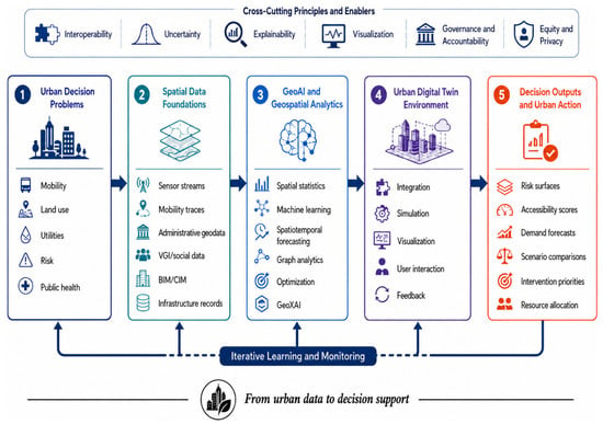
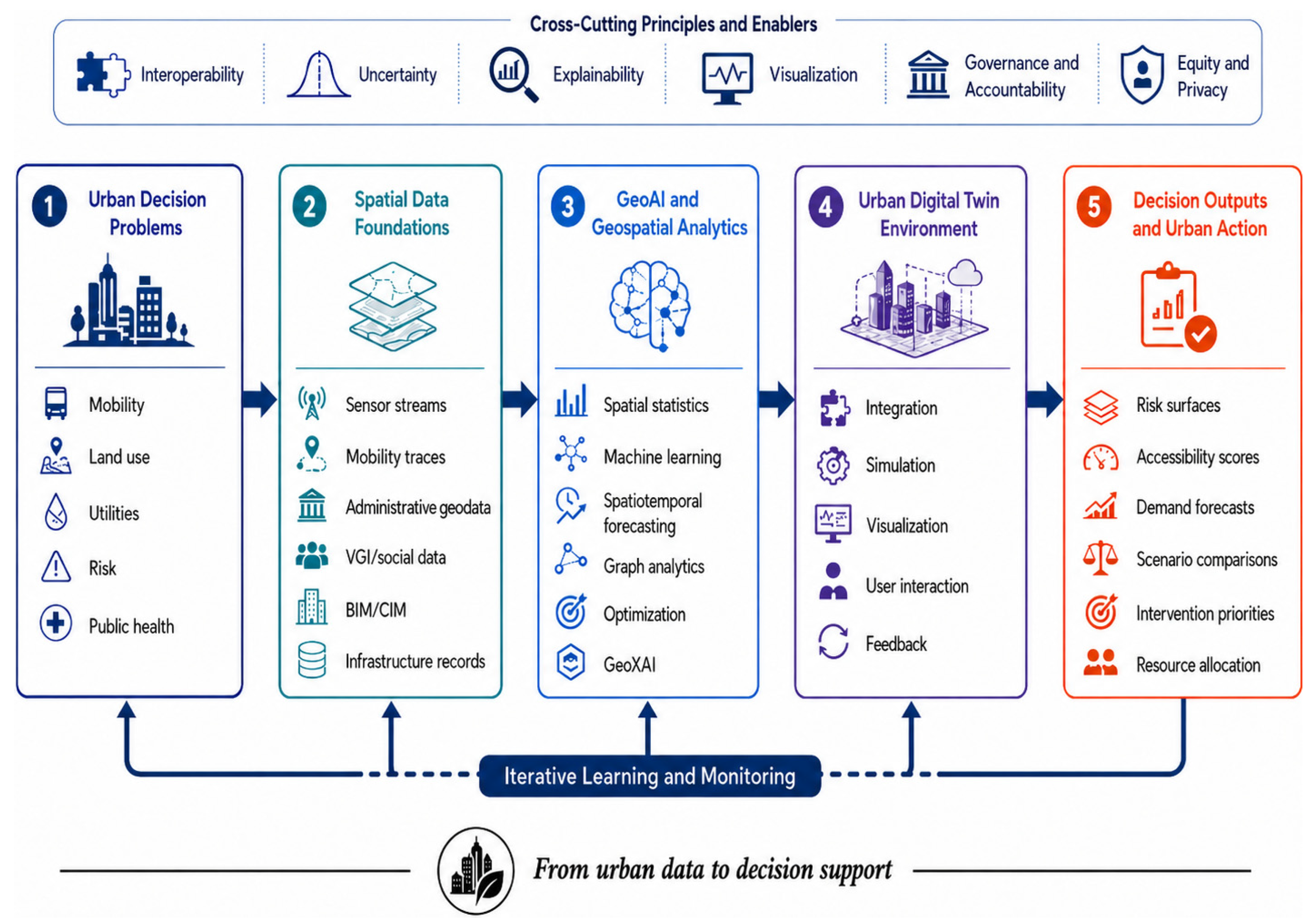
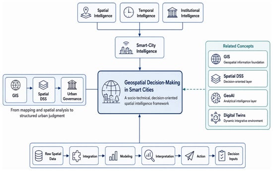
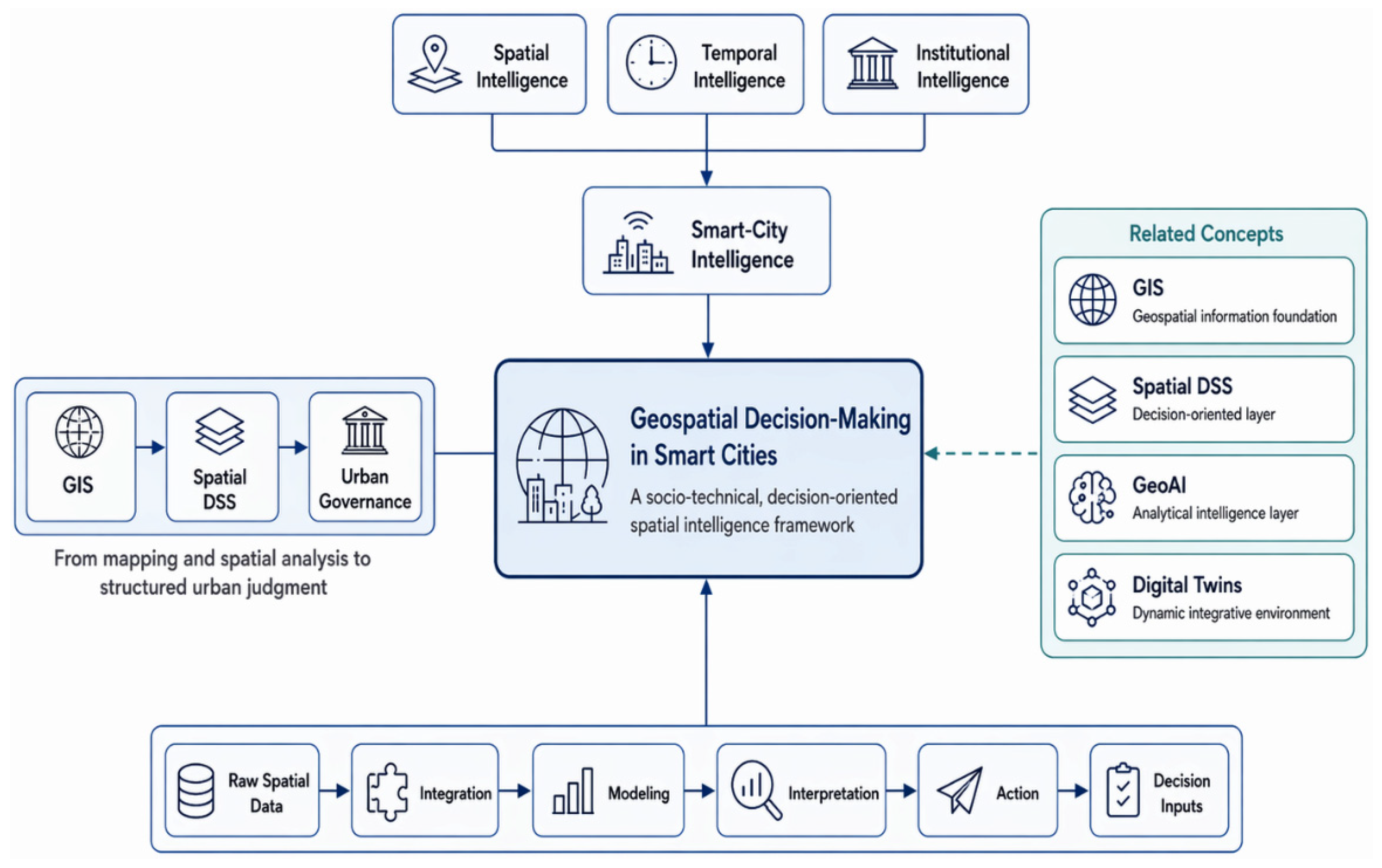
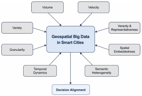
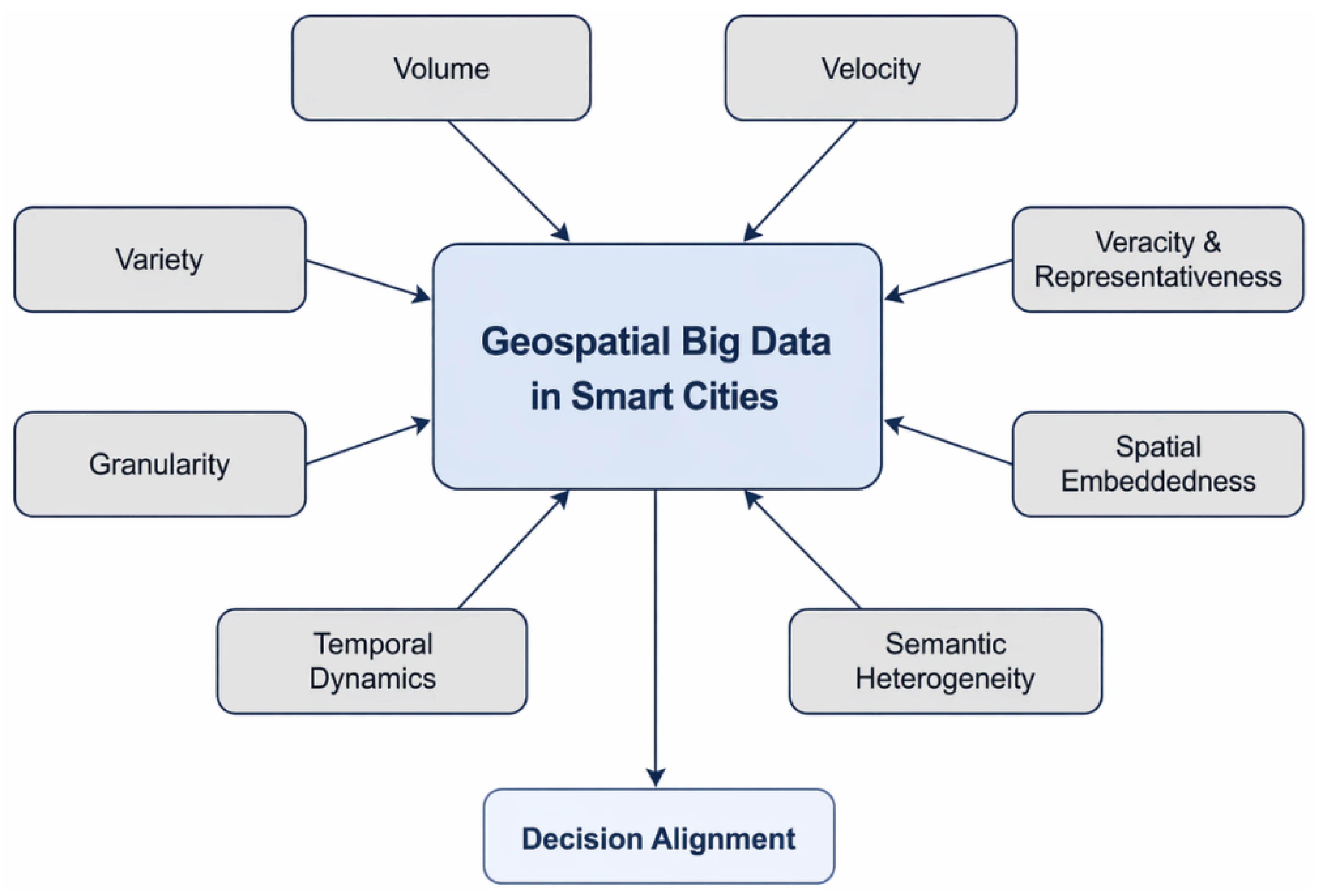
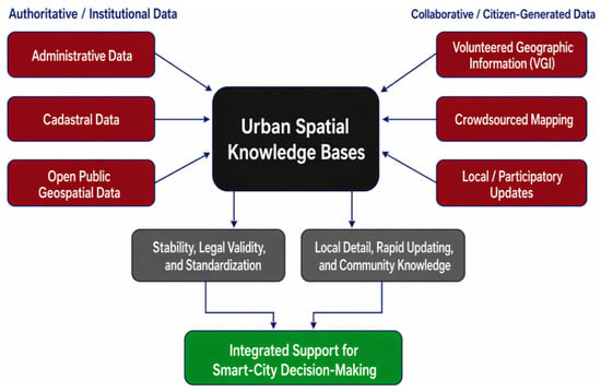
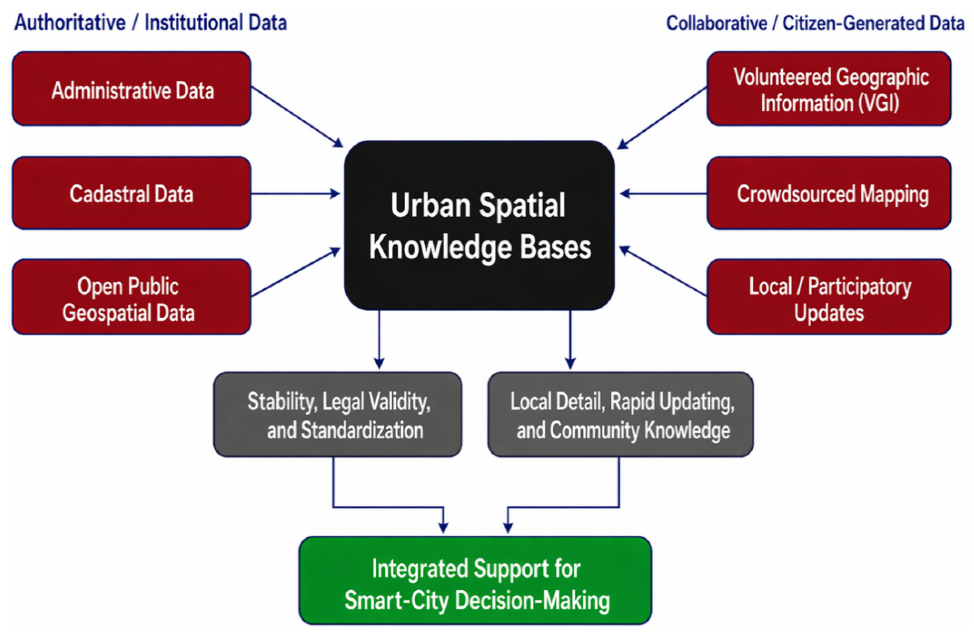
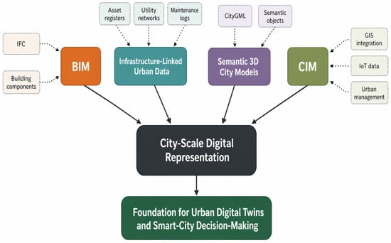
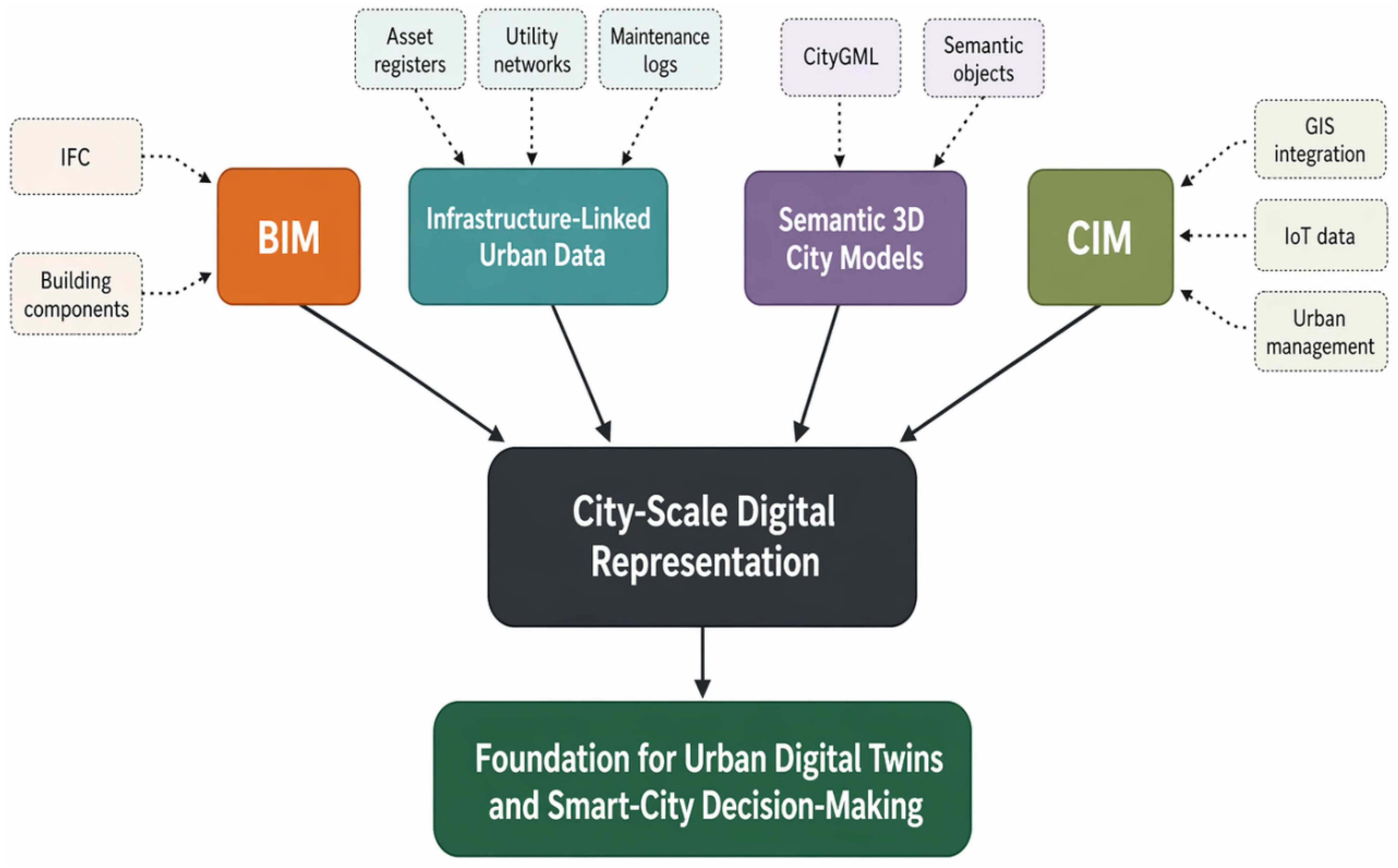
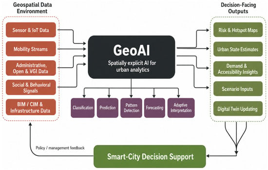
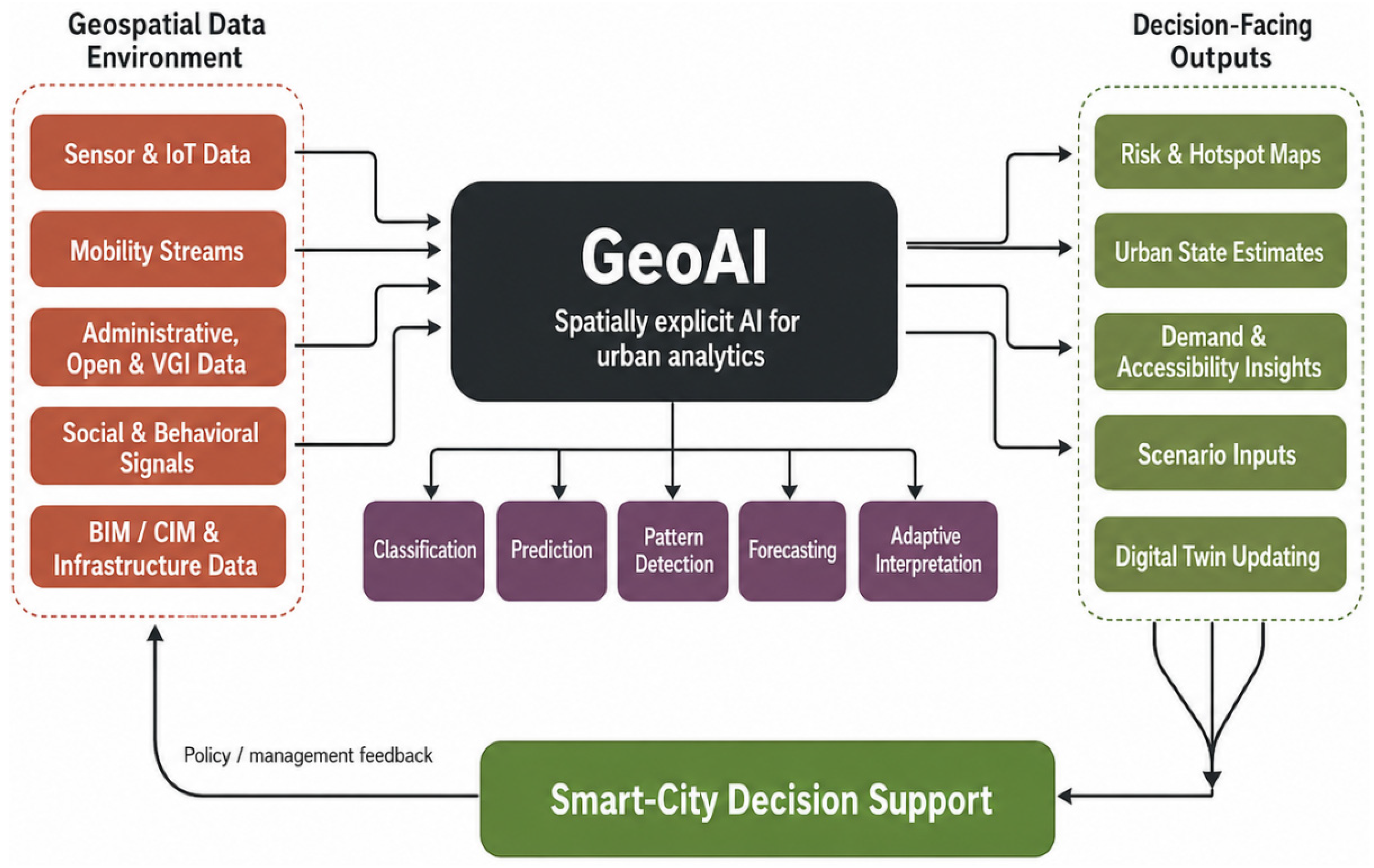
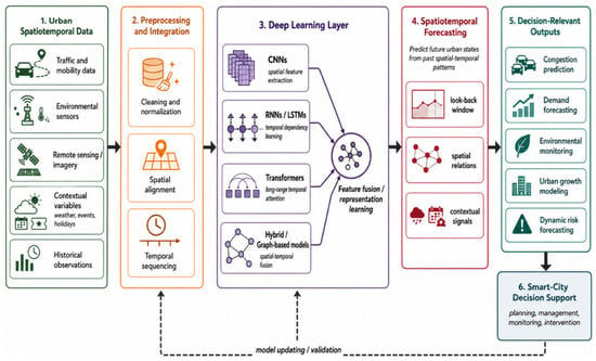
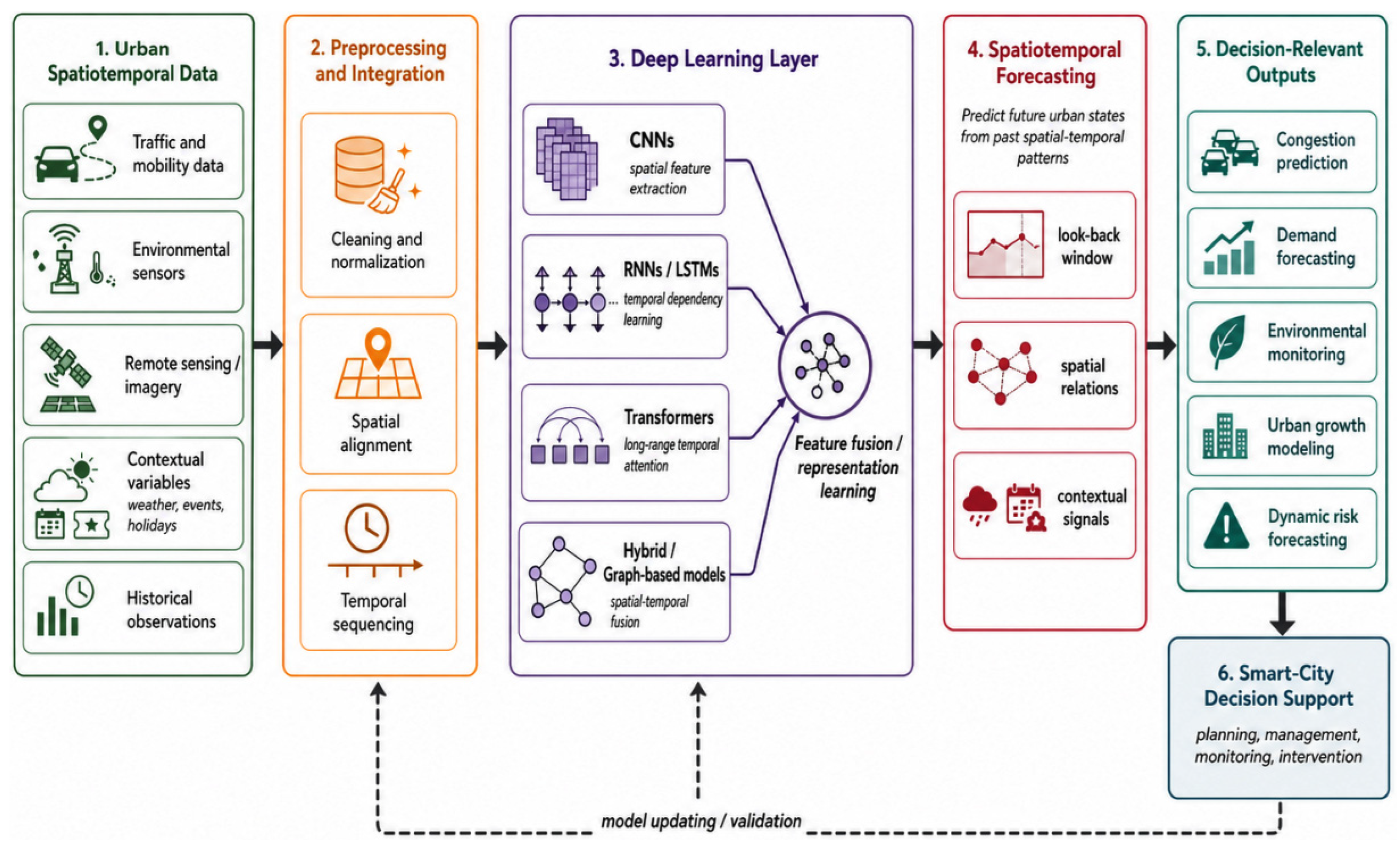
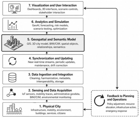
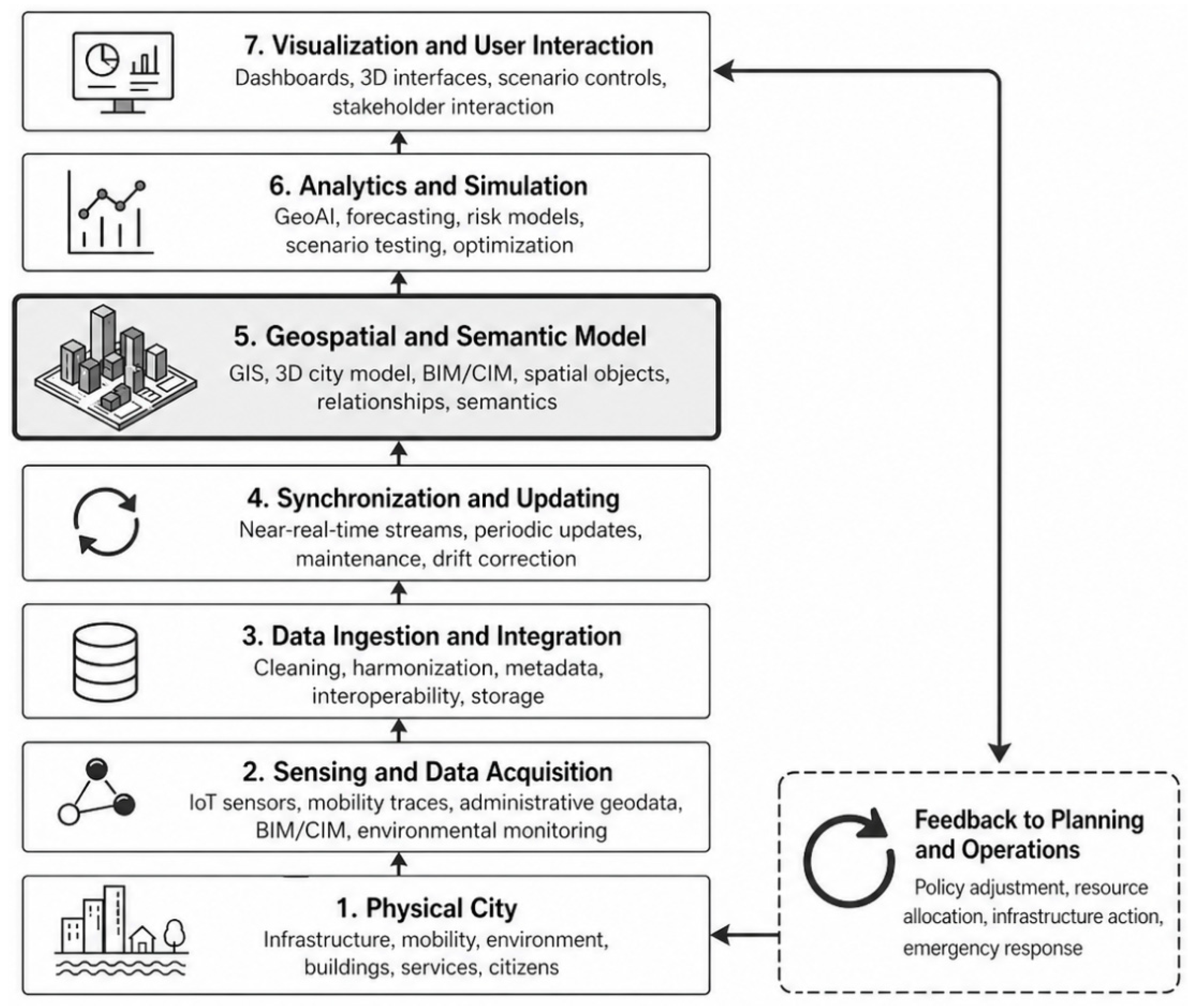
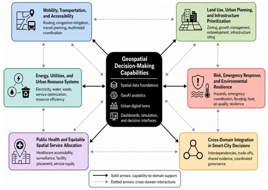
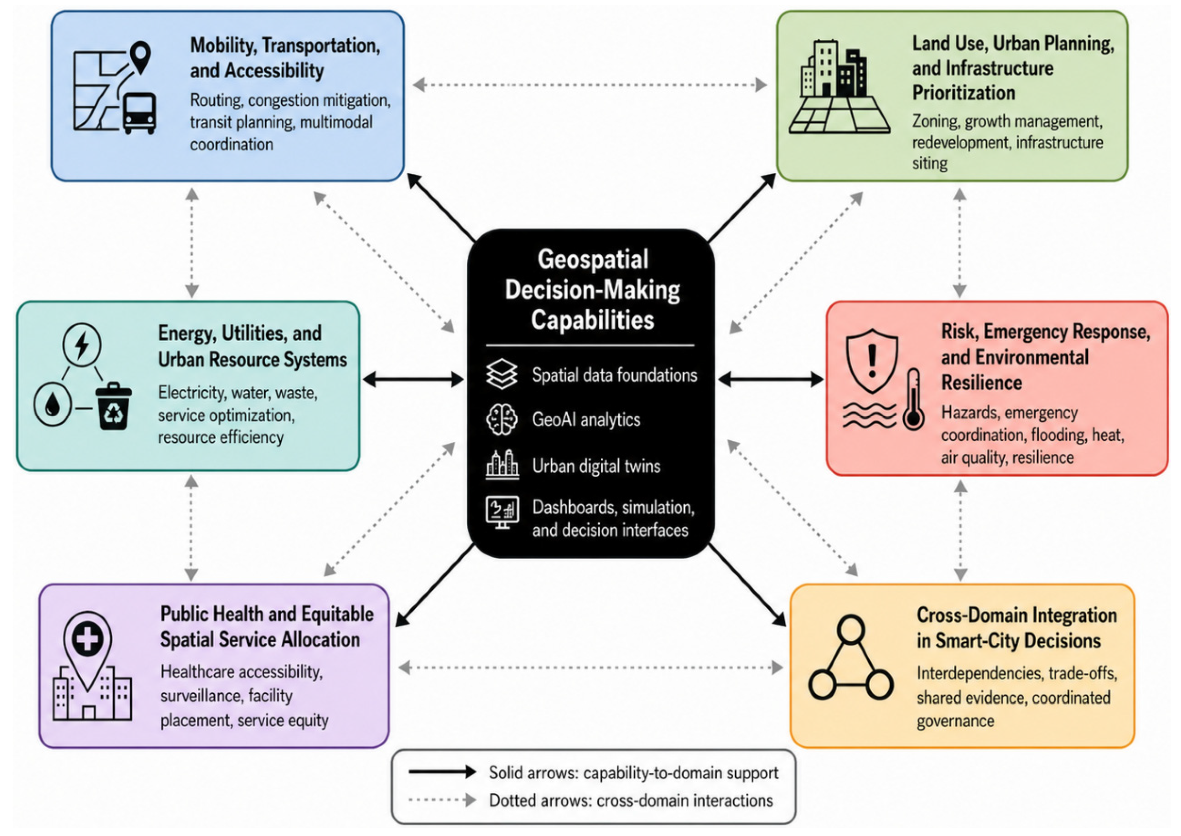

Disclaimer/Publisher’s Note: The statements, opinions and data contained in all publications are solely those of the individual author(s) and contributor(s) and not of MDPI and/or the editor(s). MDPI and/or the editor(s) disclaim responsibility for any injury to people or property resulting from any ideas, methods, instructions or products referred to in the content. |
© 2026 by the authors. Published by MDPI on behalf of the International Society for Photogrammetry and Remote Sensing. Licensee MDPI, Basel, Switzerland. This article is an open access article distributed under the terms and conditions of the Creative Commons Attribution (CC BY) license.