


Abstract
The large-scale deployment of photovoltaic (PV) systems increasingly faces land-use conflicts, particularly in regions with high environmental sensitivity resulting from intensive urban development. Consequently, decision-makers require transparent, spatially explicit tools to identify suitable areas for utility-scale PV installations (>100 kWp). This study addresses these challenges through the application of a Geographic Information System (GIS) to locate optimal sites for solar farms along the coastal zone of the Region of Murcia (southeastern Spain). First, the research characterizes the territorial context and systematically reviews the European, national, and regional regulatory frameworks to identify relevant legal and environmental constraints. These constraints are translated into thematic layers within the GIS environment and progressively applied to exclude unsuitable land through spatial editing and overlay analyses. The remaining feasible areas are subsequently evaluated according to their photovoltaic potential using publicly available solar resource data. The results show that nearly one quarter of the coastal territory is legally and environmentally suitable for PV deployment. Furthermore, due to the favourable geographical conditions of this Spanish region, the annual photovoltaic potential along the coastal zone reaches nearly 48,000 GWh, which would not only meet the Region of Murcia’s annual electricity demand (approximately 8000 GWh) but also supply neighbouring areas in southeastern Spain.
1. Introduction
1.1. Research Background and Existing Problems
Sustainable development remains a central global priority, particularly in relation to increasing energy demands and the urgent need to reduce greenhouse gas emissions. Projections indicate that global energy consumption will continue to rise significantly, even as fossil-fuel prices increase and reserves diminish. This situation has intensified the pressure on countries to promote low-carbon transitions and enhance the efficiency of resource use within their territorial systems. Within the European Union, long-term energy and climate strategies aim to accelerate the deployment of renewable energy infrastructures and to foster carbon-neutral energy systems [1,2]. Photovoltaic (PV) energy, in particular, has become one of the most rapidly expanding renewable technologies due to its declining cost, technological maturity, and strong competitiveness relative to conventional generation [3].
However, as the demand for large-scale PV installations grows, so do territorial challenges. In many regions—especially Mediterranean coastal zones—urban expansion, environmental protection, and land-use conflicts limit the availability of areas suitable for renewable energy infrastructure. These constraints underline the need for spatially explicit assessments capable of differentiating feasible from non-feasible land, based on transparent, reproducible, and policy-aligned criteria.
1.2. Existing Solutions and Deficiencies
Spain represents a paradigmatic case where favourable climatic conditions and ambitious European climate policies have driven rapid growth in renewable energy deployment. National strategic instruments, such as the Integrated Energy and Climate Plan (PNIEC) [4] and Law 7/2021 [5], reinforce these objectives by setting clear milestones for 2030 and 2050, including substantial increases in renewable electricity generation. Despite this favourable context, structural difficulties persist.
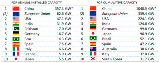
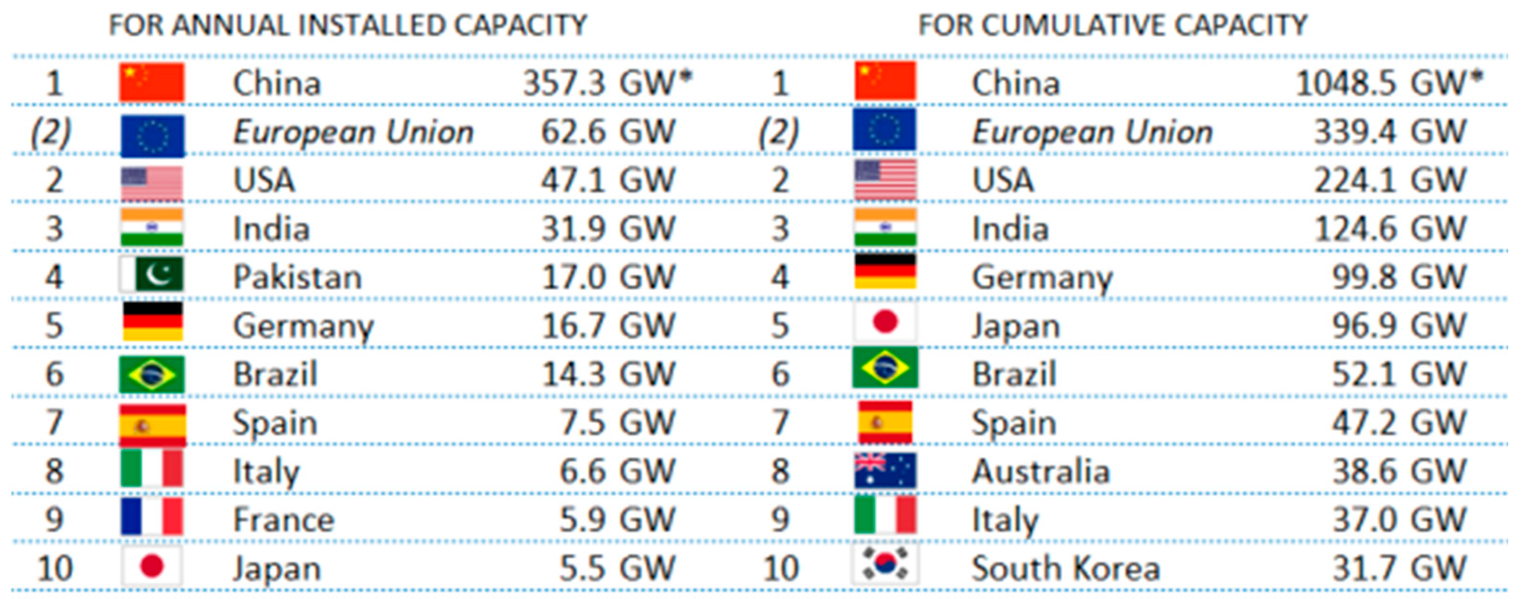
Although Spain consistently ranks among the leading countries in global PV capacity [6] (see Figure 1), several territorial constraints restrict further expansion—particularly in regions like the Region of Murcia, where urban density, environmental regulations, and land-use competition shape energy-planning dynamics. Despite having one of the highest solar radiation levels in the country [7], the region still relies heavily on natural gas combined-cycle production. Additionally, the coastal fringe, where land demand is particularly intense, poses special challenges for the siting of large-scale PV plants due to stringent planning instruments, environmental protection zones, and fragmented land ownership.
Figure 1.
Top 10 countries for annual and cumulative installed PV capacity in 2024. * IEA-PVPS preliminary assessment is higher than official China reporting [6]. This table highlights Spain’s outstanding global position in terms of both newly installed and cumulative photovoltaic capacity.
Existing assessments often address PV potential at regional or national scales, but they rarely provide the detailed, spatially disaggregated analyses necessary for complex peri-urban and coastal environments. This gap underscores the need for geospatial methodologies tailored to areas with highly constrained and heterogeneous territorial conditions.
1.3. Research Methods and Innovative Points
Geographic Information Systems (GIS) provide a robust framework for addressing these challenges. Their capacity to integrate diverse geospatial datasets, structure information through thematic layers, and apply reproducible spatial analyses makes them indispensable for renewable energy planning [8,9,10,11]. Over the past two decades, GIS has been increasingly applied to renewable energy assessments worldwide, supporting solar-resource characterization, land-suitability evaluation, environmental screening, and infrastructure optimization [12,13,14,15]. Recent studies have also shown the relevance of GIS-based suitability modelling for large-scale PV siting across diverse geographic contexts, including Iran [16], Jamaica [17], Poland [18], Turkey [19], and the Philippines [20].
More advanced approaches integrate GIS with multi-criteria decision-making techniques to weigh environmental, legal, technical, and socioeconomic factors simultaneously [21,22,23]. Complementary research has demonstrated the value of GIS within remote-sensing workflows, including solar radiation modelling, land-cover classification, and terrain-based obstruction analysis [24,25,26,27].
However, these studies primarily focus on generating suitability or capacity maps for the installation of PV power plants, without conducting a comprehensive and detailed examination of the international, regional, and/or local legislative frameworks that define, in advance, the restrictions or areas where such infrastructures cannot be developed.
The studies reviewed do not focus on specific areas where multiple restrictive factors coexist and may, in some cases, be critical. Considering a broad range of regulatory contexts—related to different levels of urban development, the proximity to ephemeral watercourses prone to causing severe flooding, the presence of valuable archaeological, paleontological, and cultural heritage, long-established environmental protections within the European Union such as the Natura 2000 Network, as well as conventional restrictions such as proximity to roads, livestock trails, or military zones—constitutes the foundation of any GIS-based analysis. Examining and analysing these types of constraints in detail would enable subsequent phases, such as the evaluation of optimal locations for hosting this type of infrastructure, to be addressed in a reliable and robust manner. Therefore, performing an exhaustive GIS-based analysis for a specific, densely urbanized geographic area—such as the case proposed in this study—would enable the extrapolation of these constraints to other territories exhibiting comparable levels of complexity.
It is for this reason that, despite this extensive body of work, research focused on Mediterranean coastal regions—where urban pressures, legislative constraints, and environmental sensitivities coexist—remains limited. This study contributes to filling this gap by:
- Implementing a detailed GIS-based exclusion framework explicitly aligned with the European, Spanish, and regional regulatory context;
- Characterizing suitability in a highly urbanized coastal corridor;
- Quantifying the photovoltaic potential of the remaining legally and environmentally feasible areas using publicly available solar-resource data.
1.4. Main Content and Structure of This Work
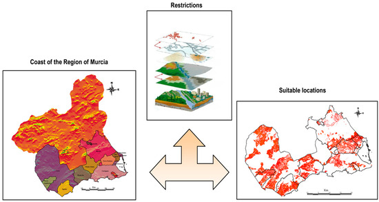
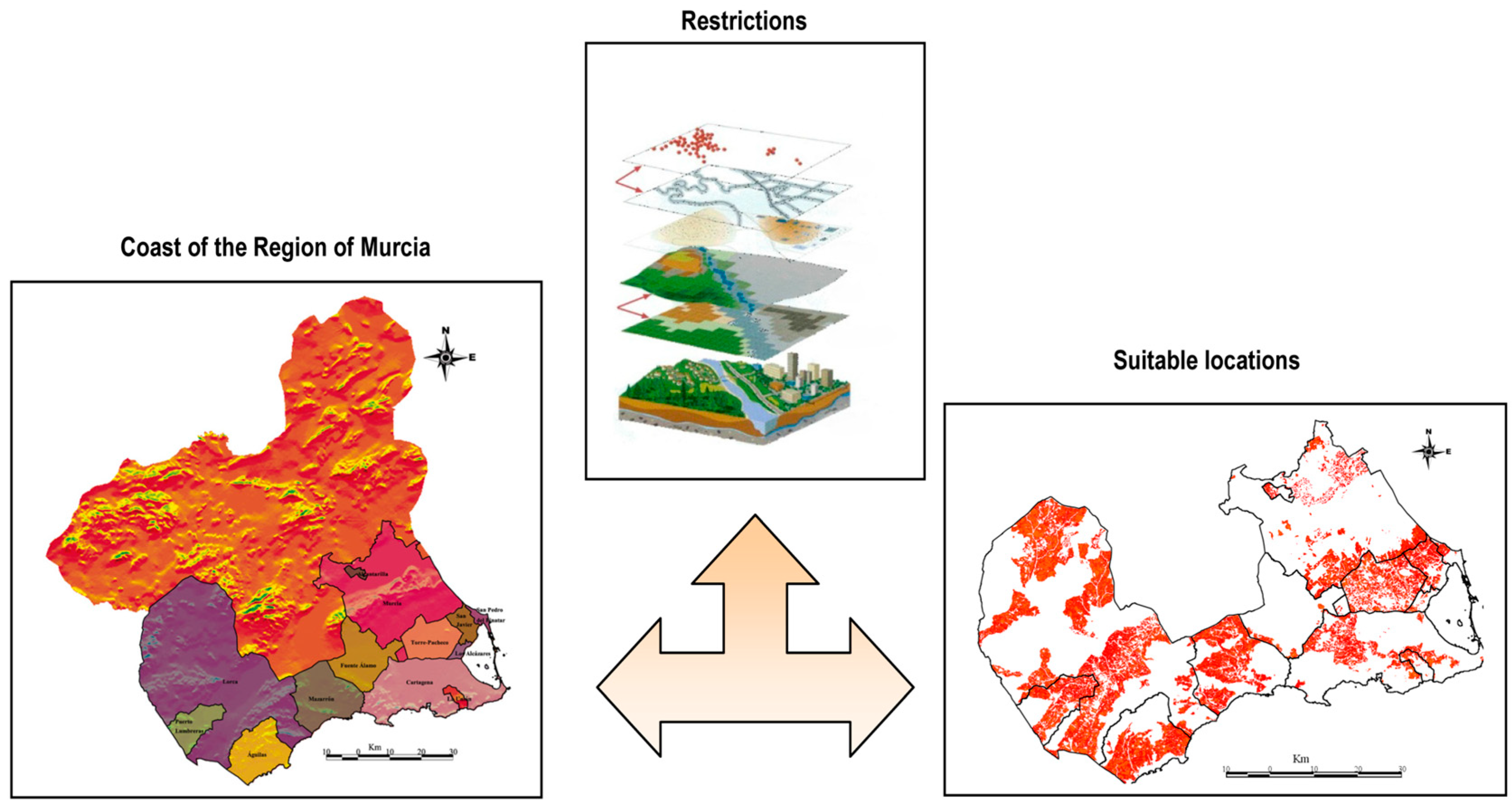
This article presents a GIS-based methodology designed to identify and evaluate suitable areas for the deployment of utility-scale photovoltaic installations along the coastal zone of the Region of Murcia in southeastern Spain (Figure 2). The structure of the paper is as follows: Section 2 presents a literature review that includes both well-established GIS publications and more recent studies, identifying the research gaps and the innovative aspects of the present work. Section 3 details the methodological framework, including the definition of legal and environmental constraints, their translation into geospatial exclusion layers, and the procedures used to delineate eligible land. Section 4 quantifies the photovoltaic potential of the identified suitable areas and contextualizes the results within regional energy-demand scenarios and finally, Section 5 synthesizes the main findings, highlights the implications for regional energy planning, provides a comprehensive description and in-depth analysis of the limitations and potential weaknesses, and proposes recommendations for future research and decision-support development.
Figure 2.
Diagram of the process illustrating how GIS tools are used to identify suitable locations for installing solar parks along the coast of the Region of Murcia, Spain. The figure displays the municipalities within the study area in different colors and shows how GIS editing of multiple thematic layers, applied to this study area, enables the generation of the final thematic layer of suitable surfaces for the deployment of large PV systems.
2. Related Work
Based on the literature briefly outlined in the previous section, we focus here on both classical and more recent studies in order to compare existing GIS analyses with the approach proposed in the present work. Several classical studies in the GIS field have become methodological benchmarks and therefore merit particular attention. One such example is the assessment of wind energy potential conducted for the island of Crete [10]. Although this case study may represent an appropriate starting point—given the coexistence of coastal zones and high tourism activity—the exclusion areas or restricted zones are not examined in detail, nor is the regulatory framework applicable to the island explored in depth.
Other clear examples include the multicriteria analysis carried out in Colorado (USA) to assess solar and wind energy potential [8], as well as the global-scale study highlighting the world’s energy needs toward 2050 [11], the latter of which does not consider any type of land-use restriction. In the Colorado study, the assessment is based on criteria influencing solar and wind potential evaluation, yet it does not focus on constraints or on the legislative context affecting such developments.
A GIS-based study of the Chigu area in southeastern Taiwan examined the region’s solar, wind, and biomass potential [12]. Although this case could serve as a useful reference, and despite the inclusion of buffer zones for constraints, the basis for such information is not justified, nor is the methodology for incorporating these restrictions into the GIS tool described. Rural areas in western China have also been analyzed using GIS software to determine solar and wind potential [13]; however, land-use constraints that should be subtracted from the evaluable surface are not considered, with the analysis centered instead on socioeconomic evaluation and market potential.
In Spain, a pioneering 2007 study assessed the country’s concentrated solar power potential [14]. This work accounted for environmental restrictions such as Natura 2000 and protected natural areas, but other regulatory exclusion contexts were omitted. The authors stressed that smaller-scale analyses—such as the one proposed here—are necessary to define and specify such aspects in order to obtain region-specific renewable energy potential.
In the province of Songkhla in southern Thailand, a GIS analysis was conducted to determine solar and wind potential [9]. Although this coastal area could resemble the present case study, it is neither densely populated nor highly urbanized, despite its considerable tourism appeal. The analysis considered only economic and environmental factors such as residential buffers, airport proximity, and distances to wetlands and forests. A study of a rural town in Vermont (USA) [25] examined the solar, wind, and biomass potential, focusing on constraints affecting the deployment of such technologies—such as minimum slope requirements, proximity to croplands, and absence of adjacent buildings—without addressing restrictions related to regulatory contexts.
Another GIS-based study in India’s Tumkur district sought to identify potential and optimal locations for biomass power plants [26], again overlooking restrictive areas limiting the evaluable territory. In the Piedmont region of Italy, GIS was used to analyze site selection for large photovoltaic plants [27]. Protected and restricted areas defined by Italian regulations were excluded, yet the process for implementing this geographic information in the GIS tool and the corresponding influence zones were not described.
A 2019 review explored renewable energy sources using remote sensing and GIS [24], focusing on cartographic datasets directly related to geothermal, solar, wind, biomass, and hydropower resources across several study areas, without detailing exclusion zones or the GIS algorithms required to incorporate them. This trend has become more pronounced in recent studies, which emphasize digital cartographic information on key criteria (solar radiation potential, wind power density, etc.) and provide general estimates or recommendations regarding potential influence areas for restrictively zoned regions. Examples include studies in Iran’s Khuzestan [23] and Kermanshah [16] provinces, Çanakkale province in Turkey [19], and Ecuador [21], which address site selection and the technical potential of photovoltaic solar farms. Due to the large territorial scope of these studies, little attention is paid to densely populated or urbanized areas, and exclusion criteria or restrictions are not justified in detail.
Similarly, GIS analyses conducted for Jamaica [17], Sibuyan [20], and Karpathos [22]—despite being insular environments with steep topography, rainforests, and beaches offering strong tourism appeal—focus mainly on identifying optimal photovoltaic farm sites based on a set of criteria, without detailing the GIS-based process for excluding unsuitable areas for such energy infrastructures. A comparable study assessing PV solar potential in Poland [18] also spans the entire national territory, thus not focusing on densely urbanized zones, and buffer distances are not justified, except for those related to the Natura 2000 network.
The brief literature review presented here highlights the difficulty of finding case studies in which the three factors emphasized in this work coexist: first, highly urbanized coastal areas; second, a detailed description of the applicable European, national (and even regional) regulatory framework; and third, zones with high photovoltaic potential due to their geographical location. Therefore, although the scientific literature shows a substantial number of studies employing GIS software to determine optimal locations and renewable energy potential, most focus on the site evaluation procedure without exhaustively analyzing the territory—particularly in highly urbanized coastal regions such as those found along much of the Mediterranean coast.
3. GIS Methodology Applied to Obtaining Suitable Locations of Photovoltaic Solar Farms on the Coast of the Region of Murcia
Although commercial Geographic Information Systems (GIS) are widely used today (e.g., ArcGIS, IDRISI), the geographic-information community continues to develop open-source software with the aim of reaching a broader user base and leveraging the potential advantages associated with open accessibility. A clear example of this trend is the widespread adoption of the open-source platform QGIS. In Spain, similar efforts have been undertaken to promote GIS tools that are accessible to the largest possible number of users, as illustrated by the gvSIG software [28]. This is precisely the GIS platform employed in the present study.
gvSIG was launched in 2004 by the Regional Ministry of Infrastructure and Transport of Valencia and has since been continuously updated and improved through the contributions of its developer community. Like any modern GIS software, gvSIG is capable of managing and editing multiple types of thematic layers and additionally provides access to remotely hosted map services, such as Web Map Service (WMS) layers.
3.1. Search for Suitable Locations
The first step in the analysis is the definition of the study area. In this work, the selected area corresponds to the coastal zone of the Region of Murcia, which covers 4456.59 km2 and comprises 13 municipalities (Figure 2). Once the study area has been established, the relevant constraints must be identified. These constraints include all zones where, due to the current territorial configuration (e.g., roads, railways, urban areas) or the applicable legislative framework at the European, national, regional, or local levels, the installation of solar farms is not permitted.
3.1.1. Restrictions
Each restriction listed in Table 1 is defined in accordance with its corresponding legislative framework. Under the current regulations (Legislative Decree 1/2005 of 10 June [29]; Decree 102/2006 of 8 June [30]; Law 42/2007 of 13 December [31]; Law 4/92 of 30 July [32]; Law 4/2009 of 14 May [33]; and the general municipal urban development plans), the construction of solar farms is prohibited on urban land, protected land, and undeveloped land (Restriction 1). According to Law 42/2007 [31] and Law 3/1995 of 23 March [34], areas of high landscape value, hydraulic infrastructures, military zones, and cattle routes constitute protected areas (Restriction 2). Furthermore, Decree 102/2006 [30] establishes that neither installations nor associated infrastructure may be built within watercourses, streams, or their areas of influence (Restriction 3).
Table 1.
Legal Restrictions to land-use in Spanish legislation.
Similarly, Law 16/1985 of 25 June [35] includes conservation measures for areas classified as archaeological, paleontological, or cultural heritage sites (Restriction 4). Road and railway networks (Restriction 5) are also subject to protection under Law 25/1988 of 29 July [36]. In addition, Sites of Community Interest (LICs; Restriction 6) and Special Protection Areas for Birds (ZEPAs; Restriction 7) are safeguarded under Directive 92/43/EEC of 21 May 1992 [37]. A similar regulatory framework applies to mountainous areas (also protected under the aforementioned Directive) and to the Spanish Mediterranean coastline (Restriction 8), which is governed by Law 22/1988 of 28 July [38]. This law establishes a terrestrial protection zone extending 100 m inland from the coastline, within which construction is strictly regulated or prohibited.
In addition to the restrictions described above, two further exclusion criteria must be considered. First, any areas containing significant built structures or facilities—such as reservoirs, agricultural buildings, or similar constructions—must be discarded. Second, areas with insufficient surface area, as defined by expert criteria for the installation of such facilities (i.e., areas smaller than 1000 m2), should also be excluded from potential suitability.
3.1.2. Database Development
Once the study area and its corresponding restrictions have been defined, the next step is to incorporate each restriction into gvSIG. To do so, it is necessary to obtain the cartographic information of both the study area and all restriction criteria in the form of thematic layers. These datasets were provided by the competent governmental agencies of the Region of Murcia.
The process begins with the incorporation of the thematic layer representing the coastline of the Region of Murcia into gvSIG (Figure 2). This layer not only delineates the study area but also enables its classification by municipalities, which in turn are organized into polygons, parcels, and cadastral sub-parcels. After this, the thematic layer containing all restrictions is added to gvSIG. Using the available software tools, each restriction is then edited and spatially defined according to the applicable legislative framework.
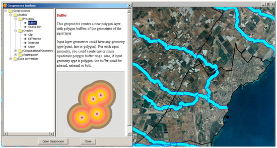
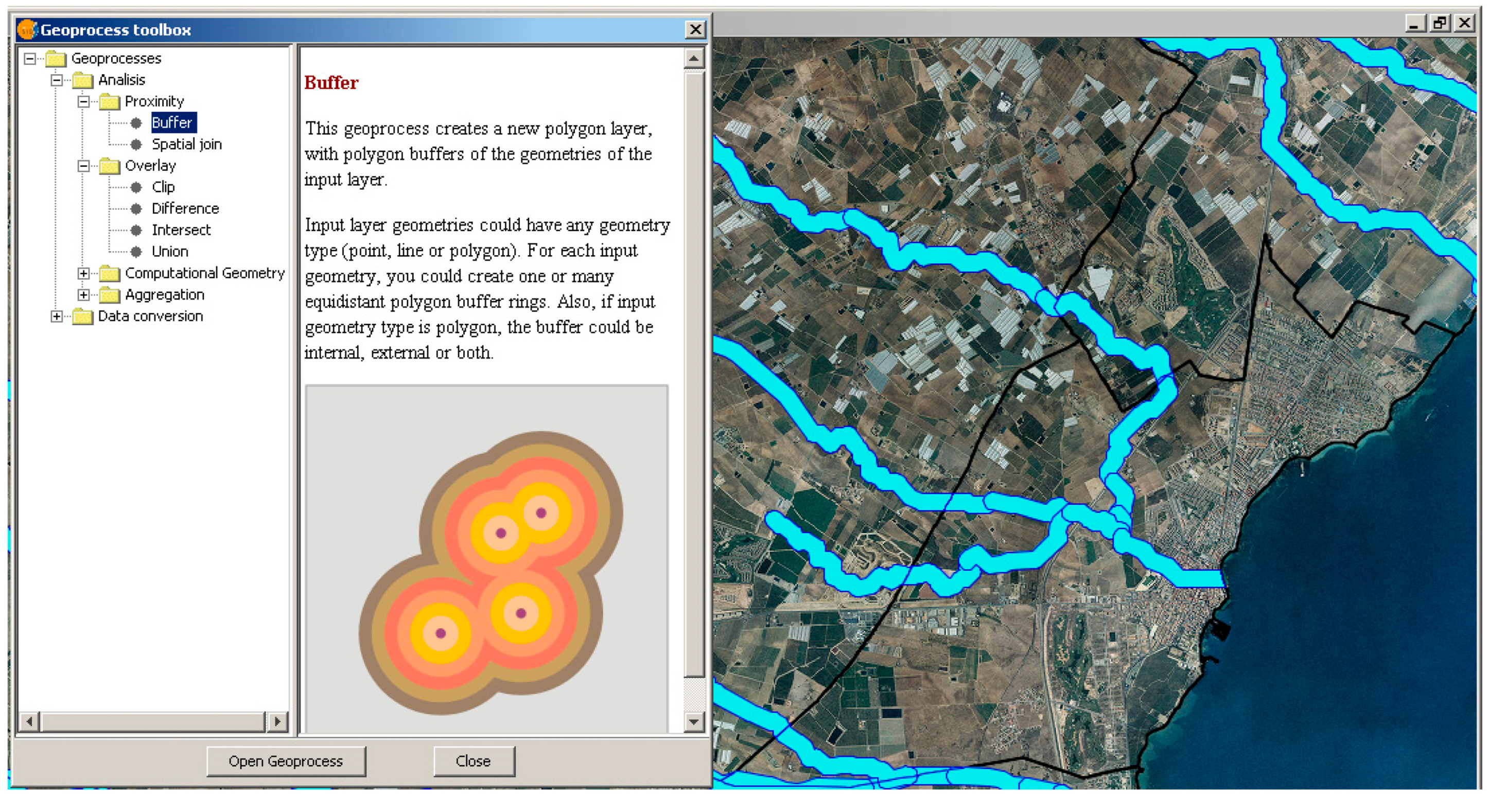
For example, the “buffer” tool must be applied to expand the area corresponding to watercourses and streams, since Decree 102/2006 requires an influence zone of 200 m on both sides (Figure 3). Similar influence zones must be generated for other restricted categories, including archaeological, paleontological, and cultural heritage sites (100 m); roads (25 m); railway networks (15 m); Sites of Community Interest (100 m); Special Protection Areas for Birds (100 m); and the Mediterranean coastline (100 m).
Figure 3.
Process of applying the Buffer tool to restriction 3. This figure illustrates how, through the Buffer command, a line feature from a vector layer representing the channel of an ephemeral watercourse (rambla) can be expanded to generate a 200 m buffer zone on both sides of the channel. This operation creates a protective area within which the analyzed regulatory framework does not permit the installation of any infrastructure.
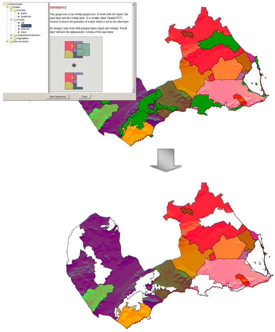
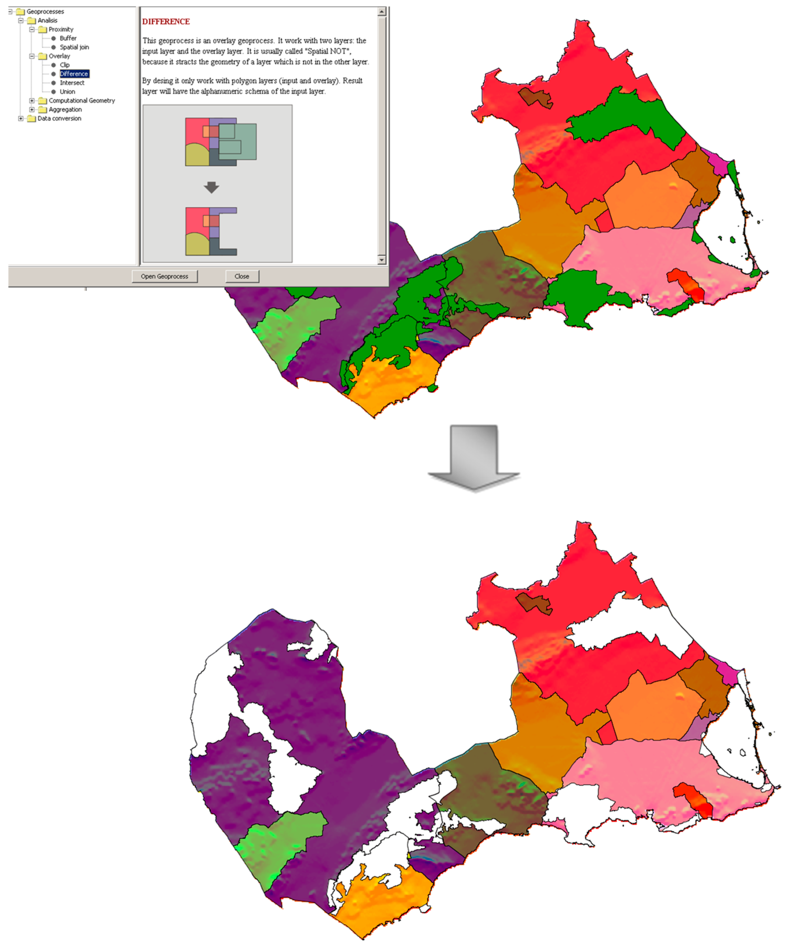
Once all thematic layers representing the restrictions have been edited in accordance with the relevant legislative framework, the “difference” tool in gvSIG is applied to subtract the restricted areas from the initial coastal area of the Region of Murcia. Figure 4 illustrates this procedure: the upper section of the figure shows the original thematic layer of the study area (Figure 2) alongside the thematic layer corresponding to Restriction 7 (Special Protection Areas for Birds), displayed in green. The lower section shows the resulting layer after applying the “difference” tool, where the excluded areas appear in white.
Figure 4.
Application of the Difference command with Constraint 7 (Special Protection Areas for birds). The figure illustrates how the surface area occupied by the bird protection zones (in white in the lower map) is subtracted using this GIS command, thereby ensuring compliance with the protection requirements established under the Natura 2000 network.
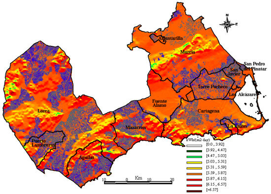
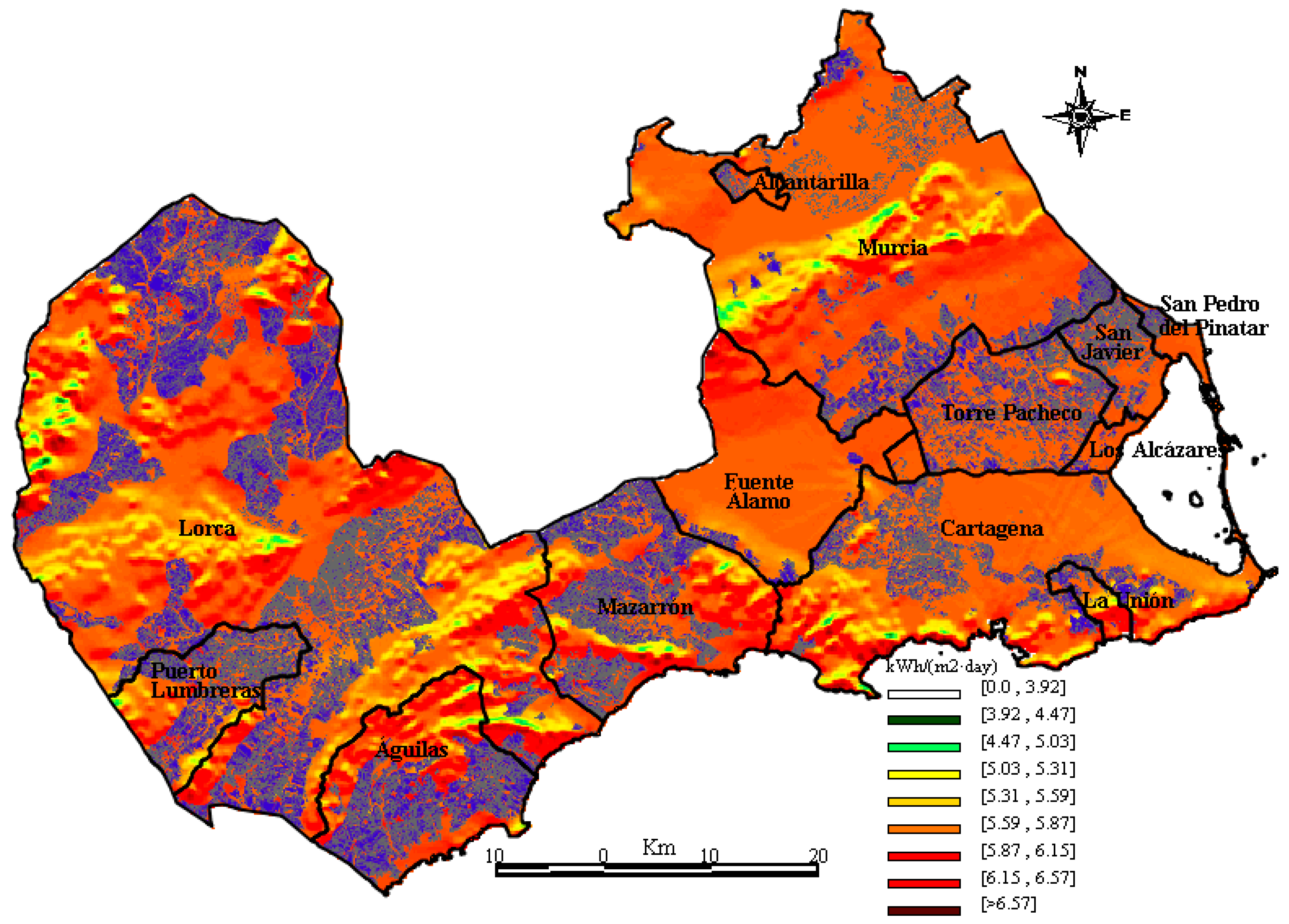
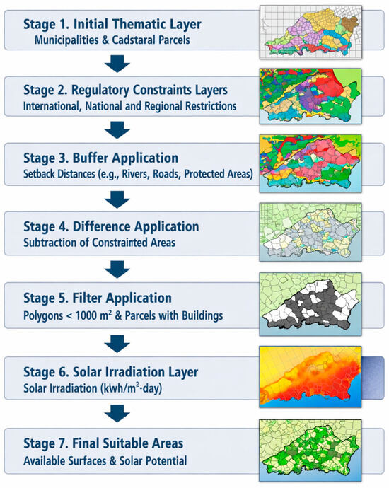
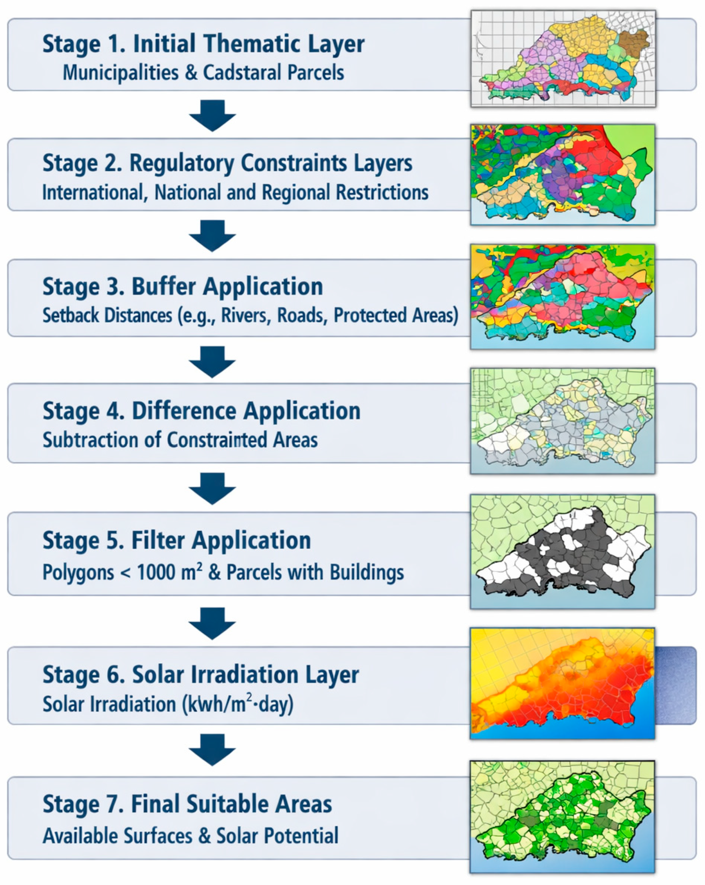
By sequentially applying the “difference” tool to all restrictions, a thematic layer is generated containing all locations that remain eligible for the installation of solar farms. These suitable areas are classified into polygons, plots, and cadastral sub plots for detailed analysis. The final preprocessing step consists of filtering out plots with an area smaller than 1000 m2 or those containing existing buildings. This is accomplished using the gvSIG “Filter” tool, which supports logical operators. Since a plot must be removed if it meets either exclusion criterion, the logical OR operator is applied. Finally, the thematic layer of daily solar radiation (kWh/m2·day) [39] is incorporated into the GIS analysis, resulting in a final layer that delineates the available suitable areas together with their solar potential for the deployment of PV solar farms (Figure 5). This layer enables both the visualization of suitable locations for large scale photovoltaic installations along the coast of the Region of Murcia (displayed in blue in Figure 5) and the creation of a comprehensive database containing cartographic and cadastral information for each viable site. An illustrative schematic showing the sequence of the GIS algorithms developed to identify suitable locations is presented in Figure 6.
Figure 5.
Suitable locations for the deployment of large PV systems (in blue) and solar irradiation. This map jointly illustrates both the solar potential of the analyzed study area and the available surfaces for the installation of these energy infrastructures.
Figure 6.
Diagram of the process detailing the applied GIS algorithms. The figure illustrates the GIS workflow carried out in seven stages, starting from the initial thematic layer of the study area and ultimately resulting in the thematic layer of suitable surfaces and the corresponding solar radiation potential.
The resulting database identifies all suitable locations and assigns each one a set of attributes describing its geographic characteristics, including UTM Zone 30 coordinates, surface area (m2), cadastral reference, municipality, polygon, plot, and sub plot. Thus, the methodology not only provides a spatial representation of suitable areas but also yields a robust dataset that can be used for subsequent decision-making processes.
An analysis of the final thematic layer reveals that 21.25% of the total coastal territory of the Region of Murcia (4456.59 km2) is suitable for the construction of solar farms. This percentage corresponds to 66,845 plots, which constitute the viable locations (shown in blue in Figure 5). When classified by municipality (Table 2), Lorca emerges as the most favorable area for siting these facilities, followed by Mazarrón and Cartagena. In contrast, Los Alcázares and La Unión exhibit the smallest number of suitable locations.
Table 2.
Suitable locations to build solar farms by municipalities and by km2.
However, when considering the number of suitable locations per square kilometer, the municipality of San Javier presents the highest density of viable sites. Despite its relatively small territorial extent (73.79 km2), the municipality is subject to fewer restrictive factors that hinder the deployment of solar farms. Conversely, the municipalities of Murcia and Cartagena—although they are the second and third largest in territorial extent (885.01 km2 and 560.78 km2, respectively)—show a comparatively low number of suitable locations per km2. It is worth noting, nonetheless, that the potential of the built environment for rooftop or building integrated photovoltaic systems is significantly greater in larger urban and industrial areas. These systems, however, fall outside the scope of the present study, which focuses exclusively on land based, large scale photovoltaic installations (>100 kWp).
4. Determination of the Photovoltaic Potential and Comparison with the Electricity Demand
Once the suitable locations within the study area have been identified, a comparative analysis of their photovoltaic potential—expressed in terms of the estimated electricity generation relative to the overall energy consumption of the Region of Murcia—is conducted. To estimate the solar electricity that could be produced at these locations, Equation 1 is applied.
For each suitable site, solar-irradiation data are incorporated into gvSIG through a thematic layer representing the solar irradiation of the coastal area [39] (Figure 5). This layer provides average values of total daily solar irradiation for each municipality, which are subsequently used in the calculation of photovoltaic potential (Table 3).
where
- , average value of the total solar daily irradiation in kWh/(m2·day). The parameter represents the azimuth and the tilted surface angle.
- Pmp, nominal peak power (kWp).
- PR, performance ratio.
- GCEM, reference irradiance at Standard Test Conditions (AM1.5, 1000 W/m2).
Table 3.
In-plane solar daily irradiation and incidental solar energy per square meter, figures provided are averaged for each municipality considering South orientation (α = 0) and for the optimal tilt angle (β) for each latitude.
Although several photovoltaic technologies are available [40], the estimation of annual energy production in this study is based on a grid-connected photovoltaic generator with fixed orientation (i.e., without a tracking system). The system is assumed to be composed of monocrystalline silicon modules manufactured in Spain, specifically the ISF-220 model by ISOFOTON. These modules have a nominal peak power of 220 Wp and standard dimensions of 1515 × 994 mm.
The performance ratio (PR) of a PV system depends mainly on the selection of its components (inverters, wiring, etc.) and on the quality of the system design. Typical PR values range from 0.6 to 0.8. In this study, a conservative value of PR = 0.6 is adopted to ensure a restrictive estimate, even though modern photovoltaic installations systematically report higher PR values. By introducing this PR, along with the physical characteristics (surface area) and electrical specifications (peak power) of the selected module, it is possible to determine the potential solar electricity output per square meter (Ep) of the photovoltaic system.
Additionally, based on the physical dimensions of the module, Equation 2 is used to determine the minimum spacing required between consecutive rows of modules in order to avoid shading losses.
where:
- h, the height difference between the highest point on which a row of modules is supported, and the bottom of the following, in meters (m).
To optimize the PV system, the installation is designed with a south-facing orientation. The optimal tilt angle depends on the latitude of the site—typically 5° to 10° lower than the local latitude—and on the period of the year for which maximum performance is sought. Given that the municipalities within the study area are located at a latitude of approximately 37°, a tilt angle of 30° is selected. Under these conditions, the associated losses remain below 10° [41].
Once these parameters are established, it is possible to determine the required spacing between module rows and, consequently, to quantify the percentage of land area that must be excluded from a solar farm layout to prevent inter-row shading. For an installation covering 1 km2, 65.8% of the area is unavailable for panel placement due to these spacing requirements. The photovoltaic potential (Es) of each municipality—defined as the amount of electricity that could be generated if all suitable land is used for PV installations—is calculated based on the incident solar irradiation per square meter and the net suitable area available for development. This net area is obtained from the gross suitable land after applying the spacing constraints required to avoid shading losses. A summary of the resulting energy estimates is presented in Table 4.
Table 4.
Gross, net suitable locations and photovoltaic solar potential by municipality.
The data in Table 4 show that Lorca exhibits the highest photovoltaic potential, followed by Mazarrón and Águilas, whereas Los Alcázares and Alcantarilla display the lowest potential for electricity generation through large-scale PV farms.
The annual photovoltaic potential along the coastal zone reaches 47,971 GWh, a value nearly six times higher than the Region of Murcia’s total electricity consumption in 2024 (8003 GWh) [42]. Considering this consumption level, the region can achieve full energy self-sufficiency by allocating 146.12 km2 for photovoltaic development. Furthermore, with a population of 1,493,898 inhabitants in that year, the consumption ratio corresponds to 0.2 inhabitants per MWh. Therefore, the coastal photovoltaic potential of the Region of Murcia is sufficient to supply electricity to approximately 9,556,598 people—around 20% of the Spanish population—assuming similar per capita electricity demand.
The results obtained in this study will enable decision-makers—whether from public administrations or stakeholder groups—to focus their attention on those territories with the largest net available areas for selecting groups of parcels suitable for the deployment of photovoltaic solar farms. Moreover, they will be able to develop their planning strategies based on the annual photovoltaic potential of each of these territories. This information is of critical importance in areas with high urban development pressure, where General Urban Development Plans are continuously being drafted and where diverse interests converge, such as the preservation of cultural heritage or protected natural areas, on the one hand, and the need to meet the territory’s electricity demand, on the other.
As mentioned at the beginning of this study, this region located in southeastern Spain is strongly dependent on natural gas–fired combined-cycle power plants installed in the area. Therefore, identifying suitable zones for the deployment of large-scale photovoltaic power plants would not only promote the region’s economic growth but also reduce its dependence on the current generation facilities, which require fossil fuels during their operational phase.
In recent years, this region has undergone an intense expansion of photovoltaic solar farms, with numerous projects already in operation, under construction, or planned. The concentration of these facilities is primarily located in coastal areas, particularly within the municipalities of Lorca, San Javier, Torre Pacheco, Cartagena, and Murcia. Among the recently constructed projects, the following photovoltaic plants are noteworthy: a large-scale PV installation of 378.59 MWp in the municipality of Lorca; another photovoltaic plant of 360 MWp located between the municipalities of Lorca and Puerto Lumbreras; a solar farm situated between the municipalities of San Javier, Murcia, and San Pedro del Pinatar, with an installed peak capacity of 196.85 MWp; a solar farm located between the municipalities of Torre Pacheco and Murcia with a peak capacity of 88.67 MWp; another solar installation in the municipality of Torre Pacheco of 85.92 MWp; and a smaller PV plant located in the municipality of Cartagena, covering approximately 20 hectares, with a capacity of 7 MWp [43].
Regarding new projects and forthcoming PV initiatives in the near future, two major developments are planned within the municipalities of Murcia, San Javier, Torre Pacheco, and San Pedro del Pinatar, with a combined total capacity of 315 MWp. Altogether, these projects reveal a high spatial concentration of photovoltaic developments within the study area, confirming the need to undertake GIS-based analyses of the type presented in this study. Such analyses are essential not only to continue promoting the deployment of renewable energy generation technologies but also to ensure that this development proceeds sustainably from an environmental perspective, minimizing impacts on natural environments and on the region’s agricultural activities [44].
5. Conclusions
5.1. The Summary of the Work
The coastal area of the Region of Murcia demonstrates highly favorable conditions for the deployment of large-scale PV systems. Its excellent solar irradiance, combined with the restrictions established in the current legislative framework and the present land-use configuration, results in a remarkably high proportion of suitable land—21.25% of the total coastal area—for the implementation of utility-scale solar farms.
The photovoltaic potential identified in this coastal zone is sufficiently large to meet not only the entire electricity demand of the Region of Murcia but also to supply solar-generated electricity to approximately 20% of the Spanish population. This result is particularly relevant in the context of Spain’s limited availability of fossil fuels and the pressing need to reduce greenhouse gas emissions in accordance with European Union commitments.
5.2. Innovation, Advantages and Limitations
Key parameters in any photovoltaic (PV) solar farm deployment—such as conditions for accessing the electrical grid, distance to transformer substations, development costs, terrain slope, and agricultural land capability—have not been considered in this study. Likewise, evaluating different PV manufacturing technologies (mono-crystalline and poly-crystalline Si, amorphous Si, III–V thin films, CdTe, and CIGS, among others), as well as various PV solar farm configurations (fixed-tilt installations, single-axis or dual-axis tracking systems, etc.), would allow not only a more precise identification of optimal locations but also the determination of the most suitable PV technology and system configuration for each site.
Different decision matrices combining alternatives and criteria—with various combinations of objectives (location, PV technology, and PV farm configuration)—will give rise to a multi-objective decision problem. Through well-established multi-criteria decision-making (MCDM) algorithms, together with recently developed decision-support methodologies, such problems can be addressed, enabling an assessment not only of the robustness of the applied methods but also of the integrity of the resulting GIS database. Such decision-making algorithms will allow the derivation of weights or importance coefficients for the criteria under consideration (using both objective and subjective MCDM methods), as well as the evaluation of the different alternatives.
Criteria such as agricultural land capability or the technological maturity of the PV solutions under evaluation are inherently difficult to quantify using precise numerical values. As a result, the decision problem involves both quantitative criteria and criteria of a qualitative or subjective nature. In these cases, the use of fuzzy logic–based tools capable of handling the associated uncertainty will enable the multi-objective decision problem to be addressed without disregarding any of the parameters involved in the deployment of a photovoltaic solar farm.
5.3. Potential Application
This study generates a spatial database that provides a solid foundation for addressing more complex decision-making challenges, such as identifying suitable locations, analysing different PV manufacturing technologies, or even evaluating alternative photovoltaic solar farm configurations. These interconnected decision problems will be addressed in a subsequent study in the form of a multi-objective decision problem, which can be approached through decision support systems or advanced multi-criteria decision-making techniques.
5.4. Future Work
Although the present work focuses on a case study in the coastal municipalities of the Region of Murcia, the methodology developed is fully transferable to other territories, provided that the corresponding regulatory, territorial, and environmental constraints are incorporated. Consequently, future research could also extend this analysis to the entire national territory or broaden its scope by integrating additional renewable energy sources such as wind, biomass, or biogas.
Author Contributions
Conceptualization, Juan Miguel Sánchez-Lozano and M. S. García-Cascales; methodology, Juan Miguel Sánchez-Lozano and Antonio Urbina; software, Juan Miguel Sánchez-Lozano; validation, M. S. García-Cascales and Antonio Urbina; formal analysis, M. S. García-Cascales; investigation, Juan Miguel Sánchez-Lozano; resources, Juan Miguel Sánchez-Lozano; data curation, Guido C. Guerrero Liquet and Juan Miguel Sánchez-Lozano; writing—original draft preparation, Juan Miguel Sánchez-Lozano and Guido C. Guerrero Liquet; writing—review & editing, M. S. García-Cascales and Antonio Urbina; visualization, Guido C. Guerrero Liquet; supervision, M. S. García-Cascales and Antonio Urbina; project administration, Juan Miguel Sánchez-Lozano All authors have read and agreed to the published version of the manuscript.
Funding
This research received no external funding.
Data Availability Statement
The original data presented in the study are openly available at: https://www.ign.es/web/ign/portal, accessed on 30 March 2026.
Conflicts of Interest
The authors declare no conflicts of interest.
References
- European Commission. REPowerEU Plan; European Commission: Brussels, Belgium, 2022. [Google Scholar]
- Dovì, V.G.; Friedler, F.; Huisingh, D.; Klemeš, J.J. Cleaner energy for sustainable future. J. Clean. Prod. 2009, 17, 889–895. [Google Scholar] [CrossRef] [Scilit]
- Firozjaei, M.K.; Abdeyazdan, H.; Esmailzadeh, A.; Sedighi, A. Optimizing urban solar photovoltaic potential: A large group spatial decision-making approach for Tehran. Energy Sustain. Dev. 2025, 85, 101689. [Google Scholar] [CrossRef] [Scilit]
- Ministry for Ecological Transition and the Demographic Challenge. National Integrated Energy and Climate Plan (PNIEC) Update 2023–2030; Ministry for Ecological Transition and the Demographic Challenge: Madrid, Spain, 2024; Available online: https://www.miteco.gob.es/es/energia/estrategia-normativa/pniec-23-30.html (accessed on 7 January 2026).
- Ministry for Ecological Transition and the Demographic Challenge. Law 7/2021 on Climate Change and Energy Transition. BOE No. 121; Ministry for Ecological Transition and the Demographic Challenge: Madrid, Spain, 2021; Available online: https://www.boe.es/buscar/act.php?id=BOE-A-2021-8447 (accessed on 7 January 2026).
- International Energy Agency. Snapshot of Global PV Markets 2025; IEA-PVPS: Paris, France, 2025; Available online: https://iea-pvps.org/ (accessed on 12 December 2025).
- Gómez-López, M.D.; García-Cascales, M.S.; Ruiz-Delgado, E. Situations and problems of renewable energy in the Region of Murcia, Spain. Renew. Sustain. Energy Rev. 2010, 14, 1253–1262. [Google Scholar] [CrossRef] [Scilit]
- Janke, J.R. Multicriteria GIS modeling of wind and solar farms in Colorado. Renew. Energy 2010, 35, 2228–2234. [Google Scholar] [CrossRef] [Scilit]
- Ali, S.; Taweekun, J.; Techato, K.; Waewsak, J.; Gyawali, S. GIS-based site suitability assessment for wind and solar farms in Songkhla, Thailand. Renew. Energy 2019, 132, 1360–1372. [Google Scholar] [CrossRef] [Scilit]
- Voivontas, D.; Assimacopoulos, D.; Mourelatos, A.; Corominas, J. Evaluation of renewable energy potential using a GIS decision support system. Renew. Energy 1998, 13, 333–344. [Google Scholar] [CrossRef] [Scilit]
- Sorensen, B.; Meibom, P. GIS tools for renewable energy modelling. Renew. Energy 1999, 16, 1262–1267. [Google Scholar] [CrossRef] [Scilit]
- Yue, C.D.; Wang, S.S. GIS-based evaluation of multifarious local renewable energy sources. Energy Policy 2004, 34, 730–742. [Google Scholar] [CrossRef] [Scilit]
- Byrne, J.; Zhou, A.; Shen, B.; Hughes, K. Evaluating the potential of small-scale renewable energy options. Energy Policy 2007, 35, 4391–4401. [Google Scholar] [CrossRef] [Scilit]
- Domínguez Bravo, J.; García Casals, X.; Pinedo Pascua, I. GIS approach to define capacity and generation ceilings of renewable energy technologies. Energy Policy 2007, 35, 4879–4892. [Google Scholar] [CrossRef] [Scilit]
- Piragnolo, M.; Masiero, A.; Fissore, F.; Pirotti, F. Solar irradiance modelling with NASA WW GIS environment. ISPRS Int. J. Geo-Inf. 2015, 4, 711–724. [Google Scholar] [CrossRef] [Scilit]
- Zandi, I.; Lotfata, A. Evaluating solar power plant sites using integrated GIS and MCDM. Sci. Rep. 2025, 15, 3288. [Google Scholar] [CrossRef] [Scilit] [PubMed]
- Richards, D.; Yabar, H.; Mizunoya, T.; Koon Koon, R.; Tran, G.H.; Esopere, Y. Sustainable solar energy deployment: A multi-criteria approach for site suitability and greenhouse gas emission reduction. Environ. Sci. Pollut. Res. 2025, 32, 2007–2035. [Google Scholar] [CrossRef] [Scilit]
- Benalcazar, P.; Komorowska, A.; Kamiński, J. A GIS-based method for assessing economics of utility-scale PV systems. Appl. Energy 2024, 353, 122044. [Google Scholar] [CrossRef] [Scilit]
- Kocabaldır, C.; Yücel, M.A. GIS-based MCDA for spatial planning of PV plants. Renew. Energy 2023, 212, 455–467. [Google Scholar] [CrossRef] [Scilit]
- Gacu, J.G.; Garcia, J.D.; Fetalvero, E.G.; Catajay-Mani, M.P.; Monjardin, C.E.F. Suitability analysis using AHP for solar power exploration. Energies 2023, 16, 6724. [Google Scholar] [CrossRef] [Scilit]
- Villacreses, G.; Martínez-Gómez, J.; Jijón, D.; Cordovez, M. Geolocation of photovoltaic farms using GIS–MCDM. Energy Rep. 2022, 8, 3526–3548. [Google Scholar] [CrossRef] [Scilit]
- Bertsiou, M.M.; Theochari, A.P.; Gergatsoulis, D.; Gerakianakis, M.; Baltas, E. Optimal site selection for wind and solar parks in Karpathos Island Using a GIS-MCDM Model. ISPRS Int. J. Geo-Inf. 2025, 14, 125. [Google Scholar] [CrossRef] [Scilit]
- Noorollahi, Y.; Senani, A.G.; Fadaei, A.; Simaee, M.; Moltames, R. A framework for GIS-based PV site selection using fuzzy-Boolean and AHP multi-criteria decision-making approach. Renew. Energy 2022, 186, 89–104. [Google Scholar] [CrossRef] [Scilit]
- Avtar, R.; Sahu, N.; Aggarwal, A.K.; Chakraborty, S.; Kharrazi, A.; Yunus, A.P.; Dou, J.; Kurniawan, T.A. Exploring renewable energy using Remote Sensing and GIS—A review. Resources 2019, 8, 149. [Google Scholar] [CrossRef] [Scilit]
- Van Hoesen, J.; Letendre, S. Evaluating potential renewable energy resources in Vermont: A GIS-based approach to supporting rural community energy planning. Renew. Energy 2010, 35, 2114–2122. [Google Scholar] [CrossRef] [Scilit]
- Kaundinya, D.P.; Balachandra, P.; Ravindranath, N.H.; Ashok, V. A GIS (geographical information system)-based spatial data mining approach for optimal location and capacity planning of distributed biomass power generation facilities: A case study of Tumkur district, India. Energy 2013, 52, 77–88. [Google Scholar] [CrossRef] [Scilit]
- Borgogno Mondino, E.; Fabrizio, E.; Chiabrando, R. Site Selection of Large Ground-Mounted Photovoltaic Plants: A GIS Decision Support System and an Application to Italy. Int. J. Green Energy 2015, 12, 515–525. [Google Scholar] [CrossRef] [Scilit]
- SCOLAB–gvSIG. Regional Ministry of Infrastructure and Transport of Valencia. Available online: https://www.gvsig-services.com/ (accessed on 15 December 2025).
- Region of Murcia. Legislative Decree 1/2005 of 10 June on Land Law. BORM No. 282. 2005. Available online: https://www.boe.es/buscar/act.php?id=BORM-s-2005-90022 (accessed on 20 November 2025).
- Region of Murcia. Decree 102/2006 on Industrial Land Planning. BORM No. 137. 2006. Available online: https://www.borm.es/services/boletin/ano/2006/numero/137/pdf (accessed on 15 November 2025).
- Spain. Law 42/2007 on Natural Heritage and Biodiversity. BOE No. 299. 2007. Available online: https://www.boe.es/buscar/act.php?id=BOE-A-2007-21490 (accessed on 19 November 2025).
- Region of Murcia. Law 4/1992 on Management and Protection. BORM No. 189. 1992. Available online: https://faolex.fao.org/docs/pdf/spa143073.pdf (accessed on 13 November 2025).
- Region of Murcia. Law 4/2009 on Integrated Environmental Protection. BORM No. 116. 2009. Available online: https://www.boe.es/buscar/act.php?id=BOE-A-2011-2547 (accessed on 8 November 2025).
- Spain. Law 3/1995 on Cattle Trails. BOE No. 71. 1995. Available online: https://www.boe.es/buscar/act.php?id=BOE-A-1995-7241 (accessed on 3 November 2025).
- Spain. Law 16/1985 on Spanish Heritage. BOE No. 24. 1985. Available online: https://www.boe.es/buscar/act.php?id=BOE-A-1985-12534 (accessed on 7 November 2025).
- Spain. Law 25/1988 on Roads. BOE No. 182. 1988. Available online: https://www.boe.es/buscar/act.php?id=BOE-A-1988-18844 (accessed on 19 November 2025).
- European Parliament. Directive 92/43/EEC on Conservation of Habitats; European Parliament: Brussels, Belgium, 2009. [Google Scholar]
- Spain. Law 22/1988 on Coasts. BOE No. 181. 1988. Available online: https://www.boe.es/buscar/act.php?id=BOE-A-1988-18762 (accessed on 3 November 2025).
- Vera, F.; García, J.R.; Hernández, Z. Solar Radiation and Atmospheric Temperature Atlas of the Region of Murcia; UPCT/ARGEM: Murcia, Spain, 2007. [Google Scholar]
- García-Cascales, M.S.; Lamata, M.T.; Sánchez-Lozano, J.M. Evaluation of photovoltaic cells in a multi-criteria decision making process. Ann. Oper. Res. 2012, 199, 373–391. [Google Scholar] [CrossRef] [Scilit]
- IDAE. Solar Photovoltaic Facilities: Technical Conditions for Grid-Connected Installations; Progensa Ed.: Madrid, Spain, 2011. [Google Scholar]
- Regional Center of Statistics of Murcia. Available online: https://econet.carm.es (accessed on 5 December 2025).
- Martínez-Medina, R.; Gil-Meseguer, E.; Gómez-Espín, J.M. Changes in Land Use Due to the Development of Photovoltaic Solar Energy in the Region of Murcia (Spain). Land 2025, 14, 1083. [Google Scholar] [CrossRef] [Scilit]
- La Razón. Campo de Cartagena, from Agricultural Garden to Solar Garden? Available online: https://www.larazon.es/medio-ambiente/20220930/ex5rc5w6nvd6pikzcrde6fcs6a.html#goog_rewarded (accessed on 20 March 2026).

Disclaimer/Publisher’s Note: The statements, opinions and data contained in all publications are solely those of the individual author(s) and contributor(s) and not of MDPI and/or the editor(s). MDPI and/or the editor(s) disclaim responsibility for any injury to people or property resulting from any ideas, methods, instructions or products referred to in the content. |
© 2026 by the authors. Published by MDPI on behalf of the International Society for Photogrammetry and Remote Sensing. Licensee MDPI, Basel, Switzerland. This article is an open access article distributed under the terms and conditions of the Creative Commons Attribution (CC BY) license.