Spatial and Temporal Analysis of Climatic Zones in Kazakhstan Using Google Earth Engine

Abstract
1. Introduction
2. Materials and Methods
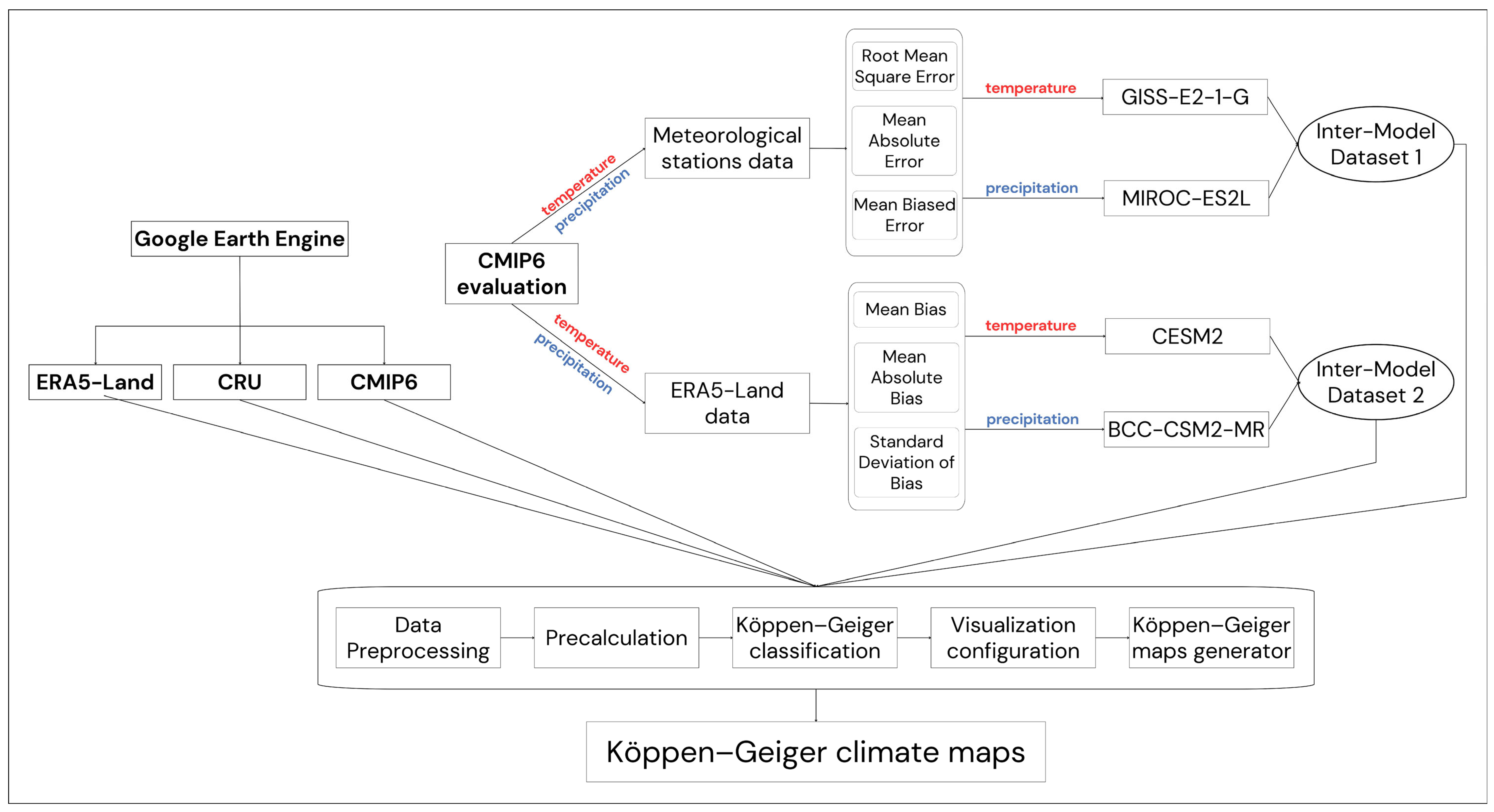
2.1. Data Preprocessing
2.2. Precalculation
2.3. Classification
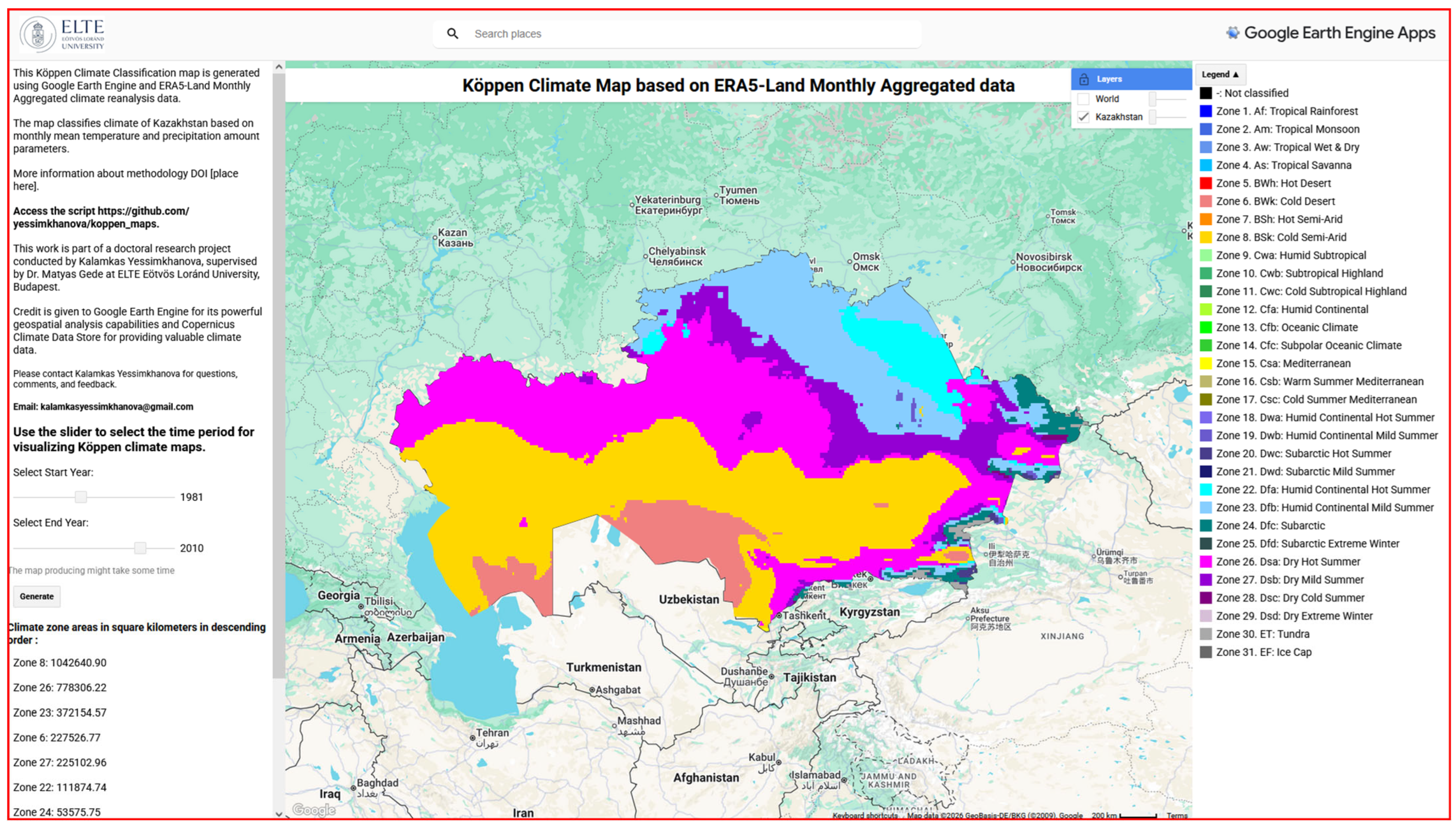
2.4. Visualization Configuration
2.5. Code Repository and Metadata
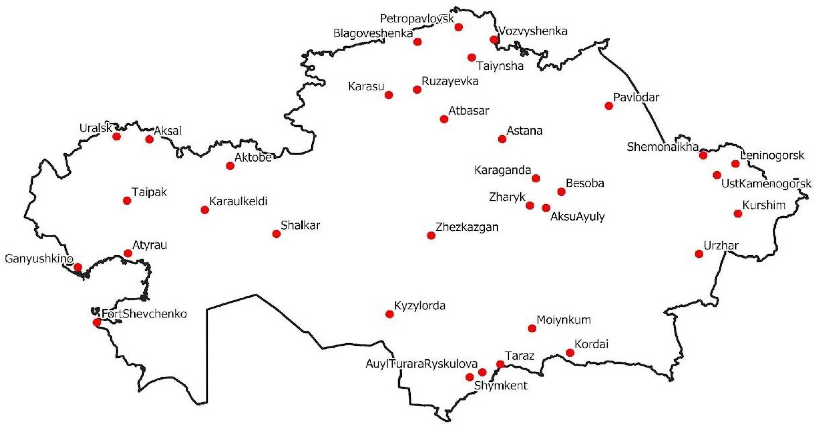
2.6. Evaluation of CMIP6 Climate Models Against Meteorological Stations
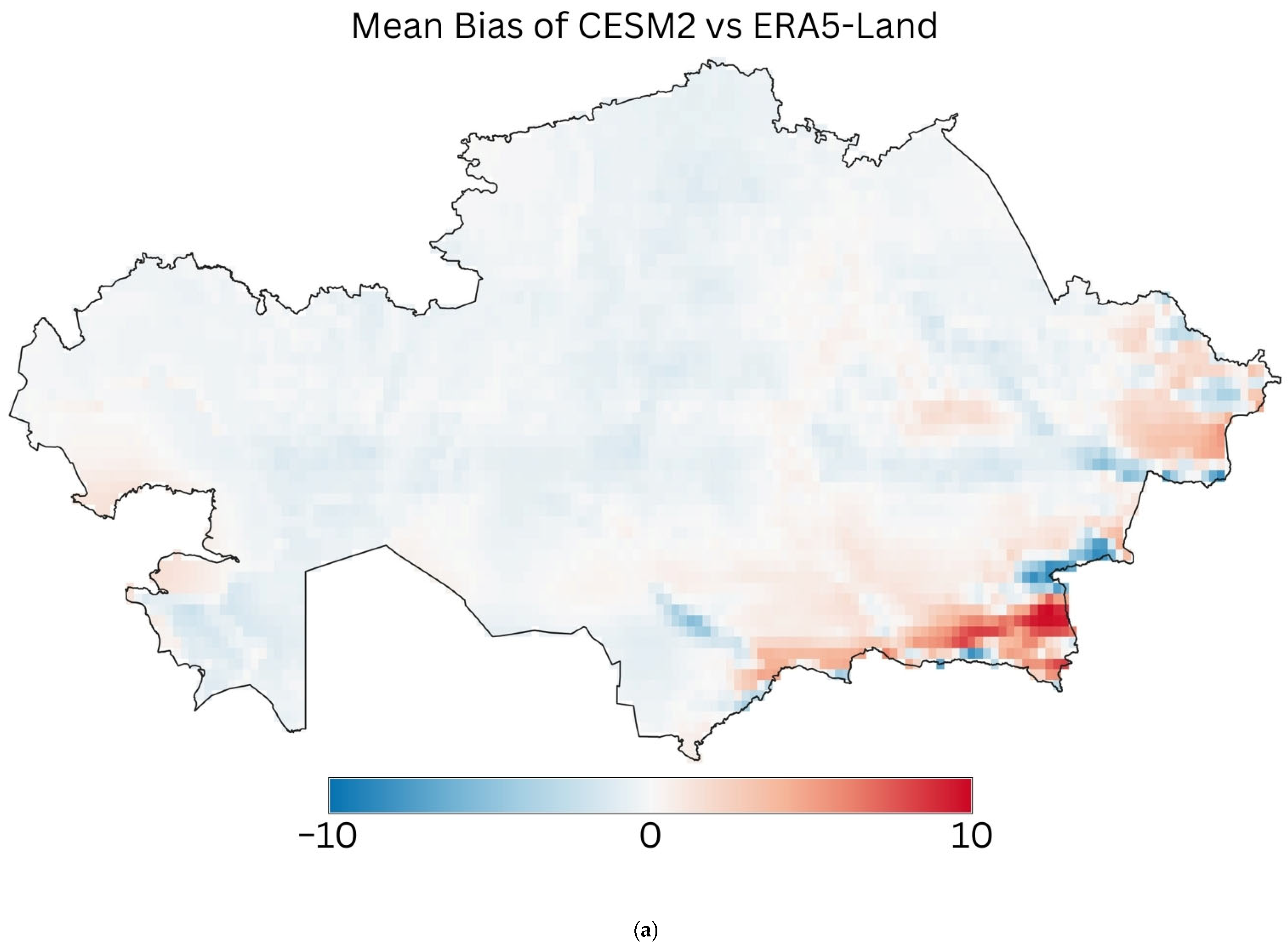
2.7. Evaluation of CMIP6 Climate Models Against ERA5-Land Climate Reanalysis
3. Results
3.1. Climate
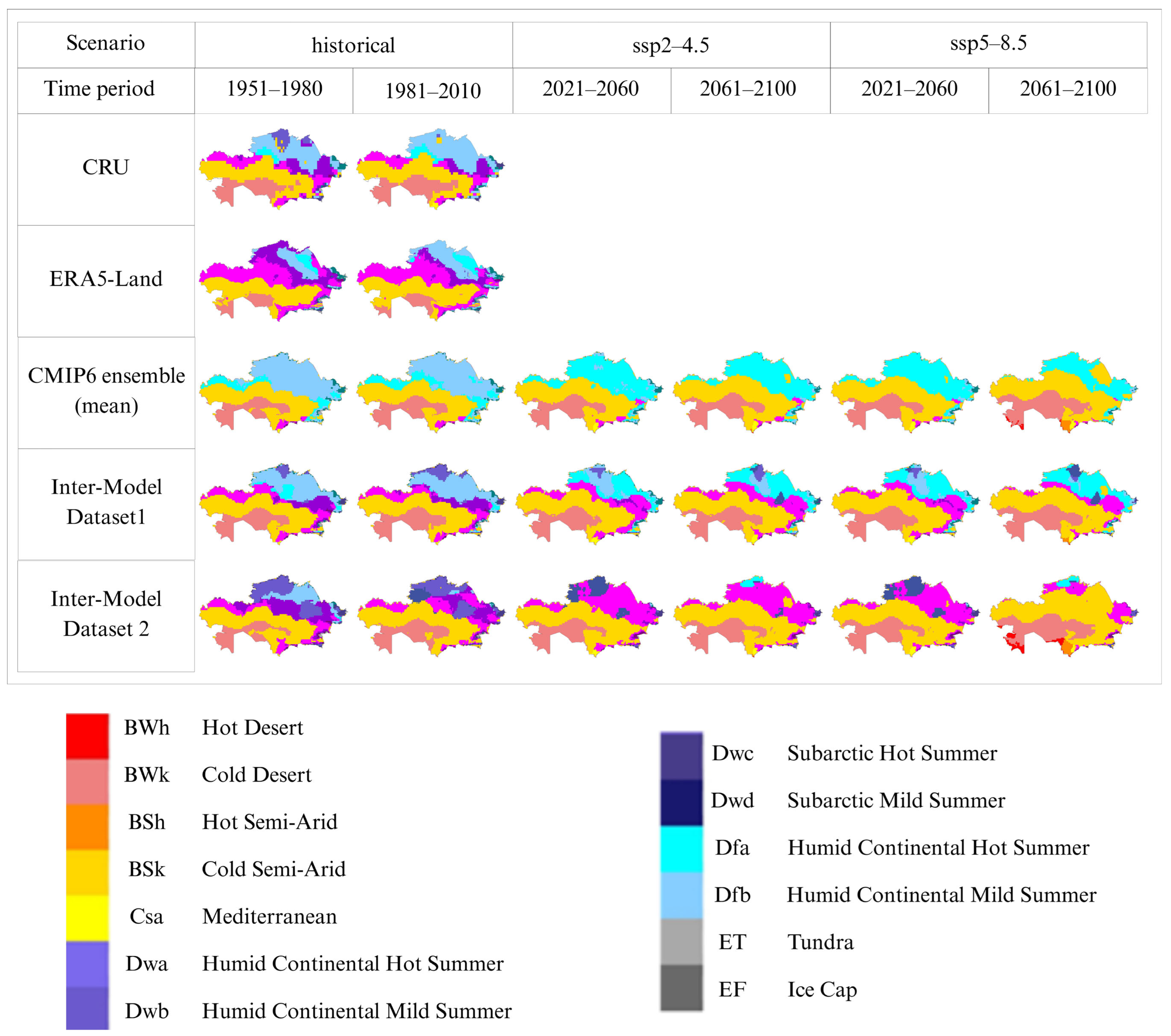
3.2. Köppen–Geiger Climate Maps
4. Discussion
4.1. Challenges and Limitations
4.2. Implications
5. Conclusions
Author Contributions
Funding
Data Availability Statement
Conflicts of Interest
Abbreviations
| CMIP6 | Coupled Model Intercomparison Project Phase 6 |
| CRU | Climatic Research Unit |
| GEE | Google Earth Engine |
| MAE | Mean Absolute Error |
| MBE | Mean Bias Error |
| RMSE | Root Mean Square Error |
| SSPs | Shared Socioeconomic Pathways |
| SSP2-4.5 | Moderate emission scenario |
| SSP5-8.5 | High-emission scenario |
References
- Issanova, G.; Saduakhas, A.; Abuduwaili, J.; Tynybayeva, K.; Tanirbergenov, S. Desertification and land degradation in Kazakhstan. Bull. Natl. Acad. Sci. Repub. Kazakhstan 2020, 5, 95–102. [Google Scholar] [CrossRef]
- Hu, Y.; Han, Y.; Zhang, Y. Land desertification and its influencing factors in Kazakhstan. J. Arid Environ. 2020, 180, 104203. [Google Scholar] [CrossRef]
- Amirkhanov, M.E.; Zhakybek, Y.; Tursbekov, S.V.; Nurpeissova, T.B. Comparative analysis of the state of desertification of the lands of West and East Kazakhstan. Eng. J. Satbayev Univ. 2025, 147, 40–49. [Google Scholar] [CrossRef]
- Annual Bulletin of Monitoring the State and Climate Change in Kazakhstan. National Hydrometeorological Service of Kazakhstan. Available online: https://www.kazhydromet.kz/en/klimat/ezhegodnyy-byulleten-monitoringa-sostoyaniya-i-izmeneniya-klimata-kazahstana (accessed on 16 December 2025).
- Overview of the Peculiarities of the Climate on the Territory of Kazakhstan. National Hydrometeorological Service of Kazakhstan. Available online: https://www.kazhydromet.kz/uploads/calendar/192/year_file/6646ff553af2710-05-2024_obzor-osobennostey-klimata_kazahstan-za-2023.pdf (accessed on 11 December 2024).
- Kottek, M.; Grieser, J.; Beck, C.; Rudolf, B.; Rubel, F. World map of the Köppen-Geiger climate classification updated. Meteorol. Z. 2006, 15, 259–263. [Google Scholar] [CrossRef]
- Peel, M.C.; Finlayson, B.L.; McMahon, T.A. Updated world map of the Köppen-Geiger climate classification. Hydrol. Earth Syst. Sci. 2007, 11, 1633–1644. [Google Scholar] [CrossRef]
- Beck, H.; Zimmermann, N.; McVicar, T.; Vergopolan, N.; Berg, A.; Wood, E. Present and future Köppen-Geiger climate classification maps at 1-km resolution. Sci. Data 2018, 5, 180214. [Google Scholar] [CrossRef]
- Beck, H.E.; McVicar, T.R.; Vergopolan, N.; Berg, A.; Lutsko, N.J.; Dufour, A.; Zeng, Z.; Jiang, X.; van Dijk, A.I.J.M.; Miralles, D.G. High-resolution (1 km) Köppen-Geiger maps for 1901–2099 based on constrained CMIP6 projections. Sci. Data 2023, 10, 724. [Google Scholar] [CrossRef]
- Alcarde Alvares, C.; Stape, J.; Sentelhas, P.; Gonçalves, J.; Sparovek, G. Köppen’s climate classification map for Brazil. Meteorol. Z. 2013, 22, 711–728. [Google Scholar] [CrossRef]
- Karki, R.; Talchabhadel, R.; Aalto, J.; Baidya, S.K. New climatic classification of Nepal. Theor. Appl. Climatol. 2016, 125, 799–808. [Google Scholar] [CrossRef]
- Raziei, T. Climate of Iran according to Köppen-Geiger, Feddema, and UNEP climate classifications. Theor. Appl. Climatol. 2022, 148, 1395–1416. [Google Scholar] [CrossRef]
- Köppen, W. Die Wärmezonen der Erde, nach der Dauer der heissen, gemässigten und kalten Zeit und nach der Wirkung der Wärme auf die organische Welt betrachtet (The thermal zones of the Earth according to the duration of hot, moderate and cold periods and of the impact of heat on the organic world). Meteorol. Z. 1884, 1, 215–226. Available online: https://koeppen-geiger.vu-wien.ac.at/pics/Koppen_1884_Map.jpg (accessed on 19 December 2025).
- Köppen, W. Versuch einer Klassifikation der Klimate, vorzugsweise nach ihren Beziehungen zur Pflanzenwelt (Attempted climate classification in relation to plant distributions). Geogr. Z. 1900, 6, 593–611. Available online: https://koeppen-geiger.vu-wien.ac.at/pics/Koppen_1900_Map1.pdf (accessed on 19 December 2025).
- Köppen, W. Klassifikation der Klimate nach Temperatur, Niederschlag und Jahresablauf (Classification of climates according to temperature, precipitation and seasonal cycle). Petermanns Geogr. Mitteilungen 1918, 64, 193–243. Available online: https://koeppen-geiger.vu-wien.ac.at/pics/Koppen_1918_Map1.jpg (accessed on 19 December 2025).
- Köppen, W. Grundriss der Klimakunde (Outline of Climate Science); Walter de Gruyter: Berlin, Germany, 1931; 388p, Available online: https://koeppen-geiger.vu-wien.ac.at/pics/Koppen_1931_Map.jpg (accessed on 19 December 2025).
- Köppen, W.; Geiger, R. Klima der Erde (Climate of the Earth). Wall Map 1:16 Mill; Klett-Perthes: Gotha, Germany, 1954; Available online: https://koeppen-geiger.vu-wien.ac.at/pics/Geiger_1954_Map.jpg (accessed on 19 December 2025).
- O’Neill, B.C.; Tebaldi, C.; van Vuuren, D.P.; Eyring, V.; Friedlingstein, P.; Hurtt, G.; Knutti, R.; Kriegler, E.; Lamarque, J.-F.; Lowe, J.; et al. The Scenario Model Intercomparison Project (ScenarioMIP) for CMIP6. Geosci. Model Dev. 2016, 9, 3461–3482. [Google Scholar] [CrossRef]
- Gorelick, N.; Hancher, M.; Dixon, M.; Ilyushchenko, S.; Thau, D.; Moore, R. Google Earth Engine: Planetary-scale geospatial analysis for everyone. Remote Sens. Environ. 2017, 202, 18–27. [Google Scholar] [CrossRef]
- Muñoz Sabater, J. ERA5-Land Monthly Averaged Data from 1981 to Present [Dataset]. Copernicus Climate Change Service (C3S) Climate Data Store (CDS). 2019. Available online: https://developers.google.com/earth-engine/datasets/catalog/ECMWF_ERA5_LAND_MONTHLY_AGGR?hl=en#description (accessed on 31 October 2025).
- Thrasher, B.; Maurer, E.P.; McKellar, C.; Duffy, P.B. Technical Note: Bias correcting climate model simulated daily temperature extremes with quantile mapping. Hydrol. Earth Syst. Sci. 2012, 16, 3309–3314. [Google Scholar] [CrossRef]
- World Bank. Climatic Research Unit (CRU) Dataset. Climate Change Knowledge Portal 2023. Available online: https://climateknowledgeportal.worldbank.org/ (accessed on 1 January 2023).
- Harris, I.; Osborn, T.J.; Jones, P.; Lister, D. Version 4 of the CRU TS monthly high-resolution gridded multivariate climate dataset. Sci. Data 2020, 7, 109. [Google Scholar] [CrossRef]
- Donchyts, G. Exploring Image Collections. In Cloud-Based Remote Sensing with Google Earth Engine; Cardille, J.A., Crowley, M.A., Saah, D., Clinton, N.E., Eds.; Springer: Cham, Switzerland, 2024. [Google Scholar] [CrossRef]
- Kelley, M.; Schmidt, G.A.; Nazarenko, L.S.; Bauer, S.E.; Ruedy, R.; Russell, G.L.; Ackerman, A.S.; Aleinov, I.; Bauer, M.; Bleck, R.; et al. GISS-E2.1: Configurations and climatology. J. Adv. Model. Earth Syst. 2020, 12, e2019MS002025. [Google Scholar] [CrossRef]
- Tachiiri, K.; Abe, M.; Hajima, T.; Arakawa, O.; Suzuki, T.; Komuro, Y.; Ogochi, K.; Watanabe, M.; Yamamoto, A.; Tatebe, H.; et al. MIROC MIROC-ES2L Model Output Prepared for CMIP6 ScenarioMIP [Dataset]. Version 2024.09.01. Earth System Grid Federation. 2019. Available online: https://developers.google.com/earth-engine/datasets/catalog/NASA_GDDP-CMIP6 (accessed on 31 October 2025).
- Danabasoglu, G.; Lamarque, J.; Bacmeister, J.; Bailey, D.A.; DuVivier, A.K.; Edwards, J.; Emmons, L.K.; Fasullo, J.; Garcia, R.; Gettelman, A.; et al. The Community Earth System Model version 2 (CESM2). J. Adv. Model Earth Syst. 2020, 12, e2019MS001916. [Google Scholar] [CrossRef]
- ee.Image.reduceRegion. Google Developers. Available online: https://developers.google.com/earth-engine/apidocs/ee-image-reduceregion (accessed on 29 January 2025).
- Wu, T.; Lu, Y.; Fang, Y.; Xin, X.; Li, L.; Li, W.; Jie, W.; Zhang, J.; Liu, Y.; Zhang, L.; et al. The Beijing Climate Center Climate System Model (BCC-CSM): The main progress from CMIP5 to CMIP6. Geosci. Model Dev. 2019, 12, 1573–1600. [Google Scholar] [CrossRef]
- Deines, J.M.; Di Tommaso, S.; Clinton, N.; Gorelick, N. Scaling up in Earth Engine. In Cloud-Based Remote Sensing with Google Earth Engine; Cardille, J.A., Crowley, M.A., Saah, D., Clinton, N.E., Eds.; Springer: Cham, Switzerland, 2024. [Google Scholar] [CrossRef]
- About the Department of Meteorology. National Hydrometeorological Service of Kazakhstan. Available online: https://www.kazhydromet.kz/en/meteologiya/o-meteorologii (accessed on 13 December 2024).
- Xu, Z.; Han, Y.; Tam, C.-Y.; Yang, Z.-L.; Fu, C. Bias-Corrected CMIP6 Global Dataset for Dynamical Downscaling of the Earth’s Historical and Future Climate (1979–2100) [DS/OL]. V5. Science Data Bank, 2024. Available online: https://www.scidb.cn/en/detail?dataSetId=791587189614968832 (accessed on 31 December 2025).
- Eyring, V.; Bony, S.; Meehl, G.A.; Senior, C.A.; Stevens, B.; Stouffer, R.J.; Taylor, K.E. Overview of the Coupled Model Intercomparison Project Phase 6 (CMIP6) experimental design and organization. Geosci. Model Dev. 2016, 9, 1937–1958. [Google Scholar] [CrossRef]
- Yessimkhanova, K.; Gede, M. Evaluating inter-model variability among CMIP6 projections of future Köppen–Geiger climate zones in Kazakhstan under SSP5-8.5. Geod. Cartogr. 2025, 77, 12–17. [Google Scholar] [CrossRef]
- Hu, Q.; Han, Z. Northward expansion of desert climate in Central Asia in recent decades. Geophys. Res. Lett. 2022, 49, e2022GL098895. [Google Scholar] [CrossRef]
- Bissenbayeva, S.; Shokparova, D.; Abuduwaili, J.; Samat, A.; Ma, L.; Ge, Y. Spatiotemporal dynamics of the aridity index in Central Kazakhstan. Sustainability 2025, 17, 7089. [Google Scholar] [CrossRef]
- Fallah, B.; Didovets, I.; Rostami, M.; Hamidi, M. Climate change impacts on Central Asia: Trends, extremes and future projections. Int. J. Climatol. 2024, 44, 3191–3213. [Google Scholar] [CrossRef]
- Song, Y.H.; Chung, E.-S.; Ayugi, B.O. CMIP6 GCMs projected future Köppen–Geiger climate zones on a global scale. Earth’s Future 2025, 13, e2023EF004401. [Google Scholar] [CrossRef]
- GO FAIR. FAIR Principles. GO FAIR. Available online: https://www.go-fair.org/fair-principles/ (accessed on 22 December 2025).



| Name | Variable | Spatial Resolution, Meters | Temporal Resolution | Unit | Time Period |
|---|---|---|---|---|---|
| ERA5-Land | Temperature | 11,132 | Monthly | Kelvin | 1951–2023 |
| Precipitation | Meter | ||||
| CRU | Temperature | 55,659 | Monthly | Celsius | 1901–2020 |
| Precipitation | Millimeter | ||||
| CMIP6 | Temperature | 27,830 | Daily | Kelvin | 1950–2100 |
| Precipitation | kg/m2/s |
| Raw Data | Derived Data | Comments |
|---|---|---|
| Monthly mean Temperature | Average Annual Temperature | |
| Minimum of monthly mean Temperature | ||
| Maximum of monthly mean Temperature | ||
| Number of months with mean Temperature > 10 °C | ||
| Monthly Precipitation | Total Annual Precipitation | |
| Minimum monthly Precipitation | ||
| Maximum monthly Precipitation | ||
| Minimum monthly Precipitation for winter months | October to March in the Northern Hemisphere | |
| Maximum monthly Precipitation for winter months | ||
| Minimum monthly Precipitation for summer months | April to September in the Northern Hemisphere | |
| Maximum monthly Precipitation for summer months | ||
| Summer precipitation ratio | Represents ratio of summer precipitation to total precipitation. Summer ratio = precipitation during summer/total precip | |
| Arid threshold | Represents calculated aridity threshold based on temperature and summer precipitation ratio. The formula is as follows: Arid threshold = Average temperature × 20 + (140 if summer ratio > 0.3) + (140 if summer ratio > 0.7). | |
| Monsoon | Calculated monsoon minimum threshold based on precipitation. The formula is as follows: 100 − (total precip/25). |
| Best-Scoring Models Based on Various Error Metrics for Temperature | ||
|---|---|---|
| RMSE | MAE | MBE |
| GISS-E2-1-G: 83 | GISS-E2-1-G: 81 | GFDL-CM4: 60 |
| MIROC-ES2L: 55 | INM-CM5-0: 35 | MPI-ESM1-2-LR: 42 |
| EC-Earth3-Veg-LR: 19 | MIROC-ES2L: 23 | INM-CM4-8: 30 |
| Best-scoring models based on various error metrics for precipitation | ||
| RMSE | MAE | MBE |
| MIROC-ES2L: 58 | MIROC-ES2L: 48 | KACE-1-0-G: 57 |
| FGOALS-g3: 33 | GISS-E2-1-G: 35 | IPSL-CM6A-LR: 35 |
| UKESM1-0-LL: 23 | FGOALS-g3: 34 | FGOALS-g3: 24 |
| Metrics | CESM2 (Temperature) | BCC-CSM2-MR (Precipitation) |
|---|---|---|
| Mean Bias | −0.2485 | −6.6857 |
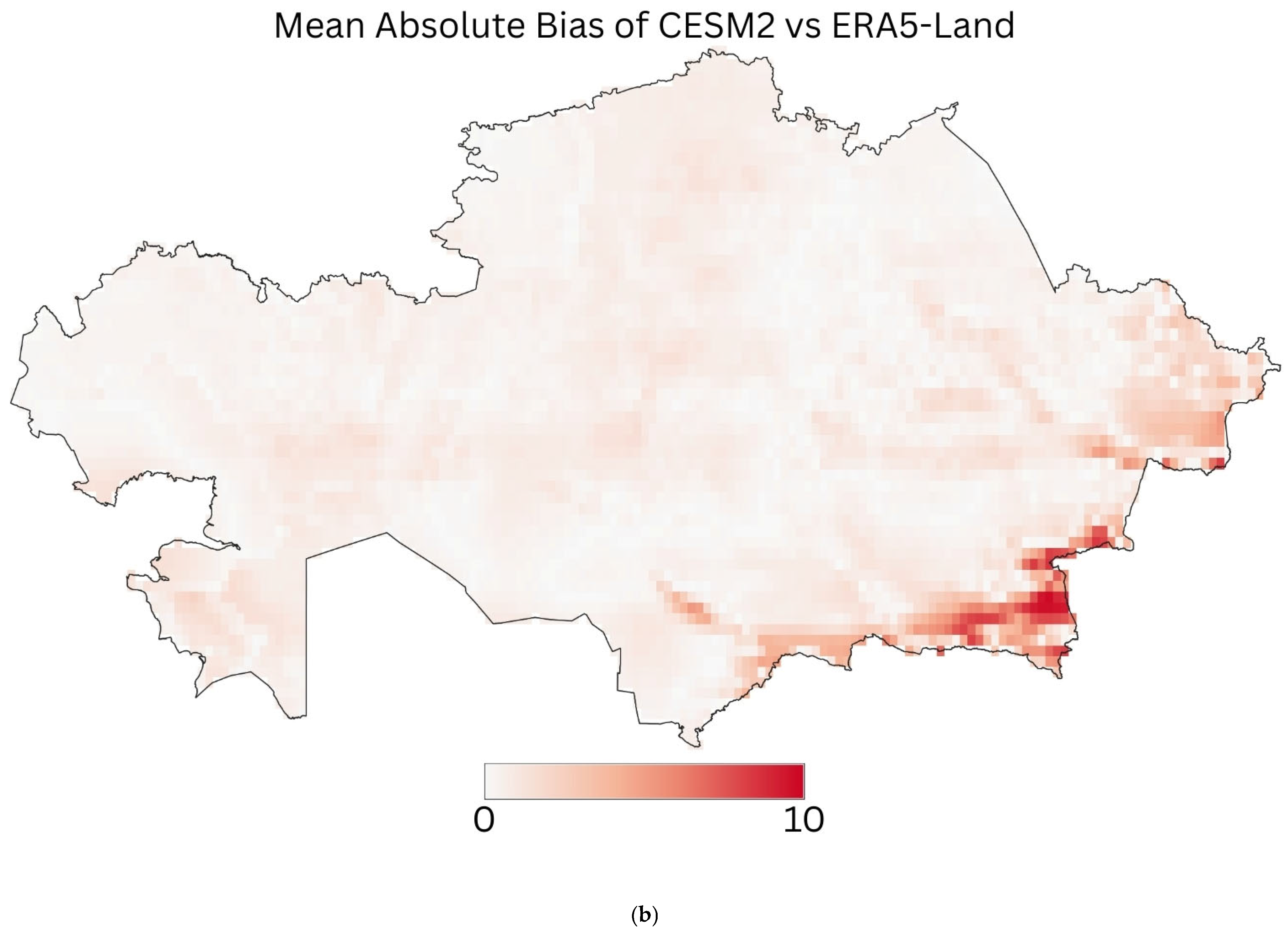
| Mean Absolute Bias | 0.5433 | 7.8547 |
| Standard Deviation of Bias | 0.6782 | 9.5969 |
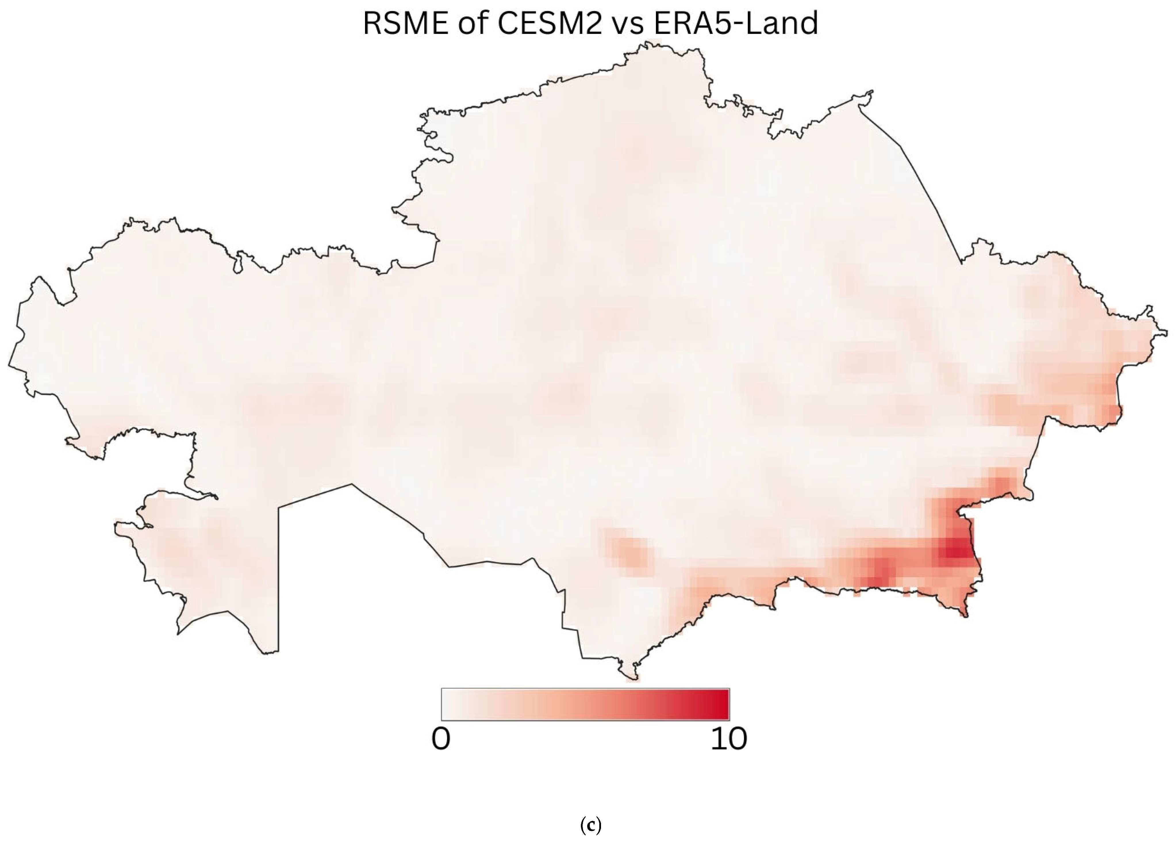
| RMSE | 0.5843 | 11.7222 |
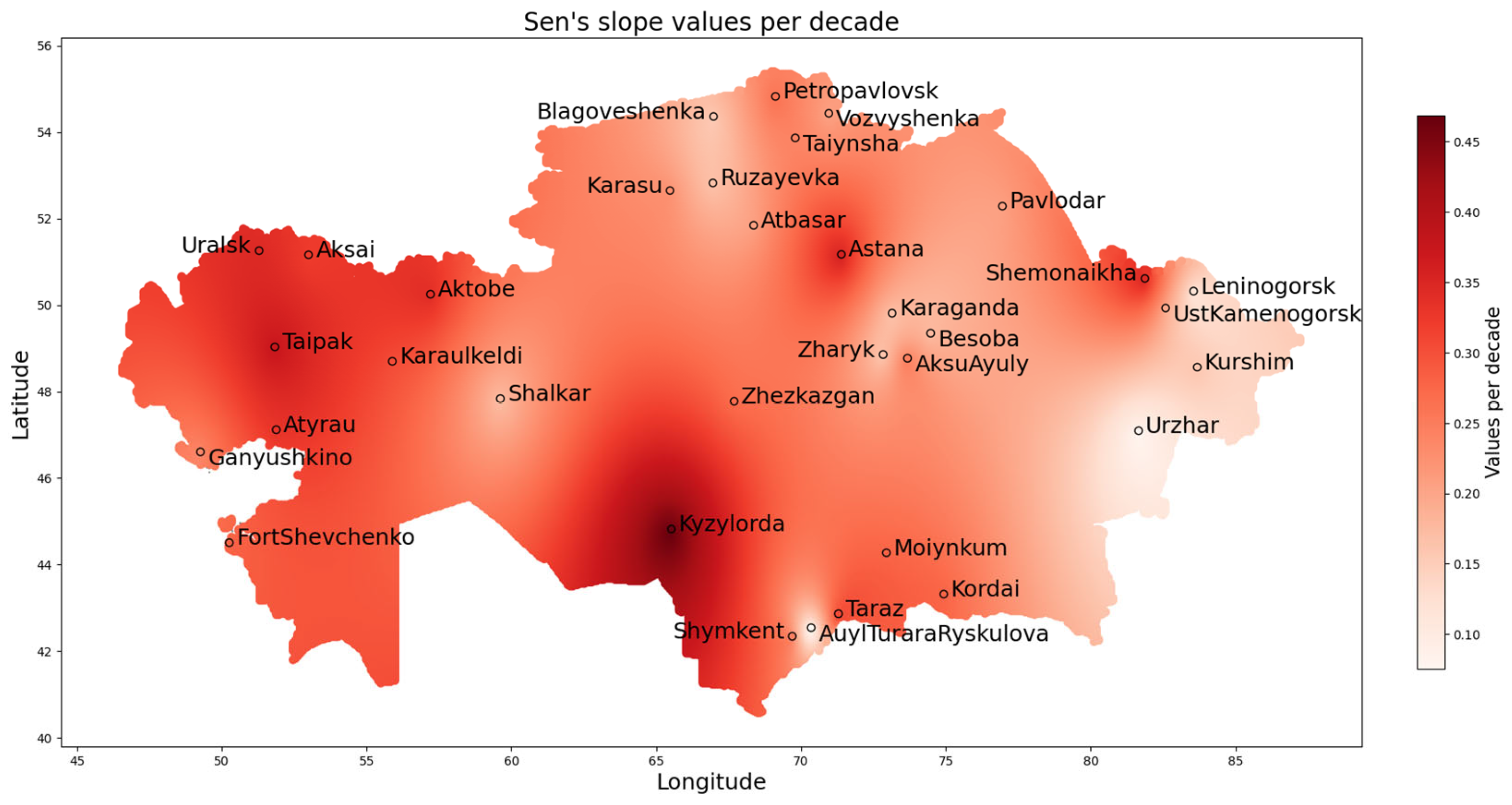
| Station | Mann–Kendall Trend | Sen’s Slope Value Per Decade |
|---|---|---|
| Aksai | increasing | 0.320513 |
| AksuAyuly | increasing | 0.246528 |
| Aktobe | increasing | 0.339286 |
| Astana | increasing | 0.355856 |
| Atbasar | increasing | 0.20679 |
| Atyrau | increasing | 0.328704 |
| AuylTuraraRyskulova | no trend | 0.075521 |
| Besoba | increasing | 0.177083 |
| Blagoveshenka | no trend | 0.154762 |
| FortShevchenko | increasing | 0.278571 |
| Ganyushkino | increasing | 0.236111 |
| Karaganda | no trend | 0.166667 |
| Karasu | increasing | 0.224806 |
| Karaulkeldi | increasing | 0.30303 |
| Kordai | increasing | 0.278571 |
| Kurshim | no trend | 0.15942 |
| Kyzylorda | increasing | 0.46875 |
| Leninogorsk | no trend | 0.120098 |
| Moiynkum | increasing | 0.278646 |
| Pavlodar | increasing | 0.206439 |
| Petropavlovsk | increasing | 0.26087 |
| Ruzayevka | increasing | 0.166667 |
| Shalkar | increasing | 0.172222 |
| Shemonaikha | increasing | 0.345833 |
| Shymkent | increasing | 0.244048 |
| Taipak | increasing | 0.373932 |
| Taiynsha | increasing | 0.240741 |
| Taraz | increasing | 0.305556 |
| Uralsk | increasing | 0.346591 |
| Urzhar | no trend | 0.077586 |
| UstKamenogorsk | no trend | 0.19697 |
| Vozvyshenka | increasing | 0.205357 |
| Zharyk | no trend | 0.16358 |
| Zhezkazgan | increasing | 0.270202 |
| Köppen–Geiger Maps Based on | |
|---|---|
| 1 | CRU data. |
| 2 | ERA5-Land data. |
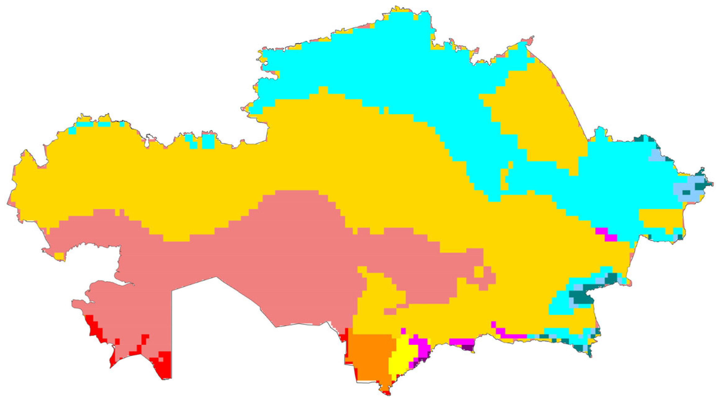
| 3 | CMIP6 ensemble, mean of 32 models, historical and scenario data. |
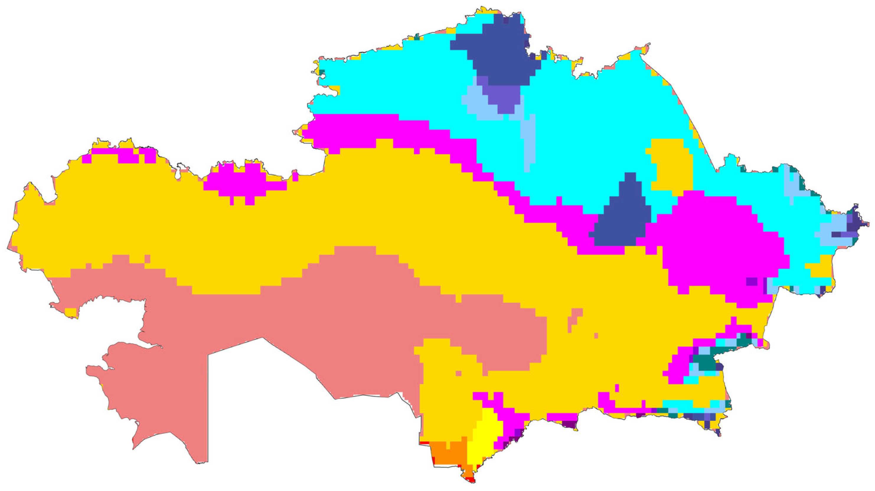
| 4 | Inter-Model Dataset 1, GISS-E2-1-G (temperature data) and MIROC-ESL2L (precipitation data) models, historical and scenario data. |
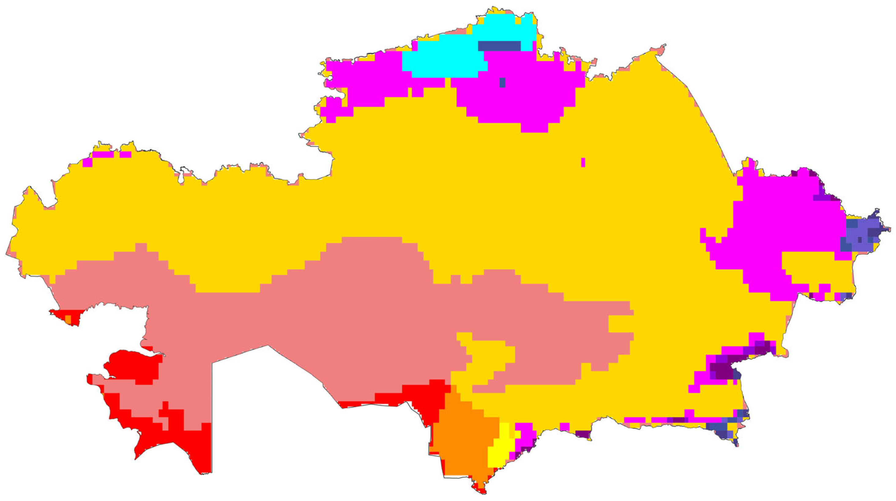
| 5 | Inter-Model Dataset 2, CESM2 (temperature data) and BCC-CSM2-MR (precipitation data) models, historical and scenario data. |
| Zone | CMIP6 Ensemble | Inter-Model Dataset 1 | Inter-Model Dataset 2 | |||
|---|---|---|---|---|---|---|
| Present 1981–2010 | Future, SSP5-8.5 2061–2100 | Present 1981–2010 | Future, SSP5-8.5 2061–2100 | Present 1981–2010 | Future, SSP5-8.5 2061–2100 | |
| BSk: Cold Semi-Arid | 1,077,268.17 | 1,318,337.59 | 986,789.48 | 1,159,601.18 | 1,090,490.81 | 1,440,459.87 |
| BSh: Hot Semi-Arid | - | 58,728.19 | - | 18,158.21 | - | 88,002.89 |
| BWk: Cold Desert | 534,297.94 | 771,158.38 | 570,050.93 | 717,690.98 | 593,667.47 | 774,695.25 |
| BWh: Hot Desert | - | 52,609.98 | - | 12,952.57 | - | 144,194.31 |
| Dfa: Humid Continental Hot Summer | 322,448.31 | 502,516.34 | 24,471.64 | 425,400.21 | - | 38,034.49 |
| Dfb: Humid Continental Mild Summer | 735,069.28 | 31,041.7 | 493,760.34 | 46,851.59 | 20,507.46 | - |
| Dfc: Subarctic | 51,704.70 | 19,942.85 | 24,981.27 | 11,457.42 | 5331.50 | - |
| Dsa: Dry Hot Summer | 36,268.09 | 19,870.81 | 315,091.27 | 293,666.97 | 425,907.11 | 271,798.46 |
| Dsb: Dry Mild Summer | 6640.94 | - | 223,774.16 | 4436.63 | 234,627.82 | 3036.07 |
| Dsc: Dry Cold Summer | 3524.56 | 3524.56 | 7789.96 | 5686.65 | 11,420.05 | 8312.50 |
| Dwa: Humid Continental Hot Summer | - | - | - | 64,455.01 | 85,811.16 | 15,193.62 |
| Dwb: Humid Continental Mild Summer | - | - | 91,065.33 | 9306.95 | 299,408.60 | 8574.03 |
| Dwc: Subarctic Hot Summer | - | - | 34,066.55 | 8377.65 | 24,756.80 | 2918.81 |
| Csa: Mediterranean | 32,577.82 | 33,931.96 | 6343.16 | 24,714.34 | - | 10,615.58 |
| Cwa: Humid Subtropical | 4466.81 | 2255.52 | 26,082.51 | 11,161.53 | 19,649.90 | 11,160.48 |
| ET: Tundra | 9651.26 | 503.27 | 9651.26 | 503.27 | 5417.69 | - |
| EF: Ice Cap | 503.27 | - | 503.27 | - | - | - |
Disclaimer/Publisher’s Note: The statements, opinions and data contained in all publications are solely those of the individual author(s) and contributor(s) and not of MDPI and/or the editor(s). MDPI and/or the editor(s) disclaim responsibility for any injury to people or property resulting from any ideas, methods, instructions or products referred to in the content. |
© 2026 by the authors. Published by MDPI on behalf of the International Society for Photogrammetry and Remote Sensing. Licensee MDPI, Basel, Switzerland. This article is an open access article distributed under the terms and conditions of the Creative Commons Attribution (CC BY) license.
Share and Cite
Yessimkhanova, K.; Gede, M. Spatial and Temporal Analysis of Climatic Zones in Kazakhstan Using Google Earth Engine. ISPRS Int. J. Geo-Inf. 2026, 15, 57. https://doi.org/10.3390/ijgi15020057
Yessimkhanova K, Gede M. Spatial and Temporal Analysis of Climatic Zones in Kazakhstan Using Google Earth Engine. ISPRS International Journal of Geo-Information. 2026; 15(2):57. https://doi.org/10.3390/ijgi15020057
Chicago/Turabian StyleYessimkhanova, Kalamkas, and Mátyás Gede. 2026. "Spatial and Temporal Analysis of Climatic Zones in Kazakhstan Using Google Earth Engine" ISPRS International Journal of Geo-Information 15, no. 2: 57. https://doi.org/10.3390/ijgi15020057
APA StyleYessimkhanova, K., & Gede, M. (2026). Spatial and Temporal Analysis of Climatic Zones in Kazakhstan Using Google Earth Engine. ISPRS International Journal of Geo-Information, 15(2), 57. https://doi.org/10.3390/ijgi15020057