


Abstract
Groundwater is the principal water resource supporting pasture-based livestock production in the arid Mangystau and Atyrau regions of western Kazakhstan, where permanent surface-water availability is limited. This study integrated field surveys of groundwater infrastructure with hydrochemical analyses of 36 groundwater samples (24 from Mangystau and 12 from Atyrau) to evaluate groundwater quality, livestock-watering suitability, and the practical usability of existing water points. Mineralization ranged from 281 to 10,298 mg/L, demonstrating substantial source-level and within-region variability. Total mineralization did not differ significantly between the sampled sources of Mangystau and Atyrau. After correction for multiple regional comparisons, statistically significant differences were retained for sulfate and bicarbonate, with higher sulfate concentrations in Mangystau and higher bicarbonate concentrations in Atyrau. Ionic charge-balance assessment showed that 35 of 36 samples were within ±10%; one charge-imbalanced sample was excluded from charge-balance-dependent hydrochemical interpretation. Among the 35 QA/QC-accepted samples, mineralization was strongly associated with Na+ (Spearman ρ = 0.834, p = 5.06 × 10⁻¹⁰) and Cl− (ρ = 0.843, p = 2.08 × 10⁻¹⁰), while Na+ and Cl− showed very strong covariation (ρ = 0.952, p = 1.51 × 10⁻¹⁸). Together with a median molar Na/Cl ratio of 1.10 and the predominance of Na–Cl facies, these relationships are consistent with an important contribution from saline and evaporitic sedimentary materials to groundwater mineralization. Twelve sources contained ≥7000 mg/L TDS and require restricted, source-specific livestock use. Elevated nitrate and ammonium occurred at a subset of water points and are interpreted as localized water-quality concerns whose origin cannot be established from the present dataset. The results demonstrate that pasture-water management should prioritize source-specific groundwater-quality assessment, infrastructure maintenance, and sanitary protection rather than reliance on administrative-region averages alone.
1. Introduction
The global water system is undergoing an unprecedented transformation caused by the combined effects of climate change, population growth, agricultural expansion, urbanization, and increasing competition among water users [1,2,3,4]. In recent decades, water scarcity has evolved from a regional environmental challenge into a major global sustainable development issue, directly impacting economic development, ecosystem integrity, and human well-being. The UN Water Development Report highlights that nearly half the world’s population experiences severe water scarcity for at least part of the year, while water demand is projected to increase by 20–30% by 2050 due to population growth, industrial expansion, and agricultural intensification [5,6]. These trends are further exacerbated by increasing hydroclimatic variability, leading to more frequent droughts, reduced river flows, and diminished groundwater recharge in many arid and semi-arid regions [7,8]. Consequently, water security has become a central component of the global sustainable development agenda and a critical condition for achieving long-term socioeconomic development.
Agriculture remains the dominant consumer of global freshwater resources, accounting for approximately 70% of all global water use [9,10]. At the same time, the global food system is expected to face unprecedented pressure as the world population approaches 9.7 billion by 2050. Increasing food production in the face of growing water scarcity is thus one of the defining challenges of sustainable development in the 21st century [11]. Recent modeling studies show that continuing current patterns of groundwater overexploitation threatens not only the sustainability of regional aquifers but also global food production, agricultural markets, and food prices [12,13,14]. Conversely, a sharp reduction in water withdrawals without accompanying improvements in agricultural water productivity, irrigation efficiency, and management could negatively impact food security in many water-stressed regions. These findings indicate that sustainable groundwater management should be considered not only as an environmental objective but also as an integral part of the sustainability of the global food system.
Groundwater is a critical component of agricultural water security in arid and semi-arid regions because its storage capacity buffers seasonal and interannual variability in surface-water availability. However, increasing abstraction, salinization, declining groundwater levels, and infrastructure deterioration threaten the long-term reliability of groundwater-dependent agricultural systems. Sustainable groundwater use therefore requires coordinated monitoring, allocation, infrastructure management, and protection of water quality rather than isolated hydrogeological interventions [15,16,17,18,19,20,21,22,23,24,25,26,27].
Despite the growing recognition of groundwater as a cornerstone of climate-resilient agriculture, significant knowledge gaps remain regarding groundwater resources supporting extensive pasture-based livestock systems. Most published studies focus primarily on hydrochemical characterization, groundwater suitability for drinking or irrigation, or localized contamination problems, whereas considerably less attention has been devoted to groundwater resources used for livestock watering in arid and semi-arid pastoral landscapes [28,29,30,31]. Furthermore, existing investigations rarely integrate groundwater quality, resource availability, hydrogeological conditions, the technical state of watering infrastructure, and the practical requirements of sustainable pasture management within a unified assessment framework [32].
These limitations are particularly evident in Kazakhstan, where livestock production is concentrated on vast pasturelands that depend almost entirely on groundwater. Although groundwater constitutes the principal source of water supply for grazing livestock, systematic hydrogeological investigations of pasture watering systems remain limited and, in many regions, are based on data collected several decades ago. Recent regional work has begun to address these deficiencies. An integrated assessment of groundwater quality and exploitable resources has been completed for eight aquifer segments spanning the Aktobe, Atyrau, and Mangystau regions, identifying an exploitable potential of 0.24 km3/yr against a natural water-supply potential of 2.68 km3/yr, with approximately 90% of that groundwater found suitable for irrigation [33]. Groundwater and soil quality in the West Kazakhstan Region have been evaluated with particular attention to contamination risks associated with oil and gas activity, together with a call for permanent monitoring [34], comparable assessments now exist for central Kazakhstan [35], the Shu transboundary basin [30], and the rural areas of the Karaganda Region [36]. For the southern regions, an integrated evaluation combining predicted, natural, and operational resources with total dissolved solids, potential well yield, and aquifer depth has been carried out across five administrative regions, showing that 92.5% of predicted exploitable resources fall below 3 g/L TDS and are therefore suitable for domestic and livestock use [37]. However, an integrated assessment linking groundwater chemistry, livestock-watering suitability, and the operational condition of pasture water infrastructure remains unavailable for the Mangystau and Atyrau regions.
Among Kazakhstan’s pastoral territories, the Mangystau and Atyrau regions are the most severely water-limited: an extremely arid climate, high evaporation, and negligible surface freshwater leave grazing dependent almost wholly on groundwater from wells, boreholes, and springs [38]. What rivers exist are transboundary, and their runoff is declining while seasonal variability increases [39,40]. The hydrogeological framework, the Mangyshlak Peninsula, the western margin of Ustyurt, and the Caspian Lowland, is structurally heterogeneous, with limited recharge and mineralization spanning fresh water to formation brines of 50–400 g/L [33,41]. Suitability consequently differs sharply between adjacent pasture areas, and interpreting those differences requires separating natural hydrogeochemical controls, evaporative concentration, evaporite dissolution, water–rock interaction, from anthropogenic ones, chiefly petroleum-related contamination [34,42]. A regional hydrogeological survey therefore characterises groundwater simultaneously as a resource, as a constraint on pasture utilization, and as a component of climate adaptation [28,31].
On this basis, the present study examines two hypotheses. First, that the sustainability of pasture-based livestock production in the Mangystau and Atyrau regions is governed jointly by hydrogeological conditions, groundwater quality, and the operational status of watering infrastructure, rather than by resource volume alone [31,34,36]. Second, we hypothesized that regional-scale groundwater salinity is controlled predominantly by natural hydrogeochemical processes, including evaporative concentration, evaporite and saline-sediment dissolution, and water–rock interaction [41,42,43], whereas localized departures in groundwater quality may indicate source-specific vulnerability to surface-derived or anthropogenic inputs [37,39].
Accordingly, the objectives of this study are to: (i) characterize the hydrochemical composition and spatial variability of groundwater used for livestock watering in the Mangystau and Atyrau regions; (ii) identify the principal hydrogeochemical controls and localized water-quality anomalies; (iii) assess groundwater suitability for livestock watering and the practical usability of existing water points considering water quality, infrastructure condition, and sanitary protection; and (iv) provide a scientific basis for source-specific groundwater management and pasture-water infrastructure planning in western Kazakhstan.
2. Materials and Methods
2.1. Study Area
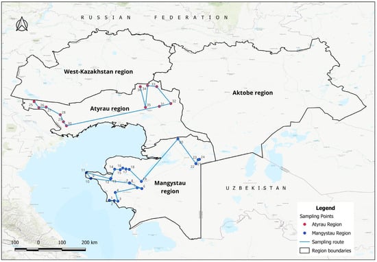
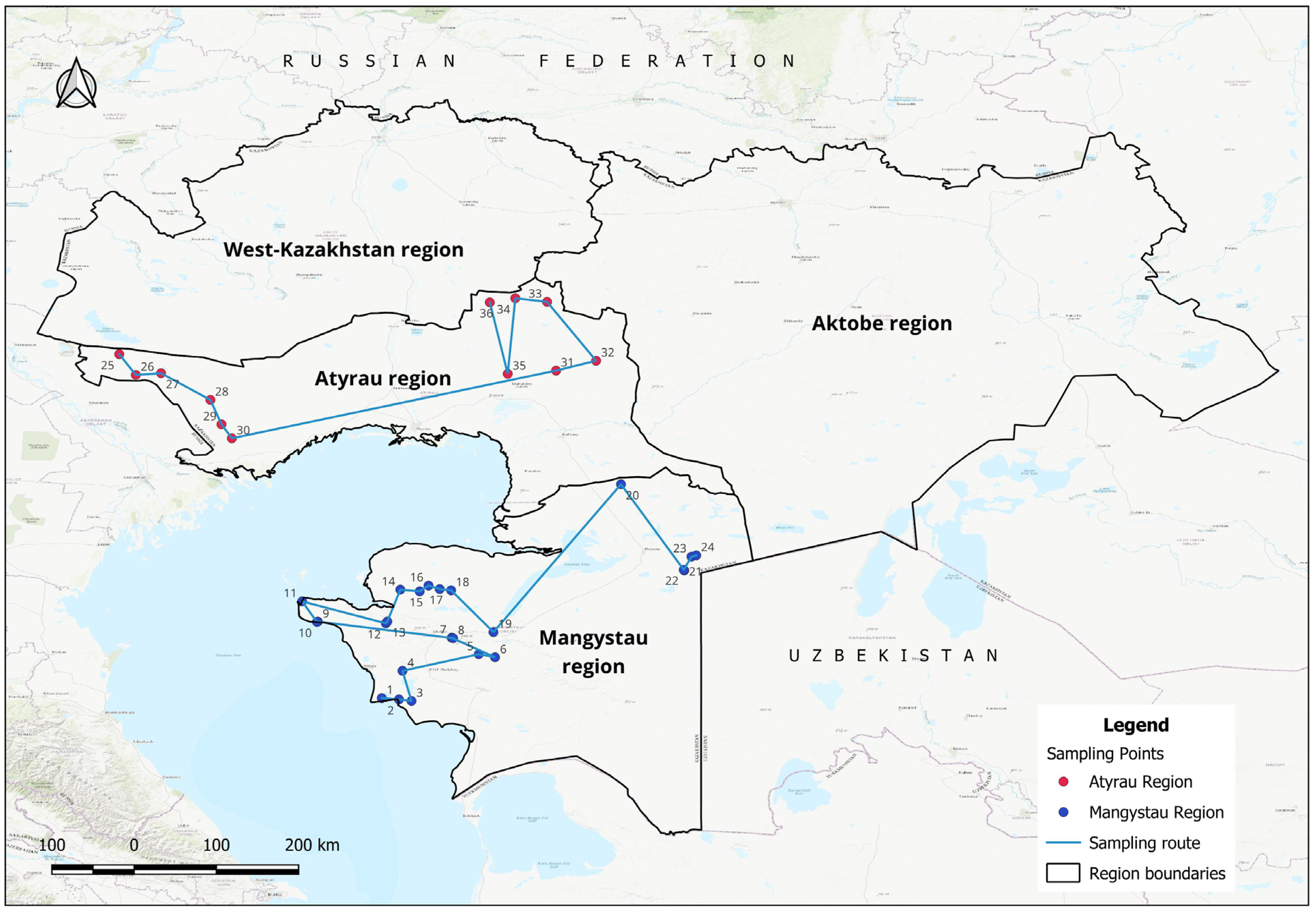
The study was conducted in the Atyrau and Mangystau regions of western Kazakhstan (Figure 1). Both regions lie within the arid to extremely arid zone and are characterized by desert and semi-desert landscapes, high evaporation, scarce permanent surface-water resources, and strong dependence on groundwater for year-round pasture livestock watering.
Figure 1.
Location of the study area and distribution of the investigated groundwater sources in the Atyrau and Mangystau regions. Coordinates are provided in Table A1.
The Mangystau Region encompasses the Mangystau Peninsula, the western part of the Ustyurt Plateau, and adjacent sandy and sedimentary landscapes. Groundwater used for pasture water supply is accessed through boreholes, dug wells, and springs occurring within a heterogeneous sedimentary hydrogeological environment. Under the extremely arid climate, effective groundwater recharge is limited and spatially uneven. Recharge is associated primarily with infiltration under locally favorable geological and geomorphological conditions, after which groundwater circulates through sedimentary formations along local and regional flow paths. During this circulation, water–rock interaction, evaporative concentration, and contact with evaporitic and saline sedimentary material progressively modify groundwater chemistry. Natural groundwater discharge is expressed locally through springs and groundwater outlets, whereas wells and boreholes constitute the principal artificial discharge points used for pasture water supply.
The Atyrau Region occupies the southern part of the Caspian Depression and the southwestern margin of the Zhaiyk–Zhem structural zone. Its hydrogeological regime is influenced by very low relief, limited effective recharge, proximity to the Caspian lowland, and the widespread occurrence of saline sedimentary formations. These conditions favor relatively slow groundwater circulation and the persistence of mineralized groundwater over large areas. Locally fresher groundwater occurs where recharge and circulation conditions are more favorable, whereas more mineralized groundwater reflects longer hydrogeochemical evolution, interaction with saline geological media, and evaporative concentration. Groundwater discharge occurs through natural outlets where present and, more importantly for pasture use, through dug wells and boreholes.
2.2. Field Survey and Groundwater Sampling
Field investigations were conducted between May and July 2025 as part of a regional hydrogeological survey aimed at assessing groundwater resources used for pasture watering in the Atyrau and Mangystau regions of western Kazakhstan. During the pre-field stage, an inventory of existing groundwater abstraction facilities, including dug wells, boreholes, and self-flowing wells, was compiled using available hydrogeological records. Preliminary survey routes and observation maps were prepared to optimize field investigations (Figure 1).
In the Mangystau Region, 25 groundwater-related facilities were inspected during the infrastructure survey, comprising 13 boreholes, 9 dug wells, and 3 springs. In the Atyrau Region, the 12 surveyed facilities comprised 1 boreholes and 11 dug wells; groundwater samples from all 12 surveyed facilities were included in the analytical dataset. Thus, the infrastructure-survey count and the analytical-sample count differ by one facility and are reported separately throughout the manuscript.
The field campaign included hydrogeological inspection of groundwater abstraction facilities, groundwater sampling for laboratory analyses, and evaluation of the technical and sanitary conditions of water points used for livestock watering. For each investigated site, the type of water source, geographic coordinates, hydrogeological characteristics, operational condition, and surrounding sanitary environment were documented. Field observations were supplemented by photographic documentation and detailed field records for every sampling location.
The field infrastructure inventory and the hydrochemical dataset were treated as related but distinct components of the study. The number of facilities inspected during the field survey therefore does not necessarily correspond exactly to the number of groundwater samples included in the final analytical dataset. A facility was counted in the infrastructure survey when its location, type, operational condition, and sanitary status were documented in the field, whereas only groundwater samples collected and retained for laboratory hydrochemical analysis were included in the analytical dataset. This distinction is maintained throughout the manuscript and is summarized explicitly in Table 1.
Table 1.
Summary of field-surveyed groundwater infrastructure and the hydrochemical analytical dataset.
The survey covered approximately 5997 km in Atyrau Region and 6200 km in Mangystau Region. The Atyrau survey was carried out within the Kurmangazy, Isatay, and Kyzylkoginsky districts, where groundwater abstraction facilities supplying pasture livestock were investigated. The Mangystau survey covered the areas surrounding the cities of Aktau, Zhanaozen, and Fort-Shevchenko, together with the settlements of Beyneu, Shetpe, Mangystau, and Kuryk, representing the principal year-round grazing areas of the region.
A total of 36 groundwater sampling points were included in this study. These comprised 12 groundwater sources in Atyrau Region and 24 groundwater sources in Mangystau Region, including dug wells, boreholes, and springs used for livestock watering. Groundwater samples were collected following the requirements of GOST ISO 5667-11:2013 [44], GOST 31861-2012 [45], and GOST 28168-89 [46].
Sanitary conditions were documented qualitatively during the field survey based on observations of wellhead and protective-structure integrity, the presence or absence of covers and fencing, direct livestock access, visible surface contamination or waste accumulation, and general maintenance condition. Because these observations were not collected using a predefined quantitative scoring protocol consistently applied to all analytical sites, sanitary condition was retained as a qualitative source-vulnerability characteristic rather than converted into a numerical explanatory variable. A retrospective ordinal score was not assigned because the original field protocol did not define standardized category boundaries, weighting rules, or an identical scoring procedure for all sites. Assigning numerical classes after data collection would therefore introduce an unvalidated post hoc classification and imply a level of quantitative precision not supported by the original field observations.
Groundwater temperature was not systematically measured during the present field campaign and is therefore not included in the analytical dataset or subsequent hydrochemical and statistical analyses. Accordingly, the occurrence of the term “Thermal” in the site identifier “Dubsky Thermal” (Table A1) reflects the established name recorded in the field inventory and does not indicate a thermal classification based on measurements conducted in this study.
2.3. Laboratory Analyses
Groundwater samples were analyzed at the Laboratory of Chemical Analytical Research of the U.M. Akhmedsafin Institute of Hydrogeology and Geoecology. Laboratory analyses included measurements of pH, total dissolved solids (TDS), major cations (Na+, K+, Ca2+, Mg2+), major anions (HCO3−, CO32−, Cl−, SO42−), nitrogen compounds (NH4+, NO2−, NO3−). The analytical program did not include boron, petroleum hydrocarbons, or trace metals other than total Fe. Consequently, no concentration data for these analytes are reported or interpreted in the present study. Sampling and laboratory procedures followed the national standards listed in Table 2.
Table 2.
Laboratory testing methods [x1–x6].
Ionic charge-balance error (CBE) was calculated for each groundwater sample as an additional quality-control criterion. Concentrations of the major dissolved ions were converted from mg/L to milliequivalents per liter, and CBE was calculated as 100 × (Σcations − Σanions)/(Σcations + Σanions). Values reported below the analytical detection limit were substituted at one-half of the corresponding detection limit for the purpose of calculation. An absolute CBE of ≤5% was considered optimal, whereas values between 5% and 10% were considered acceptable after inspection for this mineralized and compositionally heterogeneous dataset. Samples with |CBE| > 10% were excluded from quantitative hydrochemical-facies summaries, ion-ratio calculations, and process-level correlation analyses. Such samples could be retained in graphical Piper and Durov presentations for completeness of the analytical dataset, but were not used to support charge-balance-dependent hydrochemical interpretation.
2.4. Hydrochemical Analysis
Hydrochemical interpretation was performed using AquaChem 11. Groundwater types were classified using Piper diagrams, while Durov diagrams were applied to evaluate hydrochemical evolution, groundwater mineralization, and relationships among major ions.
2.5. Statistical, Spatial, and Livestock-Suitability Analysis
Regional differences in groundwater chemistry between the Mangystau (n = 24) and Atyrau (n = 12) samples were evaluated using the two-sided Mann–Whitney U test because of the unequal group sizes and non-normal distributions of several hydrochemical variables. Seven variables were compared: mineralization (TDS), Na+, Cl−, SO42−, HCO3−, NO3−, and pH. To control the family-wise error rate arising from multiple simultaneous comparisons, raw p-values were adjusted using the Holm step-down procedure. Statistical significance was evaluated at α = 0.05 using the Holm-adjusted p-values. For each comparison, the Mann–Whitney U statistic and rank-biserial correlation were reported together with the raw and Holm-adjusted p-values. The rank-biserial correlation was used to characterize the magnitude and direction of the regional difference independently of statistical significance.
Process-level relationships among major hydrochemical variables were evaluated using Spearman rank correlation because several variables were non-normally distributed and the expected relationships were monotonic rather than necessarily linear. Ionic charge-balance screening was performed before charge-balance-dependent hydrochemical interpretation. Samples exceeding the adopted |CBE| > 10% threshold were excluded from quantitative facies classification, ion-ratio calculations, and process-level major-ion correlation analyses, although they were retained in the graphical Piper and Durov plots for completeness and visual reference. Accordingly, process-level statistical analyses and the quantitative facies summary were based on 35 QA/QC-accepted samples.
Hydrochemical facies were interpreted using Piper and Durov diagrams, whereas GIS-based mapping was used to evaluate spatial patterns. The suitability of the watering place for livestock was assessed based on the content of total dissolved solids, and also on the content of nitrates, ammonium, fluorides, sulfates and total water hardness [53,54,55]. Observations of infrastructure conditions and on-site sanitation were used as information for management at the pollution source level rather than as a quantitative explanatory variable.
For the purposes of this study, “practical usability” refers to the suitability of an existing groundwater source for livestock watering under the conditions observed during the field survey, considering groundwater quality together with the operational condition and sanitary protection of the water point. It should not be interpreted as an estimate of aquifer-scale groundwater-resource potential, sustainable yield, or permissible abstraction volume.
3. Results
3.1. Current State of Pasture Groundwater Infrastructure
The current state of groundwater infrastructure used for livestock watering was assessed through regional field investigations conducted in the Atyrau and Mangystau regions of western Kazakhstan. The survey included an inspection of groundwater abstraction facilities, evaluation of their technical and sanitary condition, and documentation of their operational characteristics. The locations of the investigated groundwater sources are shown in Figure 1, and the characteristics of the surveyed facilities are summarized in Table 1.
The surveyed infrastructure included boreholes, dug wells, springs, and naturally flowing sources used for year-round livestock watering. Boreholes were generally equipped with pumps or watering troughs and provided the most controlled abstraction conditions. Dug wells were commonly connected to metal or reinforced-concrete troughs, whereas springs frequently discharged into open storage pools directly accessible to livestock. Infrastructure condition varied substantially among sites, ranging from operational and protected facilities to deteriorated sources with damaged wellheads, inadequate covers, and unrestricted animal access.
3.2. Hydrochemical Characteristics of Groundwater
The hydrochemical dataset comprised 36 groundwater samples collected from pasture water sources, including 24 samples from the Mangystau Region and 12 samples from the Atyrau Region. Complete analytical results are provided in Table A2. The investigated groundwater exhibited pronounced variability in physicochemical composition, reflecting differences in lithology, groundwater circulation conditions, and the degree of mineralization across western Kazakhstan.
Groundwater was generally characterized by neutral to slightly alkaline conditions, with pH values indicating chemically stable groundwater suitable for hydrochemical interpretation. The largest variability was observed for total dissolved solids (TDS), which ranged from moderately mineralized groundwater to highly saline waters. This wide range demonstrates the coexistence of groundwater systems representing different stages of hydrochemical evolution within the investigated pasture areas.
Major-ion chemistry showed substantial differences among sampling sites. Sodium was the dominant cation in the majority of groundwater samples, whereas calcium and magnesium contributed variably depending on the degree of mineralization. Among the anions, chloride and sulfate became progressively more abundant in highly mineralized groundwater, while bicarbonate predominated in less mineralized waters. This systematic shift in ionic composition indicates progressive groundwater evolution associated with increasing salinity and provides the geochemical basis for the hydrochemical facies identified in the subsequent Piper and Durov analyses.
Descriptive statistics for the principal physicochemical parameters, computed separately for each region, are summarized in Table 3.
Table 3.
Descriptive statistics of major physicochemical parameters by region (concentrations in mg/L; total hardness in mg-equiv/L). Below-detection values substituted at half the detection limit; fluoride was not determined in 6 of 12 Atyrau samples (n = 6).
The ionic charge-balance error (CBE) ranged from −5.50% to +19.48%, with a median absolute error of 2.59%. Overall, 32 of the 36 groundwater samples (88.9%) showed |CBE| ≤ 5%, while 35 samples (97.2%) were within ±10%, indicating satisfactory major-ion analytical consistency for nearly the entire dataset. Three samples—Prokhlada (−5.50%), Mugyr (−5.12%), and Miyaly (−5.02%)—were only marginally outside the ±5% criterion but remained within the ±10% acceptance range. Qosqulaq was the only sample exhibiting a substantial ionic imbalance (CBE = +19.48%). Consequently, this sample was retained for descriptive evaluation of directly measured parameters, including TDS and individual ion concentrations, but was excluded from charge-balance-dependent hydrochemical-facies, ion-ratio, and process-level correlation analyses.
Nitrogen species were generally low at many sites but reached elevated concentrations at a distinct subset of water points. Nitrate exceeded 50 mg/L at 11 of 36 sources and ≥100 mg/L at six sources (Buirek, 566 mg/L; Dubsky Thermal, 476 mg/L; Sazdy, 371 mg/L; Zhanasu, 189 mg/L; Malauly, 109 mg/L; and Nogaibay, 100 mg/L), while ammonium exceeded 1.5 mg/L at eight sources and reached 150 mg/L at Tasshagyl. Although the unadjusted regional comparison for NO3− yielded p = 0.041, this difference did not remain statistically significant after Holm correction for multiple comparisons. Elevated nitrogen concentrations are therefore interpreted as localized source-level water-quality anomalies rather than as a statistically supported regional signal. Their origin cannot be determined from the present hydrochemical dataset alone and is considered further in Section 3.6 and Section 4.
3.3. Spatial Distribution of Groundwater Mineralization and Hydrogeological Controls
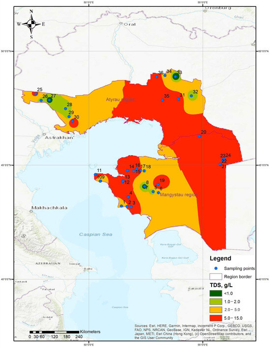
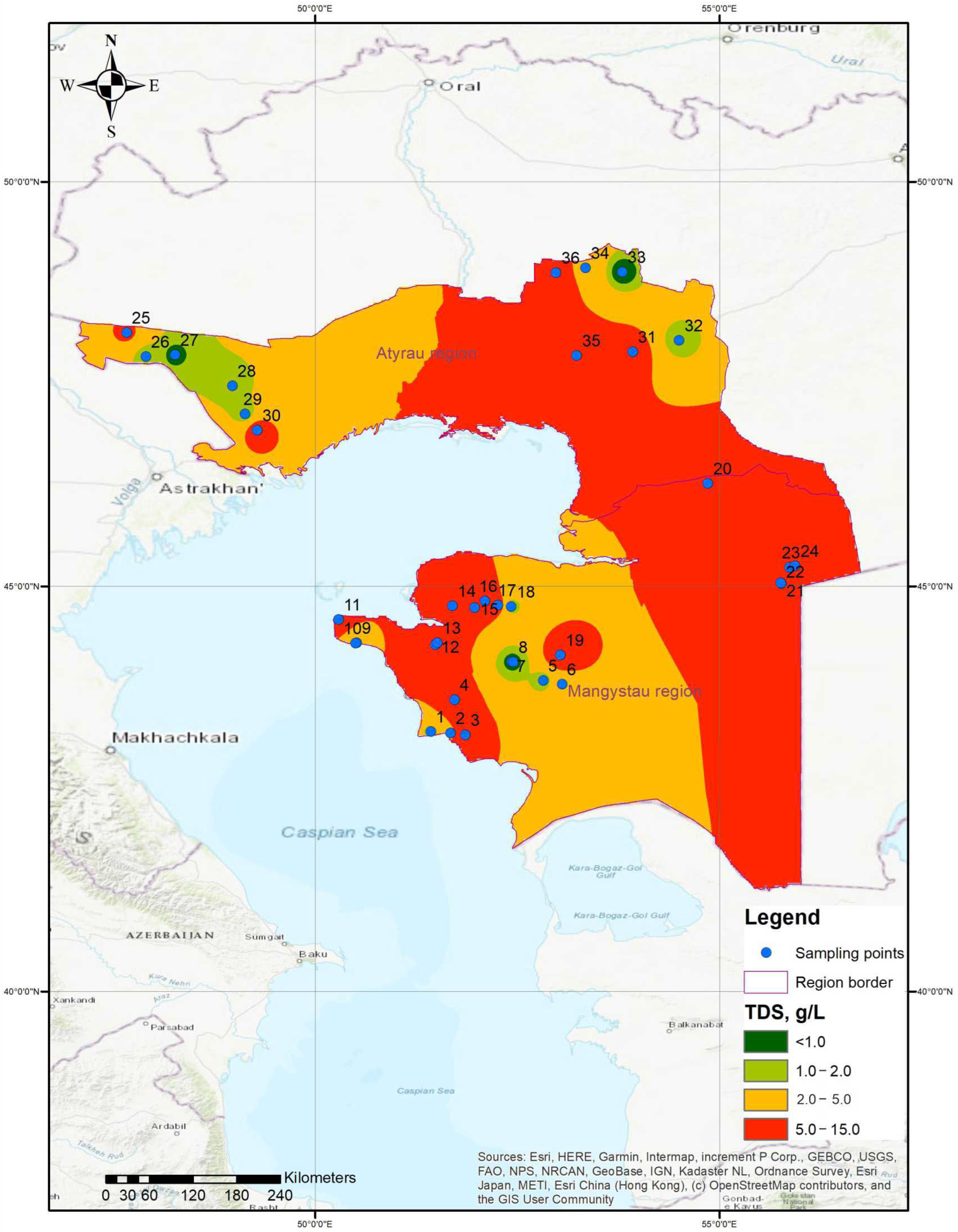
Groundwater mineralization exhibited pronounced spatial variability across the investigated water points in both regions (Figure 2). Measured TDS concentrations ranged from 281 to 10,298 mg/L, indicating the coexistence of relatively fresh and strongly mineralized groundwater sources within the study area. To visualize these source-level spatial patterns while minimizing unsupported extrapolation, TDS interpolation was restricted to areas surrounding the sampled locations. The resulting surfaces should therefore be interpreted as representations of local spatial tendencies within the investigated sampling network rather than as continuous regional-scale maps of aquifer salinity.
Figure 2.
Spatial distribution of groundwater salinity (TDS) around the studied sampling points in Mangistau and Atyrau regions. The interpolated surfaces illustrate local spatial tendencies within the sampling network and should not be interpreted as continuous aquifer-scale salinity distributions.
Figure 2 demonstrates pronounced source-level spatial heterogeneity in groundwater mineralization. Low- and high-TDS sources occur within both administrative regions, indicating that salinity cannot be represented adequately by a simple regional gradient. Because the sampling network is facility-based and spatially uneven, the interpolated surfaces illustrate local tendencies around sampled water points rather than continuous aquifer-scale salinity distributions.
Within the conceptual recharge–flow–discharge framework, the observed spatial variability is consistent with differences in groundwater circulation and hydrochemical evolution among individual sources. Relatively low-TDS groundwater may represent locally recharged or less geochemically evolved water, whereas higher mineralization may develop along longer flow paths through progressive water–rock interaction, evaporative concentration, and interaction with saline sedimentary materials. Because hydraulic-head and residence-time data were not available for the investigated sources, these mechanisms are considered a conceptual interpretation of the observed hydrochemical patterns rather than directly demonstrated flow paths.
The spatial variability of groundwater mineralization was evaluated using 36 groundwater samples, including 12 samples from the Atyrau Region and 24 samples from the Mangystau Region. Groundwater mineralization, as reported in Table A2, was used as the principal indicator of dissolved-solids content for the regional comparison. The analytical results are summarized in Table 4.
Table 4.
Summary statistics of groundwater mineralization (TDS) in the Atyrau and Mangystau regions.
Groundwater mineralization varies sharply over relatively short spatial distances. In Mangystau, very low mineralization occurs at Ondy Spring Reservoir (627 mg/L), Prokhlada (637 mg/L), and Ondy Spring (707 mg/L), whereas highly mineralized groundwater occurs at 10th Railway Siding (10,298 mg/L), Akzhigit-2 (8579 mg/L), Tugurakshan (8341 mg/L), Kiyakty (7967 mg/L), and Sam (7796 mg/L). This coexistence of fresh and strongly mineralized groundwater within the same administrative region indicates that salinity is controlled primarily by local hydrogeological setting and flow history rather than by geographic location alone.
A similarly heterogeneous pattern occurs in Atyrau. Miyaly contains only 281 mg/L TDS, while Mugyr and Nogaibay contain 970 and 791 mg/L, respectively. In contrast, Tasshagyl reaches 9632 mg/L, Qosqulaq 7883 mg/L, Sazdy 6917 mg/L, and Kenbay 6624 mg/L. Such contrasts again indicate localized recharge conditions and different stages of groundwater evolution within the regional sedimentary system.
The spatial mineralization pattern is consistent with the conceptual recharge–flow–discharge model of the study area. Lower-TDS groundwater is associated with less evolved water and locally favorable recharge conditions, whereas higher mineralization reflects longer groundwater residence and circulation, evaporative concentration under arid conditions, and enhanced interaction with evaporitic and saline sedimentary materials. Thus, spatial variation in TDS represents the combined outcome of recharge intensity, flow-path length, aquifer lithology, groundwater residence, and geochemical evolution rather than a uniform regional gradient.
Groundwater chemistry was highly variable across both regions. Although median mineralization was higher in Mangystau than in Atyrau (5906 vs. 2202 mg/L), the difference was not statistically significant (raw p = 0.2206; Holm-adjusted p = 0.6245), reflecting substantial within-region variability. After Holm correction for the seven simultaneous regional comparisons (Table 5), statistically significant differences were retained only for SO42− and HCO3−: sulfate was higher in Mangystau, whereas bicarbonate was higher in Atyrau. The initially observed NO3− difference (raw p = 0.04105) was no longer significant after correction (Holm-adjusted p = 0.2053). Na+, Cl−, pH, and total mineralization likewise showed no statistically significant regional differences. These findings indicate that regional differentiation is expressed more clearly in selected ionic components than in overall salinity and reinforce the importance of source-level interpretation.
Table 5.
Regional comparison of groundwater chemistry using Mann–Whitney U tests with Holm correction for multiple comparisons.
The spatial variability in groundwater mineralization provides the basis for subsequent analysis of major-ion composition and hydrochemical facies presented in Section 3.4, as well as for evaluating groundwater suitability for livestock watering.
3.4. Major Ion Composition and Hydrochemical Facies
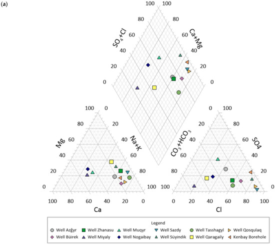
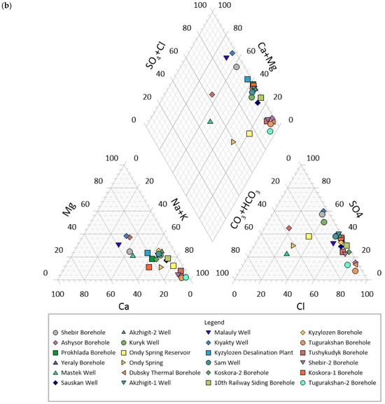
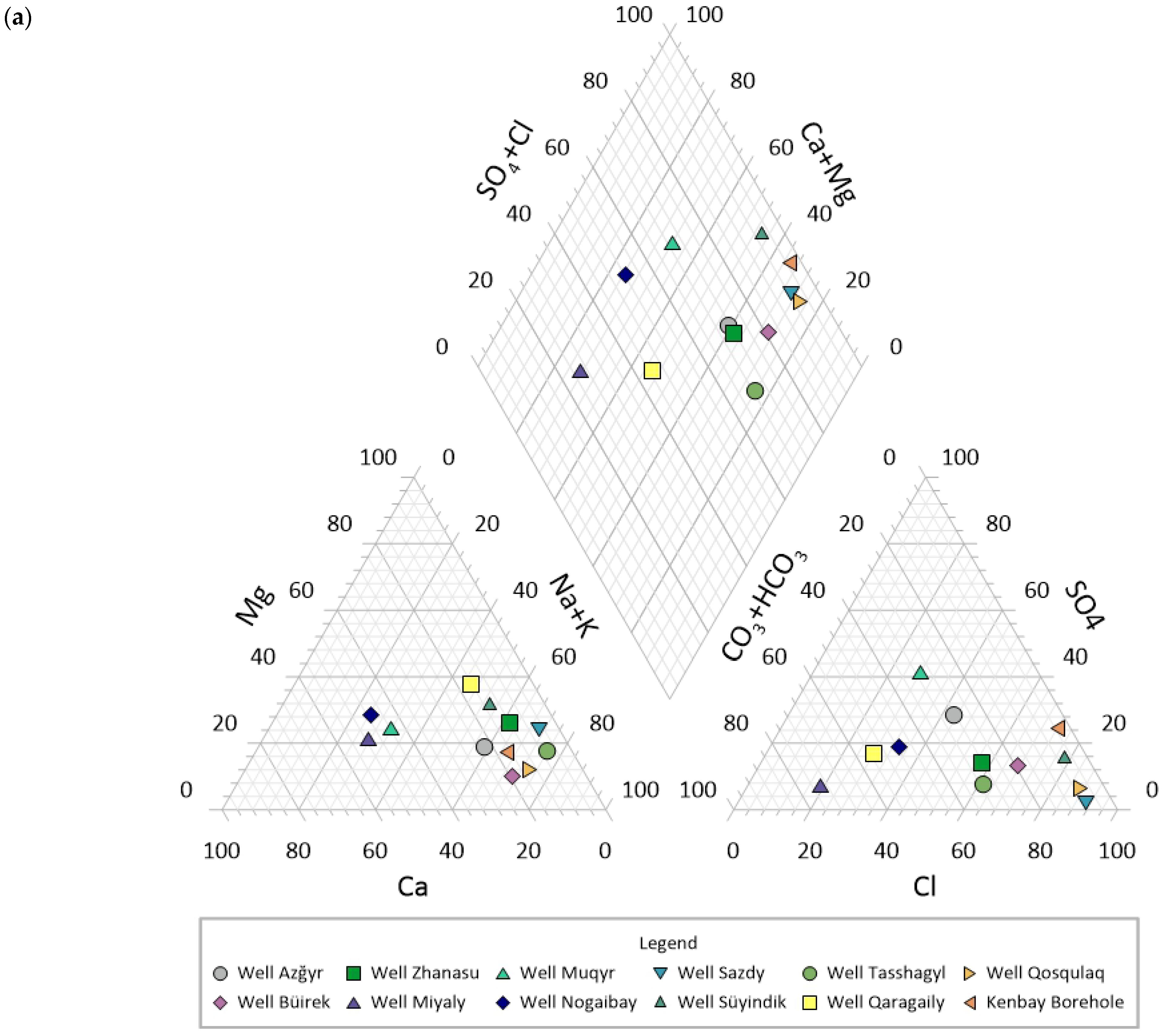
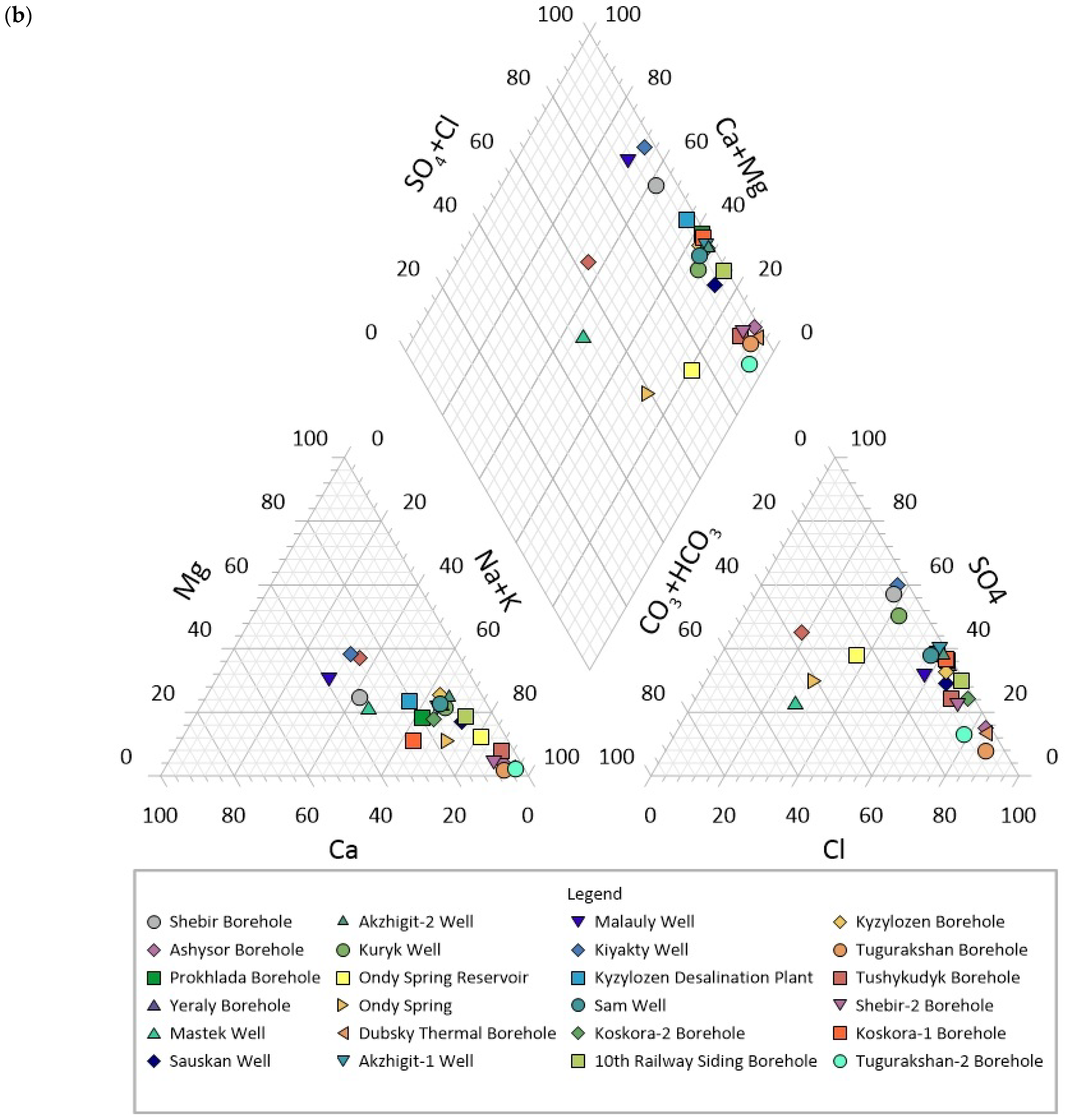
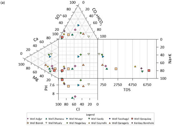
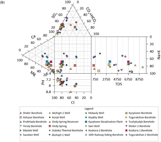
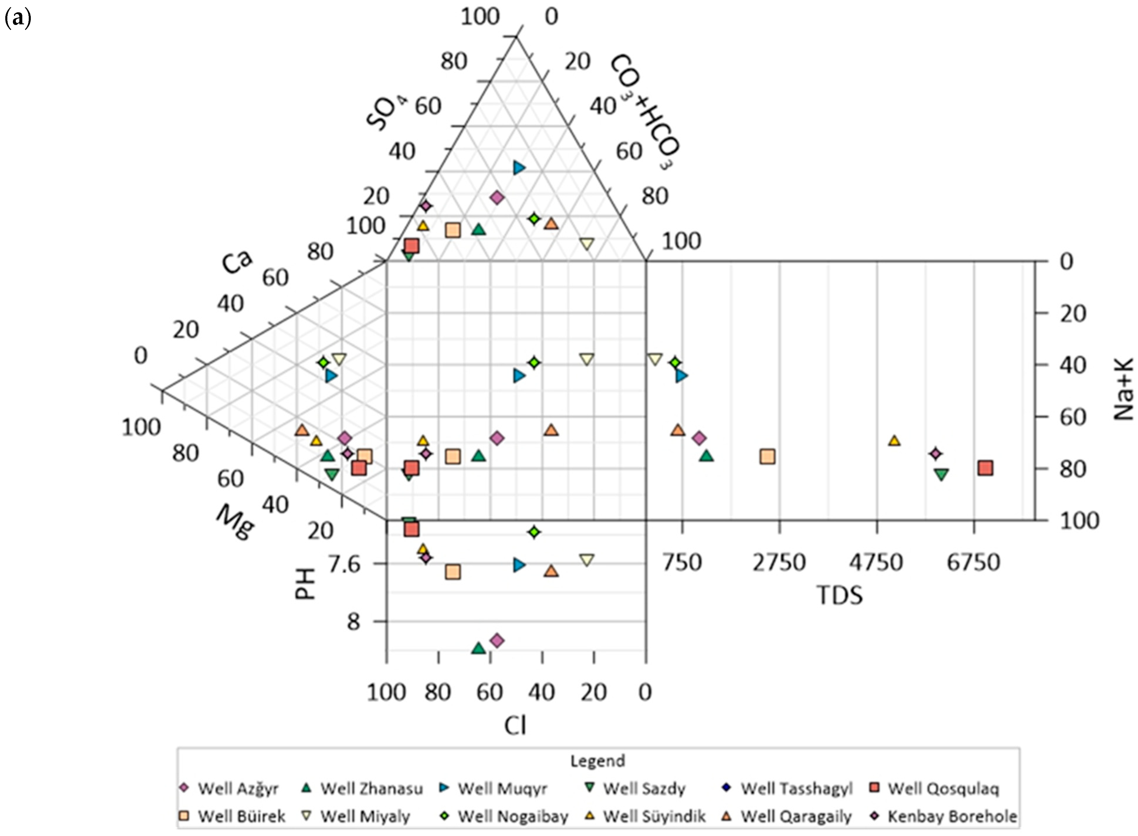
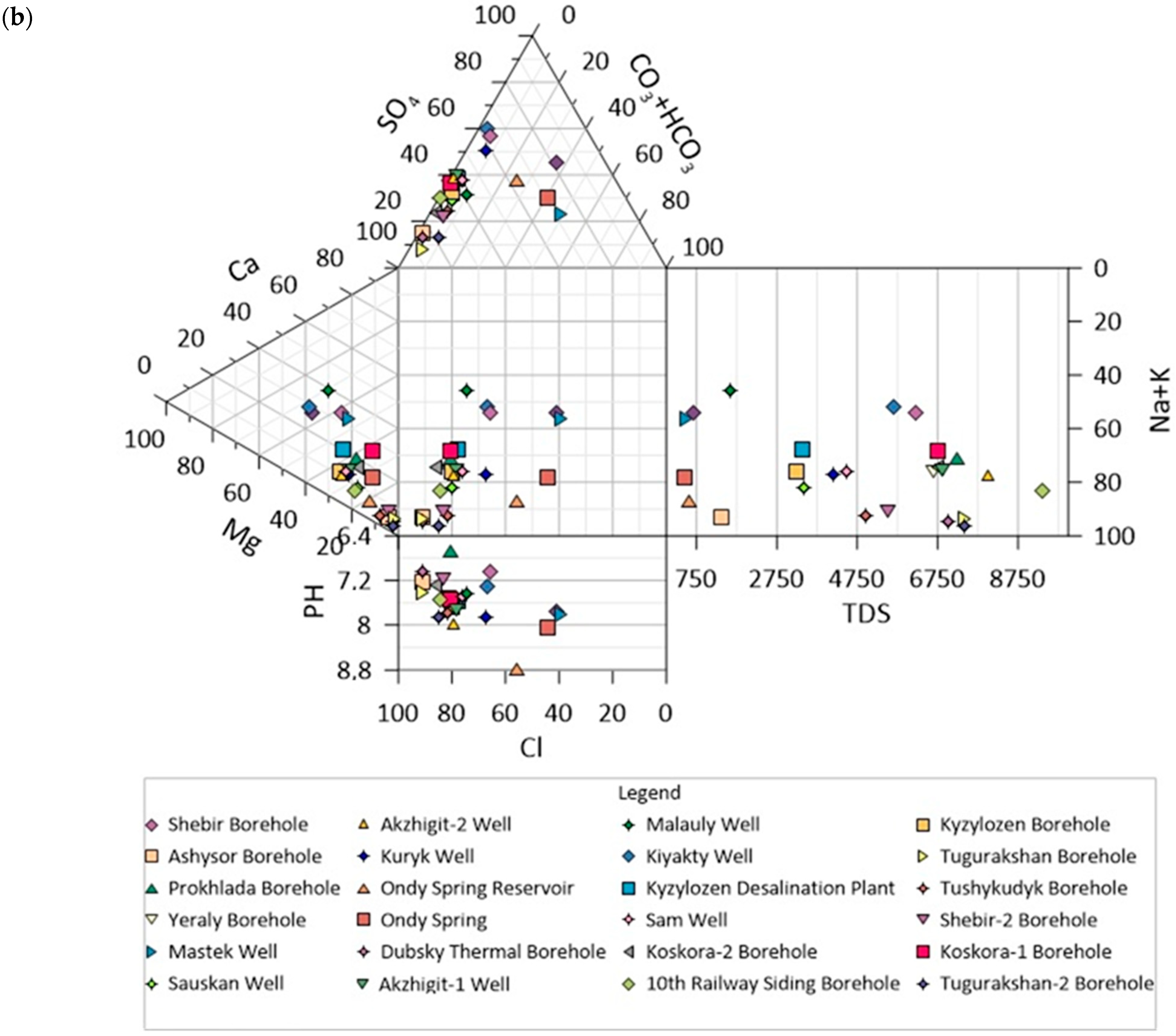
Following ionic charge-balance screening, quantitative process-level relationships and hydrochemical-facies summaries were evaluated using 35 QA/QC-accepted samples; Qosqulaq was excluded from these analyses because its CBE (+19.48%) exceeded the adopted ±10% acceptance threshold. The sample is nevertheless retained in Figure 3 and Figure 4 for graphical completeness and comparison with the complete 36-sample analytical dataset. Mineralization showed strong positive correlations with Na+ (Spearman ρ = 0.834, p = 5.06 × 10⁻¹⁰, n = 35) and Cl− (ρ = 0.843, p = 2.08 × 10⁻¹⁰, n = 35). Na+ and Cl− were themselves very strongly correlated (ρ = 0.952, p = 1.51 × 10⁻¹⁸, n = 35), whereas HCO3− showed no significant relationship with mineralization (ρ = −0.177, p = 0.310, n = 35). The median molar Na/Cl ratio was 1.10. Taken together with the predominance of Na–Cl facies, these relationships are consistent with an important contribution from chloride-rich saline and evaporitic sedimentary sources to groundwater mineralization. In contrast, the absence of a significant TDS–HCO3− relationship and the occurrence of Ca/mixed–HCO3 facies among several low-TDS sources are consistent with comparatively less evolved groundwater under locally favorable recharge conditions.
Figure 3.
Piper diagrams showing the hydrochemical composition of all 36 groundwater samples from the Atyrau (a) and Mangystau (b) regions. Qosqulaq is displayed for completeness of the analytical dataset; however, because its ionic charge-balance error (+19.48%) exceeded the adopted ±10% acceptance criterion, this sample was excluded from the quantitative hydrochemical-facies summary and subsequent charge-balance-dependent interpretation.
Figure 4.
Durov diagrams showing the hydrochemical composition of all 36 groundwater samples from the Atyrau (a) and Mangystau (b) regions. Qosqulaq is shown for completeness but was excluded from charge-balance-dependent interpretation because its ionic charge-balance error (+19.48%) exceeded the adopted ±10% acceptance criterion.
The observed facies sequence can also be interpreted in terms of groundwater evolution along conceptual recharge–flow–discharge pathways. Low-mineralization Ca/mixed–HCO3 groundwater represents comparatively less evolved conditions in which bicarbonate-producing water–rock reactions and local recharge remain important. With increasing residence and circulation through the sedimentary sequence, the relative contributions of Na+, Cl−, and SO42− increase, producing mixed sulfate and ultimately Na–Cl-dominated groundwater. The strong Na–Cl covariation and near-unity Na/Cl ratio are consistent with increasing interaction with chloride-bearing saline or evaporitic materials. Local discharge through springs, wells, and boreholes therefore intercepts groundwater at different stages of this hydrochemical evolution, explaining the pronounced differences observed between individual water points.
Major-ion concentrations were available for all 36 groundwater samples. Accordingly, all samples are displayed in the Piper and Durov diagrams (Figure 3 and Figure 4) to provide a complete graphical representation of the analytical dataset. However, following ionic charge-balance screening, the quantitative hydrochemical-facies summary, ion-ratio calculations, and process-level statistical interpretation were restricted to the 35 QA/QC-accepted samples. Qosqulaq was retained in the diagrams for visual reference but was not used to support charge-balance-dependent interpretation.
The analytical results demonstrate considerable spatial heterogeneity in groundwater chemistry across the investigated pasture areas. The relative proportions of major ions vary markedly between sampling locations, indicating the coexistence of multiple hydrochemical facies within the study area. Sodium (Na+), calcium (Ca2+), magnesium (Mg2+), chloride (Cl−), sulfate (SO42−), and bicarbonate (HCO3−) constitute the dominant dissolved ions controlling groundwater composition.
The Piper diagram (Figure 3) reveals a clear differentiation of groundwater types between samples with low and high mineralization. Waters with relatively low total dissolved solids are predominantly characterized by Ca–Mg–HCO3 facies, indicating fresh groundwater influenced by carbonate weathering and recharge processes. With increasing mineralization, groundwater composition progressively shifts toward Ca–Mg–SO4 and subsequently Na–Cl/Na–SO4 facies, reflecting increasing contributions of sulfate and chloride ions together with sodium enrichment. This hydrochemical transition indicates a systematic evolution from bicarbonate-dominated fresh groundwater to highly mineralized saline groundwater.
The dominant-ion facies assigned to each sample confirm this pattern quantitatively (Table 6): sodium–chloride water prevails across both regions, whereas fresh, low-TDS sources retain a Ca/mixed–HCO3 recharge signature.
Table 6.
Distribution of hydrochemical facies by region.
The Durov diagram (Figure 4) further supports this interpretation by illustrating distinct hydrochemical trends among the investigated samples. The distribution of groundwater samples demonstrates progressive changes in ionic composition accompanied by increasing mineralization. Fresh groundwater samples are clustered within fields dominated by calcium, magnesium, and bicarbonate ions, whereas highly mineralized waters occupy fields characterized by sodium, sulfate, and chloride dominance. The overall distribution pattern indicates that groundwater chemistry is governed by multiple hydrogeochemical processes acting simultaneously across the study area, resulting in the observed diversity of hydrochemical facies.
3.5. Hydrochemical Suitability of Groundwater for Livestock Watering
Livestock-watering suitability was evaluated using TDS as a first-level screening parameter and supplemented by nitrate, ammonium, fluoride, sulfate, and total hardness (Table 7 and Table 8).
Table 7.
General TDS-based screening of groundwater suitability for livestock watering, species-sensitivity flags, and corresponding management implications.
Table 8.
Sources exceeding non-salinity quality thresholds.
The TDS-based classification presented in Table 7 is intended as a first-level management-screening framework rather than as a universal species-independent toxicity classification. To make differences in biological sensitivity more explicit, Table 7 now includes a species-/physiological-sensitivity flag. Sources containing 3000–4999 mg/L TDS warrant caution for sensitive animals, whereas the 5000–6999 mg/L category may be unsuitable for the most sensitive species or physiological groups without source-specific assessment. Sources containing 7000–10,000 mg/L TDS should not be regarded as suitable for unrestricted livestock use and require species-, physiological-status-, and exposure-specific evaluation. The single source exceeding 10,000 mg/L represents a high-concern category across livestock species, and routine use should be avoided unless supported by dedicated veterinary and water-quality assessment.
Actual tolerance to saline water may differ substantially among livestock species and physiological groups. Adult and acclimatized animals may tolerate higher salinity than young, pregnant, lactating, or physiologically stressed animals, and adverse effects may also depend on feed composition, climatic conditions, exposure duration, and the concentrations of sulfate and other dissolved constituents. Therefore, the TDS categories used here are intended to identify sources requiring increasing levels of management attention rather than to define absolute biological thresholds for all livestock.
The highest management priority applies to the 12 sources with TDS ≥7000 mg/L: 10th Railway Siding, Tasshagyl, Akzhigit-2, Tugurakshan, Kiyakty, Qosqulaq, Sam, Akzhigit-1, Koskora-1, Yeraly, Koskora-2, and Shebir 2. These sources should not be considered routinely suitable solely on the basis of generalized livestock salinity tolerance and require source-specific evaluation before continued or intensified use. Among them, 10th Railway Siding contained 10,298 mg/L TDS and was the only investigated source exceeding the >10,000 mg/L screening category; routine livestock use of this source should therefore be avoided unless supported by dedicated veterinary and water-quality assessment.
TDS alone does not determine livestock-water suitability. Several sources were additionally constrained by nitrate, ammonium, fluoride, sulfate, and high total hardness. Accordingly, the management recommendations in Table 7 should be considered together with the non-salinity constraints summarized in Table 8. This combined interpretation reinforces the need for source-by-source assessment rather than classification based exclusively on regional mineralization or TDS class.
Thus, livestock-watering suitability is source-specific and cannot be inferred from regional mineralization alone.
3.6. Sanitary Condition of Groundwater Sources
Among the measured chemical parameters, nitrate and ammonium are the principal indicators potentially relevant to localized sanitary vulnerability. Nitrate exceeded 50 mg/L at 11 of the 36 investigated sources and reached ≥100 mg/L at six sources, with the highest concentrations at Buirek (566 mg/L), Dubsky Thermal (476 mg/L), and Sazdy (371 mg/L). Ammonium exceeded 1.5 mg/L at eight sources and reached 150 mg/L at Tasshagyl.
Field inspection identified damaged or absent wellhead protection, unrestricted livestock access, accumulation of waste, and inadequate maintenance at a subset of water points. These conditions may increase the vulnerability of individual water points to surface-derived inputs. However, the sanitary observations were qualitative and were not collected using a standardized numerical index for all 36 analytical sites. Therefore, the present study does not statistically demonstrate that sanitary condition caused the observed nitrate or ammonium concentrations. The co-occurrence of sanitary deficiencies and nitrogen enrichment is instead interpreted as evidence of potential source vulnerability requiring targeted follow-up investigation.
TDS, sulfate, fluoride, and hardness also constrain livestock-water suitability at individual sites, but their regional patterns are primarily interpreted in relation to natural hydrogeochemical processes rather than sanitary condition.
3.7. Regional Comparison and Practical Usability of the Investigated Groundwater Sources
A comparative evaluation of groundwater resources in the Mangystau and Atyrau regions was conducted using the final analytical dataset comprising 36 groundwater samples, including 24 samples from the Mangystau Region and 12 samples from the Atyrau Region, together with field observations of groundwater infrastructure. The comparative analysis takes into account the hydrochemical characteristics, mineralization of groundwater, suitability of watering places for livestock, sanitary condition of groundwater sources and practical applicability of the studied sources. The principal regional characteristics are summarized in Table 9.
Table 9.
Comparative characteristics and practical usability of the investigated groundwater sources in the Mangystau and Atyrau regions.
Despite their common location within the arid zone of western Kazakhstan, the two regions demonstrate distinct hydrogeological and hydrochemical characteristics. In both regions, groundwater represents the principal source of water for livestock watering because of the limited availability of permanent surface water. However, groundwater quality, hydrochemical variability, and the condition of water supply infrastructure differ considerably between the regions.
The Mangystau Region is characterized by a more diverse groundwater infrastructure, including boreholes, dug wells, and springs distributed across the Ustyurt Plateau and adjacent sandy massifs. Field observations indicate that these groundwater sources are widely used for year-round livestock watering in remote pasture areas. Hydrochemical analyses demonstrate considerable variability in groundwater composition, reflecting differences in groundwater circulation, lithology, and evaporative concentration under hyper-arid climatic conditions. Consequently, groundwater quality ranges from fresh and slightly mineralized waters to highly mineralized groundwater, resulting in substantial differences in livestock watering suitability among individual water sources.
In contrast, groundwater resources in the Atyrau Region are mainly represented by dug wells and isolated boreholes located within the Caspian Lowland. The hydrochemical composition is generally dominated by sodium, chloride, and sulfate ions, while elevated groundwater mineralization at several sites reflects limited groundwater recharge, intensive evaporation, and interaction with saline sedimentary formations. Although localized fresh groundwater occurs, increased salinity represents the principal factor limiting groundwater suitability for long-term livestock watering in parts of the region.
Regional differences were also identified in groundwater infrastructure and sanitary condition. Boreholes generally provide a more reliable water supply because of their better technical protection and operational stability, whereas dug wells are more susceptible to deterioration and surface contamination. Field inspections in both regions identified water sources requiring rehabilitation and improved sanitary protection, indicating that infrastructure condition represents an important component of groundwater resource assessment in addition to hydrochemical quality.
The regional and source-level perspectives are complementary rather than contradictory. Regional comparison provides useful hydrochemical context and identifies statistically supported differences in selected ions, but it does not imply uniform groundwater conditions within either administrative region. This distinction is particularly important for mineralization: despite the higher median TDS in Mangystau, the regional difference was not statistically significant, while substantial source-level variability occurred in both regions. Consequently, practical livestock-water management should rely primarily on assessment of individual water points, with regional patterns used as contextual rather than predictive information. The present assessment concerns the practical usability of existing sources and should not be interpreted as an estimate of aquifer-scale groundwater availability or sustainable yield.
3.8. Hydrogeological Controls on Groundwater Quality and Source Usability
The observed hydrochemical patterns are consistent with the hydrogeological framework described in Section 2.1. Across both regions, pronounced source-level variability reflects differences in recharge conditions, groundwater circulation, aquifer lithology, evaporative concentration, and interaction with saline or evaporitic sedimentary materials. Lower-TDS Ca/mixed–HCO3 sources are consistent with comparatively less evolved groundwater under locally favorable recharge conditions, whereas highly mineralized Na–Cl and sulfate-rich waters represent more advanced hydrochemical evolution.
These controls influence the practical usability of groundwater primarily through their effects on water quality. However, the occurrence of groundwater or the presence of an operational water point does not indicate a particular sustainable yield. The present analysis therefore characterizes hydrogeological controls on groundwater quality and source usability rather than exploitable aquifer resources.
4. Discussion
The results reveal two distinct but interacting controls on pasture water security in western Kazakhstan: regional hydrogeochemical salinization and source-specific infrastructure and sanitary constraints.
Regional differences in groundwater chemistry reflect contrasting hydrogeological settings. The sulfate-rich composition of Mangystau groundwater is consistent with prolonged water–rock interaction and dissolution of sulfate-bearing and evaporitic deposits within the Ustyurt–Mangystau system. In Atyrau, the higher bicarbonate concentrations indicate a stronger contribution from less evolved groundwater at several sites, although saline sedimentary environments still generate highly mineralized local sources. Importantly, the regional difference in total mineralization was not statistically significant because variability within each region was large. This finding shows that administrative-region averages are less informative for pasture planning than source-level hydrochemical assessment.
From a management perspective, a clear distinction should be made between the practical usability of an existing groundwater source and the quantitative water-supply potential of the underlying aquifer. The former can be evaluated from the present dataset because groundwater chemistry and the condition of existing water points were directly investigated. The latter requires quantitative hydrogeological information on groundwater levels, aquifer properties, recharge, well discharge, drawdown and recovery, and abstraction history. Accordingly, an operational borehole or dug well should not be interpreted as evidence of a specific sustainable groundwater yield. The present results instead identify existing sources whose use for livestock watering may be constrained by groundwater quality, infrastructure condition, or inadequate sanitary protection and thereby provide a basis for prioritizing further hydrogeological investigation and infrastructure rehabilitation.
Groundwater abstraction nevertheless remains an important consideration for long-term source usability. Under arid conditions characterized by limited recharge and strong spatial salinity gradients, sustained abstraction may alter hydraulic gradients and potentially induce mixing with more mineralized groundwater from adjacent or deeper parts of the aquifer system. Such processes could result in progressive increases in TDS, Na+, and Cl−. However, the present dataset does not include consistent source-specific abstraction records or repeated hydrochemical measurements and therefore cannot determine whether abstraction-induced salinization is occurring at the investigated sites. This relationship should be evaluated through long-term monitoring combining abstraction rates, groundwater levels, electrical conductivity/TDS, and major-ion chemistry.
Nitrogen compounds show a different pattern from the major ions controlling groundwater mineralization. Elevated NO3− and NH4+ concentrations occur at a subset of individual water points, while nitrate does not show a statistically significant regional difference after correction for multiple comparisons. Field observations identified inadequate source protection, unrestricted livestock access, waste accumulation, and maintenance deficiencies at some locations; however, these observations identify potentially vulnerable settings rather than demonstrating contaminant origin or causality. Because the sanitary survey was qualitative and the study did not include microbiological indicators, nitrate-isotope analysis, or detailed source-tracing information, elevated nitrogen concentrations should be regarded as priorities for targeted follow-up investigation rather than confirmed evidence of sanitary or anthropogenic contamination. Future monitoring should combine standardized sanitary assessment with microbiological analyses, δ15N–NO3/δ18O–NO3 measurements, and source-specific land-use information.
The findings support source-specific groundwater management rather than uniform regional approaches. Management should combine hydrochemical monitoring with systematic infrastructure assessment and, where elevated salinity constrains livestock use, consideration of treatment, blending, storage, or alternative supply options. Such measures should complement site-specific hydrogeological investigations and improve the reliability and resilience of pasture-water systems under arid conditions.
The livestock-water suitability assessment also demonstrates the limitations of applying a single salinity threshold uniformly across all animal categories. TDS provides a useful first-level screening indicator, but the practical risk associated with a given groundwater source depends on livestock species, age, physiological condition, acclimatization, exposure duration, and the presence of other dissolved constituents. For this reason, sources with ≥7000 mg/L TDS are treated in the revised assessment as requiring restricted and source-specific use rather than being characterized as universally acceptable or unacceptable. The single source exceeding 10,000 mg/L TDS is flagged for avoidance of routine livestock use unless additional site-specific assessment supports its use.
Groundwater abstraction remains an important potential control on long-term source usability. Under arid conditions characterized by limited recharge and strong spatial salinity gradients, sustained pumping may alter hydraulic gradients and promote mixing with, or capture of, more mineralized groundwater from adjacent or deeper parts of the aquifer system, potentially increasing TDS, Na+, and Cl− concentrations. However, the present dataset does not include standardized pumping rates, cumulative abstraction volumes, groundwater-level time series, or repeated hydrochemical observations and therefore cannot determine whether abstraction-induced salinization is occurring at the investigated sites. Future monitoring should combine source-specific abstraction records with groundwater levels, electrical conductivity/TDS, and major-ion chemistry to evaluate this risk quantitatively and, where sufficient time-series data become available, establish site-specific sustainable operating limits.
Taken together, the spatial, statistical, and hydrochemical evidence supports a source–process–constraint framework for pasture groundwater in western Kazakhstan. Hydrogeological setting and groundwater circulation influence water–rock interaction and mineralization; hydrochemical composition determines livestock-water suitability; and infrastructure condition and sanitary protection influence the practical usability and vulnerability of individual water points. Regional hydrochemical tendencies therefore provide useful context, whereas management decisions should ultimately be based on source-specific groundwater quality and water-point condition.
Finally, this study demonstrates that sustainable utilization of groundwater resources in western Kazakhstan requires an integrated management framework combining hydrogeological exploration, groundwater quality assessment, infrastructure rehabilitation, and long-term monitoring. Such an approach would improve groundwater resource efficiency, enhance the resilience of pasture-based livestock production, and contribute to sustainable management of groundwater resources under increasing climatic and anthropogenic pressures.
Study Limitations
Several limitations should be considered when interpreting the results. First, the sampling programme was facility-based rather than probability-based and included 24 groundwater sources from Mangystau and 12 from Atyrau; consequently, the reported proportions and regional comparisons describe the investigated source network and should not be extrapolated directly to all groundwater resources of either administrative region. Second, sampling was conducted during a single field campaign between May and July 2025 and therefore does not characterize seasonal or interannual hydrochemical variability. Third, the locations of sampled sources reflect existing pasture-water infrastructure and are spatially clustered in several areas.
Sanitary conditions were documented qualitatively rather than through a predefined quantitative scoring protocol, and the study did not include microbiological indicators, nitrate-isotope measurements, or detailed source-tracing information. Future surveys should apply a predefined sanitary-condition rubric consistently at all investigated water points, allowing sanitary vulnerability to be expressed as an ordinal or composite score and tested quantitatively against microbiological and hydrochemical indicators. Consequently, the origin of localized NO3− and NH4+ enrichment cannot be established. Groundwater temperature was not systematically measured and was not evaluated as an explanatory variable. In addition, one sample (Qosqulaq) exceeded the adopted ±10% ionic charge-balance criterion and was excluded from charge-balance-dependent facies, ion-ratio, and process-level correlation analyses.
The analytical campaign also did not include boron, petroleum hydrocarbons, or trace metals other than total Fe; therefore, the present dataset cannot be used to assess contamination by these constituents.
Finally, standardized pumping-test data, source-specific abstraction rates, drawdown and recovery measurements, aquifer hydraulic parameters, and long-term groundwater-level records were not available consistently for the investigated sources. The present study therefore evaluates groundwater quality and the practical usability of existing water points but does not estimate aquifer-scale exploitable groundwater resources or sustainable yield.
5. Conclusions
This study provides a source-level assessment of groundwater used for pasture livestock watering in the Mangystau and Atyrau regions of western Kazakhstan. Across the 36 investigated sources, mineralization ranged from 281 to 10,298 mg/L and represented the most widespread constraint on livestock-water suitability among the parameters evaluated. Twelve sources contained ≥7000 mg/L TDS and therefore require restricted and source-specific use, while one source exceeded 10,000 mg/L and was classified as unsuitable for routine livestock use under the adopted screening framework. These categories are intended as management-screening levels rather than universal species-independent toxicity thresholds.
Following ionic charge-balance QA/QC, 35 samples were retained for charge-balance-dependent hydrochemical interpretation. Strong associations between mineralization, Na+, and Cl−, together with very strong Na+–Cl− covariation, a median molar Na/Cl ratio of 1.10, and the observed hydrochemical facies, are consistent with an important contribution from saline and evaporitic sedimentary materials to groundwater mineralization. These relationships indicate a coherent hydrogeochemical pattern but do not uniquely identify a single salinization mechanism.
Regional differences were expressed more clearly in selected ionic components than in total mineralization. After correction for multiple comparisons, sulfate remained higher in Mangystau and bicarbonate higher in Atyrau, whereas total mineralization and nitrate did not show statistically significant regional differences. The pronounced variability within both regions demonstrates that administrative-region averages are insufficient for predicting the quality or livestock-watering suitability of individual groundwater sources.
Elevated nitrate and ammonium occurred at a subset of water points and represent localized water-quality concerns. Although inadequate sanitary protection was observed at some investigated sources, the available qualitative field observations and cross-sectional hydrochemical dataset cannot establish contaminant origin or causality. Targeted microbiological, isotopic, and source-specific land-use investigations are therefore required to resolve potential contamination pathways.
The practical usability of groundwater depends jointly on hydrochemical suitability and the condition and protection of existing boreholes, dug wells, and springs. Sustainable pasture-water management should therefore combine source-specific water-quality monitoring with sanitary protection, infrastructure rehabilitation, and, where necessary, treatment, blending, or alternative water-supply strategies. Because standardized pumping-test, abstraction, and long-term groundwater-level data were not available, the present study does not quantify sustainable groundwater yield. Future resource assessment should integrate the hydrochemical framework established here with quantitative hydrogeological monitoring to determine sustainable abstraction limits for priority water sources.
Overall, the results support a shift from generalized regional assumptions toward source-specific groundwater management integrating hydrochemical quality, hydrogeological setting, infrastructure condition, sanitary protection, and quantitative abstraction assessment where appropriate data are available.
Author Contributions
Conceptualization, S.T., Y.M. and D.Y.; methodology, Y.M., M.A. (Malis Absametov) and A.A.; software, D.A., K.T. and V.R.; validation, S.T., Y.M. and M.A. (Malis Absametov); formal analysis, A.T., A.A. and M.A. (Makhabbat Abdizhalel); investigation, S.T., M.A. (Malis Absametov), D.A., A.T., V.R. and Z.N.; resources, K.T., D.A. and A.T.; data curation, D.A., A.T., V.R. and Z.N.; visualization, K.T. and M.A. (Makhabbat Abdizhalel); writing—original draft preparation, S.T., Y.M., Z.N., A.A. and D.Y.; writing—review and editing, A.A., M.A. (Makhabbat Abdizhalel) and D.Y.; supervision, D.Y.; project administration, A.A. and D.Y.; funding acquisition, S.T. All authors have read and agreed to the published version of the manuscript.
Funding
This research was funded by the Science Committee of the Ministry of Science and Higher Education and Science of the Republic of Kazakhstan (grant BR24992885 “Scientific and practical justification for the sustainable development of livestock farming based on groundwater irrigation of pastures”).
Data Availability Statement
All data generated or analyzed during this study are included in this published article. Further inquiries can be directed to the corresponding author.
Conflicts of Interest
Author Zhanar Naurozbayeva was employed by the company JSC “Institute of Geography and Water Security”. The remaining authors declare that the research was conducted in the absence of any commercial or financial relationships that could be construed as a potential conflict of interest.
Appendix A
Table A1.
Geographic coordinates (longitude, latitude; WGS 84) of all 36 groundwater sampling sites, keyed to the sample identifiers in Table A2.
Table A2.
Hydrochemical characteristics of groundwater samples from the Mangystau and Atyrau regions, including major ions, mineralization, and hardness parameters.
References
- Vörösmarty, C.J.; Green, P.; Salisbury, J.; Lammers, R.B. Global Water Resources: Vulnerability from Climate Change and Population Growth. Science 2000, 289, 284–288. [Google Scholar] [CrossRef] [Scilit] [PubMed]
- Mekonnen, M.M.; Hoekstra, A.Y. Four Billion People Facing Severe Water Scarcity. Sci. Adv. 2016, 2, e1500323. [Google Scholar] [CrossRef] [Scilit] [PubMed]
- Flörke, M.; Schneider, C.; McDonald, R.I. Water Competition between Cities and Agriculture Driven by Climate Change and Urban Growth. Nat. Sustain. 2018, 1, 51–58. [Google Scholar] [CrossRef] [Scilit]
- Rosa, L.; Sangiorgio, M. Global Water Gaps under Future Warming Levels. Nat. Commun. 2025, 16, 1192. [Google Scholar] [CrossRef] [Scilit] [PubMed]
- Boretti, A.; Rosa, L. Reassessing the Projections of the World Water Development Report. npj Clean Water 2019, 2, 15. [Google Scholar] [CrossRef] [Scilit]
- UNESCO; UN-Water. The United Nations World Water Development Report 2024: Water for Prosperity and Peace; UNESCO: Paris, France, 2024. [Google Scholar]
- Rodell, M.; Li, B. Changing Intensity of Hydroclimatic Extreme Events Revealed by GRACE and GRACE-FO. Nat. Water 2023, 1, 241–248. [Google Scholar] [CrossRef] [Scilit]
- Taylor, R.G.; Scanlon, B.; Döll, P.; Rodell, M.; van Beek, R.; Wada, Y.; Longuevergne, L.; Leblanc, M.; Famiglietti, J.S.; Edmunds, M.; et al. Ground Water and Climate Change. Nat. Clim. Change 2013, 3, 322–329. [Google Scholar] [CrossRef] [Scilit]
- Hoekstra, A.Y.; Mekonnen, M.M. The Water Footprint of Humanity. Proc. Natl. Acad. Sci. USA 2012, 109, 3232–3237. [Google Scholar] [CrossRef] [Scilit] [PubMed]
- Puy, A.; Linga, S.N.; Wei, N.; Flinders, S.; Callow, B.; Allen, G.; Cross, B.; Aguiló-Rivera, C.; Lankford, B. Widely Cited Global Irrigation Statistics Lack Empirical Support. PNAS Nexus 2025, 4, pgaf323. [Google Scholar] [CrossRef] [Scilit] [PubMed]
- van Dijk, M.; Morley, T.; Rau, M.L.; Saghai, Y. A Meta-Analysis of Projected Global Food Demand and Population at Risk of Hunger for the Period 2010–2050. Nat. Food 2021, 2, 494–501. [Google Scholar] [CrossRef] [Scilit] [PubMed]
- Mogollón, J.M.; Hadjikakou, M.; Taherzadeh, O.; Ngumbi, E.N.; van Zanten, H.H.E.; Basu, N.B.; Kortleve, A.J.; Behrens, P. Broad Bidirectional Effects of Global Food Production on the Environment. Nat. Rev. Earth Environ. 2026, 7, 280–293. [Google Scholar] [CrossRef] [Scilit]
- Shomar, B.; Rahman, M. How Does Water Security Look like in 2050? Critical Elements from National to Global Perspectives. Water Secur. 2026, 28, 100204. [Google Scholar] [CrossRef] [Scilit]
- Wada, Y.; Wisser, D.; Bierkens, M.F.P. Global Modeling of Withdrawal, Allocation and Consumptive Use of Surface Water and Groundwater Resources. Earth Syst. Dyn. 2014, 5, 15–40. [Google Scholar] [CrossRef] [Scilit]
- Cuthbert, M.O.; Gleeson, T.; Moosdorf, N.; Befus, K.M.; Schneider, A.; Hartmann, J.; Lehner, B. Global Patterns and Dynamics of Climate–Groundwater Interactions. Nat. Clim. Change 2019, 9, 137–141. [Google Scholar] [CrossRef] [Scilit]
- Kuang, X.; Liu, J.; Scanlon, B.R.; Jiao, J.J.; Jasechko, S.; Lancia, M.; Biskaborn, B.K.; Wada, Y.; Li, H.; Zeng, Z.; et al. The Changing Nature of Groundwater in the Global Water Cycle. Science 2024, 383, adf0630. [Google Scholar] [CrossRef] [Scilit] [PubMed]
- Rohde, M.M.; Albano, C.M.; Huggins, X.; Klausmeyer, K.R.; Morton, C.; Sharman, A.; Zaveri, E.; Saito, L.; Freed, Z.; Howard, J.K.; et al. Groundwater-Dependent Ecosystem Map Exposes Global Dryland Protection Needs. Nature 2024, 632, 101–107. [Google Scholar] [CrossRef] [Scilit] [PubMed]
- Patra, S.R.; Chu, H.-J.; Tatas. Long-Term Projections of Global Groundwater Storage under Future Climate Change Scenarios Using Deep Learning. Sci. Total Environ. 2025, 1009, 181043. [Google Scholar] [CrossRef] [Scilit] [PubMed]
- Zhang, J.; Liesch, T.; Goldscheider, N. Impacts of Climate Change and Human Activities on Global Groundwater Storage from 2003 to 2022. J. Hydrol. 2026, 664, 134298. [Google Scholar] [CrossRef] [Scilit]
- Sadat-Noori, M.; Khojasteh, D.; Haghani, M.; Shamsipour, A.; Andersen, M.S. The Global Groundwater Research Knowledge Divide. J. Hydrol. 2026, 677, 135997. [Google Scholar] [CrossRef] [Scilit]
- Singh, A.K.; Mishra, S.; Singh, A.K.; Polavarapu, M.P.; Singh, A.K.; Madhav, S.; Singh, A.; Kumar, M.; Shukla, S.K. Global Water Scarcity: Understanding Challenges, Causes, and Mitigation Measures. Water Conserv. Sci. Eng. 2026, 11, 78. [Google Scholar] [CrossRef] [Scilit]
- Grafton, R.Q.; Williams, J.; Perry, C.J.; Molle, F.; Ringler, C.; Steduto, P.; Udall, B.; Wheeler, S.A.; Wang, Y.; Garrick, D.; et al. The Paradox of Irrigation Efficiency. Science 2018, 361, 748–750. [Google Scholar] [CrossRef] [Scilit] [PubMed]
- Elshall, A.S.; Arik, A.D.; El-Kadi, A.I.; Pierce, S.; Ye, M.; Burnett, K.M.; Wada, C.A.; Bremer, L.L.; Chun, G. Groundwater Sustainability: A Review of the Interactions between Science and Policy. Environ. Res. Lett. 2020, 15, 093004. [Google Scholar] [CrossRef] [Scilit]
- Molle, F.; Closas, A. Why Is State-centered Groundwater Governance Largely Ineffective? A Review. WIREs Water 2020, 7, e1395. [Google Scholar] [CrossRef] [Scilit]
- Molle, F.; Closas, A. Comanagement of Groundwater: A Review. WIREs Water 2020, 7, e1394. [Google Scholar] [CrossRef] [Scilit]
- Molle, F.; Closas, A. Groundwater Metering: Revisiting a Ubiquitous ‘Best Practice’. Hydrogeol. J. 2021, 29, 1857–1870. [Google Scholar] [CrossRef] [Scilit]
- Pahl-Wostl, C. Governance of the Water-Energy-Food Security Nexus: A Multi-Level Coordination Challenge. Environ. Sci. Policy 2019, 92, 356–367. [Google Scholar] [CrossRef] [Scilit]
- Rakhimov, T.; Tazhiyev, S.; Rakhimova, V.; Smolyar, V.; Toktar, A.; Akylbayeva, A.; Abdizhalel, M.; Yerezhep, D. Groundwater Quality, Contamination, and Resource Potential for Pasture Livestock Watering in Arid Western Kazakhstan. Water 2026, 18, 1258. [Google Scholar] [CrossRef] [Scilit]
- Tulu, D.; Hundessa, F.; Gadissa, S.; Temesgen, T. Review on the Influence of Water Quality on Livestock Production in the Era of Climate Change: Perspectives from Dryland Regions. Cogent Food Agric. 2024, 10, 2306726. [Google Scholar] [CrossRef] [Scilit]
- Tazhiyev, S.; Murtazin, Y.; Rakhimova, V.; Rakhmetov, I.; Adenova, D.; Koshpanova, K.; Sotnikov, Y.; Abdizhalel, M.; Akylbayeva, A.; Yerezhep, D. Applied Hydrogeological Assessment and GIS-Based Modeling of Transboundary Aquifers in the Shu River Basin. Water 2025, 17, 2476. [Google Scholar] [CrossRef] [Scilit]
- Tazhiyev, S.; Murtazin, Y.; Sotnikov, Y.; Rakhimova, V.; Adenova, D.; Abdizhalel, M.; Yerezhep, D. Geoinformation and Analytical Support for the Development of Promising Aquifers for Pasture Water Supply in Southern Kazakhstan. Water 2025, 17, 1297. [Google Scholar] [CrossRef] [Scilit]
- Piemontese, L.; Terzi, S.; Di Baldassarre, G.; Menestrey Schwieger, D.A.; Castelli, G.; Bresci, E. Over-Reliance on Water Infrastructure Can Hinder Climate Resilience in Pastoral Drylands. Nat. Clim. Change 2024, 14, 267–274. [Google Scholar] [CrossRef] [Scilit]
- Murtazin, Y.; Kulagin, V.; Mirlas, V.; Anker, Y.; Rakhimov, T.; Onglassynov, Z.; Rakhimova, V. Integrated Assessment of Groundwater Quality for Water-Saving Irrigation Technology (Western Kazakhstan). Water 2025, 17, 1232. [Google Scholar] [CrossRef] [Scilit]
- Adenova, D.; Sapargaliyev, D.; Sagin, J.; Absametov, M.; Murtazin, Y.; Smolyar, V. Assessing Groundwater and Soil Quality in West Kazakhstan amid Climate Impacts and Oil Industry Contamination Risks. Sci. Rep. 2025, 15, 6663. [Google Scholar] [CrossRef] [Scilit] [PubMed]
- Absametov, M.; Sagin, J.; Adenova, D.; Smolyar, V.; Murtazin, E. Assessment of the Groundwater for Household and Drinking Purposes in Central Kazakhstan. Groundw. Sustain. Dev. 2023, 21, 100907. [Google Scholar] [CrossRef] [Scilit]
- Shamshedenova, S.; Beisenova, R.; Rakhymzhan, Z.; Zhaznaeva, Z.; Syzdykova, N.; Tazitdinova, R.; Khanturin, M. Ecological Characteristics of Groundwater in Rural Areas of the Karaganda Region. J. Ecol. Eng. 2019, 20, 67–75. [Google Scholar] [CrossRef] [Scilit] [PubMed]
- Smolyar, V.; Adenova, D.; Rakhimov, T.; Ayazbayev, R.; Nyssanbayeva, G.; Kerimkulova, A. Zoning of the Territory of Southern Kazakhstan Based on the Conditions of Groundwater Availability for Watering Pasture Lands. Hydrology 2025, 12, 227. [Google Scholar] [CrossRef] [Scilit]
- Akhmedenov, K.; Sergaliev, N.; Makhambetov, M.; Sergeyeva, A.; Saparov, K.; Izimova, R.; Turgumbaev, A.; Iskaliev, D. Integrated Assessment of Pasture Ecosystem Degradation Processes in Arid Zones: A Case Study of Atyrau Region, Kazakhstan. Sustainability 2025, 17, 8869. [Google Scholar] [CrossRef] [Scilit]
- Tursunova, A.; Saparova, A.; Kulebayev, K.; Baspakova, G.; Nurbatsina, A.; Myrzakhmetov, A.; Bazarbek, A.; Huthoff, F. Assessment of Future Water Stress on Surface Waters in the West Kazakhstan Region Caused by the Combined Impacts of Climate Change and Increased Anthropogenic Pressure. Sustainability 2025, 17, 10699. [Google Scholar] [CrossRef] [Scilit]
- Makhmudova, L.; Alimkulov, S.; Tursunova, A.; Birimbayeva, L.; Talipova, E.; Alzhanov, O.; Rodrigo-Clavero, M.E.; Rodrigo-Ilarri, J. Seasonally Contrasting Sensitivity of Minimal River Runoff to Future Climate Change in Western Kazakhstan: A CMIP6 Scenario Analysis. Water 2025, 17, 2417. [Google Scholar] [CrossRef] [Scilit]
- Baratov, R.T.; Seitmuratova, E.Y.; Murtazin, E.Z.; Dautbekov, D.O.; Kelyukhov, V.N.; Shadiyev, N.S.; Mashrapova, M.A. Lithium Concentrations in Saline Brines of the Shu–Sarysu Depression. Appl. Sci. 2024, 14, 5351. [Google Scholar] [CrossRef] [Scilit]
- Wang, L.; Dong, Y.; Xie, Y.; Chen, M. Hydrological Processes and Water Quality in Arid Regions of Central Asia: Insights from Stable Isotopes and Hydrochemistry of Precipitation, River Water, and Groundwater. Hydrogeol. J. 2024, 32, 131–147. [Google Scholar] [CrossRef] [Scilit]
- Gibbs, R.J. Mechanisms Controlling World Water Chemistry. Science 1970, 170, 1088–1090. [Google Scholar] [CrossRef] [Scilit] [PubMed]
- GOST ISO 5667-11:2013; Water Quality—Sampling—Part 11: Guidance on Sampling of Groundwaters. Interstate Council for Standardization, Metrology and Certification: Moscow, Russia, 2013.
- GOST 31861-2012; Water. Sampling. Interstate Council for Standardization, Metrology and Certification: Moscow, Russia, 2012.
- GOST 28168-89; Soils. Sampling. USSR National Committee on Standards: Moscow, Russia, 1989.
- GOST 26449.1-85; Stationary Distillation Desalting Units. Methods of Saline Water Chemical Analysis. USSR National Committee on Standards: Moscow, Russia, 1985.
- ST RK ISO 6332-2008; Water Quality. Determination of Iron Content. Spectrometric Method Using 1,10-Phenanthroline. Committee for Standardization, Metrology and Certification of the Ministry of Energy, Industry and Trade of the Republic of Kazakhstan (Gosstandart): Astana, Kazakhstan, 2008.
- GOST 33045-2014; Water. Methods for Determination of Nitrogen-Containing Matters. Standartinform: Moscow, Russia, 2014.
- ST RK 1015-2000; Water. Gravimetric Method for Determining Sulfate Content in Wastewater. Committee for Standardization, Metrology and Certification of the Ministry of Energy, Industry and Trade of the Republic of Kazakhstan (Gosstandart): Astana, Kazakhstan, 2000.
- ST RK 2727-2015; Water Quality. Method for Determination of Fluorides. Committee for Standardization, Metrology and Certification of the Ministry of Energy, Industry and Trade of the Republic of Kazakhstan (Gosstandart): Astana, Kazakhstan, 2015.
- ST RK ISO 10523-2013; Water Quality—Determination of pH. Committee for Technical Regulation and Metrology of the Republic of Kazakhstan: Astana, Kazakhstan, 2013.
- Arsenopoulos, K.V.; Diakidi, D.S.; Katsarou, E.I.; Michalopoulou, E.; Papadopoulos, E.; O’Doherty, J.; Vlasiou, M.; Fthenakis, G.C. Water in Livestock and Poultry Nutrition: A Review on Consumption and Quality. Water 2026, 18, 1072. [Google Scholar] [CrossRef] [Scilit]
- Carson, T.L. Current Knowledge of Water Quality and Safety for Livestock. Vet. Clin. N. Am. Food Anim. Pract. 2000, 16, 455–464. [Google Scholar] [CrossRef] [Scilit] [PubMed]
- Valente-Campos, S.; Nascimento, E.D.S.; Umbuzeiro, G.D.A. Water Quality Criteria for Livestock Watering—A Comparison among Different Regulations. Acta Sci. Anim. Sci. 2014, 36, 1. [Google Scholar] [CrossRef] [Scilit]

Disclaimer/Publisher’s Note: The statements, opinions and data contained in all publications are solely those of the individual author(s) and contributor(s) and not of MDPI and/or the editor(s). MDPI and/or the editor(s) disclaim responsibility for any injury to people or property resulting from any ideas, methods, instructions or products referred to in the content. |
© 2026 by the authors. Licensee MDPI, Basel, Switzerland. This article is an open access article distributed under the terms and conditions of the Creative Commons Attribution (CC BY) license.