


Abstract
Unmanned and autonomous systems are increasingly investigated in maritime-port operations, but evidence remains fragmented across platforms, applications, and maturity levels. This review combined the PRISMA-based screening of Scopus publications (2010–2026), VOSviewer bibliometric mapping, and structured technical coding. Of 1030 records, 86 studies met the eligibility criteria. Sensing, imaging, and perception were the most represented capabilities, followed by autonomy, navigation, and control. The cross-platform synthesis showed complementarity rather than substitution: platform suitability depends on physical access and task requirements, whereas interoperability, communication continuity, and validation maturity are shared constraints across platform families. Validation coding identified 15 conceptual studies, 14 simulations, 29 controlled experiments, 27 field or port validations, and one documented operational deployment. Decision-support coding identified 19 studies with no explicit contribution, 53 providing information or situational awareness, seven supporting vehicle- or mission-level planning and optimisation, and seven providing recommendations, priorities, allocations, or optimised alternatives for operational or managerial decisions; no coded record explicitly reported a measured improvement in decision outcomes. The evidence therefore supports technological feasibility and information provision more strongly than routine operational readiness or demonstrated improvement in managerial decision outcomes. Future research should prioritise repeated multi-port validation, integration with operational information systems, and comparative evaluation of technology-supported decisions.
1. Introduction
Unmanned and autonomous systems have become an increasingly relevant component of maritime technological research, encompassing aerial, surface, underwater, remotely operated, and heterogeneous robotic platforms. Their development has been supported by advances in sensing, autonomous navigation, control, communications, computer vision, data processing, artificial intelligence, and cooperative robotics. Existing review-oriented studies demonstrate the breadth of this technological field but also its segmentation. Askarzadeh et al. [1] reviewed UAV-based remote sensing for nodal transportation assets, including seaports and cargo terminals; Mai et al. [2] examined subsea infrastructure inspection involving ROVs, AUVs, and semi-autonomous systems; and Batista et al. [3] reviewed the satellite-supported monitoring of maritime pollutant emissions. These contributions provide substantial knowledge within specific technological or application domains but do not offer an integrated assessment of unmanned and autonomous systems across the maritime-port operational environment.
Ports constitute a particularly demanding setting for these technologies because they combine landside, waterside, underwater, vessel-traffic, infrastructure, environmental, and information-management requirements within spatially constrained and dynamic environments. Consequently, different platform families provide different forms of physical access and operational capability. Existing studies have addressed underwater harbour surveillance, quay-wall and infrastructure inspection, autonomous surface manoeuvring, cooperative UAV–USV operations, environmental monitoring, networked container-terminal communications, and marine robotic command-and-control architectures [4,5,6,7,8,9]. This diversity demonstrates both the technological potential of the field and the difficulty of assessing its development through individual platform or application categories alone.
The closest prior reviews differ from the present study in both scope and analytical purpose. Askarzadeh et al. [1] examined the UAV monitoring of nodal transportation assets, including seaports and cargo terminals, with emphasis on aerial sensing and infrastructure-condition monitoring. Mai et al. [2] reviewed subsea infrastructure inspection, concentrating on ROV-, AUV-, and support-system approaches and the technical and operational limitations of underwater inspection. Batista et al. [3] assessed Sentinel satellite data for monitoring maritime-transport emissions, focusing on environmental observation and port-area air-quality information. Almansor et al. [10] proposed a conceptual UAV-based pilotage and communication framework for smart ports, rather than a cross-platform review of completed applications. Together, these studies establish the value of particular platforms or application domains, but they do not compare aerial, surface, underwater, remotely operated, and cooperative systems within a common maritime-port framework, nor do they jointly examine platform architecture, enabling technology, operational application, validation maturity, and decision-support evidence. The present synthesis therefore adds three cross-platform findings: platform families are complementary because their suitability is determined by physical access and operational task; interoperability, communication continuity, environmental robustness, and repeated validation are shared constraints across otherwise different applications; and vehicle- or mission-level autonomy must be distinguished from recommendations directed to operational or managerial decision makers and from measured decision outcomes.
A second limitation concerns the distinction between technological capability and operational readiness. Successful sensing, navigation, inspection, control, or autonomous execution demonstrates technical feasibility under defined conditions but does not necessarily establish reliable integration into routine port operations. Operational deployment additionally requires repeatability, environmental robustness, interoperability, communication continuity, maintainability, and integration with existing port infrastructure and information systems. An integrated state-of-the-art assessment therefore requires consideration not only of which functions technologies can perform, but also of how far their capabilities have progressed towards sustained maritime-port implementation.
A third gap concerns the relationship between technological outputs and operational decision support. Unmanned systems can increase sensing coverage, improve access to difficult or hazardous areas, generate infrastructure and environmental information, and automate defined operational tasks. However, additional data do not automatically translate into improved operational decisions. Their management value depends on whether acquired data can be processed, transmitted, interpreted, and incorporated into operational information flows. Consequently, evidence of improved information availability and situational awareness should be distinguished from empirical evidence of improved managerial decision-making accuracy.
Against this background, this study provides an integrated systematic assessment of unmanned and autonomous systems from a predominantly technical perspective while retaining their relationship with maritime-port operational requirements. The general objective is to systematically analyse their technological development, operational applications, maturity, and contribution to operational information and decision support. Six specific objectives were defined:
- SO1: To map the scientific evolution of research on unmanned and autonomous systems applied to maritime and port operations between 2010 and 2026.
- SO2: To identify the main enabling technologies associated with these systems, including sensing, autonomy, artificial intelligence, machine learning, computer vision, communication systems, and digital integration.
- SO3: To classify the main technical applications of unmanned and autonomous systems in maritime-port environments, including inspection, monitoring, surveillance, maintenance, navigation, environmental observation, emergency response, safety, and security.
- SO4: To analyse the bibliometric structure of the literature, including publication trends, authorship, publication sources, countries, citations, and keyword co-occurrence networks.
- SO5: To assess the principal technical benefits, limitations, maturity constraints, and implementation challenges associated with unmanned and autonomous systems in maritime-port operations.
- SO6: To examine how these systems contribute to operational management through improved situational awareness, information availability, operational execution, risk-related information, and decision-support capabilities.
The overarching research question is as follows:
How have unmanned and autonomous systems developed technologically and operationally within maritime-port environments, and to what extent do their capabilities contribute to operational information and decision support?
To address this question, the study combines a PRISMA-based systematic literature review with bibliometric analysis and structured technical thematic assessment. The resulting analytical approach connects scientific evolution and platform development with enabling technologies, operational applications, maturity, information generation, and decision support, enabling an integrated assessment of both the technological state of the art and the limitations affecting operational implementation.
The remainder of the article is organised as follows. Section 2 describes the systematic review, bibliometric, screening, extraction, and analytical procedures. Section 3 presents the integrated results, including scientific evolution, bibliometric structure, technological clusters, platform architectures, operational applications, enabling technologies, and their contribution to operational information and decision support. Section 4 discusses the state of the art, operational readiness, integration barriers, evidence limitations, research gaps, and future research directions. Section 5 presents the main conclusions and scientific implications of the review.
2. Materials and Methods
2.1. Research Design
This study adopted a systematic literature review design integrating bibliometric analysis and technical thematic assessment to examine the technological development and operational applications of unmanned and autonomous systems in maritime and port environments. The methodological design combined a transparent procedure for identifying and selecting the scientific corpus with quantitative mapping of the literature and qualitative interpretation of its technological and operational content.
The review focused on how unmanned and autonomous systems contribute to maritime and port operations through enabling technologies, sensor-based capabilities, autonomous navigation, digital integration, technical applications, and operational decision-support functions. The systematic review component comprised database selection, search strategy development, eligibility criteria definition, record screening, study selection, data extraction, and structured coding. The bibliometric component was designed to map publication patterns, keyword relationships, and the thematic structure of the research field. The technical thematic assessment examined the selected studies according to their operational context, system type, technical capabilities, operational applications, and contribution to management and decision-making.
The methodological procedure was informed by PRISMA 2020 recommendations for transparent reporting of study identification, screening, and inclusion procedures [11]. Bibliometric procedures were guided by established recommendations for science mapping and bibliometric analysis [12,13], while the construction and interpretation of bibliometric networks followed the principles underlying VOSviewer version 1.6.20 mapping [14]. The technical thematic assessment was also informed by qualitative content analysis principles, particularly the systematic organisation of textual evidence into analytical categories.
2.2. Database Selection and Search Strategy
Scopus was selected as the sole bibliographic database for this review because of its multidisciplinary coverage, structured indexing system, citation information, and compatibility with bibliometric analysis tools [15]. The use of a single database also ensured consistency in metadata extraction, document classification, citation processing, and preparation of the dataset for screening, coding, and bibliometric mapping [16]. Accordingly, the resulting corpus should be interpreted as a systematic representation of the Scopus-indexed literature within the defined search and eligibility criteria, rather than as an exhaustive census of all potentially relevant publications across bibliographic databases.
The search was conducted in Scopus on 30 May 2026. The search strategy was applied to titles, abstracts, author keywords, and indexed keywords through the TITLE-ABS-KEY field. It combined three conceptual groups: unmanned and autonomous systems, maritime and port operational environments, and technical or operational applications.
The first group covered unmanned aerial vehicles, autonomous underwater vehicles, unmanned and autonomous surface vehicles, marine robots, maritime robots, autonomous vessels, and autonomous ships.
The second group covered ports, seaports, harbours, terminals, maritime operations, marine operations, offshore and coastal operations, and underwater or subsea infrastructure. The third group covered inspection, monitoring, surveillance, maintenance, safety, security, emergency response, autonomous navigation, collision avoidance, artificial intelligence, machine learning, computer vision, digital twins, and edge computing.
The following search string was used:
- TITLE-ABS-KEY ((“unmanned aerial vehicle*” OR UAV OR drone* OR “autonomous underwater vehicle*” OR AUV OR “unmanned surface vehicle*” OR USV OR “autonomous surface vehicle*” OR ASV OR “marine robot*” OR “maritime robot*” OR “autonomous vessel*” OR “autonomous ship*”) AND (port OR ports OR seaport* OR harbour* OR harbor* OR “port terminal*” OR “container terminal*” OR “maritime operation*” OR “marine operation*” OR “port operation*” OR “offshore operation*” OR “coastal operation*” OR “underwater infrastructure” OR “subsea infrastructure”) AND (inspection OR “infrastructure inspection” OR “underwater inspection” OR “environmental monitoring” OR surveillance OR maintenance OR “predictive maintenance” OR safety OR security OR “emergency response” OR “search and rescue” OR bathymetry OR “collision avoidance” OR “autonomous navigation” OR “computer vision” OR “artificial intelligence” OR “machine learning” OR “digital twin*” OR “edge computing”)) AND PUBYEAR > 2009 AND PUBYEAR < 2027.
The Scopus search was restricted to documents published between 2010 and 2026; written in English; and classified as articles, reviews, or conference papers. The 2010 starting point was defined a priori to capture the contemporary period in which integrated sensing, autonomous navigation, and networked unmanned platforms began to appear together in maritime-port applications, while keeping the review focused on technologies relevant to current implementation conditions. After these filters were applied, the search returned 1030 records.
A post hoc search-sensitivity assessment was conducted to test explicit ROV/UUV terminology and external-index coverage. When rerun on 20 September 2026, the original Scopus strategy returned 1115 records, reflecting database growth since the 30 May search. Adding ROV, “remotely operated vehicle”, UUV, and “unmanned underwater vehicle” on 21 September returned 1234 records and 119 incremental records; application of the same eligibility criteria identified 36 sensitivity candidates and excluded 83. All 36 candidates were coded using the same validation and decision-support rules. Their validation distribution was V0 = 4, V1 = 5, V2 = 8, V3 = 19, and V4 = 0; their decision-support distribution was DS0 = 6, DS1 = 17, DS2a = 8, DS2b = 5, and DS3 = 0. In an expanded sensitivity scenario combining the fixed corpus and candidates (n = 122), one record remained at V4 and none met DS3. Targeted OpenAlex searches produced 86 unique records after deduplication, of which 36 supported the same platform, capability, and application themes. Because these checks used a later temporal snapshot, the records were analysed as a sensitivity set rather than retroactively merged into the fixed 86-study corpus. The principal interpretation was unchanged. Queries, record-level dispositions, and comparative distributions are reported in Supplementary Table S10.
The complete dataset was exported from Scopus for screening and analytical preparation. The exported metadata included authors, author identifiers, title, publication year, source title, citation count, DOI, affiliations, abstract, author keywords, index keywords, document type, publisher, conference information, references, and Scopus electronic identification number. The selected records were subsequently organised in a structured spreadsheet, while an RIS file containing the final corpus was prepared for bibliographic management and bibliometric processing.
2.3. Eligibility Criteria
Eligibility criteria were defined before the final study selection to maintain alignment between the analytical corpus and the objectives of the review. Studies were included when they were published in English between 2010 and 2026 and classified by Scopus as articles, reviews, or conference papers.
The technological scope comprised unmanned, autonomous, robotic, or remotely operated systems, including UAVs, AUVs, USVs, UUVs, ROVs, autonomous surface vessels, autonomous ships, marine robotic systems, multi-vehicle systems, hybrid unmanned or autonomous systems, and related sensor-based platforms.
Studies were required to demonstrate a connection with maritime or port environments. Relevant operational contexts included seaports, harbours, port and container terminals, quays, berths, mooring and docking areas, vessel traffic, port approaches, coastal operations, maritime surveillance, underwater infrastructure, subsea inspection, port security, port safety, and environmental monitoring. Offshore studies were retained only when their technological or operational contributions were transferable to maritime-port infrastructure, vessel operations, underwater inspection, monitoring, or decision-support applications.
Technical relevance was established when a study addressed at least one enabling capability, such as autonomous navigation, path planning, control systems, sensor fusion, remote sensing, computer vision, image processing, artificial intelligence, machine learning, deep learning, LiDAR, sonar, radar, communication systems, simulation, modelling, or digital integration.
Operational relevance was established when a study addressed inspection, monitoring, surveillance, maintenance, docking, berthing, vessel traffic management, environmental detection, mapping, surveying, infrastructure assessment, safety, security, logistics support, autonomous mission execution, or operational decision support.
Documents were excluded when they were unrelated to unmanned or autonomous systems or did not demonstrate relevant maritime, port, coastal, offshore, shipping, or underwater applications. Studies focused exclusively on agriculture, healthcare, road traffic, pedestrian mobility, generic urban mobility, terrestrial construction, power transmission, solar farms, wind farms, or unrelated industrial applications were excluded. Military or defence studies were excluded unless their technological contribution was directly transferable to port security, maritime surveillance, vessel operations, or related maritime-port functions.
Editorials, notes, errata, letters, books, book chapters, theses, dissertations, patents, and non-scholarly documents were also excluded. The complete inclusion and exclusion criteria and their methodological rationales are presented in Table 1.
Table 1.
Eligibility criteria and screening parameters applied during study selection.
2.4. Screening and Study Selection Procedure
The study selection process followed the identification, screening, and inclusion logic established by PRISMA 2020. The initial Scopus search produced 1030 records after the application of the predefined language, publication period, and document-type filters.
All 1030 records were screened using the information available in their titles, abstracts, author keywords, and index keywords. The first-stage screening was structured around three complementary analytical dimensions.
The first analytical dimension assessed the general application domain. Records primarily related to agriculture, healthcare, urban mobility, road traffic, recreational applications, terrestrial construction, energy infrastructure, and other non-maritime domains were excluded when they did not demonstrate technological or operational transferability to maritime or port environments.
The second analytical dimension assessed maritime and port relevance. Records were retained when they demonstrated a direct application to ports, harbours, terminals, docking and berthing operations, vessel traffic, maritime surveillance, port infrastructure, underwater assets, port approaches, coastal operations, environmental monitoring, port safety, or port security. Studies addressing wider maritime, offshore, or underwater environments were retained only when their technological capabilities had a direct and identifiable correspondence with an operational maritime-port function, such as infrastructure inspection, hydrographic surveying, environmental monitoring, surveillance, navigation, or docking and berthing. Because port was included as an unquoted standalone search term, records retrieved through non-harbour meanings were excluded unless the combined title, abstract, and keyword evidence established maritime-port relevance. A targeted audit confirmed that no study in the final 86-study corpus was retained solely because of a non-maritime use of port, and no port-Hamiltonian study remained in the final corpus.
The third analytical dimension assessed technical and operational relevance. Records were retained when they addressed unmanned or autonomous platforms and demonstrated relevant capabilities involving sensing, navigation, path planning, autonomous control, image processing, computer vision, artificial intelligence, machine learning, sonar, LiDAR, communication systems, simulation, modelling, or digital integration. The screening also considered whether each study contributed to inspection, monitoring, surveillance, maintenance, situational awareness, risk reduction, safety, security, environmental performance, operational efficiency, or decision-support processes.
The study selection process was conducted in three successive stages. In the first stage, the 1030 records retrieved from Scopus were screened based on titles, abstracts, author keywords, and index keywords, resulting in the exclusion of 702 records and the retention of 328 records. In the second stage, these 328 records underwent a focused eligibility assessment based on their abstracts and available bibliographic information, resulting in 86 potentially eligible studies. In the third stage, eligibility was verified using the available full texts and, when a full text could not be accessed, the complete abstract together with publisher and index metadata. All 86 studies satisfied the predefined eligibility criteria and constituted the final analytical corpus. This eligibility assessment was distinct from the subsequent technical coding described in Section 2.5.
Figure 1 presents the PRISMA flow diagram of the three-stage study selection process.
Figure 1.
PRISMA-based flow diagram of the study selection process.
The screening protocol and eligibility criteria were developed collaboratively by G.L. and M.C., drawing on complementary subject-matter and methodological expertise. G.L. conducted the record-level screening and eligibility assessment, while M.C. contributed to the methodological organisation of the process and to discussion of uncertain eligibility cases. This collaboration did not constitute independent duplicate screening or independent double coding.
2.5. Data Extraction and Coding Framework
Following study selection, bibliographic and analytical data were organised in a structured extraction and coding matrix. Bibliographic data extracted from Scopus included authors, title, publication year, source title, citation count, DOI, abstract, author keywords, index keywords, document type, affiliations, publisher, conference information, and Scopus electronic identification number.
Each of the 86 selected studies was additionally coded according to six analytical dimensions:
- Application context;
- System type;
- Technical capability;
- Operational use case;
- Management or decision-making contribution;
- Synthesis notes.
Application context represented the principal operational environment addressed by each study, including port operations, terminal and container operations, maritime surveillance, vessel traffic, docking and berthing, underwater inspection, harbour security, port infrastructure monitoring, environmental monitoring, coastal operations, and technologically transferable offshore applications.
System type identified the main technological platform addressed by the study, including UAV, AUV, USV, UUV, ROV, autonomous surface vessel, autonomous ship, marine robotic system, multi-vehicle system, swarm system, hybrid platform, or other relevant autonomous infrastructure.
Technical capability represented the principal technological contribution, including autonomous navigation, path planning, obstacle avoidance, control systems, sensor fusion, computer vision, image processing, sonar-based detection, LiDAR, radar, remote sensing, artificial intelligence, machine learning, deep learning, communication systems, simulation, modelling, detection, tracking, and inspection technologies.
Operational use case identified the practical function supported by the technology, including inspection, monitoring, surveillance, navigation, traffic management, docking, berthing, environmental detection, infrastructure assessment, mapping, surveying, maintenance support, safety and security operations, logistics support, and operational decision support.
Management and decision-making contribution captured how the technological application supported operational efficiency, situational awareness, data availability, decision accuracy, risk reduction, safety improvement, security enhancement, cost and time reduction, environmental performance, maintenance planning, operational automation, or data-driven management.
Synthesis notes recorded the principal findings, technological relevance, operational implications, and limitations identified in each selected study. This structured coding framework supported both descriptive classification and the subsequent technical thematic assessment.
Data extraction and technical coding were performed by G.L. using predefined operational criteria for each coding dimension. The coding used titles, abstracts, and exported bibliographic metadata, supplemented by targeted consultation of available full texts or publisher records when a category boundary remained ambiguous. In such cases, the lower defensible category was retained unless the additional source provided explicit evidence for a higher category. Decision-support evidence was coded as DS0 (no explicit contribution), DS1 (information provision or situational awareness), DS2a (vehicle- or mission-level planning, control, allocation, trajectory, or optimisation without an explicit recommendation to an operational or managerial decision maker), DS2b (an explicit recommendation, priority, allocation, schedule, or optimised alternative directed to an operational or managerial decision), or DS3 (a measured decision outcome evaluated against a baseline or reference). Thus, an internally generated technical trajectory or mission plan remained DS2a unless the record explicitly identified the decision user and operational or managerial choice. The coding framework and analytical direction were developed with methodological input from M.C. Independent double coding was not conducted and no inter-rater agreement statistic is claimed. Auditability is instead supported through explicit definitions, conservative boundary rules, and study-level codes and rationales in Supplementary Tables S1 and S3.
2.6. Bibliometric Analysis Using VOSviewer
Bibliometric mapping was conducted using VOSviewer version 1.6.20. The analysis was based on the RIS file containing the final corpus of 86 selected studies. Keyword co-occurrence analysis was selected because it enables the identification of recurring concepts; thematic concentrations; and relationships between technological platforms, enabling technologies, and operational applications within the scientific literature.
The analysis considered all keywords available in the bibliographic records, combining author keywords and indexed keywords. The full counting method was adopted, whereby each occurrence of a keyword within a document was assigned equal weight. This approach was considered appropriate because the objective was to identify the overall thematic structure of the literature rather than to fractionalise the contribution of individual terms.
After thesaurus-based harmonisation, a sensitivity analysis was conducted on the same 86-study dataset using minimum thresholds of three and four occurrences per keyword. The three-occurrence threshold retained 78 keywords, forming six clusters connected by 887 links. The four-occurrence threshold retained 44 keywords, forming four clusters connected by 445 links. The 44 higher-frequency keywords were present in both analyses, and the principal thematic cores associated with aerial, surface, underwater, and inspection-oriented applications were preserved.
The three-occurrence threshold introduced 34 lower-frequency terms and separated several underwater sensing, navigation, inspection, and port-application terms into smaller subclusters. The four-occurrence threshold consolidated these related terms into four broader and more interpretable clusters while retaining the principal technological and operational themes. It was therefore selected for the final map as the more parsimonious representation. The threshold-three and threshold-four map and network files are provided in the Supplementary Materials to support reproducibility.
The network visualisation was interpreted according to the principles of VOSviewer. The size of each node represents the number of occurrences of the corresponding keyword, with larger nodes indicating terms that appear more frequently in the selected literature. The thickness of the links represents the strength of the co-occurrence relationship between two keywords, while the proximity between nodes indicates their relative conceptual association. Keywords positioned closer together tend to co-occur more frequently. The colours identify clusters of terms that are more strongly connected to one another and therefore represent related thematic areas within the research field.
As shown in Figure 2, the resulting network is structured around the central maritime-port context and establishes connections between the main categories of unmanned and autonomous systems, including unmanned aerial vehicles, unmanned surface vehicles, autonomous underwater vehicles, inspection technologies, navigation and control, port security, environmental monitoring, and operational applications.
Figure 2.
Keyword co-occurrence network of unmanned and autonomous systems in maritime and port operations. The map was generated using VOSviewer version 1.6.20, all keywords, full counting, a customised thesaurus, and a minimum threshold of four occurrences. Node size represents keyword occurrence frequency, link thickness indicates co-occurrence strength, node proximity reflects thematic relatedness, and colours identify thematic clusters.
2.7. Descriptive and Technical Thematic Analysis
A descriptive and technical thematic analysis was conducted to complement the bibliometric mapping and provide a more detailed interpretation of the 86 studies included in the final corpus. While the bibliometric analysis examined the relational structure of the literature through keyword co-occurrence, the descriptive and thematic procedures focused on the characteristics, technological content, operational applications, and practical contributions of the selected studies.
The descriptive analysis characterised the corpus according to publication year, document type, source title, authorship, country or institutional affiliation, citation performance, system type, application context, technical capability, operational use case, and contribution to management or decision-making. These variables were used to identify the evolution of the field, the most frequently studied technological platforms, the dominant operational environments, and the principal areas of application represented in the literature.
The technical thematic assessment was based on the structured coding framework applied to each of the 86 selected studies. The coding process examined the technological profile of the literature, including autonomous navigation, path planning, sensing and sensor fusion, remote sensing, computer vision, artificial intelligence, machine learning, sonar, LiDAR, radar, control systems, communication architectures, simulation, modelling, and digital integration. Each study was analysed according to its principal technical contribution, operational context, system type, use case, and relevance to maritime and port operations.
To reduce fragmentation arising from study-specific terminology, the coded evidence was consolidated into broader analytical categories. These categories comprised platform architectures and operational environments; sensor-based capabilities and payloads; autonomy, navigation, and control; artificial intelligence, computer vision, and digital integration; inspection, monitoring, surveillance, and maintenance; safety, security, environmental monitoring, and emergency response; and contributions to operational management and decision-making.
The thematic synthesis was then used to establish connections between technical capabilities and operational outcomes. Particular attention was given to the extent to which unmanned and autonomous systems contributed to improved situational awareness, inspection coverage, detection accuracy, response time, operational safety, maritime and port security, environmental monitoring, maintenance planning, data availability, risk reduction, and decision-support quality. This analytical procedure enabled the technological findings to be interpreted not only in terms of system development, but also according to their practical relevance for intelligent maritime and port operations.
2.8. Methodological Limitations
Several methodological limitations should be acknowledged. First, the review was based exclusively on Scopus. Although Scopus provides extensive multidisciplinary coverage, structured bibliographic metadata, and compatibility with bibliometric analysis tools, relevant studies indexed only in other databases may not have been identified. The restriction to documents published in English may also have excluded relevant contributions published in other languages.
Second, the screening and initial classification of the 1030 records were based on titles, abstracts, author keywords, and index keywords. These fields provided a consistent and reproducible basis for assessing maritime, operational, and technological relevance, but they may not fully represent the methodological detail, experimental conditions, or technical depth contained in the complete publications. Consequently, some potentially relevant studies may have been excluded when the available metadata did not provide sufficient evidence of alignment with the review scope.
Third, the original Scopus query did not explicitly include ROV, “remotely operated vehicle”, UUV, or “unmanned underwater vehicle”. Although broader search terms captured underwater and remotely operated systems within the fixed corpus, omission of these explicit terms could have reduced retrieval sensitivity for these platform families. This limitation was assessed post hoc through an expanded Scopus query and targeted OpenAlex searches. The resulting 36 eligible sensitivity candidates were coded separately and did not introduce a V4 operational deployment or a DS3 measured decision outcome, but their later database snapshot prevents direct retrospective incorporation into the prespecified corpus. The boundary between directly port-related applications and wider maritime, coastal, offshore, or underwater applications with potential transferability also required analytical judgement.
Fourth, the technical coding process involved interpretative classification because several studies addressed more than one platform, technological capability, operational environment, or use case. The coding framework therefore identified the principal focus of each study while preserving relevant secondary contributions in the synthesis notes. The record-level coding was performed by one reviewer and was based principally on titles, abstracts, and exported metadata, with targeted source consultation for ambiguous records; independent double coding and inter-rater agreement were not available. Although predefined definitions, conservative boundary rules, and study-level rationales improve auditability, some classification uncertainty remains, and the allocation of multidisciplinary studies to broader analytical categories may have reduced some of the technical specificity present in the original publications.
Fifth, the final corpus included journal articles, review articles, and conference papers, which may differ in methodological depth, reporting detail, validation procedures, and technological maturity. These differences should be considered when comparing technical contributions and assessing the operational readiness of the proposed systems.
Finally, the bibliometric results depended on the availability, consistency, and specificity of the author and index keywords contained in the Scopus records. Variations in abbreviations, singular and plural forms, spelling, terminology, and indexing practices may influence keyword frequencies, link strengths, and cluster formation. To mitigate this limitation, a customised thesaurus was used to harmonise equivalent expressions and remove generic or analytically uninformative terms. An exploratory map based on a minimum threshold of three occurrences was initially generated, followed by the final network using a minimum threshold of four occurrences to improve visual clarity while preserving the principal thematic relationships. However, thesaurus construction and threshold selection necessarily involve methodological decisions that may influence the resulting network structure.
3. Results
3.1. Study Selection and Final Corpus Characterisation
The systematic search identified 1030 records in Scopus, all of which entered the first-stage screening process because no duplicate records, automation-based exclusions, or other removals were applied before screening. The initial assessment of titles, abstracts, author keywords, and index keywords resulted in the exclusion of 702 records and the retention of 328 records for focused eligibility review. A further 242 records were excluded during the second-stage assessment, leaving 86 studies for final eligibility verification. Available full texts were consulted at this stage; where a full text could not be accessed, the complete abstract and publisher/index metadata were used. All 86 studies satisfied the predefined eligibility criteria and constituted the final analytical corpus, corresponding to 8.35% of the records initially retrieved. The complete study-selection process is presented in Figure 1, while detailed characteristics of the included studies are provided in Supplementary Table S1.
The final corpus covered publications from 2010 to 2026 and comprised 49 conference papers (56.98%), 33 journal articles (38.37%), and four review articles (4.65%), as summarised in Table 2. The predominance of conference papers reflects the engineering and technology-oriented profile of the field, in which developments in autonomous maritime systems, robotics, navigation, sensing, and control are frequently disseminated through specialised scientific conferences as well as peer-reviewed journals.
Table 2.
Composition of the final analytical corpus by document type.
3.2. Temporal Evolution of Publications
The temporal distribution of the 86 included studies shows a non-linear but increasingly intensive development of research on unmanned and autonomous systems in maritime-port environments between 2010 and 2026. As shown in Figure 3, the corpus includes 11 publications in 2010, seven in 2011, three in 2012, and four in 2013. No eligible studies were identified in 2014 or 2015, followed by one in 2016, four in 2017, two in 2018, four in 2019, six in both 2020 and 2021, five in both 2022 and 2023, 12 in 2024, and 13 in 2025. Three studies were identified in 2026. This last value should not be interpreted as a decline because the search was conducted on 30 May 2026 and the year was affected both by incomplete publication coverage and by normal indexing lag.
Figure 3.
Temporal evolution of publications included in the final corpus from 2010 to 2026. Note: the 2026 value represents a partial year, as the Scopus search was conducted on 30 May 2026.
The period from 2010 to 2013 accounts for 25 studies (29.1% of the corpus) and is characterised predominantly by harbour protection, underwater surveillance, acoustic detection, port security, and early autonomous surface and underwater systems [17,18,19,20]. Research activity decreased substantially between 2014 and 2018, with only seven studies identified, although this period introduced broader applications involving underwater inspection, photogrammetry, environmental surveillance, autonomous docking, and collaborative vehicle operations [21,22,23,24].
A marked expansion is observed from 2019 onwards. The 2019–2023 period contains 26 studies and shows increasing diversification towards infrastructure inspection, environmental monitoring, UAV-supported port observation, autonomous surface navigation, underwater localisation, and digitally connected terminal applications [6,8,25,26,27,28]. The highest concentration occurs in 2024 and 2025, which together account for 25 studies (29.1% of the corpus). When 2020–2025 is considered as a whole, 47 of the 86 studies (54.7%) fall within this six-year period. Recent research further extends the field towards cooperative UAV–USV operations, AI-supported monitoring and detection, autonomous berthing and manoeuvring, swarm surveillance, corrosion sensing, and the optimisation of autonomous maritime operations [7,29,30,31,32,33,34,35].
The temporal evidence therefore demonstrates both a recent intensification of research activity and an expansion in the range of technologies and maritime-port applications represented in the literature. The implications of this evolution for technological convergence, maturity, and the current state of the art are examined in the Discussion.
3.3. Distribution by Sources, Authors, Countries, Institutions, and Citations
The 86 studies were distributed across 63 publication sources, indicating a highly dispersed scientific landscape spanning maritime engineering, robotics, remote sensing, transportation, security, automation, and related technological domains. Fifty of the 63 sources contributed only one study. Ocean Engineering was the most represented source, with seven publications (8.1% of the corpus); followed by Remote Sensing and the 2010 International Waterside Security Conference (WSS 2010), with four studies each; and the Oceans Conference Record (IEEE), with three. The ten most represented publication sources are presented in Table 3.
Table 3.
Ten most represented publication sources in the final corpus.
The authorship structure was similarly dispersed. The 86 studies involved 333 distinct authors based on Scopus Author IDs, of whom 300 appeared in only one study and 33 in two; no individual author occurred in more than two publications. This pattern indicates that the corpus is distributed across multiple research communities rather than being concentrated around a small group of recurrent authors.
The institutional affiliations represented 32 countries. As shown in Figure 4, the United States was represented in 20 studies, followed by China (12), Germany (9), Italy and Portugal (7 each), the United Kingdom (6), Poland (5), Japan and Spain (4 each), and Croatia and Viet Nam (3 each). Seventeen of the 86 studies involved affiliations from more than one country. Because internationally co-authored publications were assigned to every country represented in their Scopus affiliations, country totals are not mutually exclusive.
Figure 4.
Leading countries represented in the final corpus according to author affiliations. In internationally co-authored studies, each participating country was counted once; therefore, country totals are not mutually exclusive.
Institutional participation was also highly fragmented. After the consolidation of clearly identifiable parent institutions, Shanghai Maritime University was represented in three studies, while several organisations appeared in two, including the University of Limerick, University of the West of Scotland, University of Tokyo, Ho Chi Minh City University of Technology, Massachusetts Institute of Technology, and the Port and Airport Research Institute. This distribution reinforces the multidisciplinary and internationally dispersed character of the field.
Based on Scopus citation counts retrieved on 30 May 2026, the 86 studies accumulated 1181 citations, with a median of five citations per document. Citation distribution was markedly asymmetric, with a small number of studies accounting for a substantial proportion of total citations. The six most cited studies are presented in Table 4.
Table 4.
Most cited studies in the final corpus according to Scopus citation counts retrieved on 30 May 2026.
The two most cited studies were Johannsson et al. [4], with 193 citations, and D’Amico et al. [36], with 158, together accounting for approximately 29.7% of all citations in the corpus. The remaining highly cited studies address subsea infrastructure inspection, underwater acoustic surveillance, maritime-port safety optimisation, and autonomous USV docking [2,37,38,39], illustrating the technological diversity of the most influential contributions.
Citation counts should nevertheless be interpreted cautiously because they are influenced by publication age and disciplinary citation practices. Table 4 therefore also reports citations per year, calculated as the Scopus citation count divided by the elapsed years from publication to 2026 (e.g., 193/16 = 12.1 for Johannsson et al.). This age-normalised indicator remains descriptive and should not be interpreted as a measure of technological quality or operational maturity.
Overall, the corpus exhibits strong dispersion across publication sources, authors, institutions, and countries, while a comparatively small set of publications accounts for a substantial share of its citation impact. This bibliometric structure provides the context for the keyword co-occurrence and thematic-cluster analysis presented in Section 3.4.
3.4. Keyword Co-Occurrence and Technological Research Clusters
Keyword co-occurrence analysis identified the principal conceptual relationships linking technological platforms, enabling technologies, and maritime-port applications within the final corpus. Following thesaurus-based harmonisation, 1243 distinct author and index keywords were identified. Application of the predefined minimum threshold of four occurrences retained 44 keywords, forming four clusters connected through 445 links.
The network presented in Figure 2 is strongly centred on the maritime-port operational context. “Ports and harbors” was the most prominent term, with 42 occurrences and a total link strength of 195, and was connected to 41 of the remaining 43 keywords. The principal platform-related terms were “unmanned aerial vehicles” (33 occurrences), “autonomous underwater vehicles” (30), and “unmanned surface vehicles” (22), while “inspection” was the most frequent application-oriented term, with 17 occurrences. The strongest individual relationships included autonomous underwater vehicles with ports and harbors (link strength 18) and ports and harbors with unmanned aerial vehicles (16). The apparent relationship between antennas and unmanned aerial vehicles (link strength 14) was examined separately. Antennas occurred in 15 records exclusively as a Scopus-indexed keyword, was absent from titles and author keywords, and was explicitly discussed in only one abstract. It was therefore retained in the objective network because it met the occurrence threshold, but it was not interpreted as evidence of a distinct communication-focused research stream.
For analytical interpretation, the four algorithmically generated clusters were characterised according to their dominant keywords, technological orientation, and occurrence-weighted average publication year, as summarised in Table 5.
Table 5.
Composition and principal characteristics of the four VOSviewer keyword clusters.
Cluster 1 comprises 15 keywords and is centred on underwater autonomous systems, acoustic sensing, security, and navigation. “Autonomous underwater vehicles” is the dominant term, with 30 occurrences, followed by “port security” (13), “underwater acoustics” (11), and “submersibles” (10). The cluster also incorporates sonar, ship-hull applications, motion planning, and path planning. Its weighted average publication year of 2013.42 makes it the earliest of the four clusters. This technological profile is consistent with the specific requirements of underwater maritime-port operations, where limited access to satellite positioning and restricted visibility increase dependence on acoustic sensing, sonar, localisation, and autonomous motion-planning capabilities. Studies involving imaging-sonar-aided harbour surveillance, passive acoustic detection, quay-wall inspection, and underwater localisation demonstrate this relationship between platform architecture, sensing modality, and autonomous navigation [4,5,38,40].
Cluster 2 contains 13 keywords and is dominated by surface autonomous systems and their integration with port operations. “Unmanned surface vehicles” occurs 22 times, followed by “unmanned vehicles” (14), “port operations” (8), and “autonomous surface vehicles” (7). Navigation, optimisation, positioning, transportation safety, and particle swarm optimisation are also represented. The weighted average publication year of 2020.31 indicates a more recent research profile than Cluster 1. The technological emphasis shifts towards manoeuvring, docking, berthing, trajectory generation, state estimation, and control within constrained harbour environments. Experimental navigation architectures, autonomous docking optimisation, data-driven port manoeuvring, and fault-tolerant berthing control illustrate this transition towards increasingly autonomous execution of surface operations [6,31,32,37].
Cluster 3 contains 11 keywords and accounts for 140 keyword occurrences, making it particularly prominent in accumulated frequency. “Ports and harbors” is the dominant term with 42 occurrences, followed by “unmanned aerial vehicles” (33) and “ships” (11). Environmental monitoring, information management, aircraft detection, coastal engineering, decision making, waterway transportation, aerial vehicles, and antennas are also represented. Its weighted average publication year of 2020.79 reflects the comparatively recent expansion of UAV-related maritime-port research. The cluster primarily connects aerial mobility with port monitoring, sensing, inspection, image-based surveillance, and information-oriented applications. Examples include UAV-supported port-area monitoring, container-terminal inspection, deep-learning-based port monitoring, and machine-vision-supported vessel detection [8,29,30,41,42]. As established by the keyword audit, the presence of antennas mainly reflects Scopus indexing practice and is not used to infer a separate communication research theme.
Cluster 4 comprises five keywords and is centred on inspection and measurement activities. “Inspection” is the dominant term with 17 occurrences, followed by “monitoring” (8), “bathymetry” (7), “oceanography” (5), and “remotely operated vehicles” (4). Its weighted average publication year is 2019.07. This cluster represents a cross-platform application domain in which the operational requirement determines the combination of vehicle and sensing technology. Subsea infrastructure inspection, UAV-supported breakwater monitoring, and USV-based hydrographic assessment illustrate how aerial, surface, underwater, and remotely operated platforms contribute complementary measurement capabilities to maritime-port infrastructure assessment [2,25,43].
The temporal position of the main platform keywords provides an additional dimension to the technological structure of the network. “Autonomous underwater vehicles” presents an average publication year of 2013.83, compared with 2020.55 for “unmanned surface vehicles” and 2022.79 for “unmanned aerial vehicles”. Similarly, “inspection” has an average publication year of 2019.47, whereas “environmental monitoring” reaches 2024.00. These values indicate a chronological broadening of research emphasis from earlier underwater autonomy, acoustics, and security applications towards surface autonomy, aerial inspection and monitoring, environmental applications, communication technologies, and information-oriented port operations. They should not, however, be interpreted as a ranking of technological maturity or as evidence that one platform family has replaced another.
Taken together, the four clusters reveal an interconnected technological structure rather than isolated platform-specific research domains. Underwater autonomy and sensing, surface navigation and control, UAV-supported sensing and communication, and cross-platform inspection and monitoring are linked through the common maritime-port operational environment. The detailed distribution of platform architectures, operational applications, and enabling technologies underlying these relationships is examined in the following sections.
3.5. Platform Families, Architectures, and Operational Environments
The final corpus demonstrates substantial technological diversity across aerial, surface, and underwater operational domains. Because several studies addressed more than one vehicle family, platform classification was treated as non-exclusive. Figure 5 therefore represents the number of studies in which each major platform family was explicitly addressed rather than mutually exclusive shares of the 86-study corpus. The technical evidence further shows that these platforms are not interchangeable: their architecture and associated technologies are strongly conditioned by the physical operating environment and the requirements of the mission to be performed.
Figure 5.
Representation of major unmanned and autonomous platform families in the final corpus. Categories are non-exclusive because studies addressing multiple platform families were counted within each relevant category.
Aerial unmanned systems constituted the largest platform family, appearing in 30 studies (34.9% of the corpus). UAVs, UASs, and drones were applied to port surveillance, infrastructure inspection, environmental monitoring, photogrammetry, bathymetry, communications, terminal inspection, and AI-supported detection. Their principal architectural advantage lies in positioning sensing resources above port assets and operational areas without requiring direct physical access. Earlier studies addressed UAS-based port operations and infrastructure surveying [44,45], while subsequent research incorporated breakwater monitoring, automated terminal inspection, reactive mission planning, advanced sensing, deep learning, and computer vision [25,29,30,41,42,46,47,48]. These applications demonstrate an evolution from general aerial observation towards increasingly task-specific sensing, measurement, and inspection functions.
Surface autonomous and unmanned systems were identified in 25 studies (29.1%). USVs and ASVs operate directly within harbour and waterway environments, where navigation, state estimation, manoeuvring, obstacle avoidance, docking, berthing, and local perception become central architectural requirements. Early applications focused on harbour protection and autonomous surveillance [19,49], whereas more recent studies addressed visual–acoustic navigation, trajectory optimisation, automatic port manoeuvring, fault-tolerant berthing control, and swarm-based maritime surveillance [6,31,32,33,37]. Additional work on harbour-area manoeuvre control and camera-based dock-pose estimation further illustrates the dependence of surface autonomy on reliable perception, localisation, and motion control close to fixed infrastructure [50,51].
Underwater autonomous and unmanned systems appeared in 22 studies (25.6%). AUVs and UUVs were particularly associated with underwater surveillance, acoustic sensing, hull and quay-wall inspection, harbour security, navigation, motion planning, positioning, and submerged-infrastructure assessment. Unlike aerial and surface systems, underwater platforms operate without continuous satellite positioning and under restricted optical visibility, increasing dependence on acoustic sensing, sonar, localisation, and close-proximity navigation. Studies ranged from imaging-sonar-aided harbour surveillance and AUV-based inspection to online motion planning, quay-wall localisation, wall-following control, acoustic imaging, and visual place recognition [4,5,17,21,26,40,52]. The underwater literature therefore combines platform architecture closely with the sensing and navigation technologies required to operate reliably in submerged port environments.
ROVs were explicitly represented in two studies. Mai et al. [2] considered remotely operated vehicles within a broader assessment of subsea infrastructure inspection technologies, while Yoshie and Sato [53] examined underwater positioning infrastructure supporting both AUV and ROV operations. Although numerically limited in the corpus, ROVs provide an important reference between conventional remotely controlled intervention and increasingly autonomous underwater operations. Autonomous ships and Maritime Autonomous Surface Ships (MASSs) were also explicitly represented in two studies, addressing heterogeneous ship-traffic efficiency and port-operator acceptance of autonomous vessel operations [54,55].
A further characteristic of the corpus is the emergence of cooperative and multi-platform architectures. Six studies explicitly combined more than one major platform family. Santos et al. [7], for example, integrated UAV and USV capabilities for port inspection, using the USV as a mobile maritime base for UAV launch, recovery, and battery replacement during trials at the Port of Hamburg. Other configurations combined surface and underwater vehicles, distributed sensors, or multiple unmanned platforms for surveillance, sensing, inspection, and navigation [56,57,58]. In these architectures, different platforms perform complementary rather than identical functions, extending mission coverage and connecting aerial, surface, and underwater operational layers.
Eleven additional studies were primarily centred on supporting or cross-platform systems rather than on one specific vehicle family. These included acoustic and imaging systems, maritime tracking technologies, autonomous sensor networks, satellite-supported monitoring, digital modelling, command-and-control architectures, and other enabling infrastructures. Their presence reinforces that the technological configuration of unmanned maritime-port operations extends beyond the vehicle itself to include sensing, positioning, communication, navigation, and digital information components.
Taken together, the platform distribution shows a layered technological structure in which aerial systems provide above-water and landside access, surface systems operate within harbour and waterway environments, underwater systems enable the inspection and sensing of submerged assets, and cooperative architectures combine complementary operational domains. The specific technologies that enable sensing, autonomy, communication, data processing, and mission execution across these platform families are examined in the following sections.
3.6. Operational Applications and Functional Roles
The operational applications identified across the 86-study corpus span a broad range of maritime-port functions. Because individual studies may support more than one operational task, the application categories were treated as non-exclusive. Figure 6 presents their distribution and shows a clear concentration around information-intensive functions such as monitoring, surveillance, and inspection, alongside a second group involving increasingly autonomous navigation, manoeuvring, operational coordination, and task execution.
Figure 6.
Distribution of operational applications identified in the final corpus. Categories are non-exclusive because individual studies may address more than one operational function.
Monitoring and environmental observation constituted the largest application group, appearing in 35 studies. This category included port-area and infrastructure monitoring, environmental observation, pollution and emission detection, coastal observation, marine-species monitoring, and related data-acquisition activities. UAVs were frequently used to extend visual and spatial coverage of port areas and exposed infrastructure [25,29], while drone-assisted sensing and intelligent processing were also applied to ship-emission monitoring [59]. Monitoring was not restricted to aerial systems: autonomous surface platforms and distributed surface–underwater sensor networks were used for environmental measurement, water-column sampling, and related maritime observation functions [58,60]. The UAV-assisted deployment of underwater acoustic devices further illustrates how monitoring can combine sensing resources across different operational domains [61].
Surveillance, security, and threat response formed the second largest group, appearing in 27 studies. Applications included harbour surveillance, underwater target and diver detection, vessel interception, anomaly detection, waterside protection, and distributed maritime sensing. Earlier studies used autonomous surface platforms and underwater sensing for port protection [19], while more recent research incorporates cooperative autonomy, swarm-based surveillance, and AI-supported detection [33,62,63]. The technical mechanisms span visual, acoustic, and specialised sensing modalities: motion and shape analysis were used for diver detection from an AUV, underwater acoustic imaging supported vessel surveillance, and dedicated biosensor payloads were investigated for UUV-based detection [52,64,65]. Surveillance and monitoring can therefore employ similar sensing technologies but differ in the operational purpose assigned to the resulting information.
Inspection and infrastructure assessment were identified in 22 studies and involved breakwaters, quay walls, ship hulls, crane rails, mooring facilities, containers, subsea infrastructure, and other maritime-port assets. The evidence demonstrates a strongly cross-platform application domain. UAVs supported container-terminal and harbour-infrastructure inspection [41,48,66], USVs performed hydrographic and harbour-bottom assessment [43], and AUVs supported quay-wall and submerged-infrastructure inspection through sonar, localisation, and autonomous wall-following capabilities [5,40]. Autonomous corrosion sensing interrogated by drones provides a further example of combining specialised sensing and aerial access for asset assessment [34]. Platform selection is therefore determined primarily by asset location, accessibility, measurement requirements, and sensing conditions rather than by the application label alone.
Navigation, manoeuvring, docking, and berthing appeared in 15 studies. These functions are particularly associated with surface and underwater autonomous systems and require a tighter integration of perception, localisation, guidance, and control than predominantly observation-based applications. Experimental harbour navigation, autonomous docking optimisation, data-driven port manoeuvring, and fault-tolerant berthing control illustrate this transition towards direct execution of vessel-movement tasks [6,31,32,37].
Port operations, logistics, and traffic support were also represented in 15 studies. Applications included vessel-traffic monitoring, terminal inspection support, loading and unloading activities, scheduling, berth allocation, communications, and operational planning. UAV-assisted smart-harbour systems, communication architectures for intelligent autonomous terminal vehicles, and the optimisation of berth allocation and energy supply for USVs show how autonomous technologies can become connected with wider port-operational processes rather than functioning solely as independent observation platforms [8,27,35].
Mapping, bathymetry, and surveying were identified in 11 studies. These functions included hydrographic mapping, harbour-bottom inspection, coastal and breakwater surveys, bathymetric imaging, intertidal mapping, and underwater measurement. Surface vehicles such as the HydroCrawler supported high-precision underwater measurements, while USVs and aerial systems contributed complementary spatial information for harbour, coastal, and infrastructure assessment [67,68].
Maintenance and asset-condition support represented a smaller application group, appearing in six studies. The distinction between inspection and maintenance is important. Most reviewed systems generate images, measurements, corrosion data, sonar information, or other condition-related evidence that can subsequently support maintenance planning; substantially less evidence concerns autonomous maintenance execution or fully integrated predictive-maintenance workflows. Mooring-facility assessment and autonomous corrosion sensing illustrate this condition-information role [34,69]. The contribution should therefore be interpreted primarily as support to asset-condition assessment and maintenance planning rather than autonomous maintenance itself.
Emergency and incident response constituted the least represented group, with five studies. Applications included emergency delivery, the autonomous deployment of oil-containment booms, post-collision structural assessment, and the detection of hazardous conditions [70,71,72]. These applications exploit the ability of unmanned systems to provide remote observation, physical access, or rapid task execution when response time or human exposure is operationally significant. Given the limited number of studies, however, emergency response represents an emerging rather than a dominant application area within the corpus.
Across these application groups, a common technical sequence is evident. Platform architecture determines physical access to the operational environment; sensing and perception transform that access into measurable data; autonomy, navigation, and control support mission execution; and communication or analytical technologies can convert and transmit the resulting data as operational information. The application layer therefore defines the specific maritime-port purpose for which these technological capabilities are combined. The enabling technologies underlying this relationship are examined in the following section.
3.7. Enabling Technologies and Integrated Technical Capabilities
The technical coding of the 86 studies identified 237 technology- and capability-related descriptors, reflecting differences in sensing modality, autonomy level, system architecture, communication infrastructure, computational methods, and operational purpose. To support comparative analysis, these descriptors were consolidated into five non-exclusive capability families: sensing, imaging and perception; autonomy, navigation and control; communication, networking and digital integration; modelling, simulation and optimisation; and artificial intelligence, machine learning and intelligent analytics. Because individual systems frequently combine several capabilities, the categories represent complementary technological functions rather than mutually exclusive system types.
As shown in Figure 7, sensing, imaging and perception constituted the largest capability family, appearing in 49 studies. Technologies included optical and multispectral imaging, photogrammetry, LiDAR and laser scanning, sonar, acoustic sensing, radar, positioning, tracking, bathymetric measurement, environmental sensing, and other remote-sensing techniques. Their configuration varied substantially with the operating environment. Underwater systems relied particularly on sonar and acoustic techniques for surveillance, localisation, and close-proximity inspection where optical visibility and conventional positioning are constrained [4,5,38,73]. Aerial systems more frequently employed optical, multispectral, photogrammetric, and LiDAR-based sensing for infrastructure assessment, bathymetry, environmental observation, and terminal inspection [45,66,74,75]. Surface vehicles extended this capability to hydrographic and harbour-bottom measurement [43]. Specialised payloads, including UUV-mounted biosensors and UAV-deployed underwater acoustic devices, further demonstrate that sensing capability is determined by the target information and mission requirements rather than by the vehicle category alone [61,64].
Figure 7.
Distribution of enabling technologies and technical capability families identified in the final corpus. Categories are non-exclusive because individual studies may contain multiple technical capabilities.
This evidence also distinguishes data acquisition from data interpretation. Sensors and payloads measure or observe the operational environment, generating images, acoustic returns, spatial measurements, environmental variables, or vehicle-state information. Their operational usefulness depends on whether these outputs provide sufficient accuracy, coverage, spatial reference, and consistency for the intended task. Consequently, sensing constitutes the principal interface between the physical maritime-port environment and the subsequent processing, autonomy, and information layers.
Autonomy, navigation and control formed the second-largest capability family, appearing in 33 studies. The identified technologies included mission and path planning, motion planning, localisation, state estimation, guidance, trajectory generation and tracking, obstacle and collision avoidance, docking, berthing, wall following, supervisory control, model predictive control, and multi-vehicle coordination. These functions represent different stages of autonomous execution rather than a single technical capability. Planning defines routes and mission sequences; localisation and state estimation determine the platform’s position and movement; guidance translates mission objectives into feasible motion references; and control enables the platform to execute those references while responding to environmental and operational disturbances.
The specific implementation again reflects the operating domain. UAV applications included reactive mission planning and detect-and-avoid capabilities for terminal and infrastructure operations [46,76]. Surface systems combined perception, state estimation, guidance, and control for harbour manoeuvring, autonomous docking, and berthing [6,31,32,37,51]. Underwater systems addressed motion planning, localisation, visual place recognition, trajectory generation, and sonar-based wall following for inspection missions [5,21,40,77]. Multi-vehicle applications extended autonomy beyond individual platform motion towards cooperative mission execution and task allocation [7,23]. The evidence therefore shows autonomy as an integrated chain of navigation and control functions adapted to the physical and operational constraints of each maritime-port domain.
Communication, networking and digital integration were identified in 17 studies. This family included wireless communications, mobile ad hoc networks, IoT and Industrial IoT, visible-light communication, command-and-control architectures, vehicle-to-vehicle data transfer, distributed sensor networks, BIM-GIS integration, and other information-management infrastructures. These technologies perform a different function from onboard sensing or autonomy: they enable data, commands, and system states to circulate among platforms, operators, fixed infrastructure, and computational environments.
Marine robotic command-and-control architectures and waterborne ad hoc networks demonstrate early forms of distributed information exchange [9,56]. In container terminals, UAV-based relaying was investigated to maintain communications among intelligent autonomous vehicles where physical infrastructure can obstruct direct wireless links [8]. More recent studies extend this connectivity towards IoT-supported monitoring and persistent digital representations of port infrastructure through BIM-GIS integration [59,72,78]. The technological role of this capability family is therefore to connect autonomous missions and their outputs with wider information environments rather than to generate sensing or control capability independently.
Modelling, simulation and optimisation appeared in 16 studies and operated at both vehicle and port-operational levels. Identified approaches included trajectory and path optimisation, particle swarm optimisation, traffic-flow modelling, simulation environments, spatial–temporal modelling, task decomposition, berth allocation, structural modelling, and related computational methods. At vehicle level, optimisation was used for ship-path safety and autonomous USV docking [37,39]. At operational level, it supported joint berth-allocation and energy-supply decisions for USVs [35]. Simulation and scaled experimentation were also combined to investigate the autonomous deployment of containment booms [71]. These studies show that modelling and optimisation support both the design of autonomous behaviour and the configuration of broader maritime-port operations involving unmanned systems.
Artificial intelligence, machine learning and intelligent analytics were identified in 15 studies. Their lower frequency relative to sensing and autonomy indicates that AI represents an important but not predominant technological layer within the corpus. The identified methods included deep learning, reinforcement learning, YOLO, Faster R-CNN, self-organising maps, learning from demonstration, image classification, object detection, anomaly detection, and other machine learning approaches. Their principal role was to transform sensor or operational data into structured analytical outputs such as classifications, detections, position estimates, or control inputs.
Deep-learning and computer-vision methods were applied to ship detection, vessel identification, maritime anomaly detection, coastal and port monitoring, emission monitoring, and container inspection [30,42,47,59,63,79]. Reinforcement learning was also applied to autonomous docking of surface vehicles in unknown environments [80]. Other applications connected analytical processing with localisation, communication, or autonomous coordination [10,65,81]. These examples demonstrate that AI and computer vision operate primarily as interpretation layers between acquired data and subsequent operational use, rather than replacing the sensing, navigation, communication, or control functions on which autonomous maritime-port systems depend.
Across the five capability families, the evidence reveals a recurrent technological sequence. Sensing and perception acquire information from the physical environment; autonomy, navigation, and control use state and environmental information to plan and execute missions; communication and digital integration enable information exchange among platforms and operational systems; modelling and optimisation support configuration and planning; and AI-based methods increasingly convert sensor and operational data into structured analytical outputs. Several studies combine these functions within the same operational architecture, including visual–acoustic navigation, cooperative UAV-USV operations, IoT-supported environmental monitoring, and vision-based UAV inspection [6,7,47,59]. The resulting technical capabilities therefore emerge from combinations of technologies rather than from isolated components.
3.8. From Operational Information to Decision Support
The contribution of unmanned and autonomous systems to maritime-port operational management arises from the information and autonomous actions generated through the technological capabilities identified in the preceding sections. Decision support is therefore not an inherent property of a UAV, USV, AUV, or another robotic platform. It emerges when platform access, sensing, autonomous execution, analytical processing, and communication produce operationally relevant information that can be made available to operators or integrated into wider port information processes.
A first contribution concerns the acquisition of operational information. UAV photogrammetry can provide precise infrastructure-condition data for maintenance-oriented assessment in automated container terminals [66], while USV-based hydrographic measurements support harbour-bottom inspection [43]. Drone-based harbour surveys have also demonstrated efficiency and cost advantages compared with conventional ground- and boat-based approaches [82]. In these applications, the immediate technological output is not a management decision, but more accessible, spatially detailed, or efficiently obtained operational information.
A second contribution involves situational awareness. Visual analysis from unmanned platforms can transform sensor observations into target-related information for harbour security, while communication-supported tracking can provide dynamic information on maritime targets [65,81]. These applications illustrate the transition from raw observation to structured operational information that can support assessment, monitoring, and response.
Autonomy, navigation, and control add a distinct operational function by transferring defined elements of mission execution from continuous human control to the unmanned system. USV control architectures for harbour protection, for example, demonstrate how autonomous control can support coordinated monitoring and mission execution [83]. This form of autonomy should nevertheless be distinguished from higher-level operational decision-making: a system that determines how a vehicle manoeuvres or executes a predefined mission is not necessarily deciding whether, when, or under what broader operational conditions the port should perform that activity.
The connection with operational management becomes stronger when mission outputs are integrated into communication and information architectures. Marine robotic command-and-control systems, mobile waterborne sensor networks, and UAV-supported communications for intelligent autonomous vehicles demonstrate how data and operational states can circulate among unmanned platforms, fixed infrastructure, and operators [8,9,56]. Vehicle-to-vehicle docking for power, data, and payload transfer further illustrates how autonomous support interactions can extend mission continuity and information availability [24]. In these configurations, the unmanned platform becomes part of a wider operational information chain rather than functioning as an isolated robotic device.
The evidence identified across the corpus can therefore be synthesised through the following analytical sequence:
Platform → Technology → Capability → Application → Operational Information → Decision Support
Within this sequence, the strongest evidence concerns the stages extending from platform deployment to the generation and availability of operational information. The reviewed systems contribute through improved sensing coverage, infrastructure-condition information, environmental observation, situational awareness, navigation precision, security-related information, and access to mission results. These outputs can provide operators with a more complete, timely, or structured information basis for operational assessment.
Study-level coding makes this evidential boundary explicit. Of the 86 studies, 15 remained conceptual or review-based; 14 used simulation or numerical validation; 29 reported controlled experiments or testbeds; 27 reported field, sea-trial, or port validation; and only one documented operational deployment. For decision support, 19 studies contained no explicit contribution and 53 provided information or situational awareness. The 14 records previously grouped under recommendation, prioritisation, or optimisation were separated into seven supporting vehicle- or mission-level planning and optimisation (DS2a) and seven providing an explicit recommendation, priority, allocation, schedule, or optimised alternative for an operational or managerial decision (DS2b). No coded record explicitly reported a measured change in decision outcome meeting the DS3 definition. Evidence therefore becomes less direct at the final stage of the sequence. Most coded records report technological performance, sensing, navigation, inspection, monitoring, communication, or autonomous mission execution rather than comparative measurement of the quality of managerial decisions made with and without information generated by unmanned systems. The corpus supports a stronger conclusion regarding explicitly reported decision-support capability than regarding demonstrated improvements in decision-making accuracy.
3.9. Critical Comparison of Three Representative Operational Tasks
To clarify how technical outputs translate into operational value, three representative tasks were compared: port-infrastructure inspection, marine environmental monitoring, and autonomous manoeuvring in harbour areas. The comparison uses studies already included in the review and contrasts platform, sensing and computational architecture, validation setting, information output, supported user decision, and evidential limitations (Table 6).
Table 6.
Critical comparison of representative port-infrastructure inspection, environmental-monitoring, and autonomous-manoeuvring tasks.
The comparison shows that the three tasks are operationally complementary but not directly rankable by a common performance measure. Infrastructure inspection has the clearest connection to an established organisational workflow because observations are accumulated over time and used to diagnose condition and schedule interventions. Environmental monitoring broadens spatial and temporal awareness, but the available evidence more often demonstrates data acquisition than a quantified change in management decisions. Autonomous manoeuvring is the most tightly coupled to immediate action because perception and state estimation feed the control loop; nevertheless, its validation remains configuration-specific. Accordingly, information provision, recommendation support, and automated execution should not be treated as equivalent levels of decision support, and claims of operational benefit should be limited to the outcome actually measured in each study.
4. Discussion
4.1. State of the Art: Technological Convergence and Operational Readiness
The state of the art in unmanned and autonomous systems for maritime-port operations is characterised by technological diversification, increasing convergence, and uneven operational maturity. This assessment is supported by the validation-stage distribution: 15 conceptual studies, 14 simulations, 29 controlled experiments, 27 field or port validations, and only one documented operational deployment. The temporal evidence does not indicate a linear succession in which newer platform families replace earlier ones. Autonomous underwater vehicles show the earliest average publication year in the corpus (2013.83), followed by unmanned surface vehicles (2020.55) and unmanned aerial vehicles (2022.79). These differences reflect changing research emphasis and the progressive expansion of operational domains rather than a hierarchy of technological maturity.
This evolution is increasingly associated with convergence across both platforms and enabling technologies. Earlier research was comparatively concentrated on underwater surveillance, acoustic sensing, localisation, and inspection, whereas later studies expanded towards autonomous surface manoeuvring, docking and berthing, UAV-supported inspection and environmental monitoring, communication architectures, computer vision, intelligent analytics, and cooperative operations. Cross-domain configurations further demonstrate this development: the UAV-assisted deployment of underwater sensors and combined surface–underwater sensor networks illustrate how different platforms and technological layers can be integrated to extend mission coverage and information acquisition [58,61]. The emerging state of the art is therefore better characterised by combinations of complementary capabilities than by individual vehicle categories.
This shift from predominantly vehicle-centred research towards capability- and system-oriented configurations is one of the main findings of the review. Sensing and perception provide access to environmental and asset information; autonomy, navigation, and control support mission execution; communication and digital integration enable information exchange; and modelling, optimisation, and intelligent analytics increasingly support interpretation and operational coordination. The scientific relevance of considering these elements together lies in revealing a maritime-port technological system in which operational performance depends on the configuration and interaction of multiple technical layers rather than on the platform alone.
Technological convergence, however, has not been accompanied by uniform operational readiness. The corpus contains simulation studies, controlled experiments, field validation, sea trials, and port-based demonstrations, showing that several applications have progressed beyond conceptual development. Field-based breakwater monitoring, validated UAV inspection in automated container terminals, USV hydrographic inspection, and autonomous surface-surveillance trials provide evidence of technically validated applications under physical maritime-port conditions [33,43,48,66]. Such demonstrations confirm feasibility and, in specific cases, operational usefulness.
They do not, however, establish routine operational readiness. Sustained deployment requires more than successful technical performance under a defined test condition. Reliability across repeated missions, robustness to environmental variability, maintainability, interoperability with existing systems, communication continuity, organisational integration, and predictable performance under operational constraints must also be demonstrated. These dimensions are addressed inconsistently across the reviewed literature.
Operational maturity should therefore be assessed at the level of the application and integrated system, rather than inferred from the maturity of a platform family or an individual component. A UAV may be technically mature for infrastructure imaging while its integration into an automated inspection and maintenance workflow remains limited. Similarly, a USV may demonstrate autonomous navigation or docking without establishing the readiness of an end-to-end port-operational system. Component-level validation and system-level operational readiness are thus distinct stages of technological development.
The current state of the art can consequently be described as one in which the fundamental technological capabilities are increasingly available and experimentally demonstrated, while their integration into reliable, repeatable, and interoperable maritime-port operations remains uneven. This distinction marks an important transition in the research problem: further progress depends increasingly on how existing and emerging capabilities are combined, validated, and incorporated into operational systems. The technical and operational barriers affecting this transition are examined in the following section.
4.2. Integration Barriers and Implications for Maritime-Port Operations
The transition from demonstrated technological capability to reliable maritime-port deployment is constrained by a combination of navigation, sensing, communication, interoperability, and system-integration challenges. These barriers vary according to the physical environment and operational application and therefore cannot be reduced to a single limitation common to all unmanned and autonomous systems.
Navigation and positioning remain particularly critical in confined surface and underwater environments. Harbour manoeuvring, docking, infrastructure inspection, and submerged surveillance require accurate localisation under conditions that may involve restricted or unavailable GNSS, structural proximity, dynamic vessel traffic, and variable environmental conditions. Studies addressing dock-pose estimation, harbour manoeuvre control, underwater localisation, and visual place recognition illustrate the range of technical approaches required to maintain reliable state estimation and autonomous execution [26,40,50,51]. The evidence therefore indicates that navigation remains a system-specific integration requirement rather than a universally solved capability.
A second barrier concerns the continuity and robustness of sensing and communication. Autonomous and unmanned systems increasingly depend on multiple sensors, distributed information sources, and communication links for mission execution and information delivery. UAV-supported terminal communications, waterborne ad hoc networks, target-tracking systems, and cooperative autonomous platforms demonstrate that system performance increasingly depends on reliable data exchange across distributed components [8,56,81,84]. Communication degradation, obstruction, latency, or loss can consequently affect not only information transfer but also the performance of navigation, coordination, and higher-level autonomous functions.
Interoperability constitutes a broader system-level challenge. As maritime-port applications evolve from isolated vehicles towards cooperative and heterogeneous architectures, successful performance increasingly depends on the integration of platforms, sensors, navigation systems, communication networks, data-processing resources, shore infrastructure, and operational information systems. Cross-domain sensor deployment, mobile sensor networks, and BIM-GIS integration illustrate how technical value emerges from the interaction of multiple components rather than from the vehicle alone [58,61,78]. The reviewed evidence, however, remains comparatively limited regarding sustained end-to-end interoperability under repeated operational conditions.
This integration challenge has direct implications for intelligent maritime-port operations. The principal contribution of unmanned and autonomous systems lies in extending access to difficult or hazardous areas, increasing sensing coverage, supporting defined autonomous tasks, and producing operational information that can be incorporated into monitoring, inspection, safety, security, maintenance, environmental, and coordination processes. Examples involving infrastructure inspection, hydrographic assessment, target tracking, and networked robotic systems demonstrate how unmanned platforms can become components of wider operational information environments [9,43,56,66,81].
The value of these systems therefore depends less on platform autonomy in isolation than on the reliability, timeliness, accessibility, and operational relevance of the information generated. An unmanned system may successfully complete a mission or acquire data without necessarily producing information that is integrated into an operational workflow. Conversely, when sensing outputs, analytical results, and autonomous actions are connected with existing port information and management systems, the potential contribution extends beyond mission execution towards improved situational awareness, asset assessment, operational coordination, and decision support.
Decision support must nevertheless be distinguished from autonomous decision-making and from demonstrated improvements in managerial decision quality. Most studies in the corpus evaluate sensing, navigation, inspection, monitoring, communication, detection, or autonomous execution rather than the quality of operational decisions made with and without unmanned-system information. The reviewed evidence therefore supports a stronger conclusion regarding improved information availability and decision-support capability than regarding empirically demonstrated improvements in decision-making accuracy.
The central implication is that the operational value of unmanned and autonomous systems depends increasingly on successful integration across the complete information and operational chain. Technical capability alone is insufficient if the resulting data cannot be reliably acquired, transmitted, processed, interpreted, and incorporated into operational processes. The principal challenge for maritime-port implementation therefore lies not simply in developing more capable platforms, but in ensuring that existing and emerging technologies can operate as reliable, interoperable, and operationally meaningful components of integrated port systems.
4.3. Research Gaps, Evidence Limitations, and Future Research Directions
The review identifies a persistent imbalance between technological development and operational evidence. Although 57 studies reached controlled or field validation, only one documented operational deployment, and none measured an improvement in decision outcomes. Unmanned and autonomous systems have demonstrated increasingly sophisticated capabilities across sensing, inspection, navigation, surveillance, environmental monitoring, communication, and autonomous mission execution, yet the evidence supporting their sustained integration into routine maritime-port operations remains comparatively limited. The principal research challenge is therefore no longer simply to demonstrate that a technology can perform a specific task, but to establish whether it can perform that task reliably, repeatedly, and as part of an integrated operational system.
The first research gap concerns repeated validation under realistic maritime-port conditions. Field-based breakwater monitoring, validated UAV rail-track inspection, USV hydrographic assessment, and autonomous maritime-surveillance trials demonstrate that real-world validation is already emerging [33,43,48,66]. However, most evidence remains application specific. Future studies should evaluate system performance across different ports, environmental conditions, traffic densities, infrastructure configurations, mission durations, and operational constraints. Reliability, repeatability, availability, and robustness should be assessed across repeated missions rather than inferred from isolated demonstrations.
A second gap concerns end-to-end interoperability and system integration. The literature contains examples of cross-domain sensor deployment, mobile sensor networks, UAV-supported communications, and digital integration with BIM-GIS environments [8,58,61,78]. Nevertheless, these configurations remain heterogeneous and generally address selected parts of the operational chain. Future research should therefore examine complete architectures linking unmanned platforms, onboard sensors, navigation and control, communication networks, analytical processing, shore-based systems, operational databases, and human operators. Such studies are needed to determine whether individual technical capabilities can function reliably as components of integrated maritime-port systems.
A third gap relates to operational performance measurement. Technical studies frequently assess navigation accuracy, detection performance, trajectory execution, communication behaviour, or sensor quality, while fewer quantify the resulting operational benefits. Comparative evidence, such as the assessment of drone-, ground-, and boat-based harbour surveys reported by Reis-Filho and Giarrizzo [82], remains relatively uncommon. Future work should incorporate consistent application-specific indicators such as inspection coverage, mission duration, response time, operational availability, human exposure, detection reliability, cost, resource utilisation, environmental performance, and continuity of information delivery. This would allow technological performance to be evaluated in relation to operational value rather than only component-level performance.
The fourth and most significant gap concerns the transition from operational information to measurable decision-support outcomes. The corpus provides substantial evidence that unmanned and autonomous systems can improve information availability, sensing coverage, situational awareness, infrastructure-condition assessment, environmental observation, and autonomous execution. However, comparatively little evidence demonstrates whether these improvements lead to faster, more consistent, or more accurate operational decisions. Future studies should therefore evaluate not only the technical output of unmanned systems but also how that information is incorporated into human and organisational decision processes, including comparisons between conventional and technology-supported operational scenarios.
These gaps also reveal a broader limitation in the current evidence base: technological platforms, enabling technologies, operational applications, maturity, integration requirements, performance measures, and decision-support contributions are frequently examined separately. The literature therefore provides substantial knowledge about individual components and applications but less guidance on how port operators should systematically evaluate which combination of platform and technology is appropriate for a particular operational requirement.
A relevant future research direction is consequently the development and validation of a structured assessment and implementation model for unmanned and autonomous systems in maritime-port operations. Such a model could extend the analytical sequence identified in this review by connecting the following:
Operational Need → Operating Environment → Platform → Enabling Technologies → Technical Capability → Application Fit → Integration Requirements → Operational Performance → Information Value → Decision-Support Contribution
Within this structure, system selection would not begin with the platform itself, but with the operational problem to be addressed. Platform and technology choices could then be evaluated according to their suitability for the physical environment, required sensing or autonomous capability, maturity level, interoperability requirements, expected operational performance, and contribution to the information and decision process. Reliability, safety, robustness, maintainability, interoperability, and validation maturity would act as cross-cutting assessment dimensions.
Such a model should initially be developed from the technological and operational evidence identified in systematic reviews and subsequently validated through empirical studies involving real port environments, operational stakeholders, and multiple use cases. Multi-port validation would be particularly valuable because implementation requirements may differ substantially according to port layout, traffic profile, infrastructure, environmental conditions, and operational priorities. The objective would not be to identify a universally superior platform, but to provide a structured basis for matching operational needs with appropriate combinations of autonomous systems and enabling technologies.
Future research should therefore progress simultaneously along two complementary directions: deeper technological validation of individual and integrated systems, and development of systematic approaches for evaluating their operational suitability and implementation. Together, these directions can support the transition from successful technological demonstrations towards reliable, interoperable, and operationally meaningful autonomous-system integration in maritime-port environments.
5. Conclusions
This systematic review provides an integrated assessment of the technological development, operational applications, and decision-support contribution of unmanned and autonomous systems in maritime-port environments. Based on 86 studies selected from 1030 Scopus records published between 2010 and 2026, the evidence shows diversification and convergence rather than replacement of one platform family by another. Validation remains uneven: 15 studies were conceptual, 14 were simulation-based, 29 were controlled experiments, 27 were field or port validations, and one documented operational deployment. Aerial, surface, underwater, remotely operated, and cooperative systems address different physical environments and increasingly combine sensing, navigation, control, communication, modelling, and analytical capabilities.
The results confirm that the technological basis of maritime-port autonomous systems is broader than the vehicle platform itself. Sensing, imaging, and perception constituted the most widely represented capability family, followed by autonomy, navigation, and control, while communication and digital integration, modelling and optimisation, and AI-based analytics provided complementary functions. Operational applications were concentrated primarily on monitoring and environmental observation, surveillance and security, infrastructure inspection, autonomous navigation and manoeuvring, and port-operational support. Together, these findings demonstrate that autonomous and unmanned systems are increasingly evolving from isolated robotic platforms towards integrated technological architectures capable of accessing, sensing, interpreting, and acting within different layers of the maritime-port environment.
A central finding of the review is the distinction between technological capability and operational readiness. Several applications have progressed beyond conceptual development and simulation to experimental validation, field testing, sea trials, and port-based demonstrations. However, the available evidence does not demonstrate widespread, routine, and sustained deployment across maritime-port operations. The principal challenge identified is therefore no longer simply the availability of technical capability, but the reliable integration, interoperability, and repeated validation of these capabilities under realistic operational conditions. Navigation reliability, communication continuity, environmental robustness, maintainability, system interoperability, and integration with existing port infrastructures and information systems remain critical elements in this transition.
The review also clarifies how these technologies contribute to operational management. Their value arises primarily from improving access to operational environments; extending sensing coverage; automating defined tasks; and generating more timely, structured, and spatially detailed information. This contribution can be represented through the analytical sequence identified in the study:
Platform → Technology → Capability → Application → Operational Information → Decision Support
The strongest evidence concerns the progression from platform deployment to operational information generation. The coding identified 53 studies providing information or situational awareness; seven supporting vehicle- or mission-level planning and optimisation; and seven providing explicit recommendations, priorities, allocations, schedules, or optimised alternatives for operational or managerial decisions. No coded record explicitly reported a measured improvement in decision outcomes meeting the DS3 definition. Unmanned and autonomous systems can support infrastructure-condition assessment, environmental observation, situational awareness, navigation precision, security monitoring, and mission-information availability. Their contribution should therefore be understood more confidently as explicitly reported decision-support capability than as established evidence of improved managerial decision accuracy.
The scientific contribution of this review lies in connecting research streams that prior reviews have generally examined within individual platforms or application domains. Rather than analysing UAVs, USVs, AUVs, ROVs, autonomous vessels, sensors, artificial intelligence, navigation systems, or inspection applications in isolation, the study compares platform architecture, enabling technologies, technical capabilities, operational applications, maturity, information generation, and decision support within a common maritime-port perspective. This cross-platform synthesis establishes that the platform families are operationally complementary rather than substitutable; that interoperability, communication continuity, environmental robustness, and repeated validation are shared constraints; and that internal vehicle- or mission-level optimisation is evidentially different from recommendations directed to operational or managerial decision makers. These relationships are not visible when the aerial, surface, underwater, environmental-monitoring, and inspection literatures are considered separately. Future progress will therefore depend increasingly on selecting and combining appropriate technologies for specific operational needs and validating those combinations as complete operational systems.
Accordingly, a major direction for future research is the development and empirical validation of structured approaches for assessing and implementing unmanned and autonomous systems in maritime-port operations. Such approaches should begin with the operational need and operating environment rather than with the platform itself and should relate platform selection, enabling technologies, technical capability, application fit, maturity, interoperability requirements, operational performance, information value, and decision-support contribution. Reliability, safety, robustness, maintainability, and validation maturity should be considered as cross-cutting dimensions. Multi-port and multi-application validation will be particularly important to determine whether such approaches remain effective across different infrastructures, traffic conditions, environmental contexts, and operational priorities.
The transition towards intelligent maritime-port operations therefore depends not simply on deploying more autonomous technologies, but on establishing which combinations of platforms, technologies, and capabilities provide reliable operational value within specific port contexts. Progress from successful technological demonstrations to sustained operational adoption will require integrated validation of both the technical system and the operational information and decision processes it is intended to support.
Supplementary Materials
The following supporting information can be downloaded at: https://www.mdpi.com/article/10.3390/jmse14212066/s1: S1, Characteristics and technical synthesis of the 86 included studies; S2, Search strategy and database retrieval details; S3, Technical thematic coding framework; S4, First-stage screening audit; S5, Focused eligibility review; S6, VOSviewer thesaurus V02; S7, RIS database of the 86 studies; S8, Final VOSviewer map, network and PNG package; and S9, VOSviewer keyword metrics and cluster composition; and S10, Search-sensitivity and external-index audit.
Author Contributions
Conceptualization, G.L., T.P., A.J.M. and M.C.; methodology, G.L., T.P., A.J.M. and M.C.; software, G.L. and M.C.; formal analysis, G.L., T.P., A.J.M. and M.C.; investigation, G.L. and M.C.; writing—original draft preparation, G.L.; writing—review and editing, G.L. and M.C.; visualisation, T.P., A.J.M. and M.C.; supervision, T.P., A.J.M. and M.C.; project administration, T.P., A.J.M. and M.C.; funding acquisition, T.P. and A.J.M. All authors have read and agreed to the published version of the manuscript.
Funding
This research was funded by the Portuguese Recovery and Resilience Plan (PRR) through the NEXUS Agenda—“Pacto de Inovação—Transição Verde e Digital para Transportes, Logística e Mobilidade”, under project reference C645112083-00000059 (investment project no. 53). The APC will be funded by the Polytechnic Institute of Setúbal (IPS). The funders had no role in the design of the study; in the collection, analysis, or interpretation of data; in the writing of the manuscript; or in the decision to publish the results.
Institutional Review Board Statement
Not applicable. This study is based exclusively on published scientific literature and does not involve human participants, interviews, surveys, or the collection of personal data; therefore, ethical approval was not required.
Informed Consent Statement
Not applicable. This study did not involve human participants.
Data Availability Statement
The bibliographic data underlying this study were retrieved from Scopus and are subject to database access and licensing restrictions; therefore, the raw Scopus export cannot be publicly redistributed. The search strategy, screening records, technical coding framework, VOSviewer thesaurus, keyword metrics, and processed characteristics of the 86 included studies are provided in the Supplementary Materials. Additional processed data supporting the findings are available from the corresponding author upon reasonable request, subject to applicable database restrictions.
Acknowledgments
The authors acknowledge the institutional support provided by the Universidade Politécnica de Setúbal (UNIPS). UNIDEMI acknowledges financial support from national funds through FCT, I.P.—Fundação para a Ciência e a Tecnologia, within the scope of project UID/00667/2025 (https://doi.org/10.54499/UID/00667/2025). M.C. acknowledges NECE—Research Centre for Business Sciences, funded by the Multiannual Funding Program of R&D Centres of FCT—Fundação para a Ciência e a Tecnologia, Portugal, under grant UID/04630/2025 (DOI: 10.54499/UID/04630/2025). M.C. also acknowledges CIEQV—Life Quality Research Center, financed by national funds through FCT—Fundação para a Ciência e a Tecnologia, I.P., under project UID/CED/04748/2025. During the preparation of this manuscript, the authors used ChatGPT (OpenAI, San Francisco, CA, USA; GPT-5-series models, accessed on 30 October 2026) to support language refinement, logical organisation of the analytical narrative, identification of potential gaps relative to the predefined objectives and review question, verification of argumentative coherence and reporting/formatting requirements, and critical editorial review. The authors reviewed and edited all outputs and take full responsibility for the content of this publication.
Conflicts of Interest
The authors declare no conflicts of interest.
Abbreviations
The following abbreviations are used in this manuscript:
| AI | Artificial intelligence |
| APC | Article processing charge |
| ASV | Autonomous surface vehicle |
| AUV | Autonomous underwater vehicle |
| BIM | Building information modelling |
| CIEQV | Life Quality Research Center |
| DOI | Digital object identifier |
| FCT | Fundação para a Ciência e a Tecnologia |
| GIS | Geographic information system |
| GNSS | Global Navigation Satellite System |
| GPS | Global Positioning System |
| IoT | Internet of Things |
| IPS | Polytechnic Institute of Setúbal |
| LiDAR | Light Detection and Ranging |
| MASSs | Maritime Autonomous Surface Ships |
| NECE | Research Centre for Business Sciences |
| PRISMA | Preferred Reporting Items for Systematic Reviews and Meta-Analyses |
| PRR | Portuguese Recovery and Resilience Plan |
| R-CNN | Region-based Convolutional Neural Network |
| RIS | Bibliographic interchange format |
| ROV | Remotely operated vehicle |
| SO | Specific objective |
| UAS | Unmanned aircraft system |
| UAV | Unmanned aerial vehicle |
| USV | Unmanned surface vehicle |
| UTM | Unmanned Aircraft System Traffic Management |
| UUV | Unmanned underwater vehicle |
| YOLO | You Only Look Once |
References
- Askarzadeh, T.; Bridgelall, R.; Tolliver, D. Monitoring Nodal Transportation Assets with Uncrewed Aerial Vehicles: A Comprehensive Review. Drones 2024, 8, 233. [Google Scholar] [CrossRef] [Scilit]
- Mai, C.; Pedersen, S.; Hansen, L.; Jepsen, K.L.; Yang, Z. Subsea Infrastructure Inspection: A Review Study. In Proceedings of 2016 IEEE International Conference on Underwater System Technology: Theory and Applications (USYS); IEEE: New York, NY, USA, 2017; pp. 71–76. [Google Scholar]
- Batista, T.; Jamal, S.A.; Isbaex, C. Sentinel Data for Monitoring of Pollutant Emissions by Maritime Transport—A Literature Review. Remote Sens. 2025, 17, 2202. [Google Scholar] [CrossRef] [Scilit]
- Johannsson, H.; Kaess, M.; Englot, B.; Hover, F.; Leonard, J. Imaging Sonar-Aided Navigation for Autonomous Underwater Harbor Surveillance. In Proceedings of the 2010 IEEE/RSJ International Conference on Intelligent Robots and Systems; IEEE: New York, NY, USA, 2010; pp. 4396–4403. [Google Scholar]
- Behrje, U.; Isokeit, C.; Meyer, B.; Ehlers, K.; Maehle, E. AUV-Based Quay Wall Inspection Using a Scanning Sonar-Based Wall Following Algorithm. In Proceedings of the OCEANS 2022-Chennai; IEEE: New York, NY, USA, 2022. [Google Scholar]
- Volden, Ø.; Cabecinhas, D.; Pascoal, A.; Fossen, T.I. Development and Experimental Evaluation of Visual-Acoustic Navigation for Safe Maneuvering of Unmanned Surface Vehicles in Harbor and Waterway Areas. Ocean Eng. 2023, 280, 114675. [Google Scholar] [CrossRef] [Scilit]
- Santos, M.C.; Bartlett, B.; Schneider, V.E.; Brádaigh, F.O.; Blanck, B.; Santos, P.C.; Trslic, P.; Riordan, J.; Dooly, G. Cooperative Unmanned Aerial and Surface Vehicles for Extended Coverage in Maritime Environments. IEEE Access 2024, 12, 9206–9219. [Google Scholar] [CrossRef] [Scilit]
- Bahnes, N.; Kechar, B.; Haffaf, H. Reliable and Seamless Communications of Networked IAV in Container Terminal Using UAV Technology. Transp. Telecommun. 2022, 23, 33–47. [Google Scholar] [CrossRef] [Scilit]
- Bingham, B.S.; Walls, J.M.; Eustice, R.M. Development of a Flexible Command and Control Software Architecture for Marine Robotic Applications. Mar. Technol. Soc. J. 2011, 45, 25–36. [Google Scholar] [CrossRef] [Scilit]
- Almansor, M.J.; Din, N.M.; Baharuddin, M.Z.; Al-asadi, A.J.; Alsayednoor, H.M.; Al-Mekhlafi, Z.G.; Mohammed, B.A.; Alshammari, M.K. A Conceptual Framework for Smart Ports: Novel UAV-Based Pilotage Protocol Using Flying Aerial Ad-Hoc Networks. Alex. Eng. J. 2025, 123, 209–230. [Google Scholar] [CrossRef] [Scilit]
- Page, M.J.; McKenzie, J.E.; Bossuyt, P.M.; Boutron, I.; Hoffmann, T.C.; Mulrow, C.D.; Shamseer, L.; Tetzlaff, J.M.; Akl, E.A.; Brennan, S.E.; et al. The PRISMA 2020 Statement: An Updated Guideline for Reporting Systematic Reviews. BMJ 2021, 372, n71. [Google Scholar] [CrossRef] [Scilit] [PubMed]
- Donthu, N.; Kumar, S.; Mukherjee, D.; Pandey, N.; Lim, W.M. How to Conduct a Bibliometric Analysis: An Overview and Guidelines. J. Bus. Res. 2021, 133, 285–296. [Google Scholar] [CrossRef] [Scilit]
- Zupic, I.; Čater, T. Bibliometric Methods in Management and Organization. Organ. Res. Methods 2015, 18, 429–472. [Google Scholar] [CrossRef] [Scilit]
- Van Eck, N.J.; Waltman, L. Software Survey: VOSviewer, a Computer Program for Bibliometric Mapping. Scientometrics 2010, 84, 523–538. [Google Scholar] [CrossRef] [Scilit] [PubMed]
- Pranckutė, R. Web of Science (WoS) and Scopus: The Titans of Bibliographic Information in Today’s Academic World. Publications 2021, 9, 12. [Google Scholar] [CrossRef] [Scilit]
- Kotsemir, M. Unmanned Aerial Vehicles Research in Scopus: An Analysis and Visualization of Publication Activity and Research Collaboration at the Country Level. Qual. Quant. 2019, 53, 2143–2173. [Google Scholar] [CrossRef] [Scilit]
- Kalwa, J. Underwater Inspection Using the AUV SeaCat. Proc. Commun. Comput. Info. Sci. 2012, 318, 311–314. [Google Scholar] [CrossRef] [Scilit]
- Patterson, M.R.; Patterson, S.J. Unmanned Systems: An Emerging Threat to Waterside Security: Bad Robots Are Coming. In Proceedings of the 2010 International WaterSide Security Conference; IEEE: New York, NY, USA, 2010. [Google Scholar]
- Howard, V.; Mefford, J.; Arnold, L.; Bingham, B.; Camilli, R. The Unmanned Port Security Vessel: An Autonomous Platform for Monitoring Ports and Harbors. In Proceedings of the OCEANS—MTS/IEEE Kona, Program Book; IEEE Computer Society: New York, NY, USA, 2011. [Google Scholar]
- Simetti, E.; Turetta, A.; Torelli, S.; Casalino, G. Civilian Harbour Protection: Interception of Suspect Vessels with Unmanned Surface Vehicles. In Proceedings of the IFAC Proceedings Volumes (IFAC-Papers Online); IIFAC Secretariat: Laxenburg, Austria, 2012; Volume 45, pp. 435–440. [Google Scholar]
- Carreras, M.; Herńandez, J.D.; Vidal, E.; Palomeras, N.; Ridao, P. Online Motion Planning for Underwater Inspection. In Proceedings of the 2016 IEEE/OES Autonomous Underwater Vehicles (AUV); IEEE: New York, NY, USA, 2016; pp. 336–341. [Google Scholar]
- Paszotta, Z.; Szumilo, M.; Szulwic, J. Internet Photogrammetry for Inspection of Seaports. Pol. Marit. Res. 2017, 24, 174–181. [Google Scholar] [CrossRef] [Scilit]
- Shriyam, S.; Shah, B.C.; Gupta, S.K. On-Line Task Decomposition for Collaborative Surveillance of Marine Environment by a Team of Unmanned Surface Vehicles. In Proceedings of the International Design Engineering Technical Conferences and Computers and Information in Engineering Conference; American Society of Mechanical Engineers (ASME): New York, NY, USA, 2017; Volume 5B-2017. [Google Scholar]
- Jones, A.D.; Liu, W.; Pels, J.; Tall, M. Autonomous Maritime Vehicle-to-Vehicle Docking for Power, Data, and Payload Transfer. In Proceedings of the AUVSI XPONENTIAL; Association for Unmanned Vehicle Systems International: Arlington VA, USA, 2017. [Google Scholar]
- Fortes, C.J.E.M.; Capitão, R.; Lemos, R.; Neves, M.G.; Silva, L.G.; Henriques, M.J.; Martins, T. SINES BREAKWATER HARBOUR: THE OSOM+ MONITORING PROGRAM. Ital. J. Eng. Geol. Environ. 2020, 20, 49–57. [Google Scholar] [CrossRef]
- Ehlers, K.; Isokeit, C.; Meyer, B.; Behrje, U.; Maehle, E. Using Generalised Self-Organizing Maps as Part of Underwater Localisation for Quay Wall Inspections. In Proceedings of the Global Oceans 2020: Singapore–US Gulf Coast; Institute of Electrical and Electronics Engineers Inc.: New York, NY, USA, 2020. [Google Scholar]
- Jung, S.; Kim, J. Adaptive and Stabilized Real-Time Super-Resolution Control for UAV-Assisted Smart Harbor Surveillance Platforms. J. Real. Time Image Process. 2021, 18, 1815–1825. [Google Scholar] [CrossRef] [Scilit]
- Campos, D.F.; Matos, A.; Pinto, A.M. Modular Multi-Domain Aware Autonomous Surface Vehicle for Inspection. IEEE Access 2022, 10, 113355–113375. [Google Scholar] [CrossRef] [Scilit]
- Kaup, M.; Piór, K.; Deja, A. Use of Unmanned Aerial Vehicles (UAVs) as a Component of an Advanced Monitoring System for Port Areas. Procedia Comput. Sci. 2024, 246, 5142–5150. [Google Scholar] [CrossRef] [Scilit]
- Bakirci, M.; Bayraktar, I. Improving Coastal and Port Management in Smart Cities with UAVs and Deep Learning. In Proceedings of the 2024 Mediterranean Smart Cities Conference (MSCC); Dahmane, A.B., Dahmane, A.B., El Hibaoui, A., Essaaidi, M., Eds.; Institute of Electrical and Electronics Engineers Inc.: New York, NY, USA, 2024. [Google Scholar]
- Shi, J.; Deng, S.; Ren, J.; Chen, Y. Fault-Tolerant Model Predictive Control for Safety of Unmanned Surface Vessels Berthing under Multimodal Disturbances and Various Constraints. In Proceedings of the 2025 IEEE/RSJ International Conference on Intelligent Robots and Systems (IROS); Laugier, C., Renzaglia, A., Atanasov, N., Birchfield, S., Cielniak, G., De Mattos, L., Fiorini, L., Giguere, P., Hashimoto, K., Ibanez-Guzman, J., et al., Eds.; Institute of Electrical and Electronics Engineers Inc.: New York, NY, USA, 2025; pp. 1899–1906. [Google Scholar]
- Becerra-Mora, Y.A.; Acosta, J.Á.; Rodríguez Castaño, Á. Learning Port Maneuvers from Data for Automatic Guidance of Unmanned Surface Vehicles. Ocean Eng. 2025, 333, 121506. [Google Scholar] [CrossRef] [Scilit]
- Son, N.-S.; Park, H.-S.; Pyo, C.-S. On the Sea Test of Autonomous Sea Surveillance by Using the Swarm of Unmanned Surface Vehicles. In Proceedings of the OCEANS 2025 Brest; IEEE: New York, NY, USA, 2025. [Google Scholar]
- Rioual, S.; Lescop, B.; Talbot, P.; Vo, C.; Ngoc, T.L. Improving Harbour Infrastructure Inspections by Autonomous Corrosion Sensors Interrogated by Drones. In Proceedings of the OCEANS 2025 Brest; IEEE: New York, NY, USA, 2025. [Google Scholar]
- Zhang, J.; Long, Y.; Deng, J.; He, Z.; Qiu, D.; Liu, S. Joint Optimization of Dynamic Berth Allocation and Energy Supply for USVs Based on an Improved PSO Algorithm. Ocean Eng. 2025, 337, 121824. [Google Scholar] [CrossRef] [Scilit]
- D’Amico, G.; Szopik-Depczyńska, K.; Dembińska, I.; Ioppolo, G. Smart and Sustainable Logistics of Port Cities: A Framework for Comprehending Enabling Factors, Domains and Goals. Sustain. Cities Soc. 2021, 69, 102801. [Google Scholar] [CrossRef] [Scilit]
- Wang, X.; Deng, Z.; Peng, H.; Wang, L.; Wang, Y.; Tao, L.; Lu, C.; Peng, Z. Autonomous Docking Trajectory Optimization for Unmanned Surface Vehicle: A Hierarchical Method. Ocean Eng. 2023, 279, 114156. [Google Scholar] [CrossRef] [Scilit]
- Sutin, A.; Bunin, B.; Sedunov, A.; Sedunov, N.; Fillinger, L.; Tsionskiy, M.; Bruno, M. Stevens Passive Acoustic System for Underwater Surveillance. In Proceedings of the 2010 International WaterSide Security Conference; IEEE: New York, NY, USA, 2010. [Google Scholar]
- Yu, H.; Murray, A.T.; Fang, Z.; Liu, J.; Peng, G.; Solgi, M.; Zhang, W. Ship Path Optimization That Accounts for Geographical Traffic Characteristics to Increase Maritime Port Safety. IEEE Trans. Intell. Transp. Syst. 2022, 23, 5765–5776. [Google Scholar] [CrossRef] [Scilit]
- Gaspar, A.R.; Nunes, A.; Matos, A. Visual Place Recognition for Harbour Infrastructures Inspection. In Proceedings of the OCEANS—Limerick, OCEANS Limerick; IEEE: New York, NY, USA, 2023. [Google Scholar]
- Tang, G.; Wang, C.; Zhang, Z.; Men, S. UAV Path Planning for Container Terminal Yard Inspection in a Port Environment. J. Mar. Sci. Eng. 2024, 12, 128. [Google Scholar] [CrossRef] [Scilit]
- Sethi, P.; Sharma, N.; Shah, A.; Shah, P.; Shanmugavel, M.; Vani, S. Problem-Based UAV Design for Port Surveillance and Monitoring and Machine Learning for Detection and Identification of Vessels. In Proceedings of the 2024 8th International Conference on Electronics, Communication and Aerospace Technology (ICECA); IEEE: New York, NY, USA, 2024; pp. 1091–1097. [Google Scholar]
- Specht, C.; Śliwińska, D. Hydrographic Inspection Using a USV of a Harbour Bottom Deepened by the Periodic Actuation of SAR Vessel Propellers. Remote Sens. 2024, 16, 2522. [Google Scholar] [CrossRef] [Scilit]
- Nakamura, H.; Harada, K.; Oura, Y.; Horie, Y. UTM Concept Demonstrations in Fukushima; Requirements for UAS-Port Operation with Different UAS Operators. In Proceedings of the 2018 International Conference on Unmanned Aircraft Systems (ICUAS); IEEE: New York, NY, USA, 2018; pp. 1295–1301. [Google Scholar]
- Lewinter, A.L.; Pfennigbauer, M.; Gadomski, P.J.; Finnegan, D.C.; Schwarz, R.; Podoski, J.H.; Truong, M.-L. Unmanned Aircraft System-Based Lidar Survey of Structures above and below the Water Surface: Hilo Deep Draft Harbor Breakwater, Hawaii. In Proceedings of SPIE—The International Society for Optical Engineering; Singh, U.N., Sugimoto, N., Eds.; SPIE: Bellingham, WA, USA, 2018; Volume 10779. [Google Scholar]
- Bobbe, M.; Khedar, Y.; Backhaus, J.; Gerke, M.; Ghassoun, Y.; Ploger, F. Reactive Mission Planning for UAV Based Crane Rail Inspection in an Automated Container Terminal. In Proceedings of the International Conference on Unmanned Aircraft Systems; IEEE: New York, NY, USA, 2020; pp. 1286–1293. [Google Scholar]
- Yao, N.; Tang, G. Container Pose Estimation for UAV-Based Inspection: A Monocular Vision and Interactive Measurement Fusion Approach. In Proceedings of the 2026 5th International Symposium on Computer Applications and Information Technology (ISCAIT); IEEE: New York, NY, USA, 2026; pp. 84–87. [Google Scholar]
- Henriques, M.; Capitão, R.; Fortes, C.; Lemos, R.; Silva, L.G.; Silva, H.; Gonçalves, R. The Contribution of Drones to the Monitoring of Rubble-Mound Breakwaters. In Proceedings of the International Conference on Geographical Information Systems Theory, Applications and Management, GISTAM—Proceedings; Grueau, C., Rodrigues, A., Rodrigues, A., Ragia, L., Eds.; Science and Technology Publications, Lda: Setúbal, Portugal, 2024; pp. 160–167. [Google Scholar]
- Simetti, E.; Turetta, A.; Casalino, G. USV-Based Security System for Civilian Harbors. Sea Technol. 2010, 51, 41–43. [Google Scholar]
- Maeda, F.; Osaku, J.; Asada, A.; Yamagata, Y.; Kanamaru, T. R&D of the Maneuver Control Techniques for Autonomous Surface Vehicle Using “Dual-Extended Kalman Filte” for the Actual Harbor Area Surveillance. In Proceedings of the 2013 IEEE International Underwater Technology Symposium (UT); IEEE: New York, NY, USA, 2013. [Google Scholar]
- Chu, Y.; Wu, Z.; Zhu, X.; Yue, Y.; Lim, E.G.; Paoletti, P. Self-Supervised Dock Pose Estimator for Unmanned Surface Vehicles Autonomous Docking. In Proceedings of the 2024 10th International Conference on Mechatronics and Robotics Engineering (ICMRE); IEEE: New York, NY, USA, 2024; pp. 189–194. [Google Scholar]
- Granger, R.; Faulkner, L.; Rabe, E.; Steinbrecher, D. Harbor Shield Program Update: Underwater Acoustic Imaging of Moving Vessels. In Proceedings of the 2011 IEEE International Conference on Technologies for Homeland Security (HST); IEEE: New York, NY, USA, 2011; pp. 273–275. [Google Scholar]
- Yoshie, M.; Sato, T. Forecasting Underwater Positioning Base and Station for Coastal Construction and Inspection. In Proceedings of the 2023 IEEE Underwater Technology (UT); IEEE: New York, NY, USA, 2023. [Google Scholar]
- Liu, Y.; Liu, J.; Zhang, Q.; Liu, Y.; Wang, Y. Effect of Dynamic Safety Distance of Heterogeneous Traffic Flows on Ship Traffic Efficiency: A Prediction and Simulation Approach. Ocean Eng. 2024, 294, 116660. [Google Scholar] [CrossRef] [Scilit]
- Othman, M.K.; Mohd Sabri, N.S.A.; Abdul Rahman, N.S.F.; Osnin, N.A. Port Operators’ Perceptions and Acceptance of Maritime Autonomous Surface Ships (MASS) Operations: Insights from Malaysia. Case Stud. Transp. Policy 2025, 22, 101567. [Google Scholar] [CrossRef] [Scilit]
- Whittenton, N.; Berger, T. Mobile Ad Hoc Network of Waterborne Sensors for Enhanced Maritime Security. In Proceedings of the OCEANS MTS/IEEE—San Diego: Ocean Common; IEEE Computer Society: New York, NY, USA, 2013. [Google Scholar]
- Mišković, N.; Djapic, V.; Nad, D.; Vukić, Z. Multibeam Sonar-Based Navigation of Small UUVs for MCM Purposes. In Proceedings of the IFAC Proceedings Volumes (IFAC-Papers Online); IFAC Secretariat: Laxenburg, Austria, 2011; Volume 44, pp. 14754–14759. [Google Scholar]
- Patrikalakis, N.M.; Hover, F.S.; Ooi, B.H.; Zheng, H.; Yeo, K.T.; Cho, W.; Bandyopadhyay, T.; Tan, A.C.H.; Kurniawati, H.; Taher, T.; et al. Infrastructure for Mobile Sensor Network in the Singapore Coastal Zone. In Proceedings of the ISOPE International Ocean and Polar Engineering Conference; ISOPE: Cupertino, CA, USA, 2010; Volume 2, pp. 347–352. [Google Scholar]
- Elsisi, M.; Yu, J.-T.; Lai, C.-C.; Su, C.-L. A Drone-Assisted Deep Learning-Based IoT System for Monitoring Ship Emissions in Ports Considering Adversarial Attacks. IEEE Trans. Instrum. Meas. 2024, 73, 1–11. [Google Scholar] [CrossRef] [Scilit]
- Ziegwied, A. Containerized Autonomous Marine Environmental Laboratory—Enhancing Coastal Resiliency with New Technologies. In Proceedings of the OCEANS MTS/IEEE Charleston, OCEANS; IEEE: New York, NY, USA, 2019. [Google Scholar]
- Babatunde, D.; Pomeroy, S.; Lepper, P.; Clark, B.; Walker, R. Autonomous Deployment of Underwater Acoustic Monitoring Devices Using an Unmanned Aerial Vehicle: The Flying Hydrophone. Sensors 2020, 20, 6064. [Google Scholar] [CrossRef] [Scilit] [PubMed]
- Meng, X.; Sun, B.; Zhu, D. Harbour Protection: Moving Invasion Target Interception for Multi-AUV Based on Prediction Planning Interception Method. Ocean Eng. 2021, 219, 108268. [Google Scholar] [CrossRef] [Scilit]
- Suvittawat, N.; Soh, D.W.; Srigrarom, S. Drone-Based Maritime Anomaly Detection with YOLO and Motion/Appearance Fusion. Remote Sens. 2026, 18, 412. [Google Scholar] [CrossRef] [Scilit]
- Kusterbeck, A.W.; Charles, P.T.; Melde, B.J.; Trammell, S.A.; Adams, A.A.; Deschamps, J.R. Biosensor UUV Payload for Underwater Detection. In Proceedings of SPIE—The International Society for Optical Engineering; SPIE: Bellingham, WA, USA, 2010; Volume 7678. [Google Scholar]
- Buelow, H.; Birk, A. Diver Detection by Motion-Segmentation and Shape-Analysis from a Moving Vehicle. In Proceedings of the OCEANS—MTS/IEEE Kona, Program Book; IEEE Computer Society: New York, NY, USA, 2011. [Google Scholar]
- Ghassoun, Y.; Gerke, M.; Khedar, Y.; Backhaus, J.; Bobbe, M.; Meissner, H.; Tiwary, P.K.; Heyen, R. Implementation and Validation of a High Accuracy Uav-Photogrammetry Based Rail Track Inspection System. Remote Sens. 2021, 13, 384. [Google Scholar] [CrossRef] [Scilit]
- Degel, C.; Peter, L.; Schmieger, M.; Hewener, H.; Bost, W.; Ehrhardt, M.; Tretbar, S. HydroCrawler—An Innovative Autonomous Surface Vehicle for High Precision Underwater Measurements. In Proceedings of the OCEANS—Marseille, OCEANS Marseille; IEEE: New York, NY, USA, 2019. [Google Scholar]
- Rowley, J. Autonomous Unmanned Surface Vehicles (USV): A Paradigm Shift for Harbor Security and Underwater Bathymetric Imaging. In Proceedings of the OCEANS MTS/IEEE Charleston, OCEANS; IEEE: New York, NY, USA, 2019. [Google Scholar]
- Tanaka, T.; Yoshie, M. Field Test of a Practical Test Model of Maintenance Examination System for Mooring Facilities and Additional Installation of Chain Grasping Frame in the Vehicle. In Proceedings of the 2013 IEEE International Underwater Technology Symposium (UT); IEEE: New York, NY, USA, 2013. [Google Scholar]
- Yang, C.-S. Investigating UAVs Applications and Intention to Use in the Maritime Shipping in Taiwan. Marit. Policy Manag. 2019, 46, 982–994. [Google Scholar] [CrossRef] [Scilit]
- Jimenez, J.F.; Giron-Sierra, J.M. USV Based Automatic Deployment of Booms along Quayside Mooring Ships: Scaled Experiments and Simulations. Ocean Eng. 2020, 207, 107438. [Google Scholar] [CrossRef] [Scilit]
- Khoa, L.D.; Khoi, T.P.M.; Hung, T.K.; Thao, N.D. Building BIM-GIS Model for Post-Vessel Collision Assessment and Re-Design of Wharf Structure: A Case Study in Southern Vietnam. In Proceedings of the East Asia-Pacific Conference on Structural Engineering and Construction; Tangtermsirikul, S., Panuwatwanich, K., Tanapornraweekit, G., Warnitchai, P., Eds.; Springer Science and Business Media Deutschland GmbH: Berlin/Heidelberg, Germany, 2025; Volume 726, pp. 108–115. [Google Scholar]
- Gebbie, J.; Siderius, M.; Allen, J.S. Passive Acoustic Array Harbor Security Applications. Mar. Technol. Soc. J. 2011, 45, 103–110. [Google Scholar] [CrossRef] [Scilit]
- Viaña-Borja, S.P.; Heredia, S.; Navarro, G.; Santamarta-Benito, X.; Araujo-Suarez, N.; Caballero, I. Comparative Assessment of Bathymetric Methods Using Unmanned Aerial Vehicle (UAV) High-Resolution Multispectral Imaging. Coast. Eng. 2025, 202, 104854. [Google Scholar] [CrossRef] [Scilit]
- Azhar, M.; Schenone, S.; Anderson, A.; Gee, T.; Cooper, J.; van der Mark, W.; Hillman, J.R.; Yang, K.; Thrush, S.F.; Delmas, P. A Framework for Multiscale Intertidal Sandflat Mapping: A Case Study in the Whangateau Estuary. ISPRS J. Photogramm. Remote Sens. 2020, 169, 242–252. [Google Scholar] [CrossRef] [Scilit]
- Riordan, J.; Manduhu, M.; Black, J.; Dow, A.; Dooly, G.; Matalonga, S. LiDAR Simulation for Performance Evaluation of UAS Detect and Avoid. In Proceedings of the 2021 International Conference on Unmanned Aircraft Systems (ICUAS); IEEE: New York, NY, USA, 2021; pp. 1355–1363. [Google Scholar]
- Smith, R.N.; Cazzaro, D.; Invernizzi, L.; Marani, G.; Choi, S.K.; Chyba, M. A Geometric Approach to Trajectory Design for an Autonomous Underwater Vehicle: Surveying the Bulbous Bow of a Ship. Acta Appl. Math. 2011, 115, 209–232. [Google Scholar] [CrossRef] [Scilit]
- Khoi, T.P.M.; Chung, B.M.; Phuoc, L.N.T.; Van Tan, N.; Le Vin, T.; Van Do, T.; Thao, N.D. Integration of Advanced Surveying Technologies into BIM-GIS Systems of Port Infrastructure. In Proceedings of the International Conference on Civil Engineering and Architecture; Kang, T., Lee, Y., Eds.; Springer Science and Business Media Deutschland GmbH: Singapore, 2025; Volume 640 LNCE, pp. 178–191. [Google Scholar]
- Shi, Y.; Song, L.; Wu, L.; Li, H. A Hybrid Sparse-Semantic Image Classification Framework to Support Marine and Coastal Monitoring and Management. Ocean Coast. Manag. 2026, 277, 108207. [Google Scholar] [CrossRef] [Scilit]
- Pereira, M.I.; Pinto, A.M. Reinforcement Learning Based Robot Navigation Using Illegal Actions for Autonomous Docking of Surface Vehicles in Unknown Environments. Eng. Appl. Artif. Intell. 2024, 133, 108506. [Google Scholar] [CrossRef] [Scilit]
- Lai, Z.; Zhang, Z.; Wu, Y.; Feng, R. Maritime Target Tracking Algorithm Based on Visible Light Communication. In Proceedings of the 2021 IEEE 9th International Conference on Information, Communication and Networks (ICICN); IEEE: New York, NY, USA, 2021; pp. 200–204. [Google Scholar]
- Reis-Filho, J.A.; Giarrizzo, T. Drone Surveys Are More Efficient and Cost Effective Than Ground- and Boat-Based Surveys for the Inspection of Fishing Fleet at Harbors. Coasts 2022, 2, 355–368. [Google Scholar] [CrossRef] [Scilit]
- Kitowski, Z. Architecture of the Control System of an Unmanned Surface Vehicle in the Process of Harbour Protection. Solid State Phenom. 2012, 180, 20–26. [Google Scholar] [CrossRef] [Scilit]
- Zou, J.; Gundry, S.; Kusyk, J.; Sahin, C.S.; Uyar, M.U. Bio-Inspired Topology Control Mechanism for Autonomous Underwater Vehicles Used in Maritime Surveillance. In Proceedings of the 2013 IEEE International Conference on Technologies for Homeland Security (HST); IEEE: New York, NY, USA, 2013; pp. 201–206. [Google Scholar]
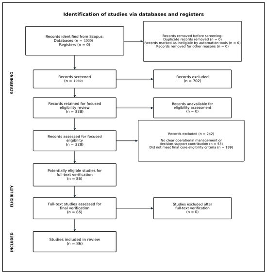
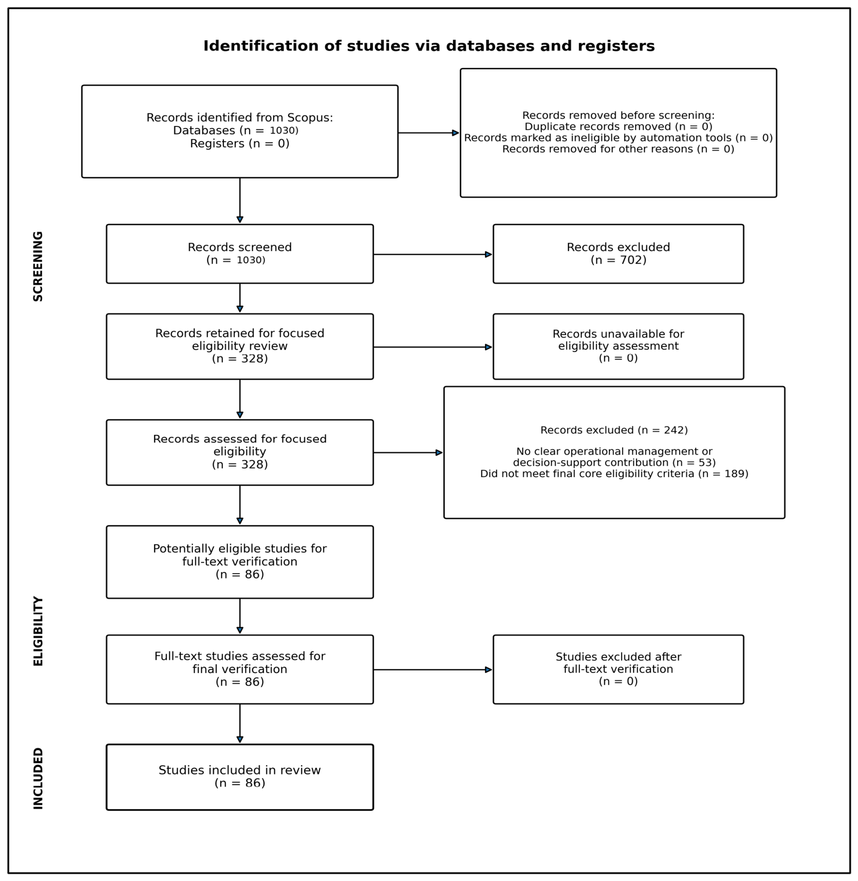
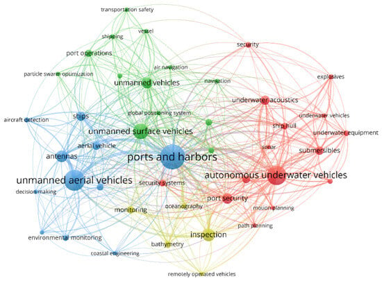
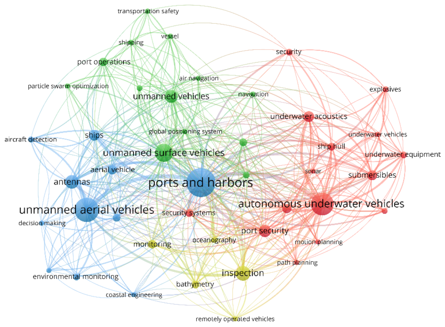
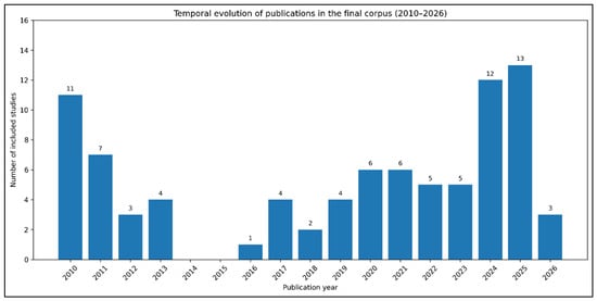
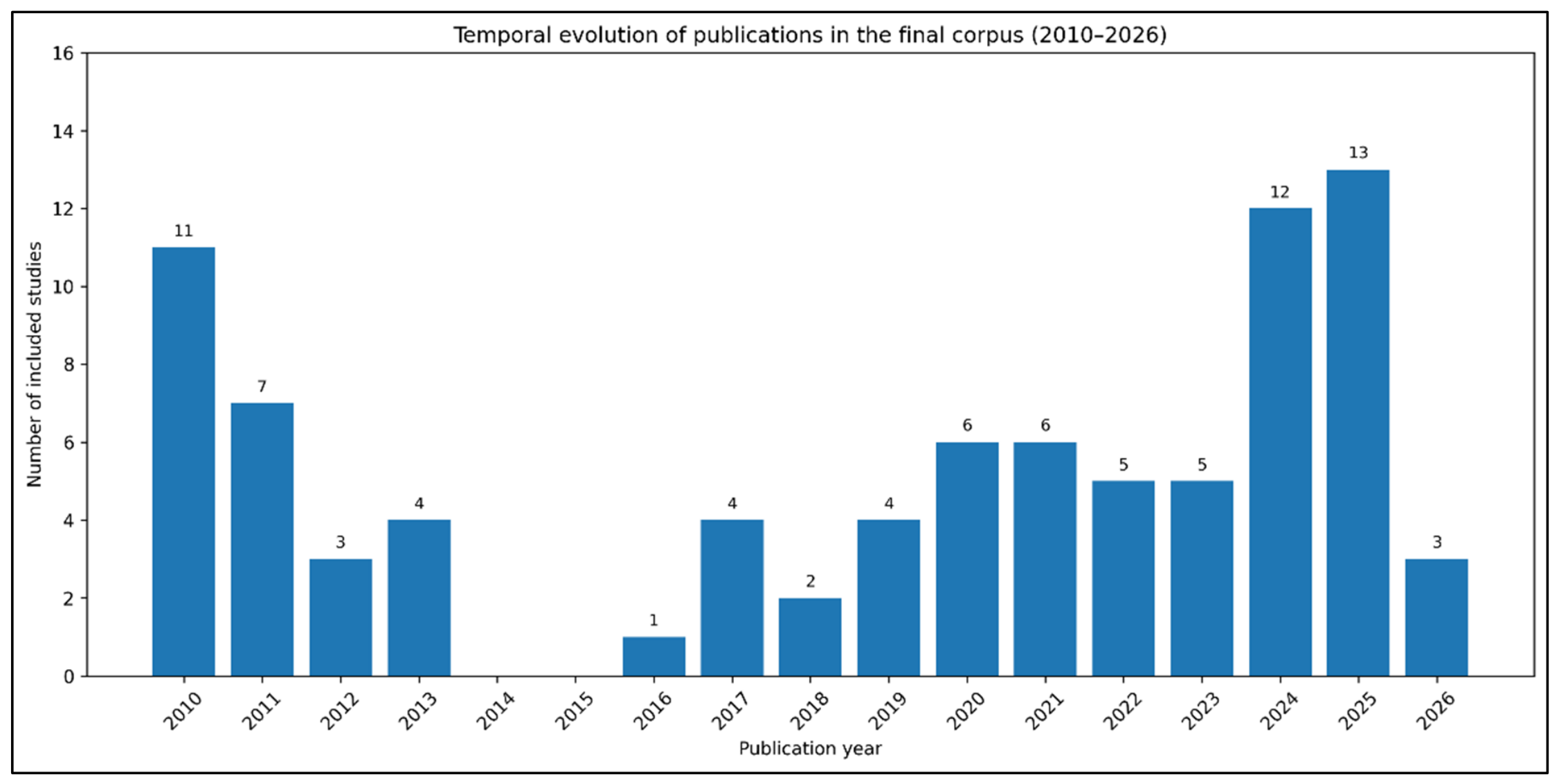
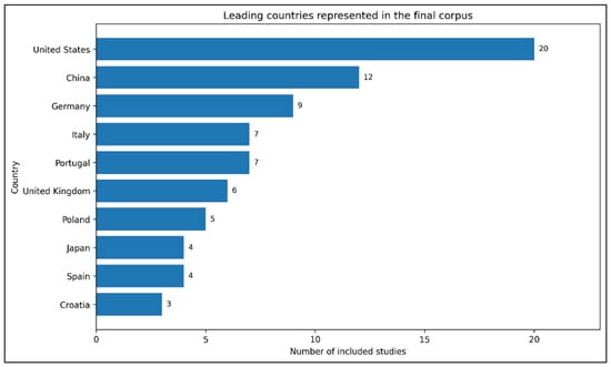
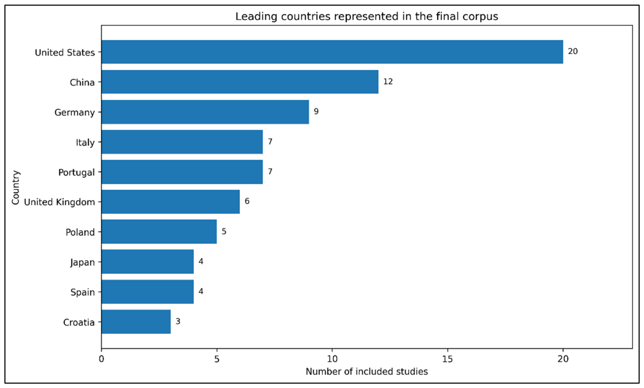
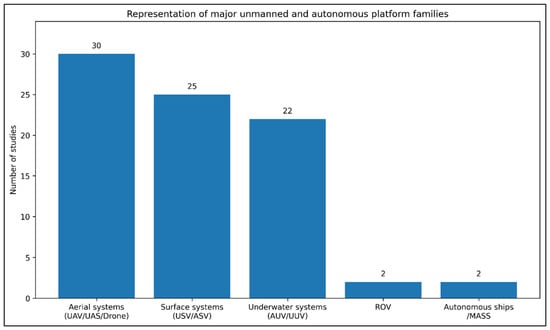
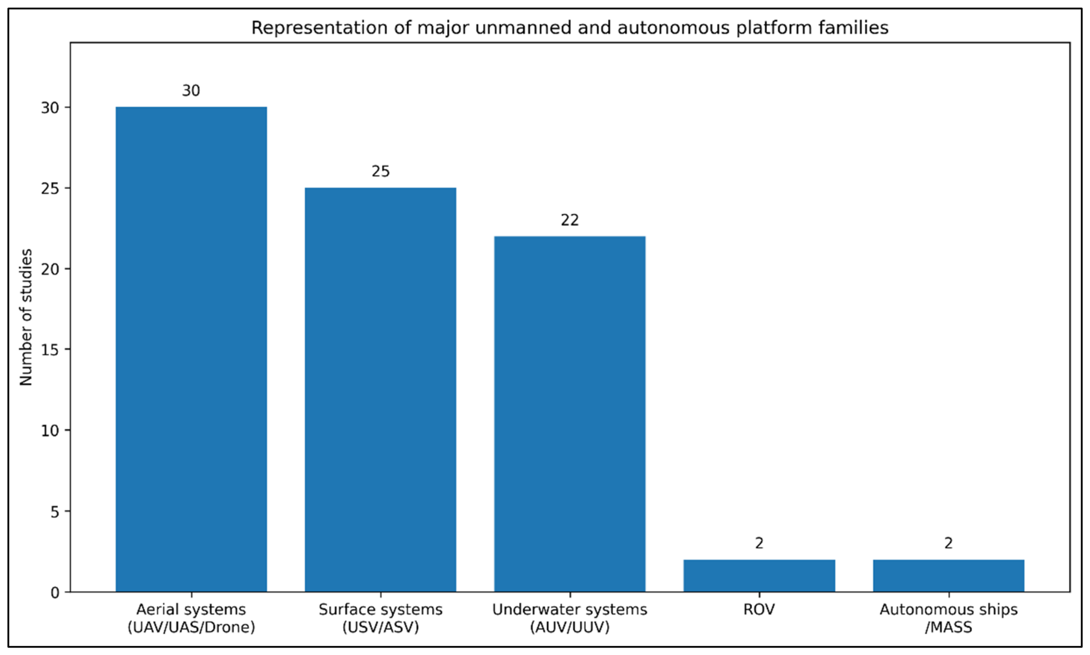
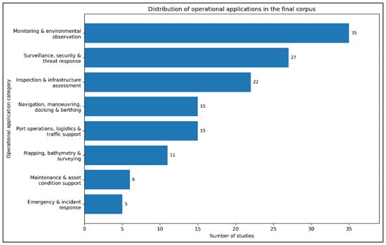
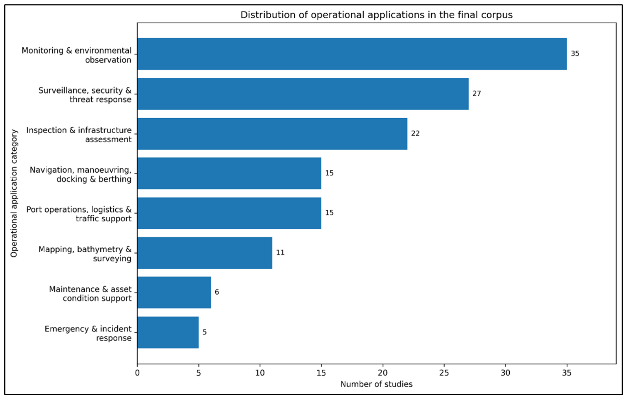
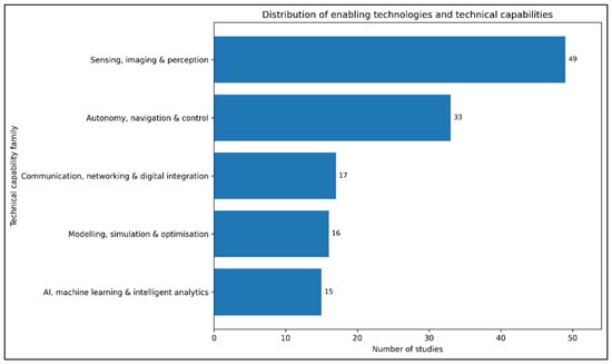
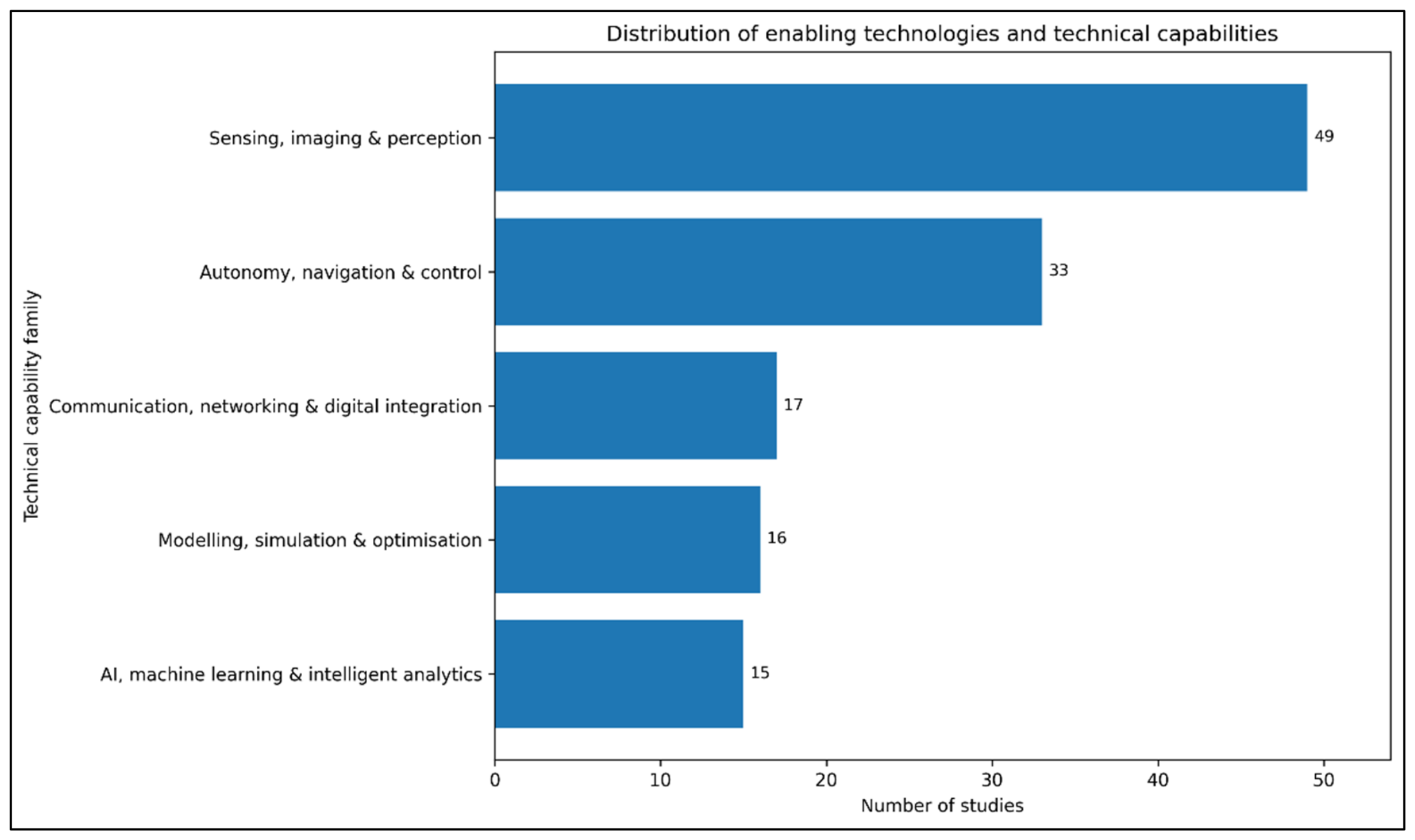

Disclaimer/Publisher’s Note: The statements, opinions and data contained in all publications are solely those of the individual author(s) and contributor(s) and not of MDPI and/or the editor(s). MDPI and/or the editor(s) disclaim responsibility for any injury to people or property resulting from any ideas, methods, instructions or products referred to in the content. |
© 2026 by the authors. Licensee MDPI, Basel, Switzerland. This article is an open access article distributed under the terms and conditions of the Creative Commons Attribution (CC BY) license.