


Abstract
Ancient tidal deposits provide important records of coastal hydrodynamics and basin evolution, yet their recognition remains challenging because tidal processes commonly interact with fluvial and wave processes in transitional environments. This study integrates petrography, grain-size characteristics, sedimentary structures, and regional paleogeography to decipher the Late Permian tidal depositional system of the Longtan Formation in the Lower Yangtze region, South China. The sandstones are mainly fine- to medium-grained and display multiple grain-size transport populations, indicating variable hydrodynamic conditions. An assemblage of bidirectional cross-bedding, double mud drapes, rhythmic sand–mud laminae, heterolithic bedding, and thick–thin sandstone bundles provides evidence of current reversals, slack-water deposition, and fluctuating hydrodynamic conditions. The facies-dependent distribution of these structures indicates spatial variations in the expression of tidal processes. Paleogeographic reconstruction suggests that the NE-opening, semi-enclosed basin configuration may have favored tidal circulation and the development and preservation of tidal deposits. Porosity and permeability measurements show differences among tidal sandstone types. Muddy matrix content is negatively correlated with both porosity and permeability, with the matrix–porosity relationship yielding R2 = 0.791, indicating that muddy matrix is an important factor associated with reservoir heterogeneity. These findings demonstrate the value of integrating sedimentological evidence with paleogeographic constraints for interpreting ancient tidal depositional systems and provide a basis for evaluating reservoir heterogeneity in comparable tide-influenced successions.
1. Introduction
Tidal depositional systems are important components of marginal marine environments, where variations in current direction and energy influence sediment transport, deposition, and preservation [1,2,3]. Ancient tidal deposits provide valuable records of past coastal dynamics and basin evolution; however, their recognition remains challenging because tidal processes commonly interact with fluvial and wave-driven processes in transitional environments [4,5,6,7,8,9,10,11,12,13,14]. Therefore, accurately identifying ancient tidal systems requires reliable sedimentological criteria that can distinguish tidal influence from other coastal depositional processes.
Sedimentary structures provide critical evidence for deciphering ancient tidal deposits because they preserve direct records of depositional hydrodynamics. In contrast to deposits dominated by persistent unidirectional currents or wave-dominated systems controlled by oscillatory motion, tidal environments are characterized by reversals in flow direction and fluctuations in depositional energy. Sedimentary features such as bidirectional cross-bedding, double mud drapes, rhythmic sand–mud laminae, heterolithic bedding, and thick–thin sandstone bundles have therefore been widely used as indicators of tidal influence [15,16,17,18]. Nevertheless, individual structures may not always provide definitive evidence because similar features can develop under different depositional conditions. An integrated analysis of sedimentary structures and their depositional context is consequently required for reliable interpretation of ancient tidal systems.
The development and preservation of tidal deposits are strongly influenced by regional paleogeographic conditions. Basin configuration, sediment supply systems, coastal morphology, and the relative importance of competing fluvial and wave processes can modify the expression of tidal sedimentation [4,7,19,20]. Although tidal deposits have been increasingly documented, distinguishing the hydrodynamic processes responsible for their sedimentary structures and identifying the paleogeographic conditions favorable for tidal sedimentation remain important challenges in ancient transitional successions.
The Late Permian Longtan Formation in the Lower Yangtze region of South China provides an important example for examining ancient tidal depositional processes. During the deposition of the Longtan Formation, the Lower Yangtze Basin evolved into a shallow marine–terrestrial transitional depositional environment [21,22,23,24,25]. The Longtan Formation consists mainly of sandstone, siltstone, mudstone, and coal-bearing strata, and records complex interactions between terrestrial sediment supply and marine hydrodynamic processes. The heterogeneous sandstone-mudstone architecture of the Longtan Formation further provides an opportunity to explore the relationships between sedimentary characteristics and reservoir properties in tide-influenced transitional systems. Previous studies have provided important insights into the stratigraphy, provenance, and depositional evolution of the Longtan Formation. Nevertheless, the sedimentary characteristics and facies-dependent distribution of tidal structures require further characterization to better understand the associated hydrodynamic processes. In addition, the regional paleogeographic conditions favorable for tidal sedimentation warrant further examination.
Recent field observations and borehole investigations in southern Anhui have identified abundant tidal-related sedimentary structures within Longtan Formation sandstones. These observations provide an opportunity to characterize the sedimentary expression of tidal processes and better understand their associated hydrodynamic conditions. In this study, we integrate sandstone petrography, grain-size characteristics, sedimentary structures, and regional paleogeographic analysis to decipher the tidal depositional system of the Longtan Formation. The objectives of this study are to (1) characterize the sedimentological features and sedimentary structures of the tide-influenced deposits; (2) interpret the hydrodynamic processes responsible for their formation; (3) evaluate the paleogeographic controls on tidal sedimentation in the Late Permian Lower Yangtze Basin; and (4) examine the relationships between sedimentary characteristics and reservoir quality and explore their implications for reservoir evaluation. This study highlights the importance of integrating sedimentary structures with paleogeographic analysis for reconstructing ancient tidal depositional systems and understanding reservoir heterogeneity in tide-influenced transitional successions.
2. Geological Setting
The Lower Yangtze region is located along the eastern margin of the Yangtze Block in South China and is bounded by the Tanlu Fault to the north and the Jiangshao Fault to the south [26,27] (Figure 1). The region exhibits an overall NE-opening basin configuration and represents an important sedimentary domain for reconstructing the Paleozoic geological evolution of South China.
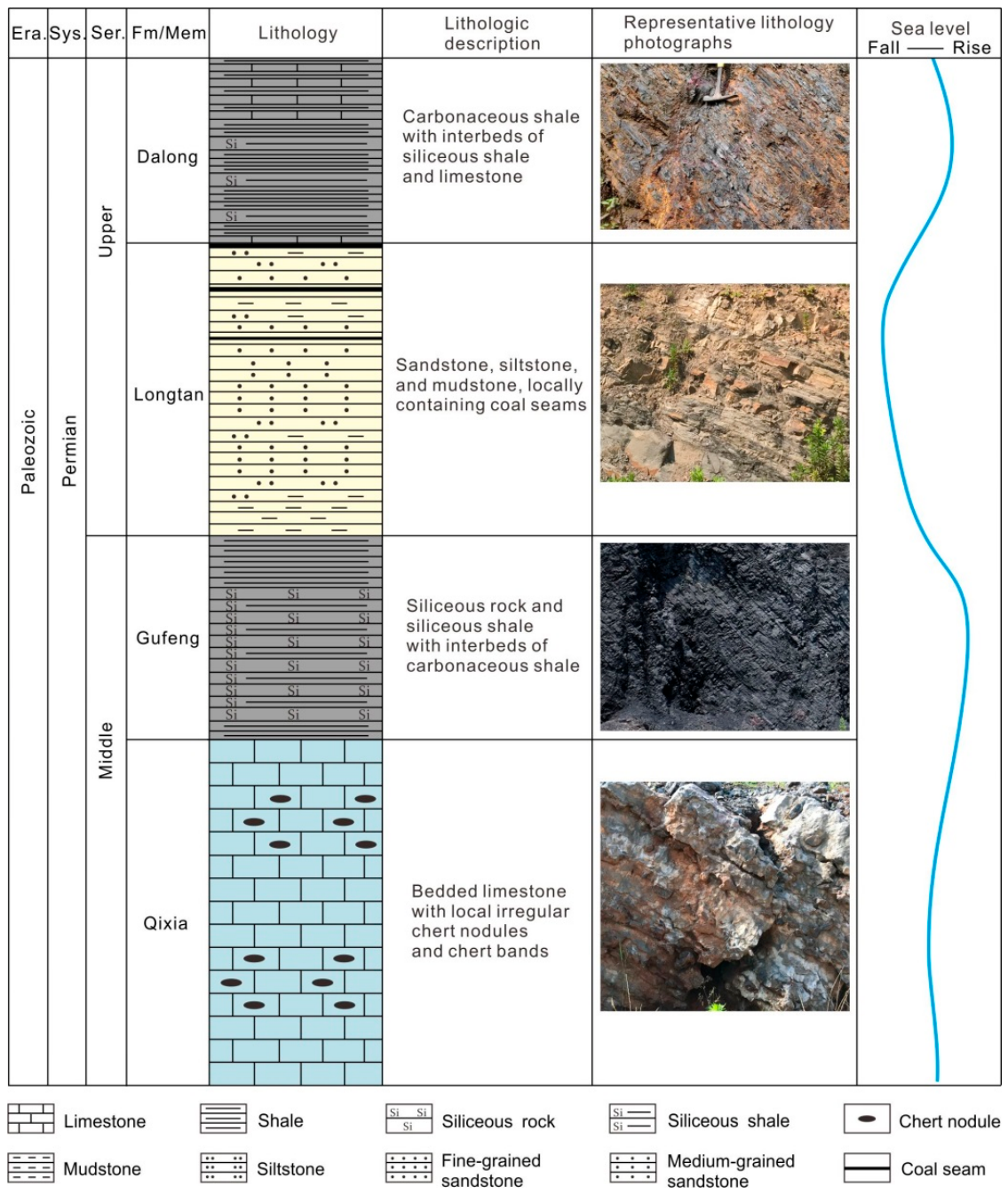
During the Middle–Late Permian, a relatively complete stratigraphic succession developed in the Lower Yangtze region, including, from bottom to top, the Qixia Formation, Gufeng Formation, Longtan Formation, and Dalong Formation (Figure 2). The Qixia Formation was deposited during a major transgressive stage associated with post-glacial sea-level rise and is dominated by shallow-marine carbonate rocks. During deposition of the Gufeng Formation, continued transgression resulted in the development of deeper-water shelf environments, where organic-rich siliceous rocks and siliceous shales accumulated. Subsequently, regional regression during the Late Permian resulted in widespread development of marine–terrestrial transitional deposits of the Longtan Formation, which consist mainly of siliciclastic rocks and coal-bearing strata. Renewed transgression during the Late Permian led to deposition of the organic-rich black shale of the Dalong Formation.
The Longtan Formation therefore represents an important transitional succession recording the evolution from deeper-water marine conditions to shallow coastal environments in the Lower Yangtze region. It is mainly exposed in southern Anhui Province, including the Chaohu, Tongling, Xuancheng, and adjacent areas, and is also well preserved in borehole successions. The thickness of the Longtan Formation generally ranges from several tens of meters to approximately 200 m, with an overall eastward thickening tendency [28,29]. The formation is composed mainly of sandstone, siltstone, mudstone, and coal seams. Sandstone intervals are commonly interbedded with fine-grained deposits and preserve diverse sedimentary structures, including features indicative of tidal influence. These well-preserved Late Permian successions provide an opportunity to characterize the sedimentary features of ancient tidal systems in the Lower Yangtze region.
Figure 1.
Tectonic location (a) and regional geological map (b) of the Lower Yangtze region, based on references [30,31]. The red star near Chaohu in (b) represents two outcrop sections that cannot be shown separately at the map scale.
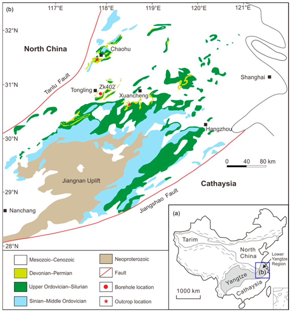
Figure 2.
Stratigraphic column of the Middle–Upper Permian in the Lower Yangtze region.
3. Materials and Methods
Field investigations were conducted in the Tongling, Chaohu, and Xuancheng areas of the Lower Yangtze region (Figure 1b). The investigated dataset comprises one cored borehole and three outcrop sections. Borehole ZK402 in the Tongling area contains 55.9 m of Longtan Formation core examined in this study. Two outcrop sections, 15 and 34 m thick, respectively, were investigated in the Chaohu area, and one 76 m thick outcrop section was investigated in the Xuancheng area. These localities provide spatially distributed observations of the Longtan Formation within the study area. Core and outcrop investigations focused on lithology, grain size, bedding characteristics, sedimentary structures, sand–mud relationships, and vertical facies associations. Particular attention was paid to the morphology, dimensions, and stratigraphic occurrence of sedimentary structures potentially related to tidal processes. Trace fossils, bioturbation, and reactivation surfaces were not systematically investigated or documented during the field and core observations. Therefore, these features are not used as evidence for tidal interpretation in this study. A total of 36 samples were collected from the Longtan Formation. Subsets of these samples were subsequently used for petrographic, grain-size, and petrophysical analyses, as described below.
Petrographic analysis was performed on 27 sandstone samples using thin sections under a polarizing microscope (Axio Scope.A1 POL, Carl Zeiss Microscopy GmbH, Jena, Germany). Quantitative point counting was conducted using 400 points per thin section to determine the proportions of quartz, feldspar, lithic fragments, muddy matrix, cement, and other components. For the Q–F–L ternary diagram, the abundances of quartz, feldspar, and lithic fragments were recalculated and normalized to 100%. Grain roundness and sorting were assessed qualitatively from thin-section observations to characterize sandstone texture.
Grain-size analysis was conducted on 12 sandstone samples using a polarizing-microscope-based particle image analysis method. Grain-size probability cumulative curves were constructed from the measured grain-size distributions, and different transport populations were identified based on variations in curve slope and breakpoints between adjacent linear segments following the approach of Visher [32]. The resulting curves were used to characterize variations in sediment-transport conditions.
Porosity and permeability were measured on 15 sandstone samples representing different sedimentary-structure types. Porosity was determined using the helium-expansion method, whereas permeability was measured using the steady-state gas-flow method. These petrophysical data were compared among sandstone types characterized by different sedimentary structures. Data from samples representing different sedimentary-structure types were then pooled for Pearson correlation analysis and linear regression to examine the overall relationships between muddy matrix content and porosity and permeability.
4. Sedimentary Characteristics of Tidal Deposits
4.1. Petrographic Composition and Grain-Size Characteristics
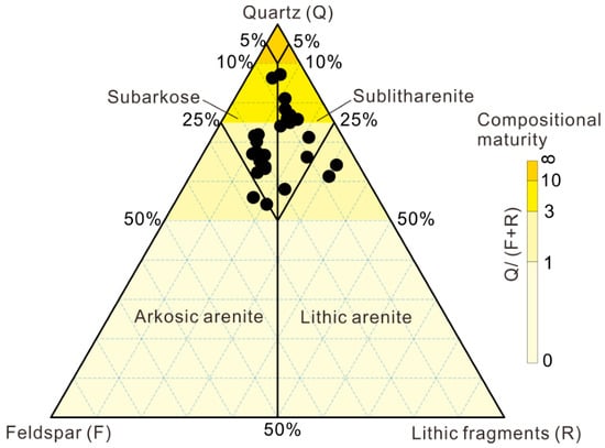
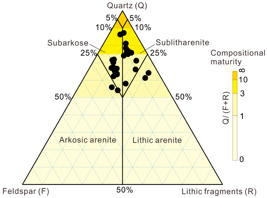
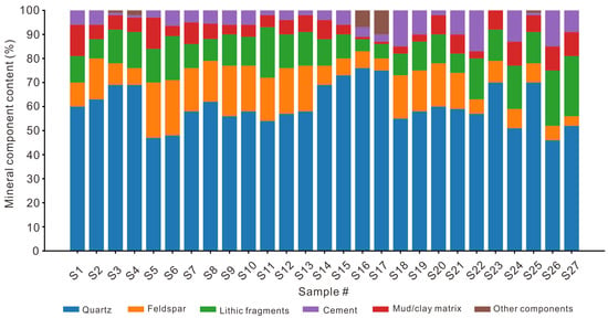
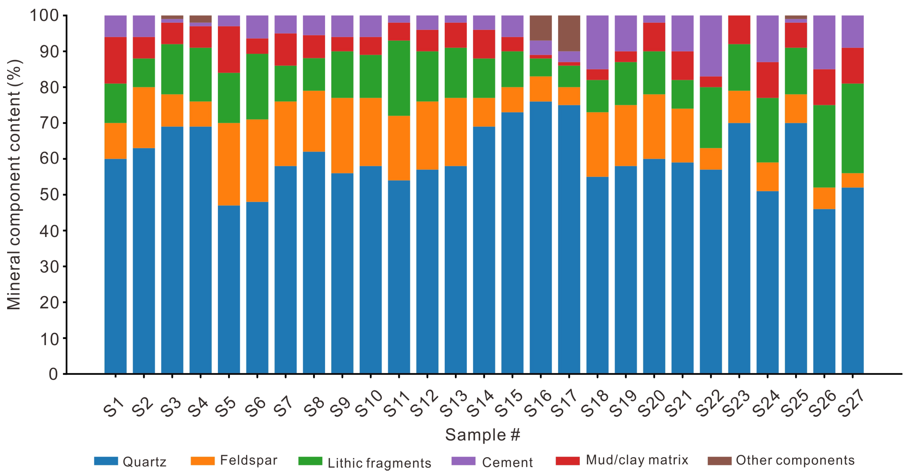
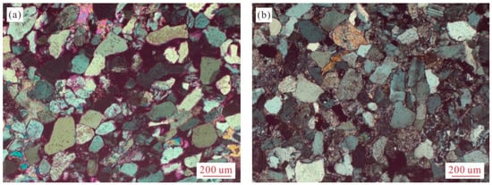
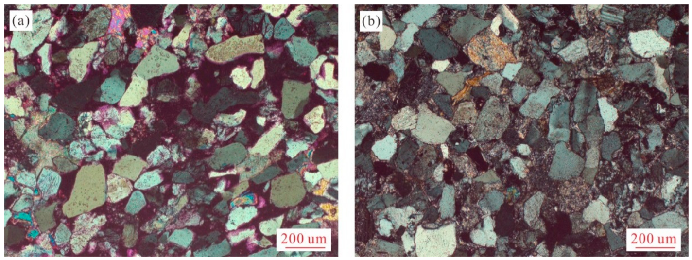
The Longtan Formation sandstones are mainly fine- to medium-grained and consist predominantly of quartz, with subordinate feldspar and lithic fragments. Quartz contents range from approximately 46% to 76%, with an average of 60.4% ± 8.5% (SD, n = 27), whereas feldspar and lithic fragments average approximately 13.2% and 13.1%, respectively. The predominance of quartz and relatively low proportions of feldspar and lithic fragments indicate relatively high compositional maturity. The Q–F–L ternary diagram further illustrates the framework-grain composition of the sandstones (Figure 3). After normalization of quartz, feldspar, and lithic fragments to 100%, most samples plot toward the quartz-rich part of the diagram, with normalized quartz contents ranging from approximately 54% to 87%. Petrographic compositions similarly show that quartz is the dominant component, whereas the proportions of feldspar, lithic fragments, muddy matrix, and cement vary among individual samples (Figure 4). Mud matrix contents range from approximately 1% to 13%, and cement contents from 0% to 17%, while other components are generally minor or absent. Overall, the Longtan Formation sandstones are characterized by a quartz-rich framework with variable proportions of subordinate components. Microscopic observations show that most detrital grains are subangular to angular and are moderately sorted (Figure 5), indicating relatively low textural maturity despite the high compositional maturity.
Figure 3.
Q–F–L ternary diagram showing framework-grain compositions of the Longtan Formation sandstones (n = 27).
Figure 4.
Petrographic compositions of individual sandstone samples, including quartz, feldspar, lithic fragments, muddy matrix, cement, and other components.
Figure 5.
Photographs of sandstone thin sections under cross-polarized light. (a) ZK402, 101.52 m, cast thin section; (b) ZK402, 98.27 m, plain thin section.
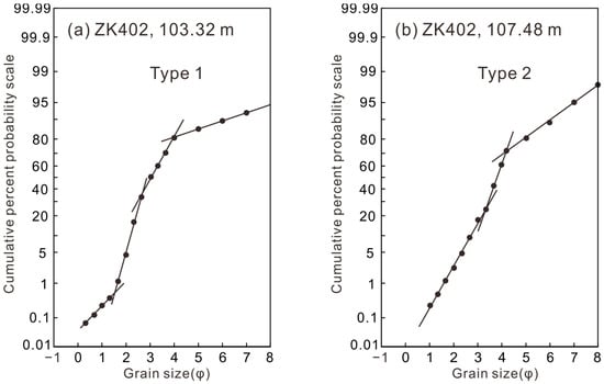
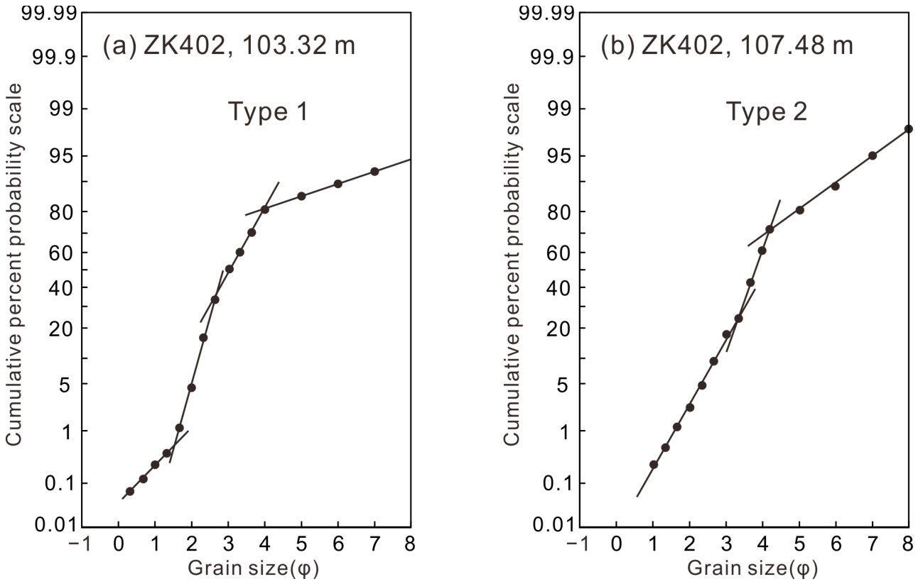
Grain-size probability cumulative curves of the 12 analyzed sandstone samples exhibit two principal types (Figure 6), distinguished by their overall curve morphology, the proportions and slopes of individual grain-size populations, and the positions of breakpoints between adjacent linear segments. Type 1 curves comprise four segments, representing one traction population, two saltation populations, and one suspension population. The two saltation populations dominate the grain-size distribution, together accounting for approximately 75–85%, whereas the suspension population contributes about 12–20%; the traction population is minor, generally representing less than 1% of the total. Type 2 curves consist of three segments, including two saltation populations and one suspension population, with no clearly distinguishable traction segment. Compared with Type 1, Type 2 generally shows poorer sorting and a greater contribution from the suspension population. The coexistence of two saltation populations in both curve types suggests that sediment transport was not governed by a single hydraulic component. Instead, the grain-size distributions record the combined influence of multiple transport populations under changing flow conditions, consistent with the interpretation of polymodal transport processes proposed for probability cumulative curves [32].
Figure 6.
Representative grain-size probability cumulative curves of the Longtan Formation sandstones showing (a) Type 1 and (b) Type 2. The curves represent individual samples selected from the 12 samples analysed, rather than averaged grain-size distributions. Grain size is expressed in phi units (φ), with larger φ values indicating finer grains and smaller φ values indicating coarser grains.
4.2. Sedimentary Structures Associated with Tidal Deposition
A wide range of sedimentary structures associated with tidal processes are preserved within the Longtan Formation sandstones. These structures include bidirectional cross-bedding, double mud drapes, rhythmic sand–mud laminae, heterolithic bedding, and thick–thin sandstone bundles. They occur in different sandstone and heterolithic intervals throughout the formation and display variable morphological characteristics. The typical dimensions or thickness, observed characteristics, and representative documented locations of these five sedimentary structures are summarized in Table 1.
Table 1.
Summary of sedimentary structures associated with tidal deposition in the Longtan Formation.
4.2.1. Bidirectional Cross-Bedding
Description
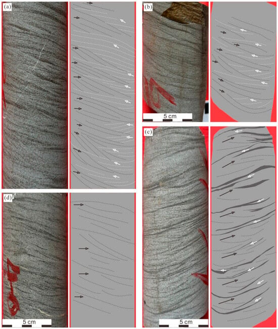
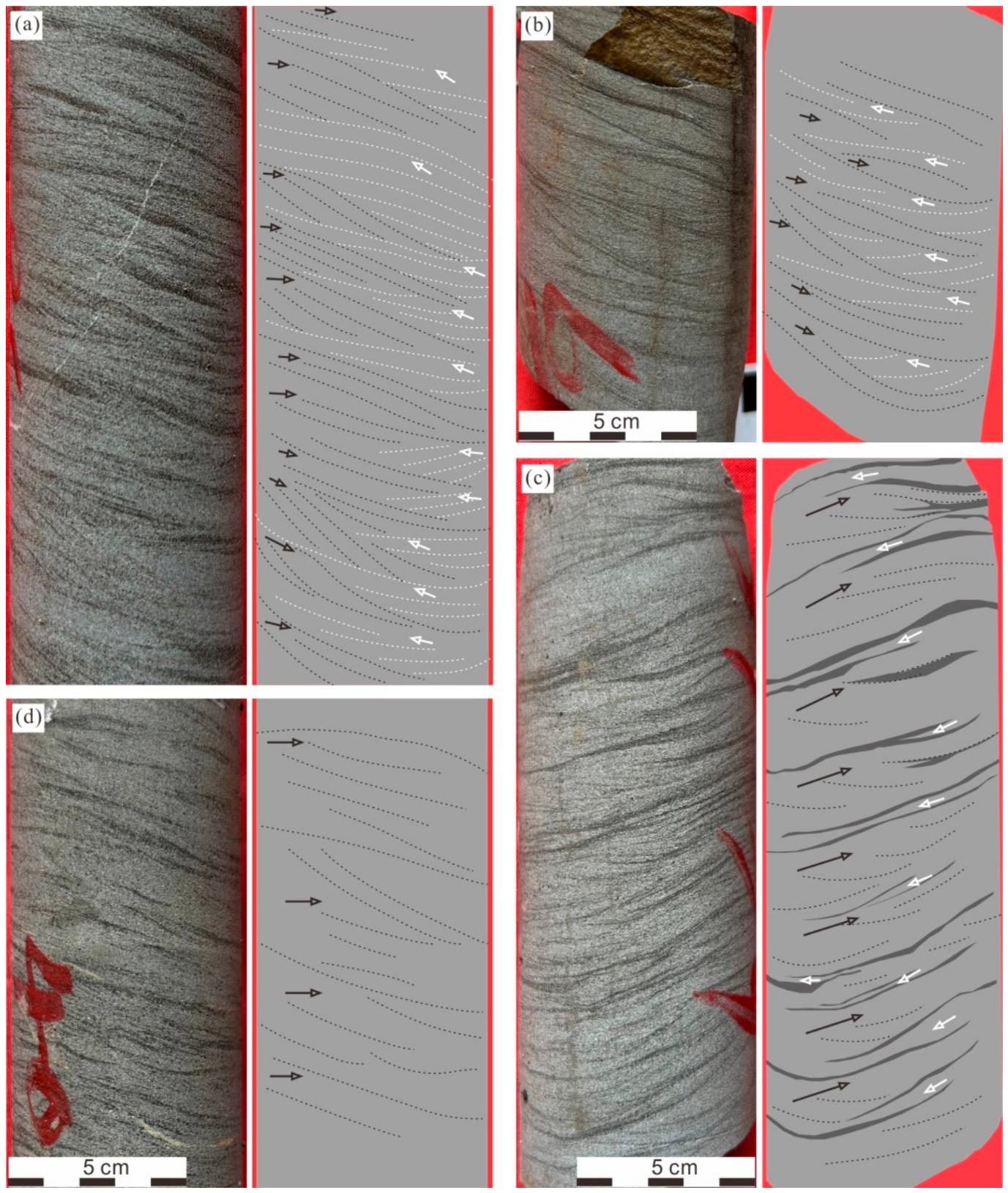
Bidirectional cross-bedding is one of the most common sedimentary structures observed in the Longtan Formation sandstones. It is characterized by adjacent cross-bed sets with apparent opposite dip directions in the observation plane (Figure 7). Based on the presence or absence of mud drapes between opposing cross-bed sets, two types of bidirectional cross-bedding are recognized. The first type is characterized by the absence of mud drapes between oppositely dipping cross-bed sets (Figure 7a,b). Individual cross-bed sets are generally 1–5 cm thick, and the two opposing foreset packages commonly display comparable thicknesses. The second type contains thin mud drapes separating cross-bed sets with opposite dip directions (Figure 7c). The mud layers are generally dark-colored, 0.1–0.3 cm thick, and exhibit relatively poor lateral continuity. Sandstone laminae enclosed between mud drapes are commonly thinner than adjacent cross-bed sets and locally show discontinuous distribution. In addition to bidirectional cross-bedding, locally developed unidirectional cross-bedding is also observed within some sandstone intervals (Figure 7d). These structures generally show consistent foreset orientations and lack mud drapes.
Figure 7.
Tidal cross-bedding observed in core from borehole ZK402, Tongling area. (a) Bidirectional cross-bedding, ZK402, 101.18 m; (b) bidirectional cross-bedding (without mud drape), ZK402, 103.08 m; (c) bidirectional cross-bedding (with mud drape), ZK402, 103.38 m; (d) unidirectional cross-bedding, ZK402, 107.58 m. Arrows indicate apparent foreset-dip directions within the plane of observation rather than geographically referenced paleocurrent azimuths.
Interpretation
The opposing foreset-dip directions are consistent with changes in sediment transport direction during the migration of subaqueous dunes or ripples. In contrast to fluvial environments dominated by persistent unidirectional currents, tidal environments experience alternating flood and ebb flows, providing a plausible mechanism for the development of cross-bed sets with opposing orientations. The superposition of bedforms generated under opposing flow directions may therefore produce bidirectional cross-bedding.
The geometry and preservation of bidirectional cross-bedding may be influenced by differences in the strength and duration of opposing currents. In tidal environments, flood-ebb asymmetry can develop in response to variations in water depth, channel geometry, and local hydrodynamic conditions [19]. Such asymmetry may result in unequal sediment transport and bedform migration during the two flow phases. Relatively stronger currents may generate thicker or more extensively developed foreset packages, whereas weaker currents may produce thinner cross-bed sets that are more susceptible to subsequent erosion. Differences in the thickness, inclination, and preservation of opposing cross-bed sets may therefore reflect variations in current strength and duration, together with sediment availability and subsequent reworking.
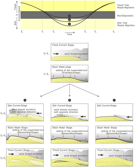
The presence or absence of mud drapes within bidirectional cross-bedding may also reflect variations in current activity and subsequent preservation. Under relatively energetic conditions, bedforms may migrate in opposing directions, producing cross-bed sets with contrasting orientations (Figure 8a). Mud drapes deposited during low-energy intervals may subsequently be eroded by renewed current activity and therefore be poorly preserved. Under conditions more favorable for mud accumulation and preservation, thin mud drapes may develop between successive cross-bed sets and survive subsequent reworking, resulting in bidirectional cross-bedding with preserved mud drapes (Figure 8b).
Figure 8.
Conceptual depositional model illustrating the sedimentary process of different cross-bedding styles in tidally influenced environments. (a) Bidirectional cross-bedding without mud drapes; (b) bidirectional cross-bedding with mud drapes; (c) unidirectional cross-bedding. Arrows indicate current directions.
Unidirectional cross-bedding observed locally within the Longtan Formation does not contradict a tidal interpretation. Modern tidal environments contain intervals where one current direction dominates because of tidal asymmetry, channel confinement, or local variations in flow pathways. In such settings, a dominant current or persistent residual currents may preferentially preserve cross-bedding generated by a single dominant flow direction (Figure 8c). Therefore, the coexistence of unidirectional and bidirectional cross-bedding is consistent with hydrodynamic variability within a tidally influenced depositional system.
4.2.2. Double Mud Drapes
Description
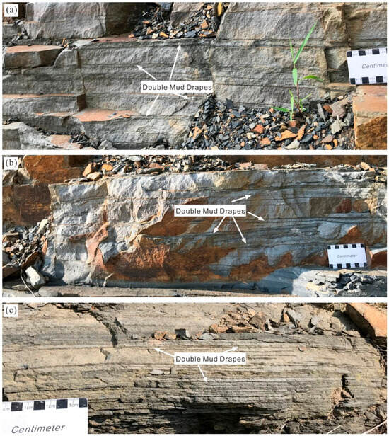
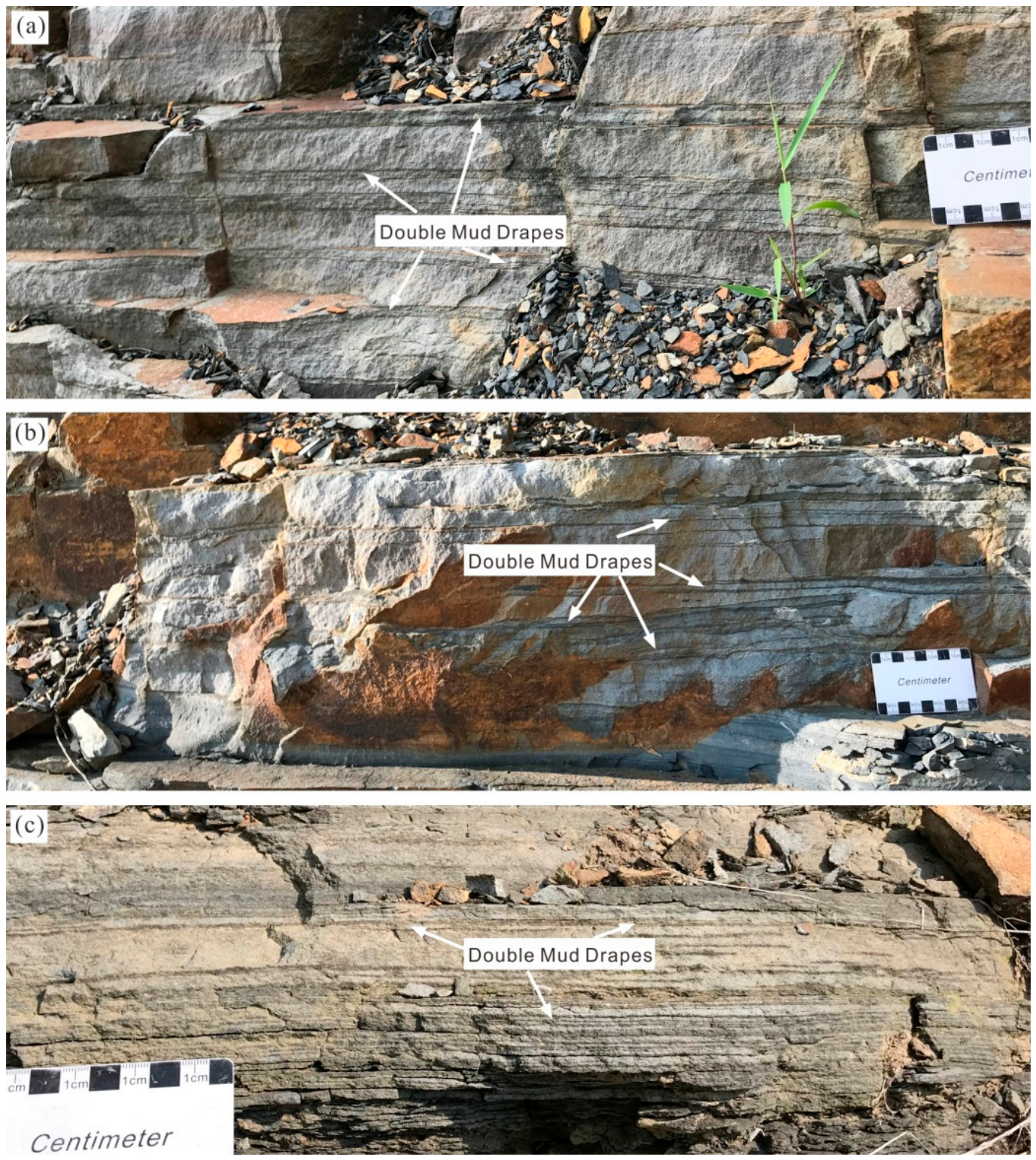
Double mud drapes are characterized by two thin mud layers separating adjacent sandstone laminae or cross-bed sets and commonly observed within sandstone intervals of the Longtan Formation in the Chaohu area of southern Anhui Province. In the Longtan Formation, the muddy layers within double mud drapes are generally dark-colored, approximately 0.1–0.3 cm thick, and exhibit meter-scale lateral continuity in outcrop exposures (Figure 9). The thin sandstone layer enclosed between the paired mud drapes is commonly less than 0.5 cm thick and shows poorer lateral continuity than the muddy layers. Locally, the intervening sandstone layer may pinch out laterally, causing the paired mud drapes to merge into a single mud drape.
Figure 9.
Double mud drapes in the outcrop of the Chaohu area. (a–c) Representative outcrop photographs.
Interpretation
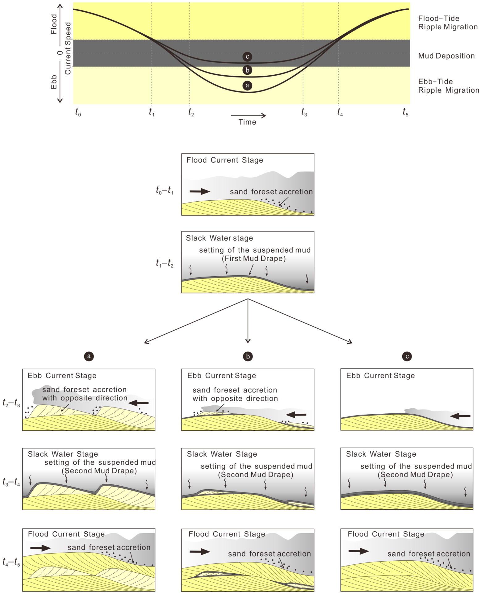
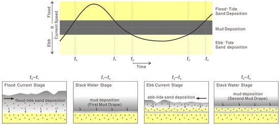
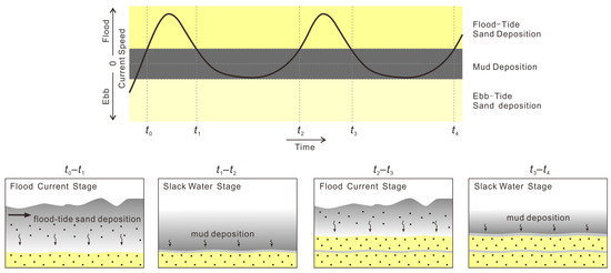
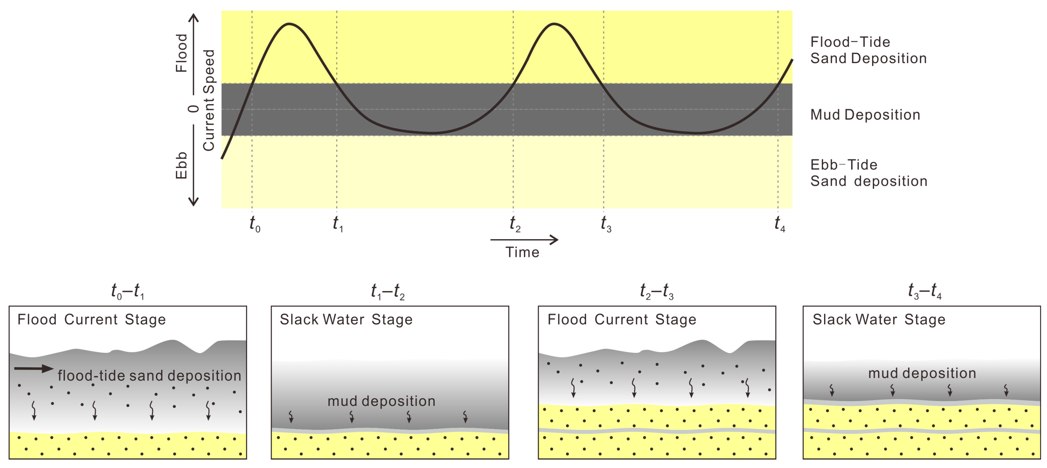
Double mud drapes provide important evidence for fluctuations in depositional energy and repeated alternation between sediment transport and suspension settling. In tidal environments, their formation is commonly associated with changes in current velocity during alternating phases of sediment transport and slack-water deposition. During periods of relatively strong tidal currents, sand-sized particles are transported and deposited as traction or saltation loads. As current velocity decreases during slack-water periods, suspended fine-grained sediments settle from the water column and form thin mud layers.
The formation of paired mud drapes can be explained by a depositional model involving alternating current activity and slack-water deposition during a tidal cycle (Figure 10). Deposition of a sand layer during one tidal phase may be followed by a reduction in flow velocity and subsequent mud accumulation. Renewed current activity during the opposite tidal phase may then deposit another sand layer, followed by the formation of a second mud drape during the next low-energy interval. Therefore, double mud drapes record repeated transitions between active sediment transport and quiescent depositional conditions.
Figure 10.
Conceptual depositional model illustrating the depositional process of double mud drapes.
The presence of double mud drapes should not be interpreted as a simple record of two tides alone. Their preservation requires a combination of suitable sediment supply, sufficient suspension concentration, and limited erosion during subsequent flow events. Therefore, double mud drapes record repeated alternations between sediment transport and mud deposition, with their preservation also depending on favorable sedimentary conditions. Such structures may be preserved in tidal-channel margins and tidal-flat environments where conditions favor mud accumulation and limit subsequent erosion [33].
4.2.3. Rhythmic Sand–Mud Laminae
Description
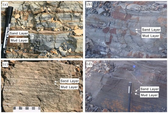
Rhythmically interbedded sandstone, siltstone, and mudstone laminae occur mainly within fine-grained intervals of the Longtan Formation (Figure 11). Individual rhythmic units commonly consist of relatively coarse-grained layers overlain by finer-grained mud layers, forming repeated sand–mud couplets [34]. The thickness and composition of individual laminae vary among different intervals, and the rhythmic structures are commonly preserved within heterolithic successions.
Figure 11.
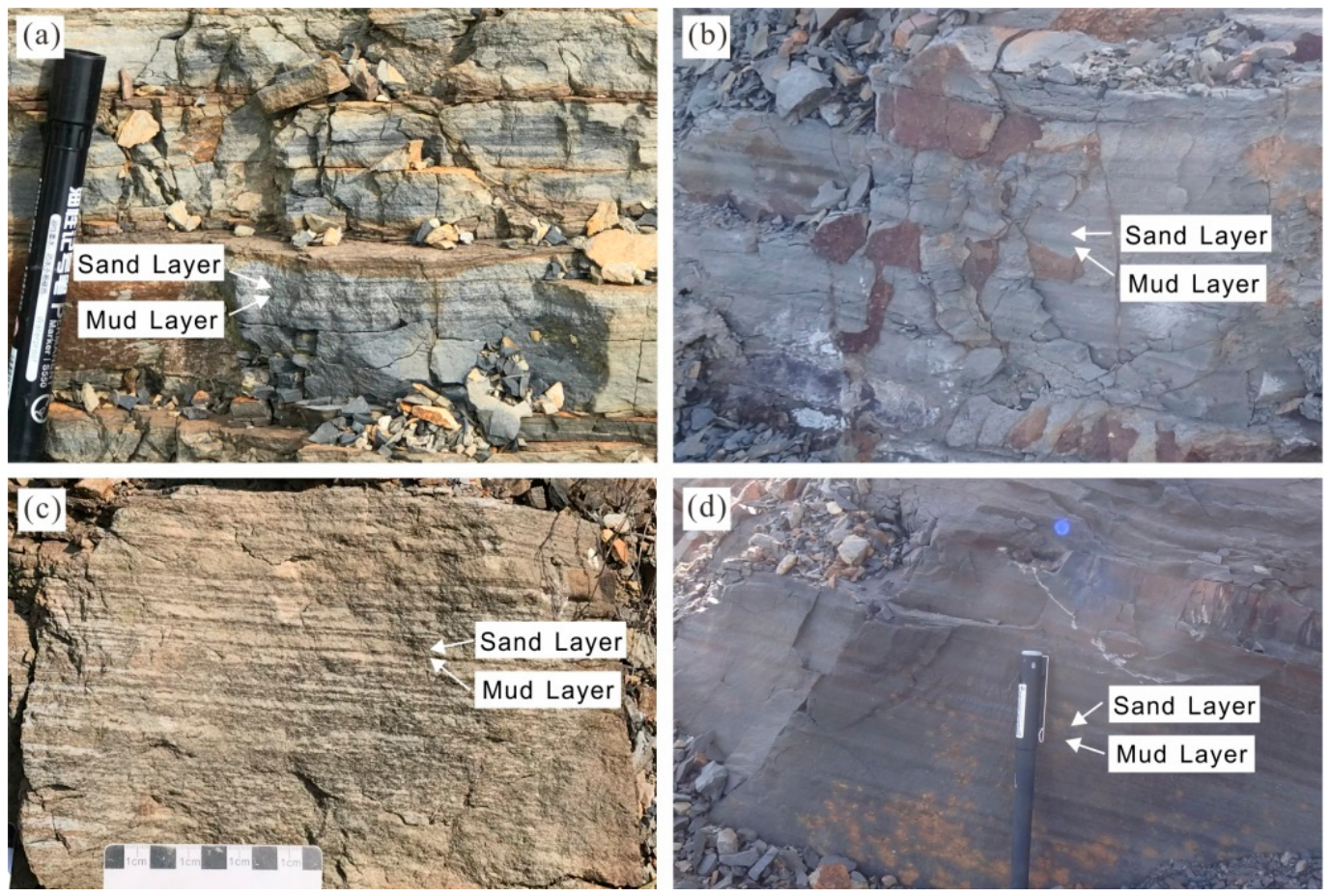
Rhythmic sand–mud laminae in the outcrop of the Chaohu area and Xuancheng area. (a–d) Representative outcrop photographs.
The sandy layers are mainly composed of fine sandstone, with individual sandy-layer thicknesses generally ranging from 0.1 to 2 cm, as measured in outcrops. Internal sedimentary structures are commonly absent or poorly developed. The muddy layers are generally darker in color and slightly thinner than adjacent sand layers. These rhythmic sand–mud couplets commonly display good lateral continuity and can extend over considerable distances. In some intervals, rhythmic sand–mud laminae show repeated vertical stacking patterns, with multiple sand–mud couplets developed over several centimeters to decimeters of stratigraphic thickness. These rhythmic successions sometimes occur together with other tidal-related structures, such as double mud drapes.
Interpretation
In tidal environments, rhythmic sand–mud alternations can record variations in depositional energy and sediment supply associated with changes in tidal flow conditions [35,36,37]. The alternation between coarser-grained and finer-grained laminae reflects repeated shifts between periods of active sediment transport and suspension settling. During higher-energy phases, stronger currents promoted sand or silt deposition, whereas reduced flow velocity during lower-energy phases favored the accumulation of suspended mud (Figure 12).
Figure 12.
Conceptual depositional model showing the depositional process of rhythmic sand–mud laminae.
The development of rhythmic sand–mud alternations indicates fluctuating hydrodynamic conditions rather than deposition under a constant flow regime. Variations in lamina thickness and composition may result from differences in current intensity, sediment availability, and tidal modulation [38,39].
Although rhythmic sand–mud alternations are not unique to tidal environments, their occurrence within a succession containing bidirectional cross-bedding and double mud drapes provides additional support for a tidal interpretation. In the Longtan Formation, these rhythmic sand–mud laminae indicate repeated changes in depositional conditions and are interpreted as reflecting tidal influence when considered together with these other sedimentary structures.
4.2.4. Heterolithic Bedding
Description
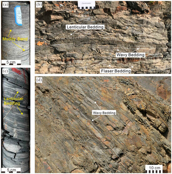
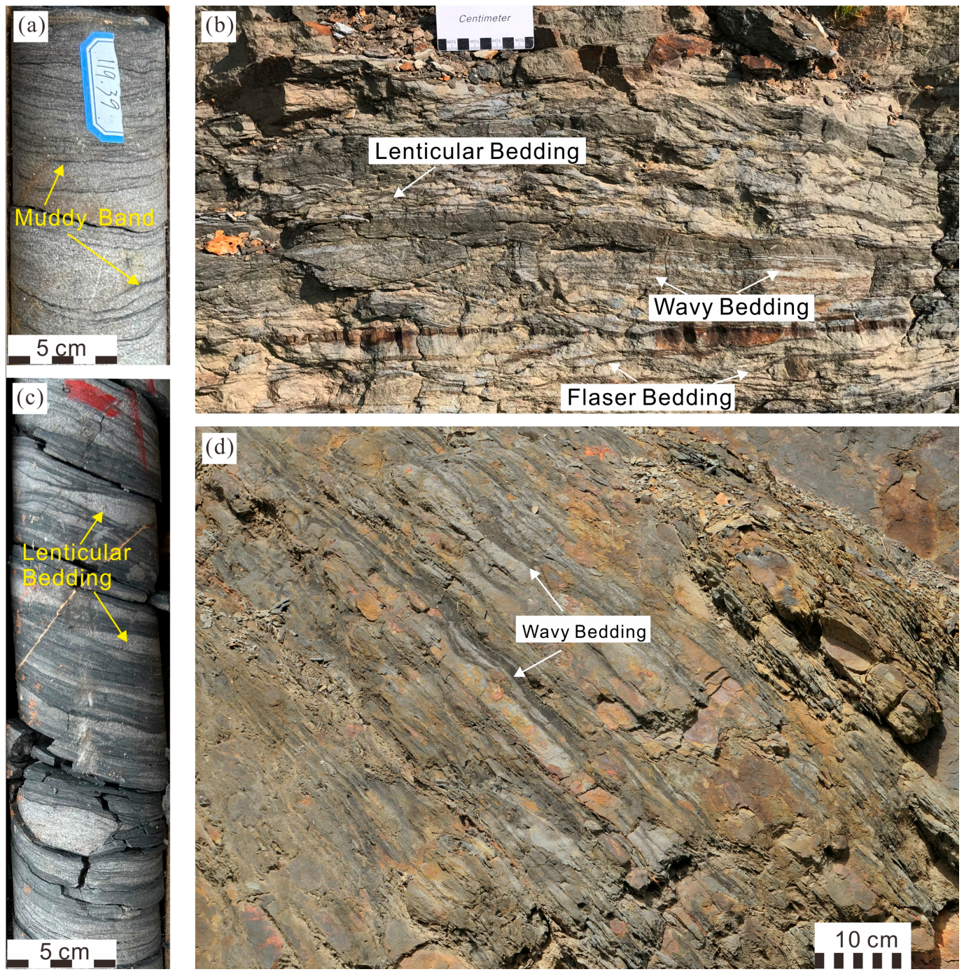
Heterolithic bedding is widely developed in the Longtan Formation and consists of rhythmic alternations between sandstone and mudstone layers. Based on qualitative assessment of the relative proportions of sand and mud, the lateral continuity of sand and mud layers, and bedding geometry, three major types are recognized: flaser bedding, wavy bedding, and lenticular bedding [40] (Figure 13).
Figure 13.
Heterolithic bedding in the Longtan Formation. (a,c) show core photographs from borehole ZK402 in the Tongling area; (b,d) show outcrop photographs from the Chaohu area. Scale bars are indicated separately in each photograph.
Flaser bedding is sandstone-dominated and consists mainly of ripple-laminated sandstone with discontinuous mud layers preserved within ripple troughs. The muddy layers are generally thin and irregularly distributed, whereas sandstone forms the continuous framework of the deposit. Wavy bedding contains relatively balanced proportions of sandstone and mudstone. Sandstone laminae and muddy layers show continuous undulating bedding surfaces, forming alternating wave-like structures. The wave height generally ranges from 2 to 8 cm, with wavelengths of approximately 5–30 cm. Lenticular bedding is mud-dominated and contains isolated sandstone lenses enclosed within a continuous muddy matrix. The sandstone lenses are commonly discontinuous and occur within otherwise fine-grained deposits. Individual sand lenses vary considerably in size, with long-axis dimensions generally ranging from 3 to 30 cm. Bidirectional current ripples can locally be observed within these sandstone lenses (Figure 13c). The vertical transition among flaser, wavy, and lenticular bedding is commonly observed within individual sedimentary successions, reflecting systematic changes in the relative abundance of sand and mud deposition.
Interpretation
Heterolithic bedding forms under conditions where depositional energy fluctuates between levels sufficient for transporting sand and levels dominated by suspension settling. Unlike environments characterized by either continuous traction transport or persistent suspension deposition, heterolithic deposits record repeated alternations between these two depositional modes.
Flaser bedding represents relatively high-energy conditions among heterolithic facies. During energetic flow periods, ripples or dunes migrate under traction transport, producing continuous sandy layers. During subsequent low-energy intervals, suspended mud settles preferentially within ripple troughs, where local topographic depressions provide protected sites for fine-grained accumulation. Wavy bedding represents an intermediate depositional condition in which sand transport and mud deposition occur with comparable importance. Frequent variations in current strength result in repeated alternations between ripple migration and suspension settling, producing relatively balanced sand–mud proportions. Lenticular bedding reflects lower-energy conditions where suspension deposition dominates and sand transport becomes intermittent. Under such conditions, isolated sand lenses are preserved within muddy deposits because the energy available for transporting sand is insufficient to produce continuous sandy layers.
The vertical succession from flaser to wavy to lenticular bedding therefore reflects changes in hydrodynamic energy and sediment availability. Within the tidally influenced depositional system inferred from the broader sedimentary assemblage, such variations may result from changes in current strength, water depth, sediment supply, and position within the depositional system.
4.2.5. Thick–Thin Sandstone Bundles
Description
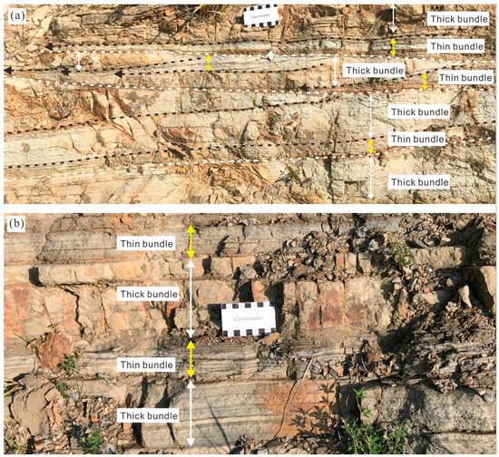
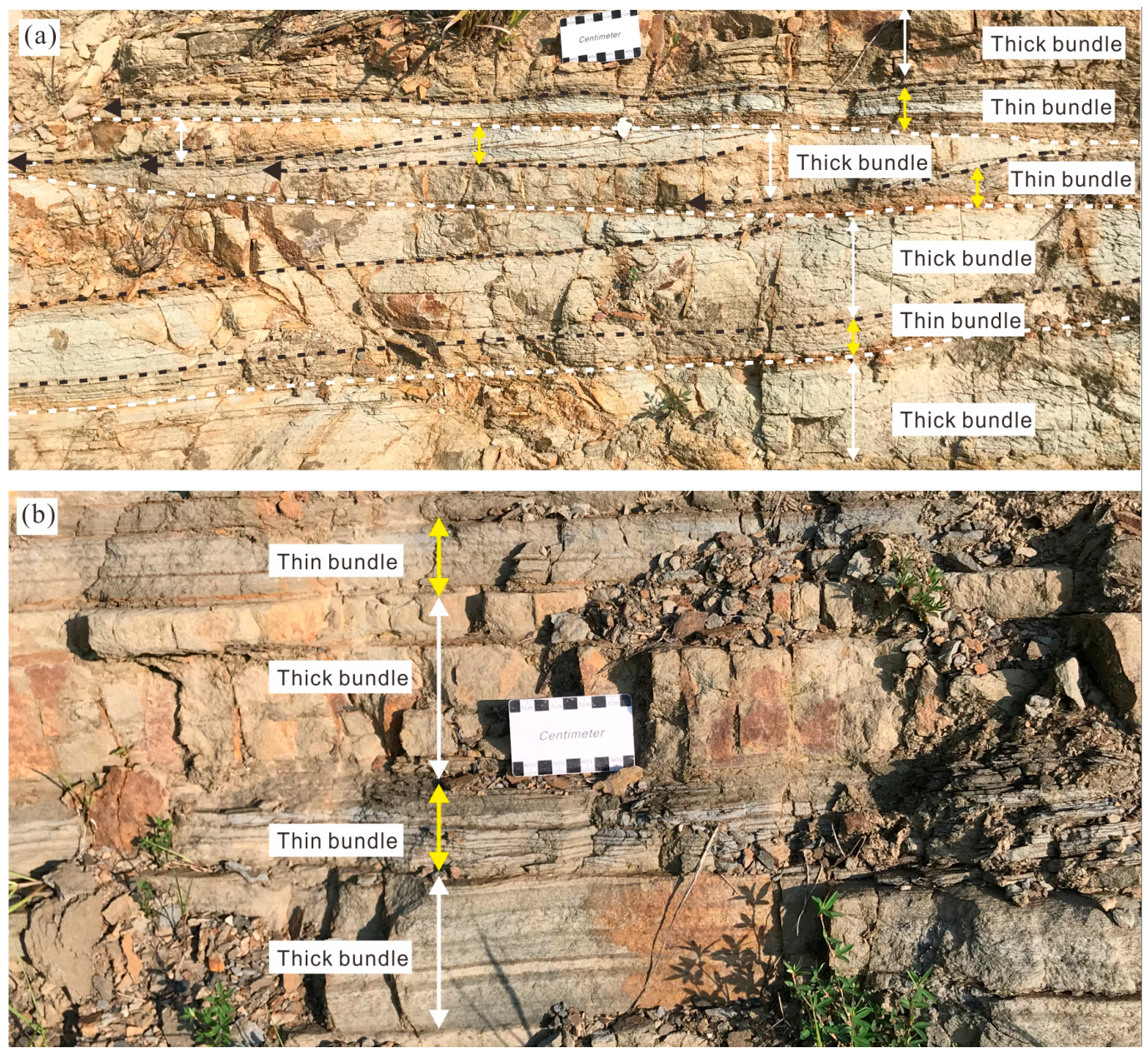
Thick–thin sandstone bundles are developed locally within cross-bedded sandstone intervals of the Longtan Formation (Figure 14). They are characterized by repeated alternations of relatively thick and thin sandstone laminae or foreset packages [41,42], forming bundles with thicknesses varying from the centimeter to decimeter scale. Individual bundles generally consist of several successive laminae with similar internal structures but different thicknesses. Thick sandstone layers are commonly composed of well-developed cross-laminae, whereas thinner layers may contain finer-grained material or increased mud content and may preserve mud drapes.
Figure 14.
Thick–thin sandstone bundles in the outcrop of the Chaohu area. (a,b) Representative outcrop photographs.
Interpretation
The alternation of relatively thick and thin bundles is consistent with variations in tidal current strength and related sediment transport intensity. Relatively strong tidal currents may enhance sand transport and promote the migration of subaqueous bedforms, resulting in the deposition of thicker sandstone laminae or foreset packages. In contrast, weaker currents may reduce sediment transport capacity and favor the development of thinner sandstone laminae or more mud-rich intervals, where suspension deposition becomes relatively more important. The resulting variations in bundle thickness may also be influenced by sediment availability and subsequent erosion. The preservation of sandstone bundles depends on several factors, including sedimentation rate, erosion intensity, sediment availability, and the duration of depositional exposure. In natural tidal environments, subsequent current activity may erode previously deposited laminae or remove parts of individual bundles, resulting in partial preservation of the original depositional record.
4.3. Distribution of Tidal Sedimentary Structures Among Different Depositional Facies
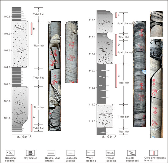
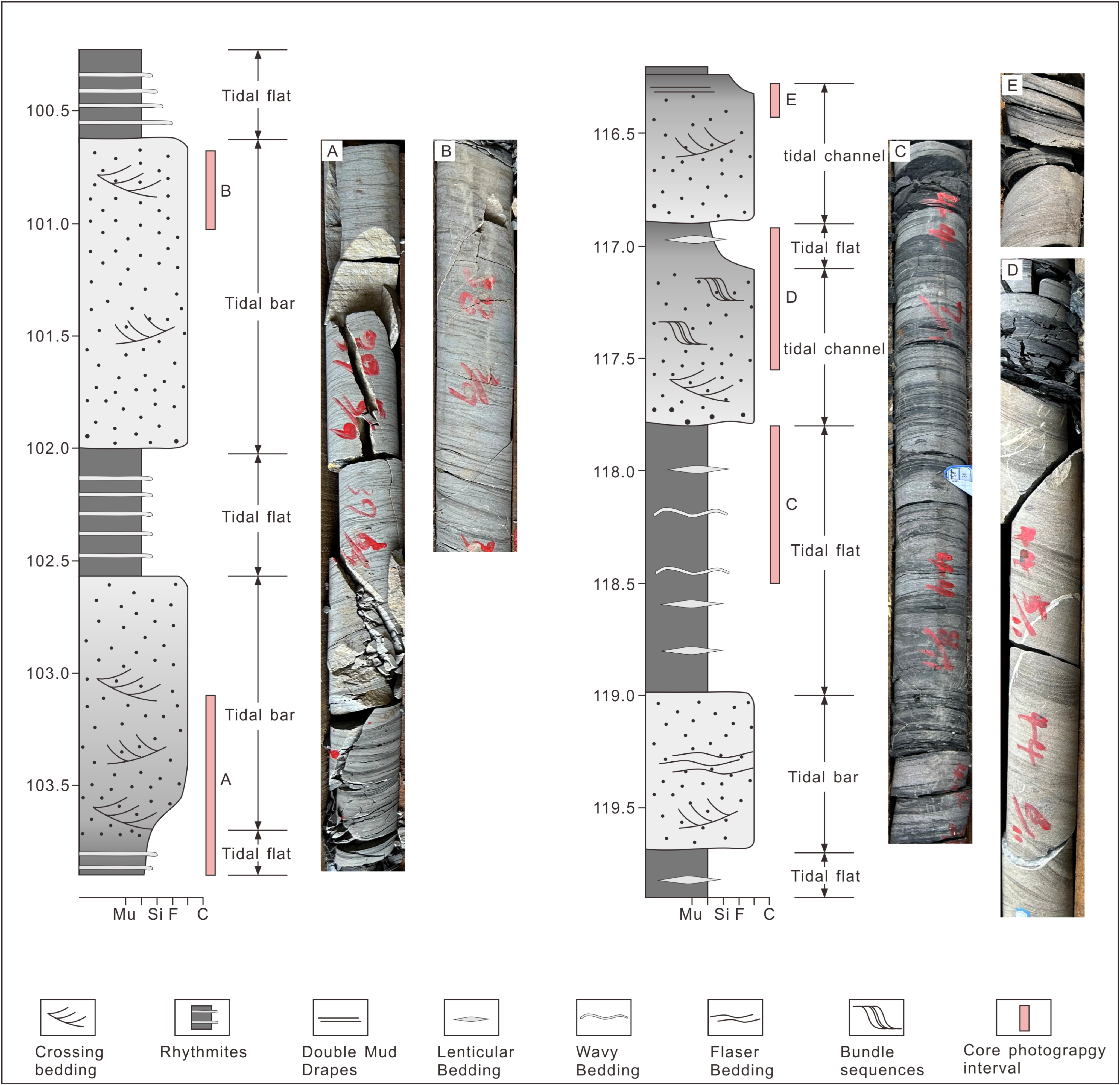
The sedimentary structures of the Longtan Formation show variations in their occurrence among sandstone-dominated and fine-grained heterolithic intervals, as documented by outcrop observations and borehole core data from the Chaohu, Tongling, and Xuancheng areas. The ZK402 borehole provides an example of these variations within a vertical sedimentary succession (Figure 15). Depositional facies were evaluated by considering lithology, grain size, contact relationships, and vertical facies successions, together with the associated sedimentary structures. In this analysis, lithological and stratigraphic characteristics provide the framework for interpreting depositional environments, whereas individual sedimentary structures are used as additional evidence of the processes operating within those environments.
Figure 15.
Core lithologic column of the Longtan Formation from borehole ZK402, Tongling area. Grain-size abbreviations: Mu, mud; Si, silt; F, fine sand; C, coarse sand.
Overall, bidirectional cross-bedding, sandstone bundles, and flaser bedding are mainly developed in sandstone-dominated intervals interpreted as tidal sand bars and tidal channels. These deposits are dominated by medium- to fine-grained sandstone and record relatively strong current activity associated with sediment transport and bedform migration. In contrast, rhythmic sand–mud laminae, and heterolithic bedding are commonly developed in finer-grained intervals interpreted as tidal flat deposits, which are characterized by higher mud content. The increased occurrence of these structures reflects more frequent alternations between traction deposition and suspension settling under fluctuating and relatively lower-energy conditions. Double mud drapes commonly occur within sandstone intervals and are interpreted as recording alternations between current-driven sand deposition and slack-water mud settling.
The distribution of tidal structures within the tidal depositional systems of Longtan Formation indicates that different sedimentary facies preserve distinct combinations of tidal indicators. High-energy sandy intervals preferentially preserve structures related to bedform migration and current reversal, whereas lower-energy heterolithic intervals more commonly record suspension deposition and repeated sand–mud alternations. Therefore, the occurrence and preservation of tidal sedimentary structures are strongly influenced by depositional facies and hydrodynamic energy regimes.
5. Discussion
5.1. Recognizing Ancient Tidal Depositional Systems from Integrated Sedimentological Evidence
The recognition of ancient tidal depositional systems remains challenging because tidal processes commonly interact with fluvial and wave processes in transitional environments [43,44,45]. In many ancient successions, individual sedimentary structures may not provide unequivocal evidence of tidal influence because similar features can occasionally develop under other hydrodynamic conditions. Therefore, reliable identification of ancient tidal systems requires an integrated assessment of sedimentary structures, their spatial distribution, and the broader depositional context.
The Longtan Formation provides an example of how multiple sedimentological indicators can be combined to improve the recognition of ancient tidal deposits. Bidirectional cross-bedding records repeated changes in sediment transport direction, providing evidence of reversing flow conditions. However, bidirectional structures alone are insufficient to define a tidal system because local flow reversals may also occur in other restricted coastal environments. Their significance is enhanced by their association with mud drapes, rhythmic sand–mud laminae, and thick–thin sandstone bundles. Although fluvial processes can also produce cross-bedding and heterolithic deposits, predominantly unidirectional river flows cannot readily explain the combined occurrence of opposing current indicators, mud drapes, and repeated traction-suspension alternations.
Mud drapes and rhythmic sand–mud alternations provide complementary evidence of changes in depositional conditions. These structures preserve transitions between active sediment transport and low-energy suspension settling, which are characteristic of environments affected by hydrodynamic fluctuations. Heterolithic bedding further records repeated competition between traction transport and suspension deposition, reflecting changes in sediment availability and flow conditions. Wave-induced oscillatory motion can also produce bidirectional flow. Nevertheless, the association of mud drapes, rhythmic sand–mud alternations, together with bidirectional cross-bedding, supports the interpretation of tidal influence.
An important aspect of the Longtan Formation is that these structures are not randomly distributed but show clear facies dependence. As demonstrated by the ZK402 borehole succession, sandstone-dominated intervals preferentially preserve structures associated with bedform migration and current activity, whereas finer-grained intervals more commonly contain rhythmic sand–mud laminae and heterolithic bedding associated with fluctuating energy conditions. These contrasting structural associations suggest that different depositional environments within the same coastal system may record and preserve different aspects of tidal processes. Therefore, ancient tidal systems should be interpreted within their sedimentary context rather than through the presence of isolated diagnostic structures. This integrated approach is particularly important for deciphering tide-influenced transitional successions, where tidal, fluvial, and wave processes commonly interact and individual sedimentary features may have ambiguous origins.
5.2. Paleogeographic Control on Tidal Sedimentation in the Late Permian Lower Yangtze Basin
Although tidal processes are globally widespread, strong tidal dominance does not occur in all coastal settings. The development and preservation of tidal sedimentation in the Longtan Formation were closely related to the paleogeographic configuration of the Lower Yangtze Basin during the Late Permian.
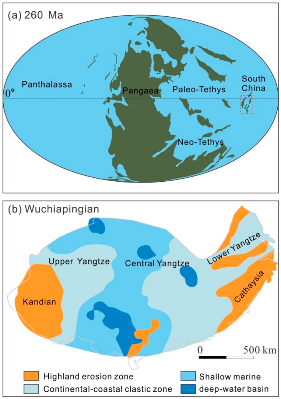
During the deposition of Longtan Formation, the Lower Yangtze Basin was characterized by a shallow-water and relatively low-relief coastal setting, with sediments mainly supplied from the surrounding Cathaysian landmass [46,47] (Figure 16). However, the paleogeographic configuration of the Cathaysian uplift was unfavorable for the development of large-scale fluvial systems. Unlike extensive continental source regions connected to major drainage networks, the uplifted areas surrounding the basin were relatively limited in extent and were not connected to other large landmasses during the Late Permian. Consequently, the development of large catchment systems and high-discharge rivers was unlikely, although local or episodic fluvial systems likely transported terrestrial sediments from the surrounding source areas into the coastal basin. This interpretation is further supported by the regional stratigraphic framework, in which the underlying Gufeng Formation and overlying Dalong Formation are dominated by organic-rich marine shales. These deposits indicate that marine environments prevailed in the surrounding regions before and after the deposition of Longtan Formation, suggesting that these regions did not represent persistent large-scale terrestrial source areas. Therefore, local fluvial systems may have supplied siliciclastic sediments to the coastal basin in response to relative sea-level fall during the deposition of the Longtan Formation, whereas tidal currents played an important role in their subsequent redistribution and reworking within the shallow-water coastal environment. It should be noted that this interpretation is primarily based on regional paleogeographic reconstructions and requires further testing using independent provenance evidence, although such an investigation is beyond the scope of the present study.
The paleogeographic position of South China during the Late Permian also influenced the relative importance of wave processes. At this time, paleogeographic reconstructions place the South China Block along the eastern margin of the Paleo-Tethys Ocean, with the Lower Yangtze Basin inferred to have been located at low paleolatitudes near the equator [48,49,50,51] (Figure 16). Although the precise paleolatitude remains uncertain, these reconstructions consistently indicate a broadly equatorial setting. This inferred equatorial setting may have been associated with relatively weak prevailing winds, potentially limiting locally generated wave activity. In addition, following the termination of the Late Paleozoic Ice Age during the Middle Permian, global climate gradually shifted toward warmer conditions. The temperature contrast between low and high latitudes remained relatively small, resulting in relatively weak thermal gradients and limited atmospheric circulation intensity [52]. Such conditions may have been less favorable for the frequent generation and development of strong storms and may have reduced the potential for wave-driven sediment reworking. The influence of these climatic conditions on wave activity would also have been modulated by basin geometry and fetch. In a broader context, modern tidal depositional systems show a preferential distribution in equatorial low-latitude regions, where tidal deposits occupy extensive coastal areas [53]. Although modern distributions cannot be directly applied to ancient systems, they provide useful analogical support that low-latitude coastal settings may be particularly favorable for tidal sedimentation.
In addition to the limited influence of rivers and waves, the regional paleogeographic configuration of the Lower Yangtze Basin further promoted tidal circulation. Paleogeographic reconstructions indicate that the basin during the deposition of Longtan Formation was characterized by a NE-opening, semi-enclosed coastal configuration, with landmasses restricting the basin to the north and south [46,50] (Figure 16). Such a semi-enclosed embayment could have facilitated tidal water exchange and the landward propagation of tidal currents. This interpretation is consistent with the sedimentological evidence documented in the Longtan Formation, particularly the widespread occurrence of bidirectional cross-bedding and associated mud drapes, which records recurrent flow reversals rather than persistent unidirectional transport. The coexistence of bidirectional and locally unidirectional cross-bedding further suggests spatial and temporal variations in residual current strength within the tidal system. However, because the borehole core used in this study was not geographically oriented and systematic paleocurrent azimuths were not obtained from the outcrop sections, the observed opposing flow directions cannot be directly correlated with the NE–SW orientation of the reconstructed basin. Accordingly, the relationship between tidal-current orientation and basin geometry is interpreted qualitatively rather than as a quantitative paleocurrent reconstruction.
Collectively, these paleogeographic conditions may have reduced the relative influence of fluvial and wave processes while favoring the preservation potential of tidal sedimentary structures. The Late Permian Lower Yangtze Basin therefore provides a useful example of how regional paleogeographic configuration influences the sedimentary expression and preservation of ancient tidal depositional systems.
Figure 16.
Global paleogeographic reconstruction of plate positions during the Late Permian (260 Ma) (a) (modified after reference [54]) and Paleogeographic map of the Yangtze region during the Wuchiapingian Stage (b) (modified after reference [50]).
5.3. Sedimentary Influences on Reservoir Quality and Implications for Reservoir Evaluation
Tidal depositional processes can influence reservoir characteristics by affecting sediment sorting, sand–mud distribution, and the internal architecture of sandstone bodies [55,56]. Variations in tidal hydrodynamic conditions affect the development of different sedimentary structures and depositional textures, which can be associated with differences in pore connectivity, permeability pathways, and reservoir heterogeneity. Therefore, sedimentary structures preserved in tidal deposits provide useful information for understanding the spatial variability of reservoir properties.
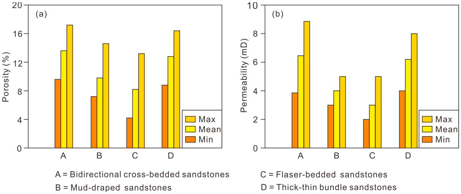
In the Longtan Formation, different tidal sedimentary structures represent contrasting depositional environments and sedimentary processes. Sandstones with bidirectional cross-bedding generally formed under relatively high-energy conditions associated with active bedform migration. Sediment transport and reworking under such conditions may favor the deposition of relatively clean sandstone. In contrast, flaser-bedded sandstones and mud-rich layered sandstones formed under lower-energy conditions characterized by frequent alternations between traction transport and suspension settling, resulting in the development of muddy laminae and heterolithic textures. These differences in sandstone texture and muddy-material distribution are relevant to reservoir properties, as illustrated by the porosity and permeability measurements of the analyzed sandstone types (Figure 17). Bidirectional cross-bedded sandstones generally exhibit the highest porosity and permeability, followed by sandstones with thick–thin bundles and sandstones with double mud drapes, whereas flaser-bedded sandstones show the lowest values.
Figure 17.
Porosity and permeability characteristics of four tidal sandstone types. (a) Porosity; (b) permeability. (A) bidirectional cross-bedded sandstone (n = 4), (B) mud-draped sandstone (n = 3), (C) flaser-bedded sandstone (n = 4), and (D) thick–thin bundle sandstone (n = 4).
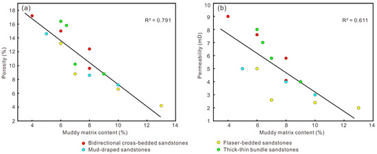
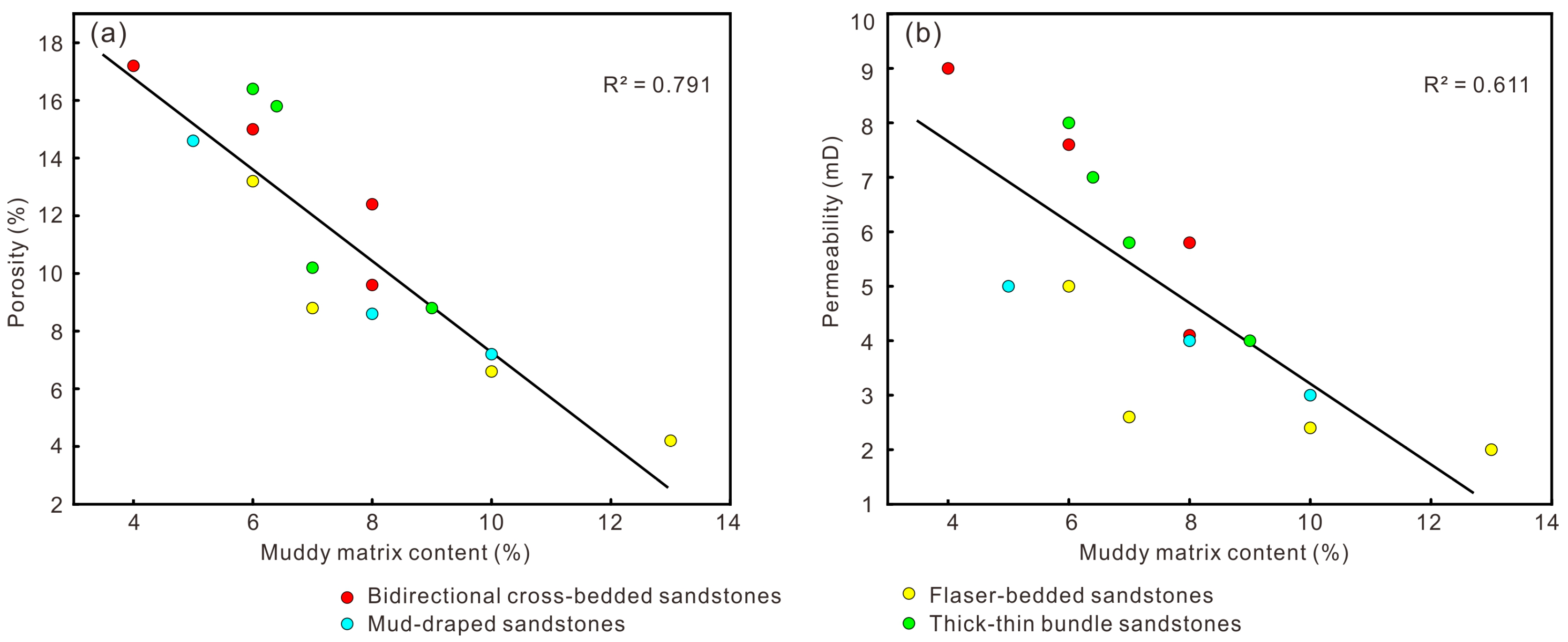
The relationship between muddy matrix and reservoir properties is further supported by petrographic and petrophysical data. Muddy matrix content is negatively correlated with both porosity (Pearson r = −0.889, R2 = 0.791, p < 0.001) and permeability (Pearson r = −0.782, R2 = 0.611, p < 0.001) (Figure 18). Fine-grained matrix occupying intergranular spaces can reduce effective pore volume and restrict pore connectivity, providing a plausible explanation for the observed negative correlations. These correlations may also partly reflect differences among sandstone types, while other depositional and diagenetic factors may contribute to reservoir-quality variation. Thin-section observations show that cement contents vary from 0 to 17% among the analyzed sandstones, indicating heterogeneous cementation. The strong negative correlations highlight the importance of muddy matrix content in reservoir-quality variation and the relevance of depositional sand–mud partitioning to reservoir evaluation.
Figure 18.
Relationships between muddy matrix content and reservoir properties of different tidal sandstone types in the Longtan Formation. (a) Matrix content versus porosity; (b) matrix content versus permeability.
The findings from the Longtan Formation provide a sedimentological framework for reservoir evaluation in ancient tide-influenced successions. Integrating sedimentary structures with petrographic and petrophysical data can help distinguish sandstone intervals with contrasting reservoir characteristics and guide the identification of relatively favorable reservoirs. This integrated approach may also improve the characterization of reservoir heterogeneity in comparable marine–terrestrial transitional deposits [57].
6. Conclusions
This study integrates sedimentological and paleogeographic evidence to decipher the Late Permian tidal depositional system of the Longtan Formation in the Lower Yangtze region. The main conclusions are as follows:
The Longtan Formation sandstones are mainly fine- to medium-grained and characterized by a quartz-rich framework with relatively high compositional maturity but comparatively low textural maturity. Grain-size distributions are dominated by saltation populations and indicate multiple sediment-transport modes under variable hydrodynamic conditions.
Diverse tidal sedimentary structures, including bidirectional cross-bedding, double mud drapes, rhythmic sand–mud laminae, heterolithic bedding, and thick–thin sandstone bundles, are widely preserved in the Longtan Formation. Their characteristics and facies-dependent distribution record current reversals, slack-water deposition, and fluctuating hydrodynamic conditions, which provide multiple lines of evidence for tidal influence.
The paleogeographic configuration of the Late Permian Lower Yangtze Basin may have provided conditions favorable for tidal sedimentation. The limited development of large fluvial systems, potentially reduced wave influence, and the NE-opening, semi-enclosed basin geometry may have collectively favored the development and preservation of tidal deposits.
Reservoir properties vary among the analyzed tidal sandstone types, with bidirectional cross-bedded sandstones exhibiting relatively high porosity and permeability and flaser-bedded sandstones showing lower values. Muddy matrix content is strongly negatively correlated with both porosity and permeability across the pooled dataset, highlighting its importance as a petrographic indicator of reservoir-quality variation. Integrating sedimentary structures, petrographic characteristics, and petrophysical properties provides a useful framework for evaluating reservoir heterogeneity and contrasting reservoir properties in ancient tide-influenced successions.
Future studies integrating additional borehole and outcrop data, systematic paleocurrent measurements, and detailed petrographic and diagenetic analyses would help strengthen the interpretation of tidal depositional systems, further constrain the controls on reservoir quality, and assess the applicability of these findings across the Lower Yangtze Basin and comparable ancient tidal systems.
Author Contributions
Conceptualization, C.Z.; Investigation, C.F., T.W., H.F. and J.X.; Writing—Original Draft Preparation, C.Z.; Writing—Review and Editing, C.Z. and M.T.; Project Administration, H.D. and W.S. All authors have read and agreed to the published version of the manuscript.
Funding
This study was supported by the National Natural Science Foundation of China (42302124), National Key Research and Development Program of China (2022YFF0800401), Geological Survey Project of China Geological Survey (DD20221662, DD202607303304), and the Open Foundation of Anhui Engineering Research Center for Unconventional Natural Gas (MTKCY-2024-32-7).
Data Availability Statement
The data presented in this study are available upon request from the corresponding author.
Conflicts of Interest
The authors declare no conflicts of interest.
References
- Willis, B.J.; Gabel, S. Sharp-based, tide-dominated deltas of the Sego Sandstone, Book Cliffs, Utah, USA. Sedimentology 2001, 48, 479–506. [Google Scholar] [CrossRef] [Scilit]
- Dalrymple, R.W.; Baker, E.K.; Harris, P.T.; Hughes, M.G. Sedimentology and stratigraphy of a tide-dominated, foreland-basin delta (Fly River, Papua New Guinea). SEPM Spec. Publ. 2003, 76, 147–173. [Google Scholar] [CrossRef] [Scilit]
- Gugliotta, M.; Saito, Y.; Nguyen, V.L.; Ta, T.K.O.; Tamura, T. Sediment distribution and depositional processes along the fluvial to marine transition zone of the Mekong River delta, Vietnam. Sedimentology 2019, 66, 146–164. [Google Scholar] [CrossRef] [Scilit]
- Hori, K.; Saito, Y.; Zhao, Q.; Wang, P. Architecture and evolution of the tide-dominated Changjiang (Yangtze) River delta, China. Sediment. Geol. 2002, 146, 249–264. [Google Scholar] [CrossRef] [Scilit]
- Walsh, J.P.; Nittrouer, C.A.; Palinkas, C.M.; Ogston, A.S.; Sternberg, R.W.; Brunskill, G.J. Clinoform mechanics in the Gulf of Papua, New Guinea. Cont. Shelf Res. 2004, 24, 2487–2510. [Google Scholar] [CrossRef] [Scilit]
- Gallo, M.N.; Vinzon, S.B. Generation of overtides and compound tides in Amazon estuary. Ocean Dyn. 2005, 55, 441–448. [Google Scholar] [CrossRef] [Scilit]
- Zhang, W.; Feng, H.; Hoitink, A.J.F.; Zhu, Y.; Gong, F.; Zheng, J. Tidal impacts on the subtidal flow division at the main bifurcation in the Yangtze River Delta. Estuar. Coast. Shelf Sci. 2017, 196, 301–314. [Google Scholar] [CrossRef] [Scilit]
- Escalona, A.; Mann, P. Sequence-stratigraphic analysis of Eocene clastic foreland basin deposits in central Lake Maracaibo using high-resolution well correlation and 3-D seismic data. AAPG Bull. 2006, 90, 581–623. [Google Scholar] [CrossRef] [Scilit]
- Guzmán, J.I.; Fisher, W.L. Early and middle Miocene depositional history of the Maracaibo Basin, western Venezuela. AAPG Bull. 2006, 90, 625–655. [Google Scholar] [CrossRef] [Scilit]
- Zhang, C.C.; Fang, C.G.; Liu, T.; Wu, T.; Shao, W.; Liao, S.B.; Xu, J.L. Research progress on flood-triggered hyperpycnal flows in sedimentary basins. East China Geol. 2024, 45, 49–61. (In Chinese) [Google Scholar]
- Li, S.L.; Xu, L.; Yu, X.H.; Hou, G.W.; Hu, Y.; Gao, Z.P. Marine transgressions and characteristics of tide-dominated sedimentary systems in the Oligocene, Xihu sag, East China Sea Shelf Basin. J. Palaeogeogr. 2018, 20, 1023–1032. (In Chinese) [Google Scholar]
- Boyd, R.; Dalrymple, R.; Zaitlin, B.A. Classification of clastic coastal depositional environments. Sediment. Geol. 1992, 80, 139–150. [Google Scholar] [CrossRef] [Scilit]
- Dalrymple, R.W.; Zaitlin, B.A.; Boyd, R. Estuarine facies models: Conceptual basis and stratigraphic implications. J. Sediment. Res. 1992, 62, 1130–1146. [Google Scholar] [CrossRef] [Scilit]
- Ainsworth, R.B.; Vakarelov, B.K.; Nanson, R.A. Dynamic spatial and temporal prediction of changes in depositional processes on clastic shorelines: Toward improved subsurface uncertainty reduction and management. AAPG Bull. 2011, 95, 267–297. [Google Scholar] [CrossRef] [Scilit]
- Allison, M.A.; Khan, S.R.; Goodbred, S.L., Jr.; Kuehl, S.A. Stratigraphic evolution of the late Holocene Ganges-Brahmaputra lower delta plain. Sediment. Geol. 2003, 155, 317–342. [Google Scholar] [CrossRef] [Scilit]
- Fan, D.D.; Wang, Y.; Liu, M. Classifications, sedimentary features and facies associations of tidal flats. J. Palaeogeogr. 2013, 2, 66–80. [Google Scholar]
- Fan, D.D.; Tu, J.B.; Shang, S.; Cai, G.F. Characteristics of tidal-bore deposits and facies associations in the Qiantang Estuary, China. Mar. Geol. 2014, 348, 1–14. [Google Scholar] [CrossRef] [Scilit]
- Guo, Q.H.; Shi, S.T.; Jin, Z.K.; Li, Y.; Wang, J.Y.; Ren, Y.L.; Wang, L. Characteristics and geological significance of tidal channels in an estuarine tidal flat: A case study from the Qiantang River estuary. Acta Sedimentol. Sin. 2022, 40, 182–191. (In Chinese) [Google Scholar]
- Peng, Y.; Steel, R.J.; Gong, C.L.; Wei, X.J.; Sheng, L.N. A review on tidal depositional processes and characteristics. J. Palaeogeogr. 2023, 25, 1069–1089. (In Chinese) [Google Scholar]
- Galloway, W.E. Sediments and stratigraphic framework of the Copper River fan-delta, Alaska. J. Sediment. Res. 1976, 46, 726–737. [Google Scholar] [CrossRef] [Scilit]
- Li, L.L.; Ma, W.J. Diagenesis and pore evolution of tight sand reservoir of the Permian Longtan formation in Huangqiao area, lower Yangtze region. Reserv. Eval. Dev. 2013, 3, 10–14. (In Chinese) [Google Scholar]
- Wu, H.; Yao, S.P.; Jiao, K.; Zhou, P. Shale-gas exploration prospect of Longtan Formation in the Lower Yangtze area of China. J. China Coal Soc. 2013, 38, 870–876. (In Chinese) [Google Scholar]
- Tian, R.C.; Gong, J.M.; Tian, J.P.; Xu, C.F.; Chen, Z.Q.; Cheng, Q.S. Stratigraphic features of the coal-bearing Longtan Formation in the Lower Yangtze area. Mar. Geol. Front. 2016, 32, 60–65. (In Chinese) [Google Scholar]
- Ding, J.H.; Sun, J.S.; Zhang, J.C.; Yang, X.T.; Shi, G.; Wang, R.Y.; Huang, B.; Li, H.L. Geochemical characteristics and its significance of Longtan Formation marine-continental transitional shale in southern Anhui Province, China. Nat. Gas. Geosci. 2023, 34, 510–524. (In Chinese) [Google Scholar]
- Shi, G.; Huang, Z.Q.; Zheng, H.J.; Xu, Z.Y.; Zhao, M.H.; Shao, W.; Yin, Q.C.; Zhou, D.R.; Fang, C.G.; Teng, L.; et al. Drilling discovery of “Three Gas One Oil” in the Permian strata of Lower Yangtze area. Geol. China 2018, 45, 416–417. (In Chinese) [Google Scholar]
- Li, J.Q.; Zhang, C.C.; Huang, Z.Q.; Fang, C.G.; Wu, T.; Shao, W.; Zhou, D.R.; Teng, L.; Wang, Y.J.; Huang, N. Discovery of overpressure gas reservoirs in the complex structural area of the Lower Yangtze and its key elements of hydrocarbon enrichment. Geol. Bull. China 2021, 40, 577–585. (In Chinese) [Google Scholar]
- Liu, T.; Wu, T.; Fang, C.G.; Zhang, C.C.; Shao, W.; Liao, S.B. Overpressure characteristics and genesis of the Triassic gas reservoirs in Wuwei Depression of Lower Yangtze Region. East China Geol. 2023, 44, 415–423. (In Chinese) [Google Scholar]
- Sun, J.; Wang, J.Q.; Gong, J.M. Abundance of organic matters in Mesozoic-Paleozoic marine source rocks of inland area of the Lower Yangtze and its bearing on lithofacies paleogeography. Mar. Geol. Front. 2016, 32, 22–28. (In Chinese) [Google Scholar]
- Gao, S.L.; Tan, S.Z.; Chen, C.F.; Zhou, P. Permian lithofacies paleogeography of the South Yellow Sea area, Lower Yangtze plate and its implications for petroleum exploration. Mar. Geol. Front. 2021, 37, 53–60. (In Chinese) [Google Scholar]
- Zhang, C.C.; Fang, C.G.; Li, J.Q.; Xing, G.F.; Tan, M.X.; Wu, T.; Shao, W.; Liu, T.; Shi, G. Origin and key enrichment factors of helium resource in the Lower Yangtze Region, Eastern China. ACS Omega 2025, 10, 7027. [Google Scholar] [CrossRef] [Scilit]
- Zhang, C.C.; Fang, C.G.; Liu, T.; Li, J.Q.; Zhou, D.R.; Xu, J.L.; Tan, M.X. Discovery of slump-type gravity flows in the Ordovician-Silurian transition of the southern Anhui area, Lower Yangtze block: New sedimentological evidence of Jiangnan slope uplift. Acta Geol. Sin. 2026, 100, 1063–1078. (In Chinese) [Google Scholar]
- Visher, G.S. Grain size distributions and depositional process. J. Sediment. Petrol. 1969, 39, 1074–1106. [Google Scholar] [CrossRef] [Scilit]
- Tessier, B.; Archer, A.W.; Lanier, W.P.; Feldman, H.R. Comparison of ancient tidal rhythmites (Carboniferous of Kansas and Indiana, USA) with modern analogues (the Bay of Mont-Saint-Michel, France). In Tidal Signatures in Modern and Ancient Sediments; Blackwell Publishing Ltd.: Oxford, UK, 1995; pp. 259–271. [Google Scholar]
- Williams, G.E. Upper Proterozoic tidal rhythmites, South Australia: Sedimentary features, deposition, and implications for the Earth’s paleorotation. In Clastic Tidal Sedimentology; Smith, D.G., Reinson, G.E., Zaitlin, B.A., Rahmani, R.A., Eds.; Canadian Society of Petroleum Geologists: Calgary, AB, Canada, 1991; Volume 16, pp. 161–177. [Google Scholar]
- Visser, M.J. Neap-spring cycles reflected in Holocene subtidal large-scale bedform deposits: A preliminary note. Geology 1980, 8, 543–546. [Google Scholar] [CrossRef] [Scilit]
- Archer, A.W.; Johnson, T.W. Modelling of cyclic tidal rhythmites (Carboniferous of Indiana and Kansas, Precambrian of Utah, USA) as a basis for reconstruction of intertidal positioning and palaeotidal regimes. Sedimentology 1997, 44, 991–1010. [Google Scholar] [CrossRef] [Scilit]
- Liu, S.Q.; Zhang, C.M.; Zhu, R.; Li, J.C.; Wang, Z.Y. Thickness Variation Characteristics of Tidal Rhythmites—An Example From the Pinghu Formation, Xihu Sag, East China Sea Shelf Basin. Front. Earth Sci. 2022, 10, 698061. [Google Scholar] [CrossRef] [Scilit]
- Bridge, J.; Demicco, R. Earth Surface Processes, Landforms and Sediment Deposits; Cambridge University Press: Cambridge, UK, 2008; p. 830. [Google Scholar]
- Kvale, E.P. Tidal constituents of modern and ancient tidal rhythmites: Criteria for recognition and analyses. In Principles of Tidal Sedimentology; Davis, R.A., Jr., Dalrymple, R.W., Eds.; Springer: Dordrecht, The Netherlands, 2012; pp. 1–17. [Google Scholar]
- Reineck, H.E.; Wunderlich, F. Classification and origin of flaser and lenticular bedding. Sedimentology 1968, 11, 99–104. [Google Scholar] [CrossRef] [Scilit]
- Terwindt, J.H.J. Lithofacies of inshore estuarine and tidal inlet deposits. Geol. Mijnb. 1971, 50, 515–526. [Google Scholar]
- Nio, S.; Yang, C.S. Diagnostic attributes of clastic tidal deposits: A review. In Clastic Tidal Sedimentology; Smith, D.G., Reinson, G.E., Zaitlin, B.A., Rahmani, R.A., Eds.; Canadian Society of Petroleum Geology Memoir: Calgary, AB, Canada, 1991; Volume 16, pp. 3–28. [Google Scholar]
- Dashtgard, S.E.; Vaucher, R.; Yang, B.; Dalrymple, R.W. Wave-dominated to tide-dominated coastal systems: A unifying model for tidal shorefaces and refinement of the coastal-environments classification scheme. Geosci. Can. 2021, 48, 5–22. [Google Scholar] [CrossRef] [Scilit]
- Gugliotta, M.; Saito, Y.; Ta, T.K.O.; Nguyen, V.L.; La Croix, A.D.; Wang, Z.; Tamura, T.; Nakashima, R.; Lieu, K.P. Late Holocene stratigraphic evolution and sedimentary facies of an active to abandoned tide-dominated distributary channel and its mouth bar. Sedimentology 2022, 69, 1151–1178. [Google Scholar] [CrossRef] [Scilit]
- Zuchuat, V.; Gugliotta, M.; Poyatos-Moré, M.; van Der Vegt, H.; Collins, D.S.; Vaucher, R. Mixed depositional processes in coastal to shelf environments: Towards acknowledging their complexity. Depos. Rec. 2023, 9, 206–212. [Google Scholar] [CrossRef] [Scilit]
- Feng, Z.Z.; He, Y.B.; Wu, S.H. Lithofacies paleogeography of Permian of middle and lower Yangtze region. Acta Sedimentol. Sin. 1993, 3, 13–24. (In Chinese) [Google Scholar]
- Feng, Z.Z.; Yang, Y.Q.; Jin, Z.K.; He, Y.B.; Wu, S.H.; Xin, W.J.; Bao, Z.D.; Tan, J. Lithofacies paleogeography of Permian of South China. Acta Sedimentol. Sin. 1996, 2, 3–12. (In Chinese) [Google Scholar]
- Enkin, R.J.; Yang, Z.Y.; Chen, Y.; Courtillot, V. Paleomagnetic constraints on the geodynamic history of the major blocks of China from the Permian to the present. J. Geophys. Res. Solid Earth 1992, 97, 13953–13989. [Google Scholar] [CrossRef] [Scilit]
- Yang, J.H.; Yan, J.X.; Huang, Y. The Earth’s penultimate icehouse-to-greenhouse climate transition and related sedimentary records in low-latitude regions of eastern Tethys. Acta Sedimentol. Sin. 2017, 35, 981–993. (In Chinese) [Google Scholar]
- Wu, Z.R.; He, S.; He, Z.L.; Li, X.C.; Zhai, G.Y.; Huang, Z.Q. Petrographical and geochemical characterization of the Upper Permian Longtan formation and Dalong Formation in the Lower Yangtze region, South China: Implications for provenance, paleoclimate, paleoenvironment and organic matter accumulation mechanisms. Mar. Pet. Geol. 2022, 139, 105580. [Google Scholar] [CrossRef] [Scilit]
- Hou, Z.S.; Fan, J.X.; Henderson, C.M.; Yuan, D.X.; Shen, B.H.; Wu, J.; Wang, Y.; Zheng, Q.F.; Zhang, Y.C.; Wu, Q.; et al. Dynamic palaeogeographic reconstructions of the Wuchiapingian Stage (Lopingian, Late Permian) for the South China Block. Palaeogeogr. Palaeoclimatol. Palaeoecol. 2020, 546, 109667. [Google Scholar] [CrossRef] [Scilit]
- Harvey, B.J.; Shaffrey, L.C.; Woollings, T.J. Equator-to-pole temperature differences and the extra-tropical storm track responses of the CMIP5 climate models. Clim. Dyn. 2014, 43, 1171–1182. [Google Scholar] [CrossRef] [Scilit]
- Murray, N.J.; Phinn, S.R.; DeWitt, M.; Ferrari, R.; Johnston, R.; Lyons, M.B.; Clinton, N.; Thau, D.; Fuller, R.A. The global distribution and trajectory of tidal flats. Nature 2019, 565, 222–225. [Google Scholar] [CrossRef] [Scilit]
- Scotese, C.R. Atlas of Middle & Late Permian and Triassic paleogeographic Maps, Maps 43–48 from Volume 3 of the PALEOMAP Atlas for ArcGIS (Jurassic and Triassic) and Maps 49–52 from Volume 4 of the PALEOMAP PaleoAtlas for ArcGIS (Late Paleozoic). Mollweide Projection; PALEOMAP Project: Evanston, IL, USA, 2014. [Google Scholar]
- Nordahl, K.; Ringrose, P.S.; Wen, R. Petrophysical characterization of a heterolithic tidal reservoir interval using a process-based modelling tool. Pet. Geosci. 2025, 11, 17–28. [Google Scholar] [CrossRef] [Scilit]
- Hasnan, H.K.; Sheppard, A.; Hassan, M.H.A.; Knackstedt, M.; Abdullah, W.H. Digital core analysis: Improved connectivity and permeability characterization of thin sandstone layers in heterolithic rocks. Mar. Pet. Geol. 2020, 120, 104549. [Google Scholar] [CrossRef] [Scilit]
- McGhee, C.; Muhammed, D.; Simon, N.; Acikalin, S.; Utley, J.E.; Griffiths, J.; Wooldridge, L.; Verhagen, I.T.; van der Land, C.; Worden, R.H. Stratigraphy and sedimentary evolution of a modern macro-tidal incised valley: An analogue for reservoir facies and architecture. Sedimentology 2022, 69, 696–723. [Google Scholar] [CrossRef] [Scilit]

Disclaimer/Publisher’s Note: The statements, opinions and data contained in all publications are solely those of the individual author(s) and contributor(s) and not of MDPI and/or the editor(s). MDPI and/or the editor(s) disclaim responsibility for any injury to people or property resulting from any ideas, methods, instructions or products referred to in the content. |
© 2026 by the authors. Licensee MDPI, Basel, Switzerland. This article is an open access article distributed under the terms and conditions of the Creative Commons Attribution (CC BY) license.