


Abstract
In many IIoT-based yard operations, accurately identifying the spatial position of containers is becoming increasingly relevant as operators try to automate stacking and retrieval processes by technologies like Container Spatial Localization (CSL). Despite this automation in IIoT, RTK-GPS–based container stacker positioning frequently lacks precision, which causes disruptions in stacking and reduces efficiency in space utilisation. Though it offers placement precision accurately up to 3 cm, this is still insufficient in high-volume Yard Management Systems (YMS). Consequently, this yields to variable container orientation, waste of usable space, increased man input is required in handling goods, and potential automated system failures. This research proposes a novel methodology that combines conventional RTK-GPS measurements with angular information captured from a BHI-260AP–based spreader sensor, allowing the system to correct container placement errors arising from orientation rather than only from positioning. In addition to the spatial positioning problem, we found that continuous IIoT operation raises concerns regarding energy use, particularly when micro-controllers remain active throughout the task cycle. As a solution, this integrates a dynamic task scheduling approach that puts the device in sleep modes whenever computation is not required. In our experiments, this strategy improved overall power efficiency by 34.44%, which makes long automated operation more practical.
1. Introduction
In recent years, developments in the Industrial Internet of Things (IIoT) have played a significant role in shaping the Industry 5.0 revolution. The IIoT not only aims for a more human centric approach but also focuses on resilient and sustainable industrial operations [1]. In large industrial environments, applications that aim to optimise logistics and manufacturing requires accurate Container Space Location (CSL). CSL accuracy is of paramount importance, as even a small placement error can disrupt proper pipeline execution and logistics planning [2,3]. The huge traffic in international commerce has attracted enormous research focusing on improving transport practices from a sustainability perspective. As per the Business Standard report (October 2024) [4], Jawaharlal Nehru Port Authority (JNPA) witnessed a surge of 11.86% year-on-year increase in container traffic to 614,651 TEUs, up from 549,487 TEUs in a year. These reports clearly articulate the need of further research with 13.12% increase in container throughput [5,6]. This high volume of container traffic has caused performance degradations in various industrial applications. Although past research has mainly focused on traffic network optimization [7,8,9], CSL in Yard Management Systems (CSL-YMS) remains underexplored and requires further deep research. CSL management for better accuracy needs to address inefficiencies during container transfer, whether they appear as delays, misalignment, or poorly timed scheduling. These issues impact CSL traffic management inside the yard setup resulting in the overall energy demand during busy periods.
Numerous research works report IoT-based Wireless Sensor Networks (WSNs) as a solution owing to continuous monitoring, reduction in manual mistakes and enabling decisions to be taken with better timing [10]. Many researchers highlight that logistics operations still depend heavily on the operator’s personal experience rather than a systematic approach [11]. This reliance often results in uneven placement methods, longer handling time and occasional human mistakes that cause misalignment and loss of usable space [12]. Poorly stacked containers can also increase the chances of damage and disrupt overall efficiency [13]. In addition, conventional handling routines are known to generate avoidable carbon emissions because equipment is not always used in the most efficient way [14].
In its early stage of development, YMS considered container handling a manual task that involved labor-intensive process of shifting and stacking the containers [15]. In that stage, for handling a limited number of containers manual operation process was feasible. However, as the number of container traffic increased, human-executed approaches resulted in unexpected delays and unfortunate accidents due to human judgment, which further led to misalignment in container stacking [16,17]. The integration of IoT and container handling is transforming port logistics by streamlining operations, improving security, and reducing operational costs [18]. IoT-enabled real-time monitoring improves decision-making and reduces congestion [19]. Advanced techniques in clustering, routing, and energy-efficient operations can also be leveraged in yard management.
IoT systems enable container tracking via RFID and GPS sensors, which provides continuous updates on container locations and statuses, thereby reducing delays and enhancing supply chain visibility [20]. Environmental monitoring within containers further improves operational efficiency and regulatory compliance [21]. Artificial intelligence and machine learning, when integrated with IoT, optimize space utilization by predictive placement resulting in reduced repositioning costs [22]. Containerized architecture and edge computing have emerged as enablers for real-time logistics operations, offering improved computational performance in IoT contexts [23,24]. Multi-container deployment, cloud-based orchestration, and fault-tolerant routing further enhance scalability and efficiency [25,26,27]. The reported conventional IoT solutions are based on Real-Time Kinematic Global Positioning System (RTK-GPS) sensors that are placed on crane gantries to locate containers. Although the location precision is high, these RTK-GPS sensors exhibit residual inaccuracies up to 3 cm, which require manual corrections and leads to compound offsets. In this work, sensor fusion is formulated as a deterministic, orientation-assisted correction approach tailored to yard crane operations. Absolute position information from RTK-GPS is combined with real-time angular measurements obtained from a spreader-mounted sensor to compensate for geometry-induced placement offsets during container pickup and drop. Given the slow motion dynamics and fixed mechanical geometry of yard cranes, the proposed fusion strategy avoids complex probabilistic filtering and instead focuses on practical offset correction under controlled operating conditions. The system is validated using a laboratory-scale prototype, with emphasis on relative improvements in placement accuracy, latency, and energy efficiency.
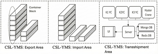
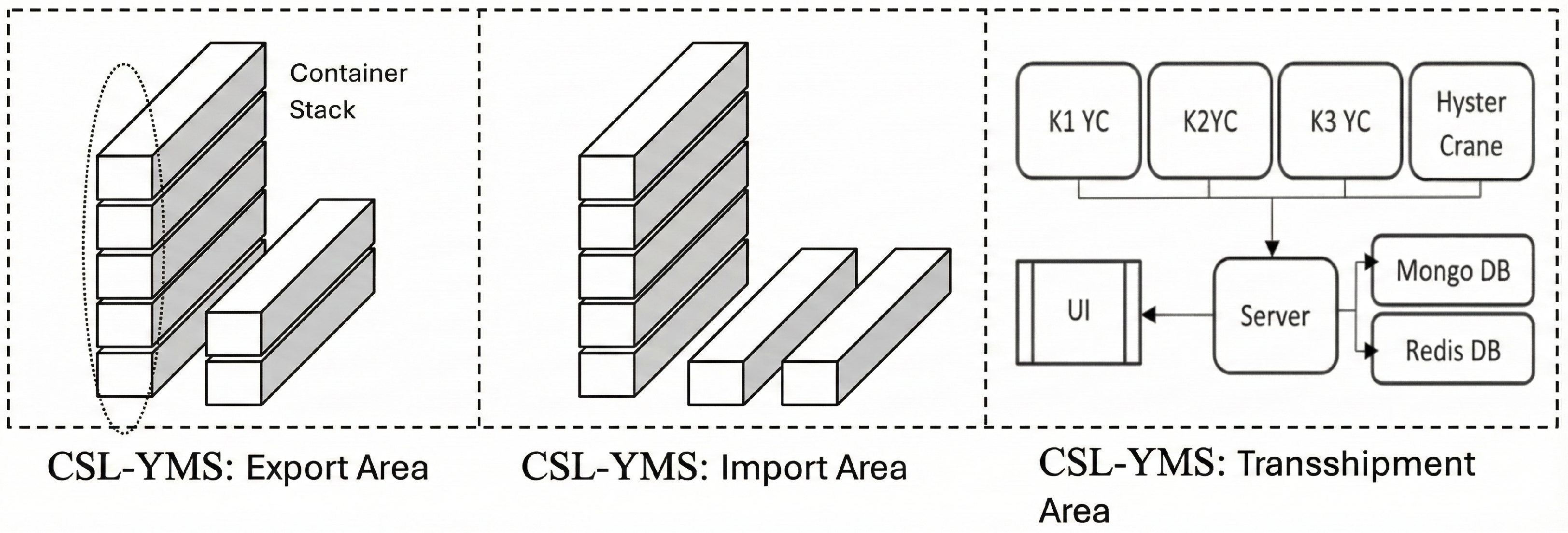
Owing to these challenges, the container management system has been moving towards automation. A recent trend in yard management is the adoption of Internet of Things (IoT) technologies to reduce human dependency and enhance workplace safety. A container yard involves several operations, such as transferring containers from ship to yard, from yard to ship, and ensuring the safe movement of containers within the yard. Overall, CSL YMS operations can be categorized into three sub areas: (i) import area, (ii) export area, and (iii) transhipment area, as illustrated in Figure 1. Each area is committed to temporal storage and relocation of dedicated container where container stack is depicted as a series of rectangular blocks. This represents the physical storage of containers in the export and import area. In a particular aligned area the loading-unloading functions are managed by allotted Yard Cranes (YCs). These are shown in Figure 1 YCs (K1, K2, K3, hyster crane) as rectangular blocks. The location data flow from the cranes to a server that further interacts with “UI Alerts” “Mongo DB” and “Redis DB”. The complete description of transshipment IIoT set up is discussed below:
Figure 1.
System architecture of the Container Spatial Localization-Yard Management System.
Location Data: This crucial element signifies the tracking of container positions. Cranes send location data to the server. Server: This is the main central processing unit for the CSL-YMS. It receives complete information of location data, manages alerts, and interacts with databases. UI Alerts: This indicates that the system provides user interface alerts, which are likely to notify operators of events or issues. Mongo DB and Redis DB: These two databases are used to store and manage the system’s data: Mongo DB - NoSQL database (flexible data storage) and Redis DB- in-memory data store (caching and fast data retrieval).
This research focuses on two key CSL-YMS operations: (i) Container Drop (CD) and (ii) Container Pickup (CP).
To address the aforementioned challenges, this research introduces a sensor fusion framework for CSL-YMS that integrates additional angular positional sensors with RTK-GPS, while also paying attention to how much energy the system consumes during operation. The contributions are as follows:
- Enhanced Positioning: IoT-based sensor fusion approach is proposed that uses Bosch angular sensors along with RTK–GPS in order to correct small offsets and improve the placement accuracy of containers.
- Optimized Power Management: The task scheduling algorithm, referred to as Power Task Clustering, is implemented to control power usage by figuring out the sleep periods of the device.
- Latency Analysis: The assessment of system-wide performance across operating frequencies is conducted using a simplified predictive model designed to estimate expected operational outcomes.
The research paper is organized as follows: mathematical formulation of crane kinematics and offset issues are addressed in Section 2. Section 3 outlines the proposed framework with energy-efficient sensor utilization. Section 4 discusses implementation details, results, and system analysis, followed by Conclusion in Section 5.
2. Mathematical Formulation: YC Kinematics and Offset Issues
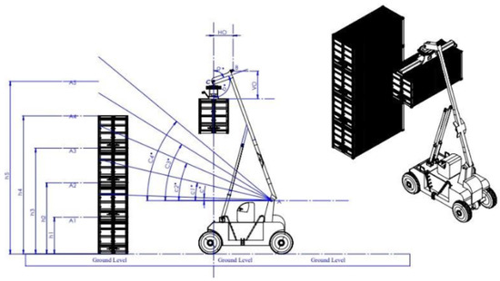
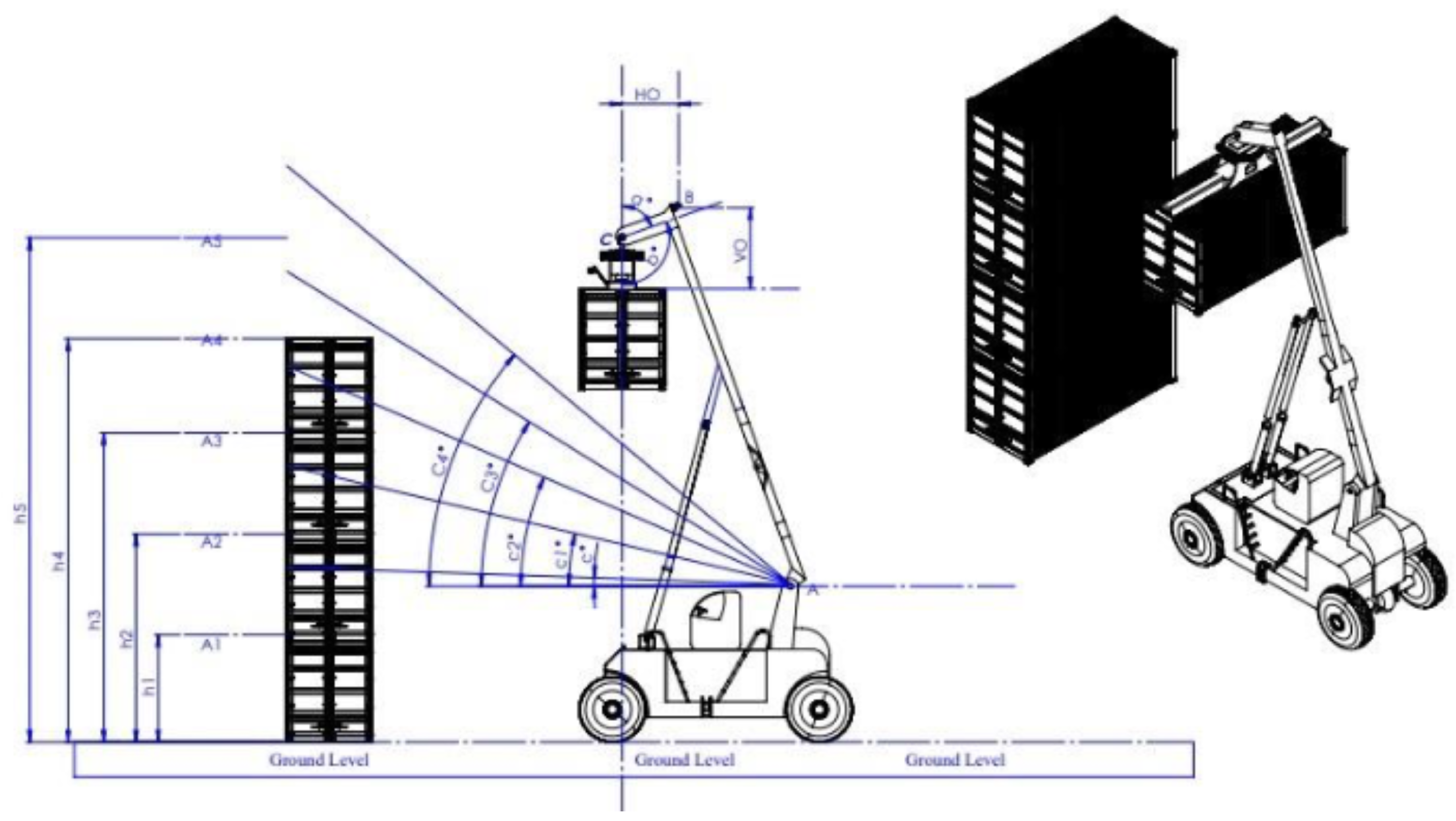
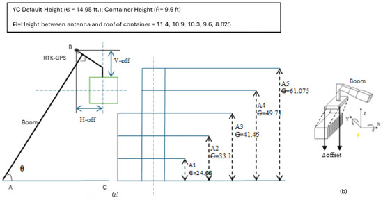
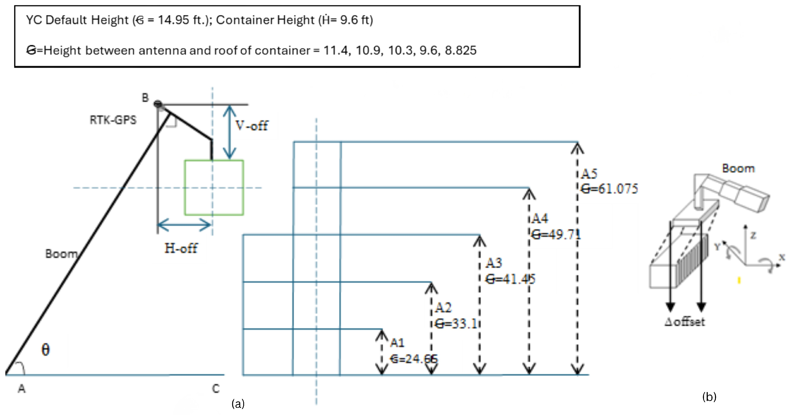
This section puts forth the details about mathematical modelling to determine the accurate position of the container. The placement of the container is mainly dependent on the driver’s knowledge and vision of the area. The manual operation of the reach stacker is prone to the erroneous and/or to accident due to various reasons such as restricted visibility due to size of container, incorrect estimation of dropping or pick up location. In order to handle these concerns, the process requires exact coordinates of the location of the container. The first step is to move the crane with minimum human intervention. To achieve the same, the location information of the crane must be available to the crane operator. It is achieved using the RTK-GPS module to 3 cm. The module is placed on the highest position of the boom on the reach stacker (point B) as described in Figure 2. The module provides the accurate coordinates of the current location information of the container. Now, depending on the information available, the operator makes the decision to drop or pick up the container. The decision of the pick up and drop is based only on the GPS data that further leads to the error in dropping the container at the designated place. This error keeps on increasing with increase in the stack size. The main cause of the error is due to the placement of the RTK GPS module i.e., at the top of the boom which is away from the center of the spreader leading to the offset from the actual location as depicted in Figure 2. To further enhance the accuracy of container placement, the coordinates of C are required. Figure 2 shows the line diagram of the container placement. The triangle formed by the crane boom and the support is right angled triangle. The coordinates of point C, are calculated as follows:
Figure 2.
Basic setup of yard management system.
- 1.
- Calculate AC using Pythagoras Theorem.
- 2.
- Find the x and y coordinate of C, by using the Euclidean distance formula.
- 3.
- The coordinates of C are .
This calculation helps in resolving spatial allocation by YC, but the orientation of the container still poses a challenge resulting in an offset issue (as illustrated in Figure 3a) as each stacker does not have information in the prior stacker. To handle orientation information, the use of angle sensors attached with the spreader of the reach stacker. The latitude and longitude of the destination, i.e., the point of pickup and drop are available.
Figure 3.
YC (a) RTK-GPS positioning and offset delineation; (b) YC-3D representation for offset.
Now, the angle information received by the user and it will calculate the corresponding latitude and longitude and keep rotating the spreader until it matches the actual value. The coordinates for a given angle and boom length r can be calculated as follows:
The positioning error between the actual coordinates and the estimated coordinates is given as Equation (3). The spreader of the reach stacker is rotated until the error approaches 0.
While Equations (1)–(3) describe the geometric estimation of container coordinates, accurate placement requires the integration of absolute RTK-GPS positioning with real-time orientation information obtained from the spreader-mounted sensor.
Orientation-Assisted Sensor Fusion Model
The mathematical formulation presented in Equations (1)–(3) establishes the geometric relationship between the crane boom, spreader orientation, and container placement error. However, accurate container localization in yard crane operations requires the integration of absolute position information with real-time orientation data. To achieve this, the proposed system adopts an orientation-assisted sensor fusion approach that combines RTK-GPS measurements with inertial angular sensing.
In the proposed CSL-YMS framework, RTK-GPS provides high-precision absolute position information of the crane boom tip, while the IMU mounted on the spreader supplies real-time angular measurements corresponding to spreader rotation. Although RTK-GPS achieves centimetre-level accuracy, its placement on the boom introduces systematic offsets when the spreader orientation changes. Conversely, the IMU captures orientation variations at a higher temporal resolution but cannot independently provide absolute position. The fusion strategy leverages the complementary characteristics of these sensors to correct orientation-induced positional offsets.
Let denote the position coordinates reported by the RTK-GPS sensor mounted on the boom, and let represent the instantaneous angular orientation of the spreader obtained from the IMU. Given the known boom length r, the corrected container coordinates are obtained as follows:
where correspond to the fused container position after orientation compensation. This formulation directly integrates angular information into the position estimation process, allowing real-time correction of spatial offsets caused by spreader rotation.
Unlike probabilistic filtering techniques, such as the Extended Kalman Filter, the proposed fusion model follows a deterministic formulation. This choice is motivated by the operational characteristics of yard crane systems, where motion dynamics are slow, the mechanical geometry remains fixed, and RTK-GPS already provides reliable absolute positioning. Under these conditions, deterministic orientation-based correction offers sufficient accuracy while maintaining computational simplicity and robustness for continuous industrial operation.
The fused coordinates obtained from Equations (4) and (5) are subsequently used to evaluate the placement error as defined in Equation (3). The spreader rotation is adjusted iteratively until the positioning error converges toward zero, ensuring accurate container alignment during both pickup and drop operations.
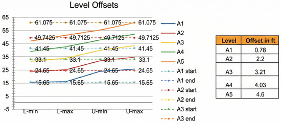
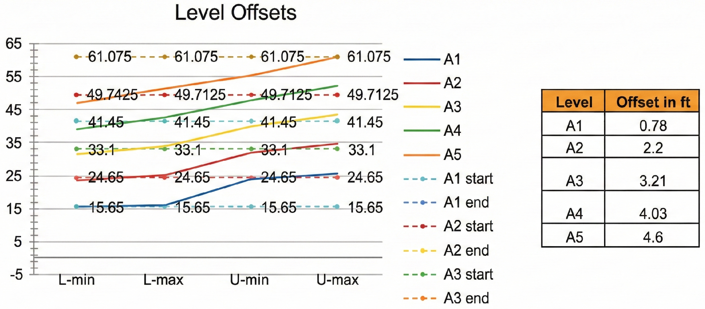
The YC RTK-GPS positioning setup is represented in Figure 3, the delineation of Horizontal offset (H-off) and Vertical offset (V-off) parameters are represented Figure 3a; RTK-GPS data, where the GPS-derived height is represented as 6 and is equal to 14.9 feet, which is further summed up for containers A1–A5. The container height = 9.6 ft. The system calculates container height based on the GPS data addressing variations depicted in Figure 4.
Figure 4.
YC container wise offset calculation.
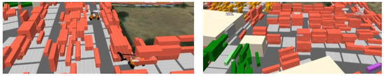
This section illustrates, in detail, the height calculation process with an offset challenge that further leads to container de-alignment resulting in low efficacy of YMS as shown in Figure 5.
Figure 5.
YC schematic/3D visualization of a simulated container of YMS with container delineation.
In Figure 5, red blocks represent stacks of shipping containers. Two yellow vehicles are visible within the yard and represent material handling equipment, likely yard trucks or straddle carriers, used to move containers. The simulation setup further demonstrates the necessity of an integrated sensor-fusion–based yard management system, as the initial operational issues observed are characteristic of routine challenges encountered in modern automated yard environments. Consequently, a robust IoT-driven fusion architecture is essential. The subsequent section elaborates on the IoT sensor framework and the specific fusion techniques employed in this research.
3. Proposed System Architecture and Data Flow
In CSL-YMS, the container drop is placing the container from shipment to yard at a specific location, whereas the container pick up is for the transfer of the container from yard to the ship. In these operations, the accuracy of the drop and pick up is of extreme importance. In manual operations, it is extremely critical due to the restricted vision of the driver due to huge container size. Location information plays an important role in retrieving the container efficiently. The present system utilizes the Real Time Kinetic (RTK)-GPS module, which provides up to date location information of the stacker. The location information alone is insufficient to cater to the needs of the container pickup and drop and sensor fusion IoT framework needs to be deployed.
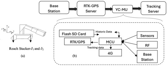
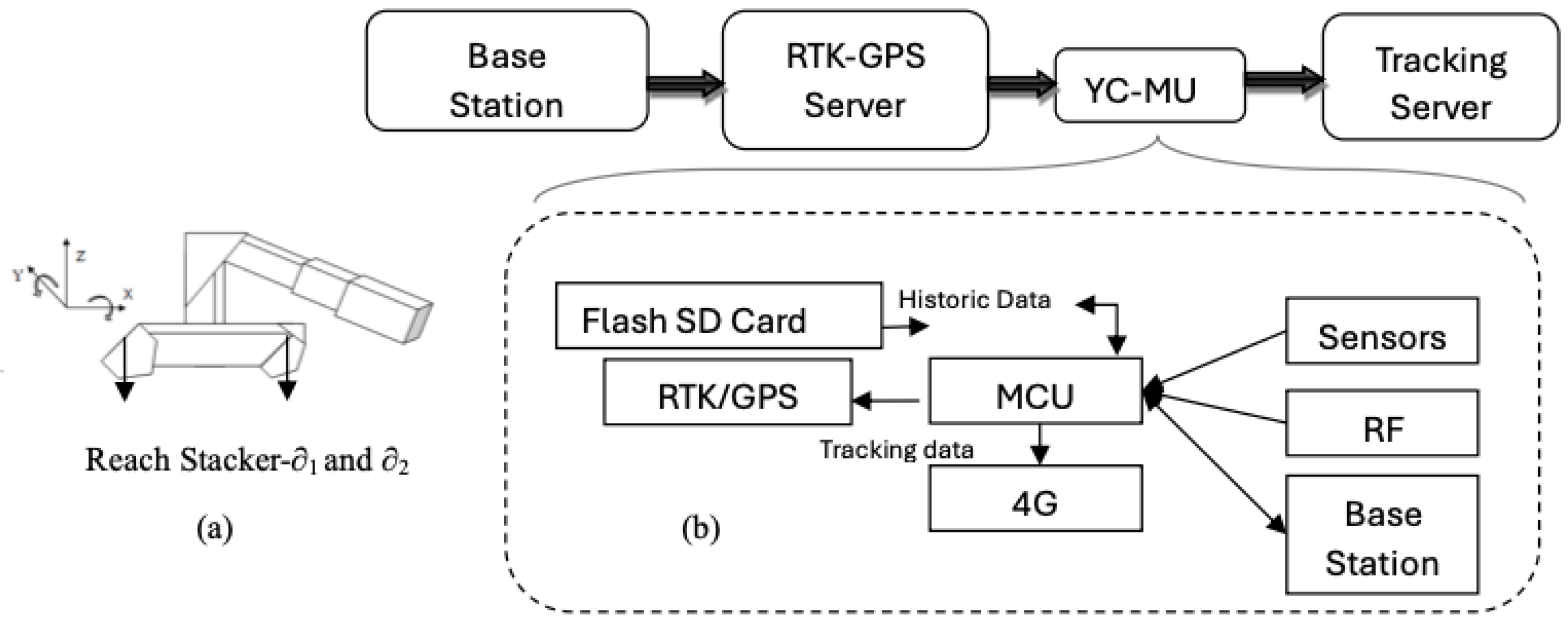
This research investigates advanced IIoT-enabled localization techniques, aiming to enhance real-time visibility and operational efficiency in modern industrial environments. The proposed CSL-YMS framework is shown in Figure 6 and depicts a two-part system comprising a Base station and a Yard Crane Microcontroller (YC-MC) unit, which are designed for high-precision location tracking and data acquisition, utilizing RTK-GPS for accurate positioning and various communication and data storage mechanisms with and . The base station employs an RTK/GPS receiver for establishing a precise base station position, providing correction data to the YC-MC, managed by a Microcontroller Unit (MCU) that handles data flow and communication, with Bluetooth for local communication and 4G cellular connectivity for transmitting RTK correction data to the RTK Server, which acts as a central hub broadcasting correction data. The YC-MC unit utilizes an RTK/GPS receiver to determine its position by receiving correction data from the RTK Server via 4G, with an MCU managing data processing, communication, and control, integrating sensors for data acquisition, RFID for tag reading, and FLASH/SD card for local data storage and Bluetooth for local communication, while 4G connectivity allows for transmitting tracking data to the Tracking Server for remote monitoring and analysis. The data flow involves the base station collecting RTK data and transmitting it to the RTK Server via 4G, which then broadcasts correction data to the MCU, enabling high-accuracy positioning through its RTK/GPS receiver, with the base station MCU collecting sensor and RFID data, storing it locally and transmitting tracking data to the Tracking Server, while also supporting Bluetooth communication with other devices.
Figure 6.
Proposed sensor fusion framework (a) RTK-GPS positioning and offset delineation; (b) Data flow and communication architecture.
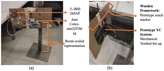
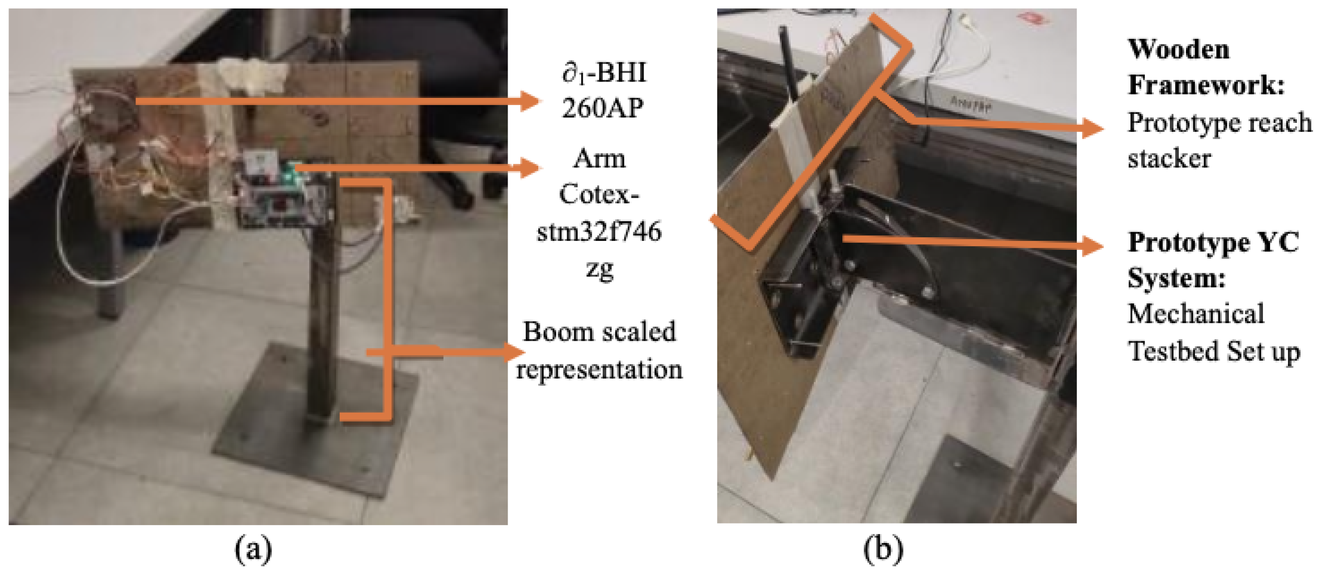
The experimental setup shown in Figure 7 is a laboratory-scale prototype based on a wooden framework, developed to validate the proposed methodology under controlled conditions; large-scale mechanical effects such as vibration, shock loading, and electromagnetic interference present in real-world steel cranes are not considered and represent a limitation of the laboratory environment.
Figure 7.
Prototype model of YC setup (a) side view of the prototype; (b) top view of the prototype.
Real-Time RTK-GPS with PTC and Peripheral Integration
By combining RTK-GPS with real-time corrections, power and task control (PTC), and a variety of interoperable peripherals, tracking applications increase accuracy and efficiency. The system uses FLASH/SD storage to store data locally, RFID to scan tag information, Bluetooth for local data interchange, and 4G connectivity to rapidly relay data to a remote tracking server. The PTC mechanism ensures that the system operates effectively without wasting energy by cleverly controlling power consumption across GPS, RFID, storage, and communication operations. To retrieve correction data and deliver real-time updates, the program describes how to wake up the MCU, turn on the GPS, and apply a distribution technique for optimal power allocation. This method ensures that data are collected, stored, and transmitted efficiently without sacrificing power, guaranteeing that, as long as the batteries have enough energy, the system will run continually. Additionally, it uses adaptive power management to maintain continuous operation by striking a balance between peak performance and battery life. Algorithm 1 illustrates the system-level task execution flow under PTC and is not intended to represent a formal real-time scheduling algorithm.
| Algorithm 1 RTK-GPS Operation with Real-Time Corrections and Power-Aware Control. |
|
4. Results
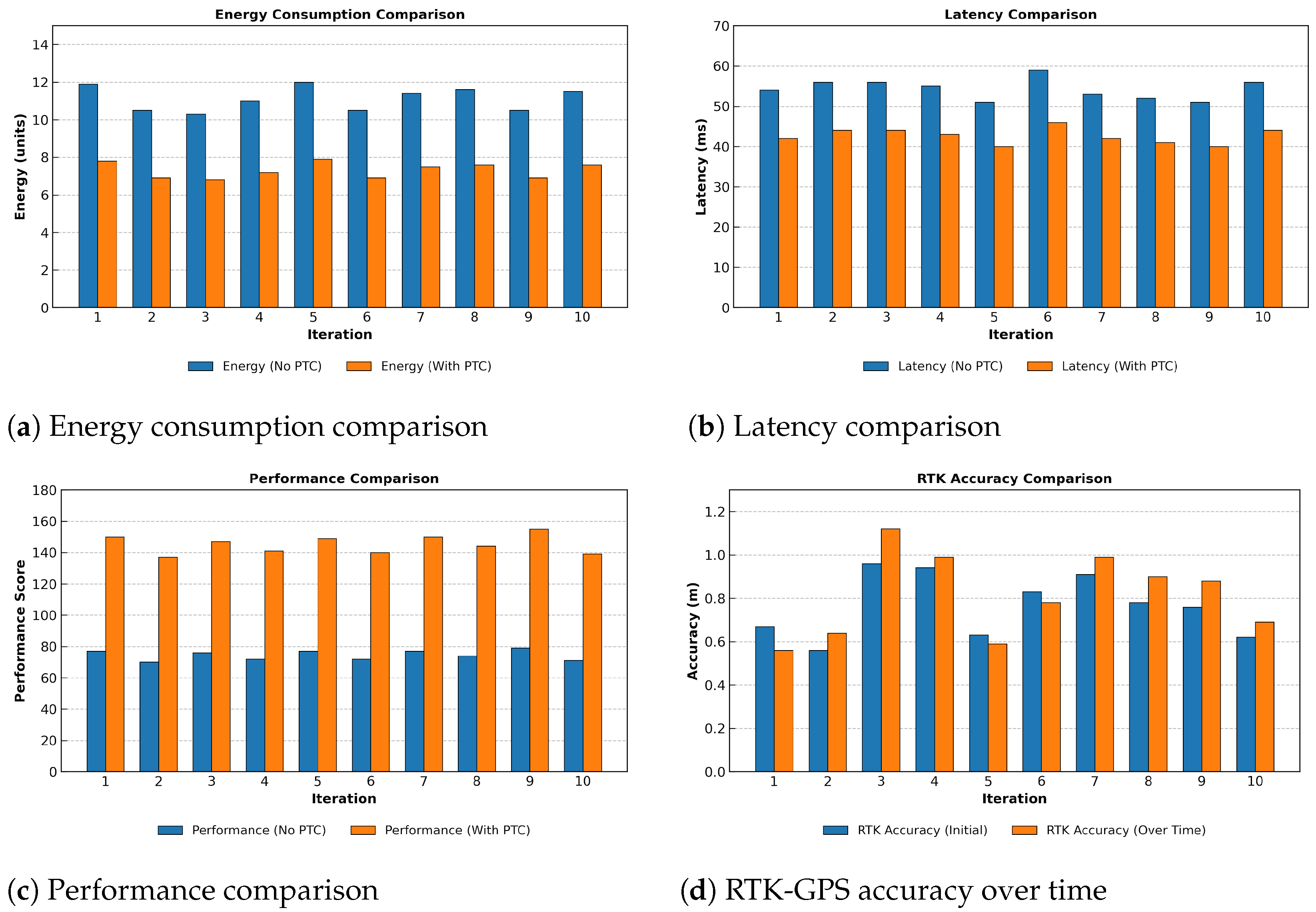
The precision with which RTK-GPS technology determines location is known as the accuracy of the SRTK (Snapshot Real-Time Kinematic) fixed solution. It shows how accurately the GNSS receiver determines its position in relation to a known reference station using real-time corrections. This degree of accuracy provides crucial information on the dependability and consistency of positioning in a variety of circumstances, such as satellite visibility, signal quality, and interference from the environment. The results plot the x and y coordinates of the fixed solution, as seen in Figure 8, demonstrating the precision and reliability of the RTK approach in providing accurate real-time positioning.
Figure 8.
Visualization of energy consumption, latency, performance, and RTK-GPS accuracy metrics.
Here, and denote the power consumption of the GPS and communication modules, respectively, while and represent their corresponding operation times. The parameters , , , and are empirical Power Task Clustering (PTC) efficiency factors applied to the power and latency terms. The constant A is a normalization factor introduced to obtain a dimensionless performance score and does not affect the relative comparison between operating modes. All variables summarized in Table 1 are defined by Equations (6)–(11). The total energy consumption without and with PTC is computed by the following:
Table 1.
Summary of parameters, PTC efficiency factors, and performance evaluation results.
- By integrating Power Task Clustering (PTC) in RTK-GPS.
- Energy consumption is significantly reduced (∼34.4%).
- Latency decreases (∼21.8%), improving response time.
- Overall system performance nearly doubles (∼95.2%), making RTK-GPS with PTC much more efficient for real-time applications.
The RTK-GPS performance test results over nine iterations are shown in Table 2, which compares scenarios with and without Power Task Clustering (PTC). These contrasts are made easier to understand by the accompanying Figure 8. Important variables such energy consumption, latency, overall system efficiency, and RTK accuracy over time are the focus of the analysis. Both setups’ energy use is monitored, demonstrating the efficiency gains made possible via PTC. The system’s response time is indicated by latency, which is measured in milliseconds. PTC’s efficient power management helps reduce delays. Stability and tracking accuracy under real-time settings are used to assess system performance. Additionally, RTK accuracy is evaluated by examining initial precision and how it changes over time, demonstrating how PTC aids in maintaining precise and consistent positioning.
Table 2.
Comparison of RTK-GPS–based system performance with and without PTC, including energy, latency, and container placement deviation.
5. Discussion and Conclusions
This research work focuses on the key challenge of CSL-YMS; centimetre-level RTK-GPS accuracy alone cannot be always relied for reliable container alignment inside busy yard environments. This paper highlights on the missing link of orientation, and therefore proposes sensor fusion optimization. The combination of RTK-GPS with Bosch BHI260AP inertial sensing and spreader-specific angular information consistently demonstrated centimetre-level stability with clear convergence of error values, showing that orientation awareness helps compensate for RTK offsets in practice. During implementation, energy use is always a key concern. This paper further explores applying Power Task Clustering continuously on IIoT operation with microcontroller sleep–wake scheduling that reduces total energy consumption by 34.44% and lowers latency by 21.8%, with comparable improvements across repeated evaluations. The observed reductions in power consumption achieved through PTC have important implications for long-term system operation, as lower energy usage reduces thermal stress on embedded components and supports sustained deployment in IIoT-based yard environments. At the same time, the concurrent reduction in latency indicates that power optimization does not compromise system responsiveness, even under continuous operation. Across repeated experimental runs conducted under identical laboratory conditions, the performance trends remain consistent, suggesting stable behavior of the proposed approach. Evaluation under varying environmental conditions, peak workload scenarios, and large-scale field deployments remains an important direction for future work. These results indicate that localisation accuracy and operational efficiency can be improved together, rather than traded against each other. The gradual deployment of RTK correction, sensor-fusion techniques and energy-aware scheduling offers a realistic path toward better placement performance and more sustainable logistics operations. Validation on a full-scale yard crane operating in a real port environment is identified as future work.
Author Contributions
S.D.: Performed all experimental investigations and simulations, and carried out the power–latency assessments together with the implementation of the Power Task Clustering (PTC) algorithm. R.C.: Designed the conceptual foundations of the IoT framework applied within the YMS. The main contribution was in shaping the system architecture, refined the IoT model and ensured that the framework was consistent with YMS IIoT operational requirements. G.F.: Originated and framed the core idea of the CSL-YMS, including its theoretical basis and overarching architectural direction. All authors have read and agreed to the published version of the manuscript.
Funding
This research received no external funding.
Data Availability Statement
The data used in this study are available from the corresponding author upon reasonable request.
Acknowledgments
The authors would like to thank Manas Parganiha from Lynkit Solutions Pvt. Ltd. for the resourceful data and constant support and guidance.
Conflicts of Interest
The authors declare no conflicts of interest.
References
- Yu, H.; Deng, Y.; Zhang, L.; Xiao, X.; Tan, C. Yard Operations and Management in Automated Container Terminals: A Review. Sustainability 2022, 14, 3419. [Google Scholar] [CrossRef] [Scilit]
- Zhen, L.; Jiang, X.; Lee, L.H.; Chew, E.P. A Review on Yard Management in Container Terminals. Ind. Eng. Manag. Syst. 2013, 12, 289–304. [Google Scholar] [CrossRef] [Scilit]
- Cuong, T.N.; You, S.-S.; Cho, G.-S.; Choi, B.; Kim, H.-S.; Vinh, N.Q.; Yeon, J.-H. Safe Operations of a Reach Stacker by Computer Vision in an Automated Container Terminal. Alex. Eng. J. 2024, 109, 285–298. [Google Scholar] [CrossRef] [Scilit]
- Business Standard, 11 November 2024. Available online: https://www.business-standard.com/finance/insurance/new-business-premium-of-life-insurers-up-13-in-october-shows-data-124111000466_1.html (accessed on 11 November 2024).
- Jawaharlal Nehru Port Authority’s Container Traffic Rises 12% in 2024. Business Standard, November 2024. Available online: https://www.business-standard.com/india-news/jawaharlal-nehru-port-authority-s-container-traffic-rises-12-in-2024-125010300932_1.html (accessed on 11 November 2024).
- Real-Time Port Congestion. GoComet, December 2024. Available online: https://www.gocomet.com/real-time-port-congestion (accessed on 11 November 2024).
- Steenken, D.; Voß, S.; Stahlbock, R. Container Terminal Operation and Operations Research—A Classification and Literature Review. OR Spectr. 2004, 26, 3–49. [Google Scholar]
- Murty, K.G.; Liu, J.; Wan, Y.-W.; Linn, R. A Decision Support System for Operations in a Container Terminal. Decis. Support Syst. 2005, 39, 309–332. [Google Scholar] [CrossRef] [Scilit]
- Wu, Y.; Luo, J.; Zhang, D.; Dong, M. An Integrated Programming Model for Storage Management and Vehicle Scheduling at Container Terminals. Res. Transp. Econ. 2013, 42, 13–27. [Google Scholar] [CrossRef] [Scilit]
- Fortino, G.; Guerrieri, A.; Lacopo, M.; Lucia, M.; Russo, W. An agent-based middleware for cooperating smart objects. In Highlights on Practical Applications of Agents and Multi-Agent Systems; Springer: Berlin/Heidelberg, Germany, 2013. [Google Scholar]
- Rodrigue, J.-P. The Geography of Transport Systems, 5th ed.; Routledge: London, UK, 2020. [Google Scholar]
- Yu, M.; Qi, X. Storage Space Allocation Models for Inbound Containers in an Automatic Container Terminal. Eur. J. Oper. Res. 2013, 226, 32–45. [Google Scholar] [CrossRef] [Scilit]
- International Labour Organization (ILO). Occupational Safety and Health in Ports; ILO Report; ILO: Geneva, Switzerland, 2021. [Google Scholar]
- Chen, T.; Notteboom, T.; Liu, L. The Carbon Footprint of Container Terminal Operations: The Impact of Yard Strategies. Transp. Res. Part D 2013, 26, 49–59. [Google Scholar]
- Park, T.; Choe, R.; Kim, Y.H.; Ryu, K.R. Dynamic Adjustment of Container Stacking Policy in an Automated Container Terminal. Int. J. Prod. Econ. 2011, 133, 385–392. [Google Scholar] [CrossRef] [Scilit]
- Zheng, S.; Sha, J. Path Optimum Algorithm for Container-Integrated Scheduling Under Dynamic Mode in Port Terminals Worldwide. J. Coast. Res. 2020, 36, 885–895. [Google Scholar] [CrossRef] [Scilit]
- Kolangiammal, S.; Prabha, S.; Sivalakshmi, P.; Kalaichelvi, S.; Sujatha, S. Transforming Yard Management for Optimizing Efficiency through IoT and AI Integration. In Proceedings of the 2024 8th International Conference on I-SMAC (IoT in Social, Mobile, Analytics and Cloud) (I-SMAC), Kirtipur, Nepal, 3–5 October 2024; pp. 218–223. [Google Scholar]
- Heaver, T.D. The Evolving Roles of Shipping Lines in International Logistics. Int. J. Marit. Econ. 2002, 4, 210–230. [Google Scholar] [CrossRef] [Scilit]
- Darmawan, C.D.P.; Dwi, S.F.; Triyasa, D.H.; Octaviani, R.I. Internet Of Things (IoT) for Inventory and Container Position. J. Phys. Conf. Ser. 2020, 1573, 012016. [Google Scholar] [CrossRef] [Scilit]
- Anusha, P.T.; Jayasurya, P.; Shylaja, G.; Buggaveeti, P.; Subhash, M. Shipping Container with IoT: A Smart Way to Monitor Environment and Location. Int. Res. J. Mod. Eng. Technol. Sci. 2024, 6, 3028–3032. [Google Scholar]
- Gilman, S. Sustainability and the Container Port. Marit. Policy Manag. 2003, 30, 251–260. [Google Scholar]
- Bichou, K.; Gray, R. A Logistics and Supply Chain Management Approach to Port Performance Measurement. Marit. Policy Manag. 2004, 31, 47–67. [Google Scholar] [CrossRef] [Scilit]
- Smith, J.; Brown, L. Internet of Things Enabled Real-Time Cold Chain Monitoring in a Port Environment. J. Shipp. Trade 2022, 7, 1–15. [Google Scholar]
- Crainic, T.G.; Kim, K.H. Intermodal Transportation. Handb. Oper. Res. Manag. Sci. 2007, 14, 467–537. [Google Scholar]
- Devraj, G.; Kumar, M.T.; Reddy, C.S.; Kumar, G.A.; Varma, K.S. IoT Enabled Shipping Containers with Location Tracking and Environment Monitoring. Int. J. Res. Appl. Sci. Eng. Technol. 2022, 10, 3028–3032. [Google Scholar] [CrossRef] [Scilit]
- Sharma, M.; Chawla, R. Efficient Power Management Unit for IIOT Edge Computing Applications. Int. J. Syst. Assur. Eng. Manag. 2025, 16, 927–938. [Google Scholar] [CrossRef] [Scilit]
- Fortino, G.; Savaglio, C.; Spezzano, G.; Zhou, M. Internet of Things as system of systems: A review of methodologies, frameworks, platforms, and tools. IEEE Trans. Syst. Man Cybern. Syst. 2021, 51, 223–236. [Google Scholar] [CrossRef] [Scilit]


Disclaimer/Publisher’s Note: The statements, opinions and data contained in all publications are solely those of the individual author(s) and contributor(s) and not of MDPI and/or the editor(s). MDPI and/or the editor(s) disclaim responsibility for any injury to people or property resulting from any ideas, methods, instructions or products referred to in the content. |
© 2026 by the authors. Licensee MDPI, Basel, Switzerland. This article is an open access article distributed under the terms and conditions of the Creative Commons Attribution (CC BY) license.