


Abstract
After nearly two decades of developments in Historic/Heritage Building Information Modeling (HBIM), the field has reached a stage of maturity that calls for a critical reassessment of its evolution, achievements, and remaining challenges. Digital representation has become a central component of contemporary heritage conservation, enabling advanced methods for analysis, management, and communication. This review examines the maturation of HBIM as a comprehensive framework that integrates extended reality (XR), artificial intelligence (AI), machine learning (ML), semantic segmentation and Digital Twin (DT). Six major research domains that have shaped recent progress are outlined: (1) the application of HBIM to restoration and conservation workflows; (2) the expansion of public engagement through XR, virtual museums, and serious games; (3) the stratigraphic documentation of building archaeology, historical phases, and material decay; (4) data-exchange mechanisms and interoperability with open formats and Common Data Environments (CDEs); (5) strategies for modeling geometric and semantic complexity using traditional, applied, and AI-driven approaches; and (6) the emergence of heritage DT as dynamic, semantically enriched systems integrating real-time and lifecycle data. A comparative assessment of international case studies and bibliometric trends (2015–2025) illustrates how HBIM is transforming proactive and data-informed conservation practice. The review concludes by identifying persistent gaps and outlining strategic directions for the next phase of research and implementation.
1. Introduction
Building Information Modeling (BIM) is a collaborative process for creating and managing digital data about a building’s or infrastructure’s physical and functional elements. Although often associated with modern construction techniques, the concept behind BIM originated before its widespread adoption. As early as 1963, Douglas Engelbart envisioned an architectural design process based on interactive digital models, anticipating many features of today’s BIM systems [1].
Initially developed in the 1980s for mechanical design, BIM later became a crucial technology in architecture, engineering, construction, and operations (AECO), revolutionizing how stakeholders communicate, coordinate, and manage the entire lifecycle of built assets [2].
Over the past twenty years, BIM has reshaped project delivery through data-driven design, real-time collaboration, and improved management of costs, schedules, and sustainability goals, contributing to more resilient and efficient buildings [3].
Despite its wide adoption in new construction, applying BIM to existing and historic structures introduces unique challenges. Irregular geometries, incomplete historical records, cultural significance, authenticity requirements and fragile material conditions limit the direct use of conventional BIM workflows. These issues led to the development of Historic or Heritage Building Information Modeling (HBIM), a specialized methodology introduced in the early 2010s to adapt BIM principles to the conservation, documentation and management of architectural heritage [4].
At its core, HBIM involves creating a semantic 3D model that captures the geometric layout together with the historical, material, and functional characteristics of a heritage structure. This model acts as a centralized, information-rich database that supports diagnostic analysis, restoration planning, monitoring, and information sharing.
The HBIM workflow can be understood as a sequence of four interconnected phases, while its broader development is structured around six thematic research domains that guide data acquisition, modeling, semantic enrichment, and information use (Figure 1):
- Data Collection: This initial phase involves gathering both geometric and non-geometric data using advanced surveying and remote sensing technologies such as laser scanning, photogrammetry, multispectral imaging, and UAV (uncrewed aerial vehicle) systems. These methods provide high-resolution, accurate spatial data essential for modeling complex heritage structures. Equally important is collecting and critically analyzing historical documentation and archival research, including architectural drawings, written records, old photographs, conservation reports, and other historical sources that offer invaluable context about the building’s original construction, subsequent modifications, past interventions, and its use over time. Incorporating this documentary evidence enhances the dataset by filling gaps left by incomplete or degraded physical remains and supports a well-informed interpretation of the asset. The thoroughness and accuracy of this multifaceted data collection are vital because they form the foundation for all subsequent modeling, analysis, and management tasks. High-quality data ensures that the HBIM model accurately reflects both the physical reality and the historical narrative of the heritage structure, enabling more reliable conservation planning and decision-making.
- Scan-to-BIM Process: This stage converts raw data into organized 3D models. It involves point cloud processing, geometric analysis, and the creation of parametric or hybrid BIM components that reflect the distinct forms of heritage assets. The emphasis is on tolerances, modeling standards, and the appropriate level of detail (LOD) for heritage visualization. This phase goes beyond just geometric reconstruction; it requires critical interpretation of spatial data to depict not only the shape but also the construction logic of architectural, archaeological, and structural features. Instead of modeling solely by shape, the process reconstructs components—such as vaults, arches, walls, or layered strata—based on their historical function and construction methods. By combining parametric and nonparametric techniques, the model captures the irregularity and complexity of heritage structures, ensuring that elements are not just 3D objects but meaningful, information-rich entities. This foundation is essential for semantic enrichment, analysis, and effective heritage management.
- Information Mapping: After modeling the geometry, semantic enrichment involves mapping a wide range of data—such as historical, material, stratigraphic, archaeological, and pathological information—onto the digital model. This phase applies principles of building archaeology to identify and interpret construction phases, historical changes, and material stratifications. It also systematically maps decay and degradation phenomena to support condition assessments and diagnostic analyses. Concepts such as Level of Information (LOI) and Level of Development (LOD) determine the level of detail and granularity of data for each model element, ensuring alignment with conservation and management needs. This enrichment is further supported by custom BIM schedules that compile, organize, and visualize complex datasets linked to architectural components, facilitating multidisciplinary analysis. The use of taxonomies, ontologies, and metadata standards is crucial for structuring this information, making it machine-readable, semantically consistent, and interoperable across collaborative platforms. This comprehensive mapping transforms the HBIM model into an intelligent, data-rich asset that supports conservation planning, monitoring, and decision-making.
- Information Sharing: In the final stage, the HBIM model becomes a dynamic and collaborative platform that supports conservation planning, multidisciplinary coordination, and public engagement. However, the value of the information depends primarily on the expertise of the users who interpret, manage, and share it. Conservators, architects, engineers, and heritage managers play crucial roles in guiding how the data is used and understood to meet various needs. Information exchange relies on infrastructure such as Common Data Environments (CDEs), which enable centralized data management and teamwork. Using open and proprietary data formats, such as IFC and other BIM standards, ensures interoperability; however, it also requires careful handling to prevent issues such as data loss or incompatibility. Skilled users are essential for selecting appropriate formats and tools, ensuring a smooth flow of information and data integrity. Integration with extended reality (XR), virtual museums, and serious games offers new opportunities for inclusive communication and public involvement. The rise of Digital Twin (DT) further enhances HBIM’s potential by adding real-time data for predictive maintenance and sustainable management. Overall, effective use of information depends on ongoing interpretation and management by knowledgeable users, making information sharing a knowledge-based process that transforms the model into a living, evolving tool for heritage preservation.
Figure 1.
HBIM Workflow and Research Domains: Four Interconnected Phases (Data Collection, Scan-to-BIM, Information Mapping, Information Sharing) Supporting Six Thematic Domains of Digital Heritage Research.
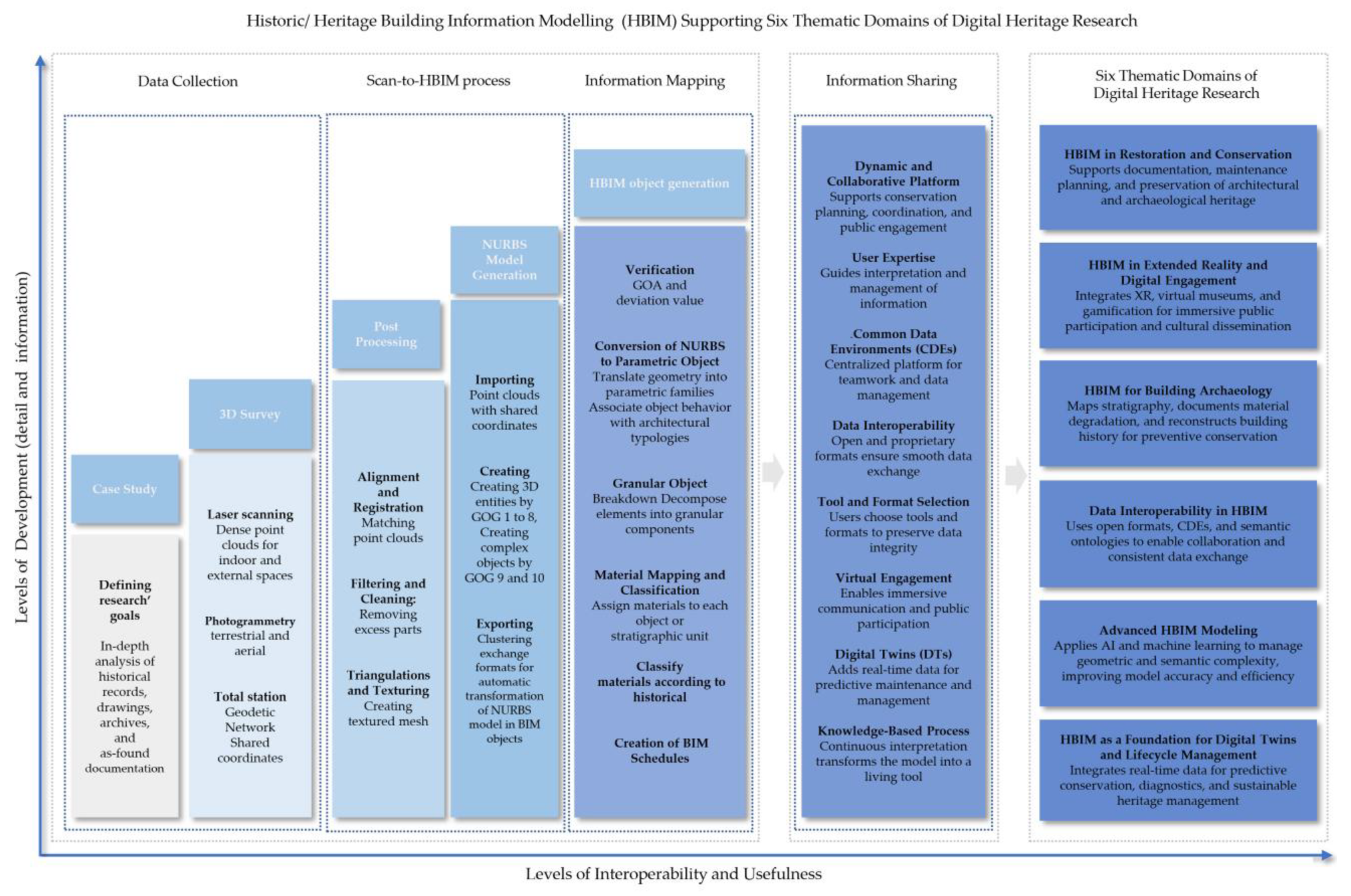
This structured approach transforms HBIM from a static and isolated geometric archive into a comprehensive digital ecosystem that supports the full lifecycle of heritage conservation—including documentation, management, research, and public engagement. It also provides a foundation for integrating DT, enabling continuous updates, real-time monitoring, and predictive maintenance.
While early HBIM studies focused on technical issues such as data acquisition and modeling, the field has rapidly expanded to include interoperability, open data exchange, virtual and augmented reality for public engagement, AI-based recognition of heritage components, and, more recently, the development of DT for built heritage.
The DT concept, which is well established in industrial engineering, has gained traction in the heritage field as a framework for real-time, data-driven, and responsive modeling of cultural assets. By incorporating live sensor data, simulations, and user interactions, DT improve static HBIM models enable predictive diagnostics, scenario planning, and lifecycle management [5]. The growing institutional recognition of this approach, highlighted by the establishment of the UNESCO Chair inDT for World Heritage Conservation in 2025, underscores its strategic importance for future heritage management.
The evolution of HBIM illustrates a field that has rapidly expanded in conceptual scope, technical sophistication, and strategic importance for heritage conservation. Previous reviews often document technical developments, bibliometric trends, or isolated application domains, while paying limited attention to the relationships and tensions among different HBIM research areas. Epistemological assumptions underlying how heritage knowledge is structured and operationalized through HBIM are rarely unpacked or critically examined. As a result, despite nearly two decades of progress, the field lacks an integrated and reflexive framework capable of supporting both future innovation and effective heritage conservation.
2. Purpose and Objectives of the HBIM Review
The review has two main objectives: first, to trace the development of HBIM as a discipline at the intersection of heritage conservation, digital innovation, and interdisciplinary collaboration; second, to identify the key research trends shaping its current state and future growth.
To support these objectives, this research is guided by a clearly defined research agenda. Each thematic domain is guided by questions that clarify the primary issues being examined. Table 1 presents the six domains and the guiding questions identified in the review, providing a clear, organized framework for analysis. It converts the study’s research agenda into a practical structure that outlines the development of HBIM and its main research directions. By arranging key questions and focus areas, the table clarifies the methodology, supports both bibliometric and interpretive approaches.
Table 1.
Thematic Domains and Guiding Questions in the Integrative Methodology for Systematic Review and Bibliometric Mapping of HBIM.
3. Integrative Methodology for Bibliometric Mapping and Critical Review of HBIM
HBIM is an inherently interdisciplinary field, in which technological innovation, methodological refinement, and heterogeneous application domains continuously intersect. To manage this complexity, the six main research domains of HBIM are examined through an integrated Bibliometric Mapping—Critical Review framework, designed to capture both the overall structure of the research landscape and the internal dynamics of consolidation and innovation within the field.
The bibliographic dataset was compiled from the Scopus database, selected for its comprehensive coverage of peer-reviewed literature in architecture, engineering, computer science, cultural heritage, and related disciplines. The temporal window 2015–2025 was deliberately chosen to represent a decade of methodological consolidation and diversification in HBIM research. While the foundational origins of HBIM are addressed in the previous section (2009–2014), which documents the conceptual emergence of the field and its early experimental applications, the period analyzed here corresponds to a more mature phase. During this decade, HBIM evolved from a predominantly exploratory paradigm into a structured research domain characterized by stabilized workflows, domain-specific methodologies, and an expanding range of advanced applications.
In this sense, the 2015–2025 interval is not intended to replace or overlap the formative phase discussed in the origins section, but rather to build upon it analytically. The earlier period (2009–2014) marks the initial articulation of HBIM concepts and the first attempts at methodological transfer from BIM to heritage contexts, whereas the selected decade captures the subsequent systematization, diversification, and acceleration of research activity. This chronological framing enables a clear distinction between the genesis of HBIM and its consolidation into a mature, interdisciplinary research field.
The dataset for the six distinct yet interconnected thematic domains was identified through targeted keyword queries applied to the TITLE-ABS-KEY fields. Only publications written in English were included, and studies not directly relevant to HBIM were excluded. The search cutoff date was set to 5 November 2025.
The six domains and their corresponding search queries are as follows:
- HBIM in Restoration and Conservation: TITLE-ABS-KEY ((“HBIM” OR “Heritage BIM” OR “Historic BIM”) AND (“restoration” OR “conservation” OR “reconstruction”))
- HBIM in Extended Reality and Digital Engagement: TITLE-ABS-KEY ((“HBIM” OR “Heritage BIM” OR “Historic BIM”) AND (“extended reality” OR “XR” OR “virtual reality” OR “VR” OR “augmented reality” OR “AR” OR “mixed reality” OR “MR” OR “virtual museum*” OR “digital museum*” OR “serious game*” OR “gamification*”))
- HBIM for Building Archaeology: TITLE-ABS-KEY ((“HBIM” OR “Heritage BIM” OR “Historic BIM”) AND (“building archaeolog*” OR “archaeological site*” OR “stratification*” OR “stratigraph*” OR “decay” OR “degradation” OR “deterioration”))
- Data Interoperability in HBIM: TITLE-ABS-KEY ((“HBIM” OR “Heritage BIM” OR “Historic BIM”) AND (“interoperability” OR “data sharing” OR “collaborat*” OR “ontolog*” OR “semantic web*” OR “open format*” OR “exchange format*” OR “openBIM” OR “metadata*” OR “Common Data Environment*” OR “CDE*” OR “multidisciplin*”))
- Advanced HBIM: TITLE-ABS-KEY ((“HBIM” OR “Heritage BIM” OR “Historic BIM”) AND (“geometric complexit*” OR “semantic complexit*” OR “semantic model*” OR “parametric model*” OR “procedural model*” OR “machine learning” OR “deep learning” OR “artificial intelligence” OR “AI” OR “computer vision” OR “automati*” OR “generative model*”))
- HBIM as a Foundation for Digital Twins and Lifecycle Management: TITLE-ABS-KEY ((“HBIM” OR “Heritage BIM” OR “Historic BIM”) AND (“digital twin*” OR “lifecycle management”))
The bibliometric analysis was performed using Biblioshiny, the web-based interface of the Bibliometrix 5.2.0 R-package for comprehensive science mapping analysis [6]. This platform allows for quantitative exploration, such as tracking publication trends, identifying thematic structures, and mapping collaboration networks.
To ensure a rigorous and balanced critical review, a targeted selection of representative publications was implemented for comparative and illustrative purposes. This structure consists of three layers that capture the historical development, the contemporary acceleration, and the emerging hotspots.
- Layer 1—Foundation Core: Publications selected from the top 10% most-cited papers within each year prior to the identified pivotal year, represent the foundational body of HBIM scholarship. These works established the conceptual underpinnings, methodological frameworks, and early digital workflows that shaped the field’s initial development.
- Layer 2—Contemporary Influentials: Publications in the top 10% most-cited papers each year after the pivotal year, reflect the consolidation and growth of HBIM research. This layer compiles highly influential recent studies.
- Layer 3—Rapid Emergence Burst Papers: The ten publications with the strongest citation bursts between 2015 and 2025, detected using a Z-score-based approach implemented in R. These works have recently attracted exceptional scholarly attention and reveal emerging or rapidly evolving research directions that are reshaping the current frontier of HBIM research.
Review papers were excluded from Layer 1 and Layer 2 to preserve a technically focused analysis and to mitigate citation bias associated with secondary literature. Pivotal years for each domain were identified through visual inspection of annual publication production curves, allowing the recognition of inflection points and shifts in research intensity. This approach was preferred over algorithmic change-point detection methods, as it enables contextual interpretation of publication dynamics in relation to domain-specific developments and avoids overfitting statistically induced breakpoints that may lack conceptual relevance.
The overall bibliometric workflow and paper selection strategy are summarized in Figure 2.
Figure 2.
PRISMA-like flow diagram illustrating the bibliometric search, screening, and three-layer paper selection strategy across the six HBIM domains.
This stratified methodological approach ensures a comprehensive and balanced analysis that captures both continuity and transformation within HBIM research. By integrating quantitative bibliometric evidence with qualitative critical interpretation, the proposed framework clarifies the current state of the field, highlights methodological strengths and limitations, and identifies promising trajectories for future research.
4. The Origins and Evolution of Historic/Heritage Building Information Modeling (HBIM)
The concept of HBIM was first introduced by Murphy et al. in 2009, marking a significant shift in how historic structures are documented, analyzed, and managed [7]. This innovative approach combined advanced survey techniques—primarily terrestrial laser scanning and high-resolution digital photography—with sophisticated point cloud processing and texturing, creating highly detailed three-dimensional digital reconstructions of heritage assets. These early advances represented a major change in how historic buildings are captured, understood, and maintained, moving beyond traditional two-dimensional documentation and manual surveys.
Meanwhile, other researchers explored similar methods even before HBIM terminology became widespread. Early studies focused on reconstructing architectural shapes, developing parametric libraries for classical architecture, and creating software to manage and analyze parametric data [8,9,10]. Since 2014, numerous case studies have shown the effectiveness of HBIM in complex situations, from post-earthquake recovery to protecting monuments of great historical and symbolic importance. Among these, two projects stand out for their scope and the specific needs of their clients. They are widely recognized as the two most significant digitization efforts worldwide for built heritage: the Basilica of Collemaggio, damaged by the 2009 earthquake in Italy, and the Canadian Parliament in Ottawa. The restoration of the Basilica of Collemaggio is a landmark case, demonstrating how HBIM can convert survey data into models that support documentation, diagnosis, and long-term monitoring [11]. The “Ripartire da Collemaggio” (“Restarting from Collemaggio”) project, funded in 2013 by ENI Servizi after the severe earthquake damage, involved a public–private partnership including three universities and an interdisciplinary team. The Superintendency of L’Aquila oversaw the restoration, with scientific support from Sapienza University of Rome and the University of L’Aquila, coordinated by the Politecnico di Milano.
Beginning in 2013, Banfi developed what is considered the first Italian HBIM model [12,13], specifically designed to support restoration work [14], construction-site management [15], and structural analysis [16]. The model aimed to preserve the basilica’s architectural integrity, improve its structural performance through innovative construction techniques, and establish new interoperability requirements for scan-to-BIM workflows across all project phases. For the first time, the modeling strategy defined specific Grades of Generation, Information, and Accuracy (GOG, GOI, GOA) [17], combining NURBS modeling [18] with direct point-cloud interpolation to create complex shapes within a BIM environment—going beyond the limitations of conventional BIM tools and object libraries for new construction.
Restoration work started on 25 November 2015, including reconstructing the transept, repairing 14 nave pillars—6 of which were severely damaged—and working on masonry elements like opus reticulatum, stuccoes, frescoes, and the façade. The project was finished on 13 December 2017, and the basilica reopened on December 20. In 2020, it received the European Heritage Award from the European Commission and Europa Nostra in the Conservation category [19,20]. The adoption of HBIM in this project marked a major shift in how historic buildings are documented, analyzed, and managed.
Furthermore, HBIM has been effectively used to manage complex historic buildings, utilizing generative techniques to support restoration and ensure smooth integration of new elements without compromising historical integrity [21,22,23]. In this context, BIM not only improved resource management and design but also enabled the creation of digital models capable of simulating structural interventions, as demonstrated by the West Block, enabling optimized operations without impacting the original architecture.
In 2014, R. Volk reviewed more than 180 publications [24]. The findings highlighted the limited application of BIM for existing buildings due to:
- The high modeling effort needed to convert survey data into BIM objects;
- The challenges of updating information and managing uncertainty;
- The complexity of representing existing building components and their relationships.
Key BIM functions currently in use or developing for existing buildings include clash detection, spatial program validation, BIM quality assessment, progress tracking, cost estimation, daylight simulation, deconstruction planning, deviation and defect analysis, data documentation and visualization, energy and thermal analysis, carbon footprinting, component localization, indoor navigation, lifecycle assessment, sensor-based performance monitoring, operations and maintenance, 3D quantity take-off, retrofit design, risk scenario planning, safety management, 4D scheduling, space management, and structural analysis [24,25,26].
Despite rapid advancements and broader adoption of BIM standards, their significance extends beyond the design and construction of new structures. As this variety of applications demonstrates, BIM is equally important for managing and conserving existing historic buildings.
Building on this, the study by Nieto Julián, J. E., and Moyano Campos, J. J. [27] enhances understanding of HBIM as a comprehensive platform for collecting, analyzing, and visualizing parametric data, highlighting the role of digital models in improving material and stratigraphic knowledge of historic structures.
This early phase (2009–2014), therefore, marks the shift from basic geometric modeling to the development of advanced information systems tailored to built heritage, highlighting three key research directions:
- The formal theoretical development of HBIM as a specific extension of traditional BIM frameworks.
- The development of parametric libraries for non-standard architectural elements.
- The application of HBIM to real case studies, demonstrating its operational value for conservation, restoration, and risk management.
This period laid the foundation for future research on modeling automation, semantic interoperability, integration with HBIM–cloud infrastructures, and the use of artificial intelligence techniques to support the analysis, preservation, and management of cultural heritage. Overall, these early efforts laid the essential foundation for HBIM, demonstrating its ability to blend detailed scientific documentation with practical heritage-preservation applications.
Since 2015, HBIM has rapidly evolved into a crucial framework for documenting, analyzing, and managing historic structures. Advances in laser scanning, photogrammetry, and point-cloud processing have allowed the creation of highly precise 3D models that reflect the geometric and material complexity of heritage buildings. At the same time, research has developed structured workflows and parametric libraries with standardized classifications and semantic data, transforming HBIM from a simple documentation tool into a knowledge-rich environment that supports conservation, intervention planning, adaptive reuse, and long-term preservation. Enhanced integration with structural analysis now enables simulations of mechanical behavior, material durability, and decay processes, facilitating data-driven decision-making. These developments represent some of the most promising research directions today. HBIM’s global growth, especially in Europe and China, reflects a rising awareness of heritage protection needs and rapid technological progress. Unlike traditional BIM, HBIM addresses the geometric complexity, documentation gaps, and conservation challenges of historic buildings, requiring interdisciplinary collaboration across technical and heritage fields.
5. HBIM in Restoration and Conservation: Preserving Architectural and Archaeological Heritage
5.1. Bibliometric Analysis of HBIM in Restoration and Conservation
Based on the annual scientific production curve generated using Biblioshiny (Figure 3), 2019 can be identified as a pivotal year in the evolution of Domain 1. This assessment is based on a noticeable increase in publication output relative to the preceding period (2015–2018), interpreted as a transition from an initial exploratory phase to one characterized by accelerated growth and increasing thematic diversification (2019–2025). Although a temporary decline is observed immediately after 2019, this fluctuation is primarily attributable to the disruptions caused by the COVID-19 pandemic and does not undermine the identification of 2019 as the onset of the expansion phase. Accordingly, the final dataset comprises 562 publications, structured into three analytical layers as shown in Table 2. The complete list of selected publications for each layer is provided in Appendix A (Table A1, Table A2 and Table A3), supporting the subsequent critical review.
Figure 3.
Annual Scientific Production of Domain 1 (2015–2025).
Table 2.
Bibliometric dataset summary and appendix references for Domain 1.
After identifying the production curve and the papers included in the three layers, Biblioshiny visualizes the connections among author keywords (DE), individual authors (AU), and publication sources (SO), presented as a three-field Sankey diagram in Figure 4. This figure highlights the most prominent keywords, the leading contributors, and the main publication venues. Notably, documentation-oriented keywords such as photogrammetry, laser scanning, and Scan-to-BIM show stronger connections than purpose-oriented terms related to restoration and conservation, which reflects the continued centrality of surveying techniques in HBIM research. Additionally, the core authors prefer to publish their research in ISPRS archives, a conference proceeding. Furthermore, Heritage, Lecture Notes in Civil Engineering, ISPRS Annals, and International Journal of Architectural Heritage are also important publishing venues.
Figure 4.
Three-Field Sankey Diagram of Author Keywords (DE), Authors (AU), and Sources (SO) in Domain 1 (2015–2025).
However, generating a three-field Sankey diagram does not allow manual exclusion of terms. As a result, broad thematic keywords such as “HBIM”, “BIM”, and “Cultural Heritage” occupy most of the visual space and overshadow more nuanced or emerging keywords that are essential for distinguishing concepts, methodologies and techniques. To trace the thematic evolution, thematic maps are therefore generated in Biblioshiny with careful keyword control. Broad and domain defining keywords, including “HBIM”, “bim”, “cultural heritage”, “heritage”, “digital heritage”, “historic building”, and “3D modeling” (Table A19), were deliberately excluded from the analysis. Although these terms are intrinsically linked to the core of the dataset and appear frequently, they offer little discriminative value for identifying thematic clusters or mapping the evolution of specific research directions. Synonyms, including abbreviations such as “virtual reality” and “VR” or “historic building information modeling” and “HBIM”, as well as variations between British and American spellings with identical meanings, were iteratively merged during thematic identification, as recurring synonym usage was observed across successive thematic map generations (Table A20). The same filtering strategy is systematically applied across all Domain analyses to maintain methodological coherence and comparability throughout the study.
According to the recognized pivotal year, thematic maps of phase 1 (2015–2018) and phase 2 (2019–2025) are presented in Figure 5 and Figure 6. In phase 1, laser scanning, photogrammetry, and conservation formed the basic themes, confirming the strong reliance on documentation techniques in early HBIM workflows. Ontology, interoperability and data standardization lie in the upper right quadrant. Their positioning indicates that they were already well developed and played a central role in structuring HBIM workflows. These themes drove conceptual discussions on data organization, semantic modeling and information exchange. LOD, NURBS and LOG appear as niche but highly developed themes, suggesting methodologically advanced yet relatively isolated researched.
Figure 5.
Thematic Map for Domain 1 (2015–2018).
Figure 6.
Thematic Map for Domain 1 (2019–2025).
Phase 2 exhibits a markedly more diversified thematic structure. While survey-related topics remain foundational, intelligent and management-oriented themes, including DT, heritage management, and GIS, become increasingly integrated into mainstream HBIM workflows. ML, deep learning (DL), and semantic segmentation emerge as motor themes, highlighting a shift toward automation and data-driven interpretation. At the same time, algorithmic and parametric modeling approaches remain specialized, and virtual reconstruction and preventive conservation continue to develop as emerging research directions.
Across the two periods, the thematic evolution reveals a clear transition from documentation-oriented workflows to intelligent and integrated management frameworks. Early focus on survey methods and geometry is progressively complemented by AI modeling, advanced management and DT applications, indicating a shift from data acquisition to data interpretation and predictive conservation. This also indicates the close connection between Domain 1 and Domian 4, 5, 6.
Figure 7 presents the country collaboration map. The depth of blue indicates the publication volume by country, with darker shades representing higher numbers of publications. The red connecting lines denote international co-authorship relationships, while the thickness of the lines reflects the intensity of collaboration, measured by the frequency of co-authored publications between countries. Italy emerges as a major hub of research activity and international collaboration in this domain, followed closely by Spain. Meanwhile, Canada, China, the USA, and the UK also display extensive international co-authorship networks, indicating the increasingly globalized nature of this domain.
Figure 7.
Country Collaboration Map for Domain 1.
5.2. Critical Review of HBIM in Restoration and Conservation
After learning the overview of HBIM in restoration and conservation research, detailed techniques and practices are examined through a critical review, with a deep dive into Layers 1, 2, and 3.
5.2.1. Early Phase: Geometry and Semantic Knowledge as Foundations of HBIM for Conservation (Layer 1)
Layer 1 (2015–2018) lays the conceptual and methodological groundwork for HBIM in heritage conservation. The 2015 work by Quattrini et al. [28] demonstrated that turning laser-scanning data into semantically rich 3D models marks a significant breakthrough in methodology. This shift is not purely technical; it introduces a new perspective on surveys as an integrated process of collecting information, where geometry is just one aspect of knowledge. Likewise, Chiabrando et al. expanded on this approach in 2016, illustrating how 3D surveying of the Albergo dei Poveri in Turin can serve as a foundation for managing built heritage [29].
Building on these works, the 2017 study by Quattrini et al. [30] introduces one of the most innovative ideas in the field: semantic enrichment through ontologies and the Semantic Web, which allows HBIM models to connect with external, interoperable knowledge bases.
In 2018, Bruamana et al. [14] began to consider the complexity of geometry and knowledge, Level of Development (LOD), Level of Geometry (LOG), Level of Accuracy (LOA), and Level of Information (LOI) were employed to enhance the restoration of Basilica of Collemaggio. while Osello et al. [31] consciously introduced AR and VR tostrengthen conservation strategies. That same year, Jordan-Palomar et al. [32] presented a systematic protocol ‘BIMlegacy’ to support the intervention process with all stakeholders involved and life cycle.
Collectively, Layer 1 illustrates HBIM’s transition from purely geometric representation toward structured, information-rich processes capable of supporting conservation. These early studies establish HBIM as a knowledge-integration framework rather than a simple modeling tool, introducing explicit considerations of geometric complexity, information levels, visual technologies, and protocol-driven workflows.
5.2.2. Expansion and Diversification: HBIM as an Integrated Conservation Platform (Layer 2)
During Layer 2 (2019–2025), HBIM undergoes a significant expansion and diversification, progressively consolidating its role as an integrated conservation platform. Research in this period no longer focuses solely on geometric representation or modeling efficiency [39,42,43,54,57], but increasingly addresses core restoration and conservation objectives, including preventive strategies, material and structural diagnostics, and multi-scale management.
For preventive conservation, a defining development of this period is the adoption of the DT paradigm, which frames HBIM as an updatable informational backbone supporting long-term conservation. Jouan and Hallot (2019, 2020) proposed the DT framework, using onsite sensors to support decision-making [36,41]. Serbouti et al. (2025) developed a DT framework integrating HBIM, IoT sensors, and predictive analytics to enable real-time monitoring, scenario simulations, and predictive maintenance [70]. While these contributions significantly extend HBIM toward predictive and real-time management, they also mark a shift in which conservation decision-making becomes increasingly mediated by data infrastructures and algorithmic interpretations.
Parallel developments extend HBIM toward material and structural diagnostics, incorporating degradation mapping, parametric modeling, and advanced sensing techniques to support condition assessment and structural analysis [38,48,61,72,73]. These approaches further strengthen HBIM’s analytical capacity but also reinforce a technically specialized orientation, in which diagnostic precision is prioritized over interpretive uncertainty.
At broader spatial scales, growing attention is devoted to the integration of HBIM and GIS in order to expand conservation analysis from individual buildings to urban and territorial contexts. Early conceptual frameworks and interoperability solutions linking HBIM with semantically enriched GIS databases [37,40] are progressively extended toward web-based platforms and multiscale environments supporting scheduled maintenance, seismic assessment, and heritage management [59,62,66]. More recent contributions further emphasize the transition from data-centered models toward metadata-driven and fully integrated HBIM–GIS infrastructures [65,71].
In addition, the researchers from Layer 1 and Layer 2 demonstrate a clear evolution in data utilization for restoration and conservation, progressing from geometric and semantic data toward predictive and real-time data. As shown in Table 3, this progression outlines a discernible utilization pattern across different studies and application contexts.
Table 3.
Mapping of HBIM Data Type in Domain 1 Across Layer 1 and Layer 2.
5.2.3. Rapid-Emergence Research Fronts (Layer 3)
Layer 3 publications represent rapidly emerging research directions characterized by rising citations and abrupt scholarly attention. These include:
- DT–based conservation frameworks [76];
- Multi-technology surveying and sensor-fusion strategies [78];
- Real-time monitoring and IoT-enabled HBIM platforms [68];
- Energy and performance modeling integration [69];
- Structural deformation modeling [48];
- Preventive-conservation-oriented HBIM processes [44].
Together, these works reflect a growing demand for conservation approaches supported by high-resolution, real-time, predictive data, and DT, as well as attention to heritage environment and structure.
6. HBIM in Extended Reality and Digital Engagement: XR, Gamification, and Virtual Museums
6.1. Bibliometric Analysis of HBIM in XR and Digital Engagement
Similarly to that of Domain 1, the annual scientific production curve of Domain 2 (Figure 8) indicates a pivotal inflection around 2019, marking a transition from an initial exploratory phase (2015–2018) to a period of accelerated growth (2019–2025). Accordingly, the final dataset comprises 119 publications, structured into three analytical layers as shown in Table 4. The complete list of selected publications for each layer is provided in Appendix A (Table A4, Table A5 and Table A6).
Figure 8.
Annual Scientific Production of Domian 2 (2015–2025).
Table 4.
Bibliometric dataset summary and appendix references for Domain 2.
The generated three-field Sankey diagram is shown in Figure 9. The keywords on the left confirm that XR technologies and documentation techniques play a central role in this research area. Each author is associated with distinct but overlapping thematic areas. The strong links, such as VR with Banfi, and virtual museum with Brumana, show the primary research focus of each contributor. Regarding publishing venues, ISPRS archives continues to serve as a key outlet. Additionally, ISPRS Annals, Lecture Notes in Computer Science, Disegnarecon, and Virtual Archaeological Review appear as complementary venues.
Figure 9.
Three-Field Sankey Diagram of Author Keywords (DE), Authors (AU), and Sources (SO) in Domain 2 (2015–2025).
The thematic map for Domain 2 (Figure 10) provides an integrated overview of the XR-related conceptual landscape. Due to the limited number of pre-2019 publications, a reliable two-phase comparison is not feasible; instead, the thematic configuration suggests a relatively continuous research trajectory across the identified pivotal year, with no pronounced structural shift before and after 2019. Overall, XR-related themes, including immersive visualization and information-rich 3D models, occupy central and well-developed positions, indicating a mature and stable integration of XR within HBIM research. Documentation-oriented workflows such as Scan-to-BIM and laser-based survey methods remain foundational, supporting interpretive applications such as virtual museums and building archaeology. More technically specialized topics related to point cloud structuring, survey accuracy, and data generation levels form niche clusters, reflecting strong internal development but limited cross-domain influence. By contrast, game-based and engagement-oriented approaches emerge only marginally, suggesting that their adoption within XR-enabled HBIM workflows remains exploratory rather than consolidated.
Figure 10.
Thematic Map for Domain 2 (2015–2025).
Taken together, Domain 2 exhibits close alignment with basic documentation and interpretive approaches associated with Domain 3, while remaining relatively weakly connected to other domains.
The country collaboration map (Figure 11) shows Italy as the primary hub of international cooperation, with strong links to China and Canada and additional connections to Spain, Germany, and Indonesia. This pattern reflects Italy’s leading role in advancing XR-enabled HBIM research.
Figure 11.
Country Collaboration Map for Domain 2.
6.2. Critical Review of HBIM in XR and Digital Engagement
The body of studies analyzed from 2015 to 2025 reveals a progressive dissolution of the boundaries separating technical digital models from experiential and narrative environments. Over the years, HBIM has expanded beyond its original role as a structured repository for geometric and semantic data, evolving into a participatory medium that not only documents but also narrates, simulates, educates, raises awareness, and fosters new relational dynamics between heritage and its audiences.
6.2.1. Foundational Phase: XR as an Extension of Interpretative Accessibility (Layer 1)
The initial phase (2015–2018) establishes the conceptual and technical foundations for integrating XR into HBIM workflows, primarily by enhancing accessibility and interpretability. Early studies demonstrate how augmented information and intuitive visualization interfaces expand the communicative reach of HBIM models beyond expert communities, supporting descriptive interpretation and public understanding [29,79]. Parallel explorations of interactive visualization and virtual tools for heritage communication anticipate the subsequent emergence of immersive XR environments [31,80].
Collectively, Layer 1 positions XR as an interpretive extension of HBIM, improving access to complex heritage information while largely maintaining a one-directional communication logic in which users consume, rather than actively negotiate, heritage narratives.
6.2.2. Expansion and Diversification: XR as an Immersive and Participatory Framework (Layer 2)
From 2019 to 2025, XR-oriented HBIM undergoes methodological diversification and conceptual maturation, progressively emphasizing engagement and inclusivity alongside accessibility. Immersive reconstructions and XR-based simulations are increasingly employed to support narrative interpretation, spatial reasoning, and temporal understanding of archaeological and architectural heritage [82,83,84]. In this context, XR functions not merely as a visualization layer but as an interpretive medium capable of conveying construction phases, stratigraphic relationships, and transformation processes.
The consolidation of hybrid survey and interaction workflows further reinforces this shift. Integrations combining TLS, UAVs, mixed reality, game engines, and visual programming environments illustrate how XR-enabled HBIM supports participatory exploration, collaborative interpretation, and interactive learning environments, including virtual museums and online platforms [85,86].
Beyond communication, XR also begins to influence conservation logic itself. Integrations of HBIM and VR within risk assessment and preventive conservation frameworks demonstrate how immersive environments can support scenario-based evaluation and decision-making [81].
These patterns are synthesized in Table 5, which maps XR-related contributions across accessibility, inclusivity, and engagement for both Layer 1 and Layer 2, highlighting dominant experiential trajectories as well as underexplored gaps.
Table 5.
Mapping of Experience-Related Dimensions in Domain 2 Across Layer 1 and Layer 2.
6.2.3. Rapid-Emergence Themes (Layer 3)
The Layer 3 collectively demonstrates a rapid intensification of interest in immersive, interactive, and XR-enhanced HBIM applications. Key emerging directions include:
- Hybrid TLS–UAV–MR reconstruction workflows [85];
- Immersive and interoperable environments [83];
- VR for risk-aware and context-driven heritage management [81];
- XR-enabled archaeological communication and stratigraphic interpretation [84];
- Game engines and visual programming for inclusive virtual museums [86];
- XR-mediated cultural interpretation [88].
Together, these studies illustrate that the integration of XR into HBIM is increasingly driving multiple objectives, including immersion, interoperability, management support, communication, inclusivity, and cultural interpretation. Approaches based on game engines and visual programming are leading this trend.
7. HBIM for Building Archaeology: Stratigraphic Mapping and Material Degradation Documentation
7.1. Bibliometric Analysis of HBIM for Building Archaeology
Biblioshiny generated the annual scientific production curve for the period 2015–2025 (Figure 12). The year 2019 marks a key inflection point, indicating a shift from the initial exploratory phase (2015–2018) to a period of rapid growth and thematic diversification (2019–2025). Consequently, the final dataset includes 144 publications, organized into three analytical layers as shown in Table 6. The full list of selected publications for each layer is provided in Appendix A (Table A7, Table A8 and Table A9).
Figure 12.
Annual Scientific Production of Domian 3 (2015–2025).
Table 6.
Bibliometric dataset summary and appendix references for Domain 3.
The generated three-field Sankey diagram is shown in Figure 13. The thick links show a strong connection between building archaeology and Banfi, Fatiguso, and Bruno. The strong presence of Scan-to-BIMand photogrammetry further emphasizes the importance of documentation techniques.
Figure 13.
Three-Field Sankey Diagram of Author Keywords (DE), Authors (AU), and Sources (SO) in Domain 3 (2015–2025).
Regarding publishing venues, ISPRS archives, ISPRS Annals, and Lecture Notes in Computer Science remain the three top preferences for core authors. In this field, Virtual Archaeology Review is also notable and shows a close relationship with building archaeology. Buildings and Lecture Notes in Civil Engineering are also included in the publication venue.
Figure 14 presents the global thematic map for the full dataset. Due to the limited number of early publications, a two-period comparison was not feasible, and the map therefore illustrates the consolidated conceptual structure of the domain.
Figure 14.
Thematic Map for Domian 3 (2015–2025).
Preservation, informative models, and LOD appear as motor themes, reflecting their methodological maturity and strong integration with other research areas. Their prominence highlights the increasing importance of information-rich HBIM models that encode material conditions, degradation patterns, and conservation requirements.
Laser scanning, photogrammetry, and Scan-to-BIM form one of the main clusters in the basic theme quadrant, confirming that survey techniques and geometric reconstruction remain foundational. Point cloud, decay, and restoration constitute a second major cluster in the same quadrant, emphasizing the core role of diagnostic practices such as condition assessment and decay mapping in archaeological and historic building contexts.
Conservation, GIS, and DT occupy a transitional position with strong centrality but moderate density. Their location indicates that they act as conceptual bridges between traditional documentation workflows and emerging predictive or multiscale management strategies. Building archaeology, monitoring, and representation cluster near the center of the map, reflecting their role in connecting raw survey data with semantically enriched HBIM models and supporting stratigraphic interpretation and historical reconstruction.
The country collaboration map (Figure 15), shows Italy is still the core country in this domain, and has strong and frequent collaboration with Spain and Portuguese.
Figure 15.
Country Collaboration Map for Domain 3.
7.2. Critical Review of HBIM for Building Archaeology
The development of HBIM in building archaeology is one of the most innovative and influential research areas of the past decade. It has steadily transformed how historic buildings are analyzed, understood, and documented from both a stratigraphic and material perspective. The combination of standing-building archaeology, decay analysis, information modeling, and immersive techniques has established a new paradigm that goes beyond simple geometric reconstruction.
7.2.1. Early Phase: Foundations of HBIM for Building Archaeology (Layer 1)
The foundational phase represents the initial incorporation of building archaeological knowledge into HBIM environments through the formal structuring of stratigraphic and material information. Early contributions establish HBIM as a framework capable of associating geometric survey data with decay patterns, deformation evidence, and material attributes, enabling archaeological observations to be embedded within emerging semantic structures [28].
Within this phase, stratigraphic and deterioration related information begins to be treated as integral components of the information model rather than as external annotations. HBIM workflows allows construction elements and initial decay mapping to be represented within a unified informational logic. This shift marks an early move toward stratified documentation practices aligned with standing building archaeology principles, in which physical evidence is contextualized within structured representations [29,89].
A further conceptual development is the framing of HBIM as a monitoring-oriented system capable of accommodating time dependent information related to material behavior and building performance [90]. In this view, documentation of pathologies is not limited to static recording but becomes part of evolving information systems designed to correlate changes across temporal scales.
Collectively, Layer 1 establishes HBIM as a semantic container for building-archaeological knowledge, enabling the formal integration of stratigraphy, decay, and material evidence. At the same time, this phase remains largely oriented toward structured and model-compatible representations, leaving interpretive uncertainty and tacit archaeological judgment only partially articulated within the HBIM framework.
7.2.2. Expansion and Maturation of HBIM for Building Archaeology (Layer 2)
With the 2019–2025 phase, research undergoes a major qualitative shift, transitioning from structured documentation to interpretive, immersive, and operational frameworks supporting interdisciplinary analysis and conservation decision-making.
During this phase, decay and pathology documentation become fully integrated within the parametric logic of HBIM environments. Thematic mapping approaches demonstrate that deterioration phenomena can be modeled as relational information, enabling correlations between materials, stratification, environmental conditions, and observed decay processes to be explored analytically rather than descriptively [37]. HBIM thus evolves into a system in which standing building archaeology is articulated through structured associations between causes, effects, and material transformations.
Building upon this structured representation of archaeological evidence, subsequent research expanded HBIM toward immersive interpretation and analytical reasoning. Stratigraphic relationships, decay patterns, and construction phases are increasingly conveyed through XR immersive environments and 3D visual frameworks, allowing archaeological knowledge to be communicated as a temporal narrative rather than a static record [82,84]. These approaches strengthen the interpretive capacity of HBIM while emphasizing visual and experiential modes of knowledge mediation.
In parallel, HBIM is progressively emerging as a collaborative interpretive environment that supports interdisciplinary integration. Shared information spaces enable the consistent combination of stratification data, construction phases, and pathologies, facilitating dialog among archaeologists, architects, engineers, and conservators within a unified model-based framework [91].
From 2022 onward, research increasingly links archaeological documentation to operational and preventive conservation practices. Methodologies connecting stratigraphic analysis with risk assessment, priority setting, and scenario evaluation reposition HBIM as a decision support framework capable of informing conservation planning and site management [50,56].
By 2024 and 2025, HBIM for building archaeology can be understood as a mature interpretive ecosystem, integrating structural diagnostics, material analyses, pathology identification, immersive visualization, and paradata management to support transparent, evidence-based conservation strategies and long-term decision-making [86,92,94].
In this phase, HBIM no longer functions solely as a documentation tool but as a comprehensive framework for archaeological reasoning, interpretation, and conservation action.
7.2.3. Rapid-Emergence Themes of HBIM for Building Archaeology (Layer 3)
Layer 3 highlight a rapid consolidation of HBIM as a framework for reconstructing stratigraphic sequences, documenting deterioration, and supporting evidence-based conservation. Key emerging directions include:
- Integrated Scan-to-BIM-to-VR workflows for interpreting ancient ruins [56];
- Volumetric stratigraphic modeling and XR time-lapse communication [84];
- HBIM quality-model framework for analyzing historical layers and structural evidence [94];
- Preventive conservation methodologies linked to stratigraphy and decay [50];
- Collaborative deterioration-focused workflow integrating historical sources, pathological mapping, and multidisciplinary knowledge [58].
Together, these studies demonstrate a clear thematic evolution toward stratigraphic reasoning, material-decay interpretation, and archaeology-centered digital reconstruction within the HBIM field.
8. Data Interoperability in HBIM: Open Formats, Common Data Environments, and Semantic Ontologies
8.1. Bibliometric Analysis of Data Interoperability in HBIM
The annual scientific production curve (Figure 16) shows 2018 a pivotal inflection point, indicating a shift from the initial exploratory phase (2015–2017) to a period of rapid growth and thematic diversification (2018–2025). Accordingly, the final dataset comprises 299 publications, structured into three analytical layers as shown in Table 7. The complete list of selected publications for each layer is provided in Appendix A (Table A10, Table A11 and Table A12).
Figure 16.
Annual Scientific Production of Domian 4 (2015–2025).
Table 7.
Bibliometric dataset summary and appendix references for Domain 4.
The generated three-field Sankey diagram is shown in Figure 17. The thick links show a strong connection between interoperability and Banfi, Quattrini, and Bruno, between ontology and Quattrini, and between VR and Gigliarelli and Moyano. The prominent flows from Scan-to-BIM and photogrammetry further underline the continued importance of documentation techniques. Regarding publishing venues, ISPRS Archives and ISPRS Annals remain the most common outlets for core authors. In addition, Buildings, Heritage, International Journal of Architectural Heritage, Applied Science, and Lecture Notes in Civil Engineering are notable publication venues.
Figure 17.
Three-Field Sankey Diagram of Author Keywords (DE), Authors (AU), and Sources (SO) in Domain 4 (2015–2025).
Since the dataset does not support a two-period comparison, a global thematic map was generated to illustrate the domain’s overall conceptual structure (Figure 18). Digital documentation, decay, and metadata appear as motor themes, reflecting the increasing importance of structured data environments and metadata-enriched workflows. Their positioning underscores the tight relationship between interoperability frameworks and conservation-oriented analyses that rely on effective material-condition representation.
Figure 18.
Thematic Map for Domain 4 (2015–2025).
A major cluster consisting of ontology, photogrammetry, and laser scanning occupies the basic themes quadrant, indicating that survey technologies and semantic structuring form the essential foundation for interoperable HBIM systems. The presence of ontology within this cluster demonstrates that semantic organization is now viewed as a core requirement for data management, rather than a specialized methodological extension.
Another significant cluster combines interoperability, GIS, and information management. Its strong centrality suggests that cross-platform data exchange, GIS-integrated frameworks, and coordinated information-management strategies constitute a key infrastructural layer supporting multidisciplinary heritage workflows.
Niche themes include heritage documentation, preventive conservation, XR applications, building archaeology, and cultural heritage documentation. Their high density but lower centrality suggests that although these subdomains are technically mature and methodologically rich, they remain less influential in shaping the broader structure of interoperability-centered HBIM research. Their position reflects that many of these workflows—particularly XR dissemination or archaeological interpretive modeling—are well-developed internally but not yet central to broader data-sharing or CDEs-driven frameworks.
The country collaboration map (Figure 19), reveals a highly intricate collaborative network. Centered on Italy, Spain, Greece, Cyprus, the USA, Canada, and the UK, the collaboration network extends across Europe, Asia, the Americas, and Africa. Italy is still the core country in this field.
Figure 19.
Country Collaboration Map for Domain 4.
8.2. Critical Review of Data Interoperability in HBIM
Data interoperability within HBIM has become one of the most important and transformative research areas over the past decade. It lays the methodological groundwork for digital models of cultural heritage to serve as truly effective tools for knowledge, management, and preservation. A thorough review of literature from 2015 to 2025 shows a significant evolution: starting with an initial focus on converting geometric data from 3D surveys into intelligent models, the field gradually shifts toward a systemic approach where open formats, CDEs, and semantic ontologies are central to complex digital ecosystems capable of integrating multiscale and multidisciplinary information sources.
8.2.1. Foundational Phase: Interoperability as a Semantic and Workflow Challenge in HBIM (Layer 1)
The foundational phase between 2015 and 2017 marks the initial exploration of interoperability in HBIM research, in which interoperability is addressed both as a semantic issue related to knowledge representation and as a practical issue associated with multi-platform workflows. Early studies establish semantic readiness as a prerequisite for interoperability by introducing ontology inspired structures capable of organizing architectural components and their relationships within HBIM environments [28]. Although full semantic interoperability is not yet achieved, these contributions define the conditions for connecting HBIM models with external knowledge systems by shifting attention from geometric representation toward structured semantic description.
Subsequent developments strengthen this semantic orientation through the adoption of Semantic Web technologies, enabling HBIM models to be translated into machine readable knowledge structures that support interoperable querying and structured exploration of enriched metadata [30]. Interoperability in this phase thus moves beyond file exchange and begins to address the formalization of architectural knowledge.
In parallel, interoperability is framed as a workflow challenge arising from the coordination of heterogeneous software environments. The need to integrate point cloud processing tools, BIM authoring platforms, visualization systems, and external modeling environments highlights limitations related to non-regular geometries, fragmented toolchains, and inconsistent data structures [29]. Standardized schemas and IFC based exchange mechanisms emerge as essential enablers for maintaining coherence across disciplines and platforms.
Collectively, Layer 1 conceptualizes interoperability in HBIM as a dual challenge combining semantic structuring and multi-platform coordination. While these early efforts establish the foundations for interoperable workflows, they remain largely focused on preparatory structures and controlled exchanges rather than on continuous information integration.
8.2.2. Advanced Phase: Interoperability as an Information Ecosystem (Layer 2)
From 2018 onward, interoperability research undergoes a substantial conceptual expansion, reframing HBIM as part of a broader information ecosystem in which data exchange extends across spatial scales, disciplines, and temporal dimensions.
A key trajectory in this phase concerns the integration of HBIM with GIS environments, enabling heritage information to operate beyond building centered models and to support territorial analysis, risk assessment, and urban scale management [40,71,97,99,103]. Interoperability thus facilitates the management of distributed heritage assets and multi scale decision contexts.
At the same time, the increasing adoption of DT paradigms reinforces the role of interoperability as a dynamic and continuous process. HBIM models are progressively connected with monitoring systems, diagnostic data, environmental information, and management records, requiring persistent synchronization across databases and collaborative platforms [36,41]. In this context, CDEs emerge as essential infrastructures for managing versioning, controlled access, and time dependent information flows.
Multi-platform interoperability continues to evolve through circular workflows that link data acquisition, HBIM, simulation environments, and immersive visualization systems [63,83,100,102]. Rather than functioning as an isolated digital artifact, HBIM increasingly operates as an interconnective semantic hub supporting bidirectional information exchange across disciplines and applications.
Semantic interoperability also matures during this phase through approaches that integrate complex surface representations with structured semantic descriptions, reinforcing the view that interoperability depends on shared concepts and formalized knowledge structures rather than on software specific translations [98]. Web-based HBIM platforms further emphasize long term accessibility, collaborative data sharing, and the persistence of heritage information beyond individual projects [96].
This mature perspective is consolidated by contributions that explicitly frame interoperability as a semantic, methodological, and temporal challenge rather than a purely technical one, emphasizing the capacity of information to remain interpretable, updatable, and reusable over time [49].
Collectively, Layer 2 establishes interoperability as a core condition for HBIM to function as a sustainable information infrastructure for heritage conservation and management. Nevertheless, the field still lacks interoperable strategies that are both technically effective and operationally scalable, limiting their transferability beyond controlled case studies and expert-driven implementations.
8.2.3. Rapid Emergence of Data Interoperability in HBIM (Layer 3)
Layer 3 highlights a rapid advancement in interoperability-driven HBIM workflows aimed at integrating heterogeneous data, enabling multi-scale analysis, and supporting coordinated heritage management. Key emerging directions include:
- External-database–driven HBIM enabling multi-temporal documentation, semantic querying, and interoperable conservation workflows through flexible relational data structures and web-based access [33,96].
- Metadata-driven HBIM–GIS integration through IFC-based exchange to support territorial to building scale documentation [71,74].
- HBIM-driven FEM pipelines linking survey-based geometry with structural simulation [100].
Together, these studies reveal a significant surge in research focused on HBIM as an interconnected, metadata-rich information hub capable of linking survey data, semantic knowledge, structural analysis, and territorial GIS platforms. Interoperability is no longer viewed merely as a technical process of transferring data between formats but as a conceptual framework that enables HBIM to serve as the central node in complex, multi-scale heritage information ecosystems.
9. Advanced HBIM Modeling: Managing Geometric and Semantic Complexity with AI and ML
9.1. Bibliometric Analysis of Advanced HBIM Modeling
Biblioshiny generated the annual scientific production curve for the period 2015–2025 (Figure 20). The year 2018 represents the pivotal inflection point, indicating a shift from the initial exploratory phase (2015–2017) to a period of rapid growth and thematic diversification (2018–2025). Accordingly, the final dataset comprises 271 publications, structured into three analytical layers as shown in Table 8. The complete list of selected publications for each layer is provided in Appendix A (Table A13, Table A14 and Table A15).
Figure 20.
Annual Scientific Production of Domian 5 (2015–2025).
Table 8.
Bibliometric dataset summary and appendix references for Domain 5.
The generated three-field Sankey diagram is shown in Figure 21. On the left, except for Scan-to-BIM, more novel modeling techniques emerge: semantic segmentation, DL, NURBs, parametric modeling, and ML. Moyano and Lanzara research focus on NURBs. point cloud semantic segmentation is notice by Capone, Biancardo, Lanzara, and Brumana. Biancardo has a wide focus on segmentation, parametric modeling, and ML. For publication, ISPRS Archives is still the first choice for core authors in this field. In addition, Lecture Notes in Civil Engineering, ISPRS Annals, Lecture Notes in Computer Science, Heritage, and Remote Sensing are important publication venues.
Figure 21.
Three-Field Sankey Diagram of Author Keywords (DE), Authors (AU), and Sources (SO) in Domain 5 (2015–2025).
The thematic map for 2015–2017 (Figure 22) indicates that automation-oriented HBIM research had not yet achieved methodological maturity. Point cloud and conservation form the dominant basic-theme cluster, reflecting the reliance on survey-data processing and conservation-driven applications. Their low density suggests that automated workflows for feature extraction were still exploratory. LOD and NURBS appear as dense niche themes, representing technically mature but domain-specific research focused on geometric accuracy and surface reconstruction. Laser scanning and photogrammetry also occupy a niche-like position, functioning mainly as data acquisition methods rather than components of integrated computational pipelines. Ontology is emerging as a theme with limited conceptual consolidation, indicating that semantic modeling is still in an early phase of development.
Figure 22.
Thematic Map for Domain 5 (2015–2017).
From 2018 onward (Figure 23), the thematic landscape becomes significantly more structured. A consolidated cluster emerges around NURBS, LOD, and generative modeling, reflecting a methodological shift toward advanced geometric representation and model automation. Generativity evolves from a niche Domain to a key methodological driver. A second motor cluster, semantic segmentation, DL, and DT, signals the maturation of AI-driven processes that automate feature extraction, damage detection, and semantic enrichment. Their strong centrality highlights the integration of ML into HBIM workflows and the emergence of predictive, dynamic modeling environments.
Figure 23.
Thematic Map for Domain 5 (2018–2025).
Point cloud, laser scanning, and Scan-to-BIM continue to form major basic clusters, functioning as infrastructural foundations rather than areas of innovation. Ontology, algorithmic design, and semantic modeling appear as dense niche clusters, indicating technically robust yet specialized research strands, while FEM remains a specialized theme linking HBIM to structural analysis. Procedural modeling and computational geometry occupy a position near the center of the thematic map, serving as integrative methods that connect generative, parametric, and semantic approaches.
Overall, the transition from the first to the second period shows a clear evolutionary path. Early geometry-focused experiments based on NURBS, LOD, and point cloud processing gradually develop into semantically rich, AI-driven, and generative modeling methods. Ontology moves from an emerging to a niche topic, reflecting methodological consolidation despite limited mainstream adoption. Generative and procedural modeling become more central, indicating increased automation. At the same time, DL, semantic segmentation, and DT surface as important themes, highlighting HBIM’s shift toward intelligent and automated modeling ecosystems.
Ultimately, the country collaboration map, as shown in Figure 24, presents a similar condition to Domain 4. This time, with Italy, Spain, Canada, the UK and China, at its core, the network spans Europe, Asia, the Americas, and Africa. Italy is the most core country always.
Figure 24.
Country Collaboration Map for Domain 5.
9.2. Critical Review of Advanced HBIM Modeling
Between 2015 and 2025, research on HBIM experienced a major transformation, evolving from a simple geometric modeling tool into a cognitive system that incorporates AI, ML, advanced semantics, and multi-scale systems. This shift occurred gradually and was driven by three main factors: the increasing geometric complexity of the artifacts studied, the need to include meaningful, contextual information into models, and the development of automated processes capable of managing large, diverse datasets. In this environment, AI became more than just a supporting tool; it became a central paradigm that redefines how HBIM is created, managed, and used.
9.2.1. Early Phase: Conceptual Foundations for Advanced and AI-Enabled HBIM (Layer 1)
The early phase between 2015 and 2017 establishes the conceptual foundations for advanced and AI enabled HBIM by addressing the growing geometric and semantic complexity of historic architecture. Initial studies recognize that conventional parametric libraries developed for new construction are insufficient for heritage contexts, requiring higher levels of abstraction, rule-based modeling strategies, and explicit semantic structures to describe irregular geometries and heterogeneous architectural components [28].
Within this phase, point clouds emerge as a primary data source for confronting geometric complexity. Early investigations explore semi-automatic and automatic recognition strategies to support HBIM generation, while acknowledging that model creation remains largely dependent on manual and assisted reconstruction processes [29]. At the same time, HBIM expands beyond pure geometry to incorporate decay patterns, unconventional shapes, and multilayered surface conditions, transforming HBIM into a combined semantic and geometric environment capable of encoding material behavior, degradation processes, and restoration related knowledge [89].
Collectively, Layer 1 positions advanced HBIM as a response to geometric complexity through semantic abstraction and assisted automation. While these contributions introduce key conceptual building blocks for later AI driven workflows, automation remains limited in scope and primarily supports interpretation rather than full model generation.
9.2.2. Expansion and Maturation of Advanced HBIM (Layer 2)
From 2018 onwards, HBIM research entered a second phase marked by the consolidation of advanced modeling strategies capable of explicitly addressing geometric, informational, and behavioral complexity. Rather than focusing on the mere creation of parametric models, studies in this period investigated how HBIM could handle irregular geometries and encode heterogeneous knowledge.
From a geometric perspective, advanced modeling approaches adopt generative and surface driven strategies to represent uniqueness, deformation, and variability in historic components. NURBS-based parametric modeling, graded generation protocols, and mixed information levels enable the representation of complex architectural elements in a knowledge-driven manner, decoupling geometric generation from conventional BIM logics [14,55]. In parallel, mesh informed workflows bridge high fidelity survey representations and HBIM environments, allowing segmented meshes to be transformed into volumetric and parametric components suitable for information modeling [48,98].
As geometric complexity increases, automation becomes a central concern. Scan-to-HBIM pipelines progressively integrate ML and DL techniques to support point cloud classification and semantic segmentation [107,111,114]. These approaches significantly accelerate the interpretation of dense survey data and improve semantic consistency across large datasets. However, automation remains largely concentrated on pre modeling stages, while the generation of complete parametric HBIM objects continues to rely on expert driven modeling processes. Automation therefore supports, rather than replaces, advanced HBIM workflows.
Alongside geometric advances, semantic structuring becomes increasingly formalized and programmable. Ontology-based enrichment, rule driven parametric generation, and dynamic semantic extension through visual programming enable HBIM models to explicitly couple geometry with historical, archaeological, and conservation knowledge [98,108,109]. More recent contributions further expand semantic modeling toward behavior and performance-oriented representations by integrating environmental parameters, simulation logic, and sensor data within HBIM-based DT [110,113].
Collectively, Layer 2 reflects the maturation of advanced HBIM from parametric abstraction and semantic enrichment toward automated Scan-to-HBIM pipelines and simulation ready knowledge systems. While these developments establish HBIM as a computational and knowledge-based infrastructure capable of supporting complex heritage analysis and decision making, they also reveal persistent limitations in end-to-end automation and highlight the continued dependence on expert interpretation in heritage modeling processes.
9.2.3. Rapid Emergence of AI-Driven and Automated HBIM (Layer 3)
Layer 3 highlight a rapid advancement in AI-enabled HBIM workflows aimed at managing geometric complexity, semantic enrichment, and automated interpretation of heritage data. Key emerging directions include:
- NURBS-based generative modeling and multi actor information management to support restoration planning and lifecycle preservation [14];
- Mesh to HBIM workflow integrating geometric segmentation with ontology enriched knowledge management [98];
- DL–based point cloud segmentation and interpretation to support cultural heritage modeling at scale [107].
Together, these works reveal that facing the complex geometry, NURBS-based generative modeling, Mesh to HBIM, and AI algorithm such as DL emerges as the most accepted approach.
All these findings lead to a single conclusion: the HBIM of the future will be a hybrid system where accurate geometric models, advanced semantics, and intelligent algorithms form a unified cognitive environment. Without AI, HBIM for heritage would remain a slow, handcrafted, and costly process; with these technologies, it becomes a powerful, adaptable tool capable of managing the irregular, fragmented, and layered complexity of historic architecture.
10. HBIM as a Foundation for DT and Lifecycle Management: Towards Real-Time Monitoring and Predictive Conservation
10.1. Bibliometric Analysis of HBIM as a Foundation for DT and Lifecycle Management
This domain research begins from 2019. Bibliometric trends (Figure 25) identify 2022 as the pivotal inflection point, indicating a shift from the initial exploratory phase (2019–2021) to a period of rapid growth (2022–2025). Accordingly, the final dataset comprises 62 publications, structured into three analytical layers as shown in Table 9. The complete list of selected publications for each layer is provided in Appendix A (Table A16, Table A17 and Table A18).
Figure 25.
Annual Scientific Production of Domian 6 (2015–2025).
Table 9.
Bibliometric dataset summary and appendix references for Domain 6.
Figure 26 presents the three-field Sankey diagram, indicating that Bruno, Cheng, and Garcia have strong link with DT, Moyano connects DT with VR. These authors like to publish their DT research on Applied Science, ISPRS Archives, Lecture Notes in Civil Engineering, and Buildings.
Figure 26.
Three-Field Sankey Diagram of Author Keywords (DE), Authors (AU), and Sources (SO) in Domain 6 (2015–2025).
Because DT research in the HBIM domain is relatively recent, the thematic map (Figure 27) is presented without temporal division. A cluster comprising DT, laser scanning, and VR occupies the motor-theme quadrant, reflecting a conceptually mature and structurally influential area in which HBIM-based DTs rely on high-fidelity geometric acquisition and immersive visualization.
Figure 27.
Thematic Map for Domian 6 (2019–2025).
Preventive conservation and heritage documentation are central, forming the operational foundation for HBIM-based DTs. Their established workflows supply the structured information required for monitoring, prediction, and long-term conservation strategies.
A specialized cluster including building energy modeling (BEM), building performance simulation (BPS), LiDAR, and structural health monitoring (SHM) shows strong internal development but relatively low centrality. These domains represent technically advanced yet peripheral areas that, despite their maturity, have not been fully integrated into main DT workflows. Their position indicates potential growth into wider multi-scale DT ecosystems.
Predictive maintenance appears as an emerging or declining theme, characterized by low density and low centrality. Although conceptually aligned with DT paradigms, its practical implementation in heritage HBIM remains limited due to the absence of standardized predictive datasets and consolidated methodological frameworks.
The country collaboration map (Figure 28) shows a simple collaboration between Italy and Spain, which are the two most actively researcher. Many other countries are also involved in the DT research, especially China, the UK, Brazil and the USA. However, the limited collaboration indicates the very beginning research condition.
Figure 28.
Country Collaboration Map for Domain 6.
10.2. Critical Review of HBIM as a Foundation for DT and Lifecycle Management
10.2.1. Early Phase: Foundation of HBIM-Based DT (Layer 1)
According to the three-layered structure, 2019–2021 set the DT foundation for HBIM.
The origins of this transformation can be traced back to pioneering research by Jouan and Hallot in 2019 [36], who introduced the concept of DT based on HBIM as a tool for supporting preventive conservation. The importance of this work lies in presenting a key idea: the DT should not just be a digital replica of the building but an organism informed by the historical and cultural significance of the artifact, capable of guiding technical decisions based on heritage value. In 2020, the same authors further refined this approach by creating a detailed methodological framework that connects preventive policies, monitoring data, and the informational structure of the HBIM model. As a result, the concept of HBIM as a dynamic environment emerged, designed to update and interact with the building’s lifecycle continuously [41].
At the same time, a Korean wooden architecture case study demonstrates that the effectiveness of HBIM-based DT depends on the accurate representation of complex and culturally specific construction systems. Detailed geometric modeling of layered and non-standardized components derived from high-resolution survey data enables DT to monitor structural behavior and anticipate maintenance needs across time [98]. This perspective expands HBIM-based DT beyond generic monitoring frameworks, highlighting their adaptability to diverse construction traditions and heritage contexts.
Collectively, Layer 1 establishes HBIM-based DT as lifecycle oriented and value sensitive systems for preventive conservation. However, at this stage, DT implementations remain largely conceptual or case-specific, with limited validation of their scalability and long-term operational robustness.
10.2.2. Expansion Phase: Structural Behavior, Monitoring and Integrated Management (Layer 2)
Between 2022 and 2025, DT in HBIM undergoes significant expansion, evolving from conceptual frameworks toward operational systems supporting monitoring, simulation, and integrated heritage management.
During this phase, DT increasingly incorporates structural behavior as a core component. Parametric HBIM models are extended to encode geometric variation and deformation as measurable and updatable attributes, enabling the reconstruction of structural behavior over time and supporting continuous monitoring workflows linked to sensor data and predictive algorithms [48]. HBIM thus shifts from a passive data container toward a diagnostic and predictive system.
Subsequent developments extend the scope of DT beyond individual buildings toward environmental and urban scale integration. The coupling of HBIM with dynamic simulation environments allows DT to forecast thermal performance and assess the impact of conservation interventions under varying environmental conditions [113]. More recent contributions demonstrate that HBIM-based DT can also support broader sustainability objectives by integrating microclimate data, energy performance, mobility patterns, and user behavior within unified management frameworks [70].
In this mature phase, HBIM no longer functions solely as a representation of the built artifact, but as a comprehensive interface for integrated heritage management aligned with sustainable development agendas. At the same time, this expansion raises critical challenges related to data governance, institutional capacity, and the long-term maintenance of complex DT infrastructures, which remain insufficiently addressed in current research.
10.2.3. Rapid Emergence of Predictive and Responsive DT Workflows (Layer 3)
Layer 3 highlights a rapid acceleration of HBIM-based DT research, with several high-impact directions emerging prominently:
- DT for automation in maintenance, energy management, and degradation prediction [87];
- DT for indoor air quality monitoring and energy-efficient adaptive Heating, Ventilation, Air Conditioning (HVAC) control [110];
- DT for real-time monitoring, damage detection and predictive conservation [70],
- “Echo-based Heritage DT” supports continuous interaction between the documented past and the simulated future [116].
Together, these works reveal an intense and rapidly growing body of research focused on HBIM-based DT for heritage maintenance, energy management, environmental control, and predictive conservation. They also signal a concept attention in which DT is an active, evolving system that links past and future.
Special attention, Moyano et al. [49] proposed four key conditions for the establishment of a DT: geometric fidelity, component-level semantic decomposition, lifecycle information integration, and sustainable usability.
11. Discussion: Comparative Synthesis Across the Six HBIM Domains
The comparative analysis of the six HBIM research domains reveals that the evolution of HBIMcannot be interpreted as a set of parallel or independent trajectories. Instead, HBIM has progressively developed as an integrated knowledge ecosystem, in which documentation, interpretation, automation, communication, and lifecycle management increasingly converge. While each domain addresses distinct objectives and communities, their evolution is governed by shared epistemological shifts and recurring structural tensions.
Across all six domains, a common transition can be identified: from geometry-centered documentation toward semantically enriched, decision-oriented knowledge systems. Early HBIM research—particularly evident in Domains 1 (Restoration and Conservation), 3 (Building Archaeology), and 4 (Interoperability)—was primarily driven by the need to translate survey data into structured 3D representations. Over time, this focus expanded toward the integration of historical sources, stratigraphic reasoning, material diagnostics, and metadata-driven organization.
This transition is not merely technical. It reflects a deeper epistemological shift in which HBIM models evolve from static digital surrogates into interpretive frameworks capable of supporting hypotheses, uncertainty management, and evidence-based conservation strategies. Domain 3 exemplifies this transformation most clearly, where stratigraphic reasoning and decay interpretation reposition HBIM as a scientific instrument rather than a descriptive archive.
11.1. HBIM as an Epistemological Platform: Integrating Knowledge, Interoperability, and DT Potential
Despite their different goals, the six domains increasingly rely on shared infrastructures and methodological foundations. Advanced modeling techniques (Domain 5), semantic interoperability (Domain 4), and DT frameworks (Domain 6) now underpin applications ranging from conservation planning (Domain 1) to immersive communication (Domain 2).
However, the domains diverge in how they operationalize these infrastructures. Domains 1 and 6 prioritize decision support, prediction, and lifecycle management, framing HBIM as an operational backbone for preventive conservation. In contrast, Domain 2 emphasizes communication, accessibility, and engagement, in which HBIM serves as a narrative and experiential medium rather than a managerial tool. In particular, the convergence of HBIM and extended reality represents a strategic direction for the future of heritage conservation, communication, and management. Immersive technologies articulate complex realities, reveal multiple interpretive layers, and reconstruct meaningful relationships between artefacts, their histories, visitors, and sites. In Virtual Heritage: From 3D Modeling to HBIM and Extended Reality, Banfi (2023) [118] advocated the use of HBIM in conjunction with VR, AR, and Web-XR technologies to create immersive experiences that communicate both the tangible and intangible values of built heritage. XR technologies and game engines further enhance scientific accuracy by incorporating perceptual, emotional, and narrative elements, making information more accessible and supporting multisensory, inclusive, and interactive learning.
Domain 5 functions as a transversal enabler, providing automation and AI-driven methods that accelerate workflows while introducing new dependencies on data quality, validation, and reproducibility.
This divergence highlights a critical tension: while HBIM infrastructures are converging, their evaluation criteria differ significantly, ranging from scientific rigor and predictive reliability to inclusivity, interpretive clarity, and cultural mediation.
Interoperability emerges as the key connective tissue—and persistent bottleneck—across all domains. Domain 4 demonstrates that without shared semantic structures, open formats, and sustainable data environments, HBIM models risk remaining isolated, short-lived artifacts. The comparative analysis shows that domains most dependent on long-term data reuse—such as restoration (Domain 1), archaeology (Domain 3), and DT (Domain 6)—are also those most constrained by incomplete semantic alignment and fragmented institutional practices.
While technical solutions for interoperability have matured, their adoption remains uneven. Ontologies, CDEs, and web-based platforms are often confined to experimental or academic contexts, limiting scalability and cross-project continuity. This gap underscores that interoperability is not solely a technical challenge but an organizational and cultural one, requiring governance models, shared standards, and institutional commitment.
Domains 5 and 6 illustrate how AI and DT extend HBIM toward automation, real-time monitoring, and predictive conservation. When compared with earlier domains, this shift marks a profound redefinition of HBIM—from a tool for representing the past to a system that actively anticipates the future.
Yet, the comparative synthesis also reveals shared limitations. Across domains, AI-driven workflows remain highly sensitive to data availability, standardization, and validation. Predictive models often lack transparency, reproducibility, and explicit uncertainty representation, raising concerns when applied to culturally significant assets. These issues are not confined to advanced modeling or DT research but resonate across conservation, archaeology, and management-oriented domains.
Taken together, the six domains depict HBIM as an increasingly integrated but internally tensioned ecosystem. Its strength lies in its capacity to connect disciplines, temporal layers, and technological paradigms within a unified framework. Its vulnerability lies in the difficulty of aligning technical innovation with interpretive responsibility, institutional capacity, and long-term sustainability.
Future HBIM research will therefore depend less on isolated advances within individual domains and more on cross-domain synthesis. This includes:
- aligning AI-driven automation with archaeological and conservation epistemologies;
- embedding XR communication within evidence-based knowledge structures;
- transforming interoperability from a technical aspiration into a shared cultural practice;
- and governing DT as accountable, transparent, and value-sensitive systems.
In this perspective, HBIM should be understood not as a stable methodology but as a reflexive platform, continuously negotiated between technology, heritage values, and societal responsibility.
11.2. Research Hotspots, Emerging Tensions, and Future Directions
Across the six thematic domains, the evolution of HBIM is characterized less by parallel development paths than by increasing convergence. Survey-based documentation, advanced modeling techniques, interoperability frameworks, immersive XR environments, AI-driven automation, and DT progressively intersect, forming integrated HBIM ecosystems rather than isolated methodological strands. This convergence reflects a broader transition from data acquisition toward interpretation, prediction, communication, and lifecycle-oriented management.
At the same time, this integration exposes structural tensions that cut across domains. Rather than representing discrete challenges, these tensions emerge at the intersections between domains, where technological ambition encounters institutional capacity, disciplinary boundaries, and cultural values. These cross-domain tensions suggest that future progress in HBIM will depend less on isolated technical innovation than on the ability to coordinate epistemological assumptions, governance structures, and interdisciplinary responsibilities. To synthesize these relationships, Table 10 summarizes the main research hotspots identified in each domain, the corresponding tensions and opportunities they generate, and the future directions.
Table 10.
Research Hotspots, Emerging Tensions, and Future Directions across six HBIM Thematic Domains.
11.3. Review Limitations
Despite its systematic scope, this study has several limitations. The reliance on bibliometric and citation-based indicators may privilege established research clusters while underrepresenting emerging or practice-oriented contributions. Although a top-10% per year selection strategy was adopted to mitigate temporal bias, this approach cannot fully capture contributions whose relevance and impact are not yet reflected in citation metrics. The identification of pivotal years and analytical phases involve interpretive judgment and should be understood as an analytical construct rather than a fixed historical boundary. Moreover, the exclusive focus on peer-reviewed literature excludes gray literature and practitioner knowledge, limiting insights into real-world adoption, institutional capacity, and long-term sustainability. Finally, the review emphasizes conceptual and methodological trends rather than empirical validation, suggesting that future work should integrate critical reviews with empirical studies and longitudinal case analyses.
12. Conclusions
This review demonstrates that HBIM has evolved from a technical modeling approach into a cognitive, epistemological, and organizational infrastructure for cultural heritage. Across six interrelated domains, the analysis reveals a consistent transition from static representation toward dynamic, predictive, and participatory knowledge systems. HBIM now operates as a connective framework linking survey data, semantic interpretation, immersive communication, AI, and DT within a shared heritage ecosystem.
Rather than offering a single trajectory of progress, the review highlights a field shaped by convergence, tension, and uneven maturity. While advances in automation, interoperability, and immersive technologies expand HBIM’s analytical and communicative potential, they also introduce challenges related to governance, transparency, institutional capacity, and long-term sustainability. Addressing these challenges requires not only technical innovation but also shared standards, ethical oversight, and collaborative infrastructures that respect the historical, material, and cultural complexity of heritage.
Ultimately, HBIM should be understood not merely as a tool but as an enabling condition for future heritage practices. Its significance lies in its capacity to integrate knowledge, support informed decision-making, and mediate between past, present, and future values. The future of HBIM will depend on the community’s ability to transform methodological ambition into accessible, interoperable, and sustainable practices that align digital innovation with cultural responsibility.
Author Contributions
Conceptualization, F.B. and W.L.; methodology, F.B. and W.L.; software, F.B. and W.L.; validation, F.B. and W.L.; formal analysis, F.B. and W.L.; investigation, F.B. and W.L.; resources, F.B. and W.L.; data curation, F.B. and W.L.; writing—original draft preparation, F.B. and W.L.; writing—review and editing, F.B. and W.L.; visualization, F.B. and W.L.; supervision, F.B.; project administration. All authors have read and agreed to the published version of the manuscript.
Funding
This research received no external funding.
Institutional Review Board Statement
Not applicable.
Informed Consent Statement
Not applicable.
Data Availability Statement
Not applicable.
Conflicts of Interest
The authors declare no conflicts of interest.
Abbreviations
The following abbreviations are used in this manuscript:
| HBIM | Historic/Heritage Building Information Modeling | Heritage/Digital Modeling |
| BIM | Building Information Modeling | Technology/Modeling |
| XR | Extended Reality | Digital/Immersive Technology |
| AR | Augmented Reality | Digital/Immersive Technology |
| VR | Virtual Reality | Digital/Immersive Technology |
| MR | Mixed Reality | Digital/Immersive Technology |
| AI | Artificial Intelligence | Technology/Data Analysis |
| ML | Machine Learning | Technology/Data Analysis |
| DL | Deep Learning | Technology/Data Analysis |
| IoT | Internet of Things | Technology/Sensor Integration |
| GIS | Geographic Information System | Spatial/Heritage Management |
| BEM | Building Energy Modeling | Sustainability/Heritage Management |
| BPS | Building Performance Simulation | Sustainability/Heritage Management |
| SHM | Structural Health Monitoring | Sustainability/Heritage Management |
| LOD | Level of Detail | Modeling/Documentation |
| LOD | Level of Development | Modeling/Documentation |
| LOG | Level of Geometry | Modeling/Documentation |
| LOA | Level of Accuracy | Modeling/Documentation |
| LOI | Level of Information | Modeling/Documentation |
| NURBS | Non-Uniform Rational B-Splines | Technology/Modeling |
| TLS | Terrestrial Laser Scanning | Surveying/Data Capture |
| UAV | Uncrewed Aerial Vehicle | Surveying/Data Capture |
| DT | Digital Twin | Heritage/Digital Modeling |
| IFC | Industry Foundation Classes | BIM/Interoperability |
| HVAC | Heating, Ventilation, Air Conditioning | Heritage/Environmental Control |
| CDE | Common Data Environments (CDEs) | Sustainability/Heritage Management |
| GOG | Grades of Generations | Modeling/Documentation |
| GOI | Grades of Information | Modeling/Documentation |
| GOA | Grades of Accuracy | Modeling/Documentation |
Appendix A
Table A1.
Domain 1—Layer 1 (2015–2018).
Table A2.
Domain 1—Layer 2 (2019–2025).
Table A3.
Domain 1—Layer 3–10: Burst papers.
Table A4.
Domain 2—Layer 1 (2015–2018).
Table A5.
Domain 2—Layer 2 (2019–2025).
Table A6.
Domain 2—Layer 3–10: Burst papers.
Table A7.
Domain 3—Layer 1 (2015–2018).
Table A8.
Domain 3—Layer 2 (2019–2025).
Table A9.
Domain 3—Layer 3–10: Burst papers.
Table A10.
Domain 4—Layer 1 (2015–2017).
Table A11.
Domain 4—Layer 2 (2018–2025).
Table A12.
Domain 4—Layer 3–10: Burst papers.
Table A13.
Domain 5—Layer 1 (2015–2017).
Table A14.
Domain 5—Layer 2 (2018–2025).
Table A15.
Domain 5—Layer 3–10: Burst papers.
Table A16.
Domain 6—Layer 1 (2019–2021).
Table A17.
Domain 6—Layer 2 (2022–2025).
Table A18.
Domain 6—Layer 3–10: Burst papers.
Table A19.
The listed terms were excluded as they are field-defining, overly generic, or context-specific and therefore do not contribute to thematic differentiation.
Table A20.
Synonymous keywords, spelling variants, abbreviations, and morphological forms were merged under unified terms to ensure consistency in keyword co-occurrence and thematic analyses.
References
- Engelbart, D.C. Augmenting Human Intellect: A Conceptual Framework. In Augmented Education in the Global Age; Routledge: New York, NY, USA, 2023. [Google Scholar]
- Bryde, D.; Broquetas, M.; Volm, J.M. The project benefits of Building Information Modelling (BIM). Int. J. Proj. Manag. 2013, 31, 971–980. [Google Scholar] [CrossRef] [Scilit]
- Ghaffarianhoseini, A.; Tookey, J.; Ghaffarianhoseini, A.; Naismith, N.; Azhar, S.; Efimova, O.; Raahemifar, K. Building Information Modelling (BIM) uptake: Clear benefits, understanding its implementation, risks and challenges. Renew. Sustain. Energy Rev. 2017, 75, 1046–1053. [Google Scholar] [CrossRef] [Scilit]
- Lovell, L.J.; Davies, R.J.; Hunt, D.V.L. The Application of Historic Building Information Modelling (HBIM) to Cultural Heritage: A Review. Heritage 2023, 6, 6691–6717. [Google Scholar] [CrossRef] [Scilit]
- Dang, X.; Liu, W.; Hong, Q.; Wang, Y.; Chen, X. Digital twin applications on cultural world heritage sites in China: A state-of-the-art overview. J. Cult. Herit. 2023, 64, 228–243. [Google Scholar] [CrossRef] [Scilit]
- Aria, M.; Cuccurullo, C. bibliometrix: An R-tool for comprehensive science mapping analysis. J. Informetr. 2017, 11, 959–975. [Google Scholar] [CrossRef] [Scilit]
- Murphy, M.; McGovern, E.; Pavia, S. Historic building information modelling (HBIM). Struct. Surv. 2009, 27, 311–327. [Google Scholar] [CrossRef] [Scilit]
- Dore, C.; Murphy, M. Integration of Historic Building Information Modeling (HBIM) and 3D GIS for recording and managing cultural heritage sites. In Proceedings of the 2012 18th International Conference on Virtual Systems and Multimedia, Milan, Italy, 2–5 September 2012; pp. 369–376. [Google Scholar] [CrossRef] [Scilit]
- Brumana, R.; Georgopoulos, A.; Oreni, D.; Raimondi, A.; Bregianni, A. HBIM for Documentation, Dissemination and Management of Built Heritage. The Case Study of St. Maria in Scaria d’Intelvi. Int. J. Herit. Digit. Era 2013, 2, 433–451. [Google Scholar] [CrossRef] [Scilit]
- Oreni, D.; Brumana, R.; Georgopoulos, A.; Cuca, B. HBIM for Conservation and Management of Built Heritage: Towards a Library of Vaults and Wooden Bean Floors. ISPRS Ann. Photogramm. Remote Sens. Spat. Inf. Sci. 2013, II-5-W1, 215–221. [Google Scholar] [CrossRef] [Scilit]
- Oreni, D.; Brumana, R.; Della Torre, S.; Banfi, F.; Barazzetti, L.; Previtali, M. Survey turned into HBIM: The restoration and the work involved concerning the Basilica di Collemaggio after the earthquake (L’Aquila). ISPRS Ann. Photogramm. Remote Sens. Spat. Inf. Sci. 2014, II-5, 267–273. [Google Scholar] [CrossRef] [Scilit]
- Banfi, F. Building Information Modelling—A Novel Parametric Modeling Approach Based on 3D Surveys of Historic Architecture. In Digital Heritage. Progress in Cultural Heritage: Documentation, Preservation, and Protection; Ioannides, M., Fink, E., Moropoulou, A., Hagedorn-Saupe, M., Fresa, A., Liestøl, G., Rajcic, V., Grussenmeyer, P., Eds.; Springer International Publishing: Berlin/Heidelberg, Germany, 2016; pp. 116–127. [Google Scholar] [CrossRef] [Scilit]
- Banfi, F. Holistic Generative Modeling Process for HBIM. 2019. Available online: https://www.politesi.polimi.it/handle/10589/145750 (accessed on 10 November 2025).
- Brumana, R.; Della Torre, S.; Previtali, M.; Barazzetti, L.; Cantini, L.; Oreni, D.; Banfi, F. Generative HBIM modelling to embody complexity (LOD, LOG, LOA, LOI): Surveying, preservation, site intervention—The Basilica di Collemaggio (L’Aquila). Appl. Geomat. 2018, 10, 545–567. [Google Scholar] [CrossRef] [Scilit]
- Trani, M.; Cassano, M. Il Cosim per il Restauro Generale della Basilica di S. Maria di Collemaggio a L’Aquila. Imready srl. 2017. Available online: https://re.public.polimi.it/handle/11311/1042912 (accessed on 10 November 2025).
- Crespi, P.; Franchi, A.; Giordano, N.; Scamardo, M.; Ronca, P. Structural analysis of stone masonry columns of the Basilica S. Maria di Collemaggio. Eng. Struct. 2016, 129, 81–90. [Google Scholar] [CrossRef] [Scilit]
- Banfi, F. Bim Orientation: Grades of Generation and Information for Different Type of Analysis and Management Process. Int. Arch. Photogramm. Remote Sens. Spat. Inf. Sci. 2017, XLII-2-W5, 57–64. [Google Scholar] [CrossRef] [Scilit]
- Piegl, L.; Tiller, W. The NURBS Book; Springer Science & Business Media: Berlin/Heidelberg, Germany, 2012. [Google Scholar]
- Commissione Nazionale Italiana per l’Unesco. European Heritage Award al Restauro della Basilica di Santa Maria di Collemaggio, luogo della Perdonanza Celestiniana. 10 May 2020. Available online: https://www.unesco.it/news/european-heritage-award-al-restauro-della-basilica-di-santa-maria-di-collemaggio-luogo-della-perdonanza-celestiniana/ (accessed on 10 November 2025).
- Ministero per i Beni e le Attività culturali e per il Turismo. Al Restauro della Basilica di Santa Maria di Collemaggio Il Prestigioso European Heritage Award. 7 May 2020. Available online: https://cultura.gov.it/comunicato/al-restauro-della-basilica-di-santa-maria-di-collemaggio-il-prestigioso-european-heritage-award (accessed on 10 November 2025).
- Fai, S.; Rafeiro, J. Establishing an Appropriate Level of Detail (LoD) for a Building Information Model (BIM)–West Block, Parliament Hill, Ottawa, Canada. ISPRS Ann. Photogramm. Remote Sens. Spat. Inf. Sci. 2014, II-5, 123–130. [Google Scholar] [CrossRef] [Scilit]
- Chow, L.; Graham, K.; Grunt, T.; Gallant, M.; Rafeiro, J.; Fai, S. The Evolution of Modelling Practices on Canada’s Parliament Hill: An Analysis of Three Significant Heritage Building Information Models (HBIM). Int. Arch. Photogramm. Remote Sens. Spat. Inf. Sci. 2019, XLII-2-W11, 419–426. [Google Scholar] [CrossRef] [Scilit]
- Banfi, F.; Chow, L.; Reina Ortiz, M.; Ouimet, C.; Fai, S. Building Information Modeling for Cultural Heritage: The Management of Generative Process for Complex Historical Buildings. In Digital Cultural Heritage: Final Conference of the Marie Skłodowska-Curie Initial Training Network for Digital Cultural Heritage, ITN-DCH 2017; Olimje, Slovenia, 23–25 May 2017, Revised Selected Papers; Ioannides, M., Ed.; Springer International Publishing: Berlin/Heidelberg, Germany, 2018; pp. 119–130. [Google Scholar] [CrossRef] [Scilit]
- Volk, R.; Stengel, J.; Schultmann, F. Building Information Modeling (BIM) for existing buildings—Literature review and future needs. Autom. Constr. 2014, 38, 109–127. [Google Scholar] [CrossRef] [Scilit]
- Sánchez-Aparicio, L.J.; Blanco-García, F.L.d.; Mencías-Carrizosa, D.; Villanueva-Llauradó, P.; Aira-Zunzunegui, J.R.; Sanz-Arauz, D.; Pierdicca, R.; Pinilla-Melo, J.; Garcia-Gago, J. Detection of damage in heritage constructions based on 3D point clouds. A systematic review. J. Build. Eng. 2023, 77, 107440. [Google Scholar] [CrossRef] [Scilit]
- Masciotta, M.G.; Morais, M.J.; Ramos, L.F.; Oliveira, D.V.; Sánchez-Aparicio, L.J.; González-Aguilera, D. A Digital-based Integrated Methodology for the Preventive Conservation of Cultural Heritage: The Experience of HeritageCare Project. Int. J. Archit. Herit. 2021, 15, 844–863. [Google Scholar] [CrossRef] [Scilit]
- Nieto Julián, J.E.; Moyano Campos, J.J. The paramental study on the Model of Information of Historic Building or ‘HBIM Project’. Virtual Archaeol. Rev. 2014, 5, 73–85. [Google Scholar] [CrossRef] [Scilit]
- Quattrini, R.; Malinverni, E.S.; Clini, P.; Nespeca, R.; Orlietti, E. From TLS to HBIM. High quality semantically-aware 3d modeling of complex architecture. Int. Arch. Photogramm. Remote Sens. Spat. Inf. Sci. 2015, XL-5-W4, 367–374. [Google Scholar] [CrossRef] [Scilit]
- Chiabrando, F.; Sammartano, G.; Spanò, A. Historical Buildings Models and Their Handling via 3d Survey: From Points Clouds to User-Oriented HBIM. ISPRS-Int. Arch. Photogramm. Remote Sens. Spat. Inf. Sci. 2016, XLI-B5, 633–640. [Google Scholar] [CrossRef] [Scilit]
- Quattrini, R.; Pierdicca, R.; Morbidoni, C. Knowledge-based data enrichment for HBIM: Exploring high-quality models using the semantic-web. J. Cult. Herit. 2017, 28, 129–139. [Google Scholar] [CrossRef] [Scilit]
- Osello, A.; Lucibello, G.; Morgagni, F. HBIM and Virtual Tools: A New Chance to Preserve Architectural Heritage. Buildings 2018, 8, 12. [Google Scholar] [CrossRef] [Scilit]
- Jordan-Palomar, I.; Tzortzopoulos, P.; García-Valldecabres, J.; Pellicer, E. Protocol to Manage Heritage-Building Interventions Using Heritage Building Information Modelling (HBIM). Sustainability 2018, 10, 908. [Google Scholar] [CrossRef] [Scilit]
- Bruno, N.; Roncella, R. HBIM for Conservation: A New Proposal for Information Modeling. Remote Sens. 2019, 11, 1751. [Google Scholar] [CrossRef] [Scilit]
- Castellano-Román, M.; Pinto-Puerto, F. Dimensions and Levels of Knowledge in Heritage Building Information Modelling, HBIM: The model of the Charterhouse of Jerez (Cádiz, Spain). Digit. Appl. Archaeol. Cult. Herit. 2019, 14, e00110. [Google Scholar] [CrossRef] [Scilit]
- Fadli, F.; AlSaeed, M. Digitizing Vanishing Architectural Heritage; The Design and Development of Qatar Historic Buildings Information Modeling [Q-HBIM] Platform. Sustainability 2019, 11, 2501. [Google Scholar] [CrossRef] [Scilit]
- Jouan, P.; Hallot, P. Digital Twin: A HBIM-Based Methodology to Support Preventive Conservation of Historic Assets Through Heritage Significance Awareness. Int. Arch. Photogramm. Remote Sens. Spat. Inf. Sci. 2019, XLII-2-W15, 609–615. [Google Scholar] [CrossRef] [Scilit]
- Matrone, F.; Colucci, E.; De Ruvo, V.; Lingua, A.; Spanò, A. HBIM in a Semantic 3D GIS Database. Int. Arch. Photogramm. Remote Sens. Spat. Inf. Sci. 2019, XLII-2-W11, 857–865. [Google Scholar] [CrossRef] [Scilit]
- Malinverni, E.S.; Mariano, F.; Di Stefano, F.; Petetta, L.; Onori, F. Modelling in HBIM to Document Materials Decay by a Thematic Mapping to Manage the Cultural Heritage: The Case of “Chiesa della Pietà” in Fermo. Int. Arch. Photogramm. Remote Sens. Spat. Inf. Sci. 2019, XLII-2-W11, 777–784. [Google Scholar] [CrossRef] [Scilit]
- Andriasyan, M.; Moyano, J.; Nieto-Julián, J.E.; Antón, D. From Point Cloud Data to Building Information Modelling: An Automatic Parametric Workflow for Heritage. Remote Sens. 2020, 12, 1094. [Google Scholar] [CrossRef] [Scilit]
- Colucci, E.; De Ruvo, V.; Lingua, A.; Matrone, F.; Rizzo, G. HBIM-GIS Integration: From IFC to CityGML Standard for Damaged Cultural Heritage in a Multiscale 3D GIS. Appl. Sci. 2020, 10, 1356. [Google Scholar] [CrossRef] [Scilit]
- Jouan, P.; Hallot, P. Digital Twin: Research Framework to Support Preventive Conservation Policies. ISPRS Int. J. Geo-Inf. 2020, 9, 228. [Google Scholar] [CrossRef] [Scilit]
- Rocha, G.; Mateus, L.; Fernández, J.; Ferreira, V. A Scan-to-BIM Methodology Applied to Heritage Buildings. Heritage 2020, 3, 47–67. [Google Scholar] [CrossRef] [Scilit]
- Alshawabkeh, Y.; Baik, A.; Miky, Y. Integration of Laser Scanner and Photogrammetry for Heritage BIM Enhancement. ISPRS Int. J. Geo-Inf. 2021, 10, 316. [Google Scholar] [CrossRef] [Scilit]
- Mora, R.; Sánchez-Aparicio, L.J.; Maté-González, M.Á.; García-Álvarez, J.; Sánchez-Aparicio, M.; González-Aguilera, D. An historical building information modelling approach for the preventive conservation of historical constructions: Application to the Historical Library of Salamanca. Autom. Constr. 2021, 121, 103449. [Google Scholar] [CrossRef] [Scilit]
- Baik, A. The Use of Interactive Virtual BIM to Boost Virtual Tourism in Heritage Sites, Historic Jeddah. ISPRS Int. J. Geo-Inf. 2021, 10, 577. [Google Scholar] [CrossRef] [Scilit]
- Nieto-Julián, J.E.; Lara, L.; Moyano, J. Implementation of a TeamWork-HBIM for the Management and Sustainability of Architectural Heritage. Sustainability 2021, 13, 2161. [Google Scholar] [CrossRef] [Scilit]
- Sztwiertnia, D.; Ochałek, A.; Tama, A.; Lewińska, P. HBIM (heritage Building Information Modell) of the Wang Stave Church in Karpacz—Case Study. Int. J. Archit. Herit. 2021, 15, 713–727. [Google Scholar] [CrossRef] [Scilit]
- Moyano, J.; Gil-Arizón, I.; Nieto-Julián, J.E.; Marín-García, D. Analysis and management of structural deformations through parametric models and HBIM workflow in architectural heritage. J. Build. Eng. 2022, 45, 103274. [Google Scholar] [CrossRef] [Scilit]
- Moyano, J.; Carreño, E.; Nieto-Julián, J.E.; Gil-Arizón, I.; Bruno, S. Systematic approach to generate Historical Building Information Modelling (HBIM) in architectural restoration project. Autom. Constr. 2022, 143, 104551. [Google Scholar] [CrossRef] [Scilit]
- Barontini, A.; Alarcon, C.; Sousa, H.S.; Oliveira, D.V.; Masciotta, M.G.; Azenha, M. Development and Demonstration of an HBIM Framework for the Preventive Conservation of Cultural Heritage. Int. J. Archit. Herit. 2022, 16, 1451–1473. [Google Scholar] [CrossRef] [Scilit]
- Moyano, J.; Nieto-Julián, J.E.; Lenin, L.M.; Bruno, S. Operability of Point Cloud Data in an Architectural Heritage Information Model. Int. J. Archit. Herit. 2022, 16, 1588–1607. [Google Scholar] [CrossRef] [Scilit]
- Martinelli, L.; Calcerano, F.; Gigliarelli, E. Methodology for an HBIM workflow focused on the representation of construction systems of built heritage. J. Cult. Herit. 2022, 55, 277–289. [Google Scholar] [CrossRef] [Scilit]
- Khan, M.S.; Khan, M.; Bughio, M.; Talpur, B.D.; Kim, I.S.; Seo, J. An Integrated HBIM Framework for the Management of Heritage Buildings. Buildings 2022, 12, 964. [Google Scholar] [CrossRef] [Scilit]
- Barrile, V.; Bernardo, E.; Bilotta, G. An Experimental HBIM Processing: Innovative Tool for 3D Model Reconstruction of Morpho-Typological Phases for the Cultural Heritage. Remote Sens. 2022, 14, 1288. [Google Scholar] [CrossRef] [Scilit]
- Costantino, D.; Pepe, M.; Restuccia, A.G. Scan-to-HBIM for conservation and preservation of Cultural Heritage building: The case study of San Nicola in Montedoro church (Italy). Appl. Geomat. 2023, 15, 607–621. [Google Scholar] [CrossRef] [Scilit]
- Stanga, C.; Banfi, F.; Roascio, S. Enhancing Building Archaeology: Drawing, UAV Photogrammetry and Scan-to-BIM-to-VR Process of Ancient Roman Ruins. Drones 2023, 7, 521. [Google Scholar] [CrossRef] [Scilit]
- Alshawabkeh, Y.; Baik, A. Integration of photogrammetry and laser scanning for enhancing scan-to-HBIM modeling of Al Ula heritage site. Herit. Sci. 2023, 11, 147. [Google Scholar] [CrossRef] [Scilit]
- Nieto-Julián, J.E.; Farratell, J.; Bouzas Cavada, M.; Moyano, J. Collaborative Workflow in an HBIM Project for the Restoration and Conservation of Cultural Heritage. Int. J. Archit. Herit. 2023, 17, 1813–1832. [Google Scholar] [CrossRef] [Scilit]
- Colucci, E.; Iacono, E.; Matrone, F.; Ventura, G.M. The Development of a 2D/3D BIM-GIS Web Platform for Planned Maintenance of Built and Cultural Heritage: The MAIN10ANCE Project. Int. Arch. Photogramm. Remote Sens. Spat. Inf. Sci. 2023, XLVIII-M-2-2023, 433–439. [Google Scholar] [CrossRef] [Scilit]
- Banfi, F.; Roascio, S.; Mandelli, A.; Stanga, C. Narrating Ancient Roman Heritage through Drawings and Digital Architectural Representation: From Historical Archives, UAV and LIDAR to Virtual-Visual Storytelling and HBIM Projects. Drones 2023, 7, 51. [Google Scholar] [CrossRef] [Scilit]
- Galanakis, D.; Maravelakis, E.; Pocobelli, D.P.; Vidakis, N.; Petousis, M.; Konstantaras, A.; Tsakoumaki, M. SVD-based point cloud 3D stone by stone segmentation for cultural heritage structural analysis—The case of the Apollo Temple at Delphi. J. Cult. Herit. 2023, 61, 177–187. [Google Scholar] [CrossRef] [Scilit]
- Sammartano, G.; Avena, M.; Fillia, E.; Spanò, A. Integrated HBIM-GIS Models for Multi-Scale Seismic Vulnerability Assessment of Historical Buildings. Remote Sens. 2023, 15, 833. [Google Scholar] [CrossRef] [Scilit]
- Giuliani, F.; Gaglio, F.; Martino, M.; De Falco, A. A HBIM pipeline for the conservation of large-scale architectural heritage: The city Walls of Pisa. Herit. Sci. 2024, 12, 35. [Google Scholar] [CrossRef] [Scilit]
- Chelaru, B.; Onuțu, C.; Ungureanu, G.; Șerbănoiu, A.A. Integration of point cloud, historical records, and condition assessment data in HBIM. Autom. Constr. 2024, 161, 105347. [Google Scholar] [CrossRef] [Scilit]
- Artopoulos, G.; Fokaides, P.; Lysandrou, V.; Deligiorgi, M.; Sabatakos, P.; Agapiou, A. Data-Driven Multi-Scale Study of Historic Urban Environments by Accessing Earth Observation and Non-Destructive Testing Information via an HBIM-Supported Platform. Int. J. Archit. Herit. 2024, 18, 920–939. [Google Scholar] [CrossRef] [Scilit]
- Barrile, V.; Genovese, E. GIS-Like Environments and HBIM Integration for Ancient Villages Management and Dissemination. Int. Arch. Photogramm. Remote Sens. Spat. Inf. Sci. 2024, XLVIII-2-W4-2024, 41–47. [Google Scholar] [CrossRef] [Scilit]
- Chaves, E.; Aguilar, J.; Barontini, A.; Mendes, N.; Compán, V. Digital Tools for the Preventive Conservation of Built Heritage: The Church of Santa Ana in Seville. Heritage 2024, 7, 3470–3494. [Google Scholar] [CrossRef] [Scilit]
- Martinelli, L.; Calcerano, F.; Adinolfi, F.; Chianetta, D.; Gigliarelli, E. Open HBIM-IoT Monitoring Platform for the Management of Historical Sites and Museums. An Application to the Bourbon Royal Site of Carditello. Int. J. Archit. Herit. 2025, 19, 153–170. [Google Scholar] [CrossRef] [Scilit]
- Ferreira, A.C.F.; Carmo, C.S.T.d.; Cruz, A.S.; Faisca, R.G. A case study to explore the synergy between HBIM and BEM for maintenance of historical buildings. Int. J. Build. Pathol. Adapt. 2025, 43, 302–320. [Google Scholar] [CrossRef] [Scilit]
- Serbouti, I.; Chenal, J.; Tazi, S.A.; Baik, A.; Hakdaoui, M. Digital Transformation in African Heritage Preservation: A Digital Twin Framework for a Sustainable Bab Al-Mansour in Meknes City, Morocco. Smart Cities 2025, 8, 29. [Google Scholar] [CrossRef] [Scilit]
- Fernandes Dionizio, R.; Dezen-Kempter, E. From Data and Metadata to HBIM-GIS Integration. Int. J. Archit. Herit. 2025, 19, 2443–2456. [Google Scholar] [CrossRef] [Scilit]
- Cruz, Y.; Cabaleiro, M.; Conde, B.; Barros, B.; Riveiro, B. Methodology for the Integration of Structural Health Assessment of Masonry Bridges into HBIM. Int. J. Archit. Herit. 2025, 19, 1362–1384. [Google Scholar] [CrossRef] [Scilit]
- Saltarelli, C.; Rippa, M.; Pagliarulo, V.; Vigorito, M.R.; Paturzo, M. The Heritage Building Information Modelling System for non-destructive optical techniques: The case study of the restoration of a Marble sculpture on the façade of the Gesù Nuovo Church in Naples. Acta IMEKO 2025, 14, 1–8. [Google Scholar] [CrossRef] [Scilit]
- Fernandes Dionizio, R.; Murphy, M.; Dezen-Kempter, E. Multi-Scale Documentation of Modern Brazilian Architecture: An HBIM-HGIS Approach. Int. J. Archit. Herit. 2025, 19, 3307–3324. [Google Scholar] [CrossRef] [Scilit]
- Franczuk, J. Information processes in Virtual 3D reconstruction of Roman Three-Bay Double Arch of Musti (Tunisia). Virtual Archaeol. Rev. 2025, 16, 1–16. [Google Scholar] [CrossRef] [Scilit]
- Vuoto, A.; Funari, M.F.; Lourenço, P.B. Shaping Digital Twin Concept for Built Cultural Heritage Conservation: A Systematic Literature Review. Int. J. Archit. Herit. 2024, 18, 1762–1795. [Google Scholar] [CrossRef] [Scilit]
- Li, Y.; Zhao, L.; Chen, Y.; Zhang, N.; Fan, H.; Zhang, Z. 3D LiDAR and multi-technology collaboration for preservation of built heritage in China: A review. Int. J. Appl. Earth Obs. Geoinf. 2023, 116, 103156. [Google Scholar] [CrossRef] [Scilit]
- Penjor, T.; Banihashemi, S.; Hajirasouli, A.; Golzad, H. Heritage building information modeling (HBIM) for heritage conservation: Framework of challenges, gaps, and existing limitations of HBIM. Digit. Appl. Archaeol. Cult. Herit. 2024, 35, e00366. [Google Scholar] [CrossRef] [Scilit]
- Barazzetti, L.; Banfi, F.; Brumana, R.; Oreni, D.; Previtali, M.; Roncoroni, F. HBIM and augmented information: Towards a wider user community of image and range-based reconstructions. Int. Arch. Photogramm. Remote Sens. Spat. Inf. Sci. 2015, XL-5-W7, 35–42. [Google Scholar] [CrossRef] [Scilit]
- Albourae, A.T.; Armenakis, C.; Kyan, M. Architectural Heritage Visualization Using Interactive Technologies. Int. Arch. Photogramm. Remote Sens. Spat. Inf. Sci. 2017, XLII-2-W5, 7–13. [Google Scholar] [CrossRef] [Scilit]
- Lee, J.; Kim, J.; Ahn, J.; Woo, W. Context-aware risk management for architectural heritage using historic building information modeling and virtual reality. J. Cult. Herit. 2019, 38, 242–252. [Google Scholar] [CrossRef] [Scilit]
- Banfi, F. HBIM, 3D drawing and virtual reality for archaeological sites and ancient ruins. Virtual Archaeol. Rev. 2020, 11, 16–33. [Google Scholar] [CrossRef] [Scilit]
- Banfi, F. The Evolution of Interactivity, Immersion and Interoperability in HBIM: Digital Model Uses, VR and AR for Built Cultural Heritage. ISPRS Int. J. Geo-Inf. 2021, 10, 685. [Google Scholar] [CrossRef] [Scilit]
- Banfi, F.; Brumana, R.; Landi, A.G.; Previtali, M.; Roncoroni, F.; Stanga, C. Building archaeology informative modelling turned into 3D volume stratigraphy and extended reality time-lapse communication. Virtual Archaeol. Rev. 2022, 13, 1–21. [Google Scholar] [CrossRef] [Scilit]
- Zachos, A.; Anagnostopoulos, C.-N. Using TLS, UAV, and MR Methodologies for 3D Modelling and Historical Recreation of Religious Heritage Monuments. J. Comput. Cult. Herit. 2024, 17, 56:1–56:23. [Google Scholar] [CrossRef] [Scilit]
- Banfi, F.; Oreni, D. Unlocking the interactive potential of digital models with game engines and visual programming for inclusive Vr and web-based museums. Virtual Archaeol. Rev. 2025, 16, 44–70. [Google Scholar] [CrossRef] [Scilit]
- Lucchi, E. Digital twins for the automation of the heritage construction sector. Autom. Constr. 2023, 156, 105073. [Google Scholar] [CrossRef] [Scilit]
- El Barhoumi, N.; Hajji, R. HBIM and Extended Reality for Cultural Mediation of Historical Heritage: A Review. Int. Arch. Photogramm. Remote Sens. Spat. Inf. Sci. 2024, XLVIII-4-W9-2024, 125–132. [Google Scholar] [CrossRef] [Scilit]
- Chiabrando, F.; Lo Turco, M.; Rinaudo, F. Modeling the Decay in an HBIM Starting from 3D Point Clouds. A Followed Approach for Cultural Heritage Knowledge. Int. Arch. Photogramm. Remote Sens. Spat. Inf. Sci. 2017, XLII-2-W5, 605–612. [Google Scholar] [CrossRef] [Scilit]
- Pocobelli, D.P.; Boehm, J.; Bryan, P.; Still, J.; Grau-Bové, J. Building Information Models for Monitoring and Simulation Data in Heritage Buildings. Int. Arch. Photogramm. Remote Sens. Spat. Inf. Sci. 2018, XLII-2, 909–916. [Google Scholar] [CrossRef] [Scilit]
- Santagati, C.; Papacharalambous, D.; Sanfilippo, G.; Bakirtzis, N.; Laurini, C.; Hermon, S. HBIM approach for the knowledge and documentation of the St. John the Theologian cathedral in Nicosia (Cyprus). J. Archaeol. Sci. Rep. 2021, 36, 102804. [Google Scholar] [CrossRef] [Scilit]
- De Falco, A.; Gaglio, F.; Giuliani, F.; Martino, M.; Messina, V. An HBIM Approach for Structural Diagnosis and Intervention Design in Heritage Constructions: The Case of the Certosa di Pisa. Heritage 2024, 7, 1850–1869. [Google Scholar] [CrossRef] [Scilit]
- Alshawabkeh, Y.; Baik, A.; Miky, Y. HBIM for Conservation of Built Heritage. ISPRS Int. J. Geo-Inf. 2024, 13, 231. [Google Scholar] [CrossRef] [Scilit]
- Brumana, R.; Roascio, S.; Attico, D.; Gerganova, M.R.; Genzano, N. Paradata to Reuse Holistic HBIM Quality Models in the SCAN-to-HBIM-to-VR Process. The Mausoleum of Cecilia Metella and the Castrum Caetani|SpringerLink. 2024. Available online: https://link.springer.com/chapter/10.1007/978-3-031-78590-0_13 (accessed on 15 November 2025).
- Wojciechowska, G.; Bednarz, Ł.J.; Dolińska, N.; Opałka, P.; Krupa, M.; Imnadze, N. Intelligent Monitoring System for Integrated Management of Historical Buildings. Buildings 2024, 14, 2108. [Google Scholar] [CrossRef] [Scilit]
- Bruno, N.; Roncella, R. A Restoration Oriented HBIM System for Cultural Heritage Documentation: The Case Study of Parma cathedral. Int. Arch. Photogramm. Remote Sens. Spat. Inf. Sci. 2018, XLII-2, 171–178. [Google Scholar] [CrossRef] [Scilit]
- Vacca, G.; Quaquero, E.; Pili, D.; Brandolini, M. GIS-HBIM Integration for the Management of Historical Buildings. Int. Arch. Photogramm. Remote Sens. Spat. Inf. Sci. 2018, XLII-2, 1129–1135. [Google Scholar] [CrossRef] [Scilit]
- Yang, X.; Lu, Y.-C.; Murtiyoso, A.; Koehl, M.; Grussenmeyer, P. HBIM Modeling from the Surface Mesh and Its Extended Capability of Knowledge Representation. ISPRS Int. J. Geo-Inf. 2019, 8, 301. [Google Scholar] [CrossRef] [Scilit]
- Pepe, M.; Costantino, D.; Alfio, V.S.; Restuccia, A.G.; Papalino, N.M. Scan to BIM for the digital management and representation in 3D GIS environment of cultural heritage site. J. Cult. Herit. 2021, 50, 115–125. [Google Scholar] [CrossRef] [Scilit]
- Ursini, A.; Grazzini, A.; Matrone, F.; Zerbinatti, M. From scan-to-BIM to a structural finite elements model of built heritage for dynamic simulation. Autom. Constr. 2022, 142, 104518. [Google Scholar] [CrossRef] [Scilit]
- Lucchi, E.; Agliata, R. HBIM-based workflow for the integration of advanced photovoltaic systems in historical buildings. J. Cult. Herit. 2023, 64, 301–314. [Google Scholar] [CrossRef] [Scilit]
- Calcerano, F.; Thravalou, S.; Martinelli, L.; Alexandrou, K.; Artopoulos, G.; Gigliarelli, E. Energy and environmental improvement of built heritage: HBIM simulation-based approach applied to nine Mediterranean case-studies. Build. Res. Inf. 2024, 52, 225–247. [Google Scholar] [CrossRef] [Scilit]
- Fortunato, T.; Bruno, S.; Fatiguso, F.; De Fino, M. From GIS to HBIM and Back: Multiscale Performance and Condition Assessment for Networks of Public Heritage Buildings and Construction Components. Int. J. Archit. Herit. 2025, 19, 3071–3095. [Google Scholar] [CrossRef] [Scilit]
- González, J.; Figueiredo, K.; Hammad, A.W.A.; Tam, V.W.Y.; Haddad, A.N.; Illankoon, C. Heritage BIM (HBIM) applied in emergency scenarios: A case study of the National Museum in Brazil. Int. J. Constr. Manag. 2025, 25, 1239–1253. [Google Scholar] [CrossRef] [Scilit]
- Bertolazzi, A.; Gianneti, I.; Giannetti, I.; Vendetti, E. Philological HBIM for Knowledge, Management, and Valorisation of the Industrialized Building: The Case of Prefabricated Large Panels Systems (1950–80). In Proceedings of the 11th International Conference of Ar.Tec. (Scientific Society of Architectural Engineering); Corrao, R., Campisi, T., Colajanni, S., Saeli, M., Vinci, C., Eds.; Springer Nature: Cham, Switzerland, 2025; pp. 86–100. [Google Scholar] [CrossRef] [Scilit]
- Capone, M.; Lanzara, E. SCAN-to-BIM vs 3D ideal model HBIM: Parametric Tools to Study Domes Geometry. Int. Arch. Photogramm. Remote Sens. Spat. Inf. Sci. 2019, XLII-2-W9, 219–226. [Google Scholar] [CrossRef] [Scilit]
- Pierdicca, R.; Paolanti, M.; Matrone, F.; Martini, M.; Morbidoni, C.; Malinverni, E.S.; Frontoni, E.; Lingua, A.M. Point Cloud Semantic Segmentation Using a Deep Learning Framework for Cultural Heritage. Remote Sens. 2020, 12, 1005. [Google Scholar] [CrossRef] [Scilit]
- Colucci, E.; Xing, X.; Kokla, M.; Mostafavi, M.A.; Noardo, F.; Spanò, A. Ontology-Based Semantic Conceptualisation of Historical Built Heritage to Generate Parametric Structured Models from Point Clouds. Appl. Sci. 2021, 11, 2813. [Google Scholar] [CrossRef] [Scilit]
- Intignano, M.; Biancardo, S.A.; Oreto, C.; Viscione, N.; Veropalumbo, R.; Russo, F.; Ausiello, G.; Dell’Acqua, G. A Scan-to-BIM Methodology Applied to Stone Pavements in Archaeological Sites. Heritage 2021, 4, 3032–3049. [Google Scholar] [CrossRef] [Scilit]
- Zhang, J.; Kwok, H.H.L.; Luo, H.; Tong, J.C.K.; Cheng, J.C.P. Automatic relative humidity optimization in underground heritage sites through ventilation system based on digital twins. Build. Environ. 2022, 216, 108999. [Google Scholar] [CrossRef] [Scilit]
- Moyano, J.; Musicco, A.; Nieto-Julián, J.E.; Domínguez-Morales, J.P. Geometric characterization and segmentation of historic buildings using classification algorithms and convolutional networks in HBIM. Autom. Constr. 2024, 167, 105728. [Google Scholar] [CrossRef] [Scilit]
- Leonardi, M.L.; Granja, J.; Oliveira, D.V.; Azenha, M. Scalable BIM based open workflow for structural analysis of masonry building aggregates. Comput. Struct. 2024, 297, 107321. [Google Scholar] [CrossRef] [Scilit]
- Cheng, J.C.P.; Zhang, J.; Kwok, H.H.L.; Tong, J.C.K. Thermal performance improvement for residential heritage building preservation based on digital twins. J. Build. Eng. 2024, 82, 108283. [Google Scholar] [CrossRef] [Scilit]
- Gil, A.; Arayici, Y. Point Cloud Segmentation Based on the Uniclass Classification System with Random Forest Algorithm for Cultural Heritage Buildings in the UK. Heritage 2025, 8, 147. [Google Scholar] [CrossRef] [Scilit]
- Youn, H.-C.; Yoon, J.-S.; Ryoo, S.-L. HBIM for the Characteristics of Korean Traditional Wooden Architecture: Bracket Set Modelling Based on 3D Scanning. Buildings 2021, 11, 506. [Google Scholar] [CrossRef] [Scilit]
- Arsalan, H.; Heesom, D.; Moore, N. From Heritage Building Information Modelling Towards an ‘Echo-Based’ Heritage Digital Twin. Heritage 2025, 8, 33. [Google Scholar] [CrossRef] [Scilit]
- Zhang, J.; Chan, C.C.C.; Kwok, H.H.L.; Cheng, J.C.P. Multi-indicator adaptive HVAC control system for low-energy indoor air quality management of heritage building preservation. Build. Environ. 2023, 246, 110910. [Google Scholar] [CrossRef] [Scilit]
- Banfi, F. Virtual Heritage|From 3D Modelling to HBIM and Extended Reality. Maggioli Editore. 2023. Available online: https://www.maggiolieditore.it/virtual-heritage.html?srsltid=AfmBOorIS4oOfdP8xX1v_mBoxkQgUWH4uQOe3qzM4yBWii6oL28Ysu_d (accessed on 10 November 2025).
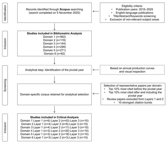
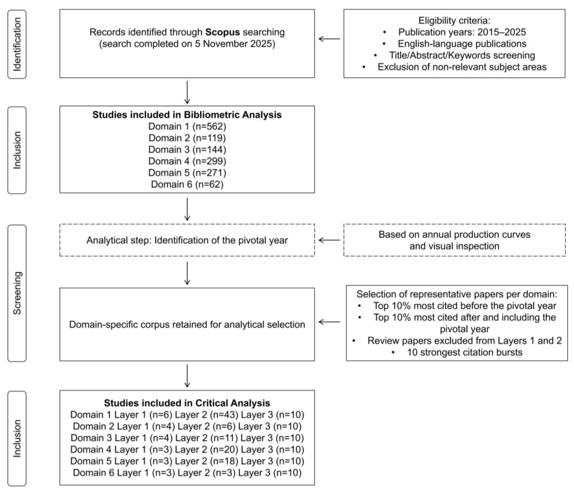
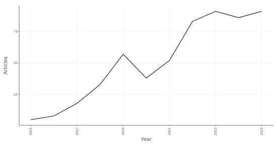
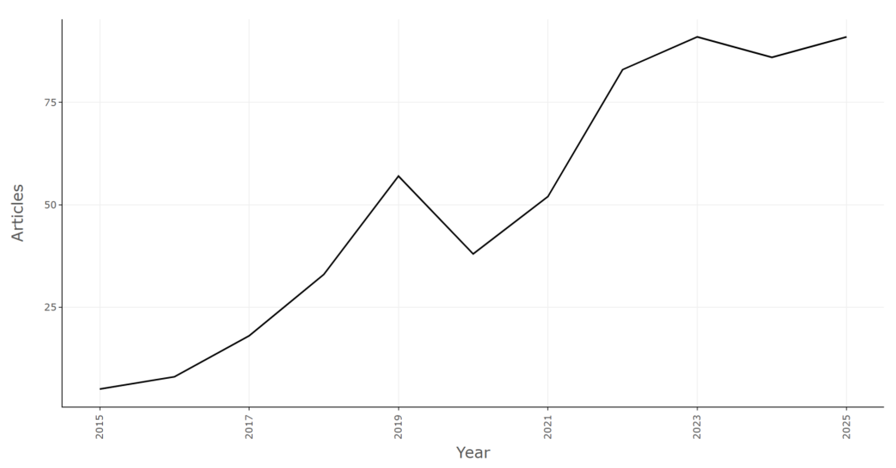
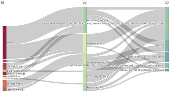
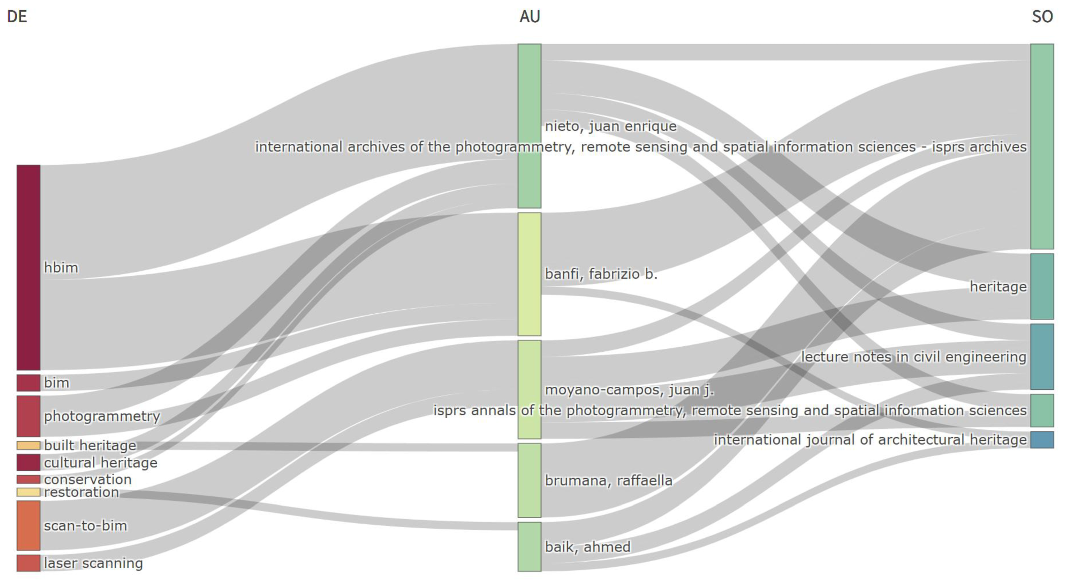
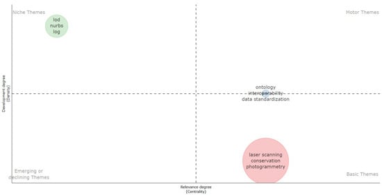
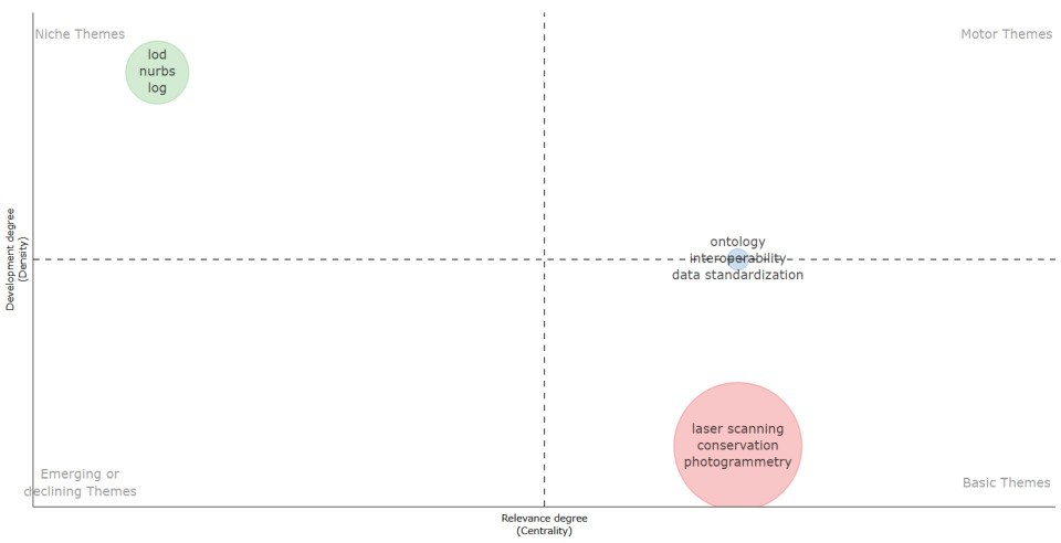
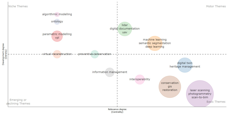
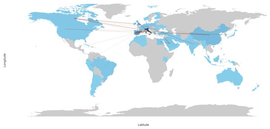
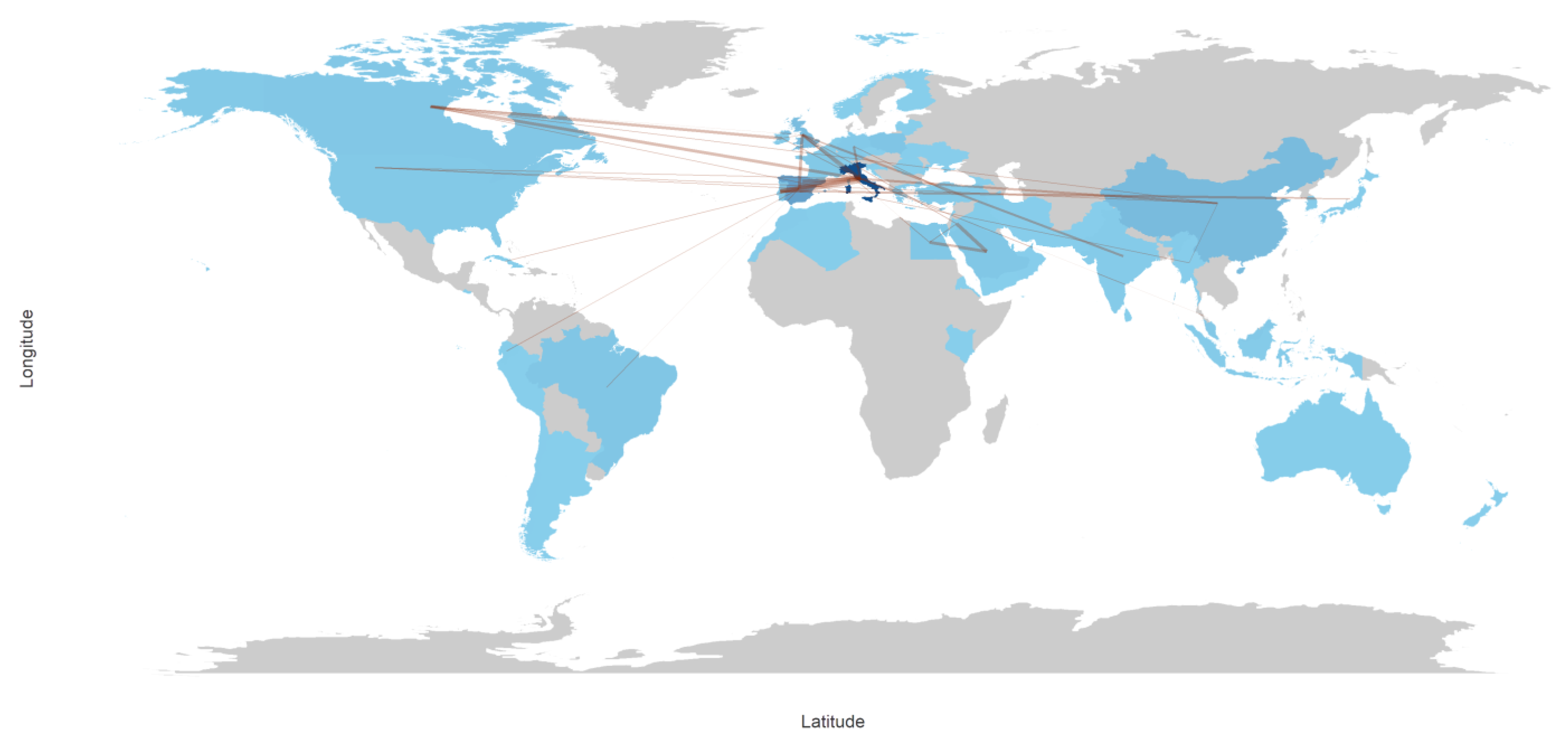
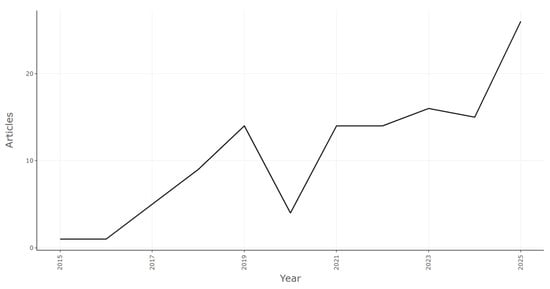
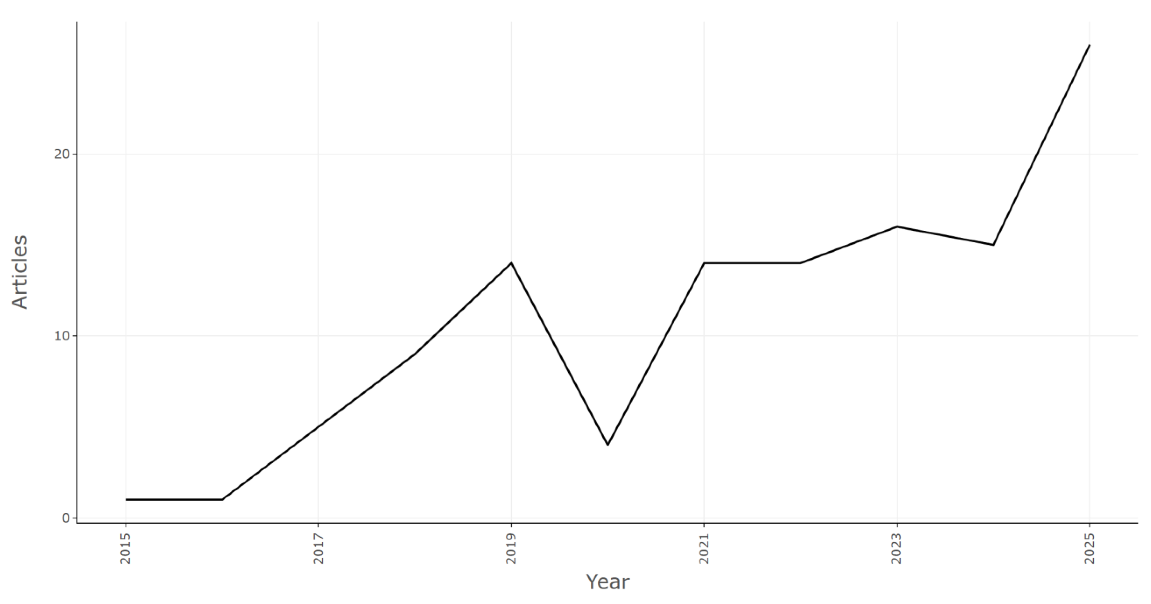
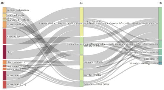
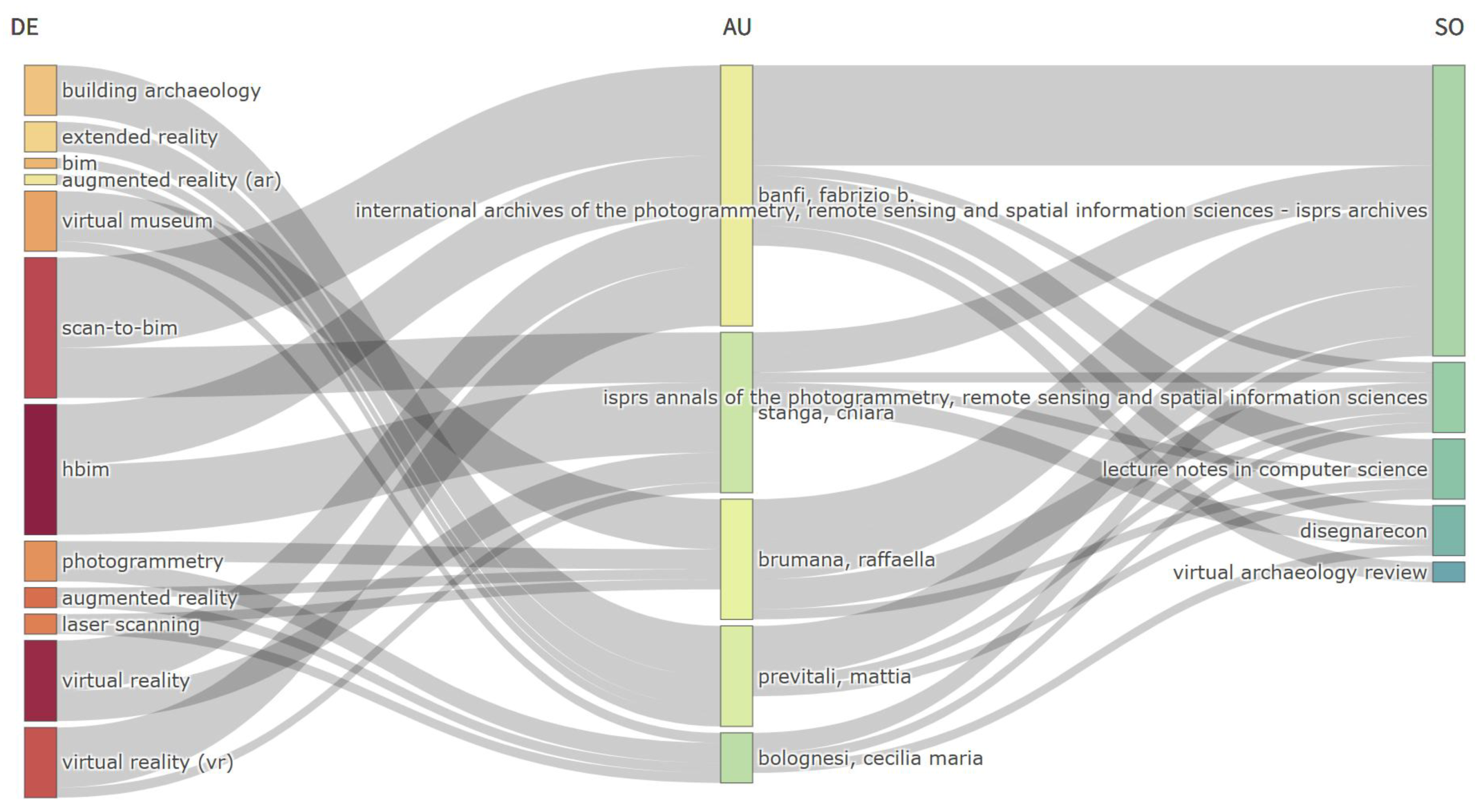
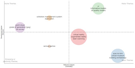
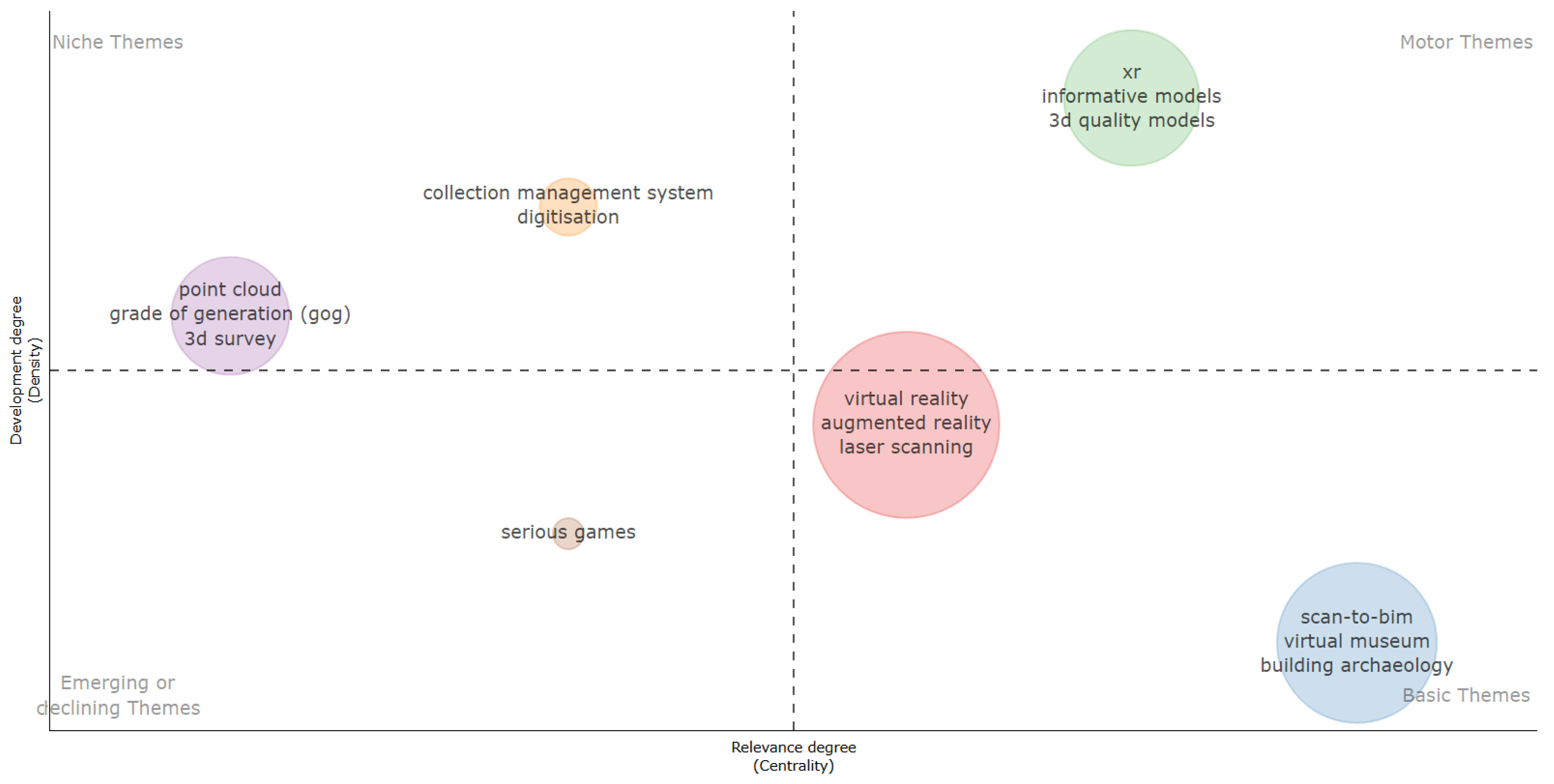
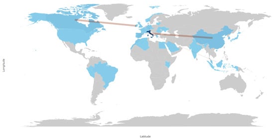
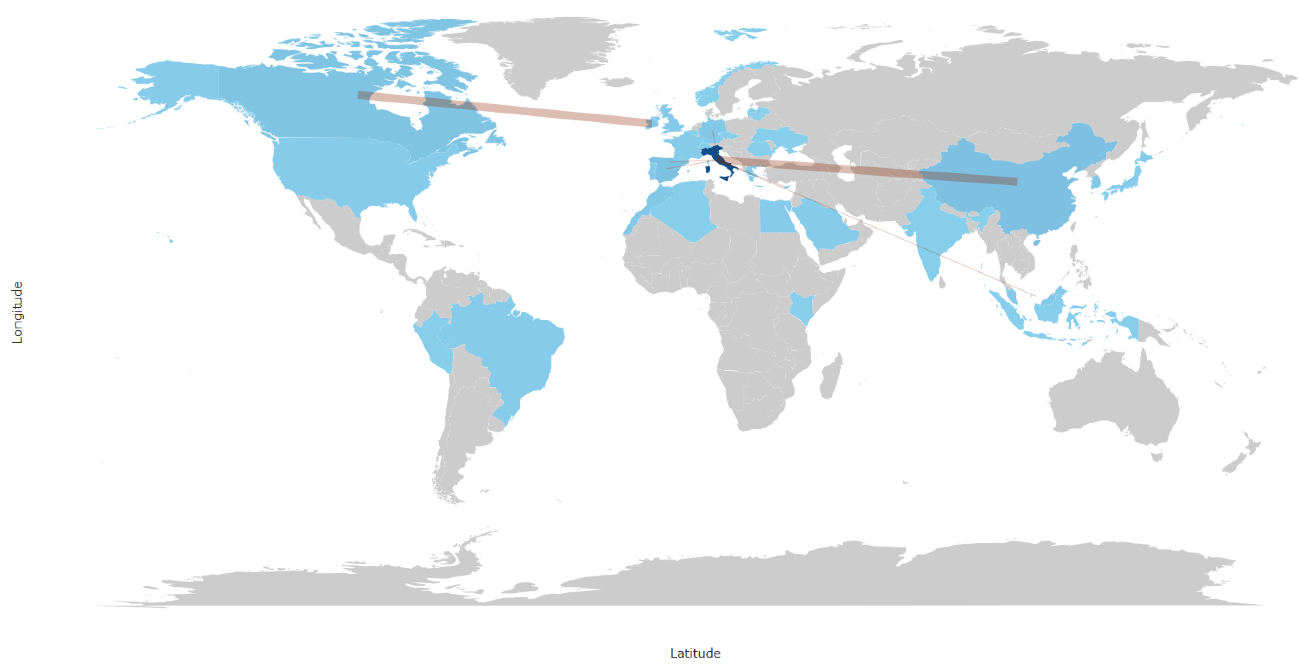
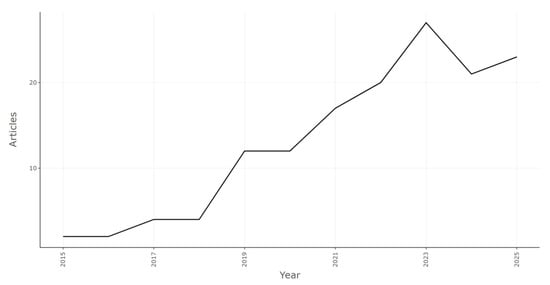
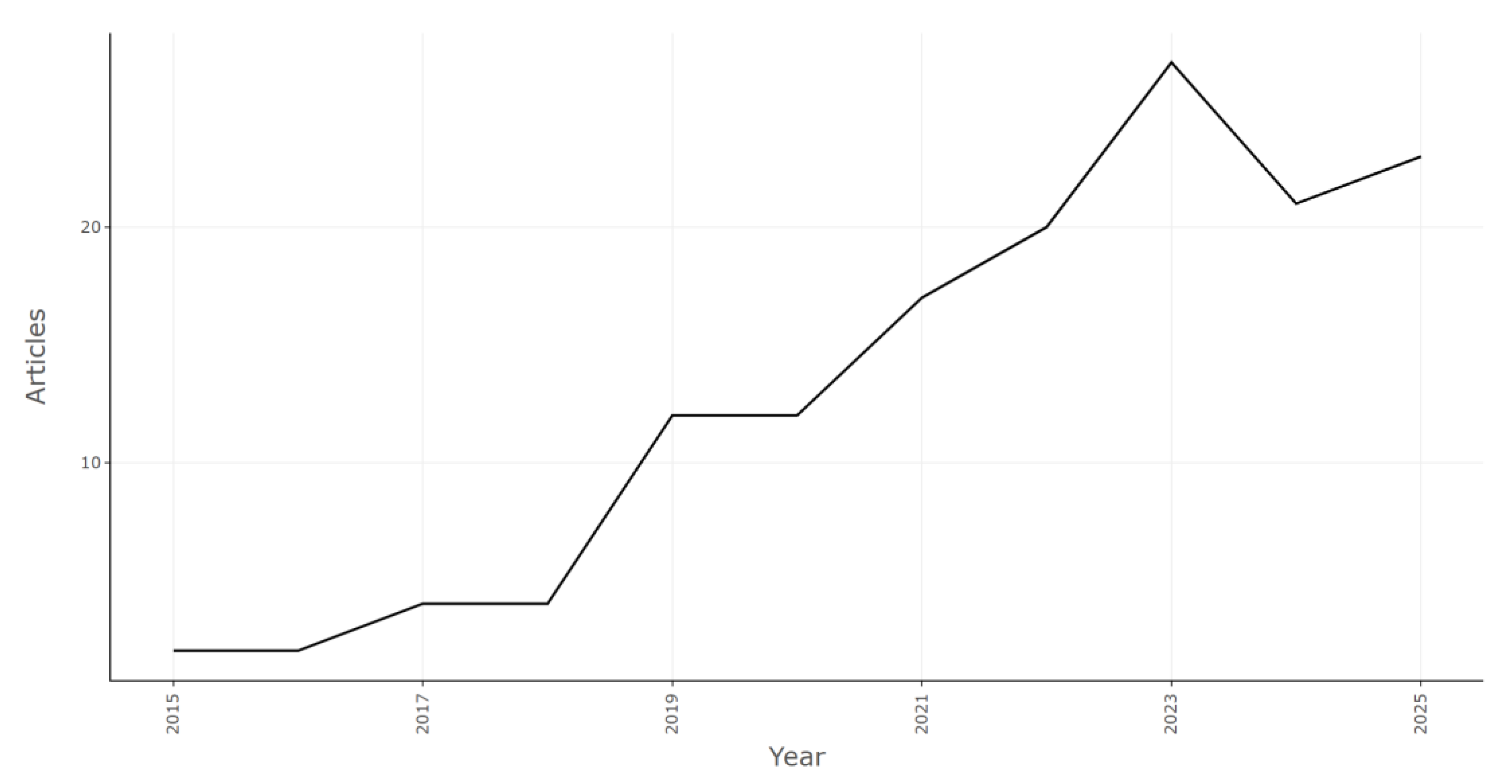
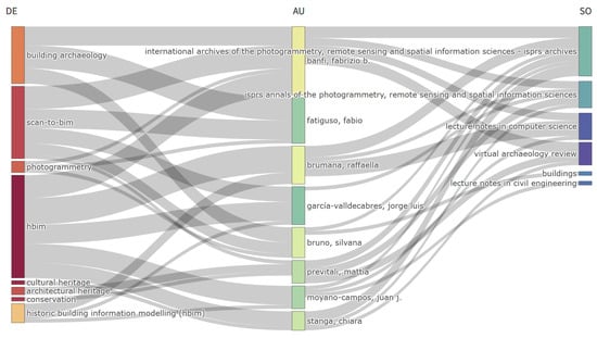
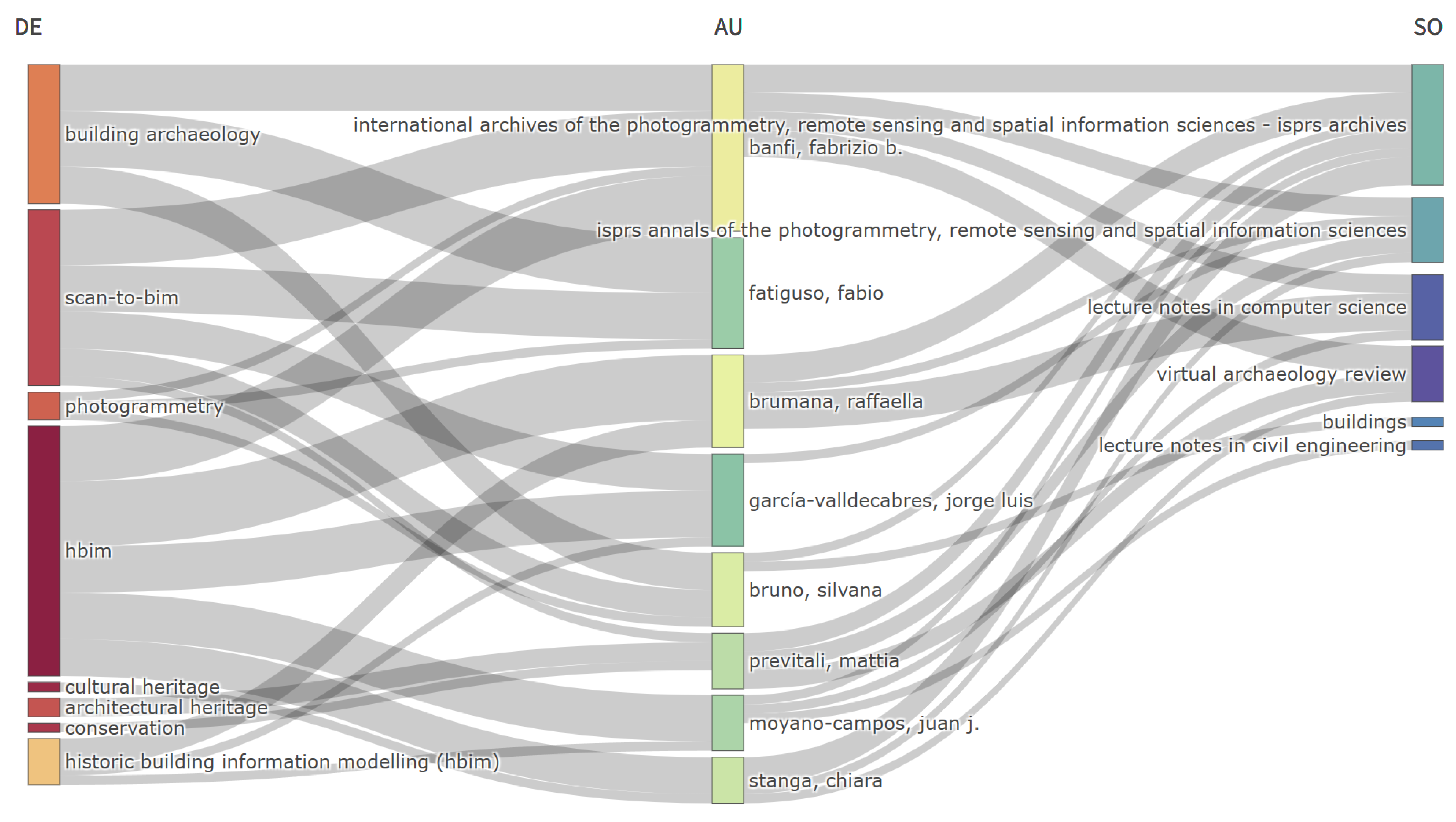
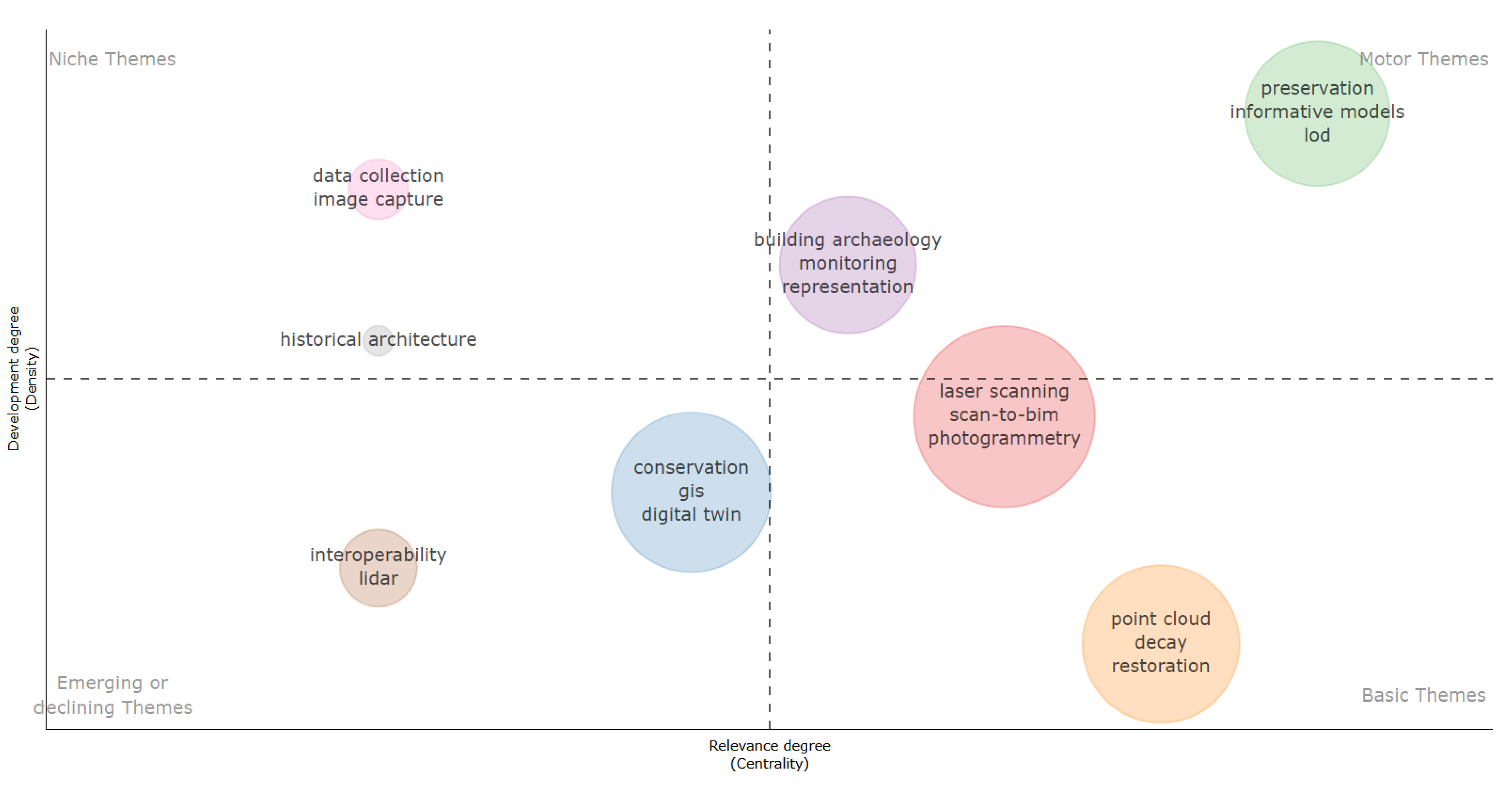
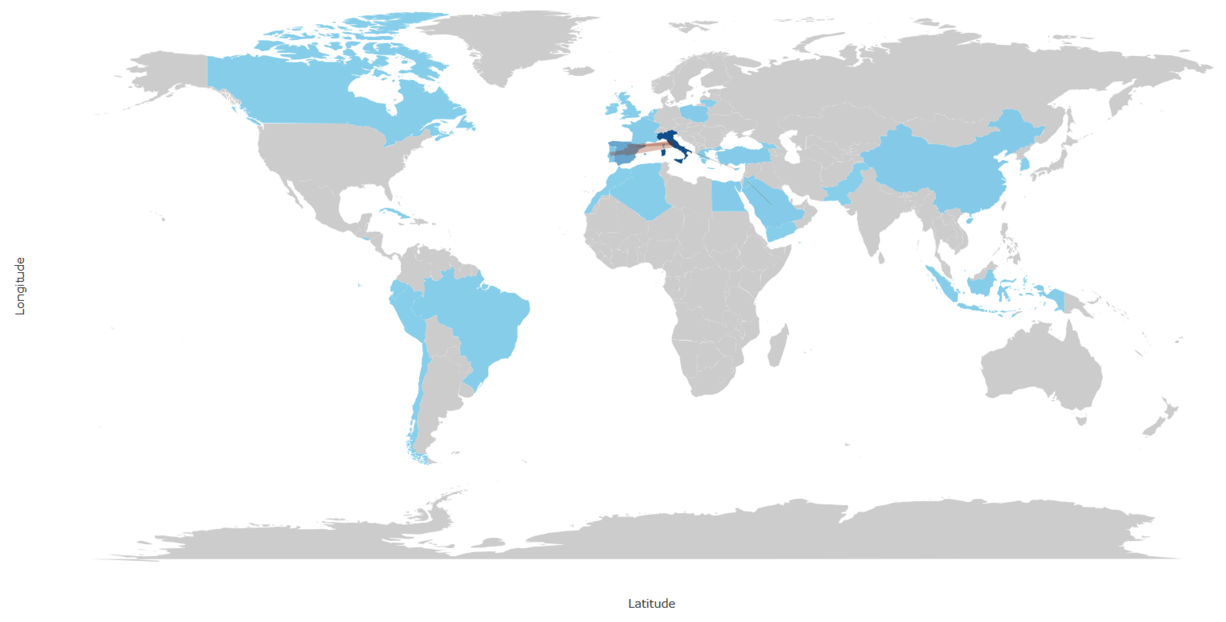
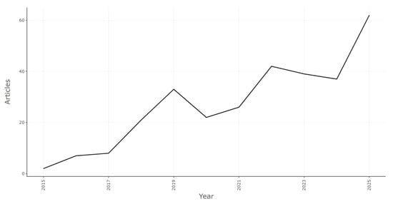
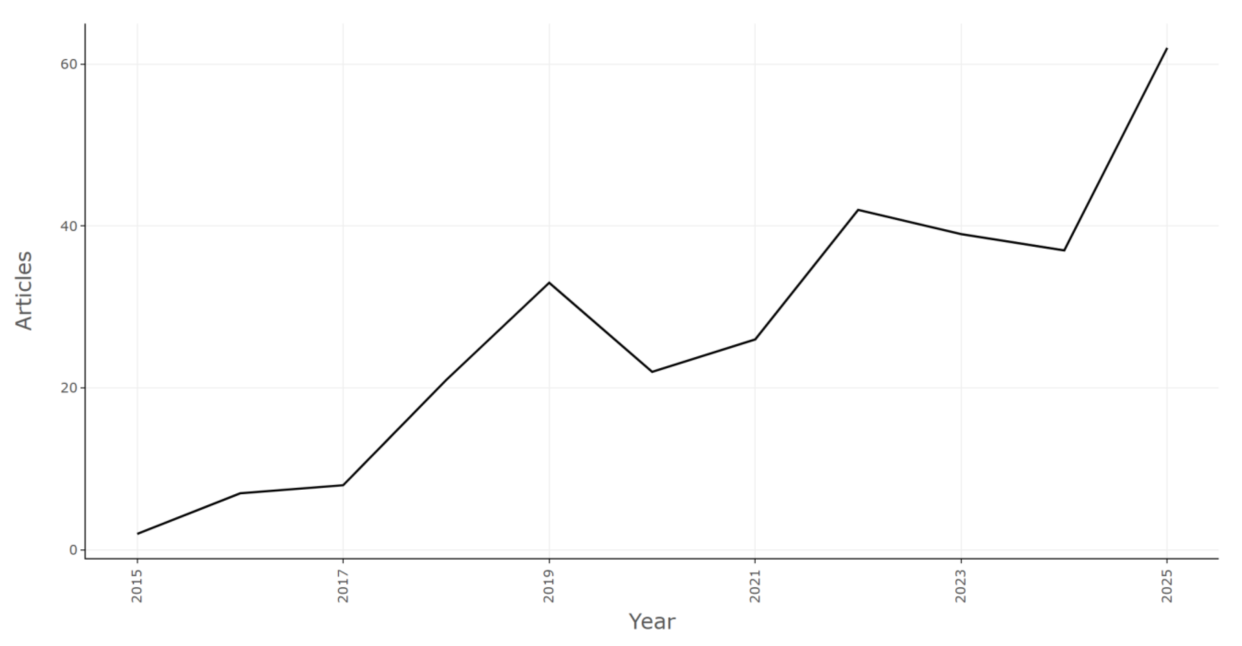
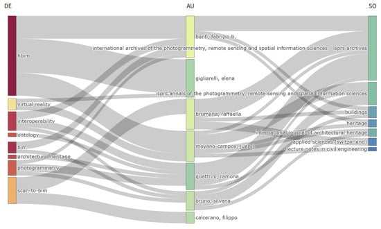
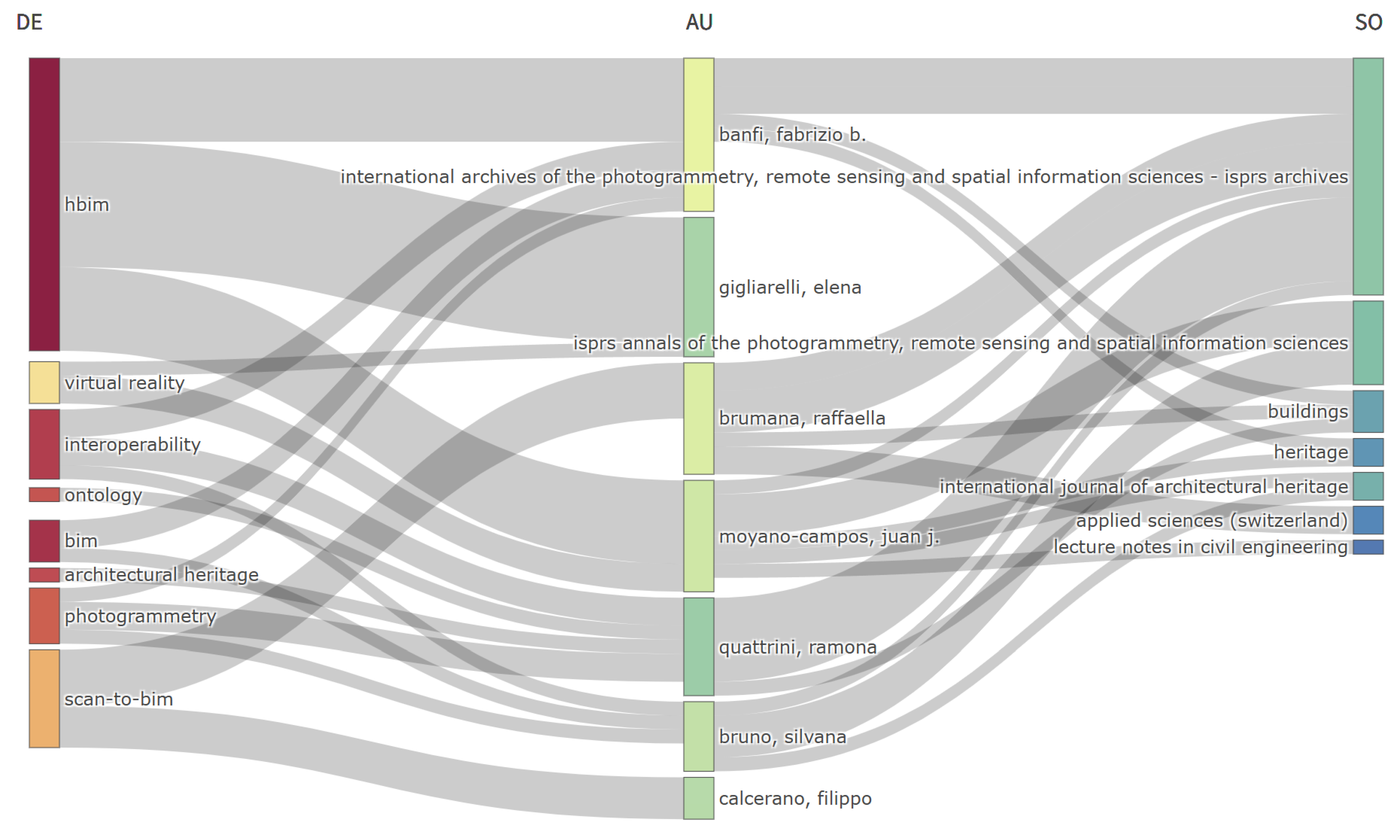
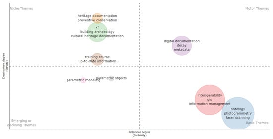
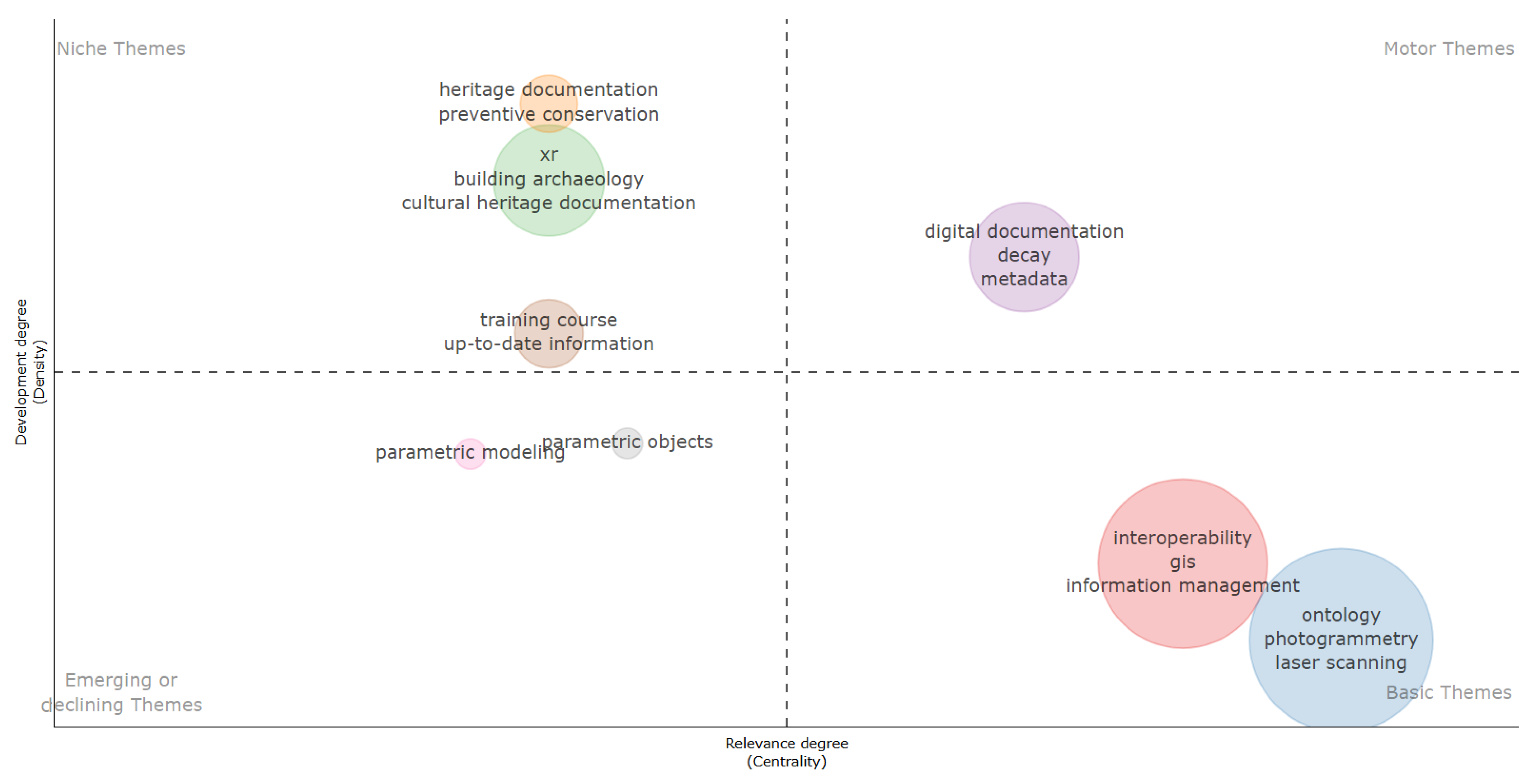
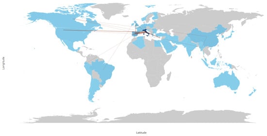
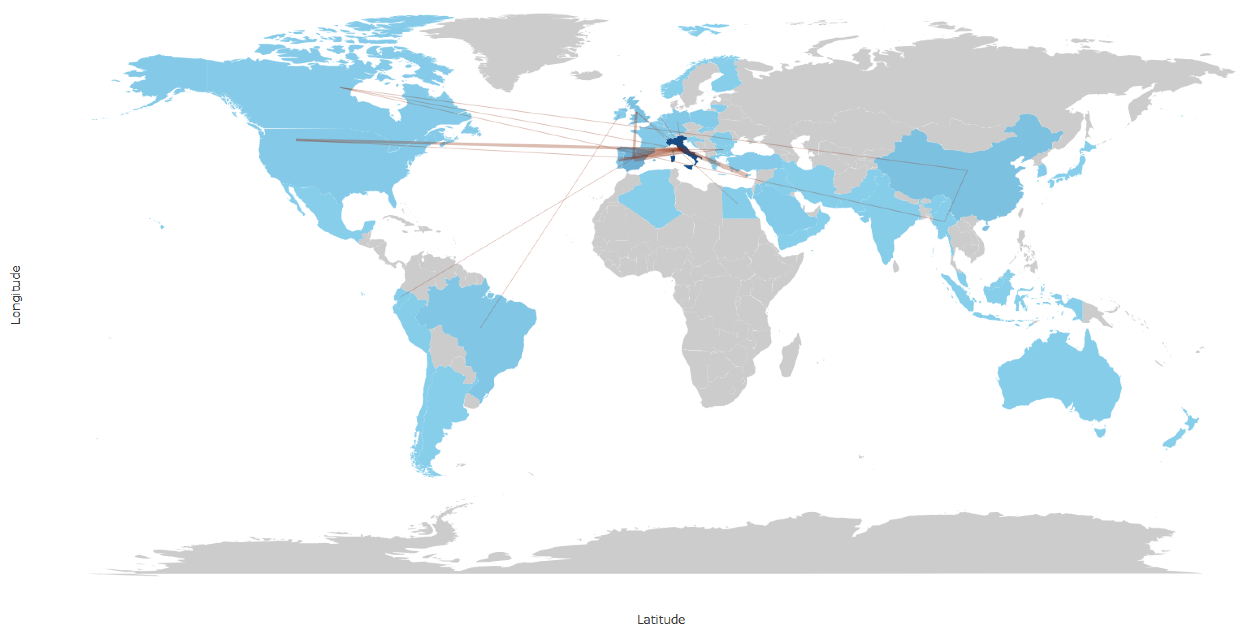
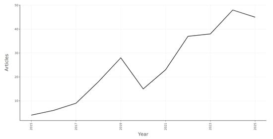
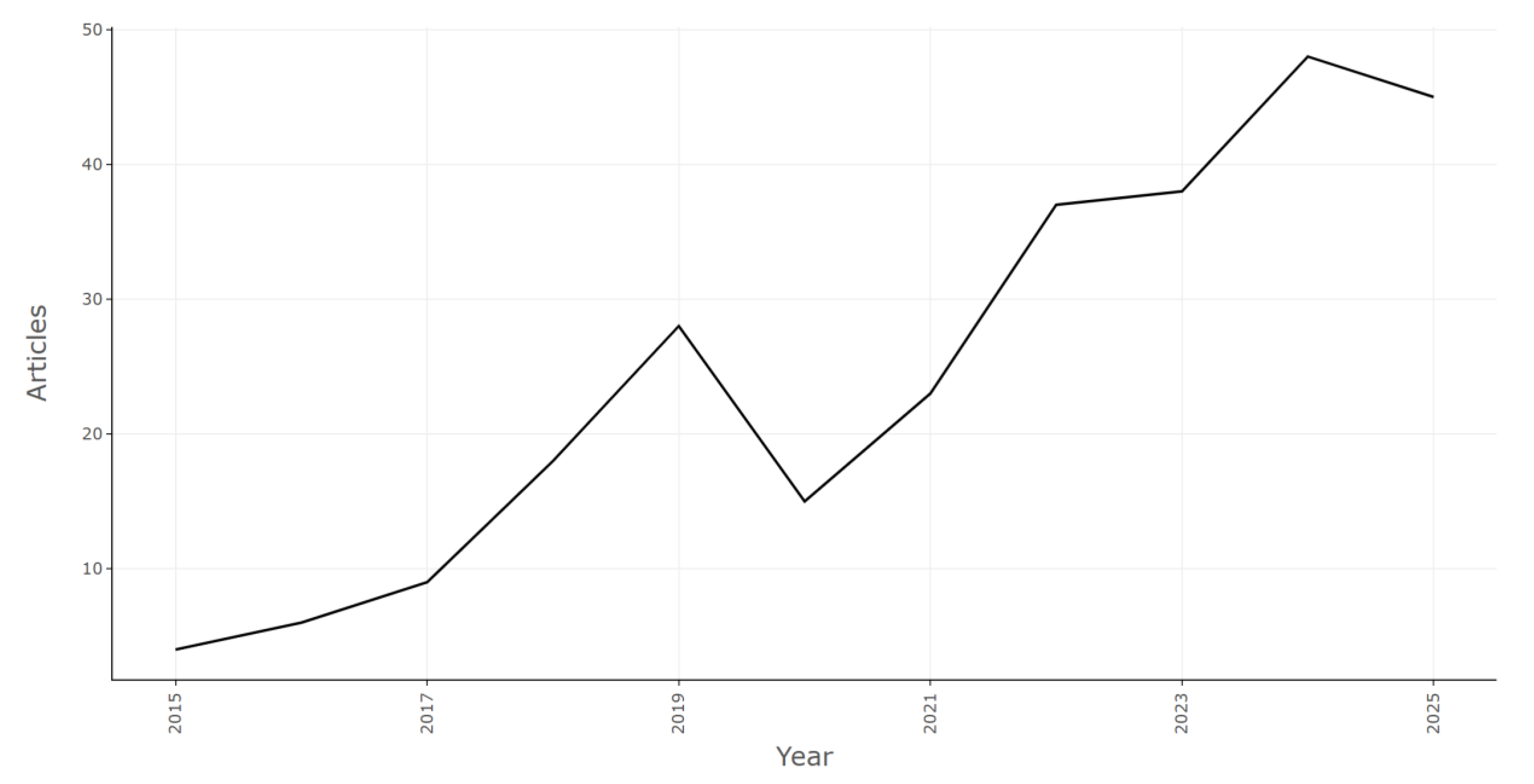
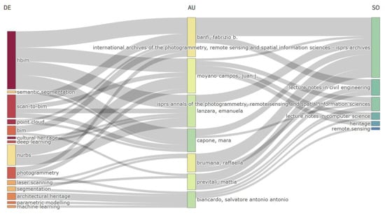
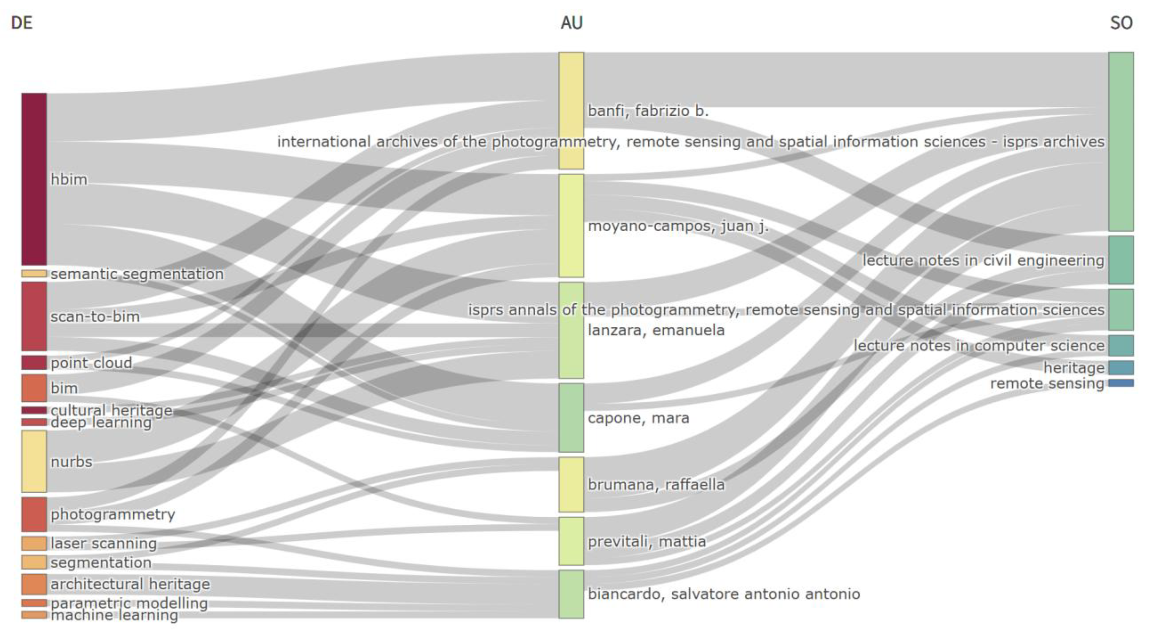
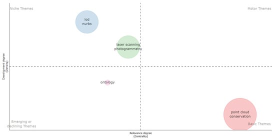
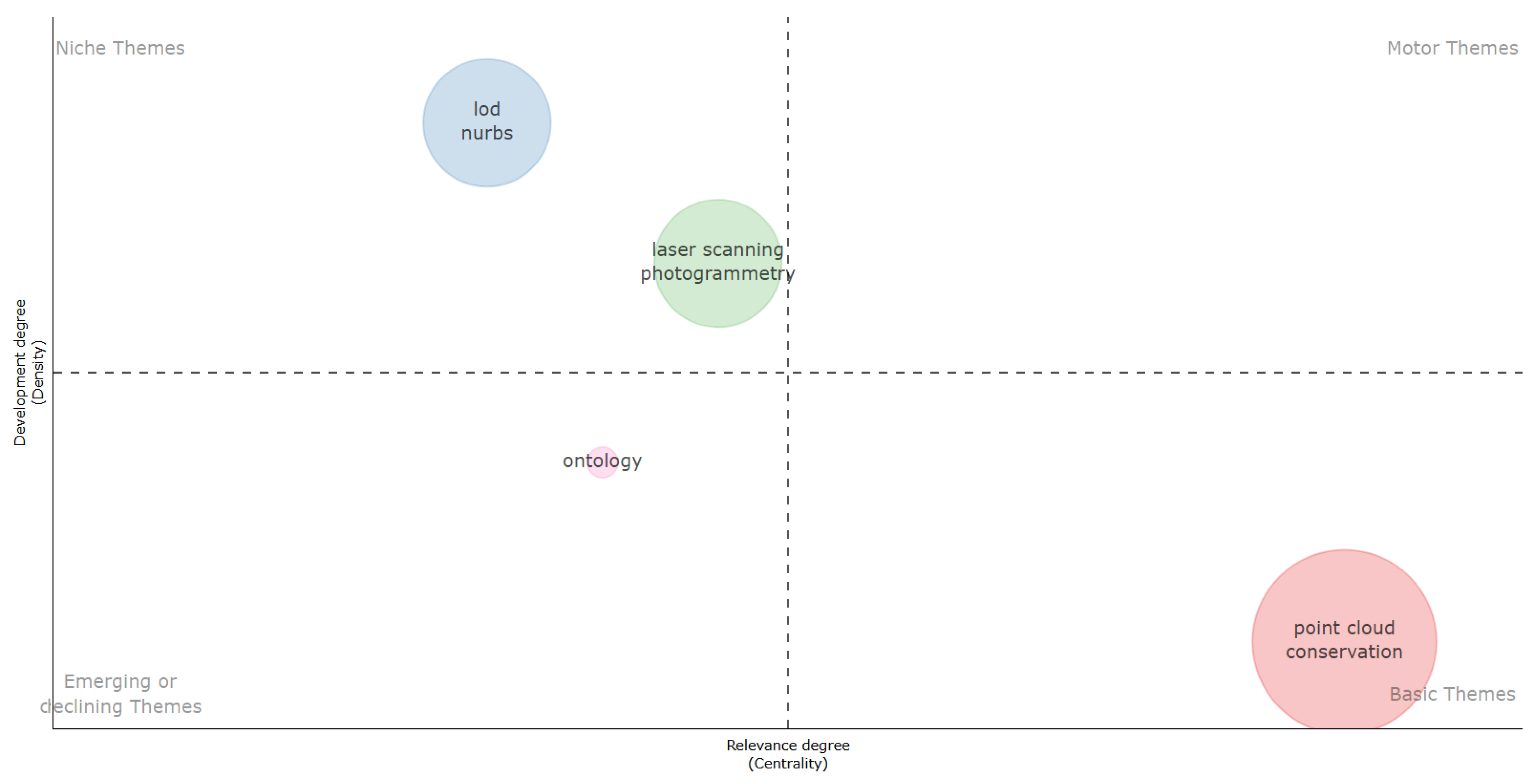
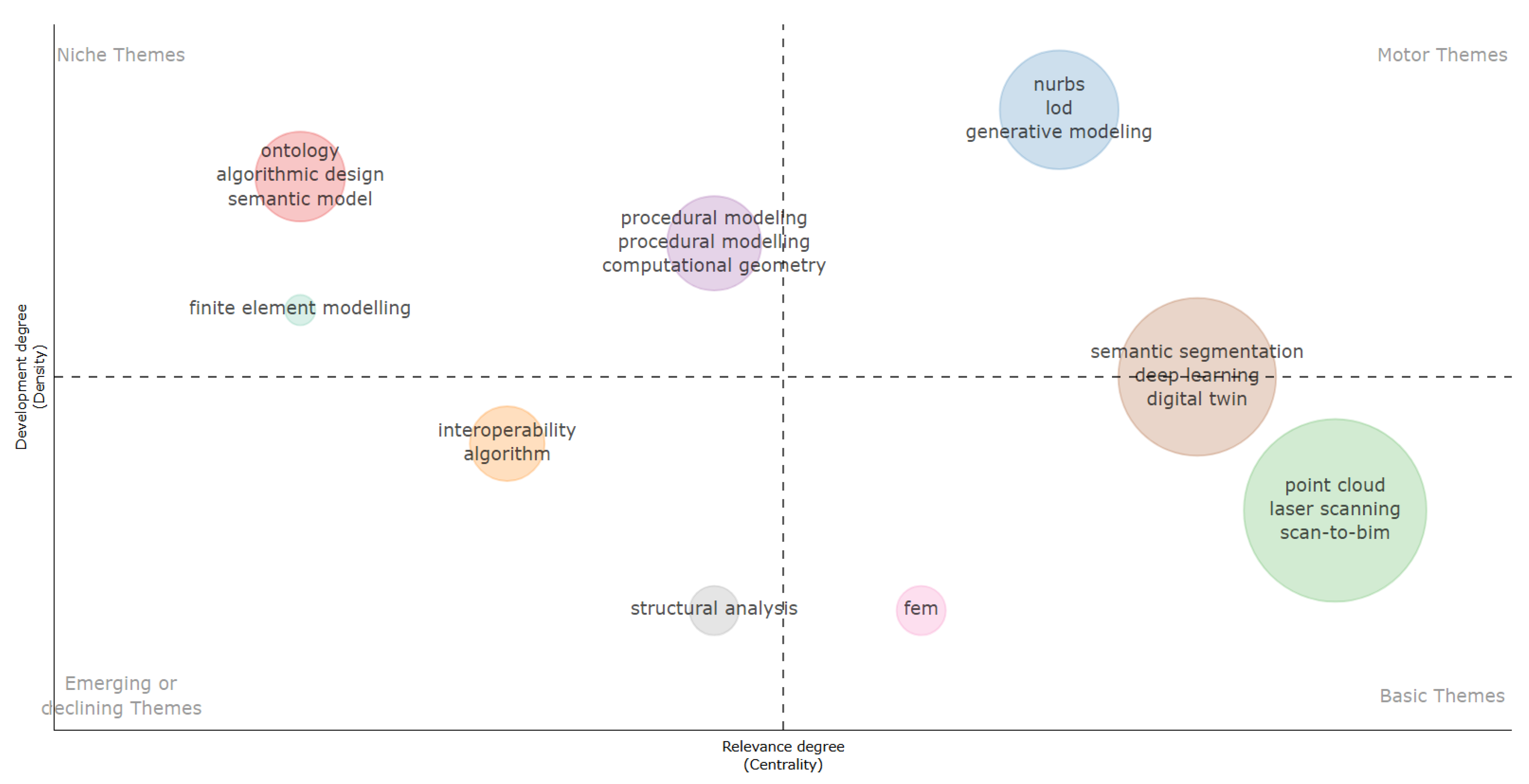
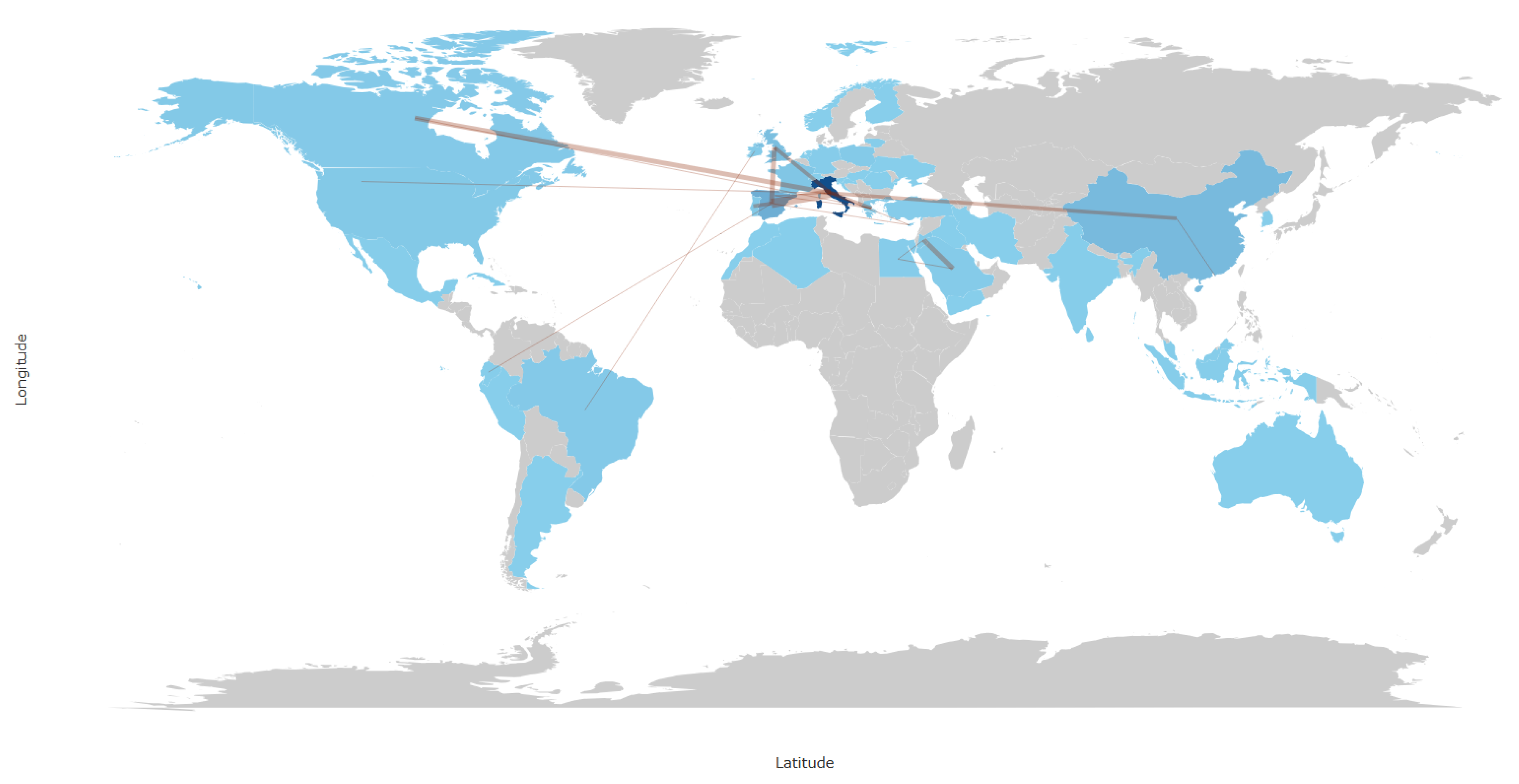
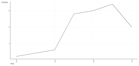
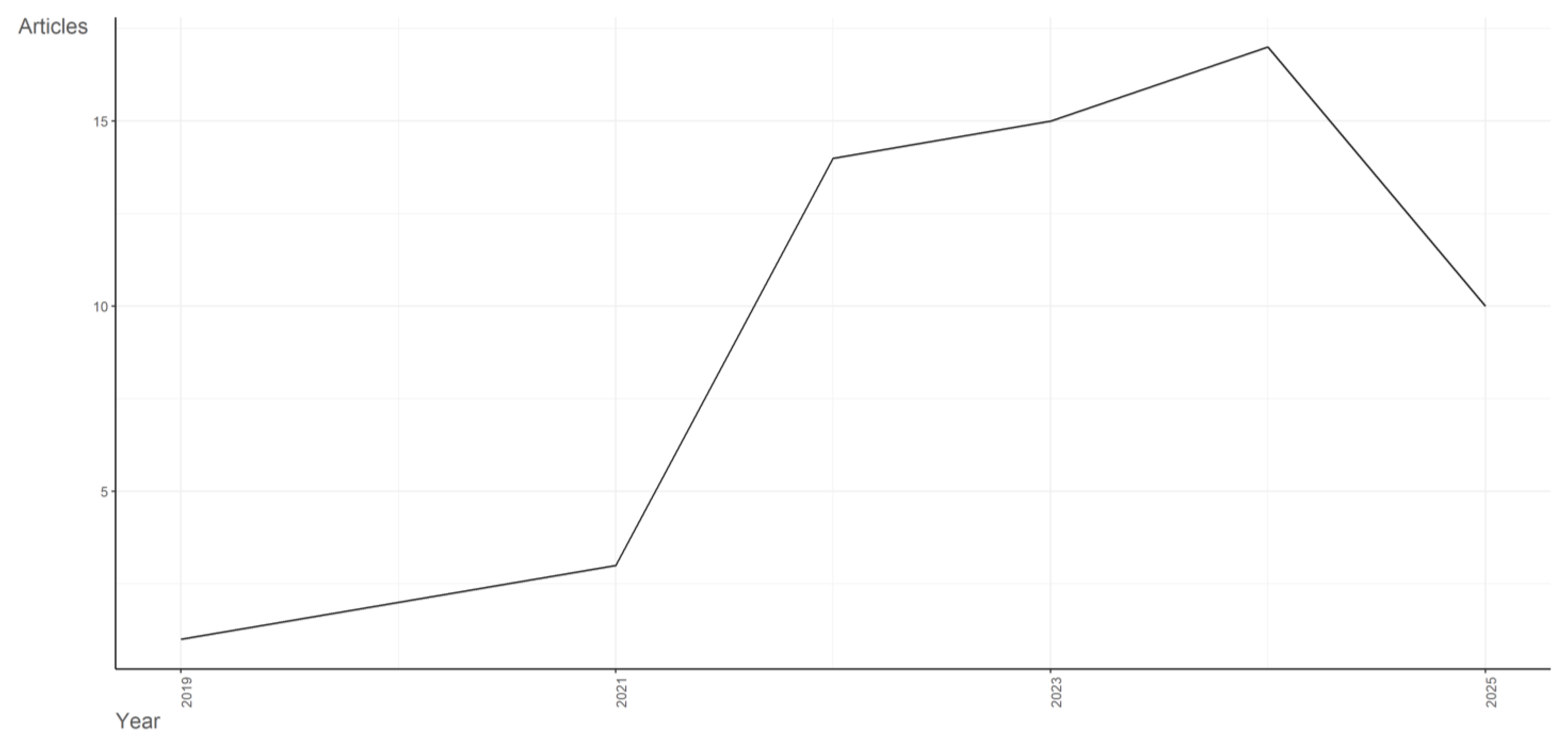
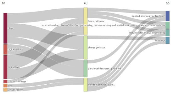
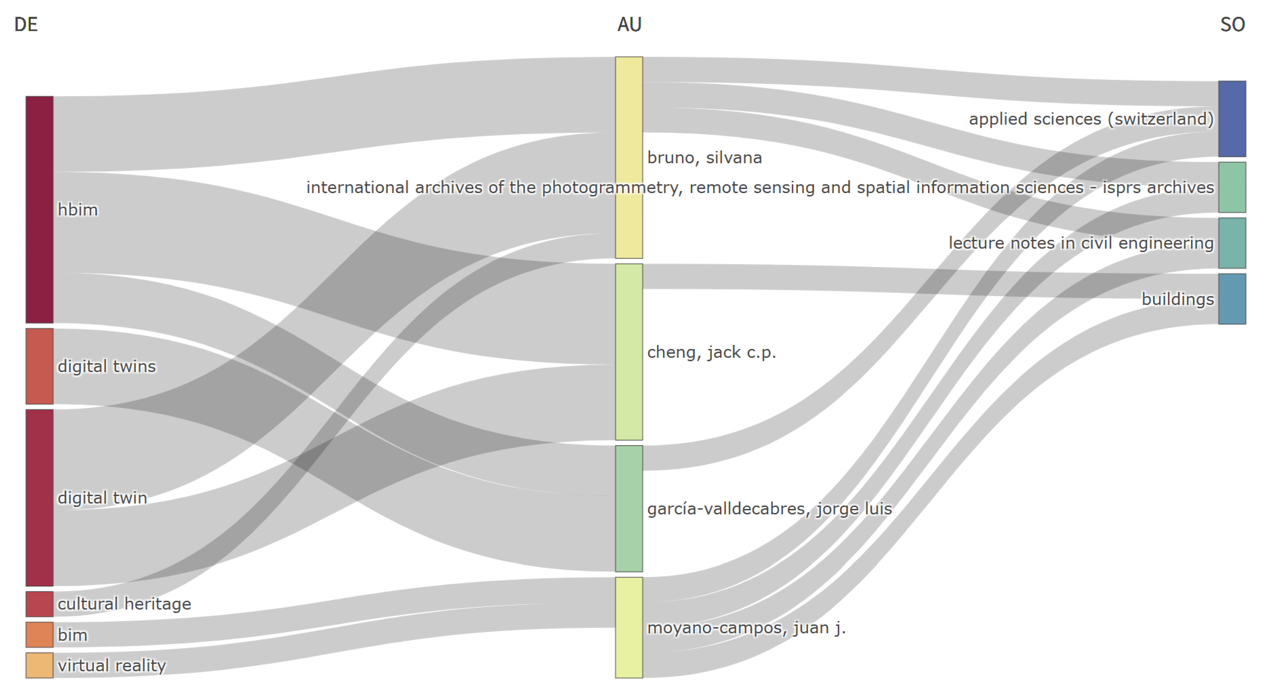
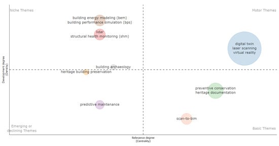
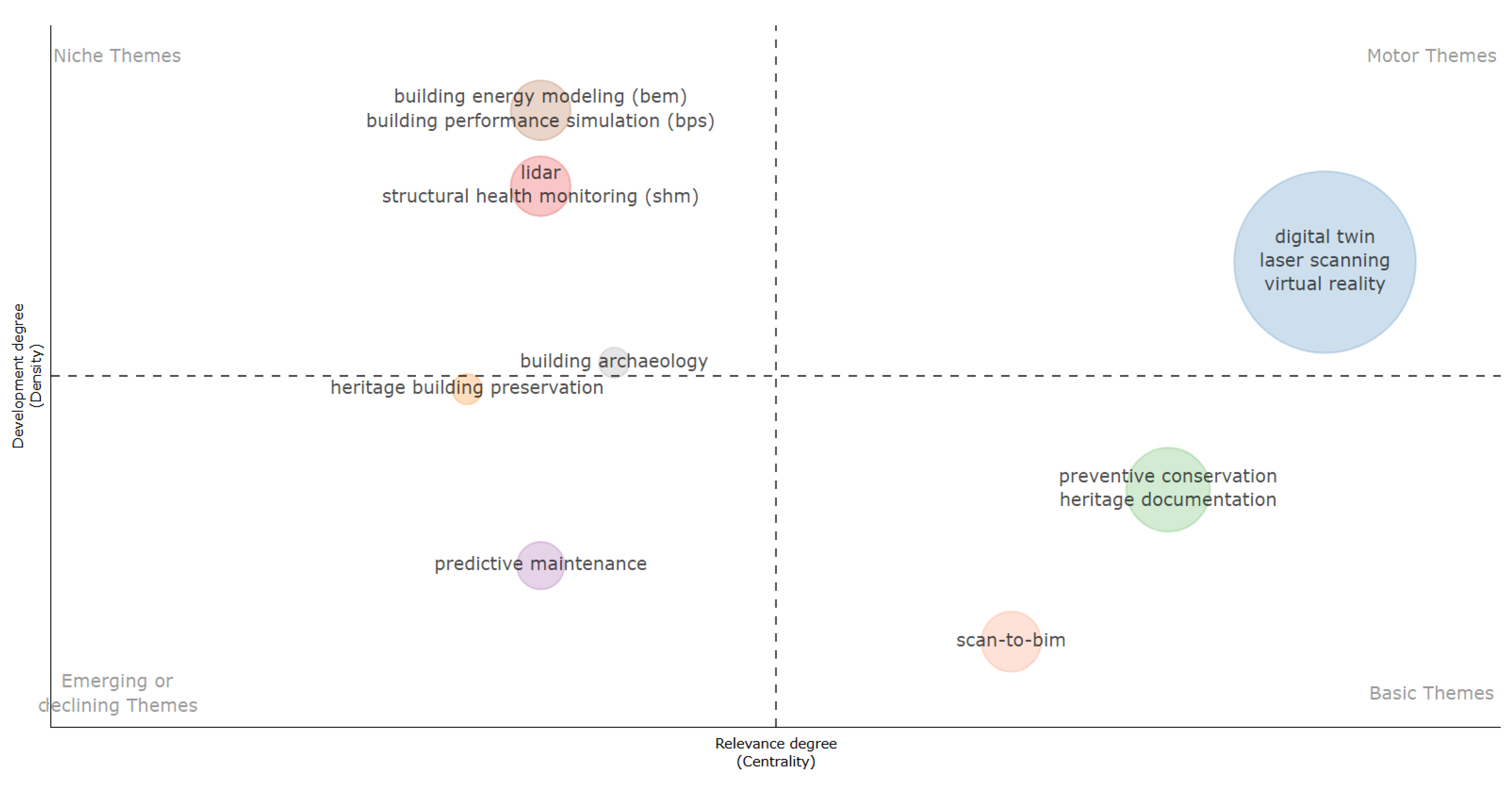
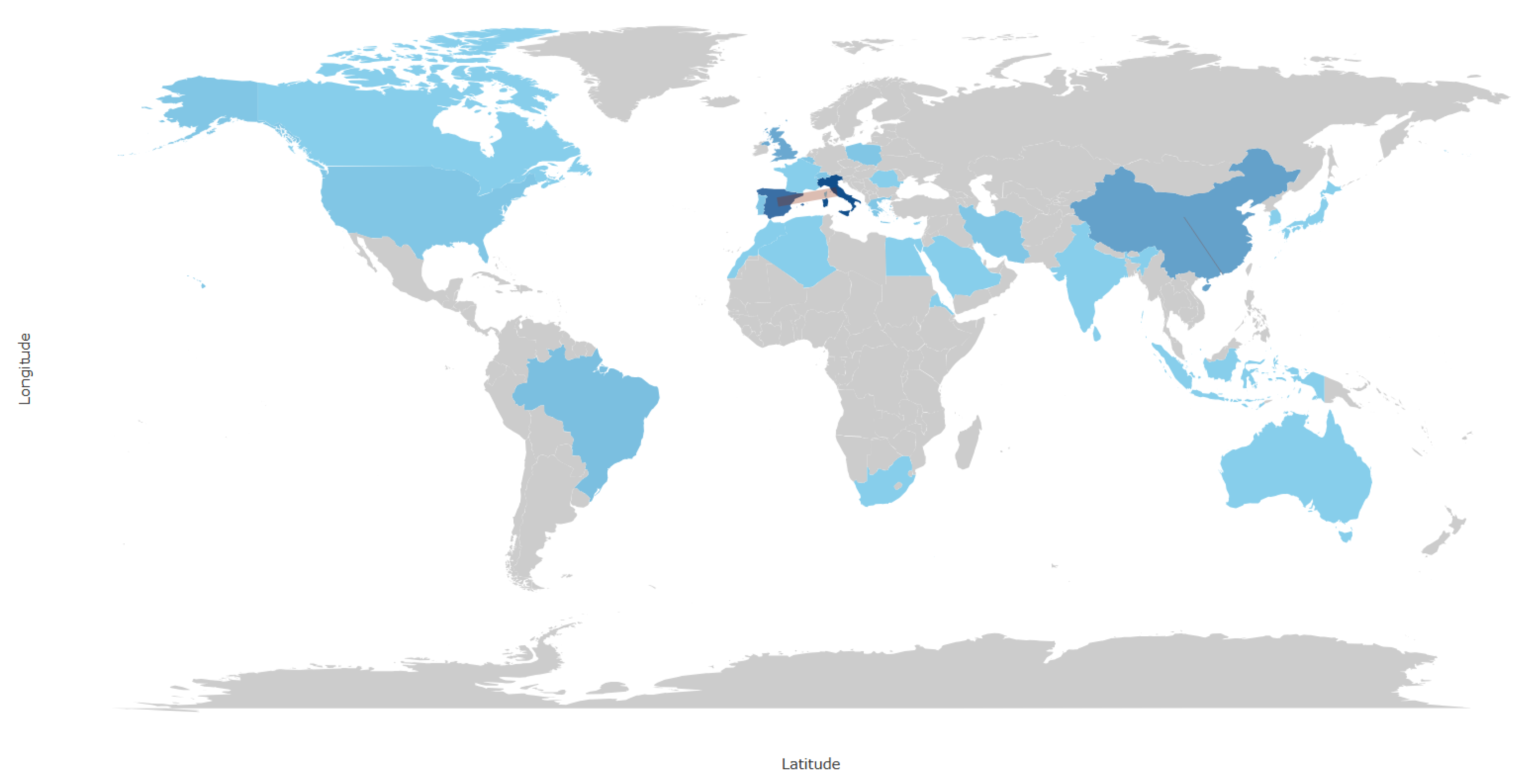

Disclaimer/Publisher’s Note: The statements, opinions and data contained in all publications are solely those of the individual author(s) and contributor(s) and not of MDPI and/or the editor(s). MDPI and/or the editor(s) disclaim responsibility for any injury to people or property resulting from any ideas, methods, instructions or products referred to in the content. |
© 2026 by the authors. Licensee MDPI, Basel, Switzerland. This article is an open access article distributed under the terms and conditions of the Creative Commons Attribution (CC BY) license.