


Abstract
Discontinuous ground deformations represent one of the most critical geohazards affecting both natural and anthropogenically transformed environments. These processes pose a serious threat to infrastructure stability and land-use planning, as they can lead to severe structural damage and long-term ground instability. Effective geotechnical hazard management requires an integrated understanding of geological structures, deformation mechanisms, and the legacy of historical subsurface transformations influencing current and future ground behaviour. This paper—the first part of a two-part series—introduces an extended three-channel conceptual–probabilistic model and outlines its causal structure, integrating predisposing, triggering, and causative factors. The present study focuses exclusively on the theoretical foundations of the model and on the hierarchical classification of thirteen key predisposing factors defining the long-term susceptibility of the rock mass (S(A)). These include both structural and physicochemical controls such as karst voids, weak interfaces, hydro-mechanical activity, and near-surface weathering. The proposed approach provides a physically consistent conceptual basis for representing the interactions among the three causal domains. The second part of the series will address triggering and causative domains and will discuss methodological and implementation aspects of the model within the completed causal structure.
1. Introduction
Among geotechnical hazards, discontinuous ground deformations are among the most complex and least predictable phenomena within the Earth’s crust. Their occurrence results in the loss of structural continuity of the ground, leading to abrupt displacements that endanger infrastructure, buildings, and eco-systems. These processes pose a major challenge for contemporary geoengineering, spatial planning, and environmental risk management. Their relevance continues to grow under global trends of urbanization, intensive resource exploitation, and climate change, which collectively alter the conditions controlling surface stability.
The classical foundations for the systematics of mass-movement processes were established by Varnes (1978) [1], who proposed the first coherent classification of slope movements based on the type of material (rock, debris, or earth) and the dominant deformation mechanism (fall, slide, flow, spread, creep). This framework was refined by Cruden and Varnes (1996) [2] within the IAEG Commission on Landslides, introducing morphodynamic and genetic distinctions. The most authoritative update was presented by Hungr, Leroueil, and Picarelli (2014) [3], who extended the classification to encompass complex and long-term deformations, emphasizing the continuum between continuous and discontinuous modes of failure.
The Italian research school (CNR–IRPI group: Reichenbach, Brunetti, Rossi, Guzzetti) further integrated morphological classifications with probabilistic and cartographic approaches. In their seminal synthesis, Reichenbach et al. (2018) [4] provided a comprehensive review of statistical methods for modelling landslide susceptibility and hazard, which remains a cornerstone reference in geomorphological risk assessment.
Despite these advances, most existing studies continue to address only narrow process groups—primarily landslides—and thus fail to represent the full spectrum of discontinuous ground deformations, including karst, suffosional, mining-induced, tectonic, and anthropogenic failures [5,6]. The classical probabilistic definition of risk, R = P(A) × L(A), expresses it as the product of the event probability P(A) and its consequences L(A). Although widely applied in engineering risk management (ISO 31000) [7], this formulation does not fully capture the dynamics of processes leading to the rupture of rock-mass continuity.
Recent progress in spatiotemporal hazard modelling has introduced formulations in which event probability is expressed through a hazard rate function λ(A,t), dependent on intrinsic susceptibility and the temporal variability of triggering factors [8,9]. These models formally separate spatial and temporal influences, ensuring logical consistency between susceptibility, triggers, and observed effects. Yet, most remain process-specific and lack the universality required to describe the complete range of discontinuous phenomena. The absence of a unified framework capable of describing and quantitatively assessing discontinuous deformations of diverse origins represents a systemic limitation of current hazard theory—rooted in the restriction of causal representation to only two factor groups.
Traditional models assume that deformation probability depends solely on predisposing and triggering factors, implying that, where susceptibility S(A) = 0, deformation cannot occur. However, certain energetically induced processes can generate discontinuous deformations regardless of prior equilibrium conditions. Such processes include open-pit excavation, blasting, and high-energy impacts.
To overcome this limitation, this study introduces an integrated hazard framework for discontinuous ground deformations that unifies natural and anthropogenic processes within a three-component causal model, distinguishing among:
- Predisposing factors—permanent ground properties defining susceptibility S(A);
- Triggering factors—time-dependent external stimuli initiating deformation hk(A,t);
- Causative factors—direct, energy-driven phenomena represented by the additional causal channel λC(A,t). This component accounts for abrupt, high-energy anthropogenic events (e.g., mining void collapse, gas outburst, structural pillar failure) that are capable of generating discontinuous deformation even in areas with low or negligible susceptibility. Such events are governed primarily by the sudden release of stored mechanical or geostatic energy rather than by pre-existing predisposing conditions at the surface.
The total hazard rate is expressed as:
where the first term represents the conditional hazard component resulting from the interaction between predisposing and triggering factors, while the second term corresponds to the causative channel λC(A,t), enabling deformation events even in areas where S(A) = 0. The probability of discontinuous deformation occurrence (D) within a time interval [t0, t1] is defined as:
S(A) is conceptualized as a spatially distributed susceptibility field, while hk(A,t) and λc(A,t) represent two independent modulation channels of the hazard rate—one governed by transient triggering influences and the other by deterministic causative actions.
Uncertainty quantification is explicitly incorporated by separating epistemic uncertainty, arising from incomplete knowledge of subsurface conditions, from aleatory variability associated with inherently stochastic deformation processes.
Introducing this third causal channel provides a formal representation for energy-forced discontinuities that remain outside the scope of conventional geotechnical hazard models. Its theoretical rationale and analytical formulation are presented in Part II of this study.
The proposed framework is general and physically consistent. It integrates multiple deformation mechanisms within a single probabilistic–geomechanical formulation, preserving both dimensional coherence and physical interpretability of the hazard function. This model enables quantitative evaluation of ground-deformation hazards across the entire natural–anthropogenic continuum. It thus offers a systematic synthesis of previously fragmented concepts and provides a foundation for the advancement of comprehensive, causally consistent risk-assessment methodologies in geoengineering and spatial-planning practice
2. Discontinuous Ground Deformations: Definition and Conceptual Framework
Discontinuous ground deformations constitute geomechanical phenomena characterized by the loss of structural continuity within a rock mass, in the topological sense. They result in abrupt spatial variations in the displacement field and the formation of discrete surfaces or lines along which the displacement exhibits a finite jump. These discontinuities partition a previously coherent medium into blocks or domains that move independently under stress redistribution.
The fundamental diagnostic features of discontinuous ground deformations are summarized below.
2.1. Topological Rupture of Medium Continuity
Discontinuous deformations involve the development of either two-dimensional (2D) surfaces or one-dimensional (1D) traces of discontinuity that divide a continuous rock mass into kinematically distinct segments. Within such regions, the displacement field is no longer continuous, and the classical Lagrangian continuum formulation becomes invalid [10]. In mechanical terms, the material response transitions from a continuous to a discontinuous regime, governed by contact conditions along evolving discontinuity surfaces.
2.1.1. Finite Displacement Jump
Across a discontinuity, the displacement vector u undergoes a finite discontinuity expressed as:
indicating that the displacements on opposite sides of the discontinuity surface do not coincide. This condition defines a strong discontinuity, in contrast to weak or gradient-type discontinuities, where only strain or stress fields are discontinuous while displacements remain continuous [11,12]. The discontinuity surface thus acts as a kinematic boundary within the medium, separating domains of distinct motion.
2.1.2. Absence of a Locally Defined Strain Tensor
At points where the displacement field exhibits a finite jump, the spatial derivatives of u cease to exist. Consequently, the infinitesimal strain tensor εij cannot be defined in the classical sense. Mathematically, the displacement field fails to satisfy the continuity conditions required for differentiability of class C1 at the discontinuity surface [13,14]. This breakdown of differentiability forms the mechanical basis for localized failure, faulting, and block separation in geomaterials.
2.1.3. Temporal Scale of Occurrence
Discontinuous deformations usually develop over short time intervals, ranging from seconds to several days, although they are not necessarily dynamic in the sense of classical mechanics. Many such events occur quasi-statically, without significant accelerations, shock waves, or momentum transfer. A typical example is the sudden collapse of a void roof or a block fall induced by progressive weakening within the near-surface rock mass [15]. The transition from a continuous deformation regime to a discontinuous one represents a qualitative change in the mechanical state of the ground—an irreversible loss of coherence in the stress–strain–displacement field, and a fundamental indicator of geotechnical instability.
2.2. Classification of Discontinuous Ground Deformations
Scientific classifications of discontinuous ground deformations presented in the literature are generally based on topological, kinematic, and genetic criteria. The topological criterion distinguishes the geometric form of discontinuities, irrespective of their origin or displacement amplitude. The displacement criterion identifies the kinematic mode and the orientation of the displacement jump relative to the discontinuity surface. The genetic criterion defines the causal mechanism that governs the formation of the deformation.
Together, these approaches provide a coherent framework for describing the wide spectrum of discontinuous deformation processes occurring in both natural and anthropogenically transformed geological settings.
2.2.1. Topological Criterion
The topological approach to the classification of discontinuous deformations allows for a clear distinction between surface and linear forms of structural disturbance, regardless of their genesis or magnitude of displacement.
This classification refers to the geometric configuration and spatial extent of discontinuities. It is based on the geometric shape of the discontinuity surface projected onto the terrain surface (a two-dimensional ground surface expression), under the assumption that the primary discontinuity within the medium is itself a surface (2D in 3D space) [16,17,18] (Appendix A), and that its manifestation depends on the geometry, orientation, and depth of the structure.
Although, from a topological perspective, all discontinuous deformations result from the rupture of medium continuity along a discontinuity surface, geomechanical classification considers their geometric manifestation at the terrain surface.
Based on this criterion, two main classes are distinguished:
- Surface deformations, whose manifestation at the ground surface is two-dimensional;
- Linear deformations, whose manifestation at the surface is approximately one-dimensional, although both correspond physically to discontinuity surfaces extending through the rock mass.
2.2.2. Displacement Criterion
While the topological criterion distinguishes the geometric character of a discontinuous deformation as observed at the ground surface—whether it manifests as a one- or two-dimensional feature—it does not by itself confirm the loss of material continuity.
To identify a genuine rupture within the rock mass, a displacement criterion must be applied, based on the quantitative assessment of the displacement-jump field.
In classical continuum mechanics, deformation is described by both the displacement field u(x) and its spatial gradient, which defines the strain tensor.
For discontinuous deformations, only the displacement field remains meaningful: at the discontinuity, u(x) ceases to be differentiable, and the strain tensor cannot be defined locally because the field is not of class C1.
Formally, this discontinuity condition is expressed as [19]:
where
- ⟦u⟧ denotes the displacement-jump operator;
- n is the unit normal vector to the discontinuity surface;
- ε denotes a positive infinitesimal quantity (not to be confused with the strain tensor).
A non-zero displacement jump ⟦u⟧ ≠ 0 indicates that displacements on opposite sides of the discontinuity surface are unequal, implying that the strain tensor εij
is not defined at that location. Consequently, classical continuous measures of strain cannot be applied within the discontinuity zone.
Depending on the orientation of the displacement jump relative to the discontinuity surface, three fundamental kinematic modes are distinguished.
These correspond to the principal mechanisms of material separation conventionally denoted as Mode I, Mode II, and Mode III, controlled by the distribution of normal and shear stresses.
The displacement vector u can be decomposed into three orthogonal components: one normal to the discontinuity surface (n) and two tangential components (t1, t2) lying within it. Accordingly, the displacement jump may consist of:
- A normal component to the surface Γ: ⟦u⟧·n ≠ 0—Mode I;
- A tangential component to Γ perpendicular to the crack front SΓ: ⟦u⟧·t1 ≠ 0—Mode II;
- A tangential component to Γ parallel to SΓ: ⟦u⟧·t2 ≠ 0—Mode III.
The unit vectors n, t1, and t2 define a local orthonormal coordinate system associated with the discontinuity surface (Figure 1). In geomechanical terms, Mode I corresponds to tensile opening or closure, Mode II represents in-plane shear sliding, and Mode III denotes out-of-plane shear (tearing). By integrating the topological criterion with the displacement-jump kinematics, discontinuous ground deformations can be consistently classified according to both their geometric manifestation at the surface and the kinematic mode of relative displacement along the discontinuity surface.
Figure 1.
Local orthonormal coordinate system (n,t1,t2) associated with the displacement discontinuity surface Γ embedded in the geological medium domain Ω, with the discontinuity edge SΓ emerging at the ground surface. The unit vector n, normal to Γ, defines the direction of opening displacement discontinuity (Mode I). The tangential vectors t1 and t2, lying within the plane of Γ, define the directions of in-plane shear discontinuities: t1 is orthogonal to the discontinuity edge (Mode II), and t2 is parallel to it (Mode III). The displacement field u(x) is discontinuous across Γ, satisfying the condition ⟦u⟧ ≠ 0 at every point on this discontinuity surface (Table 1).
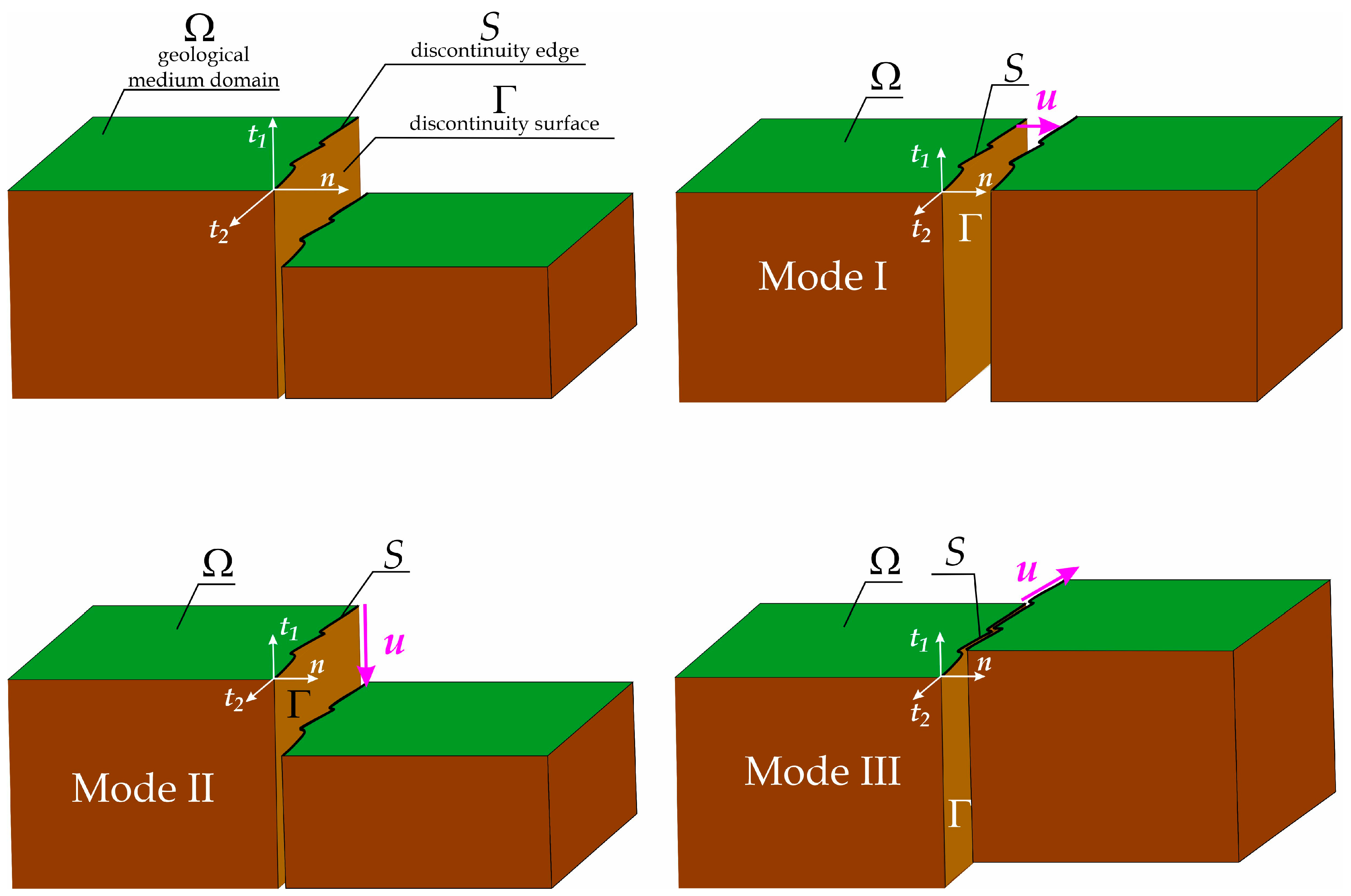
Table 1.
Kinematic classification of displacement discontinuities (Modes I–III).
When both the topological and displacement criteria are jointly applied, discontinuous ground deformations can be classified into two fundamental types: areal (surface) deformations and linear deformations. These categories capture both the geometric expression of discontinuities at the surface and the underlying kinematic nature of displacement within the rock mass:
- 1.
- Areal (surface) deformation—topological dimension 2
Areal deformation represents a discontinuity whose manifestation at the ground (terrain) surface is geometrically two-dimensional. It forms a finite-area depression bounded by a closed contour, which physically corresponds to the trace of a two-dimensional discontinuity surface extending downward into the subsurface. The enclosed area undergoes a downward displacement, typically associated with Mode II kinematics, producing an abrupt vertical offset in the ground surface. Points located within the closed boundary lie significantly lower than those outside it.
Depending on the geometry and depth of the underlying geometric discontinuity surface, such deformations may evolve into sinkholes, subsidence troughs, collapse craters, or chimneys. Their surface expressions are usually irregular and often approximate an elliptical outline. Surface deformations of this type generally result from the collapse of roofs over subsurface voids—either natural (karstic cavities) or anthropogenic (mining excavations)—caused by a loss of stability in the upper rock mass.
Typical discontinuous ground surface deformations encompass areas ranging from a few to several hundred square metres, with depths of several metres. In Central European karst terrains, sinkholes commonly exhibit diameters of 5–50 m and depths of 2–10 m. Under anthropogenic conditions, similar features are often associated with shallow abandoned mine workings [20,21,22].
Exceptional cases of large-scale surface deformation have also been documented. One of the largest natural sinkholes in the world, the Xiaozhai Tiankeng in Chongqing, China, reaches approximately 511 m in diameter, 662 m in depth, and an aerial extent exceeding 270,000 m2, illustrating the extreme development of karst denudation and subterranean drainage in carbonate formations [23].
A well-documented anthropogenic analogue is the Berezniki sinkhole in Russia, which formed in 2007 above an abandoned potash mine chamber. The collapse reached dimensions of over 500 m in length, 300 m in width, and 80 m in depth, exemplifying the sudden roof failure of water-saturated halite voids [24].
- 2.
- Linear deformation—topological dimension 1
A linear deformation represents a discontinuity whose expression at the ground (terrain) surface is geometrically one-dimensional—manifesting as a fissure, scarp, or ridge. The observed line of discontinuity corresponds physically to the trace of a two-dimensional geometric discontinuity plane propagating downward into the geological medium. The displacement discontinuity typically occurs in Mode I (tensile opening) or Mode II (in-plane shear), producing surface features such as open cracks, fault-like steps, or uplifted linear ridges. These deformations develop under tensile or shear stress regimes within the rock mass, commonly near tectonic fault zones or within areas subject to multi-level underground mining operations.
Typical linear discontinuous deformations range from several to several tens of metres in length, with widths from a few centimetres up to about 0.5 m, and vertical displacements reaching several tens of centimetres. In the Upper Silesian Coal Basin (Poland), sequences of deformation scarps have been recorded with lengths of 40–100 m and height differences of 0.4–0.5 m, occurring in areas of intensive coal extraction.
An extreme example is the extensive system of fissures and deformation scarps in the Zhaizhen Mine area (China), where cumulative mining-induced subsidence and reactivation of tectonic disturbance zones produced a crack exceeding 2100 m in length, locally up to 0.6 m wide, with vertical offsets of approximately 2.4 m
2.2.3. Genetic (Causal) Criterion
The genetic, or causal, criterion represents one of the principal approaches to classifying discontinuous ground deformations. In this framework, the primary distinguishing factor is the mechanism responsible for generating the deformation, irrespective of its morphology, spatial position, or geometric scale [25,26].
Based on this principle, three main genetic categories are generally recognized in the scientific literature:
- Deformations of anthropogenic origin
This category encompasses all discontinuous deformations induced by human activity, regardless of its character—mining, hydrotechnical, construction, or infrastructural.
Particularly significant are deformations associated with underground mining, which frequently lead to the formation of sinkholes, fissures, scarps, and linear surface displacements [27,28]. Such phenomena may result either from direct mechanical disturbance and the loss of rock-mass continuity or from secondary processes, including mine flooding, stress redistribution, or post-mining subsidence [29,30]. Anthropogenically induced discontinuities have also been reported in connection with groundwater withdrawal, fluid injection, and geothermal drainage, which locally promote subsidence or tensile fracturing within the near-surface zone [31,32].
- Deformations of natural origin
These deformations arise from naturally occurring geological processes acting independently of human influence. They include tectonic movements (faulting and fracturing), karst processes, landslides, rockfalls, and volcanic deformations [33]. Their identification and assessment are particularly relevant in urbanized or infrastructural areas, where discontinuities may develop suddenly and reach considerable magnitudes [34].
- Deformations of mixed (complex) origin
This group comprises deformations that evolve through the combined or successive action of natural and anthropogenic factors. For instance, pre-existing tectonic faults may become reactivated due to mining operations, while former karst collapses may be rejuvenated by changes in the groundwater regime within exploited zones [26]. Such mixed-origin deformations are characterized by high unpredictability and analytical complexity, making them a critical focus in modern geotechnical and engineering-geophysical studies.
3. Conditions Controlling the Occurrence of Discontinuous Ground Deformations
The genetic classification of discontinuous ground deformations is well established and widely adopted in geotechnical and geomorphological studies. However, within each genetic category, the controlling factors differ fundamentally in nature. Some represent inherent and persistent attributes of the geological or anthropogenic environment that define the predisposition of the ground to failure, whereas others act as transient external stimuli that serve as triggers for the initiation of deformation processes.
The two-tier conceptual framework distinguishing predisposing conditions from triggering factors is now a cornerstone of contemporary geotechnical and landslide hazard assessment [3,5]. This distinction extends beyond theory, holding direct practical significance: it determines the reliability of deformation forecasting and the effectiveness of preventive or mitigation strategies.
Predisposing conditions comprise the geological, hydrogeological, and anthropogenic characteristics that increase the likelihood of discontinuous deformation but are insufficient on their own to induce it. These include lithological properties (e.g., clay-rich strata, unconsolidated deposits, hydrocarbon-bearing layers), tectonic discontinuities (fault zones, breccias, cataclastic structures), joint and fracture systems, karstic or dissolution zones, and remnants of mining or historical underground works. Collectively, these features define the susceptibility of the ground and control its mechanical and hydraulic response to external stresses.
Triggering factors, in contrast, are dynamic processes or transient disturbances capable of initiating deformation when favourable predisposing conditions exist. Such factors include high-intensity precipitation, seismic or mining-induced shaking, rapid drainage, prolonged drought, and other mechanical disturbances which, acting upon a susceptible medium, lead to the development of discontinuous ground movements.
Empirical and numerical studies consistently highlight the interdependence between these two categories of controls. Livio et al. (2022) [35], analyzing deep-seated gravitational slope deformations (DSGSDs) in the Central Alps, demonstrated that even strong seismic excitation cannot initiate movement without favourable lithological and structural configurations. Villaça et al. (2024) [36] similarly showed that the rainfall threshold required to trigger landsliding depends directly on lithostratigraphic composition and bedding inclination. Numerical modelling by Guo et al. (2022) [37] confirmed that deformation thresholds can only be defined through the joint consideration of both factor groups. Comparable findings were reported by Spinetti et al. (2019) [38] in the Emilia–Romagna region, where mass movements occurred exclusively under the coupled influence of rainfall, slope geology, and fracture network geometry.
The dual-causality framework proposed by Gutiérrez et al. (2014) [6], Parise (2015) [39], Reichenbach et al. (2018) [4], and Ferrero et al. (2015) [40] offers a robust conceptual basis for the interpretation of discontinuous ground deformations. Yet, empirical evidence indicates that beyond the two conventionally distinguished categories—predisposing conditions and triggering factors—a third class should be recognized: the causative factors. These encompass processes and events that inevitably generate discontinuous ground deformation, irrespective of the pre-existing mechanical, lithological, or hydrogeological state of the rock mass. In contrast to triggering factors, whose effectiveness is modulated by the susceptibility of the medium, causative factors act as direct external mechanical drivers, imparting energy that induces displacement, loosening, and the irreversible rupture of rock mass continuity.
The most representative causative mechanisms include open-pit excavation and explosive activity. In surface mining, the very act of overburden stripping and slope formation gives rise to primary anthropogenic discontinuities—bench scarps, excavation edges, and relaxation zones—that substantially modify the local stress field. Field and numerical studies consistently reveal stress redistributions on the order of 1–3 MPa, accompanied by the initiation of tensile openings and block displacements even within lithologies of high strength and cohesion [41,42]. The statistical correlation between excavation processes—particularly the ground vibrations induced by routine blasting—and the progressive degradation of slope integrity has also been quantitatively confirmed [43,44].
Explosions—irrespective of their origin, whether industrial, mining, or military—produce short-duration, high-intensity pressure waves that act as instantaneous mechanical impulses, capable of generating discontinuous surface deformation. High-resolution topographic and geophysical analyses of test sites subjected to underground and near-surface detonations document the formation of localized subsidence bowls (typically several centimetres deep) and complex networks of radial and concentric fractures. These fracture systems may extend several hundred metres from the explosion centre, reflecting the interference and focusing of stress waves within a heterogeneous medium [45,46]. Both field investigations and numerical simulations have demonstrated that with increasing scaled depth of burial, crater morphology in non-cohesive sediments evolves systematically from ejecta-type craters to collapse depressions, marking a transition from tensile-dominated failure to shear-driven deformation mechanisms [47,48].
From a mechanical perspective, the concurrent propagation and interference of compressional (P) and shear (S) waves—coupled with transient gas overpressures within a fractured rock mass—generate localized tensile stress concentrations that exceed the intrinsic tensile strength of the medium. This transient stress regime initiates the nucleation of primary discontinuities and block-scale displacements. The anisotropy and aperture variability of pre-existing joint systems amplify tangential and non-radial displacement components, giving rise to complex, asymmetric deformation fields that deviate significantly from ideal radial symmetry [49,50]. High-resolution photogrammetric and LiDAR datasets confirm that these deformation patterns emerge independently of lithology; however, their amplitude and geometry are strongly modulated by rock fabric, fracture orientation, and the in situ stress tensor.
The collective analytical and field evidence demonstrates that explosions and open-pit excavations constitute deterministic sources of discontinuous ground deformation. They differ from triggering factors not in scale or magnitude of impact, but in mechanistic nature: whereas triggering factors merely activate pre-existing instabilities within a mechanically weakened rock mass, causative factors directly induce mechanical failure through stress redistribution, material detachment, and the irreversible loss of structural continuity.
Accordingly, the conventional causality framework governing discontinuous ground deformation can be refined by introducing a third, conceptually distinct category—causative factors. Within this expanded classification, the probabilistic evaluation of deformation hazards should account for three hierarchically interlinked components:
- Predisposing conditions—the present geotechnical state of the rock mass, characterized by residual stress fields, accumulated strain energy, and inherited discontinuities formed during its geological and anthropogenic evolution. These parameters define the intrinsic susceptibility of the terrain to discontinuous deformation.
- Triggering factors—transient external perturbations, such as seismic shocks, rainfall infiltration, or rapid drawdown, which may induce failure in susceptible zones by temporarily exceeding the local stability threshold.
- Causative factors—externally imposed mechanical actions that inevitably generate discontinuous ground deformation, irrespective of pre-existing susceptibility or boundary conditions, by driving the stress state beyond the material strength envelope (Figure 2).
Figure 2.
The diagram illustrates the interrelationships among predisposing conditions, triggering factors, and causative factors that collectively govern the occurrence of discontinuous ground deformations. Predisposing conditions define the susceptibility of the geological medium to a discontinuous mode of surface deformation; triggering factors initiate deformation when such susceptibility is present, whereas causative factors directly induce a loss of ground continuity regardless of pre-existing natural or anthropogenic conditions. The resulting discontinuous deformations modify local stress–strain–displacement fields, establishing a new state of susceptibility within the ground.
This tripartite framework provides an essential conceptual advance for both geodynamic interpretation and geotechnical risk assessment. In contemporary hazard analysis, a rigorous evaluation of ground deformation risk must consider predisposing, triggering, and causative factors as dynamically coupled elements of a unified mechanistic hazard system.
The schematic representation shown in Figure 2 illustrates the interdependent network of relationships among the three principal groups of factors that collectively control the hazard of discontinuous ground deformations:
- Predisposing conditions—inherent geological and geomechanical characteristics of the rock mass that define the susceptibility of a specific area, denoted as S(A);
- Triggering factors—external stimuli or perturbations that initiate deformation processes within susceptible zones, represented as hk(A,t);
- Causative factors—deterministic events or mechanical actions that directly generate discontinuous deformations, expressed as λC(A,t).
Only causative factors possess the capacity to induce discontinuous deformation in terrain devoid of favourable geological or structural predispositions. Conversely, in areas where the susceptibility function S(A) is non-zero—indicating a latent potential for the occurrence of event A in the form of discontinuous deformation—an external trigger is required to activate the process. This probabilistic formulation aims to minimize both epistemic (knowledge-based) and aleatory (stochastic) components of uncertainty associated with deformation prediction. Such reduction in uncertainty is achievable only if the set of predisposing conditions is rigorously constructed and based on physically measurable and spatially mappable attributes of the rock mass.
The classification of factors proposed in this study, summarizing their causal and functional interrelations, is presented in Figure 3.
Figure 3.
Integrated classification of conditioning, triggering, and causative factors governing the occurrence of discontinuous ground deformations.
In Section 4, the group of predisposing conditions is analyzed in detail to demonstrate their long-term persistence and conditioning influence on the likelihood of discontinuous deformation. The sets of triggering and causative factors will be discussed in the second part of this paper, focusing on their temporal variability, dynamic interaction, and mechanistic contribution to deformation initiation.
The table presents a unified classification of natural and anthropogenic factors that control the occurrence of discontinuous ground deformations, structured according to the tripartite causality framework proposed in this study. Conditioning factors refer to permanent geological or anthropogenic properties that define the intrinsic susceptibility of the ground to discontinuous failure. Triggering factors represent time-dependent external stimuli capable of initiating deformation when such susceptibility exists. Causative factors denote direct, energetically induced actions that can generate discontinuities even in the absence of pre-existing susceptibility.
The ordering of conditioning factors follows a descending scale of influence—from maximum (e.g., karst voids, steep slopes, weak contact zones) to minimum (e.g., zoogenic cavities). The proposed framework extends traditional two-component approaches [4,6,39] by introducing a third, causative component, formalizing processes such as open-pit mining, blasting operations, and anthropogenic collapses. Recent empirical studies corroborate the necessity of including this additional causal pathway: anthropogenic sinkholes in the Naples region [39,51,52], instability in mining districts [53,54,55], and localized discontinuities induced by energy-intensive extraction and blasting activities [56]
4. Predisposing Conditions
The development of discontinuous ground deformations is controlled by a set of persistent or quasi-permanent geological, lithological, tectonic, and hydrogeological features, as well as by enduring anthropogenic imprints that together define the inherent susceptibility of the ground mass to disequilibrium. These factors—referred to as predisposing conditions or conditioning factors—do not, by themselves, initiate deformation processes; rather, they determine the extent to which the medium is prone to deformation when subjected to dynamic triggering factors [6,39].
In the literature, their influence is commonly expressed through the concepts of destabilization potential [40] and conditioning strength, the latter denoting the ability of a given factor to permanently reduce the stability threshold of the system. This conceptual framework allows the hierarchical ranking of predisposing conditions according to their relative impact on the long-term stress–strain equilibrium within the rock mass.
4.1. Natural Predisposing Conditions
The present state of the rock mass in any given area is primarily the outcome of natural processes—it encapsulates the site’s geological evolution, manifested in its current distribution of stresses, strains, and displacements. In assessing how a particular area responds to external forces, several aspects are critical: the geological structure, the configuration and geometry of strata, the mechanical and hydraulic conditions at their interfaces, and the physicochemical and three-phase characteristics of the geological medium.
Decisive control is exerted not only by mineral composition, rock strength, and the presence of fluids, but also by the orientation and persistence of structural discontinuities and the occurrence of reactive mineral phases. The following section identifies and discusses the principal natural factors governing the susceptibility of the rock mass to discontinuous deformation, together with a justification of their relative significance.
4.1.1. Natural Karst Cavities and Caverns
The presence of subsurface voids developed in soluble rocks—such as limestones, dolomites, anhydrites, and halite—is among the most influential predisposing factors controlling the occurrence of discontinuous ground deformations.
Rocks containing soluble minerals, including calcite (CaCO3) in limestones, gypsum (CaSO4·2H2O), and halite (NaCl), are subject to dissolution processes in the presence of infiltrating water, particularly under elevated concentrations of CO2. Dissolution progressively enlarges natural discontinuities—fractures, joints, and bedding planes—forming karst conduits, cavities, and shafts. As dissolution proceeds and the void volume increases, the mechanical integrity of the overlying strata is gradually reduced. When the stability threshold of the roof is exceeded, structural collapse may occur, resulting in the downward movement of overburden and the formation of collapse-type sinkholes or subsidence depressions. Such events represent a localized and abrupt loss of rock mass continuity, characteristic of karst-induced discontinuous deformations.
The occurrence of karstic voids permanently weakens the geomechanical framework of the rock mass. The collapse mechanism is well established: when the ratio between the thickness of the cavity roof and the span of the void falls below a critical limit, arch failure develops and deformation propagates upward toward the surface [6]. Cavities infilled with loose debris or clayey sediments experience further strength reduction due to dissolution-induced loosening and suffusion—a process involving the migration of fine particles under seepage forces.
The morphology of karst-related deformations depends on the depth of the void, the thickness and stiffness of the overburden, and the lithological and structural context of the host formation. Common surface expressions include steep-walled collapse sinkholes, irregular subsidence basins, and linear sinkhole alignments developed along joint or conduit systems.
Case study: Barqa, Bekaa Valley (Lebanon)
In March 2023, a karst collapse sinkhole with a diameter of approximately 2–3 m and a depth exceeding 25 m developed near the village of Barqa in the Bekaa Valley, Lebanon. The phenomenon was investigated by the National Council for Scientific Research of Lebanon (CNRSL), which confirmed its natural karstic origin. The site is underlain by fractured Cretaceous limestones, highly susceptible to dissolution, overlain by a clayey layer more than 10 m thick. Continuous infiltration of CO2-rich groundwater led to carbonate dissolution and the formation of a subsurface cavity. Progressive weakening and tensile fracturing of the clay cover culminated in its roof collapse, producing a deep sinkhole.
Recent seismic activity in the region may have acted as an auxiliary trigger, accelerating the collapse process. Geotechnically, the area is characterized by an overconsolidated, low-permeability clay overlying karstified limestone, with the contact interface acting as a mechanically weakened boundary prone to failure under groundwater infiltration and seismic loading [57].
4.1.2. Slope Gradient and Hillslope Morphology
Slope gradient is one of the primary geometric factors governing the distribution of gravitational stresses within a rock mass and controlling the mechanical equilibrium of structurally bounded blocks. As slope angle (βS) increases, the proportion of shear stress (τ) relative to the total stress field also increases, consistent with the Mohr–Coulomb failure criterion, which defines the onset of instability as a function of acting normal and shear stresses. Steep slopes, particularly those where bedding planes dip downslope, tend to localize deformation along pre-existing structural discontinuities and lithological weakness zones [40,58].
Both numerical simulations and field observations show that when slope angles exceed approximately 25–30°, shear stresses progressively accumulate along discontinuity planes, and even small perturbations in the stress field may trigger incipient block movements or micro-slips [59]. In stratified sequences containing clay-rich or marly interbeds, structures aligned with the slope direction exhibit enhanced destabilization potential, facilitating translational sliding and localized failure.
Hillslope morphology—expressed through topographic curvature and aspect—acts as a key modifier of the local stress regime, pore pressure distribution, and subsurface hydrological pathways. Concave slope geometries promote the concentration of infiltrating water and consequently the increase in pore-water pressure, reducing effective stress and shear strength within near-surface materials [60]. Conversely, convex slopes preferentially undergo tensile relaxation and fracture opening due to gravitational unloading, which facilitates upward propagation of extensional fractures and surface cracking.
High-resolution geomorphometric frameworks based on LiDAR, InSAR, and photogrammetric digital elevation models support precise identification of slope sectors characterized by steep gradients, unfavourable curvature, and hydrological convergence—conditions that frequently coincide with areas of discontinuous deformation [4,36]. According to Ferrero et al. (2015) [40], slope geometry modifies the internal stress field in a nonlinear and spatially variable manner: curvature-driven stress concentrations develop along lithological contacts, promoting block deformation, translational sliding, and the formation of tensile surface fractures.
The relationship between slope gradient, topographic curvature, and the spatial intensity of discontinuous ground deformation has been consistently documented across diverse geomorphological environments—including the Alps, Pyrenees, and post-mining terrains—where the highest displacement rates occur on steep, dissected hillslopes with well-developed microrelief [5,35]. Accordingly, slope gradient and hillslope morphology represent essential predictors within susceptibility and hazard models for discontinuous deformation, both in natural and anthropogenically modified landscapes.
4.1.3. Weak Contact Surfaces and Plastic Interbeds
Weak contact surfaces and low–shear-strength layers represent some of the most critical lithological and structural elements controlling the susceptibility of a rock mass to discontinuous deformation. The presence of plastic interbeds—such as clays, marls, argillaceous shales, or gypsum—creates natural slip planes whose orientation, continuity, and mechanical contrast strongly govern the geometry and propagation of potential failure zones [61,62].
From a geomechanical standpoint, these zones exhibit low shear strength parameters—cohesion (c′) and internal friction angle (φ′)—combined with a high propensity for plastic yielding under variations in moisture content and pore-water pressure. Upon saturation, clay minerals undergo volumetric expansion, which increases pore pressure (σ′ = σ − pI), and lowers the stability margin of the rock mass. Cyclic wetting and drying further accelerate this process by inducing swelling, thixotropic softening, and progressive loss of interparticle bonding [63].
When bedding or foliation planes dip toward the slope, weak contact surfaces may act as preferential loci for translational or rotational displacement. Field investigations and numerical simulations show that even centimetre-scale clay seams can serve as critical slip surfaces—particularly when saturated and aligned parallel to the slope [64]. Under such conditions, deformation may manifest as tensile fractures, step-like scarps, or discrete block displacements, eventually leading to segmentation of the slope surface.
The weakening mechanism of these lithological contacts is inherently hydromechanical. Infiltration of meteoric or groundwater loosens the fabric of clayey materials, increases pore pressure, and reduces effective shear resistance. This generates incipient micro-sliding along weak planes, which progressively evolves into shear bands of reduced strength, facilitating discontinuous deformation and secondary block movements [65].
In tectonically complex settings, slope stability is additionally compromised by contrasts in permeability, stiffness, and hydraulic conductivity between adjacent layers. Such heterogeneity enhances hydromechanical coupling, modifies the internal stress field, and promotes localized deformation [66,67]. As a result, even minor fluctuations in pore pressure can significantly increase rock-mass deformability and reactivate pre-existing discontinuities [68].
Consequently, weak contact layers and plastic interbeds must be regarded as conditions of high predisposing strength, substantially reducing the stability margin and increasing the susceptibility of the subsurface to discontinuous deformation—particularly under dynamic loading or hydrologically active conditions [68,69,70].
4.1.4. Hydromechanical Activity of Clay Minerals
Clay minerals—particularly smectites (montmorillonite, beidellite), illites, and kaolinites—exhibit pronounced hydromechanical activity, manifested through swelling, shrinkage, and thixotropy in response to variations in moisture content and stress state. Their behaviour arises from their characteristic TOT (tetrahedral–octahedral–tetrahedral) layer structure, which allows interlayer hydration and the exchange of cations between crystal sheets. These processes modify the basal spacing of the mineral lattice, leading to fluctuations in volume and pore-water pressure [63,71].
During interlayer hydration, the expansion of basal spacing results in volumetric swelling, accompanied by an increase in pore-water pressure (p) and a corresponding reduction in effective stress (σ′ = σ − pI). This mechanism produces localized weakening of the rock mass and a decrease in its shear strength. Even minor variations in water content can trigger plastic yielding, initiating discontinuous deformation along pre-existing discontinuities or within newly formed slip zones.
Conversely, dehydration causes contraction of clay minerals, leading to the development of microcracks, pore voids, and surface networks of discontinuities. Repetitive wetting–drying cycles progressively degrade the soil fabric, resulting in a transition from cohesive to fracture-dominated behaviour, typical of materials highly susceptible to desiccation cracking [72,73].
In regions subject to seasonal hydrological variability—both monsoonal and temperate—the hydromechanical activity of clay minerals is a primary driver of cyclic surface deformation. Following intense precipitation, unsaturated soils experience a temporary reduction in stiffness due to the decrease in matric suction and redistribution of moisture; during the subsequent drying phase, shrinkage promotes the formation of tensile crack networks and micro-scarps [74].
A reduction in matric suction corresponds to a narrowing of the difference between air and pore-water pressures within unsaturated soils. As saturation increases, capillary menisci collapse, diminishing capillary cohesion and thereby reducing effective stress. The material undergoes temporary softening and yielding until drying resumes. Upon desaturation, the process reverses: suction recovery induces contraction of clay particles and the build-up of tensile stresses at interparticle contacts, favouring crack initiation and discrete brittle deformation.
These processes are strongly coupled and nonlinear: mechanical deformation alters hydraulic conductivity, while variations in moisture and pore pressure feed back into changes in the stress distribution and strength parameters of the medium [66,73]. Laboratory studies on expansive clays demonstrate that increasing water content produces a marked reduction in both the angle of internal friction and cohesion, confirming the strong dependence of smectitic clays on hydric state and pore-pressure regime [71,75].
The thixotropic response—a reversible decrease in shear strength caused by transient disruption of the particle framework—is particularly pronounced in montmorillonite and illite [76]. Short-term disturbances to the structured arrangement of clay particles—induced by vibration, stress changes, or hydration—result in temporary strength loss, followed by reconsolidation and particle reorientation that restore the original mechanical integrity of the medium [77].
Accordingly, the hydromechanical activity of clay minerals constitutes a higher-order conditioning factor that governs cyclic weakening, the formation of secondary discontinuities, and the enhancement of reactivation potential under triggering influences. Even thin (centimetre-scale) smectitic layers may, under such conditions, control the localization and geometry of discontinuous deformation zones [72,74]
4.1.5. Fracture Network and Its Influence on Rock Mass Susceptibility
The fracture network is a fundamental component of the rock mass structure, exerting a decisive control on its mechanical behaviour and hydraulic response under varying stress and pore-pressure conditions. Fractures—both primary (tectonic, diagenetic, thermal) and secondary (formed through unloading, weathering, or anthropogenic activity)—govern the anisotropy of mechanical and hydraulic properties and partition the rock mass into discrete blocks. Their presence enhances discontinuity-controlled deformation and markedly increases the susceptibility of the rock mass to instability and failure [62,78].
From a geomechanical perspective, fracture systems act as networks of weak planes that locally modify the stress and strain distribution within the rock mass. At fracture intersections, stress concentrations occur that promote the initiation of sliding, opening, or shear rupture. The activation of a particular fracture depends strongly on its orientation relative to the principal stress field, especially the maximum principal stress (σ1). Fractures subparallel to σ1 favour tensile opening (Mode I), whereas those oblique to σ1 tend to accommodate shear displacement (Modes II and III) [62,79].
The density and connectivity of the fracture network govern the deformation style of the rock mass. In highly fractured, well-connected systems, deformation localizes along pre-existing discontinuities, resulting in a blocky mechanical behaviour, where displacements are concentrated along interblock contacts. A key quantitative indicator of fracture intensity is P32, defined as the total fracture surface area per unit volume (m2/m3)—a three-dimensional measure of discontinuity density. Values of P32 > 4 m2/m3 typically correspond to block-structured rock masses with high effective permeability [80,81]. Increasing fracture intensity and network connectivity produce a nonlinear rise in permeability, which becomes particularly pronounced once the percolation threshold is exceeded.
In addition to mechanical weakening, fractures serve as preferential flow pathways, linking hydraulic and mechanical processes through hydromechanical coupling. Variations in the stress field alter fracture apertures, dynamically modulating permeability and fluid pressure. Consequently, the rock mass exhibits a nonlinear load–response relationship, where pore-pressure transients may trigger temporary increases in flow, localized weakening, or even fracture reactivation [70,82]. In regions with complex deformation histories—such as the Upper Silesian Coal Basin—these coupled effects are expressed as episodic reactivation of surface fissures and secondary sinkholes within former mining zones.
Recent advances in Discontinuous Deformation Analysis (DDA) enable quantitative simulation of these feedbacks. In particular, fully hydromechanically coupled DDA (HM-DDA) models capture the reciprocal interaction between deformation and fluid flow in poro-fractured media, allowing for detailed tracking of fracture evolution, aperture variation, and reactivation along planes of reduced stiffness and strength [83].
In the vicinity of underground excavations, the interplay between stress redistribution and fluid migration plays a pivotal role in governing local changes in permeability and fracture activity. Similar processes occur in mining and post-mining environments, where shifts in total stress and pore pressure drive transitions from continuous to discontinuous deformation regimes [70,82].
Therefore, the fracture network must be regarded as a factor of high destabilization potential. It not only facilitates the initiation, propagation, and reactivation of discontinuities but also enables mechanical–hydraulic feedback mechanisms that amplify deformation processes. In this sense, it represents one of the primary predisposing controls on the susceptibility of the rock mass to discontinuous ground deformation.
4.1.6. Soluble Rocks (Carbonate, Sulphate, and Halite Formations)
Soluble rocks—including limestones, dolomites, gypsum, anhydrite, and halite —exhibit a pronounced susceptibility to loss of structural continuity, governed by their mineral composition, high solubility, and rheological properties that facilitate mechanical weakening of the rock mass. Within these lithologies, discontinuous deformation develops through both chemical dissolution and mechanical softening along contacts between lithological units of contrasting strength and stiffness [84,85].
In karst and pseudokarst environments, dissolution of carbonate and sulphate minerals gives rise to voids, caverns, and conduits of diverse origin and geometry. The progressive enlargement of these cavities produces stress concentration in the overlying strata, promoting localized structural failure manifested as roof collapses, subsidence depressions, and tensile fissures in the overburden [6,85,86]. In salt-bearing formations, this process is markedly more dynamic, as halite and sylvite dissolve several orders of magnitude faster than carbonates, resulting in rapid substrate weakening and the onset of surface deformation [87].
Sulphate (gypsum, anhydrite) and halite rocks typically form within evaporitic basins with restricted water circulation, produced by prolonged evaporation and concentration of marine brines. These rocks display high solubility and contrasting rheological behaviour—ranging from the isotropic plasticity of rock salt to the pronounced mechanical anisotropy of gypsum and carbonates [87,88]. They occur widely across the globe, including in the Permian Zechstein Basin of Central Europe, the Caspian Basin, the Dead Sea region, the Paradox Basin (USA), northern China, and the Middle East. Such deposits form structures of varying geometry—lenses, sheets, and diapirs—with thicknesses from a few to several hundred metres, embedded within younger sedimentary sequences or underlying carbonate platforms. From a geomechanical perspective, these materials are characterized by low elastic moduli and low effective cohesion, which facilitate stress redistribution, creep deformation, and the initiation of discontinuous failure in the overburden [6].
Even in the absence of active dissolution, the presence of soluble strata within the geological profile reduces the overall mechanical competence of the rock mass. This reduction is expressed by decreased values of elastic modulus, cohesion (c′), and internal friction angle (φ′) compared with non-soluble lithologies. At contacts with more competent units (e.g., sandstones, conglomerates, or well-cemented shales), stress concentrations may initiate sliding or tensile opening along pre-existing weakness surfaces. Field observations and numerical modelling demonstrate that even thin evaporitic lenses or marly interbeds within carbonate successions can serve as nucleation sites for the initiation and subsequent propagation of discontinuous deformation [86,88].
Processes of dissolution and ductile softening in soluble rocks are inherently hydromechanically coupled. Infiltrating water lowers effective stress, enhances microporosity, and reduces structural stiffness, leading to progressive weakening of the rock framework that may persist long after active karst processes have ceased [6]. These mechanisms explain the occurrence of fissures and subsidence depressions in apparently stable terrains underlain by deep-seated soluble layers.
From a rock-mechanical and hazard-assessment standpoint, soluble rocks constitute lithologies of high conditioning potential for discontinuous ground deformation. Even when present as thin interbeds, they alter stress redistribution patterns, promote strain localization, and induce localized loss of rock-mass continuity. Consequently, such formations should be regarded as a primary predisposing factor in the stability assessment of mountainous, karstic, and post-mining environments.
4.1.7. Active Seismotectonic Regime
The active seismotectonic regime, which reflects the current stress field and fault activity within the Earth’s crust, exerts a fundamental control on the stress state governing the susceptibility of the rock mass to discontinuous deformation. In tectonically active regions, the local stress tensor (σᵢⱼ) undergoes continuous fluctuations driven by the cyclic accumulation and relaxation of elastic strain energy [89]. Increases in differential stress (σ1 − σ3) promote the formation of tensile and shear fractures and the propagation of secondary faults within mechanically weakened zones [90]. As a result, discontinuous deformation may develop not only in the immediate vicinity of active faults but also within their peripheral stress domains, where secondary stress accumulation and localized reorganization of the stress field (σᵢⱼ) occur.
Geomechanical analyses demonstrate that even subtle variations in the orientation or amplitude of principal stresses—on the order of 0.01–0.1 MPa—can induce localized slip or reactivation of existing discontinuities, particularly in low-cohesion or high-porosity media [91]. This process is hydromechanically and elastically coupled: seismotectonic activity generates new discontinuities that in turn modify local stress trajectories, enhancing the likelihood of further discrete deformation.
In evaluating the susceptibility of the rock mass to discontinuous deformation, the type and temporal stability of the seismotectonic regime—rather than the mere frequency of earthquakes—plays a decisive role [92]. Extensional regimes, typical of rift zones and continental margins, facilitate the formation of normal faults and tensile fissures, leading to progressive rock-mass disintegration. Compressional regimes, characteristic of collisional and thrust domains, generate reverse faults and fold-related structures that concentrate stresses and promote the reactivation of pre-existing discontinuities. Strike-slip regimes are associated with complex shear-stress fields and marked variability in the orientation of principal stress axes (σ1, σ3), producing long, multidirectional zones of discontinuity. Within such environments, the fault-valve mechanism [93] is often observed, whereby cyclic increases in pore-fluid pressure transiently reduce effective strength, inducing episodic fault opening and sudden elastic energy release.
The influence of the seismotectonic regime extends to regions of apparently low seismicity. Intraplate domains remain subject to far-field stress transmission, propagated over large distances from plate boundaries and causing slow yet persistent tectonic deformation. Examples include the New Madrid Seismic Zone (central United States), southern Scandinavia, and the Pannonian Basin, where a sustained stress field is maintained despite infrequent seismic events, reflecting continuous long-range stress transfer [94,95].
Global analyses of the stress field reveal that the orientation of principal stress axes (σ1 and σ3) —defining the seismotectonic regime—exhibits regional coherence in tectonically stable settings, whereas in active zones, spatiotemporal variability of the stress tensor leads to the development of complex, mosaic-like deformation patterns characterized by multidirectional discontinuities [92,96].
From a rock-mechanical standpoint, the active seismotectonic regime functions as a higher-order conditioning factor. Although it does not necessarily initiate deformation directly, it progressively lowers the stability threshold of the rock mass through cyclic stress accumulation and release, discontinuity reactivation, pore-pressure elevation, and microcrack propagation. In the context of hazard modelling, the seismotectonic regime constitutes a boundary condition defining the probabilistic distribution of stress accumulation and relaxation, thereby establishing conditions favourable to the initiation of localized displacement and discontinuous ground deformation.
4.1.8. High and Persistent Hydraulic Gradients
The hydraulic gradient (i) quantifies the rate of change in total hydraulic potential (h) per unit flow length (l):
The total hydraulic potential, or hydraulic head, is defined as:
where
- p—pore pressure;
- ρ—the fluid density (≈1000 kg/m3 for water);
- g—the gravitational acceleration (9.81 m/s2);
- z—the elevation relative to a datum.
Within the framework of effective stress theory, the mechanical state of a porous medium is governed by:
where
- σ′—the effective stress tensor, σ the total stress tensor;
- p—the pore pressure;
- I—the identity tensor;
- α—the Biot coefficient (0 < α ≤ 1).
Under undrained loading, the instantaneous pore-pressure increment—and corresponding reduction in σ′—is determined by the Skempton coefficient (B), while its temporal dissipation follows pore-pressure diffusion, controlled by the coefficient of consolidation (cv) or the equivalent pore diffusivity (χp), both functions of permeability, compressibility, and fluid properties [97].
An increase in i raises p, thus lowering σ′ and reducing shear strength, facilitating a transition from continuous to discontinuous deformation [97,98].
In anisotropic formations—such as fractured, laminated, or bedded rocks—the permeability tensor (k) exhibits strong directional contrast, typically with horizontal permeability (kh) exceeding vertical permeability (kv) by two to four orders of magnitude. This limits vertical drainage and concentrates flow along bedding planes, leading to the formation of overpressure zones, characterized by localized plastic yielding, effective-stress reduction, and hydromechanically induced shearing along pre-existing weak planes [99].
Cyclic fluctuations in p produce transient stiffness degradation consistent with the Mandel–Cryer effect—a short-term pore-pressure rise caused by restricted drainage and anisotropic flow [100]. Prolonged hydraulic-potential contrasts promote progressive mechanical weakening, expressed by microcracking and permeability evolution. In low-permeability cohesive soils, gradients as low as i ≈ 0.1–0.3 can significantly influence σ′, generating notable pore-pressure buildup under slow drainage. These thresholds depend on material fabric, stress history, and flow geometry.
In fracture-dominated flow networks, local gradients may exceed i > 1, reflecting short flow paths and sharp pressure contrasts. Under such conditions, the flow departs from Darcy’s linear regime and transitions to non-Darcian (Forchheimer) behaviour, enhancing ∇p, inducing softening of fracture walls, and triggering nonlinear hydromechanical feedbacks.
In semi-consolidated or fractured rocks, rapid increases in i may reactivate pre-existing discontinuities through hydraulic shearing, while in fine-grained, low-permeability sediments, they cause structural loosening, porosity enhancement, and a decrease in effective strength parameters (c′, φ′) [101].
Recent hydromechanical (HM) and thermo-hydromechanical (THM) investigations confirm that elevated hydraulic gradients accelerate damage accumulation and microcrack propagation, lower elastic modulus (E) and effective cohesion (c′), and dynamically modify permeability (k—permeability tensor) as a function of damage [66,100,102]. Mechanically, this behaviour reflects a positive hydromechanical feedback loop: ↑(hydraulic gradient/∇p) → ↑p → ↓σ′ → damage evolution→ stiffness degradation ↓E (reduction in E) → progressive strain localization.
In clay-rich formations (e.g., Opalinus Clay), self-sealing behaviour has been observed: hydration of the Excavation Damage Zone (EDZ) induces swelling, a 6–7 order-of-magnitude reduction in permeability, and reorganization of the effective-stress field (σ′). This process depends on mineral composition (proportion of smectite vs. illite) and stress history, leading either to temporary stabilization or, under unfavourable stress configurations, reactivation of existing discontinuities.
THM damage models—including phase-field and embedded-discontinuity approaches—demonstrate that fracture initiation and propagation are coupled to the evolution of pore pressure and temperature, causing progressive degradation of E, c′, and k as functions of accumulated damage (k(d) where d is a damage variable) [66,102]. Model parameters are calibrated against stress–strain (σ–ε) curves and fracture energy (Gf), enabling quantitative assessment of the effects of moisture and thermal regimes on rock degradation.
Numerical simulations confirm that both the rate of pore-pressure variation (∂p/∂t) and pressure gradients (∇p) control not only microcrack propagation velocity but also stiffness loss and growth of localized deformation bands [100].
Under transient or dynamic conditions—such as groundwater-level oscillations, mine drainage and flooding, or rapid loading events—slow pore-pressure diffusion in low-permeability zones induces temporary loss of contact stiffness and reactivation of fossil discontinuities.
From a hazard-assessment perspective, hydraulic gradients and the associated HM/THM regimes function as higher-order conditioning factors: though they do not directly trigger deformation, they progressively diminish effective stresses (σ′) and shear resistance, thereby enhancing the likelihood of discontinuous ground deformation under dynamic or transient perturbations, including load fluctuations and seismotectonic stress changes [66].
4.1.9. Very Low Strength and Weathering
Weathering represents a long-term, cumulative process of rock and soil disintegration driven by physical, chemical, biological, and mechanical mechanisms, leading to the gradual degradation of the structural integrity and mechanical strength of the rock mass. With increasing weathering intensity, a systematic reduction occurs in cohesion (c′), internal friction angle (φ′), elastic modulus (E), and uniaxial compressive strength (UCS), accompanied by increased porosity, microcrack development, and a transition from continuous to discontinuous deformation behaviour [103,104].
Physical weathering encompasses thermal expansion, freeze–thaw cycling, capillary-pressure variations, and salt-crystallization stresses. In mineralogically heterogeneous rocks—particularly sandstones, tuffs, and argillaceous shales—these processes concentrate microscale stresses along grain boundaries, promoting grain detachment and microfracture propagation. Consequently, bulk density typically decreases by 10–20%, while UCS may decline by 50–70% compared with unweathered parent material [105,106,107].
Chemical weathering involves mineralogical alteration through dissolution, oxidation, hydration, and hydrolysis reactions. It is particularly intense in rocks rich in feldspars, biotite, amphiboles, and clay minerals. The formation of secondary minerals such as kaolinite, montmorillonite, and goethite results in pronounced reductions in mechanical strength, coupled with high water absorption and volumetric expansivity. In carbonate rocks, dissolution of calcite (CaCO3) under acidic conditions weakens intercrystalline bonding, whereas in anhydrite, hydration to gypsum (CaSO4·2H2O) induces a 61–63% volume increase, generating microfractures and localized tensile stresses [108,109].
Structural weathering, caused by repeated cycles of moisture, temperature, and stress fluctuation, progressively degrades intergranular bonds, reduces cohesion, and produces zones with heterogeneous strength and stiffness. In clay-rich rocks and residual soils containing a high proportion of swelling clays, thixotropic behaviour may occur—temporary loss of shear strength under saturated conditions, followed by gradual recovery upon drying [110]. Over long timescales, these processes generate weathered mantles with reduced mechanical parameters, behaving as semi-plastic layers predisposed to sliding-type deformation [111].
The degree of weathering is commonly assessed using the six-grade ISRM classification (W1–W6), describing the progressive transition from fresh to completely decomposed rock. Materials of very low strength (UCS < 1 MPa; c′ < 50 kPa) typically correspond to R0–R2 strength classes and exhibit low Geological Strength Index (GSI) values [112]. In such materials, even minor fluctuations in moisture, temperature, or loading may induce block movements and fracture development. Field investigations show that increasing the weathering grade from W3 to W5 results in a 25–40% reduction in φ′ and more than a 70% decrease in the deformation modulus (Em) [104].
In zones of advanced weathering, hydromechanical coupling becomes a dominant mechanism: the increase in porosity and microcrack density enhances infiltration, accelerating chemical decomposition and cyclic pore-pressure buildup (p). Consequently, the local effective stress field (σ′ = σ − pI) evolves dynamically, promoting further structural weakening. This coupled mechanism explains the high susceptibility of weathered rocks to discontinuous deformation under dynamic loading—such as seismic shaking, mining-induced tremors, or intense rainfall, which can reactivate pre-existing weak planes [113,114].
From a geomechanical standpoint, weathering and its associated strength degradation act as a cumulative predisposing condition: not an instantaneous trigger, but a long-term, irreversible process that systematically reduces the strength and stiffness envelope of the rock mass. As a result, highly weathered terrains display a persistently lowered stability threshold, rendering them particularly susceptible to discontinuous ground deformation even under minor hydromechanical or tectonic disturbances.
4.1.10. Hydrogeological Regime
The hydrogeological regime describes the spatiotemporal dynamics of groundwater conditions within a rock mass, encompassing fluctuations in pore pressure (p), ground-water levels, degree of saturation, and the direction and intensity of flow and exchange between aquifer and drainage zones. According to the classical definition of the World Meteorological Organization and UNESCO, a hydrological regime represents “regularly recurring variations in the state and properties of a water body in time and space” (WMO & UNESCO, 2012) [115]. In a geomechanical context, this regime can be understood as the coupled system of flow and storage processes that controls the spatial distribution of pore pressure and the evolution of effective stress (σ′ = σ − pI), thereby governing the mechanical stability of the rock mass [116,117].
Fundamentally, the hydrogeological regime emerges from the interaction of natural factors—including lithology, permeability, porosity, fracture connectivity, and aquifer thickness—and anthropogenic influences such as dewatering, drainage, pumping, and fluid injection. Their combined effects determine the long-term evolution of subsurface pressure and flow fields, and consequently the effective stress regime [118]. In formations with pronounced permeability contrasts, such as sandstone–clay interfaces, local hydraulic-potential gradients can generate overpressured zones within low-permeability units (aquitards). These overpressures may reduce effective stress by 30–50%, promoting microfracturing, plastic yielding, and the formation of incipient slip surfaces (geometric shear- or tensile-failure surfaces) [119,120].
Temporal variations in the hydrogeological regime—driven by precipitation–drought cycles, snowmelt, flooding, or human intervention—induce dynamic pore-pressure oscillations, causing transient strength reduction and increasing deformation susceptibility. During prolonged groundwater drawdown (e.g., due to mining dewatering or groundwater abstraction), hydraulic gradients are modified, compressible layers consolidate, and tensile fracturing may develop. Conversely, rapid re-saturation during wet periods can lead to transient pore-pressure surges, promoting reactivation of pre-existing discontinuities and inducing secondary ground deformation [119,120].
In karstic and evaporitic terrains, hydrogeological variability enhances dissolution, suffosion, and leaching. Sustained groundwater flow with variable chemistry and high dissolving capacity promotes subsurface-void formation, locally reducing bearing capacity and providing nucleation sites for subsidence-type deformation [6,24,84,121]. Field and geophysical observations in carbonate and salt formations reveal progressive loosening of the rock mass and stress concentration around cavity roofs, which may evolve into structures or surface sinkholes.
Numerical and field evidence consistently demonstrate that even a pore-pressure increase of 50–100 kPa can lower the effective shear strength of the medium by 30–40%, leading to loss of continuity and the onset of sinkhole- or fissure-type discontinuous deformation [63,120]. The hydrogeological regime should therefore be regarded as a higher-order conditioning factor, maintaining the rock mass in a metastable state in which even moderate external perturbations—such as intense rainfall, seismic shaking, or mine dewatering—may trigger discontinuous ground surface deformation.
Integrating hydrogeological-regime parameters into susceptibility and hazard models is essential for realistic forecasting of ground-deformation processes. Quantitative characterization requires the combination of field monitoring data (piezometric records, flow measurements, hydraulic-gradient mapping) with fully coupled flow–stress analyses that explicitly incorporate hydromechanical (HM) coupling. Recent studies by Reichenbach et al. (2018) [4] and Molenda (2024) [32] have conclusively demonstrated that hydraulic–mechanical coupling constitutes a first-order control on the transition from continuous to discontinuous deformation in geological media governed by variable groundwater regimes.
4.1.11. Surface Morphology (Curvature, Slope Aspect, and Microrelief)
Local terrain surface morphology exerts a first-order control on the stress distribution within the near-surface layers of the rock mass and regulates the patterns of infiltration, drainage, and retention of meteoric waters. Variations in planform and profile curvature, slope gradient, and aspect relative to the dominant directions of surface runoff and solar radiation jointly define the routing of surface and subsurface flow and the formation of localized stress-concentration zones where discontinuous deformations are prone to initiate. This view is consistent with the geomorphometric approach of Evans [122] and the topographic-control framework of Montgomery and Dietrich [60].
From a continuum-mechanical standpoint, surface curvature acts as a primary modulator of the spatial distribution of shear and normal stresses in the shallow subsurface. In convex topography, flow divergence lowers pore pressure and promotes tensile stress regimes, whereas in concave zones, flow convergence increases pore pressure, decreases effective stress (σ′), and thus reduces rock-mass stability [60,123].
Steep slope gradients amplify the downslope component of gravitational loading, diminishing normal effective stress (σ′n) and the mobilized shear strength of near-surface materials [124,125]. Consequently, terrain sectors characterized by high slopes and positive curvature display an elevated susceptibility to extensional and tensile-surface deformation.
Slope aspect further governs the radiation balance and hydrothermal flux, influencing the hydromechanical response of the near-surface zone. According to Chatterjee, D. et al. (2024) [126], aspect-dependent contrasts in solar irradiance and evapotranspiration generate strong spatial variability in soil-moisture content, matric suction, and effective stress, producing distinct patterns of shallow-deformation susceptibility.
At finer spatial scales, microrelief elements—including rills, convex ridges, and shallow depressions—govern localized stress redistribution and preferential flow pathways. High-resolution LiDAR analyses demonstrate that tensile, shear, and step-like discontinuities preferentially nucleate at points of extreme curvature, where stress gradients and hydraulic contrasts reach their maxima [127,128].
Topography and stress state are reciprocally coupled: local surface geometry dictates stress concentration, drainage pathways, and pore-pressure distribution, while progressive deformation modifies the microrelief. This mutual feedback establishes a self-organizing co-evolutionary system, in which surface morphology and mechanical instability continuously interact and reshape one another [123].
4.1.12. Thermal and Gaseous Conditions
Thermal and gaseous factors delineate the energetic dimension of rock-mass susceptibility, defining the relationship between its thermodynamic state and the mechanisms governing loss of structural continuity. Through their control of temperature gradients, pore-fluid pressure, and permeability, these factors modulate the interactions among solid, liquid, and gaseous phases, thereby determining the metastable potential of the system [129,130,131]. Within the causal framework proposed in this study, they represent higher-order predisposing conditions S(A) that establish the energetic baseline of the system preceding the action of triggering (hk(A,t)) and driving (λC(A,t)) factors.
Thermal regime
The thermal regime of the rock mass—understood as the spatiotemporal distribution of temperature—directly influences its stability by altering the stress field and microstructural configuration. The dominant processes include:
- Thermal expansion of mineral phases, inducing microcracking through differential expansion coefficients among constituent minerals [132];
- Thermal pressurization, whereby pore-fluid pressure rises under undrained heating due to the higher expansivity of the fluid relative to the solid skeleton [129,133];
- Thermal decomposition reactions (e.g., decarbonation), producing gaseous species (CO2, H2O) that elevate pore pressure and reduce effective stress, facilitating instability [130].
Laboratory evidence demonstrates that localized heating under low-drainage conditions produces transient strength loss and nucleation of microfractures [134]. In low-conductivity rocks, cyclic thermal loading drives thermal fatigue—the progressive accumulation of microdamage leading to systematic degradation of mechanical strength [131]. The spatial extent and intensity of these effects are governed by thermal transport parameters such as conductivity and diffusivity, which dictate both the dissipation rate and the persistence of induced stresses [132]
Gaseous factors
The gaseous phase within pores and fractures exerts a mechanical influence analogous to that of pore fluids. Increasing gas pressure reduces effective stress (σ′ = σ − pI) and may induce localized mechanical instability [135]. At depth, gas decompression and expansion generate transient overpressure pulses, capable of initiating dynamic deformation and reactivating pre-existing discontinuities. Both laboratory and in situ observations confirm that fluid or gas injection along fault zones can either stabilize or destabilize slip behaviour, depending on the prevailing stress state and hydromechanical boundary conditions [136,137].
In organic-rich formations, cyclic methane adsorption and desorption, governed by the Langmuir isotherm, produce fluctuations in gas pressure and permeability that dynamically alter the local stress regime [135]. In hydrothermal and volcanic environments, the presence of steam and CO2 modifies fracture conductivity and heat-transfer dynamics, occasionally triggering localized tensile failure and loss of cohesion [131,138].
Thermo–hydro–gas–mechanical coupling (THGM)
Thermal and gaseous processes are strongly interdependent and exhibit complex multiphase coupling. Heating induces pore-fluid overpressure and alters fracture permeability, enabling gas migration and transient variations in thermal diffusivity. The coexistence of a gas phase affects both heat-transfer efficiency and stress evolution, while gas expansion can amplify local instabilities and accelerate damage localization [135,136].
Within the three-channel causal model developed in this study, THGM processes serve as a thermo-energetic link between the predisposing and triggering domains, maintaining the rock mass in a metastable equilibrium where even minor thermal or pressure perturbations may precipitate a transition to mechanical instability [129,134]. Advanced numerical simulations using fully coupled multi-physics solvers (e.g., TOUGH-FLAC, OpenGeoSys) reproduce these feedbacks between heat transfer, fluid and gas flow, and stress redistribution, allowing for quantitative evaluation of the spatiotemporal evolution of damage and deformation fields.
Implications for susceptibility assessment
Thermal and gaseous conditions define the energetic boundary conditions that govern the long-term susceptibility of the rock mass to discontinuous deformation. Quantitative assessment requires the integration of temperature, pore-pressure, and gas-composition data with fully coupled T–H–M–G models to resolve feedbacks among thermal, hydraulic, and mechanical processes. Such integrated analyses allow identification of zones of enhanced instability potential and estimation of critical thresholds marking the transition from quasi-stable equilibrium to structural failure.
4.1.13. Zoogenic Void System
Zoogenic void systems constitute microscale morphogenic factors that induce stress relaxation and structural weakening within the near-surface geotechnical zone. They originate from the activity of burrowing fauna, which create networks of subsurface tunnels and cavities ranging from isolated burrows to complex, interconnected systems. Such structures modify local porosity, cohesion, and stress distribution in the shallow subsurface, effectively reducing the mechanical continuity and load-bearing capacity of the ground [139,140].
Within the causal framework adopted in this study, zoogenic void systems act as predisposing conditions S(A) that alter the geometric and structural integrity of the rock mass, thereby enhancing its susceptibility to discontinuous deformation even under minor external perturbations.
Genesis and Morphology
Burrowing animals—including rodents, rabbits, badgers, foxes, and other species—develop tunnel systems typically 0.1–0.3 m in diameter, extending several metres in length and reaching depths of up to 2–3 m [141]. The morphology, connectivity, and longevity of these systems are primarily governed by soil texture, grain-size distribution, and moisture regime. In sandy and loess deposits with moderate capillary cohesion, voids may retain their stability for extended periods, whereas in fine-grained soils and anthropogenic fills, their stability is transient. The coalescence of adjacent burrows often produces localized collapse depressions or micro-sinkholes with diameters of 0.3–2 m, as observed in loessic terrains of northern China [142].
Morphostructural Mechanisms
Mechanical destabilization associated with zoogenic voids arises from the interplay between void geometry, soil strength parameters, and external environmental forcing. Four principal mechanisms can be distinguished:
- Loss of structural cohesion—excavation disrupts the soil skeleton, increases porosity, and lowers local strength and stiffness [139];
- Void coalescence and roof collapse—progressive merging of tunnels enlarges hydraulic cross-sections and induces roof instability, particularly during infiltration or rapid wetting events [142];
- Internal erosion and suffosion—voids act as preferential flow conduits, promoting piping and removal of fine particles, which enlarge the cavities and lead to loss of structural continuity [140];
- Interaction with anthropogenic loading—under surface infrastructure, voids generate stress concentration zones and localized settlement, compromising subgrade stability [143].
Under dynamic excitation—such as traffic-induced, seismic, or blast vibrations—voided ground exhibits modified dynamic stiffness and impedance, leading to localized energy focusing and microfracture initiation within the soil matrix.
Influence on Engineering Stability
Zoogenic voids behave as localized foci of structural discontinuity within embankments, levees, and engineered earth structures. Numerical modelling indicates that a 0.25 m cavity situated at a depth of approximately 1 m beneath a 40 kPa surface load can induce vertical settlements of several centimetres and partial loss of bearing stability [140].
In hydrotechnical structures, such void networks promote concentrated seepage, hydraulic piping, and internal erosion, ultimately compromising the integrity of the levee body [143]. In urban environments, small-scale collapses linked to animal burrows have been recorded beneath sidewalks, pavements, and retaining structures, highlighting their practical engineering significance [139].
From the standpoint of the S(A) susceptibility model, these voids can thus be interpreted as localized discontinuity defects within the load-bearing stratum that amplify sensitivity to hydraulic and dynamic perturbations.
Detection and Monitoring
Detection of zoogenic void systems relies on non-invasive, high-resolution geo-physical methods. Electrical resistivity tomography (ERT), ground-penetrating radar (GPR), and high-frequency seismic imaging enable the detection of voids with diameters below 0.2 m in dry or fine-grained soils [139,144]. Advanced GIS-based susceptibility models, integrating data on habitat distribution of burrowing fauna, are increasingly employed to evaluate the spatial probability of discontinuous deformation and to support risk-mapping frameworks [141].
Role within the Predisposing Conditions S(A)
Zoogenic void systems represent localized morphological–relaxation factors that increase porosity, anisotropy, and stress heterogeneity, thereby weakening the mechanical integrity of the near-surface zone. Within the hierarchical framework of pre-disposing conditions S(A), these systems correspond to microscale structural defects that facilitate stress localization and promote metastable behaviour of the ground mass.
In the broader context of deformation hazard, such void systems operate as local catalysts of instability that, when interacting with triggering factors hk(A,t)—such as infiltration, cyclic loading, or dynamic shaking—may precipitate the onset of discontinuous surface deformation.
4.2. Anthropogenic Predisposing Conditions
Anthropogenic predisposing conditions encompass secondary structures, stress perturbations, and stiffness contrasts introduced into the rock mass through human-induced interventions that permanently alter its mechanical continuity, stress regime, and hydrogeological equilibrium. Unlike natural factors, which are inherent or evolutionary in origin, anthropogenic influences stem from technogenic activities such as mining, tunnelling, underground excavation, dewatering, fluid injection, and backfilling of subsurface voids.
These processes generate new discontinuity networks, relaxation zones, voids, and pore-pressure anomalies, as well as local contrasts in stiffness and permeability, which collectively redefine the local stress field and amplify the susceptibility of the rock mass to instability.
Within the conceptual framework of the S(A)—hk(A,t)—λC(A,t) model, anthropogenic factors constitute the second domain of predisposing conditions S(A)—complementary to the natural domain—and govern the transition of the rock mass from an initially continuous to a discontinuous mechanical system. They impose secondary stress redistribution, modulate the mechanical–hydraulic response of the ground to triggering impulses hk(A,t), and delineate the spatial configuration of the potential instability field.
The principal categories of anthropogenic predisposing conditions include:
- Post-mining voids and historical subsurface workings;
- Relaxation zones above abandoned excavations;
- Residual deformation fields induced by extraction;
- Groundwater-level and permeability variations due to dewatering or injection;
- Load heterogeneity resulting from surface development and land use.
Each of these factors represents a structural component of the susceptibility system S(A), whose effects become apparent under dynamic, hydraulic, or gravitational perturbations. In engineering and geotechnical practice, the identification, spatial mapping, and characterization of such features constitute a fundamental step in evaluating discontinuous ground-deformation hazards and in forecasting thresholds of local stability loss.
4.2.1. Anthropogenic Voids
Shallow anthropogenic voids—such as post-mining excavations, tunnels, shafts, technological chambers, and historical subsurface workings—represent the most critical anthropogenic predisposing condition controlling the onset of discontinuous surface deformations (see Figure 2 and Figure 3). Their presence induces stress redistribution, structural relaxation, and loss of bearing capacity within the near-surface strata, promoting the initiation of roof collapses, sinkholes, and linear discontinuities (Figure 4).
Figure 4.
Sinkhole formed by the collapse of the roof above a salt mine cavern in Łężkowice (Poland) (Photo: G. Kortas archive).
Mechanics of Void Instability and Chimney
Shallow anthropogenic voids—such as abandoned mine workings, drifts, chambers, tunnels, shafts, and historical underground structures—represent the most critical anthropogenic predisposing factor S(A) within the system of discontinuous ground deformations. Their presence induces localized stress perturbations, structural relaxation, and hydraulic heterogeneity within the rock mass, significantly reducing the effective load-bearing capacity of the overburden [145,146,147,148]. From a geomechanical perspective, these voids act as geometrically defined discontinuities or defects within the rock mass, maintaining it in a metastable equilibrium and substantially increasing its susceptibility to failure initiation under external triggering impulses hk(A,t) (e.g., infiltration, dynamic loading, or variations in pore pressure).
Once instability develops, progressive roof collapse and upward migration of the failure zone may evolve into a self-propagating collapse chimney (sinkhole column). This process is typically governed by a sequence of arch formation, tensile and shear fracturing in the roof strata, and block detachment leading to gravitational caving. The rate and extent of chimney propagation depend on the lithological contrasts, thickness and competency of the overburden, and the spatial distribution of stress concentrations above the void.
Mechanics of collapse and upward propagation to the surface.
From a geomechanical standpoint, shallow anthropogenic voids act as geometrically defined defects that disturb the mechanical and hydraulic equilibrium of the rock mass, maintaining it in a metastable stress state. This condition enhances the susceptibility of the overburden to failure under triggering impulses hk(A,t) such as water infiltration, vibrations, or pore-pressure fluctuations (Figure 5) [145,146,147,148].
Figure 5.
Mining damage in Wapno (Poland) caused by water inflow during the 1977–1978 period (Photographic survey, 1978) (Photo: G. Kortas archive).
A post-mining cavity constitutes a zone of disturbed equilibrium, where the roof must sustain the overburden of thickness H and density ρ. The stability criterion is typically expressed by the cover ratio (H/L). Empirical and numerical analyses indicate that the critical threshold of H/L ranges from approximately 0.5 to 1.0, where the lower limit corresponds to competent, cohesive rocks (limestones, dolomites) and the upper limit to weathered or unconsolidated materials [145,149]. Exceeding this threshold leads to roof failure and the upward propagation of a collapse chimney, whose evolution depends on the lithology, thickness, and hydro-mechanical conditions of the overburden.
In the classical void-deformation model [147,148,150,151,152], three distinct structural zones are recognized:
- Collapse zone—the immediate roof-failure zone above the void;
- Fracture zone—the region of tensile stress concentration and discontinuity development;
- Continuous deformation zone—the upper transition zone characterized by gradual attenuation of strain and continuous displacements.
The H/L ratio governs not only the initiation of collapse but also the probability of chimney breakthrough to the surface, which decays exponentially with increasing H [149,153]. In shallow settings (H < 30–40 m), even minor perturbations in stress or pore pressure may drive the system into instability. In the Upper Silesian Coal Basin (Poland), over 400 linear surface deformations—with apertures of 10–60 cm and spacing of 5–25 m—have been documented above voids with H/L ratios approaching the critical value of ≈ 1.0 [148].
Processes and Controlling Parameters:
The deformation pattern above anthropogenic voids is governed by the interplay of geometric and geotechnical parameters, including the depth and span (H, L), lithology and degree of weathering of the overburden, the presence of structural discontinuities, and the prevailing hydrogeological regime [146,148,149].
Secondary processes—such as suffosion, internal erosion, and hydrodynamic collapse—alter the geometry of the void and may extend the deformation zone beyond the limits predicted by static mechanical models [149]. Interferometric radar analyses (PSI/DInSAR) have revealed persistent ground deformations of 1–2 mm yr−1, confirming the long-term relaxation of the overburden above shallow cavities [154,155].
Detection and Monitoring:
The identification and characterization of anthropogenic voids require multi-scale, multi-sensor integration, combining methods with complementary spatial resolutions and sensitivities:
- Electrical resistivity tomography (ERT) detects low-resistivity relaxation zones associated with voids or fracture corridors [156];
- Radar interferometry (PSI/DInSAR) captures millimetric displacements and reveals early precursors of surface instability [154,155];
- Airborne and terrestrial laser scanning (ALS/TLS) provides centimetric-resolution mapping of surface fissures and deformation features [157].
Integrated GIS-based susceptibility models, combining geophysical, remote-sensing, and historical mining datasets, enable spatial hazard analysis.
Functional role within the S(A)–hk(A,t)–λC(A,t) Framework
Anthropogenic voids represent predisposing geometric discontinuities within the susceptibility domain S(A), defining local potential-instability fields. Under triggering factors hk(A,t)—such as infiltration, saturation, seismic or mining-induced vibrations, and transient pore-pressure changes—these voids may evolve into an active deformation state λC(A,t), manifested by sinkholes, subsidence troughs, and tension cracks.
From a probabilistic standpoint, they define the upper limit of susceptibility for discontinuity initiation and represent the highest-weighted category among anthropogenic predisposing conditions S(A).
Engineering implications:
Effective risk management in areas affected by anthropogenic voids requires:
- Systematic hazard zoning based on integrated geophysical and mining data;
- Continuous monitoring of ground deformation and pore-pressure evolution after mine closure;
- Engineering design accommodating potential differential settlements;
- Targeted remediation, such as grouting, backfilling, or sealing, selected according to void geometry and overburden stability.
An integrated framework combining geophysical diagnostics, satellite-based remote sensing, and numerical modelling (FEM, MRS) currently provides the most effective strategy for mitigating surface-instability hazards in post-mining environments [148,157].
4.2.2. Superposition of Extraction Field Edges in Multi-Seam Mining
The interference of deformation fields is a defining feature of multi-seam mining, where collapse, fracture, and continuous deformation zones generated by adjacent mining levels interact both spatially and temporally. This phenomenon is not inevitable but emerges from the concurrence of specific geometric, lithological, and temporal configurations that govern the extent of overlap between deformation zones within the rock mass.
Interference occurs when the inter-seam spacing (t) is smaller than the vertical extent of the collapse or fracture zone—typically estimated using the Knothe influence function (1984) [151]—and when the time interval between successive extractions is shorter than the rock-mass reconsolidation period [158,159]. Under these conditions, deformation fields cease to evolve independently and instead interact nonlinearly, leading to strain accumulation, curvature amplification, and tensile-stress concentration at the interfaces between adjacent influence zones [160,161].
This interaction constitutes a structural anthropogenic predisposing factor S(A) that transforms the primary stress field into an interferential configuration characterized by increased elastoplastic energy and a lowered resistance threshold to triggering impulses hk(A,t). The dynamics of interference depend on both geometric parameters (t, overburden thickness, stiffness of the roof rocks) and temporal sequencing of extraction—the shorter the lag between adjacent seams, the higher the likelihood of reactivating residual deformation zones [148,161].
Mechanisms of interference and deformation propagation
According to the Knothe influence theory (1984) [151], deformation above a single seam is described by a subsidence curve determined by mining depth, the elastic–plastic properties of the rock, and the influence-range coefficient tgβ. In multi-seam mining, when interburden thickness hib is small, the collapse and fracture zones associated with adjacent workings overlap and coalesce, and the principle of linear superposition breaks down [158,159,161].
Empirical and numerical studies demonstrate that:
- For hib < 15 m, the collapse and fracture zones fully overlap, resulting in discontinuous surface deformation;
- For hib = 10–30 m, partial coupling and plastic softening of interbedded clays and sandstones reduce the stiffness of the overburden, producing quasi-discontinuous deformation;
- For hib > 30 m, deformation zones remain mechanically distinct, evolving independently [159].
Numerical simulations show that strain amplitudes in overlapping zones may exceed by 30–60% those predicted by linear superposition, underscoring the nonlinear coupling and energy intensification of interacting deformation fields [159,161]. In shallow or tectonically disturbed settings—particularly within stratified or faulted sequences—these effects may culminate in discrete failure structures, such as tensile fissures and shear dislocations parallel to the boundaries of extraction fields [147,162].
Field observations and monitoring
Field investigations in the Upper Silesian Coal Basin confirm that linear discontinuous deformations (LNDPs) predominantly occur in areas where extraction fields overlap or abut [147,163,164]. Surface fissures often reach lengths of up to 300 m and apertures exceeding 10 cm, while vertical displacements measured by InSAR range from 2 to 6 mm yr−1 [155]. Laser scanning (ALS, TLS) has identified curvature anomalies spatially coincident with historical field boundaries, providing direct evidence of the persistent mechanical coupling between adjacent influence zones [157]. Interferometric data from the InMoTeP project, together with field observations reported by Strzałkowski (2020, 2021) [165], show that these deformation belts can remain active for decades after mining cessation, reflecting long-term stress relaxation and delayed failure within the overburden.
Engineering implications and predictive modelling
From a geotechnical perspective, interference zones between extraction fields represent high-susceptibility domains S(A) where the superposition of deformation fields promotes heterogeneous stress redistribution and localized failure.
In engineering design, it is essential to analyze the depth-dependent variation in curvature and horizontal strain, applying serviceability limits on the order of a few mm/m as recommended by EN 1997-1 (2023) [166]. In interference corridors, these thresholds are frequently exceeded, necessitating the adoption of deformation-tolerant structures, flexible foundations, and continuous geodetic and interferometric monitoring.
From a predictive standpoint, deformation-field interference exhibits long-term metastability: persistent subsidence and progressive stress relaxation maintain the rock mass near a critical instability threshold, where even minor dynamic (seismic, blasting) or hydraulic (pore-pressure) perturbations can reactivate dormant discontinuities.
Significance within the S(A)–hk(A,t)–λC(A,t) framework
The superposition of extraction-field edges acts as a nonlinear structural coupling mechanism within the anthropogenic susceptibility domain S(A). It produces a synergistic amplification of deformation energy, reduces the system’s resistance to triggering impulses hk(A,t), and facilitates the transition from a metastable to an active deformation state λC(A,t).
This mechanism epitomizes the compound behaviour of anthropogenic perturbations, where the geometric and temporal interference of collapse and fracture zones sustains the rock mass in a state of persistent potential instability.
Practical implications
In deformation-hazard assessment, zones of multi-seam interference should be classified as areas of highest susceptibility S(A).
Engineering best practice recommends:
- Avoiding the siting of rigid or heavily loaded structures within interference corridors;
- Employing flexible and adaptive foundation systems;
- Ensuring continuous interferometric (PSI/DInSAR) and geodetic monitoring;
- Integrating historical mining data on seam geometry, depth, and extraction chronology into probabilistic predictive models [148,157,159].
Such an integrated approach provides a robust and scalable framework for forecasting and mitigating the long-term impacts of multi-seam deformation-field coupling on surface stability.
4.2.3. Relict Deformation Structures of Wartime Origin
Relics of wartime activity—such as craters, mining tunnels, collapse depressions, and explosive mounds—represent persistent anthropogenic discontinuities embedded within the subsurface. These features introduce strong contrasts in density, stiffness, and permeability, fundamentally altering local stress distributions, filtration regimes, and groundwater flow paths. Consequently, they form long-lived mechanically weakened zones, characterized by enhanced susceptibility to secondary discontinuous deformation.
Across Europe, crater fields and subterranean tunnel systems have retained both their morphological expression and geotechnical activity for over a century after the cessation of hostilities [167,168].
- Case study: Flanders—The Subterranean Battlefield
The Ypres Salient and Messines Ridge in Belgium constitute one of the most thoroughly investigated examples of wartime deformation. In 1917, nineteen explosive charges with a combined yield exceeding ~450 tonnes of TNT were detonated, forming craters 30–80 m in diameter and up to 12 m deep [167,168,169].
LiDAR and ALS analyses demonstrate that these features have maintained their geomorphic integrity, while the infilling deposits display low bulk density, cohesion values of, and internal friction angles of Such parameters typify loose anthropogenic fills with low stiffness and high compressibility, making them particularly prone to secondary consolidation and moisture-induced settlement.
- Case study: Kędzierzyn–Koźle Basin—Legacy of Aerial Bombardment
In southern Poland, near Kędzierzyn–Koźle, approximately 6000 preserved bomb craters—typically 5–9 m (smaller) to 8–14 m (larger) in diameter and up to 1.5–3.0 m deep—have been documented, resulting from 40,000 air-dropped bombs.
Crater morphology correlates with bomb weight and substrate moisture. Their infill, composed of silty sands and plastic clays, exhibits low deformation modulus and unstable pore geometry, rendering these deposits geotechnically equivalent to heterogeneous anthropogenic soils.
LiDAR surveys confirm that these craters persist as morphologically stable yet mechanically active structures, retaining deformation potential under changing hydrological conditions [170].
- Case study: Normandy—Crater Fields of Northwestern Europe
In the Normandy forests, 136 bomb craters have been mapped and subjected to detailed morphometric analysis [171,172]. Crater dimensions exhibit clear dependence on substrate lithology and surface slope.
High-resolution digital terrain models (ATMs) and historical datasets have enabled automated crater detection through curvature and slope-gradient analysis [173], while complementary approaches target crater recognition in archival aerial wartime imagery [174],providing a quantitative basis for landscape-scale assessments of crater-field density and relict deformation patterns.
- Case study: Aleppo—Deformation in a Contemporary Conflict Zone
In Aleppo, Syria, satellite-based analyses document localized vertical ground deformation and associatedsurface fissuring in the historic urban core [175,176,177]. These deformations arer linked to collapses above shallow subsurface voids—war-damaged cellars, cisterns, and tunnels—whose geometry and evolution are consistent with shallow-cavity collapse mechanisms.
The findings highlight that wartime anthropogenic subsurface conditions can remain geotechnically active, within densely built urban environments, and that satellite InSAR provides a suitable tool for their long-term monitoring and hazard assessment.
Mechanisms and role within the hazard framework
Relict wartime deformation structures do not function as independent triggering factors, but rather modify the local stress field, reduce mechanical integrity, and lower the resistance threshold of the ground to dynamic or hydraulic perturbations hk(A,t) such as infiltration, pore-pressure transients, or vibration-induced loading.
From a causal perspective, they constitute permanent predisposing components S(A), which elevate the spatiotemporal probability of discontinuous deformation events λC(A,t).
Their spatial density can be regarded as an empirical proxy for substrate heterogeneity and mechanical anisotropy, revealing zones of residual instability inherited from wartime disturbance.
Risk Management and Engineering Practice
Integrated frameworks developed by BGR (2019) [178] and BRGM (2021) [179] combine UXO inventories, geophysical data, and remote-sensing outputs within GIS-based risk models, enabling precise delineation of high-susceptibility areas.
In accordance with EN 1997-1 Eurocode 7 (CEN, 2023) [166], such zones should be classified as grounds with uncertain geotechnical parameters, requiring enhanced site investigation programmes (e.g., GPR, ERT, CPTU) and continuous deformation monitoring. For design purposes, allowable angular distortion should not exceed 1/500–1/300, consistent with the classical frameworks of Skempton & MacDonald (1956) [180] and Boscardin & Cording (1989) [181].
From a deformation-hazard standpoint, relict wartime structures form a persistent predisposing component S(A) that, when coupled with triggering impulses hk(A,t), increases the value of the hazard operator λC(A,t). Their systematic identification, parameterization, and monitoring are thus essential to the management of geotechnical risk in urbanized and post-industrial environments.
4.2.4. Excessive Surface Loading
Excessive loading applied at the terrain surface (surcharge, building load) represents a key anthropogenic predisposing factor contributing to the initiation of discontinuous ground deformations and mass movements, particularly in urbanized settings and on slopes characterized by low bearing capacity and poor drainage [182,183,184,185].
From the standpoint of continuum mechanics, it induces a redistribution of the stress field, leading to increased shear stress, pore-pressure buildup, and reduction in effective stress, which collectively undermine both shear resistance and drainage stability [186].
Mechanism and controlling conditions
Localized loading at slope crests or over mechanically weak zones shifts the plastic yield boundary, triggering localized yielding and progressive structural degradation. In cohesive and colluvial soils, such stress concentrations promote strain localization, manifested as tensile fissuring and micro-slippage along pre-existing discontinuities [182].
In the presence of anthropogenic voids or poorly compacted fills, surcharge loading can initiate cover-collapse sinkholes or shallow subsidence troughs, resulting from arch instability. Numerical simulations based on the Finite Element Method (FEM) and Material Point Method (MPM) indicate that localized loads in the range of 30–80 kPa may trigger discontinuous failure in sensitive soils, depending on stratigraphy, stiffness contrast, and drainage conditions [183,185].
In low-permeability media, such loading produces transient pore-pressure increments (Δp) and temporary reductions in effective shear strength, driving progressive failure through the accumulation of plastic strain. This hydromechanical coupling effectively transitions the system from a stable to a metastable stress state, lowering its resistance threshold to external perturbations.
Field and numerical evidence
At Sinop (Turkey), construction along a coastal escarpment reactivated a pre-existing slip surface within sandy clays, producing local settlements up to 0.4 m [182]. In southern China, surcharge from a road embankment reactivated a slope inclined at 22°, with inclinometer and piezometer data recording a pore-pressure rise of ~25 kPa and vertical displacements of up to 0.12 m [185]. In Italy, long-term loading on flysch slopes combined with seasonal wetting induced slow, persistent movements of several millimetres per year over more than a decade, persisting despite intermittent unloading [184]. Bernander et al. (2016) [183] demonstrated that even modest, localized loads can trigger downhill progressive failure on gentle slopes (<10°) through cumulative plastic strain development, without requiring abrupt pore-pressure changes.
Susceptibility and deformation patterns
The highest susceptibility is observed in layered soils containing silts and plastic clays (porosity index e > 0.8), heterogeneous embankments, and zones with limited drainage capacity.
Characteristic deformation forms include:
- Tensile cracks with apertures of 1–10 cm;
- Small scarps with displacements of several cm per month;
- Localized collapse sinkholes above anthropogenic voids.
Causally, excessive loading acts as an anthropogenic predisposing factor S(A) that, when superimposed with triggering impulses hk(A,t)—such as rainfall infiltration, dynamic loading, or groundwater fluctuations—amplifies the surface susceptibility to discontinuous and collapse-type deformations.
Engineering Implications and Monitoring
According to EN 1997-1 Eurocode 7 (CEN, 2023) [166], slope stability assessments in surcharge-affected areas require comprehensive subsurface characterization, integrating CPTU testing, inclinometer and piezometer monitoring, and geophysical surveys (ERT, GPR). While the standard does not classify surcharge as an independent failure mechanism, it emphasizes the necessity of evaluating its interaction with drainage and stress conditions.
Design practice should include:
- Staged loading procedures;
- Control of excess pore pressure (Δp ≤ 20 kPa);
- Ensuring a safety factor FS ≥ 1.3.
In low-strength materials, lightweight fills, ground reinforcement, or pile foundations are recommended to mitigate settlement risks. Continuous geodetic, InSAR, and GNSS monitoring allows for the detection of precursory deformations below 1 cm yr−1, which is critical in densely built environments where deformation tolerance is minimal.
Hazard Modelling Perspective
From a deformation-hazard standpoint, excessive surface loading operates as a quasi-triggering factor, which, in the presence of external impulses, can induce localized loss of ground continuity and elevate the value of the hazard operator λC(A,t). It simultaneously modifies the internal stress equilibrium and enhances system metastability, effectively lowering the threshold for the transition from subcritical deformation to full-scale failure.
In the broader context of the S(A)–hk(A,t)–λC(A,t) model, surcharge thus represents a high-order anthropogenic predisposing condition, integral to the mechanical evolution of discontinuous deformation fields.
4.2.5. Summary of Anthropogenic Predisposing Conditions
Anthropogenic factors constitute a multifaceted system of structural and mechanical disturbances that impart persistent physical, mechanical, and hydraulic heterogeneity to the rock mass. Their defining feature is the alteration of local stress and flow regimes, resulting in a reduction in effective strength (σ′) and a heightened susceptibility to external triggering impulses hk(A,t). The presence of anthropogenic voids (Section 4.2.1) leads to a direct loss of material continuity and the development of secondary collapse zones.
Interference between deformation fields in multi-seam mining environments (Section 4.2.2) promotes stress and curvature accumulation, extending the spatial influence of induced deformation.
Wartime relic structures (Section 4.2.3) introduce long-term contrasts in density, stiffness, and permeability, thereby reinforcing mechanical anisotropy and localizing stress redistribution. Excessive surface loading (Section 4.2.4) functions as a quasi-triggering factor, capable of exceeding the stability threshold and initiating localized failure or collapse under unfavourable boundary conditions. From a systemic standpoint, each mechanism represents a distinct component of S(A)—a predisposing attribute of the ground that increases the probability of discontinuous deformation, expressed analytically through the hazard operator λC(A,t).
The effects of these factors are persistent over decadal timescales and interact with natural predisposing conditions (Section 4.1), continuously modifying the stress distribution, drainage pathways, and stability conditions within the shallow subsurface. Comprehensive identification, genetic and morphological classification, and integration of anthropogenic deformation structures into susceptibility models are prerequisites for a realistic assessment of deformation hazard in human-modified terrains. In quantitative terms, these factors should be regarded as secondary yet enduring components of the geotechnical hazard framework, whose spatial density, morphological complexity, and degree of interaction collectively determine the intensity and spatial extent of discontinuous deformation phenomena.
5. Discussion
Discontinuous ground deformations represent a state of discontinuity in the displacement field of a soil–rock mass, arising once the stability threshold of the system is exceeded. Their essence lies not in the kinetics of motion but in the topological transformation of the displacement field—a transition from a continuous regime to one in which the displacement function u(x) becomes discontinuous along a geometric discontinuity surface or within a localized zone. Although the rate of evolution may vary, the governing mechanism remains invariant: it is dictated by the energetic–geometric configuration of the system rather than the magnitude or rate of external loading.
5.1. Mechanical and Energetic Interpretation
Within the framework of continuum mechanics, discontinuous deformations emerge as the manifestation of stability loss, preceded by the localization of strain within shear or tensile bands where the strain gradient reaches a critical value. Beyond this threshold, the system loses kinematic coherence, and the stress field undergoes discrete reconfiguration. The evolution of state variables may be expressed by the energy balance equation:
where:
- Ψ is the Helmholtz free energy of the medium;
- Dp is plastic dissipation;
- nmat is an internal state variable (of the material)
- Wext and Whyd denote, respectively, the work of external loads and hydraulic fluxes.
Loss of stability occurs when energy dissipation overtakes elastic energy accumulation, and energy redistribution under hydro-mechanical coupling (HM) drives the system toward an irreversible change of state.
The banded concentration of strain constitutes a continuous process through which the material progressively loses homogeneity. Within such zones, strain amplifies nonlinearly relative to the surrounding matrix, forming shear or tension localization bands. The displacement field u(x) remains continuous, yet the strain field becomes strongly heterogeneous.
A discontinuity in displacement represents the terminal stage of localization, emerging when further strain accumulation causes rupture of material continuity and the formation of a slip surface or tensile fracture. This transition marks a bifurcation of equilibrium, signalling a permanent reorganization of the stress-transfer mechanism within the medium. Empirical evidence supports this interpretation: surface discontinuities are the external manifestations of internal instability, not merely the cumulative outcome of progressive plastic deformation.
5.2. Structural and Lithological Controls
Geological structure and lithology critically control the spatial distribution and orientation of potential instability zones. The presence of fractures, karstic voids, weak bedding interfaces, and mechanical contrasts between strata promotes stress concentration and strain accumulation along preferential planes of weakness.
Quantitative descriptors of this predisposition include fracture density (P32), orientation (θ), and mechanical contrasts in stiffness and strength (ΔE, Δc′, Δφ′). Such parameters can be derived from Discrete Fracture Network (DFN) modelling, LiDAR-based surface mapping, and seismic tomography.
In contrast to the classical approach of Terzaghi and Peck (1996) [117], which treated geological structure as a passive background parameter, the present analysis demonstrates that structural architecture acts as an active directional control, governing both the propagation and kinematic mode of discontinuities. In heterogeneous geological media, models based solely on the Coulomb–Mohr failure criterion are inherently limited; a realistic representation of instability requires the incorporation of geometric–energetic criteria and the topological characterization of discontinuity networks.
5.3. Influence of Surface Morphology
Geomorphometric parameters—planform curvature (κp), profile curvature (κpr), slope angle (βS), and aspect (Asp)—govern the near-surface stress distribution and therefore modulate local stability conditions.
Positive curvature promotes tensile stress regimes (Mode I), whereas negative curvature favours compressive and collapse-prone configurations.
Quantitatively, κp and κpr serve as morphometric variables of the stress field, enabling the identification of zones of maximal principal stress (σ1) and minimum confining stress (σ3), which define the loci of potential instability.
5.4. Role of the Hydrogeological Regime
The hydrogeological regime operates as a coupled control variable defining the system’s proximity to the stability threshold. An increase in pore pressure (p) reduces the effective stress (σ′) and may activate slip along low-friction discontinuities.
In clayey and carbonate rocks, a positive feedback between p, porosity (n), and permeability (k) enhances transmissivity and promotes the evolution of hydraulically active zones. When the hydraulic relaxation time (τh) approaches the duration of the triggering impulse (τimp), hydraulic effects dominate the mechanical response. Conversely, when τh ≫ τimp, geometric and boundary factors exert the primary control. Hence, the hydrogeological regime should be interpreted as a stability-controlling parameter of metastable systems rather than a direct triggering factor.
5.5. Anthropogenic Conditions
Anthropogenic impacts—including surface loading, drainage and dewatering, cavity infilling, and underground extraction—alter existing stress and hydraulic fields, leading to redistribution of stresses, changes in pore pressure, and reconfiguration of flow regimes. They act as externally imposed perturbations that, in mechanically weakened settings, can precipitate instability.
Typically, such effects exhibit a catalytic nature when the available increment in impulse energy (ΔEimp) remains below the critical fracture—energy threshold ( Gf(S(A))): ΔEimp < Gf (S(A)); however, once ΔEimp ≥ Gf (S(A)), the disturbance becomes causative, directly initiating discontinuous deformation even in less susceptible materials.
The boundary between these two regimes is governed by the anisotropy of the medium and its loading history.
Quantitative assessment of impulse intensity (Δq) and displacement gradients (|∇u|) must account for the local structural configuration S(A), since uncorrected peak values tend to overestimate the actual deformation hazard.
5.6. Causal Framework and Modelling Implications
The classification of factors into predisposing, triggering, and driving components is functional rather than temporal. Predisposing conditions define the geometric–energetic configuration S(A) of the system, the initiation phase corresponds to an energetic impulse hk(A,t) and the driving term λC(A,t) describes energy dissipation and deformation evolution over time. Loss of stability occurs when a metastable configuration couples with a sufficiently energetic impulse, producing an irreversible topological transformation of the displacement field.
This causal formulation extends continuum-based approaches by incorporating a discrete kinematic representation of deformation, allowing the formal definition of the deformation-hazard intensity function λC(A,t). It provides a conceptual bridge between mechanical instability theory, energy-based failure criteria, and probabilistic hazard modelling.
5.7. Limitations
Most available data are surface-derived, whereas the critical processes of stability loss occur within the shallow subsurface transition zone. Stress cannot be measured directly and must be inferred from displacement observations (GNSS, InSAR), strain and pore-pressure records, and numerical hydro-mechanical models. The main sources of uncertainty include data resolution and noise, scale aliasing, parameter variability, and the nonlinearity of coupled HM responses. These uncertainties constrain deterministic prediction and highlight the necessity of integrated, multi-sensor, probabilistic approaches to hazard quantification.
5.8. Discussion Summary
Discontinuous deformations are the surface expressions of stability loss in the displacement field of a soil–rock system, emerging from the interaction of structural, geomorphic, hydro-mechanical, and anthropogenic factors. Their evolution is dictated by the energetic–geometric configuration of the medium rather than the temporal scale of external loading.
The identified predisposing variables—structural (P32, θ, ΔE, Δc′, Δφ′), morphometric (κp, κpr, βS, Asp), hydraulic (Δp, |∇p|, τh), and anthropogenic (Δq, ∇u)—collectively define the parameter space S(A) governing metastable stability and deformation susceptibility. These parameters constitute a unified framework for a probabilistic–energetic model of discontinuous ground deformation, linking field observations, energy balance principles, and hazard intensity modelling λC(A,t). Such an integrative approach provides the theoretical foundation for quantitative risk assessment in structurally complex and anthropogenically modified terrains.
6. Conclusions
This study proposes an integrated conceptual–probabilistic framework for the assessment of discontinuous ground deformation hazards, applicable to both natural and anthropogenically altered environments.
The proposed three-channel causal architecture—comprising predisposing, triggering, and driving components—extends the conventional two-factor susceptibility paradigm and provides a dimensionally consistent basis for the quantitative interpretation of geotechnical hazards.
The first causal channel, representing the predisposing domain, defines the long-term susceptibility field S(A) as a function of persistent geological, structural, and anthropogenic attributes. Hierarchical analysis of thirteen conditioning variables demonstrates that voids (karstic and mining), weak bedding planes, soluble lithologies, and hydro-mechanically active clays possess the highest conditioning strength, while structural anisotropy and fracture-network topology control the local redistribution of stress and the propagation of discontinuities. Mathematically, S(A) represents the spatially continuous susceptibility manifold, defining the potential energy landscape of the system prior to external excitation.
The introduction of the driving channel λC(A,t) constitutes the key conceptual innovation of this framework. It enables the formal quantification of energetically forced processes directly inducing the loss of kinematic continuity—such as open-pit mining, explosions, or transient stress perturbations—independently of the antecedent susceptibility state. In energetic terms, λC(A,t) operates as an energy-release operator, coupling the rate of mechanical work with the temporal dissipation function, and thus unifying the probabilistic and deterministic perspectives of instability.
The model preserves the dimensional coherence of the hazard operator, ensuring that the transition between the potential and active states of deformation is captured within a single geomechanical–probabilistic parameter space. This structure enables the consistent treatment of both natural and technogenic instability mechanisms through a shared formalism basis {S(A), hk(A,t), λC(A,t)}. Accordingly, it provides not only a theoretical foundation for metastability analysis, but also a practical framework for geotechnical risk quantification, spatial planning, and post-mining land management.
In Part II, the study will further develop the classification and mathematical formulation of the triggering and driving functions hk(A,t) and λC(A,t), leading to a fully coupled probabilistic–geomechanical model with explicit operator specification, energy-balance constraints, and a discussion of the model validation procedure.
Author Contributions
Conceptualization and methodology L.F.; data curation, software, resources K.B.; formal analysis, I.B.-N.; investigation, L.F. and I.B.-N.; writing—original draft preparation, visualization, L.F. and K.B.; project administration E.P. All authors have read and agreed to the published version of the manuscript.
Funding
This research was funded by the statutory research fund of the Strata Mechanics Research Institute, Polish Academy of Sciences (SMRI PAS).
Institutional Review Board Statement
Not applicable.
Informed Consent Statement
Not applicable.
Data Availability Statement
The original contributions presented in the study are included in the article, further inquiries can be directed to the corresponding author.
Acknowledgments
The authors would like to thank the colleagues from the Strata Mechanics Research Institute, Polish Academy of Sciences, for their valuable discussions and support during the conceptual development of this study.
Conflicts of Interest
The authors declare no conflicts of interest. The funders had no role in the design of the study; in the collection, analyses, or interpretation of data; in the writing of the manuscript; or in the decision to publish the results.
Appendix A
Let Γ denote the geometric displacement—discontinuity surface embedded within the rock—mass domain Ω, and SΓ its trace at the ground (terrain) surface.
A displacement field u(x) is discontinuous across Γ if the one-sided limits of u(x) exist and are finite:
The displacement jump (strong discontinuity) is defined as:
A non-zero ⟦u⟧ implies loss of continuum in the topological sense—the strain tensor ε(x) is not defined on Γ because u(x) is not differentiable (not C1—continuous). This marks the transition from a continuous deformation regime to a discontinuous one.
Geomechanical implication.
⟦u⟧ > 0 indicates segmentation of the medium into independent blocks; fracture mode depends on the orientation of ⟦u⟧ relative to the local basis (n, t1, t2).
Normal vs. tangential displacement jumps.
The displacement jump ⟦u⟧ may be decomposed into normal and tangential components with respect to the discontinuity surface Γ:
- Normal displacement jump (⟦u⟧‖n) represents opening or closure across Γ and corresponds to Mode I behaviour;
- The tangential displacement jump (⟦u⟧‖t) represents shear sliding along Γ and corresponds to Mode II/III behaviour.
Here, “across” Γ refers to the difference in displacement between the positive and negative sides of the discontinuity (u+ − u−), while “along” Γ refers to the direction of the displacement vector projected onto the tangential plane of Γ.
- Jump operator definition
In the framework of fracture and discontinuum mechanics, a displacement discontinuity (commonly referred to as a strong discontinuity) is defined along a surface Γ ⊂ Ω.
This discontinuity condition is expressed as:
where
- u—displacement vector field;
- Γ—discontinuity surface (a hypersurface in the three-dimensional domain Ω)
- ⟦ ⟧—jump operator.
- For any scalar or vector field f(x), the jump operator across Γ is defined as:where
- f+, f− are the limiting values of f evaluated on the opposite sides of the discontinuity surface.
Accordingly, for the displacement field u(x), the displacement jump represents the relative displacement between two adjacent material points separated by the discontinuity:
where
- ⟦u⟧ = 0—the displacement field remains continuous and the deformation is continuous in nature;
- ⟦u⟧ ≠ 0—the material exhibits a discontinuous deformation, and Γ is identified as a displacement-jump surface or discontinuity surface.
- Energetic interpretation
The onset of a displacement discontinuity corresponds to the loss of kinematic compatibility and localization of strain energy.
A discontinuity evolves when the energy release rate reaches a critical value:
where
- J is the driving energy (or J-integral);
- Gf is the material fracture (energy dissipation) threshold.
This condition leads to irreversible separation and propagation of Γ within the rock mass.
References
- Varnes, D.J. Slope Movement Types and Processes. In Landslides: Analysis and Control; Schuster, R.L., Krizek, R.J., Eds.; Transportation Research Board, Special Report 176; National Academy of Sciences: Washington, DC, USA, 1978; pp. 11–33. [Google Scholar]
- Cruden, D.M.; Varnes, D.J. Landslide Types and Processes. In Landslides: Investigation and Mitigation; Turner, A.K., Schuster, R.L., Eds.; Transportation Research Board, Special Report 247; National Academy of Sciences: Washington, DC, USA, 1996; pp. 36–75. [Google Scholar]
- Hungr, O.; Leroueil, S.; Picarelli, L. The Varnes Classification of Landslide Types, an Update. Landslides 2014, 11, 167–194. [Google Scholar] [CrossRef] [Scilit]
- Reichenbach, P.; Rossi, M.; Malamud, B.D.; Mihir, M.; Guzzetti, F. A Review of Statistically-Based Landslide Susceptibility Models. Earth Sci. Rev. 2018, 180, 60–91. [Google Scholar] [CrossRef] [Scilit]
- Corominas, J.; van Westen, C.J.; Frattini, P.; Cascini, L.; Malet, J.-P.; Fotopoulou, S.; Catani, F.; van den Eeckhaut, M.; Mavrouli, O.C.; Agliardi, F.; et al. Recommendations for the Quantitative Analysis of Landslide Risk. Bull. Eng. Geol. Environ. 2014, 73, 209–263. [Google Scholar] [CrossRef] [Scilit]
- Gutiérrez, F.; Parise, M.; De Waele, J.; Jourde, H. A Review on Natural and Human-Induced Geohazards and Impacts in Karst. Earth Sci. Rev. 2014, 138, 61–88. [Google Scholar] [CrossRef] [Scilit]
- ISO 31000:2018; Risk Management—Guidelines. International Organization for Standardization (ISO): Geneva, Switzerland, 2018.
- Lombardo, L.; Opitz, T.; Ardizzone, F.; Guzzetti, F.; Huser, R. Space-Time Landslide Predictive Modelling. Earth Sci. Rev. 2020, 209, 103318. [Google Scholar] [CrossRef] [Scilit]
- Opitz, T.; Bakka, H.; Huser, R.; Lombardo, L. High-Resolution Bayesian Mapping of Landslide Hazard with Unobserved Trigger Event. Ann. Appl. Stat. 2022, 16, 1521–1547. [Google Scholar] [CrossRef] [Scilit]
- Drugan, W.; Shen, Y. Finite Deformation Analysis of Restrictions on Moving Strong Discontinuity Surfaces in Elastic–Plastic Materials. J. Mech. Phys. Solids 1990, 38, 553–574. [Google Scholar] [CrossRef] [Scilit]
- Borja, R.; Lai, T. Propagation of Localization Instability under Active and Passive Loading. J. Geotech. Geoenviron. Eng. 2002, 128, 64–75. [Google Scholar] [CrossRef] [Scilit]
- Daneshyar, A.; Mohammadi, S. Strong Tangential Discontinuity Modeling of Shear Bands Using the Extended Finite Element Method. Comput. Mech. 2013, 52, 1023–1038. [Google Scholar] [CrossRef] [Scilit]
- Callari, C.; Armero, F. Analysis and Numerical Simulation of Strong Discontinuities in Finite Strain Poroplasticity. Comput. Methods Appl. Mech. Eng. 2004, 193, 2941–2986. [Google Scholar] [CrossRef]
- Larsson, R.; Runesson, K.; Ottosen, N.S. Discontinuous Displacement Approximation for Capturing Plastic Localization. Int. J. Numer. Methods Eng. 1993, 36, 2087–2105. [Google Scholar] [CrossRef] [Scilit]
- Pang, H.; Chen, C.; Xia, K.; Deng, Y.; Zhang, C.; Sun, C. A Methodology Based on Strain Analysis for Identifying Potential Discontinuous Deformation Zones in Sublevel Caving Mines. Eng. Geol. 2020, 279, 105872. [Google Scholar] [CrossRef] [Scilit]
- Belytschko, T.; Liu, W.K.; Moran, B. Nonlinear Finite Elements for Continua and Structures; Wiley: Chichester, UK, 2000. [Google Scholar]
- Mosler, J.; Meschke, G. 3D Modelling of Strong Discontinuities in Elasto-Plastic Solids: Fixed and rotating localization formulations. Int. J. Numer. Methods Eng. 2003, 57, 1553–1576. [Google Scholar] [CrossRef] [Scilit]
- Borja, R.I. Plasticity: Modeling & Computation; Springer: Berlin, Germany, 2013. [Google Scholar]
- Simo, J.C.; Oliver, J. A New Approach to the Analysis and Simulation of Strain Softeningin Solids. In Fracture and Damage in Quasibrittle Structures: Experiment, Modeling and Computer Analysis; Bažant, Z.P., Bittnar, Z., Jirásek, M., Mazars, J., Eds.; E & FN Spon: London, UK, 1994; pp. 25–39. [Google Scholar] [CrossRef] [Scilit]
- Cooper, A.H. Subsidence hazards caused by the dissolution of Permian gypsum in England: Geology, investigation and remediation. Eng. Geol. 1998, 52, 265–275. [Google Scholar] [CrossRef] [Scilit]
- Gutiérrez-Santolalla, F.; Gutiérrez-Elorza, M.; Marín, C.; Desir, G.; Maldonado, C. Spatial distribution, morphometry and activity of of La Puebla de Alfindén sinkhole field in the Ebro river valley (NE Spain): Applied aspects for hazard zonation. Environ. Geol. 2005, 48, 360–369. [Google Scholar] [CrossRef] [Scilit]
- Paukstys, B.; Cooper, A.H.; Arustiene, J. Planning for gypsum geohazard in Lithuania and England. Eng. Geol. 1999, 52, 93–103. [Google Scholar] [CrossRef] [Scilit]
- Lei, M.; Zhou, W.; Jiang, X.; Dai, J.; Yan, M. Karst collapses and their formations. In Atlas of Karst Collapses; Springer: Cham, Switzerland, 2022; pp. 1–24. [Google Scholar] [CrossRef] [Scilit]
- Osipov, V.I.; Baryakh, A.A.; Sanfirov, I.A.; Mamaev, Y.A. Hydrogeomechanical conditions of karst sinkhole formation in the area of potassium mines in Berezniki T., Perm Krai. Water Resour. 2017, 44, 937–947. [Google Scholar] [CrossRef] [Scilit]
- Chudek, M.; Janusz, W.; Zych, J. A Review of the Current State of Knowledge on the Formation and Prediction of Discontinuous Ground Deformations Induced by Underground Mineral Extraction; Zeszyty Naukowe Politechniki Śląskiej nr 141; Wyd. Politechniki Śląskiej: Gliwice, Poland, 1988. [Google Scholar]
- Ignacy, D. Wymagania Dotyczące Opisu Zagrożeń Deformacjami Nieciągłymi terenów górniczych i pogórniczych w opiniach geologiczno-górniczych. Przegląd Bud. 2019, 90, 29–37. [Google Scholar]
- Strzałkowski, P.; Ścigała, R. Unusual conditions for the formation of linear discontinuous deformations. Environ. Earth Sci. 2024. [Google Scholar] [CrossRef] [Scilit]
- Lian, X.; Zhang, Y.; Yuan, H.; Wang, C.; Guo, J.; Liu, J. Law of movement of discontinuous deformation of strata and ground with a thick loess layer and thin bedrock. Appl. Sci. 2020, 10, 2874. [Google Scholar] [CrossRef] [Scilit]
- Strozik, G.; Jendrus, R.; Manowska, A.; Popczyk, M. Mine subsidence as a post-mining effect in the Upper Silesia Coal Basin. Pol. J. Environ. Stud. 2016, 25, 777–785. [Google Scholar] [CrossRef] [Scilit] [PubMed]
- Orwat, J. Influence of discontinuous linear deformation on the values of continuous deformations. Appl. Sci. 2023, 13, 3549. [Google Scholar] [CrossRef] [Scilit]
- Semple, A.; Pritchard, M.; Lohman, R. An incomplete inventory of suspected human-induced surface deformation. Remote Sens. 2017, 9, 1296. [Google Scholar] [CrossRef] [Scilit]
- Molenda, T.; Malik, I.; Kidawa, J. Impact of the geological structure on the development of anthropogenic–karstic reservoirs diverse hydrologically and hydrochemically. J. Water Land Dev. 2024, 62, 10–16. [Google Scholar] [CrossRef] [Scilit]
- Natale, G.; Pingue, F. Ground deformations in collapsed caldera structures. J. Volcanol. Geotherm. Res. 1993, 57, 19–38. [Google Scholar] [CrossRef] [Scilit]
- Mondal, S.C.; Debsarma, S. Numerical Modelling of Aseismic Ground Deformation. In Current Topics on Mathematics and Computer Sciences; Chaouchi, B., Ed.; B P International: Hooghly, West Bengal, India, 2021; Volume 10, pp. 135–152. [Google Scholar] [CrossRef] [Scilit]
- Livio, F.; Beretta, G.P.; Ghilardi, M. Triggering Processes of Deep-Seated Gravitational Slope Deformation (DSGSD). Landslides 2022, 19, 1157–1173. [Google Scholar] [CrossRef] [Scilit]
- Villaça, R.; Lira, F.D.C.; Ramos, T.B. Modelling the rainfall threshold for shallow landslides considering the landslide predisposing factors in Portugal. Landslides 2024, 21, 2119–2133. [Google Scholar] [CrossRef] [Scilit]
- Guo, Y.; Zhang, M.; Zhang, L.; Guo, Y. Data mining technology for the identification and threshold of governing factors of landslide. Stoch. Environ. Res. Risk Assess. 2022, 36, 3997–4012. [Google Scholar] [CrossRef] [Scilit]
- Spinetti, C.; Bisson, M.; Tolomei, C.; Colini, L.; Galvani, A.; Moro, M.; Ruch, J.; Sepe, V. Landslide Susceptibility Mapping by Remote Sensing and Geomorphological Data: Case Studies on the Sorrentina Peninsula (Southern Italy). GIScience Remote Sens. 2019, 56, 940–965. [Google Scholar] [CrossRef] [Scilit]
- Parise, M. A procedure for evaluating the susceptibility to natural and anthropogenic sinkholes. Georisk Assess. Manag. Risk Eng. Syst. Geohazards 2015, 9, 272–285. [Google Scholar] [CrossRef] [Scilit]
- Ferrero, A.M.; Migliazza, M.; Pirulli, M. Zaawansowane technologie badań i modelowania do badania stabilności zboczy w kotlinie alpejskim. Nat. Hazards 2015, 76, 303–326. [Google Scholar] [CrossRef] [Scilit]
- Wu, L.; Li, D.; Zhang, S.; Zhang, W. Analysis of Stability Law and Optimization of Slope Angle during Excavation of Deep Concave Mine Slope. PLoS ONE 2022, 17, e0271700. [Google Scholar] [CrossRef] [Scilit]
- Wang, J.; Li, J.; Shen, S.; He, J. Failure Mechanism and Stability Analysis of an Open-Pit Slope under Excavation Unloading Conditions. Front. Earth Sci. 2023, 11, 1109316. [Google Scholar] [CrossRef] [Scilit]
- Kolapo, P.; Oniyide, G.O.; Said, K.O.; Adeogun, S.O.; Munemo, P.; Akinsunmade, A. An Overview of Slope Failure in Mining Operations. Mining 2022, 2, 350–384. [Google Scholar] [CrossRef] [Scilit]
- Simangunsong, M.M.; Zhang, X.; Zhao, H.; Xu, Y. Relationship between Blasting Operations and Slope Instability in Open-Pit Mines: Empirical and Numerical Insights. Sci. Rep. 2024, 14, 81784. [Google Scholar] [CrossRef] [Scilit] [PubMed]
- Schultz-Fellenz, E.S.; Coppersmith, R.T.; Sussman, A.J.; Swanson, E.M.; Cooley, J.A. Detecting Surface Changes from an Underground Chemical Explosion Using UAS Photogrammetry. Pure Appl. Geophys. 2018, 175, 3159–3178. [Google Scholar] [CrossRef] [Scilit]
- Schultz-Fellenz, E.S.; Swanson, E.M.; Sussman, A.J.; Coppersmith, R.T.; Kelley, R.E.; Miller, E.D.; Crawford, B.M.; Lavadie-Bulnes, A.F.; Cooley, J.R.; Vigil, S.R.; et al. High-resolution Surface Topographic Change Analyses to characterize a series of underground explosions. Remote Sens. Environ. 2020, 246, 111871. [Google Scholar] [CrossRef] [Scilit]
- Mandal, J.; Goel, M.D.; Agarwal, A.K. Surface and Buried Explosions: An Explorative Review with Recent Advances. Arch. Comput. Methods Eng. 2021, 28, 4815–4835. [Google Scholar] [CrossRef] [Scilit]
- Li, C.; Chen, X.; Yao, Y.; Wang, X.; Lu, Y. Field Test and Numerical Research on Explosion Crater in Calcareous Sand. Sci. Rep. 2024, 14, 25626. [Google Scholar] [CrossRef] [Scilit] [PubMed]
- Vorobiev, O.; Ezzedine, S.; Antoun, T.H.; Glenn, L. On the Generation of Tangential Ground Motion by Underground Explosions in Jointed Rocks. Geophys. J. Int. 2015, 200, 1651–1661. [Google Scholar] [CrossRef] [Scilit]
- Vorobiev, O.; Ezzedine, S.; Antoun, T.H. Near-field Non-radial Motion Generation from Underground Chemical Explosions in a Jointed Rock Formation. Geophys. J. Int. 2018, 212, 25–44. [Google Scholar] [CrossRef] [Scilit]
- Esposito, C.; Belcecchi, N.; Bozzano, F.; Brunetti, A.; Marmoni, G.M.; Mazzanti, P.; Romeo, S.; Cammillozzi, F.; Cecchini, G.; Spizzirri, M. Integration of satellite-based A-DInSAR and geological modeling supporting the prevention from anthropogenic sinkholes: A case study in the urban area of Rome. Geomatiocs Nat. Hazards Risk 2021, 12, 2835–2864. [Google Scholar] [CrossRef] [Scilit]
- Tufano, R.; Guerriero, L.; Annibali Corona, M.; Bausilio, G.; Di Martire, D.; Nisio, S.; Calcaterra, D. Anthropogenic sinkholes of the city of Naples, Italy: An update. Nat. Hazards 2022, 112, 2577–2608. [Google Scholar] [CrossRef] [Scilit]
- Pellicani, R.; Spilotro, G.; Gutiérrez, F. Susceptibility mapping of instability related to shallow mining cavities in a built-up environment. Eng. Geol. 2017, 217, 81–88. [Google Scholar] [CrossRef] [Scilit]
- Du, Z.; Feng, L.; Wang, H.; Dong, Y.; Luo, D.; Zhang, X.; Zhang, M. Identification of ground deformation patterns in coal mining areas via rapid topographical analysis. Land 2023, 12, 1221. [Google Scholar] [CrossRef] [Scilit]
- Cai, Y.; Jin, Y.; Wang, Z.; Chen, T.; Wang, Y.; Kong, W.; Hu, H. A review of monitoring, calculation, and simulation of mining subsidence. Int. J. Coal. Sci. Technol. 2023, 10, 32. [Google Scholar] [CrossRef] [Scilit]
- Samsonov, S.; Murdie, R.E.; Nastev, M.; Duffield, N.; Snee, C. Ground deformation due to natural resource extraction in the Western Canada Sedimentary Basin. Remote Sens. Appl. Soc. Environ. 2024, 34, 101159. [Google Scholar] [CrossRef] [Scilit]
- CNRSL. CNRSL Reveals Sinkhole in Bekaa Is a Natural Phenomenon. LBCI News 2023, 6 March. LBC International. Available online: https://www.lbcgroup.tv/news/lebanon-news/690571/cnrsl-reveals-sinkhole-in-bekaa-is-a-natural-phenomenon/en (accessed on 6 December 2023).
- Crosta, G.; Imposimato, S.; Roddeman, D. Numerical modelling of large landslides stability and runout. Hazards Earth Syst. Sci. 2003, 3, 523–538. [Google Scholar] [CrossRef] [Scilit]
- Brideau, M.-A.; Yan, M.; Stead, D. The role of tectonic damage and brittle rock fracture in the development of large rock slope failures. Geomorphology 2009, 103, 30–49. [Google Scholar] [CrossRef] [Scilit]
- Montgomery, D.R.; Dietrich, W.E. A physically based model for the topographic control on shallow landsliding. Water Resour. Res. 1994, 30, 1153–1171. [Google Scholar] [CrossRef] [Scilit]
- Wyllie, D.C.; Mah, C.W. Rock Slope Engineering: Civil and Mining; Spon Press; Taylor&Francis Group: London, UK; New York, NY, USA, 2004. [Google Scholar]
- Hoek, E.; Brown, E.T. Practical estimates of rock mass strength. Int. J. Rock Mech. Min. Sci. 1997, 34, 1165–1186. [Google Scholar] [CrossRef]
- Alonso, E.E.; Gens, A. A constitutive model for partially saturated soils. Géotechnique 1990, 40, 405–430. [Google Scholar] [CrossRef] [Scilit]
- Ohta, H.; Pipatpongsa, T.; Heng, S.; Yokota, S.; Takemonto, M. Significance of saturated clays seams for the stability of rainfall-induced landslides. Bull Eng. Geol. Environ. 2010, 69, 71–87. [Google Scholar] [CrossRef] [Scilit]
- Zhang, X.; Wang, L.; Krabbenhoft, K.; Tinti, S. A case study and implication: Particle finite element modelling of the 2010 Saint-Jude sensitive clay landslide. Landslides 2020, 172, 1117–1127. [Google Scholar] [CrossRef] [Scilit]
- Zhao, Y.; Liu, Q.; Lin, H.; Wang, Y.; Tang, W.; Liao, J.; Li, Y.; Wang, X. A Review of Hydromechanical Coupling Tests, Theoretical and Numerical Analyses in Rock Materials. Water 2023, 15, 2309. [Google Scholar] [CrossRef] [Scilit]
- Jameei, A.A.; Pietruszczak, S. On Hydromechanical Interaction during Propagation of Localized Damage in Rocks. Minerals 2021, 11, 162. [Google Scholar] [CrossRef] [Scilit]
- Huang, W.; Wang, H.; Zhang, T.; He, M.; Yan, L. Hydraulic Pressure Effect on Mechanical Properties and Permeabilities of Layered Rock Mass: An Experimental Study. Eur. J. Environ. Civ. Eng. 2023, 27, 2422–2433. [Google Scholar] [CrossRef] [Scilit]
- Zhang, J.; Yao, B.; Ao, Y.; Jin, C.; Sun, C. Analysis and Numerical Calculation of a Coupled Creep and Strain-Softening Model for Soft Rock Tunnels. PLoS ONE 2021, 16, e0256243. [Google Scholar] [CrossRef] [Scilit]
- Viswanathan, H.S.; Ajo-Franklin, J.; Birkholzer, J.T.; Carey, J.W.; Guglielmi, Y.; Hyman, J.D.; Karra, S.; Pyrak-Nolte, L.J.; Rajaram, H.; Srinivasan, G.; et al. From fluid flow to coupled processes in fractured rock: Recent advances and open challenges. Rev. Geophys. 2022, 60, e2021RG000744. [Google Scholar] [CrossRef] [Scilit]
- Tripathy, S.; Rao, K.S.S.; Fredlund, D.G. Water content–void ratio–swell–shrink paths of compacted expansive soils. Can. Geotech. J. 2002, 39, 938–959. [Google Scholar] [CrossRef] [Scilit]
- Cheng, Q.; Tang, C.S.; Zeng, H.; Zhu, C.; An, N.; Shi, B. Effects of microstructure on desiccation cracking of a compacted lean clay. Eng. Geol. 2020, 265, 105418. [Google Scholar] [CrossRef] [Scilit]
- Alonso, E.E.; Pinyol, N.M.; Gens, A. Compacted soil behaviour: Initial state, structure and constitutive modelling. Géotechnique 2013, 63, 463–478. [Google Scholar] [CrossRef] [Scilit]
- Stirling, R.A.; Glendinning, S.; Helm, P.; Hughes, P.N.; Yu, H.T.; Chambers, J.E.; Gunn, D.A. Weather-driven deterioration processes affecting the performance of embankment slopes. Géotechnique 2021, 71, 957–969. [Google Scholar] [CrossRef] [Scilit]
- Alonso, E.E.; Romero, E.; Hoffmann, C.; García-Escudero, E. Expansive bentonite–sand mixtures in cyclic controlled-suction drying and wetting. Eng. Geol. 2005, 81, 213–226. [Google Scholar] [CrossRef] [Scilit]
- Yang, S.; Andersen, K.H. Thixotropy of Marine Clays. Geotech. Test. J. 2016, 39, 331–339. [Google Scholar] [CrossRef] [Scilit]
- Sridharan, A.; Rao, G.V. Mechanisms controlling volume change of saturated clays and the role of the effective stress concept. Géotechnique 1973, 23, 359–382. [Google Scholar] [CrossRef] [Scilit]
- Bieniawski, Z.T. Engineering Rock Mass Classifications: A Complete Manual for Engineers and Geologists in Mining, Civil, and Petroleum Engineering; Wiley: New York, NY, USA, 1989. [Google Scholar]
- Sun, L.; Wang, S.; Liu, Z.; Wang, H.; Sun, W. Dip effect on the orientation of rock failure plane under combined compression–shear loading. Sci. Rep. 2024, 14, 53497. [Google Scholar] [CrossRef] [Scilit]
- Ye, Z.; Wu, Y.-S.; Meng, Z.; Zhang, G. Evaluation of connectivity characteristics on the permeability of fracture networks. Water Resour. Res. 2021, 57, e2020WR029289. [Google Scholar] [CrossRef] [Scilit]
- Ojeda, P.; Elmo, D.; Rogers, S.; Brzovic, A. Discrete fracture network (DFN) analysis to quantify the reliability of borehole-derived volumetric fracture intensity. Geosciences 2023, 13, 187. [Google Scholar] [CrossRef] [Scilit]
- Zhang, J.; Standifird, W.B.; Roegiers, J.-C.; Zhang, Y. Stress-dependent fluid flow and permeability in fractured media: From lab experiments to engineering applications. Rock Mech. Rock Eng. 2007, 40, 3–21. [Google Scholar] [CrossRef] [Scilit]
- Hu, Y.; Li, X.; Li, S.; Zhang, Z.; He, J.; Li, G.; Zhang, M. A fully coupled discontinuous deformation analysis model for simulating hydromechanical processes in fractured porous media. Water 2024, 16, 3014. [Google Scholar] [CrossRef] [Scilit]
- Ford, D.C.; Williams, P. Karst Hydrogeology and Geomorphology; Wiley: Chichester, UK, 2007. [Google Scholar]
- De Waele, J.; Gutiérrez, F.; Parise, M.; Plan, L. Geomorphology and natural hazards in karst areas: A review. Geomorphology 2011, 134, 1–8. [Google Scholar] [CrossRef] [Scilit]
- Parise, M.; Lollino, P. A preliminary analysis of failure mechanisms in karst and man-made caves in Southern Italy. Geomorphology 2011, 134, 132–143. [Google Scholar] [CrossRef] [Scilit]
- Cooper, A.H. Halite karst geohazards (natural and man-made) in the United Kingdom. Environ. Geol. 2002, 42, 505–512. [Google Scholar] [CrossRef] [Scilit]
- Kaufmann, G.; Romanov, D.; Tippelt, T.; Vienken, T.; Werban, U.; Dietrich, P.; Mai, F.; Börner, F. Mapping and modelling of collapse sinkholes in soluble rock: The Münsterdorf site, northern Germany. J. Appl. Geophys. 2018, 154, 64–80. [Google Scholar] [CrossRef] [Scilit]
- Scholz, C.H. The Mechanics of Earthquakes and Faulting, 3rd ed.; Cambridge University Press: Cambridge, UK, 2019. [Google Scholar] [CrossRef] [Scilit]
- King, G.C.P.; Stein, R.S.; Lin, J. Static stress changes and the triggering of earthquakes. Bull. Seismol. Soc. Am. 1994, 84, 935–953. Available online: https://www.whoi.edu/science/GG/people/jlin/papers/landers.pdf (accessed on 20 November 2025).
- Reasenberg, P.A.; Simpson, R.W. Response of regional seismicity to the static stress change produced by the Loma Prieta earthquake. Science 1992, 255, 1687–1690. [Google Scholar] [CrossRef] [Scilit] [PubMed]
- Hardebeck, J.L.; Hauksson, E. Crustal stress field in southern California and its implications for fault mechanics. JGR 2001, 106, 21859–21882. [Google Scholar] [CrossRef] [Scilit]
- Sibson, R.H. Conditions for fault-valve behaviour. Geol. Soc. Lond. Spec. Publ. 1990, 54, 15–28. [Google Scholar] [CrossRef] [Scilit]
- Zoback, M.L. First- and second-order patterns of stress in the lithosphere: The World Stress Map Project. J. Geophys. Res. Solid Earth 1992, 97, 11703–11728. [Google Scholar] [CrossRef] [Scilit]
- Calais, E.; Camelbeeck, T.; Stein, S.; Liu, M.; Craig, T.J. A new paradigm for large earthquakes in stable continental plate interiors. GRL 2016, 43, 10621–10637. [Google Scholar] [CrossRef] [Scilit]
- Heidbach, O.; Rajabi, M.; Cui, X.; Fuchs, K.; Müller, B.; Reinecker, J.; Tingay, M.; Wenzel, F. the World Stress Map Team. The World Stress Map database release 2016: Crustal stress pattern across scales. Tectonophysics 2018, 744, 484–498. [Google Scholar] [CrossRef] [Scilit]
- Wang, H.F. Theory of Linear Poroelasticity: With Applications to Geomechanics and Hydrogeology; Princeton University Press: Princeton, NJ, USA, 2000. [Google Scholar]
- Terzaghi, K. Theoretical Soil Mechanics; Wiley: New York, NY, USA, 1943. [Google Scholar]
- Cappa, F.; Rutqvist, J. Modeling of coupled deformation and permeability evolution during fault reactivation induced by deep underground injection of CO2. Int. J. Greenh. Gas Control 2010, 5, 336–346. [Google Scholar] [CrossRef] [Scilit]
- Jameei, M.; Pietruszczak, S. Coupled hydromechanical analysis of sparsely fractured crystalline rocks. Comput. Geotech. 2023, 159, 105478. [Google Scholar] [CrossRef] [Scilit]
- Kwon, O.; Herbert, B.E.; Kronenberg, A.K. Permeability of illite-bearing shale: 2. Influence of fluid chemistry on flow and functionally connected pores. J. Geophys. Res. Solid Earth 2004, 109, B10206. [Google Scholar] [CrossRef] [Scilit]
- Tsang, C.F. Coupled Thermo–Hydro–Mechanical Processes in Fractured Rocks: Some Past Scientific Highlights and Future Research Directions. Rock Mech. Rock. Eng. 2024, 5, 5303–5316. [Google Scholar] [CrossRef] [Scilit]
- Aydin, A.; Basu, A. The Schmidt hammer in rock material characterization. Eng. Geol. 2005, 81, 1–14. [Google Scholar] [CrossRef] [Scilit]
- Flandes, N.E.; Villalobos, F.A.; King, R. The effect of weathering on the variation of geotechnical properties of a granitic rock from Chile. Q. J. Eng. Geol. Hydrogeol. 2023, 56, qjegh2023-022. [Google Scholar] [CrossRef] [Scilit]
- Deprez, M.; De Kock, T.; De Schutter, G.; Cnudde, V. A review on freeze–thaw action and weathering of rocks. Earth Sci. Rev. 2020, 203, 103143. [Google Scholar] [CrossRef] [Scilit]
- Li, X.; Chen, Q.; Zhang, Z.; Yang, Y. Experimental investigation into the influences of weathering on the mechanical properties of sedimentary rocks. Geofluids 2020, 2020, 8893299. [Google Scholar] [CrossRef] [Scilit]
- Qureshi, M.U.; Towhata, I.; Yamada, S. An experimental relation between shear strength under low pressure and S-wave velocity of rock subjected to mechanical weathering. Soils Found. 2019, 59, 1468–1480. [Google Scholar] [CrossRef] [Scilit]
- Cooper, A.H. Geohazards caused by gypsum and anhydrite in the UK: Including dissolution, subsidence, sinkholes and heave. Eng. Geol. Spec. Publ. 2020, 29, 403–423. [Google Scholar] [CrossRef] [Scilit]
- Oguchi, C.T.; Yu, S. A review of theoretical salt weathering studies for stone heritage. Prog. Earth Planet. Sci. 2021, 8, 32. [Google Scholar] [CrossRef] [Scilit]
- Viles, H.A. Microbial geomorphology: A neglected link between life and landscape. Geomorphology 2013, 202, 36–49. [Google Scholar] [CrossRef] [Scilit]
- Wang, Y.; Liu, Z.; Zhang, Q.; Zhao, J. Study on the mechanical properties and microscopic damage evolution of weathered granite soil. Sci. Rep. 2024, 14, 24388. [Google Scholar] [CrossRef] [Scilit]
- Marinos, P.; Hoek, E. Estimating the geotechnical properties of heterogeneous rock masses such as flysch. Bull. Eng. Geol. Environ. 2001, 60, 85–92. [Google Scholar] [CrossRef] [Scilit]
- Keefer, D.K. Landslides caused by earthquakes. Geol. Soc. Am. Bull. 1984, 95, 406–421. Available online: https://people.wou.edu/~taylors/g407/Spring_2022/Keefer_1984_Landslides_Coseismic.pdf (accessed on 20 November 2025).
- Keefer, D.K. Investigating landslides caused by earthquakes—A historical review. Surv. Geophys. 2002, 23, 473–510. [Google Scholar] [CrossRef] [Scilit]
- World Meteorological Organization (WMO) & UNESCO. International Glossary of Hydrology, 3rd ed.; WMO-No. 385; WMO: Geneva, Switzerland, 2012. [Google Scholar]
- Freeze, R.A.; Cherry, J.A. Groundwater; Prentice-Hall: Englewood Cliffs, NJ, USA, 1979. [Google Scholar]
- Terzaghi, K.; Peck, R.B.; Mesri, G. Soil Mechanics in Engineering Practice, 3rd ed.; Wiley: New York, NY, USA, 1996. [Google Scholar]
- Van der Kamp, G.; Gale, J.E. Theory of earth tide and barometric effects in porous formations with compressible grains. Water Resour. Res. 1983, 19, 538–544. [Google Scholar] [CrossRef] [Scilit]
- Iverson, R.M. Landslide triggering by rain infiltration. Water Resour. Res. 2000, 36, 1897–1910. [Google Scholar] [CrossRef] [Scilit]
- Qi, S.; Vanapalli, S.K. Hydro-mechanical coupling effects on surficial layer stability of unsaturated expansive soil slopes. Comput. Geotech. 2015, 70, 68–82. [Google Scholar] [CrossRef] [Scilit]
- Romanov, D.; Kaufmann, G.; Al-Halbouni, D. Basic processes and factors determining the evolution of collapse sinkholes—A sensitivity study. Eng. Geol. 2020, 270, 105589. [Google Scholar] [CrossRef] [Scilit]
- Evans, I.S. Geomorphometry and landform mapping: What is a landform? Geomorphology 2012, 137, 94–106. [Google Scholar] [CrossRef] [Scilit]
- Milledge, D.G.; Bellugi, D.; McKean, J.A.; Densmore, A.L.; Dietrich, W.E. A multidimensional stability model for predicting shallow landslide size and shape across landscapes. J. Geophys. Res. Earth Surf. 2014, 119, 2481–2504. [Google Scholar] [CrossRef] [Scilit]
- Fredlund, D.G.; Morgenstern, N.R.; Widger, R.A. The shear strength of unsaturated soils. Can. Geotech. J. 1978, 15, 313–321. [Google Scholar] [CrossRef] [Scilit]
- Fredlund, D.G.; Rahardjo, H. Soil Mechanics for Unsaturated Soils; John Wiley & Sons: Hoboken, NJ, USA, 1993. [Google Scholar] [CrossRef] [Scilit]
- Chatterjee, D.; Murali Krishna, A. Effect of Slope Angle on he Stability of a Slope Under Rainfall Infiltration. Indian Geotech. J. 2019, 49, 708–719. [Google Scholar] [CrossRef] [Scilit]
- Van Den Eeckhaut, M.; Poesen, J.; Verstraeten, G.; Vanacker, V.; Moeyersons, J.; Nyssen, J.; Deckers, J. Use of LIDAR-derived images for mapping old landslides under forest. Earth Surf. Process. Landf. 2005, 32, 754–769. [Google Scholar] [CrossRef] [Scilit]
- Jaboyedoff, M.; Oppikofer, T.; Abellán, A.; Derron, M.-H.; Loye, A.; Metzger, R.; Pedrazzini, A. Use of LIDAR in landslide investigations: A review. Nat. Hazards 2012, 61, 5–28. [Google Scholar] [CrossRef] [Scilit]
- Rice, J.R. Heating and weakening of faults during earthquake slip. J. Geophys. Res. Solid Earth 2006, 111, B05311. [Google Scholar] [CrossRef] [Scilit]
- Sulem, J.; Famin, V. Thermal decomposition of carbonates in fault zones: Slip-weakening and temperature-limiting effects. J. Geophys. Res. Solid Earth 2009, 114, B03309. [Google Scholar] [CrossRef] [Scilit]
- Heap, M.J.; Kennedy, B.M. Exploring the scale-dependent permeability of fractured andesite. Earth Planet. Sci. Lett. 2016, 447, 139–150. [Google Scholar] [CrossRef] [Scilit]
- Vosteen, H.D.; Schellschmidt, R. Influence of temperature on thermal conductivity, heat capacity and thermal diffusivity for different rock types. Phys. Chem. Earth 2003, 28, 499–509. [Google Scholar] [CrossRef] [Scilit]
- Rempel, A.W.; Rice, J.R. Thermal pressurization and onset of melting in fault zones. J. Geophys. Res. Solid Earth 2006, 111, B09314. [Google Scholar] [CrossRef] [Scilit]
- Brantut, N. Assessing the efficiency of thermal pressurization using natural pseudotachylyte-bearing rocks. Geophys. Res. Lett. 2018, 45, 9539–9547. [Google Scholar] [CrossRef] [Scilit]
- Vilarrasa, V.; Makhnenko, R.Y.; Gheibi, S. Induced seismicity in geologic carbon storage. Solid Earth 2019, 10, 871–892. [Google Scholar] [CrossRef] [Scilit]
- Cappa, F.; Scuderi, M.M.; Collettini, C.; Guglielmi, Y.; Avouac, J.P. Stabilization of fault slip by fluid injection in the laboratory and in situ. Sci. Adv. 2019, 5, eaau4065. [Google Scholar] [CrossRef] [Scilit] [PubMed]
- Guglielmi, Y.; Nussbaum, C.; Cappa, F.; De Barros, L.; Rutqvist, J.; Birkholzer, J. Field-scale fault reactivation experiments by fluid injection highlight aseismic leakage in caprock analogs: Implications for CO2 sequestration. Int. J. Greenh. Gas Control. 2021, 111, 103471. [Google Scholar] [CrossRef] [Scilit]
- Lamur, A.; Kendrick, J.E.; Eggertsson, G.H.; Wall, R.J.; Ashworth, J.D.; Lavallée, Y. The permeability of fractured rocks in pressurised volcanic and geothermal systems. Sci. Rep. 2017, 7, 6173. [Google Scholar] [CrossRef] [Scilit] [PubMed]
- Borgatti, L.; Cervi, F.; Fabbri, P.; Ronchetti, F.; Tosi, N. Detection and characterization of animal burrows affecting flood embankments using ground-based geophys-ics. Eng. Geol. 2017, 226, 277–289. [Google Scholar] [CrossRef] [Scilit]
- Ceccato, F.; Malvestio, S.; Simonini, P. Effect of Animal Burrows on the Vulnerability of Levees to Concentrated Erosion. Water 2022, 14, 2777. [Google Scholar] [CrossRef] [Scilit]
- Übernickel, K.; Quist, J.; Fiedler, S.; Zink, F.; Martens, R. Burrowing animals as ecosystem engineers: Distribution, density, and functional significance along climatic gradients. Biogeosciences 2021, 18, 5573–5596. [Google Scholar] [CrossRef] [Scilit]
- Geng, H.; Liu, R.; Zheng, W.; Zhang, Y.; Xie, R.; Guo, Y.; Pan, B. Interaction Between Animal Burrowing and Loess Cave Formation in the Chinese Loess Plateau. Front. Earth Sci. 2021, 9, 806921. [Google Scholar] [CrossRef] [Scilit]
- Bayoumi, A.; Meguid, M.A. Wildlife and Safety of Earthen Structures: A Review. J. Fail. Anal. Prev. 2011, 11, 295–319. [Google Scholar] [CrossRef] [Scilit]
- Sherrod, L.; Sauck, W.A.; Simpson, E.L.; Werkema, D.; Swiontek, J. Case Histories of GPR for Animal Burrows Mapping and Geometry. J. Environ. Eng. Geophys. 2019, 24, 1–17. [Google Scholar] [CrossRef] [Scilit]
- Cooper, A.H. The Classification, Recording, Databasing and use of information about building damage caused by subsidence and landslides. Q. J. Eng. Geol. Hydrogeol. 2008, 41, 409–424. [Google Scholar] [CrossRef] [Scilit]
- Parise, M.; Gunn, J. Natural and Anthropogenic Hazards in Karst Areas; Geological Society, Special Publication: London, UK, 2007; p. 279. [Google Scholar]
- Kowalski, A.; Kaszowska, O.; Polanin, P. Risk of linear discontinuous deformation of ground surface in modern hard coal mining in Poland (Zagrożenie powierzchni terenu powstaniem liniowych nieciągłych deformacji w warunkach współczesnej eksploatacji górniczej węgla kamiennego w Polsce). Przegląd Górniczy 2018, 74, 26–33. Available online: https://yadda.icm.edu.pl/baztech/element/bwmeta1.element.baztech-a6b2fbca-5340-404b-adf8-44a9fe9b4d22?q=b4903729-fd20-466b-a33b-460901545373$2&qt=IN_PAGE (accessed on 20 November 2025). (In Polish)
- Strzałkowski, P.; Ścigała, R.; Szafulera, K.; Kołodziej, K. Surface Deformations Resulting from Abandoned Mining Excavations. Energies 2021, 14, 2495. [Google Scholar] [CrossRef] [Scilit]
- Waltham, T.; Bell, F.G.; Culshaw, M.G. Sinkholes and Subsidence: Karst and Cavernous Rocks in Engineering and Construction, 1st ed.; Springer with Praxis Publishing: Chichester, UK, 2005; Available online: https://www.researchgate.net/profile/Tony-Waltham/publication/285472898_Sinkholes_and_Subsidence_Karst_and_Cavernous_Rocks_in_Engineering_and_Construction/links/624231bc5e2f8c7a03466886/Sinkholes-and-Subsidence-Karst-and-Cavernous-Rocks-in-Engineering-and-Construction.pdf (accessed on 20 November 2025).
- Budryk, W. Mining of Deposits, Part 2: Underground Extraction of Coal Seams (Eksploatacja złóż. Część 2: Podziemna eksploatacja pokładów węgla); PWT: Katowice, Poland, 1952. [Google Scholar]
- Knothe, S. Prediction of Mining Subsidence Effects (Prognozowanie Wpływów Eksploatacji Górniczej); Wyd. “Śląsk”: Katowice, Poland, 1984. (In Polish) [Google Scholar]
- Chudek, M.; Janusz, W.; Zych, J. State-of-the-Art Review on the Formation and Prediction of Underground Mining–Induced Discontinuous Ground Deformations (Studium Dotyczące Stanu Rozpoznania Tworzenia się i Prognozowania Deformacji Nieciągłych pod Wpływem Podziemnej Eksploatacji Złóż). Zeszyty Naukowe Politechniki Śląskiej. Górnictwo. 1988, 141, 0372-9508. Available online: https://delibra.bg.polsl.pl/dlibra/doccontent?id=40010 (accessed on 20 November 2025). (In Polish)
- Strzałkowski, P. Influence of the Depth of Shallow Workings on Sinkhole Formation Probability. Pure Appl. Geophys. 2024, 181, 3121–3131. [Google Scholar] [CrossRef] [Scilit]
- Malinowska, A.; Hejmanowski, R.; Witkowski, W.T.; Zimnoch, M. Sinkhole Occurrence Monitoring over Shallow Abandoned Coal Mines with PSI. Eng. Geol. 2019, 262, 105336. [Google Scholar] [CrossRef] [Scilit]
- Apanowicz, B. Use of InSAR in Linear Discontinuous Ground Deformation Generation Analysis. J. Sustain. Min. 2022, 21, 27–36. [Google Scholar] [CrossRef] [Scilit]
- Ścigała, R.; Duży, S.; Szafulera, K. Assessment of Sinkhole Hazard in the Area of Shallow Mining Workings Using Electrical Resistivity Tomography. Energies 2021, 14, 8197. [Google Scholar] [CrossRef] [Scilit]
- Blachowski, J.; Wajs, J.; Walerysiak, N.; Becker, M. Monitoring of Post-Mining Subsidence Using Airborne and Terrestrial Laser Scanning Approach. Arch. Min. Sci. 2024, 69, 431–446. [Google Scholar] [CrossRef] [Scilit]
- Chudek, M.; Strzałkowski, P. Overview of Underground Hard Coal Mining (Zarys Podziemnego Górnictwa Węgla Kamiennego); Wydawnictwo Politechniki Śląskiej: Gliwice, Poland, 2007; ISBN 978-83-7335-427-2. (In Polish and and Vietnamese). [Google Scholar]
- Hejmanowski, R. Modeling of time dependent subsidence for coal and ore deposits. Int. J. Coal. Sci. Technol. 2015, 2, 287–292. [Google Scholar] [CrossRef] [Scilit]
- Chudek, M.; Arkuszewski, J.; Olaszowski, W. Discontinuous ground deformations in mining areas (Deformacje nieciągłe w obszarach górniczych). Zesz. Nauk. Politech. Śląskiej Ser. Górnictwo 1980, 610, 1–72. Available online: https://delibra.bg.polsl.pl/dlibra/publication/39337/edition/34987?language=pl (accessed on 20 November 2025).
- Suchowerska-Iwanec, A.; Carter, J.; Hambleton, J. Geomechanics of Subsidence above Single and Multi-Seam Coal Mining. J. Rock Mech. Geotech. Eng. 2016, 8, 304–313. [Google Scholar] [CrossRef] [Scilit]
- Strzałkowski, P. Infuence of shallow minig exploitation on terrain Surface discontinuity deformation risk (Wpływ płytkiej eksploatacji górniczej na zagrożenie powierzchni terenu deformacjami nieciągłymi). Zesz. Nauk. Politech. Śląskiej Ser. Górnictwo 2003, 246, 339–347. Available online: https://delibra.bg.polsl.pl/Content/69726/BCPS-78684_2000_Wplyw-plytkiej-ekspl.pdf (accessed on 20 November 2025). (In Polish)
- Strzałkowski, P.; Piwowarczyk, J.; Łapajski, K. Occurrence of discontinuous linear deformations in light of geological conditions analyses (Występowanie deformacji nieciągłych liniowych w świetle analiz warunków geologiczno-górniczych). Przegląd Górniczy 2006, 62, 1–5. (In Polish) [Google Scholar]
- Kruczkowski, M. Analysis of underground mining influence on occur of linear discontinuous deformation (Analiza wpływu eksploatacji górniczej na występowanie deformacji nieciągłych typu liniowego). Górnictwo Geol. 2010, 5, 115–120. Available online: https://delibra.bg.polsl.pl/Content/28492/BCPS_32102_-_Analiza-wplywu-ekspl_0000.pdf (accessed on 20 November 2025).
- Strzałkowski, P. Occurrence of Linear Discontinuous Deformations in Upper Silesia (Poland) in Conditions of Intensive Mining Extraction—Case Study. Energies 2020, 13, 1897. [Google Scholar] [CrossRef] [Scilit]
- European Committee for Standardization (CEN). EN 1997-1: Eurocode 7—Geotechnical Design. Part 1: General Rules; European Committee for Standardization: Brussels, Belgium, 2023; ISBN 978-0-580-92377-4. [Google Scholar]
- Stichelbaut, B.; Gheyle, W.; Van Eetvelde, V. The Ypres Salient 1914–1918: Historical aerial photography and the landscape of war. Antiquity 2017, 91, 235–249. [Google Scholar] [CrossRef] [Scilit]
- Gheyle, W.; Stichelbaut, B.; Saey, T.; Note, N.; Van den Berghe, H.; Van Eetvelde, V.; Bourgeois, J. Scratching the surface of war: Airborne laser scans of the Great War conflict landscape in Flanders (Belgium). Appl. Geogr. 2018, 90, 55–64. [Google Scholar] [CrossRef] [Scilit]
- Stichelbaut, B.; Gheyle, W.; Saey, T.; Van Eetvelde, V. The First World War from above and below: Historical aerial photographs and mine craters in the Ypres Salient. Appl. Geogr. 2016, 66, 64–72. [Google Scholar] [CrossRef] [Scilit]
- Waga, J.; Szypuła, B.J.; Fajer, M.J. Heritage of war: Analysis of bomb craters using LiDAR (Kędzierzyn-Koźle, Poland). Int. J. Conserv. Sci. 2022, 13, 593–608. Available online: https://ijcs.ro/public/IJCS-22-41_Waga.pdf (accessed on 20 November 2025).
- Capps-Tunwell, D.; Passmore, D.G.; Harrison, S. Second World War bomb craters and the archaeology of Allied air attacks in the forests of the Normandie-Maine National Park, north-west France. J. Field Archaeol. 2016, 41, 312–330. [Google Scholar] [CrossRef] [Scilit]
- Passmore, D.G.; Harrison, S.; Capps-Tunwell, D. Second World War conflict archaeology in the forests of north-west Europe. Antiquity 2014, 88, 1275–1290. [Google Scholar] [CrossRef] [Scilit]
- Dolejš, M.; Pacina, J.; Veselý, M.; Brétt, D. Aerial bombing crater identification: Exploitation of precise digital terrain models. ISPRS Int. J. Geo-Inf. 2020, 9, 713. [Google Scholar] [CrossRef] [Scilit]
- Kruse, R.; Rottensteiner, F.; Heipke, C. Marked Point Processes for the Automatic detection of bomb craters in Aerial Wartime Images. Int. Arch. Photogramm. Remote Sens. Spatial Inf. Sci. 2019, XLII-2/W13, 51–60. [Google Scholar] [CrossRef] [Scilit]
- Kourdey, A.; Hamza, O.; Al-Hashemi, H.M.B. Geohazard Assessment of Historic Chalk Cavity Collapses in Aleppo, Syria. GeoHazards 2025, 6, 75. [Google Scholar] [CrossRef] [Scilit]
- Washaya, P.; Balz, T.; Mohamadi, B. Coherence Change-Detection with Sentinel-1 for Natural and Anthropogenic Disaster Monitoring in Urban Areas. Remote Sens. 2018, 10, 1026. [Google Scholar] [CrossRef] [Scilit]
- Lubin, A.; Saleem, A. Remote sensing-based mapping of the destruction to Aleppo during the Syrian Civil War between 2011 and 2017. Appl. Geogr. 2019, 108, 30–38. [Google Scholar] [CrossRef] [Scilit]
- BGR. Kampfmittelbelastete Flächen Deutschlands: Methodik, Kartierung und Risikobewertung; Bundesanstalt für Geowissenschaften und Rohstoffe: Hannover, Germany, 2019; ISBN 978-3-9818781-8-4. [Google Scholar]
- BRGM. Zones Potentiellement Polluées par les Conflits: Guide Méthodologique et Cartographique; Bureau de Recherches Géologiques et Minières: Orléans, France, 2021; ISBN 978-2-7159-3362-4. [Google Scholar]
- Skempton, A.W.; MacDonald, D.H. The allowable settlement of buildings. Proc. Inst. Civ. Eng. 1956, 5, 727–768. [Google Scholar] [CrossRef] [Scilit]
- Boscardin, M.D.; Cording, E.J. Building response to excavation-induced settlement. J. Geotech. Eng. 1989, 115, 1–21. [Google Scholar] [CrossRef] [Scilit]
- Işık, V.; Doyuran, V.; Ulusay, R. Assessment of a coastal landslide subjected to building loads at Sinop, Black Sea region, Turkey, and stabilization measures. Eng. Geol. 2004, 75, 69–88. [Google Scholar] [CrossRef] [Scilit]
- Bernander, S.; Sällfors, G.; Holmberg, S. Downhill progressive landslides in long natural slopes: Triggering by local surcharge loads. Can. Geotech. J. 2016, 53, 1722–1737. [Google Scholar] [CrossRef] [Scilit]
- Comegna, L.; Mandolini, A.; Manna, D.; Rianna, G.; Reder, A. Failure mechanism in a highway embankment founded on a sloping tectonised flysch formation. Proc. Struct. Integr. 2024, 62, 484–491. [Google Scholar] [CrossRef] [Scilit]
- Zhang, L.; Wang, X.; Xia, T.; Yang, B.; Yu, B. Deformation Characteristics of Tianjiaba Landslide Induced by Surcharge. ISPRS Int. J. Geo-Inf. 2021, 10, 221. [Google Scholar] [CrossRef] [Scilit]
- Newton, J.G. Development of Sinkholes Resulting from Man’s Activities U.S. Geological Survey Circular 968; USGS: Washington, DC, USA, 1987.
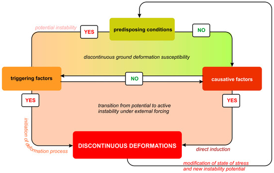
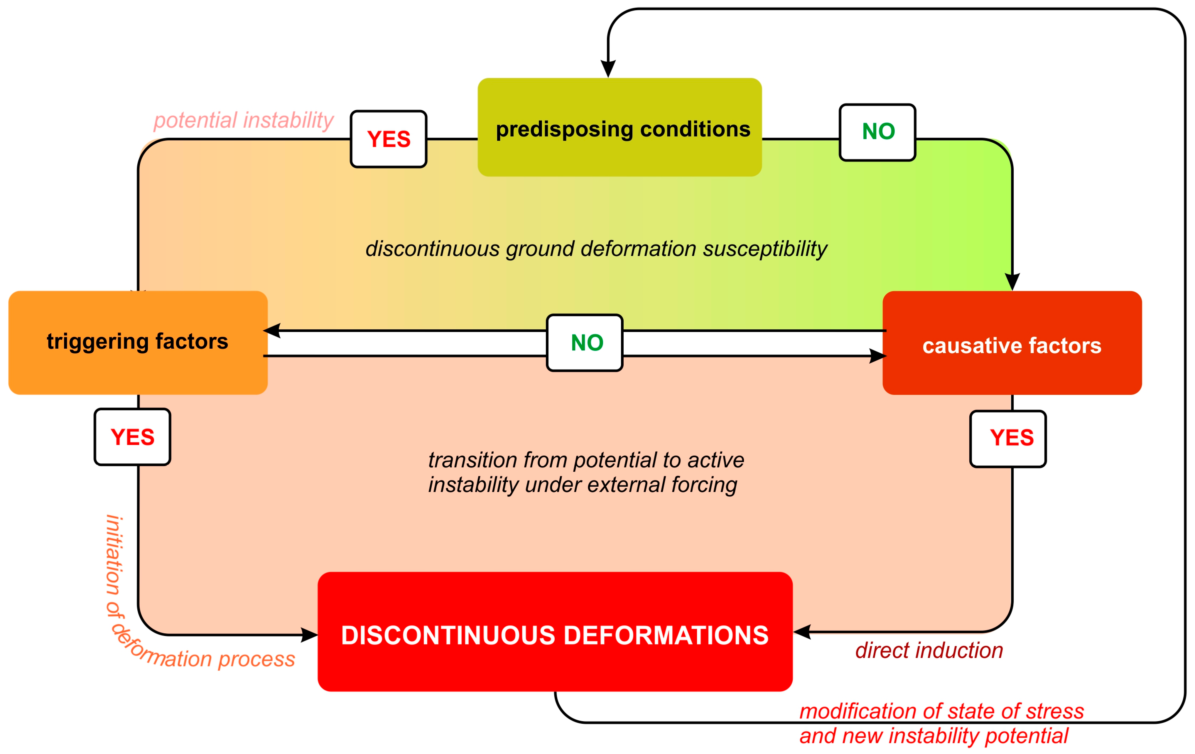
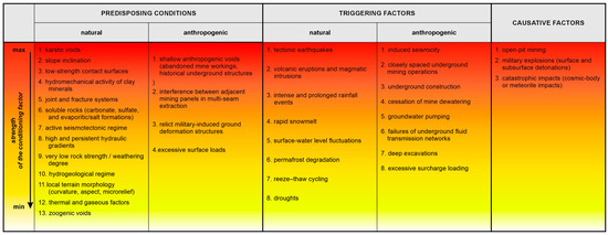
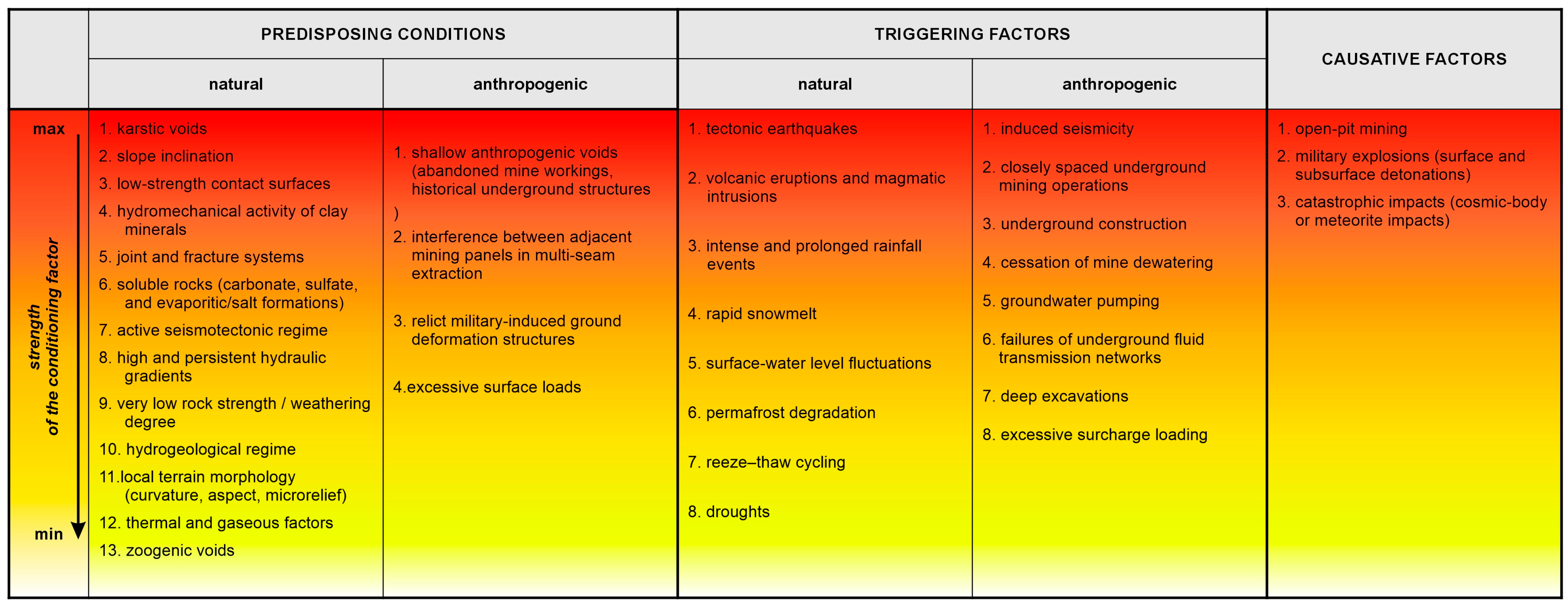
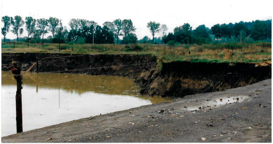
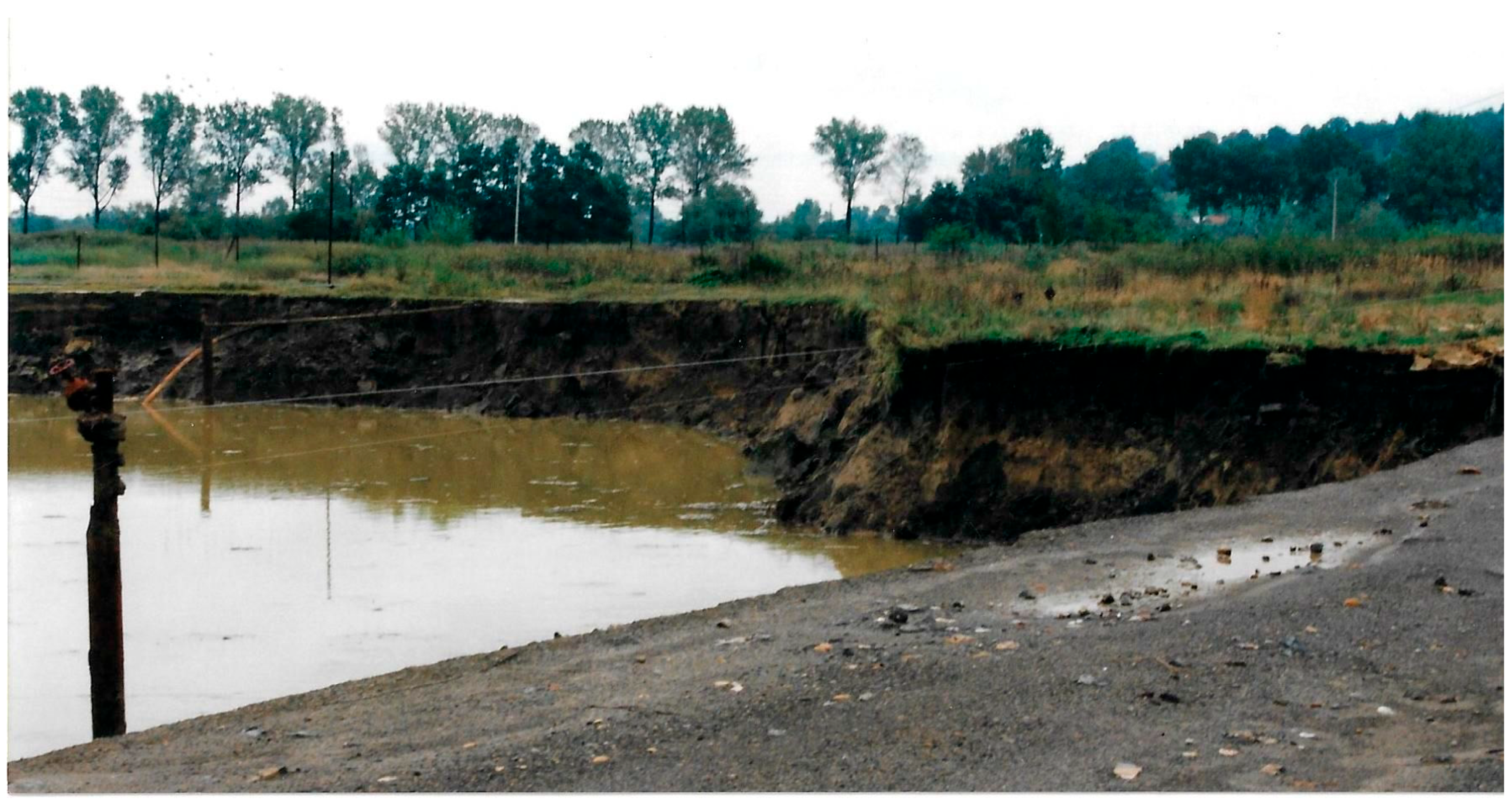
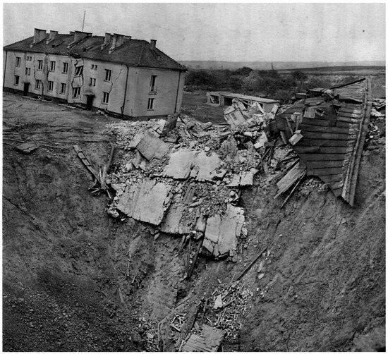
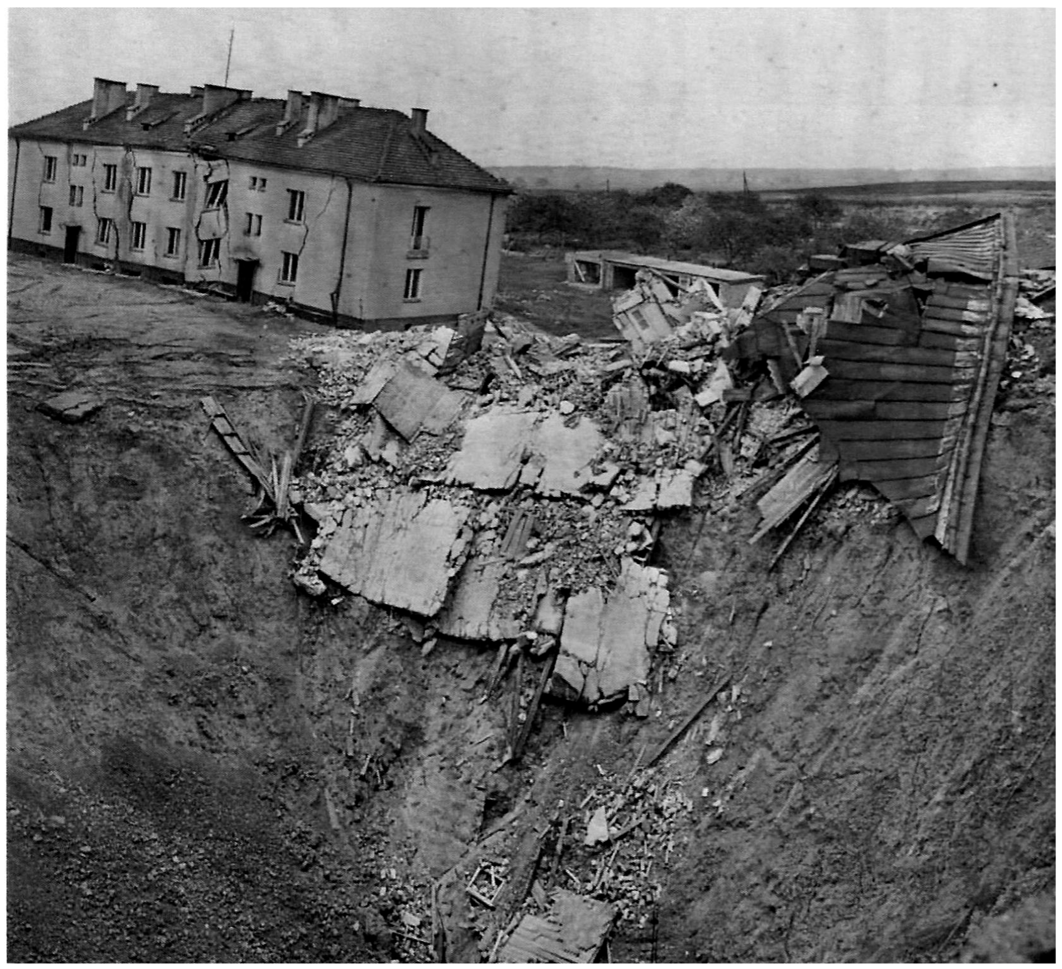
Disclaimer/Publisher’s Note: The statements, opinions and data contained in all publications are solely those of the individual author(s) and contributor(s) and not of MDPI and/or the editor(s). MDPI and/or the editor(s) disclaim responsibility for any injury to people or property resulting from any ideas, methods, instructions or products referred to in the content. |
© 2026 by the authors. Licensee MDPI, Basel, Switzerland. This article is an open access article distributed under the terms and conditions of the Creative Commons Attribution (CC BY) license.