


Abstract
Landscape, understood as the multisensory perception of our surroundings, is a fundamental component of quality of life and, as such, must be evaluated. Among the methodologies for evaluating the visual quality of landscapes, the Coastal Scenic Evaluation System (CSES) stands out. This paper focuses on the coastal landscape of Brittany, with the aim of evaluating its visual quality and how it relates to human and natural factors, as well as protected natural areas. The 93 sample sites are distributed in Class I: 13 sites, Class II: 35 sites, Class III: 35 sites, Class IV: 7 sites and just 3 sites in Class V. These results clearly indicate the high scenic quality of the studied coast, which is driven by its intrinsic natural characteristics and low level of urbanization.
1. Introduction
The coast exerts a powerful attraction for human beings. As a consequence, permanent and seasonal settlements are located close to the shoreline, often moving beyond the concept of coastal urbanization to the more encompassing term ‘urban coastalization’ [1]. Haliotropism (or thalassotropism) refers, in French social geography and demography, to human attraction towards maritime regions [2]. Therefore, coastal ecosystems are under intense pressure nowadays because of “Sun, Sand, and Sea (3S)” tourism [3] and urban sprawl intensification [4]. The environmental impact of this process can be observed through alterations to the original landscape regarding the “Big Five” [5], i.e., safety, facilities, water quality, absence of litter and scenery. The latter, which is the topic of this paper, was evaluated using the “Coastal Scenery Evaluation System (CSES)” [6,7,8]. The empirical foundation of the CSES was established between 1999 and 2003, when a three-year-long body of research, funded by the British Council [9], conducted coastal scenic assessments at selected sites in Turkey, United Kingdom and Malta [7]. Within this project over 1000 beach users were interviewed and were asked the question ‘what are the essential parameters that make up a beautiful coastal scene?’—as well as ‘coastal ugliness’—to determine the 26 essential parameters (18 physical and 8 human) that make up an attractive coastal landscape. Broadly speaking, the quality of physical parameters is determined by natural characteristics—such as topography, geomorphology, geology, vegetation cover, etc.—which can be significantly altered by human activity, particularly urban settlements. Conversely, human parameters are dictated by the level of urbanization, human interventions in beach areas, and the volume of beach users. A protected area may exist for reasons entirely unrelated to scenic quality, such as biodiversity conservation or hazard mitigation; however, physical parameters are usually still preserved and human pressure is generally low. Consequently, if natural conditions are favorable, sites were human settlements are not allowed potentially exhibit high scenic values, as observed in previous papers based on the use of the CSES [10].
The visual quality of the coastline is a relevant aspect since it sustains the tourism industry, improves the quality of life of residents and visitors, and reflects the ecological health of the environment; its degradation implies environmental deterioration and economic and social risks [11,12,13].
This article focuses on the evaluation of the landscape quality of the coast of Brittany, in northern France, and the quantitative relationship with the distribution and characteristics of protected areas where, in general, the construction of human structures is prohibited or highly restricted. Previous papers on coastal scenery based on the CSES stated that, usually, the best scenic sites are located in protected areas; however, neither the characteristics of the protected areas or their spatial distribution were further analyzed [12,13,14].
Therefore, this paper, which represents the first application of the CSES in Brittany, evaluates the relationship between high scenic scores and the legal protection status of the land through a spatial overlap analysis. This was achieved by delimiting the visual basin of the highest-rated sites and calculating the area within each basin covered by three specific protection categories: Biodiversity, Heritage, and Landscape–Heritage. This categorization allowed for the grouping of the various existing PNAs that encompass a wide range of management objectives.
Furthermore, the CSES also allowed areas of high scenic value to be identified, providing a scientific basis for designating new protected sites. These areas include land environments that act as a permeable matrix, ensuring ecological connectivity for flora and fauna. This matrix of unprotected landscapes is relevant at a higher management scale: European and biogeographical scales [14].
2. Study Area
In this paper, the scenic value of ninety-three sites was investigated along the coastline of the Brittany region, France. Site distribution was selected according to coastal morphology and accessibility (Figure 1 and Appendix A).
Figure 1.
Location map, departmental division, investigated sites and D-Value classes (see Appendix A). Source: IGN [15] and own elaboration.
The Brittany coast represents a unique geological landmark along the French coast. With the Atlantic Ocean accounting for 89.74% of its total coastline, Brittany’s four departments possess a profound maritime character that defines their landscape, economy, and regional identity [16]. Population settlement is mainly concentrated in the countryside, notable exceptions being Brest—where the port and the city lack integration—and St. Malo, where strategic plans and port concession contracts ensure the seamless integration of the harbor into the city. A diverse mosaic of coastal flora and fauna creates a transition between rural landscapes and pristine nature. This high scenic value is driven by a spectacular geomorphology, characterized by a complex variety of bays, peninsulas, river valleys, and coastal caves.
There are significant differences in climate statistics along the investigated coast. In particular, the south-facing coast of Brittany benefits from a particularly mild climate, ranging from 14 °C to 24 °C in the summer to 2–10 °C in the winter according to the Environmental Observatory in Brittany [17]. Along with the coastal protection from northern wind, this temperature provides greater climate comfort and leads to greater tourist activity in Brittany southern coast [18].
Rainfall is regular and is abundant due to the prevailing westerly and northwesterly winds throughout the year. The northern coast receives less rainfall. On the southern coast, more directly exposed to southwesterly currents, the average yearly rainfall is around 950 mm. In the far west, Finistère is the rainiest region, exceeding 1100 mm [19].
The tides in Brittany are essentially macrotidal in nature, with highly variable amplitudes: in the north, in the bay of Mont-Saint-Michel, the tidal range is among the largest in the world, reaching 14 m during spring tides; in the far west, the Iroise Sea, tidal range varies from 6.9 to 7.6 m and in the south it oscillates between 6.1 m in the Bay of Penerf and a minimum of 3.3 m in the Gulf of Morbihan [20].
Concerning coastal typology, it is essentially composed by rocky sectors belonging to the granitic Cadomian domain, which is older and extends in the Côtes-d’Armor east coast, and the Hercynian domain, which occupies the rest of the Breton coastline, composed of more recent sedimentary and metamorphic rocks [20]. The rocky coast is interrupted in places by fluvial-marine forms, i.e., large estuaries characterized by extensive intertidal flats [21]. Coastal landscapes include sandy bays, extensive and highly diverse intertidal zones and cliff sectors rising at places tens of meters. Rocky platforms, islets, coarse sediments, reefs, dunes, and ridges of shell-bearing sand and pebbles contribute to a wide variety of beaches, from small sandy or pebbly coves to long and wide sandy shores backed by dune ridges and saltmarshes. Bays, inlets, and river estuaries provide a complete catalog of coastal geomorphology. Particularly characteristic are the numerous peninsulas, deep river valleys, caves and collapses, creating large incisions in the coastline [21]. Most of continental Brittany consists of low hills and plateaus that form part of the Armorican Massif, which arose during the Cadomian and Hercynian orogenies, 620 and 360 million years ago, respectively [22]. The interior landscape presents a mosaic of plains, plateaus and two abrupt mountain ranges, with elevations reaching 387 m above sea level [15].
The rural landscape of Brittany is the archetype of the bocage, with a predominance of dispersed rural settlements enclosed by hedgerows and livestock farming. These hedgerows covered almost one million linear kilometers around 1900, but have been reduced to only 300,000 km since 1960. They contain 1700 species of vascular plants, among which the common oak and beech stand out [19]. The dispersed settlement pattern stems from an economy based on agriculture and fishing, activities organized in cooperatives that have sustained a balanced distribution of economic activity and a distinctive metropolitan structure.
Surprisingly, the lack of large-scale construction projects and the omnipresent traditional housing style keeps a largely natural aspect in the coastal landscape avoiding the urban massification. Brittany follows a unique pattern in its urban development, marked by a long history and a growing contrast between the coast and the interior. The Breton population is less concentrated in large urban areas and shows a preference for smaller towns and peri-urban zones [23]. This model of widespread urbanization is based on a very old settlement pattern, dating back to the 6th century, where Breton migrants dispersed for agricultural purposes, maintaining their connection to a central nucleus: the “burg” (town). Currently, 62% of Bretons live in small towns or suburban areas, compared to 36% nationally. This network allows for organization into “residential zones” where access to services remains readily available despite the dispersed population [24]. Brittany is France’s main maritime region, with particularly diverse maritime activities: fishing and aquaculture, shipbuilding, defense and security, recreational boating and scientific research. Furthermore, the sea contributes to the region’s image and appeal, thus boosting tourism development and highlighting the need to preserve the Breton coastline [24]. The coastal and territorial seas of the North Atlantic-West Manche (NAMO, by its French acronym) are subject to the NAMO Coast Maritime Council [25] and other regional and local bodies, such as municipalities, departments and inter-administrative structures, organized in five collegiate bodies representing 77 stakeholder associations, e.g., the management council of the Iroise Marine Natural Park [26], and others, where stakeholders and associations participation is encouraged. The NAMO seafront strategy addresses ecological challenges for the 2025–2031 period, focusing on achieving good ecological status. The division into ecological sectors of its coastal jurisdictional area, along with the types of coast included and the number of sampled sites is reflected in Table 1.
Table 1.
Checklist of the 26 physical/human parameters (CSES method). Source: Ergin et al. [7].
The main objective for all these administrations is the maintenance and restoration of the good status of the marine environment and water quality, taking into account hydrosedimentary dynamics and the land–sea connection, for the benefit of ecosystem services and the coexistence of maritime and coastal uses and activities, especially summer coastal tourism. High seasonality and job insecurity, real estate pressure and environmental crises, such as green tides or spills, have not yet damaged the good image of the Brittany coast that attracts 13 million visitors and 100 million overnight stays annually and generate 10% of the regional GDP and 70,000 direct jobs—two-thirds of these on the coast of the Finistère and Morbihan departments [25,27]. Along the study area there are several categories of coastal and marine protected areas relevant at all levels: international, European Union, national, and regional (Figure 2).
Figure 2.
Protection features along the investigated coast. Source: IGN [16].
In Brittany the following protection categories were observed (Figure 2):
- The National Inventory of Natural Heritage (INPN by its French acronym): includes 528 protected spaces. Based on criteria from the National Museum of Natural History and the French Office for Biodiversity, this protection encompasses key elements of terrestrial and marine heritage. These include extant and fossil species, natural habitats, protected areas, and geological features; however, no specific reference is made to the landscape itself. The mentioned inventory includes:
- Regional Natural Park: two protected spaces; Armorique and Morbihan Gulf.
- Marine Natural Park: one protected space; Iroise Marine Natural Park.
- Nature Reserve: 23 protected spaces.
- National Hunting and Wildlife Reserve (NHWR): Morbihan Gulf shores.
- The National Inventory of Geological Heritage (INPG by its French acronym): includes 188 protected spaces. Created in 2007 by the National Museum Natural History and the Minister of Ecology to comply with environmental legislation, the INPG identifies areas with geologic, mineral, and paleontological records. Geological heritage comprises elements with significant scientific, historical, educational, or aesthetic value across disciplines such as paleontology, tectonics, and geomorphology. Although not always explicitly stated, the aesthetic dimension can be interpreted as a direct reference to landscape values.
- The UNESCO World Heritage Convention list includes Mont Saint-Michel and its Bay. The Mount St. Michel is a Historic Monument since 1862, and the Bay is protected since 1994 by the Ramsar Convention. The built and natural environments are also protected under the French Heritage Code and the Environment Code. The shoreline is protected by the French Coastal Law and, since 2018, a protected buffer zone exists, including almost 130 communes and based on a landscape study on the Mont Saint Michel and the principal panoramic views.
- The Conservatoire du littoral includes 154 protected areas. The Conservatoire focuses on four primary mandates, none of which explicitly address landscape values: (1) the conservation of coastal heritage for future generations; (2) the preservation of natural and historical capital essential to France’s attractiveness; (3) the promotion of social well-being through equitable public access; and (4) the protection of people and property via natural buffer zones against extreme climatic events.
- The Natura 2000 network includes 86 protected sites designated under the EU 1979 Birds Directive and the 1992 Habitats Directive [14]. These sites frequently overlap with various national and regional protection categories. As the European Union’s primary instrument for ensuring the long-term survival of species and habitats, Natura 2000 plays a critical role in halting biodiversity loss. While its approach to habitat conservation encompasses the protection of cultural landscapes and their structures as a whole, it does not formally account for the aesthetic beauty of the landscape.
- The Landscape–Heritage (Western Defense Zone) comprises 388 sites: 195 listed (classés) and 193 registered (inscrits) under the authority of the Ministry of the Armed Forces and Veterans. Listed sites (classés) are under strict protection, requiring ministerial authorization for any modification, while registered sites (inscrits) are recognized as deserving conservation through lighter monitoring. Both are managed by DREAL (Regional Directorate for the Environment, Planning and Housing), which is a decentralized service of the French State, under the authority of the regional prefecture. The beauty and diversity of landscape is considered overall as a tourist asset, without specific measurement of its aesthetic values.
In addition, there are other small areas protected by municipalities not listed above because of limitations due to the scale of Figure 2. Given the high number, specific characteristics/ranges of management objectives and wide distribution of Protected Natural Areas, they were grouped in Biodiversity, Heritage, and Landscape–Heritage categories. This is a useful approximation to understand their general influence on coastal scenic values, taking also into account that, in general, such areas are free from human influence or contain only a few isolated historic buildings such as a lighthouse, an old church, or a castle.
These protected areas have numerous overlapping protection categories, either wholly or partially. Figure 3 summarizes this overlap, taking into account all the Protected Natural Areas (PNAs) included in the ecological management zones traced by CMF-NAMO (French acronym for the Maritime Council of the North Atlantic-Western Channel) [28], which were expanded by adding a 500 m coastal strip.
Figure 3.
Expanded ecological sectors in Brittany coast (numbers 6–19) and protected areas overlapping. Source: CMF-NAMO [28] and own elaboration.
3. Methodology
The landscape value of the Brittany coast was evaluated by means of the Coastal Scenery Evaluation System (CSES). The consolidation of the CSES started in 2004, when Ergin et al. formally introduced the CSES using fuzzy logic [7]. The algorithm, which incorporates weighting and fuzzy logic values, yields a Scenic Assessment Value (‘D’) that classifies the coastal landscape into five D-Value classes, from Class 1 (extremely attractive natural sites) to Class 5 (very unattractive urban sites).
A total of 26 parameters (18 physicals and 8 humans, Table 1) were selected and each was rated from a low (1, absence or poor quality) to a high rating (5, outstanding quality). In a second round of interviews, >500 beach visitors were asked to rank them from the most to the least important one, i.e., the selected parameters have not the same weighting. As an example, parameter 14 (‘Coastal landscape features’) and parameter 21 (‘Sewage discharge evidence’) are among the most relevant physical and human factors, respectively (Table 1).
The aforementioned 26 parameters are presented in a checklist that was completed by an expert surveyor during field assessments; the data were subsequently transferred to an Excel spreadsheet for analysis. Fuzzy Logic Assessment [29] is integrated into the program to mitigate potential surveyor bias; for example, if the surveyor assigns a rating of 4 (61–90 m) to the ‘Cliff height’ parameter (point 1, Table 1), the FLA translates this into a membership degree by assigning a value of 1 to that specific category and a partial value (e.g., 0.5) to the adjacent categories—namely, 31–60 m and >90 m [7].
Last, the Excel spreadsheet calculates for each site a final “D” value (Figure 1 and Appendix A) that allows the coastal scenery to be divided into five distinct classes, from Class I (D ≥ 0.85, extremely attractive natural sites) to Class V (D ≤ 0, very unattractive, intensively developed urban sites).
The field work was carried out in December 2024 and January 2025, excluding rainy days, at low tide conditions with moderate (between 80 and 40) tidal coefficients. The first and last authors carried out the fieldwork, documenting each site with photographs. These records allowed for later consultation with the second author, whose extensive experience with the CSES helped resolve any uncertainties during the analysis.
The investigated sites were, on average, 5.5 km apart with maximum distances in less accessible and more uniform coastal sectors, e.g., 35 km between sites 11 and 12, and minimum values in cases of great coastal diversity and easy accessibility, i.e., 1.3 km between sites 22 and 23. The average Euclidean distance between sample points is calculated using the ArcGIS Pro 3.3 Average Nearest Neighbor tool. The same GIS software was used along this paper for all cartographic and geostatistical purposes. Each site has been classified as remote, rural, village or urban in order to contrast landscape quality versus the level of urbanization [6].
It is also necessary to specify the geometric characteristics of the coastal layout used, since there are large divergences between the different thematic cartography due to the sinuous nature of the Brittany coastline, which is a great exponent of the fractal paradox stated in 1967 by Mandelbrot [30]. The type of coastline is the one used by the Service Hydrographic et Oceanographique and the Bureau of Geological and Mining Research (BRGM by its French acronym), the HistoLitt V2.0 coastline [31]. Its main advantage is providing a consistent basis with certain homogeneity of scale and precision.
The delimitation of the various existing protection designations was obtained from the Geocatalogue France WFS services and aggregated into three broad categories to simplify the description.
- Biodiversity:
- ○
- National Inventory of Natural Heritage.
- ○
- Natura 2000 Network.
- Heritage:
- ○
- Conservatoire du littoral.
- ○
- National Inventory of Geological Heritage.
- Landscape–Heritage:
- ○
- Landscape–Heritage (Western Defense Zone).
- ○
- UNESCO World Heritage Convention: Mont-Saint-Michel and its bay (listed in 1979) and its buffer zone (approved in 2007) [32].
The visual basin of each sampled point extends over both sea and land. To calculate the overlap with protected natural areas, only the land basin was used—as the marine basin extends to the horizon and, as previously stated, the presence of marine protected areas only slightly affects coastal scenery. The percentage of each protection category, along with their total amount within each visual basin, serves as a broad quantitative indicator of the relationship between scenic quality and the presence of protected areas. While marine and terrestrial PNAs are contiguous along the shoreline, they do not overlap. Consequently, each unique sample point is situated either within a marine or a terrestrial domain, reflecting their mutual exclusivity.
A detailed examination of how specific management issues of each PNA influence coastal scenery remains beyond the scope of this paper, as the complexity of such interactions warrants a dedicated investigation.
4. Results
4.1. Scenic Quality
The CSES allowed each site to obtain a “D-Value” classifying it into five classes (Figure 4). A total amount of 13 sites (7.5%) belonged to Class I, 35 sites (37.6%) to Class II, 35 (37.6%) to Class III, 7 (7.5%) to Class IV and 3 sites (3.2%) to Class V (Figure 4).
Figure 4.
D-Value for 93 sites along the coast of Brittany featuring urbanization level and natural coastal characteristics. Source: Ergin et al. [7], CMF-NAMO [28] and own elaboration.
The highest scenic quality is found in locations featuring cliffs, rocky shores, sandy spits, open or pocket beaches with well-developed dune systems, and special features as peninsulas or islands. Key contributors also include river mouths, promontories and caves, along with distinctive geological features such as the oddly shaped boulders of the Pink Granite Coast (Appendix A, point 21; Figure 5d). This granitic composition contrasts sharply with the nearby Normandy chalk cliffs and the opal-toned stone of the Côte d’Albâtre and Côte d’Opale.
Figure 5.
(a) Pointe de Raguenez; (b) Falaises de la Roche Percée; (c) Falaises de Kadoran; (d) Landes de Ploumanac’h; (e) Sillon de Talbert; (f) Plage de Enez Glas; (g) Baie du Mont Saint-Michel; (h) Baie de Saint-Brieuc; (i) Plage de Corz; (j) Plage de Roguédas. Source: own elaboration.
A few sampled sites can be highlighted for their representativeness:
- Class I:
- ○
- The Finistére department Class I sites can be described in four sectors:
- ▪
- The northern sector, with countless dunes, coves, peninsulas and islands in a good state of natural conservation, shows high scenic values, i.e., a Class I site is observed in the monumental Flèche sableuse of Penn Ar Ch’leuz.
- ▪
- The central sector (Iroise Sea, including Brest Bay) shows a high scenic quality, with six Class I sites, e.g., Pointe de Raguénez (Figure 5a) is the site with the highest D-Value in Brittany. Located in the southern inlet of the Bay of Brest, it is a remote and long sandy beach interrupted by a river mouth flowing next to a low cliff promontory with numerous caves.
- ▪
- The southern sector has two Class I sites, Falaises de Plogoff, near the limit with the bay of Brest, and Falaises de la Roche Percée (Figure 5b, near the Morbihan border). The latter are constituted by several high rocky cliffs and sandy coves in a coastal village environment. Despite lacking any protected status, this extensive coastal area offers a high scenic quality compendium of Brittany’s coastal geomorphology, including headlands, islands, rocky outcrops, reefs and caves, some of them carved until its collapse, creating deep incisions very characteristic of the Brittany coastline.
- ▪
- In the island of Ouessant, Falaises de Kadoran (Figure 5c) is a remote set of cliffs exceeding 20 m in height with jutting, headlands, notches, islands and collapses.
- ▪
- Côtes-d’Armor has also three sectors, without any Class I sites in the central one (Saint-Brieuc Bay):
- ○
- West coast has three Class I sites, notably Landes de Ploumanac’h (Figure 5d), which is a remote site which stands out as a spectacular chaos of massive, oddly shaped boulders in the highly touristic Pink Granite Coast.
- ○
- In the East coast, Cap Frehel pink sandstone cliffs is a unique habitat for seabirds and a distinctive landscape known for its stunning geology and ecological importance, therefore is protected as a “Grand Site de France”.
- ▪
- Morbihan presents on the mainland two coastal sectors, separated by the prominent Quiberon peninsula, to which must be added the islands of Belle-Ile and Groix, the latter without Class I sites:
- ▪
- The western sector shows just one Class I site, the Plage de la Mine d’Or.
- ▪
- The island of Belle Ilé has its main tourist attraction in the Class I cliffs of Aiguilles de Port Coton.
- Class II:
- ○
- Ille-et-Vilaine department occupies a small Breton coastline sector, showing little morphological variety. There is just one Class II site, Pointe du Grouin.
- ○
- Côtes-d’Armor shelter five Class II sites. In the department northernmost point of stands out the Sillon de Talbert (Figure 5e), an extremely unique sand and pebble spit 35 m wide and three kilometers long, shaped by opposing currents, which his framed by 11 protected areas because of its natural and landscape values, despite being located close to a village.
- ○
- In Finistère there are 21 Class II sites. Enez Glas Beach (Figure 5f) is an extensive beach in a rocky coast with low cliffs, crossed by a river mouth in a rural area.
- ○
- Morbihan shows eight Class II sites:
- ▪
- The eastern landscape has medium-high visual quality due to four Class II sites, three of them with large beaches featuring dune ridges and white sand, and another one in the Presq’ile de Quiberon cliffs.
- ▪
- The western sector shows just two Class II sites.
- ○
- In the islands, Groix has one long beach (Plage de Grand Sables), and Belle Ilé has another big beach (Plage de Grand Sablons).
- Class III:
- ○
- In Ille-et-Vilaine there are three Class III sites. The Baie du Mont Saint-Michel (Figure 5g) is a muddy plain enhanced by the presence of an iconic monastery and impressive shell ridges, natural formations aligned parallel to the coast, created by storms and ocean currents. They are of geological interest and serve as a crucial refuge and habitat for numerous protected species.
- ○
- Other Class III sites:
- ▪
- In Côtes-d’Armor (9 sites) and Finistère (17 sites), mostly located in small sandy coves surrounded by low cliffs and villages or, secondary, in rural or urban context.
- ▪
- In Morbihan (4 sites), two of them are small coves in villages in the island of Groix.
- Class IV:
- ○
- Ille-et-Vilaine has two Class IV sites: Remparts of Saint Malo is a small urban beach at the foot of the city walls; Bois Morlet is a rural site in a deep estuary.
- ○
- Côtes-d’Armor has just one Class IV site, located in the Baie de Saint-Brieuc (Figure 5h). At the southern end of the bay is the wide estuary of three rivers where the protagonist of the landscape is the tide, which advances and retreats up to 7 km, flooding an extensive marsh of great natural value, protected under nine different categories, next to which there are very diverse uses—from urban to natural.
- ○
- In Finistère there are just three Class IV sites:
- ▪
- In the northern coast and the bay of Brest there are two—both in urban beaches.
- ▪
- One more is in a village location in the southern coast, whose low visual quality value is due to the presence of a rectilinear homogeneous coastline, with beaches in flat coastal areas close to village settlements. As a result, the wide southern Finistére coast shows the lowest observed scenic quality.
- ○
- Morbihan does not have any Class IV sites.
- Class V:
- ○
- Ille-et-Vilaine and Côtes-d’Armor do not have any Class V sites.
- ○
- In Finistère there is one Class V site in Plage de Corz (Figure 5i), which is the main beach in the highly protected island of Ouessant. This beach is framed with a low cliff in a rural environment, and is protected under 16 categories: but has no remarkable value in visual quality due to its flat morphology, lack of vegetation and the presence of algae, along with a big concrete wall and a sewage discharge.
- ○
- In Morbihan there are two Class V sites:
- ▪
- Plage de Roguédas (Figure 5j), has the lowest D-Value despite being in a rural setting within the highly protected Bay of Morbihan, but the massive presence of a wall, algae, ramps and a sewage discharge point diminish its appeal.
- ▪
- Plage de Poudrantais—due to the presence of an urbanized area with a nautical club on a wall covering the cliff, there is a concrete ramp for boats and a wastewater discharge point.
4.2. Scenic Quality Versus Sites Urbanization Level
Following Williams and Micallef [6], sampled sites were classified in four categories (Appendix A) according to their level of increasing urbanization, from Remote, Rural and Village to Urban (Figure 6a) and their natural typology, e.g., cliffed, sandy and muddy (Figure 6b).
Figure 6.
Percentage of sites according to their degree of urbanization (a) and geomorphology (b). Source: own elaboration.
Most of the sampled sites are rural and remote areas (60%) followed by village sites, with a low amount of urban sites. The wide availability of natural and traditional bocage landscapes give rise to a low degree of urbanization along the Brittany coast. Most of the remote sites are clustered in Class I and Class II, mixed with rural sites, in the left side of Figure 5. Some remote and rural sites are in Class III, where village and urban sites progressively prevails towards the right side, showing the lower values in Class III and including almost all of the sites in Class IV and Class V. Therefore, there is a perceptible D-Value downward gradient in accordance with the degree of urbanization: the higher scenic quality is reached in remote locations (average D-value 0.76), followed by rural (0.7), village (0.56) and, finally, urban locations (0.43). The distribution of visual quality does not follow a strict grouping pattern, but is likely to be higher in remote locations and lower in urban areas (Figure 7a).
Figure 7.
Box plot for D-Value distribution and level of urbanization (a); box plot for D-Value distribution and natural coastal characteristics (b); scatter plot for number of Protected Natural Areas and sites D-Values: Class V (red), Class IV (orange), Class III (green); Class II (blue); Class I (purple) (c); and box plot for D-Value distribution and sites by CSES scenic quality classes (d). Source: own elaboration.
Figure 7a,b illustrates a spatial gradient, showing a transition between the sparsely urbanized high cliffs and the intensified urban development surrounding beaches and marshes.
The box plot overall shows reduced interquartile ranges (IQR), indicating that 50% of the data closely approximate the median, but with nuances for each type of environment, although without too many dissonant outliers:
- Remote: there is a reduced dispersion of extreme values corroborated by a reduced IQR range (0.17), an almost symmetric distribution around the median value and equal long whiskers. In summary, remote locations achieve high average visual quality values, with few cases of medium-high and very high value, i.e., the lower the urbanization, the higher the scenic beauty.
- Rural: This category differs to the previous one because of its positive asymmetric distribution, the higher IQR range (0.22, between 0.8 and 0.58) and the presence of two outliers (Plage de Corz and Plage de Roguédas), which have exceptionally low quality despite being in a rural setting, mainly due to existing infrastructure and sewage disposal sites.
- Village: This category shows the greatest dispersion, with IQR of 0.25, a negative asymmetry, a longer lower whisker and one outlier (D-value: −0.13, corresponding to Plage de Poudrantais), which is due to the presence of infrastructure in an urbanized area with a sewage disposal site. Other towns have preserved the landscape to a greater extent, with varying degrees of building integration that, in places, maintain the traditional style and blend harmoniously into the landscape.
- Urban: This category has the lowest IQR score (0.15), and there are no outliers, indicating little but asymmetric dispersion. The poor visual quality is associated with the more urbanized environment, which is scarce on the coast since the natural character of the coastline has been largely preserved.
4.3. Scenic Quality Versus Natural Coastal Characteristics
Regarding coastal characteristics, together, both kinds of cliffed coast comprise 76% of the total amount, while sandy sectors are not abundant and muddy sectors are really scarce. Coastal characteristics are often related to the level of urbanization, i.e., human settlements are essentially developed along attractive sandy sectors and muddy plains, where beach tourism and oyster culture finds suitable conditions; unpopulated areas, mostly devoted to cattle farming, are usually observed in correspondence with cliffs.
In the left side of Figure 4, there are 13 sites in Class I: six are cliffs > 20 m, four are <20 m cliffs and just three of those sites are sandy. A similar trend is observed for Class II sites. Four muddy sites appear in Class III, along with plenty of cliffs < 20 m (which amount to 16), sandy beaches (which amount to 16), and just a couple of cliffs > 20 m.
Finally, in the right side of Figure 4 there are three low cliffs, three sandy beaches and one muddy site in Class IV, and three low cliffs in Class V. In summary, heterogeneity predominates in all classes, but biases are perceived: higher visual quality is likely to be found in correspondence with remote cliffs, while sandy and muddy sites are clustered in the medium quality classes and the lower classes shelter village and urban sites with sandy beaches or cliffs < 20 m, which also characterize the three sites in Class V.
Therefore, Class I sites can be found in remote, rural and village environments. There are two rural and one village sites in Class V, and seven urban sites are in Class III, without any in Class V. There is a perceptible D-Value downward gradient in accordance with the coastal type (Figure 7b): visual quality is higher in sites with high cliffs, a bit lower in sites with low cliffs and sandy beaches, and worse in muddy sites. Places related to the degree of urbanization—higher in sandy beaches and muddy plains—are more attractive to urban developments and economic activities than cliffed sectors. High cliffs sectors (>20 m) are usually unpopulated because of the absence of touristic beaches, ports or oyster culture premises, keeping intact their natural beauty.
- Cliffs > 20 m in height sites are clustered. The reduced IQR range (0.15) shows a reduced dispersion of values, without outliers. Scenery quality ranks from medium to high, without any sampled site in the lower classes.
- Cliffs < 20 m in height sites has a wider IQR (0.29), positive asymmetry with two outliers. This is because there are plenty of different situations in this category, from unpopulated coastal profiles to sometimes picturesque villages in rocky coves. The three outliers are due to human structures, i.e., the existing seawalls, ramps and sewage disposal in Plage de Corz, Plage de Poudrantais and Plage de Roguédas.
- Sandy beaches present a reduced IQR (0.23) and an almost symmetric distribution associated with medium-high D-Values; the longer lower whisker is due to presence of seawalls and infrastructures at few urban beaches. The only outlier is in the Plage de Porsguen, in the northern Finistère, where a beautiful cove was invaded by algae and denaturalized because of the presence of seawalls and housing.
- Most of the muddy plains have natural values and medium scenic quality because they have a reduced IQR (0.13) but show a negative asymmetry and a longer higher whisker. This is due to the high scenic quality recorded in Mont Saint Michel Bay (Class III), while the lower whisker is due to Saint Brieuc Bay (Class IV), whose landscape is worsened by the surrounding urban environment.
4.4. Natural Protected Areas (PNA) and Scenic Quality Distribution
4.4.1. Existing PNAs Features in Brittany
Under the Law of 2 May 1930, natural monuments and sites whose conservation or preservation is of general interest from an artistic, historical, scientific, legendary, or scenic point of view are strictly protected. Any modification to their appearance requires prior authorization. This law, which is approaching its centenary, applies to the following forms of protection:
- Mont Saint Michel and its Bay are in the UNESCO World Heritage Convention list [33]. The built and natural components are protected under the national Heritage Code and the Environment Code. The shoreline is also protected by the “Coastal law” and the Bay has been protected since 1994 under the Ramsar Convention. As a largely visible landmark, there is a buffer zone including almost 130 communes, which boundary was defined in 2018 based on a landscape study.
- Conservatoire du Littoral (CdL), is a French coastal conservation institution inspired by the British Heritage Coasts, but emphasizing land acquisition instead of specific agreements with private landowners [34]. These areas are selected according to a combination of criteria: ecological value; landscape and cultural heritage; land–sea interface; level of human pressure; lack of management; and risk of overcrowding.
- The Western Defense and Security Zone management of “Landscape–Heritage” encompasses listed and registered sites under regulatory protection due to their exceptional character (historical, artistic, or picturesque) [34].
Other protected areas have even less specific relationship with the scenic value of the sites since their protection criteria are not strictly related to landscape but to others aspects of natural heritage:
- The National Inventory of Natural Heritage (INPN) [35] includes various protection categories declared by the State and the municipalities—the only entities in France authorized to establish regulations. Inventory work on natural areas of ecological, faunal, and floristic interest (ZNIEFF) is carried out by the Secretariat of Fauna and Flora, a scientific and technical service linked to the National Museum of Natural History. Brittany has two regional natural parks and the Iroise Marine Natural Park, all of them devoted to biodiversity protection without specific relation to landscape values.
- The National Inventory of Geological Heritage (INPG) [36] was launched in 2007 and is compiled at a regional level, under the responsibility of the Ministry of the Environment, to preserve specifically ecological, faunal, floral, geological, mineralogical, and paleontological resources.
- Since 2008, the Gulf of Morbihan National Hunting and Wildlife Reserve (NHWR) has been managed by the French Office for Biodiversity [37]. Is a site of international importance as a habitat for faunal species.
Finally it is important to highlight the various purposes declared in each of these protection categories, that is cultural, natural and landscape in and around Mont St. Michel; ecological, faunal, and floristic interest in the INPN; ecological, faunal, floral, geological, mineralogical, and paleontological in the INPG; biodiversity in the Gulf of Morbihan National Hunting and Wildlife Reserve; the universal approach comprising ecological, aesthetic and social values in CdL; and the exceptional character (historical, artistic, or picturesque) of Landscape–Heritage in the Western Defense and Security Zone.
4.4.2. Scenic Quality Versus PNAs
Many of the sites with the highest values are classified as remote and are often located in protected areas, confirming that less urbanized areas have higher landscape quality due to their ecological/geological uniqueness and lower human impact. In the first step, no clear trends were observed between the number of PNAs and either the D-values or the scenic classes (Figure 7c,d). In a further step, the evaluation of the relationship between the viewshed area of high scenic quality sites (Classes I and II) and the extent of Protected Natural Areas (PNAs)—sea surface areas were excluded because protected biodiversity is located below the surface and, therefore, does not contribute very much to perceived visual quality, e.g., can only partially affect “Fauna” within the “Special features”, point 14 in Table 1. Considering only the terrestrial visual basin, Appendix B was prepared, which calculates the terrestrial area included in the visual basin of each Class I and II sites, and the percentage of said basin included under the different PNAs categories, i.e., Biodiversity, Heritage, and Landscape–Heritage. The scatterplots of these areas (Figure 8) show that there is no correlation between their scenic quality and the degree of protection of their visual basin. Further analysis is complicated by the varying regulatory scopes of each protection designation, which falls outside the primary scope of the present paper.
Figure 8.
Relationship between D-Values and percentages of visual basins protected under different categories: Biodiversity (a); Heritage (b); Landscape–Heritage (c); all categories (d). Source: own elaboration.
The results clearly show that high D-values are also observed along coastal stretches lacking formal protection. These areas possess high scenic value owing to their natural characteristics and low human impact, stemming from the absence of settlements or the traditional bocage urbanization model.
Table 1 details the parameters evaluated using the CSES method. Among the 18 aspects of the physical environment examined, four stand out for their relevance to the potential protection of a terrestrial coastal area, i.e., the presence of cliffs, dunes, coastal special features, and vegetation. Regarding cliffs, geomorphological features such as the presence of rock falls, banding, terracing, jutting cliffs, notches, or irregular profiles are particularly valued. Special coastal features include blowholes, shoals, caves, pinnacles, embankments, irregular headlands, stacks, and islands. Dunes and vegetation cover are also relevant parameters to take into account. Among the eight human parameters, the presence of notable coastal landmarks—such as lighthouses and fortifications characteristic of the Brittany coast—contributes to high scores within the ‘built environment’ parameter (Table 1). Therefore, no natural protected areas can show high D-values, as is the case for Plage d’Enez Glaz (Figure 9) in northern Finistére.
Figure 9.
Plage de Enez Glaz terrestrial visual basin and protected areas categories. Source: own elaboration.
The CSES positively assessed the dune system and its vegetation, as well as the presence of rocky outcrops, a promontory, islands, and a river mouth. Additionally, the “views” parameter and the complete absence of human impact in the immediate surroundings were positively evaluated. The recorded Class II visual quality contrasts sharply with the scarcity of Protected Natural Areas (PNAs). Only 15.6% of the area is protected: 15.6% falls under the heritage protection (i.e., the Conservatoire du littoral), while 12% is designated for its biodiversity as part of the terrestrial fragment of the ZNIEFF (Natural Area of Ecological, Faunistic and Floristic Interest) ‘Baie de Morlaix,’ which is predominantly marine. The application of the CSES method therefore can allow the detection of unprotected natural values, providing essential feedback for the region’s land protection strategy.
Figure 10, which represents unprotected percentages in terrestrial visual basins for Class I and II sites, highlights as two Class I and four Class II sites belong to the higher interval (76–100%), i.e., over 75% of their visual basins are not protected.
Figure 10.
Percentages of unprotected visual basins for Classes I and II sites. Source: own elaboration.
The higher value is 100% in Plage de Amiets (Figure 11), where there are no terrestrial protected areas. The only protected space is in the Rochers De La Villau marine environment, with 346 m2. Despite this beach being located close to a village, the buildings and infrastructures are hidden behind a well-developed dune system that maintains a pristine coastal landscape where only the local picturesque rock formations stand out. Lacking any protection, this high-quality landscape is extremely vulnerable to future developments.
Figure 11.
Representation of the terrestrial visual basin for Plage des Amiets site. Source: own elaboration.
5. Discussion
The key milestones in the consolidation of the Coastal Landscape Assessment System (CSES) were as follows:
- Ergin et al. (2004) formally introduced the CSES using fuzzy logic [7]. The algorithm, which incorporates weighting and fuzzy logic values, yields a Scenic Assessment Value (‘D’) that classifies the coastal landscape into five classes, from Class I (extremely attractive natural sites) to Class 5 (very unattractive urban sites). Further details on the method are published by Ergin et al. (2006) [4].
- During the 2010–2020 period the CSES methodology was disseminated globally, being applied to diverse coastal typologies:
- ○
- Ullah et al. (2010) highlighted its potential for the development of coastal tourism in Pakistan [38];
- ○
- Williams et al. (2012) classified 45 Andalusian beaches [11];
- ○
- Rangel-Buitrago et al. (2012) classified 135 sites and analyzed their tourism potential in the Caribbean Coast of Colombia [39];
- ○
- Anfuso et al. (2014, 2017) analyzed the scenic value and coastal management issues in Cuba [12,40];
- ○
- Mooser et al. (2018) classified the most attractive 50 sites on the Andalusian coast, most of them being under some form of protection [41];
- ○
- Rangel-Buitrago (2018) published Coastal Research Library 26 titled “Coastal Scenery: Evaluation and Management” [42]; further development came are constituted by Rangel-Buitrago et al. (2019) [43]. By 2018 the CSES methodology had been replicated and cited extensively, with 1248 accumulated citations [44];
- ○
- Mestanza-Ramón et al. (2020) evaluated 67 sites in mainland Ecuador and the Galápagos Islands to prevent further environmental degradation and suggest improvement measures [44].
- Mooser et al. (2021) developed the Coastal Landscape Sensitivity Index (CSSI) by combining the aesthetic value of the CSES with intrinsic sensitivity to natural processes (NSI) and human pressure (HSI) [45]:
- ○
- In a later application to the Balearic Islands, Spain, this allowed for the classification of sites into Sensitive Groups and the determination of management priorities in the context of climate change and human pressure (Mooser et al., 2021) [46];
- ○
- Mooser et al. (2022) applied the CSES and CSSI to the Black Sea Coast of Bulgaria [47] and Chatterjee et al. [48] applied the CSES on the coast of Bengal, India.
- Botero et al. (2023) applied the CSES in Panama (Coiba National Park), highlighting its integration with a preliminary inventory of biological assets (macroinvertebrates) which is useful to guide nature-based tourism actions within PNAs, and also as a baseline for future monitoring of the impact that tourism activity may have on coastal fauna and natural attributes [13].
- Williams et al. (2023) and Mooser et al. (2023) respectively applied the CSES in Northern France [33] and Southern Italy [49]; in the latter case, the study assessed scenic quality in relation to beach concessions. Tendero-Peiró et al. (2024) applied the CSES to São Miguel Island, Azores [50].
- Rangel-Buitrago et al. (2024) [10] carried out a two-decade review confirming the worldwide classification of 1695 sites. Research has evolved from simple aesthetic evaluation in 2018 to preventive vulnerability management by 2023.
The above review makes it evident that the CSES method was widely used in the past to determine coastal scenery value in different climatic and geological settings. While management priorities were highlighted by Anfuso et al. [12] and preliminary fauna inventories were incorporated by Botero et al. [13], this paper highlights how the CSES methodology is instrumental in identifying areas of high scenic excellence that remain outside formal conservation frameworks. The results reveal a clear disconnect between legal protection status and visual landscape quality. For the first time in the CSES literature, top-tier scenic sites were also identified in unprotected areas, demonstrating that formal protection does not inherently guarantee superior scenic value, as the outcome depends strictly on the specific management objectives of each protection framework. Although many previous studies have noted the existence of PNAs as a relevant factor in determining visual quality, none have quantitatively compared the distribution of visual quality with the spatial distribution and characteristics of these protected areas. While this paper represents an initial step in this direction, further research is required to enhance the robustness and reliability of the results because each protected area has specific protection objectives.
The exceptional scenic quality of the Brittany coast is highlighted when compared to other regions assessed using the same methodology. Comparing the results obtained in this paper with a similar study recently carried out in a close area—i.e., Normandy [33], France—seven out of sixteen sites in Normandy where found to be in Class I, five in Class II and four in Class III, without any present in classes IV and V. Despite the similar scenic values observed in Brittany and Normandy, many northern Brittany Class II sites record a great abundance of rocky platforms but few score at views because of the large presence of pocket beaches. When human intervention increases, some differences are observed between Brittany and Normandy: Class III sites show excellent visual integration of buildings and infrastructure in Brittany. Concerning the impacts of other human factors, beach litter is virtually absent in Brittany and Normandy but sewage discharges are observed at places in the three Class V sites of this paper.
The scenic quality distribution of this study was also compared with similar assessments from Cuba [12], Colombia [39], Ecuador [50], and three Spanish regions (Andalusia [11], Catalonia, and the Basque Country [51], Figure 12).
Figure 12.
D-Value classes in Brittany (this paper), Cuba [12], Colombia [39], Ecuador [50] and Spain [11,51]. Source: own elaboration.
Figure 12 clearly highlights the high scenic value of the Brittany coast. On the one hand, the proportion of Class I sites in Brittany is only surpassed by a limited number of sites of exceptional scenic value exclusively located in protected areas, such as the Tayrona Park, La Guajira, and the San Andrés and Providencia islands in Colombia, and the Galápagos Islands in Ecuador. On the other hand, Brittany shows the highest proportions of Classes II and III, reflecting a consistently high scenic beauty linked to physical parameters as cliffs, rocky shores, special features and attractive skylines. Regarding human parameters, sites are usually related to rural areas and villages with appropriate building design and low levels of urbanization. Classes IV in Brittany are primarily linked to the presence of specific and isolated structures, e.g., seawalls, or problems, e.g., the presence of vegetation debris and sewage discharges in Class V sites. While sewage impacts are remediable, full restoration of scenic quality remains challenging; seawalls represent permanent structural modifications, and recurring algae accumulation requires constant, costly maintenance.
In other countries, Classes IV and V are also linked to a greater decrease in scenic values due to human impacts such as the presence of litter and numerous and unregulated hard coastal protection infrastructures, e.g., groins, jetties and seawalls in Cádiz, Spain; coastal roads in Matanzas or groins and revetments in Playa Majana and Mayabeque (Cuba); and touristic buildings which occur to a great extent in Cuban, Colombian and Spanish coasts. Hard infrastructures along with litter and sewage discharge are common in Class V. Just Esmeraldas coast, in Ecuador, has Class V sites related to poor natural conditions: flat landscape, dark sediment and murky water.
The conservation of the natural environment guarantees a higher quality of landscape with the consequent advantages in social and economic terms. To advance toward a more comprehensive territorial strategy, environmental and landscape planning must be merged. By utilizing the CSES it is possible to determine sites of great aesthetic value, which is not specifically considered in any of the examined PNAs.
Within the Heritage category, which is the one more related to scenery conservation, there are two specific kinds of protections in Brittany:
- The UNESCO World Heritage Convention list [32], which preserves Mont Saint Michel and its Bay, allowed the establishment of an extensive buffer zone defined by a landscape study. To prevent the degradation of the landscape and safeguard the exceptional heritage asset—a vast plain where the monastery is the sole prominent landmark—high-rise constructions have been prohibited. Just two sample points are in this protected area: Baie du Mont Saint-Michel (Class III) is a muddy plain close to a village, and Pointe du Grouin (Class II) is a remote rocky promontory overlooking Cap Fréhel to the east and the bay of Mont-Saint-Michel to the west.
- Conservatoire du littoral (CdL) [33] is a public institution, unique in the European context, created in 1975 to acquire coastal and lake areas of natural significance in order to protect the beauty of the landscapes, the diversity of their ecosystems, and ensure free and sustainable public access to them. The ultimate goal is the protection of one-third of the French coastline, the so-called Wild Third, incorporated into the National Strategy for Protected Areas alongside coasts protected by national parks, nature reserves, public forests, and sensitive natural areas. Currently, 14% of the French coastline has been acquired through state subsidies and private donations [52]. The exclusion of these areas from urban development has, paradoxically, increased the real estate value of adjacent residential areas, a phenomenon previously observed in England and Wales [53]. For this reason, the Conservatoire aims to create a network of natural spaces, conceived as an integral part of the territories, whose long-term management plans are aligned with adaptation strategies to climate change-related processes. To this end, the Conservatoire has more than 330 associated organizations, of which 50% are municipalities, 31% departments (and inter-municipal structures), and 15% associations (NGOs). In Brittany, 18 out of 93 sampled sites are under CdL management. Six sites are in Class I (i.e., 46.2% of this class), nine sites in Class II (25.7%) and three in Class III (8.6%). The high scenic values of these sites are essentially linked to the presence of cliff sectors and the absence of human impacts.
The Western Defense and Security Zone management of “Landscape–Heritage” is a catalog of military and security origin, therefore this protection—of strong legal weight—lacks, a priori, an intrinsic appreciation of environmental or cultural values, but the concept “picturesque” is included between the protection criteria. There are 37 (40%) sites out of 93 under this protection feature. The relevance of this in landscape preservation is evident: this protection feature includes 62% of total sites belonging to Class I and 43% of those in Class II, besides 31% of those in Class III, 14% of those in Class IV and 67% of those in Class V.
The latter three protection features emphasize natural aspects and explicitly includes landscape values. Despite the above, along the Brittany coastline, whose geomorphological and geological characteristics absolutely dominates the landscape, such fundamental component of landscape are not expressly protected. The reason why valuable landscapes remain unprotected may lie in their abundance along the Brittany coast. While regional-scale analysis typically focuses on protecting outstanding individual features, adopting a broader perspective reveals entire landscapes whose scenic qualities significantly exceed national averages. When habitats to be preserved are disposed as a mosaic, all the landscape elements should be assessed as a whole, because even unprotected land and marine areas may play a relevant role in the protection and functioning of the natural system. This is coincidental with the Natura 2000 network criteria, which aims to integrate diverse habitats, both terrestrial and marine, into a coherent system where ecological connectivity is guaranteed on a continental scale [14].
Without disregarding France’s solid administrative tradition, future research should evolve toward harmonizing international criteria, ensuring a more critical and integrated application of coastal protection instruments. A key limitation to address in future research is the refinement of the ‘visual basin’ by incorporating the scale of visible components. This involves differentiating between critical foreground elements and background features, which require distinct scales of analysis. Furthermore, while this regional study utilized a lower-resolution DEM (SRTM 30), future local-scale analyses should employ high-resolution models to refine detected mismatches. This would enable more precise recommendations aligned with Landscape Architecture principles. Furthermore, it is highly complex to determine the individual significance of each protected surface within the same visual basin, as each area is governed by different conservation objectives.
Finally, seasonal variability in human parameters should be considered in future fieldwork. A disadvantage of applying the CSES during winter is the low occupancy of the beaches, which can slightly affect anthropic parameters such as noise levels and litter accumulation. However, as the sites under study are not typically high-density tourist destinations, conducting fieldwork in winter is unlikely to significantly alter or compromise the integrity of the findings.
6. Conclusions
The Brittany coastline boasts high scenic values enhanced by its spectacular coastal geomorphology and the low impact of traditional rural settlements. Natural parameters exhibit outstanding values due to the widespread presence of cliffs, rocky shore platforms, and other unique geomorphological features. Human parameters are minimally impacted by traditional settlements. While these areas have altered the region’s natural character since ancient times, they have also preserved its visual quality by avoiding the severe landscape deterioration associated with the mass tourism development that has characterized much of Europe since the 20th century. The natural wealth of Brittany’s coastal environment is evidenced by a proliferation of overlapping protection frameworks. It was observed as there is no correlation between the density of overlapping protection categories and the quality of the landscape. While this study analyzed the surface area occupied by various protection figures within the visual basins of the highest scenic categories (Classes I and II), future research is necessary to determine the relative weight of each protected area according to its specific regulatory framework. The definition of the visual basin of each site has also to be enhanced.
Finally, it should be highlighted that, whereas previous CSES studies in other regions have typically linked high scenic quality almost exclusively to protected status, the high-quality landscapes recorded in Brittany often lack formal protection measures. This suggests that the CSES methodology could serve as a valuable tool for identifying and establishing new protected sites based on their exceptional scenic value.
Author Contributions
Conceptualization, A.F.-E. and G.A.; methodology, A.F.-E. (field work) and G.A. (design); software, A.F.-E.; validation, G.A. and E.H.G.; formal analysis, G.A.; investigation, A.F.-E. and E.H.G.; data curation, A.F.-E.; writing—original draft preparation, A.F.-E., G.A. and E.H.G.; writing—review and editing, A.F.-E., G.A. and E.H.G.; supervision, G.A.; funding acquisition, A.F.-E. All authors have read and agreed to the published version of the manuscript.
Funding
This research was funded by Universidad de Cádiz, grant number MV2024-148.
Data Availability Statement
The data presented in this study are available on request from the corresponding author.
Acknowledgments
Research groups PAI (Andalusian Research Plan) RNM-373 and HUM-831, Département de Géoarchitecture, Faculté des Sciences et Technologies, Université de Bretagne occidentale.
Conflicts of Interest
The authors declare no conflicts of interest.
Abbreviations
The following abbreviations are used in this manuscript:
| BRGM | Bureau de Recherches Géologiques et Minières |
| CMF-NAMO | Conseil maritime de façade Nord Atlantique-Manche Ouest |
| CdL | Conservatoire du littoral |
| CSES | Coastal Scenic Evaluation System |
| IGN | Institut Géographique National |
| INPN | Inventaire National du Patrimoine Naturel |
| INPG | Inventaire National du Patrimoine Géologique |
| OEB | Observatoire de l’environnement en Bretagne |
| OFB | Office Français de la Biodiversité |
| PNA | Protected Natural Areas |
| SIGES | Système d’information pour la gestion des eaux souterraines en Bretagne |
| ZNIEFF | Zone Naturelle d’Intérêt Écologique, Faunistique et Floristique |
Appendix A. Sites Distribution, D-Value, Urbanization Level, Coastal Characteristics and Number of Protection Figures
| Sector | Name | D-Value Score | D- Value Class | Urban. Level | Coastal Characteristics | Nos. Protection Figure |
| VI: Bay of Granville | (1) Baie du Mont Saint-Michel | 0.63 | III | Village | Muddy | 5 |
| (2) Pointe du Grouin | 0.81 | II | Remote | Cliffs > 20 m | 6 | |
| IX: Emerald Coast and Saint-Brieuc Bay | (3) Anse du Guesclin. | 0.62 | III | Village | Sandy | 4 |
| (4) Remparts de Saint Malo | 0.38 | IV | Urban | Cliffs < 20 m | 7 | |
| (5) Bois Morlet | 0.54 | III | Rural | Muddy | 9 | |
| (6) Anse des Rivieres | 0.39 | IV | Urban | Sandy | 10 | |
| (7) Baie de l’Arguenon | 0.41 | III | Village | Muddy | 4 | |
| (8) Port Nieux | 0.50 | III | Village | Muddy | 4 | |
| (9) Cap Frehel | 0.99 | I | Remote | Cliffs > 20 m | 7 | |
| (10) Grève des Nantois | 0.83 | II | Rural | Sandy | 2 | |
| (11) Baie de Saint-Brieuc | 0.35 | IV | Urban | Muddy | 7 | |
| X: The Seven Islands and Trégor Goëlo | (12) Falaises de Plouha | 0.70 | II | Remote | Cliffs > 20 m | 10 |
| (13) Plage de Bréhec | 0.61 | III | Village | Sandy | 11 | |
| (14) Pointe de Guilben | 0.89 | I | Remote | Cliffs < 20 m | 8 | |
| (15) Pointe de Pen Vir | 0.82 | II | Village | Sandy | 11 | |
| (16) Sillon de Talbert | 0.86 | II | Village | Sandy | 12 | |
| (17) Port-Béni | 0.60 | III | Rural | Cliffs < 20 m | 9 | |
| (18) Pors-Bugalé | 0.54 | III | Rural | Cliffs < 20 m | 9 | |
| (19) Plage de Rochanic | 0.54 | III | Village | Cliffs < 20 m | 8 | |
| (20) Plage de Trestrignel | 0.50 | III | Urban | Cliffs < 20 m | 0 | |
| (21) Landes de Ploumanac’h | 0.90 | I | Remote | Cliffs < 20 m | 9 | |
| (22) Plage de Saint-Guirec | 0.52 | III | Urban | Cliffs < 20 m | 7 | |
| (23) Plage du Coz-Pors | 0.54 | III | Urban | Cliffs < 20 m | 8 | |
| (24) Lande de Bringuiller | 0.80 | II | Remote | Cliffs < 20 m | 3 | |
| (25) Presqu’ile de Toénot | 0.75 | II | Remote | Sandy | 6 | |
| XI: Morlaix Bay and Abers Lands | (26) Plage de Saint-Efflam | 0.31 | IV | Village | Cliffs < 20 m | 0 |
| (27) Anse du Moulin de la Rive | 0.46 | III | Village | Cliffs < 20 m | 2 | |
| (28) Pointe de Penn al Lann | 0.81 | II | Village | Cliffs < 20 m | 5 | |
| (29) Plage de Traon Erc’h | 0.62 | III | Rural | Sandy | 1 | |
| (30) Presq’ile de Perharidy | 0.56 | III | Village | Cliffs < 20 m | 4 | |
| (31) Plage de Enez Glaz | 0.82 | II | Rural | Cliffs < 20 m | 0 | |
| (32) Plage des Amiets | 0.66 | II | Rural | Sandy | 0 | |
| (33) Plage de Porsmeur | 0.44 | III | Village | Sandy | 5 | |
| (34) Flèche sableuse de Penn Ar Ch’leuz | 0.88 | I | Remote | Sandy | 4 | |
| (35) Plage de Ménez Ham | 0.66 | II | Remote | Sandy | 3 | |
| (36) Pointe du Kastel Ac’h | 0.81 | II | Rural | Cliffs < 20 m | 2 | |
| (37) Plage de Sainte Marguerite | 0.60 | III | Rural | Sandy | 6 | |
| (38) Dunes de Treompan | 0.67 | II | Remote | Sandy | 2 | |
| (39) Plage de Porsguen | 0.11 | IV | Village | Sandy | 2 | |
| XII: Iroise Sea, including Brest Bay | (40) Presq’ile Saint-Laurent | 0.79 | II | Remote | Cliffs < 20 m | 2 |
| (41) Plage de Melon | 0.61 | III | Remote | Cliffs < 20 m | 6 | |
| (42) Plage de Porspaul | 0.57 | III | Rural | Cliffs < 20 m | 6 | |
| (43) Plage de Corsen | 0.81 | II | Rural | Cliffs > 20 m | 8 | |
| (44) Plage des Blanc Sablons | 0.75 | II | Village | Cliffs > 20 m | 9 | |
| (45) Plage de Conquet | 0.46 | III | Urban | Cliffs < 20 m | 7 | |
| (46) Pointe de Saint-Mathieu | 0.83 | II | Village | Cliffs > 20 m | 5 | |
| (47) Plage du Tres Hir | 0.61 | III | Village | Cliffs < 20 m | 3 | |
| (48) Plage de St.-Anne du Portzic | 0.27 | IV | Urban | Cliffs < 20 m | 0 | |
| (49) Le Bois de Sapins | 0.56 | III | Urban | Cliffs < 20 m | 3 | |
| (50) Porzh Meur | 0.45 | III | Village | Sandy | 3 | |
| (51) Plage de Troaon | 0.69 | II | Village | Sandy | 8 | |
| (52) Falaises de l’Ilot du Diable | 0.85 | II | Remote | Cliffs > 20 m | 11 | |
| (53) Plage de Pen Hat | 0.78 | II | Remote | Sandy | 15 | |
| (54) Plage du Veryac’h | 0.67 | II | Village | Cliffs < 20 m | 15 | |
| (55) Plage de Kerloc’h | 1.00 | I | Rural | Sandy | 11 | |
| (56) Pointe du Lostmarc’h | 0.83 | II | Remote | Cliffs > 20 m | 13 | |
| (57) Plage de Lostmarc’h | 0.86 | I | Remote | Sandy | 13 | |
| (58) Cap de La Chevre | 0.69 | II | Remote | Cliffs > 20 m | 10 | |
| (59) Plage de Morgat | 0.45 | III | Urban | Cliffs < 20 m | 5 | |
| (60) Pointe de Raguenez | 1.01 | I | Remote | Cliffs < 20 m | 12 | |
| (61) Falaises de Beg ar Gwin | 0.71 | II | Remote | Cliffs < 20 m | 10 | |
| (62) Falaise de Keric Bihan | 0.69 | II | Rural | Cliffs < 20 m | 9 | |
| (63) Anse du Ty Mark | 0.89 | I | Rural | Cliffs < 20 m | 5 | |
| (64) Plage de Gorleoc’h | 0.58 | III | Rural | Cliffs < 20 m | 5 | |
| (65) Pointe du Kastel Koz | 0.68 | II | Remote | Cliffs > 20 m | 6 | |
| (66) Plage des Trépassés | 0.79 | II | Remote | Sandy | 7 | |
| (67) Pointe du Raz | 0.79 | II | Remote | Cliffs > 20 m | 9 | |
| X VII: Cornish coast from Audierne to Trévignon | (68) Falaises de Plogoff | 1.00 | I | Remote | Cliffs > 20 m | 7 |
| (69) Plage de Port Pere | 0.42 | III | Village | Sandy | 1 | |
| (70) Baie du Audierne | 0.63 | III | Rural | Sandy | 5 | |
| (71) Pointe de Penmarc’h | 0.23 | IV | Urban | Sandy | 0 | |
| (72) Plage de Kermor | 0.55 | III | Rural | Sandy | 3 | |
| (73) Dunes et Étangs de Kerouiny | 0.64 | III | Village | Sandy | 7 | |
| (74) Falaises de la Roche Percée | 0.92 | I | Rural | Cliffs > 20 m | 0 | |
| (75) Falaises de Kadoran | 0.86 | I | Remote | Cliffs > 20 m | 13 | |
| (76) Anse du Penn ar Roc’h | 0.52 | III | Remote | Cliffs > 20 m | 11 | |
| (77) Plage de Corz | −0.06 | V | Rural | Cliffs < 20 m | 16 | |
| XVIII: Lorient coast from Trévignon to Quiberon | (78) Plage de Loc’h | 0.75 | II | Rural | Sandy | 4 |
| (79) Plage du Magouero | 0.54 | III | Rural | Sandy | 9 | |
| (80) Plage de Kerminihy | 0.69 | II | Rural | Sandy | 9 | |
| (81) Dunes de Kerhilio | 0.68 | II | Rural | Sandy | 7 | |
| (82) Presq’ile de Quiberon | 0.71 | II | Rural | Cliffs < 20 m | 8 | |
| (83) Plage du Men Du | 0.54 | III | Urban | Sandy | 0 | |
| (84) Plage de Roguédas | −0.13 | V | Rural | Cliffs < 20 m | 8 | |
| (85) Pointe du Grand-Mont | 0.53 | III | Remote | Cliffs > 20 m | 7 | |
| XIX: Belle Île-Quiberon-le Croisic | (86) Plage de Suscinio | 0.80 | II | Rural | Sandy | 5 |
| (87) Plage de la Mine d’Or | 0.92 | I | Village | Cliffs > 20 m | 7 | |
| (88) Plage de Poudrantais | −0.13 | V | Village | Cliffs < 20 m | 3 | |
| (89) Plage de Grand Sables | 0.77 | II | Rural | Cliffs < 20 m | 4 | |
| (90) Plage de Sables Rouges | 0.63 | III | Rural | Cliffs < 20 m | 5 | |
| (91) Plage de Locmaria | 0.43 | III | Village | Sandy | 9 | |
| (92) Plage de Grand Sablons | 0.66 | II | Rural | Sandy | 6 | |
| (93) Aiguilles de Port Coton | 0.87 | I | Remote | Cliffs > 20 m | 7 |
Appendix B. Terrestrial Area Included in the Visual Basin of Each Class I and II Sites, and Percentage Included Under the Different PNAs Categories
| Number | Name | D-Value | Class | Visual Basin (sq.m.) | Visual Basin Under Protection (%) | Biodiversity | Heritage | Landscape–Heritage | |||
| Area (sq.m.) | Visual Basin (%) | Area (sq.m.) | Visual Basin (%) | Area (sq.m.) | Visual Basin (%) | ||||||
| 2 | Pointe du Grouin | 0.81 | II | 28,971,009 | 58.8 | 9,352,366 | 32 | 4,503,207 | 16 | 16,018,790 | 55 |
| 9 | Cap Frehel | 0.99 | I | 85,454,624 | 26.0 | 13,825,801 | 16 | 5,500,693 | 6 | 16,066,399 | 19 |
| 10 | Grève des Nantois | 0.82 | II | 20,697,900 | 54.0 | 7,622,265 | 37 | 2,994,337 | 14 | 7,740,431 | 37 |
| 12 | Falaises de Plouha | 0.70 | II | 2,531,702 | 100.0 | 1,768,479 | 70 | 1,013,455 | 40 | 2,520,487 | 100 |
| 14 | Pointe de Guilben | 0.88 | I | 8,942,653 | 53.0 | 3,067,210 | 34 | 1,757,192 | 20 | 4,240,156 | 47 |
| 15 | Pointe de Pen Vir | 0.81 | II | 21,423,655 | 26.8 | 4,610,344 | 22 | 1,205,893 | 6 | 3,066,869 | 14 |
| 16 | Sillon de Talbert | 0.85 | II | 4,136,945 | 75.0 | 2,052,164 | 50 | 758,385 | 18 | 2,908,470 | 70 |
| 21 | Landes de Ploumanac’h | 0.90 | I | 4,751,292 | 34.2 | 879,483 | 19 | 714,152 | 15 | 1,024,720 | 22 |
| 24 | Lande de Bringuiller | 0.80 | II | 427,044 | 92.1 | 393,273 | 92 | 232,784 | 55 | 23,369 | 5 |
| 25 | Presqu’ile de Toénot | 0.75 | II | 21,729,424 | 22.8 | 3,409,831 | 16 | 1,497,735 | 7 | 2,632,171 | 12 |
| 28 | Pointe de Penn al Lann | 0.80 | II | 2,093,320 | 57.6 | 912,858 | 44 | 36,210 | 2 | - | - |
| 31 | Plage de Enez Glaz | 0.81 | II | 253,945 | 15.6 | 31,608 | 12 | - | 15 | - | - |
| 32 | Plage des Amiets | 0.66 | II | 36,839 | 0.0 | - | - | - | - | - | - |
| 34 | Flèche sableuse de Penn Ar Ch’leuz | 0.87 | I | 4,734,305 | 21.1 | 685,214 | 14 | 127,310 | 3 | - | - |
| 35 | Plage de Ménez Ham | 0.65 | II | 19,819,772 | 53.9 | 10,368,971 | 52 | 324,101 | 2 | - | - |
| 36 | Pointe du Kastel Ac’h | 0.81 | II | 135,476 | 100.0 | 135,476 | 100 | 36,902 | 27 | - | - |
| 38 | Dunes de Treompan | 0.67 | II | 3,841,246 | 28.1 | 1,030,326 | 27 | 693,709 | 18 | - | - |
| 40 | Presq’ile Saint-Laurent | 0.79 | II | 3,601,307 | 65.8 | 2,267,581 | 63 | 820,220 | 23 | - | - |
| 43 | Plage de Corsen | 0.81 | II | 1,791,312 | 61.1 | 1,032,247 | 58 | 593,874 | 33 | 988,666 | 55 |
| 44 | Plage des Blanc Sablons | 0.75 | II | 3,208,813 | 77.8 | 2,344,378 | 73 | 897,208 | 28 | - | - |
| 46 | Pointe de Saint-Mathieu | 0.83 | II | 20,899,147 | 94.3 | 19,653,255 | 94 | 6,470,231 | 31 | 11,478,955 | 55 |
| 51 | Plage de Troaon | 0.68 | II | 1,640,992 | 100.0 | 1,640,993 | 100 | 1241 | 0.08 | - | - |
| 52 | Falaises de l’Ilot du Diable | 0.84 | II | 8,521,179 | 34.8 | 2,582,863 | 30 | 1,495,491 | 18 | 1,405,211 | 16 |
| 53 | Plage de Pen Hat | 0.78 | II | 1,083,964 | 99.7 | 1,030,197 | 95 | 661,634 | 61 | 990,736 | 91 |
| 54 | Plage du Veryac’h | 0.66 | II | 12,049,152 | 99.9 | 12,040,004 | 100 | 4,076,793 | 34 | 7,484,828 | 62 |
| 55 | Plage de Kerloc’h | 0.99 | I | 2,416,127 | 100.0 | 2,367,169 | 98 | 1,243,006 | 51 | - | - |
| 56 | Pointe du Lostmarc’h | 0.82 | II | 7,533,101 | 88.1 | 6,207,278 | 82 | 2,047,666 | 27 | 4,299,238 | 57 |
| 57 | Plage de Lostmarc’h | 0.86 | I | 10,373,377 | 91.2 | 9,038,613 | 87 | 3,192,941 | 31 | 6,943,078 | 67 |
| 58 | Cap de La Chevre | 0.69 | II | 18,275,298 | 28.0 | 4,259,862 | 23 | 2,130,149 | 12 | 4,130,765 | 23 |
| 60 | Pointe de Raguenez | 1.01 | I | 34,588,951 | 30.1 | 9,548,330 | 28 | 1,195,647 | 3 | 4,605,592 | 13 |
| 61 | Falaises de Beg ar Gwin | 0.70 | II | 17,827,902 | 82.0 | 14,542,198 | 82 | 2,965,635 | 17 | 4,604,814 | 26 |
| 62 | Falaises de Keric Bihan | 0.68 | II | 8,803,273 | 98.7 | 8,628,717 | 98 | 2,352,042 | 27 | - | - |
| 63 | Anse du Ty Mark | 0.89 | I | 9,480,628 | 38.9 | 3,289,245 | 35 | 609,291 | 6 | 662,789 | 7 |
| 65 | Pointe du Kastel Koz | 0.68 | II | 13,127,094 | 35.6 | 3,927,400 | 30 | 2,108,740 | 16 | 3,447,713 | 26 |
| 66 | Plage des Trépassés | 0.79 | II | 934,368 | 99.7 | 871,081 | 93 | 261,348 | 28 | 490,666 | 53 |
| 67 | Pointe du Raz | 0.79 | II | 41,187,828 | 29.8 | 10,891,307 | 26 | 5,541,450 | 13 | 8,442,160 | 20 |
| 68 | Falaises de Plogoff | 0.99 | I | 8,691,110 | 58.8 | 5,026,487 | 58 | 2,077,823 | 24 | - | - |
| 74 | Falaises de la Roche Percée | 0.91 | I | 4,536,666 | 76.1 | 3,053,097 | 67 | 1,857,662 | 41 | 2,377,867 | 52 |
| 75 | Falaises de Kadoran | 0.86 | I | 11,022,749 | 22.5 | 2,288,697 | 21 | 873,281 | 8 | - | - |
| 78 | Plage de Loc’h | 0.74 | II | 7,054,323 | 28.8 | 1,580,940 | 22 | 927,777 | 13 | 1,482,619 | 21 |
| 80 | Plage de Kerminihy | 0.69 | II | 21,452,370 | 31.5 | 6,382,706 | 30 | 871,631 | 4 | 1,924,033 | 9 |
| 81 | Dunes de Kerhilio | 0.67 | II | 9,726,922 | 74.9 | 6,498,324 | 67 | 1,334,544 | 14 | 5,311,527 | 55 |
| 82 | Presq’ile de Quiberon | 0.71 | II | 99,322,972 | 18.3 | 15,090,034 | 15 | 2,861,134 | 3 | 8,710,003 | 9 |
| 86 | Plage de Suscinio | 0.80 | II | 2,987,927 | 65.2 | 1,823,605 | 61 | 87,572 | 3 | 1,739,686 | 58 |
| 87 | Plage de la Mine d’Or | 0.91 | I | 43,664,482 | 36.0 | 14,651,806 | 34 | 1,257,253 | 3 | 8,868,597 | 20 |
| 89 | Plage de Grand Sables | 0.77 | II | 138,732,924 | 29.3 | 38,184,603 | 28 | 3,746,066 | 3 | 8,425,053 | 6 |
| 92 | Plage de Grand Sablons | 0.66 | II | 194,891,426 | 29.3 | 53,112,437 | 27 | 3,352,886 | 2 | 11,992,460 | 6 |
| 93 | Aiguilles de Port Coton | 0.86 | I | 14,249 | 100.0 | 14.249 | 100 | - | - | - | - |
References
- Górgolas, P.; Vera-Rebollo, F. Medio siglo de urbanismo turístico en el litoral español: Del crecimiento a la regeneración y renovación. Ciudad y Territ. Estud. Territ. 2025, 57, 799–820. [Google Scholar] [CrossRef] [Scilit]
- Corlay, J.P. Géographie sociale, géographie du littoral. Norois 1995, 165, 247–265. [Google Scholar] [CrossRef] [Scilit]
- Dodds, R.; Kelman, I. How climate change is considered in sustainable tourism policies: A case of the Mediterranean islands of Malta and Mallorca. Tour. Rev. Int. 2008, 12, 57–70. [Google Scholar] [CrossRef] [Scilit]
- Ergin, A.; Williams, A.T.; Micallef, A. Coastal scenery: Appreciation and evaluation. J. Coast. Res. 2006, 22, 958–964. Available online: https://www.jstor.org/stable/4300353 (accessed on 29 April 2026). [CrossRef] [Scilit]
- Williams, A.T.; Micallef, A. Beach Management: Principles and Practices; Earthscan: London, UK, 2009; 480p. [Google Scholar]
- Williams, A.T. Definitions and typologies of coastal tourism beach destinations. In Disappearing Destinations: Climate Change and Future Challenges for Coastal Tourism; Jones, A.L., Phillips, M.R., Eds.; CABI: Wallingford, UK, 2009; pp. 47–66. Available online: https://www.researchgate.net/publication/285822536_Definitions_and_typologies_of_coastal_tourism_beach_destinations (accessed on 29 April 2026).
- Ergin, A.; Karaesmen, E.; Micallef, A.; Williams, A.T. A new methodology for evaluating coastal scenery: Fuzzy logic systems. Area 2004, 36, 367–386. Available online: https://www.jstor.org/stable/pdf/20004412.pdf (accessed on 29 April 2026). [CrossRef] [Scilit]
- Ergin, A. Coastal scenery assessment by means of a fuzzy logic approach. In Coastal Scenery: Evaluation and Management; Rangel-Buitrago, N., Ed.; Springer: Dordrecht, The Netherlands, 2019; Volume 229, pp. 67–106. Available online: https://link.springer.com/chapter/10.1007/978-3-319-78878-4_4 (accessed on 29 April 2026).
- British Council Report. Coastal Scenic Assessments at Selected Sites in Turkey, UK and Malta; Final report; British Council Office: Çankaya, Turkey, 2003. [Google Scholar]
- Rangel-Buitrago, N.; Ben-Haddad, M. A 20-year review of the coastal scenery evaluation system. Ocean Coast. Manag. 2024, 24, 107341. [Google Scholar] [CrossRef] [Scilit]
- Williams, A.T.; Micallef, A.; Anfuso, G.; Gallego-Fernandez, J.B. Andalusia, Spain: An Assessment of Coastal Scenery. Landsc. Res. 2012, 37, 327–349. [Google Scholar] [CrossRef] [Scilit]
- Anfuso, G.; Williams, A.T.; Casas Martínez, G.; Botero, C.M.; Cabrera Hernández, J.A.; Pranzini, E. Evaluation of the scenic value of 100 beaches in Cuba: Implications for coastal tourism management. Ocean Coast. Manag. 2017, 142, 173–185. [Google Scholar] [CrossRef] [Scilit]
- Botero, C.M.; Justo, S.C.; Garcés, B.H.A.; Díaz-Ferguson, E. Primera evaluación escénica de las playas del Parque Nacional Coiba (Panamá). Mar. Fish. Sci. 2023, 37, 515–523. [Google Scholar] [CrossRef] [Scilit]
- Del Barrio, G.; García Moral, R.; Mingarro, M.; Sillero, N.; Simón, J.C.; Vera, M.A.; Zuazu Bermejo, A. Ecological Coherence of the Natura 2000 Network: Plausible Approach Based on the Macaronesian Biogeographical Region; Ministerio para la Transición Ecológica y el Reto Demográfico: Madrid, Spain, 2025; pp. 9–13. Available online: https://libreria.miteco.gob.es/media/miteco/files/book-attachment-64.pdf (accessed on 29 April 2026).
- Institut Géographique National (IGN). Available online: https://geoservices.ign.fr/services-web-essentiels (accessed on 29 April 2026).
- Gaugue, A. Espaces touristiques et territoires identitaires en Bretagne. Norois 2000, 187, 303–316. [Google Scholar] [CrossRef] [Scilit]
- OEB (Observatoire de L’environnement en Bretagne). Available online: https://bretagne-environnement.fr/ (accessed on 29 April 2026).
- Bodlore-Penlaez, M.; Kervella, D. Atlas de Bretagne/Atlas Breizh. Available online: https://www.geobreizh.bzh/geographie-physique/ (accessed on 29 April 2026).
- Planchon, O. A study of the coastal climates in France using temperature and precipitation data (1961–1990). Meteorol. Appl. 2000, 7, 217–228. [Google Scholar] [CrossRef] [Scilit]
- Stéphan, P.; Blaise, E.; Suanez, S.; Fichaut, B.; Autret, R.; Floc’h, F.; Cuq, V.; Le Dantec, N.; Ammann, J.; David, L.; et al. Long, Medium, and Short-term Shoreline Dynamics of the Brittany Coast (Western France). J. Coast. Res. 2019, 88, 89–109. [Google Scholar] [CrossRef] [Scilit]
- Le Roy, S.; Voix, F.; Blaise, E.; Schroëtter, J.M.; Bardeau, M. Caractérisation de la Géomorphologie du Trait de Côte, Vulnérabilité à L’érosion et Inventaire des Tempêtes Dans le Département du Morbihan (56); Rapport final BRGM/RP-69485-FR; Bureau de recherches géologiques et minières: Orléans, France, 2020; Volume 191, p. 129. Available online: https://infoterre.brgm.fr/rapports/RP-69485-FR.pdf (accessed on 29 April 2026).
- Graviou, P.; Jegouzo, P.; Plaine, J.; Jonin, M. Bretagne, Guide Géologique; Coédition Bureau of Geological and Mining Research—Omniscience: Orléans, France, 2014; Available online: https://www.researchgate.net/publication/328107440_Bretagne_Guide_geologique (accessed on 29 April 2026).
- Le Couédic, D.; Prigent, L. L’urbanisation profuse saisie par la longue durée. Le cas de la Bretagne. Cah. De Géographie Du Québec 2014, 58, 491–508. [Google Scholar] [CrossRef] [Scilit]
- Brest-Bretagne Urban Planning Agency (ADEUPa). Available online: https://adeupa-brest.fr/agence/english (accessed on 29 April 2026).
- CMF-NAMO (Conseil Maritime de Façade Nord Atlantique-Manche Ouest). Available online: https://www.dirm.nord-atlantique-manche-ouest.developpement-durable.gouv.fr/IMG/pdf/2019_03_01_annexe_8_validee_cle22d6e2.pdf (accessed on 29 April 2026).
- Office Français de la Biodiversité. Parc Naturel Marin d’Iroise. Available online: https://parc-marin-iroise.fr/editorial/qui-sommes-nous (accessed on 29 April 2026).
- Charles, E.; Thouément, H. Le label territorial, facteur d’attractivité touristique: Une étude appliquée à la Bretagne. Téoros 2007, 26, 33–38. [Google Scholar] [CrossRef] [Scilit]
- Prigent, L. Tourisme durable, attractivité touristique et gastronomie: Le cas de la Bretagne. Manag. Avenir 2016, 85, 113–130. [Google Scholar] [CrossRef] [Scilit]
- Patel, A.V. Analytical structures and analysis of fuzzy PD controllers with multifuzzy sets having variable cross-point level. Fuzzy Sets Syst. 2002, 129, 311–334. Available online: https://www.sciencedirect.com/science/article/pii/S016501140100207X (accessed on 29 April 2026). [CrossRef] [Scilit]
- Mandelbrot, B.B. How Long Is the Coast of Britain? Statistical Self-Similarity and Fractional Dimension. Science 1967, 165, 636–638. [Google Scholar] [CrossRef] [Scilit]
- Service Hydrographic et Oceanographique (SHOM). Available online: https://sextant.ifremer.fr/geonetwork/srv/api/records/BDML_TCH.xml (accessed on 29 April 2026).
- UNESCO. World Heritage Convention List: Mont-Saint-Michel and Its Bay. Available online: https://whc.unesco.org/en/list/80/ (accessed on 29 April 2026).
- Williams, A.T.; Mooser, A.; Anfuso, G.; Herbert, V.; Aucelli, P.P.C. Coastal scenic assessment in northern France: An attempt to quantify scenic beauty and analyse the role played by the Conservatoire du littoral. Ocean Coast. Manag. 2023, 236, 106446. [Google Scholar] [CrossRef] [Scilit]
- Ministére des Armées et des Anciens Combattants. Zone de Défense et de Sécurité Ouest. Available online: https://www.defense.gouv.fr/ema/zone-defense-securite-ouest (accessed on 29 April 2026).
- Notre-Environnement. Available online: https://www.notre-environnement.gouv.fr/donnees-et-ressources/ressources/organisme/article/inventaire-national-du-patrimoine-naturel-inpn (accessed on 29 April 2026).
- Bureau de Recherches Géologiques et Minières (BRGM). Available online: https://www.brgm.fr/en (accessed on 29 April 2026).
- Office Français de la Biodiversité (OFB). Réserve Nationale de Chasse et de Faune Sauvage du Golfe du Morbihan. Available online: https://ofb.gouv.fr/la-reserve-nationale-de-chasse-et-de-faune-sauvage-du-golfe-du-morbihan (accessed on 29 April 2026).
- Ullah, Z.; Johnson, D.; Micallef, A.; Williams, A.T. Coastal scenic assessment: Unlocking the potential for coastal tourism in rural Pakistan via Mediterranean developed techniques. J. Coast. Conserv. 2010, 14, 285–293. [Google Scholar] [CrossRef] [Scilit]
- Rangel-Buitrago, N.; Correa, I.D.; Anfuso, G.; Ergin, A.; Williams, A.T. Assessing and managing scenery of the Caribbean Coast of Colombia. Tour. Manag. 2013, 35, 41–58. [Google Scholar] [CrossRef] [Scilit]
- Anfuso, G.; Williams, A.T.; Hernández, J.A.C.; Pranzini, E. Coastal scenic assessment and tourism management in western Cuba. Tour. Manag. 2014, 42, 307–320. [Google Scholar] [CrossRef] [Scilit]
- Mooser, A.; Anfuso, G. Playas y Paisaje: Guía de las 50 Playas Más Atractivas de Andalucía; Editorial UCA: Cádiz, Spain, 2018; p. 301. [Google Scholar]
- Rangel-Buitrago, N. (Ed.) Coastal Scenery: Evaluation and Management; Springer: Berlin/Heidelberg, Germany, 2018; Volume 26. [Google Scholar]
- Rangel-Buitrago, N.; Williams, A.T.; Ergin, A.; Anfuso, G.; Micallef, A.; Pranzini, E. Coastal scenery: An introduction. In Coastal Scenery: Evaluation and Management; Springer: Berlin/Heidelberg, Germany, 2019; pp. 1–16. [Google Scholar]
- Mestanza-Ramón, C.; Anfuso, G.; Chica-Ruiz, J.A.; Mooser, A.; Botero, C.M.; Pranzini, E. Coastal Scenic Evaluation of Continental Ecuador and Galapagos Islands: Human Impacts and Management Issues. J. Mar. Sci. Eng. 2020, 8, 468. [Google Scholar] [CrossRef] [Scilit]
- Mooser, A.; Anfuso, G.; Williams, A.T.; Molina, R.; Aucelli, P.P.C. An Innovative Approach to Determine Coastal Scenic Beauty and Sensitivity in a Scenario of Increasing Human Pressure and Natural Impacts due to Climate Change. Water 2021, 13, 49. [Google Scholar] [CrossRef] [Scilit]
- Mooser, A.; Anfuso, G.; Gómez-Pujol, L.; Rizzo, A.; Williams, A.T.; Aucelli, P.P.C. Coastal Scenic Beauty and Sensitivity at the Balearic Islands, Spain: Implication of Natural and Human Factors. Land 2021, 10, 456. [Google Scholar] [CrossRef] [Scilit]
- Mooser, A.; Anfuso, G.; Stanchev, H.; Stancheva, M.; Williams, A.T.; Aucelli, P.P.C. Most Attractive Scenic Sites of the Bulgarian Black Sea Coast: Characterization and Sensitivity to Natural and Human Factors. Land 2022, 11, 70. [Google Scholar] [CrossRef] [Scilit]
- Chatterjee, P.; Dasgupta, R.; Paul, A.K. Beach beauty in Bengal: Perception of scenery and its implications for coastal management in Purba Medinipur district, eastern India. Mar. Policy 2022, 139, 105034. [Google Scholar] [CrossRef] [Scilit]
- Mooser, A.; Anfuso, G.; Pranzini, E.; Rizzo, A.; Aucelli, P.P.C. Beach Scenic Quality versus Beach Concessions: Case Studies from Southern Italy. Land 2023, 12, 319. [Google Scholar] [CrossRef] [Scilit]
- Tendero-Peiró, C.; Asensio-Montesinos, F.; Anfuso, G.; Corbí, H. The Coastal Scenery of Sao Miguel Island, Azores Archipelago: Implications for Coastal Management. J. Mar. Sci. Eng. 2024, 12, 707. [Google Scholar] [CrossRef] [Scilit]
- Iglesias, B.; Anfuso, G.; Uterga, A.; Arenas, P.; Williams, A.T. Scenic value of the Basque Country and Catalonia coasts (Spain): Impacts of tourist occupation. J. Coast. Conserv. 2018, 22, 247–261. [Google Scholar] [CrossRef] [Scilit]
- Prunetti, D.; Maupertuis, M.A.; Furt, J.M. Corsica, France. In Extreme Heritage Management: The Practices and Policies of Densely Populated Islands; Baldacchino, G., Ed.; Berghahn Books: Brooklyn, NY, USA, 2011; pp. 117–133. [Google Scholar] [CrossRef] [Scilit]
- Williams, A.T.; Sellars, V.; Phillips, M.R. An assessment of UK Heritage coasts in south Wales: J. A. Steers revisited. J. Coast. Res. 2007, 50, 453–458. [Google Scholar] [CrossRef] [Scilit]
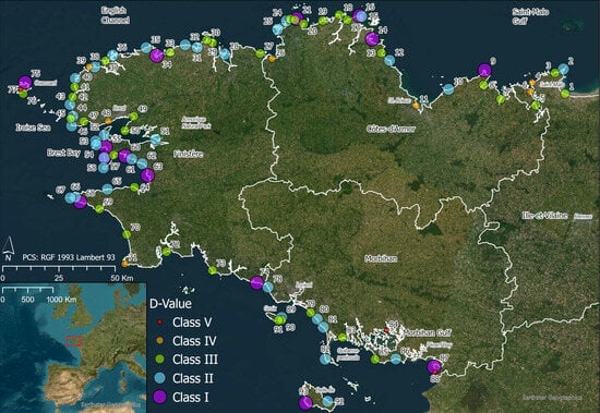
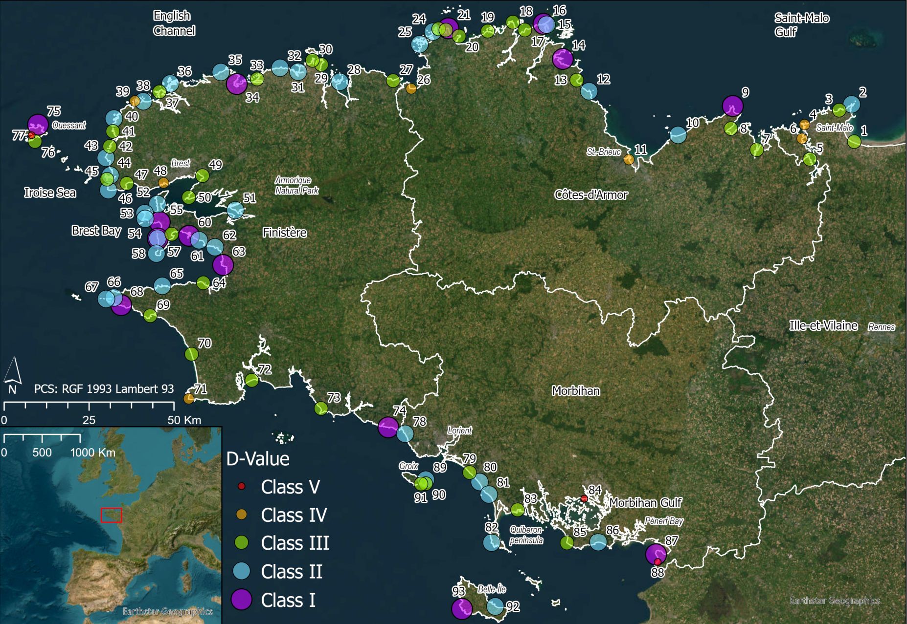
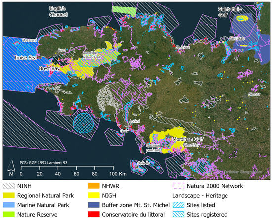
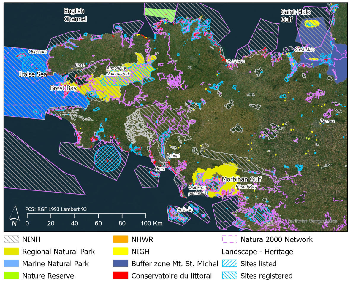
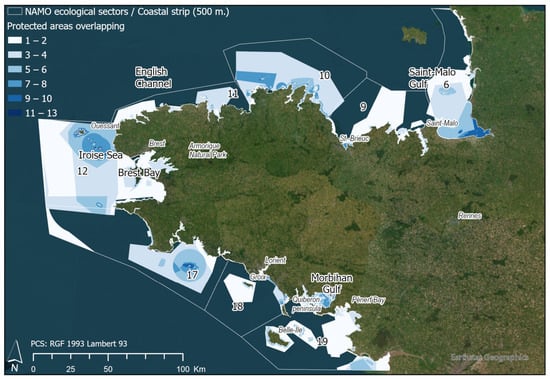
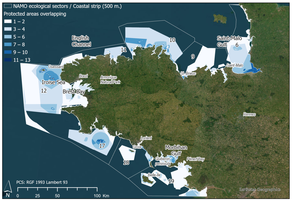
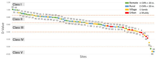
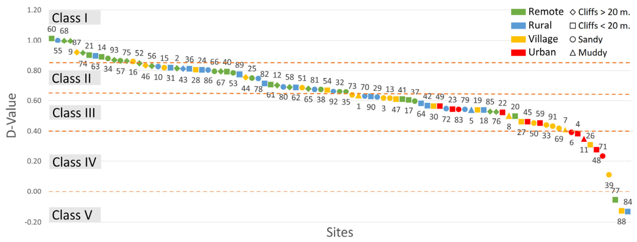
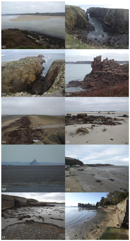
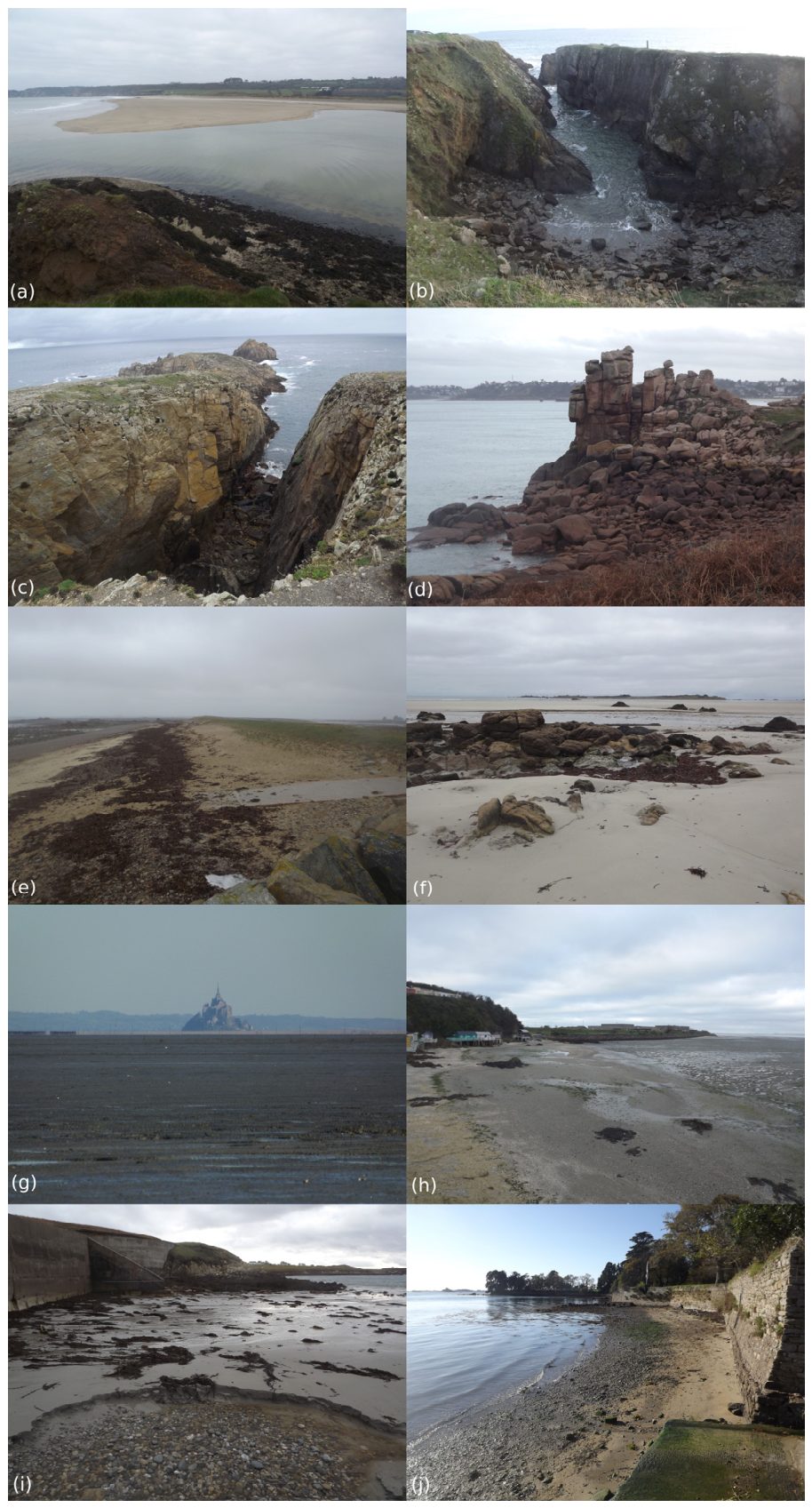
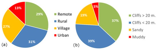
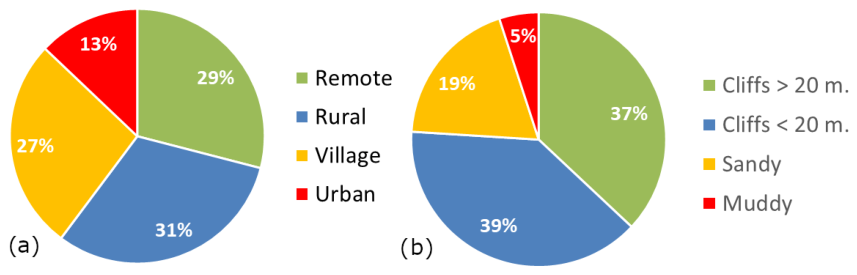
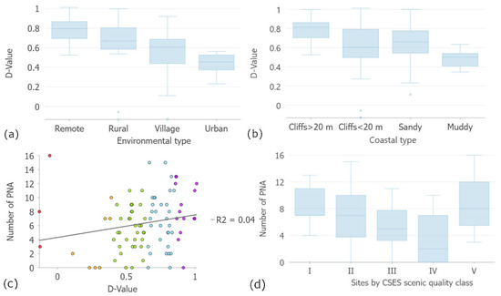
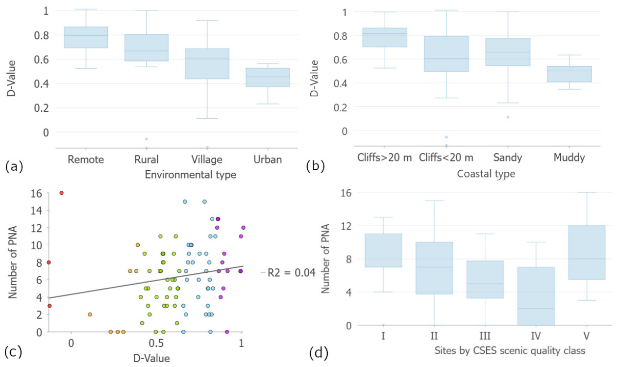
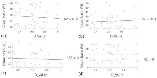
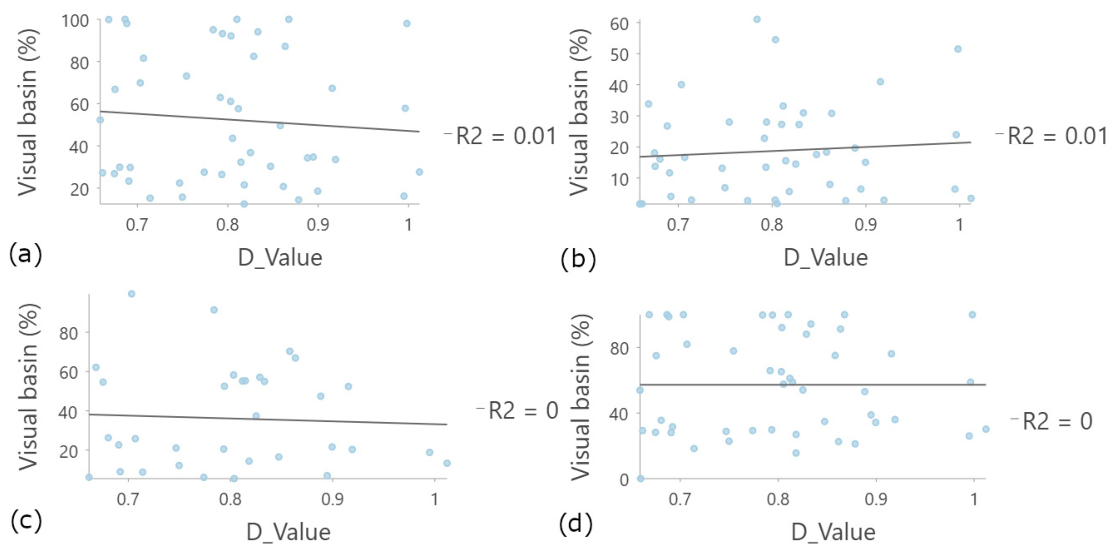
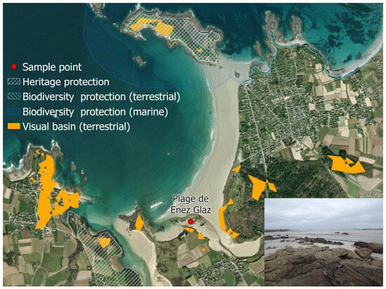
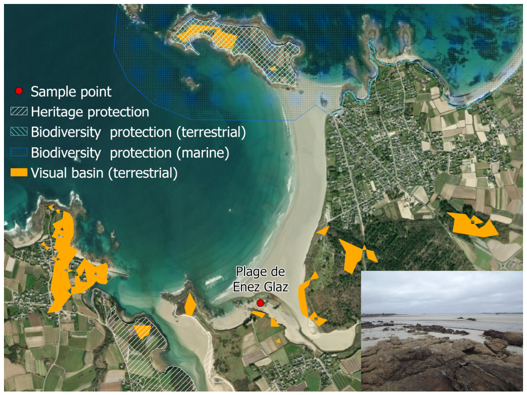
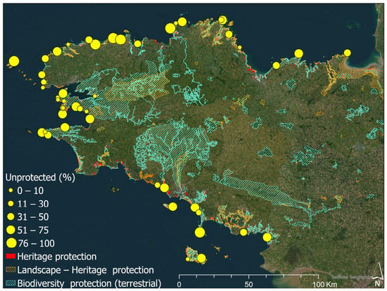
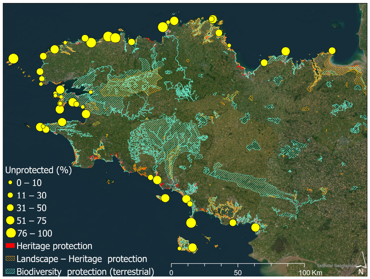
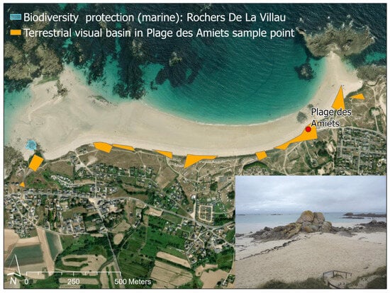
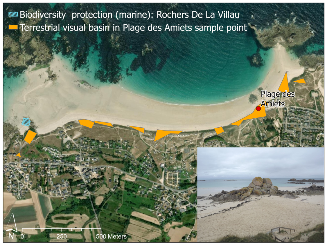
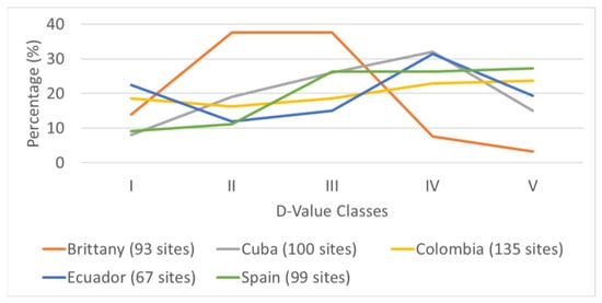
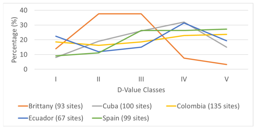

Disclaimer/Publisher’s Note: The statements, opinions and data contained in all publications are solely those of the individual author(s) and contributor(s) and not of MDPI and/or the editor(s). MDPI and/or the editor(s) disclaim responsibility for any injury to people or property resulting from any ideas, methods, instructions or products referred to in the content. |
© 2026 by the authors. Licensee MDPI, Basel, Switzerland. This article is an open access article distributed under the terms and conditions of the Creative Commons Attribution (CC BY) license.