


Abstract
The floods triggered by the 29 October 2024 cut-off low in Valencia (Spain) expose a persistent challenge in disaster risk reduction: extensive meteorological and territorial data do not automatically become timely, trusted or actionable public guidance. This conceptual synthesis uses the Valencia event as a diagnostic case and reconstructs selected evidence on rainfall, hydrological escalation and alert timing to develop a data-driven framework spanning observation, modelling, impact assessment, communication, decision-making and post-event learning. Here, “data-driven” denotes an end-to-end governance and translation process, not the development of a new forecasting model. The framework integrates four dimensions: data governance, user-centred visualization, uncertainty communication and school-based education. It also introduces territorial translation as the link between impact forecasts and place-specific infrastructures, routines, vulnerabilities and responsibilities. Its novelty lies in connecting the Early Warnings for All pillars and impact-based, people-centred warning approaches with an explicit educational and territorial learning loop. Its practical contribution is a responsibility matrix, a minimum governance package and an implementation roadmap with indicators for latency, reach, comprehension and protective action. The framework is intended for adaptation, rather than statistical generalization, across Mediterranean and other fast-onset flood contexts. Improved forecasts remain necessary but insufficient: loss reduction requires interoperable records, accessible impact-based messages and inclusive educational programmes that convert scientific information into situated collective competence.
1. Introduction
The main challenge of natural-hazard warnings is no longer the simple scarcity of information [1,2]. This diagnosis is now central to the international Early Warnings for All agenda, led by the World Meteorological Organization (WMO) and the United Nations Office for Disaster Risk Reduction (UNDRR), which defines effective multi-hazard early warning systems through four mutually dependent pillars: disaster risk knowledge, detection and forecasting, warning dissemination and communication, and preparedness and response [3,4,5]. In many countries, meteorological services, hydrological agencies, emergency managers, municipalities, satellite programmes, transport operators and citizens generate continuous streams of data before, during and after an extreme event. The problem is that these streams are heterogeneous, unevenly accessible, differently trusted and often poorly translated into the practical knowledge that people need when conditions deteriorate [6]. An early warning becomes socially effective only when a forecast, a map or a sensor reading is converted into a clear understanding of who is exposed, what impacts are plausible, what actions are urgent and which institutions are responsible for guidance. This conversion is not a purely technical operation; it is also spatial, cultural, educational and institutional [7,8].
The cut-off low that affected eastern Spain in late October 2024 provides a decisive entry point for revisiting this problem [6]. A cut-off low, or isolated depression at high levels, can favour persistent convection, intense rainfall and flash flooding when it interacts with warm Mediterranean air, orography and highly exposed catchments. On 29 October 2024, extraordinary rainfall affected the eastern and south-eastern Iberian Peninsula, with the most catastrophic consequences in Valencia [6]. The technical report by the Agencia Estatal de Meteorología (AEMET) [9] described historic accumulations in the Valencian Community and highlighted Turís, where the official station registered extreme values over one, six, twelve and twenty-four hours. Subsequent analysis by the Júcar River Basin Authority (Confederación Hidrográfica del Júcar, CHJ) emphasized the rapid increase in flows in the Barranco del Poyo system and the scale of downstream impacts [10]. The disaster was therefore meteorologically exceptional, hydrologically abrupt and territorially devastating.
Yet its importance for international research does not lie only in the magnitude of the rainfall. Valencia revealed the broader tension between scientific warning capacity and social protection. The event occurred in a region with a long history of flood exposure, high urban and peri-urban occupation, dense mobility networks and uneven public familiarity with hydrological risk. It also occurred in a media environment characterized by rapid circulation of official updates, expert interpretation, rumours and misinformation. Olcina and Morote [6] frame the episode as a problem of climate change communication, risk education and the public role of science, arguing that the disaster showed both the relevance of scientific knowledge and the need for better social preparation. This article builds on that line of argument but places it within a wider data-driven warning framework.
The international relevance is clear. Many urbanized regions face the same combination of conditions: intensifying heavy rainfall, expansion of assets into flood-prone areas, fragmented emergency governance, uneven trust in institutions, and citizens who must make rapid decisions under stress. Recent global assessments sharpen this diagnosis. The 2025 global status report on multi-hazard early warning systems indicates that 119 countries, approximately 60% of the world total, reported such systems, but also that coverage and pillar-level capabilities remain uneven [11]. The WMO State of the Global Climate 2025 report places heavy rainfall and other extremes within a wider pattern of climate disruption, vulnerability and interconnected impacts [12]. At the technical frontier, high-resolution impact-based flood forecasting and AI-supported multi-hazard warning research are explicitly moving from hazard prediction toward impacts on buildings, infrastructure and communities, but they also stress user-centred interfaces, evaluation, transparency and responsible governance [13,14]. The 2024 Valencia cut-off low therefore speaks to a global audience concerned with warning value chains, impact-based forecasting, data standards, uncertainty communication and disaster risk education. It also challenges an overly narrow view of early warning as a message sent at the end of a technical process. Warnings should instead be considered a distributed public system in which data, institutions and citizens interact over time.
Dense real-time observation networks outside hydrometeorology also show the value of making the data pathway explicit. Japan’s Seafloor Observation Network for Earthquakes and Tsunamis (S-net), for example, transmits offshore pressure-gauge data in real time and supports tsunami data assimilation and coastal waveform forecasting. Its relevance here is architectural—observation, quality control, modelling and forecast update—rather than an equivalence between tsunami and flood processes.
This article advances three claims. First, warnings must be designed as territorial translations. People do not experience a hazard as a rainfall threshold or a return period; they experience closed roads, flooded garages, trapped relatives, interrupted schooling, unreliable power, uncertain evacuation routes and fear. Second, data science can improve warnings only if data are interoperable, documented, reproducible and connected to impact pathways. More data alone can increase confusion if the warning ecology remains fragmented. Third, risk education must become a core part of warning effectiveness. Schools are critical because they can connect basic geographic understanding with local hazard knowledge, data literacy, practical preparedness and civic responsibility. The point is not only pedagogical: UNICEF’s 2025 global snapshot reported that climate-related hazards disrupted schooling for at least 242 million students in 85 countries or territories in 2024, demonstrating that schools are both exposed institutions and strategic nodes for risk communication [15].
The article is organized as a conceptual research paper. Section 2 defines the source base, analytical assumptions and limits of the synthesis. Section 3 uses selected Valencia indicators to diagnose the observation-to-action pathway. Section 4 integrates data governance, territorial translation, visualization, uncertainty communication, local data, misinformation and school-based education; it also compares the proposal with international frameworks, assigns indicative responsibilities and provides an implementation roadmap. Section 5 discusses transferability, low-resource implementation, limitations, future research and operational recommendations.
2. Conceptual Approach and Scope
This work is a conceptual synthesis rather than a forensic reconstruction of the Valencia emergency. It draws on three source groups: official event records and technical reports; international policy frameworks on early warning, school safety and disaster risk reduction; and peer-reviewed research on impact-based forecasting, risk communication, data governance and education. The selection is purposive, not a systematic review, because the objective is to articulate relationships among disciplines and institutions rather than estimate an aggregate effect. Event values are used descriptively to identify warning-chain requirements; no new empirical dataset is created, no model is calibrated and no causal or legal attribution is attempted. The synthesis is calibrated against international frameworks that treat early warning as a people-centred, multi-pillar system rather than a broadcast technology. The EW4All action plan, the 2024 risk-knowledge handbook and the recent OECD analysis of ASEAN warning systems converge on the need for risk information, clear mandates, interoperable infrastructure, trusted channels, public–private coordination and anticipatory action capacities [3,4,16].
In this article, “data-driven” refers to an end-to-end decision architecture: observations are quality-controlled and ingested into weather and hydrological models; outputs are combined with exposure, vulnerability and capacity data to create impact scenarios; authorized institutions translate those scenarios into messages and decision triggers; users take protective action; and timestamped evidence and outcomes are archived for evaluation. This definition therefore concerns governance, provenance and operational use of data, not a claim that the article itself develops a quantitative forecasting model.
The paper therefore adopts four analytical assumptions. The first is that disasters are not natural in a strict sense. Extreme rainfall may be natural or climate-amplified, but disaster losses emerge from the relation between hazard and society. Warning research must consequently address settlement patterns, land-use planning, institutional coordination, social vulnerability and public learning. The second assumption is that data have social lives. A rain gauge value, radar image or flood polygon does not have the same meaning for a forecaster, a mayor, a school principal, an older resident or a commuter. Data become protective only when they are interpreted within decision contexts. The third assumption is that communication is not the final step of the warning chain but a condition that shapes the whole chain. If users do not understand warning categories, trust channels or know which actions correspond to each message, the system is weakened before the hazard arrives. This assumption is consistent with research on impact-based forecasts and warnings, which identifies evaluation, behavioural response, data access, avoided losses and communication-chain performance as unresolved challenges [8,17].
The fourth assumption is educational. Risk knowledge cannot be improvised during a crisis. Basic concepts such as return period, flash flood, ravine, floodplain, runoff, warning colour, official source and protective action must be learned before they are needed [18]. This does not imply transforming schools into emergency agencies. It means recognizing that schools are one of the few institutions capable of building shared vocabulary, place-based understanding and civic habits across the population. The international school safety policy from the Global Alliance for Disaster Risk Reduction and Resilience in the Education Sector (GADRRRES) supports this position: the Comprehensive School Safety Framework links safer learning facilities, school safety management, educational continuity and risk reduction education, while the 2025 Global Status of School Safety report identifies persistent gaps in mandatory teacher training and assessment for disaster risk reduction and climate change education [19,20]. The conceptual framework proposed here is therefore deliberately didactic–territorial: it treats territory as the object of risk interpretation and education as a mechanism for converting technical knowledge into public competence.
The Valencia cut-off low functions here as a diagnostic case, not as the sole empirical foundation of a universally validated model. Five framework requirements arise directly from the event record: the time compression between hydrometeorological escalation and impacts; the need to connect meteorological and hydrological streams; the need for place-specific instructions about routes, buildings and routines; the importance of explicit decision authority and public-alert timing; and the preservation of records for learning amid post-event controversy and misinformation. Other elements, including CAP, FAIR data, people-centred warning and comprehensive school safety, are derived from the international literature and integrated with those Valencia-specific requirements. Transfer beyond Valencia is therefore analytical and conditional, not statistical: each application must re-specify local hazards, mandates, infrastructures, vulnerabilities and educational systems.
3. The 2024 Valencia Cut-Off Low as a Starting Point for International Analysis
The Valencia disaster should not be reduced to a singular local tragedy, nor generalized so broadly that its territorial specificity disappears [21]. Its analytical value lies in the way it condenses several contemporary risk processes. The meteorological trigger was extreme, but the consequences were produced by interactions among atmospheric dynamics, catchment behaviour, urban form, infrastructure dependency, warning communication, population vulnerability and institutional response. Table 1 summarizes a limited set of verified indicators used in this article. Times are local. The sequence is diagnostic rather than forensic: it identifies where information had to be translated into decisions without assigning individual legal responsibility or estimating counterfactual lives saved.
Table 1.
Selected Valencia event indicators and their framework implications.
The meteorological dimension is well documented. AEMET [9] described persistent torrential rainfall associated with a cut-off low near the Strait of Gibraltar and low-pressure dynamics that channelled humid easterly flow from the Mediterranean toward eastern Spain. At Turís, the official station registered 185 mm in one hour, 621 mm in six hours, 720 mm in twelve hours and 772 mm in twenty-four hours; the one-, six- and twelve-hour totals set records in the AEMET network. These values do more than establish extremity. They show the operational burden of converting a rapidly evolving convective process into differentiated instructions for municipalities, transport users, schools, workplaces and households.
The hydrological dimension was equally decisive. Flash floods are warning-system stress tests because levels can change faster than administrative routines. CHJ’s published chronology for the Barranco del Poyo reported 264 m3/s at 12:09, a decline to 28.70 m3/s by 15:50, then a rise to 1686 m3/s at 18:43 and 2282 m3/s at 18:55, when the gauge was destroyed [10]. The sequence illustrates why a warning cannot rely on a single absolute reading: rate of change, upstream observations, sensor redundancy and pre-defined territorial triggers matter. The practical question is not only whether heavy rain is expected, but when and where a dry ravine, underpass, industrial estate, ground-floor dwelling, garage or school route becomes unsafe.
The climate dimension adds a further layer. The Mediterranean is a recognized hotspot of exposure to heavy rainfall, flash flooding and climate-related variability [23]. A rapid assessment by World Weather Attribution [24] reported that extreme downpours in eastern Spain are becoming heavier as fossil-fuel emissions warm the climate, while later physical attribution research on the Valencia event indicated that anthropogenic climate change amplified rainfall intensity, spatial extent and total rainfall volume in the Júcar catchment [25]. These findings do not mean that climate change explains every causal aspect of the disaster. They mean that warning and education systems must be prepared for events whose intensity and spatial behaviour may exceed recent social memory and existing design assumptions.
The social dimension is central to the argument. The event generated debate about the relation between forecasts, official warnings, hydrological information, the ES-Alert message and residents’ capacity to interpret danger. A published chronology places the mass mobile alert at 20:11, after red meteorological warnings and during the period of severe hydrological escalation. This timing is included to distinguish stages in the warning chain, not to make a legal judgement about responsibility or to infer a simple causal relation between one message and the death toll. Olcina and Morote [6] also highlight the post-event circulation of false or misleading claims. In contemporary crises, misinformation can delay action, erode trust and create retrospective confusion about what was known, by whom and when.
Valencia thus supplies concrete requirements for the framework. The rainfall record supports high-frequency observation and impact thresholds; the Poyo sequence supports rate-of-change monitoring, redundancy and interoperable hydrological data; the warning chronology supports explicit authority, auditable timestamps and differentiated public instructions; the pattern of disruption supports route-, facility- and household-specific guidance; and the post-event information environment supports transparent archives, media coordination and risk education. End-to-end performance must therefore ask whether risk knowledge existed, data crossed institutional boundaries, forecasts were linked to impact scenarios, messages were comprehensible and actionable, vulnerable groups were reached, protocols had been rehearsed and records allow for independent evaluation. Accurate meteorological information without effective protective action remains incomplete.
4. Territorializing Data-Driven Flood Warnings: Governance, Communication and Risk Education
4.1. From Data Streams to Territorial Warnings
The warning value chain is a useful way to describe the pathway from observations to decisions [1,2]. It includes monitoring, weather forecasting, hazard forecasting, impact forecasting, warning production, dissemination, response and evaluation. However, the chain metaphor can be misleading if it suggests a simple linear sequence. In practice, warning systems operate as networks of data, models, institutions and users. Information may circulate vertically from national agencies to municipalities, horizontally across sectors, and informally through media and social networks. Breaks in this network can occur at several points: data may be unavailable, incompatible, delayed, not trusted, poorly visualized or too generic to guide individual action.
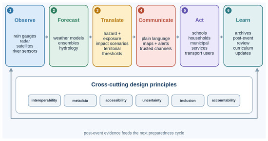
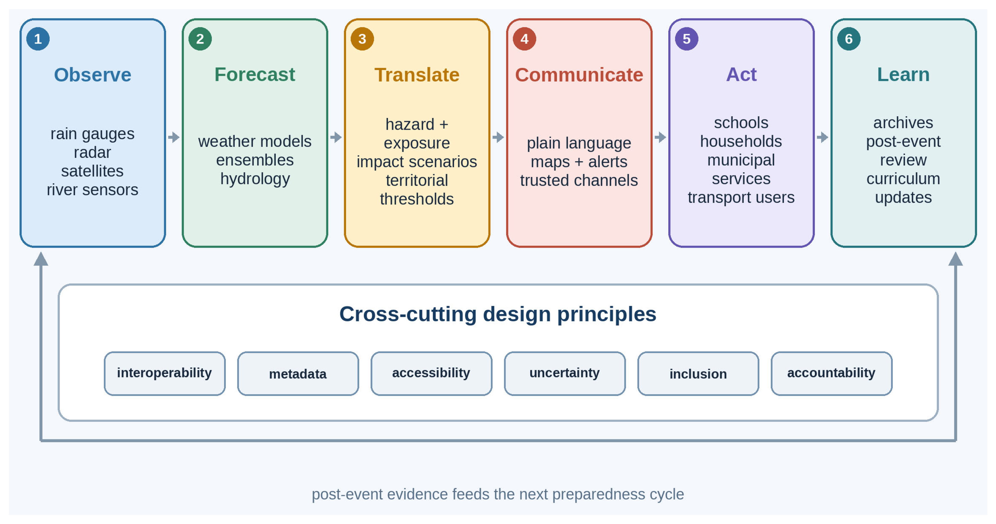
Operationally, a data-driven warning process moves through six linked transformations (Figure 1): observations are acquired and quality-controlled; weather and hydrological states are forecast; hazard outputs are combined with exposure and vulnerability data; impacts are translated into territorial thresholds; authorized actors communicate actions through trusted channels; and outcomes are archived for learning. Feedback is essential: user reports, sensor failures, message reach and observed impacts must update models, protocols and education. The value of data is therefore measured not by volume alone, but by provenance, latency, interoperability, decision relevance and the capacity to support action.
Figure 1.
Territorial warning value chain for flash-flood risk. Source: own elaboration.
A territorial warning is more than a meteorological warning (Table 2). It integrates hazard, exposure, vulnerability and capacity in relation to places. Rainfall intensity, river discharge and flood extent matter because they intersect with settlements, road networks, hospitals, schools, care homes, industrial zones, emergency routes, digital connectivity and household characteristics. Warning communication should therefore be impact-based wherever possible. A threshold such as “90 mm in one hour” may be technically precise but not actionable for the public. It becomes more useful when linked to plausible impacts and instructions: avoid specified corridors, do not enter underground garages, suspend school transport, move to higher floors, close exposed facilities, check on older neighbours or prepare for power interruption.
Table 2.
Key components of territorial warning systems.
This translation requires interoperable data. Hydrological observations, weather radar, digital elevation models, land-use maps, cadastral data, road closures, public transport status, demographic indicators, school locations and emergency resources are often held by different organizations. They may use different formats, update cycles, licences and spatial references. In normal times this fragmentation is inefficient; during a fast-moving event it can become dangerous. The FAIR principles—Findability, Accessibility, Interoperability and Reusability—provide a useful data-management orientation, but in emergency settings they must be operationalized as institutional routines [26]. Data should be documented before events, shared through agreed protocols, and archived afterward with enough metadata to reconstruct the information available at the time.
The Common Alerting Protocol (CAP) illustrates the value of targeted standardization [27]. The CAP does not solve all warning problems, but it demonstrates how a common format can help distribute alerts across systems without losing essential fields such as urgency, severity, certainty and recommended action. Similar logic should guide the integration of hazard and impact data. The goal is not to centralize all knowledge in one platform, but to ensure that relevant systems can exchange, interpret and reuse critical information quickly.
Operationally, this requires a minimum governance package. First, agencies should agree on a shared risk-data inventory before the flood season begins, identifying the owner and updating the frequency, licence, spatial unit, quality limitations and contact point for each dataset. Second, the most critical datasets should be tested through exercises, not merely listed in plans. Third, alerting protocols should define which institution has authority to translate technical thresholds into public action instructions. Fourth, municipalities should have access to templates that connect warnings to local assets: schools, health centres, social-care facilities, industrial estates, bridges and known flood traps. Fifth, post-event reviews should examine the data pathway as carefully as they examine field operations. These governance practices are modest compared with the cost of disaster losses, but they can determine whether information moves quickly enough to matter.
Open data and reproducibility are equally important (Figure 1). Post-event learning depends on knowing what warnings were issued, when they were issued, what data supported them, how they were visualized and how they changed over time. If real-time maps, hydrological readings, warning texts or dashboard states disappear after the event, independent evaluation becomes weak. Reproducible warning archives do not require storing every data stream indefinitely, but they do require preserving the crucial datasets, model versions, visualization code, alert messages and timestamps needed to evaluate performance. This is not merely a technical best practice. It is a democratic condition for accountability and institutional learning.
Territorial warnings also require attention to social diversity, because risk perception and protective decisions vary according to social context, previous experience and perceived capacity to act [28,29]. The same hazard does not produce the same risk for all residents. People differ in mobility, age, disability, language, access to transport, housing type, social support, work obligations, digital access and trust in authorities. A resident in a basement apartment, a delivery driver, a caregiver, a teacher responsible for children and an older person living alone may all receive the same colour-coded warning, but they require different guidance. User-centred warning design must therefore avoid treating the public as a homogeneous receiver. It should ask what decisions different groups must make and what information they need to make those decisions before conditions deteriorate.
4.2. Visualization, Uncertainty and User-Centred Communication
Warning visualization is not decoration; it is part of the warning itself [30,31]. Maps, dashboards, hydrographs, colour scales, icons and text determine how people perceive urgency and choose actions. During an emergency, cognitive load is high and attention is fragmented. A visualization that requires expert interpretation, uses inconsistent legends or presents excessive layers without hierarchy may fail even if the underlying data are correct. Effective hazard communication must therefore prioritize clarity, contrast, accessibility and action.
Flood maps present a particular challenge because they combine spatial extent, depth, velocity, uncertainty, time and exposure [32]. A public-facing map should allow users to locate themselves, understand the relevant time window, distinguish between observed and forecast conditions, and see the relation between the hazard and routes or facilities that matter to them. Static maps may be useful for simple announcements, but interactive maps are better suited to localized risk interpretation when they are designed responsibly. Interactive design should not mean uncontrolled complexity. The default view should show the most urgent information, while optional layers can provide more detail for users with higher data literacy or institutional responsibilities.
Colour requires careful treatment. Emergency colour scales should be culturally recognizable and accessible to people with colour-vision deficiencies; perceptually uneven rainbow or red–green schemes can distort values and exclude users. A red polygon may convey severity, but it can also obscure differences within the area if it is too broad. Blue scales may be intuitive for water depth, but depth alone does not communicate velocity or debris risk. Visualizations should therefore combine colour with labels, icons, boundaries and plain-language explanations. Accessibility also requires readable fonts, mobile compatibility, alt text for digital products and alternatives for users who cannot rely on visual displays.
Uncertainty is unavoidable and should not be hidden [33]. Weather and hydrological forecasts depend on observations, models, assumptions and incomplete knowledge. Impact forecasts add further uncertainty because they require estimating how water will interact with infrastructure and human behaviour. However, uncertainty communication must be designed carefully. A public message that emphasizes uncertainty without guidance may lead to inaction; a message that suppresses uncertainty may create false confidence or later distrust. The practical task is to communicate what is uncertain, what is still dangerous, and what protective action is justified despite uncertainty.
Layered communication can help. Emergency managers may need probabilistic flood envelopes, ensemble hydrographs, confidence intervals and scenario matrices. The general public may need simpler categories such as “possible,” “likely” and “severe,” linked to concrete actions. Schools and workplaces may need trigger-based protocols: if a red rainfall warning is issued for the municipality, outdoor activities stop; if river levels exceed a defined threshold, transport is suspended; if authorities advise shelter-in-place, staff follow a rehearsed internal plan. In this sense, uncertainty becomes actionable when it is connected to pre-agreed decisions.
The warning message should also answer the user’s implicit questions: Am I in danger? Are my relatives in danger? Can I travel? Should I collect my children? Is my school or workplace open? Can I use this road? What should I avoid? Where is official information updated? These questions are not secondary to science; they are the points at which science becomes protection. Impact-based warning design should begin with these questions and then determine which data, maps and messages are needed to answer them.
4.3. Local Data, Citizen Information and the Risk of Misinformation
Highly localized warnings require data at appropriate spatial and temporal scales. Traditional meteorological and hydrological networks remain essential, but they may not capture the full variability of convective rainfall or flash-flood responses. Remote sensing, weather radar, river gauges, traffic sensors, emergency-call logs, municipal reports, public transport feeds and crowdsourced observations can complement official networks [34,35,36]. In principle, these sources can improve situational awareness, validate model outputs and identify impacts as they emerge.
However, novel data sources are not automatically useful. Crowdsourced photos, social media posts and informal messages vary in quality, location accuracy, timestamp reliability and interpretation. They can provide early signals, but they can also amplify rumours or create false alarms. Data science can help classify, geolocate, filter and validate large volumes of heterogeneous information, using text mining, image analysis, anomaly detection and cross-source comparison. Yet automated processing must be integrated into emergency protocols and supervised by trained personnel. In life-threatening contexts, speed matters, but so does the cost of error.
A useful model is a trusted data commons for risk communication. Such a commons would not be an uncontrolled open feed. It would be a governed system in which official agencies, municipalities, research institutions and selected civil-society actors share data according to standards, privacy rules and quality indicators. Public users would see verified information and clear uncertainty labels. Professional users could access more detailed layers for response planning. After the event, archived data would support evaluation, research and public accountability.
Privacy is a central condition. Impact-based warnings may require demographic and mobility data, but these data can expose sensitive information about households, disability, age, income or location. Ethical data governance should therefore minimize personal identification, aggregate where possible, define access rights, and clarify how data will be used in emergencies and archived afterward. Trust in warning systems depends partly on the belief that institutions will not misuse data collected in moments of vulnerability.
The Valencia cut-off low also shows why misinformation must be treated as a warning-system issue. False claims about forecasts, dams, climate change or institutional responsibility can circulate rapidly, especially when people are afraid and official explanations are delayed or fragmented. Communication systems must therefore include pre-crisis education about reliable sources, real-time myth correction, cooperation with local media, and post-event transparency. Scientific institutions cannot assume that correct information will prevail by itself. They need communication strategies that are timely, understandable and socially present before misinformation fills the vacuum.
4.4. Schools as Strategic Infrastructures of Risk Culture
Risk education is often treated as an ancillary activity: useful, but separate from forecasting, emergency planning and civil protection. This separation is counterproductive. Warnings work better when people already understand hazards, exposure, vulnerability and protective action. A school is the most systematic institution for developing this understanding across generations. It is also territorial: embedded in neighbourhoods, linked to families, responsible for children during part of the day and often used as a community reference point in emergencies. Schools should therefore be considered strategic infrastructures of risk culture [37].
The educational task is not to frighten students or moralize disasters. It is to build geographic and civic competence. Geographic literacy enables students to connect atmospheric processes with river basins, slopes, impermeable surfaces, ravines, floodplains, land-use decisions and mobility networks. Civic competence enables them to interpret official warnings, understand institutional responsibilities, recognize misinformation, and act responsibly toward themselves and others. Together, these competences create what can be called territorial risk literacy: the capacity to understand how risk is produced in specific places and how it can be reduced through knowledge, planning and action.
A didactic–territorial approach should begin with the local environment. Students can map the school catchment area, identify low points and underpasses, compare historical flood maps with current urban development, examine official hazard maps, visit river or ravine environments with appropriate safety planning, and analyze how land use affects runoff. They can work with simplified rainfall and hydrograph data, interpret warning colour codes, and discuss what different messages require them to do. These activities connect science, geography, citizenship, mathematics and language. They also make climate change education concrete: global warming is not presented as an abstract planetary process, but as a factor that can intensify local hydrological extremes and challenge existing preparedness.
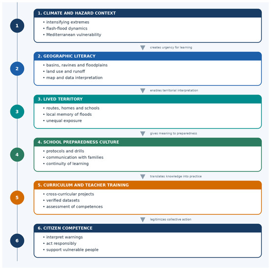
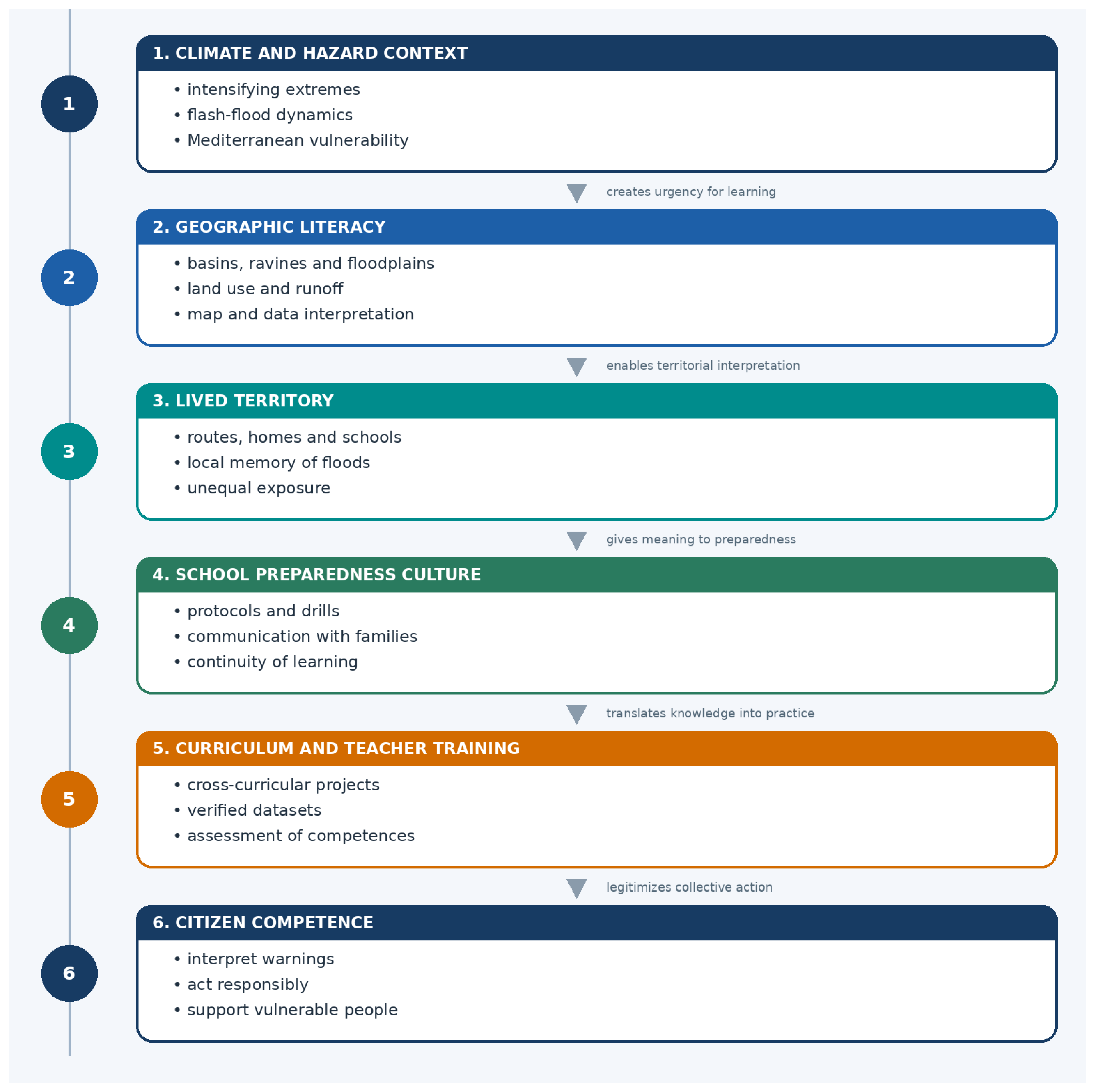
The curriculum should include four layers (Figure 2). The first is conceptual: weather, climate, cut-off low dynamics, watershed behaviour, flood types, exposure, vulnerability and resilience. The second is cartographic and data-based: reading maps, legends, scales, time series, uncertainty ranges, official dashboards and geospatial layers. The third is critical-communicative: distinguishing official sources from rumours, evaluating social media claims and communicating risk without exaggeration. The fourth is action-oriented: interpreting warning levels, preparing household plans, supporting vulnerable people, avoiding flooded roads and underground spaces, and participating in meaningful drills.
Figure 2.
Didactic–territorial framework for risk education at school. Source: own elaboration.
The empirical evidence supports careful, bounded claims. Quasi-experimental studies have found that school hazard education can improve children’s knowledge, risk perception, perceived preparedness and reported protective adjustments, including household-level spillovers. A systematic review likewise identifies repeated gains in awareness and preparedness across programmes, while also noting heterogeneity in design and outcome measurement. These studies do not yet establish that classroom programmes by themselves reduce mortality or guarantee compliance during a real flash flood. The defensible proposition is that education strengthens antecedent competences in interpretation, rehearsal, family discussion and recognition of safe behaviour; these should be tested against observed warning response in future evaluations.
Teacher training is a critical variable. Many teachers are willing to address climate and disaster risk but lack updated materials, local datasets, confidence with geospatial tools or clear alignment with curriculum standards. Professional development should therefore provide ready-to-use local case studies, simplified datasets, map-based activities, assessment rubrics and guidance for discussing emotionally difficult disasters. Collaboration between universities, meteorological agencies, civil protection, municipalities and schools can produce locally relevant resources without overloading individual teachers.
Schools must also be resilient organizations. The Comprehensive School Safety Framework emphasizes safe learning facilities, school safety management, educational continuity and risk reduction education [19]. In flood-prone territories, this means that each school should know its exposure, maintain communication protocols, define shelter-in-place and evacuation procedures, plan for transport disruption, protect students with disabilities, and coordinate with families before emergencies. A school that teaches risk but lacks an internal emergency plan sends a contradictory message. Conversely, a school that integrates curriculum, drills, facility assessment and community communication becomes a living laboratory of preparedness.
Risk education should consider students with disabilities, different language backgrounds, socio-economic constraints and varied family structures. A household preparedness assignment, for example, should not assume that all families own a car, have stable housing, can buy emergency supplies or understand official terminology. Educational materials should therefore frame preparedness as collective and equitable, not as individual responsibility alone. Students should learn that vulnerability is socially produced and that solidarity, public services and territorial planning are part of risk reduction.
The educational section of a warning framework must also address emotions. Disasters generate grief, anger and anxiety, especially when students have direct or indirect experience of loss. Climate-related risk education can produce eco-anxiety if it only presents escalating threats. UNESCO’s greening curriculum guidance emphasizes resilience-building and positive action as part of climate education [38,39,40]. In practice, this means that lessons should combine scientific realism with agency: students identify risks, understand limits, and participate in feasible actions such as mapping safe routes, interviewing older residents about past floods, creating communication materials for families or evaluating school procedures.
A practical learning sequence can be organized as a local flood inquiry. Students first explain runoff and flash-flood dynamics, then overlay buildings, routes and services on flood-prone areas. They compare official warnings with media and social-network claims, and finally design and justify actions for a small set of scenarios, such as a red warning before school, intense rain during the school day or a blocked transport route. The sequence ends by distinguishing household, school, municipal and national responsibilities.
This sequence is compatible with inquiry-based learning and with assessment of competences rather than memorization. Students can produce risk maps, short warning explainers, family checklists, interviews with local residents, or critiques of misleading claims. These products also have community value because they translate technical knowledge into accessible language. In territories affected by recent disasters, such activities should be handled with sensitivity, but avoiding the subject entirely can leave students with fear, rumours and fragmented memories rather than structured understanding.
Finally, risk education should be evaluated. It is not enough to add content to a curriculum. Schools and education authorities should assess whether students can interpret warnings, read basic hazard maps, identify safe and unsafe behaviours, explain why some groups are more vulnerable, and locate reliable information sources. Evaluation should also consider whether school plans are updated, drills are meaningful, and families understand the communication channels used during emergencies. This closes the loop between education and warning effectiveness.
4.5. An Integrated Didactic–Territorial Framework and Implementation Roadmap
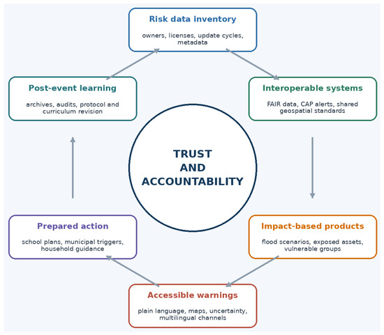
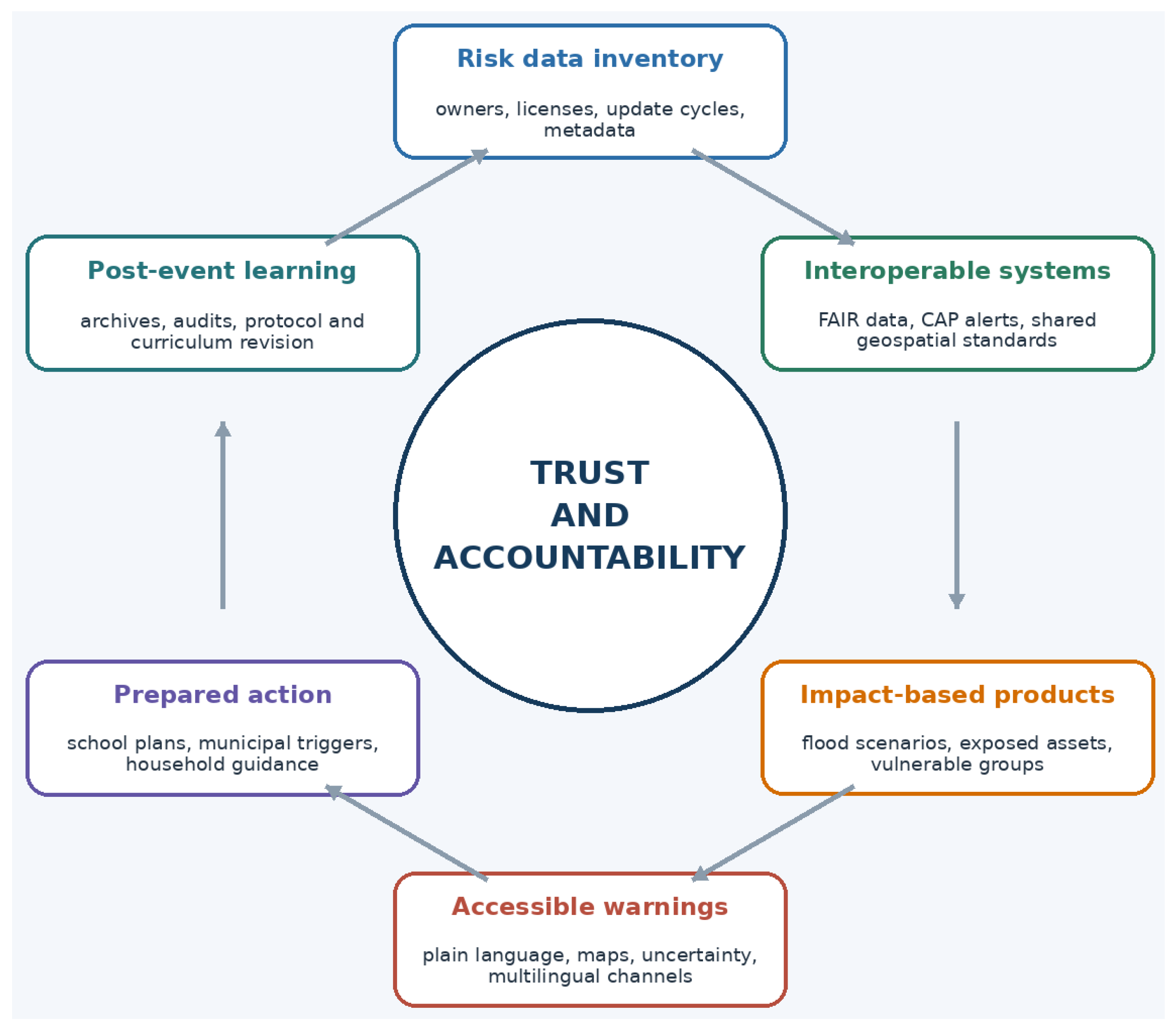
The preceding sections can be integrated into four functions: (1) knowing risk; (2) translating data; (3) communicating action; and (4) institutionalizing learning (Figure 3). These functions are recursive rather than purely sequential and must operate before, during and after events.
Figure 3.
Data governance and communication loop for user-centred early warning. Source: own elaboration.
Territorial translation is related to, but distinct from, impact-based forecasting and people-centred warning. Impact-based forecasting estimates consequences from hazard, exposure and vulnerability information. People-centred warning is the broader governance principle that warning systems should be understandable, trusted, inclusive and connected to preparedness. Territorial translation is the intermediate operational mechanism that locates those forecasts and principles in specific catchments, streets, facilities, routes, daily routines, responsible institutions and locally available capacities. It also adds an educational and feedback function: users learn how a warning category relates to their lived territory, and post-event evidence revises both protocols and curricula (Table 3).
Table 3.
Comparison with selected international warning and school safety frameworks.
The first function, knowing risk, includes scientific hazard assessment, historical flood memory, climate projections, exposure mapping and vulnerability analysis. Its territorial focus is the basin, municipality, neighbourhood and facility. The objective is to understand where water can move, who and what are exposed, and which social conditions shape vulnerability. This function should be shared by technical agencies, municipalities, schools and communities, using different levels of complexity for different users.
The second function, translating data, connects observations and forecasts with impact scenarios. It requires interoperable datasets, documented models, standard alert formats, metadata, open archives and quality assurance for novel data. Translation is successful when meteorological and hydrological variables are connected to concrete disruptions: flooded roads, unsafe ground floors, school closures, hospital access, power interruptions or evacuation constraints.
The third function, communicating action, turns impact scenarios into user-centred messages. It combines visual standards, plain language, uncertainty communication, accessibility, multilingual outreach and trusted channels. A warning should be judged by whether it supports decisions under stress. For this reason, recommended actions should be explicit, repeated and adapted to groups such as school communities, older residents, commuters, tourists and emergency volunteers.
The fourth function, institutionalizing learning, ensures that each event improves the next cycle. It includes post-event data preservation, independent evaluation, revision of protocols, teacher training, curriculum updates, public communication reviews and community memory work. Learning is where school becomes especially important, because it can transform a disaster from an isolated traumatic event into structured knowledge for future protection.
The framework is didactic because risk knowledge must be taught, practised and evaluated. It is territorial because it starts from catchments, urban forms, infrastructures, routes and lived experience. It is data-driven because it specifies how documented observations move through modelling, impact assessment, authorized communication, decision triggers and archived evaluation. It is civic because warnings depend on trust, responsibility and collective action.
Operationalization also requires an explicit allocation of responsibilities (Table 4). The matrix is indicative and must be adapted to statutory mandates; it does not replace emergency law or incident-command arrangements. Its purpose is to prevent the generic instruction to “coordinate” from obscuring who maintains data, who integrates evidence, who issues public instructions, who acts locally and who preserves the record.
Table 4.
Indicative responsibility matrix across the warning cycle.
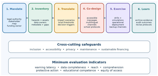
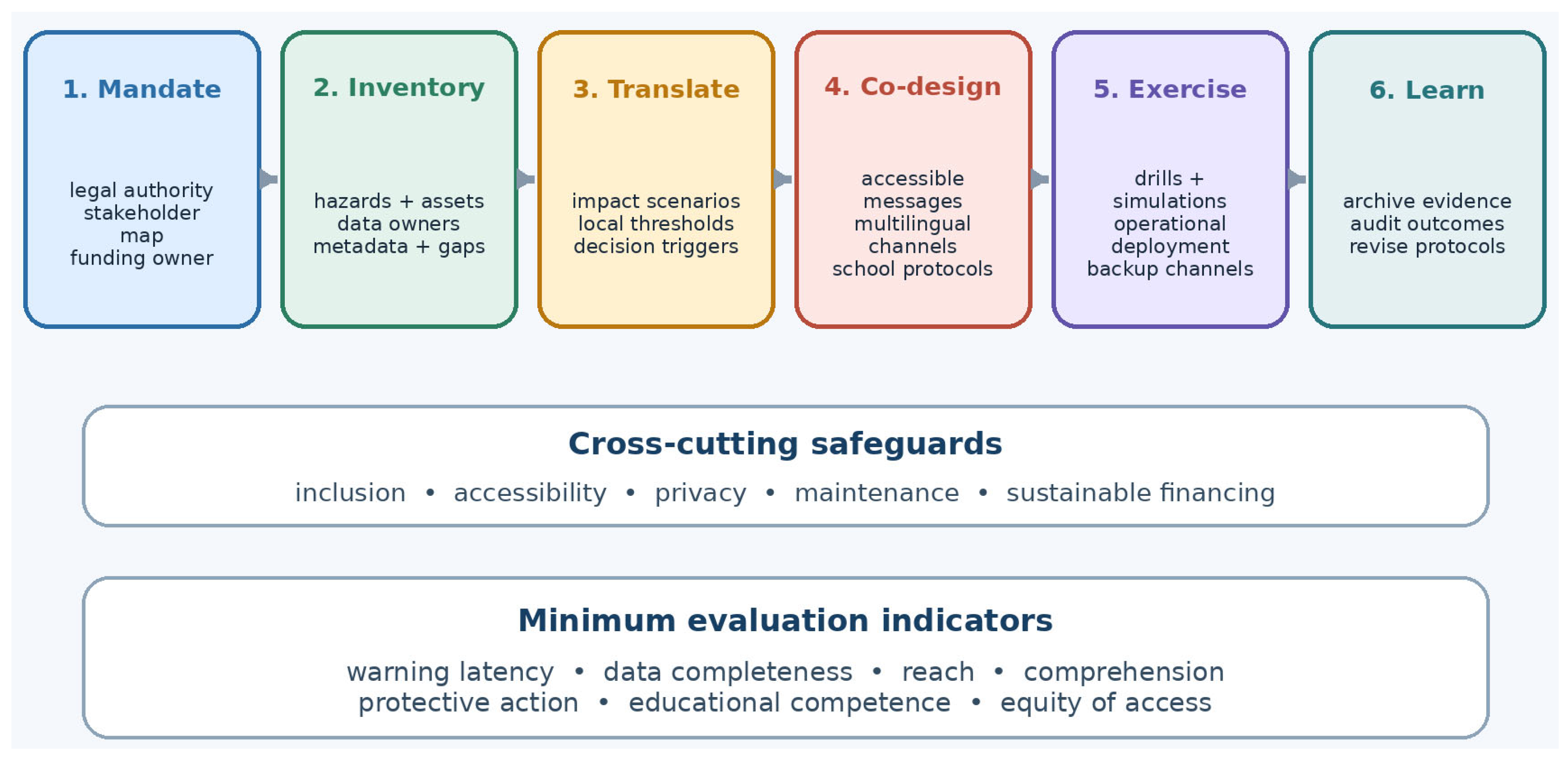
Figure 4 converts the framework into a six-stage implementation roadmap. Authorities should begin with legal mandate, stakeholder mapping and a named funding owner; inventory risks, assets and datasets; define impact scenarios and local decision thresholds; co-design accessible messages and school protocols; test them through exercises and operational deployment; and archive evidence for revision. Inclusion, accessibility, privacy, maintenance and sustainable financing are cross-cutting safeguards rather than optional final checks.
Figure 4.
Operational roadmap for implementing the didactic–territorial warning framework. Source: own elaboration.
A minimum evaluation set should include warning latency, data completeness, population reach, message comprehension, reported and observed protective action, educational competence and equity of access. Indicators should be disaggregated where lawful and ethical by age, disability, language, location and communication channel. Evaluation should compare planned thresholds and protocols with actual event timelines, while avoiding the assumption that a single metric can attribute complex disaster outcomes to one institution or message.
5. Discussion and Conclusions
5.1. Transferability and Implementation Challenges
The Valencia case supports analytical transfer rather than statistical generalization. The framework is most relevant where fast-onset hydrometeorological hazards intersect with multiple data-owning institutions and users who must make place-specific decisions under time pressure. Transfer requires re-specifying the catchment process, legal mandates, communication culture, settlement pattern, vulnerable groups and school system in each setting. Comparative testing in Mediterranean, monsoon, tropical-cyclone and urban flash-flood contexts is therefore a research requirement, not an assumption of universal equivalence.
Implementation is particularly difficult in low-resource regions with sparse gauges, intermittent connectivity, limited staff, unstable funding or weak data standards. Interoperability should not be equated with an expensive integrated platform. A minimum viable system can combine community or low-cost gauges, printed and offline maps, pre-agreed thresholds, radio, SMS and sirens, common message templates, local-language intermediaries and manual timestamped logs. Regional data hubs, open-source tools, train-the-trainer programmes and partnerships with universities or civil-society organizations can support maintenance. Reliable mandates, local risk knowledge, redundant channels and rehearsed actions should be established before advanced dashboards or artificial-intelligence components are added.
Institutional barriers can be as important as technical scarcity. Data ownership, liability, procurement cycles, staff turnover, privacy concerns, platform dependence, misinformation and unequal digital access can interrupt the warning chain. The responsibility matrix and roadmap therefore require named owners, maintenance budgets, backup channels and periodic exercises. Open data should be the default for non-sensitive warning evidence, but publication must be balanced with privacy, security and the protection of vulnerable households.
5.2. Evaluation, Limitations and Future Research
Warning systems should be evaluated as socio-technical systems. Forecast accuracy is necessary but insufficient. Evaluation should include data interoperability, message clarity, accessibility, timing, reach, public interpretation, protective behaviour, inclusion of vulnerable groups and post-event accountability. Mixed methods are required: meteorological verification, hydrological reconstruction, geospatial analysis, communication audits, surveys, interviews, observation of drills and school-based competence assessment. Comparative research after the 2021 north-western European floods similarly identifies warning thresholds, colour-code harmonization, operational impact-based inundation forecasts and structural evaluation of communication chains as gaps between early warning and early action [17].
School-based risk education should be evaluated with the same caution. Existing quasi-experimental evidence indicates gains in knowledge, perceived preparedness and reported protective adjustments [22,41,42,43,44,45], and systematic review evidence supports the educational value of repeated, interactive and locally relevant programmes [46]. However, direct evidence linking school education to observed evacuation compliance, reduced dangerous behaviour during an actual flash flood or lower mortality remains limited. Future studies should pre-register behavioural outcomes, follow students and households longitudinally and combine drills, warning simulations and post-event observations.
This article has four principal limitations. First, it is a purposive conceptual synthesis rather than a systematic review. Second, the Valencia reconstruction is selective and relies on official and published post-event records that may be revised; it does not provide a forensic causal analysis. Third, the framework was developed without direct co-design workshops, interviews or deliberation with affected residents, teachers, emergency practitioners or municipal officials. Fourth, a single diagnostic case cannot establish external validity, cost-effectiveness or effect size. Future research should therefore undertake participatory co-design, cross-case comparison, prototype implementation, equity audits, cost-effectiveness analysis and independent evaluation of behavioural and educational outcomes.
5.3. Operational Recommendations and Conclusions
For practitioners and policymakers, the framework yields eight immediate actions: (1) designate the institution legally authorized to convert technical evidence into public instructions; (2) complete a pre-season inventory of data owners, formats, update cycles, licences, quality limits and contact points; (3) define impact thresholds and rate-of-change triggers for exposed routes, facilities and groups; (4) use CAP-compatible, accessible and multilingual messages with explicit actions; (5) connect municipal and school protocols to those triggers; (6) maintain redundant low-bandwidth and non-digital channels; (7) preserve timestamped observations, model versions, warnings, decisions and outcomes; and (8) audit latency, reach, comprehension, protective action, educational competence and equity at least annually and after major events.
The central conceptual contribution is territorial translation. Impact-based forecasting estimates what may happen, and people-centred warning defines for whom and under what governance conditions warnings should work. Territorial translation connects both to the places where decisions are made: catchments, streets, bridges, schools, homes, transport routes and care networks. This mechanism also clarifies why the framework is data-driven: observations must move through documented modelling and impact assessment into authorized, localized decisions, and the entire pathway must remain auditable.
The Valencia event demonstrates that scientific capacity and catastrophic outcomes can coexist when the conversion of data into timely, situated and trusted action is incomplete. Better forecasts remain essential, but protection also requires interoperable records, explicit responsibilities, uncertainty communication, accessible channels, rehearsed municipal and school protocols, and post-event learning. Schools are not substitutes for emergency agencies; they are strategic institutions for building the geographic, data and civic competences that make official warnings intelligible before a crisis.
For international audiences, Valencia should therefore be read neither as an exceptional anomaly nor as a universal template. It is a high-consequence diagnostic case that reveals transferable questions: who owns the data, who integrates them, who decides, what place-specific action is required, who may be excluded and how the system learns. The ultimate purpose of warning is not the transmission of information; it is the creation of sufficient territorial competence for people and institutions to act before danger becomes irreversible.
Author Contributions
Conceptualization, Á.-F.M. and J.O.; methodology, Á.-F.M. and A.B.; software, D.L.-R., B.M.-V. and J.J.-N.; validation, Á.-F.M.; formal analysis, Á.-F.M.; investigation, Á.-F.M.; resources, Á.-F.M.; data curation, Á.-F.M. and A.B.; writing—original draft preparation, Á.-F.M.; writing—review and editing, Á.-F.M.; visualization, Á.-F.M.; supervision, Á.-F.M.; project administration, Á.-F.M. All authors have read and agreed to the published version of the manuscript.
Funding
This research was supported by the R&D&I project “INCLUCOM-Curricular Models and Historical-Geographical Competencies of Teachers for the Construction of Inclusive Identities” (PID2021-122519OB-I00), funded by MCIN/AEI/10.13039/501100011033 and by FEDER-A Way of Making Europe.
Institutional Review Board Statement
Not applicable.
Informed Consent Statement
Not applicable.
Data Availability Statement
This study is based on publicly available documentary sources cited in the manuscript. The event indicators summarized in Table 2 are derived from AEMET, CHJ and published sources. No original empirical dataset was generated or analyzed.
Conflicts of Interest
The authors declare no conflicts of interest.
References
- Golding, B. (Ed.) Towards the “Perfect” Weather Warning: Bridging Disciplinary Gaps Through Partnership and Communication; Springer: Cham, Switzerland, 2022. [Google Scholar] [CrossRef] [Scilit]
- Zhang, Q.; Li, L.; Ebert, B.; Golding, B.; Johnston, D.; Mills, B.; Panchuk, S.; Potter, S.; Riemer, M.; Sun, J.; et al. Increasing the value of weather-related warnings. Sci. Bull. 2019, 64, 647–649. [Google Scholar] [CrossRef] [Scilit] [PubMed]
- World Meteorological Organization. Early Warnings for All: Executive Action Plan 2023–2027; WMO: Geneva, Switzerland, 2022; Available online: https://www.preventionweb.net/publication/early-warnings-all-executive-action-plan-2023-2027 (accessed on 15 June 2026).
- United Nations Office for Disaster Risk Reduction; CIMA Research Foundation. Handbook on the Use of Risk Knowledge for Multi-Hazard Early Warning Systems; UNDRR: Geneva, Switzerland, 2024; Available online: https://earlywarningsforall.org/sites/default/files/2024-10/20241022_CIMA_Handbook_EW4ALL_digitale.pdf (accessed on 15 June 2026).
- United Nations Office for Disaster Risk Reduction; World Meteorological Organization. Global Status of Multi-Hazard Early Warning Systems 2024; UNDRR/WMO: Geneva, Switzerland, 2024; Available online: https://www.undrr.org/reports/global-status-MHEWS-2024 (accessed on 15 June 2026).
- Olcina, J.; Morote, Á.-F. Comunicación y educación sobre cambio climático y extremos atmosféricos: El papel de la ciencia en la DANA de 2024 (Valencia, España). Doc. d’Anàlisi Geogràfica 2025, 71, 501–533. [Google Scholar] [CrossRef] [Scilit]
- Morote, A.F. ¿De dónde está recibiendo la información sobre el cambio climático el alumnado? Una aproximación desde las Ciencias Sociales. Rev. Complut. Educ. 2023, 34, 337–346. [Google Scholar] [CrossRef] [Scilit]
- Potter, S.H.; Kox, T.; Mills, B.; Taylor, A.; Robbins, J.; Cerrudo, C.; Wyatt, F.; Harrison, S.; Golding, B.; Lang, W.; et al. Research gaps and challenges for impact-based forecasts and warnings: Results of international workshops for High Impact Weather in 2022. Int. J. Disaster Risk Reduct. 2025, 118, 105234. [Google Scholar] [CrossRef] [Scilit]
- Agencia Estatal de Meteorología. Informe Sobre el Episodio Meteorológico de Precipitaciones Torrenciales y Persistentes Ocasionadas por una DANA el día 29 de Octubre de 2024; AEMET: Madrid, Spain, 2024; Available online: https://www.aemet.es/documentos/es/conocermas/recursos_en_linea/publicaciones_y_estudios/estudios/informe_episodio_dana_29_oct_2024_pdf (accessed on 15 June 2026).
- Confederación Hidrográfica del Júcar. Obras de Emergencia DANA 29 de Octubre de 2024. Available online: https://www.chj.es/es-es/medioambiente/obrasemergencia/Paginas/Obras_Emergencia_DANA_29O2024.aspx (accessed on 15 June 2026).
- United Nations Office for Disaster Risk Reduction; World Meteorological Organization. Global Status of Multi-Hazard Early Warning Systems 2025; World Meteorological Organization: Geneva, Switzerland, 2025; Available online: https://wmo.int/publication-series/global-status-of-multi-hazard-early-warning-systems-2025 (accessed on 15 June 2026).
- World Meteorological Organization. State of the Global Climate 2025; WMO: Geneva, Switzerland, 2026; Available online: https://wmo.int/publication-series/state-of-global-climate/state-of-global-climate-2025 (accessed on 15 June 2026).
- Najafi, H.; Shrestha, P.K.; Rakovec, O.; Apel, H.; Vorogushyn, S.; Kumar, R.; Thober, S.; Merz, B.; Samaniego, L. High-resolution impact-based early warning system for riverine flooding. Nat. Commun. 2024, 15, 3726. [Google Scholar] [CrossRef] [Scilit] [PubMed]
- Reichstein, M.; Benson, V.; Blunk, J.; Camps-Valls, G.; Creutzig, F.; Fearnley, C.J.; Han, B.; Kornhuber, K.; Rahaman, N.; Schölkopf, B.; et al. Early warning of complex climate risk with integrated artificial intelligence. Nat. Commun. 2025, 16, 2564. [Google Scholar] [CrossRef] [Scilit] [PubMed]
- United Nations Children’s Fund. Learning Interrupted: Global Snapshot of Climate-Related School Disruptions in 2024; UNICEF: New York, NY, USA, 2025; Available online: https://www.unicef.org/reports/learning-interrupted-global-snapshot-2024 (accessed on 15 June 2026).
- Organization for Economic Co-operation and Development. Disaster Early Warning Systems and Private Sector Participation in ASEAN: Focus on the Philippines; OECD Development Policy Papers, No. 59; OECD Publishing: Paris, France, 2025. [Google Scholar] [CrossRef] [Scilit]
- Busker, T.; Rodriguez Castro, D.; Vorogushyn, S.; Kwadijk, J.; Zoccatelli, D.; Oliveira, R.G.L.; Murdock, H.J.; Pfister, L.; Dewals, B.; Slager, K.; et al. Comparing flood forecasting and early warning systems in northwestern Europe. Nat. Hazards Earth Syst. Sci. 2026, 26, 1457–1478. [Google Scholar] [CrossRef] [Scilit]
- Morote, A.F. La investigación sobre manuales escolares de Geografía españoles: Análisis bibliométrico (1980–2019). An. De Geogr. 2020, 40, 467–497. [Google Scholar] [CrossRef] [Scilit]
- Global Alliance for Disaster Risk Reduction and Resilience in the Education Sector. Comprehensive School Safety Framework 2022–2030 for Child Rights and Resilience in the Education Sector; GADRRRES: Geneva, Switzerland, 2022; Available online: https://gadrrres.net/files/cssf_2022-2030_en.pdf (accessed on 15 June 2026).
- Global Alliance for Disaster Risk Reduction and Resilience in the Education Sector. Global Status of School Safety: Technical Report of the 2024 Comprehensive School Safety Policy Survey; GADRRRES: Geneva, Switzerland, 2025; Available online: https://gadrrres.net/files/css_policy_survey_2024_global_technical_report.pdf (accessed on 15 June 2026).
- Pastor, A.; Camarasa, A.M.; Pitarch, M.D. Aproximación al relato ciudadano sobre la DANA del 29 de octubre de 2024 en Valencia. Cuad. Geogr. Univ. València 2025, 114–115, 319–346. [Google Scholar] [CrossRef] [Scilit]
- Martin-Moreno, J.M.; Garcia-Lopez, E.; Guerrero-Fernandez, M.; Alfonso-Sanchez, J.L.; Barach, P. Devastating “DANA” Floods in Valencia: Insights on Resilience, Challenges, and Strategies Addressing Future Disasters. Public Health Rev. 2025, 46, 1608297. [Google Scholar] [CrossRef] [Scilit] [PubMed]
- Intergovernmental Panel on Climate Change. Climate Change 2023: Synthesis Report. In Contribution of Working Groups I, II and III to the Sixth Assessment Report of the Intergovernmental Panel on Climate Change; Lee, H., Romero, J., Eds.; IPCC: Geneva, Switzerland, 2023. [Google Scholar] [CrossRef] [Scilit]
- World Weather Attribution. Extreme Downpours Increasing in Southeastern Spain as Fossil Fuel Emissions Heat the Climate. 4 November 2024. Available online: https://www.worldweatherattribution.org/extreme-downpours-in-southern-spain-as-fossil-fuel-emissions-heat-the-climate/ (accessed on 15 June 2026).
- Calvo, C.; Díaz-Fernández, J.; González-Alemán, J.J.; Halifa-Marín, A.; Miglietta, M.M.; Azorin-Molina, C.; Prein, A.F.; Montoro-Mendoza, A.; Bolgiani, P.; Morata, A.; et al. Human-induced climate change amplification on storm dynamics in Valencia’s 2024 catastrophic flash flood. Nat. Commun. 2026, 17, 1492. [Google Scholar] [CrossRef] [Scilit] [PubMed]
- Wilkinson, M.D.; Dumontier, M.; Aalbersberg, I.J.; Appleton, G.; Axton, M.; Baak, A.; Blomberg, N.; Boiten, J.-W.; da Silva Santos, L.B.; Bourne, P.E.; et al. The FAIR Guiding Principles for scientific data management and stewardship. Sci. Data 2016, 3, 160018. [Google Scholar] [CrossRef] [Scilit] [PubMed]
- OASIS. Common Alerting Protocol Version 1.2; OASIS Standard: Woburn, MA, USA, 2010. Available online: https://docs.oasis-open.org/emergency/cap/v1.2/CAP-v1.2-os.html (accessed on 15 June 2026).
- Lindell, M.K.; Perry, R.W. The protective action decision model: Theoretical modifications and additional evidence. Risk Anal. 2012, 32, 616–632. [Google Scholar] [CrossRef] [Scilit] [PubMed]
- Twigg, J. The human factor in early warnings: Risk perception and appropriate communications. In Early Warning Systems for Natural Disaster Reduction; Zschau, J., Küppers, A., Eds.; Springer: Berlin/Heidelberg, Germany, 2003; pp. 19–26. [Google Scholar]
- Kuller, M.; Schoenholzer, K.; Lienert, J. Creating effective flood warnings: A framework from a critical review. J. Hydrol. 2021, 602, 126708. [Google Scholar] [CrossRef] [Scilit]
- Twomlow, A.; Grainger, S.; Cieslik, K.; Paul, J.D.; Buytaert, W.; Morera, S.B. A user-centred design framework for disaster risk visualisation. Int. J. Disaster Risk Reduct. 2022, 77, 103067. [Google Scholar] [CrossRef] [Scilit]
- Morote, A.F.; Olcina, J. La enseñanza del riesgo de inundación en Bachillerato mediante Sistemas de Información Geográfica (SIG). El ejemplo del PATRICOVA en la Comunidad Valenciana (España). An. Geogr. 2021, 41, 431–461. [Google Scholar] [CrossRef] [Scilit]
- Spiegelhalter, D. Risk and uncertainty communication. Annu. Rev. Stat. Its Appl. 2017, 4, 31–60. [Google Scholar] [CrossRef] [Scilit]
- Chari, R.; Petrun Sayers, E.L.; Amiri, S.; Leinhos, M.; Kotzias, V.; Madrigano, J.; Thomas, E.V.; Carbone, E.G.; Uscher-Pines, L. Enhancing community preparedness: An inventory and analysis of disaster citizen science activities. BMC Public Health 2019, 19, 1356. [Google Scholar] [CrossRef] [Scilit] [PubMed]
- Kaku, K. Satellite remote sensing for disaster management support: A holistic and staged approach based on case studies in Sentinel Asia. Int. J. Disaster Risk Reduct. 2019, 33, 417–432. [Google Scholar] [CrossRef] [Scilit]
- Wang, Z.; Ye, X. Social media analytics for natural disaster management. Int. J. Geogr. Inf. Sci. 2018, 32, 49–72. [Google Scholar] [CrossRef] [Scilit]
- Morote, A.F. Investigación y enseñanza en Didáctica de la Climatología. Estado de la cuestión (1980–2020) (España). Espac. Tiempo Y Forma. Ser. VI Geogr. 2021, 14, 89–120. [Google Scholar] [CrossRef] [Scilit]
- UNESCO. Greening Curriculum Guidance: Teaching and Learning for Climate Action; UNESCO: Paris, France, 2024; Available online: https://unesdoc.unesco.org/ark:/48223/pf0000390022 (accessed on 15 June 2026).
- United Nations Office for Disaster Risk Reduction. Sendai Framework for Disaster Risk Reduction 2015–2030; UNDRR: Geneva, Switzerland, 2015; Available online: https://www.undrr.org/publication/sendai-framework-disaster-risk-reduction-2015-2030 (accessed on 15 June 2026).
- United Nations Office for Disaster Risk Reduction. Global Assessment Report on Disaster Risk Reduction 2025; UNDRR: Geneva, Switzerland, 2025; Available online: https://www.undrr.org/gar/gar2025 (accessed on 15 June 2026).
- Wang, Y.; Satake, K. Real-Time Tsunami Data Assimilation of S-Net Pressure Gauge Records during the 2016 Fukushima Earthquake. Seismol. Res. Lett. 2021, 92, 2145–2155. [Google Scholar] [CrossRef] [Scilit]
- Crameri, F.; Shephard, G.E.; Heron, P.J. The misuse of colour in science communication. Nat. Commun. 2020, 11, 5444. [Google Scholar] [CrossRef] [Scilit] [PubMed]
- Yildiz, A.; Dickinson, J.; Priego-Hernandez, J.; Teeuw, R.; Shaw, R. Effects of disaster education on children’s risk perception and preparedness: A quasi-experimental longitudinal study. Geogr. J. 2024, 190, e12556. [Google Scholar] [CrossRef] [Scilit]
- Ronan, K.R.; Johnston, D.M. Hazards education for youth: A quasi-experimental investigation. Risk Anal. 2003, 23, 1009–1020. [Google Scholar] [CrossRef] [Scilit] [PubMed]
- Ronan, K.R.; Crellin, K.; Johnston, D.M. Community readiness for a new tsunami warning system: Quasi-experimental and benchmarking evaluation of a school education component. Nat. Hazards 2012, 61, 1411–1425. [Google Scholar] [CrossRef] [Scilit]
- Seddighi, H.; Sajjadi, H.; Yousefzadeh, S.; Lopez Lopez, M.; Vameghi, M.; Rafiey, H.; Khankeh, H. School-Based Education Programs for Preparing Children for Natural Hazards: A Systematic Review. Disaster Med. Public Health Prep. 2022, 16, 1229–1241. [Google Scholar] [CrossRef] [Scilit] [PubMed]

Disclaimer/Publisher’s Note: The statements, opinions and data contained in all publications are solely those of the individual author(s) and contributor(s) and not of MDPI and/or the editor(s). MDPI and/or the editor(s) disclaim responsibility for any injury to people or property resulting from any ideas, methods, instructions or products referred to in the content. |
© 2026 by the authors. Licensee MDPI, Basel, Switzerland. This article is an open access article distributed under the terms and conditions of the Creative Commons Attribution (CC BY) license.