


Abstract
Rapid regional evaluation of earthquake-induced landslide susceptibility via the traditional Newmark model is often constrained by geotechnical parameter spatial variability and subjective empirical adjustments in static factor of safety (Fs) calculations. To resolve this bottleneck, this study develops an inversion-based stability factor determination (ISFD) method for adaptive parameter configuration. Integrating sparse post-earthquake observations with multi-source geo-environmental factors, a LightGBM inversion model targets and corrects unphysical anomalies (Fs < 1.0) from traditional limit equilibrium calculations while retaining native dynamic analytical solutions for valid mechanical units (Fs ≥ 1.0), achieving a physically consistent parameter calibration within the Newmark framework. Validation in the Jiuzhaigou earthquake-affected region demonstrates that the ISFD method minimizes parameter uncertainty interferences. The model’s AUC increases from 0.727 to 0.786 (an 8.116% relative improvement), yielding high-susceptibility zones with superior spatial alignment with actual landslide inventories and mitigating localized under-predictions. Data sensitivity analysis confirms that model performance exhibits rapid initial gains followed by high-level saturation as the sample size increases, maintaining robust stability under ultra-low-sample conditions and accurately capturing critical risks along the Minjiang fault zone. The ISFD method delivers a mechanistically self-consistent, highly regionally adaptive technical workflow for rapid post-earthquake landslide susceptibility evaluation under data-scarce scenarios.
1. Introduction
Earthquake-induced landslides are a typical form of geological hazard triggered by strong ground motion and are characterized by high suddenness, a wide spatial distribution, rapid development, and severe secondary impacts, making them one of the most destructive components of the earthquake hazard chain [1,2]. The instantaneous impact of strong seismic shaking can severely disturb the internal stress field of slope materials, leading to a rapid degradation of shear strength and structural integrity and consequently triggering large numbers of landslides within a short time period [3,4]. Such hazards not only cause direct casualties and damage to residential buildings [5,6], but also severely disrupt critical infrastructure, including transportation corridors, water conservancy and hydropower facilities, and communication networks. Moreover, they may further induce secondary disasters such as landslide dams and debris flows, substantially amplifying the spatial extent of damage and increasing the complexity and cost of post-earthquake emergency response and reconstruction efforts [7,8]. China is highly affected by frequent seismic activity, and earthquake events pose a persistent and serious threat to public safety and property [5]. The 2008 Mw 8.0 Wenchuan earthquake triggered tens of thousands of landslides with extensive spatial coverage and high occurrence density, resulting in numerous landslide-dammed lakes and causing incalculable losses to life and property in the affected areas [9,10]. The 2017 Mw 7.0 Jiuzhaigou earthquake induced a large number of shallow rock landslides within the scenic area, which not only severely damaged the regional eco-geological environment but also posed significant threats to tourist safety and the operation of local infrastructure [11]. In addition, major earthquakes such as the Yushu earthquake [12] and the Lushan earthquake [13] were also accompanied by widespread earthquake-induced landslides. The high frequency of such disasters clearly highlights the urgent need for scientific and accurate risk assessment of earthquake-induced landslides [14], as well as the establishment of a comprehensive earthquake-related geological hazard prevention and mitigation framework.
Within this context, earthquake-induced landslide susceptibility assessment has emerged as a crucial technical pillar for post-earthquake emergency rescue and post-disaster reconstruction [15]. Its core objective is to identify the spatial distribution characteristics of potential landslide-prone areas under seismic action and to classify landslide occurrence probabilities across different zones [16]. The evaluation results provide a critical scientific basis for regional geological hazard early warning and the strategic layout of disaster mitigation engineering while serving as a vital reference for post-earthquake emergency rescue corridor planning and site selection for post-disaster reconstruction [17,18]. Since the mid-to-late 20th century, a diversified technical methodological system has progressively evolved for landslide susceptibility evaluation, currently categorized into physically based mechanical analysis methods [3,19,20] and machine learning-driven methods [21,22,23,24]. Physically based mechanical analysis, rooted in limit equilibrium theory, characterizes landslide risks by evaluating slope stability under seismic action. Represented prominently by the Newmark permanent displacement method, it remains the most widely applied foundational approach for regional-scale assessments. Concurrently, machine learning-driven approaches leverage data mining and pattern recognition technologies to construct predictive models by learning relationships between landslide inventories and conditioning factors, experiencing rapid development in recent years [25,26]. Among these methodologies, the Newmark permanent displacement model accomplishes quantitative characterization of cumulative permanent slope deformation under seismic loading by coupling critical acceleration with ground motion time histories, thereby becoming a mainstay for rapid post-earthquake evaluation. Within this framework, the static slope (Fs) acts as the core controlling parameter that directly governs the critical acceleration (ac) and consequently dictates the estimation precision of the permanent displacement (Dn) [27]. Therefore, the spatial solution accuracy of the static Fs field largely determines the overall evaluation performance of the Newmark model.
However, calculating accurate regional-scale Fs fields remains a formidable challenge. In traditional workflows, static Fs is solved using rigid-body limit equilibrium formulas supplemented by geotechnical parameters. Across vast regions, however, geotechnical parameters exhibit profound heterogeneity and spatial variability [26,28]. Constrained by the spatial sparsity of regional geological surveys, a refined spatial characterization of geotechnical shear strength parameters is exceedingly difficult to achieve [29], inevitably introducing substantial uncertainties that propagate into the subsequent permanent displacement calculations. Crucially, conventional applications of the Newmark model introduce a pervasive empirical assumption [8,30]: when deterministic mechanical formulas yield unphysical, distorted grid units with a static Fs < 1.0—which theoretically implies pre-earthquake instability and contradicts geological reality—researchers typically force these values to a fixed empirical threshold of 1.01. This uniform correction reflects the parameter degradation and formulaic distortion of limit equilibrium theory under complex, regional-scale engineering geological conditions [31]. Such forced assignments eliminate the spatial heterogeneity of true safety margins and obscure the mechanical reality that high-risk slopes reside in a critical state of limit equilibrium. This induces error accumulation in dynamic displacement calculations, underestimating the dynamic seismic risk of slopes near critical static failure while misclassifying valid safety margin zones, ultimately distorting the entire permanent displacement field.
To address these deficiencies, this study proposes an inversion-based stability factor determination (ISFD) method for localized parameter optimization. Using sparse post-earthquake observation data as objective constraints, a LightGBM inversion model is constructed to characterize the relative stability differences between landslide and non-landslide units controlled by multi-source environmental conditioning factors. This methodology abandons the conventional paradigms of full acceptance or uniform empirical assignment. Instead, it precisely identifies anomalous zones exhibiting unphysical distortions (Fs < 1.0) within traditional limit equilibrium solutions and introduces critical stability Fs values derived from data-driven inversions as targeted, directional replacements, thereby providing a more rational representation of the pre-earthquake limit equilibrium state. Meanwhile, valid mechanical units with a traditional Fs ≥ 1.0 are fully retained to preserve the classic model’s capacity to express spatial stability variations. While fully maintaining the classic Newmark dynamic analytical framework, this method eliminates the systematic interference of intensive empirical assumptions on permanent displacement calculations and achieves localized, physically consistent corrections of numerically distorted grid units. This approach establishes a mechanistically self-consistent, empirically minimized, and highly regionally adaptive pathway for refined regional-scale earthquake-induced landslide susceptibility evaluation.
2. Study Area and Data Preparation
2.1. Overview of the Study Area
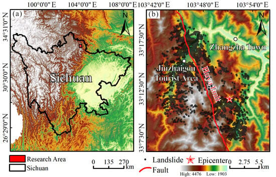
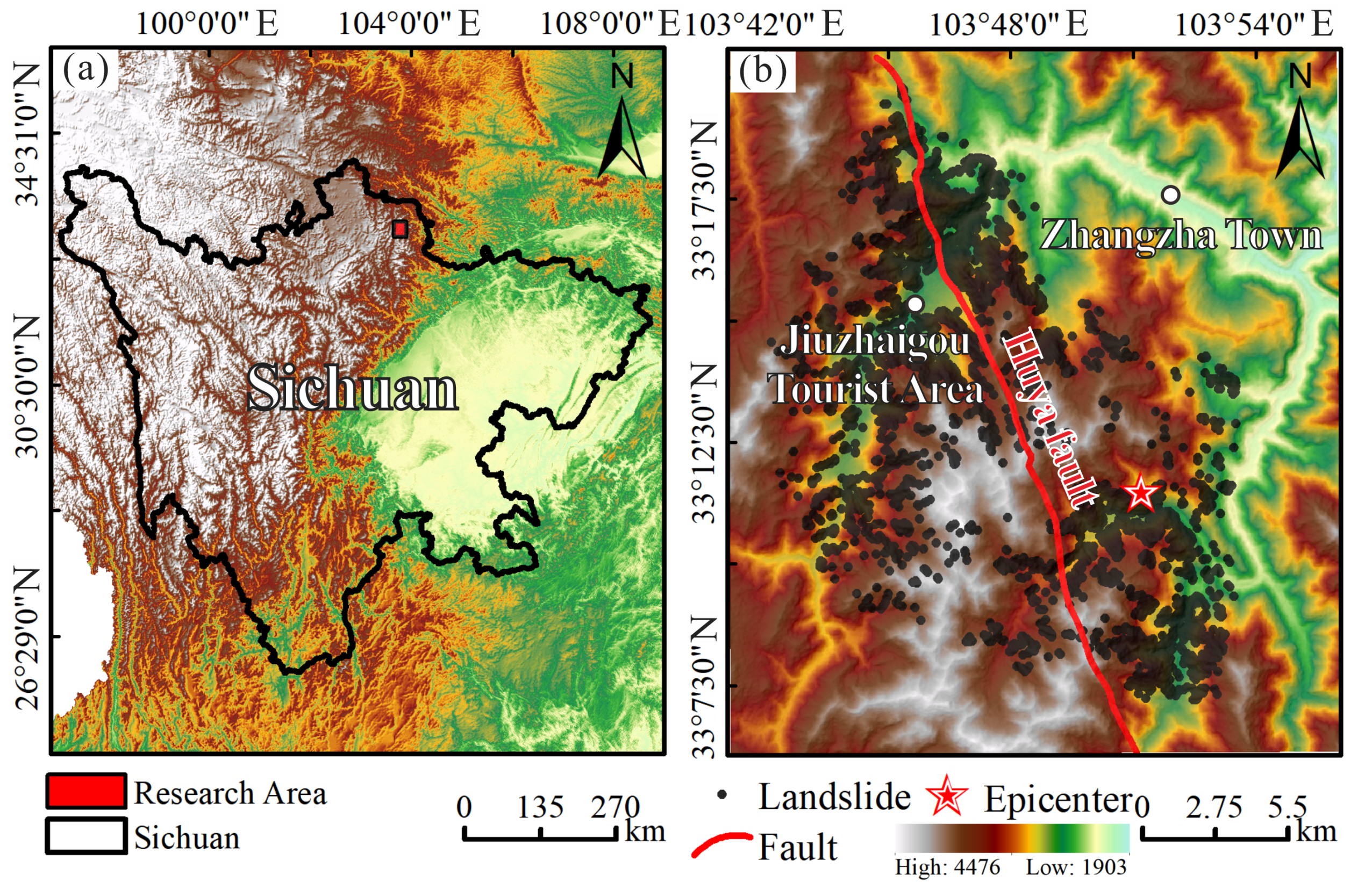
The impact area of the 2017 Mw 7.0 Jiuzhaigou earthquake was selected as the case study region (Figure 1). The study area is located in Jiuzhaigou County, Aba Tibetan and Qiang Autonomous Prefecture, Sichuan Province, at the transitional zone between the eastern margin of the Tibetan Plateau and the Sichuan Basin. The terrain is characterized by a pronounced topographic gradient, with higher elevations in the northwest and lower elevations in the southeast, and altitudes ranging from 1900 to 4700 m. The rugged relief and deeply incised valleys provide favorable geomorphological conditions for landslide development [32]. Tectonically, the region lies at the junction of the eastern margin of the Songpan–Ganzi fold belt and the Motianling block, where multiple active faults, including the Huya fault zone, are well developed. The area has experienced intense neotectonic activity, and the lithology is dominated by Triassic low-grade metamorphic rocks with relatively low shear strength. Moreover, the study area is located in the central segment of the North–South seismic belt and has been affected by several historical strong earthquakes, such as the 1933 Diexi Mw 7.5 and 1976 Songpan–Pingwu Mw 7.2 events. Frequent seismic activity has continuously disturbed the rock mass, providing a fundamental geological setting for landslide occurrence [33]. On 8 August 2017, a Mw 7.0 thrust-type earthquake struck the region, with its epicenter at Zhangzha Town (33.20° N, 103.82° E) and a focal depth of 20 km. The earthquake resulted in 25 fatalities, 525 injuries, and direct economic losses of 2.83 billion CNY, causing severe damage to core scenic landscapes and infrastructure, and triggering widespread secondary landslide hazards [34]. According to post-disaster field surveys and high-resolution remote sensing interpretation, the earthquake triggered 4834 individual landslides with a total area of 12.87 km2, dominated by shallow rockslides and spatially concentrated along seismogenic faults and highways [35]. Spatial distribution patterns reveal strong fault-control and topographic amplification effects: landslides are highly concentrated within 5 km on both sides of the seismogenic fault and within high-intensity seismic zones, particularly on steep canyon slopes with elevations of 2800–3800 m and slope gradients of 35–50°. By encompassing precise spatial locations, scales, and morphological attributes, this comprehensive inventory provides a reliable benchmark dataset for model inversion and validation, making the study area an ideal target for evaluating the performance and accuracy of landslide susceptibility assessment methods.
Figure 1.
(a) Map showing the location of the study area; (b) Overview of the study area.
2.2. Data Collection and Preprocessing
The occurrence of earthquake-induced landslides results from the combined effects of geological conditions [36], topography [37], hydrometeorological factors [2], and seismic ground motion [38]. These formation mechanisms exhibit pronounced multi-factor coupling characteristics [39]. No single factor can adequately explain the spatial distribution patterns or triggering processes of landslides. Therefore, earthquake-induced landslide susceptibility assessment requires an integrated, multi-source approach that comprehensively considers the key factors representing both the disaster-prone environmental conditions and the seismic triggering mechanisms of the study area.
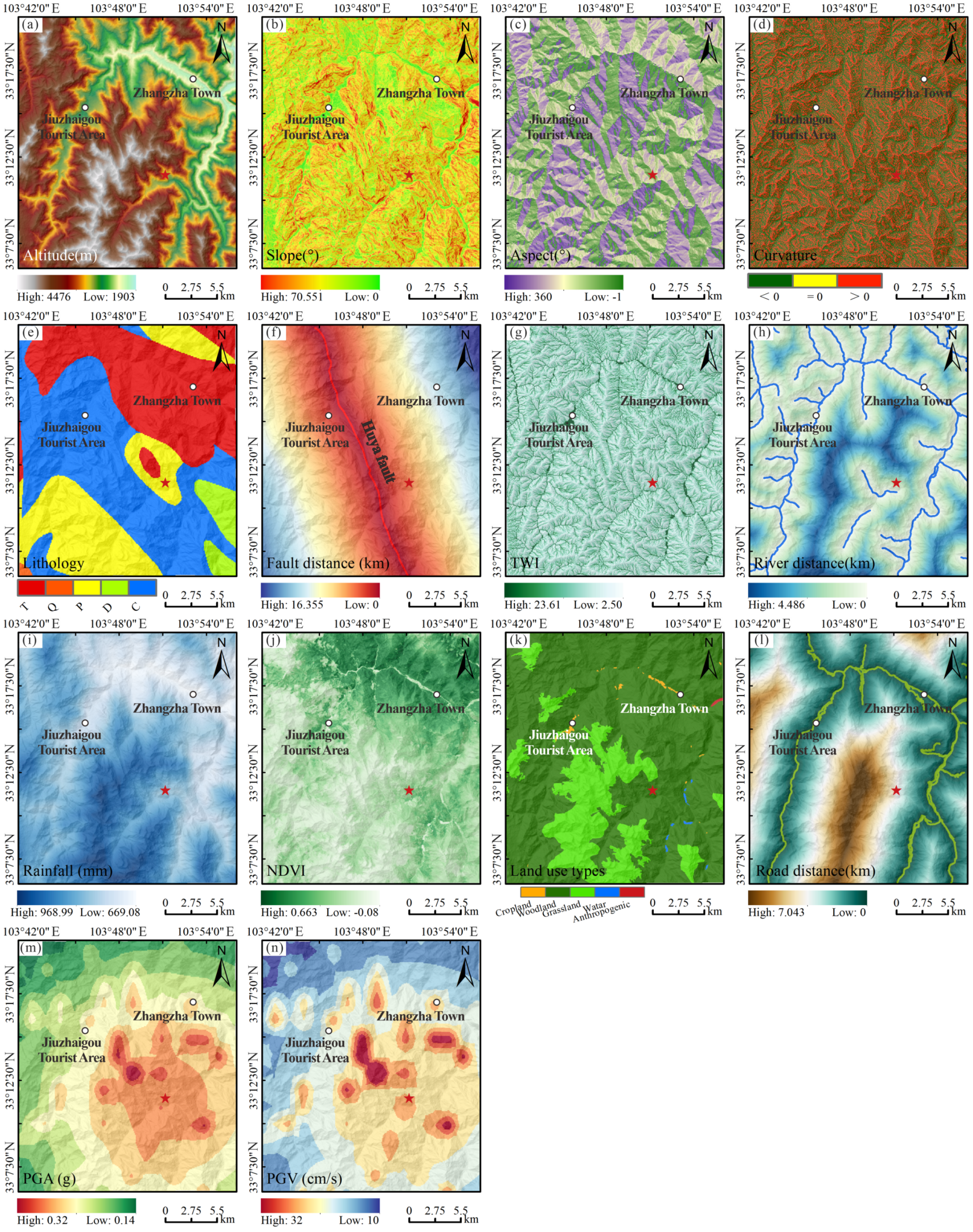
Based on this understanding, this study systematically collected and processed multi-source spatial datasets closely related to the occurrence of earthquake-induced landslides. A total of 14 influencing factors were selected for subsequent analysis and modeling, including Altitude, Slope, Aspect, Curvature, Lithology, Fault distance, Topographic Wetness Index (TWI), River distance, Rainfall, Normalized Difference Vegetation Index (NDVI), Land-use types, Road distance, Peak Ground Acceleration (PGA), and Peak Ground Velocity (PGV). These factors jointly characterize the fundamental environmental settings and seismic triggering conditions of the study area from the perspectives of topography and geomorphology, geological structure, hydrometeorological processes, surface cover and human activities, and seismic ground-motion intensity. Detailed information on data sources and specific applications of each factor is provided in Table 1.
Table 1.
List of data sources.
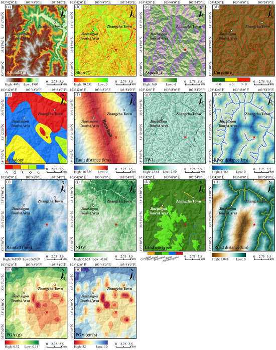
All influencing-factor datasets were uniformly processed within a ArcGIS 10.8 environment to ensure consistency in coordinate projection, spatial extent, and spatial resolution, thereby providing a reliable data foundation for subsequent analysis (see Figure 2a–n). Given that the Newmark permanent displacement model requires geotechnical mechanical parameters, an engineering geological lithological classification was conducted for the study area to facilitate model computation and parameter assignment, based on 1:2,000,000-scale geological data. The lithological classification followed established rock mass classification standards and specifications, while comprehensively considering stratigraphic lithology, degree of weathering, and rock genesis. Accordingly, the lithologies in the study area were categorized into three engineering geological groups: hard rock, moderately hard rock, and soft rock. The hard rock group primarily includes Upper Triassic dolomite and slate; the moderately hard rock group mainly comprises Carboniferous light-colored thin- to medium-bedded limestone, bioclastic limestone, dolomitic limestone, as well as Middle–Lower Triassic calcareous dolomite and argillaceous dolomite; the soft rock group consists predominantly of unconsolidated deposits such as gravel, sand, and clay formed by alluvial–pluvial and glacial processes.
Figure 2.
Distribution of Landslide Influence Factors: (a) Altitude; (b) Slope; (c) Aspect; (d) Curvature; (e) Lithology; (f) Fault distance; (g) TWI; (h) River distance; (i) Rainfall; (j) NDVI; (k) Land use types; (l) Road distance; (m) PGA; (n) PGV.
Based on this classification, the primary physical and mechanical parameters of each lithological group were empirically assigned with reference to previous studies [3,8,30,45], and the adopted parameter values are summarized in Table 2. The spatial distributions of all processed influencing factors are illustrated in Figure 2, providing a comprehensive data basis for subsequent earthquake-induced landslide susceptibility analysis and model implementation.
Table 2.
The values of lithological mechanical parameters in the study area.
3. Methodology
3.1. Newmark Permanent Displacement Method
The Newmark permanent displacement method, grounded in rigid-block sliding theory [46], quantitatively evaluates earthquake-induced landslide stability by coupling seismic ground motion with slope mechanics. Widely applied in regional susceptibility assessments, it assumes that slope instability occurs when seismic inertia exceeds resisting forces. The resulting cumulative displacement, calculated by comparing ground acceleration with the critical acceleration (ac), serves as the key stability indicator [46]. The first step of this approach is determining the static factor of safety (Fs) via the following core formula:
where c represents cohesion; φ represents the friction angle; γ represents bulk density; γw represents the density of water; t represents the thickness of the slope; α is the slope angle and m represents the proportion of water-saturated thickness in the sliding block.
where a(t) is the time history function of acceleration, obtained from observations at the seismograph station during the earthquake.
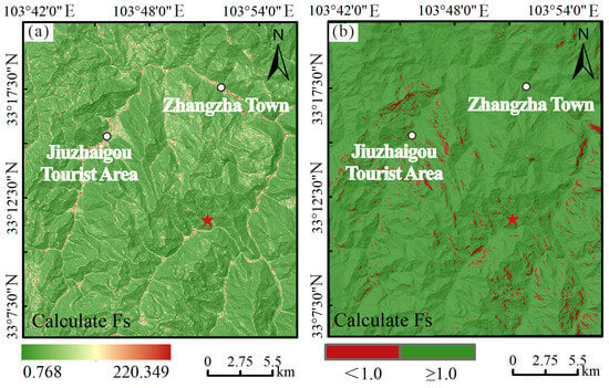
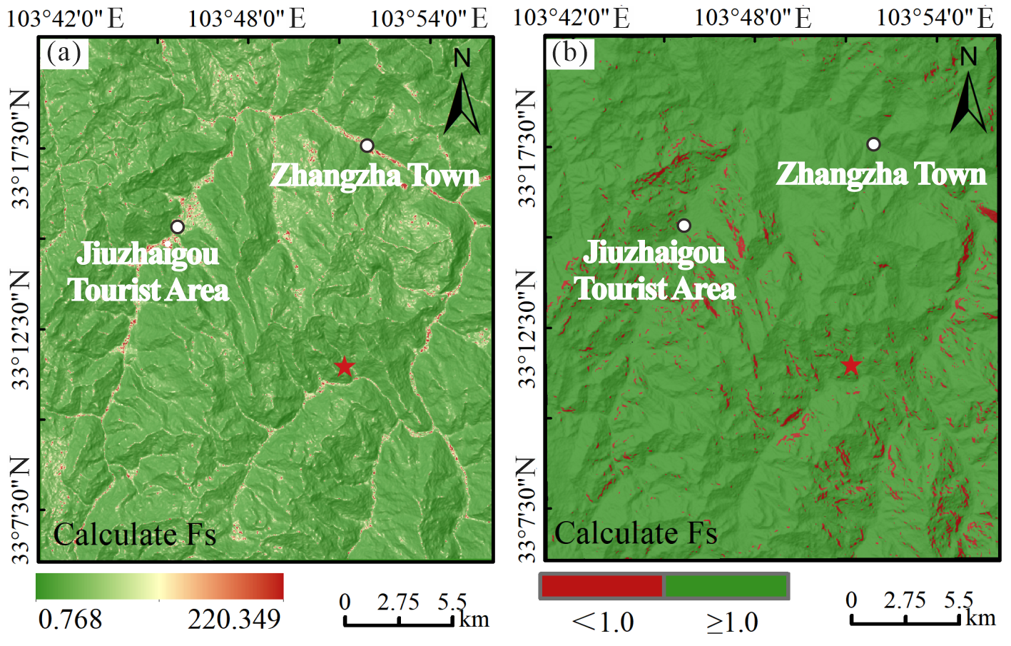
It can be seen that the accuracy of Fs directly governs the precision of the ac calculation, making it the core controlling parameter of the Newmark method (as shown in Figure 3a). The next step involves extracting the seismic acceleration time-history, which can be obtained from either seismic station observations or seismic hazard maps, to characterize the intensity and duration of ground motion within the study area. Finally, the Dn is computed by comparing the seismic acceleration time-history with ac; the portions of acceleration exceeding ac are double-integrated to obtain the cumulative permanent displacement of the slope under seismic loading. It is generally accepted that when Dn exceeds a certain critical threshold (e.g., 15 cm), the slope is considered to have undergone instability and failure [18].
Figure 3.
(a) Fs Results Calculated Using the Classical Newmark Method; (b) After Fs classification.
Considering the actual geological conditions and hazard development characteristics of the Jiuzhaigou earthquake-affected area, the limitations of the traditional Newmark method in determining Fs parameters are pronounced. Based on detailed post-earthquake geological hazard survey data, the slope stability of the study area computed via the traditional limit equilibrium method indicates that approximately 3.214% of the evaluation units exhibit Fs < 1.0 (as shown in Figure 3b). These anomalous zones are primarily distributed along the Minjiang fault zone, scenic highway arteries, and steep valley slopes. From an actual geological perspective, these regions were not entirely unstable prior to the seismic event; rather, they represented critically stable states collectively influenced by tectonic faulting, rock-soil weathering, and engineering perturbations, showing high spatial consistency with the actual dense clusters of Jiuzhaigou earthquake-induced landslides.
However, the traditional Newmark method typically addresses these anomalies by uniformly assigning a fixed critical value (such as 1.01) to force corrections on zones where Fs < 1.0. Although this treatment ensures the mathematical continuity required for ac calculations, it completely obscures the spatial heterogeneity of regional geological conditions and the stability variances among diverse slopes. For mountainous regions like Jiuzhaigou, characterized by intense tectonic activity and complex topography, such uniform assignments artificially inflate the ac values of certain critically stable slopes. This inflation consequently underestimates permanent displacements, causing actual high-risk zones to be misclassified as low-to-medium risk. Simultaneously, it can amplify the relative risk of certain secure zones, ultimately undermining the spatial consistency between the susceptibility assessment results and the actual landslide inventory.
Consequently, the uniform Fs correction approach in the traditional Newmark method, rooted in rigid empirical assumptions, fails to satisfy the requirements for refined earthquake-induced landslide assessments in complex mountainous terrains. There is an urgent necessity to develop an Fs optimization methodology capable of integrating post-earthquake observational information and minimizing manual empirical interferences, thereby enhancing the physical rationality and regional adaptability of landslide susceptibility evaluation outcomes.
3.2. Research Technical Roadmap
To address the issue where the Fs determination in the traditional Newmark model is heavily compromised by parameter uncertainties and artificial modification assumptions, this study introduces an inversion-based stability factor determination method for localized parameter optimization. The optimization workflow begins with the systematic collection of sparse post-earthquake observation data within the study area, including field survey records of landslide and non-landslide points, along with 14 conditioning factors characterizing topography, geology, environment, and ground motion features. These datasets are preprocessed under a unified spatial reference to construct the baseline dataset.
(1) Machine Learning-Driven Fs Inversion: Post-earthquake landslide and non-landslide development states are utilized as supervisory labels to train a LightGBM inversion model based on preprocessed multi-source conditioning factors. This model learns the nonlinear mapping relationships between slope stability and environmental variables, subsequently generating a spatial distribution of Fs that conforms to regional geological characteristics. Departing from conventional limit equilibrium methods that rely on empirical parameterizations, this approach constrains the model using actual post-earthquake ground-truth observations, minimizing error propagation induced by empirical parameter configurations and manual corrections.
(2) Targeted Local Correction of Anomalous Zones: The calculated inversion outcomes are introduced to execute targeted, localized corrections on anomalous, distorted grid units where Fs < 1.0 within the traditional framework, which conventionally prevents the effective mathematical solution of ac. For grid units where traditional limit equilibrium calculations yield an unphysical Fs < 1.0, critical stability Fs values derived under the constraints of the inversion results are applied as replacements to represent the pre-earthquake limit equilibrium state of the slopes, while valid mechanical units with a traditional Fs ≥ 1.0 are fully retained.
(3) Permanent displacement derivation and susceptibility zoning: The corrected Fs field is incorporated into the Newmark model to compute slope critical acceleration and dynamic permanent displacements. Based on these cumulative permanent displacement fields, comprehensive earthquake-induced landslide susceptibility evaluations and spatial zoning analyses are conducted to delineate risk boundaries across the entire study area.
(4) Quantitative Validation and Performance Evaluation: Quantitative accuracy verification is performed using the complete post-earthquake landslide inventory database. Metrics including Accuracy, Recall, and the Area Under the Receiver Operating Characteristic Curve (AUC) are utilized to evaluate the model outcomes, and a comparative analysis is subsequently conducted against the traditional Newmark model to demonstrate the effectiveness of the proposed method in mitigating parameter uncertainties, eliminating empirical modification interferences, and enhancing predictive accuracy.
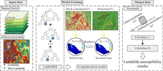
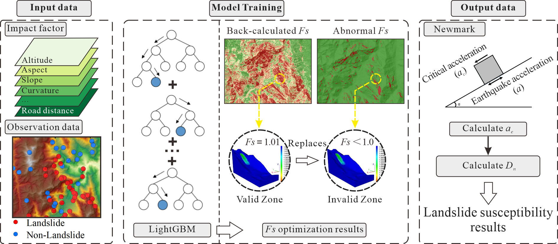
In summary, this methodology leverages the objective constraint mechanism of post-earthquake observation data to optimize the Fs parameter determination process within the traditional Newmark model. While fully preserving the classic physically based framework, it achieves rational, physically consistent corrections of numerically distorted parameters in anomalous zones, thereby advancing the refinement and regional adaptability of earthquake-induced landslide susceptibility evaluations (as illustrated in Figure 4).
Figure 4.
Research Technology Roadmap.
4. Results
4.1. Assessment Results for the Study Area
4.1.1. Sample Construction and Environmental Factor Correlation Analysis
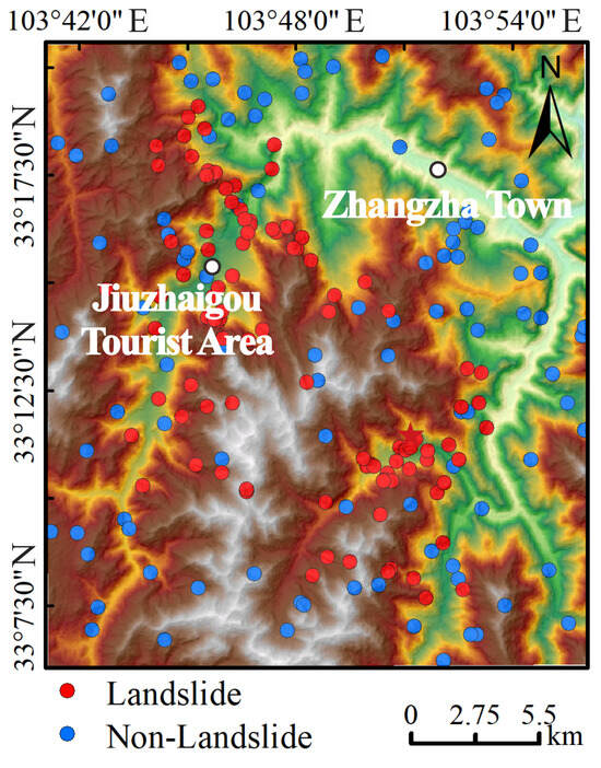
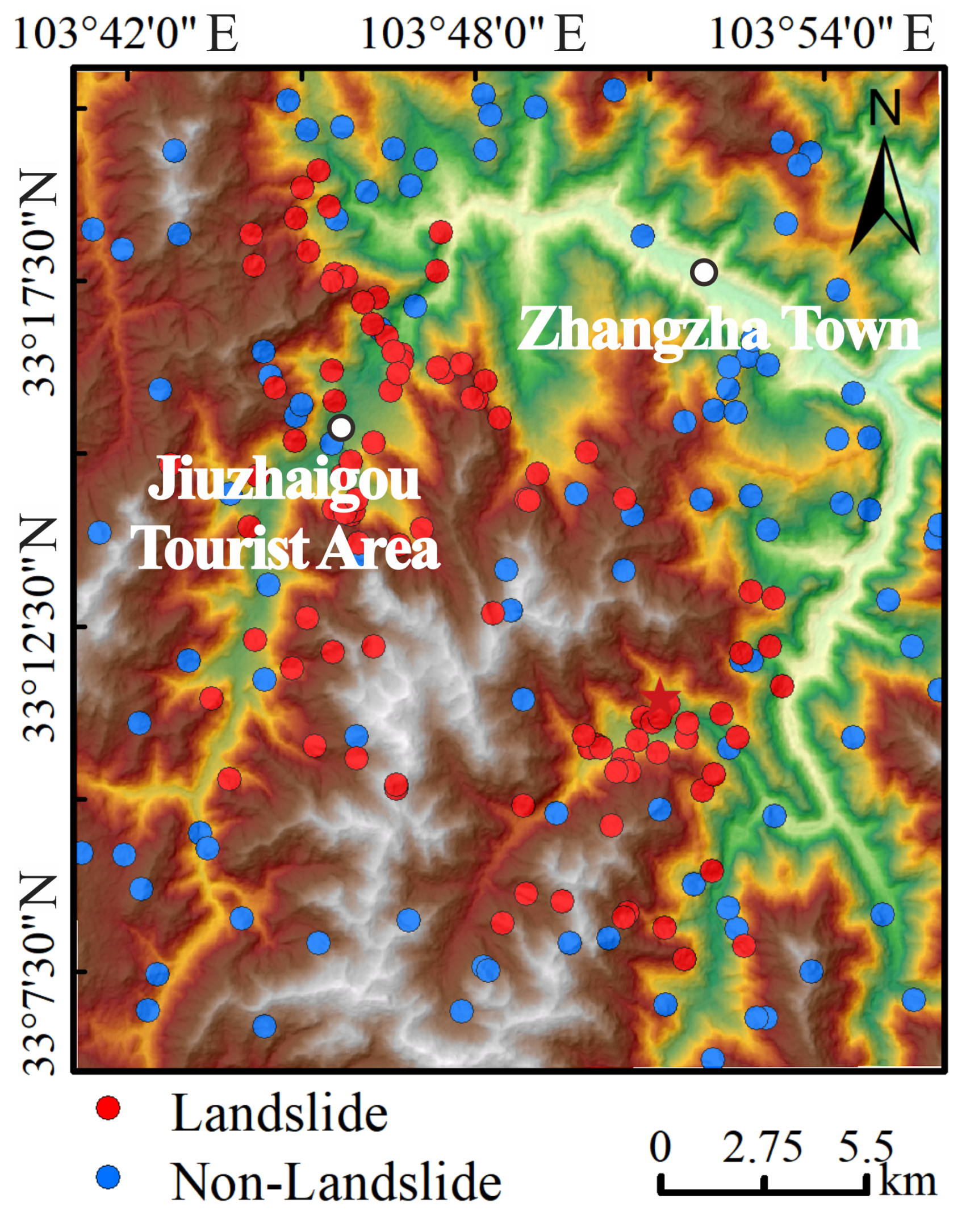
To simulate the actual engineering application scenarios under the constraints of sparse observation data in the immediate aftermath of a strong earthquake, this study randomly selects 100 actual landslide points from the comprehensive regional landslide inventory of the Jiuzhaigou earthquake (which contains a total of 4834 interpreted landslides). Concurrently, 100 non-landslide points are matched within the stable non-landslide zones to construct a 1:1 balanced dataset. Figure 5 presents the spatial distribution of the randomly sampled landslide and non-landslide samples, intuitively showing their geographical locations and spatial coverage characteristics within the study area and providing the sample basis for subsequent analyses.
Figure 5.
Random observation data distribution.
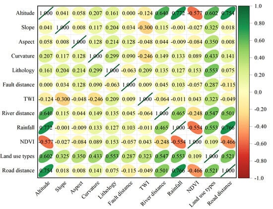
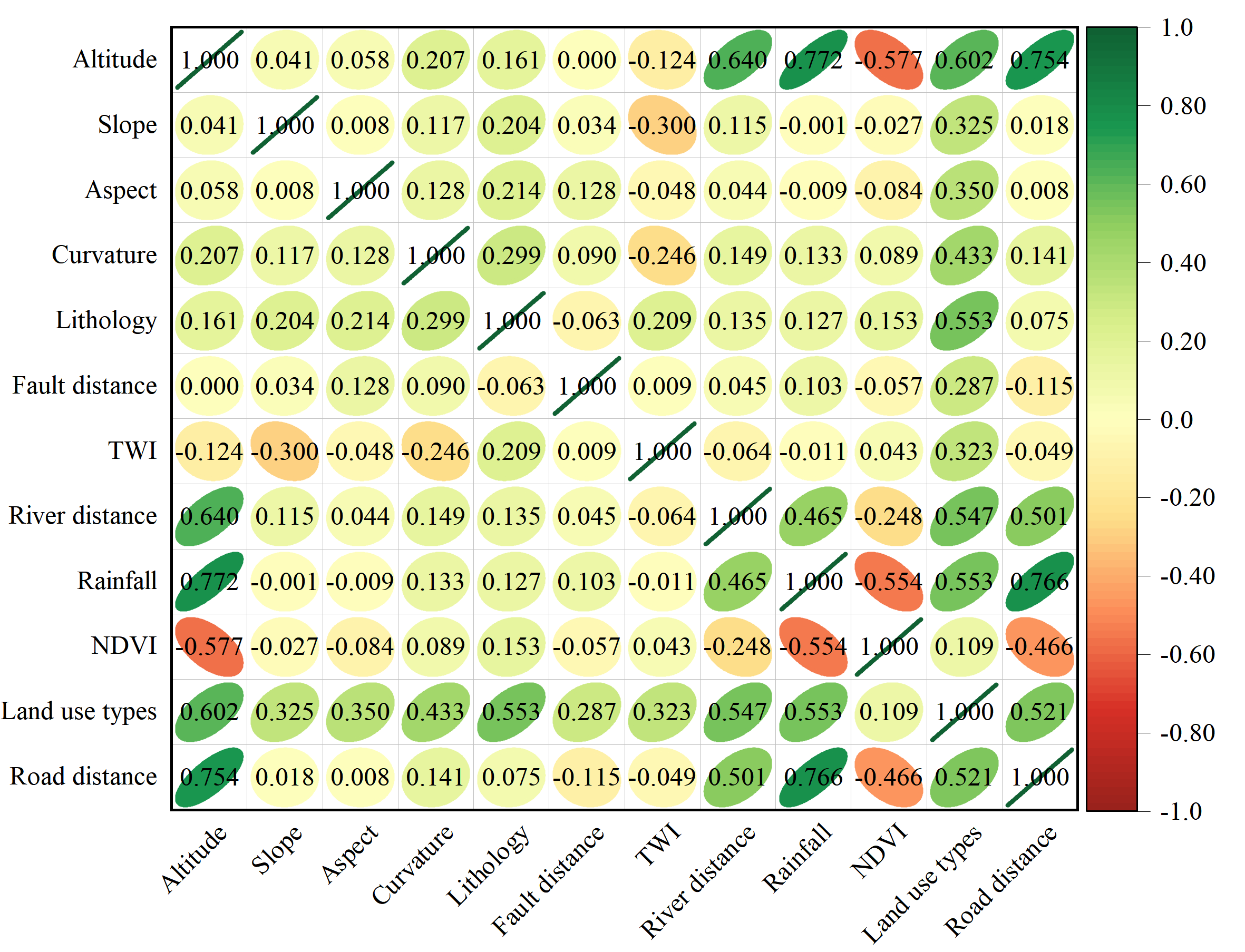
Given that strong ground motion parameters, such as PGA and PGV, serve as the dynamic triggering factors and their physical contributions have already been independently characterized within the Newmark dynamic displacement model, this study excludes them from the inversion process. To prevent mechanical coupling interference between triggering factors and conditioning factors during the data-driven inversion stage, only 12 foundational environmental conditioning factors—including elevation, slope, aspect, curvature, lithology, distance to faults, TWI, distance to rivers, rainfall, NDVI, land use, and distance to roads—are selected as the input variables for the LightGBM model. The Pearson correlation heatmap (Figure 6) visually depicts these inter-factor relationships through a color gradient from green (positive correlation) to red (negative correlation), with the ellipse eccentricity indicating correlation strength (narrower ellipses denote stronger correlations). Statistical results show that the absolute correlation coefficients among all environmental factors are strictly less than 0.8, with the maximum coefficient of 0.772 observed between elevation and rainfall (represented by a relatively narrow green ellipse). These findings confirm the absence of significant multicollinearity among the input variables [47], satisfying the independence requirements for model inversion.
Figure 6.
Heatmap of Factor Correlation.
4.1.2. Spatial and Local Correction Results of the Static Safety Factor
According to the physical prior knowledge of slope limit equilibrium theory, units where earthquake-induced landslides actually developed were mostly on the verge of critical static failure prior to the dynamic triggering, meaning their true theoretical Fs should approach the mechanical critical threshold of 1.0. Based on this premise, this study first utilizes the LightGBM inversion model constrained by observation samples (calculation parameters are listed in Table 3) to solve for the static critically stable Fs inversion baseline field that conforms to the regional engineering geological background (Figure 7a).
Table 3.
Key Hyperparameters of LightGBM Model.
Figure 7.
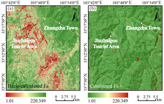
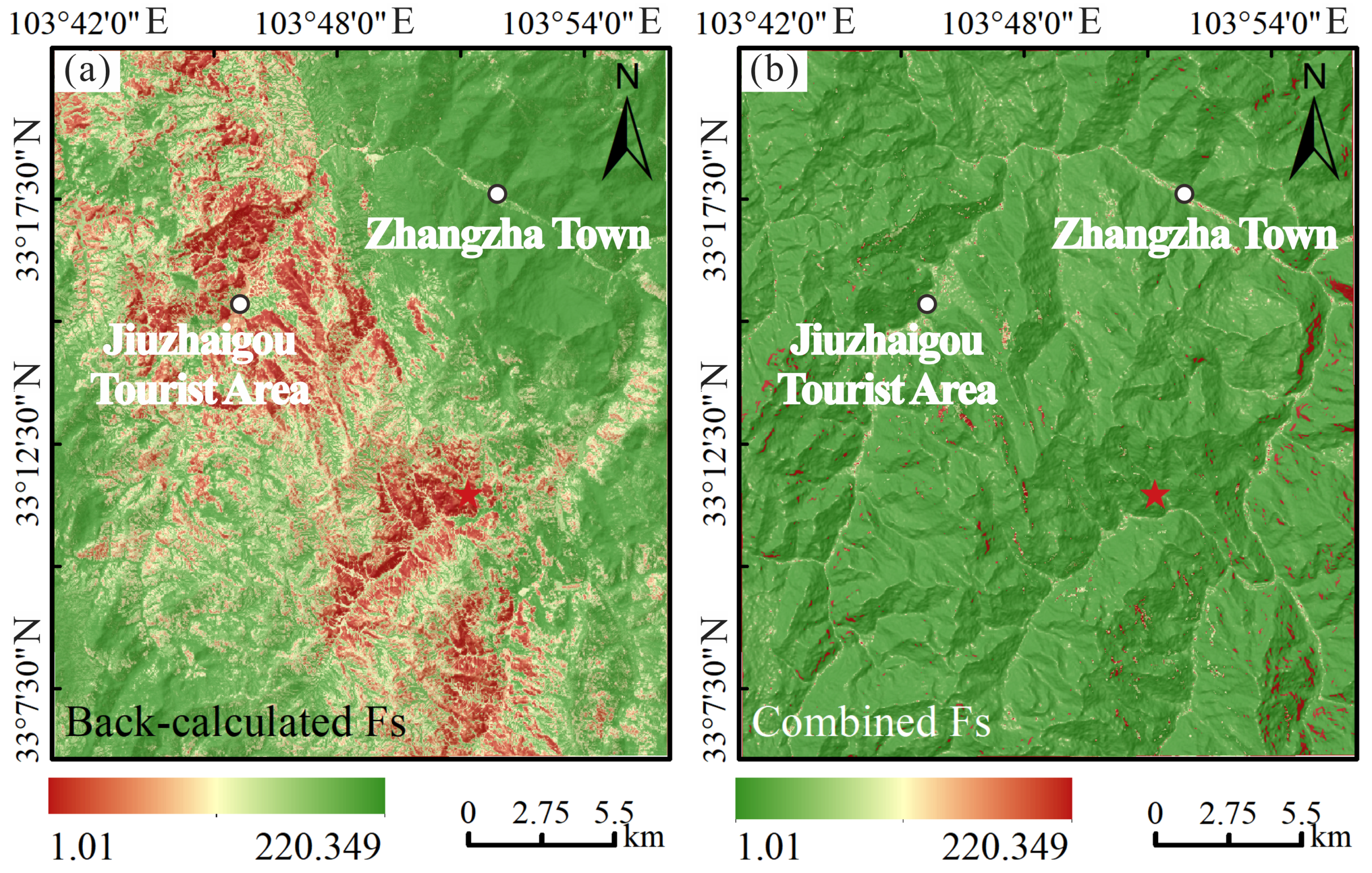
Distribution of Fs: (a) Inverted Fs; (b) Fs obtained after optimisation.
The results show that the static low-stability units (Fs approaching 1.0) in the inversion baseline field are concentrated along the Zhangzha Town to Jiuzhaigou scenic area’s core transportation arteries, both sides of major river valleys, and high steep slope zones. This distribution exhibits strong strip-like and patch-like clustering characteristics, covering a total area of approximately 51.315 km2, which accounts for 8.301% of the study area. This spatial pattern objectively reflects the joint weakening effects on the static shear strength of rock-soil masses caused by natural geomorphological forces, such as intensely dissected topography and fluvial headward erosion, as well as human engineering perturbations like road excavation and slope toe modification. In contrast, zones with high static stability margins are primarily distributed across wide valley terraces, gentle slope platforms, and high vegetation cover zones, displaying a continuous, planar stable distribution. The spatially controlled characteristics of the inverted Fs are highly compatible with the actual development laws of geological disasters in the Jiuzhaigou earthquake-affected area.
Subsequently, the anomalous zones displaying unphysical distortions (Fs < 1.0) in the traditional limit equilibrium calculations are directionally replaced by the data-driven inversion results shown in Figure 7a to realistically characterize the pre-earthquake limit equilibrium state of high-risk slopes. Meanwhile, the valid safety margin areas where Fs ≥ 1.0 in the traditional calculation are fully retained, ultimately yielding the comprehensive regional static Fs spatial distribution field optimized by ISFD fusion (Figure 7b). Comparative analysis indicates that traditional mechanical calculations fail to precisely account for the profound heterogeneity of regional geotechnical parameters, which leads to discrete, distorted distributions of unphysical Fs < 1.0 values. The optimized Fs field (Figure 7b) retains the capacity of the original mechanical formulas to express the spatial variation in safe zones while achieving targeted physical correction for the numerically distorted units. The corrected Fs spatial transition is more smooth and continuous, which eliminates the interference of unphysical values on the traditional Newmark model and provides a more scientific and reasonable characterization of the spatial variance in regional pre-earthquake static slope stability.
4.1.3. Earthquake-Induced Landslide Susceptibility Assessment
To achieve efficient estimation of permanent slope displacement, this study adopts the multiple displacement empirical prediction model constructed by Saygili and Rathje [48] to execute the Newmark permanent displacement calculation, with the specific formula provided in Equation (4).
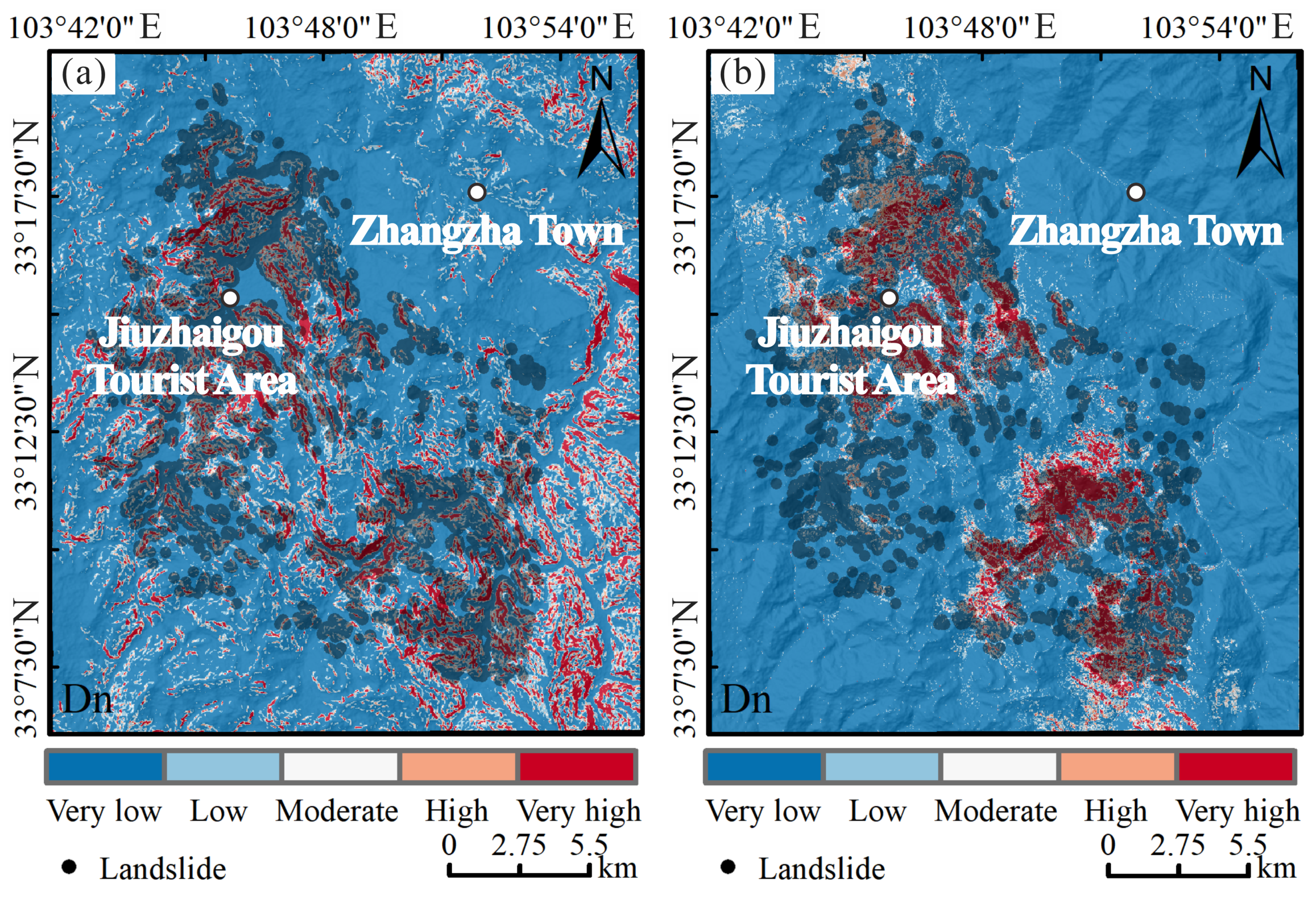
Consequently, the static Fs field optimized by ISFD is incorporated into the Newmark model to complete the regional calculation of slope critical acceleration and permanent displacement across the study area. Based on the calculated permanent displacement, earthquake-induced landslide susceptibility is classified into five distinct risk levels: very low risk (Dn < 1cm), low risk (1 cm ≤ Dn < 5 cm), medium risk (5 cm ≤ Dn < 10 cm), high risk (10 cm ≤ Dn < 15 cm), and very high risk (Dn ≥ 15 cm). This process yields the final spatial distribution of earthquake-induced landslide susceptibility for the study area (Figure 8).
Figure 8.
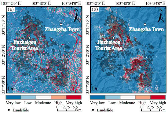
Spatial zoning of earthquake-induced landslide susceptibility: (a) Classic Newmark results; (b) ISFD results.
To verify the effectiveness of the proposed ISFD method, a comparative analysis is performed between the ISFD-optimized results (Figure 8b) and the traditional Newmark model results (Figure 8a). The results indicate that the high-susceptibility zones computed by the traditional Newmark model (Figure 8a) are spatially controlled predominantly by individual factors, specifically surface slope and ground motion parameters. This dominance manifests as a discrete and fragmented distribution pattern, which demonstrates an insufficient response to foundational engineering geological environmental factors such as tectonic faults, sensitive lithologies, and human engineering perturbations. This mechanism distortion limits the capacity of the traditional model to characterize complex multi-factor coupling effects in mountainous environments. For example, several areas where actual landslides are densely developed due to tectonic activity, intense valley incision, and road excavations are incorrectly classified into low susceptibility levels during the dynamic displacement calculation. This misclassification occurs because the traditional static Fs fails to effectively represent the true critical stability margins of these slopes, leading to significant spatial omissions and mismatches. In contrast, the high and very high susceptibility zones in the ISFD model results (Figure 8b) exhibit more pronounced spatial clustering. These zones are distributed continuously along the Minjiang fault zone and both sides of the scenic area transportation arteries, demonstrating much higher consistency with the actual dense post-earthquake landslide inventory. This confirms that the local Fs optimization strategy constrained by sparse post-earthquake observations successfully enhances the response and identification capability of the physical mechanical model to regional heterogeneous geological environments, precisely capturing the dynamic instability patterns under the combined effects of rock mass structural fragmentation and artificial slope modification.
Furthermore, within stable units where no actual landslides developed, the extensive presence of unphysical distorted values (Fs < 1.0) in the traditional Newmark model directly participates in the permanent displacement calculation, easily inducing pathological amplification of cumulative displacements under seismic loading. Consequently, certain areas characterized by steep slopes or strong ground motion parameters, but where no landslides actually occurred, exhibit unphysical anomalies and an inflation of high risk values along the periphery of gentle boundaries, generating a severe false high risk over-prediction. The ISFD method addresses this by implementing a targeted mechanical correction and rational harmonization of these anomalous zones through data-driven inversion values. Following optimization, the pathological amplification of high displacements caused by numerical distortion is effectively suppressed, and these stable areas are correctly recalibrated and classified into low or medium-to-low susceptibility levels. The significant reduction in spatial misclassification fully demonstrates that while preserving the advantages of the classic physical mechanical framework, the proposed method provides superior regional adaptability and zoning reliability.
4.2. Accuracy Assessment and Comparison
To further quantitatively compare the performance differences between the traditional Newmark model and the ISFD method in earthquake-induced landslide susceptibility assessment, multiple metrics—including Accuracy, Precision, Recall, F1-Score, the Kappa coefficient, and the AUC—were selected to comprehensively evaluate the classification capability and spatial consistency of both models. The statistical evaluation results are summarized in Table 4.
Table 4.
Comparison of Model Evaluation Results.
From the perspective of overall classification accuracy, the traditional Newmark model achieves an Accuracy of only 0.625, indicating that its regional discriminative capacity is relatively constrained. Following the ISFD optimization, the Accuracy increases significantly to 0.718, representing a 14.88% improvement. This demonstrates that the local Fs optimization strategy, constrained by post-earthquake observation data, effectively rectifies the zoning degradation caused by empirical parameterizations and unphysical numerical distortions, thereby substantially enhancing the overall grid classification capacity of the model for both landslide and non-landslide units.
An in-depth analysis of the structural characteristics of the classification metrics reveals that under the complex engineering geological background of near-fault strong motion zones, both models exhibit a characteristic pattern of relatively high precision accompanied by low recall. The core underlying cause of this structural discrepancy is that shallow landslides triggered by strong earthquakes in complex mountainous terrains feature extremely high spatial dispersion and complicated mechanical mechanisms, which typically leads to a certain degree of mechanical under-prediction within deterministic analytical frameworks.
- (a)
- First, the traditional Newmark model yields a Recall of only 0.392, which objectively reflects a prominent omission phenomenon of actual landslide units. However, its Precision reaches 0.726, indicating that the high-susceptibility risk grids derived from its theoretical solutions still possess a foundational level of credibility.
- (b)
- Second, while maintaining high precision discrimination, the ISFD optimized model elevates the Recall to 0.465, an increase of 18.62%. Concurrently, its Precision steadily grows to 0.785. This strongly demonstrates that the ISFD method successfully expands the identification boundaries for true hazard grids, capturing more actual landslides, without triggering uncontrolled generalization or introducing additional false positives, thereby achieving a precise expansion of the predictive boundaries.
- (c)
- Third, the F1-Score, as the harmonic mean of Precision and Recall, effectively characterizes the comprehensive equilibrium of a discriminative system. The traditional model exhibits a low F1-Score of 0.510, reflecting a deficiency in evaluation balance. In contrast, the F1-Score of the ISFD method increases to 0.592, representing a 16.08% improvement. This confirms that the improved model establishes a superior physical mechanical balance between landslide inventory completeness and hazard prediction accuracy.
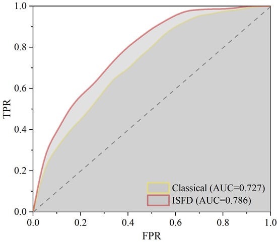
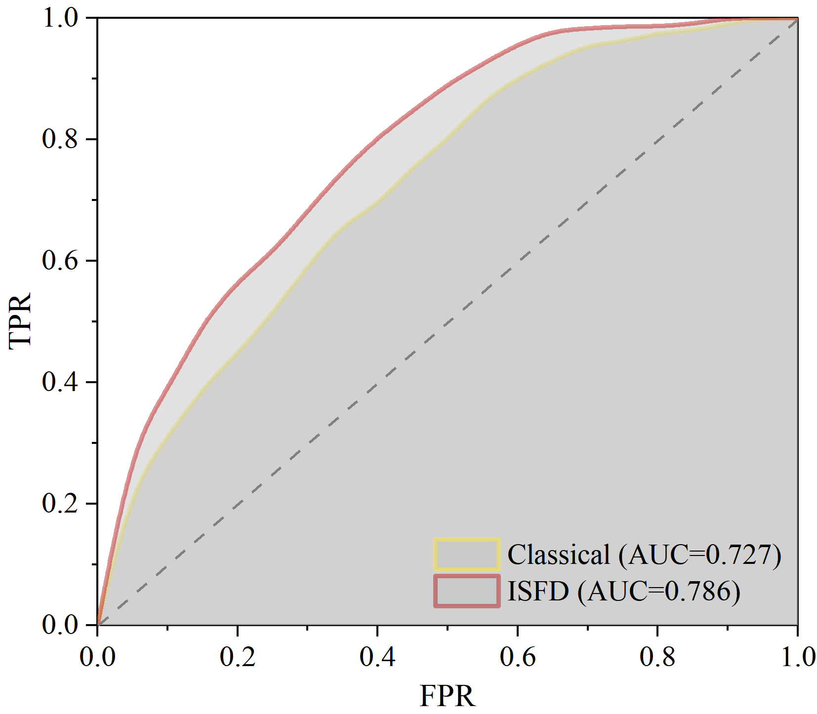
Analyzing the spatial consistency and zoning capabilities, the traditional Newmark model yields a Kappa coefficient of only 0.251, which falls within the slight consistency range and indicates a limited spatial overlap between its predicted zones and actual landslides. In comparison, the Kappa coefficient of the ISFD optimized model increases to 0.386, reaching a moderate consistency level. The physical mechanism behind this improvement is that the localized physical correction based on the inverted Fs effectively suppresses numerical distortions of anomalous low values during cumulative dynamic displacement calculations. This suppression allows the computed permanent displacement field to achieve a superior spatial alignment with regional geological frameworks, including active faults, intense valley incisions, and human engineering perturbations. Furthermore, the ROC curve analysis shown in Figure 9 indicates that the ISFD model expands the regional AUC threshold by 8.116%, from 0.727 to 0.786, validating the positive enhancement of the proposed method on regional landslide susceptibility classification from a probabilistic perspective.
Figure 9.
ROC Curve Comparison Results.
In conclusion, the traditional Newmark model exhibits inherent limitations in regional landslide identification completeness, spatial distribution conformity, and overall classification accuracy due to its inability to accurately characterize the profound spatial heterogeneity of geotechnical parameters and its vulnerability to subjective empirical adjustments. Conversely, the ISFD method leverages the physical constraints of sparse post-earthquake observations to perform targeted corrections on numerically distorted units of the static safety factor. While fully retaining the advantages of the classic physical mechanical framework, this method effectively enhances the model’s spatial identification capability regarding complex mountainous geological factors. The quantitative evaluation metrics and qualitative spatial distribution analyses corroborate each other, fully confirming the robust engineering applicability of the proposed method for post-earthquake emergency responses and long-term susceptibility zoning in strong-motion seismic zones.
5. Discussion
5.1. Influence of the Newmark Permanent Displacement Model on the Assessment Results
The evaluation results of the Newmark permanent displacement model exhibit strong sensitivity to the adaptation of ground motion data, underlying calculation assumptions, and critical parameter configurations. Distinct derivative Newmark models vary markedly in their theoretical hypotheses and applicable engineering scenarios. To systematically evaluate the generalization applicability of the proposed ISFD method across different Newmark permanent displacement frameworks, this study selects two additional representative empirical models for a comparative analysis.
Specifically, Model 2 is an empirical Newmark permanent displacement model established by Jibson et al. [45] based on the rigid sliding block assumption (Equation (5)). This model is derived from a dataset of 30 earthquake events and 2270 ground motion records, offering robust statistical reliability and broad general applicability. Model 3 is an improved model proposed by Gao et al. [49] based on 189 near-fault pulse-like ground motion records (Equation (6)), which explicitly introduces key parameters such as the velocity pulse period to effectively capture the pulse effects of near-fault ground motions. Combined with the primary permanent displacement calculation method adopted in this paper (Equation (4)), these three frameworks are designated as Model 1, Model 2, and Model 3, respectively.
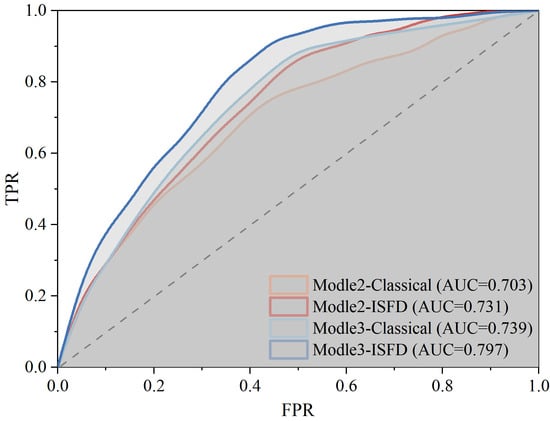
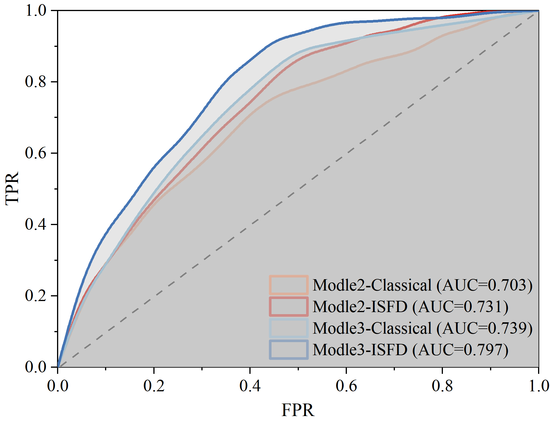
Combined with the statistical results in Table 5, the evaluation performances of the three dynamic models under the raw condition without Fs optimization exhibit a pronounced gradient differentiation due to their inherent mechanical assumptions, with the overall performance following the sequence of Model 3 > Model 1 > Model 2. Model 3 achieves the optimal comprehensive discriminative efficiency under the raw condition, yielding the highest baseline precision metrics among the three frameworks, including an AUC of 0.739. This superior performance is primarily attributed to its embedded near-fault velocity pulse response mechanism, which precisely captures the instantaneous energy amplification of the strong ground motion inputs during the Jiuzhaigou earthquake, making it highly compatible with the specific seismogenic structures and fault geological backgrounds of the study area. Model 1 demonstrates intermediate baseline performance; however, owing to its lack of targeted characterization for pulse effects, it exhibits certain tendencies toward spatial mismatch and under-prediction. Although Model 2 possesses robust broad-spectrum statistical universality, it fails to account for the highly nonlinear dynamic destruction characteristics associated with near-fault pulse-like ground motions. Consequently, its characterization of local strong shaking responses across the study area is severely deficient, resulting in the weakest baseline performance among the three frameworks, with a raw AUC of only 0.703.
Table 5.
Comparison of Evaluation Results from Multiple Newmark Models.
Combined with the multi-model ROC curves (as shown in Figure 10), the implementation of the ISFD data-driven local Fs inversion optimization yields positive performance enhancements across all three models, without experiencing any performance degradation or negative generalization. This strongly confirms that the ISFD method possesses excellent model universality in mitigating parameter uncertainties and intercepting the interference of numerical anomalies. However, because the baseline assumptions of each model align differently with the local geological background, the optimization gains and mechanical synergy demonstrated by ISFD exhibit significant divergence. Following the integration of the inverted Fs, Model 1 exhibits the most dramatic relative increase across all precision metrics, with its Kappa coefficient leaping from 0.251 to 0.386, demonstrating a clear deficiency-compensation characteristic. This phenomenon indicates that for classic empirical models where the traditional parameter systems suffer from inherent distortions due to spatial continuity assumptions, ISFD can leverage the strong constraints of objective post-earthquake observations to compensate for the mechanistic shortcomings of the static physical input field within the dynamic model, thereby generating a physical correction effect on large-scale, discretely distributed numerical distortions.
Figure 10.
Comparison of ROC Curves for Different Permanent Displacement Models.
In contrast, after optimization, Model 2 and Model 3 exhibit distinct trends. Model 3 demonstrates a high-level convergence characterized by transitioning from widespread to stable and balanced quality improvement, achieving the highest absolute discriminative performance across the study area with its AUC expanding to 0.797 and its Kappa coefficient increasing to 0.413. The underlying mechanical mechanism of this significant gain is that near-fault velocity pulse effects inherently generate extremely intense instantaneous dynamic accelerations. If the static Fs inputted into the framework contains unphysical distortions below 1.0, the cumulative Newmark displacement solutions undergo a pathological, exponential amplification under the severe excitation of pulse loading, which subsequently leads to severe overloading and distortion of the regional susceptibility results. The ISFD method addresses this issue by applying a data-driven inversion value to execute precise, localized mechanical mitigation on units where Fs < 1.0, thereby alleviating this pathological amplification. This mitigation establishes a highly effective synergy with the native dynamic pulse advantages of Model 3, causing the hazard identification boundaries to converge rationally and optimizing the spatial recognition capacity of the high and very high susceptibility zones. Meanwhile, the metrics for Model 2 also steadily improve after optimization, with its AUC increasing from 0.703 to 0.731, though its relative increase remains the most limited among the three frameworks. The root cause of this limitation is that Model 2 relies on a wide-spectrum global large-sample statistical structure as its native core architecture. Its sensitivity range to input parameters has been diluted and passivated by its vast historical regression samples. Consequently, a refined mechanical constraint based on local, sparse post-earthquake observations can introduce minor architectural adaptation conflicts with its native wide-spectrum universality, which ultimately dampens the release of optimization gains from the ISFD method.
In summary, the optimization benefits of the ISFD data-driven inversion method across different dynamic displacement models do not represent a homogeneous, mechanical translation; rather, they depend deeply on the mechanistic fusion between the native assumptions of the dynamic model and the specific regional seismological–geological environment. Wide-spectrum classic models with weaker mechanistic adaptability can achieve active hedging of parametric shortcomings and performance leaps through local Fs corrections. Most notably, this scheme provides the most prominent optimization benefits for models dedicated to near-fault dynamic responses, enabling refined structural corrections of the dynamic calculations. Overall, the ISFD method possesses robust model universality and exhibits the most outstanding optimization effects on near-fault strong-motion adaptive models, offering an efficient approach to push the accuracy of earthquake-induced landslide susceptibility assessments in near-fault strong-motion zones to its upper limit.
5.2. Influence of Observational Data on the Assessment Results
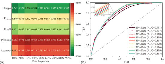
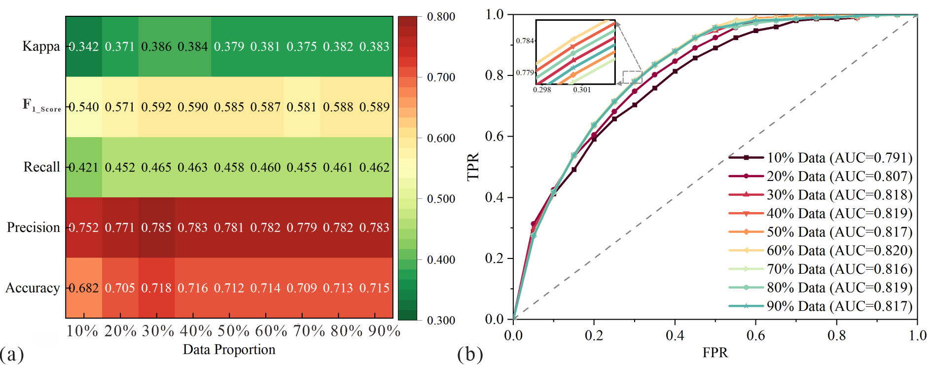
This study simulates an extreme post-earthquake data-scarce scenario by randomly selecting only 2% of total landslide points for core inversion. To explore the sensitivity of this sparse observation-based Fs inversion scheme, the sample proportion is progressively increased, enabling an analysis of the spatial correction capability of post-earthquake ground truth and its dynamic impacts on prediction accuracy.
The horizontal sensitivity experimental results indicate (as shown in Figure 11a) that as the proportion of observation samples increases, the overall discriminative performance of the ISFD-optimized Newmark model exhibits a distinct evolutionary trend characterized by rapid initial gains followed by high-level saturation. Within the low-sample interval of 10% to 30%, the solution framework is highly sensitive to the empirical data. A small amount of post-earthquake landslide location information can effectively constrain the spatial deviations of the regional Fs field, thereby compensating for the deficiency of prior information in the native model. During this stage, all evaluation metrics jump substantially, with the AUC climbing from 0.791 to a global peak of 0.818 (as shown in Figure 11b), which represents a significant improvement in both model identification accuracy and spatial consistency. However, when the sample proportion exceeds 30%, the model performance enters a pronounced bottleneck steady-state phase. Within the wide interval of 30% to 90%, the AUC fluctuates stably within a high-value platform of 0.816 to 0.820, and none of the core metrics exhibit continuous upward or systematic downward trends. This indicates that the core physical constraint information governing slope stability in the study area has been fully activated and completely fitted at a 30% sample size. Simply stacking larger sample volumes can no longer breach the inherent accuracy upper limit of the dynamic model.
Figure 11.
Model Accuracy Comparison: (a) Model accuracy metrics; (b) ROC curve comparison.
This performance trend of strong initial sensitivity and late-stage high saturation confirms the applicability of the ISFD method under extremely sparse observation conditions. Even at an ultra-low sample capacity of 10%, the optimized model maintains robust performance, yielding an AUC of 0.791 and a Precision of 0.752. The physical essence of this strong robustness mechanism is that ISFD does not adopt a pure, end-to-end data-driven mode to fit hazard patterns out of nothing. Instead, it utilizes the limited ground-truth observations as pulse signals to target, eliminate, and rectify unphysical, anomalous Fs grid units within the traditional mechanical model. This framework of physical mechanism constraints combined with sparse data calibration enables the model to rely on the prior mechanical support of the analytical framework at low data volumes, consistently outputting stable and reasonable susceptibility zoning results. Nevertheless, the plateau effect where performance stagnates with increasing data volume profoundly reveals the fundamental mechanical bottlenecks encountered when implementing numerical optimization solely at the Fs level. The inability of model accuracy to improve further despite multiplying the sample size demonstrates that the ultimate restriction on the evaluation upper limit stems from the simplified assumptions of the underlying mechanical framework. The computational accuracy of the Newmark rigid sliding block analytical framework depends heavily on the refined spatial characterization of regional static geotechnical parameters. Local Fs inversion based on discrete labels of post-earthquake landslide events essentially represents a post-processing rectification constrained by outcomes. It cannot inversely reconstruct complex, deep-seated initial constitutive parameter fields of natural strata, and its capacity to enhance overall accuracy is ultimately constrained by the mechanical framework itself.
In view of this, to achieve further breakthroughs in the quantitative evaluation of earthquake-induced landslide susceptibility, future research directions should shift from the post-processing correction of model outputs or intermediate parameter layers to the front-end geotechnical constitutive parameter level, focusing on the refined spatial characterization of complex rock and soil mechanical parameters at large scales. The research priority should lie in utilizing refined stratigraphic investigation and in-situ testing techniques to resolve the problem of rational spatial heterogeneity assignment for regional shear strength parameters, alongside deeply parsing the dynamic degradation laws of rock and soil shear strength under strong seismic loading. By integrating data-driven approaches with refined parameter inversion, the input accuracy of foundational mechanical data can be enhanced at the source. This will further improve the computational architecture of the classic Newmark model, fully unleashing the predictive potential of coupling physically based and data-driven paradigms.
5.3. Limitations and Future Prospects
Although the ISFD method proposed in this study demonstrates substantial practical value in post-earthquake data-scarce scenarios, certain limitations remain based on the evaluation process and result analysis. To address these constraints and align with current technological trends in earthquake-induced landslide assessment, clear optimization directions for future research are identified. Specifically, the study limitations manifest primarily in two aspects:
(1) First, the Fs field obtained via the data-driven inversion scheme does not possess the precise physical connotation of a traditional static safety factor strictly solved through vector analytics of sliding and anti-sliding forces in classical geological engineering. Instead, it represents a spatial mapping parameter of critical stability states bridging post-earthquake ground-truth labels and multi-dimensional environmental conditioning factors. Although this parameter effectively rectifies unphysical numerical distortions within traditional physical models, such as Fs < 1.0, and successfully assists the dynamic analytical framework in achieving high-precision spatial zoning, it focuses more on the macro-environmental nonlinear characterization of slope failure intensity. Consequently, it exhibits limitations regarding strict micro-mechanical interpretability.
(2) Second, this methodology is inapplicable to extreme post-earthquake scenarios characterized by a complete absence of empirical data. Although the core inversion scenario in this study utilizes an extremely sparse dataset comprising only 2% of the entire inventory, equivalent to 100 recorded landslides, it still relies on a small volume of observed landslide samples to construct the training dataset and establish the correlation between Fs values and slope conditioning factors. When effective landslide observation data are completely unavailable in the immediate aftermath of an earthquake, the ISFD method cannot execute targeted corrections on anomalous Fs zones, which restricts its operational capability in zero-sample extreme contexts.
To refine this methodology, future research can be advanced along two primary directions. Temporally, the instantaneous inversion scheme should be deeply integrated with long-term interferometric synthetic aperture radar (InSAR) monitoring datasets. By capturing the time-series micro-deformation characteristics of slopes during different post-earthquake phases, a dynamically updated earthquake-induced landslide susceptibility evaluation framework can be established, enabling long-term slope stability tracking and chronic secondary risk evolution analysis. Spatially, future efforts should break away from the outcome-oriented post-processing rectification mode. To address the mechanical bottleneck where numerical optimization solely at the Fs level is restricted by the analytical framework itself, data-driven approaches must be combined with refined parameter inversion. By improving the spatial heterogeneity assignment accuracy of regional shear strength and introducing non-linear softening mechanisms under strong seismic loading, this optimization can advance front-end geotechnical parameter inputs and foundational model iterations. This paradigm shift will fundamentally refine and advance the generalized calculation architecture of the classic Newmark model, overcoming the inherent accuracy bottlenecks induced by empirical parameterizations at the source.
6. Conclusions
To resolve the limitation where the predictive accuracy of the traditional Newmark permanent displacement model in earthquake-induced landslide susceptibility assessment is easily compromised by geotechnical parameter uncertainties and subjective empirical adjustments during the static Fs calculation, this study proposes an ISFD method for adaptive parameter configuration. By leveraging ultra-sparse post-earthquake failure observations, this methodology executes localized mechanical mitigation and adaptive corrections on anomalous, distorted grids where Fs < 1.0 within the classic physically based framework. The primary conclusions are drawn as follows:
(1) The developed data-driven local optimization strategy for the spatial Fs field was successfully validated. Departing from conventional paradigms that rely on empirical parameterizations or uniform manual adjustments, this approach utilizes the nonlinear mapping relationships between post-earthquake observation samples and multi-dimensional slope environmental characteristics to perform targeted corrections on the static baseline stability field. This strategy significantly dampens the spatial variability interference of input parameters, rendering the optimized spatial distribution of Fs highly compatible with the complex regional geological background and actual spatial development laws of landslides in the study area.
(2) The spatial rationality and reliability of earthquake-induced landslide susceptibility zoning are significantly enhanced. The Newmark permanent displacement calculation framework is improved by incorporating the ISFD-optimized Fs results. The evaluation results demonstrate that the AUC of the optimized model increases from 0.727 to 0.786, representing an improvement of approximately 8.116% in comprehensive discriminative performance. Concurrently, the high-susceptibility zones achieve a superior spatial alignment with the actual dense landslide inventories. This optimization effectively mitigates the issues of fragmented high-risk distributions and localized under-predictions inherent in traditional approaches, verifying that the ISFD method can successfully enhance the spatial correctness and reliability of susceptibility mapping outcomes.
(3) The proposed model is confirmed to possess excellent adaptability and strong robustness under sparse post-earthquake observational data conditions. Sensitivity experiments indicate that the model performance exhibits an evolutionary trend characterized by rapid initial gains followed by high-level saturation as the sample size increases. Even under extreme operational conditions involving an ultra-low sample capacity of only 2% to 10%, the model maintains a high level of discriminative capability due to the rigid support of the classic analytical physical framework. This demonstrates outstanding robustness in data-scarce scenarios, providing an efficient and highly reliable rapid identification tool for risk sources during the post-earthquake information-blind phase.
Author Contributions
B.S.: Methodology, Drawing, Writing—original draft, Writing—review & editing, Funding acquisition. X.F.: Conceptualization, Supervision, Writing—review & editing. J.L.: Writing—review & editing. Z.Z.: Writing—review & editing. All authors have read and agreed to the published version of the manuscript.
Funding
This study was financially supported by the Research Startup Fund for Introduced Doctoral Talents (2025YJ-38).
Data Availability Statement
The datasets generated during this study are available from the corresponding author on reasonable request, within the framework of cooperation agreements and scientific research projects.
Acknowledgments
The financial supports are gratefully acknowledged.
Conflicts of Interest
Author Xin Feng was employed by the company Sichuan Provincial Geological Engineering Co., Ltd. The remaining authors declare that the research was conducted in the absence of any commercial or financial relationships that could be construed as a potential conflict of interest.
References
- Fan, X.; Scaringi, G.; Korup, O.; West, A.J.; van Westen, C.J.; Tanyas, H.; Hovius, N.; Hales, T.C.; Jibson, R.W.; Allstadt, K.E.; et al. Earthquake-Induced Chains of Geologic Hazards: Patterns, Mechanisms, and Impacts. Rev. Geophys. 2019, 57, 421–503. [Google Scholar] [CrossRef] [Scilit]
- Xi, C.; He, K.; Liu, B.; Hu, X. Evolutionary Controls on Post-Seismic New Landslides Revealed by Multi-Earthquake Inventories. Landslides 2026, 23, 2727–2743. [Google Scholar] [CrossRef] [Scilit]
- Zeng, Y.; Zhang, Y.; Liu, J.; Wang, Q.; Zhu, H. Rapid Emergency Response Assessment of Earthquake-Induced Landslides Driven by Fusion of InSAR Deformation Data and Newmark Physical Models. Remote Sens. 2023, 15, 4605. [Google Scholar] [CrossRef] [Scilit]
- Zhang, Z.; Liu, M.; Tan, Y.J.; Walter, F.; He, S.; Chmiel, M.; Su, J. Landslide Hazard Cascades Can Trigger Earthquakes. Nat. Commun. 2024, 15, 2878. [Google Scholar] [CrossRef] [Scilit] [PubMed]
- Gomez, C.; Hadmoko, D.S. Application of LiDAR Differentiation and a Modified Savage–Hutter Model to Analyze Co-Seismic Landslides: A Case Study of the 2024 Noto Earthquake, Japan. Geosciences 2025, 15, 180. [Google Scholar] [CrossRef] [Scilit]
- Wu, Z.; Qin, M.; Zhang, Y. Landslide Risk Assessment and Susceptibility Analysis in the Loess Plateau Region: A Case Study of Yuzhong County, Lanzhou City, Western China. Geosciences 2026, 16, 344. [Google Scholar] [CrossRef] [Scilit]
- Huang, R. Large-scale landslides and their sliding mechanisms in China since the 20th century. Chin. J. Rock Mech. Eng. 2007, 26, 433. [Google Scholar] [CrossRef]
- Jibson, R.W.; Harp, E.L.; Michael, J.A. A Method for Producing Digital Probabilistic Seismic Landslide Hazard Maps. Eng. Geol. 2000, 58, 271–289. [Google Scholar] [CrossRef] [Scilit]
- Wang, X.; Wang, X.; Zhang, X.; Wang, L.; Guo, H.; Li, D. Near Real-Time Spatial Prediction of Earthquake-Induced Landslides: A Novel Interpretable Self-Supervised Learning Method. Int. J. Digit. Earth 2023, 16, 1885–1906. [Google Scholar] [CrossRef] [Scilit]
- Yin, D.; Zeng, L.; Chen, Y.; Liu, S.; Cheng, Y.; Liu, Q.; Qian, L. Initial Rupture Sequence and Rupture History of the 2008 Wenchuan Earthquake from a Kinematic Perspective. Nat. Hazards 2024, 120, 14409–14430. [Google Scholar] [CrossRef] [Scilit]
- Yin, S.; Dai, Z.; Zeng, Y. Optimized Landslide Susceptibility Prediction Based on SBAS-InSAR: Case Study of the Jiuzhaigou Ms7.0 Earthquake. Geomat. Nat. Hazards Risk 2024, 15, 2366362. [Google Scholar] [CrossRef] [Scilit]
- Zhao, B.; Su, L.; Xu, Q.; Li, W.; Xu, C.; Wang, Y. A Review of Recent Earthquake-Induced Landslides on the Tibetan Plateau. Earth-Sci. Rev. 2023, 244, 104534. [Google Scholar] [CrossRef] [Scilit]
- Zhu, X.; Wei, B.; Su, G.; Qi, W.; Gao, Y.; Zhang, T.; Guo, X.; Wang, X. Post-Disaster Recovery Assessment and Driving Factors of the 2013 Lushan Earthquake Affected Area Based on Multi-Temporal Nighttime Light Data. J. Mt. Sci. 2026, 23, 1367–1383. [Google Scholar] [CrossRef] [Scilit]
- Zhan, Z.; Chen, S.; Zhang, M.; Shi, W.; Sun, Y.; Luo, H. Multi-Scale Attention Network for Landslide Susceptibility Assessment. Geosciences 2026, 16, 188. [Google Scholar] [CrossRef] [Scilit]
- Zeng, Y.; Zhang, Y.; Liu, J.; Xu, P.; Zhu, H.; Yu, H.; He, Y. Assessment of Earthquake-Induced Landslide Hazard Zoning Using the Physics-Environmental Coupled Model. J. Mt. Sci. 2023, 20, 2644–2664. [Google Scholar] [CrossRef] [Scilit]
- Achu, A.L.; Thomas, J.; Aju, C.D.; Remani, P.K.; Gopinath, G. Performance Evaluation of Machine Learning and Statistical Techniques for Modelling Landslide Susceptibility with Limited Field Data. Earth Sci. Inform. 2023, 16, 1025–1039. [Google Scholar] [CrossRef] [Scilit]
- Wang, Y.; Feng, L.; Li, S.; Ren, F.; Du, Q. A Hybrid Model Considering Spatial Heterogeneity for Landslide Susceptibility Mapping in Zhejiang Province, China. CATENA 2020, 188, 104425. [Google Scholar] [CrossRef] [Scilit]
- Gade, M.; Nayek, P.S.; Dhanya, J. A New Neural Network–Based Prediction Model for Newmark’s Sliding Displacements. Bull. Eng. Geol. Environ. 2021, 80, 385–397. [Google Scholar] [CrossRef] [Scilit]
- Newmark, N.M. Effect of Earthquake on Dams and Embankments. Geotechnique 1965, 15, 139–159. [Google Scholar] [CrossRef] [Scilit]
- Chen, X.; Yuan, R.; Yu, L. Applying the Newmark’s model to the assessment of earthquake-triggered landslides during the Lushan earthquake. Seismol. Geol. 2013, 35, 661–670. [Google Scholar]
- Luo, W.; Liu, C.-C. Innovative Landslide Susceptibility Mapping Supported by Geomorphon and Geographical Detector Methods. Landslides 2018, 15, 465–474. [Google Scholar] [CrossRef] [Scilit]
- Yalcin, A.; Reis, S.; Aydinoglu, A.C.; Yomralioglu, T. A GIS-Based Comparative Study of Frequency Ratio, Analytical Hierarchy Process, Bivariate Statistics and Logistics Regression Methods for Landslide Susceptibility Mapping in Trabzon, NE Turkey. CATENA 2011, 85, 274–287. [Google Scholar] [CrossRef] [Scilit]
- Wu, S.-J.; Chen, S.-R.; Wang, C.-D. Modeling ANN-Based Estimations of Probabilistic-Based Failure Soil Depths for Rainfall-Induced Shallow Landslides Due to Uncertainties in Rainfall Factors. Geosciences 2025, 15, 88. [Google Scholar] [CrossRef] [Scilit]
- Zeng, Y.; Zhang, Y.; Liu, J. Earthquake-Induced Landslide Prediction Using a Semi-Supervised Incremental Learning Strategy. Bull. Eng. Geol. Environ. 2025, 84, 235. [Google Scholar] [CrossRef] [Scilit]
- Zhang, Y.; Yan, Q. Landslide Susceptibility Prediction Based on High-Trust Non-Landslide Point Selection. ISPRS Int. J. Geo-Inf. 2022, 11, 398. [Google Scholar] [CrossRef] [Scilit]
- Dias, H.C.; Hölbling, D.; Grohmann, C.H. Examining the Influence of Different Inventories on Shallow Landslide Susceptibility Modeling: An Assessment Using Machine Learning and Statistical Approaches. Geosciences 2025, 15, 77. [Google Scholar] [CrossRef] [Scilit]
- Xi, C.; Han, M.; Hu, X.; Liu, B.; He, K.; Luo, G.; Cao, X. Effectiveness of Newmark-Based Sampling Strategy for Coseismic Landslide Susceptibility Mapping Using Deep Learning, Support Vector Machine, and Logistic Regression. Bull. Eng. Geol. Environ. 2022, 81, 174. [Google Scholar] [CrossRef] [Scilit]
- Sun, C.-G.; Kim, H.-S. GIS-Based Regional Assessment of Seismic Site Effects Considering the Spatial Uncertainty of Site-Specific Geotechnical Characteristics in Coastal and Inland Urban Areas. Geomat. Nat. Hazards Risk 2017, 8, 1592–1621. [Google Scholar] [CrossRef] [Scilit]
- Wang, H.; Wang, G.; Wang, F.; Sassa, K.; Chen, Y. Probabilistic Modeling of Seismically Triggered Landslides Using Monte Carlo Simulations. Landslides 2008, 5, 387–395. [Google Scholar] [CrossRef] [Scilit]
- Parise, M.; Jibson, R.W. A Seismic Landslide Susceptibility Rating of Geologic Units Based on Analysis of Characteristics of Landslides Triggered by the 17 January, 1994 Northridge, California Earthquake. Eng. Geol. 2000, 58, 251–270. [Google Scholar] [CrossRef] [Scilit]
- Wang, M.-X.; Leung, Y.F.; Li, D.-Q. Neural Network-Assisted Generic Predictive Models of Safety Factor and Yield Acceleration for Seismic Slope Stability and Displacement Assessments. Can. Geotech. J. 2025, 62, 1–19. [Google Scholar] [CrossRef] [Scilit]
- Huang, R.; Luo, L.; Pei, X. Earthquake-triggered landslide occurrence probability in strong seismically mountainous areas: A case study of Jiuzhaigou National Geopark. Chin. J. Rock Mech. Eng. 2020, 39, 2079–2093. [Google Scholar] [CrossRef]
- Cheng, E.; Li, G.; Chen, H. On the Direction of the Maximum Compressive Principal Stress before and after the 1976 Songpan-Pingwu Earthquake (M=7.2) of the Sichuan Province. Acta Seismol. Sin. 1982, 4, 136–148. [Google Scholar]
- Zhao, B.; Wang, Y.; Luo, Y.; Li, J.; Zhang, X.; Shen, T. Landslides and Dam Damage Resulting from the Jiuzhaigou Earthquake (8 August 2017), Sichuan, China. R. Soc. Open Sci. 2018, 5, 171418. [Google Scholar] [CrossRef] [Scilit] [PubMed]
- Tian, Y.; Xu, C.; Ma, S.; Xu, X.; Wang, S.; Zhang, H. Inventory and Spatial Distribution of Landslides Triggered by the 8th August 2017 MW 6.5 Jiuzhaigou Earthquake, China. J. Earth Sci. 2019, 30, 206–217. [Google Scholar] [CrossRef] [Scilit]
- Nan, J.; Lu, C.; Wang, Z.; Sun, Q. Multi-Factor Coupling Effects on Deformation Mechanisms of the Suoertou Landslide: Insights from 3D Numerical Modeling and Field Analysis. Nat. Hazards 2026, 122, 451. [Google Scholar] [CrossRef] [Scilit]
- Zhang, Y.; Zeng, Y.; Xu, P.; Liu, J.; Li, Z.; Sun, Y.; Feng, Z. Effects of Combination of Influencing Factors on Earthquake-Induced Landslide Susceptibility Assessments. Environ. Earth Sci. 2025, 84, 189. [Google Scholar] [CrossRef] [Scilit]
- Zhang, Y.; Xu, P.; Liu, J.; He, J.; Yang, H.; Zeng, Y.; He, Y.; Yang, C. Comparison of LR, 5-CV SVM, GA SVM, and PSO SVM for Landslide Susceptibility Assessment in Tibetan Plateau Area, China. J. Mt. Sci. 2023, 20, 979–995. [Google Scholar] [CrossRef] [Scilit]
- Grozavu, A.; Patriche, C.V. Mapping Landslide Susceptibility at National Scale by Spatial Multi-Criteria Evaluation. Geomat. Nat. Hazards Risk 2021, 12, 1127–1152. [Google Scholar] [CrossRef] [Scilit]
- Geospatial Data Cloud. Available online: https://www.gscloud.cn/search (accessed on 30 August 2025).
- National Geological Archives of China. Available online: https://www.ngac.cn/125cms/c/qggnew/index.htm (accessed on 10 July 2025).
- National Geomatics Center of China GlobeLand30: Global Land Cover Data. Available online: https://www.webmap.cn/commres.do?method=globeIndex (accessed on 27 June 2025).
- USGS Earthquake Hazards Program. Available online: https://earthquake.usgs.gov/ (accessed on 30 August 2025).
- National Earth System Science Data Center. Available online: https://www.geodata.cn/main/ (accessed on 28 August 2025).
- Jibson, R.W. Regression Models for Estimating Coseismic Landslide Displacement. Eng. Geol. 2007, 91, 209–218. [Google Scholar] [CrossRef] [Scilit]
- Du, W. Effects of Directionality and Vertical Component of Ground Motions on Seismic Slope Displacements in Newmark Sliding-Block Analysis. Eng. Geol. 2018, 239, 13–21. [Google Scholar] [CrossRef] [Scilit]
- Booth, G.D.; Niccolucci, M.J.; Schuster, E.G. Identifying Proxy Sets in Multiple Linear Regression: An Aid to Better Coefficient Interpretation; US Department of Agriculture, Forest Service, Intermountain Research Station: Ogden, UT, USA, 1994; Volume 25, pp. 3–18.
- Saygili, G.; Rathje, E.M. Empirical Predictive Models for Earthquake-Induced Sliding Displacements of Slopes. J. Geotech. Geoenviron. Eng. 2008, 134, 790–803. [Google Scholar] [CrossRef] [Scilit]
- Gao, G.Y.; Song, J. Predictive models for permanent displacement of slopes induced by near-fault pulse-like ground motions. Rock Soil Mech. 2014, 35, 1340–1347. [Google Scholar] [CrossRef]

Disclaimer/Publisher’s Note: The statements, opinions and data contained in all publications are solely those of the individual author(s) and contributor(s) and not of MDPI and/or the editor(s). MDPI and/or the editor(s) disclaim responsibility for any injury to people or property resulting from any ideas, methods, instructions or products referred to in the content. |
© 2026 by the authors. Licensee MDPI, Basel, Switzerland. This article is an open access article distributed under the terms and conditions of the Creative Commons Attribution (CC BY) license.