Article

Generation Mechanisms of the Complex Adaptive System in Traditional Settlements: A Case Study of Zheshui Village, China

School of Architectural & Artistic Design, Henan Polytechnic University, Jiaozuo 454000, China
*
Author to whom correspondence should be addressed.
Buildings 2026, 16(4), 830; https://doi.org/10.3390/buildings16040830
Submission received: 21 December 2025 / Revised: 29 January 2026 / Accepted: 10 February 2026 / Published: 18 February 2026

Abstract

Traditional villages embody tangible repositories of historical, cultural, and geographical heritage, and their sustainable and authentic development poses a global challenge. By applying complex adaptive system (CAS) theory via a bottom–up approach, we analyze traditional settlements using China’s Zheshui village as a representative case. Road networks and spatial configurations were examined through image analysis (ImageJ 1.54 p, Depthmap+ Beta 1.0), integrating space syntax, box-counting dimension, and point-density analysis to decode hierarchical point-line-plane structures. Key findings reveal that building units self-similarly aggregate into courtyards under landmark constraints, with courtyards further coalescing into villages. Road systems function as adaptive agents that facilitate nodal information flow while exhibiting fluidity and diversity. The village emerges as a macro-scale complex system from the building-unit level, displaying cross-scale self-similarity, yet intrinsic diversity in architecture and roads underlies its core complexity. BTM topic modeling of tourist sentiment—identifying tourists as novel adaptive agents—predictively guides strategies for enhanced cultural dissemination and public infrastructure. By establishing a CAS-driven internal generative mechanism, this work offers a novel methodological framework for authentic conservation and sustainable development.

1. Introduction

1.1. Study Background

Traditional villages constitute an indispensable part of China’s cultural heritage, embodying profound cultural connotations and distinctive spatial attributes, and are rich in social relations, customs, architecture and industrial structure. Their evolution is shaped by an intricate interplay of factors encompassing history, geography, economy, and culture, manifesting a dynamic process of transformation. By 2024, a total of 8155 traditional villages were officially listed in the traditional villages of China inventory; however, socioeconomic disparities between urban and rural areas pose a significant threat to their continued existence [1].
Currently, most planning methods for villages adopt the same design methods as those for cities do; the top–down design mode has plunged these settlements into the predicament of “a thousand villages in a row”, and the homogenization of traditional villages is little by little eliminating the unique cultures of different regions [2]. However, since the spatial structure, architectural form and social structure of each settlement are born from the complex interaction of various historical and social factors, quantitatively expressing the characteristics of the settlement is difficult [3]. In the study of the settlement form, qualitative analysis, which can provide more historical and cultural information, is needed, but it is difficult to determine the characteristics of its spatial form and its formation law [4]. The architecture, layout and lifestyle of a settlement reflect the social structure and development process in the past and have important research value [5]. Moreover, traditional settlements attract tourists because of their unique culture, and research and development can bring new opportunities to local areas and encourage people to shift their attention to and enhance their understanding of local traditional culture.

1.2. Literature Review

Academic investigations of these villages encompass a wide range of disciplines, including architecture, sociology, history, and geography [6]. Among these, architecture and geography play a particularly central role. Geographical research has focused primarily on spatial characteristics, factors influencing village formation [7], morphological evolution [8], and related dimensions. Architectural inquiry, on the other hand, delves into architectural details, construction techniques, and the overall village texture [9,10].
Researchers employ both qualitative and quantitative methodologies, such as morphological analysis [11], spatial syntax [12], and gene mapping [13]. For example, the integration of spatial metrics, including village roads, reveals the intricate interplay between public facilities and historical elements [14]. Spatial syntax has been utilized to examine the spatial morphology and logical connections between a village and its architectural and public spaces [15]. In addition to physical aspects, studies also delve into nonmaterial dimensions, such as cultural heritage [16], settlement aesthetics [17], and religious beliefs [18]. Nonetheless, existing studies often adopt a narrow, microscopic perspective, failing to comprehend the generative laws governing the entire system. Under this demand, scholars have begun to introduce the theory of complex adaptive systems (CAS) to explore the evolution mechanism and influencing factors of villages from the spatial evolution characteristics of villages [19] and to explore the complex adaptive characteristics of settlements from the human–land relationship [20]. The above studies have analyzed the generation mechanism and evolution process of villages from an overall perspective, but these studies tend to analyze them from a macroscopic perspective and lack research from the perspective of complex adaptive characteristics characterized by traditional methods. Research on the complex adaptive properties of traditional settlements, particularly from the perspective of their material constitution, remains insufficiently examined.

1.2.1. Complex Adaptive System Theory

The theory of CAS, originally conceived by John H. Holland in 1994, provides a comprehensive framework within the realm of complexity science [21]. In his seminal work Hidden Order: How Adaptation Builds Complexity, Holland conceptualizes CAS as a system composed of adaptive agents. These agents continuously adapt and evolve through interactions with their environment and with one another. He further outlines seven fundamental features of CAS theory. These are divided into four core properties (aggregation, nonlinearity, flows, and diversity) and three key mechanisms (tagging, internal models, and building blocks) [22]. Positioned as the third generation of theoretical frameworks—following general systems theory and dissipative structure theory—CAS embraces a bottom–up perspective, offering profound insights into the intricate dynamics of systems. Initially, applied in the domain of economic management, notably through a groundbreaking program developed by Arthur and Holland in 1987 to simulate stock market behavior, CAS has subsequently extended its influence to a wide range of fields. For example, in China, it has been extensively utilized for macroeconomic simulation modeling. Its versatility has been further demonstrated in software development [23,24], engineering management, and urban disaster prevention planning [25]. Current research on CAS in architecture predominantly focuses on macro-scale evolution or abstract entities such as the “human–environment” relationship [26]. Few studies have examined the micro-mechanisms of CAS from the material perspective of traditional construction practices and through a “bottom-up” analytical lens [27].

1.2.2. Fractal Theory

The mathematical cornerstone of fractal theory is fractal geometry, a concept first articulated by mathematician Benoît Mandelbrot in 1975 [28]. This theory leverages a fractal-dimensional perspective and sophisticated mathematical techniques to elucidate intricate phenomena, providing a more nuanced representation than conventional linear and planar depictions do. Mandelbrot’s groundbreaking 1967 publication, “How Long Is the Coast of Britain? Statistical self-similarity and the fractional dimension”, is instrumental in the evolution of fractal theory [29]. In this work, he coined the term “fractals” to describe shapes exhibiting self-similarity across different scales of the coastline. Within this paradigm, linear fractals are characterized by self-similarity, with principles of self-similarity and iterative generation playing pivotal roles in their conceptualization and analysis. The fractal dimension is a fundamental quantitative metric in fractal theory, offering a precise means of characterizing and analyzing fractal patterns [30]. A key computational approach for assessing spatial fractal dimension is the box-counting method. This technique involves superimposing a fractal pattern onto a grid of uniformly partitioned boxes and progressively decreasing the side lengths of these boxes until the fractal pattern completely fills all the boxes, thereby enabling a detailed quantitative analysis [31].
The fractal dimension has diverse applications in architecture. It has been integrated with parametric learning for village planning. Studies have correlated soil fractal characteristics with soil properties [32], and fractal theory offers new perspectives for Chinese garden research [33]. Analyses of traditional village layouts and building material hierarchies provide valuable insights for enhancing aesthetics and functionality [34]. These approaches support fractal theory applications in traditional villages. However, existing works often examine single hierarchical levels within individual villages. It neglects interdependent generation and mutual influence across village system hierarchies. This study addresses this gap by comparatively analyzing fractal characteristics across two dimensions: roads and settlements. Our dual-dimensional comparison provides a novel quantitative approach.

1.3. Compatibility of Traditional Villages with CAS Theory

Adaptive agents and their seven core characteristics stem from Holland’s foundational work and constitute both the basic elements of complex systems and the necessary conditions for forming CAS. In traditional village research, scholars have adapted these characteristics to local contexts through various approaches. These include establishing a framework that links the micro-scale adaptive behaviors of agents to the decomposition of macro-scale building blocks [35], as well as constructing multi-dimensional resilience assessment systems for historic districts [36].
This study adopts the seven characteristics as its analytical framework. These characteristics are mapped to the generative foundations, exchange networks, identification mechanisms, and response mechanisms of traditional village material space. Collectively, they describe the dynamic process through which interactions among agents within the village system generate and continually adapt its structure. This approach explains static spatial patterns, such as building clusters formed by distinctive identifiers, as well as dynamic processes like adaptive evolution driven by internal flows. Additionally, it captures the cultural dimensions reflected in diversity and identity, encompassing both tangible and intangible aspects. These provide a holistic lens for understanding traditional villages as complex systems that demonstrate spatial stability and social complexity (Table 1).

2. Materials and Methods

2.1. Study Area

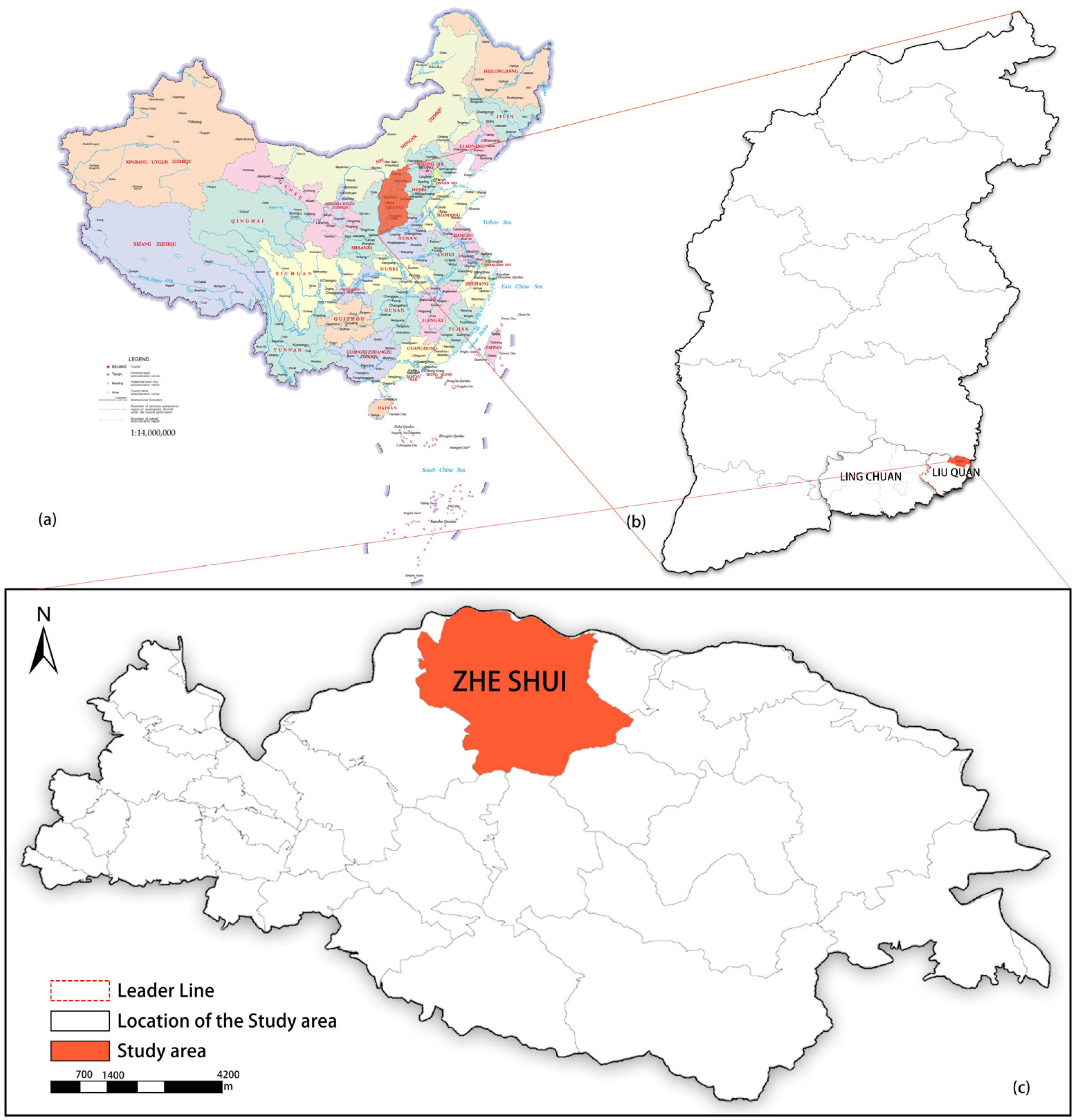
As shown in Figure 1, Zheshui village, a Ming–Qing settlement on the Shanxi–Henan border, represents a classic northern Chinese mountain village. Nestled in the Qi River Basin amid Xiongshan and other peaks, it shows terrain-adaptive features such as fengshui-based layouts and sun-facing terraced dwellings. The village preserves unique vernacular architecture with earth-stone-wood structures and two-story houses.
Designated in the fourth batch of Chinese national-level traditional villages, Zheshui village has functioned historically as a post station along the Ming–Qing dynasties’ Shanxi–Henan trade route. The village preserves notable traditional architecture: 17 Ming–Qing period residential structures, a Ming-era Guanyin Temple, the Yangma Ancient Road site, and contemporaneous commercial remnants. After the 2020 opening of Taihang No. 1 Tourist Road, it reached the AAA-level scenic area status in 2023. By 2024, tourism revenue exceeded 20 million yuan, with a corresponding increase of 200,000 yuan in collective village income. Against the backdrop of urbanization, traditional villages face homogenization and diminished economic vitality. In this context, Zheshui village stands out as a successful example of integrating heritage conservation with contemporary development. It serves as a representative case for studying how authenticity preservation and innovative revitalization can coexist in traditional settlements. In terms of physical form, Zheshui village is characterized by stone-and-wood houses and a shop-front-residence-behind layout. These features represent adaptive responses by villagers to the local mountainous terrain. The construction of road networks facilitates the exchange of information and materials. This, in turn, drives the evolution of functional spaces and architectural distribution within the village. The preserved ancient buildings date back to the Ming and Qing dynasties. While their fundamental typologies have remained consistent over time, variations in architectural details and courtyard arrangements collectively constitute a typical rural CAS.
Moreover, Zheshui village exhibits universal characteristics common to traditional mountain settlements in northern China. These include terrain adaptation, vernacular construction techniques, traces of clan-based settlement, and a historical link to trade routes. At the same time, the village has undergone a complete lifecycle and achieved a successful contemporary transformation. Its well-preserved historical fabric provides tangible evidence for elucidating general CAS principles and dynamic evolutionary processes in traditional settlements.
Therefore, this research takes Zheshui village as a case study. It translates three key revealed mechanisms into objectively measurable variables: “agent response”, “tag-based clustering”, and “internal models”. This approach aims to provide new insights for the conservation and development of traditional settlements in China and similar contexts across Asia.

2.2. Data Sources

This study established a geospatial database by synthesizing field surveys, government planning documents, and multisource spatial datasets. Precise administrative boundaries at the provincial, municipal, and county levels were delineated via DataV. The GeoAtlas platform (https://datav.aliyun.com/portal/school/atlas/area_selector (accessed on 13 September 2024)) was used, while township- and village-level boundaries were extracted from official records of the Zheshui Village Committee, referencing the “Lingchuan County Zheshui Village Traditional Village Protection Plan.” A high-resolution satellite image from Google Earth (Map Type: Hybrid; Zoom Level: 17; Approval No.: GS (2019)1709; Acquisition Date: 21 August 2024; Image Size: 17,664 × 14,848 pixels) served as the base spatial reference. The associated GeoTIFF file containing data in the Web Mercator projection was imported into QGIS 3.18 and reprojected via bilinear resampling. The accuracy of the coordinate transformation was validated via the use of building corner points as control features. On this georeferenced base map, precise mapping of settlement patterns, building footprints, and infrastructure networks was conducted to enable comprehensive spatial analysis.
This dataset provides detailed building metadata, including construction dates, structural characteristics, and public facility locations.
Primary data were obtained through field surveys during two key selected periods—April and October 2024—to capture high visitor volumes and distinct seasonal conditions. The surveys were conducted in April, coinciding with China’s peak “spring outing” visitor period, and in October, which provided contrasting seasonal landscapes and the National Day holiday—both periods enabling representative sampling under high tourist volumes. The April survey combined questionnaire distribution, architectural recording, and archival review of the Zheshui Village Traditional Village Protection Plan, local government records, and regional historical documents. The October survey included observational sampling to supplement the questionnaire data. This two-phase design allowed for spatiotemporal cross-validation, strengthening dataset integrity. All the data sources are summarized in Table 2.

2.3. Study Methods

(1) Point Level: Architectural Research Methods
As the fundamental unit of traditional villages, individual buildings aggregate and exhibit hierarchical emergence, ultimately shaping the material spatial environment of these settlements. This paper analyzes this point element through the following approaches:
  • Point density analysis
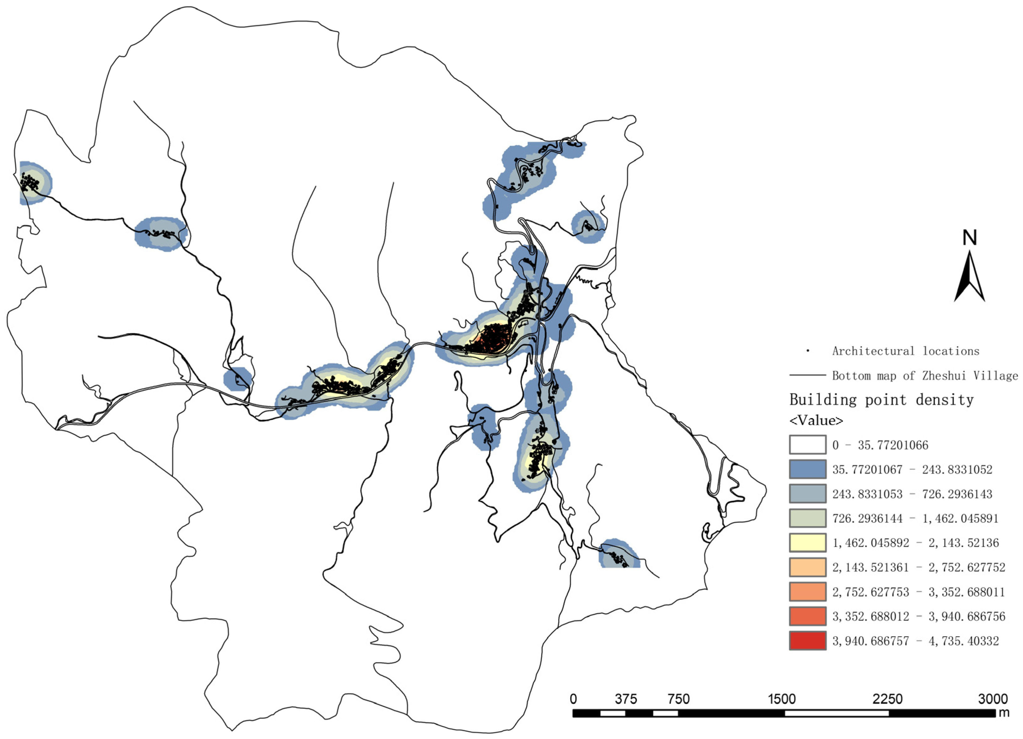
The point density analysis calculates the density of point features around each output raster cell. This computational method produces spatially explicit density visualizations that effectively characterize the clustering patterns of point elements [37]. The calculation formula is as follows:
D ( x , y ) = 1 A i = 1 n P i f ( d i )
where D ( x , y ) is the density value of the output raster image element at position ( x , y ) ; A is the area of each output raster image element; n is the number of input points that fall within the neighborhood of each output raster image element; P i is the value of the i point (if the population field is used); d i is the distance from the i point to the center of the output raster image element; and f ( d i ) is the distance decay function, which is usually a distance-based function, e.g., f ( d i ) = e d i .
2.
Integration of Field Surveys and Questionnaires
Data from preliminary fieldwork and Centmap, including questionnaires, interviews, hand-drawn maps, literature, and satellite imagery, were imported into CAD 2020 to map building typologies, node distributions, road networks, and building layouts in these villages for subsequent analysis.
(2) Line Level: Road Research Methods
  • Spatial syntax
Space syntax represents a graph-theoretic methodology that quantifies spatial configuration relationships through topological representations, where spatial units are modeled as nodes and their connections as edges [38]. Integration serves as a critical measure in spatial syntax, quantifying the degree of spatial aggregation or dispersion in a defined area. A higher integration value suggests a more compact and accessible spatial layout, which in turn leads to the emergence of a prominent central feature. The mathematical representation of the integration is provided as follows:
I n t = 2 ( D a 1 ) a 2
where I n t is the degree of integration, a is the total number of axial lines or nodes, and D a is the average depth.
Degree of selectivity: This metric quantifies the frequency with which the shortest topological distance between two nodes intersects a specific spatial region. It evaluates the significance of spatial units as preferred travel routes, thereby providing insight into the likelihood of space traversal. Consequently, locations with higher selectivity values are more likely to attract substantial pedestrian and vehicular traffic, increasing the probability of such traversal. The formula for calculating this metric is as follows:
D x = j = 1 k 1 L j ˙
where k is the number of axes directly connected to x and L j ˙ is the connection value of axis i .
On basis of the detailed texture map of Zheshui village, a spatial axis diagram was constructed via CAD 2020 software and subsequently imported into Depthmap + Beta 1.0 to calculate global integration and connectivity for analyzing traditional road characteristics.
2.
Box-counting method
The box-counting method provides a precise approach for measuring spatial fractal dimensions. It works by overlaying the fractal structure with grids of varying scales, counting the occupied cells at each level, and calculating the dimension through scaling relationship analysis [39]. This method achieves accuracy through iterative grid refinement and multiscale pattern quantification. The formula for this computation is articulated as follows:
D = l i m ϵ 0 log ( N ( ϵ ) ) log ( 1 ϵ )
where D is the fractal dimension; N ( ϵ ) is the number of boxes, and the size of a box is ϵ ; ϵ is large enough to cover the entire fractal object; and ϵ is the length of the box edges, which converge infinitely toward 0.
High-resolution satellite imagery of Zheshui village, obtained through the Centmap platform, was seamlessly integrated into CAD 2020 to generate a detailed settlement road network map. Rigorous fractal dimension analysis was conducted at multiple scales to assess the complexity and coverage of the road network. Scales of 1:15 and 1:3 were selected to examine all road configurations as well as roads within three distinct building clusters in Zheshui village. These maps were subsequently imported into ImageJ 1.54 p software, where the Box Counting plugin was applied to binarized images to calculate the fractal dimension. The parameters were set as follows: the grid size started at one-quarter of the short side of the image and decreased geometrically with a common ratio of 2 until reaching 2 pixels. Specifically, a sequence of 11 non-uniform scales—64, 48, 32, 24, 16, 12, 8, 6, 4, 3, and 2 pixels—was used to provide higher resolution at critical scales. At each scale, the number of non-empty grids covering the target was counted. Linear regression was performed on log(N) versus log(1/s), with the absolute value of the slope of the regression line taken as the fractal dimension Db. Only results with a regression coefficient of determination R2 > 0.99 were included in the analysis.
(3) Surface Level: Settlement Research Methods
  • Box-counting method
Village base maps at a scale of 1:3 and cluster base maps at 1:15 were imported into ImageJ 1.54 p. Enclosed building footprints were selected as the analysis objects, and the Box Counting plugin was used to calculate the fractal dimension. Parameter settings followed the description above. A double-logarithmic regression line was generated, and only results with a regression coefficient R2 > 0.99 were included in the analysis.
2.
Intelligibility
Intelligibility explores the intricate relationship between the local and the whole. Specifically, the intelligibility of a region is quantitatively assessed by the correlation coefficient that connects local and global integration [40]. This study employs Depthmap+ Beta 1.0 software to establish a linear regression model analyzing the relationship between global integration and local integration via a 3-step topological radius, generating scatter plots of the intelligibility coefficient R2 via the least squares method. The formula for this analysis is as follows:
R 2 = [ i = 1 n ( I i I ¯ ) ( I Σ I ¯ ) ] 2 i = 1 n ( I i I ¯ ) 2 i = 1 n ( I i I ¯ ) 2
where I i is the local integrality value of node i ; I is the average of the local integrality values; I i is the global integrality value of node i ; and I ¯ is the average of the global integrality.
A spatial axis diagram of the settlement was constructed in CAD 2020 and saved in DXF format. Global integration and local integration were then calculated in Depthmap+ Beta 1.0. The two datasets were combined to generate a scatter plot, and a linear regression analysis was performed within the software. The coefficient of determination (R2) represents intelligibility.
When 0.0 < R2 < 0.5, the local intelligibility is low; when 0.5 < R2 < 0.7, the intelligibility is more average; and when 0.7 < R2 < 1, the intelligibility is strong. The higher the R2 value is, the stronger the user’s ability to comprehend the global spatial configuration from localized positions [41].
(4) Integrated Output: Big Data-Driven Tourist Sentiment Analysis.
  • Introduction of Adaptive Agents
In CAS theory, system operation relies on the “internal model” of agents—behavioral patterns exhibited in response to various stimuli. In traditional villages, fixed architectural forms, road networks, and settlement layouts developed over extended historical periods represent spatial manifestations derived from dynamic adjustments by adaptive agents [42]. Zheshui village opened a tourist highway in 2020, became a “3A-level scenic area” in 2023, and recorded more than 500,000 visitors in 2024, far exceeding its resident population of 1220 (Source: Lingchuan County Government Public Information Network, accessed on 22 July 2025). Tourists have now replaced villagers as new adaptive agents shaping the village’s industrial model and development trajectory. Machine learning is employed to analyze the sentiment orientation of these adaptive agents, thereby forecasting spatial evolution trends.
2.
Machine Learning Methods
The biterm topic model (BTM) is a probabilistic generative model designed for topic modeling in short texts. Each document is represented as a mixture of topics, with each topic consisting of multiple biterms—unordered word pairs. By modeling the relationships between biterms, BTM captures nuanced term interactions more effectively than word-based approaches. Through training, it identifies key biterms within topics and their semantic associations.
The core innovation of BTM lies in its use of biterms as the modeling unit, which addresses the data sparsity issue inherent in short texts in traditional models such as LDA. This significantly improves topic coherence and stability. Its effectiveness makes BTM an ideal choice for social media analysis, real-time public opinion monitoring, and recommendation systems.
This study leverages major Chinese social media platforms (Douyin, Kuaishou, and Xiaohongshu) as primary data sources. The vast number of users, real-time evaluations, and user-generated content (UGC) offer distinct advantages over traditional feedback methods. Using Python 3.8 scripts, we systematically collected user-generated comments from video posts tagged “Lingchuan County Zheshui Village” and “Zheshui Village” from 1 January 2020 to 30 August 2024 (with sensitive information anonymized). After filtering irrelevant content, 3269 valid comments were extracted from the initial dataset (3852 entries), covering tourism experiences, transportation routes, and facility services.
To address the inherent brevity and lexical sparsity of UGC, we employed BTM for fine-grained information extraction and clustering analysis. By capturing biterm co-occurrence, the model effectively mitigates challenges posed by low information density and scarce vocabulary in short texts. Data processing involved loading data using Python 3.8, vectorization with scikit-learn, and BTM implementation via the biterm library [43]. The optimal number of clusters (1–12 topics) was determined through perplexity optimization, followed by 80 iterations of model training. Subsequent sentiment analysis via ROSTCM 6.0 software revealed emotional tendencies within topic clusters. The BTM results enabled the classification of data into structured thematic categories, facilitating further statistical analysis. Finally, quantitative analysis was conducted to calculate topic distribution and sentiment tendency scores, and visualizations generated via ECharts ensured intuitive data interpretation.
From a CAS perspective, the relationship between the built physical space and humans can be described as follows: adaptive agents shape space, and the physical space in turn informs the adaptive strategies of the agents. Tourism development, as an environmental disturbance factor, has altered the economic, cultural, and social context of Zheshui village, triggering a shift in the core adaptive agents from villagers to tourists. The essence of this change lies in the agents’ active transition from “using space to adapt to livelihood” to “transforming space to adapt to consumption”.
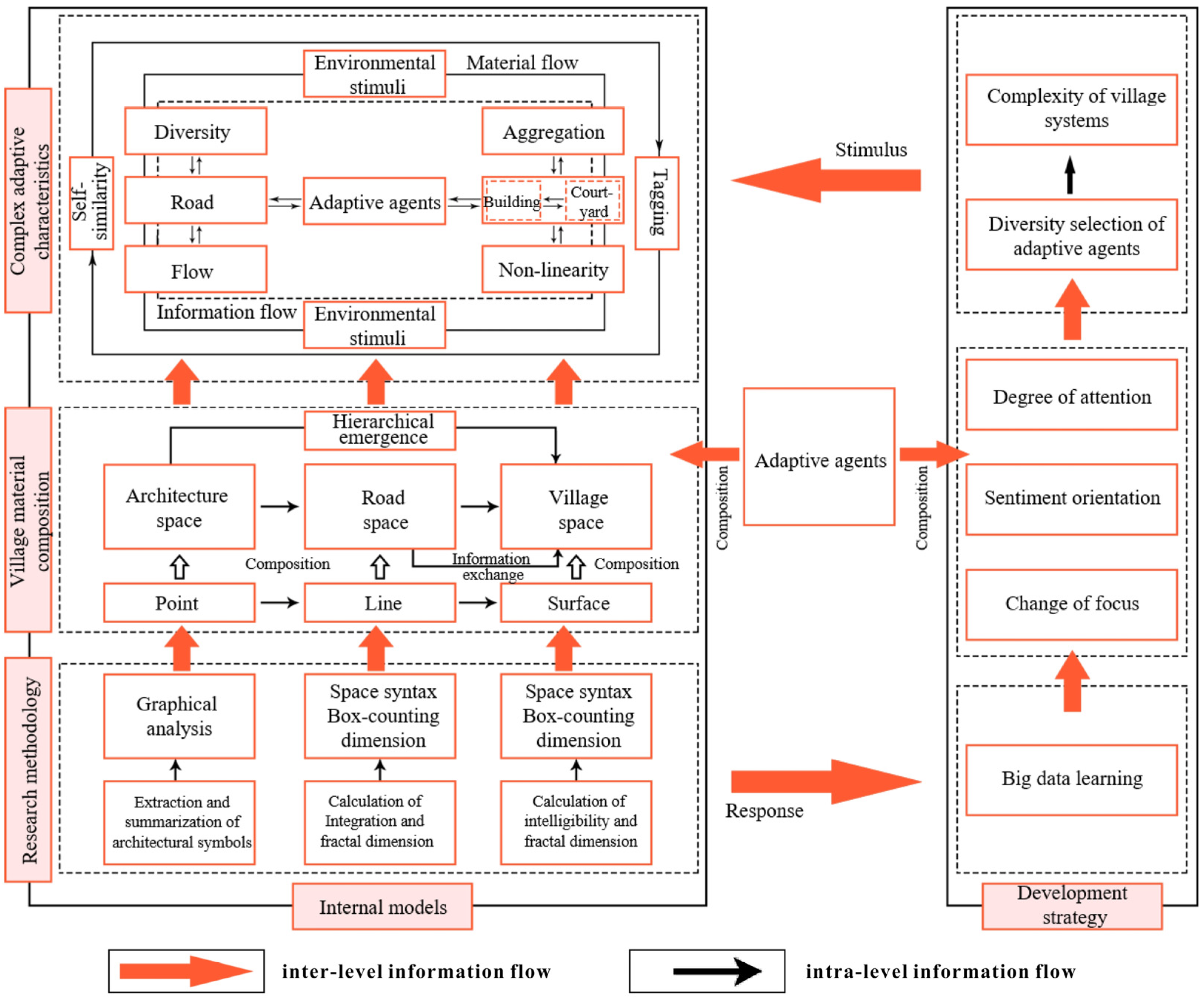
Accordingly, this study applies quantitative methods to Zheshui village, including graphic analysis, space syntax, and box-counting dimension, and proposes a framework for quantitatively analyzing the complex adaptability of traditional villages and predicting their development:
First, villagers and tourists are treated as adaptive agents within the framework. Through quantitative analysis at three scales—point (individual buildings), line (road networks), and area (village form)—individual buildings are considered building blocks that aggregate through distinctive tags (e.g., decorations, structures). Various flows of information are transmitted via roads to different nodes, where the agency of the agents leads to nonlinear interactions, ultimately giving rise to diverse village layouts. The resulting configuration of buildings, roads, and settlement patterns collectively constitutes the internal model of the village.
Second, by integrating big-data-driven sentiment analysis of tourists (new adaptive agents), we employ an internal model—a CAS-based, structured response to external stimuli—to predict and guide future development. The research framework is detailed in Figure 2.

3. Results

3.1. Point Dimension: Blocks and Tags for Architecture

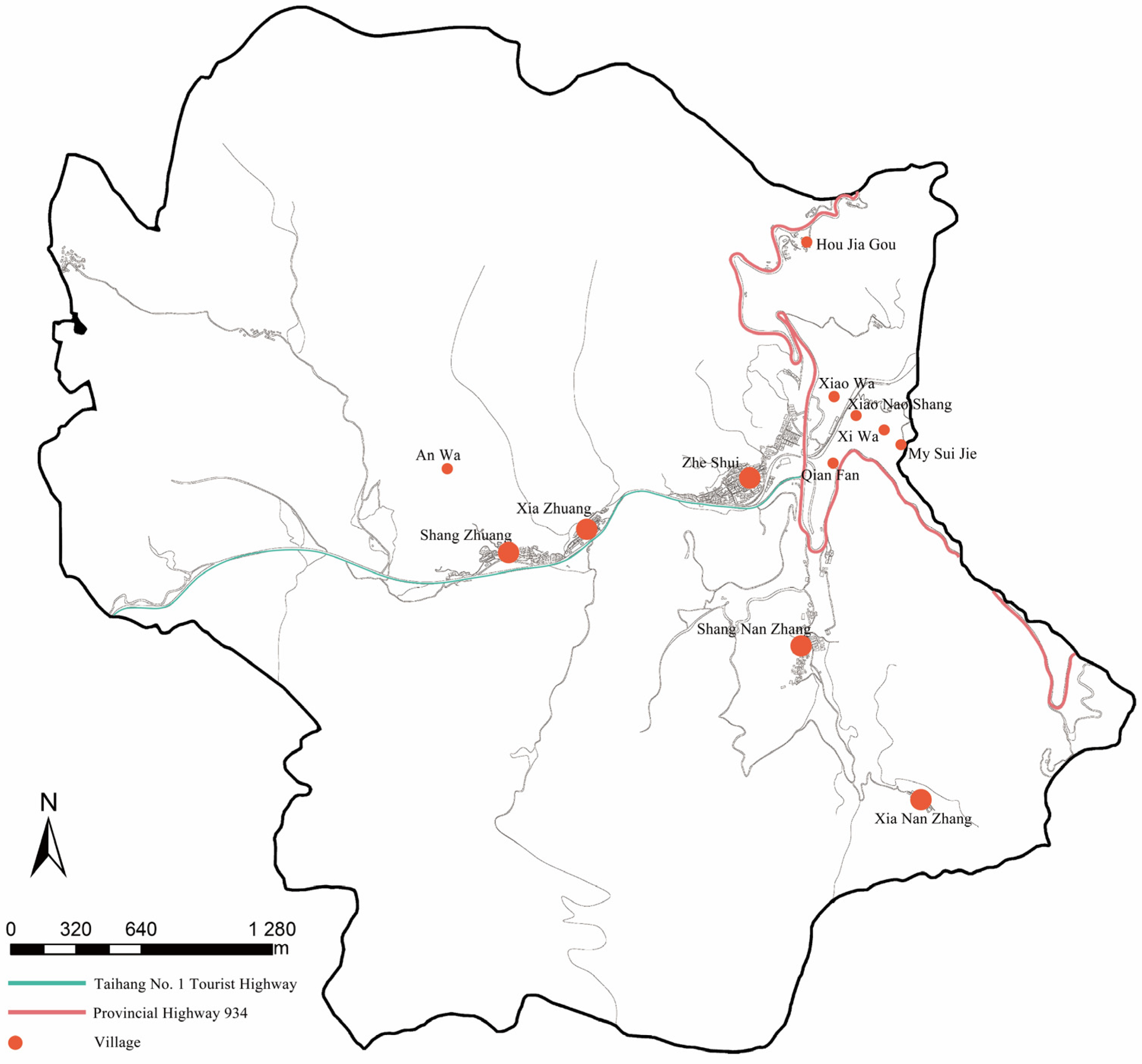
As a historical commercial nexus along the Yangma Old Road during the Ming–Qing period (1368–1912 CE), Zheshui village evolved from a merchant-driven settlement into an architecturally distinctive ensemble of residential courtyard complexes. After 1949, administrative reorganization designated Zheshui village as a governance hub for twelve natural villages, including Houjiagou, Xiaowa, Xiaonaoshang, Xiwa, Mysuijie, Qianfan, Zheshui, Shangnanzhang, Xiananzhang, Xiazhuang, Shangzhuang and Anwa. As illustrated in Figure 3, the architectural forms, node distributions, road networks, and village distributions of these villages were delineated via satellite imagery obtained from a Centmap and plotted in CAD 2020.
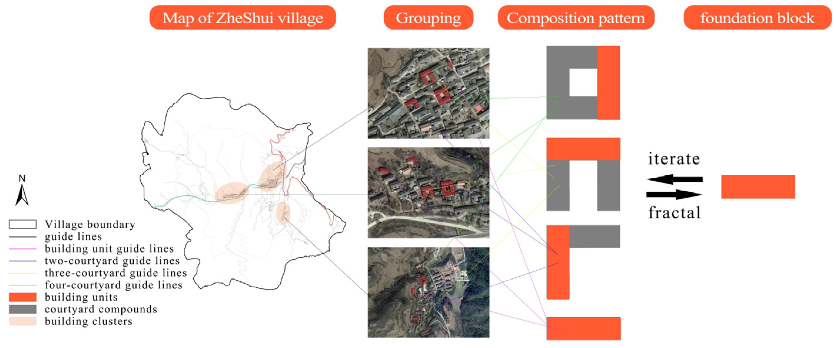
Most villages were unsuitable for study because of economic decline, poor accessibility, substantial structural degradation, and population depletion. Three optimally preserved, high-density architectural clusters were selected: Zheshui village, the Shangnanzhang group, and the contiguous Shangzhuang–Xiazhuang group (Figure 4). The analysis revealed four prototypical courtyard typologies in the settlement:
The enclosed courtyard: Enclosed on all sides, this form exhibits strong closure and a pronounced hierarchical order. The buildings are arranged along a central axis, with the main house, a two- or three-story brick building, situated at the center. The first floor is for living, and the second floor is for storage. The departments on either side house the younger generation in two-story brick-cut or brick-sandwich rammed earth wall buildings. The narrow, high doorway is characterized by ornate wooden decorations and intricate carvings, symbolizing the family’s wealth and power.
Three-sided courtyards: Enclosed on three sides, this form combines enclosure and order with a more flexible layout. It is the most prevalent in Zheshui village and is characterized by lower costs, making it suitable for most residents. The buildings are oriented north–south to optimize lighting, with the south window opening and the door facing south. However, the stores along the east–west Yangma Old Road have doors opening in opposite directions, exemplifying the villagers’ prioritization of economic activities over living comfort.
The “L”-shaped courtyard: Enclosed on two sides, this form is cost-effective and space-efficient. The main house is located on the north side, with secondary rooms on the east or west side. Paradoxically, this courtyard typology has the lowest distribution density within the affluent context of Zheshui village, despite its cost-efficient construction characteristics.
“I”-shaped courtyards: Predominantly constructed in the past decade, these freestanding residential units employ nonenclosed configurations where architectural volumes demarcate courtyard boundaries. Characterized by cost-effective construction and minimal ornamentation, their siting demonstrates adaptive responsiveness to roadway networks and topographic conditions.
The analysis revealed that the basic residential unit of Zheshui village consists of a fundamental “—”-shaped unit. Horizontal replication forms a “—”-shaped architectural combination; vertical replication forms an “L”-shaped structure; axial symmetry forms a “π”-shaped three-sided enclosing structure; and center symmetry forms a typical “U”-shaped courtyard structure (Figure 5). This demonstrates that, irrespective of the complexity of courtyards and building organizations, they all originate from the deformation and replication of basic units—a characteristic of building blocks in a CAS.
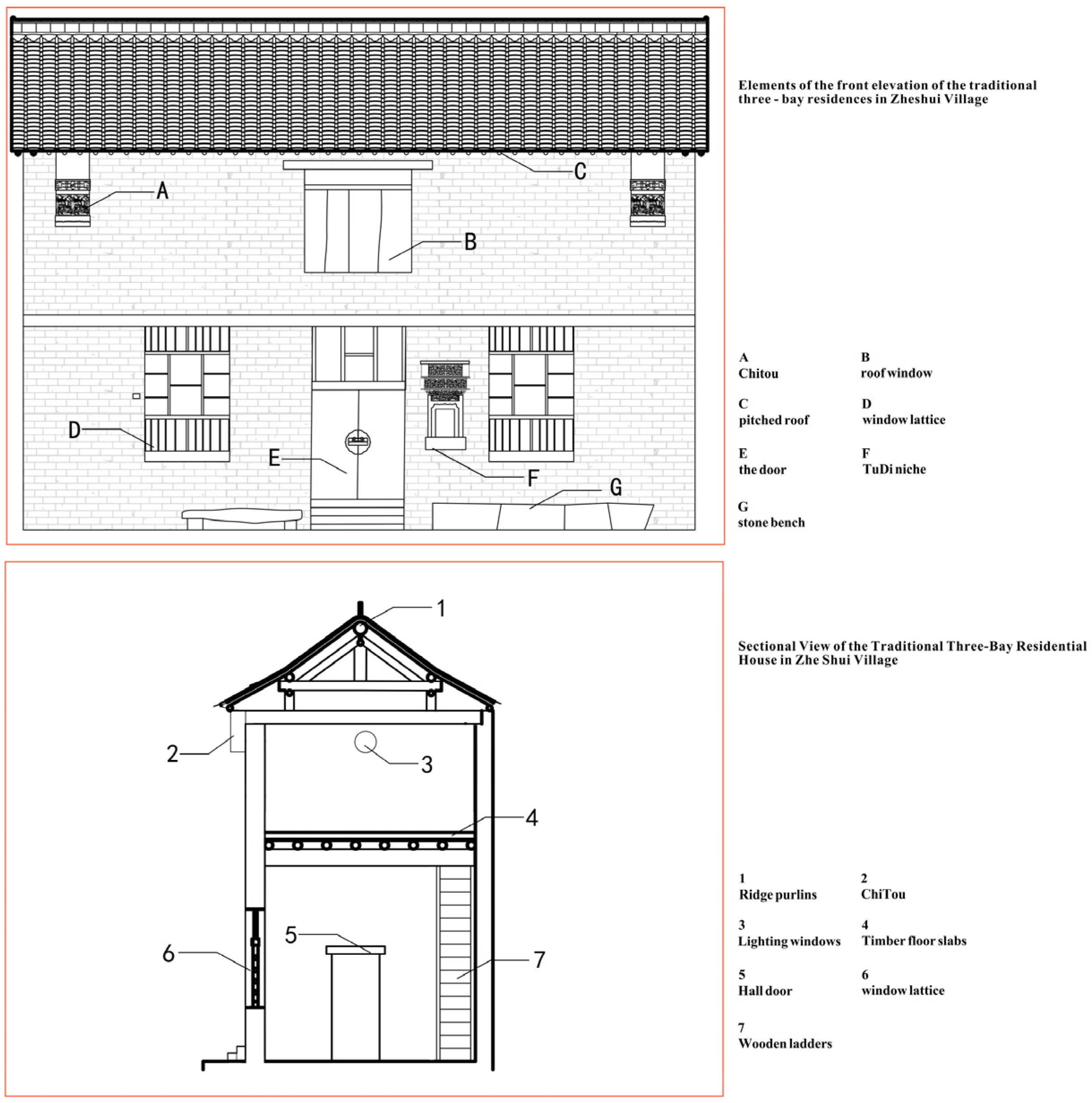
This study systematically documents and analyzes the architectural characteristics of Zheshui village, Lingchuan County, on basis of field surveys, photographic documentation, and official preservation plan data. Architectural investigations identified a uniform anchoring system and various architectural subsystems throughout the village, demonstrating interactions between local culture, the environment, and socioeconomic factors. Figure 6 shows this structural system through a typical three-bay residential façade comprising a green tile hip roof, two-story construction, a second-floor balcony, a lighting window, a main entrance, and a roadside shrine. The building employs a post-and-lintel roof structure. The first floor serves as a living space with elevated ceilings and a ladder-access opening in wooden flooring, whereas the second floor functions as a storage space with a reduced ceiling height and minimal lighting.
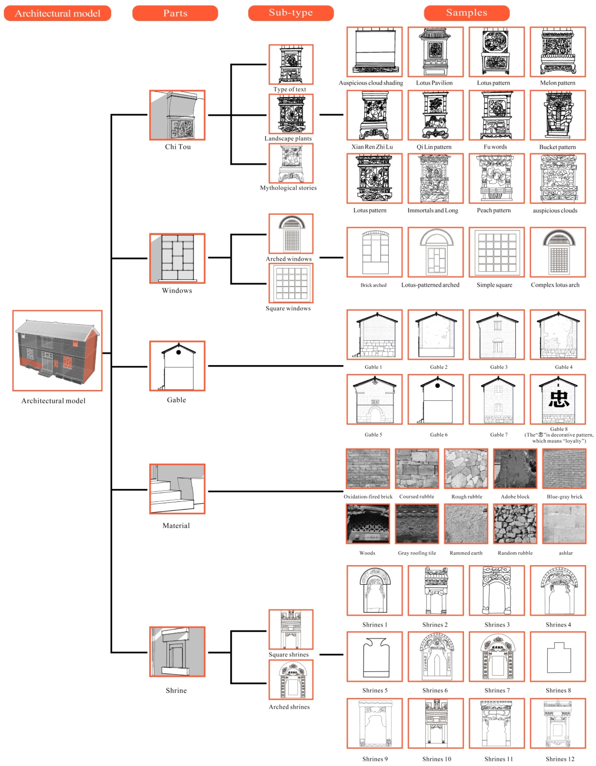
Figure 7 depicts the diverse architectural subsystems, which are classified as eaves, windows, walls, building materials, and shrines. Shrine styles feature three distinct themes on basis of carving patterns: auspicious motifs, landscape plants, and humanities narratives. Windows are arched or rectangular, adorned with brick carvings around the edges, and fitted with wooden lattices. The wall styles and materials vary considerably; examples include a lower stone base with rammed earth walls, a combination of a lower stone base with rammed earth sides and brick walls above, full-face brick walls, rammed earth brick walls, and adobe bricks combined with brick walls. The construction materials used include oxidation-fired brick, cracked rubble, rough rubble, adobe block, blue–gray brick, wood, gray roof tile, rammed earth, random rubble, and ashlar. Shrines are arched or rectangular, distinguished by specific carving patterns and constructed from various materials. They offer a unified framework for the village to differentiate, specialize, and integrate its distinctive features. The architectural form of traditional dwellings in Zheshui village exhibits a consistent typology—characterized by two-story structures, fixed chitou (wall-end decorative block) positions, uniform window patterns, a shrine niche to the right of the main entrance, and a standardized structural layout. This distinct typology functions as the “tag” in CAS theory, enabling group categorization and boundary formation. At a finer subsystem scale, however, variability persists in construction details, materials, and individual components.

3.2. Linear Dimension: Flow and Diversity of Settlement Roads

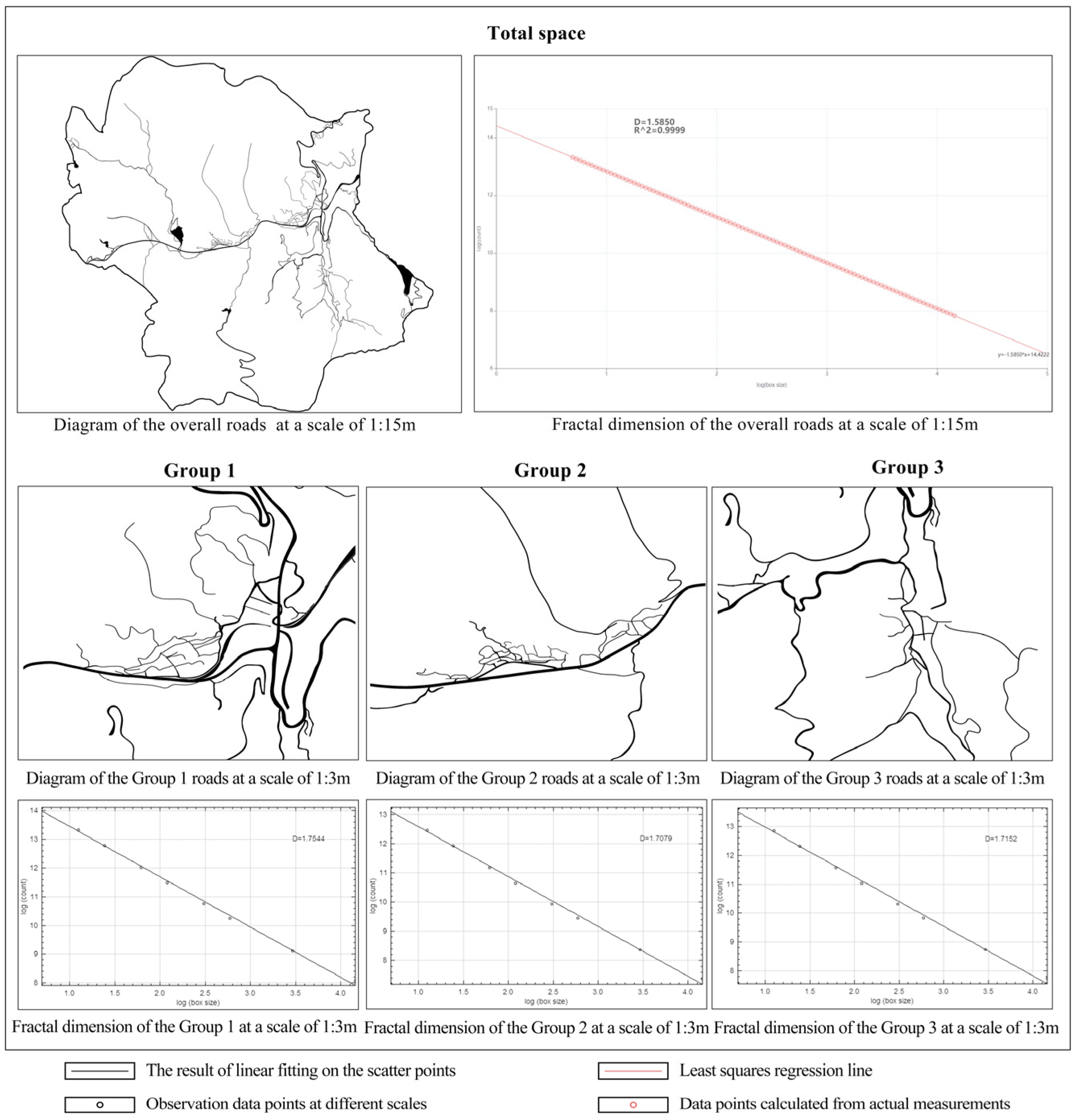
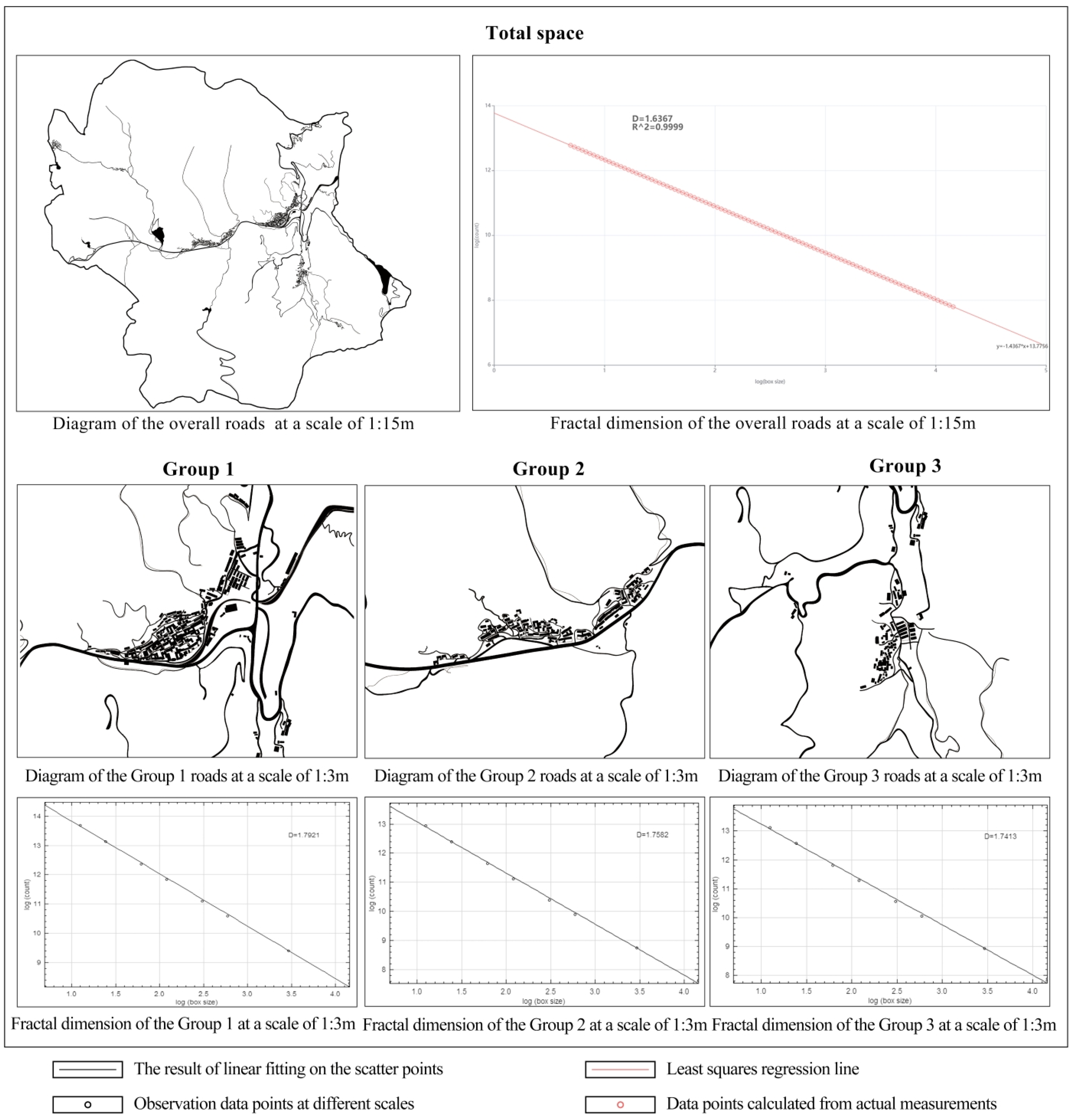
Fractal analysis of the settlement road network was conducted via ImageJ 1.54 p, with the resulting fractal dimensions presented in Figure 8. Generally, a fractal dimension exceeding 1.4 indicates a well-integrated, net-like road network with high connectivity and accessibility, whereas a fractal dimension above 1.2 suggests average coverage with a less dense, tree-like branching structure [44]. The analysis reveals that Zheshui village’s road network has a fractal dimension of 1.585 (R2 = 0.999), demonstrating superior spatial coverage characteristics. The fractal dimension measurements of the road networks in the three residential clusters reached 1.754, 1.708 and 1.715, respectively, which were markedly greater than the road network dimension of 1.585. This dimensional difference clearly demonstrates scale-dependent variations in the road system configuration. As the observation scale decreases, the network displays both greater coverage density and an increasingly interconnected mesh-like structure. These findings provide quantitative evidence for the hierarchical organization of the road network, where finer scales develop more complex connectivity patterns characteristic of mature network systems.
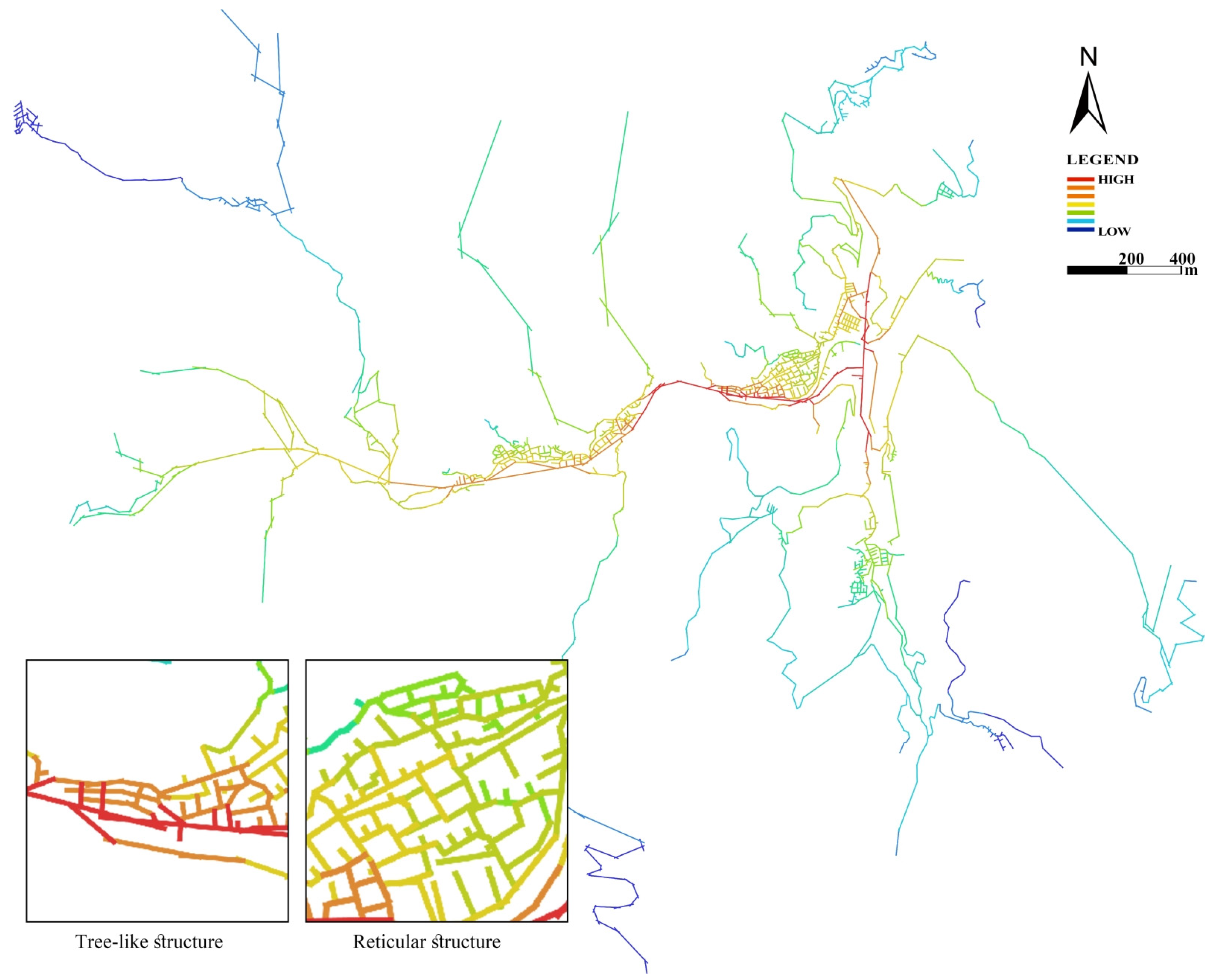
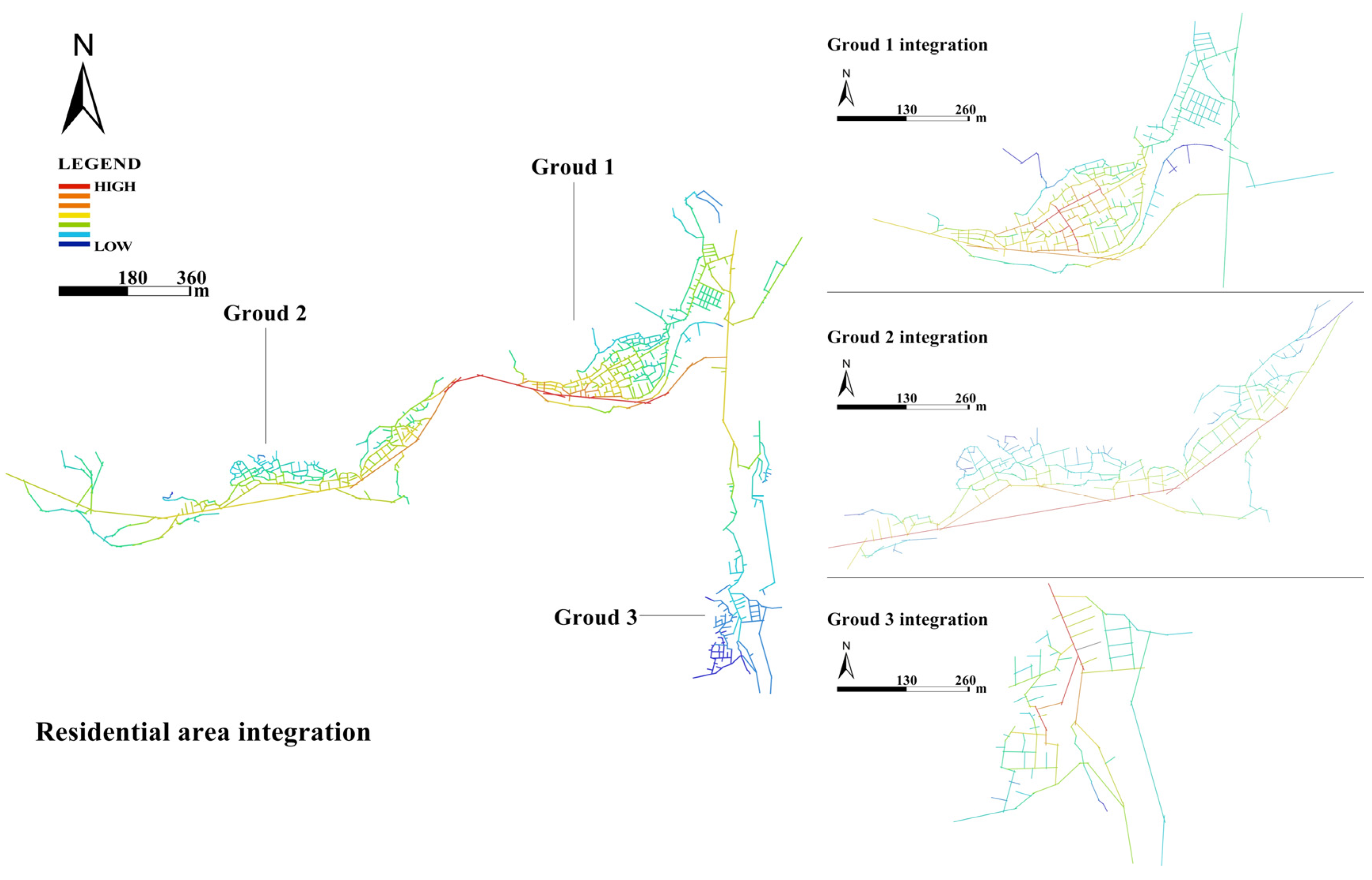
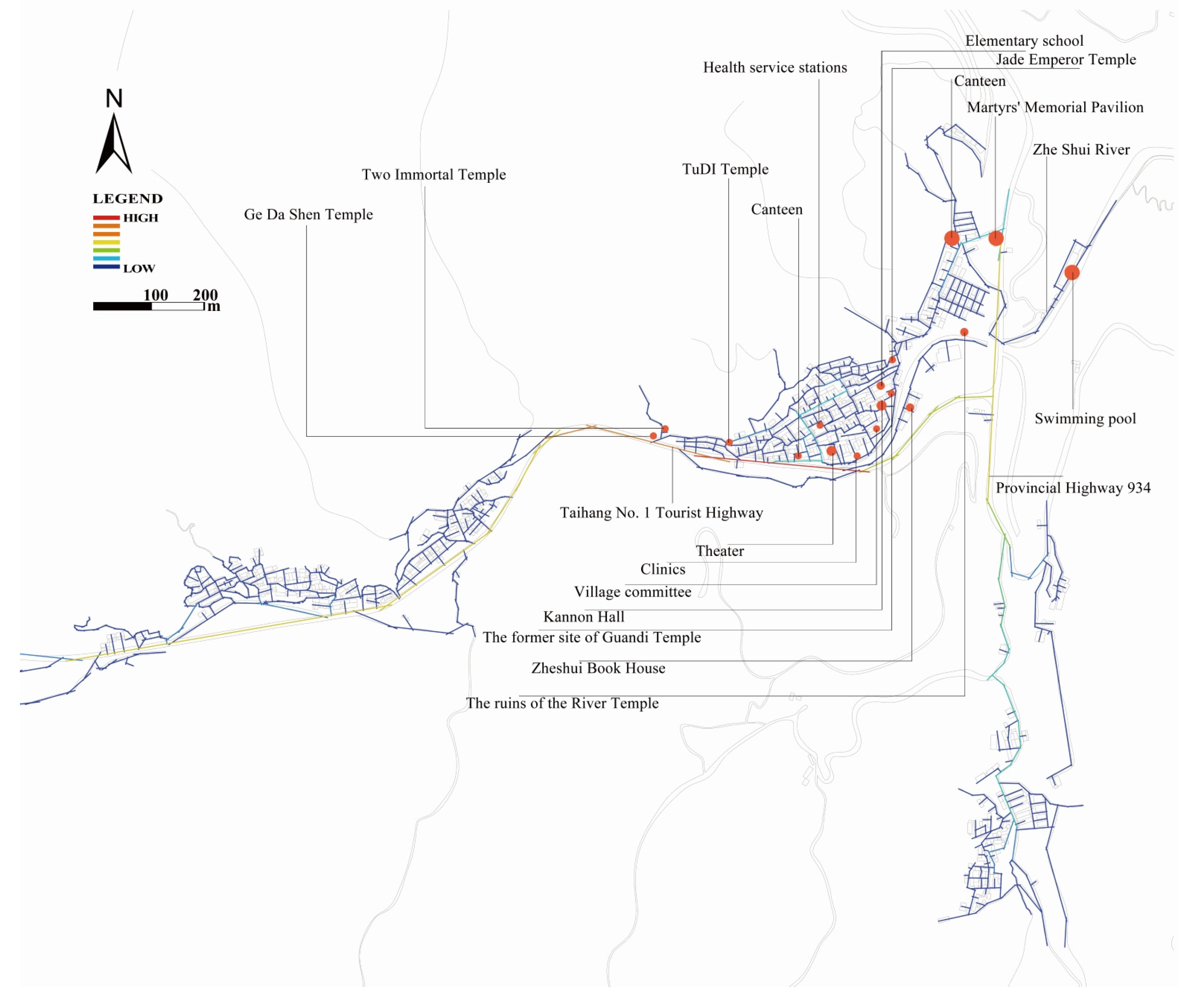
The selectivity data were then overlaid with the geographical locations of public buildings in the village, and the resulting findings are presented in Figure 9, Figure 10 and Figure 11.
During the late Ming and early Qing dynasties, the Yangma Old Road spurred commercial development in Zheshui village, gradually forming a complex road network shaped by its three-tiered elevation gradients, creating triangular forks and fragmented pathways near the main route. In 2018, Jincheng city established the Taihang No. 1 Tourist Highway from Zheshui village as part of a provincial tourism strategy, positioning it at the intersection of Provincial Highway 934 and the new highway. This elevated transportation access transformed the village into a tourism hub, with villagers developing guesthouses and restaurants and concentrating new constructions along the two main routes. As shown in Figure 9, Taihang No. 1 Highway and Provincial Highway 934 exhibit peak integration, whereas bifurcation roads demonstrate greater connectivity and accessibility than mesh roads do, reflecting the adaptive evolution of the network.
Selectivity, defined as the frequency of node occurrence on the shortest topological paths, quantifies the degree of spatial network interconnection. In Zheshui village, we observe that building clusters located along the main road exhibit a notably higher degree of selectivity. This hierarchical pattern is most evident in three road segments that achieve maximal selectivity: (1) the Taihang Highway No. 1 alignment, (2) the principal axial roads, and (3) the Yangma Old Road segment traversing the village core. Serving as Zheshui village’s primary tour bus terminus, the western entrance (Erxian Temple) constitutes a pivotal spatial hub. The area surrounding this entrance demonstrates maximal building density and optimal accessibility, supporting concentrated commercial development (retail stores, souvenir shops, and dining facilities). Peripheral main roads exhibit measurable selectivity; however, their indices are reduced relative to those of the entrance corridor. This reduction can be attributed to the village’s annular spatial configuration and the topological disconnection of peripheral structures from arterial networks. This spatial logic extends to the Yangma Old Road segment, which focuses on critical public infrastructure (Tudi Temple, theater, Kannon Hall, village committee, Zheshui Bookstore, Guandi Temple) and supports daily communal activities. These intersections reflect enhanced functional connectivity and serve as convergences for ritual, commercial, recreational, social, and educational activities. Here, diverse information and material resources converge and interact, systemically shaping resident outcomes. This multifunctional overlap—particularly between selective routes and public informational nodes—explicitly captures the flow characteristics embedded within the road network.
The road network adapts dynamically to socio-economic demands through ongoing local spatial practices. This process, where peripheral areas preserve connectivity while core corridors intensify under growing activity, reflects the functional diversity central to CAS theory. Consistent with CAS theory, distinct spatial functions produce corresponding road morphologies: linear patterns prevail in open and cultivated zones, whereas dense mesh structures emerge at village entrances, ancient pathways, and other high-activity public spaces. This agent-driven morphological diversity directly informs strategies for heritage conservation and adaptive reuse.

3.3. Faceted Dimensions: Nonlinearity and Self-Similarity in Clustering

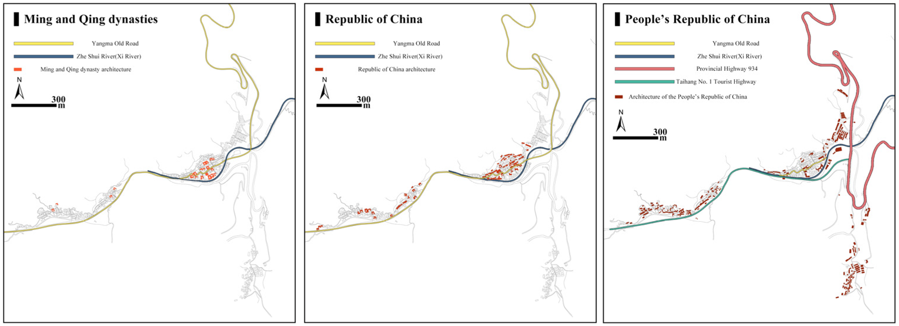
Zheshui village provides a compelling model for studying the morphological imprint of economic transitions on traditional settlements. Three developmental phases demonstrate this dynamic interplay. During the Ming–Qing period, Shanxi Merchants’ transregional trade networks catalyzed unprecedented economic growth, concentrating dense architectural clusters along Yangma Old Road. The Yang Millionaire Manor exemplifies this period’s spatial logic and is situated at the road–river nexus to control regional commerce. After 1912, economic reorientation toward agriculture and traditional medicine production shifted construction to northern farmlands while maintaining Yangma Old Road’s structural dominance as a connectivity backbone. Recent heritage commercialization efforts have manifested in large-scale infrastructure projects along Taihang No. 1 Tourist Highway and Provincial Highway 934. Modern architectural complexes now coexist with indigenous vernacular structures, reflecting the dialectic between preservation and economic exploitation. Methodological rigor underpins our analysis of these transformations. The integration of Centmap satellite imagery, CAD 2020-generated texture maps, and construction chronologies from locally validated preservation plans (Figure 12) enabled the quantification of spatial dynamics. The adaptive spatial transformation of Zheshui village is driven by the interdependence of economic transitions, transport-network evolution, and socio-environmental change. Their nonlinear interactions generate multiple distinct outcomes—a hallmark of complex settlement systems.
Self-similarity serves as a cardinal property of complex systems, wherein comparable structural patterns manifest across hierarchical organizational scales. This trait is particularly pronounced in the generative and developmental dynamics of Zheshui village, which serves as the focus of this study. The satellite imagery dataset sourced from Centmap underwent rigorous textural characterization via CAD 2020-assisted feature mapping. Following the observational scale (1:15 and 1:3), the preprocessed imagery was subjected to fractal analysis via ImageJ 1.54 p. The computational outcomes are visually encapsulated in Figure 13, which displays the global fractal dimension (D) calculated as 1.637 (R2 = 0.999). The settlements exhibit global fractal dimensions of 1.792, 1.758, and 1.741 for Clusters 1, 2, and 3, respectively. A low global-to-local variation (ΔDmax = 0.155) confirms structural self-similarity.
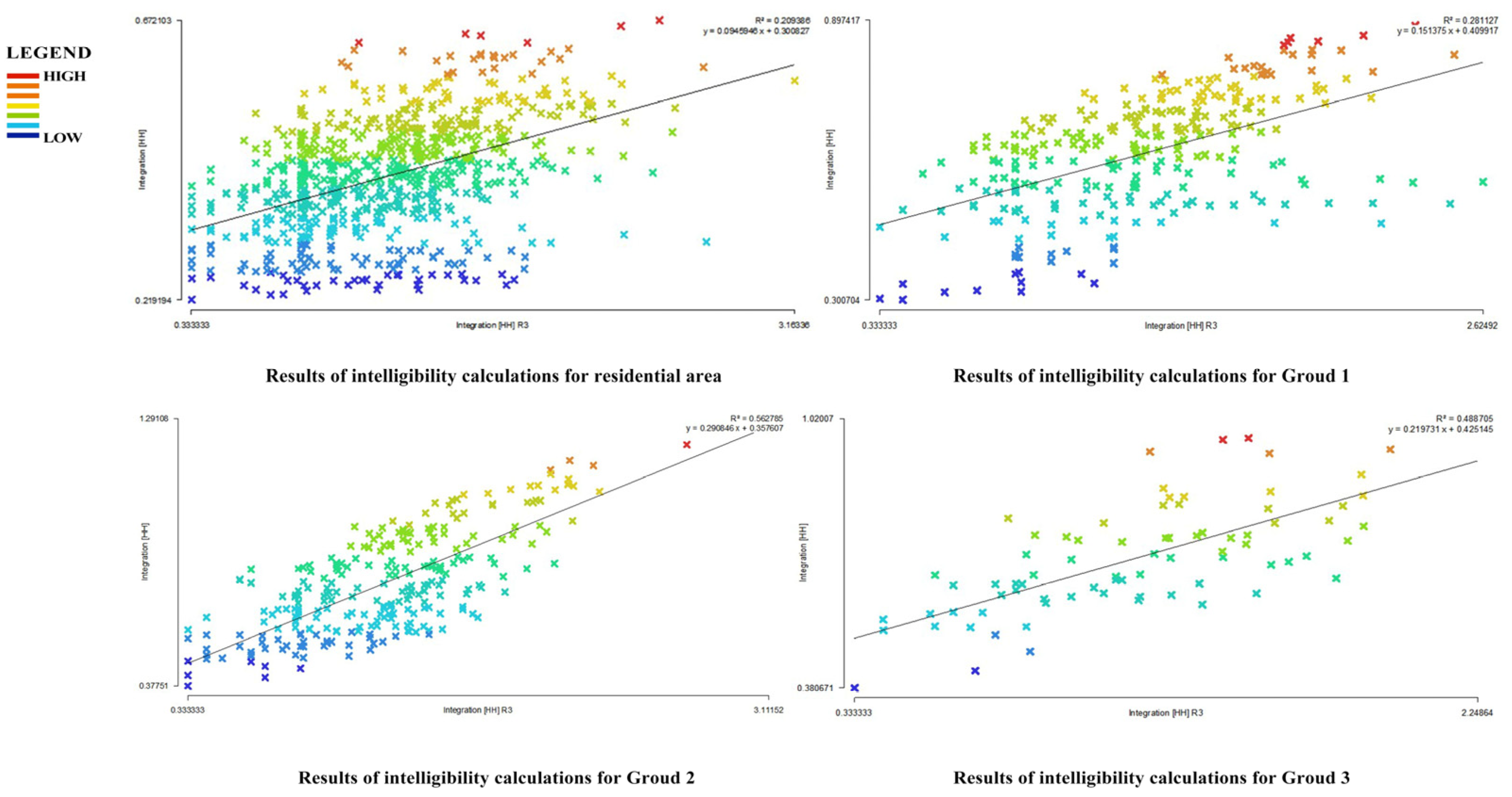
As shown in Figure 14, Zheshui village’s spatial intelligibility (R2 = 0.209) is significantly below the 0.5 benchmark, indicating spatially fragmented organization. Theoretical models predict that closer alignment between local and global fractal dimensions denotes structural self-similarity, whereas elevated spatial intelligibility implies cohesive integration of local spatial units in systemic frameworks. Empirically, increased spatial self-similarity is correlated with enhanced local-scale coherence. However, Zheshui village constitutes an empirical anomaly, demonstrating a dissociation between theoretical expectations and observed spatial patterns.
This study identifies three primary determinants of diminished spatial legibility in rural settlements through a hierarchical analysis of morphological evolution. Topographic constraints, encompassing mountainous terrain and arable land scarcity, necessitate irregular multi-cluster settlement configurations that inherently disrupt holistic structural cognition. Spatial fragmentation stems from village dispersion across heterogeneous landscapes, exacerbated by self-organized development, yielding tortuous road networks with cul-de-sacs. Temporal architectural dissonance arises from historical accretion of heterogeneous paradigms, progressively altering original road morphologies and creating cognitive dissonance between historical and contemporary spatial experience. The comparative case of Shangzhuang and Xiazhuang (Group 2) exemplifies morphological coherence effects: their densely aggregated, regularly configured building stock achieves significant spatial legibility (R2 = 0.563), demonstrating the legibility-enhancing potential of formal homogeneity. This counterexample underscores the cumulative impairment mechanism whereby topographic, fragmentation, and temporal factors synergistically degrade spatial orientation efficacy and environmental comprehensibility in traditional rural settlements.

3.4. Machine Learning: Analysis of Tourist Emotion Perception

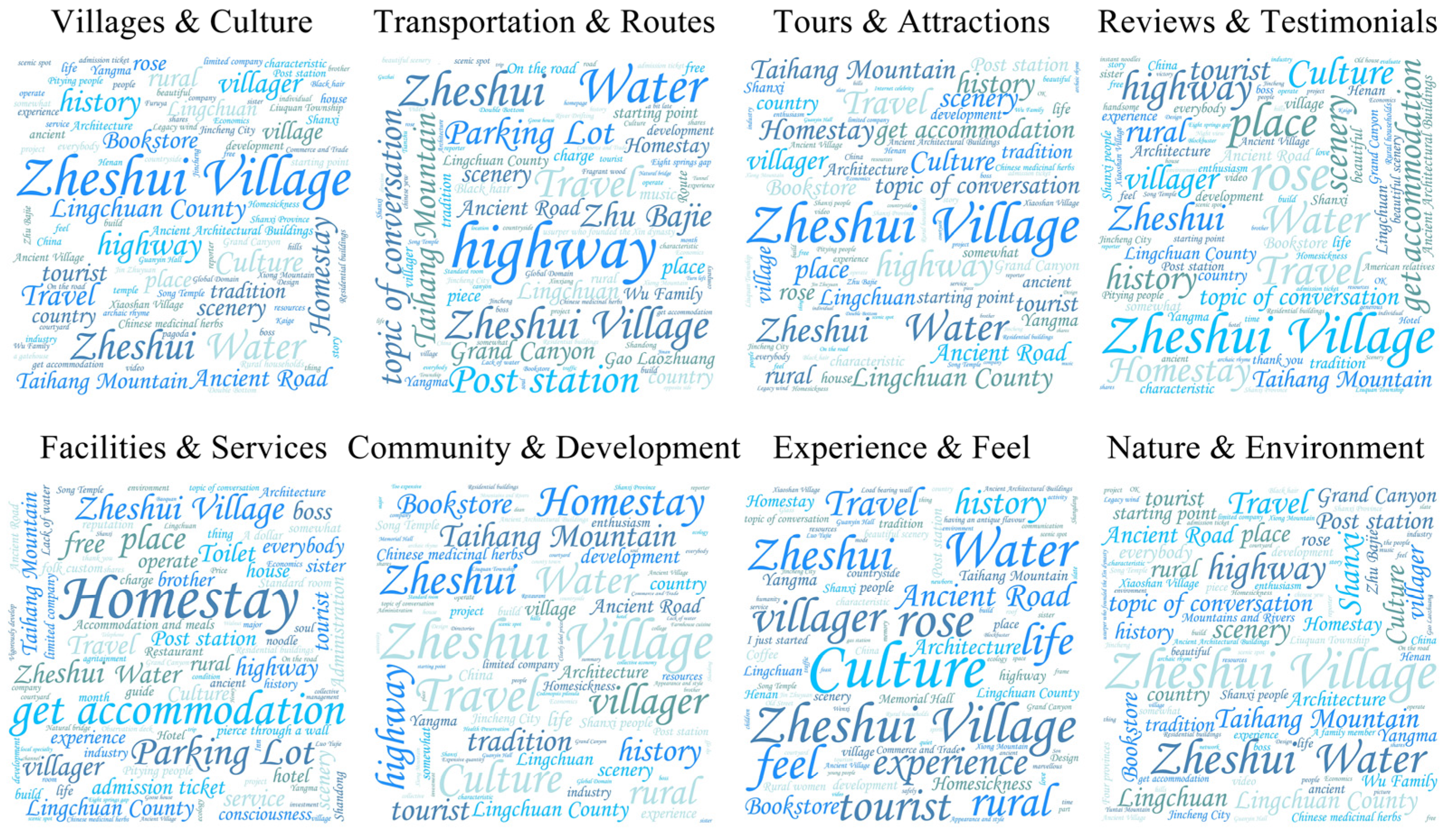
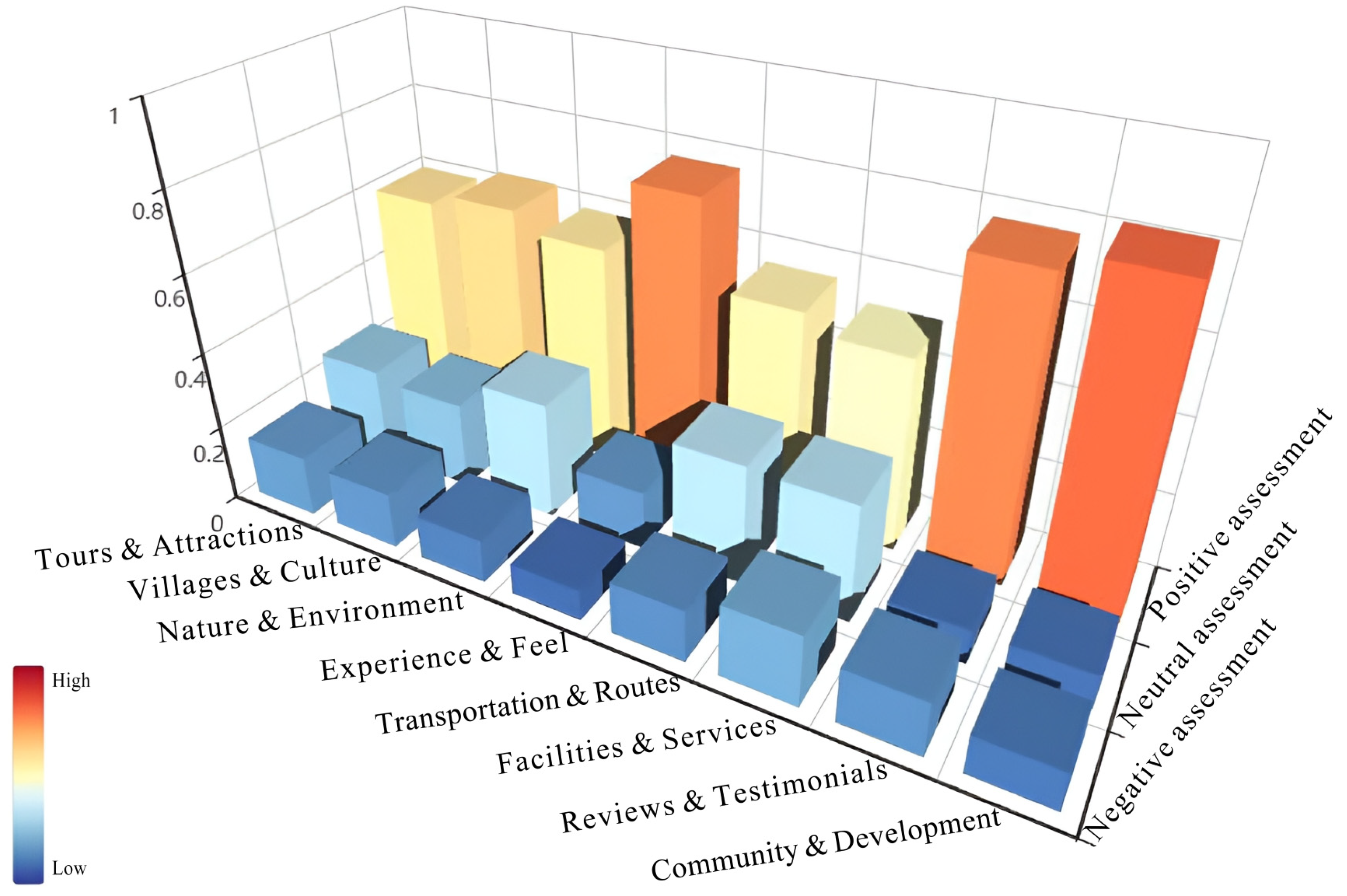
The semantic analysis using the BTM model automatically identified eight thematic clusters (Table 3, Figure 15), ranked by frequency: village & culture (27.4%), reviews & testimonials (18.1%), tours & attractions (15.8%), transportation & routes (10.6%), natural & environment (8.9%), community & development (7.7%), and facilities & services (6.0%). As shown in Figure 16, the color gradient indicates predominantly positive evaluations, suggesting destination coherence. Village and culture demonstrated the strongest positive engagement (62.55%), reflecting cultural heritage appreciation and developmental diversity. The experience and emotion themes showed a weaker focus due to price sensitivity and aesthetic factors, whereas facilities and services presented the highest percentage of negative evaluations (18.68%). Despite 76.94% overall positivity, this discrepancy highlights specific service gaps requiring attention. These findings quantitatively map tourist perception patterns, emphasizing cultural assets as primary emotional drivers while identifying service infrastructure as a critical improvement domain.
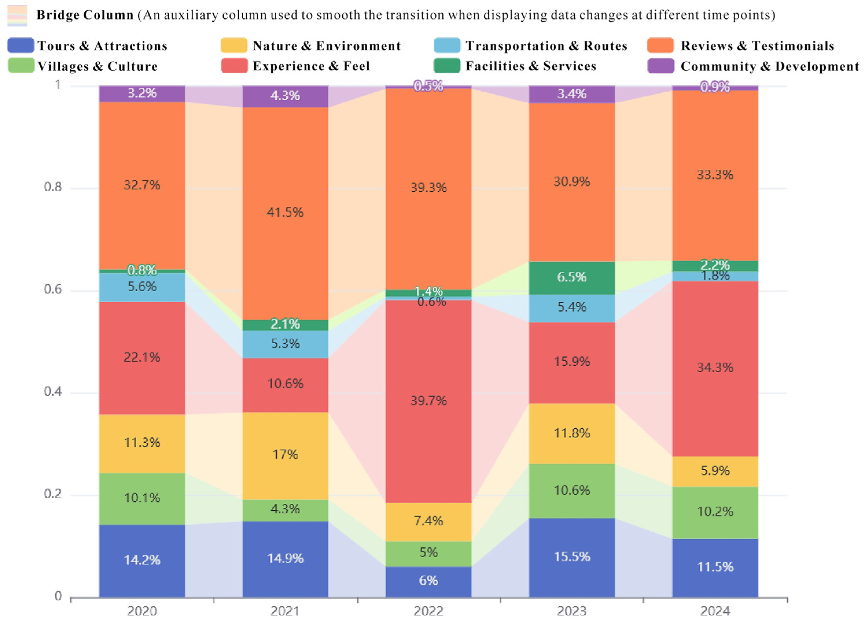
The temporal distribution of comments (1 January 2020–30 August 2024) enables annual proportional analysis in thematic clusters, reflecting shifts in tourist priorities (Figure 17). Throughout this period, tourist experiences and evaluations predominated. Notably, from 2020 to 2022—during the incomplete construction of the Taihang No. 1 Highway—transportation-related perceptions were subdued, with evaluations primarily originating from residents. This resulted in fewer public facility comments and greater emphasis on community development themes. By 2023, following the highway’s near completion and Zheshui village’s tourism revitalization, tourists had regained market dominance. Online evaluations have increasingly focused on tourism-related aspects, particularly service facilities and transportation infrastructure.

4. Discussion

Traditional villages serve as tangible repositories of historical legacy, reflecting shifts in social structures, ideologies, cultural aesthetics, productivity paradigms, and environmental dynamics. Zheshui village exemplifies traditional construction paradigms and a profound reverence for natural harmony, evident in site-selection practices aligned with traditional geomantic principles such as pillowing the mountain, embracing water, and facing the screen to optimize wind and qi circulation. This reverence is underscored by the village’s axial orientation, with south-facing buildings arranged symmetrically around the ancestral hall. Over time, spatial configurations evolve through incremental, often imperceptible, processes of reorganization.
Existing CAS research on settlements has yielded significant academic contributions but has limitations in terms of comprehensiveness. While Ye et al. analyzed spatial morphology evolution through qualitative agent-based modeling [45] and Luo’s team explored resident-driven adaptation in urban communities [46], Yang conceptualized urban resilience as an integration of stability, self-organization, and adaptability [47]. Despite these insights, prior studies predominantly employ qualitative methodologies focused on singular variables and lack holistic assessments of settlement formation and development.
This study quantitatively analyzes the complex adaptive characteristics of traditional villages across three dimensions—from the microscale to the macroscale—by examining both internal generative mechanisms and responses to external stimuli through internal models to predict future trajectories. At the settlement scale, a counterintuitive pattern emerged: spatial intelligibility was low while self-similarity remained high. This deviation between theoretical prediction and observed patterns may be explained by the following:
(1)
The village layout is irregular, with buildings clustered among several settlement groups, while much of the area consists of mountains and cultivated land, significantly impairing the local perception of the overall configuration.
(2)
Individual hamlets are scattered across different parts of the mountainous terrain. Many buildings and pathways are seldom traversed and are arranged freely according to topography and elevation, resulting in self-organized, disordered patterns. Roads are fragmented and winding, creating dead-end zones that reduce intelligibility. In contrast, Cluster 2—formed by the upper and lower hamlets—shows dense, orderly building layouts along roads and at consistent elevations, with an intelligibility R2 = 0.563 (>0.5), indicating relatively high comprehensibility.
(3)
Architectural styles from different periods coexist, disrupting the original road network and further diminishing the local capacity to perceive the whole.
Under environmental influences such as rugged terrain, fragmented road networks, and the juxtaposition of old and new buildings, adaptive agents continually adjust buildings in response, leading to a complex adaptive state that cannot be easily generalized.
However, limitations remain. First, the focus on a single nationally protected village restricts generalizability. Second, despite the presence of a unified anchoring system and diverse building subsystems, their quantitative relationships—such as proportional metrics among building clusters—require further investigation.

5. Conclusions

This study introduces a multi-scale analytical framework that deconstructs dispersed mountain settlements into point-, line-, and area-based dimensions, quantifying their evolutionary processes. Within this framework, building clusters emerge through road-mediated information exchange, are constrained by architectural forms and markers, and further aggregate into the settlement. These patterns constitute an internal model, which comprises the adaptive strategies developed by villager-agents in response to external changes. By integrating this model with sentiment analysis of tourist-agent discourse, the approach can be used to predict and guide future spatial transformation. Linking micro-scale behaviors with macro-scale configurations, the analysis employs spatial tools (Centmap, Depthmap+ Beta 1.0, ArcMap 10.8.1, ImageJ 1.54 p) and computational methods (Python 3.8, ROSTCM 6.0) within a synthesized theory of CAS, space syntax, and fractal geometry, yielding four principal findings.
(1)
At the point level, architectural systems exhibit “building block” and “tagging” mechanisms. Clusters emerge through replication, deformation, and aggregation of Type-I units. Fixed facade patterns establish morphological boundaries, whereas variable elements (window lattices, materials, decorations) adapt to aesthetic and economic shifts.
(2)
At the line level, the road networks demonstrate hierarchical diversity. Tourist routes (Taihang No. 1 Highway, Provincial Highway 934) present the highest integration/choice values, followed by Yangma Old Road and community service lanes, with mountain paths showing the lowest connectivity. This hierarchy mirrors the spatial organization of villagers’ social life.
(3)
At the plane level, architectural transformations reflect CAS flow characteristics, with fractal self-similarity maintained despite reduced spatial legibility due to terrain complexity, fragmented networks, and new constructions.
(4)
Agent-Driven Adaptation: Consistent with CAS theory, adaptive agents (primarily tourists in this tourism-dependent economy) are reshaping village development. Sentiment analysis generally confirms positive perceptions but identifies critical areas for improvement in public facilities and cultural IP development.
Buildings form the flesh and blood of traditional villages. Through aggregation and topological transformation, individual structures coalesce into courtyards—the fundamental organizational units. These courtyards further aggregate to constitute the village, exhibiting hierarchical emergence across observational scales. Roads serve as the village’s vascular system, facilitating material and informational exchange between adaptive agents at various nodes. This exchange is continuously modulated by multidimensional inputs, rendering the “flow” inherently complex and nonlinear rather than simply linear. The village system—comprising roads and building clusters—demonstrates overall self-similarity, as each spatial hierarchy is generated under landmark constraints. This framework enables the assessment of adaptive agents’ emotional perceptions in response to external stimuli, thereby predicting and guiding sustainable development.
In essence, traditional villages function as CASs: their internal mechanism utilizes buildings as building blocks, driven by landmark-driven aggregation and flow dynamics. Analyzing the complex adaptive features manifested in architecture, roads, and spatial structure reveals an internal model for forecasting and directing village evolution.

Author Contributions

Conceptualization, Y.Z., B.Z., H.L. and F.Z.; Methodology, B.Z., C.L., J.G., H.L. and F.Z.; Software, B.Z.; Formal analysis, B.Z.; Investigation, B.Z., N.H., C.L. and J.G.; Data curation, N.H.; Writing—original draft, B.Z.; Writing—review and editing, Y.Z. and F.Z.; Visualization, B.Z.; Supervision, Y.Z. and H.L.; Funding acquisition, Y.Z. and F.Z. All authors have read and agreed to the published version of the manuscript.

Funding

This work was supported by Professor Y.Z.’s Graduate Education and Teaching Reform Fund Project of Henan Poly-technic University (Grant No. 2023YJ19) and Professor F.Z.’s Philosophy and Social Science Planning Project of Henan Province, China (Grant No. 2024CYS034).

Institutional Review Board Statement

Ethical review and approval were waived for this study as this study involves structured interviews and questionnaire surveys with the indigenous residents of Zheshui village. The research strictly adheres to the principles of social science ethnography, and the interview outlines and questionnaires do not involve content related to personal privacy, economic status, political stance, health conditions, or other sensitive domains. Prior to conducting interviews and distributing questionnaires, the research team fully informed all participants of the research objectives, methodologies, data usage protocols, and publication intentions, and proceeded with all research procedures only after obtaining the participants’ consent. In the process of data processing for this study, the personal identities of all the participants were fully anonymized. The raw interview data are stored on an encrypted hard disk exclusively managed by the team leader and are accessible and usable only by members of the research team. The content of the research interviews was fully consistent with local customs and ethical norms, avoiding any content that may conflict with the village’s cultural traditions and practices. Moreover, the research team shared the research findings with the village committee, providing a reference for local village conservation efforts. This study strictly complied with the core ethical principles of informed consent, privacy protection, and voluntary participation. It poses no ethical risks such as harm to participants, privacy leakage, or cultural conflicts.

Informed Consent Statement

Informed consent was obtained from all the subjects involved in the study.

Data Availability Statement

The data presented in this study are available in the article.

Acknowledgments

We would like to express our gratitude to Chengxiang Zhang of Shandong University of Traditional Chinese Medicine for his assistance and technical support in this study. We acknowledge the constructive comments from the reviewers, who helped us improve the manuscript.

Conflicts of Interest

The authors declare no conflicts of interest.

Abbreviations

CASComplex Adaptive Systems
GISGeographic information system
UGCUser-Generated Content
BTMBiterm Topic Model

References

  1. Plekhanov, D.; Scott, R.; Natalie, H. Invisible China: How the Urban–Rural Divide Threatens China’s Rise. J. Chin. Political Sci. 2022, 27, 197–199. [Google Scholar] [CrossRef]
  2. Verdini, G.; Frassoldati, F.; Nolf, C. Reframing China’s heritage conservation discourse. Learning by testing civic engagement tools in a historic rural village. Int. J. Herit. Stud. 2016, 23, 317–334. [Google Scholar] [CrossRef]
  3. Karaderi, Ş.; Turkan, Z. First Greek Orthodox Temple in Sustainable Cultural Heritage of Nicosia’s Historical Urban Texture: Chrysaliniotissa Church and Its Architectural Characteristics. Sustainability 2024, 16, 10178. [Google Scholar] [CrossRef]
  4. Ge, H.; Wang, Z.; Bao, Y.; Huang, Z.; Chen, X.; Wu, B.; Qiao, Y. Study on space diversity and influencing factors of Tunpu settlement in central Guizhou Province of China. Herit. Sci. 2022, 10, 85. [Google Scholar] [CrossRef]
  5. Cao, K.; Cao, Y.; Wang, J.; Tian, Y. Construction and characteristic analysis of landscape gene maps of traditional villages along ancient Qin-Shu roads, Western China. Herit. Sci. 2024, 12, 37. [Google Scholar] [CrossRef]
  6. Xiao, W.; Huang, E.; Li, C.; Li, H. Investigating the spatial distribution and influencing factors of traditional villages in Qiandongnan based on ArcGIS and geodetector. Sci. Rep. 2025, 15, 5786. [Google Scholar] [CrossRef]
  7. Yang, X.; Pu, F. Clustered and dispersed: Exploring the morphological evolution of traditional villages based on cellular automaton. Herit. Sci. 2022, 10, 133. [Google Scholar] [CrossRef]
  8. Zhou, Z.; Omar, J.; Doh, S.L. A Review on Traditional Villages Protection and Development in China. Construction 2024, 4, 140–149. [Google Scholar] [CrossRef]
  9. Wu, C.; Chen, M.; Zhou, L.; Liang, X.; Wang, W. Identifying the Spatiotemporal Patterns of Traditional Villages in China: A Multiscale Perspective. Land 2020, 9, 449. [Google Scholar] [CrossRef]
  10. Song, Y.; Liao, C. Structural Materials, Ventilation Design and Architectural Art of Traditional Buildings in Guangdong, China. Buildings 2022, 12, 900. [Google Scholar] [CrossRef]
  11. Cai, H.; Yu, J.; Guo, Y. Spatial and temporal distribution and evolution of traditional villages in Xin‘an River Basin of China based on geographic detection and remote sensing technology. Ecol. Indic. 2025, 171, 113239. [Google Scholar] [CrossRef]
  12. Jiang, Z.; Qi, M.; Chen, L.; Xu, L.; Wan, D.; Burak-Gajewski, P.; Zawisza, R.; Liu, L. External Spatial Morphology of Creative Industries Parks in the Industrial Heritage Category Based on Spatial Syntax: Taking Tianjin as an Example. Buildings 2024, 14, 559. [Google Scholar] [CrossRef]
  13. Feng, Y.; Wei, H.; Huang, Y.; Li, J.; Mu, Z.; Kong, D. Spatiotemporal evolution characteristics and influencing factors of traditional villages: The Yellow River Basin in Henan Province, China. Herit. Sci. 2023, 11, 97. [Google Scholar] [CrossRef]
  14. Peng, Y.; Zhang, J.; Li, D.; Chen, R. Analysis on material elements and spatial form of Huizhou traditional villages: A case study of Bishan Village in Anhui Province. Archit. Cult. 2022, 19, 154–156. [Google Scholar] [CrossRef]
  15. Fu, J.; Zhou, J.; Deng, Y. Heritage values of ancient vernacular residences in traditional villages in Western Hunan, China: Spatial patterns and influencing factors. Build. Environ. 2021, 188, 107473. [Google Scholar] [CrossRef]
  16. Lin, L.; Gui, Y. Traditional culture of settlements associated with the natural environment: The case of Yi minority Southwest China. J. Asian Archit. Build. Eng. 2024, 24, 2411–2429. [Google Scholar] [CrossRef]
  17. Tao, J.; Chen, H.; Zhang, S.; Xiao, D. Space and Culture: Isomerism in Vernacular Dwellings in Meizhou, Guangdong Province, China. J. Asian Archit. Build. Eng. 2018, 17, 15–22. [Google Scholar] [CrossRef]
  18. Ding, C.; Zhuo, X.; Xiao, D. Ethnic differentiation in the internal spatial configuration of vernacular dwellings in the multi-ethnic region in Xiangxi, China from the perspective of cultural diffusion. Herit. Sci. 2024, 12, 3. [Google Scholar] [CrossRef]
  19. Ullah, F.; Kumar, K.; Rahim, T.; Khan, J.; Jung, Y. A new hybrid image denoising algorithm using adaptive and modified decision-based filters for enhanced image quality. Sci. Rep. 2025, 15, 8971. [Google Scholar] [CrossRef]
  20. Li, B.; Zeng, R.; Liu, P.; Liu, Y.; Dou, Y. Human settlement evolution of traditional village based on theory of complex adaptive system: A case study of Zhangguying village. Geogr. Res. 2018, 37, 1982–1996. [Google Scholar]
  21. Holland, J.H. Studying Complex Adaptive Systems. Jrl Syst Sci & Complex. 2006, 19, 1–8. [Google Scholar] [CrossRef]
  22. Holland, J. Hidden Order: How Adaptation Builds Complexity; Shanghai Scientific and Technological Education Publishing House: Shanghai, China, 2000. [Google Scholar]
  23. Ahmad, S.; Peng, X.; Ashraf, A.; Yin, D.; Chen, Z.; Ahmed, R.; Israr, M.; Jia, H. Building resilient urban drainage systems by integrated flood risk index for evidence-based planning. J. Environ. Manag. 2025, 374, 124130. [Google Scholar] [CrossRef] [PubMed]
  24. Uusitalo, P.; Peltokorpi, A.; Seppänen, O.; Alhava, O. Towards systemic transformation in the construction industry: A complex adaptive systems perspective. Constr. Innov. 2024, 24, 341–368. [Google Scholar] [CrossRef]
  25. Gao, J.; Newberry, M. Scaling in branch thickness and the fractal aesthetic of trees. PNAS Nexus 2025, 4, 3. [Google Scholar] [CrossRef] [PubMed]
  26. Shang, X.; Qiu, B.; Zhang, H. Methods, Mechanisms, and Practices for Enhancing Urban Disaster Resilience: A Complex Adaptive Systems Perspective. Urban Dev. Stud. 2024, 31, 61–69. [Google Scholar]
  27. Li, D.; Hong, J.; Zhu, S.; Cui, P. Evolution Mechanism of Urban Flood Resilience from the Perspective of Complex Adaptive System:A Case Study of Kunshan. Chin. J. Syst. Sci. 2023, 31, 64–70. [Google Scholar]
  28. Mandelbrot, B.B. Les Objets Fractals: Forme, Hasard et Dimension; Flammarion: Paris, France, 1975. [Google Scholar]
  29. Mandelbrot, B.B. How Long Is the Coast of Britain? Statistical Self-Similarity and Fractional Dimension. Science 1967, 156, 636–638. [Google Scholar] [CrossRef]
  30. You, P.; Li, X.; Sun, H.; Zhang, Y.; Yang, L.; Li, L. Crack characteristic and fractal analysis of SFRC shear wall with CFST columns under repeated low cycle load. J. Build. Eng. 2024, 97, 110978. [Google Scholar] [CrossRef]
  31. Su, Y.F. Spatial continuity and self-similarity in super-resolution mapping: Self-similar pixel swapping. Remote Sens. Lett. 2016, 7, 338–347. [Google Scholar] [CrossRef]
  32. Wang, Y.; Sun, X.; Li, S.; Wei, B. Research on the soil fractal characteristics and their correlation with soil properties in various forest types: Insights from sub-humid area in Northern China. Sci. Rep. 2025, 15, 1–18. [Google Scholar] [CrossRef]
  33. Chen, Y.; Gu, Y.; Liu, Y.; Cao, L. Unveiling the dynamics of “scenes changing as steps move” in a Chinese classical garden: A case study of Jingxinzhai Garden. Herit. Sci. 2024, 12, 131. [Google Scholar] [CrossRef]
  34. Zhang, Y.; He, Y. Human-land relationship in the construction of historical settlements based on Complex Adaptive System (CAS) theory: Evidence from Shawan in Guangfu region, China. Herit. Sci. 2024, 12, 173. [Google Scholar] [CrossRef]
  35. Ye, L.; Wang, H.; Wang, D.; Chen, T. Characteristics and impact mechanisms of rural spatial evolution from the perspective of Complex Adaptive System: A case study of Yeshan island in Suzhou. Hum. Geogr. 2024, 39, 83–95. [Google Scholar] [CrossRef]
  36. Yang, C.; Jin, H.; Sun, F.; Yang, P. Measuring and Enhancing the Resilience of Historic Districts throughthe Lens of CAS: A Case Study of Shangshu Lane, Taining. Urban Dev. Stud. 2025, 32, 72–84. [Google Scholar]
  37. Mazzucato, M.; Durante, C. Toward more practical site density determination in Fe-N-C catalysts for oxygen reduction reaction: NO-stripping at gas diffusion electrode setup. Electrochim. Acta 2024, 507, 145194. [Google Scholar] [CrossRef]
  38. Peng, P.; Zhou, X.; Wu, S.; Zhang, Y.; Zhao, J.; Zhao, L.; Wu, J.; Rong, Y. An exploration of the self-similarity of traditional settlements: The case of Xiaoliangjiang Village in Jingxing, Hebei, China. Herit. Sci. 2024, 12, 196. [Google Scholar] [CrossRef]
  39. Makrygiannakis, M.A.; Vastardis, H.; Athanasiou, A.E.; Halazonetis, D.J. Novel method to delineate palatal rugae and assess their complexity using fractal analysis. Sci. Rep. 2022, 12, 21749. [Google Scholar] [CrossRef]
  40. Zhao, Y.; Luo, Z.; Huang, K. Characterization of public space forms in traditional Chinese villages based on spatial syntax: Zhangli village as an example. J. Asian Archit. Build. Eng. 2024, 24, 3030–3051. [Google Scholar] [CrossRef]
  41. Li, K.; Zou, Y.; Wang, H.; Chen, S. Exploring the relationship between the tourist behavior and the spatial characteristics for rural tourism. Sci. Rep. 2025, 15, 9229. [Google Scholar] [CrossRef]
  42. Tu, Z.; Zhang, P.; Zhang, Z. Complex coupling relationships and spatiotemporal flow patterns of “Production-Living-Ecological Space” in rural areas of metropolitan coordinating regions: A case study of rural areas in the Yinchuan Metropolitan Coordinating Region. Geogr. Sci. 2025, 45, 2215–2227. [Google Scholar] [CrossRef]
  43. Xu, X.; Gao, S.; Liu, S.; Yan, F. Multi-dimensional evaluation of tourist perception in historic conversation area via machine learning: Taking Beiyuanmen historic conversation area of Xi’an as an example. J. Hum. Settl. West China 2024, 39, 109–115. [Google Scholar] [CrossRef]
  44. Mao, Y.; Xu, X. Research on the design strategy for the protection and renewal of the enclosure settlement in Southern Jiangxi from the fractal perspective. Archit. Cult. 2021, 18, 257–260. [Google Scholar] [CrossRef]
  45. Ye, J.; Pu, Y. Research on the Spatial Morphological Evolution and Adaptive Development of Traditional Villages from the Perspective of Complex Adaptive Systems Theory: A case study of Zhuge village in Zhejiang. J. Nanjing Agric. Univ. Soc. Sci. Ed. 2024, 24, 109–120. [Google Scholar] [CrossRef]
  46. Luo, P.; Chen, S.; Huang, X.; Liu, H. Study on Impact Mechanisms of Resident Adaptability in Old Communities Based on Complex Adaptive System Theory: Theoretical Construction and Empirical Analysis of Xuzhou City Center. Urban Sci. 2024, 8, 221. [Google Scholar] [CrossRef]
  47. Yang, L.; Yang, H.; Zhao, X.; Yang, Y. Study on Urban Resilience from the Perspective of the Complex Adaptive System Theory: A Case Study of the Lanzhou-Xining Urban Agglomeration. Int. J. Environ. Res. Public Health 2022, 19, 13667. [Google Scholar] [CrossRef]
Figure 1. Research area. (a) Map of China (Map Review Approval Number: GS (2022) 4308); (b) Map of Shanxi Province; (c) Map of Lingchuan County. The figures involving maps in the subsequent sections of this manuscript are original works prepared by the authors based on the standard map shown in (a).
Buildings 16 00830 g001
Figure 2. Research framework.
Buildings 16 00830 g002
Figure 3. The distribution of Zheshui village and its subordinate natural villages.
Buildings 16 00830 g003
Figure 4. Density map of the building points in Zheshui village.
Buildings 16 00830 g004
Figure 5. Component monoliths of the courtyard.
Buildings 16 00830 g005
Figure 6. Constant anchoring system.
Buildings 16 00830 g006
Figure 7. Variable building subsystems.
Buildings 16 00830 g007
Figure 8. Fractal dimension of the road in Zheshui village.
Buildings 16 00830 g008
Figure 9. Analysis diagram of the degree of integration of Zheshui village.
Buildings 16 00830 g009
Figure 10. Residential area integration.
Buildings 16 00830 g010
Figure 11. Selectivity and public building POI diagram of Zheshui village.
Buildings 16 00830 g011
Figure 12. Maps of buildings at different nodes.
Buildings 16 00830 g012
Figure 13. Fractal dimension of Zheshui village.
Buildings 16 00830 g013
Figure 14. Intelligibility value of Zheshui village.
Buildings 16 00830 g014
Figure 15. High-frequency word clustering word clouds.
Buildings 16 00830 g015
Figure 16. Tourists’ emotional perception evaluation.
Buildings 16 00830 g016
Figure 17. Changes in visitor attention.
Buildings 16 00830 g017
Table 1. Compatibility Analysis of Traditional Villages with Core CAS Characteristics.
Core PrinciplesCore CharacteristicsConceptual InterpretationCompatibility Analysis
Theoretical Foundationadaptive agentAdaptive agents
(Stimuli-responsive learning entities)
Traditional villages are human-constructed systems
System PropertiesaggregationAggregated emergence
(Multi-agent clustering → behavioral diversity)
Their formation emerges from agent aggregation
nonlinearityNonlinear learning
(Agent-environment exchanges)
Diverse agents within villages adapt nonlinearly
flowFlow connectivity
(Material/energy/information/capital transfers)
Material-informational flows drive systemic vitality
diversityDiversity-driven complexity
(System evolution complexity)
Architectural, decorative, and infrastructural diversity manifests complexity
System MechanismstaggingTag-based stratification
(Selective interaction via similarity)
Shared architectural forms and values enable categorical tagging
internal modelsPredictive internal models
(Behavioral mechanism forecasting)
Internal models govern responses to external stimuli
building blocksBuilding block recombination
(Modular element interaction)
Simple material/non-material elements function as building blocks
Table 2. Data sources and use.
DataData SourceData UseData Application Steps
Satellite ImageryCentmapDraw village points, village boundaries, texture maps, building outlines, road network structures, and axis mapsPoint,
Line,
Surface
Land-use mapDataV.GeoAtlas and Protection planning of traditional villages in Zheshui village, Ling Chuan CountyAdministrative boundaries at the provincial, municipal, and county levelsLine,
Surface
POI DataProtection planning of traditional villages in Zheshui village, Ling Chuan County and Field researchDraw road and public building pointsLine
Questionnaires and InterviewsVillagers, Village Committee, TouristsDrawing Architectural Legends, Organizing Village HistoryPoint,
Line,
Surface,
Machine Learning
Table 3. Tourist evaluation clustering refers to emotional perception evaluation.
TopicsKeywordsWord
Frequency
PercentageTopic
Sentences
Topic Sentence Sentiment Analysis
PositiveNeutralNegative
Tours & AttractionsTourism, Attractions, Self-drive, Tourists, Travel, Accommodation, Zheshui, Bookstore, Porkchop26815.8%65559.24%24.89%15.88%
Villages & CultureVillage, Villagers, Culture, History, Ancient Villages, B&B, Traditional, Rural, Old Buildings, Nostalgia, Vernacular, Folklore, Specialties46327.4%48662.55%22.84%14.61%
Nature & EnvironmentNature, Landscape, Mountain, Water, Scenery, Eco, Garden, Clear, Picturesque, Beautiful Environment, Green, Ecological Environment1508.9%56157.93%30.66%11.41%
Experience & FeelFeeling, Experience, Enjoyment, Pleasant, Good, Relaxing, Easy, Real, Expectation945.6%14876.35%15.54%8.11%
Transportation & RoutesHighway, Navigation, Traffic, Parking, Lines, Speed, Traffic Lanes, Segments, Departure, Traffic17910.6%23554.89%31.49%13.62%
Facilities & ServicesService, Accommodation, Hygiene, Convenience, Shopping, Well-furnished, Rest, Rooms, Restaurant, Convenience Store1016%18250.55%30.77%18.68%
Reviews & TestimonialsRecommended, Nice, Good, Praise, Real, Expected, Highly rated, Good experience, Worthwhile Word of mouth30718%81176.94%9.00%14.06%
Community & DevelopmentCommunity, Economy, Culture, Industry, Cooperatives, Rural Revitalization, Rural Building, Rural Revitalization Strategy1307.7%19181.15%8.90%9.95%
Disclaimer/Publisher’s Note: The statements, opinions and data contained in all publications are solely those of the individual author(s) and contributor(s) and not of MDPI and/or the editor(s). MDPI and/or the editor(s) disclaim responsibility for any injury to people or property resulting from any ideas, methods, instructions or products referred to in the content.