


Abstract
As a significant component of hydraulic cultural heritage within the Grand Canal Cultural Belt, ancient stone bridges serve as vital physical evidence reflecting the evolutionary patterns of water conservancy and settlement spaces in Wuxi. Consequently, understanding their distribution holds critical significance for the holistic protection and revitalized utilization of the heritage. This study investigates 118 ancient stone bridges in Wuxi, China, employing ArcGIS spatial analysis methods, specifically average nearest neighbor, kernel density estimation, and standard deviational ellipse, to examine spatiotemporal characteristics. Additionally, a random forest (RF) model is utilized to quantify the importance of natural environmental factors influencing their distribution. The results reveal the following: (1) Temporally, the distribution transitioned from a random pattern in the Song Dynasty to a highly clustered pattern during the Ming, Qing, and Republic of China periods. (2) Spatially, the distribution centroid exhibited a distinct southwestward trend, evolving from a dispersed structure into a multi nuclei aggregation model centered on Yixing and Wuxi City. (3) Environmentally, bridges are predominantly located in low-elevation plains, gentle slopes (2° to 5°), and stable zones far from geological hazards. They exhibit a preference for northeast and northwest aspects, with the highest concentration within 100 m of rivers and in paddy or yellow–brown soil regions. (4) The RF model identifies rivers as the absolute dominant factor, followed by aspect, geological hazards, slope, and elevation, while soil factors have the lowest importance. These findings enrich the conservation theory for hydraulic cultural heritage and provide a scientific basis for the risk assessment, hierarchical protection, and integrated tourism planning of ancient stone bridges.
1. Introduction
As the oldest and longest manmade waterway in the world, the Grand Canal was inscribed on the World Heritage List in 2014 and serves as a linear cultural belt carrying profound social, economic, and cultural values [1,2]. Currently, research on the protection of hydraulic heritage along the Grand Canal centers on heritage conservation and inheritance [3,4,5,6], heritage revitalization [7,8], cultural landscape construction [9], macro ecological monitoring [10], cultural lineage [11], and network construction [12], primarily focusing on large scales such as national, provincial, and urban clusters. The dense ancient bridges (comprising the Song, Ming, Qing, and Republic of China eras, 960–1949 CE) along the canal are core components of hydraulic heritage. They serve not only as transportation hubs connecting both banks but also possess unique architectural styles, carving techniques, and decorative patterns. Their cultural influence is a primary medium for public perception of canal value [8]. It is important to note that with the acceleration of modern urbanization, the ecological and heritage spaces along the Grand Canal face unprecedented pressure. The survival of ancient stone bridges is often subject to the multiple impacts of natural erosion [13], urban expansion, and human interference. High-intensity urban expansion is often negatively correlated with the intensity of renewable energy [14]. Urbanization issues such as pollution emissions, shoreline hardening, and road expansion directly threaten the preservation environment of heritage, thereby endangering the ecological balance of riverside heritage existence [15]. Wuxi, a city with an urbanization rate reaching 82.9%, has recently seen a sharp decrease in the number of ancient stone bridges and severe damage due to river filling and road construction to alleviate traffic pressure. The protection and inheritance of canal cultural heritage along the banks face a crisis that cannot be ignored. In response, cultural relic protection departments in Jiangsu Province and Wuxi City have issued documents such as the “Interim Provisions on the Management of the Ancient Canal in Wuxi” and the “Wuxi Hydraulic Heritage Protection and Utilization Plan,” explicitly requiring archaeological investigations and protective research on hydraulic remains along the line. To implement local protection policies, conducting targeted academic research has become a necessary prerequisite.
Regarding the protection of stone bridge heritage, the academic community has conducted microscale research on structural types [16,17,18], construction techniques [19,20], decorative arts [21], and diagnostic restoration [22,23,24]. For instance, through digital recording and laboratory analysis, strategies for preventing the weathering of tuff stone bridges have been proposed [25]. Other experimental studies explored contactless protection paths for ancient bridge foundations under the risk of water scouring [13]. Although these microscale studies provide a scientific basis for the physical protection of individual bridges, current research on Grand Canal heritage exhibits a polarization of scales. Current studies primarily focus on either individual defects at an extreme microscale or the entire corridor at an extreme macroscale. This results in a lack of systematic analysis at the mesoscale regarding the quantitative weighting relationships between specific heritage types—such as stone bridges—and natural environmental factors like micro-landforms and water systems. Therefore, it is necessary to supplement the mechanistic relationship between specific heritage types and the natural environment surrounding the canal.
The introduction of Geographic Information Systems (GIS) has provided a pathway for solving such problems. Building databases based on ArcGIS for data preservation, updates, management, and analysis provides a foundation for the protection and planning of cultural heritage. Scholars use GIS for spatial analysis to clarify the development history of cultural heritage based on construction era, type, and spatial distribution characteristics, further exploring the formation and influencing factors of cultural heritage [26]. Some studies have used methods such as kernel density estimation and standard deviational ellipse to summarize the chronological evolution trends of cultural heritage, revealing the accumulation and migration characteristics of canal cultural heritage in the Suzhou section during historical periods (960–1949 CE) [6]. However, the survival state of regional cultural heritage is the result of complex interactions between multiple factors such as physical geography and economic development. Therefore, it is necessary to further study the action mechanisms of influencing factors based on spatiotemporal distribution patterns [27].
Furthermore, urbanization has profoundly affected the natural environment around canal heritage; thus, focusing on the natural environment is crucial. Existing research has shown that geographical features played a decisive role in the evolution of canal heritage [28]. Academic attention to geographical features emphasizes hydrological characteristics, elevation, slope, and aspect [29]. Few studies focus on the mechanisms of geological disasters and soil factors. Therefore, it is necessary to supplement the mechanistic relationship between the spatial distribution patterns of ancient canal stone bridges and multidimensional natural factors.
Although ArcGIS can reveal the distribution patterns of cultural heritage and provide research conclusions from a qualitative perspective, there is currently a lack of more scientific prediction and regulation analysis. With the continuous development of digital technology, the random forest model provides a new path and a deeper spatial system processing route for this purpose. This model obtains prediction results based on classification trees [30] and ultimately provides scores for variable importance by processing high-dimensional data. Some scholars have used ArcGIS combined with the random forest model to calculate the importance between regional cultural heritage and geographical features [31]. Other studies indicate that the random forest model possesses higher accuracy and predictability compared with other machine learning models in the field of cultural heritage research [32].
Therefore, this paper uses the ancient stone bridges of Wuxi as the research object. It utilizes methods such as ArcGIS spatial analysis, field investigation, literature analysis, and the random forest model to explore their spatiotemporal layout and the formation mechanisms of environmental influencing factors. This study aims to enrich the correlation analysis between ancient stone bridges and micro landforms or water systems at the mesoscale, providing a reference for the subsequent holistic research, protection, and planning of ancient stone bridges in Wuxi. This study has the following three main objectives: (1) reveal the spatiotemporal distribution patterns and evolution characteristics of Wuxi ancient stone bridge cultural heritage; (2) discuss the response mechanism between the spatial distribution patterns of Wuxi ancient stone bridges and natural environmental factors; (3) quantify the importance of various natural factors to the distribution of Wuxi ancient stone bridges to provide a basis for protection and reuse.
2. Materials and Methods
2.1. Overview of the Study Area
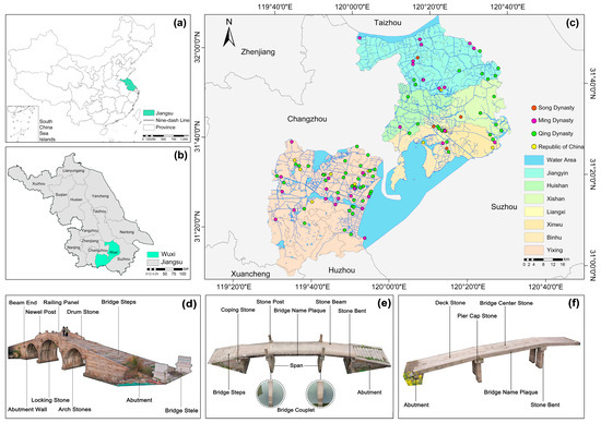
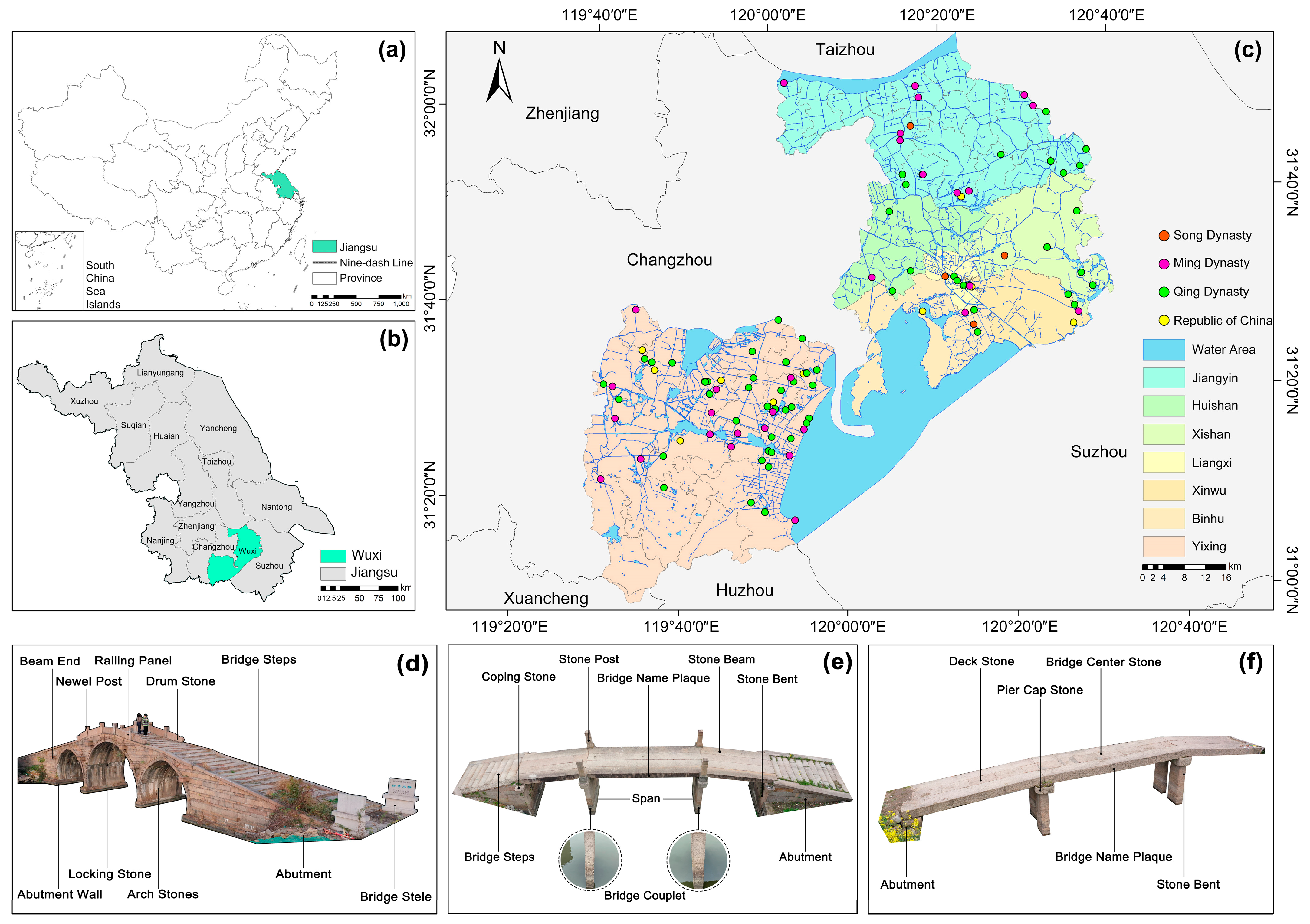
The reason for selecting ancient stone bridges in the Wuxi region as the research object is twofold. First, Wuxi serves as a typical sample of the conflict between high urbanization and the preservation of linear cultural heritage, where its high-intensity urbanization (82.9%) presents a sharp contradiction to heritage survival. The contradiction between modern transportation expansion and the physical space of ancient stone bridges in Wuxi City has led to a sharp reduction in the number of stone bridge heritage sites and the systemic degradation of their occurrence environment. Investigating how to achieve resilient protection of cultural heritage by quantifying environmental influencing factors not only enriches the scope and scale of the research subjects but also provides a decision-making template for heritage protection in similar rapid urbanization regions. The ancient stone bridges of Wuxi are concentrated in the southern region of Jiangsu Province (119°33′–120°38′ E, 31°7′–32°2′ N) (Figure 1b). Second, geographically, Wuxi uniquely spans the transition zone from the Yangtze River floodplain to the Taihu Lake basin and includes the hilly terrain of Yixing. This composite “plain-hill” geomorphology distinguishes it from purely flat canal cities, offering a more diverse range of elevation and slope variables to validate the sensitivity of environmental factors. The study area specifically covers Wuxi City, primarily comprising Liangxi, Binhu, Huishan, Xishan, and Xinwu Districts, as well as the cities of Yixing and Jiangyin under its jurisdiction [33] (Figure 1c). This region features a subtropical humid monsoon climate characterized by warm and humid conditions, with a mean annual temperature of 16.2 °C and a mean annual precipitation of 1121.7 mm.
Figure 1.
Distribution of ancient stone bridges in Wuxi region across historical periods. (a) The geographical location of Jiangsu Province in China; (b) the geographical location of Wuxi City in Jiangsu Province; (c) the spatial distribution of ancient stone bridges in Wuxi, classified by historical periods; (d) stone arch bridge; (e) stone beam bridge; (f) stone slab bridge in Wuxi.
2.2. Data Sources
The data used in this study primarily consist of ancient stone bridge heritage data and natural environmental data for the Wuxi region.
For the ancient stone bridge data, based on the Jiangsu Province Immovable Cultural Heritage Database, the list of cultural heritage protection units at the Wuxi municipal (county) level and above, and relevant literature [21,34,35,36], it is noted that most extant ancient stone bridges in Wuxi were predominantly constructed during the Song Dynasty (960–1279 CE), Ming Dynasty, Qing Dynasty, and Republic of China periods.
Analysis of data regarding cultural heritage protection units identified 125 recorded sites. Consequently, this study delimits the temporal scope to the period prior to the founding of the People’s Republic of China (1949). The Song Dynasty (960–1279 CE), Ming Dynasty, Qing Dynasty, and Republic of China periods constitute the primary research focus, while other historical periods serve as secondary references. It should be noted that while the Republic of China period (1912–1949) is classified as modern history, the stone bridges constructed in Wuxi during this era retained traditional masonry techniques, structural styles, and materials, preserving a lineage of “ancient” craftsmanship distinct from modern reinforced concrete structures. Therefore, this study categorizes traditional bridges from the Republic of China period as “ancient stone bridges.”
For the environmental and base map data, the 2024 Map of Wuxi was selected as the base map for information acquisition. The base map layers include the Wuxi administrative division layer (polygon layer), the provincial–county–township road network layer (polyline layer), and the water body layer (polygon layer). DEM elevation data were derived from 90 m resolution SRTM data available on the Geospatial Data Cloud (http://www.gscloud.cn/). Additionally, a 12.5 m resolution DEM was acquired via ALOS. Data on water systems and geological hazard points in the region were obtained from the Resource and Environment Science and Data Center of the Chinese Academy of Sciences (RESDC).
2.3. Data Processing
For heritage data screening and verification, having undergone multiple renovations, ancient stone bridges exhibit a fusion of functional, structural, and stylistic features from various eras, making it difficult to analyze them by isolating any specific historical period [37]. To ensure data accuracy, a comprehensive field survey was conducted from September 2024 to June 2025. During the investigation, the inventory was verified; newly constructed bridges and those confirmed as destroyed in recent years were updated or excluded. Ultimately, 118 extant ancient stone bridges were selected as the subjects of this study (Figure 1d–f). GPS coordinates of the bridges’ geometric centers were extracted to inventory Wuxi’s ancient stone bridges.
For spatial data processing, ArcGIS 10.8 was employed to perform georeferencing and vectorization of the Wuxi region, projecting all data to the Beijing 1954 Coordinate System. Administrative village data were categorized into natural attribute data and social attribute data. The DEM elevation data were processed via vectorization in ArcGIS 10.8. Based on the 12.5 m resolution ALOS DEM, slope and aspect information for cultural heritage sites were extracted in ArcGIS [38]. Through these steps, this study systematically collected and processed data on elevation, water systems, soil, geological hazards, and cultural heritage foundations in the Wuxi region.
2.4. Research Methods
2.4.1. Average Nearest Neighbor Analysis
Average nearest neighbor analysis (NNA) is utilized to reveal the spatial distribution pattern of point features by comparing the observed average nearest neighbor distance with the theoretical average nearest neighbor distance within a given spatial extent [39]. The calculation formula is expressed as
where A represents the area of the study region; n is the number of samples; rE denotes the theoretical nearest neighbor distance; rI denotes the observed nearest neighbor distance; and R is the nearest neighbor index. The value of R indicates the spatial distribution pattern of the study samples within the region: random distribution (R = 1), clustered distribution (R < 1), and dispersed distribution (R > 1).
2.4.2. Kernel Density Estimation
Kernel density estimation (KDE) is a non-parametric estimation method employed to analyze the density of geographic features within a surrounding neighborhood. By assigning varying weights to sample points in the study area through a kernel function, it generates a smoother density map to reveal density attributes in unmeasured areas [40]. The calculation formula is expressed as
where k[(x − xi)/h] represents the kernel function; h is the bandwidth (h > 0); n is the number of sample points; and (x − xi) denotes the distance between the sample point xi and the estimation point x.
2.4.3. Standard Deviational Ellipse
The standard deviational ellipse (SDE) serves as a vital method for investigating the directionality and trend characteristics of the spatial distribution of point features. In this method, the mean center indicates the relative position of the point distribution, while the azimuth—defined as the angle between true north and the clockwise-rotated major axis—represents the primary orientation of the spatial distribution [41,42]. The calculation formulas are expressed as follows:
where represents the coordinates of the mean center; θ denotes the azimuth of the ellipse; and xi, yi are the spatial coordinates of the point features.
2.4.4. Random Forest
Random forest (RF) is an ensemble learning algorithm based on decision trees. It utilizes Bootstrap resampling techniques to generate multiple training subsets for constructing decision trees, thereby enhancing model accuracy through the aggregated predictions of multiple trees [43,44]. In this study, the random forest (RF) algorithm was selected over other machine learning models due to its superior ability to handle high-dimensional spatial data and provide interpretable variable importance rankings (Gini Index) without the risk of overfitting common in small sample datasets. The RF algorithm was employed to investigate the extent of influence of various natural environmental factors on the distribution of ancient stone bridges. The importance of each factor was quantified by calculating the average decrease in the Gini Index. The calculation formula is expressed as follows:
where Gini(p) represents the Gini impurity of a node; pk is the probability that a sample belongs to class k; VIMj denotes the Variable Importance Measure for the j-th natural environmental factor; N is the total number of decision trees in the random forest; and ∆Gini(t) represents the decrease in the Gini Index resulting from the split at node t by feature j. A higher value indicates a greater significance of the factor in influencing the distribution of ancient stone bridges.
3. Results
3.1. Spatial Distribution Patterns of Ancient Stone Bridges Across Historical Periods
Based on the historical evolution of the Wuxi region and the sample data, the construction periods of ancient stone bridges in the Wuxi region were categorized into four historical eras: the Song Dynasty (960–1279 CE), the Ming Dynasty, the Qing Dynasty, and the Republic of China period. The spatial proximity of the bridges across these four periods was analyzed using the average nearest neighbor tool and calculation formulas in ArcGIS 10.8 (Table 1). The results indicate that during the Song Dynasty (960–1279 CE), the nearest neighbor ratio was greater than 1, with a Z-score of 5.21, suggesting no significant clustering characteristics; thus, the distribution pattern during this period was dispersed. In contrast, from the Ming and Qing Dynasties to the Republic of China period, the nearest neighbor index was approximately 0.55, and the Z-scores were all negative, indicating an overall clustered distribution.
Table 1.
Nearest neighbor indices of ancient stone bridges in Wuxi across historical periods.
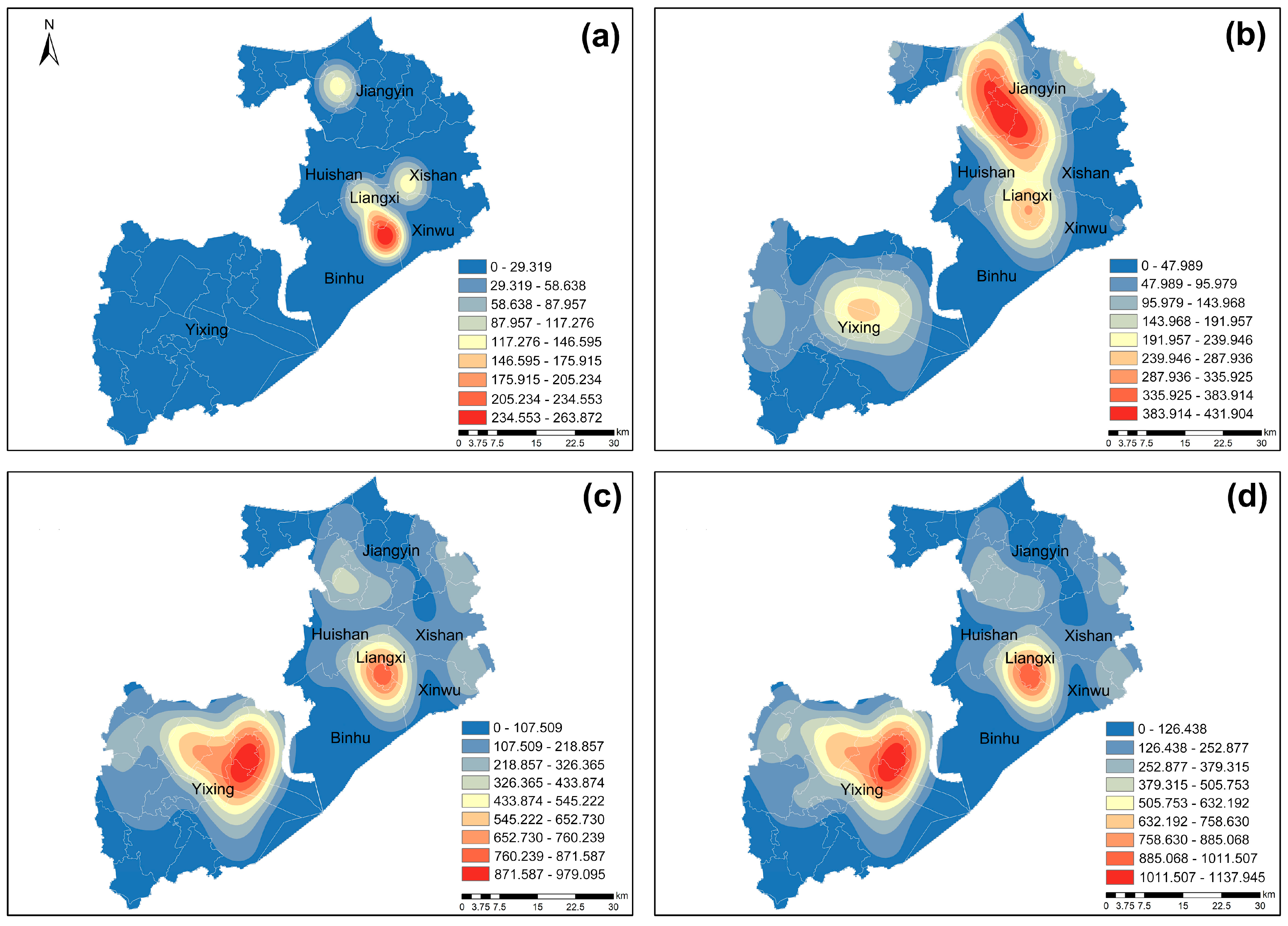
The ancient stone bridges in Wuxi are primarily distributed in Wuxi City proper and the cities of Yixing and Jiangyin under its jurisdiction (Figure 1). Specifically, there are 32 bridges in the main urban area, accounting for 27.12% of the surveyed total; 65 in Yixing, accounting for 55.08%; and 21 in Jiangyin, accounting for 17.80%. Regarding the current preservation status, 32 bridges are located in Wuxi City, 65 in Yixing City, and 21 in Jiangyin City. It can be observed from the statistics of construction eras (Table 2) and the kernel density distribution map of ancient stone bridges in Wuxi (Figure 2) that there is a significant disparity in the quantity of bridges across different periods. The number of high-density areas increased notably during the Ming and Qing dynasties, exhibiting a migration trend from the northeast to the southwest over time.
Table 2.
Statistics of extant ancient stone bridges in Wuxi region by construction era.
Figure 2.
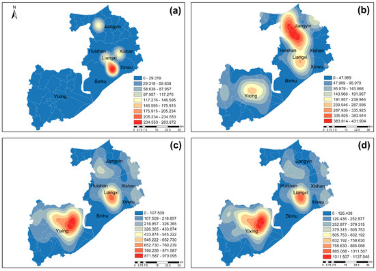
Kernel density distribution patterns of ancient stone bridges in Wuxi across historical periods. (a) Kernel density estimation for the Song Dynasty; (b) kernel density estimation for the Ming Dynasty; (c) kernel density estimation for the Qing Dynasty; (d) kernel density estimation for the Republic of China.
- (1)
- Song Dynasty (960–1279 CE)
Wuxi developed an extensive water network during the Song Dynasty (960 to 1279 CE). Grand Canal connectivity boosted the regional economy and bridge demand. Four extant stone bridges remain, mostly in central Wuxi City within the current Liangxi District (Figure 2a). Other bridges in western Jiangyin indicate that water-rich areas were vital hubs for human activity. These structures primarily facilitated local transport and were strategically built at river confluences to meet socio-economic needs.
- (2)
- Ming Dynasty (1368–1644 CE)
The Ming Dynasty (1368 to 1644 CE) was a pivotal period as extant stone bridges increased to 32 (Figure 2b). High-density zones emerged across Wuxi, Jiangyin, and Yixing, establishing a new distribution framework. A major cluster formed near Qingyang Town while another developed in central Yixing and expanded westward. Driven by Yangtze River trade and water conservancy projects, bridge distribution shifted northward, forming the “Near Yangtze River” and “Near Taihu Lake” settlement systems.
- (3)
- Qing Dynasty (1644–1911 CE)
Bridge construction peaked during the Qing Dynasty with 68 extant stone bridges (Figure 2c). Spatial focus shifted to two primary zones: one in eastern and southern Yixing (centered on Fangqiao and Xinzhuang) and another in central Wuxi. The Wuxi region formed multiple clusters extending toward Xishan and southeastern Jiangyin. This shift reflects socio-economic adjustments within the Taihu Lake Basin, where agricultural growth and river regulation concentrated bridges along key water transportation belts.
- (4)
- Republic of China Period (1912–1949 CE)
Construction stabilized during the Republic of China period (1912 to 1949 CE). There are 13 extant stone bridges, and the distribution pattern remained consistent with the Qing Dynasty (Figure 2d). High-density zones persisted in Wuxi and Yixing, with Yixing’s cluster expanding westward to Yangxiang Town. This multi-point pattern centered on Yixing and Wuxi reflected ongoing urbanization and transportation upgrades, ultimately establishing the contemporary layout of ancient bridges in the region.
3.2. Distribution Centroids and Evolutionary Trends of Ancient Stone Bridges Across Historical Periods
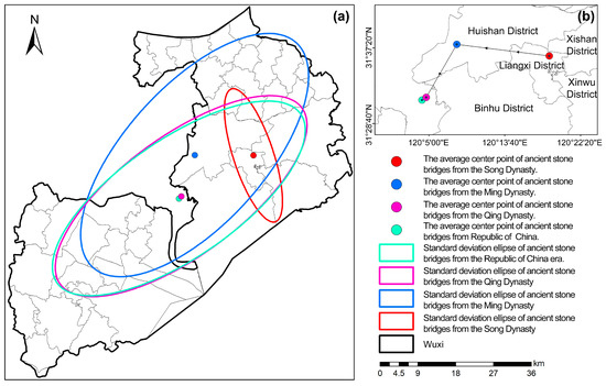
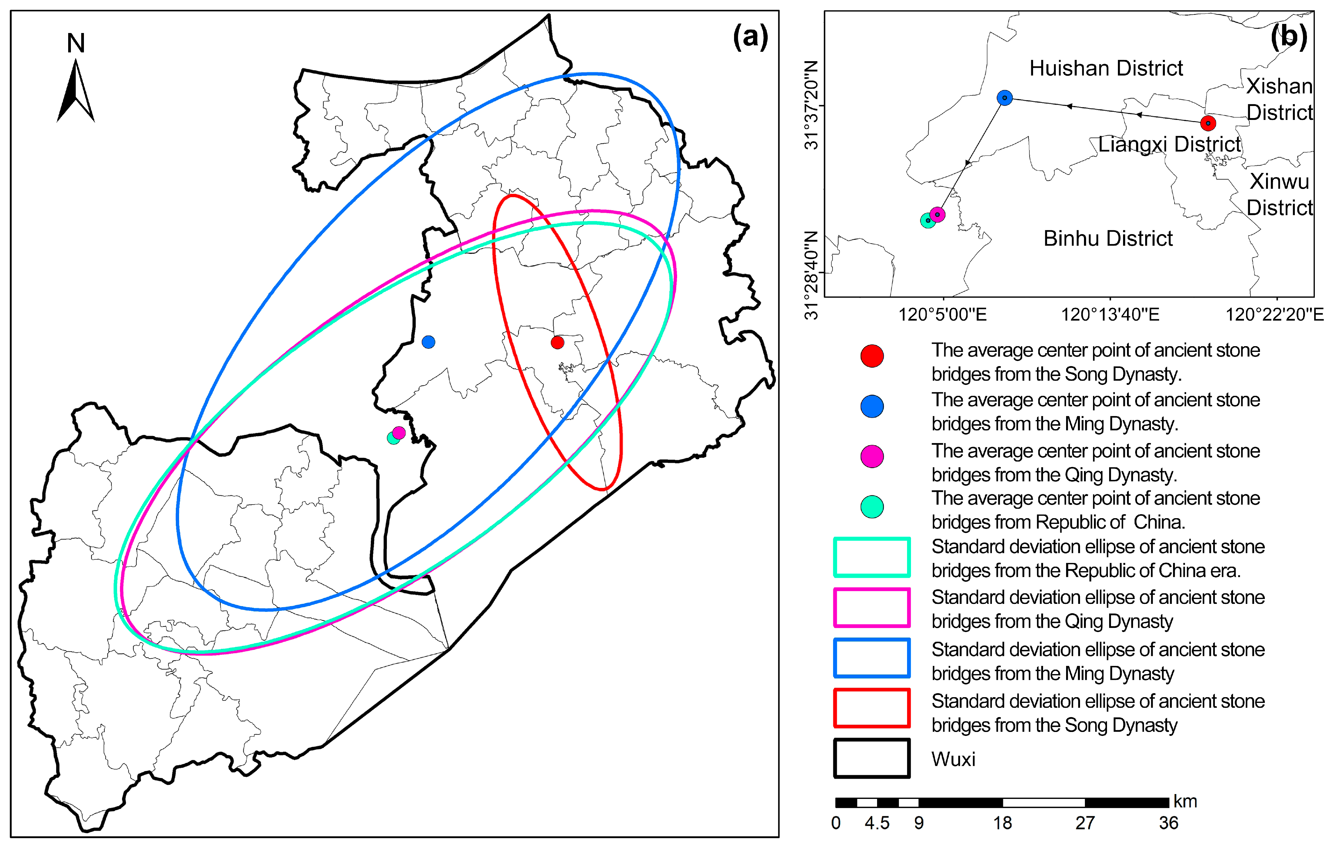
Based on data characteristics, the historical timeline comprises four stages. Standard deviational ellipse (SDE) and centroid coordinates were analyzed via ArcGIS (Figure 3a). The stages were as follows: (1) Song Dynasty (960–1279 CE): The centroid was in northern Liangxi District (120.31° E, 31.61° N). (2) Ming Dynasty (1368–1644 CE): It shifted west to Huishan District (120.14° E, 31.63° N). (3) Qing Dynasty (1644–1911 CE): It migrated south to Wujin District, Changzhou (120.08° E, 31.53° N). (4) Republic of China (1912–1949 CE): It remained in Wujin District (120.07° E, 31.52° N) (Figure 3b).
Figure 3.
Distribution centroids and directional characteristics of ancient stone bridges in Wuxi across historical periods. (a) Standard deviational ellipses (SDE) across historical periods; (b) migration trajectory of the mean centers.
The trajectory shows a gradual northeast to southwest migration, reflecting shifts in transportation, economy, and water systems. Regarding SDE parameters, the Song period exhibited a distinct northwest and southeast orientation (θ 167.93°), indicating dispersed distribution dependent on natural waterways. The Ming (θ 56.51°), Qing (θ 66.47°), and Republic of China (θ 67.70°) periods shifted to and maintained a northeast and southwest orientation.
Overall, the spatial pattern evolved from dispersion to aggregation. High dispersion in the Song era implies limited technology, while increased clustering in later periods reflects urbanization and water engineering advancements. Notably, the “perfection of the grain transport system” during the Ming and Qing dynasties drove construction peaks. Additionally, the “charitable estate system” encouraged local gentry to fund bridges for public welfare.
3.3. Relationship Between Spatial Distribution of Ancient Stone Bridges in Wuxi and Natural Environment
3.3.1. Elevation Factor
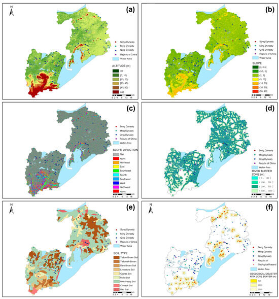
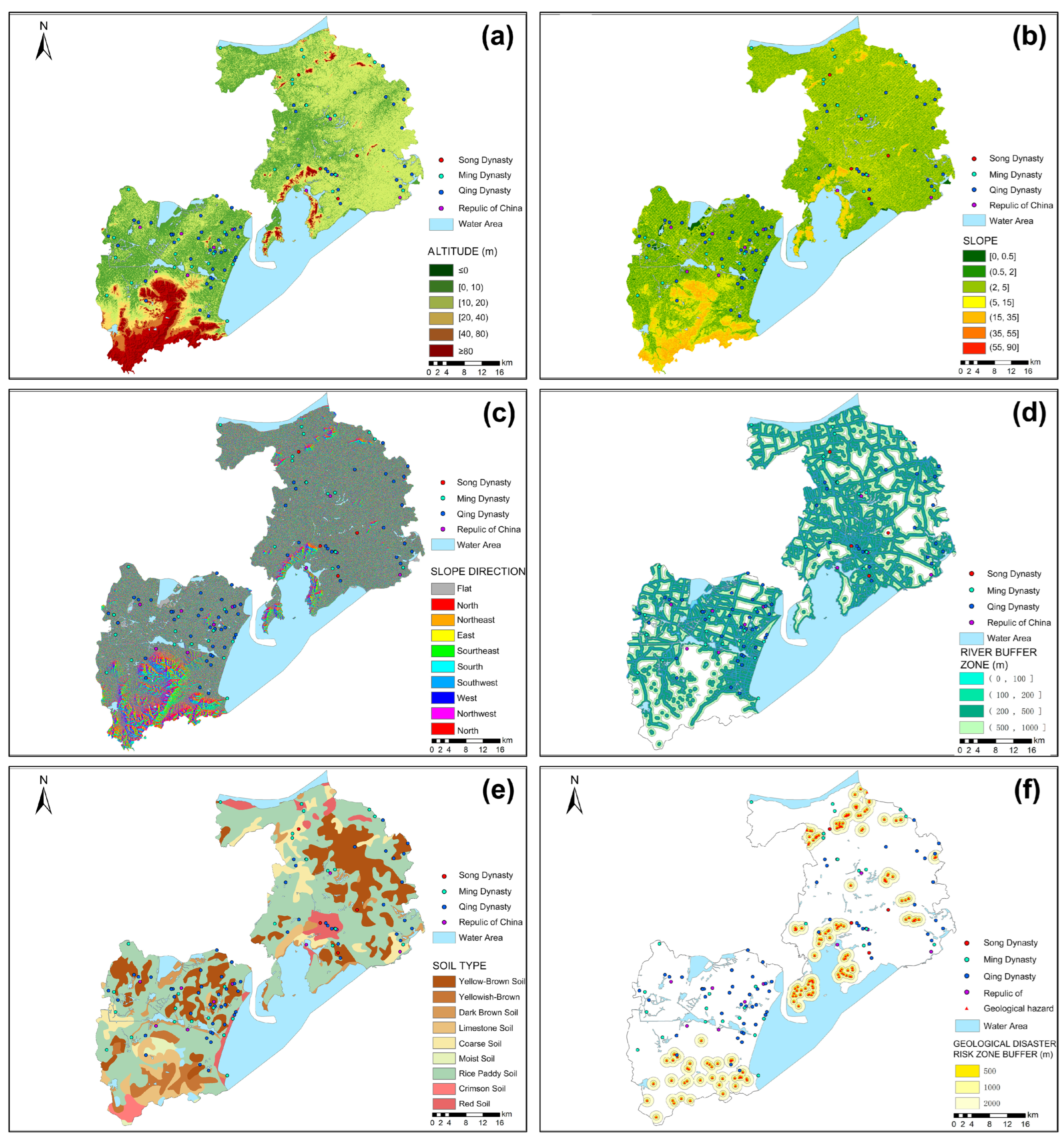
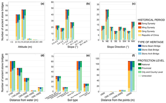
The Wuxi region lies on the Yangtze River Delta alluvial plain between the Yangtze River and Taihu Lake, featuring low terrain and a dense water network. As shown in Table 3, Figure 4a and Figure 5a, the vertical distribution of ancient stone bridges exhibits high consistency; 96.61% are concentrated in plain zones below 20 m elevation, indicating that site selection was strictly constrained by water systems and landforms. Historically, settlements clustered in these low-altitude areas to utilize convenient water transport, characterized by hydrophilic distribution and cross river connectivity.
Table 3.
Relationship between the distribution of ancient stone bridges in Wuxi and elevation across historical periods.
Figure 4.
Spatial distribution of ancient stone bridges in Wuxi under different natural factors across historical periods. (a) Elevation; (b) slope; (c) aspect; (d) river buffer zones; (e) soil types; (f) geological disaster risk zones.
Figure 5.
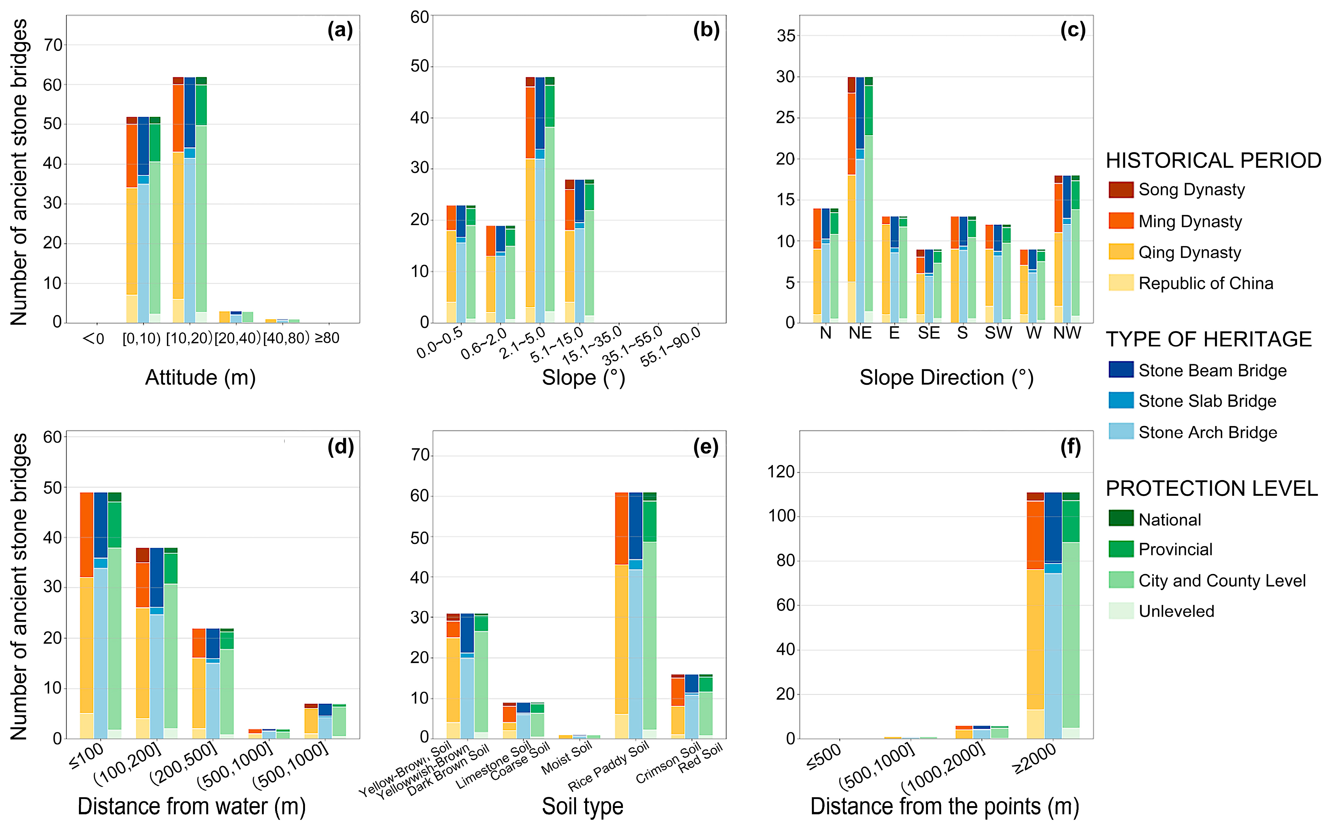
Data analysis of the influence of six natural factors on different attributes of ancient stone bridges. (a) Altitude; (b) slope; (c) slope direction (aspect); (d) distance from water; (e) soil type; (f) distance from geological disaster points. The grouped bars represent the distribution by historical period, bridge type, and protection level.
Regarding evolutionary trends, bridges from the Song Dynasty (960–1279 CE), Ming Dynasty (1368–1644 CE), and Republic of China (1912–1949 CE) were strictly distributed below 20 m elevation. This underscores the long-term stability of the core water network as the center of regional activity. The Qing Dynasty (1644–1911 CE) marked the peak of construction. While 94.12% of bridges remained in lowlands, distribution extended sporadically toward hill zones at elevations from 20 to 80 m. This slight vertical diffusion reflects population growth and localized development in mountainous areas like Xishan and Huishan, yet it did not alter the overall pattern dominated by low-altitude plains (Figure 4a).
3.3.2. Slope Factor
Based on the slope classification of the International Geographical Union (IGU) [45] and data in Table 4, Figure 4b and Figure 5b, the distribution of ancient stone bridges in Wuxi correlates highly with geomorphology. The highest concentration (40.68%) occurs on gentle slopes ranging from 2.1° to 5.0°. Significant numbers also appear on slopes ranging from 5.1° to 15.0° (23.73%) and flat lands ranging from 0.0° to 0.5° (19.49%). Notably, no bridges exist on steep slopes exceeding 15.1°.
Table 4.
Relationship between the distribution of ancient stone bridges in Wuxi and slope across historical periods.
These results indicate that site selection adhered to low-gradient terrain. While the plain is flat, bridge construction required specific gradients for approaches and boat clearance. Consequently, moderate slopes ranging from 2.1° to 5.0° became the optimal choice, balancing traffic flow with engineering feasibility.
Historically, bridges in all eras were strictly limited to slopes within 15.0°. During the Qing Dynasty (1644–1911 CE), construction peaked on gentle slopes ranging from 2.1° to 5.0° (42.64%). This preference mitigated flood risks associated with flat lands while avoiding the construction challenges of steep slopes (>15.1°). Synthesizing elevation data, the ancient stone bridge landscape in Wuxi is concentrated in zones with an elevation below 20 m and a slope within 5.0° (Figure 4b).
3.3.3. Aspect Factor
Aspect influences solar exposure and microclimates [46]. However, for ancient stone bridges in the plain water network of Wuxi, hydrology and transport axes outweigh environmental adaptability. As shown in Table 5, Figure 4c and Figure 5c, distribution is uneven and concentrated in northeast and northwest directions. The northeast aspect dominates with 30 sites (25.42%), followed by the northwest with 18 sites (15.25%).
Table 5.
Relationship between the distribution of ancient stone bridges in Wuxi and aspect across historical periods.
This distribution reflects strict constraints by regional spatial structures. As nodes crossing water systems, bridge orientation aligns with major river flows and historic transport arteries. The northeast and northwest concentration mirrors the alignment of primary water corridors.
Historically, this dominance persisted. From the Song Dynasty (960–1279 CE) to the Ming Dynasty (1368–1644 CE), bridges concentrated in the northeast, reflecting early network limits. The Qing Dynasty (1644–1911 CE) saw expansion to all directions, yet the northeast remained primary. This indicates a comprehensive network that still adhered to the northeast and northwest axis. Thus, aspect distribution spatially reflects the historical water network. Future research should combine regional hydrogeography and transport planning to explore site selection mechanisms (Figure 4c).
3.3.4. River Factor
Early settlements prioritized water sources [47]. In Wuxi, the dense river network supported life and transport, making rivers the primary constraint for bridge site selection. As shown in Table 6, Figure 4d and Figure 5d, bridge distribution is highly coupled with river proximity. A total of 109 bridges (92.38%) lie within 500 m of rivers, with 73.74% concentrated within 200 m, confirming a strong hydrophilic orientation.
Table 6.
Relationship between the distribution of ancient stone bridges in Wuxi and river proximity across historical periods.
Historically, construction consistently focused on near river areas. Song Dynasty (960–1279 CE) bridges concentrated in the range from 100 to 200 m, while Ming Dynasty (1368–1644 CE) bridges clustered within 100 m. This reflects the spatial organization of core water networks at different stages (Figure 5d).
Seven bridges located 1000 m or more from current rivers do not imply land transport dominance but likely correspond to silted or diverted channels. These relic sites indicate historical water network changes and hold significance for hydrogeographical evolution. In summary, the river factor decisively influences spatial distribution, mapping the historical water system and transportation flow (Figure 4d).
3.3.5. Soil Factor
According to the Classification and Codes for Chinese Soil (GB/T17296-2009), yellow–brown, yellow–cinnamon, and dark-brown earths are leached soils, limestone and skeletal soils are priming soils, while lateritic red and red earths are ferro aluminous soils. As indicated in Table 7, Figure 4e and Figure 5e, bridge distribution correlates significantly with soil types. The highest density occurs in paddy soil areas (61 sites, 51.69%), followed by leached soil zones (26.27%).
Table 7.
Relationship between the distribution of ancient stone bridges in Wuxi and soil types across historical periods.
Paddy soil, formed in long-term submerged environments, features soft texture and weak bearing capacity. Despite these challenges, bridge concentration here stems from water transport needs and agricultural settlements rather than foundation suitability. To ensure stability, builders employed pile or deep foundations, marking a distinct adaptive link between stone materials and the soil environment.
Wuxi bridges generally utilize local weather-resistant materials like granite, bluestone, and sandstone. High-strength granite and bluestone suit the soft foundations of paddy soil. Conversely, lower strength sandstone appears in stable leached or priming soil zones. Hilly areas with ferro aluminous or skeletal soils (21.19%) often coincide with hard rock layers, facilitating local sourcing and establishing a direct correspondence between materials and geological background.
In summary, the concentration in paddy soil reflects the combined effects of water systems, transport demands, and engineering technology. Material selection demonstrates adaptive differences across soil environments, shaping the unique spatial pattern of Wuxi bridges (Figure 4e).
3.3.6. Geological Hazard Factors
As indicated in Table 8, Figure 4f and Figure 5f: (1) Geological hazards in Wuxi concentrate in surrounding low mountains and hills. Risks are dominated by small- and medium-scale events on gentle slopes, such as landslides and collapses. Although Wuxi sits on a stable alluvial plain with low hazard density, avoiding affected zones remained a rigid constraint for ancient site selection. (2) Ancient stone bridges are highly distributed within safety zones; 94.07% are located in extremely low-risk areas over 2000 m from hazards, with zero presence within 500 m. Across historical periods (960–1949 CE), bridge density correlates positively with distance from hazards. This consistency confirms that ancient builders prioritized risk avoidance as a prerequisite for ensuring long-term structural stability.
Table 8.
Relationship between the distribution of ancient stone bridges in Wuxi and geological hazards across historical periods.
3.4. Analysis of the Importance of Natural Factors on the Distribution of Ancient Stone Bridges in Wuxi
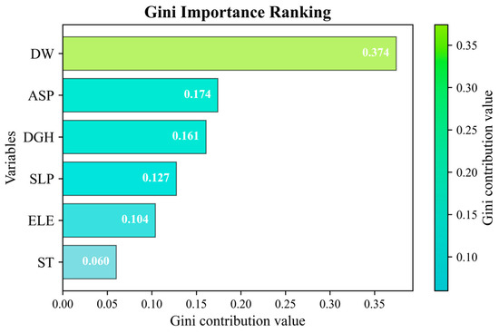
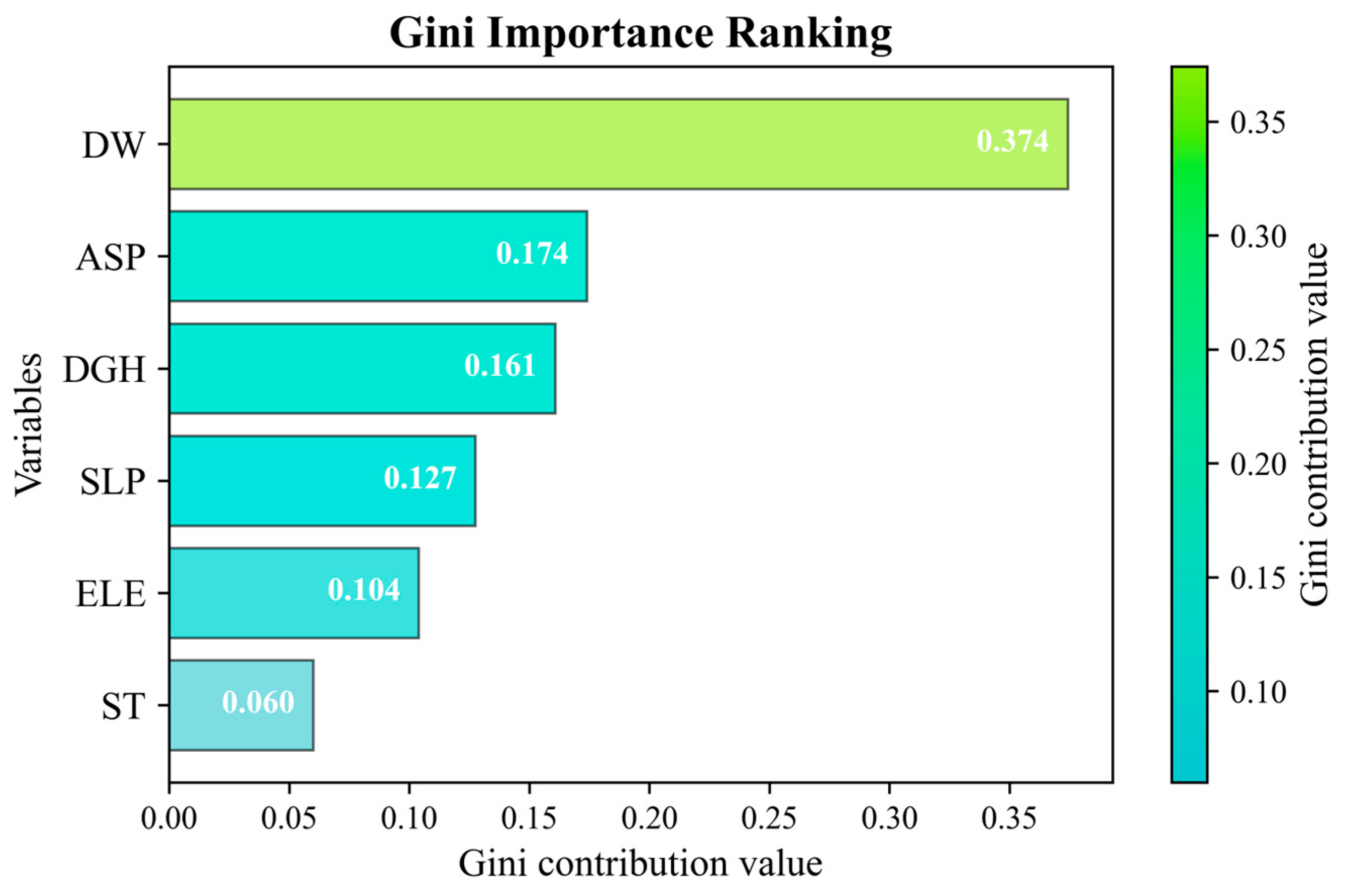
Random forest (RF) is an ensemble model based on Bootstrap sampling and decision trees. Numerous theoretical and empirical studies [44,48,49] have demonstrated that RF possesses high-prediction accuracy, exhibits excellent tolerance toward outliers and noise, and is less prone to overfitting. The results indicate that the accuracy of the RF model for the dataset of six natural factors is 68.18%. The importance ranking of factors influencing the distribution of ancient stone bridges in Wuxi, in descending order, is river (DW), aspect (ASP), geological hazards (DGH), slope (SLP), elevation (ELE), and soil (ST) (Figure 6). (1) This result profoundly reveals that the water system pattern is the core driving force behind the site selection of ancient stone bridges, the spatial evolution of settlements, and the construction of transportation networks. It validates the high coupling relationship and hydrophilic characteristics between their spatial distribution and the water system network; this conclusion is highly consistent with the statistical results regarding the distance to rivers (Table 6). (2) The importance indices for aspect (ASP), geological hazards (DGH), slope (SLP), and elevation (ELE) are relatively high and numerically close in magnitude. This indicates that, on the basis of satisfying water transportation demands, site safety and micro-topographic conditions were also environmental constraints that required significant weighting during ancient bridge construction. This is particularly reflected in the general tendency of ancient stone bridges to be located in aspects with suitable sunlight, far from potential geological hazard sites, and concentrated in low-slope and low-elevation areas to ensure the structural stability and durability of the engineering projects (Table 3, Table 4 and Table 5). (3) Soil (ST) holds the lowest importance in the model. Combined with the kernel density distribution (Figure 2), it is concluded that since the paddy soil, yellow earth, and red earth in the Wuxi plain water network region all possess favorable agricultural suitability, ancient people did not need to prioritize the soil factor extensively.
Figure 6.
Importance indices of natural factors influencing the distribution of ancient stone bridges in Wuxi.
4. Discussion
Ancient stone bridges serve as spatial carriers reflecting the evolution of cultural heritage and transportation networks. Their distribution is driven by hydrology, microtopography, and regional economy [50]. By coupling ArcGIS spatial analysis with random forest models, this study explores the internal construction mechanism of cultural heritage in the Jiangnan Canal plain.
4.1. Spatiotemporal Evolution Patterns
The distribution of ancient stone bridges in Wuxi exhibits significant temporal stages and spatial heterogeneity. Nearest neighbor index analysis shows the distribution evolved from dispersion in the Song Dynasty (960–1279 CE) to high clustering during the Ming (1368–1644 CE), Qing (1644–1911 CE), and Republic of China (1912–1949 CE) eras. The scale peaked in the Qing Dynasty (1644–1911 CE) with 68 bridges. Spatially, a pattern formed with Yixing as the core and the main urban area and Jiangyin as two wings. This shift from scattered distribution to local clustering aligns with canal heritage evolution in Suzhou. Combined with the perfection of the water transport system during the Ming and Qing Dynasties, it confirms the artificial reshaping of transportation networks by urbanization [6]. Furthermore, water conservancy projects influenced site selection and optimization [27]. Bridge distribution in the Song Dynasty (960–1279 CE) depended on natural water systems for living needs, showing randomness. With the repair of canal projects, bridges became components of hydraulic facilities, causing towns to cluster, which is the main reason for heritage concentration [51]. The scale of water conservancy projects determines the survival density of bridges [7]. However, the proportion of extant stone bridges in Yixing is 55.08%. Considering the complex topography of southern Yixing, bridge density correlates with surface fragmentation rather than just water system development. Transportation in plains can be replaced by detours, but the complex microtopography of Yixing creates rigid obstacles. This forced the local system to build bridges to connect fragmented spaces, leading to clustering exceeding that of open plains. Studying these spatial patterns aids unified protection planning [52]. It is important to acknowledge that the distribution of ancient bridges is not solely determined by natural factors. Human factors, such as ancient population density, trade routes, and the charitable estate system mentioned earlier, played significant roles. However, due to the difficulty in obtaining precise quantitative spatial data for these historical socioeconomic indicators across different dynasties, they were not included in the random forest model.
4.2. Migration Trajectory and Preservation Reality
The distribution center of gravity of ancient stone bridges in Wuxi exhibits a significant migration trend from northeast to southwest, reflecting the superimposed effects of historical development. The center of gravity in the Song Dynasty (960–1279 CE) was located in the northern part of Liangxi District, showing a northwest southeast direction and strong dependence on natural water systems. During the Ming Dynasty (1368–1644 CE) and Qing Dynasty (1644–1911 CE), the center of gravity shifted significantly southwest to the border of Wujin in Changzhou, and the axis turned to a northeast southwest direction, making the spatial structure more stable. The significant migration of the center of gravity from northeast to southwest deeply couples the perfection of the water transport system during the Ming Dynasty (1368–1644 CE) and Qing Dynasty (1644–1911 CE) with the public welfare donations of local gentry and merchants under the Yizhuang system. It can be seen that the movement of the bridge center of gravity is essentially a spatial reconfiguration of regional transportation resources, reflecting the expansion of human activity scope in different historical stages of Wuxi. However, it is noteworthy that the urbanization rate of the main urban area of Wuxi is as high as 82.9%, while southern Yixing and some towns in Jiangyin are less disturbed by modernization. Transportation between cities along the ancient Grand Canal mainly relied on inland water transport, which made the spatial connection between ancient intangible cultural heritage and road networks weak, resulting in a weak role for road network density indicators at that time [50]. The current northeast to southwest migration trajectory is an analysis of extant ancient bridges; therefore, it may not be entirely the influence of the historical construction center of gravity, but rather the result shown by extant ancient bridge samples. High-density stone bridges in the early period of the Liangxi District in the main urban area of Wuxi may have disappeared due to frequent urbanization and filling of rivers for road construction, leading to surviving samples concentrating in the Yixing area where development is relatively lagging. The current stone bridge distribution pattern is not only a product of historical construction but also a surviving cultural heritage after modern urbanization, which further highlights the urgency of conducting rescue protection research. In this situation, building a protection system for canal cultural heritage in the Wuxi region becomes crucial. By adopting a “focus on core and multilevel buffer” method, isolated ancient bridge points scattered in canal tributaries and the Yixing mountainous area can be integrated through networked integration and linear series connection to achieve holistic protection and systematic management of cultural heritage, thereby empowering the development of the water transport cultural tourism industry and exerting its internal motivation.
4.3. Environmental Response Mechanisms
First, the lives of Wuxi region ancestors showed significant hydrological dependence. Simultaneously, other types of cultural heritage in the Taihu Lake Basin also reflect significant hydrophilic characteristics. It is certain that the water system is the primary geographical element shaping the water town cultural landscape [53]. Second, the topography of Wuxi is dominated by plain water networks and low mountains and hills. Ancient stone bridges exhibit a specific spatial orientation of “northeast northwest” in slope aspect selection. This primarily stems from passive adaptation to the natural flow of regional water systems. As linear nodes crossing water systems, the slope aspect selection of ancient stone bridges does not depend on the sunshine angle but is controlled by the axial constraints of regional water transport arteries and the structure of transportation corridors. Main rivers and historical water transport paths in the Wuxi region mostly show a northeast southwest orientation. To achieve vertical connection with these hydraulic arteries, bridge approach roads passively formed a northeast or northwest slope aspect preference. Other regional cultural heritages mostly exhibit active selection of sunny slopes [54,55] with sufficient light or flat open areas [56]. Third, the calculation results of the random forest model show that slope aspect and geological hazard factors have a greater impact on the distribution of cultural heritage, second only to river factors. This reveals that, while meeting water transport functions, the hydrological adaptability of microtopography and engineering safety are rigid constraints for bridge construction. Finally, although soil factors have the smallest impact on heritage distribution in the model, the wide distribution of paddy soil and yellow soil evidences the superior agricultural resource endowment of the region, providing a material basis for the prosperity of the ancient agricultural economy in Wuxi, thereby promoting public welfare activities such as building bridges and roads through economic surplus. The relationship between water transport development and the distribution of bridge heritage in various historical periods confirms this conclusion. Unlike previous studies that overlooked the weight of micro-landforms, the random forest model reveals the secondary dominant role of slope aspect and quantifies the hierarchy of these influences, thereby extending the understanding of heritage site selection mechanisms in plain water network regions. From the perspective of the natural environment, to maintain the symbiotic relationship between ancient stone bridges and the environment, it is necessary to coordinate ecological and human elements such as river water systems, revetment vegetation, and traditional blocks associated with ancient bridges, perform well in water environment governance and ecological conservation, and consolidate the foundation of the “bridge water landscape” cultural ecological spatial pattern of ancient stone bridges, ultimately ensuring the integrity of the cultural heritage landscape of Jiangnan water towns.
5. Conclusions
As a key component of Grand Canal heritage, Wuxi ancient stone bridges face threats from urbanization. While existing literature covers Canal heritage, research linking bridge groups to natural elements remains scarce. Using ArcGIS, this study reveals a distribution evolution from dispersion to clustering and a center of gravity migration from northeast to southwest. This study not only enriches research on specific heritage types at the mesoscale but also provides a replicable analytical framework integrating ArcGIS and random forest. By quantitatively analyzing micro-environmental factors such as elevation and distance from water, it demonstrates that quantitative means can reveal environmental adaptation mechanisms often imperceptible to traditional qualitative methods. This approach shifts the focus from qualitative observation to quantitative mechanism exploration.
Analyzing 118 bridges via historical records and fieldwork, the study concludes the following: (1) Song Dynasty bridges were randomly distributed, reflecting discrete early settlements. By the Ming Dynasty, Qing Dynasty, and Republic of China periods, patterns shifted to clustering with increasing intensity, reflecting improved human activity and transport density. (2) High-density areas expanded and migrated southwest toward Yixing. Song bridges scattered near natural water. Ming and Qing bridges, driven by Canal and Taihu transport maturity, clustered in Yixing pottery and tea hubs. This coincides with regional social economy and logistics trajectories. (3) Standard deviational ellipse analysis confirms spatial evolution from discrete to multicore clustering. The center of gravity shifted overall from northeast to southwest, reflecting a logic transition from natural generation to economic-driven distribution. (4) Bridges predominantly occupy low plains, gentle slopes (2° to 5°), and stable zones. They frequent northeast and northwest aspects and cluster within 100 m of rivers in paddy and yellow soil areas, highlighting lowland and hydrophilic traits. (5) Random forest ranking places rivers as the dominant factor, followed by aspect, geological disaster, slope, elevation, and soil. The dominance of rivers reflects bridge water spatial coupling. Aspect implies passive adaptation to microtopography, while soil is least restrictive.
Limitations exist due to urbanization obscuring sites and complex Yixing topography. Future updates to the database are necessary. Future research should ① integrate human factors like population and trade to analyze physical social system coupling; ② optimize protection strategies, aligning legal processes with urban renewal to enhance landscape resilience; ③ expand scale to the Taihu Basin and Yangtze Delta to clarify spatial layers of the water town landscape. Research must align with Grand Canal policies for scientific protection and revitalization.
Author Contributions
Conceptualization, H.P. and P.L.; methodology, H.P. and P.L.; software, H.P.; validation, P.L., Z.D. and H.J.; formal analysis, H.P. and S.Z.; investigation, H.P., Z.D. and X.G.; resources, C.Z.; data curation, Z.D. and H.J.; writing—original draft preparation, H.P. and P.L.; writing—review and editing, H.P. and P.L.; visualization, H.P. and S.Z.; supervision, C.Z.; project administration, C.Z.; funding acquisition, C.Z. All authors have read and agreed to the published version of the manuscript.
Funding
This research was funded by the Key Project of the National Social Science Fund of China (Social Group Project) “Research on the Theoretical Construction and Practical Path of the Holistic Protection System of Cultural Heritage” (Grant No. 25SGB011).
Data Availability Statement
The data that support the finds of this study are available from the corresponding author upon reasonable request.
Acknowledgments
During the preparation of this manuscript, the authors used Google Gemini (Advanced model) for the purposes of assisting with English translation, linguistic polishing, and formatting of references. The authors have reviewed and edited the output and take full responsibility for the content of this publication.
Conflicts of Interest
The authors declare no conflicts of interest.
References
- Zhang, S.; Liu, J.; Pei, T.; Chan, C.-S.; Wang, M.; Meng, B. Tourism value assessment of linear cultural heritage: The case of the Beijing–Hangzhou Grand Canal in China. Curr. Issues Tour. 2023, 26, 47–69. [Google Scholar] [CrossRef] [Scilit]
- Li, Y.; Zheng, N. Integral protection of cultural heritage of the Grand Canal of China: A perspective of cultural spaces. Front. Soc. Sci. Technol. 2020, 2, 60–69. [Google Scholar]
- Liu, Y.; Ge, H. Exploration of the Cultural Heritage Distribution Along the Beijing-Hangzhou Grand Canal and Its Implications: A Case Study of Cultural Relics Protection Units in the Jiangsu Section. Sustainability 2024, 16, 11248. [Google Scholar] [CrossRef] [Scilit]
- Yang, J.; Hu, D.; Chen, Z.; Xu, Y.; Zou, Z.; Zhu, Y. Analysis of Spatial and Temporal Distribution Patterns of Traditional Opera Culture along the Beijing–Hangzhou Grand Canal. ISPRS Int. J. Geo-Inf. 2023, 12, 477. [Google Scholar] [CrossRef] [Scilit]
- Li, L. Cultural communication and diversity along the Grand Canal of China: A case study of folk songs in intangible cultural heritage. Herit. Sci. 2023, 11, 1. [Google Scholar] [CrossRef] [Scilit]
- Huang, Y.; Yang, S. Spatio-Temporal Evolution and Distribution of Cultural Heritage Sites along the Suzhou Canal of China. Herit. Sci. 2023, 11, 188. [Google Scholar] [CrossRef] [Scilit]
- Chen, M.; Wang, J.; Sun, J.; Ye, F.; Zhang, H. Spatio-Temporal Distribution Characteristics of Intangible Cultural Heritage and Tourism Response in the Beijing–Hangzhou Grand Canal Basin in China. Sustainability 2023, 15, 10348. [Google Scholar] [CrossRef] [Scilit]
- Peng, N.; Chen, Y.; Wang, L.; Zhang, C.; Zhu, Y. Cultural transmission ability of urban heritage along the Jiangsu section of the Beijing–Hangzhou Grand Canal. npj Herit. Sci. 2025, 13, 401. [Google Scholar] [CrossRef] [Scilit]
- Xu, Y.; Rollo, J.; Jones, D.S.; Esteban, Y.; Tong, H.; Mu, Q. Towards Sustainable Heritage Tourism: A Space Syntax-Based Analysis Method to Improve Tourists’ Spatial Cognition in Chinese Historic Districts. Buildings 2020, 10, 29. [Google Scholar] [CrossRef] [Scilit]
- Yan, P.; Xu, Y. Ecological and Cultural Water Environment Restoration and Improvement: Governance of Urban Water System in Yangzhou Section of the Grand Canal. J. Green Sci. Technol. 2014, 201–203. [Google Scholar]
- Zhang, S.; Zhang, X.; Liu, J. Spatial distribution and pedigree age of intangible cultural heritage along the Grand Canal of China. Herit. Sci. 2024, 12, 246. [Google Scholar] [CrossRef] [Scilit]
- Jin, X.; Wang, J. Assessing Linear Urban Landscape from dynamic visual perception based on urban morphology. Front. Archit. Res. 2021, 10, 202–219. [Google Scholar] [CrossRef] [Scilit]
- Sun, M.; Wang, G.; Wang, C.; Jin, L.; Liang, F. Investigation into Noncontact Protective Strategy of Ancient Bridge Foundations against Scour Risk: An Experimental Study. Nat. Hazards Rev. 2025, 26, 04025037. [Google Scholar] [CrossRef] [Scilit]
- Li, Z.; Che, T.; Tang, X.; Li, C.; Zhou, C.; Luo, Y.; Zhong, L.; Yu, W.; Xu, Y. Changes in landscape pattern and ecosystem services along the Yangzhou section of the Grand Canal. J. Yangzhou Univ. Agric. Life Sci. Ed. 2022, 43, 132–137. [Google Scholar]
- Yue, Z.; Hua, Y.; He, Y.; Yao, D.; Wang, L.; Tong, X. The Synergistic Structure and Potential Development for Sustainable Ecosystem Services in Urban Areas along the Grand Canal: A Case Study of the Wuxi Segment. Sustainability 2024, 16, 4734. [Google Scholar] [CrossRef] [Scilit]
- Tang, H. History of Science and Technology in China: Bridges Volume; Science Press: Beijing, China, 2017. (In Chinese) [Google Scholar]
- Yue, J. History of Chinese Architecture; Unity Press: Beijing, China, 2005. (In Chinese) [Google Scholar]
- Luo, Y. Chinese Stone Bridges; People’s Communications Press: Beijing, China, 1954. (In Chinese) [Google Scholar]
- Society for Research in Chinese Architecture. Bulletin of the Society for Research in Chinese Architecture; International Culture Publishing Company: Beijing, China, 1997. (In Chinese) [Google Scholar]
- Xu, F.; Zhao, Y.; Chen, Q. Introduction to Bridge Landscape. Bridge Constr. 2003, 4, 30–33. (In Chinese) [Google Scholar]
- Zha, N. Research on the Artistic Characteristics of Ancient Bridges in Wuxi. Master’s Thesis, Jiangnan University, Wuxi, China, 2014. (In Chinese) [Google Scholar]
- Germinario, C.; Gorrasi, M.; Izzo, F.; Langella, A.; Limongiello, M.; Mercurio, M.; Musmeci, D.; Santoriello, A.; Grifa, C. Damage Diagnosis of Ponte Rotto, a Roman Bridge along the Ancient Appia. Int. J. Conserv. Sci. 2020, 11, 277–290. [Google Scholar]
- Chen, B.; Yang, Y.; Zhou, J.; Ding, K.; Kong, X. Damage Detection of Underwater Foundation of a Chinese Ancient Stone Arch Bridge via Sonar-Based Techniques. Measurement 2021, 169, 108283. [Google Scholar] [CrossRef] [Scilit]
- Cao, Y. Research on the Conservation of Ancient Bridges in Shanghai; Shanghai Jiao Tong University Press: Shanghai, China, 2020. (In Chinese) [Google Scholar]
- Jin, H.; Chun, Q.; Shi, J.; Wang, H. A Method of Weathering Prevention for Ancient Stone Arch Bridges: A Case Study of the Putang Bridge, China. Int. J. Civ. Eng. 2023, 21, 805–824. [Google Scholar] [CrossRef] [Scilit]
- Peng, H.; Li, P.; Zhu, R. Enhancing the Sustainability of Cherry Blossom Landscapes—A Case Study in Fujian Province, China. Front. For. Glob. Change 2024, 7, 1339603. [Google Scholar] [CrossRef] [Scilit]
- Li, Y.; Shi, Z.; Zhou, K.; Wang, P.; Wang, C.C. Spatiotemporal Distribution of Water Heritages in the Xishan–Yongding River Cultural Belt. Buildings 2025, 15, 4069. [Google Scholar] [CrossRef] [Scilit]
- Jiao, M.; Lu, L. Spatiotemporal distribution of toponymic cultural heritage in Jiangsu Province and its historical and geographical influencing factors. Herit. Sci. 2024, 12, 377. [Google Scholar] [CrossRef] [Scilit]
- Zhao, Y.; Bian, G.; Sun, T.; Yan, J. The in-situ spatial-temporal evolution of the settlement space along the Grand Canal Tianjin section from the perspective of cultural heritage. Land 2023, 12, 1023. [Google Scholar] [CrossRef] [Scilit]
- Duan, J.; Zhao, Z.; Xu, Y.; You, X.; Yang, F.; Chen, G. Spatial Distribution Characteristics and Driving Factors of Little Giant Enterprises in China’s Megacity Clusters Based on Random Forest and MGWR. Land 2024, 13, 1105. [Google Scholar] [CrossRef] [Scilit]
- Huang, X.; Shen, S.; Hu, X.; Liao, Q.; Tong, Y.; Cao, Y.; Sun, X. Spatio-Temporal Characteristics of Cultural Heritage Distribution in Meishan Area and Its Relationship with Natural Environment. Econ. Geogr. 2024, 44, 218–228. (In Chinese) [Google Scholar]
- Shao, D.; Zoh, K.J.; Xie, Y. The Spatial Differentiation Mechanism of Intangible Cultural Heritage and Its Integration with Tourism Development Based on Explainable Machine Learning and Coupled Coordination Models: A Case Study of the Jiang-Zhe-Hu in China. Herit. Sci. 2024, 12, 21. [Google Scholar] [CrossRef] [Scilit]
- Zhang, Y. The Origin and Development of Wu Culture; China Translation & Publishing Corporation: Beijing, China, 2009. (In Chinese) [Google Scholar]
- Tian, H.; Zhu, R. Investigation and Research on the Current Status of Ancient Bridges in Yixing. Art Sci. Technol. 2016, 8, 14–15. (In Chinese) [Google Scholar]
- Yang, H.; Zhang, X.; Jiang, X.; Luo, X. Research on the Historical and Cultural Connotation and Conservation of Ancient Bridges in Wuxi. Jiangnan Forum 2015, 12, 33–34. (In Chinese) [Google Scholar]
- Peng, H. Research on the Conservation and Reuse of Ancient Stone Bridges in Wuxi. Master’s Thesis, Jiangnan University, Wuxi, China, 2024. (In Chinese) [Google Scholar]
- Gu, B. Famous Sites of Wuxi; Shanghai People’s Publishing House: Shanghai, China, 1992. (In Chinese) [Google Scholar]
- Nie, Q.; Man, W.; Yuan, Y.; Du, X.; Ke, Z.; You, C. Spatio-Temporal Diffusion of Intangible Cultural Heritage in Minnan and Its Response to Geographical Environment Based on Social Media Big Data. Sci. Geogr. Sin. 2023, 43, 1392–1400. (In Chinese) [Google Scholar]
- Price, M. Mastering ArcGIS, 5th ed.; McGraw-Hill: New York, NY, USA, 2012. [Google Scholar]
- Peng, H.; Li, P.; Zhang, X.; Han, Y.; Sun, R.; Zhang, C. Spatial-Temporal Distribution Characteristics, Species Selection, and Influencing Factors of Cherry Blossom Scenic Spots in China. Front. For. Glob. Change 2025, 8, 1553808. [Google Scholar] [CrossRef] [Scilit]
- Tang, G.; Yang, X. ArcGIS Spatial Analysis Experimental Tutorial; Science Press: Beijing, China, 2012. (In Chinese) [Google Scholar]
- Zhang, S.; Liu, J.; Song, C.; Chan, C.-S.; Pei, T.; Wenting, Y.; Xin, Z. Spatial-Temporal Distribution Characteristics and Evolution Mechanism of Urban Parks in Beijing, China. Urban For. Urban Green. 2021, 64, 127265. [Google Scholar] [CrossRef] [Scilit]
- Zhou, S.; Ji, Q.; Zhang, L.; Wu, J.; Li, P.; Zhang, Y. Exploration of Differences in Housing Price Determinants Based on Street View Imagery and the Geographical-XGBoost Model: Improving Quality of Life for Residents and Through-Travelers. ISPRS Int. J. Geo-Inf. 2025, 14, 391. [Google Scholar] [CrossRef] [Scilit]
- Zhang, L.; Wang, L.; Wu, J.; Li, P.; Dong, J.; Wang, T. Decoding urban green spaces: Deep learning and google street view measure greening structures. Urban For. Urban Green. 2023, 87, 128028. [Google Scholar] [CrossRef] [Scilit]
- Xu, L.; Li, J.; Liu, C.; Cui, X. Research on Geomorphology and Zoning of Hoh Xil Based on Digital Elevation Model (DEM). Acta Sci. Nat. Univ. Pekin. 2017, 53, 833–842. (In Chinese) [Google Scholar]
- Liu, H.; Fu, Y.; Yin, M. Spatial Pattern and Influencing Factors of Bohai Ancient City Sites of Tang Dynasty in Northeast China. Sci. Geogr. Sin. 2022, 42, 1005–1014. (In Chinese) [Google Scholar]
- Wang, F.; An, L.; Dang, A.; Han, J.; Miao, C.; Wang, J.; Zhang, G.; Zhao, J. Human–Land Coupling and Sustainable Human Settlements in the Yellow River Basin. Geogr. Res. 2020, 39, 1707–1724. (In Chinese) [Google Scholar]
- Tang, F.; Zeng, P.; Guo, Y.; Shen, Y.; Wang, L.; Liu, K.; Zhang, L. Decoding the spatiotemporal dynamics and driving mechanisms of ecological resilience in the Beijing-Tianjin-Hebei urban agglomeration: A deep learning approach. Urban Clim. 2025, 61, 102436. [Google Scholar] [CrossRef] [Scilit]
- Zhang, L.; Han, X.; Wu, J.; Wang, L. Mechanisms influencing the factors of urban built environments and coronavirus disease 2019 at macroscopic and microscopic scales: The role of cities. Front. Public Health 2023, 11, 1137489. [Google Scholar] [CrossRef] [Scilit]
- Yang, J.; Wang, L.; Wei, S. Spatial variation and its local influencing factors of intangible cultural heritage development along the Grand Canal in China. Int. J. Environ. Res. Public Health 2022, 20, 662. [Google Scholar] [CrossRef] [Scilit] [PubMed]
- Min, J.; Lu, L.; Niu, F.; He, J.; Mu, X. Spatial distribution characteristics of national key cultural relics protection units and their driving factors in the Grand Canal Cultural Belt. Econ. Geogr. 2023, 43, 228–239. [Google Scholar]
- Jiao, M.; Li, M.; Lu, L.; Xue, X.; Dai, Z.; Wu, J. Spatiotemporal distribution of immovable cultural relics and their relationships with geographic elements in Sichuan–Chongqing area. npj Herit. Sci. 2025, 13, 425. [Google Scholar] [CrossRef] [Scilit]
- Li, J.; Yang, X.; Gao, Y.; Gao, C. Spatial and Temporal Distribution Characteristics and Influencing Factors of Cultural Heritage: A Case of the Grand Canal (East Zhejiang Section)—Maritime Silk Road. PLoS ONE 2025, 20, e0318529. [Google Scholar] [CrossRef] [Scilit] [PubMed]
- Li, Y.; Du, J.; Ran, D.; Yi, C. Spatio-Temporal Distribution and Evolution of the Tujia Traditional Settlements in China. PLoS ONE 2024, 19, e0299073. [Google Scholar] [CrossRef] [Scilit]
- Zhang, W.; Ma, L.; Xu, J.; Peng, Y. Spatial–Temporal Distribution Characteristics and Influencing Factors of Immovable Cultural Heritage in Hubei, China. Sci. Rep. 2025, 15, 24570. [Google Scholar] [CrossRef] [Scilit] [PubMed]
- He, C.; Chen, L.; Liang, Y. A study on the spatial dislocation relationship and influencing factors between the ICH and traditional villages in the Xiangjiang River Basin. Sci. Rep. 2025, 15, 23174. [Google Scholar] [CrossRef] [Scilit] [PubMed]

Disclaimer/Publisher’s Note: The statements, opinions and data contained in all publications are solely those of the individual author(s) and contributor(s) and not of MDPI and/or the editor(s). MDPI and/or the editor(s) disclaim responsibility for any injury to people or property resulting from any ideas, methods, instructions or products referred to in the content. |
© 2026 by the authors. Licensee MDPI, Basel, Switzerland. This article is an open access article distributed under the terms and conditions of the Creative Commons Attribution (CC BY) license.