


Abstract
Focusing on the digital preservation and management of Lingnan modern historical gardens, this study proposes and practices a full-process framework of landscape information modeling (LIM), integrating multi-source data collection, information integration and business collaboration in view of the three major challenges of insufficient overall records, regional information integration difficulties, and disconnection between digitalization and management practice. Its innovation lies in the fusion of ground/handheld laser scanning and 3D Gaussian splash technology to cope with the complex environment of buildings, vegetation and topography, and achieve high-precision interpretation of modern historical garden elements in Lingnan for the first time. On this basis, The study established the first regional heritage information platform integrating a cloud-based information management system with a game engine, incorporating local protection rules. In this study, application modules such as preventive preservation, emergency response, and assessment and repair for daily management are further developed, and the synergy between technical capabilities and management needs is initially realized. On the practical surface, the framework achievements realize the analysis of complex historical garden elements and control the accuracy within 4 mm, and the platform effectively integrates 5 types of multi-source data and connects the link from data to management. This study provides a set of reusable digital preservation and management methodologies for the sustainable protection and refined management of Lingnan and even similar historical gardens.
1. Introduction
Since 1964, the Venice Charter has expanded the concept of heritage beyond individual architectural monuments to encompass cities, gardens, and historic districts. Building upon the foundational principles of architectural heritage conservation, the 1981 Florence Charter introduced new interpretations tailored to the characteristics of historic garden preservation, defining historic gardens as “architectural and horticultural structures of historical or artistic interest to the public” [1]. As a vital component of cultural heritage, historic gardens have been extensively studied worldwide. They are characterized by their long history, high recognition, embodiment of traditional garden artistry, and designation as protected cultural sites [2]. Governments and organizations like UNESCO have launched numerous conservation projects for historic gardens [3]. Over time, research on historic gardens has shifted from focusing solely on the gardens themselves to encompassing broader cultural, ecological, and social values [4]. Currently, China’s historical gardens can be geographically categorized into Northern Gardens, Jiangnan Gardens, Lingnan Gardens, and other gardens [5]. Influenced by climate, geography, culture, and economics, Lingnan gardens developed distinctive landscape and architectural characteristics [6]. Typically small in scale with a high proportion of structures, Lingnan gardens generally consist of courtyards or garden complexes [7]. As a distinct type of regional historical garden, Lingnan gardens emphasize spatial utility and functionality, exhibiting local characteristics of stylistic evolution from traditional to modern forms [8]. However, existing conservation practices predominantly focus on large-scale sites or classical gardens, with insufficient attention given to the unique category of modern Lingnan gardens. Therefore, this study selects Guangzhou’s Shuangxi Villa—a representative modern classic Lingnan garden—as its research subject. Completed in 1963, this garden became a landmark in the emergence of modern Lingnan garden style. Its construction context and design philosophy offer a developmental pathway for inheriting and innovating traditional Chinese garden art [9]. Through adaptive design, the garden accommodates its mountainous landscape to address climate-related ventilation [10] and embodies a distinct cultural regional character through its regional technical features, the spirit of its social era, and humanistic aesthetic ideals [11]. However, during the Qing Dynasty, the original site of Shuangxi Villa, “Shuangxi Ancient Temple,” was reduced to ruins by a major fire. The reconstructed Shuangxi Villa ceased operation in 1966 due to human destruction, with its interior decoration and furniture damaged and the buildings themselves compromised [12]. In 1998, 2006, and 2016, the management conducted restorations on Buildings A and B of Shuangxi Villa. While these efforts restored features from the villa’s original construction period, they did not incorporate Building C or other elements within the site. The restoration process faced challenges including the absence of post-construction technical drawings, relevant photographs, and hand-drawn materials, and discrepancies between the current layout and the 1998 restoration drawings [13]. While the authenticity and integrity of Shuangxi Villa have been compromised by a series of disasters, it was nonetheless included in Guangzhou’s first batch of historical buildings in 2014 and listed among China’s fourth batch of “20th Century Architectural Heritage” in 2019. Evidence indicates that Guangzhou’s Shuangxi Villa urgently requires digital methods to accurately document its complex garden environment—encompassing architecture, vegetation, and topography—and establish a comprehensive information framework supporting its sustainable conservation and daily management.
The UNESCO Digital Heritage Charter, promulgated in 2003, defines digital preservation as the process of using digital technologies to record, protect, and access the cultural and historical value of cultural heritage [14,15,16]. After decades of continuous development, research and practice in this field have expanded into the broader new domain of “digital heritage,” encompassing the creation and application of native digital content [17]. Interdisciplinary technologies have progressively become a vital force in cultural heritage preservation and transmission. Emerging information technologies—represented by remote sensing, the Internet of Things, big data and cloud computing, and virtual reality—are extensively applied in the digital practices of cultural heritage conservation [18]. At the international level, digital technologies have been applied to comprehensive surveying and 3D visualization analysis of large heritage sites such as Pompeii in Italy [19], information management and 3D visualization of Mayan ruins in Honduras [20], and digital monitoring and management of the Palace Museum in China [21], establishing mature paradigms. These focus on large-scale spatial information management and the collection and monitoring of single-type elements. The technical approaches relied upon in these cases—such as photogrammetry, 3D scanning, 3D modeling, information management, and virtual reality—reveal limitations when applied to small-to-medium-sized garden environments within tropical and subtropical climatic contexts. This has prompted consideration of adaptive integrated technical solutions. The unique nature of cultural heritage—emphasizing the tracing, verification, and preservation of historical information—creates challenges in accurately translating real elements into physical models for digital regeneration. Researchers have expanded upon BIM to develop models and concepts such as HBIM and LIM [22]. Compared to BIM, HBIM places greater emphasis on the data behind heritage buildings and structural modeling techniques, requiring detailed architectural surveying combined with documentation to complete the modeling process [23]. LIM, as a form of information technology, was first proposed by Professor Stephen Ervin of Harvard University in 2009 [24]. LIM technology represents a unique expression tailored for the landscape architecture sector. Its essence extends beyond mere digital modeling techniques to encompass a comprehensive methodological framework for both application and implementation [25]. Within heritage conservation, this has evolved into the concept of HLIM. Given the dynamic nature of cultural landscape entities, implementing this approach requires a more inclusive platform to address the informational demands of landscape heritage conservation and management, thereby supporting daily administrative decision-making [26]. Reviewing the current state of digitalization in landscape heritage, the relevant technologies can be categorized into data acquisition and collection, storage and management, and dissemination and sharing [27]. Presently, LIM technology has established a mature foundation in applications such as collecting and analyzing landscape elements and building information platforms. Its application perspectives encompass conservation and management, including ontology data collection for landscape heritage [28], systematic information management [29], and landscape restoration and rehabilitation [30]. Numerous international case studies exist, such as Spain’s Royal Gardens emphasizing mobile laser scanning for tree detection [31], Germany’s Royal Gardens utilizing terrain visualization and database-assisted information technology [32], Cambodia’s cultural heritage focusing on architectural precision modeling [33], and workflows for modeling garden heritage information [34]. However, when documenting garden environments in small-to-medium-sized densely vegetated tropical and subtropical climates from a holistic perspective, there is limited focus on the rapid integrated documentation and associated management of the “architecture–plant–topography” triad. This approach faces three key limitations: First, generic technologies are disconnected from regional phenological characteristics, lacking specialized models tailored to high-density vegetation and architectural features. Second, generic digital platforms lack mechanisms to accommodate local conservation regulations, and existing technical systems lack an information framework for their protection and management, resulting in superficial technical applications. Third, there is insufficient integration between information models and conservation management operations, rendering these data as static digital assets that struggle to effectively support specific scenarios like preventive maintenance and emergency response. Therefore, this study aims to transcend mere documentation or display, addressing the following application gaps in real-world contexts: (1) Providing a quantitative hybrid data collection solution for complex, overlapping environments; (2) Exploring methods to translate local conservation regulations into platform rules; (3) Integrating digital models to achieve closed-loop management for specific operations like preventive maintenance and emergency response.
In summary, we propose the following research hypothesis: For complex garden environments characterized by highly intertwined architecture and vegetation within tropical and subtropical regional climatic contexts, a digital conservation framework integrating multi-source data collection technologies and embedding local conservation rules can achieve more effective holistic documentation than single technologies or generic platforms. This framework directly supports daily conservation management decisions. To address the dual challenges of holistic documentation and adaptive management at Guangzhou Shuangxi Villa, this study will validate these hypotheses through comprehensive case practice at the site, extracting transferable technical integration pathways and platform design principles. The core research question is: How can an LIM framework be constructed for historical gardens in tropical and subtropical climatic contexts, where architecture and vegetation are highly intertwined and preservation conditions are complex? This framework must achieve comprehensive, high-precision documentation while embedding local conservation regulations and directly driving daily management operations. Specific research objectives are as follows:
- (1)
- Improve high-precision data acquisition and modeling methods for complex historical garden elements;
- (2)
- Explore a heritage information platform that integrates regional conservation frameworks and supports multi-source data management;
- (3)
- Develop application scenarios for daily management pathways based on LIM for historical garden elements.
2. Research Subjects
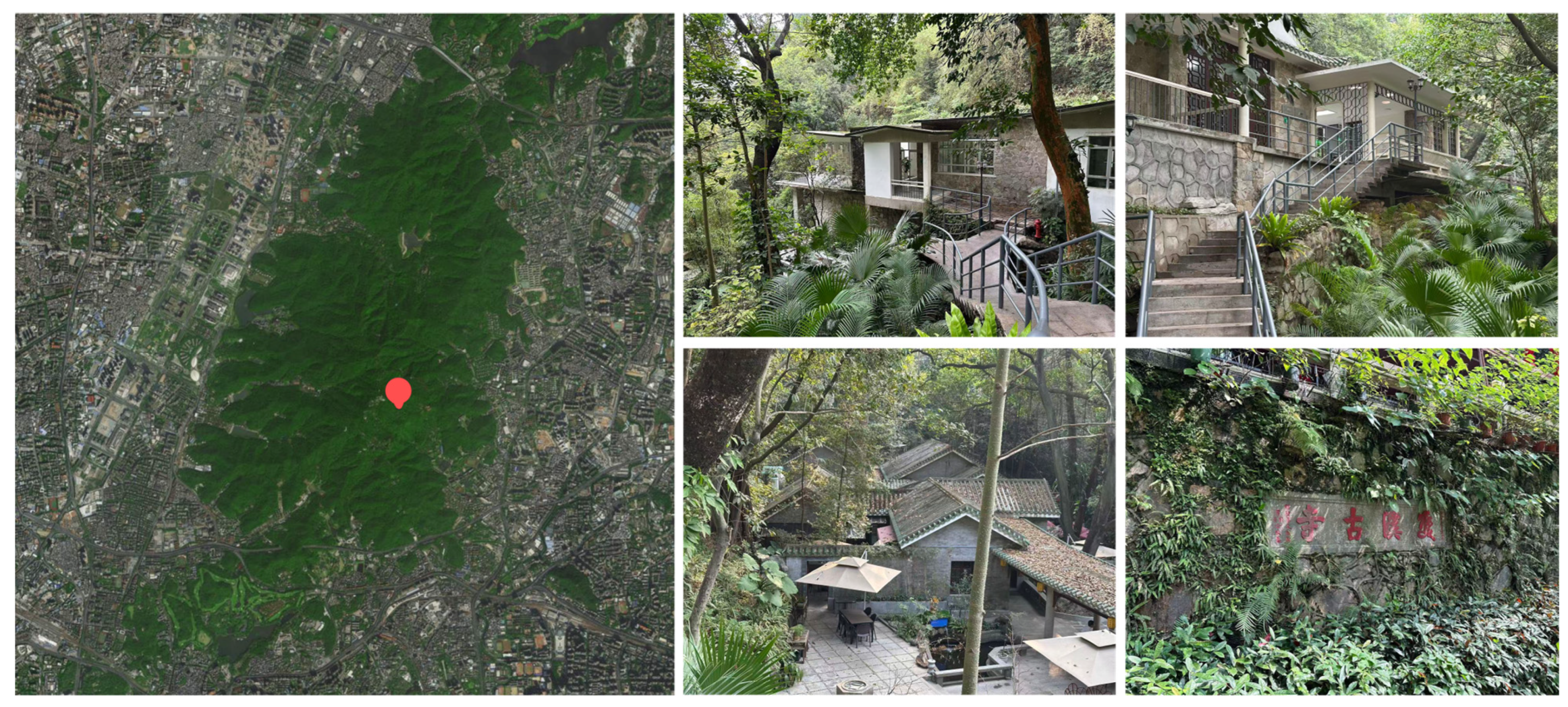
As an outstanding example of Lingnan’s modern historical gardens, Shuangxi Villa was built in 1963 on the site of the ancient Shuangxi Temple within Guangzhou’s Baiyun Mountain Scenic Area, as illustrated in Figure 1. Its historical roots trace back to the Song Dynasty. In 1962, the local government organized its construction. Covering over 4000 square meters, the garden design embodies “lightness and transparency.” Villa B was designed by Mo Bozhi and Wu Weiliang. Relevant studies have thoroughly examined the heritage site’s historical evolution [12], current environmental status [35], heritage characteristics [10], garden design techniques [6], creative philosophy [36], and heritage value [37].
Figure 1.
The location of Shuangxi Villa within the Baiyun Mountain Scenic Area. The name of Shuangxi Ancient Temple is carved on the plateau.
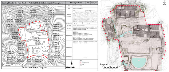
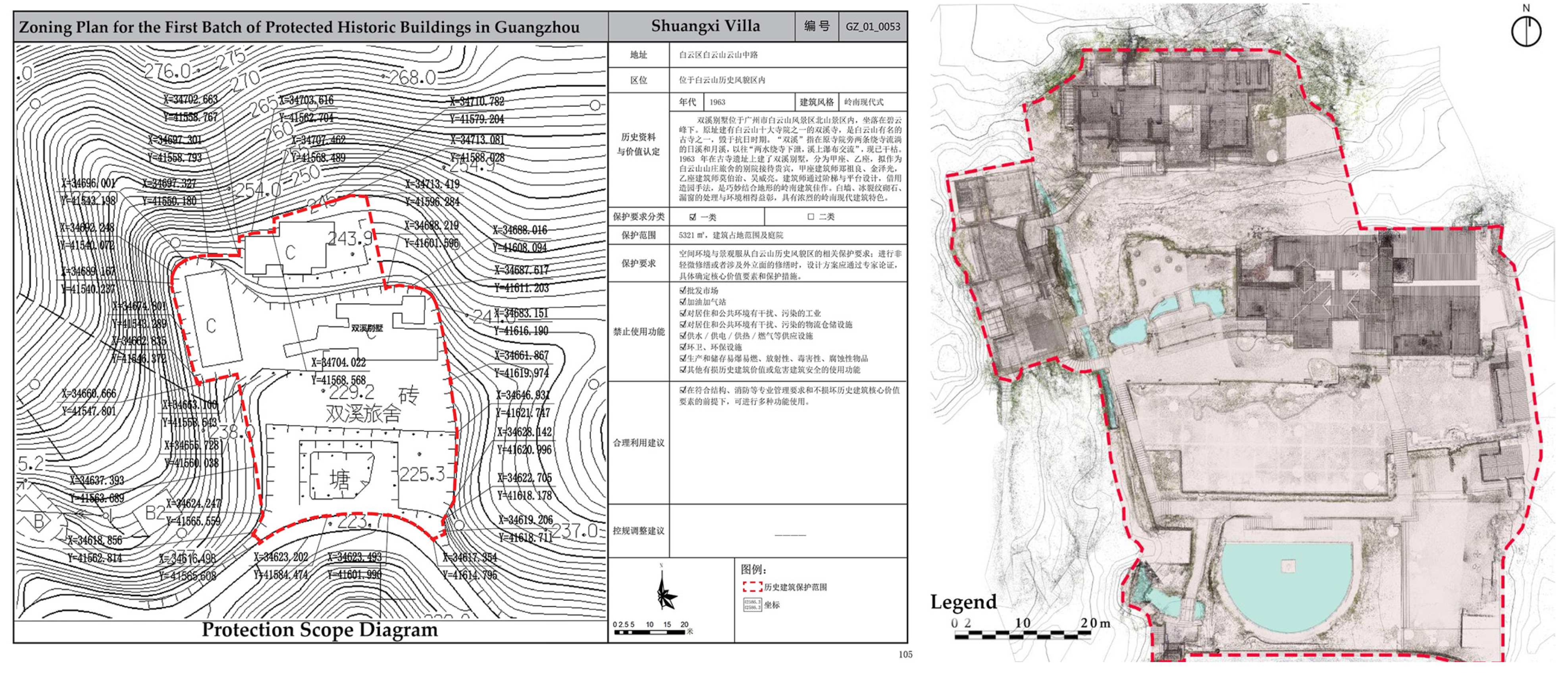
This study focuses on the Shuangxi Villa in Guangzhou, with its digital research area strictly delineated according to the preservation redline boundaries established in the “Guangzhou First Batch of Historic Buildings Protection Planning Map (Part One).” This area fully encompasses the three main buildings on the western, northern, and eastern sides of the site (Building B, Building A, and Building C) along with the core garden landscape zone in the south. The eastern boundary originates from the drainage ditch and retaining wall in the southern section, extending northward to be delineated successively by the eastern boundary of Building C in the central section and the eastern boundary of Building A in the northern section. The southern boundary is defined by the rubble retaining walls flanking the entrance space. The western boundary follows the rubble retaining wall, incorporating the Moon Creek water feature of landscape value into the survey area. The boundary then extends northward along the western side of Building B in the central section. The northern boundary is defined by the rubble retaining wall on the north side of Building A. This closed perimeter precisely delineates the core spatial entity for this digital preservation and exhibition research, as shown in Figure 2.
Figure 2.
Protection Zone and Survey Boundary of Shuangxi Villa.
3. Research Methods
The core of this research methodology lies in the logic of the workflow rather than the application of any single specific business software. The tools mentioned—Leica Cyclone, Revit, EWCDE Twin Map Collaboration, Unreal Engine—can all be replaced by comparable open-source or commercial alternatives (e.g., Context Capture Center Engine, ArchiCAD, Vectorworks, Unity). Key parameters for critical steps such as point cloud stitching and registration, modeling standards, etc., are detailed to ensure method reproducibility.
Technology selection balances precision, efficiency, cost, and usability. For instance, when choosing between handheld and stationary laser scanners versus drones, we evaluated their flexibility in indoor and obstructed areas. 3DGS was selected for its optimal compromise between handling complex vegetation and processing speed.
3.1. Data Collection and Processing
Three-dimensional laser scanning and photogrammetry, as digital technologies for capturing the fundamental composition, morphological structure, and environmental characteristics of heritage objects, offer advantages such as high measurement accuracy and ease of implementation [28]. These techniques provide the data foundation for acquiring point cloud models and real-scene photographs used in constructing three-dimensional models [38]. Due to the site’s dense vegetation and complex topography, relying solely on photogrammetry or 3D laser scanning cannot meet the surveying demands of this intricate terrain. The use of equipment like drones and 3D laser scanners is limited, particularly as dense vegetation coverage restricts drone photography. Therefore, this study established a collaborative framework integrating site laser scanning, handheld laser scanning, photogrammetry, and 3D Gaussian splatter technology based on environmental characteristics, enabling synergistic multi-acquisition techniques for material space.
In this study, we employed site-based laser scanning, handheld laser scanning, and 3D Gaussian splatter mapping techniques to rapidly acquire high-precision 3D spatial data, adapting to the site’s complex topography and vegetation conditions. For site-based laser scanning, the LEICA RTC360 stationary laser scanner (Leica Geosystems AG, Heerbrugg, Switzerland) was deployed along the site’s access routes to capture comprehensive spatial information. The handheld laser scanner employed the LEICA BLK2GO (Leica Geosystems AG, Heerbrugg, Switzerland) to supplement blind spots in the stationary scan, including areas such as rooftops and revetments. The 3D Gaussian splatter scanner utilized the XGRIDS L2 PRO (XGRIDS Technology Co., Ltd., Shenzhen, China) to capture point clouds in irregular, dense areas like vegetation and surface textures of the site environment. Beyond laser scanning, a Canon EOS 70D digital camera was employed (Canon (China) Co., Ltd., Beijing,China). Featuring a 22.3 × 14.9 mm sensor (APS-C format) with 20.2 megapixels and a fixed 22.5 mm focal length, it captured site textures. The combination of these four methods not only delivers high-precision point cloud data but also effectively handles complex geometric environments like dense vegetation, achieving higher fidelity. This provides reliable data support for subsequent modeling and analysis, as shown in Table 1.
Table 1.
Comparison of Surveying and Mapping Techniques for Shuangxi Villas.
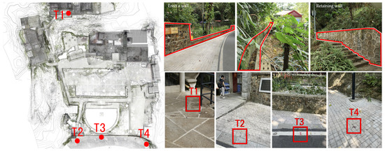
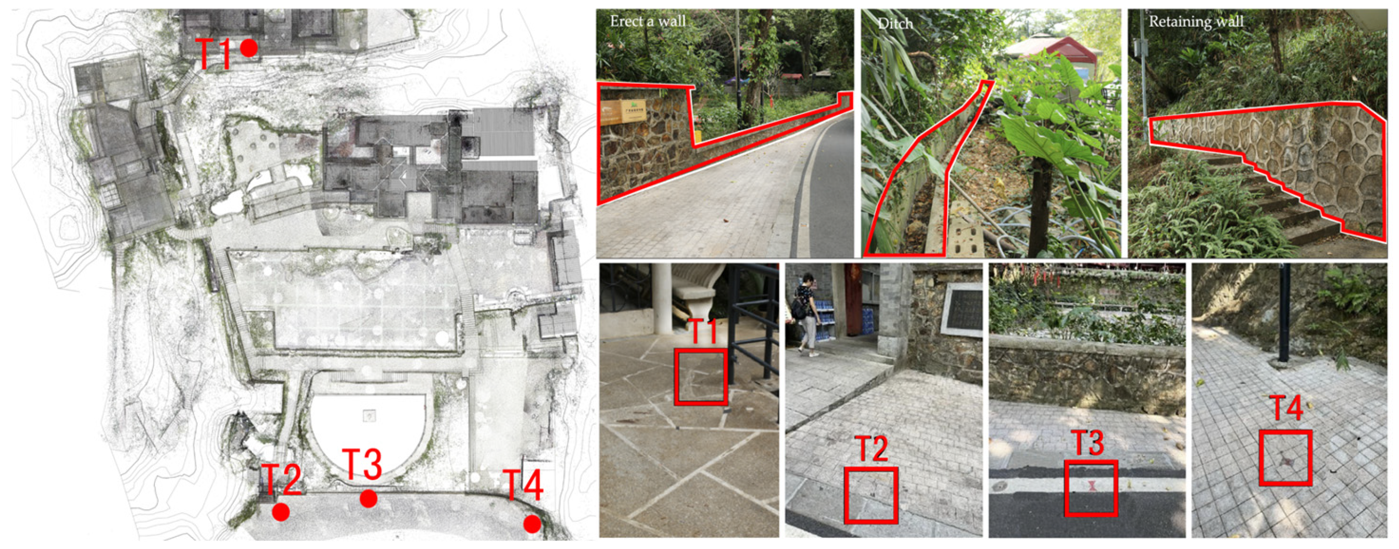
The data collection process includes site surveys, control point layout, control network establishment, and site scanning. Each spatial unit at Shuangxi Villa is independently terraced, requiring multiple survey stations to be combined to obtain complete garden-wide data. Therefore, this study deployed four control points across the entire garden using a ZG25 RTK surveying instrument (Zhongwei Surveying Systems (Wuhan) Co., Ltd., Wuhan, China). Coordinate horizontal errors were controlled to less than 2 mm, and elevation errors to less than 5 mm. This enabled the conversion of individual coordinate systems from single-station point clouds to a unified coordinate system within the overall control network. This facilitated subsequent point cloud stitching to form a complete point cloud dataset, as shown in Figure 3. To obtain comprehensive data for the Guangzhou Shuangxi Villa, integrated point cloud models and panoramic photographs of the garden were acquired through stationary and handheld laser scanning. This included a control network formed by 210 scanning stations, with 198 scanning points collecting a total of 2,430,828,725 point cloud data points. Simultaneously, the device’s built-in camera captured 210 panoramic images with a resolution of 4096 × 3072 pixels each.
Figure 3.
On-site Marking of Control Points at Shuangxi Villa.
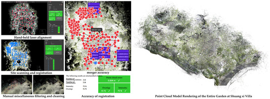
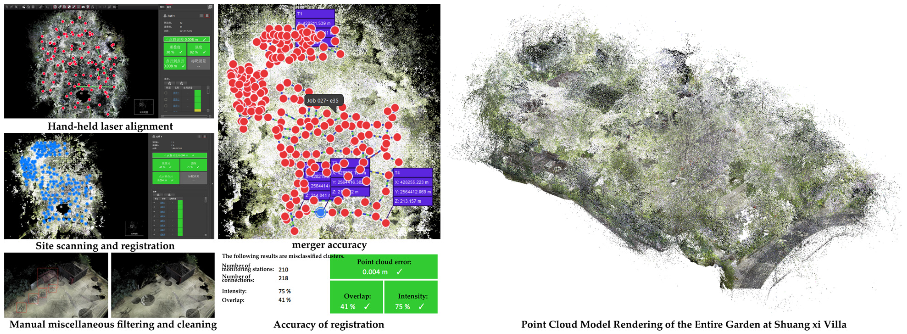
The data processing workflow includes stitching, registration, denoising, and deletion of point cloud data. Survey data was imported into Leica Cyclone Register 360 2023 software developed by Leica Geosystems for denoising, resampling, and feature extraction before point cloud stitching and registration. Manually aligned point clouds were used for data that could not be automatically registered by the software. The processed point cloud comprised 649,063,469 points, with an average stitching error of 4 mm and a point cloud overlap of 41%. Non-original elements within the Shuangxi Villa’s full-garden point cloud model (such as outdoor tents, dining tables and chairs, catering paraphernalia, etc.) were edited and removed using the software. The processing log files were retained to ensure the accurate restoration of Shuangxi Villa’s physical space and maintain process traceability. The final comprehensive point cloud model of Guangzhou Shuangxi Villa was obtained, as depicted in Figure 4.
Figure 4.
The process of generating the point cloud model of Shuangxi Villa.A total of 210 monitoring stations are established, with a point cloud overlap rate of 41%.
3.2. LIM Construction at Shuangxi Villa
The aforementioned digital technologies can produce two types of deliverables: panoramic photographs and point cloud data. The point cloud model of Guangzhou Shuangxi Villa requires format conversion using Autodesk Recap. It is then imported into Autodesk Revit as an RCP file for modeling. The model library is constructed using Revit’s proprietary “Family Library” feature.
Regarding modeling accuracy, the study adopts the Level of Detail (LOD) concept first introduced by the American Institute of Architects (AIA) and meets the requirements for Level of Detail 3.0 (LOD3.0) as specified in the Building Information Modeling Design and Delivery Standard (GB/T 51301-2018) [39]. This approach avoids issues such as excessive workload from high-precision models potentially reducing efficiency, or overly simplified component information failing to meet future application needs of the model [40]. Emphasizing frugality throughout its design and construction, the Guangzhou Shuangxi Villa features a relatively simple overall garden style and interior decoration. Its heritage value is primarily embodied in spatial composition and material usage. Therefore, the modeling precision focuses on distinguishing its materials, forms, and spatial relationships (including precise geometric contours and structural relationships between components).
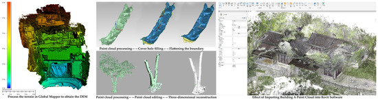
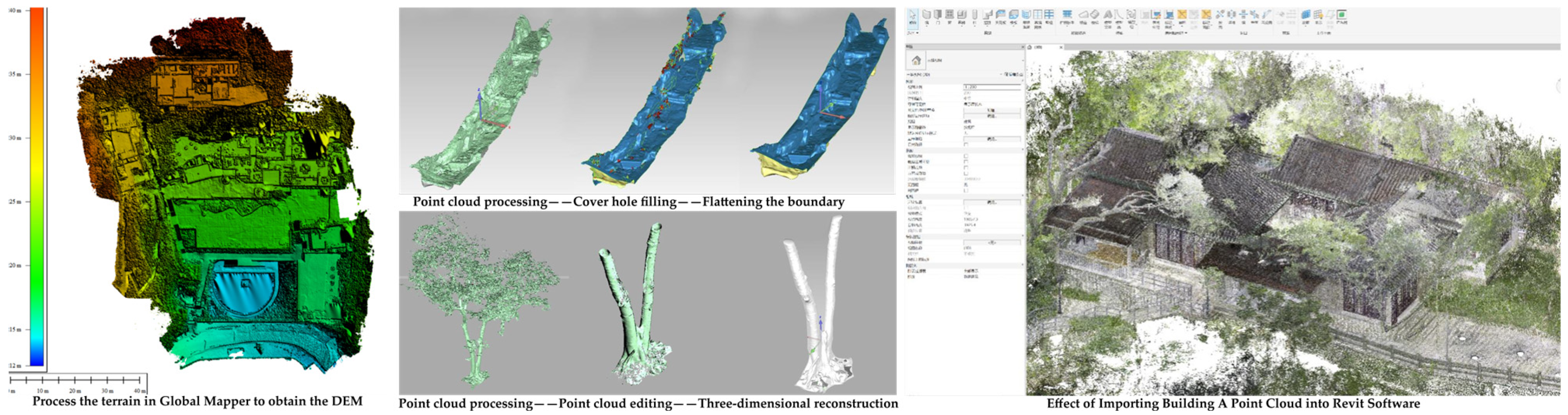
Research was conducted on establishing a Landscape Information Model (LIM) for the garden elements (topography, water features, stones, plants, and architectural structures) of Shuangxi Villa in Guangzhou. Contour lines serve as the primary representation of topography. The study extracts DEM data (Digital Elevation Model) to depict terrain. The point cloud model of Shuangxi Villa’s ground level was imported into LIDAR360 V7.2 software for segmentation and editing. Parameters such as elevation thresholds and slope filtering were configured. DEM data was exported with a grid accuracy of 0.1 m and imported into Global Mapper 23 software. Contour intervals were set to 1 m, with a sampling accuracy of 1 m × 1 m. For irregular entities like vegetation and rocks, surface textures were captured via photography and stitched together. Alternatively, point clouds were sampled using Geomagic Wrap or Context Capture Center at 0.1 m precision, then mesh edges were smoothed with auto-repair functions before being encapsulated into complete 3D models. This method sacrifices some accuracy but yields regular geometric models. For regular spatial entities like buildings and outdoor structures, the study converts point clouds to RCP format for import into Revit. This supports LIM by providing visual references, dimensional benchmarks, and precision assessments during construction. Relying solely on point cloud data makes it difficult to clearly delineate various building components and their connections. Therefore, analyzing internal structural connections requires utilizing archived design, construction, and as-built drawings from Guangzhou Landscape Architecture Group Co., Ltd. (Guangzhou, China). Using the combination of the aforementioned platforms and software, the final LIM model of Guangzhou Shuangxi Villa was obtained, as shown in Figure 5.
Figure 5.
Based on the point cloud model, use different modeling software for three-dimensional reconstruction. Based on point cloud models, perform 3D reconstruction using different modeling software. For example, import the point cloud model into Revit 2025 software.
3.3. Establishment of the Heritage Information Platform
The UNESCO Charter on the Preservation of Digital Heritage, adopted in 2003 as the world’s first systematic international document for protecting digital heritage, states in Article 5 that the ongoing preservation of digital heritage requires systematic measures throughout its entire lifecycle. This necessitates the design of reliable systems and processes to ensure the authenticity and stability of digital objects. This study established a heritage information platform for Guangzhou’s Shuangxi Villa by integrating digital technologies such as laser scanning, photogrammetry, digital restoration, virtual simulation, digital monitoring, and information management. It also incorporated requirements for content outcomes and presentation formats outlined in the local policy, the Guangzhou Municipal Regulations on the Preservation of Historic Gardens, proposing to address the lack of a multi-source data management platform by integrating it into a regional preservation framework.
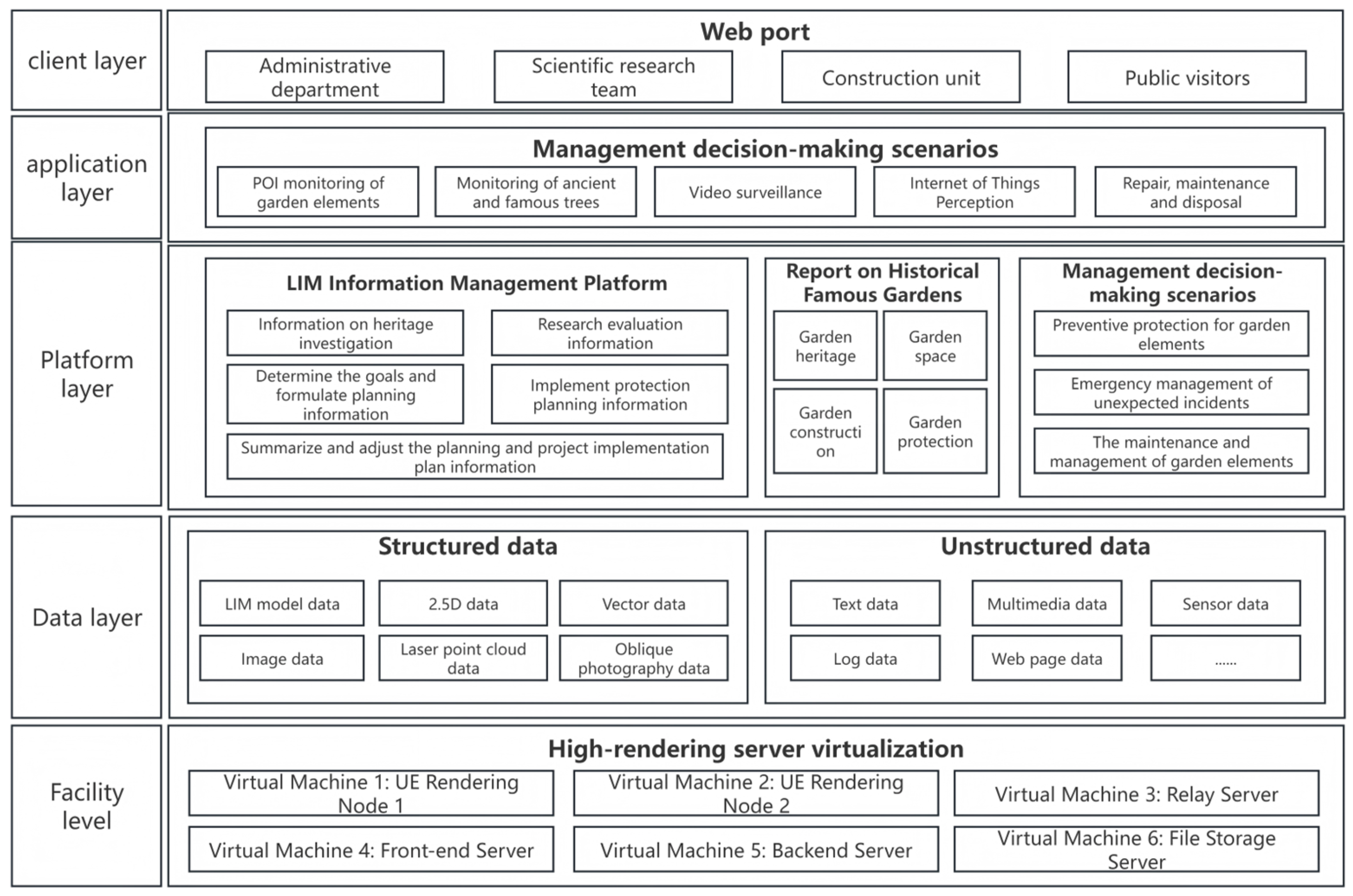
This study integrates the unstructured text requirements in local policies with the operational environment, data sources and types, technical architecture, application scenarios, and target user groups of digital platforms to establish the overall structure of the Shuangxi Villa Heritage Information Platform. Logically, it can be divided into the facility layer, data layer, platform layer, application layer, and user layer, as shown in Figure 6.
- The infrastructure layer provides hardware and software support for platform operations. The study utilized four servers: two rendering servers to meet computational and storage demands for scenes, and two cloud application servers managing the platform’s frontend and backend respectively.
- The data layer comprises structured and unstructured data derived from the heritage survey of Sungai Villa. Textual, pictorial, audio, video, and spatial data pertaining to historical garden conservation are stored in the cloud to ensure timely and readily available access, as shown in Table 2.Table 2. Geometric and Non-Geometric Data Types Integrated into the Platform and Their Applications.
- The platform layer serves as the core component, providing technical support for the heritage information platform. The backend utilizes the EWCDE Collaboration Platform deployed on private servers, offering database integration modules for storing and managing diverse heritage data. The frontend employs Unreal Engine to deliver visualization and application development modules, enabling the deployment of spatial data and the display of high-precision 3D models with interactive capabilities within three-dimensional scenes.
- The application layer integrates multiple use cases to meet the information requirements for the preservation and management of Guangzhou Shuangxi Villas. By combining video surveillance, surveying, and manual data collection to monitor the condition of historical garden elements, it has achieved preventive conservation. During disasters, it enables timely response through browsing or uploading monitoring information, providing essential heritage data for maintenance, repair, and reconstruction operations.
- The user layer represents the platform’s user base. It provides web-based interaction methods for four distinct groups: management departments, research teams, public visitors, and construction entities. Each group possesses different levels of access to platform functionalities.
Figure 6.
Architecture of the Shuangxi Villa Heritage Information Platform.
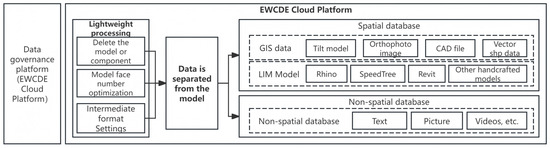
The material and immaterial information of Shuangxi Villa obtained through data collection and processing exhibits multi-source, heterogeneous data format characteristics. Therefore, the study adopts a twin-map collaborative platform for heritage data governance, establishing intermediate formats to process multi-source data including raster, vector, point cloud, and information models. Through lightweight processing, unnecessary models or components (such as internal building structures, landscaping, and decorations) are removed, and the number of model mesh faces is reduced. For information models, a data–model separation approach is adopted, parsing and separating the 3D models from the data. Using the parsed models and files, a model library and database are created on the Twin Map collaborative platform to facilitate subsequent operation and maintenance work, as shown in Figure 7.
Figure 7.
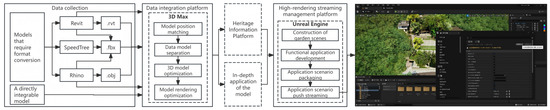
Technical Architecture Diagram of the Shuangxi Villa Heritage Information Platform.
3.4. Visual Presentation and Development
The essence of preserving complex heritage data lies in information dissemination [41]. Therefore, this study integrates multi-source data processing with visualization techniques. Addressing issues such as large capacity and high redundancy in the LIM information model, a data–model separation approach was adopted. Using 3D Max 2022 software, the separated three-dimensional models of garden elements were integrated into a unified spatial reference within the 3D Max platform. The integrated 3D digital model was exported via Unreal Engine’s Data smith plugin, submitted to the engine, and utilized within the editor to create a high-rendering base scene for Shuangxi Villa. Lumen global illumination technology and the Substance material framework were applied to enhance and optimize the model’s appearance, achieving a virtual restoration of the entire Shuangxi Villa environment. This was then packaged and deployed to a web interface, as shown in Figure 8. The Blueprint system within Unreal Engine enables custom visual programming development without requiring external third-party software imports.
Figure 8.
LIM 3D Model Integration Technology and Scene Packaging Interface in Unreal Engine v5.7 Software.
4. Results and Discussion
4.1. Collection and Processing of Physical Elements in Historic Gardens
Given the unique style of Guangzhou Shuangxi Villa, which blends Lingnan classical gardens with modern design concepts, conventional single-element classification methods prove inadequate. To ensure consistency between geometric and semantic data, this study integrates classification frameworks from Lingnan Gardens and the Florence Charter, supplemented by outdoor structure classifications from Garden Architectural Ornaments as references for semantic 3D modeling [1,8,42]. As a mountain landscape garden, topography constitutes a vital component of Shuangxi Villa. Rocks are scattered throughout the site, frequently integrated with water features. Therefore, water bodies and rock elements are grouped into a single category, subdivided into rock placements and retaining walls. For the broad category of plants, alignment with existing point cloud recognition capabilities necessitates further subdivision into trees/shrubs and groundcover. For the numerous structures at Shuangxi Villa, drawing from the classification of outdoor structures in the “Guidelines for Garden Architectural Ornaments,” they are simplified into functional categories: railings, pathways/stairs, retaining walls, and bridge decks. Architectural elements are further detailed into structural components—roofs, beams/columns, walls, railings, and flooring—to illustrate the composition and layout of garden features. This study established a comprehensive classification system integrating classical and modern principles, categorizing site material elements into natural and artificial components. The detailed structure is presented in Table 3. This classification system provides a robust foundation for subsequent feature recognition and information structuring within LIM.
Table 3.
Classification of Elemental Components for Shuangxi Villa.
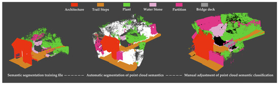
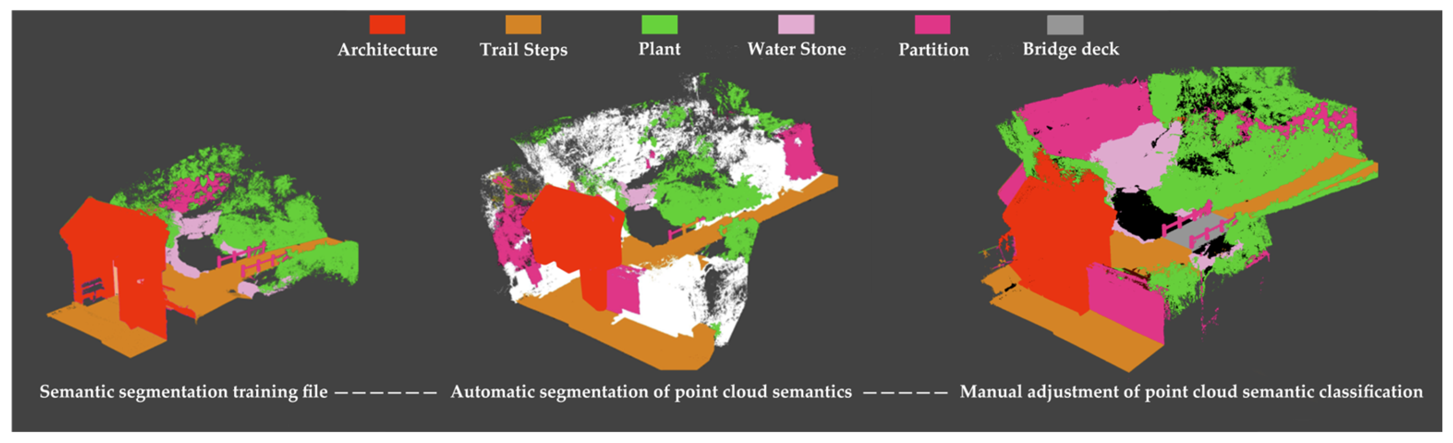
At the data acquisition level, the point cloud data of Shuangxi Villa exhibits characteristics of massive data volume, complex structure, and diverse elements. To construct a high-precision model of the entire garden, this study selected LiDAR360 software for processing. Due to severe spatial occlusion among landscape elements, direct semantic segmentation presents significant challenges. Therefore, the study first employed a ground point filtering algorithm based on Cloth Simulation (CSF). By analyzing the relative positions between simulated cloth and the point cloud, it effectively distinguished ground points from non-ground points, providing a crucial preprocessing step for subsequent precise feature identification. Taking plant features as an example, due to the dense interlacing of tree branches and foliage within the site, necessary manual corrections and interventions were applied to erroneously identified point clouds after initial segmentation. Following processing, the program successfully assigned unique color labels and ID numbers to each tree, generating metadata files (in CSV format) containing key attributes such as location, tree height, and crown spread. These filtered, precise individual tree point clouds can be exported independently, serving as the core basis for constructing detailed tree information models, as shown in Figure 9.
Figure 9.
Point Cloud Processing Machine Learning Workflow13.
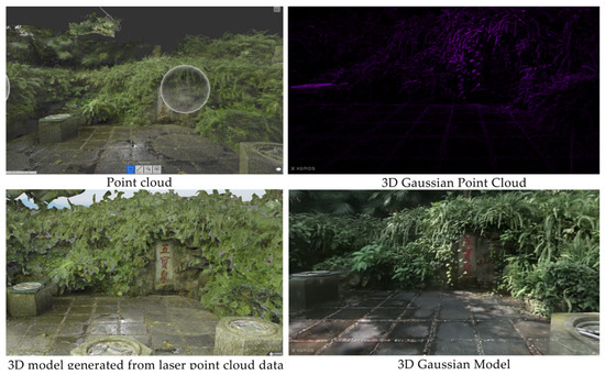
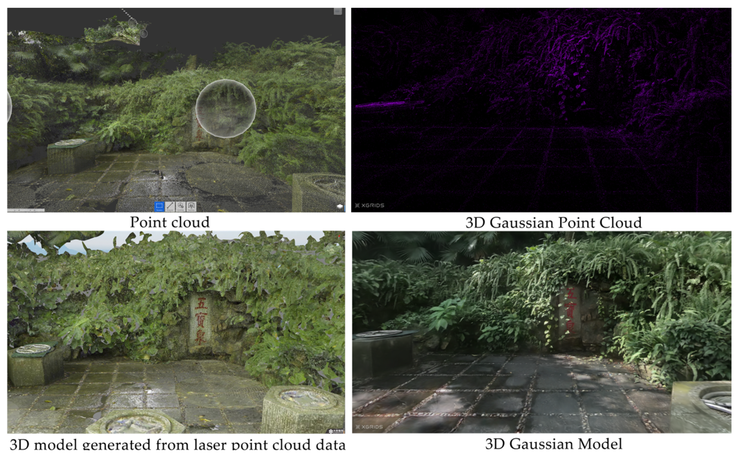
The classification system proposed for Lingnan modern gardens in this study provides a foundation for rapid 3D model construction. However, it retains some ambiguity in defining the specific attributes of individual elements. Future work should develop more detailed classification rules or refine attribute standards by integrating relevant mainstream data standards (e.g., CIDOC CRM, IFC, City GML) [43,44,45,46,47]. Technically, while the CSF filtering algorithm effectively handles complex mountainous terrain, it may erroneously filter out valid point cloud data for the extensive low shrubs and groundcover layers prevalent in the Shuangxi Villa. This could compromise the integrity of lower vegetation information. Therefore, for the lower layer of low shrubs and groundcover plants, the study employed 3D Gaussian Splash with higher resolution to obtain three-dimensional models as a supplement to laser scanning. Taking the Wubaoquan area within the site as an example, the 3DGS model of the same region exhibits a relatively complete and continuous surface, whereas the laser point cloud shows noticeable sparse voids, as illustrated in Figure 10. Although 3D Gaussian Splash demonstrates advantages in complex vegetation areas, its 3DGS requires high consistency in captured images, stable lighting conditions, and demanding hardware (particularly GPU performance). Furthermore, the generated data necessitates intermediate conversion formats for compatibility with traditional CAD/BIM software. Future applications must balance its visual and efficiency benefits against workflow integration costs. Furthermore, when confronting dense and intertwined tree canopies, current point cloud segmentation methods remain highly dependent on manual post-processing. This not only reduces processing efficiency but also introduces subjective errors. Future research could focus on developing or integrating automated segmentation algorithms better suited for highly complex plant community scenarios, thereby enhancing the overall automation and objectivity of the workflow.
Figure 10.
Real-world 3D model generated from 3D Gaussian point clouds in the low shrub and groundcover layer of Shuangxi Villa.
4.2. Digital Applications for Regional Conservation Frameworks of Historic Gardens
Existing digitalization projects for classical gardens, such as Huan Xiu Villa, Jingyi Garden, and the Three Su Shrine, have primarily focused on categorizing and analyzing garden elements and spatial variations, establishing diverse three-dimensional digital models, while paying insufficient attention to intangible information. Shuangxi Villa warrants exploration in its layout, form, style, cultural significance, and spatial environment. Particularly noteworthy is the integration of garden architecture with its surroundings, where distinctive design philosophies profoundly shape spatial forms and elemental arrangements, thereby influencing landscape characteristics and aesthetic expression. This embodies a rich fusion of local modernist theory and traditional garden craftsmanship. Against this backdrop, the promulgation of the Guangzhou Municipal Regulations on the Preservation of Historic Gardens provides a policy foundation for systematic conservation. Article 11 elaborates on the specific requirements for historic garden archives: (1) Basic information on the historic garden, including an assessment of its historical and cultural value; (2) Current status of the garden layout and historical appearance; (3) Master plan and protected perimeter; (4) Detailed documentation including drawings, photographs, and footage of immovable cultural relics, historic buildings, traditional architectural features, and historical sites; (5) Records of ancient and notable trees, including location, geographic coordinates, species information, growth status, and current photographs; (6) Documentation of conservation efforts, objectives, and requirements. These requirements encompass the heritage value, spatial elements, data types, and conservation status of the gardens. The regional conservation framework provides the foundation for multi-source data management, guiding the establishment of the heritage information platform in this study.
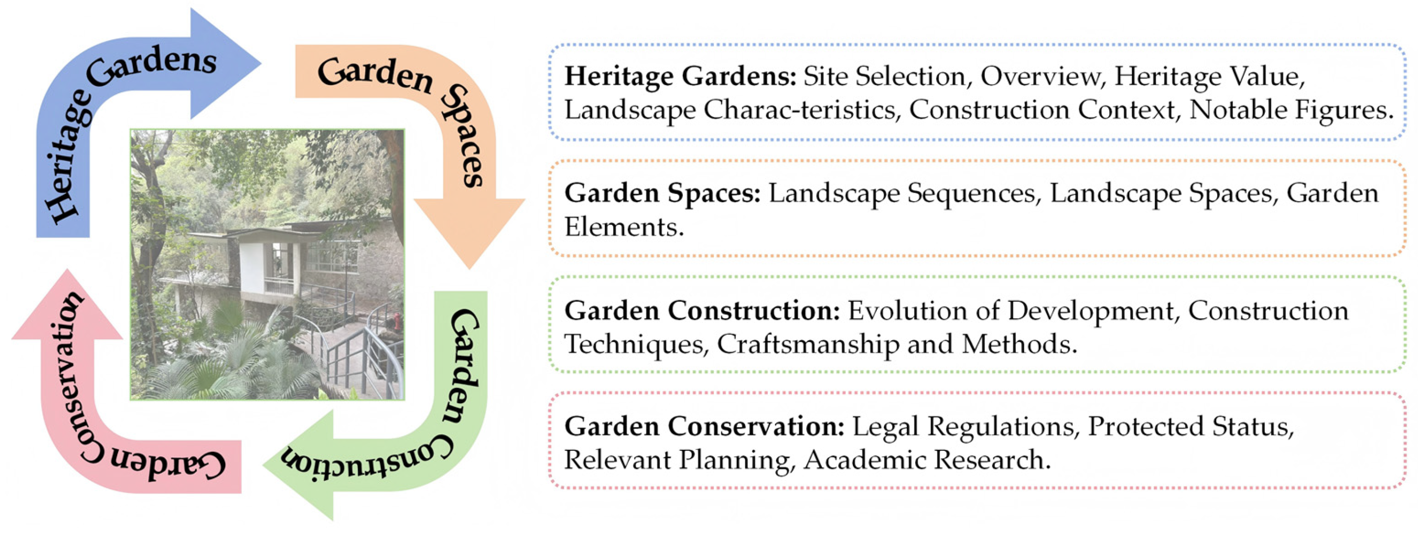
In response, this study constructs a systematic research framework encompassing four dimensions: cognition, ontology, application, and preservation. It aims to comprehensively examine the heritage value, spatial structure, construction wisdom, and management strategies of Shuangxi Villa. This framework is specifically divided into four major categories and sixteen subcategories: heritage of the garden, spatial structure of the garden, construction techniques of the garden, and conservation of the garden. This approach seeks to serve the preservation of historic gardens, as illustrated in Figure 11:
- Heritage Gardens: Site Selection, Overview, Heritage Value, Landscape Characteristics, Construction Context, Notable Figures;
- Garden Spaces: Landscape Sequences, Landscape Spaces, Garden Elements;
- Garden Construction: Evolution of Development, Construction Techniques, Craftsmanship and Methods;
- Garden Conservation: Legal Regulations, Protected Status, Relevant Planning, Academic Research.
Figure 11.
Outline of Historical Garden Nomination Content.
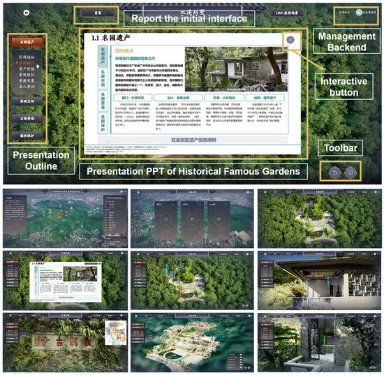
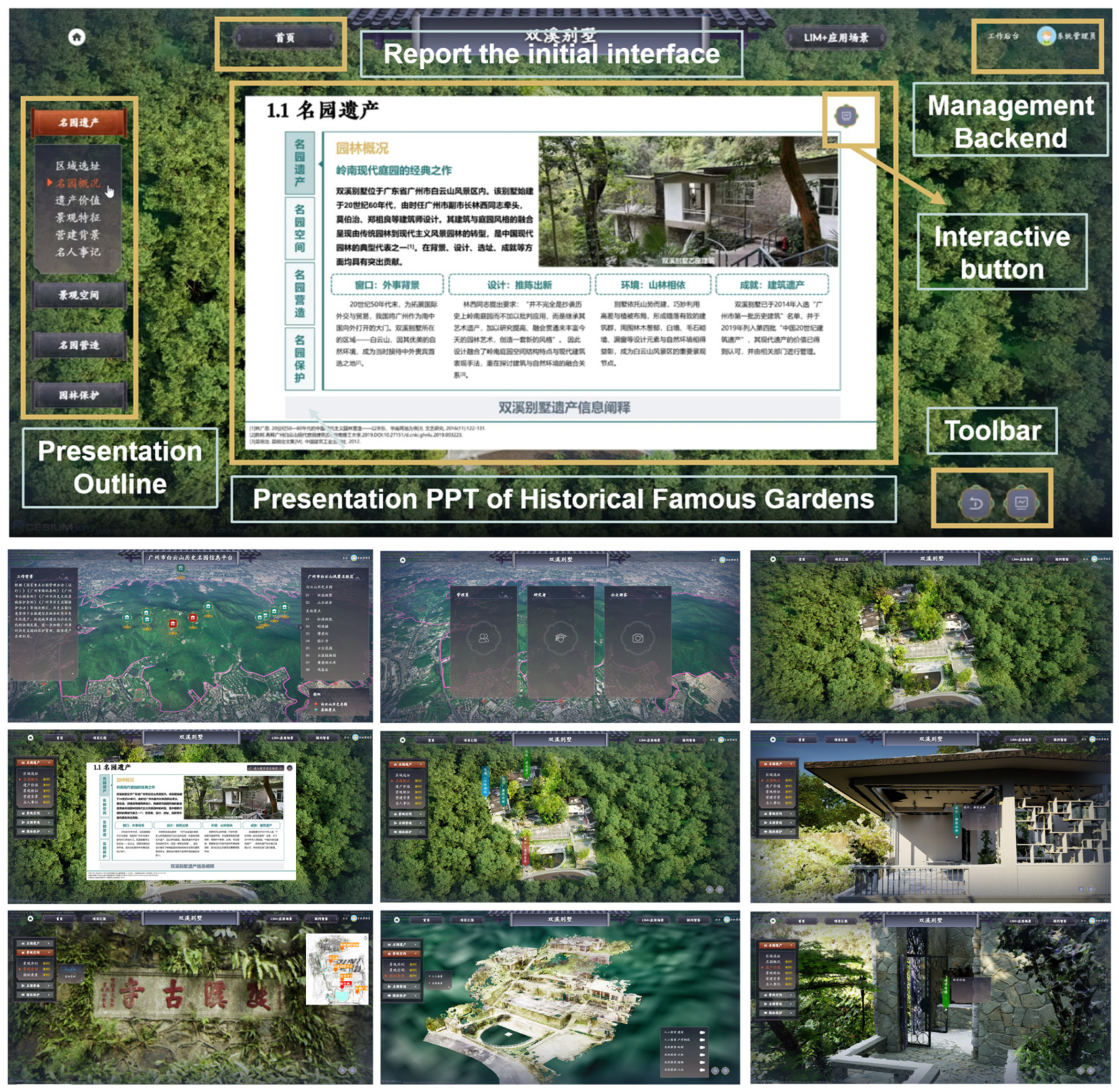
The Guangzhou Shuangxi Villa Historical Garden Information Platform is built upon surveying-derived spatial models of garden elements, including point cloud models, BIM models, mesh models, 3D Gaussian models, as well as image, text, and video data. The platform’s development focuses on four key areas: garden recognition and identification, ontological feature analysis, application pathway communication, and conservation status statistics. By establishing a database of historical garden heritage data, it becomes pivotal for preserving historical gardens. Serving as a carrier for integrating diverse data and professional analytical content, the heritage information platform enables information visualization and interactive scenarios. This enriches core data for various garden types, facilitating sustainable conservation, as illustrated in Figure 12.
Figure 12.
Historical Garden Information Platform User Guide and Functional Examples (Including Main Interface, User Selection Interface, Reporting Interface, and Various Interactive Display Interfaces) [8,36].
The four-dimensional framework proposed in this study and its corresponding information platform partially address the limitations of existing landscape digitization practices that “prioritize the material while neglecting the immaterial.” It provides a systematic solution for integrating the physical space and deep cultural value of Shuangxi Villa. However, the successful implementation of this framework faces two major challenges. First, standardizing and structurally encoding the intangible information within “heritage gardens” and “garden construction”—such as construction contexts, craft techniques, and aesthetic expressions—while accurately linking them to their physical carriers presents significant technical and methodological difficulties. Although the current platform integrates multi-source data, further exploration is needed on achieving deep semantic associations and intelligent knowledge mining. Second, the long-term “sustainable preservation” of platform data relies on continuous management, maintenance, and financial investment. Establishing effective operational mechanisms to ensure dynamic data updates and platform vitality represents a practical challenge that must be addressed as the initiative transitions from research to implementation.
4.3. Daily Management Application Scenarios for Historical Landscape Elements Based on LIM
This study successfully developed a management pathway for the daily operation of the historical gardens at Sungai Villa based on the LIM framework. The pathway strictly adheres to the operational procedures outlined in the Chinese Guidelines for the Conservation of Cultural Heritage and places the management focus on the “research and evaluation” phase. It effectively addresses three major challenges in conservation practices: “untimely discovery,” “inadequate diagnosis,” and “incorrect treatment.” This methodology provides systematic support for management departments to identify and resolve potential issues while coordinating efforts to preserve spatial integrity and authenticity.
During the “survey” phase, this study implemented methods for collecting and integrating multi-source heterogeneous data. Results indicate that for irregular elements like plants, relying solely on point cloud data to generate mesh models introduces significant errors, failing to meet precise management requirements. Therefore, this study adopted a combined approach of photogrammetry, point cloud data, and specialized software (e.g., Speed Tree) modeling as an effective solution to enhance the accuracy of plant information models. For elements such as buildings and garden paths, standardized collection protocols were established for BIM models and mesh models respectively, ensuring the diversity and applicability of information models.
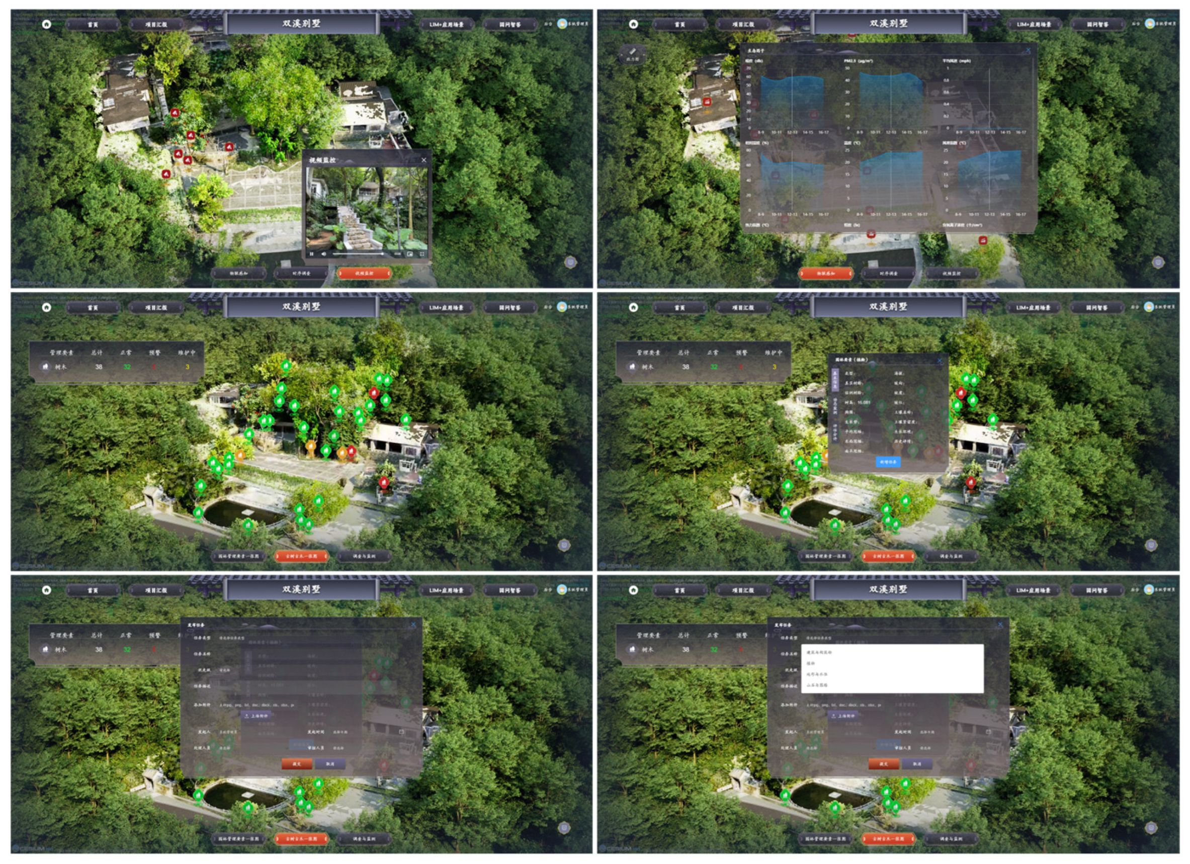
The implementation results of the management process demonstrate that through the integration of the Twin Map collaboration platform with LIM application scenarios, a closed-loop management system can be achieved—from issue early warning to disposal review. Specifically, when problems are identified during the research and assessment phase, the system triggers POI alerts for landscape elements and generates task work orders. Maintenance units receive tasks via mobile devices, conduct on-site disposal, and submit for review, forming a dynamic cycle of “investigation–assessment–goal setting–disposal–feedback evaluation,” as illustrated in Figure 13. This process, applied at Guangzhou Shuangxi Villa, crystallizes into four operational core steps: (1) Data collection and heritage survey; (2) Assessment analysis and conservation implementation; (3) POI updates and task initiation; (4) Maintenance resolution and audit request. Ultimately, through information archiving and platform feedback, a management loop is established, significantly enhancing the responsiveness and standardized resolution of daily maintenance tasks, as illustrated in Figure 14.
Figure 13.
Path Construction of Management Decision-Making LIM.
Figure 14.
The “One Map for Landscape Elements” module integrates monitoring, maintenance, and resolution functions for various landscape management elements (including video surveillance, ecological monitoring, landscape element monitoring, and an interface for submitting resolution actions).
The LIM daily management pathway developed in this study provides a feasible technical framework for achieving refined, process-oriented management of historical garden elements. To ensure the platform’s long-term vitality, we propose a three-tier maintenance protocol: (1) Routine updates by inspection personnel and site administrators: Daily photographic documentation and monthly uploads of inspection logs to the platform; (2) Annual audits by specialists: Update heritage health ratings based on annual monitoring data (e.g., point cloud comparisons, photo evaluation analyses); (3) Versioned updates following major alterations by the project team: After any restoration or modification work, a new LIM model version must be generated and archived alongside the previous version to establish a traceable record. Model version control can be achieved using the timeline functionality within the EWCDE LuanTu collaboration platform’s built-in model library. However, its implementation and application have revealed several limitations worthy of discussion. On one hand, the effectiveness of this pathway heavily depends on the completeness and accuracy of preliminary data collection. Although the study proposes modeling approaches for different elements, the refinement of plant models, for instance, still relies on specialized software and manual intervention. This relatively complex process may pose cost and efficiency challenges during large-scale implementation. Future research should explore more automated, low-cost technologies for real-world 3D modeling and semantic information association. On the other hand, while a management loop has been established, its level of “intelligence” remains limited. The system primarily facilitates information flow and process management, yet the “research evaluation” phase heavily relies on manual judgment based on experience. A key direction for future research is how to more deeply integrate machine learning algorithms to conduct predictive assessments of heritage condition changes, thereby shifting from “reactive response” to “proactive intervention.”
5. Conclusions
This study takes the Shuangxi Villa in Guangzhou as a case example to establish a LIM-based digital preservation framework covering the entire process from data collection and processing to management and application. The study primarily achieved three objectives: (1) It achieved high-precision feature interpretation in complex Lingnan garden environments. The framework provides systematic digital support for the sustainable preservation and daily management of landscape heritage. By integrating photogrammetry, terrestrial and handheld laser scanning, and 3D Gaussian splatter technology, combined with multi-software collaboration and regionally specific semantic construction of the LIM model, this study successfully achieved precise identification and quantitative documentation of multiple elements and their spatial relationships within a complex environment where architecture, vegetation, and topography are highly intertwined. This effectively addresses the previous research gap in insufficient attention to the characteristics of Lingnan modern gardens, and addresses the limitations of relying solely on a single technical approach. (2) A regional heritage information platform has been established. Addressing the relatively lagging digital heritage progress in Lingnan, this study integrates a cloud information management platform (Twin Map Collaboration Platform) with a game engine (Unreal Engine) in the region. It developed a regional heritage information platform supporting multi-source heterogeneous data management, visualization, and interactive analysis, providing a reusable technical framework for the digital preservation of small-to-medium-sized, high-value heritage sites. (3) It developed scenario-based application pathways tailored to daily management needs. To overcome compatibility barriers between digital technologies and management practices, this study further applied LIM technology to specific management scenarios. It developed and integrated modules for preventive conservation, emergency response, and implementation procedures, achieving preliminary synergy between technical capabilities and management requirements.
Overall, this study’s LIM framework extends hybrid data collection approaches for complex tropical and subtropical regional environments, particularly exploring Gaussian splatter techniques for modeling low vegetation and complex terrain. It incorporates a regional heritage information platform tailored for Lingnan through local policy frameworks, while expanding backward to create closed-loop application scenarios linked to specific management operations. This provides a concrete technical pathway for constructing a comprehensive historical garden heritage information platform. However, when migrating this framework to other small-to-medium-sized historical gardens with comparable complexity, the following adjustments are required: (1) Replace the regional knowledge base with locally relevant regulations and value assessment criteria; (2) Adapt the feature classification system to align with local garden characteristics; (3) Select appropriate data collection techniques based on garden features (e.g., prioritizing photogrammetry for architecture-dominated gardens); (4) Consider objective factors including the establishment of interdisciplinary teams in the initial phase, sustained data maintenance investments during the mid-phase, and management acceptance of the digital workflow.
However, this research still has several limitations. First, the singularity of the case study limits the generalizability of conclusions across broader categories of Lingnan gardens. Future research should incorporate representative garden cases from different periods and styles for validation and refinement. Second, the technical framework and application logic of the constructed platform have not yet undergone systematic validation in long-term management practice. Moreover, its advanced visualization capabilities may increase application costs. Future efforts should explore more cost-effective alternatives and establish a scientific evaluation system. Finally, the potential of LIM for intelligent decision-making and data-driven optimization remains largely untapped. Constrained by data quality, sample size, and algorithm integration, future research should focus on deepening the integration of AI algorithms with the LIM platform. This includes developing intelligent analysis modules tailored for conservation management and exploring continuous learning mechanisms based on big data to enhance the model’s adaptive capacity and predictive accuracy in historical garden conservation.
Author Contributions
Conceptualization, W.G. and R.L.; methodology, W.G. and R.L. and M.L.; software, R.L. and M.L.; validation, W.G. and S.H.; formal analysis, W.G. and R.L. and M.L.; investigation, R.L. and M.L.; resources, W.G. and R.L.; data curation, R.L. and M.L.; writing—original draft preparation, R.L.; writing—review and editing, W.G. and R.L.; visualization, R.L.; supervision, W.G. and S.H.; project administration, W.G.; funding acquisition, W.G. All authors have read and agreed to the published version of the manuscript.
Funding
This research is funded by the Science and Technology Plan Project of Guangzhou Construction Group Co., Ltd. and the award number is [2024]-KJ090. The research is funded by the Guangzhou Science and Technology Plan Project, and the award number is 2023A04J561. This research is funded by the Guangzhou Basic and Applied Basic Research Project, and the funding number is SL2022A04J01191. This research is funded by the 2023 General Project of the Guangzhou Philosophy and Social Sciences Development Plan for the 14th Five-Year Plan Period, Guangdong Province, China, and the funding number is 2023GZYB42. This research is funded by the Humanities and Social Sciences Research Project of the Ministry of Education of China, and the award number is 24YJA760026.
Institutional Review Board Statement
Not applicable.
Informed Consent Statement
Not applicable.
Data Availability Statement
The data presented in this study are available on request from the corresponding author. The data are not publicly available due to privacy reasons.
Acknowledgments
We extend our gratitude to Guangzhou Landscape Construction Group Co., Ltd. for its support of surveying and mapping-related work, including the valuable insights and historical archives provided by Gong Chen. We also thank Zhuo Sheng hao and Xu Yaoting of the Digital Engineering Institute at China Power Engineering Consulting Group East China Survey and Design Institute for their guidance and relevant materials regarding platform development. Additionally, we acknowledge the assistance of Xiao Yong tao from South China Agricultural University in BIM model construction, as well as Chen Pu and Zhou Xiao yin in ecological data collection.
Conflicts of Interest
The authors declare no conflicts of interest.
Abbreviations
The following abbreviations are used in this manuscript:
| LIM | Landscape Information Modeling |
| DEM | Digital height model |
| EWCDE | Luan Tu Collaboration Platform |
| UE | Unreal Engine |
| CSF | Cloth simulation filtering |
| IFC | Industry Foundation Classes |
| CAD | Computer Aided Design |
| BIM | Building Information Modeling |
| POI | Point Of Information |
References
- ICOMOS (International Council on Monumants and Sites). The Florence Charter. 1982. Available online: https://www.icomos.org/images/DOCUMENTS/Charters/gardens_e.pdf (accessed on 10 October 2024).
- CJJ/T 91—2017; Standard for Basic Terminology of Landscape Architecture. Ministry of Housing and Urban-Rural Development of the People’s Republic of China: Beijing, China; China Architecture & Building Press: Beijing, China, 2017.
- Waterton, E.; Smith, L. Heritage protection for the 21st century. Cult. Trends 2008, 17, 197–203. [Google Scholar] [CrossRef] [Scilit]
- Carvalho, P.; Susana, S. Historic gardens: Heritage and tourism. Tur. Soc. 2013, 6, 605–625. [Google Scholar]
- Li, W.; Gao, C. Research on Changsha Gardens in Ming Dynasty, China. Land 2023, 12, 707. [Google Scholar] [CrossRef] [Scilit]
- Lu, Q. Lingnan Garden Design and Aesthetics, 2nd ed.; China Architecture & Building Press: Beijing, China, 2005.
- Zhou, W.Q. A History of Classical Chinese Gardens, 3rd ed.; Tsinghua University Press: Beijing, China, 2008; p. 687. [Google Scholar]
- Xia, C.S.; Mo, B.Z. Lingnan Garden, 1st ed.; China Architecture & Building Press: Beijing, China, 2008; pp. 17–57.
- Lin, G.S. Inheritance and Innovation in Lingnan Garden Art: A Study Based on Villa B of Shuangxi Guest House. Decoration 2014, 7, 76–78. [Google Scholar] [CrossRef]
- He, X.Y. A Study on the Suitability of Ventilation Design in Lingnan Mountainous Landscape Gardens. Master’s Thesis, South China University of Technology, Guangzhou, China, 2021. [Google Scholar] [CrossRef]
- Meng, Y. A Preliminary Discussion on the Cultural Regional Character of Villa B at Shuangxi Guest House. J. Liaocheng Univ. 2015, 28, 42–46. [Google Scholar]
- Zhu, X.W. Revitalization of the Historical Building Complex at Shuangxi Villa. Master’s Thesis, South China University of Technology, Guangzhou, China, 2017. [Google Scholar]
- Guangzhou Municipal Local Chronicles Compilation Committee. Guangzhou Chronicles; Guangzhou Publishing House: Guangzhou, China, 1995; Volume 3, p. 554.
- Adamopoulos, E.; Rinaudo, F. Close-range sensing and data fusion for built heritage inspection and monitoring—A review. Remote Sens. 2021, 13, 3936. [Google Scholar] [CrossRef] [Scilit]
- Sutherland, N.; Marsh, S.; Priestnall, G.; Bryan, P.; Mills, J. InfraRed thermography and 3D-data fusion for architectural heritage: A scoping review. Remote Sens. 2023, 15, 2422. [Google Scholar] [CrossRef] [Scilit]
- Zhao, C.; Zhang, Y.; Wang, C.-C.; Hou, M.; Li, A. Recent progress in instrumental techniques for architectural heritage materials. Herit. Sci. 2019, 7, 36. [Google Scholar] [CrossRef] [Scilit]
- He, Y.; Ma, Y.H. Research on the Theory and Innovative Practice of “Digital Heritage”. Chin. Cult. Herit. 2016, 4–17. [Google Scholar]
- Zhang, Z.; Dang, A.R.; Hou, M.L.; Wu, D.; Wang, Z.; Zhang, Z.; Xin, T. Establishing an Information Technology Methodology Framework for the Protection and Utilization of the Great Wall Cultural Heritage. J. Remote Sens. 2021, 25, 2339–2350. [Google Scholar]
- Dell’Unto, N.; Leander, A.M.; Dellepiane, M.; Callieri, M.; Ferdani, D.; Lindgren, S. Digital reconstruction and visualization in archaeology Case-study drawn from the work of the Swedish Pompeii Project. In Proceedings of the 2013 Digital Heritage International Congress, Marseille, France, 28 October–1 November 2013. [Google Scholar] [CrossRef] [Scilit]
- von Schwerin, J.; Richards-Rissetto, H.; Remondino, F.; Agugiaro, G.; Forte, M.; Maqueda, R. The MayaArch3D Project: Digital Technologies for Research in Maya Archaeology. In Final Performance Report and White Paper for NEH Digital Humanities Level II Start-Up Grant; NEH Office of Digital Humanities (ODH): Washington, DC, USA, 2010. [Google Scholar]
- Feng, N.E. A Review of Concepts and Practices in Museum Digitalization: The Case of the Digital Palace Museum Community. Bull. Palace Mus. 2017, 1, 108–123+162. [Google Scholar] [CrossRef]
- Murphy, M.; Mcgovern, E.; Pavía, S. Historic building information modelling (HBIM). Struct. Surv. 2009, 27, 311–327. [Google Scholar] [CrossRef] [Scilit]
- Xu, J. Research on Digital Preservation and Application of the Du Fu Thatched Cottage, a Memorial Garden Honoring Historical and Cultural Figures of Western Shu. Ph.D. Thesis, Sichuan Agricultural University, Chengdu, China, 2024. [Google Scholar] [CrossRef]
- Liu, S.; Zhang, S.W. Research Progress in Digital Landscape Technology: An Overview of the Development of the International Digital Landscape Conference. Chin. Landsc. Archit. 2015, 31, 45–50. [Google Scholar] [CrossRef]
- Guo, Y. On the Conceptual Implications and Technical Application System of Landscape Architecture Information Models. Chin. Landsc. Archit. 2020, 36, 17–22. [Google Scholar] [CrossRef]
- Yang, C.; Han, F.; Wu, H.; Chen, Z. Heritage Landscape Information Model (Hlim): Towards a Contextualised Framework for Digital Landscape Conservation in China. Int. Arch. Photogramm. Remote Sens. Spatial Inf. Sci. 2019, XLII-2/W15, 1221–1227. [Google Scholar] [CrossRef] [Scilit]
- Zhang, R.; Zhang, C. Classification and Application of Digital Technologies in Landscape Heritage Protection. Land 2022, 11, 1699. [Google Scholar] [CrossRef] [Scilit]
- Liang, H.L.; Li, W.Z.; Lai, S.Q.; Zhu, L.X.; Jiang, W.L.; Zhang, Q.P. The integration of terrestrial laser scanning and terrestrial and unmanned aerial vehicle digital photogrammetry for the documentation of Chinese classical garden–a case study of Huan Xiu Shan Zhuang, Suzhou. China J. Cult. Herit. 2018, 33, 222–230. [Google Scholar] [CrossRef] [Scilit]
- Jia, S.Z.; Liao, Y.; Xiao, Y.Q.; Zhang, B.; Meng, X.B.; Qin, K. Conservation and management of Chinese classical royal garden heritages based on 3D digitalization-a case study of Jianxin courtyard in Jingyi garden in fragrant hills. J. Cult. Herit. 2022, 58, 102–111. [Google Scholar] [CrossRef] [Scilit]
- Guo, L.; Ma, W.; Gong, X.; Zhang, D.; Zhai, Z.; Li, M. Digital preservation of classical gardens at the San Su Shrine. Herit. Sci. 2024, 12, 66. [Google Scholar] [CrossRef] [Scilit]
- Perez, M.E.; Lopez, C.M.S.; Herrero, T.T.; Pérez-Souza, M.A.; de Mata, J.A.; Ezquerra-Canalejo, A. Assessment of tree diameter estimation methods from mobile laser scanning in a historic garden. Forests 2021, 12, 1013. [Google Scholar] [CrossRef] [Scilit]
- Thürkow, D.; Pokladek, M.; Dette, C.; Glässer, C. 3D-Landschaftsvisualisierungen fur einnachhaltiges Management zum Erhalt und zur Pflege des UNESCO Weltkulturerbes Dessau Worlitzer. Gartenreich 2014, 2014, 129–141. [Google Scholar] [CrossRef] [Scilit]
- Zhang, L.; Wang, F.Y.; Cheng, X.; Li, C.; Lin, H.; Song, Y.X. 3D Documentation of Cultural Heritage: The Case Study of Banteay Srei Temple in Angkor, Siem Reap. ISPRS—Int. Arch. Photogramm. Remote Sens. Spat. Inf. Sci. 2020, XLIII-B2-2, 919–923. [Google Scholar] [CrossRef] [Scilit]
- Napolitano, R.K.; Scherer, G.; Glisic, B. Virtual tours and informational modeling for conservation of cultural heritage sites. J. Cult. Herit. 2018, 29, 123–129. [Google Scholar] [CrossRef] [Scilit]
- Zhuang, S.P. A Study on the Architectural Creative Process and Thought of Mo Boji. Ph.D. Thesis, South China University of Technology, Guangzhou, China, 2011. [Google Scholar]
- Chen, K. Reinterpreting the Modern Garden Architecture of Baiyun Mountain, Guangzhou. Master’s Thesis, South China University of Technology, Guangzhou, China, 2019. [Google Scholar] [CrossRef]
- Lei, K.X. The Formation and Influence of Lingnan Modernist Garden Style. Master’s Thesis, South China University of Technology, Guangzhou, China, 2020. [Google Scholar] [CrossRef]
- Jia, S.J.; Liu, C.; Guan, X.J.; Wu, H.B.; Zeng, D.D.; Guo, J. Bidirectional interaction between BIM and construction processes using a multisource geospatial data enabled point cloud model. Autom. Constr. 2022, 134, 104096. [Google Scholar] [CrossRef] [Scilit]
- GB/T 51301-2018; Building Information Modeling Design and Delivery Standard. China Standards Press: Beijing, China, 2018.
- Zhang, J.; Zhang, L.; Zhao, W.; Lu, Y.; Wang, X.; Yao, S.; Lyu, H. HBIM for the protection and management: A case study of Chinese timber architectural heritage. npj Herit. Sci. 2025, 13, 399. [Google Scholar] [CrossRef] [Scilit]
- Dai, D.X.; Zheng, M.L.; Chen, M.S. Construction and Application of a Knowledge Hierarchy Information Model for Urban Historical Parks Oriented toward Conservation Management. Landsc. Archit. 2023, 30, 91–99. [Google Scholar] [CrossRef]
- Liu, G.P. Regarding Garden Architecture and Decorative Elements, Architect; China Architecture & Building Press: Beijing, China, 1980; pp. 83–108.
- Bruseker, G.; Carboni, N.; Guillem, A. Cultural heritage data management: The role of formal ontology and CIDOC CRM. In Heritage and Archaeology in the Digital Age: Acquisition, Curation, and Dissemination of Spatial Cultural Heritage Data; Vincent, M.L., López-Menchero Bendicho, V.M., Ioannides, M., Levy, T.E., Eds.; Springer: Cham, Switzerland, 2017; pp. 93–131. [Google Scholar] [CrossRef] [Scilit]
- Doerr, M. The CIDOC conceptual reference module: An ontological approach to semantic interoperability of metadata. AI Mag. 2003, 24, 75. [Google Scholar]
- Diara, F.; Rinaudo, F. IFC classification for FOSS HBIM: Open issues and a schema proposal for cultural heritage assets. Appl. Sci. 2020, 10, 8320. [Google Scholar] [CrossRef] [Scilit]
- Kolbe, T.H. Representing and exchanging 3D city models with CityGML. In 3D Geo-Information Sciences; Lee, J., Zlatanova, S., Eds.; Springer: Berlin, Germany, 2009; pp. 15–31. [Google Scholar] [CrossRef] [Scilit]
- Gröger, G.; Plümer, L. CityGML—Interoperable semantic 3D city models. ISPRS J. Photogramm. Remote Sens. 2012, 71, 12–33. [Google Scholar] [CrossRef] [Scilit]




Disclaimer/Publisher’s Note: The statements, opinions and data contained in all publications are solely those of the individual author(s) and contributor(s) and not of MDPI and/or the editor(s). MDPI and/or the editor(s) disclaim responsibility for any injury to people or property resulting from any ideas, methods, instructions or products referred to in the content. |
© 2026 by the authors. Licensee MDPI, Basel, Switzerland. This article is an open access article distributed under the terms and conditions of the Creative Commons Attribution (CC BY) license.