


Abstract
Urbanised estuaries face complex flood risks as fluvial, pluvial, tidal and coastal processes interact with dense settlement, critical infrastructure and climate-driven change. While hybrid water infrastructure is discussed, the concept remains inconsistently defined and weakly operationalised. Limited attention has been given to how hybridity is materially configured, spatially organised and made operational within built projects. This paper develops a relational framework for explaining how hybridity can be constituted in water-infrastructure projects. The study compares 31 built precedents from Europe, Asia, North America and Oceania, covering urbanised estuarine, coastal, deltaic, tidal-river and hydrologically connected flood contexts. It links 26 normalised strategy categories, 7 spatial-infrastructural typologies, 5 design principles and 5 modes of hybridity. The findings elaborate this relational understanding by showing how similar interventions acquire different infrastructural roles across project configurations. Hybridity emerges through relations between hydraulic functions, ecological processes, engineered protection, spatial form, public use and adaptation over time. Five modes of hybridity are identified: functional-spatial, ecological, structural, socio-cultural and adaptive-temporal. The paper contributes an interpretive framework for clarifying the relational basis of hybrid integration and its conceptual distinction from general multifunctionality or the simple co-location of grey and green components. It offers an analytical lens for flood-adaptation planning and design in urbanised estuarine and estuary-connected environments.
1. Introduction
Urbanised estuaries are critical sites of climate exposure because they bring dense urban development into direct contact with dynamic land–water processes. They support ecological productivity and biodiversity while concentrating human settlements, industries, ports, transport corridors and critical infrastructure within fragile and dynamic landscapes shaped by river discharge, tidal exchange, sediment movement, salinity gradients and seasonal variability [1,2]. Urbanisation does not simply occupy these environments; it modifies them physically, ecologically and hydrologically through drainage networks, flood barriers, seawalls, wastewater systems, reclaimed land and waterfront redevelopment [3,4]. In this paper, urbanised estuaries are understood as densely developed estuarine environments where tidal-fluvial dynamics, ecological processes, urban settlement and engineered water-management systems are spatially and operationally entangled. In this study, urbanised estuarine contexts encompass projects located directly within estuarine environments, as well as coastal, deltaic, tidal-river and hydrologically connected urban flood interventions whose drainage, catchment, backwater or flood-management roles are relevant to estuarine flood adaptation.
In these settings, flood risk is rarely attributable to a single source. It emerges from the convergence of fluvial discharge, intense rainfall runoff, tidal backwater, coastal surge and groundwater dynamics, which can overlap spatially and temporally to produce compound flooding [5,6,7,8]. For example, high water levels in a receiving river can restrict tributary outflow, causing backwater flooding in upstream urban areas [9]. Climate change amplifies these interactions. Sea-level rise extends tidal inundation and storm-surge reach, raises shallow groundwater, reduces drainage capacity and prolongs rainfall-driven surface flooding [4,10,11]. At the same time, saltwater intrusion, wetland loss, coastal squeeze and altered sediment regimes weaken ecological systems that have historically buffered estuarine flood risk [12,13,14]. In dense estuarine cities, these pressures are compounded by constrained land, ageing infrastructure, legacy development in flood-prone areas, fragmented governance and competing demands for waterfront space.
These interacting flood processes and urban pressures must be understood in relation to the water-management systems already embedded in estuarine landscapes. Water infrastructure is, therefore, not merely a neutral technical layer: it mediates flood risk while also modifying drainage patterns, land–water boundaries and ecological connections, shaping the conditions through which that risk is experienced [3,4]. Conventional flood-management systems have often assumed climatic stability, predictable hydrology and stable land–water boundaries, prioritising defence, conveyance and separation through levees, seawalls, pumping stations and channelised drainage systems [15,16]. Such systems remain necessary in dense urban contexts, but their limits become more visible as sea-level rise, compound flooding and long-term uncertainty unsettle the conditions they were designed to control. By treating resilience primarily through lenses of protection, they can reduce immediate exposure while reinforcing path dependence, ecological degradation and a narrow conception of how cities might live with brackish water in urbanised estuaries.
Blue–green infrastructure responds to the limitations of traditional approaches to water infrastructure by working with landscape and ecological processes to retain, infiltrate, filter, attenuate or accommodate water through wetlands, bioswales, rain gardens, detention landscapes, green roofs and restored waterways [17,18,19,20]. These approaches connect flood mitigation with ecological regeneration, water-quality improvement, public space and environmental co-benefits. Despite these benefits, blue–green infrastructure (BGI) is not always sufficient in dense urbanised estuarine contexts, where water is brackish, land is constrained, existing development is exposed, flood processes interact across scales, and engineered protection may still be required. The challenge is, therefore, not to replace grey infrastructure with blue–green alternatives, but to understand how engineered, ecological, spatial, civic and temporal functions can be configured together.
This challenge has led to growing interest in hybrid water infrastructure, broadly understood as the integration of engineered systems with natural, ecological or landscape-based components to form multifunctional water-management systems [21,22]. This framing moves beyond a grey versus blue–green dichotomy by recognising that flood resilience may depend on combinations of hard protection, ecological performance, public use and adaptive capacity. Under deep uncertainty, such integration may support incremental adaptation, where interventions can be staged or modified while preserving options for later change, helping to limit infrastructural lock-in [21,23]. However, identifying combinations of engineered, ecological and landscape-based components does not in itself explain how hybrid integration is constituted within built projects. A more precise account is needed of how different forms of hybridity manifest through material, spatial, functional, temporal and socio-cultural relationships, and how these forms can be compared across projects.
This ambiguity is especially consequential in urbanised estuaries, where river discharge, rainfall runoff and tidal or coastal water levels can interact to generate compound flooding [5]. These processes occur within urban landscapes whose shorelines, drainage and ecological systems have already been modified by development [3,4]. The resulting challenge is to understand how flood-adaptation functions can be integrated with existing urban form, ecological processes and everyday public use. A floodwall, a wetland, a raised landscape, a detention basin, a water square or an adaptive waterfront retrofit is not necessarily hybrid in itself. Their hybrid significance lies in the documented relationships through which water-management functions are integrated with ecological processes, engineered protection, spatial form, public use or adaptation over time. These are domains through which hybridity is examined, rather than elements that must all be present in every project.
These relationships extend beyond flood events. Hybrid configurations may support public access, recreation, ecological processes and routine water management under non-flood conditions, alongside protection, storage or conveyance functions activated or intensified during flooding. Co-location of infrastructure systems is, therefore, insufficient. What matters is how their spatial and operational relationships connect everyday functions with flood adaptation under specific hydrological, urban and institutional conditions. These functions may operate concurrently or become active under different water conditions.
The research problem is, therefore, both practical and analytical. A comparative framework is needed to identify and compare how water-management functions, ecological processes, existing infrastructure and everyday urban uses are spatially and operationally connected in urbanised estuarine and estuary-connected flood contexts.
To address this gap, this paper develops such a framework through a comparative analysis of selected global built precedents. It enquires how hybrid integration is materially configured, spatially organised and made operational in water-infrastructure projects addressing flood adaptation in urbanised estuarine and estuary-connected flood contexts. The analysis traces progression from implemented strategies to spatial-infrastructural typologies, design principles and relational modes of hybridity.
The contribution is threefold. First, the paper develops a framework for analysing hybrid water infrastructure as a relational condition rather than a component-based category. Second, it provides a comparative pathway for analysing built precedents across multiple levels, from strategies to typologies, principles and modes. Third, it shows how hybrid integration can be examined through the relations between hydraulic, ecological, spatial, structural, civic and temporal functions.
2. Literature Review
2.1. The Estuarine Condition: Compound Risk and Infrastructural Limits
Urbanised estuaries expose the limits of infrastructure approaches that treat water, ecology and urban development as separate domains. Conventional grey infrastructure has remained central to flood management in these settings. Levees, seawalls, pumping stations and channelised drainage systems are designed to protect urban development by controlling, conveying or containing water [4,24]. Where these systems are organised primarily around protection and hydraulic control, ecological performance, spatial flexibility, public use and adaptation over time may receive less attention. Reliance on predictable hydrological conditions also becomes increasingly problematic under climate change, where assumptions of stationarity no longer provide a secure basis for future water-management decisions [16].
Blue–green infrastructure offers a different water-management logic by working with landscape and ecological processes. These approaches can connect flood mitigation with ecological restoration, water-quality improvement and public-space benefits [17,18,19,20]. Yet they may also be constrained in dense urbanised estuaries, where land is limited, existing development is exposed and flood processes interact across scales. Engineered protection may, therefore, remain part of an integrated response [25]. The challenge is, therefore, to understand how different infrastructure logics can be combined, layered and coordinated under estuarine flood conditions. This provides the basis for examining hybrid water infrastructure as a problem of integration.
2.2. The Hybridity Problem: Beyond Grey–Green Combination
Hybrid water infrastructure has emerged as a response to the limitations of infrastructure approaches organised around either hard protection or stand-alone ecological regulation. Depietri and McPhearson [25] examine combinations of grey, green and blue approaches to urban risk reduction, while Andersson et al. [21] frame hybrid infrastructure through the coupling of built environments with landscape-scale biophysical structures and processes. These accounts recognise that resilience may depend on combinations of hydraulic control, ecological performance, spatial accommodation and adaptive change. In this sense, hybrid water infrastructure seeks to reposition engineered systems within broader socioecological and spatial configurations.
These contributions establish integration as a concern that extends beyond the presence of engineered and ecological components. The analytical limitation addressed here concerns differentiation within the broad category of hybrid infrastructure: the same label can encompass materially different relationships among water-management, ecological, spatial and civic functions. This study, therefore, examines how these relationships can be traced and compared across built projects. A project may combine a seawall with planting, a detention basin with public space, or a wetland with engineered drainage, yet these combinations do not necessarily demonstrate integration. The analytical problem is, therefore, how their functions, spatial positions and temporal operations are connected.
Urban and infrastructure scholarship has long challenged the treatment of infrastructure as a purely technical object, instead framing cities and infrastructures as socio-natural, socio-technical and relational formations [26,27,28]. Landscape urbanism connects ecological processes with the organisation of urban form [29], while adaptive pathways scholarship examines how interventions can be sequenced and adjusted under uncertainty [23]. These perspectives provide complementary foundations for examining the spatial and temporal relationships through which water infrastructure is configured. Applied to water infrastructure, these perspectives direct attention to multiple forms of relation: between hydraulic functions and spatial form, engineered protection and ecological processes, flood defence and public use, material systems and cultural meaning, or fixed structures and adaptive change. In this study, these relationships guide interpretation without requiring every domain to be present in every project.
Research on multifunctional and hybrid flood defences examines how flood protection is integrated with other uses and ecological processes. Van Veelen et al. [30] distinguish four ascending levels of integration, from shared use and spatial optimisation to structural and functional integration. Marijnissen et al. [31] extend attention to how additional uses affect flood risk through interactions with the foreshore, defence geometry, materials and objects within the protection zone. Focusing on engineered–ecological relationships, Waryszak et al. [32] examine how engineered structures support coastal wetland restoration and conservation within hybrid flood defences. Together, these studies emphasise relationships through which different components contribute to flood protection. Co-location alone is insufficient; what matters is whether different components are connected, layered or coordinated through documented spatial or operational relationships. These relationships may connect routine water management, ecological processes and public use under non-flood conditions with protection, storage or conveyance during flooding. Such connections may operate concurrently or become active under different water conditions, consistent with attention to infrastructure functions between disturbances [21]. For this study, hybrid water infrastructure is, therefore, understood as a relational condition produced through specific configurations.
2.3. A Relational Lens for Analysing Built Precedents
Built precedents provide an important basis for this kind of analysis because they allow hybrid infrastructure to be examined through realised spatial and infrastructural arrangements. Design scholarship treats precedents as a form of design knowledge through which designers recognise, interpret and reason through prior design examples [33,34]. In design-led research, project interpretation can contribute to knowledge production through iterative analysis and synthesis [35]. For this paper, built precedents are examined through comparative documentary analysis to identify specific aspects and forms of hybridisation.
A multi-level analytical lens provides a way to connect individual interventions to broader patterns of integration. Individual strategies identify what is materially implemented, such as floodwalls, wetlands, raised ground, detention basins, channels or floodable public spaces. Qualitative cross-case analysis provides a basis for organising these descriptions and identifying recurrent patterns across cases [36]. However, strategies do not explain integration by themselves. Their hybrid significance depends on how they are assembled into recurring spatial-infrastructural configurations and organised through broader design logics. This provides the rationale for examining strategies, typologies and design principles, before interpreting relational patterns as modes of hybridity. These modes allow several relationships to be identified within one spatial configuration and shared relationships to be examined across different configurations. The modes complement van Veelen et al.’s [30] ascending integration levels by distinguishing coexisting forms of relation within and across infrastructure types, without ranking projects by their degree of integration.
This progression allows documented material, spatial and operational relationships to be compared across built projects in urbanised estuarine and estuary-connected flood contexts. Such comparison does not in itself establish measured hydraulic effectiveness, ecological outcomes or actual public use; project failures and adverse outcomes were not systematically evaluated. The procedures for identifying, coding and comparing these relationships are presented in Section 3.
3. Materials and Methods
3.1. Research Design and Unit of Analysis
This study examines how hybrid integration is materially configured, spatially organised and relationally interpreted across selected built water-infrastructure precedents addressing flood adaptation in urbanised estuarine, coastal, deltaic, tidal-river and hydrologically connected urban flood contexts. It develops a comparative understanding of how infrastructural components, spatial arrangements and water-management functions are brought into relation within realised projects. A comparative case-study approach is used because the research is concerned with complex, context-dependent built interventions whose hybrid qualities emerge through relationships among components, functions and spatial configurations rather than through a single variable or standardised infrastructure type.
Within the comparative case-study design, reflexive thematic analysis informed the development of design principles and modes of hybridity. This approach recognises the researcher’s active role in developing and interpreting recurring patterns of meaning across project documentation [37]. The built project was the unit of analysis, while secondary documentation provided the evidence base for each case. Built projects were understood as implemented water-infrastructure interventions with identifiable spatial, material and operational characteristics. Programme, policy and city-scale documents were used as source pathways for identifying specific projects, rather than as analytical units in themselves. Projects sharing a programme or municipal context were retained separately because the analysis compares their individual implemented configurations. The evidence bases included peer-reviewed studies, project reports, policy documents, design descriptions, programme documentation and publicly available project material. Each case was assessed through structured extraction, coding and cross-case comparison of this documentation.
The analytical scope of the study is configurational and interpretive. It focuses on documented arrangements of hybrid integration: how water-management strategies are implemented, how engineered, ecological, spatial and civic components are organised, and how relational forms of hybridity can be interpreted across cases. Performance evaluation, including measured hydraulic effectiveness, ecological outcomes, cost-effectiveness and post-occupancy use, is outside the scope of the analysis. The method proceeded through four linked stages: strategy coding, typology development, design principle inference and mode interpretation. The following subsections explain how cases were identified, screened, coded and compared.
3.2. Case Identification and Screening
Cases were identified through two linked pathways. The first was a structured academic database search used to locate peer-reviewed studies on flood-related infrastructure in urbanised estuarine, coastal, deltaic, tidal-river and hydrologically connected contexts. The second was a targeted, iterative search of grey literature and programme documentation used to identify implemented projects documented outside peer-reviewed literature. Both pathways fed into a single project-level screening process.
The academic search was conducted in Scopus and Web of Science on 3 March 2026. The same Boolean search was applied across both databases, targeting title, abstract and keyword fields, with flood-related terms restricted to the title field to prioritise studies where flooding was a central concern rather than a secondary issue. The search combined five term groups covering estuarine and coastal settings, urban contexts, flood processes, integration and hybridity, and infrastructure. The full search string is provided in Appendix A. The academic search followed a PRISMA-informed screening process. It returned 561 records: 341 from Scopus and 220 from Web of Science. After duplicate removal, 375 records were screened by title and abstract, and 73 studies were reviewed in full.
Five academic publications were retained, some of which documented more than one built project. The corresponding publications are cited alongside the academic-source project names in Appendix B. Backward and forward citation tracking was then conducted on the retained studies to identify additional relevant case material. Most excluded studies focused on modelling, scenario analysis, conceptual frameworks, planning frameworks, literature reviews, vulnerability assessments or non-implemented proposals rather than built projects with sufficient evidence of hybrid integration.
Grey literature complemented the academic search to identify implemented water-infrastructure projects documented through programme reports, agency publications, design descriptions and public project information. Programme and initiative names encountered during academic screening and full-text reading, together with exploratory searches in Google and Google Scholar, provided starting points for targeted investigation. Papers not retained in the academic synthesis also supplied leads to relevant reports and programme documents. Searches focused on flood-adaptation and urban water-management programmes and plans in estuarine, coastal and hydrologically connected urban contexts; identified programme, report and project names guided subsequent targeted searches. Only English-language material was examined. Programmes were pursued where their water-management focus and geographical or hydrological context were relevant to the study and where they could identify implemented interventions. Official programme documentation, agency reports and project-specific materials were examined to establish implementation status, water-management functions and evidence of integration, and to assess individual interventions against the inclusion criteria in Table 1. Programme-level sources served as discovery pathways rather than analytical units. Examples included Singapore’s ABC Waters Programme and related PUB documentation, Copenhagen’s cloudburst-management plans, New York City’s green-infrastructure and Bluebelt documentation, San Francisco Bay shoreline and horizontal-levee initiatives, Auckland stormwater and greenway initiatives, Thames Estuary 2100, Room for the River, the Integrated Rhine Programme, and Rebuild by Design. Programme discovery concluded when further searches repeatedly returned programmes already examined without identifying additional programmes relevant to the study’s urban estuarine focus. During revision, the AACODS checklist [38] was used to structure the documentation and appraisal of the grey-literature sources supporting the selected projects, addressing authority, accuracy, coverage, objectivity, date and significance.
Table 1.
Project inclusion and screening criteria.
All projects identified through academic and grey-literature sources were screened using the same project-level criteria. These criteria were derived from the article’s analytical focus: implemented hybrid water-infrastructure projects addressing flood or water-management functions relevant to urbanised estuaries, including projects in coastal, deltaic, tidal-river and hydrologically connected urban contexts. Relevance to estuarine flood adaptation was assessed through documented hydrological, strategic or flood-management connections rather than site location alone. For projects outside the immediate estuarine zone, these included tidal or backwater interactions, downstream drainage constraints, catchment-scale flood processes or coastal adaptation pathways; direct tidal influence at the project site was not required. The criteria established minimum relevance and analytical usability; they did not predetermine the typologies, design principles or modes of hybridity that were later developed through cross-case analysis. Selection, therefore, established the presence of documented interaction, and comparison examined how that interaction was configured and expressed across projects. The resulting framework elaborates a relational understanding of hybridity, without independently testing its boundary against projects characterised solely by co-location.
Duplicate entries were removed, the source type was retained as a traceability attribute, and applying the criteria produced a final dataset of 31 selected projects. Table 1 summarises the project inclusion and screening criteria. The pathways connecting academic literature, programme documentation and project-level screening are summarised in Appendix C.
3.3. Evidence Matrix and Strategy Coding
A structured evidence matrix was developed for all 31 projects to maintain traceability between source material and coding decisions. It recorded project name, location, source type, implementation status, primary flood driver, contributing flood processes, coded strategies, typology assignments, design principles and modes of hybridity. The primary flood driver was assigned from the principal hazard identified in the project objective or supporting flood-risk documentation. Compound flooding was coded where interacting flood sources jointly shaped the documented flood-management setting. Sea-level rise was treated as a modifier of coastal or tidal water levels, and coastal and tidal codes were retained where those hazards remained the principal documented focus. All project-level coding was undertaken by the lead researcher and checked against cited source evidence through repeated cross-case review. The co-authors reviewed the project evidence, coding process and resulting interpretations through successive rounds of feedback. Their feedback informed further review and refinement until general agreement was reached on the coding approach and analytical framework. The development of design principles and modes drew on reflexive thematic analysis (Section 3.4). For this interpretive stage, quality was supported through sustained engagement with the evidence, reflexivity and explicit analytical reasoning; agreement between independent coders is not a required quality criterion in reflexive thematic analysis [37,39]. Where sources differed, peer-reviewed and official programme or agency documents were prioritised over design descriptions or public-facing material. The project evidence matrix is provided in Appendix B. Implementation status was recorded as completed, under construction (phased), or partially implemented, using dated project documentation. For ongoing or phased projects, the classification refers to the scope and delivery stage documented in the cited sources and does not imply completion of every project component. Strategy coding and relational interpretation were restricted to the implemented components and their documented relationships.
Minimum integration requires source evidence identifying the components involved and a relationship between at least two infrastructural domains. The relationship must connect a water-management function with another domain through a shared spatial or structural element, a linked process, or coordinated operation. Shared location or a list of independent functions is insufficient. At Benthemplein Water Square (C06), recreational surfaces also form stormwater-storage basins. At Lorong Halus Wetland (C17), flow control and biological treatment are documented as jointly managing leachate. At Enghaveparken Climate Park (C21), park levels, containment and controls are documented as coordinating everyday civic use with episodic storage. One qualifying relationship establishes project eligibility, and other measures within the project may remain adjacent.
Project-level strategies were extracted through close reading of peer-reviewed papers, project reports, design descriptions, programme material and public project information. Strategies were coded at the level of materially implemented interventions, not source terminology, because similar interventions were described through different technical, policy or design vocabularies. Floodplain lowering, side-channel excavation, wetland restoration, floodable public space, detention basins and raised ground were, therefore, coded according to their implemented form and documented water-management role. Protective barriers referred to floodwalls, seawalls and sheet-pile structures, while levee and dike reinforcement referred to strengthening embankments. Horizontal levees were distinguished by their broad, vegetated ecotone slopes, and setback dike relocation by movement of the defensive alignment landward. Urban detention and floodable basins referred to designated temporary-storage areas, and floodplain lowering and reconnection required documented modification of river-floodplain levels or connectivity.
After the projects had been examined, the extracted interventions were compared across cases to identify overlapping descriptions and materially similar actions. To support cross-case comparison, materially similar interventions were normalised into 26 recurring strategy codes. These codes grouped related interventions under consistent labels and allowed the presence or absence of each strategy to be recorded across the dataset. Strategy occurrence records the presence of a normalised intervention within a project; it does not measure the scale, intensity or effectiveness of that intervention. The coding, therefore, provides the empirical basis for the strategy distribution reported in Section 4.2, but it does not by itself explain hybridity. Instead, the strategy codes function as the first analytical layer, providing the basis for the subsequent identification of recurring spatial-infrastructural configurations, design principles and relational modes of hybridity through cross-case analysis.
3.4. Cross-Case Study Analytical Workflow
The cross-case study analysis proceeded through four linked stages: strategy comparison, typology development, design principle inference and mode interpretation. These stages moved from coded evidence of materially implemented interventions toward higher-level relational interpretation. However, the analytical relationship between stages was not uniform. Strategy comparison provided the direct empirical basis for typology development, while design principle inference and mode interpretation involved higher-order interpretation across strategy patterns, typological configurations and documented project evidence. The relational domains outlined in Section 2.2 guided analytical attention, while modes of hybridity were developed through theoretically informed interpretation of the project evidence and were not applied as predefined project categories or selection criteria. Figure 1 illustrates the four-stage analytical workflow, highlighting the relationships between strategy coding, typology development, design-principle inference and mode interpretation.
Figure 1.
Analytical workflow showing the layered relationship between evidence extraction, strategy coding, typology development, design-principle inference and mode interpretation. Modes of hybridity form a distinct interpretive layer informed by coded strategies, typological configurations, design principles and project documentation; they are not derived from design principles alone.
The first stage compared the presence, recurrence and patterns of co-presence of the 26 normalised strategy codes across the full dataset. This produced the strategy distribution and strategy-occurrence profile reported in the Results Section. The analysis then moved from individual strategy occurrence to typology development. Typologies were identified where similar combinations of strategies recurred across more than one project and formed a recognisable spatial-infrastructural configuration. They were distinguished by their spatial arrangement and dominant water-management role rather than by individual strategy frequency alone. Typologies were, therefore, treated as dominant configurations, not fixed project types. Where projects showed characteristics associated with more than one configuration, one primary typology was assigned for comparison and secondary affiliations were recorded for later discussion in Section 4.
Design principles were inferred by examining repeated alignments between strategy patterns, typological configurations, project descriptions, design narratives and implementation accounts. These principles were not treated as physical components or as a second typology system. Rather, they were interpreted as broader organising logic through which implemented interventions were combined, directed and made coherent as hybrid water infrastructure. Mode interpretation did not treat design principles as categories that mechanically generated modes. Instead, it read across coded strategies, typological configurations, design principles and cross-case relational patterns to interpret how hydraulic function, ecological process, engineered protection, spatial form, civic use and temporal or adaptive change were brought into relation across cases. The modes of hybridity were interpretive outputs of the cross-case study analysis, not pre-existing categories used to select projects. This distinction separates the minimum integration evidence used during screening from the more developed relational patterns identified through the analysis.
Within the wider cross-case analysis, Kallang River–Bishan-Ang Mo Kio Park (C14) and Houtan Park (C28) illustrate how comparable interventions supported different typological and design-principle interpretations. Both were coded for ‘constructed wetlands, reedbeds and treatment parks’ and ‘floodable platforms and terraces’; these interventions formed part of river and floodplain reconfiguration in C14 and industrial waterfront transformation in C28. The typologies ‘expanded river and canal corridors’ and ‘flood-adaptive waterfront redevelopment areas’ distinguished these spatial arrangements. The principles ‘hydraulic reconfiguration’ and ‘adaptive infrastructural retrofit’ captured their different organising logics of restructuring water pathways and adapting inherited waterfront fabric. Ecological hybridity was interpreted across both from the documented role of biological processes in water treatment, rather than inferred from their typological assignments.
The development of design principles and modes drew on reflexive thematic analysis. Project descriptions, design narratives and implementation accounts were read alongside strategy patterns and typological configurations to interpret recurring relationships across cases. These interpretations were developed through repeated engagement with the documentation and cross-case comparison. The researcher’s relational perspective directed attention to connections among hydraulic, ecological, engineered, spatial, civic and temporal functions. Reflexivity involved examining how this relational perspective shaped the identification and interpretation of recurring patterns across the project documentation. The resulting principles and modes were actively developed analytical constructs grounded in the project evidence. Project-level mode assignments required documentary evidence of the relational features described in Section 4.5—component presence or primary typology alone was insufficient. Multiple modes were recorded where the documentation supported the distinct features of each, within or across a project’s configurations.
3.5. Methodological Scope
This study analyses documented configurations of hybrid integration across selected built projects. Because the evidence base is secondary and uneven, it does not evaluate measured hydraulic performance, ecological outcomes, cost-effectiveness or post-occupancy use. Instead, it examines how hybrid integration is materially implemented, spatially configured and relationally interpreted across comparable cases.
Methodological consistency was strengthened through shared screening criteria, a structured evidence matrix, strategy normalisation, source traceability and iterative cross-case comparison. These procedures supported consistent extraction and interpretation across cases with different source types and levels of documentation. The typologies, design principles and modes developed in this paper should, therefore, be understood as analytical constructs derived from the selected dataset, rather than as a universal or exhaustive classification of all hybrid water infrastructure. Accordingly, the framework is intended as a transferable analytical lens rather than an exhaustive global inventory or performance evaluation of hybrid water infrastructure.
4. Results
This section first reports the dataset and strategy profile, then examines recurring spatial-infrastructural configurations, the organising logics interpreted as design principles and the relational features identified as modes of hybridity. The purpose is to explain how hybrid integration is materially and spatially configured across the selected built precedents.
4.1. Dataset Scope, Geographical Distribution and Flood-Driver Profile
The final dataset comprises 31 selected built water-infrastructure precedents with documented evidence of hybrid integration. The selected precedents range from stormwater storage within civic spaces, exemplified by Benthemplein Water Square in Rotterdam, to river-corridor reconfiguration, exemplified by Kallang River–Bishan-Ang Mo Kio Park in Singapore. The dataset includes 12 cases identified through academic sources and 19 through grey literature. Appendix B records the project names, locations, primary flood drivers and analytical classifications for all 31 cases. These projects were coded through 26 normalised strategy categories, producing 90 strategy occurrences across the dataset. Individual projects contain between one and 5 coded strategies, with a mean of 2.90 strategies per project and a median of 3. Only 3 projects contain a single coded strategy, while 28 contain more than 1. These figures establish the empirical scope of the analysis and show that most cases involve more than one identifiable intervention type. Strategy count is treated as the first basis for examining recurrence and combination across the selected precedents. The selected precedents are geographically concentrated in Europe and Asia (Figure 2), while their dataset characteristics and primary flood-driver distribution are summarised in Table 2.
Figure 2.
Geographical distribution of the 31 selected precedents. Regional totals are Europe (n = 14), Asia (n = 11), North America (n = 5) and Oceania (n = 1). Each marker represents one project at an approximate location. The corresponding primary flood-driver distribution is reported in Table 2, Part B.
Table 2.
Dataset and flood-driver profile of the selected precedents.
The flood-driver profile provides contextual information about the selected dataset. Pluvial flooding forms the largest group, followed by fluvial, coastal, compound and tidal cases. This distribution reflects the mixed water conditions associated with urbanised estuarine, coastal, deltaic, tidal-river and hydrologically connected urban flood contexts. For example, the Nhieu Loc–Thi Nghe intervention, coded as primarily pluvial, serves an urban drainage catchment connected through the canal to the tidally influenced Saigon River [40]. This illustrates how a rainfall-focused intervention can belong to a wider water-management system influenced by tidal receiving-water conditions. The primary flood-driver categories are, therefore, used to frame the environmental scope of the sample, rather than to suggest that each project addresses only one flood process or operates within a single hydraulic condition.
The following sections examine how these strategies are assembled into spatial-infrastructural configurations and interpret the organising logics and relational features of those configurations.
4.2. Strategy Distribution: Recurrent Intervention Roles
The 26 strategy categories represent normalised intervention types, each grouping comparable project-specific interventions. They record materially implemented actions identified across the selected projects, including floodwalls, wetlands, raised ground, detention basins and floodable platforms. Rather than treating these strategies as hybrid in themselves, the analysis uses them to identify recurring physical operations whose hybrid significance depends on their documented spatial and functional relationships with other engineered, ecological, spatial or civic components. Strategy distribution, therefore, provides the first evidence layer for the analysis, but it does not by itself determine the degree of hybrid integration within a project.
The categories ‘Protective barriers: Floodwall, seawall and sheet-pile’ and ‘Constructed wetlands, reedbeds and treatment parks’ are jointly the most frequent, each appearing in eight projects (25.8%). The category ‘Raised ground, plinths and elevated parks’ appears in seven projects (22.6%). A further group appears in six projects each, or 19.4% of the dataset: floodgates and closure structures, adaptive reuse of waterfront and infrastructural fabric, and urban detention and floodable basins. As shown in Table 3, the most recurrent strategies span engineered flood protection, wetland-based treatment, elevation measures, hydraulic control, adaptive reuse of waterfront infrastructure and temporary water storage.
Table 3.
Ranked frequency of coded intervention strategies across the 31 selected projects.
These frequencies describe the intervention profile of the selected sample. Section 4.3 examines how these intervention types are spatially assembled and functionally connected within projects.
4.3. Typologies of Hybrid Water Infrastructures: From Strategy Bundles to Spatial-Infrastructural Configurations
Building from the strategy distribution, the typology analysis identifies seven recurring spatial-infrastructural configurations across the dataset. Here, configuration refers to the spatial arrangement of water-management interventions and the functional connections between them within an urban landscape. Typologies were identified by grouping recurring project configurations according to how interventions were combined and spatially organised, and the water-management and infrastructural functions of those arrangements. They are not fixed project types, but dominant configurations through which flood-adaptation functions are spatially assembled. This step shifts the analysis from counting individual interventions to examining how strategies take on hybrid significance through their arrangement and relation to other engineered, ecological, spatial or civic components.
The seven typologies are distributed across the dataset without a single dominant configuration. Expanded river and canal corridors form the largest group, with six projects or 19.4% of the dataset. Urbanised flood-defence edges, stormwater storage public spaces and treatment wetland and filtration landscapes each contain five projects, or 16.1%. Coastal buffer and habitat edges and flood-adaptive waterfront redevelopment areas each contain four projects, or 12.9%, while controlled hydraulic landscapes contain two projects, or 6.5%. This distribution shows that the selected projects organise flood-adaptation interventions through multiple recurring spatial-infrastructural configurations.
The typologies differ in the spatial work through which water is managed. Urbanised flood-defence edges organise water at protected urban margins, controlled hydraulic landscapes regulate levels and flows, expanded river and canal corridors increase room for conveyance, storage or floodplain reconnection, stormwater storage public spaces accommodate temporary water within civic landscapes, treatment wetland and filtration landscapes manage water through ecological treatment systems, coastal buffer and habitat edges mediate tidal or wave-related forces, and flood-adaptive waterfront redevelopment areas retrofit inherited urban–industrial edges.
Strategy categories identify what is implemented, such as floodwalls, constructed wetlands or raised ground. Typologies describe how interventions are spatially organised within projects and the dominant infrastructural role of the resulting configuration. For example, the strategy category ‘Protective barriers: Floodwall, seawall and sheet-pile’ occurs in projects assigned to both urbanised flood-defence edges and flood-adaptive waterfront redevelopment areas (Table 4). In the former, protection forms part of a configuration organised primarily around defending an urban edge; in the latter, it is incorporated into the broader retrofit of an inherited waterfront. The presence of a floodwall, therefore, does not determine the typology: classification depends on the configuration in which it operates.
Table 4.
Typology construction matrix linking strategy bundles to spatial-infrastructural configurations.
A single project can contain layered configurations associated with more than one typology. Houtan Park, for example, is classified as flood-adaptive waterfront redevelopment because its overall spatial organisation reworks an inherited waterfront condition. Within this redeveloped waterfront, its water-treatment landscape also exhibits a configuration associated with the treatment wetland and filtration typology. The primary typology identifies the dominant spatial-infrastructural configuration used for comparative classification, while secondary affiliations recognise additional configurations within the same project. Where a project contains several configurations, modes of hybridity are interpreted from documented relationships within individual configurations or between them, rather than assigned from the primary typology alone.
4.4. Design Principles of Hybrid Integration: Cross-Typological Organising Logics
Across the seven typologies, five analytical design principles express recurrent design ideas linking implemented interventions, spatial arrangements and documented water-management functions. They were inferred from repeated alignments among strategy bundles, typological patterns, project descriptions, design narratives and implementation accounts. The five principles are P1 Hydraulic Reconfiguration, P2 Embedding Storage within Civic Space, P3 Living Water Infrastructure, P4 Layered Hybrid Defence and P5 Adaptive Infrastructural Retrofit. The labels are analytical terms generated through cross-case reading, not prescriptive design rules. Typologies describe the spatial configuration of interventions, and design principles explain the organising logic linking the components and documented functions of those configurations. The development and review of these principles are described in Section 3.3 and Section 3.4. Table 5 summarises the five design principles, their primary assignments, underlying coded strategies and associated typologies.
Table 5.
Design principles, strategy basis and typological expression.
The primary design principles are distributed within a narrow range across the 31 projects. Living Water Infrastructure, Layered Hybrid Defence and Adaptive Infrastructural Retrofit each appear as the primary organising logic in seven projects, or 22.6% of the dataset. Hydraulic Reconfiguration and Embedding Storage within Civic Space each appear in five projects, or 16.1%. This distribution indicates that no single design principle predominates among the selected projects, with primary assignments distributed across five recurring design logics.
Design principles do not correspond one-to-one with typologies. Hydraulic Reconfiguration organises changes to channels, floodplains and flow paths, linking expanded river and canal corridors with the controlled retention landscape at Karlsruhe Rappenwört (C09). Embedding Storage within Civic Space describes the integration of temporary water storage into public or recreational settings. Living Water Infrastructure organises water management through ecological and coastal processes, with primary assignments in treatment wetland and filtration landscapes and coastal buffer and habitat edges. Layered Hybrid Defence describes documented spatial or operational connections between engineered protection and landform, ecological systems or public space. Adaptive Infrastructural Retrofit organises the reworking of inherited waterfront, drainage and canal systems, linking flood-adaptive waterfront redevelopment areas with treatment wetland and filtration landscapes and expanded river and canal corridors.
The design principles clarify the organising logic that connects strategy evidence to typological configuration. Strategies identify what is materially implemented. Typologies show how interventions are spatially assembled. Design principles explain how those assemblies are directed towards hydraulic reconfiguration, civic storage, ecological water-management functions, layered defence or adaptive retrofit. This sequence prepares the final analytical step: interpreting the recurring relationships among hydraulic functions, ecological process, engineered protection, civic use, spatial form and temporal change as modes of hybridity. The modes, therefore, allow configurations with different organising logics to be compared in terms of how integration occurs.
4.5. Modes of Hybridity: Cross-Case Synthesis
Across the cross-case synthesis, five modes of hybridity were identified to describe the recurring relational forms through which hybrid integration is constituted: functional-spatial, ecological, structural, socio-cultural and adaptive-temporal hybridity. These modes interpret how hydraulic functions, ecological processes, engineered protection measures, spatial forms, civic uses and temporal dynamics are brought into relation across the identified typologies and design principles. Functional-spatial hybridity links hydraulic functions with spatial form, socio-cultural hybridity links water management with civic use and cultural meaning, and adaptive-temporal hybridity concerns temporal change in these relationships; hydraulic functions remain relevant across all five modes. Table 6 summarises associations between recorded modes, primary design principles and primary typologies, with illustrative project examples.
Table 6.
Cross-case synthesis of design principles and modes of hybridity.
Strategy counts describe the number of coded intervention types, while modes of hybridity interpret the documented relationships among hydraulic, spatial, ecological, structural, civic and temporal functions. The key distinction is how components are coupled. Within a project meeting the integration criterion, some measures may remain adjacent while others reorganise relationships between water management, ecological process, spatial form, public use and inherited urban fabric. The modes, therefore, identify different relational conditions through which flood-adaptation functions are configured, rather than measuring a fixed degree of hybridity.
Functional-spatial hybridity is interpreted where a shared spatial configuration integrates water-management functions with public use, access, circulation or other urban and landscape functions. It is expressed through the documented organisation of conveyance, storage or flood accommodation within these shared spaces. Benthemplein Water Square and Enghaveparken Climate Park, for example, make stormwater storage part of civic space and flood-time operation, while Kallang River–Bishan-Ang Mo Kio Park and Houtan Park connect water-management function to spatial reconfiguration. In these cases, hybridity is produced through the alignment of hydraulic function and spatial organisation.
Ecological hybridity is interpreted where project documentation identifies water-management roles for vegetation, habitat or living systems, such as filtration, attenuation, buffering or water-quality improvement. At Lorong Halus Wetland (C17), collected landfill leachate passes through pre-treatment, reed beds and polishing ponds; at Houtan Park (C28), cascades and planted terraces combine aeration with pollutant removal from river water. These arrangements support ecological hybridity through the coupling of engineered water routing with biological treatment, despite their different water sources and project configurations. Vegetated surfaces or green roofs may contribute environmental value, but their infrastructural role depends on an explicit connection to water management.
Socio-cultural hybridity concerns the documented connections between water management, civic practices, public legibility and cultural meaning. Functional-spatial hybridity concerns how hydraulic functions are organised through spatial form. The two modes may coexist within the same project, but the provision of stormwater storage within public space does not, by itself, establish socio-cultural hybridity. At Benthemplein Water Square, exposed water routes and blue basin surfaces are designed to make stormwater processes legible within everyday public space. At Enghaveparken Climate Park, rainwater management is incorporated into sensory and recreational features within a renewed historic park. These arrangements indicate intended connections between water management, public experience and cultural meaning. They do not establish how the spaces are actually used, understood or valued after occupation.
Structural hybridity is interpreted where engineered protection is physically integrated with landform, landscape or urban structures through a documented material or structural connection. These connections may combine protection with public space, retention landscapes or ecological functions. The mode is recorded in urbanised flood-defence edges, controlled hydraulic landscapes and coastal buffer and habitat edges. Katwijk aan Zee (C05) and the Sand Motor (C24) both employ coastal nourishment but organise protection through different relationships. At Katwijk, the dike is embedded within widened dunes, supporting structural hybridity through the integration of engineered protection and landform; at the Sand Motor, placed sand is intended to be redistributed by wind, waves and currents, supporting adaptive-temporal hybridity through progressive coastal adjustment.
Adaptive-temporal hybridity appears where flood-adaptation functions are organised through episodic operation, staged change or longer-term ecological and coastal processes. This includes documented arrangements for switching between everyday use and flood operation, as well as configurations whose water-management functions depend on sediment movement, marsh establishment, shoreline adjustment or staged infrastructural change. Staged infrastructural change supports this interpretation only where the documentation identifies provisions for adjusting water-management functions in response to changing conditions; construction phasing alone is insufficient. At Enghaveparken Climate Park (C21), gates are designed to close during extreme rainfall so that the park temporarily retains stormwater, and adaptive-temporal hybridity is expressed through this change in operating state, compared with the Sand Motor’s gradual sediment redistribution. These arrangements indicate documented provisions for temporal operation or intended adjustment; they do not establish long-term adaptive capacity. Sustaining their intended functions may depend on maintenance and operational management.
The findings, therefore, move from intervention evidence to relational synthesis. The Discussion Section now considers what this relational reading contributes to flood-adaptation planning in urbanised estuarine contexts.
5. Discussion
5.1. From Component Mixture to Relational Integration
The cross-case analysis develops the relational understanding of hybrid water infrastructure by showing how similar intervention strategies acquire different infrastructural roles through their spatial assembly, functional connections and temporal operation (Section 4.3, Section 4.4 and Section 4.5). Strategies such as floodwalls, wetlands, raised ground, floodable public spaces and adaptive waterfront retrofits do not become hybrid automatically. Hybrid integration emerges through spatial-infrastructural configurations that connect water-management functions with ecological processes, public use, engineered protection or adaptation over time. Strategy count is used here to describe the number of coded intervention types. Relational coupling is interpreted from documented spatial, functional and operational connections. This is an analytical distinction, not a tested relationship between strategy count and integration strength.
This interpretation is particularly important for urbanised estuarine and estuary-connected flood-prone contexts, where flood adaptation cannot be organised around a single hazard process, infrastructure type or spatial condition. Fluvial, pluvial, tidal, coastal and compound flood processes often interact within constrained urban environments shaped by legacy development, critical infrastructure, ecological modification and competing demands for waterfront space [5,6,7,8]. In these settings, infrastructure cannot be understood only as an isolated object or single-purpose measure. The framework developed in this paper helps explain how flood-adaptation functions are spatially and operationally organised within built precedents by identifying the relationships through which different infrastructural domains are configured. Its contribution is, therefore, analytical: it shows how hybrid integration can be examined as a relational configuration of hydraulic, ecological, structural, civic and temporal functions, rather than as a fixed infrastructure type.
5.2. What the Modes Reveal About Hybrid Integration
Building on the relational interpretation, the modes of hybridity show why hybrid water infrastructure should be understood as a relational logic of adaptation rather than as a project category. Considered collectively, they reveal three qualities central to the framework: hybrid integration is configurational, functional and temporal in nature.
First, hybrid integration is configurational because similar interventions change role according to their spatial and infrastructural assembly. A floodwall may operate as a defensive edge, but it can also become part of a raised park, public waterfront, redevelopment section or layered coastal buffer when it is integrated into a broader spatial system. Similarly, a water square or floodable park becomes infrastructural when storage, conveyance or flood accommodation is embedded into the form, use and operation of urban space. The typologies identified in the findings are important because they show how this configurational work occurs across different settings. Urbanised flood-defence edges, stormwater storage public spaces, expanded river and canal corridors and flood-adaptive waterfront redevelopment areas each organise water-management functions through distinct spatial arrangements. Hybridity, therefore, emerges through the configuration of relations between components, functions and spatial form.
Second, hybrid integration is functional because ecological and civic components become infrastructural only when they take on water-management roles. Wetlands, bioswales, marshes, riparian landscapes, horizontal levees and living breakwaters become significant where they support filtration, attenuation, buffering, habitat formation, water-quality improvement or shoreline transition. Public space operates in a similar way when access, recreation, visibility and place-making are connected to storage, conveyance, flood accommodation, water legibility or adaptive use. Benthemplein Water Square and Enghaveparken Climate Park make this relationship visible through floodable civic surfaces, while Museumpark Carpark demonstrates a more concealed relationship between public space and underground storage. These examples show that hybrid integration depends on the functional coupling of ecological, civic and infrastructural roles.
Third, hybrid integration can be organised through time as well as through material and spatial arrangements. Some projects are designed to shift between everyday use and flood operation. In others, the documented design logic depends on gradual processes, such as marsh establishment or sediment redistribution, or on staged waterfront redevelopment. Adaptive pathways research provides a complementary planning perspective by examining how actions can be sequenced and adjusted under uncertainty [23].
In this study, adaptive-temporal hybridity identifies documented provisions for temporal operation or intended adjustment, rather than verified long-term adaptive capacity. This temporal perspective also draws attention to the maintenance, monitoring, funding, governance and institutional continuity that may be needed to sustain intended functions after delivery. Hybrid integration, therefore, requires attention to both initial design and ongoing management and stewardship over a project’s life.
5.3. Contribution to Debates on Grey, Blue–Green and Hybrid Infrastructure
These findings contribute to debates on grey, blue–green and hybrid infrastructure by reframing infrastructure type as a question of relational organisation. Grey infrastructure is commonly associated with defence, control and separation through engineered systems such as levees, seawalls, pumping stations and channelised drainage [4,15,41,42]. Blue–green infrastructure is more often associated with landscape and ecological processes, such as retention, infiltration, filtration, attenuation and water-quality improvement [17,18,19,20]. The analysis reframes this distinction by showing how engineered protection and control continue to operate within hybrid water infrastructure. Floodwalls, seawalls, floodgates, levees and related protective systems remain important in dense and exposed urbanised estuarine settings, but their role changes when integrated with landform, public realm, ecological buffers, operational controls or adaptive redevelopment. Hybridisation, therefore, involves the reconfiguration of engineered systems within broader spatial, ecological, civic and temporal relations.
The findings extend existing relational accounts of hybrid infrastructure [21,25] by interpreting the documented relationships through which integration is configured across the selected projects. Depietri and McPhearson’s [25] continuum distinguishes engineered, ecosystem-based and hybrid approaches, while Hill’s [4] typology differentiates static and dynamic walls and landforms. The five modes complement these classifications by distinguishing how functions are coupled within documented project configurations and how those relationships can differ between projects containing similar components. A wetland, floodwall, raised park, water square or adaptive waterfront retrofit contributes to hybridity when it connects water-management functions with ecological operation, spatial organisation, public use, engineered protection or temporal adaptation. The contribution of the study is to characterise and compare documented forms of hybrid integration across different spatial-infrastructural configurations.
The framework developed in this paper provides a comparative method for interpreting these relationships across the selected built precedents. By moving from strategy coding to typological configuration, design-principle inference and mode interpretation, the analysis connects implemented interventions to broader relational patterns. This sequence allows built projects to be compared without reducing them to isolated case descriptions or broad labels such as grey, blue–green or hybrid. It also clarifies why similar components can produce different forms of hybridity depending on how they are spatially arranged, functionally coupled and temporally managed. The framework is, therefore, transferable as an analytical lens for examining hybrid integration across urbanised estuarine conditions, while remaining open to refinement through additional cases, contexts and forms of evidence.
5.4. Implications for Estuarine Flood-Adaptation Planning and Design
For estuarine flood-resilience planning and design, the framework provides an analytical lens for examining how forms of integration are configured under particular flood, spatial, ecological and governance conditions. It shifts attention from the selection of individual infrastructure components to the relationships organised within a project. In one setting, the priority may be to connect stormwater storage with public space; in another, to link ecological systems with filtration, attenuation or buffering; in another, to integrate engineered defence with landform, public realm or redevelopment; while in another, to coordinate everyday urban use with episodic flood operation. The framework provides a structured basis for examining how hydraulic, ecological, spatial, civic, structural and temporal functions can be configured together in response to specific estuarine conditions.
Hybrid integration can also create dependencies and competing functional requirements [21,25]. Failure of pumps or gates may disrupt connected drainage or storage functions, while ecological degradation may impair treatment or buffering capacity. Where public spaces accommodate floodwater, temporary access restrictions and maintenance after inundation may be required, creating trade-offs between hydraulic operation and everyday civic use. Planning, therefore, needs to consider these dependencies and competing uses both within individual projects and in relation to the wider water-management systems to which they connect.
These planning considerations are particularly relevant in urbanised estuaries, where pluvial, fluvial, tidal and coastal processes can interact to produce compound flooding [5,6,7,8]. In these contexts, hybrid water infrastructure needs to be planned as a spatial system across scales. Local interventions, such as swales, detention basins, floodable parks, water squares or waterfront retrofits, should be examined in relation to wider drainage networks, ecological corridors, flood-defence edges, redevelopment areas and estuarine adaptation strategies. This shifts planning attention from isolated project delivery to the spatial relationships among catchment processes, urban form, waterfront occupation and long-term climate adaptation. The estuarine focus, therefore, concerns how these configurations respond to their position within the connected drainage, river and coastal system. The identified typologies and modes provide a framework for interpreting integration under these conditions and a basis for examining comparable relationships in other urban water-management settings.
Planning these connected systems also requires coordination across institutional responsibilities. Hydraulic operation, ecological management, public-space maintenance and adaptive planning may fall under different agencies, disciplines or funding arrangements. Separate mandates, budgets and maintenance schedules can leave responsibility for the relationships between assets unclear [21]. For functional-spatial and socio-cultural hybridity, coordination concerns how water-management functions coexist with public access and the legibility of water processes. For structural and ecological hybridity, it involves aligning engineering decisions with landform and ecosystem management. Adaptive-temporal hybridity adds the need to coordinate changes in operation, ecological or coastal adjustment, and implementation of adaptive provisions across project and funding cycles. Governance mechanisms, therefore, need to connect these responsibilities throughout a project’s life.
The framework provides a structured basis for clarifying these coordination responsibilities and evaluating how relationships among functions are sustained after delivery. Future evaluations could examine whether ecological systems continue to fulfil documented water-management roles, whether floodable public spaces continue to support everyday use and flood-time operation, and whether engineered systems remain coordinated with landform and ecological processes. They could also examine whether intended changes in operation or staged adjustments are supported through monitoring, maintenance and institutional continuity. Hybrid flood adaptation, therefore, involves both initial design integration and ongoing stewardship of the relationships that sustain water-management functions.
5.5. Scope, Limitations and Future Research
The framework was developed from English-language secondary sources, including peer-reviewed publications, institutional reports, policy and programme documents, and project descriptions. This evidence base enabled comparison across diverse built precedents, while also foregrounding projects with clear documentation, institutional visibility and accessible design or implementation narratives. Larger, formally delivered or programme-based projects are, therefore, likely to be more visible in the analysis than smaller, incremental, community-led, informally maintained or less visible adaptive practices. Informal, incremental or community-led forms of hybrid water management in urban estuaries of the Global South may, therefore, be underrepresented. Reliance on project descriptions may limit the evidence available on everyday use, stewardship and change after delivery, constraining interpretation of socio-cultural and adaptive-temporal relationships.
The sample is concentrated in Europe and Asia, with substantial Dutch representation and no African or South American cases (Section 4.1; Figure 2). This concentration may give Dutch design and institutional contexts disproportionate influence on the typological patterns identified. Application in other hydrological and institutional contexts is, therefore, needed to assess transferability, including informal estuarine settlements and municipalities with limited resources. Such applications would need to examine how differences in infrastructure provision, funding, maintenance and community stewardship affect the configurations represented and the relationships captured by the framework.
Each project contributes one record to the frequency distributions despite differences in physical extent and implementation stage (Appendix B). Coding is restricted to implemented components across all projects, but differences in project extent and delivery stage may affect the number and combination of strategies recorded. Shared programme or municipal contexts may also increase the representation of particular strategies and typologies. The frequencies, therefore, describe the selected project records; they do not provide standardised measures of integration strength or establish prevalence across programmes or cities.
A further limitation concerns the type of evidence available for comparison. The analysis supports claims about documented strategy implementation and spatial configurations, and about the design principles and modes developed to interpret these configurations. Performance assessment requires additional evidence on flood attenuation, ecological outcomes, maintenance demands, cost-effectiveness, post-occupancy use and long-term adaptive capacity. This distinction matters because a project may appear strongly integrated in spatial or conceptual terms while producing uneven outcomes over time. The value of post-construction assessment is illustrated by field monitoring of an eight-year-old bioretention cell, which measured hydrological and water-quality outcomes [43]. Future research could evaluate the performance of project configurations represented by the typologies. It could also examine whether their documented relationships are sustained over time and under different hydrological, ecological, social and governance conditions.
The framework provides a structured basis for comparing configurations and interpreting relationships across projects. Further studies should examine its transferability using additional cases from underrepresented regions and institutional contexts, including informal or community-led interventions, and evidence from non-English-language sources. Practitioner application could assess the framework’s usefulness for interpreting project configurations and informing planning and design decisions. Such work would clarify its practical uses and assess where its analytical categories require refinement.
6. Conclusions
Urbanised estuarine and estuary-connected flood contexts present particularly demanding conditions for contemporary flood-adaptation planning. Fluvial, pluvial, tidal and coastal processes interact within environments shaped by dense settlement, critical infrastructure, ecological modification and competing demands for waterfront space. In these settings, flood adaptation cannot rely only on isolated protective structures or stand-alone blue–green interventions. The central challenge is to understand how different infrastructural domains can be spatially and functionally integrated under complex flood, spatial and institutional conditions.
This paper has addressed that challenge by developing a relational framework for analysing hybrid water infrastructure across selected built precedents from urbanised estuarine, coastal, deltaic, tidal-river and hydrologically connected urban flood contexts. Drawing on 31 selected projects and 26 normalised strategy categories, the analysis traced a progression from implemented strategies to spatial-infrastructural typologies, design principles and modes of hybridity. This progression elaborates the argument that hybridity is not sufficiently explained by the presence of multiple components. Its significance depends on how water-management functions, ecological processes, engineered systems, spatial form, public use and temporal change are brought into relation.
The findings identify seven recurring typological configurations, five design principles and five modes of hybridity: functional-spatial, ecological, structural, socio-cultural and adaptive-temporal. Together, these modes show that hybrid integration is configurational, functional and temporal. Similar strategies take on different meanings depending on their spatial assembly, ecological and civic elements become infrastructural when they perform water-management roles, and some forms of hybridity depend on episodic flooding, ecological succession, staged redevelopment, operational management and long-term stewardship.
The contribution of the paper lies in clarifying hybrid water infrastructure as a relational condition rather than a component-based category. This distinction moves the discussion beyond broad labels such as grey, blue–green or hybrid, and towards a more precise understanding of how integration is materially implemented, spatially organised and made operational within built projects. For urban flood-adaptation planning, this relational perspective shifts attention from selecting infrastructure components to organising the relationships among them. It provides an analytical perspective on which forms of integration are relevant to particular estuarine settings, how local interventions connect to wider spatial systems, and the governance, maintenance and stewardship considerations involved in sustaining hybrid functions over time.
Author Contributions
Conceptualisation, P.N., D.N., D.C. and M.G.; methodology, P.N., D.N., D.C. and M.G.; validation, P.N., D.N., D.C. and M.G.; formal analysis, P.N.; investigation, P.N.; data curation, P.N.; writing—original draft preparation, P.N.; writing—review and editing, P.N., D.N., D.C. and M.G.; visualisation, P.N.; supervision, D.N., D.C. and M.G. All authors have read and agreed to the published version of the manuscript.
Funding
This research received no external funding.
Data Availability Statement
The original contributions presented in this study are included in the article. Further inquiries can be directed to the author.
Acknowledgments
During the preparation of this manuscript, the authors used ChatGPT (GPT-6) to assist with drafting and revising manuscript text. The authors have reviewed and edited the output and take full responsibility for the content of this publication.
Conflicts of Interest
The authors declare no conflicts of interest.
Appendix A. Academic Database Search String
(TITLE-ABS-KEY (estuar* OR delta* OR “tidal river*” OR “river mouth” OR “coastal river*” OR Coast*) AND TITLE-ABS-KEY (urban* OR city OR cities OR metropolitan OR “built environment”) AND TITLE (flood* OR inundat* OR “storm surge” OR “sea level rise” OR “coastal flood*” OR “riverine flood*” OR pluvial OR fluvial OR tidal OR “compound flood*”) AND TITLE-ABS-KEY (integrat* OR “multi-function*” OR multifunction* OR “multi-purpose” OR multipurpose OR “combined system*” OR hybrid* OR “hybrid infrastruct*” OR “gray and green”) AND TITLE-ABS-KEY (infrastructure* OR “flood defence*” OR “flood defense*” OR “flood protection” OR “flood control” OR “flood mitigation”)) AND PUBYEAR > 2009 AND PUBYEAR < 2027 AND (LIMIT-TO (SUBJAREA,”ENVI”) OR LIMIT-TO (SUBJAREA,”ENGI”) OR LIMIT-TO (SUBJAREA,”SOCI”) OR LIMIT-TO (SUBJAREA,”EART”)) AND (LIMIT-TO (LANGUAGE,”English”)).
Appendix B. Project Evidence Matrix
| Case ID | Project Name | Location | Source Type | Implementation Status as Documented | Primary Flood Driver | Strategies | Typology | Primary Design Principle | Modes of Hybridity |
| C01 | Dakpark [30] | Rotterdam, Netherlands | Academic | Completed | Compound flooding | Levee and dike reinforcement Raised ground, plinths and elevated parks Green roofs and vegetated retention surfaces | Urbanised flood-defence edges | Layered Hybrid Defence | Socio-cultural hybridity Functional-spatial hybridity |
| C02 | Hilledijk [30] | Rotterdam, Netherlands | Academic | Completed | Fluvial flooding | Levee and dike reinforcement Raised ground, plinths and elevated parks | Urbanised flood-defence edges | Layered Hybrid Defence | Functional-spatial hybridity |
| C03 | Noordendijk [30] | Dordrecht, Netherlands | Academic | Completed | Compound flooding | Protective barriers: Floodwall, seawall and sheet-pile Raised ground, plinths and elevated parks | Urbanised flood-defence edges | Layered Hybrid Defence | Structural hybridity Functional-spatial hybridity |
| C04 | Phan Boi Chau Street Pilot [44] | CầnThơ City, Vetnam | Academic | Completed (Pilot) | Pluvial flooding | Underground stormwater storage Permeable paving systems Bioswales and bioretention systems | Stormwater storage public spaces | Embedding Storage within Civic Space | Functional-spatial hybridity Ecological hybridity |
| C05 | Katwijk aan Zee Parking Garage [45] | Katwijk, Netherlands | Academic | Completed | Coastal flooding | Coastal nourishment and dune widening Levee and dike reinforcement | Coastal buffer and habitat edges | Layered Hybrid Defence | Structural hybridity |
| C06 | Benthemplein Water Square [45] | Rottedam, Netherlands | Academic | Completed | Pluvial flooding | Urban detention and floodable basins Floodable platforms and terraces | Stormwater storage public spaces | Embedding Storage within Civic Space | Functional-spatial hybridity Socio-cultural hybridity Adaptive-temporal hybridity |
| C07 | Museumpark Carpark [45] | Rottedam, Netherlands | Academic | Completed | Pluvial flooding | Underground stormwater storage | Stormwater storage public spaces | Embedding Storage within Civic Space | Functional-spatial hybridity |
| C08 | Kampen Bypass [46] | Kampen, Netherlands | Academic | Completed | Fluvial flooding | Bypass and side-channel excavation Floodplain lowering and reconnection Floodgates and closure structures Riparian and alluvial habitat restoration | Expanded river and canal corridors | Hydraulic Reconfiguration | Functional-spatial hybridity Ecological hybridity |
| C09 | Karlsruhe Rappenwört [47] | Karlsruhe, Germany | Academic | Under construction (Phased) | Fluvial flooding | Floodgates and closure structures Pumping stations Controlled retention polders Riparian and alluvial habitat restoration | Controlled hydraulic landscapes | Hydraulic Reconfiguration | Adaptive-temporal hybridity Structural hybridity |
| C10 | Mainz Zollhafen [47] | Mainz, Germany | Academic | Partially implemented (phased) | Fluvial flooding | Floodable platforms and terraces Raised ground, plinths and elevated parks Adaptive reuse of waterfront and infrastructural fabric | Flood-adaptive waterfront redevelopment areas | Adaptive Infrastructural Retrofit | Functional-spatial hybridity Adaptive-temporal hybridity |
| C11 | Nijmegen Lent (Spiegelwaal) [47] | Nijmegen, Netherlands | Academic | Completed | Fluvial flooding | Setback dike relocation Bypass and side-channel excavation Floodplain lowering and reconnection Riparian and alluvial habitat restoration | Expanded river and canal corridors | Hydraulic Reconfiguration | Functional-spatial hybridity Ecological hybridity Adaptive-temporal hybridity |
| C12 | Dordrecht Stadswerven [47] | Dordrecht, Netherlands | Academic | Partially implemented (phased) | Compound flooding | Protective barriers: Floodwall, seawall and sheet-pile Raised ground, plinths and elevated parks Adaptive reuse of waterfront and infrastructural fabric | Flood-adaptive waterfront redevelopment areas | Adaptive Infrastructural Retrofit | Functional-spatial hybridity Adaptive-temporal hybridity |
| C13 | Marina Barrage [48] | Singapore | Grey | Completed | Compound flooding | Floodgates and closure structures Pumping stations Barrage and dam structures Raised ground, plinths and elevated parks | Controlled hydraulic landscapes | Layered Hybrid Defence | Structural hybridity Functional-spatial hybridity Adaptive-temporal hybridity |
| C14 | Kallang River–Bishan-Ang Mo Kio Park [49] | Bishan, Singapore | Grey | Completed | Fluvial flooding | Floodplain lowering and reconnection Riparian and alluvial habitat restoration River naturalisation and stream daylighting Constructed wetlands, reedbeds and treatment parks Floodable platforms and terraces | Expanded river and canal corridors | Hydraulic Reconfiguration | Functional-spatial hybridity Ecological hybridity |
| C15 | Kolam Ayer ABC Waterfront [49,50] | Kallang, Singapore | Grey | Completed | Fluvial flooding | Constructed wetlands, reedbeds and treatment parks Adaptive reuse of waterfront and infrastructural fabric | Treatment wetland and filtration landscapes Secondary: Flood-adaptive waterfront redevelopment areas | Adaptive Infrastructural Retrofit | Ecological hybridity Socio-cultural hybridity |
| C16 | Alexandra Canal Rejuvenation [51] | Singapore | Grey | Completed | Pluvial flooding | Bioswales and bioretention systems Constructed wetlands, reedbeds and treatment parks | Treatment wetland and filtration landscapes | Living Water Infrastructure | Ecological hybridity Socio-cultural hybridity |
| C17 | Lorong Halus Wetland [52,53] | Singapore | Grey | Completed | Pluvial flooding | Constructed wetlands, reedbeds and treatment parks Adaptive reuse of waterfront and infrastructural fabric | Treatment wetland and filtration landscapes | Living Water Infrastructure | Ecological hybridity Socio-cultural hybridity |
| C18 | Staten Island Blubelts [54,55] | Staten Island, New York, USA | Grey | Partially implemented (completed schemes within an expanding programme). | Pluvial flooding | Urban detention and floodable basins Constructed wetlands, reedbeds and treatment parks | Treatment wetland and filtration landscapes Secondary: Stormwater storage public spaces | Living Water Infrastructure | Ecological hybridity Functional-spatial hybridity |
| C19 | South SF Bay Shoreline Project [56,57,58] | South San Francisco Bay, California, USA | Grey | Partially implemented (phased shoreline works) | Coastal flooding | Levee and dike reinforcement Floodgates and closure structures Horizontal levees and transitional ecotone slopes Tidal marsh and intertidal habitat restoration | Coastal buffer and habitat edges Secondary: Controlled hydraulic landscapes (minor: gates/closure structures) | Living Water Infrastructure | Ecological hybridity Structural hybridity Adaptive-temporal hybridity |
| C20 | Oro Loma Living Laboratory [59] | San Lorenzo California, USA | Grey | Completed (pilot) | Coastal flooding | Constructed wetlands, reedbeds and treatment parks Horizontal levees and transitional ecotone slopes | Treatment wetland and filtration landscapes Secondary: Coastal buffer and habitat edges | Living Water Infrastructure | Ecological hybridity |
| C21 | Enghaveparken Climate Park [60,61,62] | Copenhagn, Denmark | Grey | Completed | Pluvial flooding | Floodgates and closure structures Urban detention and floodable basins Underground stormwater storage Floodable platforms and terraces Protective barriers: Floodwall, seawall and sheet-pile | Stormwater storage public spaces | Embedding Storage within Civic Space | Functional-spatial hybridity Socio-cultural hybridity Adaptive-temporal hybridity |
| C22 | Te Ara Awataha Greenway [63,64] | Northcote, Auckland, New Zealand | Grey | Partially implemented (completed greenway sections; further works outstanding) | Pluvial flooding | Urban detention and floodable basins Riparian and alluvial habitat restoration River naturalisation and stream daylighting Protective barriers: Floodwall, seawall and sheet-pile Constructed wetlands, reedbeds and treatment parks | Expanded river and canal corridors | Hydraulic Reconfiguration | Functional-spatial hybridity Ecological hybridity Adaptive-temporal hybridity |
| C23 | Barking Riverside [65,66,67] | London, United Kingdom | Grey | Partially implemented (phased) | Tidal flooding | Protective barriers: Floodwall, seawall and sheet-pile Urban detention and floodable basins Bioswales and bioretention systems Tidal marsh and intertidal habitat restoration | Urbanised flood-defence edges Secondary: Stormwater storage public spaces/Treatment wetland and filtration landscapes | Layered Hybrid Defence | Structural hybridity Adaptive-temporal hybridity Ecological hybridity |
| C24 | Sand Motor [68] | South Holland Coast, Netherlands | Grey | Completed | Coastal flooding | Coastal nourishment and dune widening | Coastal buffer and habitat edges | Living Water Infrastructure | Ecological hybridity Adaptive-temporal hybridity |
| C25 | Nhieu Loc–Thi Nghe [69,70] | Ho Chi Minh City, Vietnam | Grey | Completed | Pluvial flooding | Protective barriers: Floodwall, seawall and sheet-pile Canal and channel dredging or widening Interceptor sewers and sewer separation Pumping stations | Expanded river and canal corridors | Adaptive Infrastructural Retrofit | Functional-spatial hybridity |
| C26 | Xuyen Tam Canal [71] | Ho Chi Minh City, Vietnam | Grey | Under construction (Phased) | Pluvial flooding | Protective barriers: Floodwall, seawall and sheet-pile Canal and channel dredging or widening Interceptor sewers and sewer separation | Expanded river and canal corridors | Adaptive Infrastructural Retrofit | Functional-spatial hybridity |
| C27 | Go Vap Park [70,72] | Ho Chi Minh City, Vietnam | Grey | Under construction (Phased) | Pluvial flooding | Urban detention and floodable basins | Stormwater storage public spaces | Embedding Storage within Civic Space | Functional-spatial hybridity |
| C28 | Houtan Park (Huangpu) [73] | Shanghai, China | Grey | Completed | Compound flooding | Constructed wetlands, reedbeds and treatment parks Floodable platforms and terraces Adaptive reuse of waterfront and infrastructural fabric Tidal marsh and intertidal habitat restoration | Flood-adaptive waterfront redevelopment areas Secondary: Treatment wetland and filtration landscapes | Adaptive Infrastructural Retrofit | Functional-spatial hybridity Ecological hybridity Socio-cultural hybridity |
| C29 | Xuhui Binjiang Park (Huangpu) [74] | Shanghai, China | Grey | Completed | Fluvial flooding | Green roofs and vegetated retention surfaces Adaptive reuse of waterfront and infrastructural fabric | Flood-adaptive waterfront redevelopment areas | Adaptive Infrastructural Retrofit | Socio-cultural hybridity Functional-spatial hybridity |
| C30 | Living Breakwaters [75,76,77] | Staten Island, New York, USA | Grey | Completed | Coastal flooding | Oyster reefs and living breakwaters Coastal nourishment and dune widening | Coastal buffer and habitat edges | Living Water Infrastructure | Ecological hybridity Adaptive-temporal hybridity |
| C31 | East Side Coastal Resiliency (ESCR) [78,79,80] | Manhatan, New York, USA | Grey | Under construction (Phased) | Coastal flooding | Protective barriers: Floodwall, seawall and sheet-pile Floodgates and closure structures Raised ground, plinths and elevated parks | Urbanised flood-defence edges | Layered Hybrid Defence | Structural hybridity Adaptive-temporal hybridity Functional-spatial hybridity |
Appendix C. Literature to Project Identification and Selection Pathways
Figure A1.
Academic screening exclusions: 186 duplicate records were removed. Of the 73 academic reports assessed in full text, 68 were excluded for the following recorded reasons: modelling study (n = 23); scenario modelling study (n = 9); conceptual design discourse (n = 7); planning framework (n = 6); conceptual framework (n = 4); environmental analysis study (n = 3); historical or governance analysis (n = 3); methodological literature review (n = 3); scenario analysis (n = 2); vulnerability study (n = 2); conceptual typology paper (n = 2); literature review (n = 1); impact assessment study (n = 1); ecosystem service valuation study (n = 1); outside the estuarine scope (n = 1). These categories total 68 excluded reports, leaving 5 retained academic publications. The 186 duplicate records were removed before title-and-abstract screening and are not included in the full-text exclusion total. These publication-level exclusions are distinct from the subsequent project-level eligibility screening against Table 1.
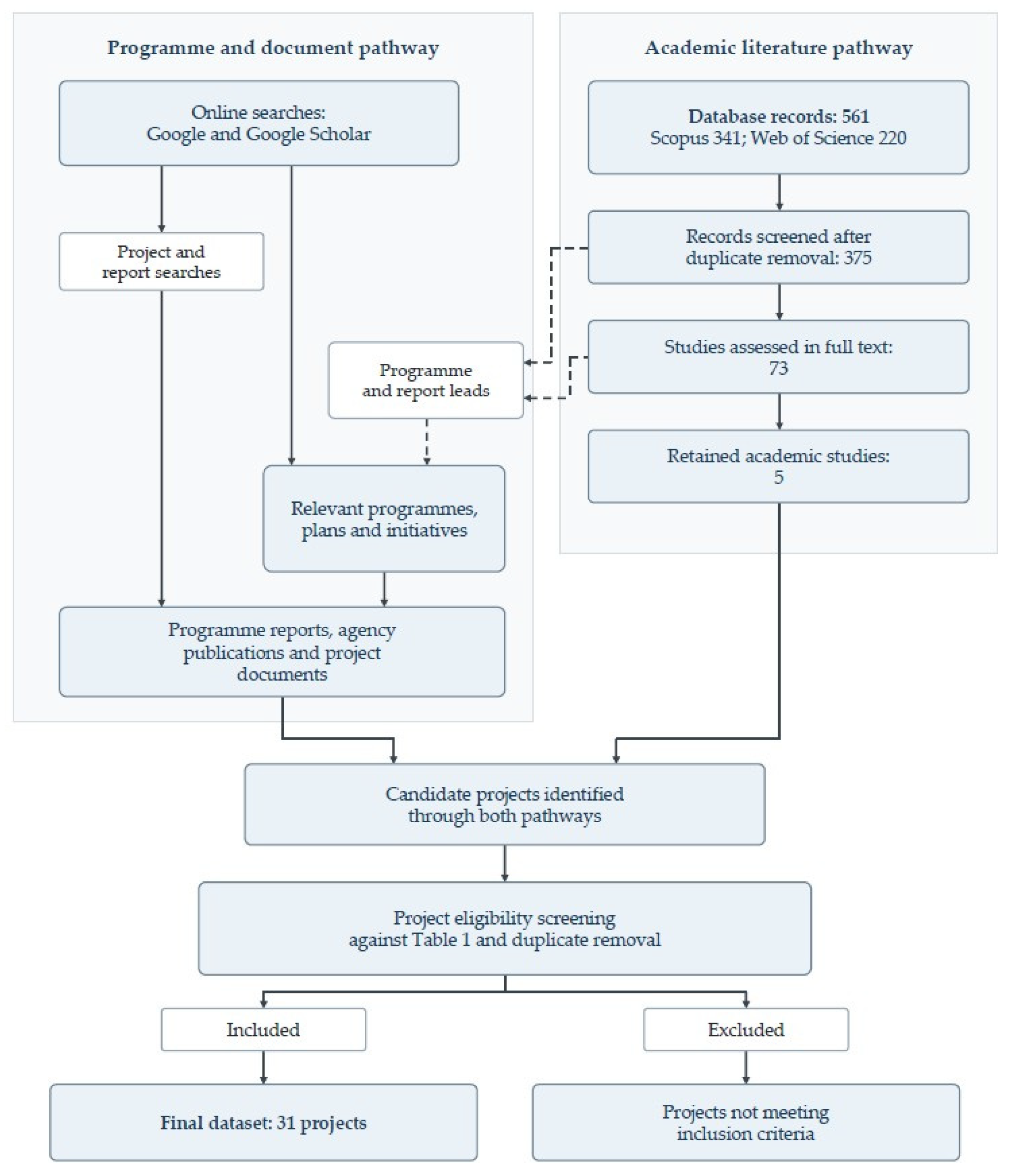
References
- Bianchi, T.S. Biogeochemistry of Estuaries; Oxford University Press: New York, NY, USA, 2007. [Google Scholar] [CrossRef] [Scilit]
- Day, J.W., Jr. Estuarine Ecology; Kemp, W.M., Yáñez-Arancibia, A., Crump, B.C., Eds.; John Wiley & Sons: Hoboken, NJ, USA, 2012. [Google Scholar]
- Kennish, M.J. Environmental threats and environmental future of estuaries. Environ. Conserv. 2002, 29, 78–107. [Google Scholar] [CrossRef] [Scilit]
- Hill, K. Coastal infrastructure: A typology for the next century of adaptation to sea-level rise. Front. Ecol. Environ. 2015, 13, 468–476. [Google Scholar] [CrossRef] [Scilit]
- Kumbier, K.; Carvalho, R.C.; Vafeidis, A.T.; Woodroffe, C.D. Investigating compound flooding in an estuary using hydrodynamic modelling: A case study from the Shoalhaven River, Australia. Nat. Hazards Earth Syst. Sci. 2018, 18, 463–477. [Google Scholar] [CrossRef] [Scilit]
- Perez Lopez, I.; Martin, D.J. Rethinking Estuary Urbanism—Preparing Australian Estuary Cities for Changes to Come in the Climate and Biodiversity Emergency. Sustainability 2023, 15, 962. [Google Scholar] [CrossRef] [Scilit]
- Fang, J.; Shi, P. Research progress and prospect of coastal flood disaster risk assessment against global climate change. J. Geogr. Cartogr. 2021, 4, 102–116. [Google Scholar] [CrossRef] [Scilit]
- Wright, L.D.; D’Elia, C.F.; Nichols, C.R. Impacts of Coastal Waters and Flooding on Human Health. In Tomorrow’s Coasts: Complex and Impermanent; Wright, L.D., Nichols, C.R., Eds.; Springer International Publishing: Cham, Switzerland, 2019; pp. 151–166. [Google Scholar] [CrossRef] [Scilit]
- Cappato, A.; Baker, E.A.; Reali, A.; Todeschini, S.; Manenti, S. The role of modeling scheme and model input factors uncertainty in the analysis and mitigation of backwater induced urban flood-risk. J. Hydrol. 2022, 614, 128545. [Google Scholar] [CrossRef] [Scilit]
- Hinkel, J.; Lincke, D.; Vafeidis, A.T.; Perrette, M.; Nicholls, R.J.; Tol, R.S.; Marzeion, B.; Fettweis, X.; Ionescu, C.; Levermann, A. Coastal flood damage and adaptation costs under 21st century sea-level rise. Proc. Natl. Acad. Sci. USA 2014, 111, 3292–3297. [Google Scholar] [CrossRef] [Scilit] [PubMed]
- Horton, B.P.; Khan, N.S.; Cahill, N.; Lee, J.S.H.; Shaw, T.A.; Garner, A.J.; Kemp, A.C.; Engelhart, S.E.; Rahmstorf, S. Estimating global mean sea-level rise and its uncertainties by 2100 and 2300 from an expert survey. npj Clim. Atmos. Sci. 2020, 3, 18, Correction in npj Clim. Atmos. Sci. 2020, 3, 22. [Google Scholar] [CrossRef] [Scilit]
- Barbier, E.B.; Hacker, S.D.; Kennedy, C.; Koch, E.W.; Stier, A.C.; Silliman, B.R. The value of estuarine and coastal ecosystem services. Ecol. Monogr. 2011, 81, 169–193. [Google Scholar] [CrossRef] [Scilit]
- Doody, J.P. Coastal squeeze and managed realignment in southeast England, does it tell us anything about the future? Ocean Coast. Manag. 2013, 79, 34–41. [Google Scholar] [CrossRef] [Scilit]
- Werner, A.D.; Bakker, M.; Post, V.E.; Vandenbohede, A.; Lu, C.; Ataie-Ashtiani, B.; Simmons, C.T.; Barry, D.A. Seawater intrusion processes, investigation and management: Recent advances and future challenges. Adv. Water Resour. 2013, 51, 3–26. [Google Scholar] [CrossRef] [Scilit]
- Shannon, K. Eco-engineering for Water: From Soft to Hard and Back. In Resilience in Ecology and Urban Design: Linking Theory and Practice for Sustainable Cities; Pickett, S.T.A., Cadenasso, M.L., McGrath, B., Eds.; Springer: Dordrecht, The Netherlands, 2013; pp. 163–182. [Google Scholar] [CrossRef] [Scilit]
- Milly, P.C.; Betancourt, J.; Falkenmark, M.; Hirsch, R.M.; Kundzewicz, Z.W.; Lettenmaier, D.P.; Stouffer, R.J. Stationarity is dead: Whither water management? Science 2008, 319, 573–574. [Google Scholar] [CrossRef] [Scilit] [PubMed]
- Fletcher, T.D.; Shuster, W.; Hunt, W.F.; Ashley, R.; Butler, D.; Arthur, S.; Trowsdale, S.; Barraud, S.; Semadeni-Davies, A.; Bertrand-Krajewski, J.-L.; et al. SUDS, LID, BMPs, WSUD and more—The evolution and application of terminology surrounding urban drainage. Urban Water J. 2015, 12, 525–542. [Google Scholar] [CrossRef] [Scilit]
- Sutton-Grier, A.E.; Wowk, K.; Bamford, H. Future of our coasts: The potential for natural and hybrid infrastructure to enhance the resilience of our coastal communities, economies and ecosystems. Environ. Sci. Policy 2015, 51, 137–148. [Google Scholar] [CrossRef] [Scilit]
- Alves, A.; Gersonius, B.; Kapelan, Z.; Vojinovic, Z.; Sanchez, A. Assessing the Co-Benefits of green-blue-grey infrastructure for sustainable urban flood risk management. J. Environ. Manag. 2019, 239, 244–254. [Google Scholar] [CrossRef] [Scilit] [PubMed]
- Ghofrani, Z.; Sposito, V.; Faggian, R. A comprehensive review of blue-green infrastructure concepts. Int. J. Environ. Sustain. 2017, 6. [Google Scholar] [CrossRef] [Scilit]
- Andersson, E.; Grimm, N.B.; Lewis, J.A.; Redman, C.L.; Barthel, S.; Colding, J.; Elmqvist, T. Urban climate resilience through hybrid infrastructure. Curr. Opin. Environ. Sustain. 2022, 55, 101158. [Google Scholar] [CrossRef] [Scilit]
- CRCWSC. Harnessing Hybrid Systems for Transformative Cities; Cooperative Research Centre for Water Sensitive Cities: Melbourne, Australia, 2021. [Google Scholar]
- Haasnoot, M.; Kwakkel, J.H.; Walker, W.E.; Ter Maat, J. Dynamic adaptive policy pathways: A method for crafting robust decisions for a deeply uncertain world. Glob. Environ. Change 2013, 23, 485–498. [Google Scholar] [CrossRef] [Scilit]
- de Meulder, B.; Shannon, K. (Eds.) Water Urbanisms: East; Park Books: Zürich, Switzerland, 2013. [Google Scholar]
- Depietri, Y.; McPhearson, T. Integrating the grey, green, and blue in cities: Nature-based solutions for climate change adaptation and risk reduction. In Nature-Based Solutions to Climate Change Adaptation in Urban Areas: Linkages Between Science, Policy and Practice; Springer: Cham, Switzerland, 2017; pp. 91–109. [Google Scholar]
- Swyngedouw, E. The city as a hybrid: On nature, society and cyborg urbanization. Capital. Nat. Social. 1996, 7, 65–80. [Google Scholar] [CrossRef] [Scilit]
- Gandy, M. Cyborg Urbanization: Complexity and Monstrosity in the Contemporary City. Int. J. Urban Reg. Res. 2005, 29, 26–49. [Google Scholar] [CrossRef] [Scilit]
- Star, S.L. The Ethnography of Infrastructure. Am. Behav. Sci. 1999, 43, 377–391. [Google Scholar] [CrossRef] [Scilit]
- Waldheim, C. Landscape as Urbanism: A General Theory; Princeton University Press: Princeton, NJ, USA, 2016. [Google Scholar] [CrossRef] [Scilit]
- van Veelen, P.; Voorendt, M.; van der Zwet, C. Design challenges of multifunctional flood defences. Flowscapes Des. Infrastruct. Landsc. 2015, 3, 275–292. [Google Scholar] [CrossRef] [Scilit]
- Marijnissen, R.J.; Kok, M.; Kroeze, C.; Loon-Steensma, J.M.V. The four components to combine flood protection with other functions. In Proceedings of the FLOODrisk 2020-4th European Conference on Flood Risk Management; Budapest University of Technology and Economics: Budapest, Hungary, 2021. [Google Scholar]
- Waryszak, P.; Gavoille, A.; Whitt, A.A.; Kelvin, J.; Macreadie, P.I. Combining gray and green infrastructure to improve coastal resilience: Lessons learnt from hybrid flood defenses. Coast. Eng. J. 2021, 63, 335–350. [Google Scholar] [CrossRef] [Scilit]
- Lawson, B. Schemata, gambits and precedent: Some factors in design expertise. Des. Stud. 2004, 25, 443–457. [Google Scholar] [CrossRef] [Scilit]
- Boling, E.; Basdogan, M.; Abramenka-Lachheb, V.; Guo, M.; Nadir, H.; Sankaranarayanan, R.; Yan, Y.; Alghamdi, K.; Chaudhuri, P.; Li, Z.; et al. Precedent Knowledge in Multiple Domains of Design: A Review and Analysis of Literature. In Proceedings of the DRS2024: Boston, Boston, USA; Design Research Society: Hertfordshire, UK, 2024. [Google Scholar] [CrossRef] [Scilit]
- Roggema, R. Research by design: Proposition for a methodological approach. Urban Sci. 2017, 1, 2. [Google Scholar] [CrossRef] [Scilit]
- Miles, M.B.; Huberman, A.M.; Saldaña, J. Qualitative Data Analysis: A Methods Sourcebook, 3rd ed.; SAGE Publications: Thousand Oaks, CA, USA, 2014. [Google Scholar]
- Braun, V.; Clarke, V. One size fits all? What counts as quality practice in (reflexive) thematic analysis? Qual. Res. Psychol. 2021, 18, 328–352. [Google Scholar] [CrossRef] [Scilit]
- Tyndall, J. AACODS Checklist; Flinders University: Bedford Park, Australia, 2010. [Google Scholar]
- Braun, V.; Clarke, V. Conceptual and design thinking for thematic analysis. Qual. Psychol. 2022, 9, 3. [Google Scholar] [CrossRef] [Scilit]
- Lempert, R.; Kalra, N.; Peyraud, S.; Mao, Z.; Tan, S.B.; Cira, D.; Lotsch, A. Ensuring robust flood risk management in Ho Chi Minh City; World Bank Policy Research Working Paper; World Bank: Washington, DC, USA, 2013. [Google Scholar]
- Brears, R.C. From Traditional Grey Infrastructure to Blue-Green Infrastructure. In Blue and Green Cities: The Role of Blue-Green Infrastructure in Managing Urban Water Resources; Palgrave Macmillan UK: London, UK, 2018; pp. 1–41. [Google Scholar] [CrossRef] [Scilit] [PubMed]
- Green, D.; O’Donnell, E.; Johnson, M.; Slater, L.; Thorne, C.; Zheng, S.; Stirling, R.; Chan, F.K.S.; Li, L.; Boothroyd, R.J. Green infrastructure: The future of urban flood risk management? Wiley Interdiscip. Rev. Water 2021, 8, e1560. [Google Scholar] [CrossRef] [Scilit]
- Patrick, A.N.; Bernard, K.; Tirpak, R.A.; Simpson, I.M.; Smith, J.S.; Winston, R.J. Hydrologic and water quality performance of an 8-year old bioretention cell treating residential runoff. Water Sci. Technol. 2025, 92, 752–769. [Google Scholar] [CrossRef] [Scilit] [PubMed]
- Huynh, T.N.; Nguyen, H.T.; Le, H.T.N. A Quantitative Approach to Selecting SUDS for Flood Resilience in Can Tho City, Mekong Delta. Int. J. Sustain. Constr. Eng. Technol. 2025, 16, 164–176. [Google Scholar] [CrossRef] [Scilit]
- Al, S. Multi-functional urban design approaches to manage floods: Examples from Dutch cities. J. Urban Des. 2022, 27, 270–278. [Google Scholar] [CrossRef] [Scilit]
- Sokolewicz, M.; Louters, T.; Otten, A. Modern integrated river flood management for climate change in the Netherlands: The IJssel Delta project. Int. J. River Basin Manag. 2011, 9, 141–149. [Google Scholar] [CrossRef] [Scilit]
- Redeker, C. Rhine cities—Urban Flood Integration (UFI): German and Dutch adaptation and mitigation strategies. A BE|Archit. Built Environ. 2018, 4, 1–394. [Google Scholar] [CrossRef]
- PUB. Bask in the Barrage; PUB: Singapore, 2010.
- PUB. Active, Beautiful, Clean Waters Design Guidelines; Public Utilities Board: Singapore, 2018.
- PUB. Kolam Ayer Waterfront: Water Study Exercise Guidelines and Safety Brief; PUB: Singapore, 2010.
- PUB. ABC Waters Design Guidelines; Public Utilities Board: Singapore, 2011.
- PUB. Lorong Halus Wetland Adjacent to Serangoon Reservoir: Water Study Exercise Guidelines and Safety Brief; PUB: Singapore, 2014.
- Sim, C.H.; Quek, B.S.; Shutes, R.B.E.; Goh, K.H. Management and treatment of landfill leachate by a system of constructed wetlands and ponds in Singapore. Water Sci. Technol. 2013, 68, 1114–1122. [Google Scholar] [CrossRef] [Scilit] [PubMed]
- New York City Department of Environmental Protection. Staten Island Bluebelt Drainage Plans for Mid-Island Watersheds: Final Generic Environmental Impact Statement; New York City Department of Environmental Protection: New York, NY, USA, 2013.
- City of New York, Office of the Mayor. Marking 11 Years Since Superstorm Sandy, Mayor Adams Celebrates Completion of $110 Million New Creek Bluebelt Expansion to Prevent Flooding on Staten Island. Available online: https://www.nyc.gov/mayors-office/news/2023/10/marking-11-years-since-superstorm-sandy-mayor-adams-celebrates-completion-110-million-new (accessed on 10 November 2026).
- U.S. Army Corps of Engineers, San Francisco District. South San Francisco Bay Shoreline Phase I Study: Final Integrated Interim Feasibility Study and Environmental Impact Statement/Environmental Impact Report; U.S. Army Corps of Engineers: San Francisco, CA, USA, 2015.
- U.S. Army Corps of Engineers. Supplemental Information Report for the South San Francisco Bay Shoreline Project, Santa Clara County, California; U.S. Army Corps of Engineers: San Francisco, CA, USA, 2023.
- Santa Clara Valley Water District. Milestone Reached in South San Francisco Bay Shoreline Phase I Project. Available online: https://www.valleywater.org/shoreline (accessed on 10 November 2026).
- Cecchetti, A.; Dang, J.; DeSalvo, A.; Harris-Lovett, S.; Sedlak, D.; Stiegler, A.; Uhler, J.; Warner, J. Operations and Maintenance of Horizontal Levees—Lessons from the Oro Loma Pilot Project; San Francisco Estuary Partnership: San Francisco, CA, USA, 2025. [Google Scholar]
- City of Copenhagen. Cloudburst Management Plan 2012; City of Copenhagen: Copenhagen, Denmark, 2012.
- Williams-Eynon, A. Social Spaces, Resilient Communities: Social Infrastructure as a Climate Strategy for Real Estate; Urban Land Institute: Washington, DC, USA, 2023. [Google Scholar]
- Danish Environmental Protection Agency. The Enghaveparken Climate Parken in Copenhagen Now Attracts Both People and Stormwater Drainoff. Available online: https://eng.klimatilpasning.dk/examples-of-climate-adaptation/the-capital-region-of-denmark/the-enghaveparken-climate-parken-in-copenhagen-now-attracts-both-people-and-stormwater-drainoff (accessed on 10 November 2026).
- Auckland Council. Northcote’s Greenway Te Ara Awataha. Available online: https://www.audo.co.nz/projects/northcotes-greenway-te-ara-awataha/ (accessed on 10 November 2026).
- Auckland Council. Te Kaitaka Greenslade Reserve. Available online: https://www.audo.co.nz/projects/greenslade-reserve/ (accessed on 10 November 2026).
- Frith, M.; Duckworth, M.; Cole, S.; Jacob, R. A Cool Place to Live: A Good Practice Guide to Implementing Landscape Adaptation to Climate Change for Social Landlords; London Wildlife Trust for Neighbourhoods Green: London, UK, 2015. [Google Scholar]
- Stantec Landscape. Barking Riverside Foreshore Packages 0–1 Strategic Infrastructure Scheme: Design and Access Statement; Stantec Landscape: Edmonton, AB, Canada, 2025. [Google Scholar]
- Environment Agency. Thames Estuary 2100: Managing Flood Risk Through London and the Thames Estuary—TE2100 Plan; Environment Agency: London, UK, 2012.
- Huisman, B.J.A.; Wijsman, J.W.M.; Arens, S.M.; Vertegaal, C.T.M.; van der Valk, L.; van Donk, S.C.; Vreugdenhil, H.S.I.; Taal, M.D. 10-Years Evaluation of the Sand Motor: Results of the Monitoring- and Evaluation Program (MEP) for the Period 2011 to 2021; 11201431-003-ZKS-0014; Deltares: Delft, The Netherlands, 2021. [Google Scholar]
- World Bank. Implementation Completion and Results Report: Ho Chi Minh City Environmental Sanitation (Nhieu Loc–Thi Nghe Basin) Project; ICR2375; World Bank: Washington, DC, USA, 2012. [Google Scholar]
- Asian Development Bank. Restoring Waterways of Ho Chi Minh City. Available online: https://www.adb.org/news/videos/restoring-waterways-ho-chi-minh-city (accessed on 10 November 2026).
- Trungnam E&C. Construction Officially Begins on the Xuyen Tam Canal Project. Available online: https://trungnamec.com.vn/en/construction-begins-on-xuyen-tam-canal/ (accessed on 10 November 2026).
- Asian Development Bank. Nature-Based Solutions for Cities in Viet Nam: Water Sensitive Urban Design; Asian Development Bank: Mandaluyong City, Philippines, 2019. [Google Scholar]
- Rottle, N.; Lacson, D.; Cromwell, P.; Yeh, Y.-J.; Hai, C. Shanghai Houtan Park; Landscape Architecture Foundation: Washington, DC, USA, 2011. [Google Scholar]
- Zhang, Q.; Lee, J.; Jiang, B.; Kim, G. Revitalization of the Waterfront Park Based on Industrial Heritage Using Post-Occupancy Evaluation—A Case Study of Shanghai (China). Int. J. Environ. Res. Public Health 2022, 19, 9107. [Google Scholar] [CrossRef] [Scilit] [PubMed]
- Louis Berger U.S., Inc. Rebuild by Design Living Breakwaters Project: Benefit Cost Analysis; New York Governor’s Office of Storm Recovery: New York, NY, USA, 2017.
- New York State Homes and Community Renewal. Living Breakwaters Construction Update—Q4 2024. Available online: https://hcr.ny.gov/living-breakwaters-construction-update-q4-2024 (accessed on 10 November 2026).
- New York State Homes and Community Renewal. Living Breakwaters Project Background and Design. Available online: https://hcr.ny.gov/living-breakwaters-project-background-and-design (accessed on 10 November 2026).
- New York City Office of Management and Budget; New York City Department of Parks and Recreation. East Side Coastal Resiliency Project: Final Environmental Impact Statement; City of New York: New York, NY, USA, 2019.
- New York City Department of Design and Construction. First Phase of East Side Coastal Resiliency Receives National Engineering Excellence Award From the American Council of Engineering Companies. Available online: https://www.nyc.gov/site/ddc/about/press-releases/2025/pr-052325-ACEC.page (accessed on 10 November 2026).
- New York City Department of Design and Construction. Just in Time for Summer, City Opens Large New Sections of the New East River Park. Available online: https://www.nyc.gov/site/ddc/about/press-releases/2025/pr-052925-ESCRopenings.page (accessed on 10 November 2026).
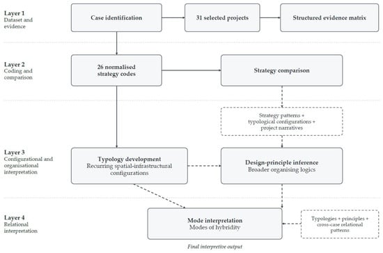
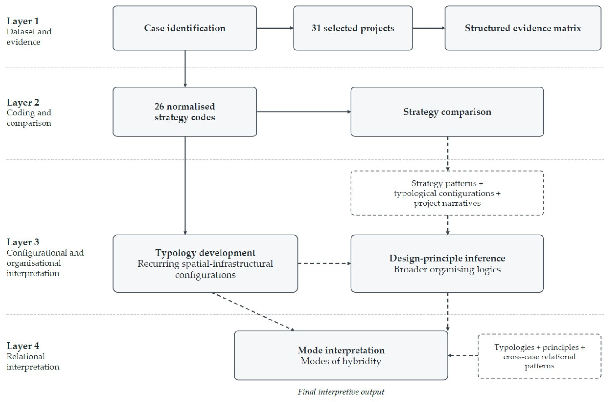
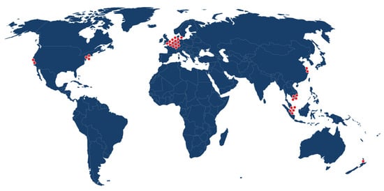
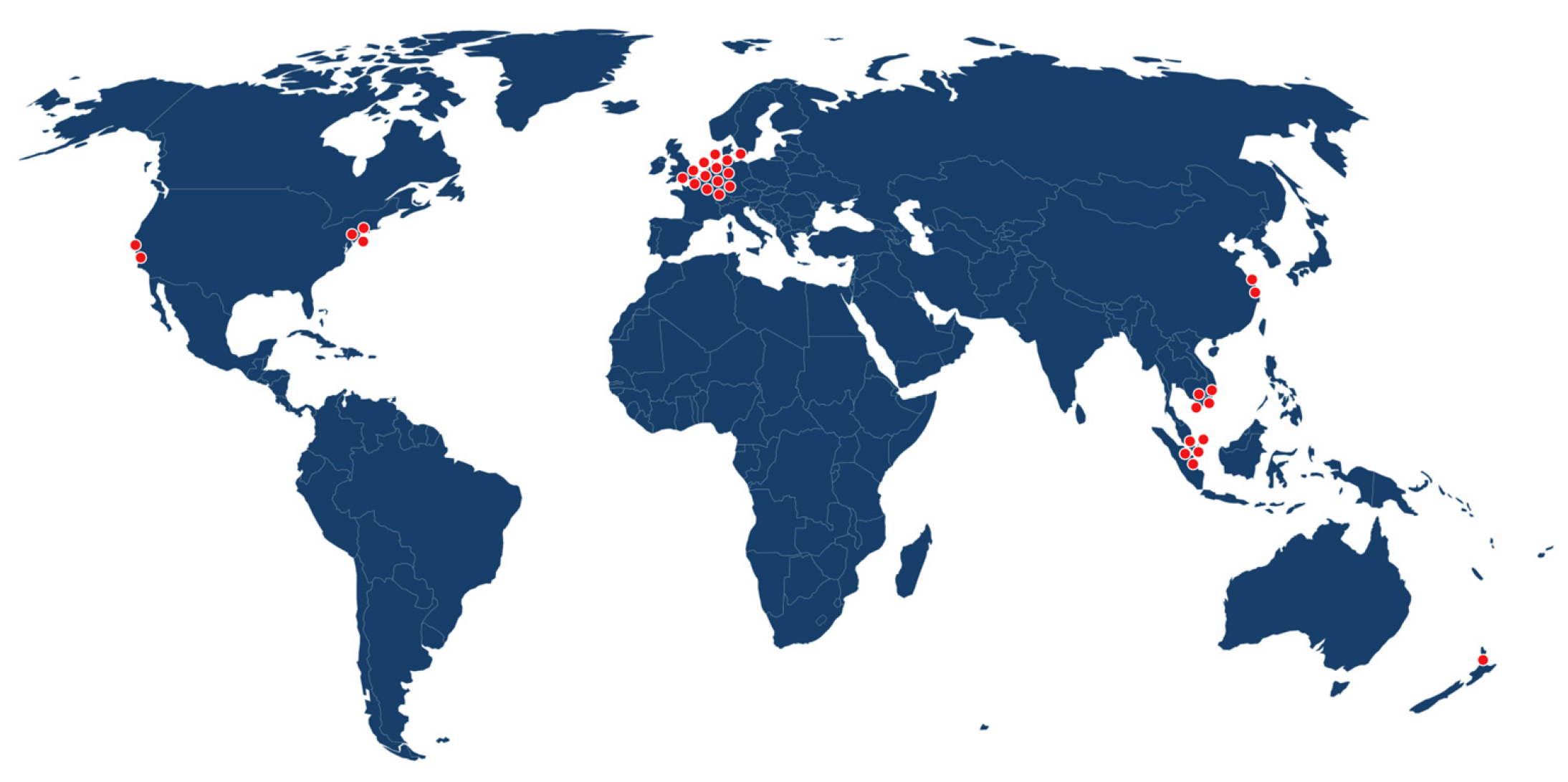

Disclaimer/Publisher’s Note: The statements, opinions and data contained in all publications are solely those of the individual author(s) and contributor(s) and not of MDPI and/or the editor(s). MDPI and/or the editor(s) disclaim responsibility for any injury to people or property resulting from any ideas, methods, instructions or products referred to in the content. |
© 2026 by the authors. Licensee MDPI, Basel, Switzerland. This article is an open access article distributed under the terms and conditions of the Creative Commons Attribution (CC BY) license.