


Abstract
Military settlements are an integral part of the military defense system of the Ming Great Wall, and the spatial layout of their constituent elements embodies the wisdom of ancient military geography. However, existing studies have predominantly focused on the macro-scale distribution of military settlements, with insufficient exploration of the spatial differentiation mechanisms of their micro-level constituent elements. Therefore, this study examines 61 military settlements in Miyun District, Beijing. Based on documentary research and field surveys, the types of constituent elements were systematically identified. This study employs kernel density analysis and the Optimal Parameters-based Geographical Detector (OPGD) model to explore their spatial patterns and driving mechanisms. The results show that (1) the constituent elements of military settlements collectively exhibit a spatial pattern of “one belt and three cores”, with pronounced spatial heterogeneity; (2) Fortress level, Military strength, and Distance to the Lu Fort are the core factors influencing the spatial differentiation of elements; and (3) when multiple factors interact, the interaction between Military strength and Distance to the Lu Fort demonstrates a significant nonlinear enhancement effect. This study reveals the spatial organizational logic of the Ming Great Wall military settlements at the micro-element level, providing a scientific basis for the graded protection and adaptive reuse of military settlements in Miyun District. Furthermore, the proposed analytical framework can also offer methodological insights for studies in other regions along the Great Wall.
1. Introduction
To consolidate the northern frontier, the Ming dynasty (1368–1644 CE) constructed thousands of kilometers of the Great Wall stretching from Hushan, Liaoning, to Jiayuguan, Gansu, and established nine military districts of the frontier, around which numerous military settlements were developed [1]. The construction of border walls in the nine military towns during the Ming Dynasty occurred in different sequences and was quite complex. Large-scale construction of the border walls began during the Chenghua period (1465–1487), and by the Jiajing period (1522–1566), the frontier defense project was largely completed [2]. Unlike traditional agricultural settlements that emerged spontaneously through kinship ties, military settlements were state-planned and systematically constructed cultural landscapes formed under the specific military system and frontier defense pattern of the Ming Dynasty. Such cultural landscapes are regarded as spatial manifestations of humanity’s desire to inscribe control and power upon the earth’s surface, and their formation is often closely associated with territorial consciousness and political ambition [3]. In addition to serving defensive and garrison functions, military settlements gradually evolved into vital spatial units that supported social life and regional economies [4], thereby becoming carriers of cultural heritage with living value. As another World Heritage site, Hadrian’s Wall in the UK has also received long-term academic attention. Existing studies often approach it from a holistic perspective, considering it as a complete defense system [5]. The associated settlement system is typically divided into three levels, “fortress–fort–fortlet,” with the understanding that, in addition to their military defense functions, these settlements also possess basic living attributes [6]. However, compared to the military settlements along the Ming Great Wall, the settlements along the Hadrian’s Wall primarily focus on military control and border defense, and their layout exhibits a stronger standardization and modularity. In contrast, the military settlements along the Ming Great Wall, under a strict hierarchical system, demonstrate a deeper “military–civilian integration” characteristic. Therefore, systematic study of the military settlements along the Ming Great Wall not only reveal their unique heritage value but also provide important localized references for the precise conservation and sustainable use of China’s Great Wall heritage.
As spatial carriers of ancient military and civilian life, the military settlements along the Ming Great Wall utilized various physical facilities during their construction to establish both defense system and living environment, making them material embodiments of ancient military wisdom and regional culture. This study collectively refers to these physical facilities with specific spatial locations and functions as “constituent elements” (e.g., gates, corner towers, temples, etc.). Therefore, investigating the spatial distribution patterns of the constituent elements of military settlements is of great significance for deepening the understanding of their values and promoting the holistic protection and adaptive reuse of settlements.
In recent years, driven by the growing awareness of cultural heritage preservation and the development of cultural tourism, research on the military settlements along the Ming Great Wall has attracted widespread scholarly attention. This trend not only reflects the increasing societal emphasis on the value of the Great Wall heritage but also provides new impetus for deepening the understanding of its material remains and historical logic from multidisciplinary perspectives, including history, geography, and architecture. Currently, most studies primarily focus on aspects such as spatial distribution [7,8] and morphological characteristics [9,10], and research areas primarily concentrating on military garrison towns [7]. From the perspective of research scale, existing studies have primarily focused on the macro-level distribution of settlements [8] and the meso-level morphological characteristics [10], with insufficient attention paid to the micro-level constituent elements of settlements. From the perspective of research methods, existing studies have mainly relied on qualitative analysis and case studies [11,12,13], lacking systematic investigations that integrate historical geography with quantitative techniques to reveal the intrinsic logic and external driving mechanisms of the selection and layout of the constituent elements of settlements.
This study examines 61 military settlements along the Ming Great Wall in Miyun District, Beijing. It employs kernel density analysis to reveal the spatial distribution patterns of settlement elements, and applies the Optimal Parameters-based Geographical Detector model to evaluate the driving effects of multidimensional factors on their spatial distribution. This approach explores the underlying formation mechanisms and construction logic of their spatial configuration. This study is mainly devoted to (1) clarifying the typological system of constituent elements of the Ming Great Wall military settlements in Miyun; (2) revealing the spatial distribution characteristics of these elements; and (3) investigating the driving mechanisms underlying their spatial differentiation.
2. Literature Review
This study aims to investigate the spatial distribution characteristics of the constituent elements of military settlements and further reveal the driving mechanisms underlying their formation. Therefore, the literature review is structured around four aspects: (1) research on military settlements; (2) existing research methods; (3) selection of influencing factors; and (4) research gaps.
2.1. Research on Military Settlements
Among the Great Wall built throughout history, the Ming Great Wall has the most extensive remains and the largest scale, characterized by a complex and rigorous hierarchical system [11]. Research on the Ming Great Wall has been extensive, with scholars conducting systematic and in-depth explorations across the field. The objects of study cover multiple aspects, including the Great Wall itself [2,14,15], military settlements [7,16,17], beacon transmission system [18,19], and mutual trade [20], thereby establishing a relatively comprehensive research framework for Great Wall heritage. Similarly, as a representative of ancient Roman frontier defense, the study of the Hadrian’s Wall has accumulated over a century of archaeological, archival, and conservation experience [5,21]. Some scholars have focused on excavating the forts along the wall, providing important clues to understanding the military life of the time [22]. The types of forts along Hadrian’s Wall are directly related to the size of the stationed troops, with their distribution being relatively uniform. In addition to military facilities such as corner towers, barracks, granaries, and command centers, the forts also included living facilities such as hospitals, workshops, and baths [23], indicating that, like the military settlements along the Ming Great Wall, they served both military defense and daily life functions. However, the military settlements along the Ming Great Wall, as functionally more complex and socially more stable “military–civilian integrated” settlements, possess specific hierarchies, forms, and systems of constituent elements [11]. Therefore, a systematic study of the constituent elements of the military settlements along the Ming Great Wall can reveal the key aspects of their unique spatial logic. At present, research on military settlements are relatively abundant, primarily focusing on site selection [17], spatial distribution [7,9], defensive hierarchy [1,8,24], morphological characteristics [9,10], developmental evolution [4], and value assessment [25]. However, most existing studies use the entire military settlement as the analytical unit, focusing on macro-level patterns, hierarchical systems, and overall characteristics, while lacking a systematic exploration of their constituent elements. This research approach not only leaves the spatial organizational logic of military settlements insufficiently revealed but also limits our ability to gain a deeper understanding of their construction wisdom and multidimensional driving mechanisms. In the context of contemporary heritage conservation, the holistic protection and adaptive reuse of cultural heritage have become frontier topics in academia, leading to the emergence of many theoretical frameworks [26,27,28]. However, for complex heritage systems such as the Ming Great Wall, which integrates multiple values of history, military, culture, and more, its conservation practice requires a refined and quantitative spatial mechanism analysis as empirical support. Therefore, this study focuses on the quantitative research of the constituent elements of military settlements, aiming to provide scientific evidence for interdisciplinary heritage conservation theories and planning practices by revealing their spatial patterns and driving mechanisms. This approach aims to establish a pathway from “deep historical spatial analysis” to the “precise application of modern conservation planning”.
2.2. Existing Research Methods
Research on the military settlements along the Ming Great Wall has been extensive, and the methodologies employed in this research are continuously evolving. Scholars have conducted qualitative analyses of the site selection and spatial distribution of military settlements through literature reviews [11,17,29]. In recent years, spatial analysis methods based on Geographic Information Systems (GIS) have been widely applied. The specific methods include terrain and buffer analysis [7,12], kernel density analysis [9,25,30], nearest neighbor analysis [9,30], Thiessen polygons [31], and spatial autocorrelation analysis [9]. Overall, existing studies largely remain at the stage of identifying spatial patterns and analyzing environmental correlations, lacking in-depth exploration of the distribution mechanisms of settlement constituent elements. In particular, traditional methods often rely on global or linear statistics, which can make it difficult to reveal spatial heterogeneity and the complex relationships among multiple factors. In the field of geography, existing studies have begun to focus on the relationship between spatial differentiation and influencing factors [32,33,34,35], but systematic studies of the spatial mechanisms of military settlements remain relatively limited. To overcome this limitation, the Geographical Detector model has been introduced into the study of cultural heritage and settlement, enabling the identification of spatial heterogeneity and driving mechanisms [36]. It has been applied in research on folk defensive settlements [37], traditional villages [38,39,40,41], intangible cultural heritage [42,43,44], ethnic minority cultural heritage [45], and industrial heritage [46]. However, this model has certain limitations in variable discretization, as it cannot determine the optimal discretization method for variables. To address this issue, Yongze Song et al. developed the Optimal Parameters-based Geographical Detector (OPGD) model, which enables more accurate spatial analysis through optimal discretization methods [47]. At present, the OPGD model has been applied to identify the driving factors of spatial differentiation in traditional villages [48,49], explore the influencing mechanisms of cultural heritage spatial distribution [40,50,51], and analyze the formative causes of spatial patterns in historic districts [52]. However, no studies have yet employed the OPGD model to investigate the driving mechanisms behind the spatial distribution of military settlement elements. Therefore, introducing the OPGD model into the research on the constituent elements of military settlements not only compensates for the shortcomings of existing methods but also provides a new technical approach for exploring their spatial organizational logic and multidimensional driving mechanisms.
2.3. Selection of Influencing Factors
In terms of factors selection, existing studies typically focus on natural environment factors, such as slope, elevation, annual precipitation, and distance to river [34,38,40,43,49,53], as well as socio-economic factors, including population density, GDP, and road network density [34,39,42,43,48]. Scholars have further incorporated historical and cultural factors [42,49,51]. Table 1 lists the factors selected by some scholars. Overall, existing studies demonstrate considerable richness and diversity in the selection of influencing factors; however, these factors are primarily confined to the natural and social dimensions commonly employed in research on the distribution of traditional villages or cultural heritage [39,45,50,54], which remain insufficient for the study of military settlements. Military settlements are a special form of human habitation that emerged alongside the construction of the Ming Great Wall defense system. They not only play an important role in the defense system but are also deeply influenced by the natural geographical conditions of their locations. Their spatial layout is often the result of the interaction between terrain conditions and military strategy [9,12]. Therefore, it is necessary to explore, from the perspective of military geography, the shaping mechanisms of military actions and defense logic on the spatial pattern of military settlements along the Ming Great Wall. At the same time, as a product of the specific historical context of the Ming Dynasty, the study of the Great Wall also calls for the introduction of historical geography’s “human-environment relationship” perspective [55], which systematically examines the interplay between human and natural geographical factors behind its formation. The constituent elements of military settlements not only reflect the influence of natural geographical conditions and human activities, but more profoundly embody the role of military construction and strategic defence logic in shaping spatial patterns. Based on existing literature and the specific characteristics of military settlement research, this study systematically selects 12 influencing factors from three dimensions—natural environment, military defense, and spatial accessibility—to more comprehensively and effectively reveal the spatial distribution patterns of the constituent elements of military settlements.
Table 1.
Summary of influencing factors in Previous Studies.
2.4. Research Gaps
Overall, existing research on military settlements has made certain progress in site selection logic, spatial pattern identification, and the analysis of environmental factor correlations, yet several shortcomings remain. First, research primarily focuses on the macro-level defense system or meso-level morphological characteristics, with insufficient attention to the constituent elements of settlements. Second, existing methodologies have a limited capacity to reveal spatial heterogeneity and complex interactions among factors. Furthermore, the selection of influencing factors remains lacking in both systematicity and specificity.
This study focuses on 61 military settlements in Miyun District, Beijing. By integrating literature research and field surveys, the types of settlement constituent elements are clarified. Kernel density analysis and the Optimal Parameters-based Geographical Detector (OPGD) model are employed to examine the spatial distribution patterns of these elements and their driving mechanisms.
3. Methods
3.1. Study Area
To prevent the intrusion of the Mongolian tribes, the Ming Dynasty established nine military towns along the northern frontier from east to west, including Liaodong Town, Ji Town, Xuanfu Town, Datong Town, Shanxi Town, Yansui Town, Ningxia Town, Guyuan Town, and Gansu Town. Among them, Ji Town extended from Shanhaiguan in the east to Mutianyu in the west, passing through ten districts and counties, including the present-day Huairou District, Miyun District, and Pinggu District in Beijing, as well as Jizhou District in Tianjin [58]. According to the Annals of the Four Towns and Three Passes [59], Ji Town was divided into eastern, central, and western units, each further subdivided into smaller defensive units called Lu. Its military defense structure consisted of ‘Jiliao Supreme Commander-Regional Commander-Vice Regional Commander-Assistant Regional Commander-Supervising Commander-Company Commander’, forming a tightly organized chain of command. The Ming Great Wall in Miyun was under the jurisdiction of the western unit of Ji Town, which was further divided into four Lu: Qiangzi Lu, Caojia Lu, Gubeikou Lu, and Shitang Lu. Each Lu administered more than ten military settlements. Based on the rank of their commanding officers, this study classifies the military settlements in Miyun District into three levels: Lu Fort (Lu Cheng), Ying Fort (Ying Cheng), and Fort (Bao Cheng). Among them, Lu Fort served as the command center of each Lu, Ying Fort functioned as a secondary defensive hub, and Fort represented the basic defensive unit.
According to the Great Wall resource survey data released by the National Cultural Heritage Administration, there are 61 extant military settlements in Miyun District (including four Lu Forts, five Ying Forts, and fifty-two Forts). Among the 10 districts and counties traversed by Ji Town, its number ranks first, accounting for approximately one-third of the total number of existing military settlements in Ji Town (Table 2). These settlements are numerous and diverse in type (Figure 1). Figure 2 illustrates the types and spatial distribution of constituent elements of military settlements of different levels. Given Miyun’s central role in the defense system of Ming Ji Town and the representativeness of its settlement, this study focuses on 61 military settlements in the area. It identifies the types of constituent elements, reveals their spatial distribution patterns, and further analyzes the driving mechanisms behind these patterns, thereby uncovering the underlying spatial organization logic and regional adaptability of Ming military settlements.
Table 2.
Statistics of Existing Military Settlements in Each Area of Ming Ji Town. (Data source: http://greatwallheritage.cn/CCMCMS/, accessed on 24 December 2025).
Figure 1.
Study area.
Figure 2.
Constituent elements of military settlements at different levels: (a) Qiangzilu Lu Fort; (b) Caojialu Lu Fort; (c) Gubeikou Lu Fort; (d) Jijiaying Ying Fort; (e) Simatai Ying Fort; (f) Xiaying Ying Fort; (g) Heiguguan Fort; (h) Yaoqiaoyu Fort; (i) Baimaguan Fort. (Base map: 1973 satellite remote sensing image of Miyun District).
3.2. Data Sources
The data used in this study mainly include the following five types (Table 3): (1) Administrative boundaries and basic geographic information data. The administrative boundary data of Miyun District is sourced from the Chinese Academy of Sciences, Resource and Environmental Science Data Platform; terrain data utilizes a 30 M resolution digital elevation model (DEM) provided by the Geospatial Data Cloud Platform; water system data is sourced from OpenStreetMap. (2) Geographic information data of the Great Wall heritage. This data includes spatial distribution information of the Great Wall border wall, military settlements, defense towers, and beacon towers, all sourced from the Great Wall Heritage of China Network. (3) Historical information data. This data mainly includes historical information, such as the hierarchical classification and troop deployment of military settlements, derived from historical documents including the Annals of the Four Towns and Three Passes [59], Records and Maps of the Nine Frontiers [60], and the Kangxi edition of the Annals of Miyun County [61]. It should be noted that the records of troop deployment of some military settlements in the Annals of the Four Towns and Three Passes are incomplete. To improve data completeness, this study incorporates The Annals of Shanhai Pass from the Jiajing reign period of the Ming Dynasty [62] as a supplementary source. Although the two documents were compiled in different periods, The Annals of Shanhai Pass provides more comprehensive records of troop deployment in military settlements. Therefore, based on a comparison of corresponding military settlements in both sources, a proportional calculation method is adopted to estimate the missing garrison data, ensuring the relative comparability of the data in the spatial analysis. Geographic information data on postal facilities, including post stations and urgent delivery stations, is sourced from the ‘Ming Postal Stations and Routes Database’ published by the Centre for Geographic Analysis at Harvard University. (4) Planimetric data of military settlements. These data are mainly derived from 1973 satellite remote sensing images, the Guangxu edition of the Annals of Miyun County [63], and the data from the Third National Cultural Relics Survey in Miyun District (hereafter referred to as the ‘Third Survey’). By integrating the GIS platform with field surveys, settlement boundaries were extracted and mapped to calculate settlement areas. (5) Data on constituent elements of military settlements. To construct a systematic and comprehensive typology of constituent elements, this study first systematically reviews historical documents such as Annals of the Four Towns and Three Passes [59] and the Kangxi edition of the Annals of Miyun County [61]. Supplementary references include works such as Chronicles of The Great Wall of China Architecture [64] and Survey of the Miyun Fortress [65]. These are further integrated with the ‘Third Survey’ data of Miyun District and 1973 satellite remote sensing images. Due to historical changes and the destruction of facilities, some elements are incomplete or missing. Therefore, this study conducted systematic field survey of 61 military settlements in Miyun District from July to September 2025. The survey was carried out in two main phases: first, high-precision GPS equipment was used to spatially locate all visible constituent elements, and a camera was used to capture photographic records; second, semi-structured interviews were conducted with local residents, grassroots officials, and the Great Wall preservation staff to further determine the spatial locations of submerged elements and gather related oral histories. This work not only supplemented the information on elements that have been damaged or disappeared due to historical changes, but also verified and corrected the existing literature and remote sensing interpretation results through field validation, thus improving the accuracy and completeness of the data.
Table 3.
Data sources.
3.3. Research Framework
The research framework of this study is illustrated in Figure 3. Firstly, the constituent elements of 61 military settlements in Miyun District were systematically identified through a combination of historical document review, field surveys, satellite imagery, and the ‘Third Survey’ data. Using ArcGIS 10.8, a spatial database of these elements was constructed and functionally categorized into three categories: military defense, living and production, and belief and ritual, thereby forming a relatively comprehensive typological system. Secondly, kernel density analysis is employed to identify and reveal the spatial clustering characteristics and differentiation patterns of the constituent elements of military settlements. Finally, the Optimal Parameters-based Geographical Detector (OPGD) model is applied to investigate the driving mechanisms underlying the spatial distribution of these elements.
Figure 3.
Research framework.
3.4. Data Processing and Variable Selection
3.4.1. Classification of Constituent Elements of Military Settlements
Previous studies have examined the constituent elements of military settlements, including their quantification, the relationships among elements, and how the development of these elements drives the expansion of settlement size and spatial structure [66]. Building on this, Feng Junming et al. classified the constituent elements of military settlements into three categories based on functional attributes: defensive, residential, and production-trade, providing a reference framework for the element classification in this study [12]. However, the military settlements along the Ming Great Wall were not merely defensive structures; they represent typical ‘military–civilian integrated’ settlements. Their constituent elements not only fulfil defensive and survival functions but are also deeply embedded with social, religious, and spiritual needs. Therefore, building on existing studies and integrating historical document records, high-resolution remote sensing image interpretation, and field survey results, this study classifies the constituent elements of military settlements in Miyun District from a functional perspective into three major categories and 14 types, with a total of 358 elements. Among them, the military defense elements primarily include the core defensive facilities of the settlements and internal military structures, such as gates, corner towers, and training grounds. The living and production elements include facilities closely related to the daily life of both soldiers and civilians, as well as military supply, such as ancient trees, ancient wells, opera stages, and Bell and Drum Towers. Ancient trees are not only natural landscape elements but also important public space nodes, carrying the collective memory of both soldiers and civilians. The opera stage, as the core venue for festive activities, plays an irreplaceable role in maintaining the morale of border garrison troops and strengthening discipline. The Bell and Drum Tower is typically located at the central crossroads of the settlement, serving as a strategic high point within the military settlement. It functions not only to mark time but also to convey orders, primarily serving the management of daily routines and the maintenance of military discipline. Therefore, based on its primary function, the Bell and Drum Tower is classified as a living and production element. These elements vividly reflect the historical characteristics of the evolution of Ming Dynasty border settlements from a simple military fortress to a multifunctional “military–civilian symbiotic” community. The belief and ritual elements primarily refer to religious and folk belief sites within the settlements. Based on their principal deities and functions, they are further subdivided into four types: military-related beliefs (e.g., Guandi Temple, Zhenwu Temple), water deity beliefs (e.g., Longwang Temple, Erlang Temple), agricultural beliefs (e.g., Tudi Temple), and folk beliefs (e.g., Niangniang Temple, Wudao Temple) (Table 4).
Table 4.
Classification of Constituent Elements of Military Settlements.
3.4.2. Variable Selection
In this study, the element type and element density are used as dependent variables. Element type is listed in Table 3. Element density is calculated as the ratio of the number of constituent elements in each military settlement to the settlement area, using the following formula:
where represents the element density of the i-th military settlement; is the number of elements in the i-th settlement; and denotes the area of the i-th settlement. In this study, “element density” is one of the dependent variables, aimed at revealing the spatial distribution frequency of constituent elements within military settlements. To simplify the analysis, all types of constituent elements are abstracted as spatial points. This method focuses on analyzing the “presence” and “aggregation” of elements in space, rather than their internal scale or functional differences, helping to more clearly capture the influence of external driving factors on the spatial distribution patterns of elements at the settlement scale.
Based on a review of historical documents and with reference to relevant studies [16,38,67,68,69], this study, grounded in military geography and historical geography, selects 12 factors as independent variables from three dimensions: natural environment, military defense, and spatial accessibility (Table 5), in order to systematically reveal the driving mechanisms behind the spatial distribution of constituent elements of military settlements. As shown in Table 4, the natural environment factors include Slope (X1), Aspect (X2), Elevation (X3), and River distribution (X4). In this study, the influence of river distribution is quantified by calculating the shortest distance from each fortress to the river. The military defense factors include Fortress level (X5), Military strength (X6), and Distance to the Great Wall (X7). Fortress level and Military strength reflect the hierarchical structure and spatial logic of the defense system, which are core elements in the organization of military settlements. The distance to the Great Wall is quantified by calculating the Euclidean distance from each fortress to the Great Wall. The spatial accessibility factors include Distance to the Lu Fort (X8), Distance to the post station (X9), Distance to the urgent delivery station (X10), Distance to the beacon tower (X11), and Distance to the post road (X12). These factors focus on the influence of the historical layout of the defense system on the constituent elements of military settlements. Among these, the distance to the Lu Fort refers to the shortest distance from Ying Fort or Fort to Lu Fort, while the other factors are quantified by calculating the shortest distance from each fortress to facilities.
Table 5.
Summary of influencing factors.
3.5. Kernel Density Analysis
Kernel density analysis is a spatial analysis method used to determine the distribution of data within a specific geographic area. It can effectively reveal areas of clustering and spatial distribution patterns [70,71]. This study employs kernel density analysis to quantitatively examine the spatial distribution of the three categories of constituent elements: military defense, living and production, and belief and ritual, further identifying high-density clusters and distribution variations. The calculation formula is as follows:
where represents the estimated kernel density at location x; n is the number of element points within the study area; denotes the location of the i-th element point; h is the bandwidth parameter controlling the smoothness of the kernel density estimation; and is the kernel function.
3.6. Optimal Parameters-Based Geographical Detector
The Optimal Parameters-based Geographical Detector (OPGD) model consists of five components: parameter optimization, factor detection, interaction detection, risk detection, and ecological detection [47]. The OPGD model can determine the optimal discretization method for explanatory variables, enabling more precise spatial analysis. This study primarily employs factor detection and interaction detection.
Factor Detection: Used to analyze the influencing factors of spatial differentiation of dependent variables. The expression is as follows:
where q represents the explanatory power of the independent variable on the dependent variable, with a range of [0, 1]; the closer q is to 1, the stronger the explanatory power; h is the number of layers of the influencing factor; and N are the sample numbers; and is the variance of layer h and the whole study region; SSW is the sum of variances within layers; SST is the total variance.
Interaction Detection: Used to identify the interactions between the influence factors, that is, to assess the influence of the combined effect of the factors (enhanced or weakened) on the dependent variable. Interaction types can be classified into five types: nonlinear-weaken, uni-variable weaken, bi-variable enhance, independent, and nonlinear-enhance [36].
4. Results
4.1. Spatial Distribution Characteristics of the Constituent Elements of Military Settlements
Before conducting the kernel density analysis, this study employed the Moran’s I to analyze the spatial autocorrelation of the three categories of constituent elements. The results show that the Moran’s I for military defense, living and production, and belief and ritual elements are all greater than 0 and statistically significant (Table 6), indicating that their spatial distribution exhibits significant positive correlation and clustering. Based on this, kernel density analysis was further conducted to specifically identify and visualize the clustered locations and intensity of the three types of elements in space. As shown in Figure 4, the results of the kernel density analysis indicate that the constituent elements of military settlements in Miyun District exhibit an overall spatial pattern characterized as ‘one belt and three cores’. The ‘one belt’ refers to the continuous belt-shaped distribution along the Ming Great Wall, while the ‘three cores’ denote high-density clusters centered around the Lu Fort of Qiangzi Lu, Caojia Lu, and Gubeikou Lu (Figure 4a). From the perspective of different element categories, military defense elements are mainly concentrated along the northern and northeastern sections of the Great Wall, with significant spatial clustering observed particularly in the Caojia Lu and Gubeikou Lu defense zones (Figure 4b). Living and production elements form a high-density distribution zone in the northeast (Figure 4c). Belief and ritual elements show pronounced high-value clustering around the Gubeikou Lu Fort (Figure 4d).
Table 6.
Results of Spatial Autocorrelation Analysis for the Three Element Categories.
Figure 4.
Spatial Distribution of Constituent Elements of Military Settlements: (a) Total Elements; (b) Military Defense Elements; (c) Living and Production Elements; (d) Belief and Ritual Elements.
Overall, the three categories of elements exhibit significant spatial differentiation, with their distribution patterns closely aligned with the hierarchical structure and strategic node arrangement of the Ming Great Wall military defense system. Different categories of elements form a spatially nested and complementary pattern: military defense elements emphasize strategic control, living and production elements secure the daily needs of both soldiers and civilians, while belief and ritual elements sustain social and spiritual order.
4.2. Single-Factor Driving Analysis of the Spatial Pattern of Elements
Before conducting factor detection, each continuous independent variable must be discretized. Different discretization methods (equal, natural, quantile, geometric, and standard) are applied to calculate the q-values. The classification method and number of intervals corresponding to the maximum q-value are then selected as the optimal parameters for that variable. The results of parameter optimization, with element type as the dependent variable, are shown in Figure 5. Factor detection results (Figure 6) indicate that there are significant differences in the explanatory power of different factors on the dependent variable.
Figure 5.
Optimal Parameterization of Influencing Factors. (X1) Slope; (X2) Aspect; (X3) Elevation; (X4) River distribution; (X6) Military strength; (X7) Distance to the Great Wall; (X8) Distance to the Lu fort; (X9) Distance to the post station; (X10) Distance to the urgent delivery station; (X11) Distance to the beacon tower; (X12) Distance to the post road.
Figure 6.
The Explanatory Power of Different Factors on the Dependent Variables: (a) Element type as dependent variable; (b) Element density as dependent variable. (Note: *** p < 0.001, ** p < 0.05).
When element type is used as the dependent variable (Figure 6a), the top three factors in terms of explanatory power are Fortress level (X5, q = 0.568) > Military strength (X6, q = 0.468) > Distance to the Lu Fort (X8, q = 0.455). This indicates that military defense factors and spatial accessibility factors have a significant influence on the spatial distribution of element types, whereas the effect of natural environment factors is relatively weak. When element density is used as the dependent variable (Figure 6b), the top three factors in terms of explanatory power are Distance to the Lu Fort (X8, q = 0.186) > Distance to the Great Wall (X7, q = 0.169) > Aspect (X2, q = 0.133), indicating that spatial accessibility factors are the primary influencing factors.
4.3. Interactive Driving Analysis of the Spatial Pattern of Elements
Interaction detection results (Figure 7) indicate that the synergistic effects among factors exert a significant influence on the spatial patterns of settlement elements. Most interactions exhibit positive superimposed effects, primarily manifested as nonlinear enhanced and bi-enhanced. When the element type is taken as the dependent variable (Figure 7a), the top three interaction factors pairs in terms of explanatory power are Military strength ∩ Distance to the beacon tower (X6 ∩ X11, q = 0.679), Military strength ∩ Distance to the Lu Fort (X6 ∩ X8, q = 0.661), and Fortress level ∩ Distance to the beacon tower (X5 ∩ X11, q = 0.622). When the element density is taken as the dependent variable (Figure 7b), the top three interaction factors pairs in terms of explanatory power are Military strength ∩ Distance to the Lu Fort (X6 ∩ X8, q = 0.684), Military strength ∩ Distance to the Great Wall (X6 ∩ X7, q = 0.584), and Distance to the Great Wall ∩ Distance to the Lu Fort (X7 ∩ X8, q = 0.551).
Figure 7.
Interaction Detection Results: (a) Element type as dependent variable; (b) Element density as dependent variable.
It is noteworthy that natural environment factors, such as Slope (X1) and Aspect (X2), exhibit uni-variable weaken when interacting with certain military defense factors or spatial accessibility factors. In addition, high-influence single factors such as Fortress level (X5) and Distance to the Lu Fort (X8) also exhibit uni-variable weaken effects when interacting with certain other factors. Overall, the interaction detection results reveal that the synergy between military defense and spatial accessibility factors plays a crucial role in shaping the spatial distribution of military settlement constituent elements. In contrast, the influence of natural environment factors is comparatively weaker. This underscores the dominant role of the defense and transportation systems in the spatial organization of military settlements along the Ming Great Wall.
5. Discussion
5.1. Spatial Pattern of the Constituent Elements of Military Settlements
This study employed kernel density analysis to systematically identify the spatial distribution characteristics of the constituent elements of military settlements in Miyun District. The results indicate significant spatial differences among the three categories of elements. Military defense elements are relatively evenly distributed along the Great Wall, forming two high-density clusters around the Gubeikou Lu and Caojia Lu defense zones. This distribution pattern highlights the decisive role of strategic location in the allocation of defense elements. Areas under greater defensive pressure typically require a higher density of fortification facilities to ensure the security of the defense system. Living and production elements are mainly concentrated in the Caojia Lu defense zones. Their spatial distribution depends not only on the number of settlements and water resource conditions but also reflects the logistical demands of military settlements functioning as ‘military–civilian symbiotic’ spaces. Belief and ritual elements are most densely distributed around the Gubeikou Lu Fort. Religious and ceremonial facilities within military settlements not only provided spiritual support but also played a vital role in uniting the troops and maintaining social order. According to Annals of the Four Towns and Three Passes [59], Gubeikou Lu and Caojia Lu were major concentration areas of military settlements. The results of the ‘Third Survey’ indicate that the settlements along these two defensive zones together account for nearly half of all military settlements in Miyun District (Table 7), demonstrating a distinct pattern of spatial clustering. Since ancient times, Gubeikou has been a strategically vital military stronghold. During the Ming Dynasty, in response to the threats from northern nomadic forces, large-scale construction of the Great Wall was carried out, forming a well-structured military defense system. Various elements were densely arranged in this area, making it the core zone of the entire defense system. Caojia Lu is located in the northeastern part of Miyun District, guarding the ‘eastern gateway’. Surrounded by mountains to the north and south, most military settlements were constructed along the slopes, offering excellent defensive conditions. The terrain hindered large-scale enemy advances, making it suitable for garrisoning troops. This led to the concentrated distribution of military settlements.
Table 7.
Statistics on the Number of Military Settlements.
Overall, the distribution of military defense elements is closely associated with the spatial distribution of settlements, primarily driven by strategic significance and defensive requirements, following a layout logic of ‘defense dictated by terrain’. Living and production elements rely on natural resources such as water sources and arable land, forming localized high-value zones while ensuring military supplies and logistical support. Belief and ritual elements are highly coupled with the military defense layout, reflecting the pervasive role of religious and ritual practices in the social life and spiritual sustenance of military settlements. These patterns are consistent with existing research on the spatial distribution of military settlements along the Ming Great Wall: driven by military strategy, they exhibit high-density clustering at core nodes and dispersed distribution in peripheral areas [11,29].
It should be noted that the “one belt and three cores” spatial pattern identified in this study can be regarded as the “spatial crystallization” formed through the long-term construction and adjustment of the Ming Great Wall military defense system in Miyun. This pattern embodies a spatial state achieved when military strategy, engineering techniques, natural constraints, and social culture interacted and reached a relative balance during a specific historical period. However, to gain a deeper understanding of the historical evolution and dynamic adaptability of this spatial pattern, future research should consider conducting a comparative study across different historical periods, thereby deepening the understanding of its spatial evolution mechanisms from a temporal perspective.
5.2. Driving Factors and Their Mechanisms of Action
To reveal the driving mechanisms underlying the spatial pattern of constituent elements of military settlements, this study uses ‘element type’ and ‘element density’ as dependent variables to conduct factor detection and interaction detection. The results indicate that military defense and spatial accessibility factors play a dominant role, while natural environment factors are relatively secondary. This finding is generally consistent with conclusions from existing studies on historical geography and defense system [9,29]. To specifically illustrate the driving mechanisms of influencing factors, this study selects Jijiaying Ying Fort and Shangyu Fort as typical case studies for in-depth analysis. Firstly, Jijiaying Ying Fort belongs to the “Ying Fort” level and is located within the close radiation range of the Lu Fort, representing the “high level–near core” type; Shangyu Fort belongs to the “Fort” level and is situated near the Great Wall’s border, representing the “low level–near border” type. Together, these two cases cover the main types of the military settlement hierarchy and spatial location system. Secondly, both have clear historical records, good preservation status, and relatively complete identification of their constituent elements, making them suitable for driving factor analysis. Therefore, these two military settlements effectively reflect the formation logic of the overall spatial pattern.
- (1)
- Driving Mechanisms of Element Type
The factor detection results indicate that factors such as Fortress level (X5), Military strength (X6), and Distance to the Lu Fort (X8) have significant impacts on the distribution of element type. Among these, the q-value of Fortress level and Military strength rank highest, indicating that settlement level and troop scale are the key driving factors determining element type. High-level settlements generally undertake functions such as defense, command, and supply, and thus accommodate relatively larger garrisons. Consequently, their facility configurations are more comprehensive, reflecting a mechanism of ‘hierarchical elevation leading to functional expansion’ [11]. In addition, the locational advantage of proximity to the Lu Fort enhanced troop deployment, supply, and information transmission, thereby further promoting the diversification of element types. The interaction detection results reveal that the coupling between military defense and spatial accessibility factors significantly enhances the explanatory power, reflecting a ‘military support–transport linkage–functional diversification’ logic. This suggests that settlements located closer to core nodes with stronger garrison support tend to exhibit greater functional diversity.
Taking the Jijiaying Ying Fort as an example (Figure 8), it served as a secondary defensive center within the Caojia Lu defense zone. According to historical records, ‘a supervising commander was appointed in the first year of the Wanli reign’ [59], and more than 1900 soldiers were stationed there, making its military strength second only to that of the Caojialu Lu Fort. With ample troop support, the Jijiaying Ying Fort served not only as a frontline defensive post but also as a multifunctional hub for logistical storage, troop mobilization, and communication. The Ying Fort contained as many as ten types of constituent elements, including gates, corner towers, ancient trees, temples, and other functional elements. It is evident that Jijiaying Ying Fort served as a pivotal hub within the Caojia Lu defense zone. Not only did it reinforce the local defense system, but it also significantly enhanced supply efficiency and defensive depth, fully validating the rationality of the ‘high-level–high-troop-strength–multifunctional’ mechanism.
Figure 8.
Constituent elements of the Jijiaying Ying Fort: (a) distribution of constituent elements; (b) site location; (c) aerial photograph.
- (2)
- Driving Mechanisms of Element Density
The factor detection results indicate that Distance to the Lu Fort (X8), Distance to the Great Wall (X7), and Aspect (X2) are the primary influencing factors. Among these, Distance to the Lu Fort (X8) exhibits the highest explanatory power. Settlements located near the Lu Fort exhibit high element density due to convenient transportation and troop deployment. Similarly, areas adjacent to the Great Wall often form high-density clusters owing to heightened defensive pressures and intensive garrison duties. Although the influence of natural environment factors is relatively weak, they still reflect the constraining role of terrain suitability in site selection [7,17,39]. Interaction detection further reveals that the combined effect of military strength and locational conditions is the most significant: settlements with ample troops situated at core transportation or defensive nodes are more likely to develop high-density clusters of elements. Overall, the spatial pattern of element density follows a logic of ‘defensive pressure–transport accessibility–functional clustering’. Military defense requirements determine the high-density distribution of elements near the Great Wall, while transport accessibility reinforces this clustering effect, and military strength acts as a catalytic factor.
Taking the Shangyu Fort as an example (Figure 9), it lies less than 1 km from the Great Wall’s border wall and guards the Fengjiayu Pass. According to historical records, ‘Fengjiayu Pass was constructed in the Yongle era… accessible to a single horseman, difficult to defend’ [59], indicating that the pass was easily traversable and subject to significant defensive pressure. Therefore, the Shangyu Fort represents a typical near-border defensive settlement. Elements such as gates, corner towers, drill grounds, and temples are closely integrated within a limited space, forming a compact military layout. This spatial arrangement is influenced by multiple factors, including terrain, military strength, and transportation. Thus, its location adjacent to the border wall enabled Shangyu Fort to serve as a crucial outpost within the defense system, further facilitating the high-density concentration and multifunctional integration of its constituent elements.
Figure 9.
Constituent elements of the Shangyu Fort: (a) distribution of constituent elements; (b) site location; (c) aerial photograph.
In summary, the interaction between “Military strength” and “Distance to the Lu Fort” demonstrates significant nonlinear-enhance effects on both dependent variables, revealing the spatial adaptation logic within the military defense system of the Ming Great Wall. Specifically, as the command center of the defense zone, the area surrounding the Lu Fort is typically a core strategic defense zone. Military settlements near the Lu Fort often station more troops and have a clear advantage in terms of command functions and logistical support. This locational advantage directly promotes the diversification and complexity of the settlement functions. At the same time, the sufficient military strength creates higher demand for logistical support, living facilities, and spiritual solace, driving the dense construction of various elements within the settlement. It is important to note that this nonlinear-enhance effect manifests as the “distance enhancement effect,” where military settlements closer to the Lu Fort are more efficient in resource allocation, troop deployment, and logistical support, significantly promoting the functional expansion and spatial concentration of constituent elements. The coupling of these factors results in a more compact spatial structure and a more diverse functional layout, forming a spatial pattern characterized by “military support–transportation linkage–functional aggregation”. The previously discussed Jijiaying Ying Fort is a typical example of this spatial pattern.
Additionally, this study found that, among the various factors influencing the spatial differentiation of constituent elements in the military settlements of Miyun, the explanatory power of natural environment factors is relatively weak. This phenomenon should be understood in the context of the specific regional geography and historical military environment. The Ming Great Wall in Miyun was under the jurisdiction of the Ji Town, with its primary function being the defense of the capital, making it of significant military strategic importance. Therefore, the layout of military settlements in this area primarily follows a top-down, highly organized military defense logic, as well as a spatial organizational logic aimed at maintaining the efficient operation of the defense system. Under the principle of “military priority,” natural conditions such as terrain and hydrology serve more as basic constraints or references for adaptive adjustments, rather than as decisive guiding factors. However, in other sections of the Ming Great Wall, natural environment factors may play a different role and could be more central, or even decisive, in settlement site selection and element configuration. Therefore, future research could further explore the differential impact of natural environment factors across different sections of the Great Wall through cross-regional comparative analysis.
- (3)
- Case Comparison and Pattern Extraction
The comparison between Jijiaying Ying Fort and Shangyu Fort clearly reveals two typical patterns of spatial differentiation in the constituent elements of military settlements (Table 8). The former, as a secondary command center, relies on its high level and sufficient military strength to develop a diversified cluster of elements in a favorable location near the command core, The latter, as a frontline defense outpost, forms a compact layout of high-density element integration in a location close to the border wall, driven by defensive pressures. These two patterns correspond to the “functional expansion” and “density aggregation” core spatial models within the military settlements of the Ming Great Wall in Miyun. Although the dominant driving forces and spatial expressions differ, both reflect the common logic of “military needs as the driving force, geographical conditions as constraints, and element configuration as response,” collectively validating the planning wisdom of the Ming Great Wall military settlements, which achieved overall system resilience through differentiated spatial resource allocation in a complex environment.
Table 8.
Case Comparison.
5.3. Policy Implications
As an integrated whole, military settlements and their constituent elements form the spatial carrier and material witness of ancient military systems, frontier governance, and the “military–civilian symbiosis”. They embody multiple layers of value encompassing historical, military, technological, and social dimensions. This study conducts a quantitative analysis of the spatial distribution and influencing mechanisms of the constituent elements of military settlements in Miyun District, aiming to provide support for the protection and adaptive reuse of military heritage.
- (1)
- Differentiated Protection Strategies Based on the “One Belt and Three Cores” Spatial Pattern
The kernel density analysis results indicate that the spatial pattern of the constituent elements of military settlements in Miyun District overall exhibit a “one belt and three cores” spatial pattern. Protection strategies should be implemented based on different zones. The “three cores” areas, which historically served as military command, logistical supply, and social life hubs, have high element density and complex functions. These areas should undergo holistic protection and systematic revitalization strategies, with a focus on interpreting their command hierarchy and comprehensive support functions. These core heritage areas can be planned for integration of exhibitions and educational purposes. The “one belt” refers to the linear corridor of element aggregation along the Great Wall border wall. The focus should be on the overall protection of this linear heritage and the construction of a heritage corridor, linking military settlements and key constituent elements along the route, to represent the Great Wall as a comprehensive military and cultural landscape [72,73]. For peripheral areas, a combined approach of key element conservation and historical environment maintenance should be adopted to ensure the effective protection of the historical and cultural diversity of military settlements.
- (2)
- Function-Oriented Revitalization Strategies Based on Element Types
The protection and revitalization measures should be closely aligned with the functions of the various elements. For areas with a high density of military defense elements, the focus should be on interpreting and showcasing the value of defensive structures, which can be achieved through signage and educational programs. The concentration of life and production elements is a material carrier of the “military–civilian symbiosis” historical scene [12]. Their protection should be integrated with the continuation of community life, allowing facilities such as opera stages and Bell and Drum Towers to revitalize within contemporary community cultural activities. For areas rich in belief and ritual elements, it is important to emphasize their dual role as spiritual spaces and social cohesion agents. While protecting the architectural structures, these areas should also incorporate related festivals, rituals, and intangible cultural heritage preservation, reinforcing local cultural identity.
- (3)
- Protection Intervention and Planning Guidance Strategy Based on Key Driving Mechanisms
The quantitative identification of driving mechanisms in this study provides a scientific basis for determining protection priorities and optimizing resource allocation [74]. For example, the Jijiaying Ying Fort and Shangyu Fort, as previously mentioned, represent two typical spatial patterns within the military defense system of Miyun and should be prioritized for protection and utilization. By investing in infrastructure, designing thematic visitation routes, and building an interpretative system, the connection between these key nodes and the Lu Fort should be strengthened, thereby recreating the internal logic and hierarchical structure of the Ming Great Wall military defense system.
6. Conclusions
This study focuses on 61 military settlements along the Ming Great Wall in Miyun District, Beijing, and systematically reveals the spatial patterns and driving mechanisms of their constituent elements using a combination of kernel density analysis and the Optimal Parameters-based Geographical Detector (OPGD) model. The research found that the three types of elements exhibit a spatial structure characterized as “one belt and three cores”. This pattern is a spatial summary of the hierarchical defense system in Miyun based on quantitative analysis. Fortress level, Military strength, and Distance to the Lu Fort are key factors influencing the spatial distribution of these elements. The interaction between Military strength and Distance to the Lu Fort demonstrates a significant nonlinear enhancement effect, which reveals the adaptive spatial logic of military settlements from a mechanistic perspective. The main contribution of this study is that, based on micro-level quantitative analysis, it provides three precise guidelines for the protection and adaptive reuse of military settlements in Miyun: (1) it offers empirical boundaries for protection zoning, with the “one belt and three cores” pattern directly supporting the delineation of heritage corridors, core exhibition areas, and general control areas; (2) it provides selection criteria for intervention priorities, with key driving factors helping identify strategic nodes that should be prioritized for protection or interpretation; and (3) it offers functional guidance for adaptive reuse, where the functional differentiation of elements serves as the objective basis for differentiated paths in defense display, community integration, and spiritual reconstruction.
Miyun District, as a highly representative area, features a relatively complete military defense system and a dense distribution of military settlements. Therefore, although the conclusions of this study are regionally specific, the analytical framework and methodology employed can still provide valuable references for studies in other sections of the Ming Great Wall. This study still has certain limitations. Firstly, the research area is limited to Miyun District, and future studies could expand the scope to more regions along the Ming Great Wall. Secondly, there are certain limitations in the selection of influencing factors. In terms of natural environment factors, although representative factors such as slope, aspect, and elevation have been considered, other natural environment factors such as soil conditions and terrain roughness have not been included in the analysis. Additionally, social, economic, and cultural factors have also not been incorporated into the quantitative analysis. Therefore, future research that introduces influencing factors from more dimensions will help to more comprehensively reveal the spatial distribution mechanisms of the constituent elements of military settlements. Furthermore, this study employs only the OPGD model for quantitative analysis; future research could integrate multiple models for comparison and cross-validation to more comprehensively reveal the distribution mechanisms of constituent elements of military settlements.
Author Contributions
Conceptualization, D.H. and M.F.; methodology, M.F.; software, M.F.; Validation, M.F.; formal analysis, M.F.; investigation, M.F.; resources, D.H. and S.L.; data curation, M.F. and S.L.; writing—original draft preparation, M.F.; writing—review and editing, D.H. and S.L.; visualization, M.F.; supervision, D.H.; project administration, D.H.; funding acquisition, D.H. All authors have read and agreed to the published version of the manuscript.
Funding
This work was supported by the National Natural Science Foundation of China (Grant No. 52378002).
Data Availability Statement
The data used in this study are available from the corresponding author upon reasonable request.
Conflicts of Interest
The authors declare no conflicts of interest.
References
- Cao, Y.; Zhang, Y. The fractal structure of the Ming Great Wall Military Defense System: A revised horizon over the relationship between the Great Wall and the military defense settlements. J. Cult. Herit. 2018, 33, 159–169. [Google Scholar] [CrossRef] [Scilit]
- Yang, Y.; Zhang, Y.; Li, Y. Temporal and spatial distribution characteristics of the Ming Great Wall. Herit. Sci. 2024, 12, 81. [Google Scholar] [CrossRef] [Scilit]
- He, D.; Dong, H.; Li, S.; Fang, M. Study on the Evolution Mechanism of Cultural Landscapes Based on the Analysis of Historical Events—A Case Study of Gubeikou, Beijing. Buildings 2025, 15, 3495. [Google Scholar] [CrossRef] [Scilit]
- Xie, D.; Wang, M.; Zhang, W. Cultural landscape resilience evaluation of Great Wall Villages: A case study of three villages in Chicheng County. PLoS ONE 2024, 19, e0298953. [Google Scholar] [CrossRef] [Scilit] [PubMed]
- Bruce, J.C.; Breeze, D.J. Handbook to the Roman Wall; Society of Antiquaries of Newcastle upon Tyne: Hancock, UK, 2006; pp. 102–104. [Google Scholar]
- Li, Y.; Zhai, Y.; Li, Z. Investigation and Research on the Defense System of the Hadrian’s Wall in the UK. China Cult. Herit. 2024, 3, 88–104. [Google Scholar]
- Wang, L. Spatial analysis of the Great Wall Ji Town military settlements in the Ming Dynasty: Research and conservation. Ann. GIS 2018, 24, 71–81. [Google Scholar] [CrossRef] [Scilit]
- Liu, H.; Wang, Y.; Tan, L.; Zhang, R.; Zhang, F. Analysis of the spatial evolution of coastal defense patterns in the Ming Dynasty based on long-time-series Wokou invasions (Zhejiang). Herit. Sci. 2024, 12, 263. [Google Scholar] [CrossRef] [Scilit]
- Jiang, B.; Huang, Y.; Chen, Y.; Lu, J.; Yang, T. The Distribution Pattern and Spatial Morphological Characteristics of Military Settlements Along the Ming Great Wall in the Hexi Corridor Region. Buildings 2025, 15, 1136. [Google Scholar] [CrossRef] [Scilit]
- Wei, W.; Liu, L.; Niu, Z.; Qiao, S. A study on the spatial morphological types of military settlements along the Ming Great Wall: The case of ‘central three frontiers’. City Plan. Rev. 2025, 49, 97–108+120. [Google Scholar]
- Li, Y.; Zhang, Y.; Li, Z. A Study of the Defense System and Military Settlements of the Ming Great Wal. Archit. J. 2018, 5, 69–75. [Google Scholar] [CrossRef]
- Feng, J.; Li, Y.; Li, Y. Research on the Construction Wisdom of Military Settlements of Ming Great Wall in Datong Town. Tradit. Chin. Archit. Gard. 2022, 2, 31–36. [Google Scholar]
- Chen, D.; Zhong, Z.; Chen, Y.; Lin, H.; Zhu, X. The evolutionary characteristics and driving factors of Chinese coastal defense settlements—A case study of Dacheng Suo Citadel. J. Asian Archit. Build. Eng. 2024, 24, 5005–5023. [Google Scholar] [CrossRef] [Scilit]
- Wang, T.; Li, Z.; Chen, Z. Spatial investigation and pattern exploration of salinity erosion damage of the Ming Great Wall in Gansu, China. npj Herit. Sci. 2025, 13, 108. [Google Scholar] [CrossRef] [Scilit]
- He, D.; Chen, W.; Zhang, J. Integrating Heritage and Environment: Characterization of Cultural Landscape in Beijing Great Wall Heritage Area. Land 2024, 13, 536. [Google Scholar] [CrossRef] [Scilit]
- Bai, J.; Bian, J.; Wang, Z.; Yuan, S.; Mu, N.; Xiao, T. Resource supply and demand model of military settlements in the cold weapon era: Case of Zhenbao Town, Ming Great Wall. Herit. Sci. 2024, 12, 389. [Google Scholar] [CrossRef] [Scilit]
- Li, Y.; Shang, X.; Zhou, Y. Geographical Landscape Model of Military Settlements Along the Ming Great Wall. Landsc. Archit. 2023, 30, 97–104. [Google Scholar] [CrossRef]
- Li, Z.; Li, M.; Li, Y. Study on the Early Warning Scene of Beacon Fire on the Ming Great Wall Based on Auxiliary Beacon Digital Archaeological Survey. Space Return Remote Sens. 2023, 44, 1009–8518. [Google Scholar] [CrossRef]
- Chen, W.; Du, Y.; Cui, K.; Fu, X.; Gong, S. Architectural Forms and Distribution Characteristics of Beacon Towers of the Ming Great Wall in Qinghai Province. J. Asian Archit. Build. Eng. 2017, 16, 503–510. [Google Scholar] [CrossRef] [Scilit]
- Li, Z.; Xie, J.; Tuo, X.; Zhang, Y.; Li, Y. A Study on the Horse Market Space along the Ming Great Wall. Archit. J. 2022, 7, 80–85. [Google Scholar] [CrossRef]
- Hodgson, N. Hadrian’s Wall: Archaeology and History at the Limit of Rome’s Empire; The Crowood Press: Marlborough, UK, 2017. [Google Scholar]
- Fields, N. Hadrian’s Wall AD 122-410; Osprey Publishing: Oxford, UK, 2003; Volume 2. [Google Scholar]
- Miller, M.C.; Miller, M. Polybius and Pseudo-Hyginus: The Fortification of the Roman Camp; Ares Publishers, Inc.: Chicago Ridge, IL, USA, 1994. [Google Scholar]
- Du, Y.; Chen, W.; Cui, K.; Guo, Z.; Wu, G.; Ren, X. An exploration of the military defense system of the Ming Great Wall in Qinghai Province from the perspective of castle-based military settlements. Archaeol. Anthropol. Sci. 2021, 13, 46. [Google Scholar] [CrossRef] [Scilit]
- Fan, X.; Wang, Z.; Li, S. Value evaluation model (VEM) of ancient Chinese military settlement heritage: A case study of Liaoxi Corridor in the Ming Dynasty. Herit. Sci. 2024, 12, 97. [Google Scholar] [CrossRef] [Scilit]
- Deng, Y.; Ma, Q.; Zhang, Y. Identification, evaluation, classification of the Chengdu-Chongqing Ancient Road cultural heritage corridor. npj Herit. Sci. 2025, 13, 621. [Google Scholar] [CrossRef] [Scilit]
- Yuan, L.; Xu, L.; Zhang, Z.; Xu, Y. Traditional village clustered protection and utilization methods based on network science. npj Herit. Sci. 2025, 13, 140. [Google Scholar] [CrossRef] [Scilit]
- Zhang, H.; Jiang, J.; Guo, X. HSVI-Net: A deep learning network for scene understanding based on panoramic street-view images within historical districts. npj Herit. Sci. 2025, 13, 383. [Google Scholar] [CrossRef] [Scilit]
- Duan, S.; Lin, Q. Research on the Distribution and Site Selection of Military Settlements of the Ming Great Wall in Ningxia Military Town. Landsc. Archit. 2021, 28, 107–113. [Google Scholar] [CrossRef]
- He, D.; Wang, Z.; Zhang, J.; Zhang, J.; Yang, Z.; Sun, Z. Spatial distribution characteristics of the Ming Great Wall heritages in Beijing. J. Arid. Land Resour. Environ. 2022, 36, 184–191. [Google Scholar] [CrossRef]
- Zhang, Y.; Li, S.; Tan, L.; Zhou, J. Distribution and Integration of Military Settlements’ Cultural Heritage in the Large Pass City of the Great Wall in the Ming Dynasty: A Case Study of Juyong Pass Defense Area. Sustainability 2021, 13, 7166. [Google Scholar] [CrossRef] [Scilit]
- Zheng, R.; Mei, L.; Jiang, H.; Zhen, S.; Wei, Y. An exploration of spatial differences and influencing factors of migrant attainment in Chinese cities. Geogr. Ann. Ser. B Hum. Geogr. 2022, 104, 163–183. [Google Scholar] [CrossRef] [Scilit]
- Bentué-Martínez, C.; Rodrigues, M.; Llorente González, J.M.; Sebastián Ariño, A.; Zuil Martínez, M.; Zúñiga-Antón, M. Spatial Patterns in the Association between the Prevalence of Asthma and Determinants of Health. Geogr. Anal. 2024, 56, 265–283. [Google Scholar] [CrossRef] [Scilit]
- Guo, Y.; He, P.; Huang, J. Exploring the spatial and temporal distribution mechanism and multidimensional influencing factors of traditional villages in the Huaihe River Basin of China based on geographic grids. Humanit. Soc. Sci. Commun. 2025, 12, 1393. [Google Scholar] [CrossRef] [Scilit]
- Tao, G.; Li, X.; Tian, S.; Li, H.; Song, Y. Influence of human settlements factors on the spatial distribution patterns of traditional villages in Liaoning province. Humanit. Soc. Sci. Commun. 2024, 11, 1757. [Google Scholar] [CrossRef] [Scilit]
- Wang, J.; Xu, C. Geodetector: Principle and prospective. Acta Geogr. Sin. 2017, 72, 116–134. [Google Scholar] [CrossRef]
- Song, S.; Wang, S.; Li, X.; Wang, Z.; Zhou, L.; Su, C.; Xu, D.; Zheng, J.; Huang, Z.; Liang, H.; et al. An investigation into the spatial distribution patterns and influencing factors of fortresses in Tianshui, Gansu Province, China. Humanit. Soc. Sci. Commun. 2025, 12, 1337. [Google Scholar] [CrossRef] [Scilit]
- Gao, S.; Wang, J.; Liu, S.; Xu, X.; Liao, Y.; Zhang, Z.; Sun, T. Spatio-temporal evolution characteristics and influencing factors of traditional villages in the Qiantang River Basin based on historical geographic information. npj Herit. Sci. 2025, 13, 134. [Google Scholar] [CrossRef] [Scilit]
- Chen, W.; Yang, L.; Wu, J.; Wu, J.; Wang, G.; Bian, J.; Zeng, J.; Liu, Z. Spatio-temporal characteristics and influencing factors of traditional villages in the Yangtze River Basin: A Geodetector model. Herit. Sci. 2023, 11, 111. [Google Scholar] [CrossRef] [Scilit]
- Liu, Y.; Liu, L.; Xu, R.; Yi, X.; Qiu, H. Spatial distribution of toponyms and formation mechanism in traditional villages in Western Hunan, China. Herit. Sci. 2024, 12, 171. [Google Scholar] [CrossRef] [Scilit]
- Ding, C.; Zhao, Y. Spatial patterns, factor identification, and ethnic differences: A study of traditional villages in the Yuan River Basin based on geographical detectors. Humanit. Soc. Sci. Commun. 2025, 12, 939. [Google Scholar] [CrossRef] [Scilit]
- Wang, X.; Zhang, T.; Duan, L.; Liritzis, I.; Li, J. Spatial distribution characteristics and influencing factors of intangible cultural heritage in the Yellow River Basin. J. Cult. Herit. 2024, 66, 254–264. [Google Scholar] [CrossRef] [Scilit]
- Ren, K.; Li, C.; Zhan, J.; Lam, J.F.I. Spatiotemporal distribution and influencing factors of intangible cultural heritage in the Guangdong-Hong Kong-Macao region. npj Herit. Sci. 2025, 13, 407. [Google Scholar] [CrossRef] [Scilit]
- Xue, Q.; Huang, Y. The spatial relationship and influence mechanism of traditional villages and intangible cultural heritage: A case study of the upper reaches of the Yellow River Basin. Humanit. Soc. Sci. Commun. 2025, 12, 142. [Google Scholar] [CrossRef] [Scilit]
- Li, C.; Qian, Y.; Li, Z.; Tong, T. Identifying factors influencing the spatial distribution of minority cultural heritage in Southwest China. Herit. Sci. 2024, 12, 117. [Google Scholar] [CrossRef] [Scilit]
- Yang, J.; Huang, Z.; Wu, Z.; Fang, Y. Spatial Distribution Characteristics and Influencing Factors of Industrial Heritage in Kunming, China. Buildings 2025, 15, 1726. [Google Scholar] [CrossRef] [Scilit]
- Song, Y.; Wang, J.; Ge, Y.; Xu, C. An optimal parameters-based geographical detector model enhances geographic characteristics of explanatory variables for spatial heterogeneity analysis: Cases with different types of spatial data. GIScience Remote Sens. 2020, 57, 593–610. [Google Scholar] [CrossRef] [Scilit]
- Shen, W.; Chen, Y.; Rong, P.; Li, J.; Yan, W.; Cheng, J. The spatial coupling and its influencing mechanism between rural human-habitat heritage and key rural tourism villages in China. npj Herit. Sci. 2025, 13, 79. [Google Scholar] [CrossRef] [Scilit]
- Qian, X.; Yu, Y.; Liu, R. The Spatial Relationship Characteristics and Differentiation Causes Between Traditional Villages and Intangible Cultural Heritage in China. Buildings 2025, 15, 2094. [Google Scholar] [CrossRef] [Scilit]
- Shen, W.; Chen, Y.; Cao, W.; Yu, R.; Rong, P.; Cheng, J. Spatial pattern and its influencing factors of national-level cultural heritage in China. Herit. Sci. 2024, 12, 384. [Google Scholar] [CrossRef] [Scilit]
- Lei, C.; Zhong, L.; Zhang, S.; Zhang, T. Spatial-temporal pattern of cultural heritage along the Sichuan Tibet railway and influencing factors. npj Herit. Sci. 2025, 13, 301. [Google Scholar] [CrossRef] [Scilit]
- Fan, J.; Gu, T. Comparative analysis of spatial patterns and driving factors of historic districts in the Chinese four ancient capitals. npj Herit. Sci. 2025, 13, 245. [Google Scholar] [CrossRef] [Scilit]
- Guo, Y.; Wang, L.; Huang, J. Evolution of toponymic cultural landscapes in Xinjiang’s Yulongkashi River Basin. npj Herit. Sci. 2025, 13, 428. [Google Scholar] [CrossRef] [Scilit]
- Wu, K.; Su, W.; Ye, S.a.; Li, W.; Cao, Y.; Jia, Z. Analysis on the geographical pattern and driving force of traditional villages based on GIS and Geodetector: A case study of Guizhou, China. Sci. Rep. 2023, 13, 20659. [Google Scholar] [CrossRef] [Scilit]
- Baker, A.R. Geography and History: Bridging the Divide; Cambridge University Press: Cambridge, UK, 2003; Volume 36. [Google Scholar]
- Lin, Z.; Kaiyi, C.; Kai, J.; Li, Z. Spatio-temporal characteristics of traditional village landscape pattern and its influencing factors from the perspective of tourism development: A case study of Huangcheng Village, China. J. Asian Archit. Build. Eng. 2025, 24, 1000–1012. [Google Scholar] [CrossRef] [Scilit]
- Gao, T.; Wang, D. Spatial distribution and pedigree age of traditional handicraft intangible cultural heritage in the Yellow River Basin. npj Herit. Sci. 2025, 13, 420. [Google Scholar] [CrossRef] [Scilit]
- Wang, L.; Zhang, Y.; Wei, Y. The Defense System and Military Settlements of the Ming Great Wall in Ji Town; China Architecture & Building Press: Beijing, China, 2018; pp. 8–10. [Google Scholar]
- Liu, X. Annal of the Four Towns and Three Passes; National Library of Microfilming Document Replication Center: Beijing, China, 1991. [Google Scholar]
- Huo, J. Records and Maps of the Nine Frontiers; Facsimile Edition; National Central Library: Taipei, Taiwan, 1981. [Google Scholar]
- Zhao, H. The Annals of Miyun County. In Miyun Chronicles; Kangxi Edition; National Library of China Publishing House: Beijing, China, 2021. [Google Scholar]
- Rong, Z. The Annals of Shanhai Pass; Annotated Edition; China Audit Press: Beijing, China, 2001. [Google Scholar]
- Zhang, D. The Annals of Miyun County. In Miyun Chronicles; Guangxu Edition; National Library of China Publishing House: Beijing, China, 2021. [Google Scholar]
- Tang, Y. Chronicles of The Great Wall of China·Architecture; Jiangsu Phoenix Science and Technology Publishing House: Nanjing, China, 2016. [Google Scholar]
- Gao, W. Survey of the Miyun Fortress; China Textile Press and Apparel Press: Beijing, China, 2021. [Google Scholar]
- Li, Y.; Zhang, Y.; Xie, D. The Defense System and Military Settlement of the Nine Border Towns of the Ming Great Wall; China Architecture & Building Press: Beijing, China, 2018; pp. 194–211. [Google Scholar]
- Fang, S.; Zhao, Y.; Liu, X.; Yang, Y. Quantitative characteristics and influencing factors of Tibetan Buddhist religious space with monasteries as the carrier: A case study of U.-Tsang, China. Herit. Sci. 2024, 12, 93. [Google Scholar] [CrossRef] [Scilit]
- Yang, G.; Fan, J.; Yang, M.; Li, Z. Research on the influence of military construction in the Ming Dynasty on the distribution characteristics of villages in Southeast Guizhou. J. Hum. Settl. West China 2024, 39, 157–164. [Google Scholar] [CrossRef]
- Zhou, J.; Jiang, Y.; Liu, J.; Tan, L.; Meng, L. Evaluation of Chinese traditional military settlements’ defensive capabilities via principal component analysis (PCA): A case study of coastal Wei forts in the Ming dynasty. Herit. Sci. 2024, 12, 100. [Google Scholar] [CrossRef] [Scilit]
- Feng, Y.; Wei, H.; Huang, Y.; Li, J.; Mu, Z.; Kong, D. Spatiotemporal evolution characteristics and influencing factors of traditional villages: The Yellow River Basin in Henan Province, China. Herit. Sci. 2023, 11, 97. [Google Scholar] [CrossRef] [Scilit]
- Huang, Y.; Huang, Y.; Chen, Y.; Yang, S. Spatial evolution of traditional waterside settlements south of the Yangtze River and the distribution of settlement heritage: Evidence from the Nanxi River Basin. npj Herit. Sci. 2025, 13, 62. [Google Scholar] [CrossRef] [Scilit]
- Zhou, J.; He, J.; Tan, L.; Yan, S. Integrity protection of the Chang Zhen Great Wall heritage corridor based on minimum cumulative resistance. npj Herit. Sci. 2025, 13, 479. [Google Scholar] [CrossRef] [Scilit]
- Chu, T.; Liu, C.; Li, Z. Composite Ecological–Heritage–Recreation Corridors for Social Sustainability: A Regional Framework in the Qinling–Daba Mountains. Buildings 2025, 15, 3700. [Google Scholar] [CrossRef] [Scilit]
- Lin, Z.; Li, D. Spatial distribution characteristics and influencing factors of defensive traditional villages in the Taihang Mountain Area. npj Herit. Sci. 2025, 13, 565. [Google Scholar] [CrossRef] [Scilit]
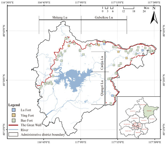
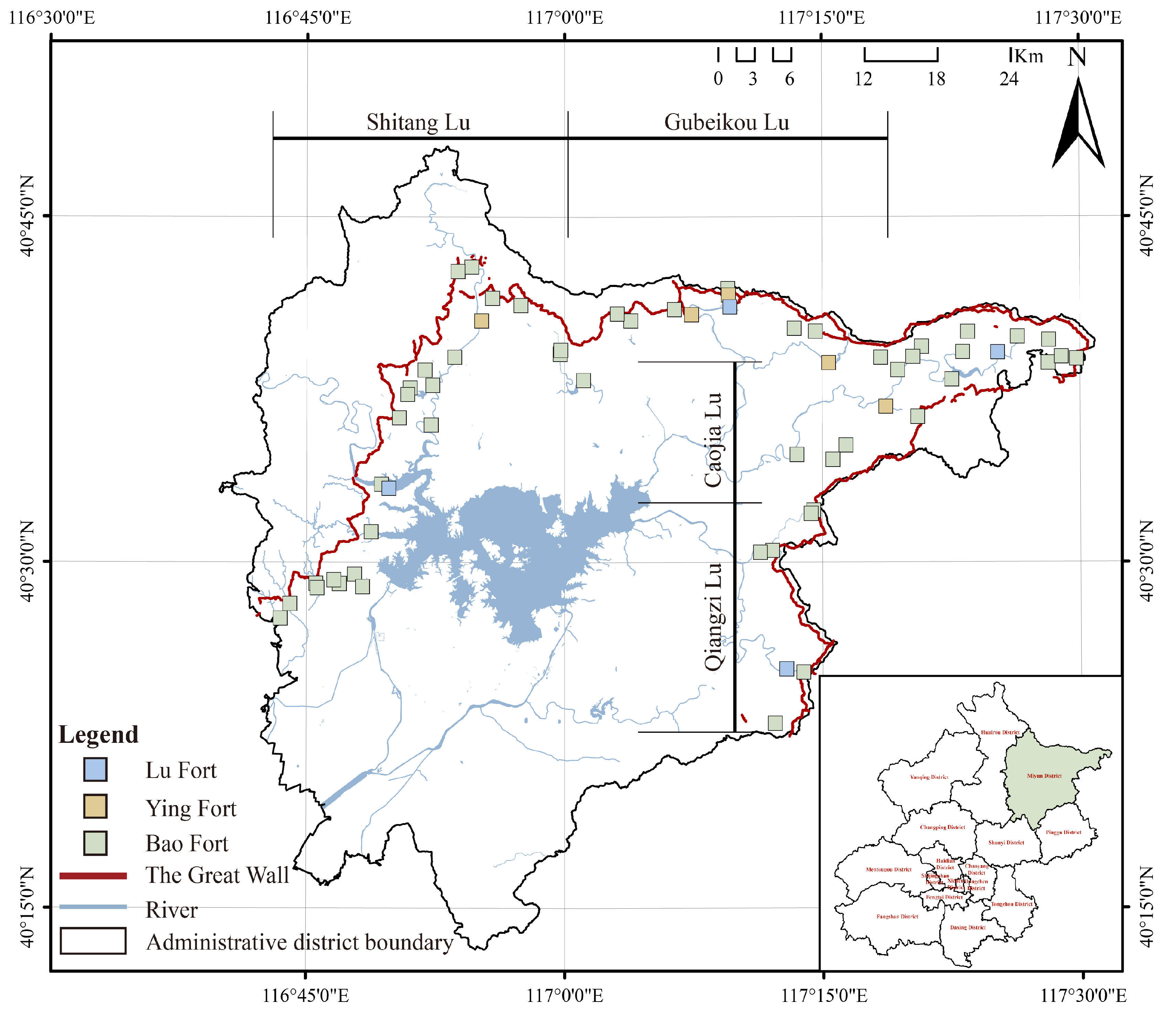
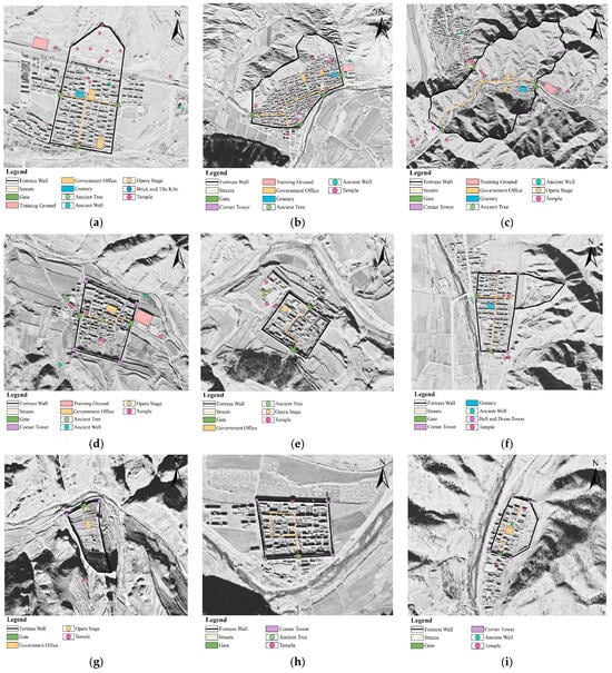
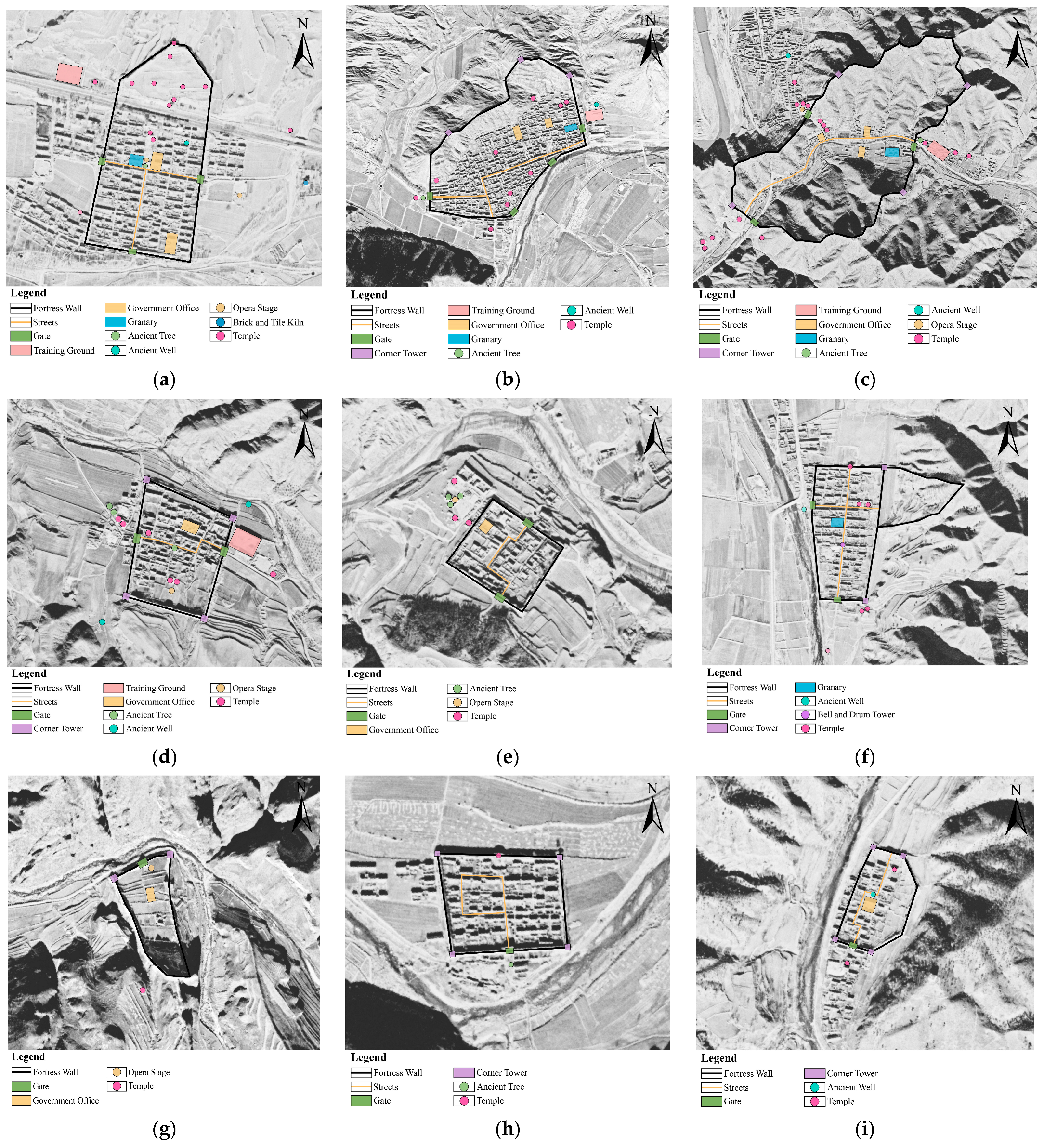
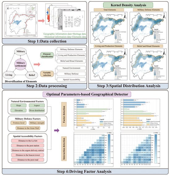
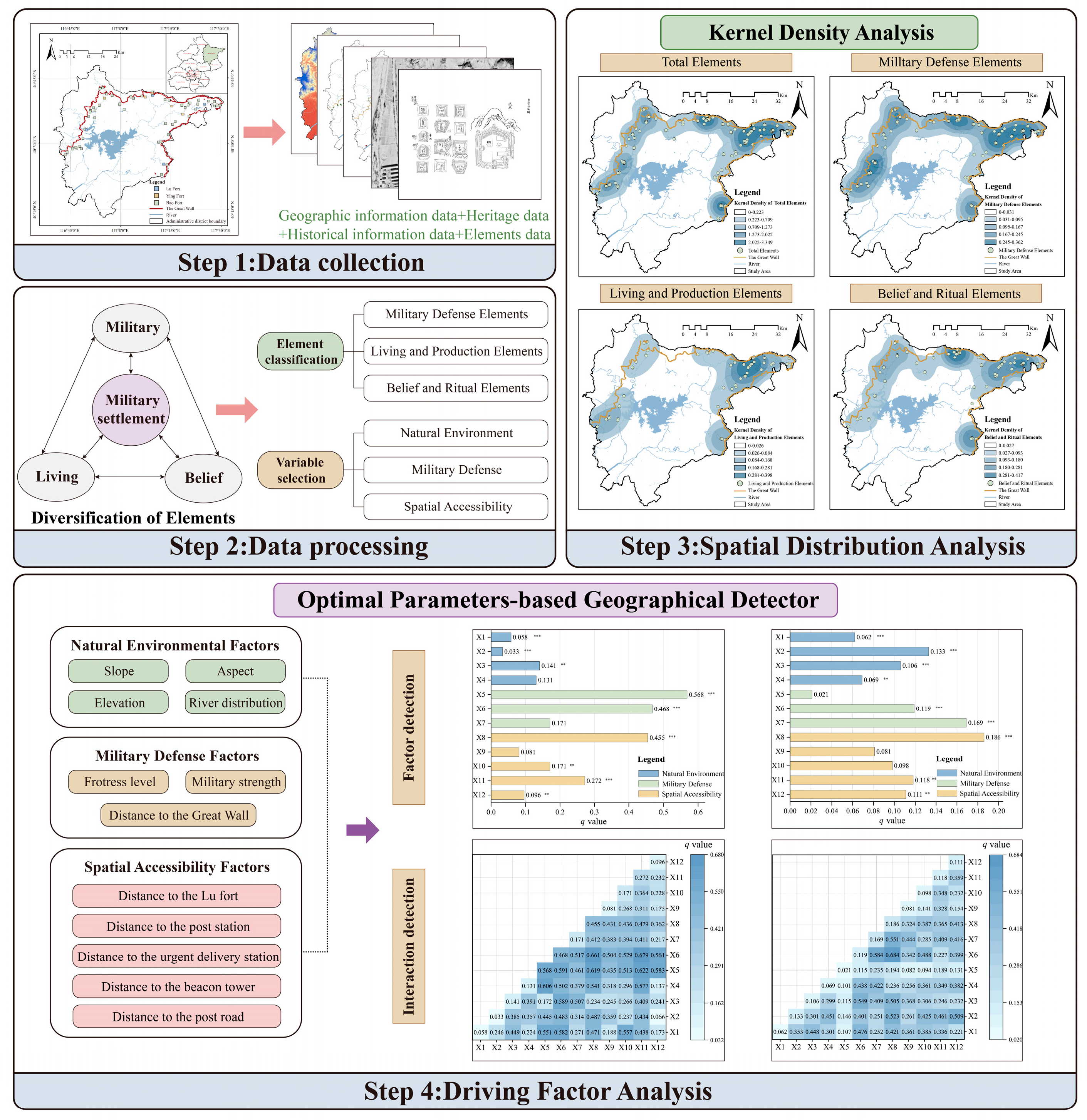
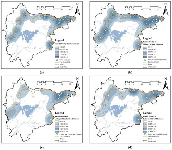
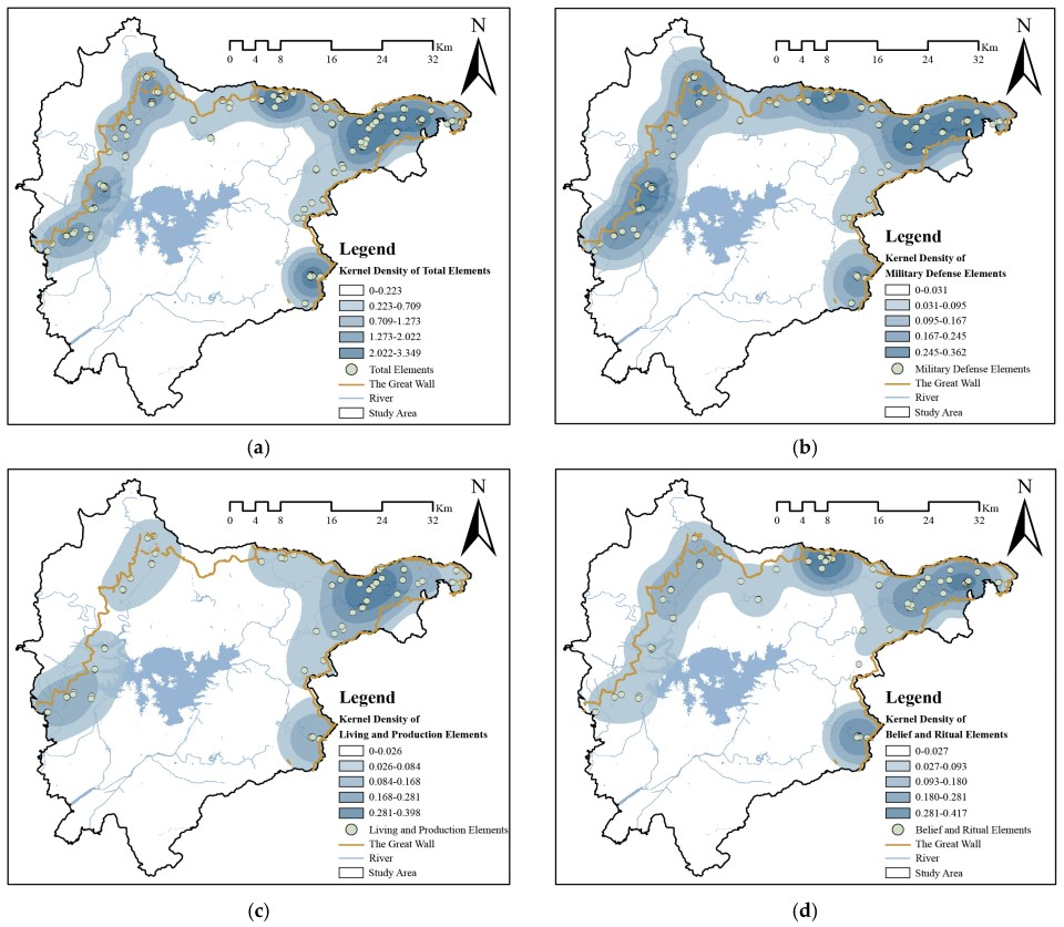
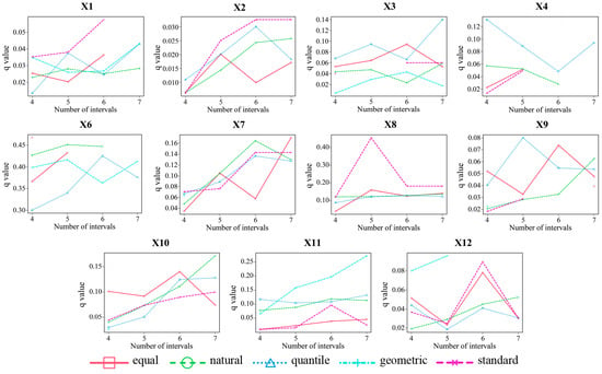
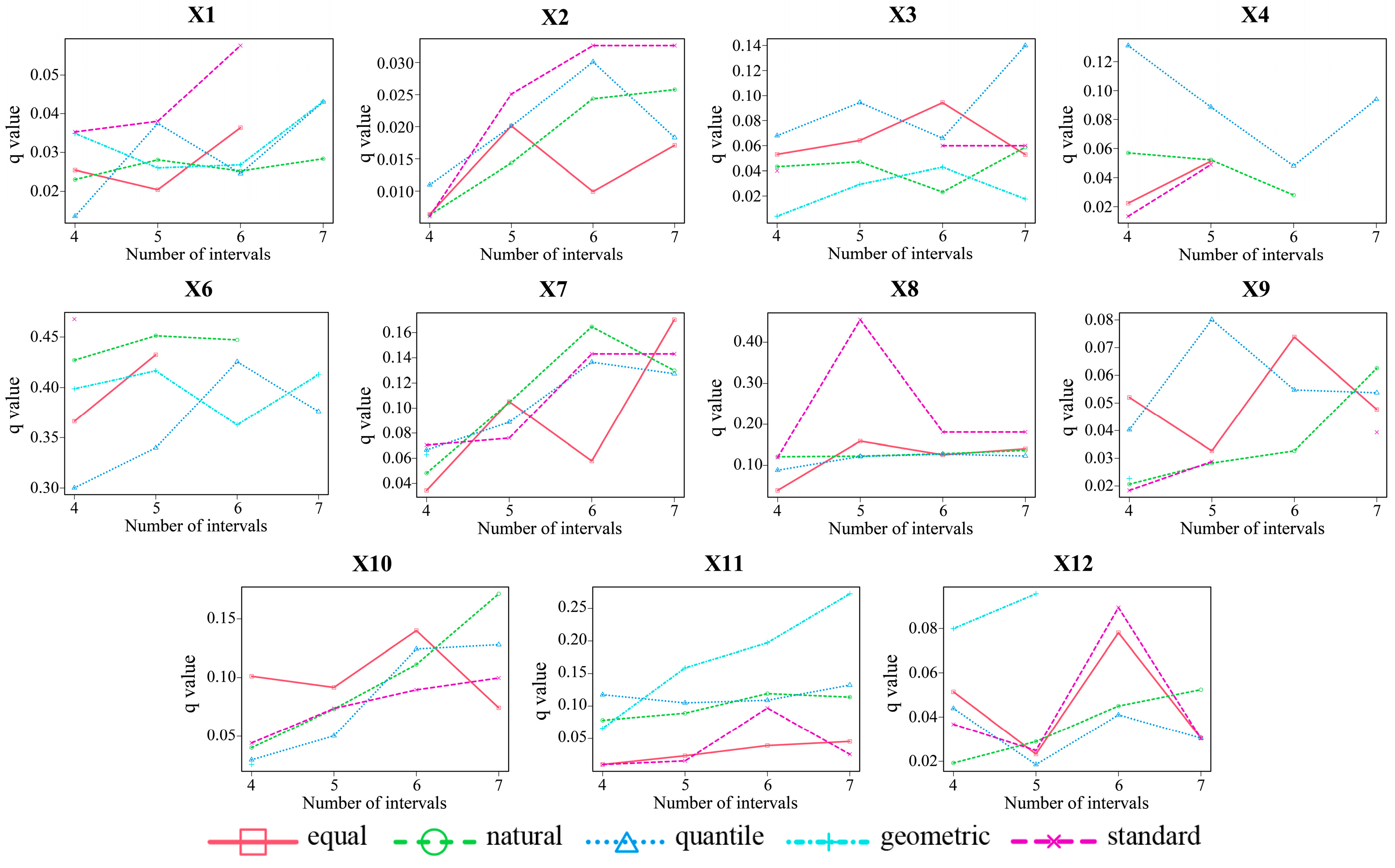
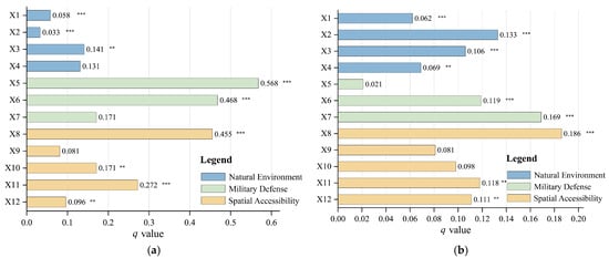
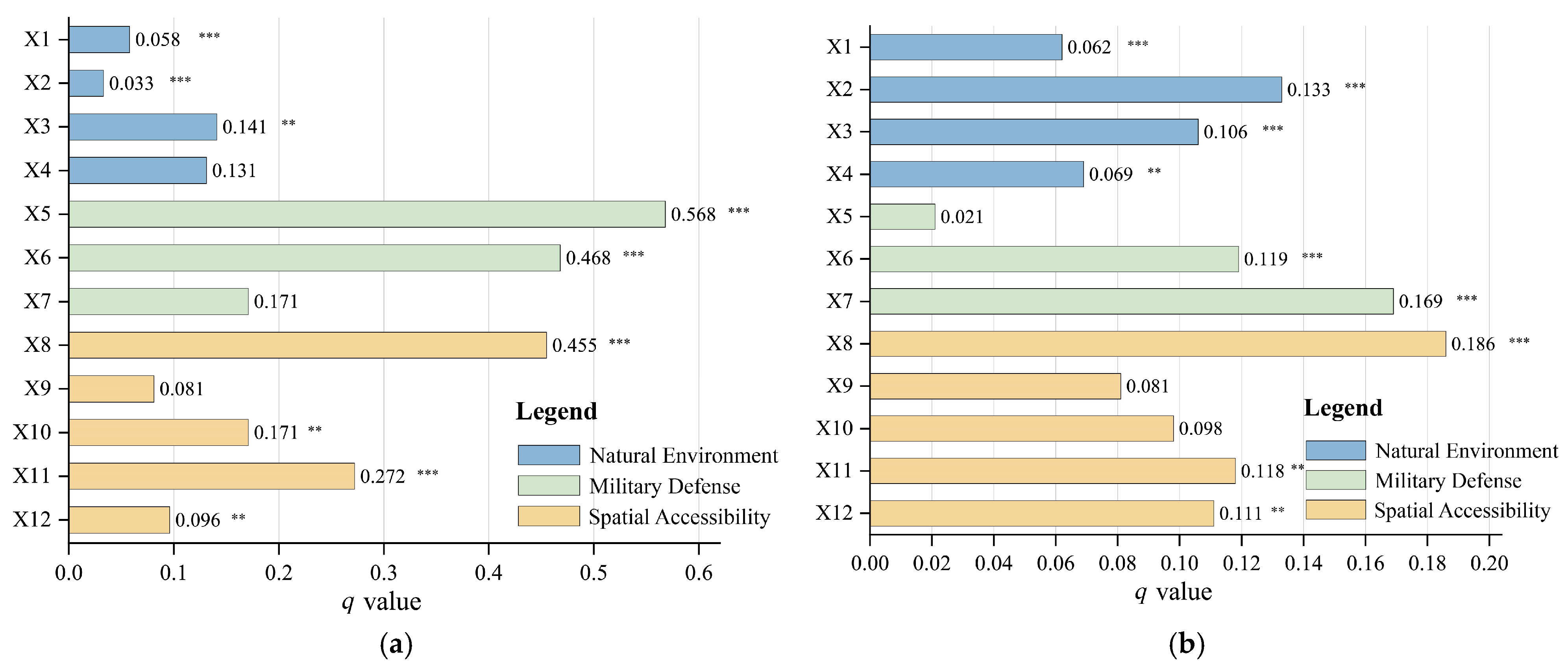
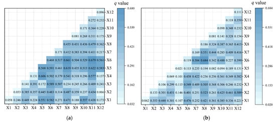
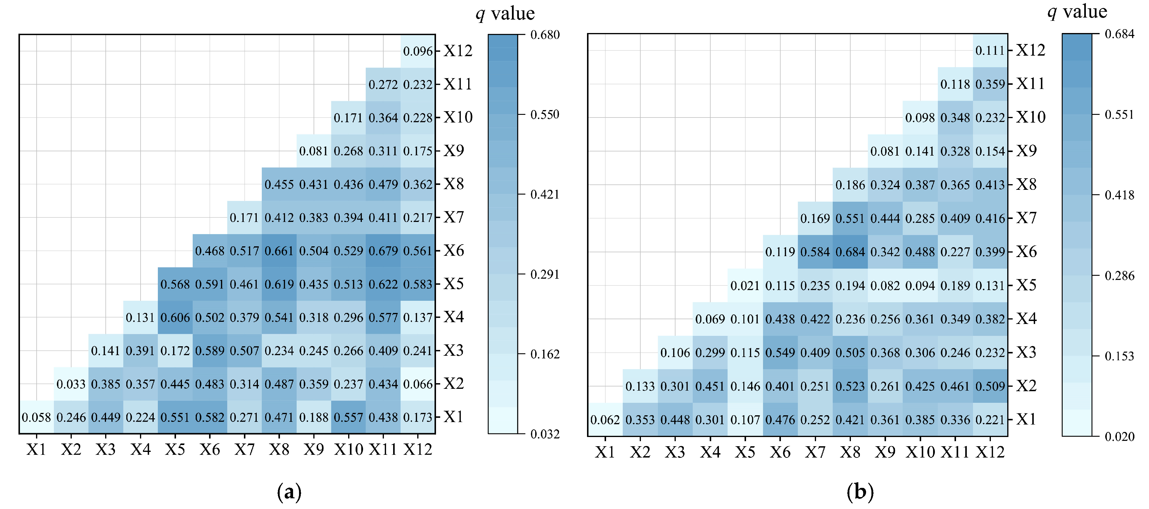
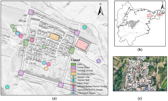
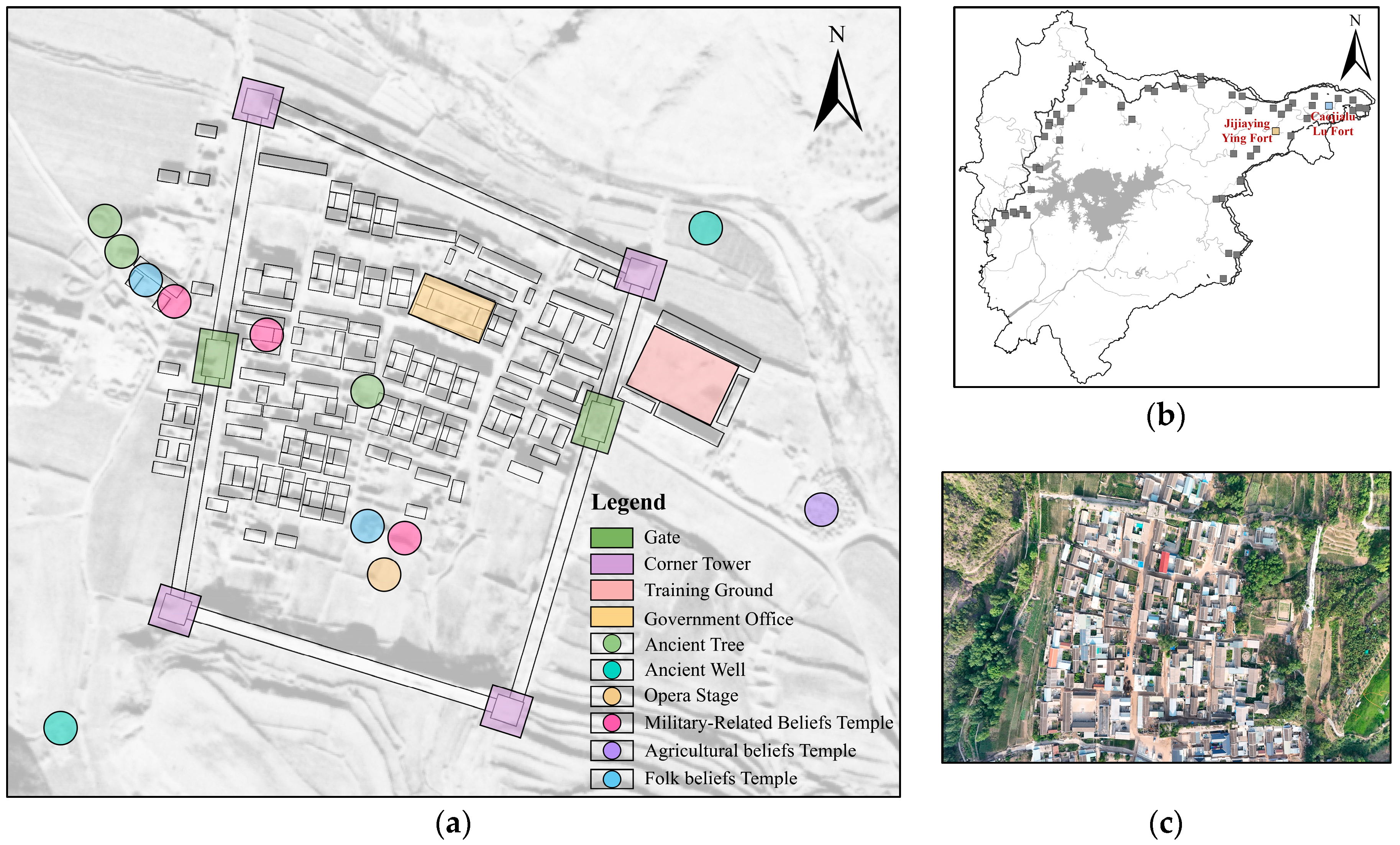
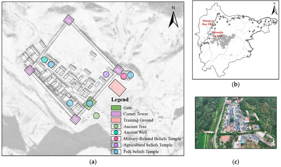
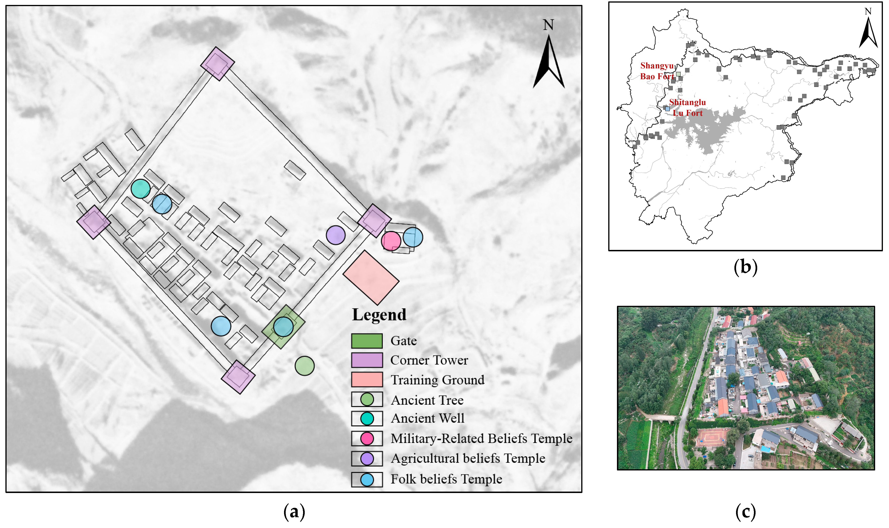

Disclaimer/Publisher’s Note: The statements, opinions and data contained in all publications are solely those of the individual author(s) and contributor(s) and not of MDPI and/or the editor(s). MDPI and/or the editor(s) disclaim responsibility for any injury to people or property resulting from any ideas, methods, instructions or products referred to in the content. |
© 2026 by the authors. Licensee MDPI, Basel, Switzerland. This article is an open access article distributed under the terms and conditions of the Creative Commons Attribution (CC BY) license.