


Abstract
Wind–Rain Bridge architecture is an important type of ancient bridge architecture. To reveal the factors contributing to the decline in the spatial performance of Wind-Rain Bridges in Hunan under the influence of urbanization and to assess their spatial legibility across different urbanization gradients, this study addresses the limitations of traditional research, which has largely relied on static observations and lacked quantitative analysis. The findings provide a scientific basis for the refined conservation and adaptive revitalization of traditional architecture. This study examines 535 Wind–Rain Bridges in Hunan. Using Space Syntax, core indicators such as Integration and Choice were quantitatively calculated for both Wind–Rain Bridges and modern bridges. A controlled variable experiment was further employed to analyze the disturbance effects of modern road networks. In addition, an XGBoost multi-classification model was constructed to assess spatial legibility levels and identify key spatial-topological predictors. The results indicate that the decline in the spatial performance of Wind–Rain Bridges in Hunan is not linearly correlated with urbanization. Urban-type Wind–Rain Bridges are most significantly affected by the replacement effect of modern road networks, whereas Semi-Village-type Wind–Rain Bridges exhibit the strongest resilience. Among the variables included in this study, Integration and Mean Depth are the strongest predictors of spatial legibility. This study establishes an analytical framework of “type classification–factor identification–differentiated strategy formulation” and confirms that the primary driver of the spatial performance decline of Wind–Rain Bridges in Hunan is the fragmentation of traditional pedestrian road networks caused by modern transportation systems under urbanization, rather than the aging of the bridge structures themselves.
1. Introduction
Wind–Rain Bridges represent a distinctive type of ancient bridge architecture and embody the integration of bridge engineering and traditional timber construction techniques (Figure 1). Their basic architectural form consists of columns erected on the bridge deck to support a covered corridor roof. In some cases, pavilion structures resembling tower-style drum towers are constructed on the bridge body. By organically integrating the functions of the bridge, pavilion, and corridor, Wind–Rain Bridges form a unique architectural typology that combines transportation, resting, and recreational spaces. This construction approach, often described as “building space upon bridges,” enables Wind–Rain Bridges not only to span rivers and connect transportation routes, but also to create public spaces for social interaction among local residents. Each Wind–Rain Bridge accommodates essential functions such as passage, rest, and ritual activities, while also serving as a venue for market trading, welcoming ceremonies, and communal entertainment. Within traditional settlement patterns, Wind–Rain Bridges function as prominent landmarks and concentrated expressions of regional culture and ethnic traditions. They are regarded as the spiritual centers of local communities, important bonds that connect neighborhoods, corridors for cultural continuity, and living architectural carriers of history and culture.
Figure 1.
Typical cases of Wind and Rain Bridges in Hunan. (A) Xinhua Longtan Bridge; (B) Tongdao Huilong Bridge.
With the acceleration of urbanization, traditional architecture such as Wind–Rain Bridges has been subjected to multiple pressures, including natural deterioration, human-induced damage, and the gradual loss of original functions. The transmission of traditional timber construction techniques has become increasingly fragmented, while a scientific and systematic conservation and restoration framework has yet to be fully established. Urbanization has profoundly reshaped the surrounding environments of Wind–Rain Bridges in Hunan. The expansion of modern road networks and the construction of vehicular bridges have gradually replaced their original transportation functions, resulting in functional displacement, increasing spatial marginalization, and a severe decline in potential for pedestrian use.
Although existing studies have produced substantial achievements in the structural typology, construction culture, and spatial distribution patterns, a critical gap remains. Most studies treat Wind–Rain Bridges as static architectural heritage and fail to conduct quantitative investigations within dynamically changing road network topologies. As a result, the mechanisms underlying the decline in the spatial performance of traditional bridges under urbanization remain unclear. Overall, Wind–Rain Bridges in Hunan are currently facing severe challenges in terms of survival and sustainable development. Systematic research is urgently needed to support their living inheritance and scientific conservation.
2. Literature Review
Space Syntax, as a mature theory for quantitative spatial morphology analysis, provides a core methodological framework for examining the topological role of Wind–Rain Bridges within road networks. Proposed by Bill Hillier and colleagues in the 1970s, this theory abstracts space into axial or segment-based models and quantitatively measures indicators such as Integration, Choice, and Connectivity. These indicators objectively reveal the intrinsic relationship between the spatial structure and social function [1,2]. After decades of development, Space Syntax has been widely applied worldwide. China has become one of the major centers for related research, where scholars frequently employ indicators such as Integration to evaluate spatial accessibility while also emphasizing the deeper cultural attributes embedded in spatial configurations [3]. In terms of analytical methods, the field has evolved from early axial map analysis to a diverse methodological system that includes Segment Maps and Visibility Graph Analysis (VGA) [4]. Applications of Space Syntax span multiple scales, ranging from macro-level comparisons of urban transportation network performance [5] and street vitality evaluation [6,7] to micro-level studies of traditional villages [8,9] and the spatial morphology of historic districts [10,11]. For example, Liu et al. [12] used Space Syntax to examine how city walls constrained and guided the spatial expansion of historic cities. Zhao et al. [13] and Sun et al. [14] applied syntactic indicators to evaluate the spatial accessibility and equity of museums and urban parks, respectively. These studies demonstrate the universality and effectiveness of Space Syntax as a language for spatial morphology analysis. However, existing research has largely focused on the static description of spatial accessibility across different environments [15]. Comparatively few studies have applied this approach to assess the dynamic changes in spatial performance of specific heritage objects under external environmental disturbances, particularly for Wind–Rain Bridges, which simultaneously possess the dual attributes of transportation infrastructure and cultural heritage.
Recent international studies further demonstrate that Space Syntax has developed from a basic configurational description tool into a mature, multi-scalar analytical framework. A bibliometric review of Space Syntax research from 1976 to 2023 shows that the field has formed a broad intellectual structure across urban studies, architecture, planning, transportation, and spatial cognition, indicating its methodological maturity and interdisciplinary expansion [16]. Haq [17] emphasizes that Space Syntax should be understood not merely as a software-based technique, but as a theory-driven methodology for quantifying layouts, visibility, accessibility, and movement-related spatial experience. Recent empirical studies have also strengthened the relationship between syntactic indicators and observed movement. For example, Johnsson and Camporeale [18] compared Space Syntax integration values at public transport hubs and public squares with pedestrian detections obtained from drone footage, showing that integration can help explain small-scale pedestrian movement patterns. Similarly, Othman et al. [19] combined GIS processing with visibility-based Space Syntax parameters and found that integration and direct visibility were significantly associated with the traffic volume, indicating the relevance of syntactic indicators for interpreting movement-related spatial behavior.
At the same time, recent research has expanded Space Syntax beyond a general street-network description toward accessibility, heritage conservation, indoor navigation, and spatial cognition. Morales et al. [20] demonstrated that Space Syntax can serve as a complementary accessibility measure in data-scarce contexts because it requires relatively limited input data while still capturing network-centrality patterns. Hegazi et al. [21] applied axial graph and visibility graph analyses to assess socio-spatial vulnerability around heritage buildings in historic Cairo, showing that the spatial configuration surrounding heritage assets can be linked to human-induced risks and conservation management. Bilgili et al. [22] used Space Syntax measures to evaluate indoor navigation paths and wayfinding, confirming that syntactic measures are closely related to spatial cognition and route choices. Esposito et al. [23] further integrated Space Syntax with agent-based and spatial cognition approaches, arguing that configurational analysis can be enriched by behavioral and perceptual interpretations. These studies suggest that Space Syntax is suitable for examining the spatial legibility, accessibility, and network embeddedness of Wind–Rain Bridges. However, they also indicate that Space Syntax primarily captures static configurational potential rather than directly observed social activity and therefore should be combined with behavioral observation or other social variables when actual use intensity is evaluated.
Wind–Rain Bridges and related covered bridges should not be regarded as a heritage type unique to Hunan. Rather, they form a broader family of vernacular bridge architecture distributed across several mountainous regions of southern China, including Hunan, Fujian, Zhejiang, Guangxi, and Guizhou. As a composite architectural form integrating bridge engineering, timber construction, covered corridors, and public space, Wind–Rain Bridges possess significant research value in the fields of history, folk culture, architecture, art, and heritage conservation.
In Fujian and Zhejiang, studies on timber-arched corridor bridges have emphasized their temporal–spatial distribution, mountain settlement context, heritage value, and conservation challenges. For example, Chen et al. [24] used ArcGIS spatial analysis, field investigation, and historical documents to examine 106 timber-arched corridor bridges in Fujian and Zhejiang, revealing a long-term clustered distribution pattern centered on northern Ningde and shaped by both natural and socio-cultural factors. Other research has focused on authenticity, fire prevention, reconstruction, and structural performance, highlighting the distinctive woven-arch structural system and the importance of balancing traditional craftsmanship with modern conservation technologies [25,26]. Compared with Hunan Wind–Rain Bridges, the Min-Zhe timber-arched corridor bridges are more strongly characterized by their arched structural system, World Heritage nomination context, and fire-related conservation issues, while both types share the attributes of timber construction, covered public space, and close interaction with mountainous settlement environments.
Research on Dong Wind–Rain Bridges in the Xiang-Gui-Qian border region, especially in Guangxi Sanjiang and Guizhou Qiandongnan, has placed greater emphasis on ethnic culture, ritual space, craftsmanship transmission, and community identity. Lei [27] argues that Dong Wind–Rain Bridges in the Hunan–Guangxi–Guizhou border area integrate ecological adaptation, functional aggregation, and cultural expression, serving not only as transportation facilities but also as carriers of Dong ecological concepts, social ethics, and spiritual beliefs. Studies of Sanjiang Wind–Rain Bridges further show that bridge construction is closely related to the role of master carpenters, oral transmission, mortise-and-tenon techniques, and digital preservation strategies [28]. From the perspective of public space and ritual practice, Cheng and Li [29] found that Wind–Rain Bridges, drum towers, Sa altars, and other public spaces in Qiandongnan Dong settlements jointly support ritual activities and regional cultural continuity. Semiotic studies also indicate that Sanjiang Wind–Rain Bridges have gradually shifted from practical crossing structures to cultural symbols of Dong ethnic identity [30]. In addition, multi-ethnic covered-bridge studies in the Hunan–Guizhou–Guangxi region suggest that Dong Wind–Rain Bridges, Miao flower bridges, Han corridor bridges, and other related bridge types differ in form and cultural expression but share common functions as transportation links, commercial nodes, ritual spaces, and places of social interaction [31].
At present, relatively well-preserved and numerous Wind–Rain Bridges can still be found in southern regions of China, particularly in provinces such as Fujian, Hunan, Zhejiang, and Guizhou [32]. Current academic research on Wind–Rain Bridges in Hunan mainly focuses on their architectural forms and cultural connotations. Relevant studies include typological classifications and evolutionary analyses of large timber structural systems [33], investigations of regional construction culture, ritual beliefs, and decorative artistic characteristics [34], as well as examinations of the “Bridge Bureau” system, a traditional social management mechanism associated with the construction of ancient Wind–Rain Bridges [35]. Some scholars have also adopted a macro-geographical perspective and applied methods such as GIS kernel density analysis and correlation regression to reveal the spatial distribution pattern of Wind–Rain Bridges within the Zijiang River Basin in Hunan Province, characterized by a denser distribution in the west and a sparser distribution in the east. These studies further explored the relationships between bridge distribution and factors such as ancient transportation routes, annual precipitation, population density, and GDP [36]. Existing architectural research on Wind–Rain Bridges, as a distinctive form of vernacular architectural heritage, has produced substantial achievements. Most previous studies have focused primarily on the bridge structures themselves, including their architectural forms, structural systems, and functional characteristics. Other studies have examined Wind–Rain Bridges in conjunction with their surrounding traditional villages from the perspectives of sociology, ethnology, and history. Comparatively little attention, however, has been given to their conservation and adaptive renewal [37]. Despite these valuable contributions, current research shares a common methodological limitation: Wind–Rain Bridges have rarely been quantitatively examined within the dynamically evolving topology of contemporary urban and rural road networks. Under rapid urbanization, the increasing construction of modern bridges and road systems has gradually threatened to replace the transportation functions historically carried by traditional Wind–Rain Bridges. Existing studies lack effective spatial quantitative tools capable of diagnosing how this replacement mechanism operates and how the spatial roles and usage values of Wind–Rain Bridges have declined or transformed within present-day transportation networks. Addressing this gap is precisely the key objective of introducing Space Syntax as a quantitative analytical tool in this study.
When exploring the complex relationships between built environment factors and target variables, such as spatial legibility, land value, and health effects, traditional linear models, including Ordinary Least Squares (OLS) and Geographically Weighted Regression (GWR), often fail to adequately capture the non-monotonic relationships and threshold effects commonly existing among variables because they rely on strict statistical assumptions [38,39]. In recent years, gradient boosting tree ensemble learning algorithms represented by XGBoost have rapidly emerged in the fields of spatial analysis and urban studies due to their outstanding non-monotonic fitting capabilities and their ability to automatically learn multidimensional feature interactions. Numerous studies have demonstrated that XGBoost significantly outperforms traditional models such as Random Forest (RF) and OLS in predicting urban spatial vitality [12,40], analyzing the complex relationships between metro station vitality and the built environment [41], evaluating land value [38], assessing residents’ self-rated health [10], and optimizing environmental perception in underground spaces [9], as well as resilience evaluations of traditional villages [42]. In particular, when combined with the interpretable framework of Shapley Additive Explanations (SHAP), XGBoost can not only effectively process high-dimensional spatial data, but also accurately quantify the contribution, direction, and potential threshold effects of individual influencing factors [43]. This approach further reveals complex interaction patterns that are difficult to identify using conventional statistical models. Such powerful capabilities in feature identification and pattern mining provide a promising technical pathway for addressing the complex interactions between the spatial performance of Wind–Rain Bridges and their surrounding road network environments. More importantly, this framework enables the precise identification of the key spatial structural indicators responsible for differences in the potential for the pedestrian use of Wind–Rain Bridges. Some scholars have even begun to develop spatialized XGBoost models to further address the heterogeneity of spatial data [44]. In addition, traditional analytical approaches represented by the Two-Step Floating Catchment Area (2SFCA) method have been widely applied to evaluate the spatial accessibility and equity of various public service facilities [14]. These studies provide an important reference framework for understanding the service supply capacity of Wind–Rain Bridges in this research.
In summary, existing studies have achieved considerable maturity in the static application of Space Syntax analysis, while research on the cultural and morphological characteristics of Wind–Rain Bridges in Hunan has also accumulated substantial findings. Meanwhile, machine learning models such as XGBoost have introduced new approaches for exploring complex spatial relationships. However, significant gaps remain among these research domains. First, there is still a lack of quantitative research that situates Wind–Rain Bridges, as a form of traditional architectural heritage, within the context of dynamically evolving regional road network systems. Second, few studies have attempted to integrate the topological measurements of Space Syntax with the nonlinear modeling capabilities of XGBoost to identify the key factors and threshold effects influencing the spatial cognition and potential for pedestrian use of traditional bridges. In response to the severe conservation challenges faced by Wind–Rain Bridges in Hunan, this study innovatively establishes an analytical framework of “type classification–factor identification–differentiated strategy formulation.” First, Space Syntax is employed to quantitatively measure and compare Wind–Rain Bridges under different urbanization gradients. Controlled comparative experiments are further designed to eliminate the influence of modern road networks on the syntactic indicator data of Wind–Rain Bridges. Subsequently, Space Syntax indicator data are used as input features to construct an XGBoost multi-classification model for a spatial legibility assessment and the identification of key influencing factors. This study aims to provide scientific data support and a replicable quantitative analytical framework for spatial legibility assessments, differentiated conservation, adaptive reuse, and spatial resilience enhancement of traditional architecture in the context of rapid urbanization.
3. Materials and Methods
3.1. Research Framework and Research Process
The technical framework of this study follows a progressive research process consisting of dataset construction and problem identification, spatial quantitative measurements and controlled experiments, machine learning modeling and factor identification, and the formulation of differentiated conservation and adaptive reuse strategies (Figure 2). Specifically, the study can be divided into three major research stages (Figure 3).
Figure 2.
Research framework. Source: compiled by the research team based on the core logic of this study and the technical route.
Figure 3.
Research process. Source: compiled by the research team based on the core logic of this study and the technical route.
This study uses 535 Wind–Rain Bridges in Hunan as research samples and follows an integrated technical workflow comprising multi-source data collection and database construction, urbanization gradient classification, Space Syntax topological measurements, controlled experiments on modern road networks, an XGBoost-based spatial legibility assessment and influencing factor identification, and the formulation of differentiated conservation strategies. First, multi-source data—including field surveys, historical and archival records, official census and special survey results, administrative boundaries, 30 m resolution digital elevation models, land-use data, and socio-economic statistics—were integrated to construct a spatial attribute database of Wind–Rain Bridges using the ArcGIS 10.8 platform. Second, based on urbanization rates and characteristics of the surrounding built environment, all Wind–Rain Bridges were classified into four types: Urban-type, Village-type, Semi-Village-type, and Field-type. On this basis, an axial model for Space Syntax analysis was constructed to quantitatively measure five core indicators: Integration, Choice, Connectivity, Intelligibility, and Synergy. Comparative analyses were conducted between different types of Wind–Rain Bridges and surrounding modern bridges to reveal differences in spatial performance under varying urbanization contexts. Fenghuanghong Bridge was selected as a representative case for controlled experiments in which modern bridges were either with or without. This allowed for the quantification of how modern road networks disturb the spatial permeability of Wind–Rain Bridges and generate diversion and replacement effects. Furthermore, seven feature variables—including Space Syntax indicators and bridge attribute types—were used as inputs in an XGBoost multi-classification model. Spatial legibility levels were constructed using weighted metrics such as Intelligibility and Synergy. Leave-one-out cross-validation was applied to train the model, evaluate its accuracy, and rank feature importance, thereby identifying the dominant factors affecting bridge spatial vitality. Finally, the study summarizes the nonlinear response patterns of Wind–Rain Bridge spatial performance to urbanization impacts and proposes differentiated strategies for conservation, adaptive reuse, and the improvement of spatial legibility, accessibility, and adaptive reuse potential for the four bridge types. This establishes a comprehensive research workflow that integrates spatial quantitative measurement with intelligent machine learning analysis.
3.2. Space Syntax
This study employs Space Syntax as the primary analytical framework, combining topological analysis with axial line analysis [45]. It uses parametric indicators to evaluate the accessibility of spatial units, the strength of links between nodes, the spatial circulation efficiency, and the dialectical relationship between the overall topological structure and local characteristics [46]. Within a spatial unit, the furthest distance visible from any point defines the geometric boundary of the space. Consequently, axial lines are generated according to the principles of minimal number and maximum length. A core premise of Space Syntax is that different areas of a street network carry varying intensities of pedestrian and vehicular flows, and these differences in carrying capacity significantly influence the functional layout within the network. Commonly used Space Syntax variables include Integration, Choice, Connectivity, Intelligibility, and Synergy. In this study, Integration, Choice, Connectivity, Intelligibility, and Synergy are employed to characterize the spatial accessibility of the transportation network in the study area (Table 1).
Table 1.
Definitions of selected Space Syntax parameters.
During the construction of the axial model, the topological relationships between different types of roads and Wind–Rain Bridges were checked and corrected manually. In this study, the link and unlink tools in depthmapX 0.8.0 were used to refine the topological connectivity of the axial network. The purpose of this procedure was not to change the geometric position of axial lines, but to ensure that the graph-based spatial model corresponded as closely as possible to actual passable spatial relationships.
The unlink tool was applied to axial-line intersections that appeared connected in the plan but were not connected in actual space. For example, where a Wind–Rain Bridge that prohibits motor-vehicle passage intersected with an adjacent vehicular road in the plan drawing, but no actual vehicular transition was possible, the corresponding topological relationship was removed using the unlink command. This avoided overestimating the accessibility of Wind–Rain Bridges within the modern vehicular road network. Similarly, unlink corrections were also applied to non-level crossings, visually overlapping roads, or blocked connections where movement could not occur in reality.
The link tool was used in the opposite situation, namely where two axial lines did not geometrically intersect in the drawing but were connected in actual space. For example, some Wind–Rain Bridges are connected to surrounding settlements through pedestrian alleys, bridge approaches, steps, or slow-traffic paths that may not form direct geometric intersections in the axial model. In such cases, link corrections were added to represent the actual pedestrian connection and to avoid underestimating the bridge’s role in the local walking network. All link and unlink corrections were checked according to field investigation records, high-resolution satellite images, road-network data, and bridge-site photographs.
In addition, this study distinguished between local and global spatial accessibility by calculating Integration at different radii. Integration R3 was used to represent local-scale spatial accessibility and pedestrian-oriented spatial legibility, because a radius of three topological steps is commonly used in Space Syntax studies to capture local movement potential. Integration Rn, by contrast, was used to represent global-scale spatial accessibility within the entire study-area network. Rather than directly equating Rn with motorized traffic, this study interprets it as a measure of broader network integration, which is particularly relevant for identifying the influence of modern roads and vehicular bridges on the spatial role of Wind–Rain Bridges. Therefore, the axial analysis maps are presented separately for R3 and Rn in the results section, allowing the spatial accessibility of Wind–Rain Bridges to be compared at both the pedestrian-oriented local scale and broader road-network scale.
3.3. XGBoost
This study first employs Space Syntax indicators and classification attributes as independent variables to investigate the key factors influencing the spatial cognition and usage value of Wind–Rain Bridges under different urbanization gradients. XGBoost was selected as the core predictive model because of its recognized advantages in capturing complex non-monotonic relationships between spatial structure and the spatial legibility of traditional architecture, mitigating overfitting through built-in regularization mechanisms, and providing feature-importance rankings. To rigorously verify the rationality of model selection, the performance of XGBoost was benchmarked against two commonly used algorithms: Random Forest (RF) and Artificial Neural Networks (ANNs). The XGBoost multi-classification model constructed in this study can be expressed by the following function:
where is the cross-entropy loss function, measuring the difference between the predicted probability and the true label ; controls the complexity of the (k)-th decision tree to prevent overfitting; (n) is the number of training samples; and (k) is the total number of trees. The number of classification categories was set to three, with 100 decision trees, a maximum tree depth of 3, a learning rate of 0.1, and a random seed of 42.
This study trained an XGBoost multi-classification model using a sample of 60 Wind–Rain Bridges in Hunan (Supplementary Material S1). The input variables consisted of field-measured Space Syntax indicators and classification attributes, including seven features: Integration (R = n), Choice, Connectivity, Mean Depth, Integration (R = 3), and Bridge Type. The model output target was the spatial legibility level (Y), which was classified into three categories: low, medium, and high, corresponding respectively to weak, moderate, and strong levels of spatial cognition and potential for pedestrian use.
The model evaluation results indicate that the XGBoost classification model achieved a high overall accuracy, with all performance metrics outperforming comparison models such as Random Forest. The classification results closely align with the actual road network locations of the Wind–Rain Bridges, the existing road network morphology, human usage patterns, and spatial perception characteristics, effectively reflecting the differentiation of spatial cognition and spatial legibility across different urbanization gradients. Feature importance analysis reveals significant hierarchical differences in the contribution of factors to the spatial cognition of Wind–Rain Bridges. Integration (R = n) showed the highest contribution, serving as the primary determinant of network centrality, spatial accessibility, and overall recognizability. Integration (R = 3), Choice, and Connectivity followed, influencing users’ spatial cognition and usage intentions through local spatial clustering efficiency, path traversal potential, and network connectivity, respectively. The topological depth, bridge form, and location type exhibited relatively lower contributions. Overall, Space Syntax topological indicators demonstrated substantially greater explanatory power for spatial cognition and potential for pedestrian use than the bridge form and location attributes. These findings confirm that the integrity of the road network morphology is a key foundation for maintaining the spatial cognition spatial legibility and the ongoing functional and cultural value of Wind–Rain Bridges.
3.4. LOWESS
To further examine whether the relationship between urbanization and the spatial legibility of Wind–Rain Bridges follows a linear or non-monotonic pattern, this study treated the county-level urbanization rate as a continuous variable rather than relying solely on categorical urbanization gradients. A continuous Spatial Legibility Index (SLI) was constructed by standardizing Intelligibility and Synergy to remove scale differences and then calculating their weighted average to represent the overall level of spatial cognition and network readability for each Wind–Rain Bridge sample case.
A LOWESS smoothing curve was then fitted using the county-level urbanization rate as the independent variable and SLI as the dependent variable. The smoothing parameter was set to 0.45. This analysis was used as an exploratory visualization method to examine whether the relationship between the urbanization rate and spatial legibility followed a simple linear trend or a non-monotonic pattern. The LOWESS result should be interpreted as descriptive evidence of spatial association rather than causal inference.
3.5. Research Area and Data Sources
This study focuses on the spatial performance and spatial legibility assessment evaluation of Wind–Rain Bridges in traditional villages of Hunan (Figure 4). Located in south-central China (24°38′–30°08′ N, 108°47′–114°15′ E), Hunan Province contains 704 nationally recognized traditional villages, many of which preserve a large number of Wind–Rain Bridges. These bridges are highly concentrated in ethnic minority settlements inhabited by groups such as the Dong and Miao peoples, providing a solid empirical foundation for analyzing the spatial performance and spatial legibility of Wind–Rain Bridges.
Figure 4.
Location and research scope of Hunan Province.
At the ecological level, the geomorphological environments supporting Wind–Rain Bridges are highly diverse, including mountainous river valleys, hilly basins, river-lake networks, and karst landscapes. This heterogeneous ecological background fundamentally shapes bridge-site-selection patterns, morphological adaptability, and spatial enclosure characteristics. The diversity of the terrain and ethnic culture provides a robust analytical basis for identifying the determinants of spatial performance, including accessibility, Connectivity, functional complexity, and climate adaptability, as well as for comparing spatial legibility levels across different ecological and social contexts. From the perspective of social space, Wind–Rain Bridges serve not only as transportation infrastructure, but also as multifunctional public spaces that accommodate gatherings, rituals, leisure activities, and informal communication. As such, they exert a profound influence on the spatial legibility of public life within traditional villages. However, under the combined pressures of rapid urbanization, tourism commercialization, and the transformation of local livelihood patterns, the spatial performance and spatial legibility of Wind–Rain Bridges are facing varying degrees of decline. A systematic evaluation of their spatial performance and spatial legibility is therefore essential for maintaining social cohesion and cultural continuity. The identification and analysis of the spatial performance and spatial legibility of Wind–Rain Bridges are also closely connected to the broader global discourse on the sustainable revitalization of public spaces in traditional villages.
The village samples used in this study were derived from a self-established database of Wind–Rain Bridges in Hunan developed by the research team. Since 2014, the team has conducted systematic field investigations on Wind–Rain Bridges in Hunan, collecting attribute information for each bridge individually, including the bridge name, county and city location, and conservation classification. Based on these data, a feature dataset was established on the ArcGIS 10.8 platform, resulting in a spatial database containing 535 Wind–Rain Bridges as of 6 April 2026. The database integrates field surveys, documentary research, and cross-validation using multiple data sources. Its scale is comparable to the results of the special survey on covered bridges in Hunan Province, which confirmed a total of 535 Wind–Rain Bridges across the province, including 26 nationally protected cultural heritage sites and 87 provincially protected cultural heritage sites. According to watershed divisions, the bridges included in the database are distributed as follows: 87 bridges in the Xiangjiang River Basin, 185 in the Zishui River Basin, 223 in the Yuanjiang River Basin, and 29 in the Lishui River Basin. The spatial distribution characteristics of Wind–Rain Bridges in Hunan analyzed in this study were derived from vectorized point data and examined through spatial analysis using the ArcGIS 10.8 platform.
In addition, the administrative boundary data used in this study were obtained from the Standard Map Service System (http://bzdt.ch.mnr.gov.cn/). Digital Elevation Model (DEM) data were acquired from the NASA Earth Science Data website (https://www.earthdata.nasa.gov/), with a spatial resolution of 30 m and a vertical accuracy of approximately ±10 m. Satellite imagery was obtained from Google Earth, which satisfies the accuracy requirements for a regional-scale spatial analysis.
4. Results
4.1. Classification of Wind–Rain Bridges in Hunan
Based on the urbanization process across Hunan and the locational characteristics of Wind–Rain Bridges, this study establishes a classification system grounded in urbanization gradients. The system categorizes Wind–Rain Bridges into four types, systematically reflecting their spatial distribution and functional characteristics under different urbanization contexts. In this study, the urbanization rate was calculated as the proportion of the urban permanent resident population to the total permanent resident population in each district or county. The classification of urban and rural populations strictly followed the Regulations on the Statistical Classification of Urban and Rural Areas issued by the National Bureau of Statistics of China. This regulation is based on China’s administrative divisions, takes the jurisdictional areas of residents’ committees and villagers’ committees confirmed by the civil affairs authorities as the basic classification units, and uses actual built-up conditions as the main criterion for distinguishing urban and rural areas. Accordingly, the national territory is statistically divided into urban and rural areas.
Based on the urbanization-rate data, this study further referred to the urbanization-stage theory proposed by the American urban geographer Ray M. Northam to determine the threshold values for classifying urbanization-gradient types. Through empirical research on the urbanization processes of different countries, Northam divided urbanization development into three stages: the initial stage, in which the proportion of urban population is below 30%; the acceleration stage, in which the proportion ranges from 30% to 70%; and the mature stage, in which the proportion exceeds 70%. This stage-based “S-shaped curve” model has been widely adopted in urbanization studies and has become a classic theoretical framework for analyzing urbanization processes.
Within this framework, the 50% threshold was used as the midpoint of the acceleration stage. This threshold also has particular relevance in the context of China’s urbanization process. In 2011, China’s permanent-resident urbanization rate exceeded 50% for the first time, marking a historic transition from a society dominated by the rural population to one dominated by urban population. Therefore, using 50% as an internal dividing point within the acceleration stage has both theoretical and practical justification.
On this basis, and in combination with the actual locational characteristics of Wind–Rain Bridges, this study established a four-category classification system. Bridges located in areas at the mature stage of urbanization were defined as Urban-type bridges. Bridges located in the later part of the acceleration stage were defined as Village-type bridges. Bridges located in the early stage of urbanization or in the lower part of the acceleration stage, but still clearly dependent on nearby settlements, were defined as Semi-Village-type bridges. Bridges that were completely separated from settlements and road-network systems were defined as Field-type bridges. This classification integrates statistical urbanization thresholds with the actual spatial relationship between Wind–Rain Bridges, settlements, and transportation networks, thereby avoiding reliance on the urbanization rate alone.
It should be noted that the county-level urbanization rate represents the macro-level urbanization background of the administrative unit in which each Wind–Rain Bridge is located, rather than the micro-level urbanization condition of the specific village or site where the bridge is situated. Since counties and districts often include both urban cores and rural settlements, the urbanization rate was not used as the sole criterion for determining the bridge type. Instead, this study adopted a combined classification strategy that integrates the county-level urbanization background with the actual locational characteristics of each bridge, including its relationship with settlements, built-up areas, and road-network systems.
The thresholds used in this study were theoretically grounded in Northam’s urbanization-stage theory. According to this framework, an urban population proportion below 30% corresponds to the initial stage of urbanization, 30–70% corresponds to the acceleration stage, and above 70% corresponds to the mature stage of urbanization [47]. In the context of China’s urbanization process, the 50% threshold also has practical significance, as China’s permanent-resident urbanization rate exceeded 50% for the first time in 2011, marking the transition from a predominantly rural population structure to a predominantly urban one. Therefore, this study used 70% to identify areas at the mature stage of urbanization and used 50% as an internal dividing point within the acceleration stage.
Specifically, bridges located in highly urbanized areas with an urbanization rate above 70% and clearly affected by urban built-up areas and modern road networks were classified as Urban-type bridges. Bridges located in areas within the later acceleration stage of urbanization, especially those with an urbanization rate between 50% and 70% and still embedded in village settlements and local road networks, were classified as Village-type bridges. Bridges located in areas with an urbanization rate below 50%, but still clearly attached to settlements and local road networks, were classified as Semi-Village-type bridges. Bridges that were largely detached from settlements and contemporary road-network systems were classified as Field-type bridges. This four-type classification framework therefore combines theoretically grounded urbanization thresholds with the actual spatial context of Wind–Rain Bridges, rather than relying on the statistical urbanization rate alone. To further validate the rationality of the proposed classification framework, Jenks natural breaks classification was applied to the county-level urbanization-rate data as a supplementary robustness check. Unlike the theoretically defined 50% and 70% thresholds, the Jenks method identifies break points according to the internal distribution structure of the sample data by minimizing within-class variance and maximizing between-class variance. As shown (Figure 5), the Jenks classification reveals a clear hierarchical differentiation in the urbanization-rate distribution, which generally supports the distinction between highly urbanized areas, moderately urbanized areas, and less urbanized areas. Although the Jenks break points do not necessarily coincide exactly with the theoretical thresholds, they provide data-driven evidence that the urbanization background of the study area presents distinct gradient characteristics. Therefore, the bridge-type classification adopted in this study is not based solely on the arbitrary threshold division, but is supported by both urbanization-stage theory and the empirical distribution of the data. For bridges located near threshold boundaries, the final classification was further determined by considering their actual spatial context, including field investigation, satellite imagery, built-up-area conditions, settlement dependence, and the relationship between each bridge and the surrounding road-network system.
Figure 5.
Robustness check of urbanization thresholds for Wind–Rain Bridge classifications using Jenks natural breaks.
Urban-type Wind–Rain Bridges are located in areas with an urbanization rate of 70% or higher. These bridges are mainly embedded within urban districts and major town built-up areas, where the surrounding infrastructure is highly developed. They simultaneously serve transportation, cultural tourism, and cultural display functions, representing a typical integration of traditional architecture with modern urban life. Village-type Wind–Rain Bridges are situated in regions with urbanization rates between 50% and 70%. They are widely distributed around townships and traditional villages, where they retain traditional architectural forms while fulfilling both practical transportation and cultural inheritance functions. These bridges function as important nodes connecting traditional settlements with the influence of surrounding urban development. Field-type Wind–Rain Bridges are independently located within mountainous forest interiors and are completely detached from the influence of urbanization. These bridges are generally surrounded by areas without permanent residents and mainly serve temporary passage and shelter from rain. They preserve their original construction conditions and traditional landscape characteristics.
The classification results (Table 2) indicate that the distribution of Wind–Rain Bridges across the four urbanization gradient types is highly uneven, with a strong concentration in moderately urbanized and rural environments (Figure 6). Semi-Village-type Wind–Rain Bridges, located in transitional areas with urbanization rates below 50% and relatively limited intervention from modern transportation systems, account for the highest proportion at 45%. This dominant proportion suggests that nearly half of the study samples remain in low-urbanization environments, where the original road network morphology and settlement patterns are relatively well preserved and where the bridges continue to fulfill both transportation and public social functions. Village-type and Field-type Wind–Rain Bridges each account for 26.4% of the total sample. Together, they comprise more than half of all bridges, indicating that a substantial number of Wind–Rain Bridges still survive within traditional rural landscapes and remote mountainous environments that have not yet experienced the full impact of modern road network expansion. In sharp contrast, Urban-type Wind–Rain Bridges, located in regions with urbanization rates above 70%, account for only 2.2% of the total. This extremely low proportion clearly reveals the processes of functional replacement and spatial marginalization experienced by Wind–Rain Bridges in highly urbanized environments. As modern vehicular bridges and dense transportation networks gradually assume their original transportation functions, most traditional Wind–Rain Bridges in such areas have either been demolished, replaced, or fallen into functional decline.
Table 2.
Classification system of Wind–Rain Bridges in Hunan.
Figure 6.
Proportional distribution of Wind–Rain bridge types.
Overall, the data exhibit a pronounced pattern of polarized spatial concentration. Wind–Rain Bridges are highly concentrated in Semi-Village-type transitional zones and rural mountainous hinterlands, whereas only a very limited number remain in highly urbanized areas. This distribution pattern strongly supports the central premise of this study: the spatial persistence of Wind–Rain Bridges is negatively correlated with the intensity of urbanization and positively correlated with the integrity of traditional road network morphology.
4.2. Theoretical Significance and Analytical Value of the Classification Framework
This chapter classifies Wind–Rain Bridges in Hunan into four types—Urban, Village, Semi-Village, and Field—based on urbanization gradients, aiming to provide clear research units for subsequent spatial quantitative analysis. Against the broader backdrop of rapid urbanization, which has generally weakened the functional use of Wind–Rain Bridges, this classification not only challenges the linear narrative that “urbanization inevitably leads to the decline of traditional architecture,” but also establishes a methodological basis for translating qualitative typologies into precise quantitative assessments.
The classification also reveals the non-monotonic relationship between urbanization impacts and the spatial resilience of Wind–Rain Bridges, providing a typological basis for differentiated preservation strategies. Traditionally, the urbanization process and the survival space of historic buildings are often viewed as a zero-sum trade-off [47]. However, the classification in this chapter demonstrates that the impact of urbanization on the functional use of Wind–Rain Bridges is not a simple linear decline; rather, it is highly dependent on the bridge’s regional context and the structure of the surrounding spatial network. The results show that although Urban-type Wind–Rain Bridges are situated within high-density built environments and generally exhibit lower Integration and Choice values than nearby modern bridges (Table 3), some examples—such as Longjin Wind-Rain Bridge—have been incorporated into modern pedestrian networks, thereby acquiring new functions as cultural landmarks and public spaces. In contrast, Village- and Semi-Village-type bridges in intermediate urbanization gradients often maintain comparable or even superior spatial performance relative to modern bridges in certain local contexts (Table 4 and Table 5), retaining strong Integration and through-movement potential. This finding corrects the oversimplified assumption that “the higher the urbanization, the greater the risk to Wind-Rain Bridges.” The classification highlights a key insight: the “deactivation” of Wind–Rain Bridges in urban spaces primarily results from the replacement of pedestrian networks by motorized traffic. At the village and semi-village scales, as long as the original road network morphology remains largely intact, Wind–Rain Bridges continue to exhibit spatial resilience and can still integrate with contemporary transportation systems. Consequently, the classification establishes critical theoretical boundaries for subsequent differentiated interventions: for Urban-type bridges, preservation should focus on maintaining pedestrian network connectivity, whereas for Semi-Village-type bridges, attention must be given to the potentially disruptive effects of modern road construction on the integrity of traditional road network morphology.
Table 3.
Space Syntax metrics of urban-type Wind–Rain bridges and modern bridges.
Table 4.
Space Syntax metrics of village-type Wind–Rain bridges and modern bridges.
Table 5.
Space Syntax metrics for semi-village-type Wind–Rain bridges and modern bridges.
In summary, the classification framework presented in this chapter reveals the nonlinear effects of urbanization and provides an epistemological foundation for the conservation strategies of Wind–Rain Bridges. As the logical starting point for subsequent quantitative analyses, it ensures that the overall argumentative chain of this study—from typological description to spatial measurement and further to value stratification—maintains internal rigor and coherence.
4.3. Quantitative Analysis of Wind–Rain Bridges in Hunan
4.3.1. Quantitative Analysis of Hunan Wind–Rain Bridges by Type
The Wind–Rain Bridge database established in this study includes a total of 535 Wind–Rain Bridges in Hunan Province, as presented in the classification results in Section 4.1. According to the statistical classification of the database, the numbers of the four types of Wind–Rain Bridges are as follows: 12 Urban-type bridges, 141 Village-type bridges, 241 Semi-Village-type bridges, and 141 Field-type bridges.
In the implementation of the Space Syntax axial-line analysis, this study selected seven representative bridges from each of the Urban-type, Village-type, and Semi-Village-type categories, resulting in a total of 21 bridges as analytical samples. The sample selection followed three principles: first, the selected bridges should cover different river basins and geographical units to ensure regional representativeness; second, the surrounding areas of the selected bridges should have relatively complete road-network topologies that can be constructed for Space Syntax analysis; and third, the selected bridges should exhibit typical road-network locational characteristics within their respective categories. These samples can therefore reflect the differences in spatial performance between Wind–Rain Bridges and modern bridges under different urbanization contexts.
The remaining bridges were included in the database and classified according to the proposed typological framework, but they were not incorporated into the axial-line analysis at this stage. This is mainly because some field-survey data are still being processed, while some bridge sites lack comparable modern-bridge reference systems or complete surrounding road-network structures required for paired Space Syntax comparison. In particular, Field-type bridges are often detached from settlements and contemporary road-network systems, making them unsuitable for the same axial-line comparative analysis applied to Urban-type, Village-type, and Semi-Village-type bridges. Therefore, the Space Syntax analysis in this study focuses on the 21 representative samples, while the full database of 535 bridges provides the overall classification basis and research context.
For the Urban-type samples, the surrounding infrastructure is well developed and the road network is highly dense. Their traditional transportation functions have been partially replaced by modern bridges, and they currently mainly serve cultural tourism display and landmark functions. For the Village-type samples, the bridges retain complete traditional architectural forms and simultaneously perform both transportation and public interaction functions. They act as key nodes connecting traditional settlements with the influence of surrounding urban systems. For the Semi-Village-type samples, the bridges are located far from urban cores and are less affected by modern transportation systems. They preserve relatively primitive architectural forms and mainly serve local inter-village circulation, with well-preserved original characteristics. Based on four core Space Syntax indicators measured from the axial networks where the three types of samples are located, this study conducts a systematic calculation and statistical analysis.
Field-type Wind–Rain Bridges (Figure 7), due to their remote locations and lack of integration into continuous regional transportation networks, do not possess a complete surrounding road network morphology or topological connections. As a result, axial models cannot be constructed for these bridges using Space Syntax, and core topological indicators such as Integration and Choice cannot be calculated, making them unsuitable for the study’s quantitative analysis framework based on transportation network topology.
Figure 7.
Satellite images of Field-type Wind–Rain Bridges. (A) Chongshanwan Bridge; (B) Panshan Bridge; (C) Luohong Bridge; (D) Maoping Bridge.
In addition, these bridges primarily serve scattered mountainous settlements or temporary passage functions. They lack stable pedestrian flows and consistent usage scenarios, making it difficult to establish measurable samples for vitality evaluation. Accordingly, Field-type Wind–Rain Bridges are not included in the Space Syntax analysis or the XGBoost-based vitality evaluation framework in this study. Instead, the research focuses on Urban-type, Village-type, and Semi-Village-type Wind–Rain Bridges, which exhibit stronger connections to road networks, thereby ensuring the scientific validity and interpretability of the analytical results.
The quantitative comparison (Table 3, Figure 8 and Figure 9) shows that Urban-type Wind–Rain Bridges generally exhibit weaker spatial performance than nearby modern bridges within the same urban road-network contexts, although this pattern is not completely uniform and several exceptions can be observed. Across the seven paired samples, the average Integration Rn value of Wind-Rain Bridges is 0.83, lower than that of modern bridges at 0.89. This indicates that, at the global network scale, most Urban-type Wind–Rain Bridges have gradually lost part of their central position within the contemporary road system. Among the seven paired samples, only Fenghuanghong Bridge and Longjin Wind–Rain Bridge show slightly higher Integration Rn values than their corresponding modern bridges. In particular, the Longjin Wind–Rain Bridge reaches an Integration Rn value of 1.22, exceeding its modern counterpart of 1.17, suggesting that this bridge still maintains a relatively strong global centrality within the historic urban block. By contrast, Nanmen Bridge, Rongchang Bridge, Durong Bridge, Guangwen Bridge, and Huangxikou Bridge all show lower Integration Rn values than their adjacent modern bridges. For example, Nanmen Bridge has an Integration Rn value of 0.93, which is approximately 14.7% lower than that of the corresponding modern bridge at 1.09.
Figure 8.
Spatial performance comparison of Urban-type Wind–Rain Bridges and adjacent modern bridges based on Space Syntax, with axial-line counts indicated in parentheses. The seven representative cases include the following: (A) Nanmen Bridge (218), (B) Rongchang Bridge (178), (C) Fenghuanghong Bridge (174), (D) Longjin Wind-Rain Bridge (185), (E) Durong Bridge (196), (F) Guang-wen Bridge (124), and (G) Huangxikou Bridge (90).
Figure 9.
Spatial performance comparison of Urban-type Wind–Rain Bridges and adjacent modern bridges based on space syntax indicators. (a) Integration Rn; (b) Integration R3; (c) Choice Rn; (d) Choice R3; and (e) Connectivity.
The difference becomes more evident when local-scale accessibility is considered. In terms of Integration R3, all seven Wind–Rain Bridges have lower values than their corresponding modern bridges. The average Integration R3 value of Wind–Rain Bridges is 1.59, while that of modern bridges is 2.04, indicating that modern bridges have stronger local accessibility and are more directly embedded in the surrounding short-distance movement network. This result suggests that even when some Wind–Rain Bridges still retain a certain degree of global centrality, their local pedestrian-oriented accessibility is often weakened by the reorganization of modern road systems. For instance, Nanmen Bridge has an Integration R3 value of 1.47, compared with 2.34 for the modern bridge, while Rongchang Bridge has an Integration R3 value of 1.83, compared with 2.59 for its modern counterpart. These differences demonstrate that modern bridges have become more efficient connectors within local urban road networks. The disparity in the Choice indicator is even more pronounced. At the global scale, the average Choice Rn value of modern bridges is 6342, which is much higher than the average value of 2393 for Wind–Rain Bridges. In six of the seven paired samples, modern bridges have higher Choice Rn values than traditional Wind–Rain Bridges. The most significant gap appears in the Nanmen Bridge group, where the modern bridge reaches a Choice Rn value of 15,240, approximately 15.5 times higher than that of Nanmen Bridge at 983. Similar large differences are also found in the Durong Bridge and Huangxikou Bridge groups, where the Choice Rn values of the modern bridges are 20.4 times and 10.0 times higher than those of the corresponding Wind–Rain Bridges, respectively. These findings indicate that modern bridges have become the main carriers of through-movement flows in urban road networks, while traditional Wind–Rain Bridges are increasingly bypassed. At the local scale, the Choice R3 values further support this conclusion. The average Choice R3 value of Wind–Rain Bridges is 31.7, whereas that of modern bridges reaches 95.7. This means that modern bridges not only dominate long-distance through-movement within the overall road network, but also play a stronger role in short-distance local route selection. The Nanmen Bridge group again shows a sharp contrast, with the modern bridge reaching a Choice R3 value of 173, compared with only 9 for Nanmen Bridge. The Rongchang Bridge group also shows a considerable gap, with the modern bridge reaching 204, compared with 52 for the Wind–Rain Bridge. These results suggest that Urban-type Wind–Rain Bridges have generally been replaced by modern bridges as preferred routes in both global and local movement systems. The Connectivity indicator also reflects this structural replacement. The Connectivity values of Urban-type Wind–Rain Bridges range from 2 to 5, with an average of 3.43, whereas those of modern bridges range from 4 to 8, with an average of 5.71. This indicates that modern bridges have established denser direct connections with surrounding streets and roads. Nanmen Bridge, Durong Bridge, and Huangxikou Bridge each have a Connectivity value of only 2, while their corresponding modern bridges reach 8, 4, and 4, respectively. This difference shows that many Urban-type Wind–Rain Bridges have become relatively isolated nodes within the local road-network structure. By contrast, Longjin Wind–Rain Bridge is the only case in which the traditional bridge has a higher Connectivity value than the modern bridge, further confirming its exceptional spatial position within the historic district. However, the Intelligibility and Synergy results suggest that the spatial role of Urban-type Wind–Rain Bridges should not be evaluated only from the perspective of movement efficiency. The Longjin Wind–Rain Bridge group has the highest Synergy value among all samples, reaching 0.71, while its Intelligibility value is also relatively high at 0.40. This indicates that when a Wind–Rain Bridge is located within a well-preserved historic urban fabric and remains connected to a continuous pedestrian network, its local spatial structure can still be effectively perceived by users and coordinated with the broader urban spatial system. Huangxikou Bridge also shows the highest Intelligibility value of 0.45, suggesting that although its movement potential is relatively weak, the relationship between local and global spatial structures remains relatively clear. In contrast, Guangwen Bridge has the lowest Intelligibility and Synergy values, at 0.29 and 0.43, respectively, indicating a weaker correspondence between local spatial perception and the overall road-network structure.
Overall, the results indicate that Urban-type Wind–Rain Bridges have generally experienced a decline in spatial performance under the influence of modern urban road systems. Modern bridges show higher values in Integration R3, Choice Rn, Choice R3, and Connectivity, demonstrating their stronger capacity to organize both local and global movement flows. Nevertheless, cases such as Longjin Wind–Rain Bridge show that traditional bridges can still maintain relatively strong spatial legibility when the surrounding pedestrian network and historic urban fabric remain intact. Therefore, the conservation of Urban-type Wind–Rain Bridges should not focus only on the protection of the bridge structure itself, but should also emphasize the restoration of pedestrian connectivity, the reduction of excessive traffic diversion by modern bridges, and the reconstruction of the spatial relationship between Wind–Rain Bridges and surrounding historic streets. Through these measures, it may be possible to partially restore their spatial legibility, accessibility, and potential for pedestrian use within contemporary urban environments.
The comparison of Space Syntax indicators between Village-type Wind–Rain Bridges and adjacent modern bridges reveals a more complex pattern of mixed competition than the systematic replacement observed in Urban-type bridges (Table 4, Figure 10 and Figure 11). At the global scale, the average Integration Rn value of Village-type Wind–Rain Bridges is 0.74, which is only slightly lower than that of modern bridges at 0.77. This indicates that, within village road-network contexts, traditional Wind–Rain Bridges have not been completely marginalized in terms of global spatial centrality.
Figure 10.
Spatial performance comparison of Village-type Wind–Rain Bridges and adjacent modern bridges on Space Syntax, with axial-line counts indicated in parentheses. The seven representative Village-type cases include the following: (A) Xinan Bridge (151), (B) Zhuangyuan Bridge (100), (C) Jusheng Bridge (137), (D) Huitong Covered Bridge (158), (E) Lixi Bridge (102), (F) Xihe Bridge (100), and (G) Xiyanhua Bridge (85).
Figure 11.
Spatial performance comparison of village-type Wind–Rain Bridges and adjacent modern bridges based on Space Syntax indicators. (a) Integration Rn; (b) Integration R3; (c) Choice Rn; (d) Choice R3; and (e) Connectivity.
Among the seven paired samples, four Village-type Wind–Rain Bridges show higher Integration Rn values than their corresponding modern bridges, including Xinan Bridge, Jusheng Bridge, Lixi Bridge, and Xihe Bridge. For example, Jusheng Bridge reaches an Integration Rn value of 0.87, exceeding its modern counterpart at 0.80, while Xihe Bridge records 0.62, also higher than the modern bridge at 0.54. These results suggest that some Village-type Wind–Rain Bridges remain embedded in the original settlement road-network structure and continue to maintain a certain degree of global accessibility. However, the local-scale Integration R3 results reveal a different pattern. The average Integration R3 value of Wind–Rain Bridges is 1.39, lower than that of modern bridges at 1.71. Except for Xihe Bridge, whose Integration R3 value of 1.31 exceeds that of the corresponding modern bridge at 1.00, all other Wind–Rain Bridges show lower local integration. This indicates that although some traditional bridges still retain global centrality, their local accessibility has often been weakened by the construction of modern roads and bridges. In particular, Jusheng Bridge has an Integration R3 value of 1.38, while its modern counterpart reaches 2.23, suggesting that the modern bridge has become more strongly embedded in the short-distance local movement network. The Choice indicators further reveal the diversion effect of modern bridges on movement flows. At the global scale, the average Choice Rn value of modern bridges is 4256, much higher than that of Wind–Rain Bridges at 1448. Among the seven paired samples, only Xihe Bridge has a higher Choice Rn value than its corresponding modern bridge. The most significant contrast appears in the Huitong Covered Bridge group, where the modern bridge reaches a Choice Rn value of 13,872, approximately 13.7 times that of the traditional bridge at 1016. This demonstrates that, in some village contexts, newly constructed modern bridges have become the main carriers of through-movement flows. A similar trend appears at the local scale. The average Choice R3 value of Village-type Wind–Rain Bridges is 20.0, whereas that of modern bridges reaches 56.9, indicating that modern bridges not only attract long-distance through movement but also play a stronger role in local route selection. For instance, the modern bridge corresponding to Jusheng Bridge has a Choice R3 value of 126, far higher than the traditional bridge at 20, while the modern bridge corresponding to Zhuangyuan Bridge reaches 122, compared with 58 for the Wind–Rain Bridge. Nevertheless, Xihe Bridge remains an important exception, with a Choice R3 value of 16, higher than the modern bridge at 6. This suggests that when a Wind–Rain Bridge remains closely connected to the historic pedestrian network, it may still function as a key local route. Connectivity also reflects this mixed spatial relationship. The average Connectivity value of Wind–Rain Bridges is 2.86, lower than that of modern bridges at 4.57. Modern bridges generally have denser direct connections with surrounding roads, especially in the Zhuangyuan, Jusheng, and Huitong Covered Bridge groups, where Connectivity values reach 7, 7, and 8, respectively. By contrast, most Wind–Rain Bridges have Connectivity values between 2 and 4. However, Xihe Bridge again shows a different pattern, with a Connectivity value of 3 compared with 2 for its modern counterpart, while Lixi Bridge and its modern bridge both record a value of 2. Finally, the Intelligibility and Synergy indicators reveal differences in spatial legibility. The Zhuangyuan Bridge group records the highest Intelligibility value of 0.48 and Synergy value of 0.86, indicating a strong correspondence between local perception and the overall road-network structure. Xihe Bridge also performs well, with an Intelligibility value of 0.40 and a Synergy value of 0.63. In contrast, Xinan Bridge and Huitong Covered Bridge show lower Intelligibility values of 0.18 and 0.17, respectively, with Synergy values of 0.35, reflecting weaker coordination between local spatial structure and the overall network.
Overall, the Village-type results indicate that Wind–Rain Bridges in village settlements have not been uniformly replaced by modern bridges. Although modern bridges generally show higher Integration R3, Choice Rn, Choice R3, and Connectivity values, some traditional bridges, especially Xihe Bridge and Jusheng Bridge, still perform competitively in indicators such as Integration Rn and Choice. This suggests that when the original village road-network morphology remains relatively intact, Wind–Rain Bridges can still retain important spatial roles and support spatial legibility and potential for pedestrian use. Therefore, conservation should focus not only on the bridge structures themselves, but also on maintaining historic pedestrian routes, settlement connections, and the continuity of local road networks.
The comparison of Space Syntax indicators between Semi-Village-type Wind–Rain Bridges and adjacent modern bridges reveals a distinctive pattern of partial balance and differentiated competition (Table 5, Figure 12 and Figure 13). Unlike Urban-type bridges, where modern bridges generally show comprehensive spatial dominance, Semi-Village-type Wind–Rain Bridges still retain certain advantages in global spatial centrality and through-movement potential. However, their local accessibility and local route-selection capacity are generally weaker than those of adjacent modern bridges.
Figure 12.
Spatial performance comparison of Semi-Village-type Wind–Rain Bridges and adjacent modern bridges based on Space Syntax, with axial-line counts indicated in parentheses. The seven representative Semi-Village-type cases include the following: (A) Yongxi Bridge (130), (B) Xinan Wind-Rain Bridge (102), (C) Dadian Qinlong Bridge (277), (D) Mugong Bridge (119), (E) Sanhe Bridge (102), (F) Taiping Bridge (69), and (G) Zhongxing Bridge (119).
Figure 13.
Spatial performance comparison of semi-village-type Wind–Rain Bridges and adjacent modern bridges based on Space Syntax indicators. (a) Integration Rn; (b) Integration R3; (c) Choice Rn; (d) Choice R3; and (e) Connectivity.
For Integration Rn, the average value of Semi-Village-type Wind–Rain Bridges is 0.54, almost identical to that of their corresponding modern bridges at 0.53. This indicates that traditional Wind–Rain Bridges in semi-village settlements have not yet been fully marginalized at the global road-network scale. Among the seven paired samples, Yongxi Bridge, Sanhe Bridge, and Taiping Bridge show higher Integration Rn values than their modern counterparts, while Dadian Qinlong Bridge records the same value as its corresponding modern bridge. For example, Yongxi Bridge reaches 0.68, higher than the modern bridge at 0.54, and Taiping Bridge records 0.76, slightly exceeding its modern counterpart at 0.73. These results suggest that some Wind–Rain Bridges still retain global accessibility in transitional settlement environments.
However, the Integration R3 results reveal a clear local-scale disadvantage. The average Integration R3 value of Semi-Village-type Wind–Rain Bridges is 1.27, lower than that of modern bridges at 1.67, and all seven traditional bridges have lower values than their modern counterparts. For instance, Xinan Bridge records 1.00, compared with 1.86 for the modern bridge, while Taiping Bridge records 1.30, lower than 1.90. This suggests that modern bridges are more strongly embedded in short-distance movement networks.
The Choice Rn results present a more balanced but differentiated pattern. The average Choice Rn value of Semi-Village-type Wind–Rain Bridges is 1942, slightly higher than that of modern bridges at 1751. This suggests that some traditional bridges still play an important role in through-movement at the broader network scale. Yongxi Bridge shows the most notable advantage, with a Choice Rn value of 4508, much higher than its modern counterpart at 1502. Taiping Bridge also performs better than its corresponding modern bridge, with values of 1274 and 1085, respectively. These cases indicate that certain traditional bridges remain located on important routes and continue to support cross-settlement movement.
In contrast, the Choice R3 values consistently favor modern bridges. The average Choice R3 value of Wind–Rain Bridges is only 14.3, while that of modern bridges reaches 34.7. All seven modern bridges have higher Choice R3 values than the traditional bridges. For example, Taiping Bridge has a Choice R3 value of 16, compared with 48 for the modern bridge, and Xinan Bridge records 8, far below the modern bridge at 45. This result demonstrates that modern bridges are increasingly preferred in local route selection and have become more important in short-distance daily movement.
The Connectivity indicator shows a smaller gap between the two bridge types. The average Connectivity value of Wind–Rain Bridges is 3.57, slightly lower than that of modern bridges at 3.86. Xinan Bridge is the only case where the traditional bridge has higher Connectivity than the modern bridge, with values of 5 and 3, respectively. In addition, Dadian Qinlong Bridge, Mugong Bridge, and Taiping Bridge have the same Connectivity values as their modern counterparts. This suggests that several traditional bridges still maintain stable direct connections with surrounding roads, even though their local movement advantages have weakened.
Finally, the Intelligibility and Synergy indicators show internal differences among Semi-Village-type Wind–Rain Bridges. Taiping Bridge records the highest Intelligibility value of 0.34 and a Synergy value of 0.53, while Yongxi Bridge also performs well, with values of 0.29 and 0.56, respectively. In contrast, Dadian Qinlong Bridge has the lowest values, with an Intelligibility of 0.10 and a Synergy of 0.17, indicating weak coordination between local spatial structure and the overall road network. Overall, Semi-Village-type Wind–Rain Bridges retain certain global spatial advantages, but their local accessibility and route-selection functions are increasingly being overtaken by modern bridges.
Overall, Semi-Village-type Wind–Rain Bridges still retain certain spatial advantages, especially in Integration Rn and Choice Rn. However, modern bridges generally perform better in Integration R3 and Choice R3, suggesting stronger local accessibility and route-selection capacity. This indicates that the spatial role of Semi-Village-type Wind–Rain Bridges has not been completely replaced, but is being weakened at the local movement scale. Therefore, conservation should focus on maintaining their remaining global network roles, strengthening pedestrian connections, and preventing further fragmentation caused by new roads and modern bridges.
The comparative results of (Table 3, Table 4 and Table 5) reveal a clear gradient in the relationship between Wind–Rain Bridges and adjacent modern bridges under different urbanization contexts. Overall, the spatial performance of Wind–Rain Bridges is not uniformly weakened by urbanization; rather, it varies according to the degree of urbanization, the integrity of the original settlement road network, and the extent to which modern bridges have been integrated into the contemporary transportation system.
For Urban-type Wind–Rain Bridges, the replacement effect of modern bridges is the most evident. As shown (Table 3), modern bridges generally have higher values in Integration R3, Choice Rn, Choice R3, and Connectivity. This indicates that modern bridges have become more strongly embedded in both local and global movement networks. In particular, the large differences in Choice values show that modern bridges have taken over the main through-movement function in urban road systems. Although a few traditional bridges, such as Longjin Wind–Rain Bridge, still retain strong global centrality and spatial legibility due to their location within a historic district, most Urban-type Wind–Rain Bridges have been gradually marginalized in terms of accessibility and route-selection potential.
The Village-type Wind–Rain Bridges show a more complex pattern of mixed competition. As shown (Table 4), the average Integration Rn value of Village-type Wind–Rain Bridges is close to that of modern bridges, and several traditional bridges even exceed their modern counterparts in global integration. This suggests that, in village settlements where the original road-network morphology remains relatively intact, Wind–Rain Bridges can still maintain a certain degree of spatial centrality. However, modern bridges generally perform better in Integration R3, Choice Rn, Choice R3, and Connectivity, indicating their stronger capacity to organize local movement and through-movement flows. Therefore, Village-type Wind–Rain Bridges have not been completely replaced, but their spatial role is increasingly challenged by modern road construction.
Semi-Village-type Wind–Rain Bridges present a transitional condition between the Urban-type and Village-type patterns. As shown (Table 5), the average Integration Rn value of Semi-Village-type Wind–Rain Bridges is almost equal to that of modern bridges, and their average Choice Rn value is even slightly higher. This indicates that some Semi-Village-type Wind–Rain Bridges still retain important global network roles and through-movement potential. However, all Semi-Village-type Wind–Rain Bridges have lower Integration R3 and Choice R3 values than their corresponding modern bridges, showing that their local accessibility and local route-selection capacity have already been weakened. This pattern suggests that Semi-Village-type Wind–Rain Bridges have not yet been fully replaced, but they are facing increasing pressure from modern road-network restructuring at the local scale.
Across the three bridge types, a common tendency can be observed: modern bridges generally show stronger local accessibility, local route-selection capacity, and direct connectivity, while Wind–Rain Bridges retain advantages only in specific contexts where historic pedestrian routes, settlement structures, or traditional street networks remain relatively intact. In other words, the decline of Wind–Rain Bridges is not caused simply by the aging of the bridge structures themselves, but by the transformation and fragmentation of the surrounding road-network system. The comparison also shows that Integration Rn and Choice Rn are more likely to reflect the remaining global spatial role of Wind–Rain Bridges, whereas Integration R3, Choice R3, and Connectivity more clearly reveal the replacement effect of modern bridges at the local movement scale.
These findings further demonstrate that the conservation of Wind–Rain Bridges should shift from isolated architectural protection to road-network-based spatial protection. For Urban-type bridges, conservation should focus on restoring pedestrian connectivity and reducing the diversion effect of modern traffic systems. For Village-type bridges, the priority should be to preserve historic route structures and maintain the continuity between bridges and village settlements. For Semi-Village-type bridges, planning control should prevent further fragmentation of local pedestrian networks and avoid excessive replacement by newly constructed modern bridges. Therefore, differentiated conservation strategies should be formulated according to the spatial performance characteristics of each bridge type.
4.3.2. Analysis of the Decline Characteristics of Wind–Rain Bridges in Hunan Based on Indicator Differences
To reveal the functional replacement effects and spatial interference mechanisms imposed by modern road networks on Wind–Rain Bridges in Hunan under urbanization, this study calculates the mean differences in Space Syntax indicators between the three types of Wind–Rain Bridges and their corresponding modern bridges. The calculation adopts the form of “Wind-Rain Bridge indicator − modern bridge indicator.” Negative values indicate that the spatial performance of Wind–Rain Bridges is weaker than that of modern bridges, whereas positive values indicate that Wind–Rain Bridges still retain relative advantages. This approach provides a direct representation of the varying degrees of impact exerted by modern transportation systems on Wind–Rain Bridges across different urbanization gradients (Table 6 and Figure 14).
Table 6.
Mean values and differences of Space Syntax parameters among three types of Wind–Rain Bridges and modern bridges in the same locations.
Figure 14.
Variation trends of Space Syntax indicators of Wind–Rain Bridges in Hunan under urbanization gradients. (a) Integration (R = n); (b) Choice; (c) Connectivity; (d) Integration (R = 3). The blue dashed line indicates the overall trend across the three Wind–Rain Bridge types.
Urban-type Wind–Rain Bridges exhibit the most significant replacement effects from modern road networks and display the most pronounced characteristics of spatial decline. The differences in Integration (R = n), Choice, Connectivity, and Integration (R = 3) are all negative. Among these indicators, the Choice difference reaches as low as (−3506), the Integration (R = n) difference is (−0.07), and the Integration (R = 3) difference is (−0.31). These results indicate that Urban-type Wind–Rain Bridges have been comprehensively surpassed by modern bridges in the core topological indicators of the road network. Within urban transportation systems dominated by motorized traffic, the transportation functions of Wind–Rain Bridges have been substantially diverted. Their path selection potential and nodal centrality continue to weaken, reflecting a clear trend of functional marginalization and spatial decline.
Village-type Wind–Rain Bridges are also affected to a certain extent by the replacement effects of modern transportation systems, although their overall spatial legibility remains relatively stable. All indicator differences are negative; however, their absolute values are significantly smaller than those of Urban-type Wind–Rain Bridges. The difference in Integration (R = n) is only (−0.02), the Choice difference is (−2579), and the Integration (R = 3) difference is (−0.21). These results indicate that within rural road networks still dominated by traditional pedestrian circulation, Wind–Rain Bridges continue to maintain a certain degree of topological advantage and transportation function. Compared with Urban-type bridges, they experience relatively weaker impacts from modern bridges, and their overall usage condition remains comparatively stable without obvious signs of decline.
Semi-Village-type Wind–Rain Bridges experience the weakest disturbance from modern road networks, and some indicators still retain relative advantages over modern bridges. Their Integration (R = n) difference is (0.03), and the Choice difference reaches (430), making them the only bridge type with positive values among the three categories. These results indicate that Semi-Village-type Wind–Rain Bridges still maintain strong path traversal potential and nodal centrality within mountainous road networks. They are minimally affected by traffic diversion caused by modern transportation systems, and their spatial performance remains relatively stable without obvious signs of decline.
Overall, as the urbanization gradient decreases, the indicator difference between Wind–Rain Bridges and modern bridges shifts from negative to positive and its absolute value shrinks, revealing a clear attenuation trend in the substitution effect. These results demonstrate that the impact of urbanization on Wind–Rain Bridges is not homogeneous. Through the restructuring of modern road networks, this impact weakens the topological performance of Wind–Rain Bridges in Hunan across multiple dimensions—including centrality, through-movement potential, and connectivity. The intensity of the impact is directly related to the urbanization level of the bridge’s location. Urban-type Wind–Rain Bridges, situated in areas of the most dramatic road-network restructuring, exhibit the most pronounced decline. Village-type Wind–Rain Bridges experience moderate impacts and still retain their basic passage function. Semi-Village-type Wind–Rain Bridges, relying on the original road networks, are the least affected by modern bridge substitution and thus better preserve their spatial legibility.
This finding further indicates that the survival resilience of Wind–Rain Bridges depends not only on their architectural form but, more importantly, on their topological position within the regional road network and the degree of disturbance from modern transportation. The stronger the original traffic function of a Hunan Wind–Rain Bridge, the more susceptible it is to replacement by modern bridges and the consequent loss of its function. Conversely, bridges with weaker traffic functions—such as those connecting villages to farmland or crossing mountainous areas—are less affected by modern bridges.
4.4. The Disturbance Effect of Modern Bridges on the Spatial Performance of Wind–Rain Bridge Architecture: A Case Study of Fenghuanghong Bridge
To clarify the specific mechanism through which modern road construction affects the spatial accessibility of the traditional Wind–Rain Bridge architecture during urbanization, this section uses the Fenghuanghong Bridge as a representative case and conducts a controlled comparative experiment. While keeping the overall road network structure of the ancient town unchanged, two Space Syntax axial models are constructed: one with modern bridges retained (With Modern Bridges) and one with modern bridges removed (Without Modern Bridges). By comparing changes in quantitative indicators, the experiment measures the degree to which the modern transportation infrastructure disturbs the spatial performance of the traditional Wind–Rain Bridge architecture.
Comparative analysis shows that after removing modern bridges (Table 7 and Figure 15), the Integration value of Fenghuanghong Bridge increases slightly from 0.76 to 0.77, an increase of approximately 1.3%. This indicates that the presence or absence of modern bridges has only a limited impact on the accessibility and centrality of the bridge within the overall system and that its spatial locational advantage remains relatively stable. The Connectivity value remains unchanged at 4, suggesting that the direct adjacency relationships between Fenghuanghong Bridge and the surrounding road network are not altered by the presence of modern bridges. Its topological role as a local spatial node therefore exhibits strong structural rigidity. The Integration (R = 3) value also remains constant at 1.66, further confirming that the local aggregation capacity of the bridge within a three-step topological radius is not significantly affected by modern transportation infrastructure. The most significant change is observed in the Choice indicator. After the removal of the modern bridge, the Choice value of Fenghuanghong Bridge increases dramatically from 3848 to 7128, representing an increase of 85.2%, and substantially exceeding the Choice value of the nearby modern bridge (5193). This result provides important evidence for understanding the spatial substitution mechanism of modern road networks on traditional Wind–Rain Bridges. When modern bridges are introduced into the transportation network of the historic town, a considerable proportion of through-movement traffic is redirected to modern routes with greater carrying capacity and higher design standards. Consequently, the traditional Wind–Rain Bridge loses a substantial amount of pass-through pedestrian flow and experiences a decline in its value as a traversed space. However, once modern transportation alternatives are removed, traditional Wind–Rain Bridges rapidly regain their role as indispensable nodes along the most efficient routes within the road network, allowing their latent movement potential to be fully released. This finding indicates that, in pedestrian-oriented historic districts, the spatial topological efficiency of traditional Wind–Rain Bridges is not inherently inferior to that of modern bridges. Their relatively low Choice values are primarily the result of traffic flows being artificially diverted by modern transportation infrastructure, rather than a consequence of deterioration in the road network structure itself.
Table 7.
Comparison of Space Syntax metrics of Fenghuanghong Bridge with and without modern bridges.
Figure 15.
Comparison of core Space Syntax metrics between semi-village type Wind–Rain bridges with and without modern bridges: (A) Integration (R = n) (with modern bridge); (B) Integration (R = n) (without modern bridge); (C) Integration (R = 3) (with modern bridge); (D) Integration (R = 3) (without modern bridge); (E) Choice (with modern bridge); (F) Choice (without modern bridge); (G) Connectivity (with modern bridge); (H) Connectivity (without modern bridge).
This finding provides a new perspective for understanding the functional decline of Urban-type Wind–Rain Bridges. Conventional interpretations often attribute the deterioration of Wind–Rain Bridges in modern urban environments to the limitations of their architectural form and transportation capacity. However, the comparative experiment involving Fenghuanghong Bridge demonstrates that the weakening of their usage value is, to a large extent, the result of modern transportation planning deliberately bypassing traditional structures. While newly constructed roads and bridges improve vehicular traffic efficiency, they simultaneously strip traditional Wind–Rain Bridges of their original transportation functions. As a consequence, these bridges are transformed from “indispensable crossing points” into “optional routes” and, in some cases, even into “forgotten bridges.” Therefore, the conservation of Urban-type Wind–Rain Bridges should extend beyond the repair of physical structures and the preservation of architectural appearance. Greater attention should be paid to urban planning and transportation management, particularly in controlling the diversion effects of newly constructed roads on traditional transport nodes. Strategies such as establishing pedestrian-priority zones, strengthening slow-mobility network connectivity, and appropriately rerouting modern vehicular traffic can help retain a necessary level of pedestrian movement through Wind–Rain Bridges. Such measures are essential for sustaining their functional relevance and preserving their spatial legibility as living traditional architectural heritage.
In summary, the comparative analysis of Fenghuanghong Bridge demonstrates that the insertion of modern road networks exerts a significant disturbance effect on the Choice value of traditional Wind–Rain Bridges, whereas Integration, Connectivity, and local aggregation capacity exhibit relatively strong structural resilience. This finding not only corroborates the previous quantitative results showing that Urban-type Wind–Rain Bridges generally possess lower accessibility performance than modern bridges, but also clarifies the specific mechanism underlying this decline. The results indicate that the weakening of traditional Wind–Rain Bridges is primarily associated with the diversion of movement flows caused by modern transportation infrastructure, rather than with a fundamental deterioration of their spatial structure. Consequently, these findings provide a more precise basis for spatial intervention and conservation planning, offering valuable guidance for the development of targeted protection strategies for Urban-type Wind–Rain Bridges.
4.5. Spatial Performance Analysis of Wind–Rain Bridge Architecture in Hunan Based on XGBoost
The spatial cognition level and potential for pedestrian use of Wind–Rain Bridges are jointly influenced by multiple factors, including the road network topology, bridge attributes, and urbanization environments. These variables exhibit complex nonlinear relationships and interaction effects. Traditional linear statistical models are unable to effectively capture the nonlinear response relationships between Space Syntax indicators and the spatial perception and usage value of Wind–Rain Bridges, which may lead to biases in quantitative interpretation. To address this issue, this study introduces the Extreme Gradient Boosting (XGBoost) algorithm to construct a multi-classification evaluation model for classifying the spatial cognition levels of Wind–Rain Bridges in Hunan and identifying their key influencing factors. Compared with machine learning models such as Random Forest and Artificial Neural Networks, XGBoost demonstrates stronger nonlinear fitting capabilities and superior performance in analyzing high-dimensional features. Its built-in regularization mechanism effectively alleviates overfitting problems in small-sample modeling, while also providing feature importance rankings. These advantages make XGBoost particularly suitable for quantitative research scenarios involving traditional architectural spaces characterized by small samples and multi-factor coupling, thereby providing reliable technical support for interpreting the spatial cognition mechanisms of Wind–Rain Bridges in Hunan.
This study adopts representative Wind–Rain Bridges in Hunan as research samples. The model input features consist of two categories: measured Space Syntax indicators and typological attributes. A total of seven variables are included: Integration (R = n), Choice, Connectivity, Depth Mean, Integration (R = 3), Bridge-Type, and Classification of Wind–Rain Bridges. Together, these variables comprehensively characterize the topological centrality, path traversal potential, and locational environmental characteristics of Wind–Rain Bridges within regional road networks. The model output target is the usage value level of Wind–Rain Bridges, which is classified into three categories: low, medium, and high. These categories correspond respectively to weak spatial cognition ability, a moderate cognition level, and strong spatial perception capability. To avoid the subjective bias caused by manual classification, this study constructs a usage value evaluation index using an equal-weight combination of Intelligibility. Classification thresholds are then objectively determined through the quantile method, thereby generating standardized data-driven sample labels. The study employs the leave-one-out cross-validation method for model training and performance evaluation. Classification accuracy, macro F1-score, and macro recall are adopted as the comprehensive evaluation metrics. In addition, comparative experiments across multiple models are conducted to verify the applicability and superiority of the XGBoost model in this research context. To systematically reveal the nonlinear association mechanism between the Space Syntax characteristics and spatial cognition synergy of Wind–Rain Bridges in Hunan, this study employs the XGBoost algorithm to construct a predictive model. Multi-dimensional visualization methods are further applied to comprehensively evaluate model performance, error characteristics, and key influencing factors (Figure 16).
Figure 16.
XGBoost + leave-one-out cross validation (LOOCV) validation plots: (A) predicted vs. actual values; (B) residual distribution; (C) residuals vs. predicted values; (D) XGBoost feature importance; (E) LOOCV RMSE trend; (F) LOOCV error distribution.
The scatter plot comparing the predicted values with the observed Intelligibility values visually demonstrates the fitting performance of the model. Overall, the scatter points are evenly distributed along the reference line of (y = x), with no obvious systematic deviation, indicating a high consistency between the predicted trends and the actual variation patterns of the data. The key evaluation metrics further confirm the effectiveness of the model. The coefficient of determination (R2 = 0.543) indicates that the model can explain approximately 54.3% of the variation in Intelligibility, demonstrating a moderately strong predictive capability. In addition, the root means square error (RMSE = 0.078) and mean absolute error (MAE = 0.064) suggest that the overall prediction error remains within an acceptable range, without extreme deviations. The slight deviations observed in several individual samples may be attributed to the unique spatial morphology of certain Wind–Rain Bridges or interference from external environmental conditions.
The residual distribution and error assumption test are presented through a frequency histogram of residuals (observed values − predicted values) together with a theoretical normal fitting curve, aiming to verify the fundamental error assumptions of the regression model. The residuals are generally concentrated around zero and exhibit an approximately normal distribution, with a mean value of (μ = 0.000) and a standard deviation of (σ = 0.078). These results indicate that the model errors are largely random in nature, without systematic tendencies toward overestimation or underestimation. Furthermore, no obvious skewness or extreme long-tail distribution is observed, suggesting that the model maintains stable error control across samples with different Intelligibility levels. The results also indicate that no directional bias is introduced by variations in Space Syntax characteristics, thereby satisfying the error assumption requirements of the regression model.
The heteroscedasticity test is presented through a scatter plot of residuals versus predicted values, which is used to examine whether the model exhibits heteroscedasticity problems. The residuals are randomly distributed around the reference line of (Residual = 0), without showing systematic patterns such as funnel-shaped, fan-shaped, or curved distributions. This indicates that the variance in the model errors does not change with the magnitude of the predicted values, confirming the absence of heteroscedasticity. These results demonstrate that the model maintains consistent predictive stability across samples with both low Intelligibility (Village-type Wind–Rain Bridges) and high Intelligibility (Urban-type Wind–Rain Bridges). No error amplification caused by differences in the spatial typology is observed, further verifying the reliability and general applicability of the model.
The identification of key influencing factors is based on the XGBoost feature importance ranking derived from information gain, which quantitatively measures the contribution of each Space Syntax indicator to spatial cognition synergy. Integration (R = n) exhibits the highest importance value (0.4055), followed by Depth Mean (0.3311). Together, these two variables contribute approximately 73.7% of the overall predictive capability, indicating that spatial accessibility and depth characteristics are the dominant factors affecting the Intelligibility of Wind–Rain Bridges. In comparison, the contributions of Integration (R = 3), Choice, Bridge-Type, and Connectivity are relatively lower, suggesting that these indicators exert weaker direct influences on model prediction performance.
The LOOCV RMSE trend presents the variation curve of the root means square error (RMSE) across different folds during leave-one-out cross-validation, reflecting the predictive stability of the model under different training subsets. The RMSE values generally fluctuate within the range of 0–0.20, with an average RMSE of 0.0640. No systematic upward or downward trend is observed throughout the validation process, indicating that the model is insensitive to the removal of individual samples and does not exhibit obvious overfitting or underfitting problems. The model demonstrates stable performance during cross-validation and possesses strong generalization capability.
The boxplot of the LOOCV error distribution visually presents the central tendency and dispersion characteristics of the cross-validation errors. The median error is 0.0542, while the interquartile range defined by the lower quartile (Q1 = 0.0278) and upper quartile (Q3 = 0.0844) forms a relatively narrow box, indicating that the prediction errors of most validation folds are concentrated at relatively low levels. This demonstrates stable overall error control of the model. The interquartile range (IQR) is 0.0566, and no obvious outliers are observed. These results further verify the reliability of the cross-validation process and indicate that the model performance remains consistent across different data subsets.
The XGBoost model successfully captures the complex non-monotonic relationship between the spatial structure and potential for pedestrian use, achieving an accuracy of 54.3% under leave-one-out cross-validation. The impact of urbanization on Wind–Rain Bridges in Hunan demonstrates a dual restructuring effect. On the one hand, urbanization has accelerated rural population outmigration and the collapse of traditional maintenance systems, causing many Wind–Rain Bridges to deteriorate rapidly due to the absence of routine repair and maintenance. On the other hand, some villages with convenient transportation access and proximity to urban areas have witnessed the restoration of Wind-Rain Bridges through tourism development and “Beautiful Countryside” construction initiatives. However, these effects cannot be directly observed through Space Syntax indicators alone. The axial model reflects the static spatial configuration of settlements, whereas urbanization is a dynamic social development process involving population migration, land policies, fiscal investment, and local residents’ conservation awareness. These urbanization-related variables, which are not captured by the model, constitute the primary source of the remaining 46% of unexplained variance within the residuals. Therefore, the R2 = 0.54 result validates an important conclusion: the preservation condition of Wind–Rain Bridges in Hunan is determined equally by their topological positions within settlement spatial configurations and by the social realities shaped by urbanization. Feature importance ranking further identifies Integration (R = n) as the most significant predictor of bridge spatial cognition and usage value, with an influence substantially greater than bridge typology or locational category. This quantitatively confirms that the topological centrality of a bridge within the overall road network is the fundamental determinant of its spatial legibility. These findings carry profound implications for the conservation and management of traditional architecture. Evaluations focused solely on the physical preservation of bridge structures are insufficient. Instead, spatial performance-based assessment—particularly the degree of integration within living spatial networks—should be regarded as the critical criterion. This also provides a quantitative basis for subsequent differentiated conservation strategies, including prioritizing the restoration of key road network nodes and maintaining spatial recognizability.
The R2 value of 0.543 indicates that the selected Space Syntax indicators and bridge attribute variables explain approximately 54.3% of the variance in the evaluated spatial legibility of Wind–Rain Bridges. This result suggests that road-network topology has a meaningful explanatory role, but it also indicates that nearly 46% of the variance remains unexplained. Therefore, the model should not be interpreted as a complete prediction of real-world pedestrian use, social activity, or temporal behavioral patterns. Rather, it should be understood as an assessment of spatial–topological legibility based on measurable network characteristics.
The unexplained variance may be associated with several important variables that were not included in the present model due to data availability limitations. First, tourism intensity may strongly affect actual bridge use. Wind–Rain Bridges located in popular tourist destinations, such as Fenghuang Ancient Town, may experience high pedestrian flows regardless of their topological position in the road network, whereas bridges in non-tourist villages may remain underused even when they have relatively favorable spatial accessibility. Second, local conservation policies, including the official heritage designation, conservation planning, maintenance funding, and government-led renewal projects, can directly influence the physical condition, public visibility, and accessibility of Wind–Rain Bridges. Third, community participation is likely to affect daily use and maintenance. Bridges that remain embedded in local rituals, festivals, markets, or village-level stewardship systems may retain stronger everyday social functions than bridges that have lost their community roles. Fourth, the physical maintenance condition of each bridge, including timber-frame integrity, roof leakage, deck safety, accessibility, and the presence of warning or closure measures, may determine whether the bridge can continue to support everyday use independently of its network centrality.
Accordingly, the moderate R2 value does not negate the usefulness of the XGBoost model, but reveals the boundary of a model based primarily on spatial-topological variables. Future studies should incorporate tourism intensity, conservation-policy variables, community participation indicators, physical maintenance assessments, and on-site pedestrian counts into a multi-dimensional “spatial–social–institutional–physical” database. Such an expanded model would make it possible to compare the relative contributions of road-network topology and non-topological factors, thereby providing a more comprehensive explanation of the spatial legibility, actual use conditions, and adaptive reuse potential of Wind–Rain Bridges under urbanization.
4.6. Spatial Legibility Assessment of Wind–Rain Bridge Architecture in Hunan Based on XGBoost
To avoid conflating spatial-topological properties with directly observed social behavior, this section uses the term “spatial legibility” rather than “vitality.” Space Syntax indicators can reveal the configurational characteristics of road networks, but they cannot directly measure pedestrian flows, staying activities, tourism behavior, or temporal social dynamics. Therefore, the XGBoost model in this study should not be interpreted as a direct prediction of real-world pedestrian use or social behavior. Instead, it is used as an exploratory tool to examine the association between selected spatial-topological and contextual variables and the derived spatial legibility classification of Wind–Rain Bridges.
In this study, spatial legibility refers to the extent to which a Wind–Rain Bridge is structurally embedded, recognizable, and potentially accessible within its surrounding road-network system. Intelligibility and Synergy were used only to construct the spatial legibility labels, because these two indicators reflect the relationship between local spatial perception and the overall road-network structure. Based on the combined classification of Intelligibility and Synergy, Wind–Rain Bridges in Hunan were divided into three spatial legibility levels: low, medium, and high. These categories do not represent observed pedestrian use; rather, they indicate the relative spatial–topological legibility of each bridge within its surrounding spatial system.
To avoid circular reasoning and target leakage, Intelligibility and Synergy were excluded from the input variables of the subsequent XGBoost model. The model therefore did not use the same indicators both to construct and to explain the spatial legibility labels. Instead, the XGBoost model included other spatial-topological and contextual variables, such as Integration Rn, Integration R3, Choice Rn, Choice R3, Connectivity, Mean Depth, bridge type, and urbanization-related attributes. In this sense, the model was not designed to validate the spatial legibility labels independently, but to explore whether other measurable spatial and contextual variables are associated with the derived spatial legibility classification.
The classification results show clear differences among bridge types. Low-spatial-legibility bridges are mainly concentrated in Urban-type areas and aging village environments, where the original pedestrian-oriented spatial structure has been significantly disrupted by modern road networks and vehicular bridges. Medium-spatial-legibility bridges are predominantly Village-type, characterized by relatively stable but not highly optimized road-network conditions. High-spatial-legibility samples are relatively limited in number and are mostly found in Village- and Semi-Village-type areas with well-preserved original road-network morphology. These bridges maintain relatively strong spatial performance because of their intact topological structures and continued embeddedness within local pedestrian networks. Field-type Wind–Rain Bridges were excluded from the quantitative modeling because their spatial contexts differ substantially from the urbanized and village-based samples; therefore, they are discussed descriptively rather than included in the XGBoost assessment.
The XGBoost model was further used to examine the relationship between the derived spatial legibility classification and the selected non-label variables. After excluding Intelligibility and Synergy from the feature set, the model achieved an R2 value of 0.5433, indicating that the remaining variables explain approximately 54.3% of the variance in the spatial legibility assessment. This result suggests that road-network topology and contextual attributes have a meaningful association with the spatial legibility of Wind–Rain Bridges. However, it also indicates that nearly 46% of the variance remains unexplained. Therefore, the model should not be understood as a complete prediction of actual pedestrian use or social behavior, but rather as an exploratory association analysis within a spatial-topological framework.
Among the variables included in the revised model, Integration and Mean Depth showed the strongest explanatory contributions. Integration reflects the degree to which a bridge is connected to the broader road-network system, while Mean Depth indicates the spatial distance from a bridge to other network elements. Bridges with higher Integration and lower Mean Depth tend to be more easily reached and more clearly embedded within the surrounding spatial system. These results suggest that the spatial legibility of Wind–Rain Bridges is closely related to their accessibility and topological position within the road network. Nevertheless, these variables should be understood as spatial-topological correlates rather than direct determinants of real-world use.
Model misclassifications mainly occurred between adjacent spatial legibility levels, such as low–medium or medium–high categories, while no obvious systematic cross-category bias was observed. This indicates that the classification results are generally consistent within the spatial–topological framework. However, the moderate explanatory capacity of the model also reveals the limitations of relying only on road-network indicators and bridge attribute variables. The unexplained variance may be associated with non-topological factors that were not included in the present model due to data availability limitations.
First, tourism intensity may strongly affect actual bridge use. Wind–Rain Bridges located in popular tourist destinations may experience high pedestrian flows regardless of their topological position in the road network, whereas bridges in non-tourist villages may remain underused even when they have relatively favorable spatial accessibility. Second, local conservation policies, including heritage designation, conservation planning, restoration projects, and maintenance funding, can directly influence the physical condition, public visibility, and accessibility of Wind–Rain Bridges. Third, community engagement may affect daily use and maintenance. Bridges that remain embedded in local rituals, festivals, markets, or village-level stewardship systems may retain stronger everyday social functions than bridges that have lost their community role. Fourth, physical maintenance conditions, including timber-frame integrity, roof leakage, bridge-deck safety, accessibility, and closure measures, may determine whether a bridge can continue to support everyday use independently of its network centrality.
Accordingly, the XGBoost results should be interpreted as an exploratory analysis of the variables associated with derived spatial legibility levels, rather than as a direct representation of observed bridge use or social behavior. Future studies should incorporate tourism intensity, conservation-policy variables, community participation indicators, physical maintenance assessments, and on-site pedestrian counts into a multi-dimensional database. Such an expanded framework would make it possible to compare spatial legibility with observed pedestrian use and to examine whether bridges with higher spatial legibility also attract higher levels of actual use under different urbanization conditions.
To avoid relying only on categorical urbanization groups, the county-level urbanization rate was further treated as a continuous variable and compared with the Spatial Legibility Index using LOWESS smoothing (Figure 17). The results show that the relationship between the urbanization rate and spatial legibility is not characterized by a simple linear decline. The Pearson correlation between the urbanization rate and SLI is very weak and statistically insignificant (r = 0.024, p = 0.855), and the linear model explains almost none of the variance (R2 = 0.0006). The LOWESS curve suggests a non-monotonic association: spatial legibility fluctuates across the urbanization gradient rather than decreasing continuously with an increasing urbanization rate. This result supports the revised interpretation that urbanization influences Wind–Rain Bridges through differentiated road-network restructuring processes, rather than through a simple linear relationship with urbanization rate alone.
Figure 17.
LOWESS_urbanization_spatial_legibility.
5. Conclusions
This study takes 535 Wind–Rain Bridges in Hunan as research objects and classifies them into four categories—Urban-type, Village-type, Semi-Village-type, and Field-type—based on urbanization gradients. This paper innovatively introduces the Space Syntax axial model into the study of spatial performance of Wind–Rain Bridges, systematically measuring five core indicators from a road network topology perspective: Integration, Choice, Connectivity, Intelligibility, and Synergy. It quantitatively compares spatial performance differences between different types of Wind–Rain Bridges and adjacent modern bridges. A controlled variable experiment is conducted using Fenghuanghong Bridge as a case study to reveal the disturbance effects and functional substitution mechanisms of modern road network interventions on the spatial performance of Wind–Rain Bridges. Meanwhile, a spatial legibility assessment model for Wind–Rain Bridges is constructed based on Space Syntax and XGBoost. Leave-one-out cross-validation (LOOCV) is employed to achieve objective classification of spatial legibility levels, accurate identification of dominant influencing factors, and comprehensive validation of model stability and generalization ability. The main findings are as follows:
(1) This study applies five core Space Syntax indicators—Integration, Choice, Connectivity, Intelligibility, and Synergy—to conduct a quantitative topological analysis of Urban-type, Village-type, and Semi-Village-type Wind–Rain Bridges in Hunan. The results reveal that the spatial performance degradation of Wind–Rain Bridges does not follow a linear decline with urbanization intensity, but is instead highly dependent on the integrity of the surrounding road network morphology. Field-type Wind–Rain Bridges are excluded from subsequent analyses due to their remote locations and lack of connection to continuous regional transport networks, which makes them incompatible with the road-network-based spatial topology framework adopted in this study. Urban-type Wind–Rain Bridges are most strongly impacted by modern vehicular road network restructuring. Their Choice, Integration, and Connectivity values are significantly lower than those of modern bridges in the same areas, indicating substantial diversion of traffic flows and emerging spatial marginalization and functional weakening. Village-type Wind–Rain Bridges retain relatively well-preserved original network morphology. In some cases, their Integration and Choice values even exceed those of modern bridges, allowing them to maintain their role as key nodes for village commuting and public interaction. Semi-Village-type Wind–Rain Bridges experience the weakest level of urbanization interference. Multiple Space Syntax indicators are comparable to or even higher than those of modern bridges, indicating the strongest spatial resilience among the three categories and the least disturbance from modern road networks. A controlled experiment using Fenghuanghong Bridge further confirms that the introduction of modern bridges significantly reduces the Choice value of Wind–Rain Bridges, substantially weakening their path-through potential. However, it has a limited impact on Integration and the local aggregation capacity. This suggests that the spatial decline of Wind–Rain Bridges in Hunan is primarily driven by rerouting and functional substitution caused by planning decisions, rather than inherent structural deficiencies of the bridges themselves.
(2) Quantitative analysis based on mean differences in Space Syntax indicators between the three types of Wind–Rain Bridges and modern bridges shows that the higher the urbanization gradient, the greater the negative deviation of Wind–Rain Bridges relative to modern bridges, indicating a more pronounced substitution effect. Notably, Semi-Village-type Wind–Rain Bridges exhibit positive deviations for the first time, confirming that bridges in low-urbanization areas still maintain competitive advantages within the road network. Across the three categories, a clear gradient pattern emerges: Urban-type Wind–Rain Bridges show the most significant decline, Village-type bridges exhibit moderate to mild weakening, and Semi-Village-type bridges remain relatively stable. These quantitative results are consistent with observed spatial usage patterns in the field. The findings demonstrate that Space Syntax-based quantitative analysis can effectively distinguish topological differences of Wind–Rain Bridges across different urbanization contexts in Hunan, thereby addressing the limitations of traditional qualitative descriptions. This approach provides an objective quantitative basis for evaluating the spatial performance of Wind–Rain Bridges.
(3) Based on Space Syntax indicators, an XGBoost model with leave-one-out cross-validation (LOOCV) is constructed, showing satisfactory fitting performance with a moderately high R2 value. The residuals approximately follow a normal distribution, indicating small prediction errors and strong model stability. The feature importance results reveal that Integration (R = n) and Mean Depth are the dominant factors influencing the spatial legibility of Wind–Rain Bridges in Hunan, contributing the highest proportion among all variables. Integration (R = 3), Choice, and Connectivity play secondary roles, while locational type contributes relatively less. This indicates that road network topology has a far stronger influence on bridge spatial legibility than intrinsic bridge attributes.
(4) It should be noted that the spatial legibility assessment in this study is based primarily on Space Syntax indicators and bridge attribute variables. The XGBoost model achieved an R2 value of 0.5433, indicating that these variables explain approximately 54.3% of the variance in the spatial legibility classification. Therefore, the model should not be interpreted as a direct measurement or complete prediction of real-world pedestrian use, social behavior, or temporal activity patterns. Rather, it reflects the spatial-topological potential of Wind–Rain Bridges within contemporary road-network systems. The remaining unexplained variance may be related to non-topological factors such as tourism intensity, local conservation policies, community participation, and physical maintenance conditions. Future studies should incorporate on-site pedestrian counts, visitor-flow data, conservation-policy variables, community engagement indicators, and maintenance-condition assessments to further validate the relationship between spatial legibility and actual bridge use.
It should also be noted that the LOWESS result provides exploratory evidence of a non-monotonic association rather than statistical proof of a causal effect. The county-level urbanization rate represents the macro-level urbanization background of each bridge’s administrative unit, while the spatial legibility of an individual Wind–Rain Bridge is also affected by local road-network morphology, settlement structure, tourism development, conservation policy, community participation, and physical maintenance conditions. Therefore, the observed pattern should be interpreted as evidence that urbanization does not affect Wind–Rain Bridges through a single linear pathway. Instead, its influence depends on how modern road networks interact with the original pedestrian-oriented spatial structure around each bridge.
(5) The core driver of spatial performance decline in Wind–Rain Bridges in Hunan is not simply structural aging, but rather the fragmentation of traditional pedestrian street networks and traffic diversion caused by modern road construction under urbanization. In other words, the dominant mechanism is the restructuring of movement systems—especially the replacement of pedestrian-based circulation with motorized transport networks. Significant spatial efficiency gradients are observed across Urban-type, Village-type, and Semi-Village-type Wind–Rain Bridges. This necessitates a differentiated conservation strategy with zoned management. Urban-type bridges should prioritize the restoration of pedestrian connectivity within surrounding street networks; Village-type bridges should focus on preserving existing street-grid morphology to maintain their functional continuity; Semi-Village-type bridges require strict control over new road construction to prevent further fragmentation of spatial structure. Field-type bridges should be conserved primarily in terms of architectural form and landscape integrity to maintain their original stylistic and cultural characteristics. The analytical framework of “typological classification–factor identification–differentiated strategy development” can effectively enable the quantitative assessment of spatial performance, evaluation of spatial legibility levels, and identification of key influencing factors for Wind–Rain Bridges in Hunan. It also provides a robust quantitative foundation for differentiated conservation, spatial restoration, and the preservation of historical continuity.
6. Limitations and Future Research
Through the integrated analysis of Space Syntax and XGBoost, this study revealed the relationship among the spatial performance, spatial accessibility, and spatial legibility of Wind–Rain Bridges in Hunan under different urbanization gradients, and proposed differentiated conservation strategies. However, several limitations remain and require further reflection and improvement in future research.
(1) Although the literature review of this study summarizes previous research on Wind–Rain Bridges in terms of the typology, construction culture, and spatial distribution, it does not systematically compare the “Urban-type–Village-type–Semi-Village-type–Field-type” classification framework proposed in this study with existing classification systems based on architectural form, structural system, or river-basin culture. This limitation weakens the depth of dialogue between this study and the existing body of architectural knowledge. The classification framework proposed in this study is based primarily on urbanization rate and the degree of road-network intervention, whereas traditional classifications tend to emphasize timber structural types, corridor-bridge forms, or regional styles. These two classification approaches are not mutually exclusive, but rather represent complementary dimensions. Future research could establish a cross-classification matrix to examine the relationship between the “urbanization gradient” and “architectural typological form.” Such cross-analysis would help embed spatial performance, spatial accessibility, and spatial legibility into a richer architectural interpretive framework.
(2) The empirical scope of this study is limited to Hunan Province. Whether the findings can be extended to other regions with a high concentration of Wind–Rain Bridges, such as southeastern Guizhou, northern Guangxi, and the mountainous areas of Fujian and Zhejiang, or further applied to other types of vernacular architectural heritage, remains to be verified. The methodological framework proposed in this study, namely “type classification–factor identification–differentiated strategy formulation,” has potential transferability. However, the socioeconomic conditions, road-network evolution patterns, and local conservation systems vary significantly among different regions. Therefore, the direct application of this framework to other contexts may lead to inaccuracies. Future studies should conduct comparative case studies across multiple geographical units to test the cross-regional robustness of Space Syntax indicators. In addition, the moderating effects of regional cultural factors, such as ethnic beliefs and festival activities, on spatial cognition should be further explored in order to enhance the external validity of the research.
(3) Although this study proposes macro-level conservation strategies for the four types of Wind–Rain Bridges, these strategies have not yet been transformed into an operational list of spatial interventions. According to the data of this study, Urban-type Wind–Rain Bridges are most severely affected by modern bridges in terms of Choice, with a difference of −3506, while they account for only 2.2% of the total sample. Therefore, urgent measures should prioritize the restoration of pedestrian connectivity. In combination with historic-district renewal projects, slow-mobility networks centered on Wind–Rain Bridges should be reconstructed, and excessive motor-traffic diversion around these bridges should be appropriately restricted. Semi-Village-type Wind–Rain Bridges currently retain relatively good spatial performance, but they account for the largest proportion of the sample, approximately 45%, and are located at the frontier of urban expansion. Their conservation priority should therefore focus on preventive control. Specifically, the cutting effect of newly constructed roads on traditional road-network morphology should be strictly assessed, and construction control zones should be designated. Village-type and Field-type bridges should focus respectively on structural maintenance and authenticity preservation. Future research is encouraged to collaborate with local cultural heritage authorities and, based on the Space Syntax data generated in this study, develop “intervention-risk heat maps” for different bridge types. Such maps could clarify the topological potential of each bridge within the regional road network and provide spatial decision-making tools for graded and phased conservation.
(4) The “Space Syntax + XGBoost” analytical workflow constructed in this study has been preliminarily validated. However, due to limitations in the sample size and variable dimensions, the classification accuracy reached 63.93%, and the regression model achieved an R2 value of 0.543, indicating that nearly 46% of the variance remains unexplained. This result suggests that, in addition to road-network topology, other important factors also affect the spatial cognition and use conditions of Wind–Rain Bridges. This study attributes the unexplained variance mainly to two types of factors that have not yet been incorporated into the model. The first type includes institutional and policy-related factors, such as local cultural heritage conservation policies, levels of financial investment, and the official protection status of heritage sites. These factors directly influence the maintenance condition and public accessibility of Wind–Rain Bridges. The second type includes socioeconomic factors, such as the tourism development intensity, community participation, population outmigration, and the vitality of village social networks. These variables have a profound influence on the actual frequency of use and the continuation of social functions of Wind–Rain Bridges. In addition, the physical maintenance condition of the bridge itself, including the integrity of timber structures, roof leakage prevention, and overall structural safety, directly determines whether the bridge can continue to support daily use.
Future research will further optimize the model in three directions. First, the scope of data collection should be expanded by incorporating variables such as tourism popularity indices, types of conservation policies, and levels of community organization activity, thereby constructing a multidimensional “spatial–social–institutional” indicator system. Second, interpretable analysis methods such as SHAP values should be used to reveal the interaction mechanisms among different influencing factors. Third, a time-series analytical framework should be developed by integrating multi-period road-network data and field-survey records. This would make it possible to trace the evolution of the spatial performance of the same bridge across different stages of urbanization and provide a more comprehensive understanding of the evolutionary patterns and key driving factors of the spatial-topological potential of Wind–Rain Bridges.
(5) Space Syntax is a static configurational method that can reveal the topological position, accessibility, and spatial embeddedness of Wind–Rain Bridges within road networks, but it cannot directly measure pedestrian flows, staying behavior, ritual activities, tourism use, or temporal changes in everyday social activities. Therefore, the spatial legibility levels identified in this study should be understood as spatial–topological potential rather than as direct evidence of actual bridge use.
Future research should validate the relationship between spatial legibility and observed use through systematic on-site pedestrian counts. A representative sample of Wind–Rain Bridges should be selected from different spatial types, including Urban-type, Village-type, Semi-Village-type, and Field-type bridges. For each selected bridge, pedestrian counts should be conducted on both weekdays and weekends and at different times of day, such as morning, midday, afternoon, and evening. The survey should record not only the number of pedestrians crossing the bridge, but also staying activities, resting behavior, tourism visits, ritual or festival use, and other forms of public-space use. These observed behavioral data can then be correlated with Space Syntax indicators such as Integration, Choice, Intelligibility, Synergy, and the Spatial Legibility Index proposed in this study.
Such a validation framework would make it possible to examine whether bridges with higher spatial legibility also generate stronger actual use under different settlement and urbanization conditions. It would also help distinguish the effects of spatial-topological factors from non-topological factors, such as tourism intensity, local conservation policy, community participation, and physical maintenance conditions. By integrating Space Syntax analysis with field-based behavioral observation, future studies can develop a more comprehensive “spatial–behavioral–social” evaluation framework for the conservation and adaptive reuse of Wind–Rain Bridges.
(6) This study also identifies several feasible directions for future research by other scholars. First, Space Syntax indicators such as Choice and Integration may be used as general proxy indicators for assessing the spatial performance and potential use value of heritage spaces and could be applied to the analysis of other types of linear heritage, such as ancient post roads and historic canals. Second, interpretable machine-learning methods, especially SHAP value analysis, could be further employed to reveal the influence mechanisms of different indicators and provide quantitative evidence for the formulation of planning and conservation standards. Third, greater attention should be paid to the integration of social science methods. User perception data obtained through interviews, questionnaires, and behavioral observation could be triangulated with spatial-topological indicators, thereby compensating for the dimensional limitations of purely geometric analysis.
In summary, this study is expected to serve as a bridge between spatial quantitative research and heritage conservation practice. It also aims to stimulate more interdisciplinary and cross-regional research, so as to jointly address the sustainable conservation of vernacular architectural heritage under rapid urbanization.
Supplementary Materials
The following supporting information can be downloaded at: https://www.mdpi.com/article/10.3390/buildings16142795/s1, Supplementary Material S1: Space Syntax quantitative indicators data.
Author Contributions
Conceptualization, B.P. and J.Y.; methodology, B.P. and J.Y.; software, B.P.; validation, B.P., J.Y., S.S. and J.L.; formal analysis, B.P., J.Y., J.L., S.S. and J.G.; investigation, B.P., J.Y. and J.L.; resources, B.P., J.Y. and J.L.; data curation, B.P., J.Y., J.L. and S.L.; writing—original draft preparation, B.P., J.Y. and J.L.; writing—review and editing, B.P., J.Y. and J.L.; visualization, B.P., J.Y., J.L. and X.Z.; supervision, B.P., J.Y., J.L., S.L. and S.S.; project administration, B.P., J.Y. and J.L.; funding acquisition, J.Y. All authors have read and agreed to the published version of the manuscript.
Funding
This paper was supported by the Scientific Research Fund of the Hunan Provincial Education Department in China (22A0214).
Data Availability Statement
The datasets presented in this article are not readily available as the data are part of an ongoing study. Requests to access the datasets should be directed to the authors.
Acknowledgments
The authors extend sincere thanks to Changsha University of Science and Technology for its research support and resources. Gratitude is also expressed to Jun Yan for their guidance on this study and to the reviewers and editors for their constructive comments.
Conflicts of Interest
The authors declare no conflicts of interest.
References
- Yamu, C.; van Nes, A.; Garau, C. Bill Hillier’s Legacy: Space Syntax-A Synopsis of Basic Concepts, Measures, and Empirical Application. Sustainability 2021, 13, 3394. [Google Scholar] [CrossRef] [Scilit]
- Netto, V.M. ‘What Is Space Syntax Not?’ Reflections on Space Syntax as Sociospatial Theory. Urban Des. Int. 2016, 21, 25–40. [Google Scholar] [CrossRef] [Scilit]
- Meng, D.; Zhang, J. The Evolution of Space Syntax over the Past Two Decades: Evidence from China. J. Asian Archit. Build. Eng. 2025, 24, 4606–4624. [Google Scholar] [CrossRef] [Scilit]
- Song, X.; Tao, Y.; Pan, J.; Xiao, Y. A Comparison of Analytical Methods for Urban Street Network: Taking Space Syntax, sDNA and UNA as Examples. Urban Plan. Forum 2020, 2, 19–24. [Google Scholar] [CrossRef]
- Zhang, X.; Liu, M. Study on Comparison and Optimization of Urban Road Network Accessibility in Western China. J. Anhui Norm. Univ. (Nat. Sci.) 2025, 48, 341–348. [Google Scholar] [CrossRef]
- Liu, X.; Sheng, Q.; Yang, Z.S. Influence of Pedestrian Accessibility on Street Space Activity and Communication. Shanghai Urban Plan. Rev. 2017, 1, 56–61. [Google Scholar]
- Nie, X.; Liu, C. Screening Pedestrian Street Systems in Historic Urban Areas Based on Space Syntax and POI Data: A Case Study of Hefei’s Historic Urban Area. Archit. Cult. 2025, 8, 123–126. [Google Scholar] [CrossRef]
- Zhi, X.; Shi, W.; Ding, Q.; Wang, C. Study on public space cognition and optimization strategies in traditional villages based on spatial syntax—A case study of Changling Village, Jiaozuo City. Resour. Dev. Mark. 2025, 42, 293–302. [Google Scholar]
- Yao, T.; Sun, L.; Geng, L.; Xu, Y.; Xu, Z.; Hu, K.; Chen, X.; Liao, P.; Wang, J. Exploring Optimisation Pathways for Underground Space Quality Under the Synergy of Multidimensional Perception and Environmental Parameters. Buildings 2025, 15, 204. [Google Scholar] [CrossRef] [Scilit]
- Ding, Y.; He, H.; Li, Y.; Zhao, X.-Y.; Zhang, H.; Zhang, T. Investigating the Influence Patterns of the Built Environment on Residents’ Self-Rated Health: An Interpretable Machine Learning Approach. Buildings 2025, 16, 66. [Google Scholar] [CrossRef] [Scilit]
- Chen, Y.; Ding, Q.; Shen, Y. Assessing Accessibility and Social Equity of Tertiary Hospitals for Older Adults: A City-Wide Study of Tianjin, China. Buildings 2022, 12, 2107. [Google Scholar] [CrossRef] [Scilit]
- Liu, W.; Yang, Z.; Gui, C.; Li, G.; Xu, H. Investigating the Nonlinear Relationship Between the Built Environment and Urban Vitality Based on Multi-Source Data and Interpretable Machine Learning. Buildings 2025, 15, 1414. [Google Scholar] [CrossRef] [Scilit]
- Zhao, X.; Lee, J.; Hong, K. A Comparative Analysis of Museum Accessibility in High-Density Asian Cities: Case Studies from Seoul and Tokyo. Buildings 2023, 13, 1886. [Google Scholar] [CrossRef] [Scilit]
- Sun, Y.; Tian, D.; Zhang, M.; Hou, Y. Spatial Green Space Accessibility in Hongkou District of Shanghai Based on Gaussian Two-Step Floating Catchment Area Method. Buildings 2023, 13, 2477. [Google Scholar] [CrossRef] [Scilit]
- Hossain, S.T.; Al-Ramadan, B.; Bilal, M.; Altuwaijri, H.A. Enhancing Accessibility in Public Spaces: A Computational Study of Hatirjheel Lakefront Using Space Syntax. ISPRS Int. J. Geo-Inf. 2025, 14, 29. [Google Scholar] [CrossRef] [Scilit]
- Mohamed, A.A.; van der Laag Yamu, C. Space Syntax has Come of Age: A Bibliometric Review from 1976 to 2023. J. Plan. Lit. 2024, 39, 203–217. [Google Scholar] [CrossRef] [Scilit]
- Haq, S. Where We Walk Is What We See: Foundational Concepts and Analytical Techniques of Space Syntax. HERD Health Environ. Res. Des. J. 2019, 12, 11–25. [Google Scholar] [CrossRef] [Scilit] [PubMed]
- Johnsson, C.; Camporeale, R. Exploring Space Syntax Integration at Public Transport Hubs and Public Squares Using Drone Footage. Appl. Sci. 2022, 12, 6515. [Google Scholar] [CrossRef] [Scilit]
- Othman, F.; Yusoff, Z.M.; Salleh, S.A. Assessing the Visualization of Space and Traffic Volume Using GIS-Based Processing and Visibility Parameters of Space Syntax. Geo-Spat. Inf. Sci. 2020, 23, 209–221. [Google Scholar] [CrossRef] [Scilit]
- Morales, J.; Flacke, J.; Morales, J.; Zevenbergen, J. Mapping Urban Accessibility in Data Scarce Contexts Using Space Syntax and Location-Based Methods. Appl. Spat. Anal. 2019, 12, 205–228. [Google Scholar] [CrossRef] [Scilit]
- Hegazi, Y.S.; Tahoon, D.; Abdel-Fattah, N.A.; El-Alfi, M.F. Socio-Spatial Vulnerability Assessment of Heritage Buildings through Using Space Syntax. Heliyon 2022, 8, e09133. [Google Scholar] [CrossRef] [Scilit] [PubMed]
- Bilgili, A.; Sen, A.; Basaraner, M. Evaluation of Indoor Paths Based on Indoor Navigation Network Models and Space Syntax Measures. Geod. Vestn. 2023, 67, 11–39. [Google Scholar] [CrossRef] [Scilit]
- Esposito, D.; Santoro, S.; Camarda, D. Agent-Based Analysis of Urban Spaces Using Space Syntax and Spatial Cognition Approaches: A Case Study in Bari, Italy. Sustainability 2020, 12, 4625. [Google Scholar] [CrossRef] [Scilit]
- Chen, X.; Yao, L.; Chen, J.; Lan, S.; Peng, D. Temporal and Spatial Layout and Evolution of Cultural Heritage of Timber Arch Lounge Bridges in Fujian and Zhejiang Provinces. Chin. Landsc. Archit. 2021, 37, 139–144. [Google Scholar] [CrossRef]
- Chen, S.; Candeias, A.; Chen, B.; Pang, B. Conservation Measures of Min-Zhe Wooden Arch Bridges Based on Authenticity Principle of World Heritage Bridges. World Bridges 2025, 53, 108–115. [Google Scholar] [CrossRef]
- Zhang, Z.; Chen, N.; Wang, L.; Zhang, L.; Zhang, B.; Li, Z.; Miao, Y. Experimental study on vertical mechanical performance of timber-arched corridor bridges in Fujian and Zhejiang provinces. J. XI Univ. Arch. Technol. (Nat. Sci. Ed.) 2026, 58, 208–218. [Google Scholar] [CrossRef]
- Lei, L. The design characteristics, inheritance challenges, and contemporary empowerment of the Dong Feng and Rain Bridge in the Hunan-Guangxi-Guizhou border region. Acad. J. Art Des. 2026, 170–172. [Google Scholar]
- Mo, C.; Yi, S.; Liu, H. Research on Digital Inheritance Strategies for the Construction Techniques of the Sanjiang Dong Wind and Rain Bridge. Cities Towns Constr. Guangxi 2025, 3, 33–39. [Google Scholar]
- Cheng, J.; Li, C. On the Relationship Between the Festival Rituals and PublicSpace of Dong Settlements in Qiandongnan. J. Kaili Univ. 2023, 41, 30–39. [Google Scholar]
- Jiang, W.S. Cultural Construction and Identification Mechanism of Sanjiang Wind and Rain Bridge from a Semiotic Perspective. Mix. Accent 2026, 2, 58–61. [Google Scholar]
- Liu, J.; He, H. Sharing · Coexistence · Shared Lessons—Research on Multi-Ethnic Covered Bridge Culture and the Consciousness of the Chinese National Community. Dahe Art Newsp 2026, 10. [Google Scholar]
- Li, T.; Zhou, W. Analysis of the Value of Fengyu Bridge, and Research on Its Protection and Inheritance—A Case Study of Matouxi Village. Beauty Times 2023, 10–12. [Google Scholar]
- Yan, J.; Wang, D. Study on the Wooden Structure Pedigree of Wind and Rain Bridge in Zi Jiang River Basin of Hunan Province. Des. Community 2023, 1, 65–69. [Google Scholar]
- Yan, J.; Li, Y.; Cao, Z. The Study on the Regional Characteristics of Wind and Rain Bridge Architecture in Hunan Province. Chin. Overseas Archit. 2022, 2, 20–24. [Google Scholar] [CrossRef]
- Yan, J.; Zhou, Z.; Cao, Z. Bridge Bureau System of Ancient Wind and Rain Bridge Construction in Zijiang River Valley, Hunan Province. Tradit. Chin. Archit. Gard. 2025, 4, 12–16. [Google Scholar]
- Yan, J.; Zou, S. On the Space Distribution Pattern of Wind and Rain Bridge in Zi River Basin of Hunan Province. Chin. Overseas Archit. 2016, 10, 35–38. [Google Scholar] [CrossRef]
- Yan, J.; Wang, D.; Fu, L. Value Evaluation System and Graded Protection Research on Wind and Rain Bridges Based on Analytic Hierarchy Process Analysis. Highw. Automot. Appl. 2023, 6, 128–131. [Google Scholar] [CrossRef]
- Doan, Q.C.; Vu, K.H.; Trinh, T.K.T.; Bui, T.C.N. Examining the Nonlinear and Threshold Effects of the 5Ds Built Environment to Land Values Using Interpretable Machine Learning Models. J. Geogr. Sci. 2024, 34, 2509–2533. [Google Scholar] [CrossRef] [Scilit]
- Zhang, H.; Wang, C.; Dong, H.; Zhao, X.; Zhang, Y.; Du, M. The Game Between Quality Induction and Traffic Constraint: A Non-Linear Threshold Study of Park Travel Carbon Emissions from an Urban–Rural Differentiation Perspective. Buildings 2026, 16, 867. [Google Scholar] [CrossRef] [Scilit]
- Yang, Q.; Guo, Q.; Song, C.; Jiang, Y. The Influence of Ancestral Temple on the Landscape of Traditional Chinese Villages: Based on Landscape Pattern Analysis and Spatial Syntax Approach. J. Asian Archit. Build. Eng. 2025, 24, 4195–4212. [Google Scholar] [CrossRef] [Scilit]
- Gui, W.; Wu, W.; Wu, D. Study on the Correlation between Rail Station Area Vitality and Built Environment. J. Asian Archit. Build. Eng. 2025, 25, 1–14. [Google Scholar] [CrossRef] [Scilit]
- Dai, W.; Cheng, T.; Jiang, Y.; Ding, Q. Resilience Evaluation of Traditional Villages from a Built-Environment Perspective: An Integrated Community–Ecology–Economy–Culture Approach. Buildings 2026, 16, 133. [Google Scholar] [CrossRef] [Scilit]
- Sutou, A.; Wang, J. Influence-Balanced XGBoost: Improving XGBoost for Imbalanced Data Using Influence Functions. IEEE Access 2024, 12, 193473–193486. [Google Scholar] [CrossRef] [Scilit]
- Grekousis, G. Geographical-XGBoost: A New Ensemble Model for Spatially Local Regression Based on Gradient-Boosted Trees. J. Geogr. Syst. 2025, 27, 169–195. [Google Scholar] [CrossRef] [Scilit]
- Wang, Q.; Yuan, Q.; Li, Z.; Cheng, G.; Gao, X.; Li, M.; Ma, X. Study on the Spatial Relationships of Traditional Regional Dwellings in Huizhou District. npj Herit. Sci. 2025, 13, 238. [Google Scholar] [CrossRef] [Scilit]
- Yang, T. Space Syntax: Meso- and Micro- Urban Morphology under the View of Graph Theory. Urban Plan. Int. 2006, 21, 48–52. [Google Scholar]
- Chen, J.; Song, Y. Spatial Form Cognition of Traditional Villages in the Guangfu Area Based on Space Syntax: Taking Shenjing Ancient Village of Guangzhou as an Example. Urba. Plan. Int. 2024, 42, 102–108. [Google Scholar] [CrossRef]
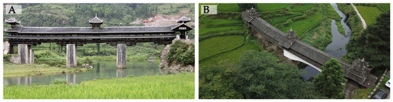
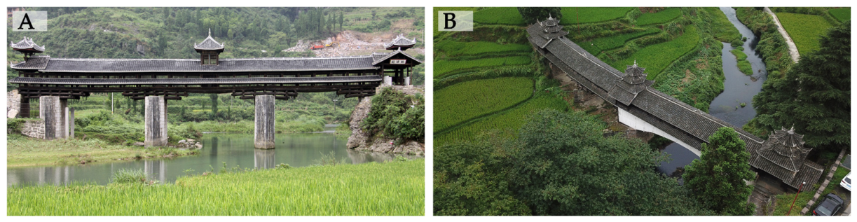
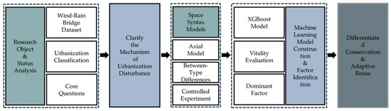
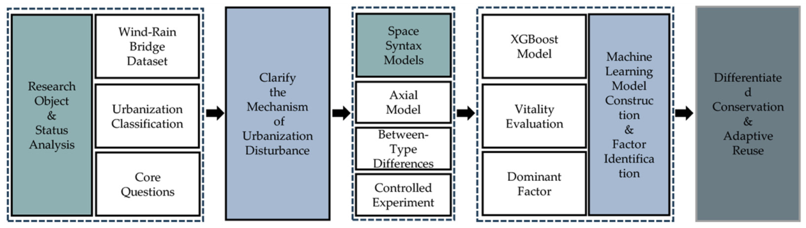
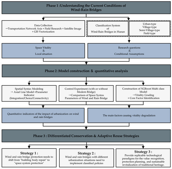
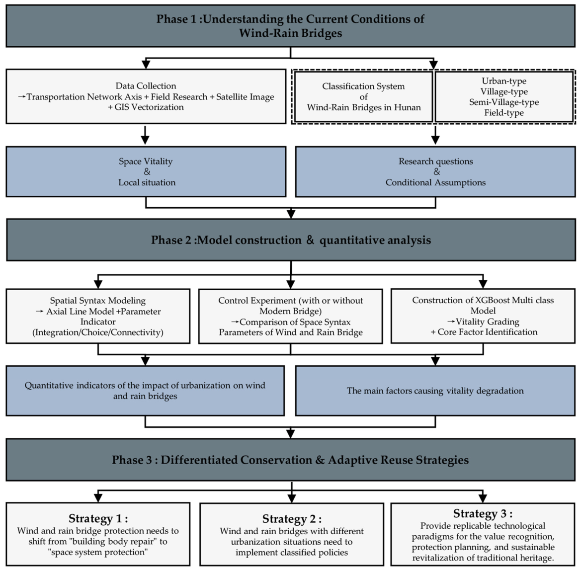
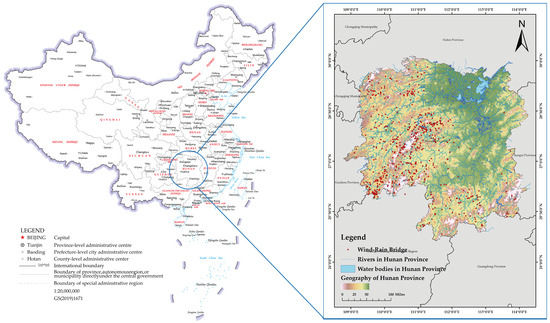
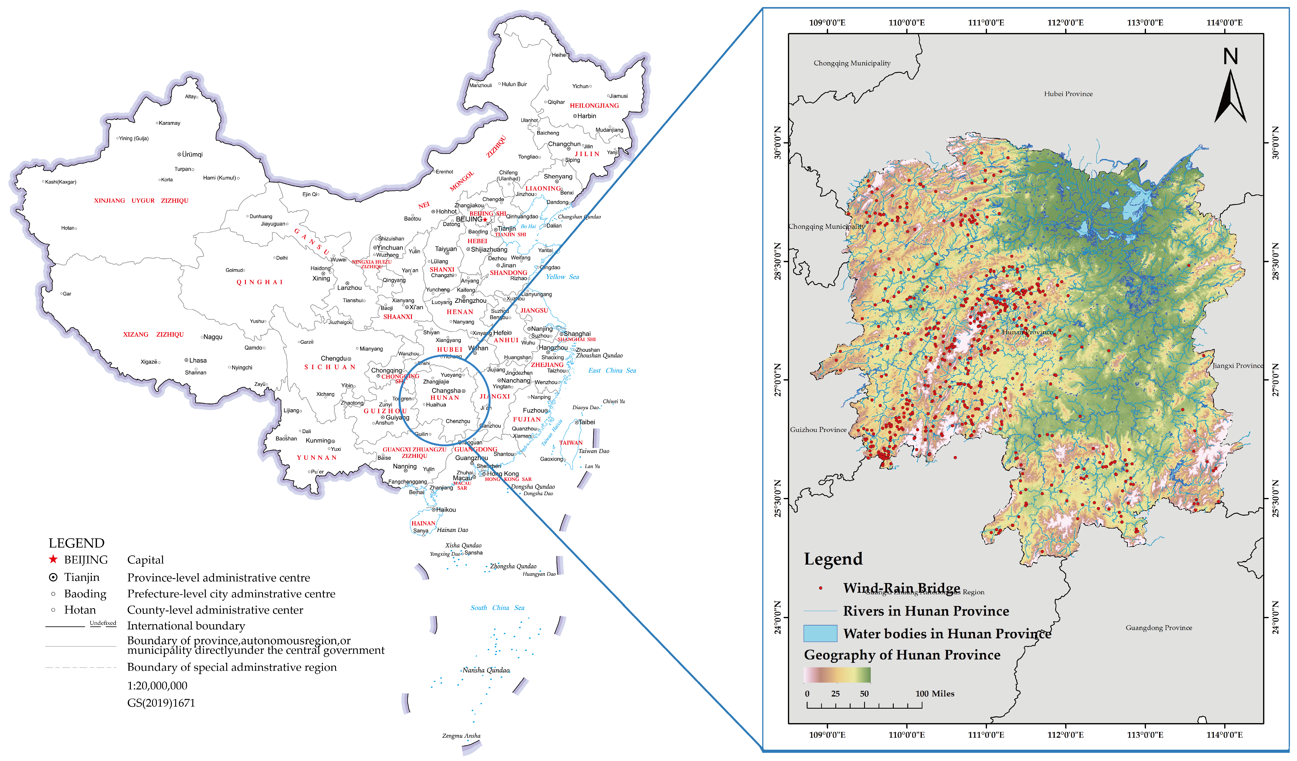
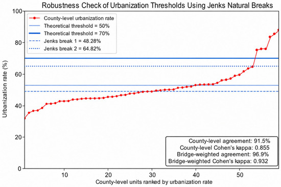
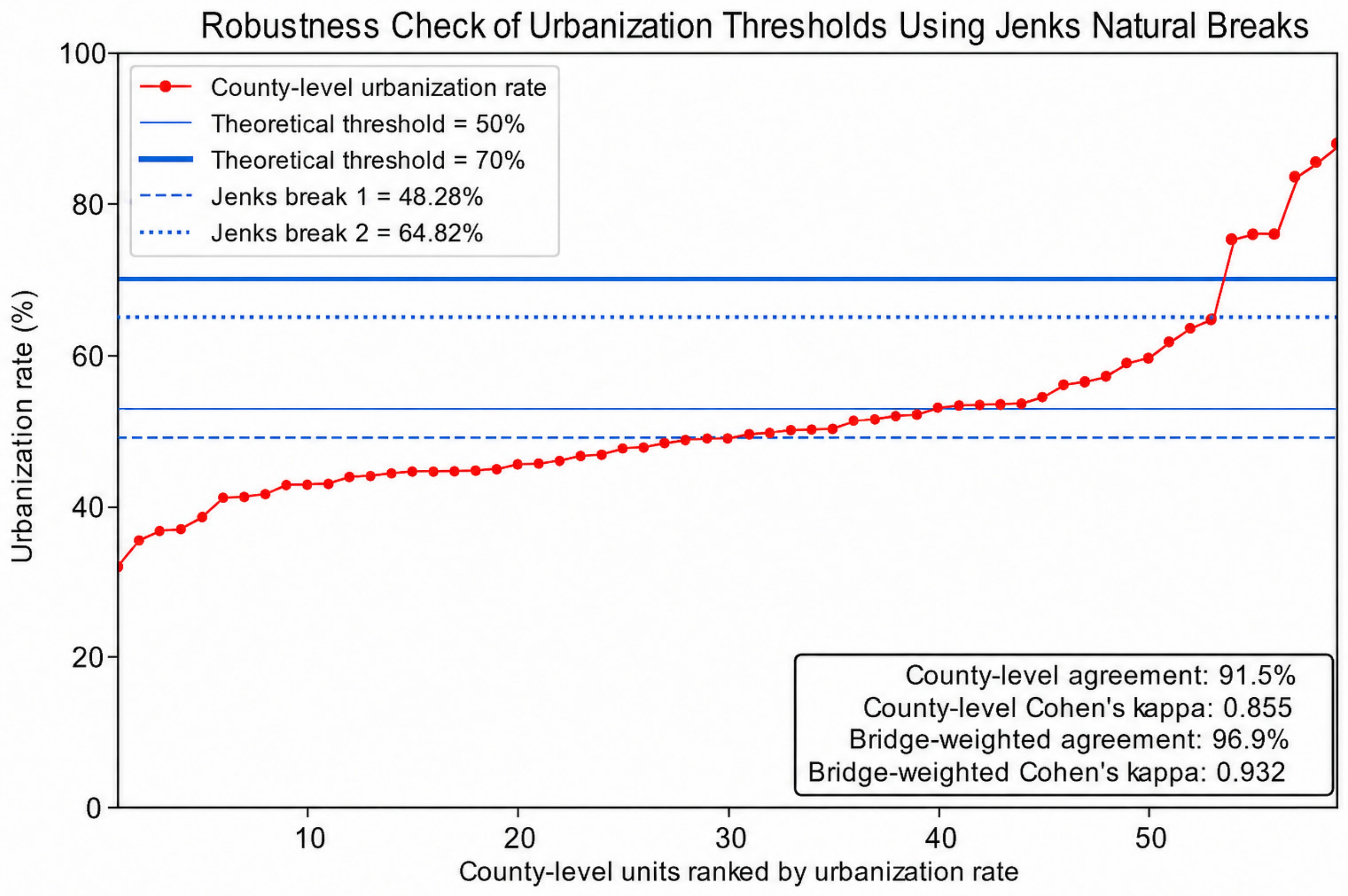
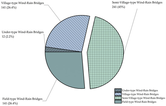
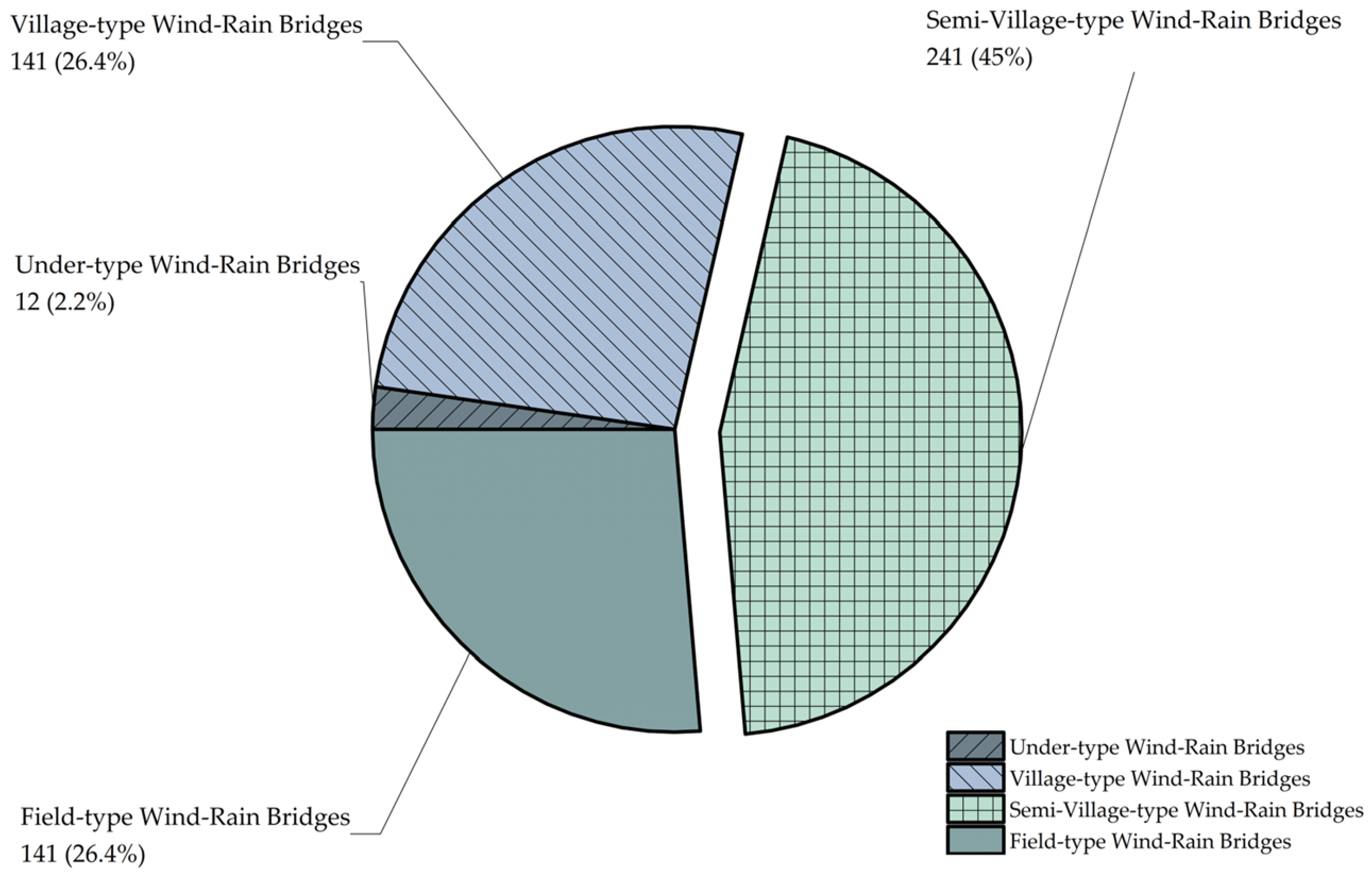
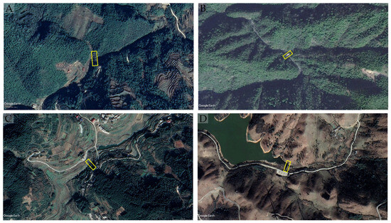
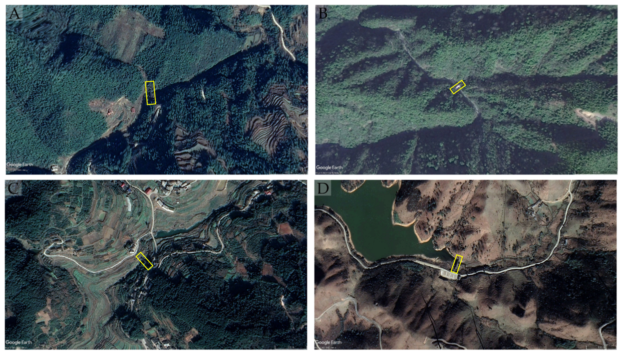
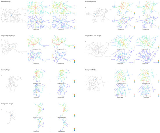
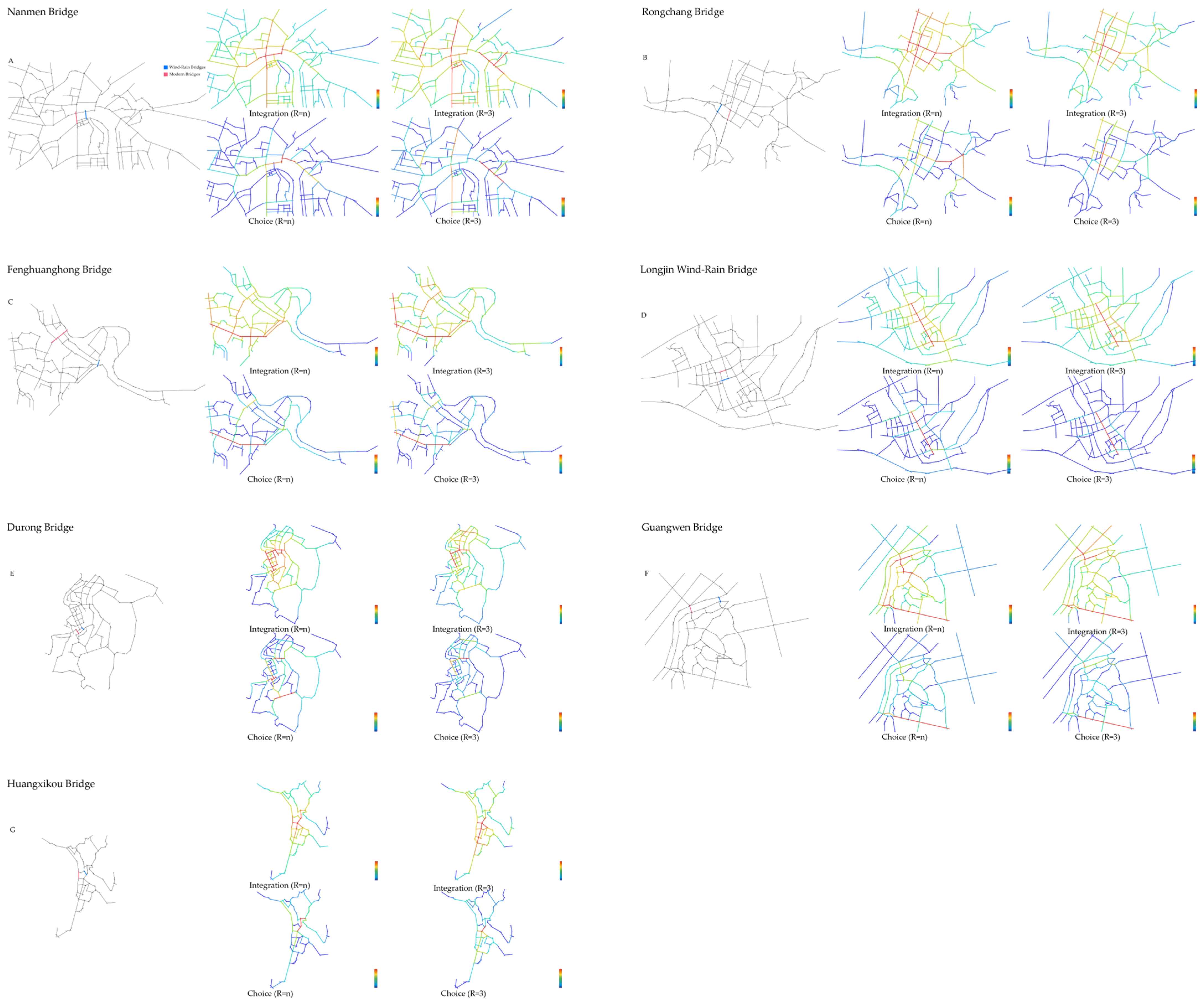
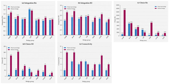
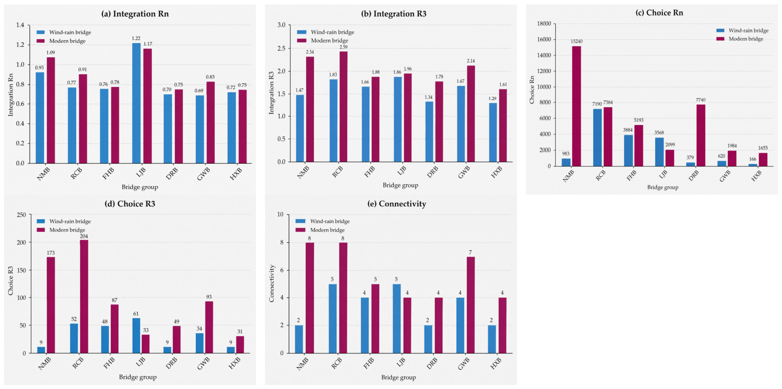
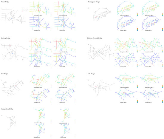
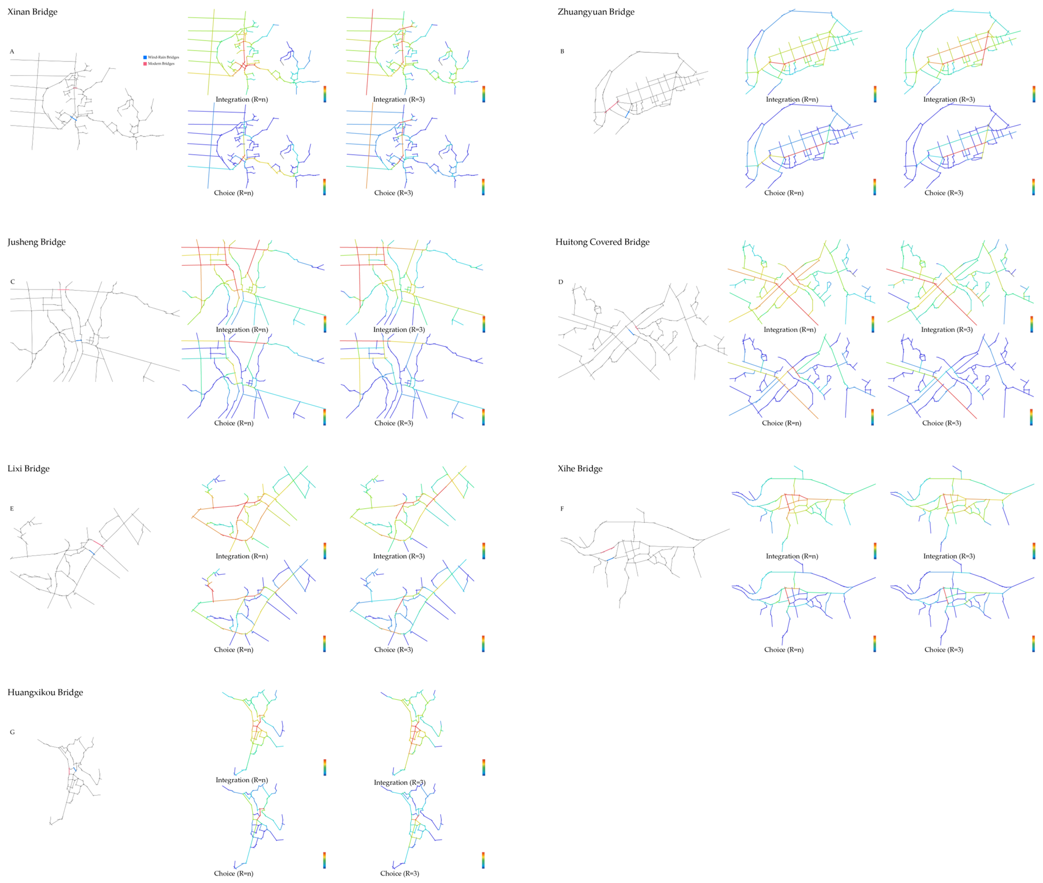
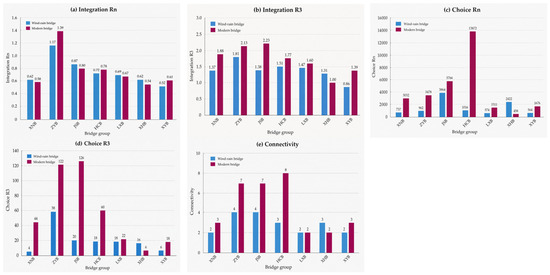
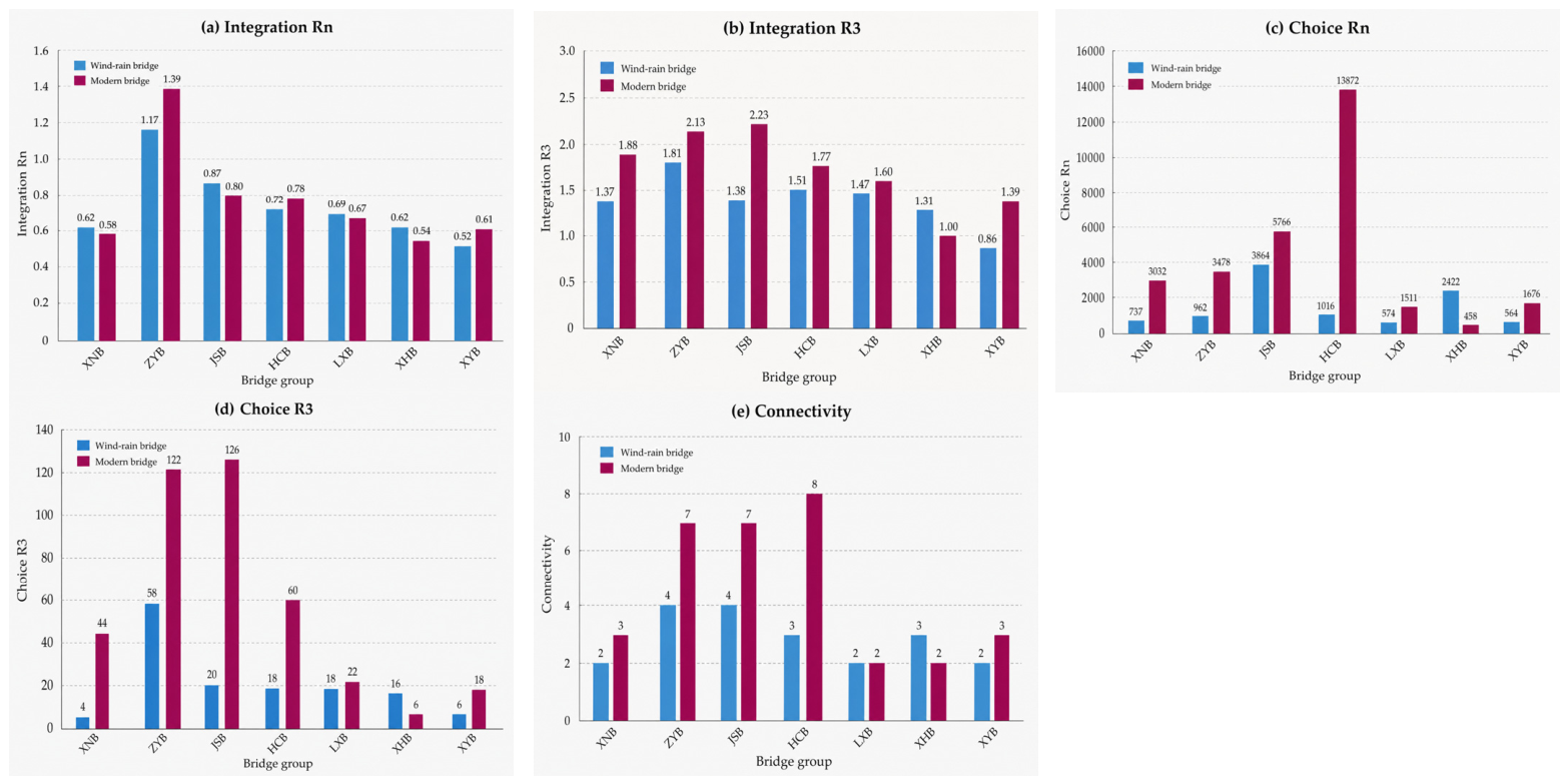
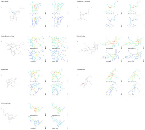
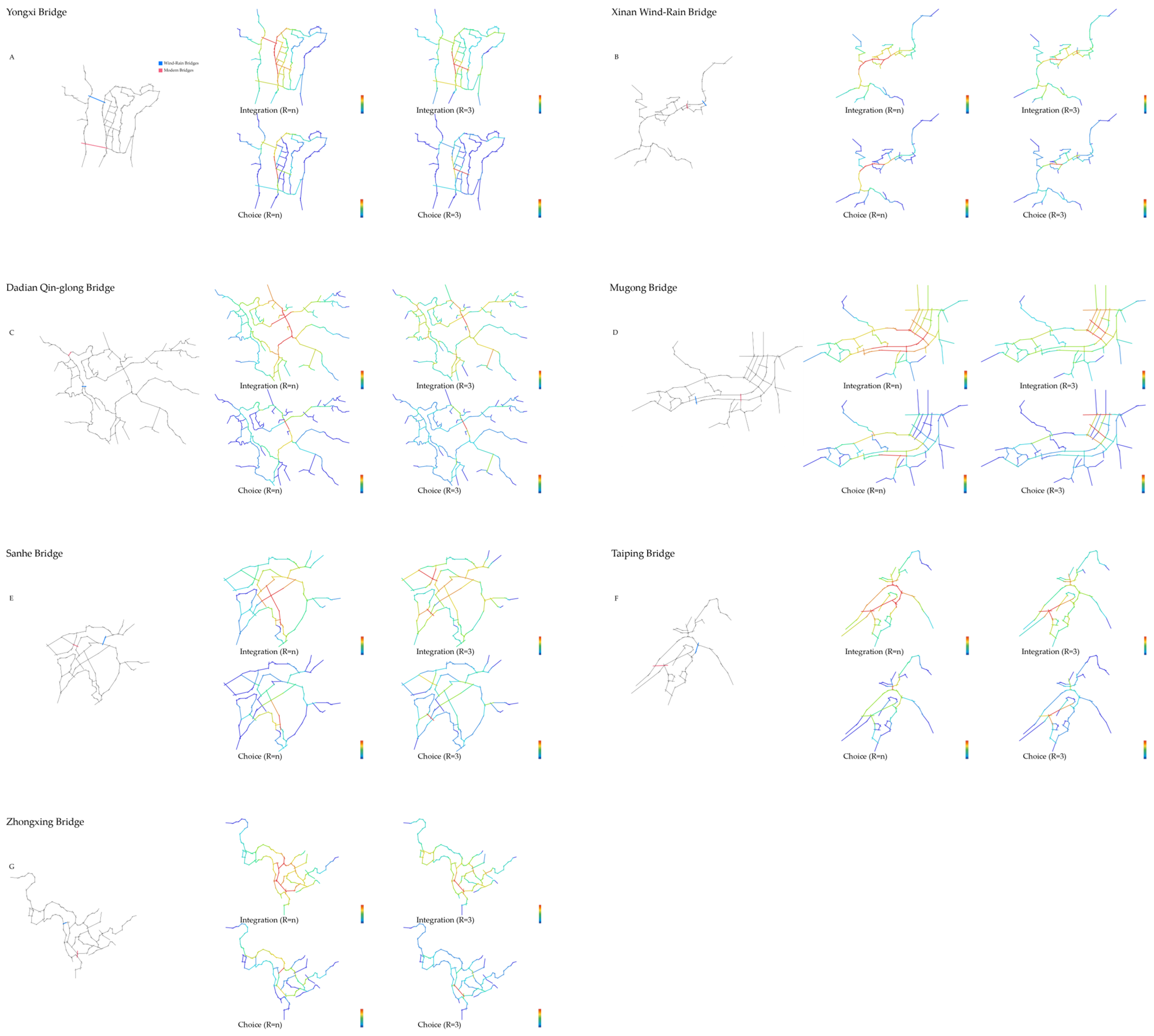
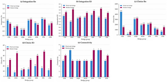
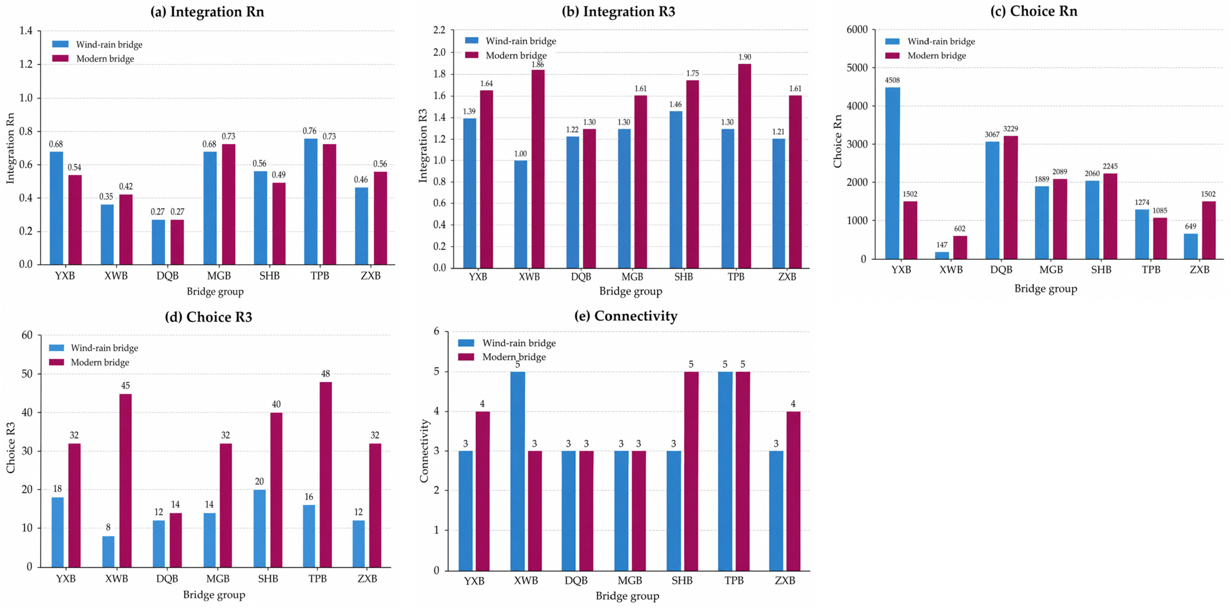
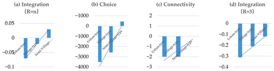
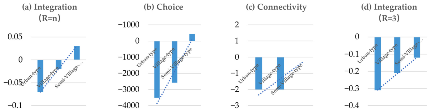
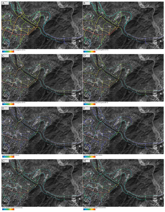
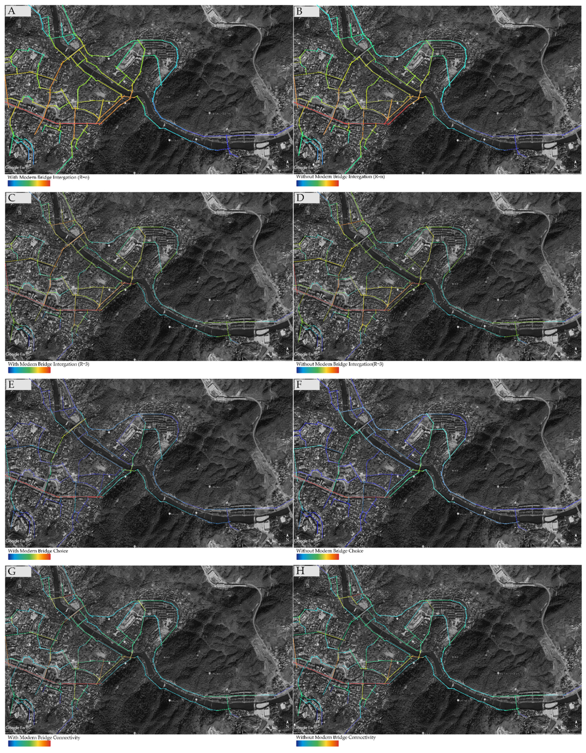
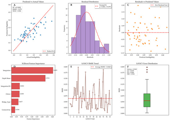
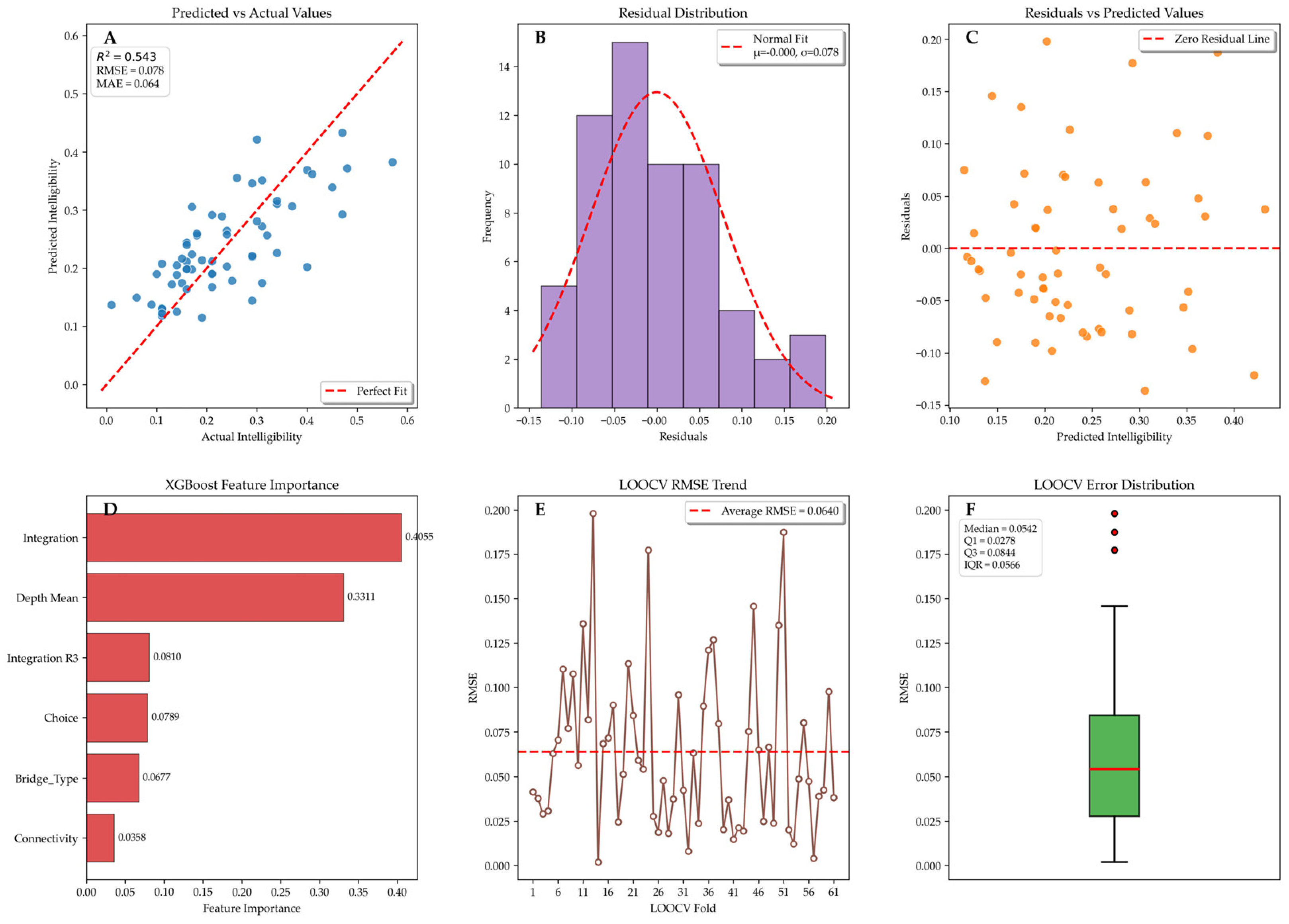
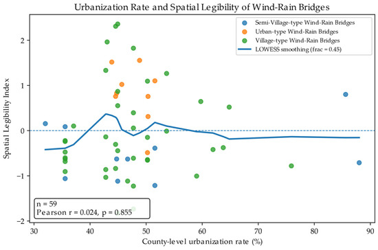
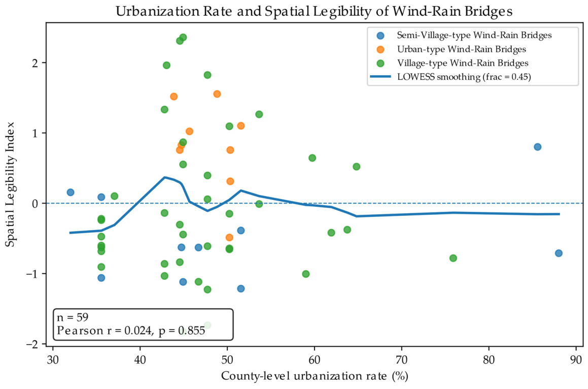

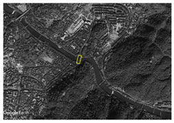
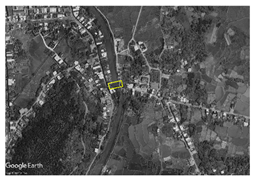
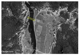
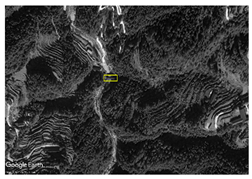
Disclaimer/Publisher’s Note: The statements, opinions and data contained in all publications are solely those of the individual author(s) and contributor(s) and not of MDPI and/or the editor(s). MDPI and/or the editor(s) disclaim responsibility for any injury to people or property resulting from any ideas, methods, instructions or products referred to in the content. |
© 2026 by the authors. Licensee MDPI, Basel, Switzerland. This article is an open access article distributed under the terms and conditions of the Creative Commons Attribution (CC BY) license.