


Abstract
This study explores the relationship and mechanism between traditional village distribution and human settlement suitability in Hunan Province. Based on village distribution data and a human settlement evaluation system, spatial analysis and the LISA model are used to analyze spatial correlation and influencing patterns. Results show that (1) Traditional village density is significantly negatively correlated with human settlement suitability. (2) L-H and H-L agglomerations dominate the region, with L-H clusters in central-northern plains and valleys and H-L clusters in western mountainous areas. (3) Human settlement factors show strong spatial heterogeneity, with natural factors varying regionally and human factors reflecting moderate adaptation. This study reveals the adaptive logic of traditional villages to natural and human environments, enriches relevant theories, and provides targeted guidance for classified protection of traditional villages and human settlement optimization.
1. Introduction
As vital living carriers of agricultural civilization, traditional villages possess distinctive architectural characteristics, profound cultural genes, and valuable ecological wisdom. Representing complex spatial systems shaped by long-term interactions between humans and nature, their conservation and sustainable development have emerged as key issues in rural revitalization and cultural heritage preservation [1]. As a major province with abundant traditional village resources, Hunan has the largest number of traditional villages in China. The province is characterized by widespread mountains and hills, well-developed water systems, and diverse ethnic cultures [2]. Influenced by the regional features of southern and western Hunan, it has formed a unique distribution pattern of villages and a distinctive human settlement system. However, in the process of rapid urbanization and modernization, traditional villages in Hunan are generally faced with problems such as population hollowing, spatial order disorder, cultural inheritance fracture, and slow functional transformation. The vulnerability of the living environment is increasingly prominent, and the coordinated development of its distribution pattern and suitability level is severely challenged.
The distribution characteristics of traditional villages and the suitability of human settlements are closely coupled and interactive. This represents a concrete manifestation of the human-land relationship within traditional village spaces [3]. Natural and human environmental factors together shape the spatial distribution of traditional villages. Previous studies have shown that the overall distribution of traditional villages in China is unbalanced at the macro level. Specifically, they are more concentrated in the south than in the north and denser in the east than in the west, with several prominent high-density clusters [4]. Natural geographical factors form the fundamental framework for the spatial distribution of traditional villages. Their influence is basic and long-lasting, mainly reflected in topography, elevation, water system distribution, and other aspects [5,6,7,8,9]. For example, in Guizhou Province, traditional villages are mainly distributed in regions with a moderately large topographic index, which is the dominant factor controlling their scale and clustering. In contrast, topographic relief significantly influences the morphological structure of these settlements [10]. In Shaanxi Province, most traditional villages are distributed along river systems, which directly determine their basic distribution pattern [11]. Such water-adjacent distribution reflects the most primitive and direct constraints and guidance of natural geographical conditions on village site selection.
As an active driving force, human, social, and economic factors have further shaped, strengthened, or changed the spatial distribution structure of traditional villages. Its influence is reflected in multiple dimensions, such as history and culture, economic development, population, ethnicity, and traffic conditions [12,13,14,15,16]. The study found that in areas with low levels of social and economic development, traditional villages can be preserved. This is mainly because the lower levels of economic development and urbanization have delayed the impact of modern construction on traditional settlements. For example, the relatively backward transportation conditions in the high-altitude areas of Yunnan Province have objectively delayed the destruction of traditional villages by urbanization and industrialization [17]. In contrast, in Guangdong Province, rapid urbanization in economically developed regions has frequently led to the disappearance or transformation of traditional villages. This suggests that social and economic development levels directly affect the spatial distribution and preservation of traditional villages [18]. Based on the in-depth analysis of the above spatial laws and influencing factors, for different regions and types of traditional villages, we must abandon the “one-size-fits-all” protection and development model and implement precise differentiation strategies [19]. For agglomeration zones influenced by natural, historical, and socioeconomic conditions, a hierarchical, classified, and targeted conservation strategy should be applied. Villages with high ecological sensitivity and cultural value should be strictly protected. For villages within urban radiation areas and strongly affected by socioeconomic factors, it is essential to protect their historical features while coordinating their development with urbanization [20].
The distribution patterns and construction modes of traditional villages continuously optimize the human settlement system (Figure 1). Amid accelerating global urbanization and increasing resource and environmental pressures, establishing a scientific, dynamic, and multi-scale evaluation system for human settlements is highly significant. It helps elucidate the characteristics of regional human–land systems, optimize land spatial structure, and promote coordinated regional development [21]. At present, research in this field has gradually developed from the early single-factor evaluation to the multi-dimensional comprehensive evaluation of nature, humanities, ecology, and society [22,23,24,25,26] and has made remarkable progress in the theoretical framework, method model, and spatial analysis technology of evaluation [27]. For example, Zhang et al. selected three typical cities-Chengdu, Wuhan, and Lanzhou-to establish a natural suitability evaluation system comprising five indicators: topography, vegetation, water bodies, climate, and natural disasters. Using a unified natural dimension framework, this study compared the characteristics of different cities. However, its index system entirely excludes socioeconomic factors, making it difficult to fully capture the comprehensive connotation of human settlements [28]. With higher requirements for industry and livability under new-type urbanization, the evaluation of human settlements has expanded significantly into social and cultural fields. For example, Li Dawei et al. used multi-source data to construct an evaluation system covering four dimensions, economic level, transportation accessibility, history and culture, and public services, in order to assess human settlement suitability in Anhui Province [29]. Li Shangzhi et al. took the central urban area of Xi’an as the research object and built an evaluation system at the block level, including natural environment, economic prosperity, living convenience, and architectural patterns [30]. These studies indicate that human settlement evaluation systems are gradually developing toward multi-dimensional integration and multi-scale combination.
Figure 1.
The interaction mechanism diagram of the human settlement environment system and the traditional village system.
International scholars have paid attention to traditional villages and human settlements at an early stage, with research perspectives gradually expanding from the description of settlement morphology to multi-dimensional fields such as landscape ecology, cultural perception, policy governance, and sustainable development. In terms of spatial analysis, Greek scholars employed GIS viewshed analysis. They found a significant correlation between traditional settlement locations and the “visual control” of intensive land use, revealing a spatial coupling between land-use intensity and visibility [31]. At the level of policy and cultural perception, Italian scholars emphasized that the conservation of traditional rural landscapes should adopt a “bottom-up” approach, integrating local knowledge into planning decisions, and promoting deep synergy between rural and landscape policies [32]. Spanish scholars conducted large-scale surveys in Asturias and Galicia, establishing a GIS-based vernacular architecture database and a graded protection system, providing an operational methodological paradigm for the identification, assessment, and revitalization of traditional settlements [33]. Focusing on a pottery village in the Mekong Delta, Vietnamese scholars proposed an integrated “Heritage-Livelihood-Ecology” (HLE) framework and designed a comprehensive planning model incorporating heritage continuity, experiential tourism, participatory development, and smart technology, with particular attention to a conflict management matrix between tourism development and traditional culture [34]. Turkish scholars reconstructed residential land cover and population distribution in the mid-19th century, demonstrating the potential of historical GIS in representing the spatiotemporal dynamics of traditional settlements [35].
Human settlement suitability evaluation has become more comprehensive and systematic, yet existing studies still have prominent limitations. First, most research targets cities and provincial administrative units, while few conduct dedicated evaluations for traditional villages as cultural heritage sites. Current indicator systems tend to decouple natural and socio-humanistic factors, and rarely fully account for cultural inheritance and settlement security. Second, traditional village clusters in hilly and mountainous provinces of central China are understudied. There is a lack of refined, localized analyses that incorporate regional characteristics such as terrain, hydrology, ethnic culture and traffic gradients.
Hunan Province lies in the hilly and mountainous zone of south-central China, where numerous traditional villages exhibit diverse types and distinct regional disparities. Compared with villages in eastern plains and western plateaus, these 704 traditional villages present unique features in terrain patterns, ethnic culture, transportation and living environments. Nevertheless, current studies have not systematically clarified the association between the spatial distribution of traditional villages and human settlement suitability across Hunan. Quantitative analysis of multi-factor synergistic driving mechanisms and spatial constraint patterns remains inadequate, which hinders the differentiated conservation of traditional villages and the optimization of human settlement conditions, particularly in southern and western Hunan.
Based on this, this paper takes 704 traditional Chinese villages in Hunan Province as the research object, constructs the suitability evaluation system of human settlements environment that integrates natural background, human society and spatial pattern, and uses spatial analysis and geographically weighted regression model to reveal the suitability pattern of human settlements environment and the distribution characteristics of traditional villages in the province, and analyzes the synergy path and driving and restraint mechanism of key elements such as topography, hydrology and transportation, so as to provide scientific basis for the protection of traditional villages in Hunan, the restoration of human settlements environment and the cultivation of characteristic industries, and help the protection of cultural heritage and the coordinated promotion of livable and beautiful rural construction.
2. Study Area and Data Sources
2.1. Overview of the Study Area
Hunan Province is located in the south of central China, south of Dongting Lake. The topography of the province presents a clear, horseshoe-shaped basin structure. It is surrounded by mountains on the east, south, and west sides. The northern terrain is low and flat, and the overall terrain tilts from the southeast to the northwest. The terrain is dominated by mountains and hills [36], which have a typical subtropical monsoon climate. At the same time, Hunan Province has a profound cultural heritage, integrating diverse regional traditions and ethnic characteristics. Its superior natural conditions and long-standing social and cultural background have laid a solid foundation for the formation and continuation of villages and have spawned a large number of traditional villages with significant cultural and historical values [37]. These traditional villages reflect the typical spatial pattern of wide distribution, large number, rich form, and cluster aggregation (Figure 2 and Figure 3).
Figure 2.
The distribution of traditional villages in Hunan Province.
Figure 3.
Traditional Villages in Hunan Province.
2.2. Data Sources and Processing
In this study, basic data mainly comprised traditional village information and human settlement environment factors, with detailed data sources listed in Table 1. For natural components, we selected a digital elevation model (DEM), normalized difference vegetation index (NDVI), and meteorological observation data. For human components, we used nighttime light imagery, traffic networks, and points of interest (POI) data. Using ArcGIS 10.8, 30 m resolution DEM, meteorological station data, and NDVI were preprocessed through spatial registration, vector-to-raster conversion, projection transformation, and clipping, yielding a 1 km resolution natural raster dataset for the study area. For human-related data, including nighttime light, road networks, air quality, and POI, kernel density estimation, network analysis, and Kriging interpolation were applied to derive corresponding human factor layers. On this basis, all raw indicators were standardized to eliminate discrepancies in dimensionality and attribute direction, after which a comprehensive evaluation index system for the human settlement environment was established.
Table 1.
Data sources.
In order to ensure the accuracy and consistency of the subsequent analysis, this study first used ArcGIS 10.8 to systematically preprocess the data of traditional villages and related human settlements. Geographical coordinates of traditional villages were acquired via the Google Earth platform, and a corresponding spatial vector database was established using GIS techniques. Data processing was conducted within the ArcGIS, including the following steps: mosaicking and masking raster datasets such as DEM and nighttime light imagery; integrating and overlaying precipitation, temperature, humidity, and air quality indices to derive annual mean values, followed by spatial interpolation using the Kriging method. The road network was classified into four levels-expressways, primary roads, secondary roads, and tertiary roads-according to their grade and function, after which grid computation and related analyses were implemented. Public service-related records were extracted from the raw POI data for subsequent analysis. To unify the spatial datum and ensure the accuracy of distance and area calculation, all data are uniformly projected to the WGS_1984_UTM_Zone_49N projection coordinate system, which ensures the accuracy and effectiveness of distance-based spatial analysis such as kernel density estimation, Kriging interpolation, and geographically weighted regression.
3. Methods
The living environment system consists of two parts: nature and humanity, and the spatial distribution pattern of traditional villages is also the result of the dual role of nature and humanity (Figure 4).
Figure 4.
The mechanism diagram of the relationship between the factors of the human settlement environment and the space of traditional villages.
3.1. Comprehensive Suitability Analysis of Human Settlements Environment
3.1.1. The Relief Degree of Land Surface Index
The relief degree of land surface (RDLS) [38] serves as an important indicator reflecting micro-topographic variations. This index not only characterizes the overall morphology and spatial differentiation of regional landforms but also enables assessment of ecological environment risks around traditional villages and the suitability of engineering construction. In general, higher topographic relief indicates less favorable terrain conditions for human settlement. The specific formula is as follows:
In Equation (1), RDLS represents the relief degree of land surface index. ALT denotes the average elevation of the study area (m). and are the maximum and minimum elevations within the region (m), respectively. A stands for the total area of the region (km2), and P(A) refers to the flat land area (km2), which is defined as zones with a slope smaller than 5°.
3.1.2. The Temperature and Humidity Index
The temperature and humidity index (THI) is an important index for quantifying the basic climate conditions in the region. The index is closely related to residents’ subjective feelings of climate comfort [39], which can comprehensively reflect the thermal and humid environmental effects formed by the combined action of temperature and humidity. In general, the higher THI value indicates that the region has more suitable heat and humidity conditions, which is more conducive to human living activities. Its calculation formula is:
In Equation (2), THI denotes the temperature and humidity index for Hunan Province; t represents the monthly mean air temperature of the region (°C), and f refers to the monthly mean relative air humidity of the region.
3.1.3. The Water Resource Index
In order to evaluate the scarcity of water resources in the study area, this study selected the ratio of water area to precipitation as a measure. Among them, the water area can reflect the region’s ability to accumulate water resources, while precipitation reflects its natural water supply level.
WRI is the water resource index; P is the normalized annual precipitation; Wa is the normalized water area; and and are the weights of precipitation and water area, respectively.
3.1.4. The Land Cover Index
Vegetation coverage is a key parameter to evaluate the quality of human settlements’ ecological environment. The normalized difference vegetation index (NDVI) can not only reveal the natural conditions such as groundwater, surface water distribution, and soil fertility but also have a significant correlation with the urban heat island effect, local climate regulation, and green space coverage [40]. In this paper, the degree of vegetation coverage in the region is characterized by NDVI data. The higher the value, the better the greening conditions, which then have a positive impact on the suitability of human settlements.
In Equation (4), LCI represents the land cover index, NDVI denotes the regional normalized difference vegetation index, and indicates the weight corresponding to each land-use type. Based on the actual land use conditions in the study area, the relevant weights were determined with reference to the Environmental Protection Industry Standard of the People’s Republic of China: Technical Specification for Ecological Environment Assessment [41], as listed in Table 2.
Table 2.
The weight of each land use type.
3.1.5. The Traffic Accessibility Index
The traffic accessibility index (TAI) is a quantitative index used to evaluate the convenience of traffic links between nodes in the region. By assigning the corresponding design speed to different grades of roads, the TAI of Hunan Province is calculated based on the network analysis method. The specific process is as follows: first, the road network is topologically processed, and the travel time of each road segment is calculated, and then the network data set is constructed at the cost of travel time [42]. Then, with the help of the OD cost matrix tool in the ArcGIS network analysis module, the accessibility values of all network nodes are calculated to characterize the traffic accessibility index. The higher the index value, the greater the traffic time cost between nodes, and the lower the accessibility.
is the time cost, and is the speed through different paths. The highway is 110 km/h, the expressway is 80 km/h, the main road is 60 km/h, and the secondary road is 45 km/h.
3.1.6. The Public Service Index
The public service index (PSI) constitutes a key dimension for evaluating livelihood well-being. It encompasses domains closely tied to daily life, including medical care, entertainment, and education, and directly reflects and determines the quality of the regional human settlement environment. Based on point-of-interest (POI) data for Hunan Province, this study extracts facilities related to medical treatment, scientific research, education, and culture, as well as catering and shopping. Kernel density analysis in ArcGIS is then employed to assess their spatial agglomeration patterns and service levels, thereby characterizing the completeness of regional infrastructure.
3.1.7. The Nighttime Light Index
The nighttime light index (NLI) is a key human indicator that comprehensively reflects the intensity of human activities, the state of urban expansion, and the level of urbanization development. Generally, a higher nighttime light index means more intensive human activities in the region [43], and the suitability of human settlements is correspondingly improved. There is a positive correlation between the two. Based on NPP/VIIRS nighttime light images, this study performed spatial correction and mask extraction operations on the ArcGIS platform and uniformly resampled the final data to a spatial resolution of 1 km.
3.1.8. The Air Quality Index
The air quality index (AQI) is a key indicator for measuring air quality and pollution levels [44]. Based on ambient air quality standards and the impact of related pollutants on health and ecology, the index integrates various conventionally monitored air pollutant concentrations into a single comprehensive evaluation value. In this study, the air quality index was used to quantify the effect of air pollution on the suitability of human settlements, and spatial interpolation analysis was performed using the Kriging interpolation method in ArcGIS.
AQI represents the air quality index, and the smaller the index value, the better the air quality. IAQIi is the air quality index of pollutant i, and n is the number of pollutant types. In this study, the ordinary Kriging interpolation method was used, and the semivariogram model was selected as the spherical model. The model can better fit the spatial structure of regionalized variables, with high fitting accuracy and small residuals. Compared with inverse distance weighted interpolation, Kriging interpolation can make full use of spatial autocorrelation and structural characteristics, and provide interpolation error estimation, which is more suitable for the spatial expression of continuous environmental variables such as meteorology and air quality.
3.1.9. The Comprehensive Human Settlement Suitability
Comprehensive human settlement suitability refers to the extent to which the environment of a given region can support human settlements and associated activities. As a holistic assessment, it quantifies the degree of matching between human settlement conditions and human needs.
In Equation (7), HSCI represents the comprehensive human settlement suitability index (dimensionless, range 0–1). , , , , , , , and denote the normalized values (by min-max normalization, range 0–1) of the relief degree of land surface index, temperature-humidity index, water resource index, land cover index, traffic accessibility index, public service index, nighttime light index, and air quality index, respectively. The parameters α, β, χ, δ, γ, λ, ρ, and φ correspond to the weight of each individual index. Hunan Province is located in central China. Referring to the research framework proposed by Feng Zhiming [45], combined with the objective weighting results obtained by the entropy weight method, the specific weights of each index are determined and listed in Table 3.
Table 3.
The weights of various factors of the human settlement suitability.
3.2. Analysis of the Spatial Distribution of Traditional Villages
In this study, the kernel density estimation method is employed to quantitatively analyze the spatial distribution pattern of traditional villages in Hunan Province, thereby revealing their agglomeration rules and distribution characteristics across different regions.
where denotes the kernel density function, represents the kernel function, n is the number of observation points, h refers to the search radius of the grid, and is the distance from the grid center point to the known observation point. In this study, kernel density estimation uses Silverman’s rule of thumb to determine the optimal bandwidth. The kernel function is the Gaussian kernel, which can effectively capture the spatial agglomeration characteristics of traditional villages and mitigate the influence of local fluctuations on the analysis results.
3.3. Bivariate Spatial Autocorrelation
Inspired by recent methodological advances in characterizing nonlinear and non-stationary behaviors in complex systems [46], this study employs bivariate spatial autocorrelation analysis to investigate the spatial coupling relationship and coordinated distribution pattern between the distribution of traditional villages and ecological environment suitability in Hunan Province. In this study, bivariate spatial autocorrelation analysis was conducted using GeoDa 1.20.0.36 software to investigate the spatial coupling relationship and coordinated distribution pattern between the distribution of traditional villages and ecological environment suitability in Hunan Province.
In Equations (9) and (10), n denotes the total number of grid cells; represents the spatial weight matrix; is the first variable, corresponding to traditional village density; is the second variable, referring to the ecological environment suitability index; and stand for the mean values of the first and second variables, respectively; and denotes the combined variance of the two variables.
3.4. Geographically Weighted Regression Models
The Geographically Weighted Regression (GWR) model room is a local linear regression method based on spatial change and relationship modeling. It explains the local spatial relationship and spatial heterogeneity of variables by generating a local regression model in space. The formula is as follows:
In Equation (11): represents the global dependent variable; denotes the observed value of the k-th variable for the i-th research unit; refers to the geographic coordinates of the research unit; is the regression intercept; stands for the regression coefficient of the k-th variable for the respective unit; and denotes the random error term. Guided by the geographically weighted regression (GWR) framework within a GIS environment, this study treats four indices of ecological environment suitability as explanatory factors. It further examines their spatial variations in driving the relationship between the spatial distribution of traditional villages and ecological environment suitability in Hunan Province. In this study, the geographically weighted regression model adopts an adaptive bandwidth determined via the AICc minimization criterion. The Gaussian kernel function is selected to guarantee favorable local fitting performance, prevent overfitting, and enhance the stability and reliability of regression outcomes.
4. Result and Analysis
4.1. Comprehensive Suitability Analysis of Human Settlement Environment
In this study, the ArcGIS geographic information platform was employed to systematically assess the comprehensive suitability of human settlements in Hunan Province, with the results illustrated in Figure 5. The comprehensive human settlement suitability index (HSCI) in Hunan Province ranges from 0.171 to 0.625, exhibiting significant spatial heterogeneity and agglomeration characteristics. Spatially, the provincial distribution presents an overall pattern of high suitability in the east and low suitability in the west. The Changsha-Zhuzhou-Xiangtan urban agglomeration constitutes the most highly suitable region, with HSCI values ranging from 0.434 to 0.625, representing the core high-value zone. Eastern and northern Hunan, including Hengyang, Yueyang, Yiyang, and other cities, also demonstrate relatively high suitability, with most HSCI averages falling between 0.384 and 0.433. Benefiting from relatively flat terrain, concentrated urban and industrial distribution, and favorable transportation and infrastructure conditions, these regions feature superior human settlement suitability. Conversely, northwestern Hunan forms the primary low-value area, encompassing the Xiangxi Tujia and Miao Autonomous Prefecture, Zhangjiajie City, and western Huaihua City, where the average HSCI is concentrated between 0.171 and 0.290. Localized low-value zones are also observed in western Shaoyang City and southern Chenzhou City. Dominated by mountainous and hilly landscapes with considerable topographic relief, these areas are constrained by natural conditions and relatively underdeveloped economies, resulting in comparatively low human settlement suitability.
Figure 5.
Comprehensive suitability analysis of human settlement environment in Hunan Province.
Factors influencing the comprehensive suitability of human settlements were analyzed as illustrated in Figure 6. From an ecological perspective, the central-northern Hunan plain, encompassing Changsha, Xiangtan, Hengyang, Yiyang, and Changde, exhibits high topographic, hydrological, and temperature-humidity indices, accompanied by a moderate ground cover index. This indicates that these areas feature gentle and open terrain, dense river networks, and a mild climate, constituting favorable natural conditions that serve as a fundamental foundation for human settlement construction. In contrast, the Wuling–Xuefeng Mountains in the west, the Nanling Mountains in the south, and the Luoxiao Mountains in the east, including Xiangxi, Zhangjiajie, eastern Chenzhou, and southern Yongzhou, are characterized by rugged topography, inadequate water resources, and harsh climatic conditions. Despite the relatively high ecological integrity in these regions, their development potential is constrained, and natural conditions impose significant limitations on the livable environment.
Figure 6.
The standardized results of each factor of the comprehensive suitability of the human settlement environment in Hunan Province. (a) The relief degree of land surface index; (b) the temperature and humidity index; (c) the water resource index; (d) the land cover index; (e) the traffic accessibility index; (f) the public service index; (g) the nighttime light index; (h) The air quality index.
From a humanistic perspective, only the Changsha-Zhuzhou-Xiangtan metropolitan area demonstrates high values for both traffic accessibility and public service indices, reflecting favorable humanistic supporting conditions. Nevertheless, intensive anthropogenic activities and severe air pollution have led to the degradation of ecological quality in this region. The hilly areas in western, southern, and central Hunan maintain better air quality yet suffer from relatively low traffic and public service indices. Sporadic high-value zones of the public service index are distributed in Zhangjiajie, Huaihua, southern Yongzhou, and Yueyang, most of which correspond to county-level central cities. Additionally, prefecture-level cities such as Changde, Yueyang, and Hengyang display high-value clusters of the nighttime light index, acting as regional secondary activity centers.
4.2. Analysis of Spatial Distribution Characteristics of Traditional Villages in Hunan Province
This study uses the kernel density estimation method to analyze the spatial distribution pattern of traditional villages in Hunan Province. The results (Figure 7) show that the spatial distribution of traditional villages in Hunan Province shows significant agglomeration and gradient differentiation characteristics.
Figure 7.
Kernel density of traditional villages in Hunan Province.
From the perspective of density distribution, the overall pattern exhibits a distinct multi-center agglomeration structure. The kernel density values range from 0.000 to 0.022, with high-value clusters concentrated mainly in western Hunan (Xiangxi), southern Hunan, and parts of central Hunan, indicating significant spatial clustering of traditional villages in these regions. Among these areas, the Wuling Mountain region in western Hunan and the Nanling Corridor in southern Hunan form continuous high-density belts, highlighting the profound influence of natural geographical conditions and historical-cultural backgrounds on the site selection and preservation of traditional villages. In terms of the spatial gradient of kernel density, the concentration of traditional villages gradually decreases outward from the core high-value zones, forming a circular “core–periphery–edge” hierarchical structure. Notably, from western Hunan toward central Hunan and from southern Hunan toward eastern Hunan, traditional villages are distributed along valleys and ancient traffic routes with obvious zonal extension characteristics, suggesting that topographic corridors and transportation routes exert a strong guiding effect on the spatial organization of traditional villages.
From the perspective of regional disparities, high-density zones are mostly distributed at the intersections of mountains, hills, and traditional transportation corridors. These areas have been relatively less affected by modern urbanization, allowing traditional villages to remain largely intact. In urbanized regions such as Changsha, Zhuzhou, Xiangtan, Yueyang, and Changde, the distribution of traditional villages is highly fragmented under the pressure of urban expansion and intensive agricultural development. With flat terrain and intense human activity, the central Hunan plains encompassing Yiyang and Loudi retain only a small number of isolated traditional villages.
The kernel density clustering characteristics of traditional villages essentially reflect the long-term coupling between traditional human settlement wisdom and the natural–humanistic environment. The formation of such spatial distribution patterns is closely associated with regional topographic conditions, cultural heritage continuities, and historical development trajectories, which provides an important empirical basis for the formulation of conservation planning and spatial optimization strategies for traditional villages.
4.3. Analysis on the Correlation Between the Distribution of Traditional Villages and the Comprehensive Suitability of Human Settlements in Hunan Province
To quantitatively identify and test the spatial correlation characteristics between the distribution density of traditional villages and the comprehensive human settlement suitability index (HSCI) in Hunan Province, this study adopted spatial econometric approaches and employed GeoDa software to construct a bivariate spatial autocorrelation model (Table 4). The results of the global bivariate Moran’s I analysis are presented as follows: the Moran’s I index was −0.195, and this result passed the significance test at the 5% level (p < 0.05). This statistically significant result indicates a prominent negative spatial correlation between the two variables. Specifically, within the administrative scope of Hunan Province, areas with a high distribution density of traditional villages typically correspond to regions with low comprehensive human settlement suitability. Conversely, regions with high HSCI values (i.e., high human settlement suitability) are characterized by relatively sparse distributions of traditional villages. In essence, there is an inverse spatial distribution pattern between the spatial agglomeration of traditional villages and human settlement suitability. Traditional villages are more likely to form and be preserved in areas where the comprehensive evaluation of living conditions-including natural environmental conditions, traffic accessibility, and public service levels-is relatively less optimal.
Table 4.
Bivariate spatial autocorrelation results.
To further explore the local spatial correlation between traditional village distribution density and human settlement suitability in Hunan Province, this study uses the local spatial autocorrelation (LISA) model to identify and visualize the coupling relationship between ecological environment suitability and the spatial distribution pattern of traditional villages.
As shown in Figure 8, the study area is primarily dominated by low-high (LH) and high-low (HL) clustering types. Among them, LH-type regions account for 35.51% of the total area and are mainly concentrated in the Changsha-Zhuzhou-Xiangtan urban agglomeration, eastern Yueyang, northern Yiyang, eastern Changde, and other plain and river-valley zones in central and northern Hunan. These areas are characterized by flat terrain, abundant water resources, convenient transportation, and high suitability for human settlements. However, as the core regions for urbanization and industrialization in the province, human activities-including urban expansion and intensive cultivated land use-have exerted strong disturbances on the spatial patterns of traditional villages. Most traditional villages have disappeared due to demolition, hollowing-out, or loss of traditional features [47], thus forming a negative coupling pattern characterized by the low-density distribution of traditional villages and high human settlement suitability.
Figure 8.
Cluster analysis of kernel density and ecological suitability of traditional villages in Hunan Province.
The HL-type regions account for 15.04% of the total area, mainly covering Xiangxi Tujia and Miao Autonomous Prefecture, southern Huaihua, and western Shaoyang. These areas are dominated by mountainous and karst landforms, with rugged terrain, poor traffic accessibility, and low human settlement suitability. Nevertheless, due to relatively weak disturbances from modern development, these regions have become the core concentration areas of traditional villages.
The high-high (H-H) clustering type is concentrated in southern Yongzhou and central and southern Chenzhou. Dominated by low mountains and hills, these regions possess a sound ecological background and relatively weak direct disturbance from modern urban expansion. They not only preserve densely distributed traditional villages but also maintain relatively favorable human settlement suitability, representing a rare positive coupling zone of “traditional village agglomeration and human settlement adaptation” in the province.
The low-low aggregation areas (L-L) are scattered in the southern part of Zhangjiajie, most of Changde, and remote mountainous areas in northern Shaoyang. The suitability of human settlements in such areas is low, and the distribution density of traditional villages is also low due to terrain restrictions and population outflow, reflecting the dual constraints of natural conditions and development restrictions. Therefore, differentiated protection strategies should be formulated for different types of gathering areas in the study area.
To verify the robustness of the weighting scheme and address potential circularity, we conducted a one-at-a-time sensitivity analysis with varying perturbation amplitudes. Specifically, the urbanization-related indicators (PSI, NLI) increased by 20%, and other natural indicators by 10%. Bivariate global spatial autocorrelation analysis was performed between the adjusted suitability index and traditional village kernel density under each scenario. As shown in Table 5, the bivariate Global Moran’s I values remained stable between −0.1275 and −0.1312, and all results were highly significant (p = 0.001). Even when the weights of PSI and NLI were substantially increased, the negative spatial correlation remained unchanged, confirming that the core finding is robust.
Table 5.
Sensitivity analysis results of weighting schemes and bivariate global Moran’s I.
4.4. The Spatial Differentiation of the Influence of Each Factor of the Comprehensive Suitability of the Human Settlement Environment on the Distribution of Traditional Villages
Based on the ordinary least squares (OLS) model and geographically weighted regression (GWR) model, this study systematically analyzed the relationship between the spatial distribution density of traditional villages in Hunan Province and the factors influencing human settlement suitability. Prior to constructing the geographically weighted regression model, the OLS model was employed to test the multicollinearity of each explanatory variable (Table 6). The results indicated that most human settlement environmental factors exerted a significant linear effect on the distribution density of traditional villages in Hunan Province, and the variance inflation factor (VIF) values among all variables were less than 2. This suggests that the model had no serious multicollinearity issues, and the regression results were statistically reliable.
Table 6.
OLS regression statistical results.
To reveal the direction and magnitude of the global average impact of various factors affecting human settlements on the distribution of traditional villages, this study provides an in-depth interpretation of the OLS regression results. The results show that the regression coefficients for THI, WRI, and PSI are significantly negative, indicating that, from the perspective of the whole province, the distribution density of traditional villages is lower in areas with higher climate comfort, superior hydrological conditions, and perfect public service facilities. The regression coefficients of LCI, NLI, TAI, and AQI are significantly positive, indicating that on the global scale of Hunan Province, better air quality, higher vegetation coverage, moderate human activity intensity, and convenient traffic conditions are generally positively correlated with the distribution of traditional villages. This reflects that traditional villages tend to be distributed in areas with a good ecological environment and certain convenience of external contact.
The above OLS results reveal the global average effect of each factor, but it is difficult to reflect the spatial heterogeneity of the impact; the GWR model allows the regression coefficient to change with the spatial location and can capture the regional differences affected by the factors. After adjustment, R2 (0.91) is much higher than OLS (0.34), and AICc is significantly reduced, indicating that GWR is more suitable for expressing the complex spatial driving mechanism of traditional village distribution (Table 7). This study further visualizes the GWR coefficients (Figure 9).
Table 7.
Comparison of OLS and GWR models.
Figure 9.
The geographically weighted regression coefficient map of each factor of human settlement environment suitability. (a) The relief degree of land surface index; (b) the temperature and humidity index; (c) he water resource index; (d) the land cover index; (e) the traffic accessibility index; (f) the public service index; (g) the nighttime light index; (h) the air quality index.
In order to verify the reliability of the GWR model and test whether there is over-fitting, this study further carried out model diagnosis. The results show that the local R2 distribution range of the model is 0.01–0.89, mainly concentrated between 0.60 and 0.80, showing significant spatial heterogeneity, which is in line with the objective law of regional differences in the intensity of influencing factors.
4.4.1. The Relationship Between the Relief Degree of Land Surface Index and Spatial Distribution of Traditional Villages
As shown by the distribution of regression coefficients for topographic factors in the figure, the influence of terrain on traditional village distribution varies in intensity across different geographical units. In southern Huaihua, southern Xiangxi Autonomous Prefecture, and the core area of Hengyang City, undulating terrain creates enclosed spaces and diverse resources that support the long-term development of villages, leading to a strong positive correlation between topographic factors and traditional village distribution density. In the counties surrounding Huaihua and southern Zhangjiajie, where the terrain consists of moderately undulating low mountains and hills, the promotional effect of topographic factors is weakened but remains significantly positive. In contrast, the Changsha-Zhuzhou-Xiangtan city group and northern Shaoyang City feature relatively flat terrain; here, traditional village distribution is dominated by human and economic factors, with topographic factors exerting only a weak positive correlation. In southern Shaoyang City and southern Yongzhou City, the plain edges are prone to flooding, while mountainous terrain hinders village concentration-resulting in a negative correlation between topographic factors and distribution density. Meanwhile, most areas of Yiyang City, Loudi City, and northern Yongzhou City lie in a gentle transition zone from hills to plains, where the influence of terrain is neutral.
4.4.2. The Relationship Between the Temperature and Humidity Index and Spatial Distribution of Traditional Villages
Regarding the spatial distribution of regression coefficients for the temperature-humidity index (THI), substantial spatial variations are observed across geographical units, implying that the influence of thermal-moisture conditions on traditional village distribution is characterized by spatial heterogeneity and local dependence. In the core area of Hengyang City, parts of Xiangxi Autonomous Prefecture, and certain zones of Changde City, temperature and humidity conditions closely match the requirements of agricultural production and human settlement. Abundant hydrothermal resources support a stable agricultural economy, resulting in a strong positive correlation between the THI and traditional village density. This indicates that favorable thermal-moisture conditions significantly promote the agglomeration of traditional villages. In regions including most counties of Huaihua City, southern Zhangjiajie, and peripheral counties of Hengyang, temperature and humidity conditions remain favorable, and hydrothermal combinations satisfy basic agricultural needs. Here, the THI also exerts a notable promoting effect on village distribution density. Conversely, negative correlations between the THI and village density appear in certain areas, reflecting the restraining effect of mismatched hydrothermal conditions on village agglomeration. For instance, in western Xiangxi Autonomous Prefecture, the complex mountainous topography likely induces local disequilibrium in temperature and humidity regimes.
4.4.3. The Relationship Between the Water Resource Index and Spatial Distribution of Traditional Villages
The spatial differentiation characteristics of the regression coefficient of the hydrological index are closely related to the suitability of the regional hydrological environment. The northern part of Xiangxi Autonomous Prefecture and the southern part of Zhangjiajie City are in the Wuling Mountain area. The river network is dense and dominated by mountain streams. The stable water source can not only meet the needs of agricultural production and daily water use but also form a natural flood control barrier because of the undulating terrain. Therefore, the hydrological index is strongly positively correlated with the distribution density of traditional villages, which can reflect the obvious promotion effect of high-quality hydrological conditions on village agglomeration.
In the central part of Xiangxi, the northern part of Huaihua and the southern part of Yongzhou, the rivers in these areas are well developed, the water supply is sufficient, and the hydrological conditions are also stable, which can support the long-term development of the villages. The promotion effect of the hydrological index is weaker than that of the red area, but there is still a significant positive correlation. Because of the multi-karst landform in the middle of Shaoyang City, the surface water is scarce, and the water source stability is also insufficient. The hydrological index is negatively correlated with the distribution density of traditional villages. The northern part of Changde City is on the edge of the Dongting Lake Plain. The water network is too dense and vulnerable to the threat of floods. The high hydrological connectivity reduces the safety of village living, so the hydrological index is also strongly negatively correlated with the distribution density of traditional villages.
4.4.4. The Relationship Between the Land Cover Index and Spatial Distribution of Traditional Villages
The spatial differentiation of the regression coefficients of the ground cover index is highly correlated with the characteristics of regional vegetation coverage and land use patterns. The results in the figure show that southern Xiangxi Autonomous Prefecture, southern Huaihua City, and local areas of Shaoyang City are located at the edge of the Wuling Mountain area, where the coverage of native vegetation is high. Natural vegetation such as forestland and grassland not only provides production and living resources (e.g., wood and fuel) but also effectively conserves soil and water, regulates the local climate, and provides stable ecological support for the long-term survival of traditional villages. Therefore, the ground cover index is strongly positively correlated with the distribution density of traditional villages. However, in central Zhangjiajie City, southern Yongzhou City, and southern Chenzhou City, the ground cover index is negatively correlated with the distribution density of traditional villages. This is because central Zhangjiajie is a high-altitude mountainous area where the development of native vegetation is difficult; meanwhile, Yongzhou and southern Chenzhou are hilly and mountainous areas with high vegetation coverage but a lack of cultivated land resources.
4.4.5. The Relationship Between the Traffic Accessibility Index and Spatial Distribution of Traditional Villages
Spatial variations in the regression coefficients of the traffic accessibility index are closely associated with the maturity of regional transportation networks and the site-selection preferences of traditional villages. Areas such as southern Xiangxi Autonomous Prefecture, central Huaihua, southern Shaoyang, and parts of Hengyang feature predominantly mountainous and hilly terrain. Traditional villages in these regions tend to be located in zones with moderate external connectivity to facilitate material exchange while relying on rugged terrain to maintain relative seclusion. This combination has effectively contributed to the preservation of their traditional architectural styles and cultural characteristics.
Moderate traffic accessibility balances the demand for external connections and settlement protection, so the traffic accessibility index is strongly positively correlated with the distribution density of traditional villages. Although the transportation network in the core area of the Changsha-Zhuzhou-Xiangtan (Chang-Zhu-Tan) urban agglomeration is relatively improved, the distribution of traditional villages is more affected by factors such as cultivated land resource distribution and urbanization, resulting in a weak direct promotional effect of traffic accessibility. In contrast, regions with mountainous or hilly terrain-such as central Zhangjiajie City, southern Yiyang City, central Loudi City, and southern Yongzhou City-face difficulties in traffic construction. Low traffic accessibility limits the external connections and development of villages; this is particularly evident in western Xiangxi Autonomous Prefecture, which is located in the core of the Wuling Mountain area, with rugged terrain and extremely inconvenient transportation. Therefore, the traffic accessibility index is negatively correlated with the distribution density of traditional villages in these regions.
4.4.6. The Relationship Between the Public Service Index and Spatial Distribution of Traditional Villages
The spatial differentiation of the regression coefficient of the public service index can indicate the coverage level of regional public service facilities, which is one of the important factors affecting the development of traditional villages. In the southern part of Huaihua City and the local area of Chenzhou City, the public service facilities are relatively perfect, and the accessibility is good, which can meet the basic living needs of traditional village residents. Therefore, the public service index is positively correlated with the distribution density of traditional villages. However, in the western part of Xiangxi, the southernmost part of Huaihua, the southern part of Shaoyang, and the southern part of Yongzhou, these areas are located in the core area of the Wuling Mountain area. The rugged terrain leads to a serious shortage of public service facilities, which greatly restricts the development and agglomeration of traditional villages. Therefore, the public service index is negatively correlated with the distribution density of traditional villages.
4.4.7. The Relationship Between the Nighttime Light Index and Spatial Distribution of Traditional Villages
The spatial differentiation of the regression coefficients of the nighttime light index is closely associated with the intensity of regional human activities and the level of urbanization. In the core areas of western Hunan, southern Yongzhou, and southern Chenzhou, the nighttime light intensity is at a moderately high level. These regions not only have a certain foundation of human activities and public service support but also do not damage the original form of traditional villages due to high-intensity urbanization. The moderate development intensity balances the needs of village protection and development; therefore, the nighttime light index is strongly positively correlated with the distribution density of traditional villages. However, in northwestern Xiangxi, southern Shaoyang, and eastern Chenzhou, the nighttime light intensity is excessively low. These remote mountainous areas have insufficient human activities and a lack of basic service support, thus leading to a strong negative correlation between the nighttime light index and the distribution density of traditional villages.
4.4.8. The Relationship Between Their Quality Index and Spatial Distribution of Traditional Villages
The core areas of Shaoyang City, the central part of Chenzhou City, and the southern part of Huaihua City are characterized by high native vegetation coverage and excellent air quality. This favorable ecological environment provides a livable foundation for the long-term survival and development of traditional villages, so the air quality index is strongly positively correlated with the distribution density of traditional villages. However, in some remote mountainous areas (such as parts of western Xiangxi Autonomous Prefecture and southern Zhangjiajie), despite the excellent air quality, the harsh natural environment, inconvenient transportation, and insufficient public service support lead to a negative correlation between the air quality index and the distribution density of traditional villages. In addition, the spatial differentiation of the air quality index is closely related to the regional ecological environment and geographical location, which also reflects the local characteristics of the spatial distribution of traditional villages.
5. Discussion
This study reveals the complex relationship between the distribution of traditional villages and the suitability of human settlements in Hunan Province, and reflects the deep coupling of natural geographical adaptation, human and social evolution, and the survival logic of traditional villages. The results show that the distribution density of traditional villages is significantly negatively correlated with the comprehensive suitability of human settlements and shows obvious spatial agglomeration and regional differentiation characteristics.
Compared with the existing research, the spatial pattern of traditional villages obtained in this study is consistent with the conclusions of Li et al. (2015) [2] and Zheng et al. (2021) [37]. Both of them point out that the traditional villages in Hunan show the distribution characteristics of mountain agglomeration and plain sparseness, which verifies the reliability of the spatial distribution results of this study. Different from previous studies focusing on the distribution characteristics of traditional villages and single influencing factors, this study constructs a comprehensive evaluation system of human settlements including natural and human dimensions, quantitatively reveals the coupling relationship between the distribution of traditional villages and the suitability of human settlements, supplements the research perspective of human–land relationship in traditional villages, and responds to the research needs of multi-dimensional comprehensive analysis proposed by Fang et al. (2023) [4] and Zhang et al. (2025) [6]. At the same time, the negative correlation law found in this study is consistent with the conclusion that traditional villages are concentrated in areas with weak urbanization interference on a national scale (Fang et al., 2023) [4], but it further clarifies the differentiation mechanism within the province: the preservation of traditional villages does not depend on the high habitat suitability in the modern sense, but depends on the balance between natural adaptation and external weak interference, which deepens the understanding of the spatial differentiation mechanism of traditional villages.
Over long-term historical evolution, traditional villages were primarily located and sustained to ensure survival, security, and cultural inheritance, rather than modern human settlement suitability. Contemporary anthropogenic disturbances such as urban sprawl and agricultural reclamation have severely disrupted village landscapes, leading to landscape degradation, village abandonment, and decreased distribution density. Accordingly, in mountainous and hilly regions of western and southwestern Hunan characterized by low human settlement suitability, complex terrain, limited transportation, and weak urbanization pressure, traditional villages retain their original forms and spatial structures. Additionally, the sheltering effect of mountainous landforms provides natural conditions for the long-term persistence of traditional villages, ultimately generating a unique spatial pattern featuring high village density in areas with low human settlement suitability.
LISA model results further reveal distinct spatial agglomeration and regional differentiation patterns between traditional villages and human settlement suitability. The low-high (L-H) clusters are concentrated in plain valleys of central and northern Hunan, which feature favorable natural conditions and constitute the core urbanization and industrialization zone of Hunan Province with intensive human activities and high settlement suitability. Nevertheless, intensive anthropogenic disturbances lead to a sparse distribution of traditional villages in these areas. In contrast, high-low (H-L) clusters are mainly distributed across western Hunan and southern Huaihua, dominated by mountainous and hilly terrain with unfavorable natural conditions and low settlement suitability. Weak human interference and prominent topographic sheltering effects facilitate the agglomeration of traditional villages here. High-high (H-H) clusters in southern Yongzhou and central-southern Chenzhou benefit from superior climatic and ecological conditions, while escaping intense urbanization pressures, thereby achieving benign coupling between traditional village persistence and human settlement suitability. Low-low (L-L) clusters exhibit poor natural endowments and low human development levels, which are insufficient to sustain large-scale traditional villages, reflecting dual constraints from natural and anthropogenic factors. These findings refine the spatial correlation rules governing traditional village distribution and living environments and offer precise spatial references for zoned and classified conservation of traditional villages.
In addition, the spatial heterogeneity of the impact of various factors on the living environment reveals the regional adaptability of the relationship between the distribution of traditional villages and the living environment and enriches the research on the formation mechanism of the spatial distribution of traditional villages. Natural factors play a leading role in regional differentiation, which is in line with the traditional concept of village location according to local conditions. In the Wuling Mountain area, the strong positive correlation between terrain and hydrological factors reflects the dual logic of adaptive site selection and terrain shielding. In the Nanling region, the positive correlation between temperature and humidity conditions and ecological factors highlights the agglomeration effect brought by environmental livability. In contrast, in the Dongting Lake Plain and the Changsha-Zhuzhou-Xiangtan urban agglomeration, the role of natural factors is covered or even reversed by strong human disturbances. It is worth noting that the hydrological conditions in the plain area may change from resource advantage to flood risk. The moderate adaptation mode of humanistic factors reflects the balance logic between the survival of traditional villages and the development of social economy and culture: convenient transportation and perfect public services are the necessary prerequisites for the sustainable development of villages, but too high traffic accessibility will aggravate external interference, and insufficient public services cannot support the long-term development of villages. Only with appropriate adaptation, humanistic factors can play a positive and sustained supporting role in the protection and development of traditional villages. In this study, the quantitative thresholds of moderate adaptation were as follows: TAI regression coefficient 0.001~0.003, PSI 0.01~0.03, NLI 0.001~0.002; the spatial boundaries are concentrated in the south-central part of Xiangxi, the central part of Huaihua, the south of Shaoyang, the south of Yongzhou, and the south-central part of Chenzhou.
Based on the above conclusions, this paper relies on the four types of agglomeration partitions of LISA, combines the regional dominant impact factors identified by GWR, adheres to the principle of partition correspondence and local policy, and constructs a differentiated protection and living environment optimization path that is highly matched with the empirical results. The H-L agglomeration area covers the mountainous areas of western Hunan, southern Huaihua, and western Shaoyang. The village agglomeration degree is high, but the human settlement foundation is weak. The terrain, hydrology, and vegetation ecology are positively driven, and the supply of transportation and public services lags behind. The region should delimit the core protection and buffer control boundary of traditional villages, strictly control mountain development and large-scale demolition and construction, and maintain the original texture of landscape settlements; the distributed layout is used to make up for the shortcomings of basic services, moderately improve the rural slow traffic, maintain the relative closure of the settlement space, and rely on low-interference farming and folk cultural tourism to achieve coordinated development of living protection and local housing.
The L-H agglomeration area is mainly composed of Chang-Zhu-Tan, eastern Yueyang, Yiyang-Changde eastern plain river valley. The suitability of human settlements and the level of urbanization are high, and urban expansion has become the main cause of the demise of traditional villages. The red line of urban development avoidance should be delineated, and the rescue protection of traditional villages on the edge of the metropolitan area should be implemented. Strictly control the style, volume, and height of new buildings, optimize the road network structure to avoid splitting the village pattern; relying on the superior public service and traffic conditions, the suburban cultural and leisure functions are implemented. Through the micro-renewal of human settlements, sewage, greening, and sanitation facilities are improved, and the ancient river network is connected in series to create a corridor of traditional waterfront villages, so as to realize the symbiosis of urbanization development and context inheritance.
The H-H agglomeration area is located in the south of Yongzhou and the low mountains and hills in the south-central part of Chenzhou. The agglomeration of traditional villages is benignly coupled with the suitability of human settlements. The ecological endowment of climate, vegetation, and air quality is superior, and the urbanization interference is moderately controllable. We should adhere to the idea of giving priority to protection and moderately activating, and maintain the pastoral ecology and the original pattern of settlements; promote the quality improvement of the village’s living environment, moderately improve the secondary road network and public service support, and maintain the dynamic balance between humanistic development and traditional features; integrate village cluster resources to develop ecological health care, rural homestay and non-heritage industries, and build a demonstration area for the coordinated development of traditional village protection, livable human settlements construction and rural industries.
The L-L agglomeration area is distributed in the south of Zhangjiajie, most of Changde, and the remote mountainous areas in the north of Shaoyang. The suitability of human settlements and the density of villages are low. Due to the complex terrain, limited arable land, traffic occlusion, and insufficient public services, the population outflow and hollowing out are prominent. It is advisable to combine point-like precise protection with classification and renovation of hollow villages, implement fixed-point conservation for villages with a complete pattern and outstanding cultural value, and orderly withdraw and resettle scattered villages with poor location conditions and serious hollowing out. Priority should be given to improving drinking water safety, rural roads, basic medical education and other living just-needed facilities, and carrying out slope farmland remediation and geological disaster risk management; we should strictly abide by the ecological red line, improve the local livability level through vegetation restoration and small watershed management, guide the moderate agglomeration of population relying on township service nodes, and coordinate ecological restoration, human settlement improvement and local culture continuation.
This study systematically reveals the correlation characteristics and driving mechanism between the spatial distribution pattern of traditional villages and the suitability of human settlements in Hunan Province, which can provide a reference for the protection of regional traditional villages and the optimization of rural human settlements. However, there are still the following deficiencies:
(1) Incomplete coverage of the socioeconomic dimension. Restricted by research scale, data availability, and index spatialization, this study only incorporates fundamental socioeconomic indicators, including population density, traffic accessibility, and public service facilities. Several latent spatial influencing factors, such as historical culture, ethnic composition, policy-driven conservation, and topographic barriers, are excluded from the GWR model, leaving certain spatial structures unexplained in model outputs.
(2) This study also exhibits limitations in analytical depth and mechanism interpretation. When examining the linkage between the spatial distribution of traditional villages in Hunan and human settlement suitability, traditional villages are merely treated as simple geospatial units, with their intrinsic humanistic attributes overlooked. Individual traditional villages differ distinctly in historical inheritance, heritage resources, and architectural features; such humanistic characteristics are critical drivers shaping village spatial patterns and settlement quality. Omission of these humanistic dimensions prevents this study from fully revealing differentiated adaptive mechanisms of traditional villages to living environments, resulting in insufficient depth and comprehensiveness of the analysis.
(3) This study lacks micro-scale and long-term time-series analyses. Taking 704 provincial-level traditional villages in Hunan as macro-scale research subjects, this work focuses only on spatial patterns and static settlement suitability assessment. It fails to address micro-level socioeconomic disparities at the village and household scales, as well as long-term dynamic monitoring and prediction. Consequently, the long-term effects of socioeconomic processes (e.g., urbanization and tourism development) on the distribution and livability of traditional villages cannot be fully identified.
6. Conclusions
This paper takes 704 Chinese traditional villages in Hunan Province as samples, integrates multi-source geographic remote sensing, meteorology, transportation, POI and environmental monitoring data, constructs a natural-human multi-dimensional human settlements suitability evaluation system, and comprehensively uses kernel density estimation, bivariate LISA spatial autocorrelation and geographically weighted regression (GWR) model to systematically reveal the spatial distribution of traditional villages in Hunan and the differentiation characteristics of human settlements suitability, clarify the coupling relationship between the two and the spatial heterogeneity driving mechanism of human settlements factors.
Future research can use multi-scale geographically weighted regression (MGWR) to allow different factors to have different bandwidths and try to semi-quantitatively incorporate indicators such as traditional village protection level and cultural heritage density into the model to further reduce residual autocorrelation and improve model accuracy. At the same time, in the future, we can also improve the data and evaluation system, strengthen interdisciplinary and practical application, deepen the research on the correlation mechanism between the two, provide more accurate theoretical support and practical guidance for the living protection of traditional villages and the high-quality development of human settlements in Hunan, and help the in-depth implementation of the rural revitalization strategy.
Author Contributions
Conceptualization, C.H., W.C. and J.X.; methodology, W.C. and C.T.; software, C.H., W.C. and H.X.; validation, C.H., W.C. and J.X.; formal analysis, C.T.; investigation, H.X.; resources, C.H. and W.C.; data curation, C.H. and W.C.; writing—original draft preparation, C.H. and W.C.; writing—review and editing, J.X. and H.X.; visualization, W.C. and C.T.; supervision, C.H.; project administration, C.H.; funding acquisition, C.H. All authors have read and agreed to the published version of the manuscript.
Funding
This research was funded by the Postgraduate Scientific Research Innovation Project of Hunan Province (CX20251396), the Social Science Foundation Project of Hunan Province (23YBA103), the Social Science Foundation Project of Hunan Province (22YBA089), the Subjects of Hunan Provincial Social Science Achievement Review Committee (XSP24YBC158), the Subjects of Hunan Provincial Social Science Achievement Review Committee (XSP24YBZ222) and the Research Project on Degree and Graduate Education Reform at Changsha University of Science and Technology (1205015).
Data Availability Statement
All data sources are described in Section 2.2 of the manuscript.
Acknowledgments
The authors also wish to thank the anonymous reviewers for their thorough review of the article and their constructive comments.
Conflicts of Interest
The authors declare no conflicts of interest.
References
- The Central People’s Government of the People’s Republic of China. The Central Committee of the Communist Party of China and the State Council Have Issued the «Comprehensive Rural Revitalization Plan (2024–2027)». Available online: https://www.gov.cn/zhengce/202501/content_7000499.htmm (accessed on 11 March 2026).
- Li, B.H.; Yin, S.; Liu, P.L.; Dou, Y.D. Spatial Distribution of Traditional Villages and the Influencing Factorsin Hunan Province. Econ. Geogr. 2015, 35, 189–194. [Google Scholar]
- Wang, F.; An, L.Z.; Dang, A.R.; Han, J.Y.; Miao, C.H.; Wang, J.; Zhang, G.H.; Zhao, Y. Human-land coupling and sustainable human settlementsin the Yellow River Basin. Geogr. Res. 2020, 39, 1707–1724. [Google Scholar]
- Fang, Y.L.; Lu, H.Y.; Huang, Z.F.; Zhu, Z.G. Spatiotemporal Distribution of Chinese Traditional Villages and Its Influencing Factors. Econ. Geogr. 2023, 43, 187–196. [Google Scholar]
- Dong, D.; Wen, X.; Li, Q.; Chen, M.X.; Xiao, T.Q.; Gu, K.K. Geographical detection of spatial variation characteristics and influencing factors in traditional villages of Anhui Province based on spatial scale effects. J. Anhui Agric. Univ. 2025, 52, 915–928. [Google Scholar]
- Zhang, D.Y.; Liu, Y.; Fan, L.; Zhang, W.J. Study on the Influencing Factors and Characteristics of the Spatial Distribution of Traditional Chinese Villages. Chin. Landsc. Archit. 2025, 41, 61–68. [Google Scholar]
- Xi, H.; Li, Y.Y.; Hou, W.J.; Wang, B. Study on the Spatial Distribution Characteristics andInfl uencing Factors of Traditional Villages in the SouthwestHunan-Guizhou-Yunnan Cultural Corridor. Mod. Urban Res. 2025, 40, 49–57. [Google Scholar]
- Li, X.P.; Wang, X.N.; Wang, Z.Y.; Li, G.Q. A Study on the Spatial Differentiation Characteristics and Influencing Factors of Traditional Villages in Shanxi Province. J. Xi’an Univ. Technol. 2025; in press.
- Zhang, X.R.; Liu, S.Z. Spatio-temporal Differentiation and Influencing Factors of Traditional Villages in Jiangxi from a Multidimensional Perspective. Sci. Technol. Eng. 2024, 24, 12296–12307. [Google Scholar]
- Yang, X.Y.; Zhao, C.W. Spatial Distribution of Residential Areas in Traditional Villages of Guizhou Province and Its Influencing Factors. Res. Soil Water Conserv. 2020, 27, 389–395+404. [Google Scholar]
- Li, G.; Tian, H.N.; Guo, R.; Yan, J. Analysis of the spatial distribution characteristics and causes of traditional villages—Take the provincial level villages in Shaanxi Province as examples. J. Northwest Norm. Univ. (Nat. Sci.) 2024, 60, 1–96+114. [Google Scholar]
- Zhang, P.G.; Qu, P.H.; Yang, N.N.; Luo, X.L. Spatial Distribution Features and Controlling Factors of Traditional Villages in Jiangsu Province. Mod. Urban Res. 2024, 39, 70–77. [Google Scholar]
- Zhang, L.L.; Sun, J.W.; Deng, L.L.; Luo, J.; Tian, Y. Characteristics of multi-scale spatiotemporal pattern and influencing factors of Chinese traditional villages. Res. Soil Water Conserv. 2025, 32, 321–330. [Google Scholar]
- Zhou, S.Q.; Peng, S.T.; Zhao, C.W.; Du, A. Analysis of spatial distribution characteristics and influencing factors of traditional villages in Southwest China. J. Guizhou Norm. Univ. (Nat. Sci.) 2025, 43, 97–106+116. [Google Scholar]
- Wang, X.; Xu, X.D.; Yu, Y.F.; Liu, K.; Zhang, R. Spatial distribution characteristics and influencing factors of traditional villages in Guizhou from the perspective of watershed. J. Hum. Settl. West China 2025, 40, 213–220. [Google Scholar]
- Huang, S.C.; Lin, X.Q. Spatiotemporal Distribution of Traditional Settlements and Its Influencing Factors along the Xiang-Gui Ancient Road in Guangxi. Mod. Urban Res. 2025, 40, 98–104. [Google Scholar]
- Xu, S.H.; Dong, L.P. Spatial Distribution and Tourism Activation of Traditional Villages in Yunnan Province. J. Res. Ecol. 2022, 13, 851–859. [Google Scholar]
- Chen, B.; Xu, S.Z.; Zhou, Y.Y.; Wang, H.Z.; Yang, D.T.; Ye, Y.Q. Analysis of Multi-scale Characteristics and Influencing Factors Under the Spatial Distribution of Traditional Villages—Taking 263 Traditional Villages in Guangdong Province as Examples. Res. Soil Water Conserv. 2023, 30, 423–429. [Google Scholar]
- Li, E.K.; Liu, Y. Discussion on the Current Distribution Status and Measurement Methods of Influence Factors of Traditional Villages in Yunnan Province. Geospat. Inf. 2025, 23, 76–80+110. [Google Scholar]
- Tian, H. Spatial Distributive Characteristics and Its Influencing Factors of Traditional Villages in Beijing-Tianjin-Hebei Region. Econ. Geogr. 2020, 40, 143–149. [Google Scholar]
- Xia, X.Y.; Chen, H.M.; Gao, Q.; Shao, H.Y.; Cao, Z.H.; Zhao, Y.W. A Study on Temporal and Spatial Variations of Suitability of Urban Living Environment in Jiangsu Province Based on a Geographical Detector. Bull. Soil Water Conserv. 2020, 40, 289–296. [Google Scholar]
- Gong, H.; Wang, Z.Y. The spatiotemporal heterogeneity of vulnerability assessment and influencing factors of urban human settlements in the Yellow River Basin. J. Shaanxi Norm. Univ. (Nat. Sci. Ed.), 2026; in press.
- He, K.H.; Yuan, X.; Song, Y.H. Spatial characteristics and influencing factors of human settlement suitability in traditional villages of Baoshan City, Yunnan Province. Bull. Soil Water Conserv. 2025, 45, 357–368. [Google Scholar]
- Zhong, Y.; Zha, H.Y.; Wu, Z.P. Research on the Quality Evaluation and Spatial Differentiation of Human Settlement Environment in the Changsha- Zhuzhou-Xiangtan Urban Agglomeration. Res. Soil Water Conserv. 2024, 31, 365–375. [Google Scholar]
- Li, Y.; Mao, Z.Y.; Ke, W.L. A comprehensive quality assessment of the human settlement environment in Fuzhou. J. Cent. China Norm. Univ. (Nat. Sci.) 2024, 58, 433–442. [Google Scholar]
- Zhao, Y.Y.; Alimujiang, K.; Gao, P.W.; Liang, H.W. Evaluation of natural suitability of human settlements in urban agglomeration on the northern slope of Tianshan Mountain based on GIS. Ecol. Sci. 2023, 42, 84–93. [Google Scholar]
- Zhen, J.H.; Tian, T.Y. Assessment of Human Settlement Environmental Suitability for Inner Mongolia Pastoral Areas—Taking Xilingol as an Example. Res. Soil Water Conserv. 2024, 31, 384–394. [Google Scholar]
- Zhang, M.H.; Li, L.; Ma, J.F. Evaluation on Natural Suitability of Human Settlements in Urban Scale. Geogr. Geo-Inf. Sci. 2022, 38, 91–96+128. [Google Scholar]
- Li, D.W.; Huang, W.W.; Shen, F.; Cheng, Y.; Chen, M.Y. Evaluation of Human Suitability of Human Settlement Environment in Anhui Province based on Grid. J. Geo-Inf. Sci. 2021, 23, 1017–1027. [Google Scholar]
- Li, S.Z.; Zhang, M. Application of a nonlinear TOPSIS algorithm to human settlement suitability evaluation in central Xi’an, Northwest China. Chin. J. Appl. Ecol. 2025, 36, 3161–3174. [Google Scholar]
- Sevenant, M.; Antrop, M. Settlement models, land use and visibility in rural landscapes: Two case studies in Greece. Landsc. Urban Plan. 2007, 80, 362–374. [Google Scholar] [CrossRef] [Scilit]
- Seardo, B.M. Preserving and Restoring Italian Traditional Rural Landscapes. Addresses from Social Perception to Spatial Planning, Policies and Research. Agrourbanism 2018, 124, 187–203. [Google Scholar]
- Plácido, L.; Evaristo, Z.G. Lessons from two (contemporary) wide surveys on vernacular architecture and traditional settlements in Galicia and Asturias (Spain). In Surveys on Vernacular Architecture. Their Significance in the 20th Century Architectural Culture; Centro de Estudos Arnaldo Araújo (CEAA)/ESAP: Porto, Portugal, 2012; pp. 304–320. [Google Scholar]
- Ustaoglu, E.; Kabadayı, M.E. Reconstruction of Residential Land Cover and Spatial Analysis of Population in Bursa Region (Turkey) in the Mid-Nineteenth Century. Land 2021, 10, 1077. [Google Scholar] [CrossRef] [Scilit]
- Do, T.D. Preserving Cultural Landscapes: An Integrated Framework for the Conservation and Sustainable Development of Mang Thit Pottery Village, Vietnam. J. Umm Al-Qura Univ. Eng. Archit. 2025. [Google Scholar] [CrossRef] [Scilit]
- Qi, J.Q.; Zhang, S.Q.; Deng, Y.Y. Study on the spatial characteristics of the place name cultural landscape of Hunan traditional villages. Sci. Surv. Mapp. 2023, 48, 220–230. [Google Scholar]
- Zheng, W.W.; Li, B.H.; Liu, P.L.; Zeng, R.Q.; Deng, Y.Y.; Zeng, C. Gene Identification and Zoning of Traditional Village Landscape Groups in Hunan Province. Econ. Geogr. 2021, 41, 204–212. [Google Scholar]
- Feng, Z.M.; Tang, Y.; Yang, Y.Z.; Zhang, D. The Relief Degree of Land Surface in China and Its Correlation with Population Distribution. Acta Geogr. Sin. 2007, 62, 1073–1082. [Google Scholar]
- Li, B.H.; Zheng, S.N. Evaluation and spatial differentiation of human settlement suitability in Fen river basin. J. Arid Land Resour. Environ. 2018, 32, 87–92. [Google Scholar]
- Yang, X.; Zhang, W.Z. Combining natural and human elements to evaluate regional human settlements quality based on raster data:A case study in Beijing-Tianjin-Hebei region. Acta Geogr. Sin. 2016, 71, 2141–2154. [Google Scholar]
- Ministry of Ecology and Environment of the People’s Republic of China. The People’s Republic of China Environmental Protection Industry Standard: Technical Specification for the Evaluation of Ecological Environmental Conditions. Available online: https://www.mee.gov.cn/ywgz/fgbz/bz/bzwb/stzl/201503/t20150324_298011.shtml (accessed on 14 December 2025).
- Wang, Z.B.; Xu, J.G.; Zhu, C.G.; Qi, Y.; Xu, L. The County Accessibility Divisions in China and Its Correlation with Population Distribution. Acta Geogr. Sin. 2010, 65, 416–426. [Google Scholar]
- Shi, K.F.; Huang, C.; Yu, B.L.; Yin, B.; Huang, Y.X.; Wu, J.P. Evaluation of NPP-VIIRS night-time light composite data for extracting built-up urban areas. Remote Sens. Lett. 2014, 5, 358–366. [Google Scholar] [CrossRef] [Scilit]
- Yin, J.X.; Wang, Y.H. Evaluation and spatial distribution pattern analysis of livable environment suitability in Cangzhou. J. Spatio-Temporal Inf. 2024, 31, 397–407. [Google Scholar]
- Feng, Z.M.; Tang, Y.; Yang, Y.Z.; Zhang, D. Establishment and Application of Human Settlements Environment Index Model (HEI) Based on GIS. Acta Geogr. Sin. 2008, 63, 1327–1336. [Google Scholar]
- Wang, Y.; Shi, Y.; Yang, T.; Wang, W.; Sun, Z.; Zhang, Y. Structural Performance Warning Based on Computer Intelligent Monitoring and Fractional-Order Multi-Rate Kalman Fusion Method. Fractal Fract. 2026, 10, 186. [Google Scholar] [CrossRef] [Scilit]
- China’s Ancient Villages Are on the Brink of Disappearing: Nearly 920,000 Have Vanished over the Past 15 Years, at a Rate of 1.6 per Day. Available online: https://www.thepaper.cn/newsDetail_forward_1900637 (accessed on 26 May 2026).
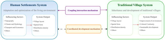
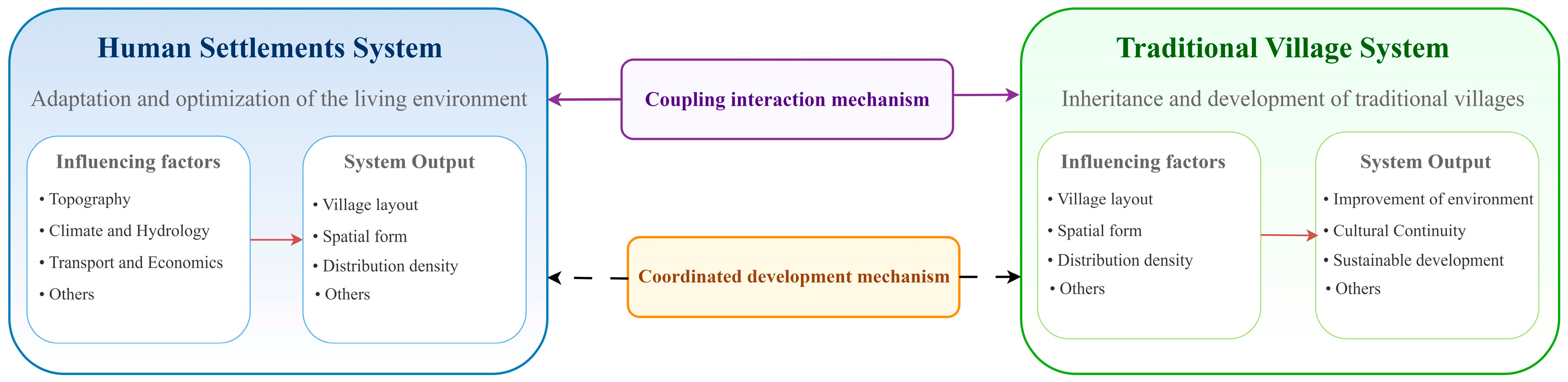
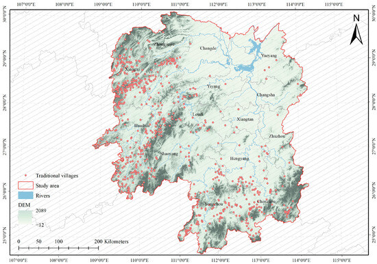
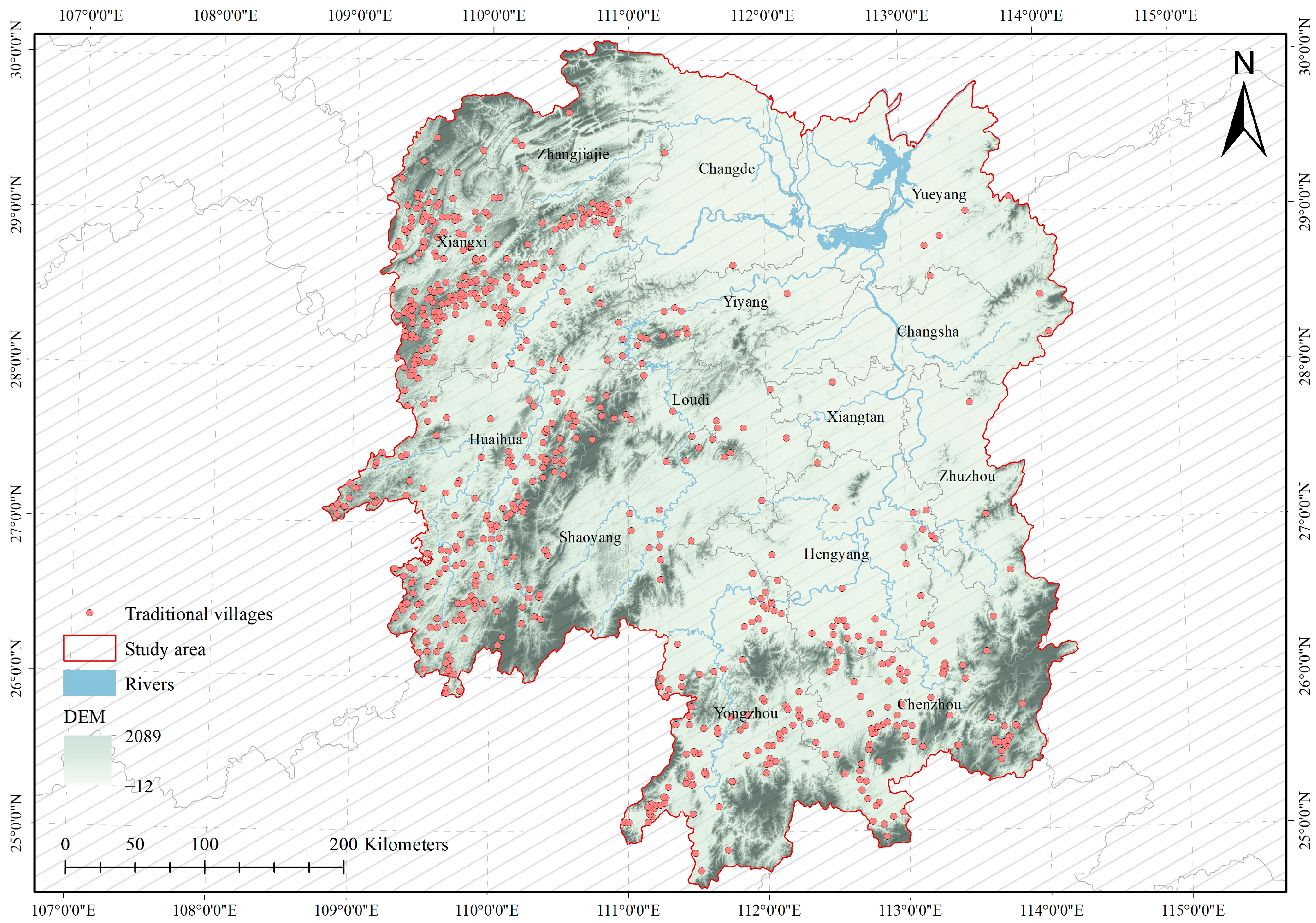
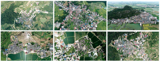
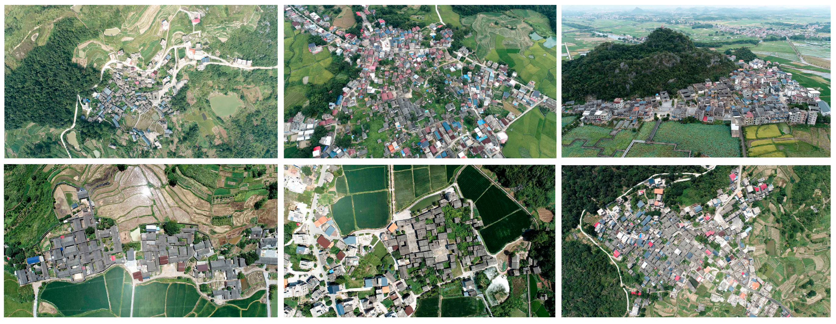
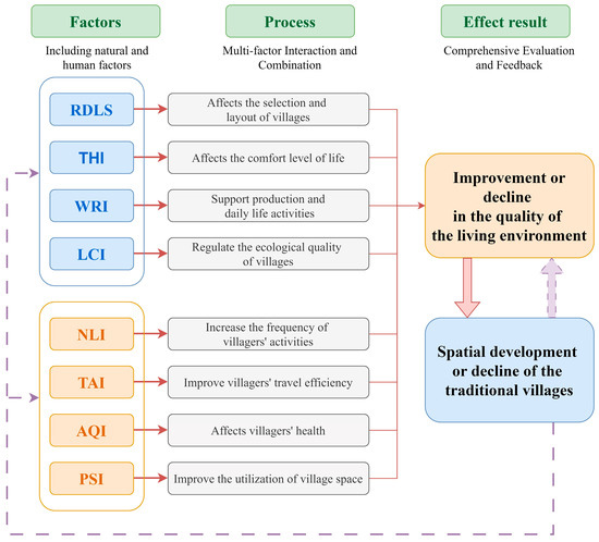
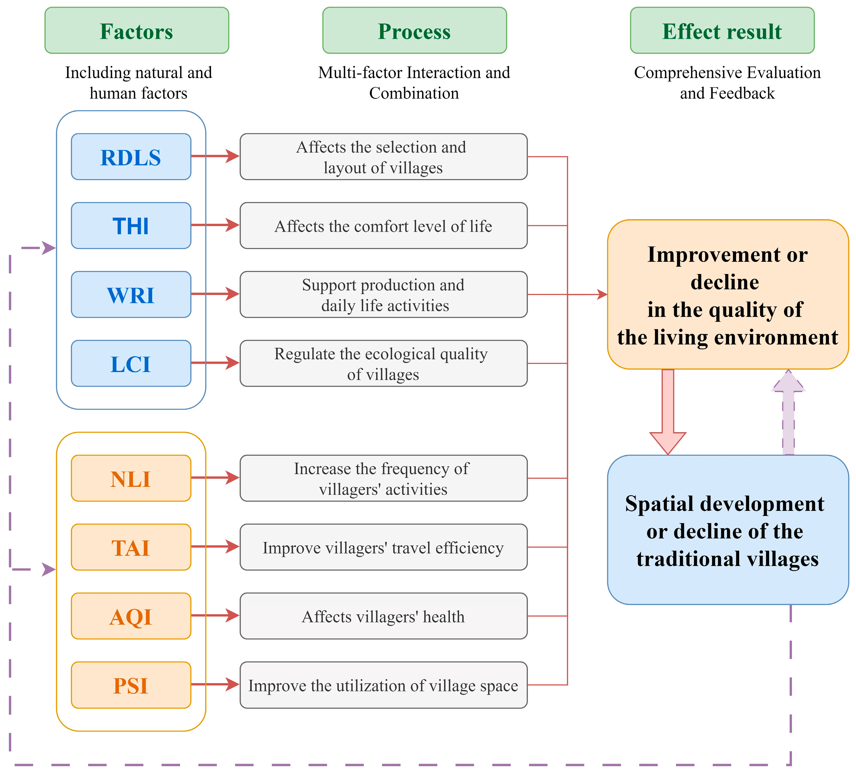
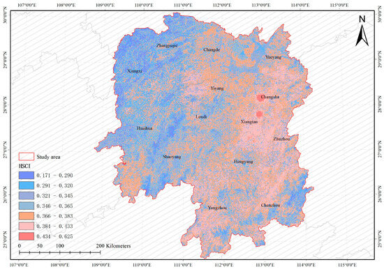
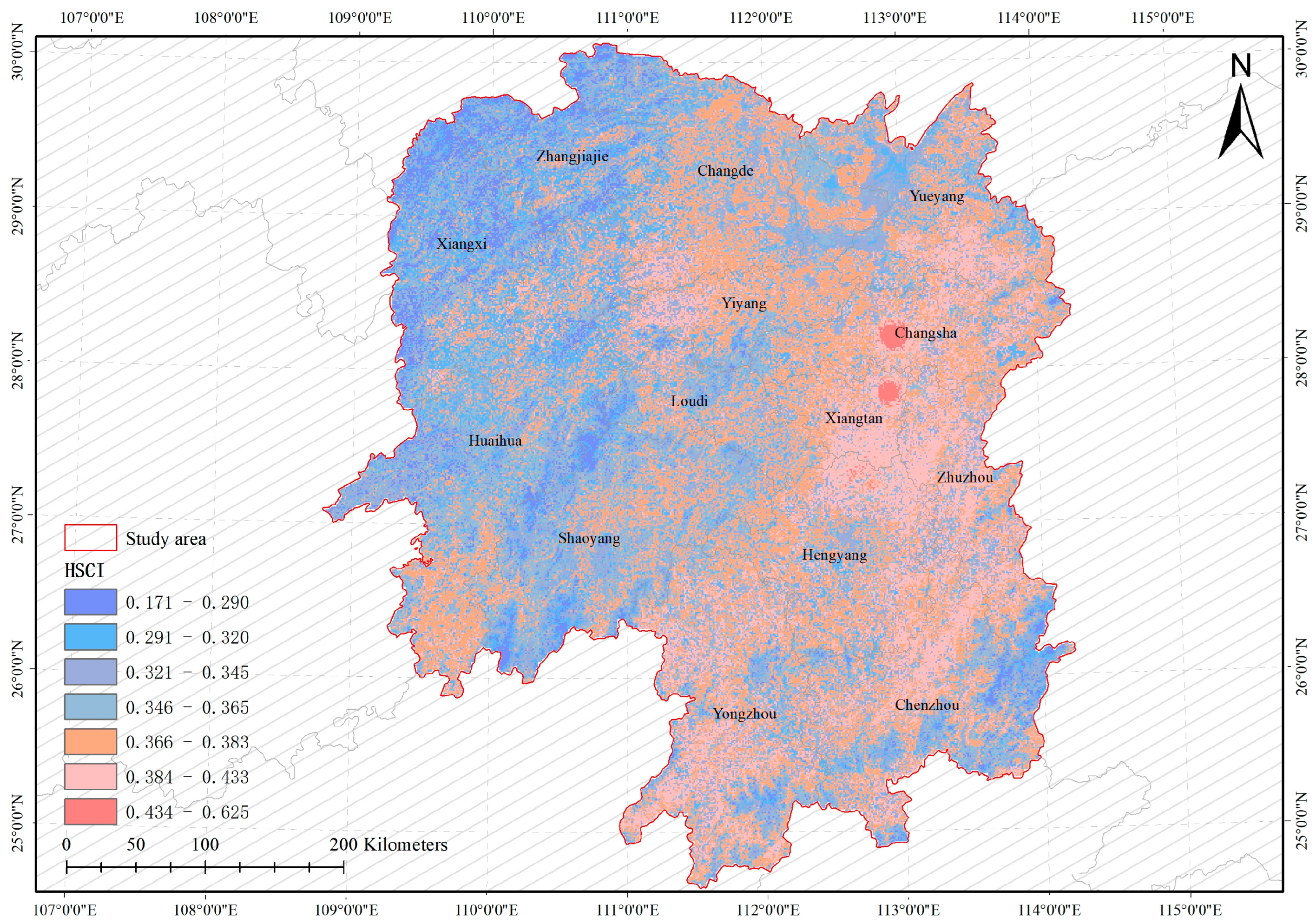
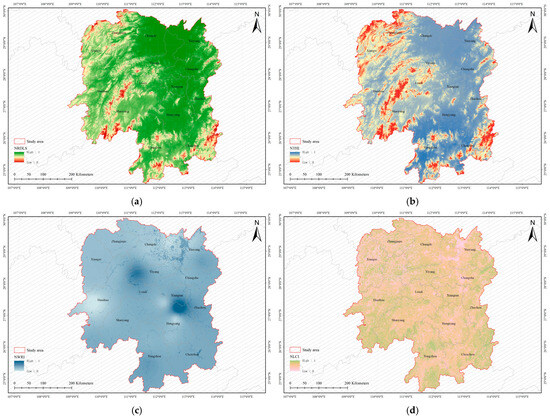
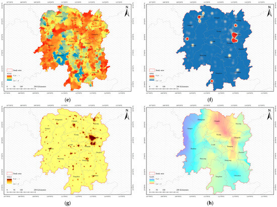
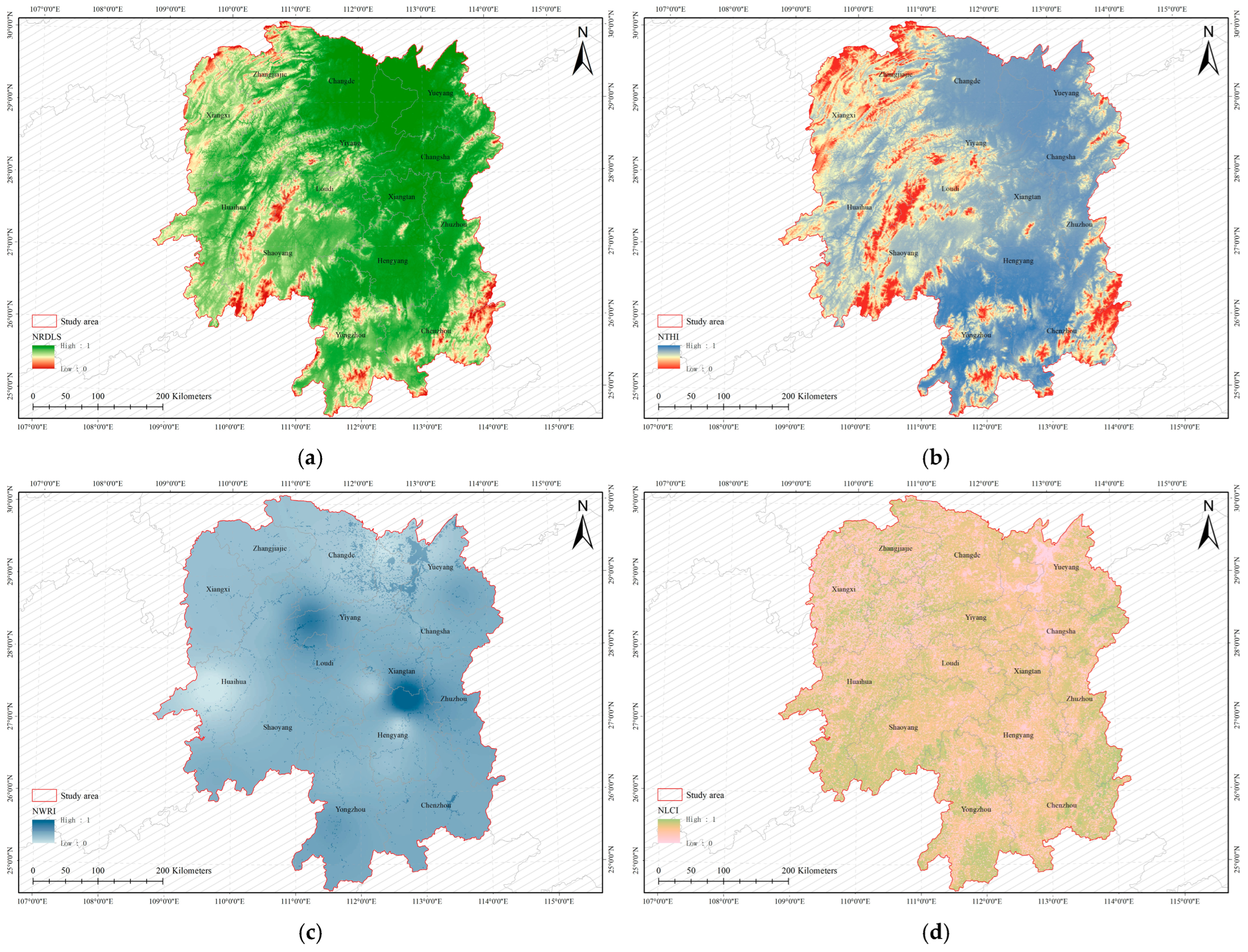
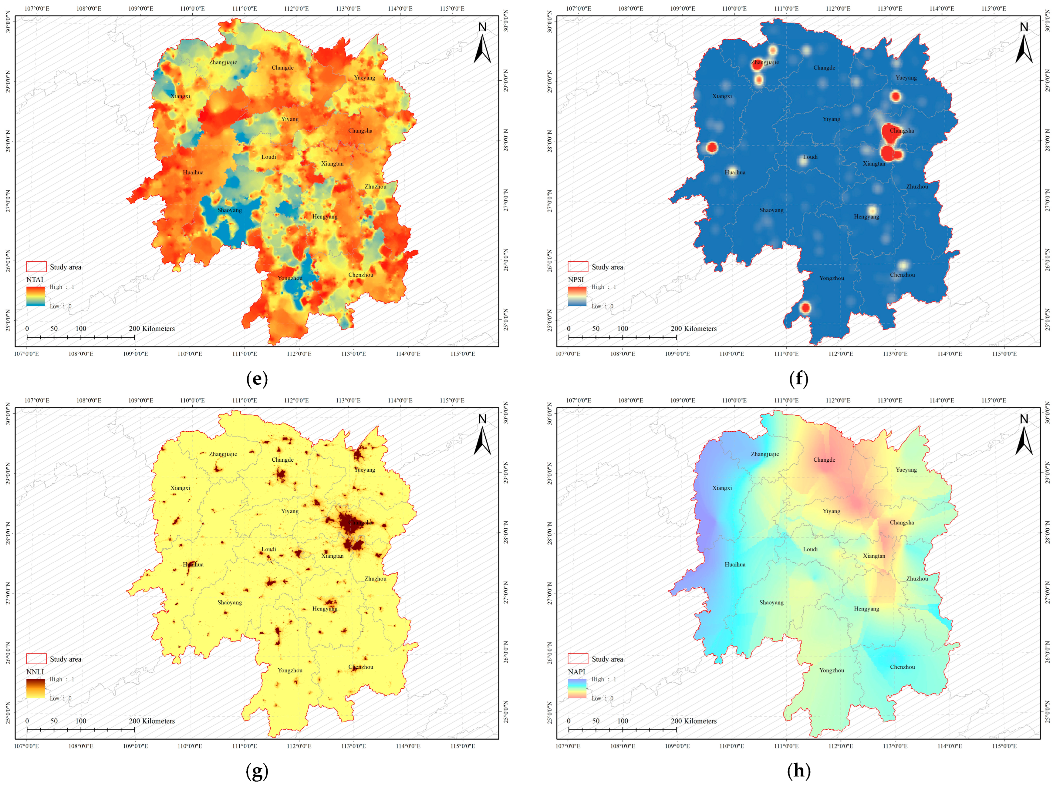
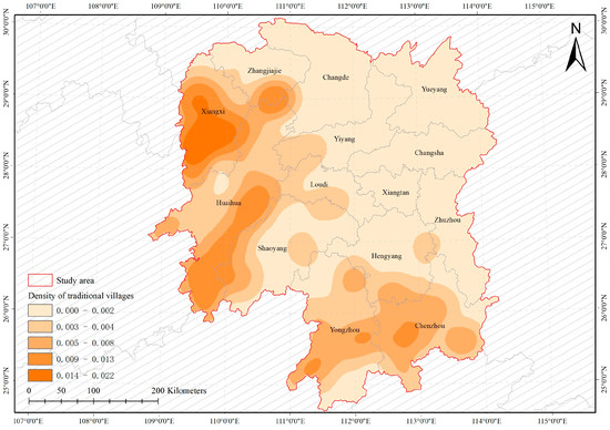
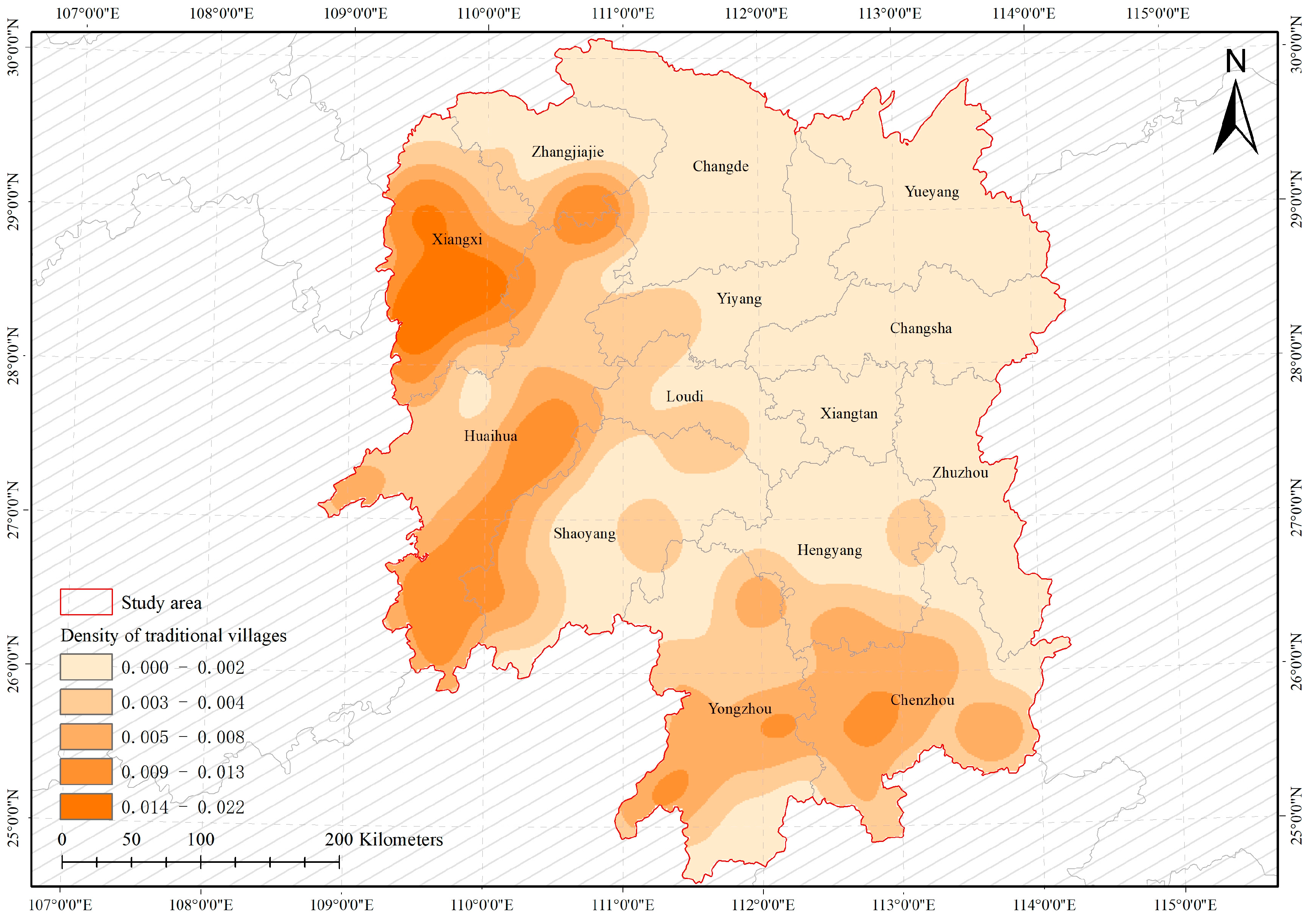
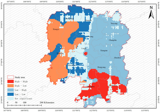
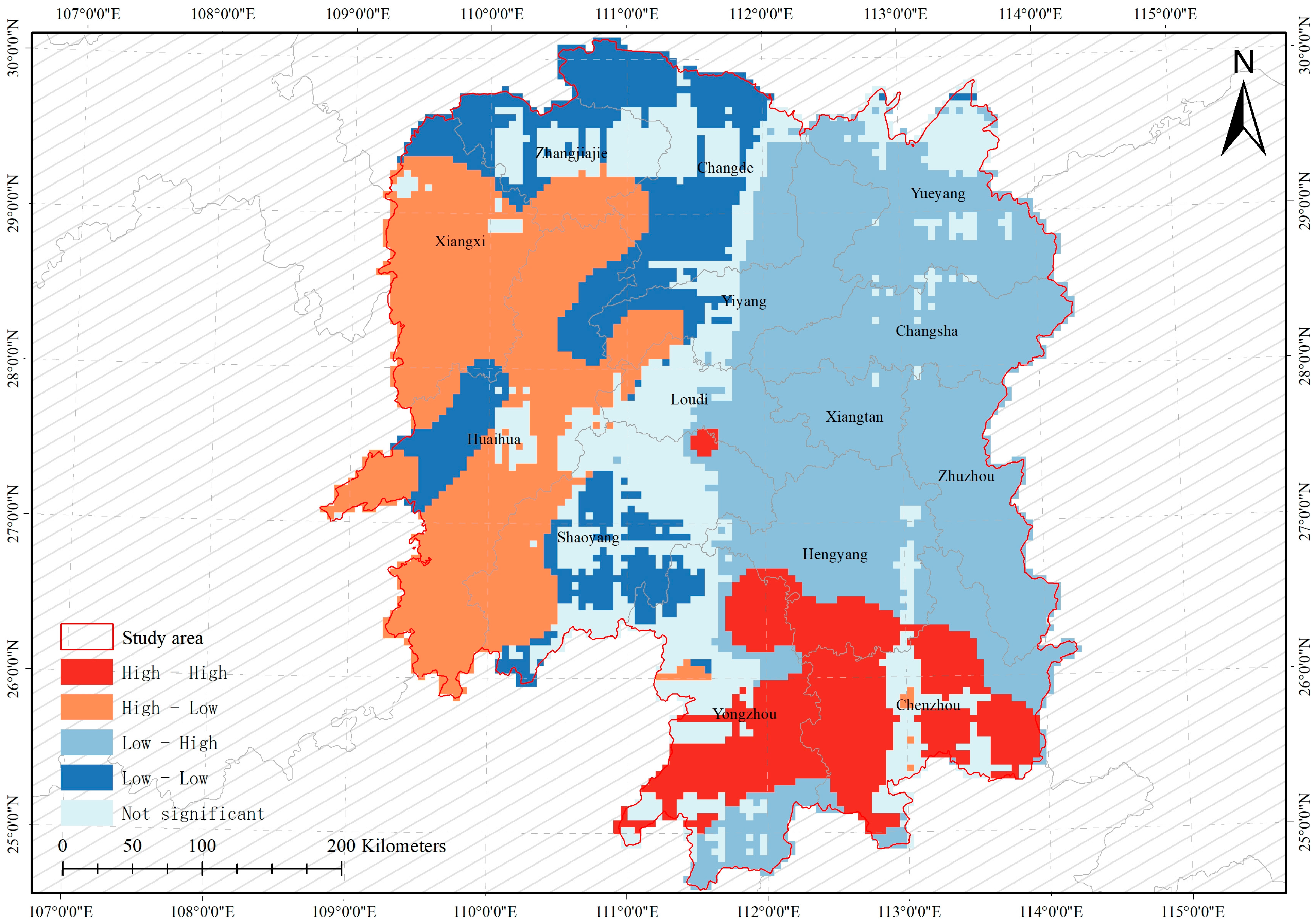
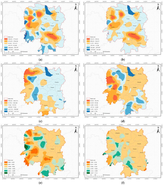
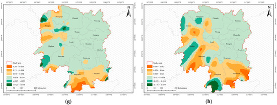
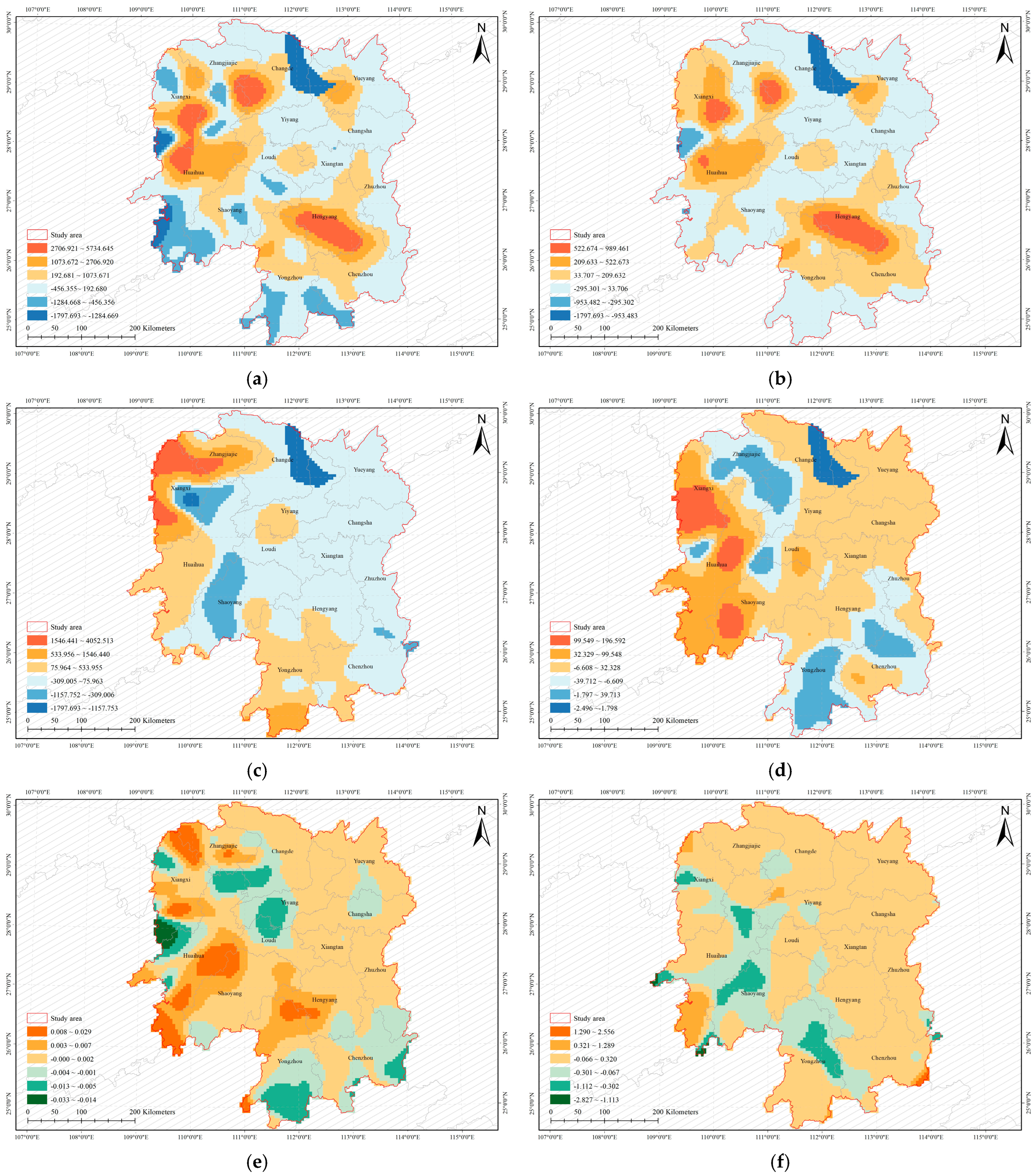
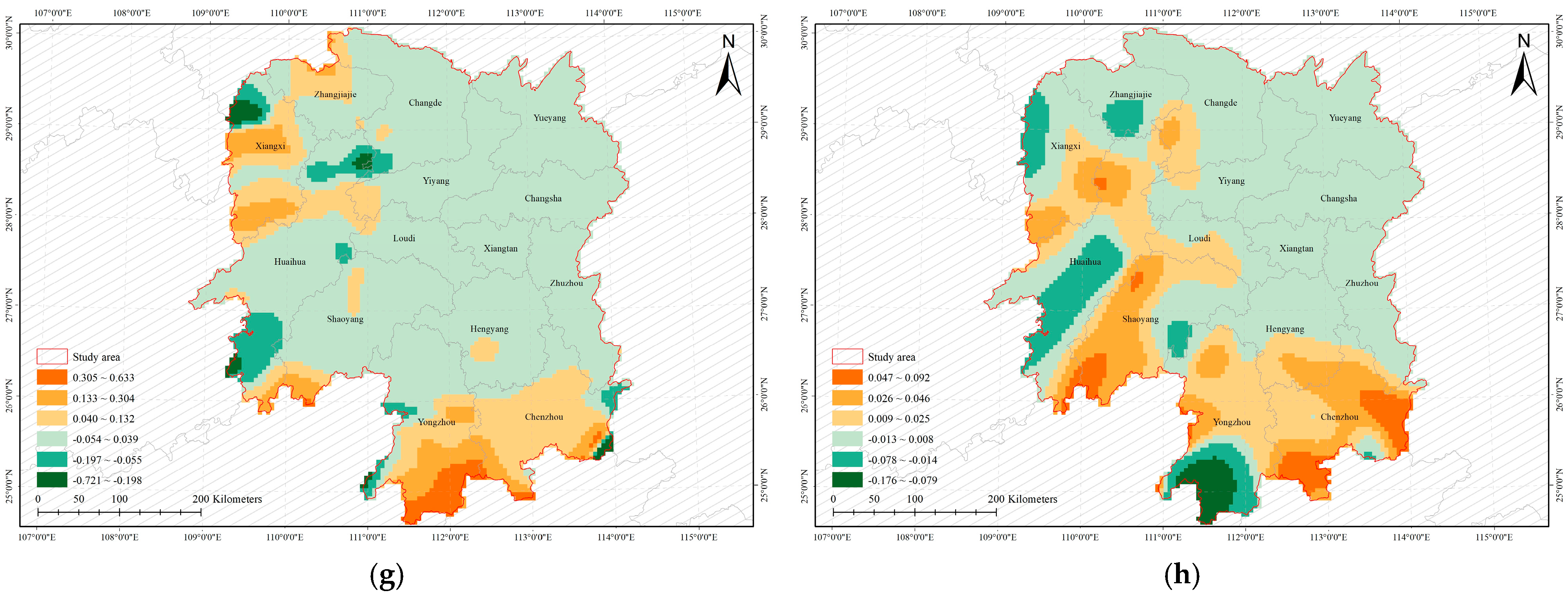

Disclaimer/Publisher’s Note: The statements, opinions and data contained in all publications are solely those of the individual author(s) and contributor(s) and not of MDPI and/or the editor(s). MDPI and/or the editor(s) disclaim responsibility for any injury to people or property resulting from any ideas, methods, instructions or products referred to in the content. |
© 2026 by the authors. Licensee MDPI, Basel, Switzerland. This article is an open access article distributed under the terms and conditions of the Creative Commons Attribution (CC BY) license.