


Abstract
Since the 1950s, Türkiye has experienced rapid urbanization and urban expansion followed by continuous planning initiatives, yet these efforts have resulted in significant land degradation and unsustainable urban sprawl. As a remedy, legislators and administrations are increasingly turning to the use of transferable development rights (TDRs), which have arisen as an innovative land readjustment tool and have recently been incorporated into the spatial planning system. This paper examines the effectiveness of TDRs by analyzing the legislative framework and operational rationale of the Turkish model through a hypothetical scenario, while also considering the institutional restrictions that could limit its usefulness as a sustainable planning instrument. By contrasting the scenario model with the framework recently developed through legal reform, this study employs the success factors of TDRs from the literature to assess the effectiveness of the tool integrated into the spatial planning system. Since the new legislation that forms the basis of the TDR model was passed in late 2024, empirical data on completed transactions is currently unavailable, and hence, the analysis used a hypothetical what-if-case scenario model in the local context, the Muratbey-Torbalı district of Izmir. To clarify the rationale behind incorporating the TDR into the planning system, we will first examine its conceptual development within the national legislation, followed by a critical evaluation of the TDR model as established by the recent amendment. Secondly, the study will present a hypothetical TDR model that incorporates the essential components ex-ante and offer guidance for conducting a market-based evaluation of TDRs, considering factors influencing agricultural market values and related standards. The findings demonstrate that there is a lack of legal clarity that stresses the program’s holistic design with sending and receiving locations or TDR-allocation rates. The implementation regulation is challenging to ascertain how transfers impact land use justice, social benefit, and the public interest.
1. Introduction
Based on the institutional and legal framework, planning is crucial for the physical reconstruction of land, the authority to do so, and property sovereignty [1]. The physical layout, street patterns, parcel volumetric indices, and density distributions all have significant implications for land value, property regimes, social use, and the societal meaning of land. Therefore, planning tools are vital for capturing and expressing the land’s material complexity to inform land use decisions. All countries require effective and equitable planning tools to support sustainable urban growth; however, no perfect solutions have yet been identified. In the country, as elsewhere in the world, land policy and land use decisions are governed by zoning plans developed in accordance with zoning laws and administrative authorities. Despite the long history of the country’s planning system, it has declined in relevance with the rise of neoliberalism, and its tools have become outdated and often ineffective. Recently, the search for new tools has intensified, and TDRs have become part of spatial planning.
A study by Green to Grey (Arena for Journalism in Europe and the Norwegian national broadcaster started the project), which used satellite images, artificial intelligence, and on-the-ground checks, discovered that from 2018 to 2023, 9000 square kilometers (the analysis covers 30 countries; this accounts for 96 percent of the European Environment Agency’s (EEA) 39-country area, https://greentogrey.eu, accessed on 27 April 2026) of land (about 60 percent of natural areas and 40 percent of farmland) were turned into built-up areas all around Europe. This shows that despite the EU’s 2050 goal of zero net land take, European countries are building housing, tourism, industry, and other sectors faster than expected. The most startling discovery is that Türkiye has lost the greatest amount of green space in Europe, 1860 km2, or more than one-fifth of all of Europe. The surge in tourism investments along the coastline, expedited infrastructure development within the metropolitan area, and the disintegration of profitable agricultural areas have resulted in significant land loss and degradation throughout the country over the past five years. The Soil Atlas prepared by the TMG Research Group (Think Tank Group’s research for sustainability, SOIL ATLAS 2025 Turkey Report [2]) points to the same findings in Türkiye, indicating widespread soil depletion and deterioration [2] (p. 51). The country’s land use practices indicate a developmental trajectory that substantially contradicts the United Nations’ 2030 Sustainable Development Goals. Specifically, SDG 11 (concerning Sustainable Cities and Communities) is jeopardized by irregular and unplanned urban expansion, which undermines spatial coherence, escalates infrastructure expenses, and restricts access to inclusive and resilient urban services. In response to these serious circumstances, lawmakers, authorities, and administrators are pursuing effective land readjustment (LR) procedures in land use planning that prioritize the transfer of development rights.
TDRs’ role and impact on land regulation as a market-based substitute for conventional regulatory instruments have long been the focus of in-depth research in the literature. Policymakers, administrators, and planners have been increasingly interested in the TDR program, and Türkiye is no exception. This is relevant for both developed and developing countries for several reasons, such as controlling the built environment, funding urban infrastructure, and managing land [3]. Nevertheless, despite growing interest and a variety of applications, it is not successful at reaching the desired goals; seldom do effective outcomes occur [4]. TDR programs are complex processes involving many parties and cannot be viewed as a panacea that is always valid in the same way [5,6,7]. Instead, they must be adjusted to the various circumstances and supported by the appropriate assessments. Numerous studies on TDR applications worldwide have shown some success, particularly in protecting farmland [8,9,10], along with disadvantages such as administrative difficulties, unfulfilled expectations among planners, the unrealistic cost-effectiveness of market-based tools, insufficient receiving areas, and a lack of program leadership. Therefore, some researchers have proposed the factors affecting the success of TDRs, based on a comprehensive examination of cases from various countries [11,12,13,14,15]. The innovative factors that ensure the TDRs’ success are political foundation [13] (pp. 410–411), [14,15,16], its design, the TDR allocation rate [17], its certainty, and simplicity [11,12,13], local land use demand and patterns [16], incorporation of the regulatory framework, and the planning system in general. These internal elements can be adjusted by the planners and local administrations by designing TDR programs [18]. In contrast, external factors indicate more structural characteristics and can be assessed by examining the context before implementation; these factors encompass a growing and dynamic housing market, limited development options [11], and a specific land policy framework [13].
TDRs were first presented as an innovative instrument in the early 2000s when the nation passed a number of laws and regulations; however, its application was restricted and unsuccessful. TDRs have been incorporated into the legislative planning framework, as outlined in Zoning Law No. 3194 (new legal amendment, 7534/5 December 2024); however, the Turkish legal system does not officially recognize the instrument as a program or long-term strategy. The numerous challenges make the integration of TDRs as a tool in the land management system difficult, discouraging planners and local governments from using it; furthermore, if it is used, it complicates the administration, control, and monitoring. Despite the insistence of the state administrations on TDRs, its execution remains inadequate [19,20], and the method of implementation, considering particular institutional frameworks and local conditions, remains ambiguous. Thus, a country’s efforts to develop alternative planning tools can benefit greatly from international samples of TDR applications, and vice versa. On the other hand, these problems are not unique to Türkiye; rather, they are comparable to planning challenges seen in other countries [21].
Using a case scenario focused on protecting agricultural land in the Torbalı-Muratbey district of Izmir, this research critically highlights the challenges faced when adapting the TDR program within the conventional planning system. Although TDRs have the potential to be an effective spatial control strategy for managing agricultural land, institutional constraints, inconsistent implementations, legal issues, and structural flaws in the planning system limit its chances of success. Planning has long been practiced across the country under a system governed by strict, legally mandated regulations. On the other hand, the nation’s dynamic structure and rapid urbanization have made it difficult for the strict planning approach to address the complex and multifaceted problems faced by urban areas or to adapt to constantly changing circumstances. As the country fails to establish a discretionary planning system built with consent-based, participatory practices due to the planning reform movement abroad and the zeitgeist’s necessity, the integration of TDRs, a flexible market-based tool into a planning system that has historically been subject to a high level of strict regulation but has become more flexible due to privatized targets and deregulation efforts may have unintended consequences [22]. Furthermore, the recent amendment, which incorporated TDR as a mechanism for LR into conventional spatial planning, was approved in late 2024; hence, we are unable to determine the results of completed transactions [21]. This serves as the primary rationale for employing a what-if scenario methodology to evaluate TDRs, its potential, and its limitations that may hinder its effectiveness as a sustainable planning tool. Therefore, this study uses TDRs’ success factors from the literature to assess the effectiveness of the TDRs as a tool for spatial planning by contrasting our hypothetical scenario model with the recently adopted model by the legislative reform. We want to clarify the inherent limitations of the planning system and its capacity to include TDRs. The presentation of the case study should be viewed as a preliminary effort, a theoretical exploration, rather than a case study of a real-world scenario.
The issue of property value variation brought on by land-use planning regulations has long been the subject of scholarly investigation into ways to compensate for landowner losses without placing a burden on the local government’s financial resources [23] (p. 2) [24]. TDR programs have been proposed as a practical means of accomplishing both, which are non-financial instruments designed with the market in mind, to balance supply and demand by generating a financial incentive [3] (p. 833). TDRs are deeply ingrained with the institutional system regarding land management, secondly how to carry out the defined purposes of the equity and efficiency by striking a balance with constructing a trading scheme (how to design transfer mechanism in-between sending and receiving areas), and lastly how to construct an ex-ante design of the TDR program as a planning tool are still the main issues for the future of the well-functioning programs. The design phase, which is one of the factors that influence the performance of the TDR program, thus constitutes a substantial field of research and experimentation to improve the effectiveness of programs and serve as a guide for the planners and administrators [4,18]. There is limited research on how to perform the initial phase, what the constituent components are, and how to suit the local institutional contexts, even though it has generally been highlighted in the literature as a critical component of the TDR success factors [3,12], [25] (p. 2).
The core features of a typical TDR instrument that make up its operating design are as follows: (1) a sending area with zoning restrictions that limit development potential; (2) a receiving area selected through planning that encourages compact and higher-density development; (3) how development rights are defined in legal and spatial (planning) terms; (4) a trading mechanism that commodifies development rights (expressed as coefficient, allocation (transfer) ratio, floor area, or unit of land and permits them to be transferred from the former to the latter [3,4] (p. 2) [26]. Investigating the allocation rate and quantity, as well as the value of land development rights among areas for trading TDRs in accordance with the planning legislation, is essential for efficient TDR programs. This ratio shows the mathematical correlation between the increased construction density in the receiving area and the total possible development rights in the sending area, which would be subject to the plan’s restrictions [8] (p. 286). The study aims to present a comprehensive TDR program, incorporating a hypothetical model tailored to the local context, along with high-level structuring to discuss the potential and limitations of agricultural land conservation in the Torbalı-Muratbey district of Izmir.
The study will be structured as follows: the first part begins with a comprehensive literature review of the global application of TDR programs (Section 2). The analysis will begin by clarifying the rationale for incorporating the TDR model into the planning system, followed by a critical evaluation of the model as established by a recent amendment (Section 3). In the fourth section, a hypothetical model from a case study describes the procedures needed to successfully institutionalize TDRs for agricultural land management in the Turkish context. In particular, the study will provide guidelines for initial design using a market-based evaluation of TDRs as a planning tool to conduct a model affecting farmland market values and associated standards. The Muratbey neighborhood in the Torbalı district (ilçe) of Izmir was chosen as a case study because it has high agricultural production and is heavily impacted by urban growth. The fifth section presents a comparative analysis of the newly created TDR model and the case study, utilizing a set of success factors derived from the literature [27] (p. 316) to illustrate the effectiveness of TDRs as a spatial planning instrument, while also highlighting the parallels and disparities between the Turkish case and wider TDR applications. By evaluating the results and the effectiveness of TDRs in accordance with the series of TDR’s success factors (Section 5), as well as the steps needed to incorporate TDRs into the planning system, we highlight the lessons learned from the case study.
The study contributes to the body of research by exploring the concerns and challenges of operating TDR programs as a new instrument in land use management, assisting administrations, local institutions, specialists, and planners in areas where increasing urbanization, together with weak institutional structure and planning systems, coexist. The analysis of the study focuses on three principal dimensions based on the scenario model: (1) the institutional and legal flaws that distinguish the Turkish model from the international practices: what are the ways that lawmakers and administrations interpret TDR as a tool for LR differently, and why it is framed as a model in legislation? (2) Conditions for the operationalization of TDR, insights derived from a case analysis; and finally, (3) the risks associated with the advance of the TDR applications, valuations of rights, density problems, a definition of actors and their role in the TDR procedures, and a lack of participation.
2. Use of TDRs as an Instrument of Planning: A Contentious Topic
The idea behind transferable development rights is to prevent development (downzoning) of the sending area’s vulnerable land by persuading its owners to willingly accept restrictions on their ability to develop their property in exchange for credits that can be sold to developers in the receiving area [28]. The sale of development rights compensates sending-area landowners for their voluntary restrictions on land development and the resulting value reduction. TDR credits allow developers to build at a higher (extra) density in the receiving areas if they wish to build more than the permitted level. Receiving areas, on the other hand, must have infrastructure, capacity, and local population support to accommodate increasing density growth. Through the sale of development rights, landowners in sending areas are compensated for their voluntary acceptance of restrictions on developing their land and the resulting loss of value.
The first application was begun in the United States with the “air right” in 1916 in New York [8,29]. In 1968, the model was again implemented in New York and subsequently disseminated throughout the USA in the 1980s [30]. Though TDRs were initially used to preserve historic structures, they are now mostly used in the USA to protect open spaces, farmlands, and forests. After the initial programs were implemented, scholars tried to evaluate the effectiveness of those “first-generation” TDR programs [31] (p. 379). The significance of stakeholders and their engagement in program development and implementation are emphasized by a second wave of TDR projects that started in the 1980s. The third-generation TDR programs were focused on program participants and incentives (extra development rights used to incentivize the transfer of parcels located in environmentally sensitive areas to parcels located in growth-friendly areas, see Linkous and Chapin [32]). In the 1990s, “new generation” programs designated receiving areas in peripheral and rural areas to increase the market for TDRs, discouraging a not-in-my-backyard mentality and promoting market traction in areas where consumer demand and developer attitude favour suburban subdivision development [26,32]. Since then, TDRs have been applied globally, adapting to local conditions and ever-changing needs. Its scope, goals, and objectives have changed and become more diverse, and its applications have spread throughout the world.
In many instances, TDR programs have consistently been proven to be an effective means of mitigating excessive land use and protecting the environment [25,32,33,34]. Its use in agricultural areas can be regarded as one of the most efficient spatial control mechanisms for optimizing land use [25,35]. Downzoning restricts how much land a property owner can use and may drive down real estate values, which could create legal and political issues. Since it restricts landowners’ access to the market and permits some low-density development to take place in agricultural regions, it is frequently not politically feasible because it reduces the effectiveness of farmland protection [11,35]. Areas subject to development restrictions due to agricultural production and ecological goods should be compensated through the fiscal payment for their sacrifices through financial transfer payments by targeting development opportunities for regulating the effectiveness of the territorial spatial usage [36]. TDR seems to be a way to economically stabilize the impacted property while lessening the burden on local government to take over, without compromising the policy’s (downzoning) liability and practice of protecting farmland [30,37], [38] (p. 163).
Transferring land development rights from sending areas might offer better compensation in exchange for greater development density in the receiving areas, which is anticipated to boost regional economic growth [8,9,10,11,12,13,14,15,16,17,18,19,20,21,22,23,24,25,26,27,28,29,30,31,32,33,34,35,36,37,38]. Thus, the conventional planning system plays a critical role in regulating the unified and comprehensive design of TDR programs, which is an essential tool for striking a balance between compensating for land management and enhancing local or regional economic performance. These demand an updated national law and a well-defined planning strategy [39]. Furthermore, to coordinate equitable regional economic development and optimize the territorial space structure, stringent planning requirements necessitate suitable market incentives [15,25]. By clearly separating the building (receiving area) and non-building zones (sending area), a dual-zone TDR strategy arises as a mechanism to provide efficiency and equity in land policy (Vejchodská and colleagues [40] (p. 580) claim that while some policy tools concentrate on equity, others seek to boost efficiency. A smart land use strategy, however, must ensure both efficiency and equality; one cannot sacrifice the other for the other.) to distribute the costs and benefits of new developments [4,23,24,25,26,27,28,29,30,31,32,33,34,35,36,37,38,39], mitigate inappropriate land zoning, and alleviate land loss [41].
In many cases, the planning regulatory system controls the amount of growth by deciding whether land development rights are constrained or not [42] (p. 142). Nevertheless, such planning inevitably leads to irreconcilable rental disparities among uses, as land allocation induces fluctuations in urban land value, resulting in unintended externalities [15,25] (p. 3), [42] (p. 279). New alternative methods are needed to address these externalities in the planning system that traditional land use planning has been unable to resolve for a long time. Strict planning regulations need proper market incentives to optimize the territorial space structure and coordinate equitable economic development [15,25]. The significance of TDRs as the incentive structure for spatial development is emphasized by this viewpoint, particularly the fact that the government does not compensate landowners by paying them money but by providing them with a right that is worth a certain sum [43] (p. 2). Since then, TDRs have been promoted as a welfare instrument to redistribute the costs and benefits of new developments [11,16,17,18,19,20,21,22,23,24,25,26,27,28,29,30,31,32,33,34,35,36,37,38,39], combat shortcomings in land-use issues [33], and address inappropriate land zoning policies.
TDRs have emerged as a remedy for the excessive arbitrariness and rigidity of the land use plan in many European nations, eliminating the inequalities in the treatment of private properties brought on by the idea of non-compensation of the landowners for building restrictions imposed by planning regulation [42,43,44] (p. 2). Italy, which has significant TDR applications, equalizes development rights (equal share of loss among proprietors of land) to all landowners in urban plans. This practice was prompted primarily by the Nation’s strict budgetary constraints and complex expropriation process for the creation of public service districts, urban renewal, or the preservation of natural areas [42] (p. 144). Finally, TDRs can be viewed as a remedy that atones for the steps taken to accomplish the community purpose without requiring financial compensation because it allows development rights to be bought and sold on the private market without imposing taxes or collecting debt. The basis of the public policy issue today is the valid paradigm towards more market-oriented, voluntary, and financially compensated approaches for assuring food security, preventing the consumption of productive land, and providing land use efficiency [3] (p. 833), [9,45]. However, some scholars claim that the primary reasons for local governments’ eagerness to embrace market-based tools are the challenges of resolving structural issues that hinder planning processes and deficiencies of organizations [4]. In this way, market-oriented planning innovations appear as mechanisms that reinforce the logic of the market while maintaining or even exacerbating the shortcomings of planning systems.
Despite its complexity and drawbacks, TDRs continue to be attractive because they can take the place of more established regulatory tools that depend on the authority of the state and public funds [4]. This occurs as a result of national austerity policies placing local governments under ever-tougher budgetary restrictions, which significantly diminish the effectiveness of conventional regulatory tools like zoning. The second characteristic that explains why TDR programs continue to be popular is the increased flexibility of transfer techniques that capture the unique qualifications of each program. These transfers can occur between jurisdictions, across adjacent parcels in the form of the air rights inside designated districts, or even from urban to rural or from rural to rural. However, it also clearly highlights the significance of matching the program design to a recipient area’s real estate market in a densely populated region where location can necessitate long-distance transfers or be more complex transfer modalities [8]. The objective conditions of the transfers, as well as how to identify the unused (development) zoning rights, have grown to be overly complex and profound challenges as a result of the widespread usage of TDR applications. This procedure has been operationalized in the form of the transfer or conversion ratio, the allocation rate for achieving a density bonus, in the literature in general. The ratio is defined as the mathematical relationship between the total limiting potential development rights in the sending area and the increased building density in the receiving area [3,8] (p. 286), [15,25] (p. 2), [46]. The discussion has centered on various problems. Primarily, the density bonus amount—a market-sensitive incentive payment—must be accurately calculated to offset the amount of compensation that landowners can expect for the limitations placed on their development rights. The statutory land-use plan’s development indexes, the socioeconomic standing of the private property owners living in the sending areas, and the sending areas’ unique status, such as agricultural land, natural areas, and historic preservation, all need to be considered during the calculations. To calculate the extent to which development rights are constrained by planning restrictions, parameters are typically specified by the land use regulations, floor area ratio, building density, or height [25]. Secondly, density bonuses determine how much and what kind of growth will be supported in receiving areas by tying the TDR programs to market circumstances. Upon creation and delivery of the TDRs, developers may utilize them as additional (extra) density credits in development projects within receiving regions, contingent upon planners’ permission [41] (p. 136).
The vast majority of studies on the designation of TDR programs show that it is context-dependent and is contingent upon each country’s socio-political characteristics, institutional structure, the capacity of the planning institution, along with the operation of the market, or any combination of these factors. So, the identification of factors affecting the effectiveness of the TDR program has been extensively studied and developed in the literature. Among these, Machemer and Kaplowitz’s [16] studies in the USA, Aken et al. [47] in the USA, Kaplowitz et al. [31] in the USA, Pruetz and Standridge [11] in the USA, McConnel et al. [6] in the USA, Chan and Hou [12] and Hou et al. [14] (pp. 467–468) in Hong Kong, and Shahab et al. [13] in the USA can be mentioned (Table 1). The policy foundation is the foremost factor in managing the transfer of rights, encompassing laws, ordinances, and land-use planning as indicators of the robust political and legal underpinnings essential for TDR initiatives [13] (pp. 410–411), [14,16]. Each country will create policy goals and formulate them according to its institutional formation. The use of TDR programs as a planning tool and their integration into the legal framework and the overall planning system are among the most often discussed aspects of TDR programs; these include program design, particularly the identification of preservation (sender) and development (receiver) areas, the TDR allocation ratio, and the principle of equal treatment of landowners (a matter of social equity).
Table 1.
Factors affecting the TDR success: selected parameters.
Since a legal amendment was passed very recently in the country, there is no real-ground application yet; therefore, market assessments, TDR transactions, transaction costs, place attachment of local actors to the local environment, and participation are not included in the study. However, the general evaluation of the recently enacted TDR system will briefly address participation, sense of place, and other issues and will be listed as policy recommendations.
To sum up, the development and application of TDR programs is a multidimensional and inherently challenging process [4]. Because of the complex process of the instrument and the particular characteristics of the local setting, there is no guarantee of achieving the desired result. Policymakers and administrations across the nation are increasingly interested in using TDRs as an LR tool in planning; yet the legislation’s program design and its weak integration with the planning system limit and compromise the tool’s effectiveness.
Therefore, using a scenario model, the study focuses on emphasizing planning issues presented by the existing legal framework and suggesting alternative program design. Success factors will help evaluate the efficiency of TDR programs and will reveal the convergence and divergence of the Turkish case from world examples. The following are the research questions: (1) how does the legally framed TDR model actually determine the sending and receiving area and transfer mechanism? (2) What discrepancies and deficiencies exist in the country’s TDR framework? (3) Considering the deficiencies detected from the actual model, what are the main components of the hypothetical case study scenario design? What are the key features of a guide to improving the effectiveness of TDR programs and supporting planners and local governments? (4) How may the shortcomings in the Turkish case be resolved using a hypothetical case scenario? Are there sufficient resources, techniques, knowledge, or experiences to improve TDR’s effectiveness in the Turkish context? The study will conclude with additional future policy recommendations aimed at improving the TDR model.
3. Operationalization of TDRs in the Turkish Context
3.1. Turkish Planning System’s Land Readjustments: Brief Info
The LR methods of Turkish planning are used to transform non-urban or agricultural land into urban areas, generating urban plots that are technically formed throughout the transition period. The granting of zoning rights and the construction of infrastructure are two ways to accomplish this conversion. At the end of the process, urban land has been acquired with a zoning plan, assigned development rights, and urban plots for future constructions, all of which are connected to the urban infrastructure system [48] (p. 6). In the country’s planning culture, the relationship between a single building and the plots on which the building is located has been considered primarily for the implementation of the zoning plan. The size of the plot, the way the plots are arranged in subdivision plans, and their amalgamation (tevhit) or separation (ifraz) are of utmost consideration under the supervision of the Zoning Law [49].
Among others, the most commonly used LR instrument is known as the colloquial dough rule, i.e., land consolidation (Article 18 (R.G. 02.11.1985/18916 “Regulation on Land and Land Arrangement Guidelines to be Made in Compliance with Article 18 of the Zoning Law”), which could be seen as a way for the public to control private property bylaws. Cadastral land can only be converted into an urban land plot with the implementation of the urban development plan, according to Article 18th of the Zoning Law. A zoning subdivision plan was produced with the necessary land arrangement, reserving up to 45 percent of the land for public use in exchange for the projected (estimated) future increase in land value. The size of the land plots is the basis for the assessment procedures in the application. The remaining areas are distributed to the landowners in proportion to the area or value of their included plots, following the allocation of a common share, up to 45 percent, for public usage areas such as roads, parks, schools, parking lots, etc., from the total of all plots that fall into the LR area [50]. Additionally, the physical plan’s layout can be implemented after the readjustment of the plots and property rights.
Despite having a lengthy history of application, the dough rule (ever since the nation’s first zoning law, the Ebniye Regulation, was enacted in 1848, the dough rule has been a crucial component of national planning) is widely acknowledged to be not viable in the country for a variety of reasons. All legal sources about urban planning, as well as the general logic of the planning system, when the urban area is being built in the housing development area, heavily favor the “single parcel—single building” approach [19,51]. In contrast to the collaborative and community production of the metropolitan areas, this strategy mainly consists of the readjustment of small areas at the plot scale with the direct initiative of the proprietor, the partition of land, and finally abandonment [50] (p. 37). When combined with factors like rapid urbanization, the planning culture’s single parcel/single building feature and the use of inefficient tools for spatial organization prevent solutions that satisfy the current needs in the layout of vast urban areas. The actual type of LR disregards sociospatial processes and merely considers plot size and ownership, which has a detrimental impact on space production. Furthermore, the nation’s LR framework is different from contemporary approaches because it was conducted without the active involvement of pertinent parties (landowners, communities, developers) to establish a broad and strong consensus on the future vision.
3.2. Legislative Regulations Regarding TDRs
In the 2000s, TDR programs gained traction in the country and were included in bylaws. The first comprehensive regulation regarding TDRs was included in the “Protection of Cultural and Natural Assets Law” (Article no: 17, RG. 2863/18113), which, for the first time, formally incorporates TDRs into conventional land use planning. According to the “Law on Transformation of Areas Under Disaster Risk’s Implementing Regulation (Transformation of Areas Under Disaster),” the Ministry of Environment, Urbanization is in charge of “purchasing immovable lands, using the pre-emption power, exchanging property that also contains independent portions, and transferring development rights or zoning permissions to another location.” Several laws address the TDRs after release. The first is Law No. 644, which created the Environment and Urbanization Ministry, which allowed the start and running of development rights transfer initiatives. Second, the Expropriation Act No. 2942’s Temporary Article 6 states that “agreements can be established via property exchange, by permission for using the development right elsewhere, or by other means” [46] (p. 10). Even though TDR is included in the country’s legislative framework, it is still unclear how it would be institutionalized as the mandatory way (TDR programs might be mandatory or voluntary, state Johnston and Madison [52] (p. 366). The voluntary program uses development credit from transfers, while the compulsory program includes a pre-zoned sending and receiving location) [19,20] (p. 111).
The inclusion of new plan notes to the existing zoning plans in 2008 marked the beginning of the Nation’s development rights transfer practices, which were voluntary and had a limited scope [53] (p. 280). Some Istanbul local district municipalities voluntarily adopted TDR to (1) restrict parcel owners in the buffer zone of protected streams or the energy transmission line of the buffer zone, (2) ease land assembly, (3) improve the environmental quality of tiny parcels, (4) ensure historic conservation and recover development rights’ restrictions, and (5) downzone earthquake-risk areas and transfer density restriction to non-earthquake-risk areas [19]. In many cases, receiving areas are not predetermined in areas within the authorized land-use plan. In addition, Niron [20] (p. 178) found that planners, landowners, and employees of the local administrations have lacked information and a thorough understanding of TDRs. Trial-and-error tactics have determined TDR deployment, resulting in a range of applications among Istanbul metropolitan municipalities. With the constantly changing plan notes, transfer applications were conducted under different conditions in neighboring areas, which disrupted the integrity of the programs’ applications.
After numerous fragmented and shortsighted implementations, the 6th Conseil d’Etat (Danıştay 6. Dairesi) and local administrative courts evaluated and rejected rulings regarding various zoning plans, which employed TDRs (6th Council of State (E: 2018/1, E: 2015/2559, K: 2015/7964, E: 2015/7293, K: 2016/7921, E: 2018/1, K:2019/3715 [54] (p. 239). For more court’s decisions for the annulations see Niron [20] (pp. 125–126).) and Ersoy [54] (p. 239). Niron’s [20] (pp. 125–126) compilation of the Conseil d’etat annulation ruling about property ownership are as follows: (1) the Constitution’s Article 35 states that interference with property rights may only be made when it serves the public good; (2) property rights are protected under Annex 1 of the European Convention on Human Rights, which states that laws may only restrict property rights when doing so serves the public good; (3) it is uncertain whether the property in question will be transferred to another private property owner after it becomes public property; (4) the legal basis is not created in detail because the application (TDRs) is not covered by the Zoning Law. The court further highlights how ambiguous and challenging it is to distinguish between the right to development and the general nature of property. The main premise is that the law, particularly the zoning code, should define TDRs clearly. Furthermore, TDRs were often preferred since expropriation is challenging due to the financial difficulties faced by local municipalities. The Expropriation Law mandates that the landowner must receive the expropriation fee within five years. The execution of local spatial plans is thus more complex due to the legal stipulation that “property confiscation without expropriation” (kamulaştırmasız el atma) may occur if the social and technical infrastructure areas in the plans are not expropriated within five years from the start of the plan [19,55]. Numerous plan applications have been canceled as a result of court rulings declaring that “property confiscation without expropriation” is an unjust legal practice. A recent comprehensive legal revision to Zoning Law No. 3194 (5 December 2024) included TDRs as an alternative LR tool to expropriation in spatial planning. This modification is seen as a significant turning point for the TDR operations in the country [21].
3.3. Operationalization of the TDR Programs in the New Amendment
The new amendment (Law No. 7534) to the Zoning Law specifies that the possible development rights in question may be transferred to another parcel(s) within the plan limits if all or a portion of a parcel remains in a general public service area, which precludes it from being given. The primary objective of the amendment is to address conflicts about parcels within land regulation areas and to avoid prolonged litigation by utilizing public partnership shares (KOP in literal translation), which were eliminated in 2019 (this date serves as the reference point, as supplementary land contributions were implemented for areas subject to expropriation before the 2019 legislative amendment [21] following the increase in the contribution share rate (DOP) in the LR procedure up to 45 percent (Law No. 7181, article 9). Secondly, the amendment requires receiving parcels to be within the zoning plan’s boundaries and have a square meter value no higher than the sending property. The receiving parcel’s development rights may be expanded during the transfer process in compliance with the floor area ratio (FAR) outlined in the zoning plan; however, no more than thirty percent of the plot’s total area may be made available for development. A third prerequisite is that at least two approved appraisal firms must decide which development rights will be transferred between the transferring and receiving plots. When zoning rights are transferred, the receiving parcel’s construction area (calculated using the FAR ratio) may be increased to the extent indicated in the zoning plan, but it must never surpass 30 percent of the receiving parcel. The non-transferable portion of the zoning rights may be offset if it makes up 20 percent or less of the total value. The voluntary mutual offset rule (mahsuplaşma) may be used whenever the value of the transferor and transferee parcels changes (Figure 1). Ultimately, following the completion of the transfer process, the landowner freely transfers all property rights to the relevant administrations.
Figure 1.
TDR scheme according to the new rules.
TDRs were introduced into the planning system to resolve interim, shorthanded problems related to land pooling, expropriation disputes, and lengthy court cases, rather than to achieve a strategic land policy. The official planning system’s adoption of TDRs is a positive move, but it is hard to claim that TDRs are structured to maximize their full potential as an effective strategy to safeguard agricultural land or environmentally sensitive areas while optimizing the use of land. Furthermore, the amendment emphasizes public lands, specifically state-owned or municipal land, as designated recipient areas, and stipulates that if public land is unavailable, TDRs may be utilized instead. In this context, TDRs are not one of the strategic tools in land use management; instead, they function as a last resort. Additionally, the amendment limits the zoning rights transmitted between sending and receiving plots to 30 percent of the receiving plot’s floor area ratio in the zoning plan. The development plan allows for a rise of up to 30 percent of the floor area ratio for extra rights. The legislation has failed to strike a balance between the potential consequences that a fixed increase in development rights, established without prior assessment, might have on the receiving area. Besides, the legislation does not create a mathematical correlation or equilibrium between the value in the sending area and that in the recipient area; rather, it associates the transfer with a predetermined (fixed) enhancement ratio in development rights, without considering local contexts and land value changes. In addition, the most important issue in evaluating the development rights or converting them into tradable loans is making the correct calculation, which forms the basis of the development potential of the protected area. If it does not accurately represent the restricted land’s development potential, some market forces might distort the transfer program [52] (p. 375). The literature often underscores the significance of the TDR program’s effectiveness, the assessment of this quantity, and the prerequisites required to incentivize developers’ participation in the program [12]. However, in the Turkish case, developers were not included in the transfer schemes as significant players in the process; additionally, development rights were not presented as a distinct marketable product in the form of credits, and no effort was made to establish a value comparison or achieve a balance between the sending and receiving regions.
4. Research Design of the Case Study
Initial TDR implementations relied on the legal premise that every piece of land had a certain set of development rights, which were often connected to the maximum amount of floor area permitted by the zoning plan. TDRs normally allow the transfer of unused zoning rights from one zoning plot to another under specific circumstances to safeguard and/or open farmland areas or buildings with significant cultural value [56] (p. 1–2). The objective criteria of the transfers, as well as how to identify unused rights, have become overly complex and profoundly challenging due to the widespread use of TDR applications. This procedure has been operationalized in the form of the transfer or conversion ratio, the allocation rate for achieving a density bonus, in the literature in general. The ratio is defined as the mathematical relationship between the total limiting potential development rights in the sending area and the increased building density in the receiving area [3,8,9,10,11,12,13,14,15,25,45]. TDRs can be generated and allocated to developers, who can then use them as additional density permits in development projects inside receiving areas, contingent upon the planners’ approval [41] (p. 136). Shih et al. [3] (p. 834) claim that three variables affect the density bonus’s volume: (1) the sending area, (2) the receiving area’s baseline floor area ratio, and (3) the transfer ratio between the assessed land value of the sending and receiving area.
In the study, this formulation was improved by considering the zoning plan’s development indices, the status of the land in the sending and receiving areas, the level of agricultural production, and the geographic position of the agricultural fields. Then, numerous techniques are used, including a hypothetical mathematical model to transfer development rights to examine the challenges related to conserving agricultural land in the Turkish Planning System, which is subject to strict restrictions due to its high economic value and the quality of the soil. The market values of agricultural lands, including their economic value and value as rural property, are then quantitatively compared, and the limitations on property development rights are evaluated. The areas where urban development rights have been given in compliance with the zoning plan are also compared to these values. As a result, the variables influencing the property’s market value and standards are taken into account when determining the quantity of “transferable rights” based on the market value comparison. We assert that rather than using the actual size of the plot or just the building value alone, the calculation of how many TDRs transferred from the sending area, or farmland preservation area, should be based on the unit value for the comparison of the different land statutory provisions of the urban and non-urban areas, as well as the soil, size, and location criteria.
By developing a single-zone TDR program that compares the land values of the sending and receiving regions within the constraints and opportunities of Torbalı’s zoning plan, we addressed, in the study, how the TDR program may be incorporated into the overall plan. The single zone transfer is preferred as it facilitates the calculation of the transfer of rights within the designated plots derived from the zoning area. Development rights may be allocated to plots within the same locality under a single zone TDR program, contingent upon adherence to a certain rule (Figure 2). In TDR’s hypothetical modeling, the Muratbey neighborhood in Torbalı district of Izmir was chosen as the field study site, as it is a location where substantial agricultural farming and rapid urban growth are occurring simultaneously. Torbalı, due to its rich soil, favorable climate, and advantageous location, has the best agricultural lands of Izmir and the capacity to produce a wide variety of crops in large quantities. Additionally, the central area is easily accessible, which promotes industrial growth [57].
Figure 2.
Muratbey in Torbalı and its Agricultural Land-use Capability Map displayed on the left [58]. TDR model and its location in the Torbalı-Muratbey District (on the right). The proximity parameter from the urban center is delineated into four concentric in meters: the 1st ring at 200 m, the 2nd ring at 400 m, the 3rd ring at 1.5 km, and the 4th ring representing the most distant location.
Agricultural areas are declining due to industrial growth, which has also raised the demand for new construction sites, especially for housing to accommodate the growing population. Most of the time, conventional land use planning legitimizes illegal developments. Planning, in many instances, has frequently been used as a short-term tactic by a coalition made up of local officials, developers, property owners, or even farmers due to the high return on urban land rent; agricultural land protection decisions can still be violated easily. Aydemir’s [58] analysis reveals that between 1986 and 2022, agricultural land in Izmir and Torbalı was significantly converted to urban land uses (Figure 3a–d). Between 1986 and 2022, the percentage of Izmir’s total area that was urbanized rose from 2.8 percent to 10.48 percent.
Figure 3.
Izmir Land Use Map in (a) 1986, (b) 1998, (c) 2010 and (d) 2022 (Source: Corine, 2018 and USGS satellite imagery, 2022) [58].
Conversely, Izmir’s agricultural land has decreased from 28.5 percent in 1986 to 26.8 percent in 1998, 23.1 percent in 2010, and 22.7 percent in 2022. A considerable decline of 18.67 percent in agricultural lands throughout the 36 years between 1986 and 2022 had occurred in Torbalı district. In comparison, urban regions have risen to 13.02 percent at the same time. Of all land uses, including agriculture, urban, and light/high vegetation areas, the loss of agricultural land has been the most significant.
The master plan’s U-shape urban settlements surrounding the agricultural areas is a clear sign that the agricultural land will soon be absorbed and disappear (Figure 4). Every safety measure must be put in place as quickly as possible to stop this. Recent images from the area clearly show the construction activities and the new buildings on the productive farmlands (Figure 5).
Figure 4.
Master Plan, 2017 (scale 1:5000) for Torbalı-Muratbey (left side) and the 2019 Master Plan Revision (right side), authorized two years later, clearly show how agricultural lands were transformed into urban lands (taken from Master Plan Revision Report).
Figure 5.
Images from 2018 (on the left) and 2022 (on the right), respectively, taken at the same location.
4.1. Materials and Methods
The study started by requesting information from the Izmir Greater Area Municipality, Torbalı District Municipality, and Torbalı Cadastral Directorates regarding the land use analysis, existing plan, and master development plans of Torbalı district. The Izmir Provincial Directorate of Agriculture then provided information on Torbalı’s agricultural product patterns and Izmir’s yearly agricultural product pricing. After the data collection stage (between February and May 2022) was over, the mathematical model, referred to as land value computations approach, was put into practice (Figure 6). The second and third phases were to apply the selected valuations to the area and to develop a mathematical model. Since the urban and non-urban land are subject to distinct land regulations, the valuations of agricultural and urban land were computed separately and compared using two different techniques. Furthermore, we assert that the difference will be equivalent to the transfer quantity that will be utilized in the TDR exchange. To ascertain the value of agricultural land, contact with the Real Estate Appraisal Unit of Izmir Greater Area Municipality was also undertaken. Based on reports from experts, a method called the income capitalization method was used to determine the net revenue of agricultural products in the research area. Next, a capitalization rate (the productivity of the agricultural land is used to determine the capitalization rate. It is utilized at four percent for irrigated and fertile land, five percent for medium fertile lands, and six percent for low productive lands) that varies according to the production output was used to determine the land’s actual value.
Figure 6.
The model proposal for the calculation of the TDR transfer ratios for the farmland areas of Muratbey-Torbalı.
In the next stage (3rd phase, stages 1, 2, and 3), we used the “construction right in exchange for the flat” (in literal translation) technique, which is widely used by the municipality’s real estate appraisal unit in Torbalı district, selected for urban land valuation. This method functions based on the building capacity dictated by land use decision and building codes within the zoning plan, which initiates by assessing the sales prices of adjacent properties to establish an average value that acts as a reference point in property appraisal for designated zoning lots. We employed these two methods in the article because (1) “income capitalization” for agricultural land and (2) “construction rights in exchange for a flat” for urban land are techniques frequently utilized by the municipal valuation unit to calculate comparable land prices, given the distinct statuses of urban and rural land.
In the final phase, these two values were proportioned to be used as a transfer ratio after both computations were finished. The price per square meter for urban land valuation was obtained by dividing the total value of the sample plot at the master plan border by the cash payment index and land area using the flat-for-flat method. We got its raw (non-urban) status after reverting the land to its pre-DOP (regulatory partnership share). The urban and rural cadastral square meter prices are then computed. By dividing the land prices of urban and non-urban areas, the TDR transfer rate—a crucial model component—was computed. Our findings suggest that key agricultural land resources are hard to protect due to asymmetric market appraisals of urban and non-urban areas. Since the current condition is unsustainable, TDR can prevent this loss.
4.2. Land Value Assessment for the Agricultural Land
The “direct comparison valuation technique” in the country is used to determine the market value of the land. The factor and methodology of the appraisal of the registered land are contained in the eleventh and fifteenth articles of the “Expropriation Law” (R.G. 2942, date: 8 November 1983), titled “Determination of Expropriation Price”. According to Section 11/1-f of the Law, the valuation of the expropriation price is determined using the net income the land generates while accounting for its location, attributes, and other factors. Although the Law’s titles specify the criteria to be considered during the appraisal, court rulings have shaped what those criteria imply and how to apply them.
According to the nation’s LR procedure, urban and farm parcels have distinct legal statuses. Urban parcels (arsa) are immovable properties that fall within the Zoning Plan’s approval limits, whereas farm parcels (arazi) are typically isolated areas of property used for agricultural production. In accordance with the Law (R.G. 2942, article 11-3i), a farm parcel that is actively involved in agricultural production and located within a zoning plan approval boundary is still referred to as a farm parcel, not an urban one. However, its exchange value is impacted and is subject to an objective value increment. The direct comparison valuation technique was employed to compare the unit values of an urban parcel and a farm parcel to calculate the TDR allocation rate or the number of TDRs that were transferred from the sending area (agricultural property) to the receiving area. For the appraisal of a farm parcel, the value plus or minus parameters were used. In the country, for calculating the exchange value of farm parcels, a measure of the soil’s long-term effectiveness is considered, but other elements, like the plot’s location and proximity to the market, also have an impact [58] (Figure 7). The value of productivity is considered to be adversely affected by the area’s proximity to the forested areas, sloped or wet ground, bushy areas, and so forth.
Figure 7.
Exchange value of the agricultural land, source: [59] (p. 68).
To begin with, the net income from agricultural yields was determined (Table 2). According to “Soil Law, No. 5403”, the study area is first-class, water-rich agricultural land with absolute protected status (Map 1). Since the land used to produce a high value-added crop is less likely to be developed for urban use, the profit and cost of the crops grown in the field are crucial. It is commonly known that agricultural land can only withstand urban sprawl if the income from agricultural production exceeds the rent from urban expansion [60] (pp. 180–181). The net income from agricultural output was first calculated (1), and its property value in terms of land price was then calculated (2) in accordance with how far away the urbanized area was—at least 1.5 km. According to High Court decisions, the “capitalization rates” for a farm parcel are 4 percent for wet land, 5 percent for dry land, and rarely 6 percent. Low capitalization interest rates are associated with high-value agricultural products, but as the economic value of the products declines, the interest rate rises.
Table 2.
The calculation of crops’ net income.
The method used to calculate net income is as follows: farmers in the Torbalı region typically rotate their crops every four years to preserve the soil’s productivity and economic benefit from the harvest. The cyclical products in Izmir’s agricultural production system include tomato, cabbage, corn, cotton, and green peas. For instance, it is presumed that tomato and cabbage will be grown in the first year, followed by cereal corn in the second, cotton in the third, and green pea and silage corn in the fourth. Table 3 lists the crops that are commonly grown in the fertile lands around Izmir, and the most profitable crop overall was the tomato. Four agricultural zones were chosen in the second step of the computation based on how far away the urban areas were: first belt, 200 m, closest to the city and most susceptible to change; the second belt is 400 m, more prone to conversion; the third belt is 1.5 km away from urban areas, and the fourth belt is the farthest (Figure 2 and Figure 8). According to the calculations, the price of the farm parcel for the fourth belt is equivalent to 88.98 TL per square meter.
Figure 8.
1st ring at 200 m, the 2nd ring at 400 m, the 3rd ring at 1.5 km, and the 4th ring representing the most distant location (see also Figure 2).
The “objective value increment” (OVI) ratio is used to determine the third ring’s value for the farm parcel using the fourth ring’s value. The OVI is derived from court judgments delivered by the real estate assessment unit of the Izmir Greater Area Municipality. The attributes of a farm parcel that make it more valuable than comparable properties are enumerated and reflected in the price, as per the subheading “Agricultural Land Immobile Property’s Value Appraisal” of article 11-f of the Expropriation Law.
Table 3.
Average agricultural product income and costs in Izmir (2021).
Whether a municipality is nearby, its proximity to residential areas, urban centers, major roads, and other features that will enhance the farm parcel’s value are all regarded as objective measures that can be used to determine price. The farm parcel’s estimated value, as determined by the income capitalization technique, is capable of rising from 10 percent to 500 percent. Following the fieldwork, it was discovered that the Torbalı had a 25 percent OVI level. As a result, we were able to determine the TL price per square meter for the third zone at 88.98 × 1.25 = 111.22 TL/m2 (Figure 9).
Figure 9.
Urban area in the Zoning Plan’s jurisdiction.
Because of their close proximity to urban centers, the first and second rings can alternatively be described as transition zones that are more vulnerable to illegal settlements or the demand of land rent. Rapid urbanization will most likely cause the remaining agricultural parcels in these locations to lose their attributes.
4.3. Land Value Assessment for the Urban Land
According to the Turkish Planning System, the “construction right in exchange for flat” is the most widely used calculating technique for land value appraisal. The sale prices of the houses near agricultural areas were listed on the most widely used website (sahibinden.com, for more information see Akbudak’s thesis [61] (pp. 145–148) appendix D, access February–May 2022). The houses have been chosen and have fulfilled the following requirements: (1) they must be within the zoning plan’s approval limits; (2) they must be near agricultural land; and (3) they must have been recently sold. The average purchase price per square meter for the houses was then determined to be 7000 TL (Table 4). The land value, as well as the building value that is constructed on a piece of parcel, has been calculated in accordance with the building code from the zoning plan (Figure 10). As an example, suppose that a 4-story home is built in accordance with the Torbalı Zoning Plan’s floor area ratio (FAR) requirements of 1.20 and a building footprint ratio (BFR) of 0.30 on a 333.33 m2 of the parcel.
Table 4.
Average purchase price per square meter for the houses.
Figure 10.
Housing unit price according to the building codes of the Zoning Plan.
The remaining flats are 115 m2, while the ground floor is 100 m2. Because of environmental factors, there are differences in the costs and sizes of floors. The top floor is the second least expensive, while the intermediate floors are more expensive due to some form of climatic discomfort brought on by excessive heat, wind, and the need for escalators. We use indexes to normalize the price, which are 0.925 for the top floor and 0.91 for the bottom floor, to determine the price of each floor. As a result, the sample building costs 2,992,000 TL in total (Table 5).
Table 5.
Calculation of the housing’s normalized price.
The second step is determining the net income, which is determined using the normalized index (Table 6). Finding the net income, which is derived using the normalized index, is the second stage. The rate of the construction right in return for flat index, which is calculated by the relevant bodies and several real-estate agencies, is typically 45 percent in Torbalı (based on consultations with real estate professionals and builders, we found that Torbalı has a 45 percent index ratio, while Izmir’s core neighborhoods have a 50 percent ratio. This is due to Torbalı’s remoteness and extensive farmlands). The developer owns a 55 percent stake in the property’s 2,992,000 TL total value, while the landowners own a 45 percent stake, which can be in the form of cash or obtained through a residential unit. The coefficient of 1.20 must be considered when determining the risk to the contractor for marketing the property and to encourage him/her to continue working on the project if the landowner prefers real cash payment. The landowner’s share is (2,992,000 x 0.45), or 1,346,400 TL, and after dividing this sum by 1.20, the overall gain for the owner of the property is 1,122,000 TL. Therefore, the ground area is 1,222,000/333.33, or 3366 TL per square meter, which is the net income for the urban land parcel.
Table 6.
Determining the net income of the urban land.
Finally, in the third step, urban land is transformed into a cadastral land value for comparison with the agricultural parcel. In the Turkish planning system, non-urban property, especially agricultural land, is transformed into urban space through the land pooling process. The readjustment serves as a public control mechanism for private property since up to 45 percent of the land must be set aside for public use after the necessary revisions to reflect the expected future growth in land value. For the sake of our sample, 1850 TL/m2 is roughly equal to 3666 TL/m2 multiplied by 0.55. The Real Estate Appraisal Unit of Izmir Greater Area Municipality states that the price differential between an urban and an agricultural parcel is four to one. Although rural parcels generate agricultural revenue, urban parcels command a price that is four times higher than that of non-urban areas. This is equivalent to 463 TL per square meter (1850/4). The next belt (400 m from the zoning plan’s approval boundary) has a price of 463 (2/3 price disparity), or roughly 308 TL/m2. As a result, we were able to determine the unit price values per square meter and compare them as we moved away from the urban region and the peripheries that we had drawn at specific distances (Figure 11). The unit prices can then be used to calculate the transfer ratio, which is essential for creating a TDR program and determines how much TDR is levied from the sending area and how much is landed for the receiving area.
Figure 11.
According to the zones established for the distance from the center to the periphery, unit land assessment is conducted for the urbanized area and the agricultural plots. The transition zone has covered the 1st and 2nd zones together.
4.4. Results of the Scenario Model
The case study reveals how the planning process actively opposes farmland protection and often leads to urban growth and land loss. After comparing the economic values of highly productive agricultural fields with urban counterparts, we discovered how the conventional land use plan, which strictly protects agricultural lands, causes market failures owing to its direct interference. Conventional land use planning creates a considerable land price disparity between sending (rural) and receiving (urban) areas, with urban properties benefiting four times more in the belt closest to the urban borders. To eliminate this discrepancy, TDRs, as a market-based tool, can be used as a solution in the model proposal.
In TDR applications, “value” (price) modeling is becoming more important. To prevent speculative uses of the TDRs, it is necessary to be explicit and compromise on how to compute the TDRs, which account for components to use, the amount, and the comparative measure of property restriction. This study compares rural locations with comparable land costs per square meter to urban areas next to protected, fertile farmlands subject to statutory planning regulations’ transfer of rights. By accounting for the distance parameter, the model also included the net income from agricultural production obtained from the farm parcels using the income capitalization technique to compute the property value in the form of land price per square meter. After this assessment, a transfer ratio, or TDR allocation rate, must be used to balance the property value between “price in the parcel of the sender” and “price in the parcel of the buyer” between sending and receiving areas. We assert that rather than using the actual size of the plot or just the building value alone, the calculation of how many TDRs transferred from the sending area, or farmland preservation area, should be based on the unit value for the comparison of the different land statutory provisions of the urban and non-urban areas as well as the soil, size, and location criteria.
In the study, Torbalı district’s Muratbey neighborhood, with extensive farming operations have been conducted, is facing significant development pressures and, if action is not taken, could easily vanish in the near future. The enormous rent differences between farmland areas and the nearby main area have irreconcilable property values, undermining all attempts to preserve farmland areas. These ratios, which begin with the first ring in proximity and end with the farthest (4th ring), explicitly demonstrate the difficulty of farmland preservation (Table 7). There is a significant threat of agricultural land conversion in the transition zone, in particular (200 and 400 m away), so urgent precautions will need to be taken. We argue that it is crucial to designate the transition zone (buffer zone) or a land strip external to the plan’s approval limits as sending areas to preserve the integrity of the farmland areas and to stop the illegal development.
Table 7.
Synthesis of the results of the TDR Model.
5. Discussion
With a recent update (Law No. 7534/5 December 2024), TDRs were introduced into the Zoning Law as a new tool for LR. The official planning system’s adoption of TDRs is a positive move, but it is hard to claim that TDRs are structured to maximize their full potential as an effective strategy to safeguard agricultural land or environmentally sensitive areas while optimizing the overall use of land. To address our research question, we examine the operationalization of the TDRs in both the new amendment and the hypothetical scenario model, considering the framework established by a set of success factors outlined in Section 2.
5.1. Institutional Aspect: Policy Foundation (Presence of Strong Support and Leadership)
This factor is a crucial prerequisite for almost all public actions in managing the transfer of rights, including legislation, ordinances, and land-use planning, serving as indicators of the strong political and legal foundations necessary for TDR initiatives. The recent Zoning Law amendment (Law No. 7534/5 December 2024) incorporated TDRs for land control, a turning point for the country as a whole. The operational framework of the new amendment indicates that TDRs are not the main strategic goal of land use planning, but rather a (non-monetary) solution to the issues presented by the financial demands of expropriation and protracted, unresolved litigation. The amendment highlights public lands, particularly state or municipal land, as designated recipient plots, and specifies that if public land is inaccessible or does not exist, TDRs may be employed as an alternative solution. In this context, TDRs are not an effective tool for land use management; rather, it serves as a last resort. On the other hand, municipal authorities in Izmir state that there is no implementation of TDRs, neither as mandated by law nor in the context of agricultural land management; we see this as a deficiency in leadership. The recent enactment of the law, which passed at the end of 2024, may be cited as a justification. However, no attempt to employ TDRs has been found because of various ambiguities in the rule of law. Because there is a lack of legal clarity that stresses the program’s holistic design with sending and receiving locations or TDR allocation rates, the implementation regulation is challenging to ascertain how transfers impact land management, social benefit, and the public interest. The Law states that property owners in the transmitting or receiving area, as well as competent authorities or municipalities, may initiate TDR initiatives. The possibility of TDRs remains ambiguous without top-down political support or political will.
The case scenario illustrates that agricultural lands face significant pressure. Despite strict laws and regulations, ongoing land loss persistently threatens agricultural output and land assets in an unsustainable manner. After comparing the economic values of highly productive agricultural fields with urban counterparts, we discovered how the conventional land use plan, which strictly protects agricultural lands, causes market failures owing to its direct interference. Conventional land use planning creates a considerable land price (value) disparity between sending (rural) and receiving (urban) areas, with urban properties benefiting four times, six times, and more successively in the belts close to the urban borders. To eliminate this discrepancy, TDRs, as a market-based tool, can be used as a solution in the model proposal. By restricting the case study to model design, we refrained from assessing its findings concerning political formation.
5.1.1. Become a Tool of Planning and a Mandatory Program
The latest modification allows mandatory TDRs in the country’s spatial planning system. However, TDRs were introduced to resolve the conventional land use planning’s interim, shorthanded problems related to land pooling, expropriation disputes, and lengthy legal cases, rather than to achieve a strategic land policy. The official planning system’s adoption of TDRs is a positive move, but it is hard to claim that TDRs are structured to maximize their full potential as an effective strategy to safeguard agricultural land or environmentally sensitive areas while optimizing the use of land. However, the incorporation of TDRs into the planning system presents new possibilities even though it is not strong and efficient enough. To this end, we developed a scenario model and illustrated its feasibility for integration into alternative programs utilizing current legislative frameworks, implementation strategies, and appraisal techniques. All procedures such as valuation and calculation techniques were formulated in accordance with the Turkish land regulatory framework and expropriation legislation and were neither outsourced nor adapted to meet new circumstances. For this reason, the model has possibilities for action plans or small-scale trial initiatives that will show off its capabilities and context-specific solutions.
5.1.2. Strict Sending-Area Regulation/Customized Receiving Area
The new law clearly defines the sending/receiving areas as single plot-based and in the form of transferring development rights fully to the public authorities due to the statutory norm; however, it lacks the TDR’s comprehensive architecture as a multifaceted, intricate system. The amendment merely addresses the sending plot; it does not specify a particular sending area. TDRs can be applied to plots in LR areas that have long been designated as general public service areas have remained unused for an extended period, or are subject to pending litigation. LR areas in the country are generally small and not part of high-level land policy issues in spatial planning. This requires a comprehensive strategy to determine the sending and receiving areas.
The only condition for receiving plots is that they are located within the boundaries of the zoning plan. And there is concern over unexpected outcomes like increased density in some unsuitable areas or a burden on the infrastructure. Therefore, it is crucial to balance supply and demand by assessing the plan’s overall development potential and taking the availability of an additional density bonus into account for improvement operations, such as loss of land or redirecting development to suitable areas or confined development. Finally, there is a lack of clarity and precision in the regulation governing the execution of the transfer. All property owners involved in the program must provide consent for the transfer, and if the beneficiary parcel has multiple owners, all must legally consent to the transfer. How the receiving plot’s property owner(s) will be convinced to accept this transfer and what this increase will signify for them are still unknown.
5.2. TDR Creation (Asset Specificity): TDR Allocation Rate/the Density Bonus
The new law says that the development rights that can be transferred between the sending and receiving lots cannot exceed 30 percent of the area of the receiving plot, which is set for building according to the FAR ratio in the zoning plan. It is unclear how technically the TDR allocation rate can be calculated or what the attributes and components for formulating the allocation rates are. Spatial planning’s receiving area location decisions should determine density bonuses. Besides, the legislation does not create a mathematical correlation or equilibrium between the value in the sending area and that in the recipient area; rather, it associates the transfer with a predetermined (fixed) enhancement ratio in development rights, without considering local contexts and land values.
In contrast to international TDR standards, Türkiye does not allow converting any of the density bonuses, additional development rights, or allocation rates into tradable loans (credits) to be sold and bought. The TDR’s primary characteristic as a market-based instrument is that rights are valued like loans to be purchased and sold like other financial assets. At this stage, it is crucial that the (credits) transfer ratios appropriately represent the sending regions’ potential for development. Otherwise, market forces seeking to manipulate the transfer initiatives could take the program away from its intended goal [54].
The literature frequently emphasizes the significance of the necessary conditions to promote developers’ involvement in the program. However, in the Turkish case, development rights were not offered as distinct marketable products, and no attempt was made to compare the value or create a balance between the sending and receiving regions. Additionally, developers were not included as significant players in transfer programs.
In the study, by creating a single-zone TDR program, contrasting the sending and receiving areas’ land values within the restrictions of the opportunities and limitations offered by the zoning plan, we addressed how the TDR program design may be accommodated into the overall plan by employing case study in Torbalı. The single zone transfer type is preferred because it makes sense to compute transfers of rights inside the specific plot’s defined zoning area within the plan’s limit. Development rights may be transferred across plots within the same planning area under a single-zone TDR program, provided that a particular rule is followed. The study’s receiving area and selection criteria were not thoroughly examined due to purely pragmatic reasons. We will assume that the designated receiving area of the single-zone scheme was chosen to be the nearest to the sender region inside the Muratbey neighborhood.
In the hypothetical TDR modeling, the allocation rate calculation employs an income capitalization technique to determine revenue from agricultural produce and construction rights in return for the flat method for land values in urban regions to enable transfers between rural and urban lands. In the model, “value” (price) analysis is performed to facilitate an accurate comparison between urban and rural land. To prevent speculative uses of the TDRs, it is necessary to be explicit on how to compute the TDRs, which account for components to use, the amount, and the comparative measure of property restriction. This study compares rural locations with comparable land costs per square meter to urban areas next to protected, fertile farmlands subject to statutory planning regulations’ transfer of rights. By accounting for the distance parameter, the model also included the net income from agricultural production obtained from the farm parcels using the income capitalization technique to compute the property value in the form of land price per square meter. After this assessment, a transfer ratio, or TDR allocation rate, must be used to balance the property value between “price in the parcel of the sender” and “price in the parcel of the buyer” between these two areas. We assert that rather than using the actual size of the plot or just the building value alone, the calculation of how many TDRs lifted from the sending area, or farmland preservation area, should be based on the unit value for the comparison of the different land statutory provisions of the urban and non-urban areas, as well as the soil, size, and location criteria. A unit value was constructed in the model to transfer the values of locations with differing land regulations, including both urban and non-urban areas. Without a real-time application, the model’s transfer performance or transaction costs cannot be measured.
5.3. Transfer of Equal Value/Equal Treatment of Landowners (Social Equity Issue)/Participation
Because there is a lack of legal clarity that stresses the program’s holistic design with sending and receiving locations or TDR allocation rates, the implementation regulation is challenging to ascertain how transfers impact social and territorial justice, social benefit, and the public interest. Furthermore, TDR programs lack a strong foundation for participation. The sending or receiving area property owners or administrations may be the ones who start the program. The regulation places an additional burden on private property owners who have already suffered as a result of expropriation and/or other LR problems by requiring them to find a suitable partner for transfer. This is not the type of arrangement where development rights are converted into credits and then purchased by contractors to obtain extra rights. Furthermore, no system incentivizes consumers to purchase this additional right. In this case, the property owner needs to locate a buyer for the piece, and if there are several owners, s/he needs to persuade each one because the law demands full consent. Administrations may assist; however, they are not legally mandated to do so. Moreover, the owners of the sending plots give the public administration all of their property rights at the end of the procedure; this may also lead administrations to start TDR programs to obtain land for themselves.
In the scenario model, each sending area’s transferable development rights—the sum of all future development rights—considers the land characteristics of the case area. The single zone approach, which employs a system of plot-by-plot evaluation based on several parameters, was used to determine the transfer ratio. The soil, size, and location parameters should be based on plot size or building value alone, which decides how many TDRs are transferred from the sending region or the farmland preservation area. We are unable to evaluate social equality and equal treatment of the rights of the sending and receiving areas because the model is a hypothetical case scenario. Nonetheless, we want to highlight how important participation is in eradicating doubt or uncertainties in TDR initiatives.
6. Final Notes
The study reveals that past norms, regulations, and practices of conventional planning have not met the current issues related to land use and spatial planning. The effectiveness of TDRs is contingent upon a strong regulatory framework, significant political and public support, and thorough design; the absence of these prerequisites in Turkey restricts the feasibility of TDRs, despite existing legal advancements and regulatory frameworks. To eliminate any ambiguity regarding TDR programs and to incorporate TDRs into other ordinances, this amendment is still far from adequate. However, the latest modifications offer fresh chances to incorporate mandated TDRs into the conventional planning system, even though institutional and comprehensive TDR programming has not been developed under the Act. It has possibilities to extend the application areas and subjects, in the form of action plans or small-scale trial initiatives that will show off its capabilities and context-specific solutions. Additionally, the relationship between the functioning of the market and the administration’s interference (regulation) affects how the TDRs are implemented. The administration’s stance on this issue will significantly impact the effectiveness of the TDRs, as well as societal expectations and responses.
Author Contributions
Conceptualization, F.A.; Methodology, H.A. and F.A.; Validation, F.A.; Formal analysis, F.A.; Investigation, H.A. and F.A.; Resources, H.A. and F.A.; Data curation, F.A.; Writing—original draft, F.A.; Writing—review & editing, F.A.; Visualization, H.A. and F.A.; Supervision, F.A.; Funding acquisition, H.A. All authors have read and agreed to the published version of the manuscript.
Funding
This article is based on the unpublished M.Sc. thesis of Hacer Akbudak under the supervision of Figen Akpınar (Thesis no 752670). This thesis was funded by Izmir Institute of Technology (Izmir, Türkiye) as Scientific Research Projects (BAP No:2021IYTE-1-0045).
Institutional Review Board Statement
The study’s research techniques for land valuation were dependent upon the data taken from open sources, as indicated in Hacer Akbudak’s MSc., thesis’s appendix, which includes the URLs of the online sites. According to university official documents, copies of them were submitted to the journal editor, consultations were held with relevant employees of Izmir Metropolitan Municipality (Real Estate Valuation Unit), Municipal Cartography Department, and Izmir Directorate of Agriculture, but their content was not used as data in the article. Questions were only concerned with technical applications.
Informed Consent Statement
The official documents outlining the study, specifying the required information, and briefly requesting the public institution’s consent were sent by the authors’ university officer to the Izmir Greater Area Municipality (Real Estate Appraisal Unit of the Municipality), the Municipality’s Cartography Department, and the Izmir Agricultural Directorate.
Data Availability Statement
The data presented in this study are based on the M.Sc. thesis of Hacer AKBUDAK (Thesis no 752670) and are openly available in the Turkish Council of Higher Education’s Thesis Center, https://tez.yok.gov.tr/UlusalTezMerkezi (access on 27 April 2026).
Acknowledgments
The authors would like to thank the institutions whose names are given below for their valuable guidance and recommendations during study modelling. Real Estate Appraisal Unit of Izmir Greater Area Municipality (Emlak Yönetimi Daire Başkanlığı). Ali Akbakir from the Greater Area Municipality of Izmir, who has made great contributions to the data collection and design of the calculation. Mehmet Ali Çelik from University of Iğdır for teaching an innovative method during the analysis phase. Sena Aydemir from Manisa Municipality for her valuable support in providing Izmir’s land-use change maps (Figure 3a–d).
Conflicts of Interest
The authors declare no conflict of interest.
References
- Kuletskaya, D.; Schindler, S.; Kramer, F. Land matters: Planning histories of value, use, and property. Plan. Perspect. 2025, 40, 1087–1097. [Google Scholar] [CrossRef] [Scilit]
- Soil Atlas 2025—Türkiye, Heinrich Böll Foundation Association, and Others. Available online: https://tr.boell.org/tr/toprak-atlasi (accessed on 25 April 2026).
- Shih, M.; Chiang, Y.H.; Chang, H.B. Where Does Floating TDR Land? An Analysis of Location Attributes in Real Estate Development in Taiwan. Land Use Policy 2019, 82, 832–840. [Google Scholar] [CrossRef] [Scilit]
- Ferreira, A. Reconsidering the merit of market-oriented planning innovations: Critical insights on Transferable Development Rights from Coimbra, Portugal. Land Use Policy 2020, 99, 104977. [Google Scholar] [CrossRef] [Scilit]
- McConnell, V.; Kopits, E.; Walls, M. Farmland Preservation and Residential Density: Can Development Rights Markets Affect Land Use? Agric. Resour. Econ. Rev. 2005, 34, 131–144. [Google Scholar] [CrossRef] [Scilit]
- McConnell, V.; Walls, M.; Kopits, E. Zoning, TDRs and the density of development. J. Urban Econ. 2006, 59, 440–457. Available online: https://ideas.repec.org/a/eee/juecon/v59y2006i3p440-457.html (accessed on 27 April 2026). [CrossRef] [Scilit]
- Harman, B.; Choy, D.L. Perspectives on tradable development rights for ecosystem service protection: Lessons from an Australian peri-urban region. J. Environ. Plan. Manag. 2011, 54, 617–635. [Google Scholar] [CrossRef] [Scilit]
- Nelson, A.C.; Pruetz, R.; Woodruff, D.; Nicholas, J.C.; Juergensmeyer, J.C.; Witten, J. The TDR Handbook: Designing and Implementing Transfer of Development Rights Programs, 1st ed.; Island Press: Washington, DC, USA, 2011. [Google Scholar]
- Wang, B.; Li, F.; Feng, S.; Shen, T. Transfer of development rights, farmland preservation, and economic growth: A case study of Chongqing’s land quotas trading program. Land Use Policy 2020, 95, 104611. [Google Scholar] [CrossRef] [Scilit]
- Wang, Y.; Tian, L.; Wang, Z.; Wang, C.; Gao, Y. Effects of Transfer of Land Development Rights on Urban–Rural Integration: Theoretical Framework and Evidence from Chongqing, China. Land 2023, 12, 2045. [Google Scholar] [CrossRef] [Scilit]
- Pruetz, R.; Standridge, N. What Makes Transfer of Development Rights Work? Success Factors from Research and Practice. J. Am. Plan. Assoc. 2008, 75, 78–87. [Google Scholar] [CrossRef] [Scilit]
- Chan, E.H.W.; Hou, J. Developing a framework to appraise the critical success factors of transfer development rights (TDRs) for built heritage conservation. Habitat Int. 2015, 46, 35–43. [Google Scholar] [CrossRef] [Scilit]
- Shahab, S.; Clinch, J.P.; O’Neill, E. An Analysis of the Factors Influencing Transaction Costs in Transferable Development Rights Programmes. Ecol. Econ. 2019, 156, 409–419. [Google Scholar] [CrossRef] [Scilit]
- Hou, J.; Chan, E.H.W.; Li, L.H. Transfer of development rights as an institutional innovation to address issues of property rights. J. Hous. Built Environ. 2018, 33, 465–479. [Google Scholar] [CrossRef] [Scilit]
- Guzle, G.; Akpınar, F.; Duvarcı, Y. Transfer of development rights for the effectiveness of the conservation plans: A case from Historic Kemeraltı, Izmir. Habitat Int. 2020, 103, 102207. [Google Scholar] [CrossRef] [Scilit]
- Machemer, P.L.; Kaplowitz, M.D. A Framework for Evaluating Transferable Development Rights Programmes. J. Environ. Plan. Manag. 2002, 45, 773–795. [Google Scholar] [CrossRef] [Scilit]
- Kopits, E.; McConnell, V.; Walls, M. Making Markets for Development Rights Work: What Determines Demand? Land Econ. 2008, 84, 1–16. [Google Scholar] [CrossRef] [Scilit]
- Bruno, E.; Falco, E.; Shahab, S.; Geneletti, D. Integrating ecosystem services in transfer of development rights: A literature review. Land Use Policy 2023, 131, 106694. [Google Scholar] [CrossRef] [Scilit]
- Niron, S.; Sence-Turk, S. Using transfer of development rights (TDR) in a legally ambiguous context: Istanbul case. Land Use Policy 2023, 135, 106934. [Google Scholar] [CrossRef] [Scilit]
- Niron, S. İmar Hakkı Transferi, Yenilikçi bir Araç (Transfer of Development Right, An Innovative Tool); İstanbul Araştırmaları Misafir Araştırmacı Programı—5; Çağatay, İ., Çelik, İ.U., Bozkurt, S., Eds.; İstanbul Büyükşehir Belediyesi Kütüphane ve Müzeler Müdürlüğü (KMM) ve İstanbul Planlama Ajansı (İPA): İstanbul, Turkey, 2024. [Google Scholar]
- Atasoy, B.A.; Uzun, B.; Terzi, F.; Yildirim, V. From expropriation to transfer of development rights: Legal-operational analysis of the Turkish Model. Surv. Rev. 2026, 1–17. [Google Scholar] [CrossRef] [Scilit]
- Dembski, S.; O’Brien, P. The quest for certainty: Introducing zoning into a discretionary system in England and the European experience. Raumforsch. Raumordn. 2023, 81, 579–590. Available online: https://rur.oekom.de/index.php/rur/article/view/1695 (accessed on 27 April 2026). [CrossRef] [Scilit]
- Klaus, J. Sharing property value losses: The spatial concentration of development rights as a way to limit urban sprawl. Land Use Policy 2020, 94, 104540. [Google Scholar] [CrossRef] [Scilit]
- Zhu, H.; Wei, M.; Gao, X.; Chen, Y. Balancing Short-Term Gains and Long-Term Sustainability: Managing Land Development Rights for Fiscal Balance in China’s Urban Redevelopment. Urban Sci. 2026, 10, 71. [Google Scholar] [CrossRef] [Scilit]
- Song, M.; Yi, L.; Hu, C. Building up a compensation-oriented transferable development right mechanism: A theoretical and empirical exploration in Hubei, China. Technol. Forecast. Soc. Change 2023, 187, 122208. [Google Scholar] [CrossRef] [Scilit]
- Walls, M.; McConnell, V. Transfer of Development Rights in U.S. Communities Evaluating Program Design, Implementation, and Outcomes; Resources for the Future: Washington, DC, USA, 2007; Available online: https://media.rff.org/documents/Walls_McConnell_Sep_07_TDR_Report.pdf (accessed on 27 April 2026).
- Mittal, J. Self-Financing Land and Urban Development via Land Readjustment and Value Capture. Habitat Int. 2014, 44, 314–323. [Google Scholar] [CrossRef] [Scilit]
- Grover, R.; Göksu, F.; Corsi, A.; Kindap, A. Transfer of Development Rights: Technical Note. 2018. Available online: https://documents1.worldbank.org/curated/en/260991541401819816/pdf/Transferable-Development-Rights-Technical-Note.pdf (accessed on 25 April 2026).
- Hanly-Forde, J.; Homsy, G.; Lieberknecht, K.; Stone, R. Transfer of Development Rights Programs: Using the Market for Compensation and Preservation. 2006. Available online: http://mildredwarner.org/www.mildredwarner.org/gov-restructuring/privatization/tdr.html (accessed on 27 April 2026).
- Pruetz, R. Beyond Takings and Givings: Saving Natural Areas, Farmland, and Historic Landmarks with Transfer of Development Rights and Density Transfer Charges; Arje Press: Marina Del Rey, CA, USA, 2003. [Google Scholar]
- Kaplowitz, M.D.; Machemer, P.; Pruetz, R. Planners’ experiences in managing growth using transferable development rights (TDR) in the United States. Land Use Policy 2008, 25, 378–387. Available online: https://www.tdc-alberta.ca/Files/Planners_experiences_with_TDRs.pdf (accessed on 27 April 2026). [CrossRef] [Scilit]
- Linkous, E.R.; Chapin, T.S. TDR Program Performance in Florida. J. Am. Plan. Assoc. 2014, 80, 253–267. [Google Scholar] [CrossRef] [Scilit]
- Chiodelli, F.; Moroni, S. Zoning-integrative and zoning-alternative transferable development rights: Compensation, equity, efficiency. Land Use Policy 2016, 52, 422–429. [Google Scholar] [CrossRef] [Scilit]
- Linkous, E.; Laurian, L.; Neely, S. Why do counties adopt transfer of development rights programs? J. Environ. Plan. Manag. 2019, 62, 2352–2374. Available online: https://ideas.repec.org/s/taf/jenpmg.html (accessed on 27 April 2026). [CrossRef] [Scilit]
- Amponsah, O.; Blija, D.K.; Ayambire, R.A.; Takyi, S.A.; Mensah, H.; Braimah, I. Global urban sprawl containment strategies, and their implications for rapidly urbanising cities in Ghana. Land Use Policy 2022, 114, 105979. [Google Scholar] [CrossRef] [Scilit]
- BenDor, T.K.; Branham, J.; Whittemore, A.; Linkous, E.; Timmerman, D. A national inventory and analysis of US transfer of development rights programs. J. Environ. Plan. Manag. 2022, 65, 2276–2296. [Google Scholar] [CrossRef] [Scilit]
- Janssen-Jansen, L.; Spaans, M.; Van Der Veen, M. (Eds.) Non-financial compensation in international comparative research. In New Instruments in Spatial Planning. An International Perspective on Non-Financial Compensation; IOS Press: Amsterdam, The Netherlands, 2008; Available online: https://resolver.tudelft.nl/uuid:5c051f70-96ad-48ae-a85f-d590a2c42c3f (accessed on 27 April 2026).
- Linkous, E.R. Transfer of development rights in theory and practice: The re-structuring of TDR to incentivize development. Land Use Policy 2016, 51, 162–171. [Google Scholar] [CrossRef] [Scilit]
- Colavitti, A.M.; Serra, S. The transfer of development rights as a tool for the urban growth containment: A comparison between the United States and Italy. Pap. Reg. Sci. 2018, 97, 1247–1266. [Google Scholar] [CrossRef] [Scilit]
- Vejchodská, E.; Shahab, S.; Hartman, T. Revisiting the Purpose of Land Policy: Efficiency and Equity. J. Plan. Lit. 2022, 37, 575–588. [Google Scholar] [CrossRef] [Scilit]
- Shahab, S.; Clinch, J.P.; O’Neill, E. Timing, and distributional aspects of transaction costs in Transferable Development Rights programmes. Habitat Int. 2018, 75, 131–138. [Google Scholar] [CrossRef] [Scilit]
- Micelli, E. Development Rights Markets to Manage Urban Plans in Italy. Urban Stud. 2002, 39, 141–154. [Google Scholar] [CrossRef] [Scilit]
- Yang, D.Y.R.; Chang, J.C. Financialising space through transferable development rights: Urban renewal, Taipei style. Urban Stud. 2018, 55, 1943–1966. [Google Scholar] [CrossRef] [Scilit]
- Serra, S. Urban planning, and the market of development rights in Italy: Learning from Milan. City Territ. Archit. 2021, 8, 3. [Google Scholar] [CrossRef] [Scilit]
- Menghini, G.; Gemperle, F.; Seidl, I.; Axhausen, K.W. Results of an Agent-Based Market Simulation for Transferable Development Rights (TDR) in Switzerland. Environ. Plan. B Plan. Des. 2015, 42, 157–183. [Google Scholar] [CrossRef] [Scilit]
- Konbul, Y.; Yanalak, M. A Technical Proposal for the Implementation of Transfer of Development Rights (TDR) on Preserved Historic Buildings in Turkey. Buildings 2022, 12, 778. [Google Scholar] [CrossRef] [Scilit]
- Aken, J.; Eckert, J.; Fox, N.; Swenson, S. Transfer of Development Rights (TDR) in Washington State: Overview, Benefits, and Challenges By Jeff Aken, Jeremy Eckert, Nancy Fox, and Skip Swenson. A Report Prepared by the Cascade Land Conservancy for Consideration by the Washington State Department of Community, Trade and Economic Development and the Regional TDR Advisory Committee. 2008. Available online: https://citeseerx.ist.psu.edu/viewdoc/download?doi=10.1.1.167.5097&rep=rep1&type=pdf (accessed on 25 April 2026).
- Akçeşme, H. Tools Used in Implementing Development Plans and Transferring Urban Rent to the Public: Article 18th Application. Master’s Thesis, Gazi University, Ankara, Turkey, 2006. [Google Scholar]
- Meşhur, M.Ç. The Analysis of Land Readjustment Process with regard to Formation of Urban Space. METU J. Fac. Archit. 2008, 25, 21–38. Available online: https://jfa.arch.metu.edu.tr/uploads/docs/sayilar/sayi-25-2/21-38.pdf (accessed on 27 April 2026).
- Turk, S.S. Land readjustment: An examination of its application in Turkey. Cities 2005, 22, 29–42. [Google Scholar] [CrossRef] [Scilit]
- Turk, S.S. An analysis on the efficient applicability of the land readjustment method in Turkey. Habitat Int. 2007, 31, 53–64. [Google Scholar] [CrossRef] [Scilit]
- Johnston, R.A.; Madison, M.E. From Landmarks to Landscapes: A Review of Current Practices in the Transfer of Development Rights. J. Am. Plan. Assoc. 1997, 63, 365–378. [Google Scholar] [CrossRef] [Scilit]
- Duyguler, F. Value and right in zoning. In Urban Rents, Planning and Public Benefit; Keleş, R., Ersoy, M., Levent, T., Keskinok, H.Ç., Duyguluer, F., Büyükcivelek, A.B., Zorlu, F., Eds.; İmge Kitapevi Yayınları: Ankara, Turkey, 2022; pp. 253–286. [Google Scholar]
- Ersoy, M. From Tanzimat to Today: Sharing the Increases in Value Due to Public Decisions in Urban Areas. In Urban Rents, Planning and Public Benefit; Keleş, R., Ersoy, M., Levent, T., Keskinok, H.Ç., Duyguluer, F., Büyükcivelek, A.B., Zorlu, F., Eds.; İmge Publishing: Ankara, Turkey, 2022. [Google Scholar]
- Böke, V. Expropriation Law and Expropriation Cost Determination Cases; Legal Book Series: 464; Seçkin Publishing: Ankara, Türkiye, 2008. [Google Scholar]
- Yang, Q. The Social Production of Industrial Heritage Spaces in the Background of Cultural Governance: A Comparative Study Based on Cases from Taipei and Hong Kong. Buildings 2023, 13, 1579. [Google Scholar] [CrossRef] [Scilit]
- Kurucu, Y.; Christina, N.K. Monitoring the impacts of urbanization and industrialization on the agricultural land and environment of the Torbali, Izmir region, Turkey. Environ. Monit. Assess. 2008, 136, 289–297. [Google Scholar] [CrossRef] [Scilit] [PubMed]
- Aydemir, S. Conflictual Interplay Between Rural and Urban Areas: Demarcation of Peri-Urban Areas and Challenges in Planning, The Case of Izmir. Master’s Thesis, Izmir Institute of Technology, Urla, Türkiye, 2024. [Google Scholar]
- Demirel, Z. Arazi Toplulaştırma [Land Consolidation]; Yıldız Teknik Üniversitesi Basım-Yayım Merkezi: İstanbul, Turkey, 1999. [Google Scholar]
- Catalán, B.; Saurí, D.; Serra, P. Urban sprawl in the Mediterranean? Patterns of growth and change in the Barcelona Metropolitan Region 1993–2000. Landsc. Urban Plan. 2008, 85, 174–184. [Google Scholar] [CrossRef] [Scilit]
- Akbudak, H.; Akpınar, F. Transfer of Development Rights for Agricultural Land Protection in Izmir’s Periphery: A Case Study in Torbalı. Proc. Int. Conf. Contemp. Aff. Archit. Urban.-ICCAUA 2022, 5, 779–793. [Google Scholar] [CrossRef] [Scilit]
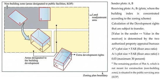
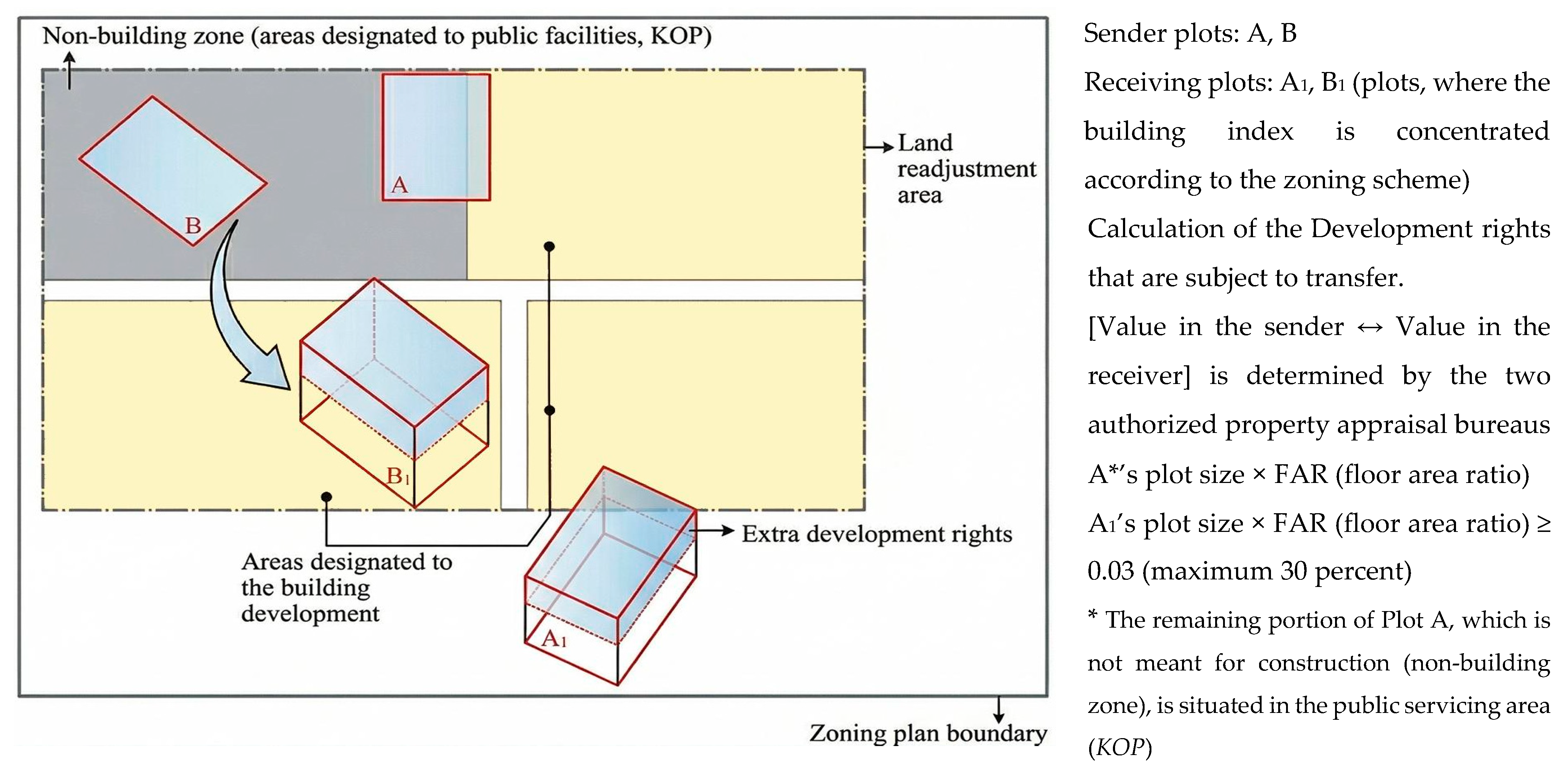
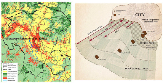
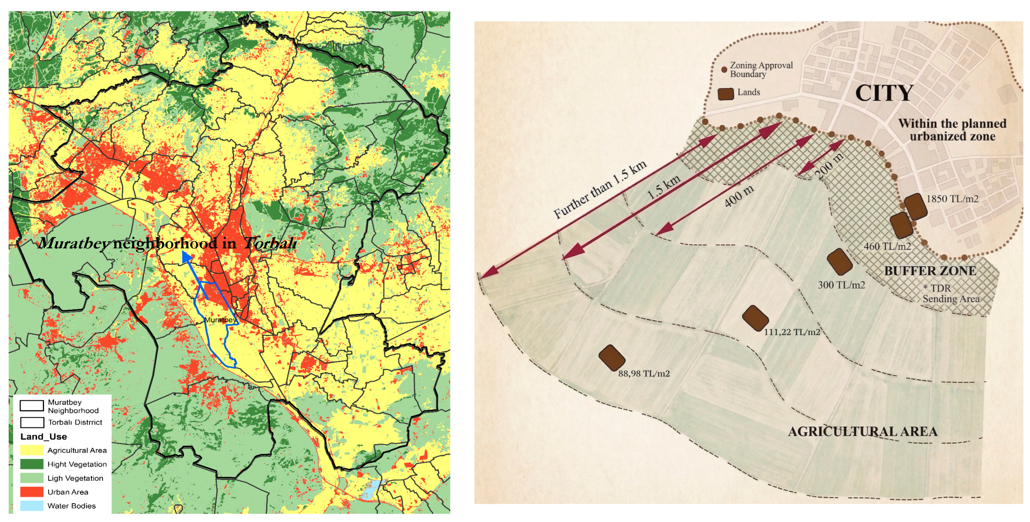
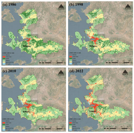
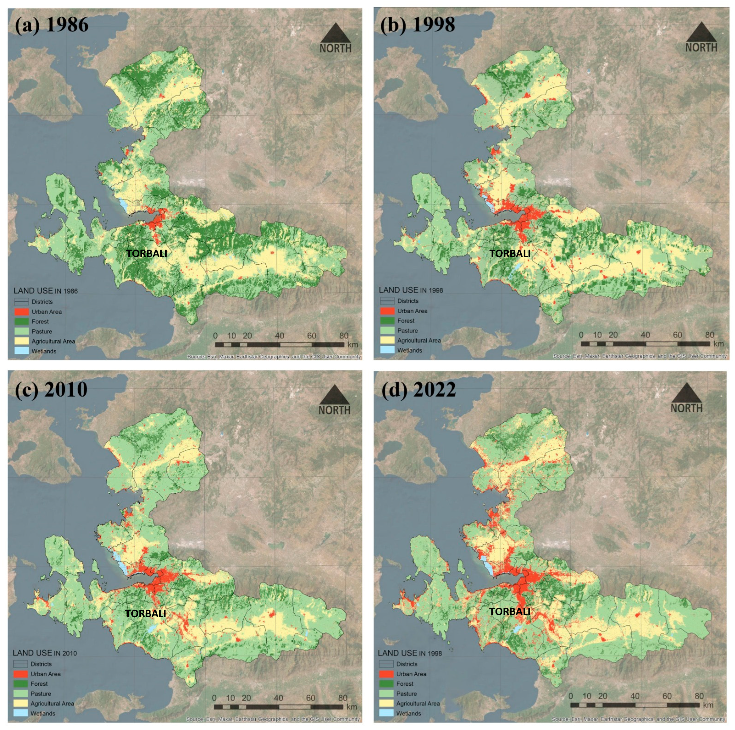
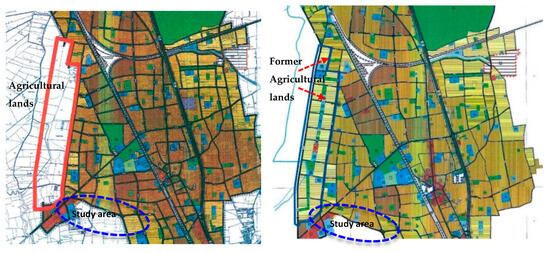
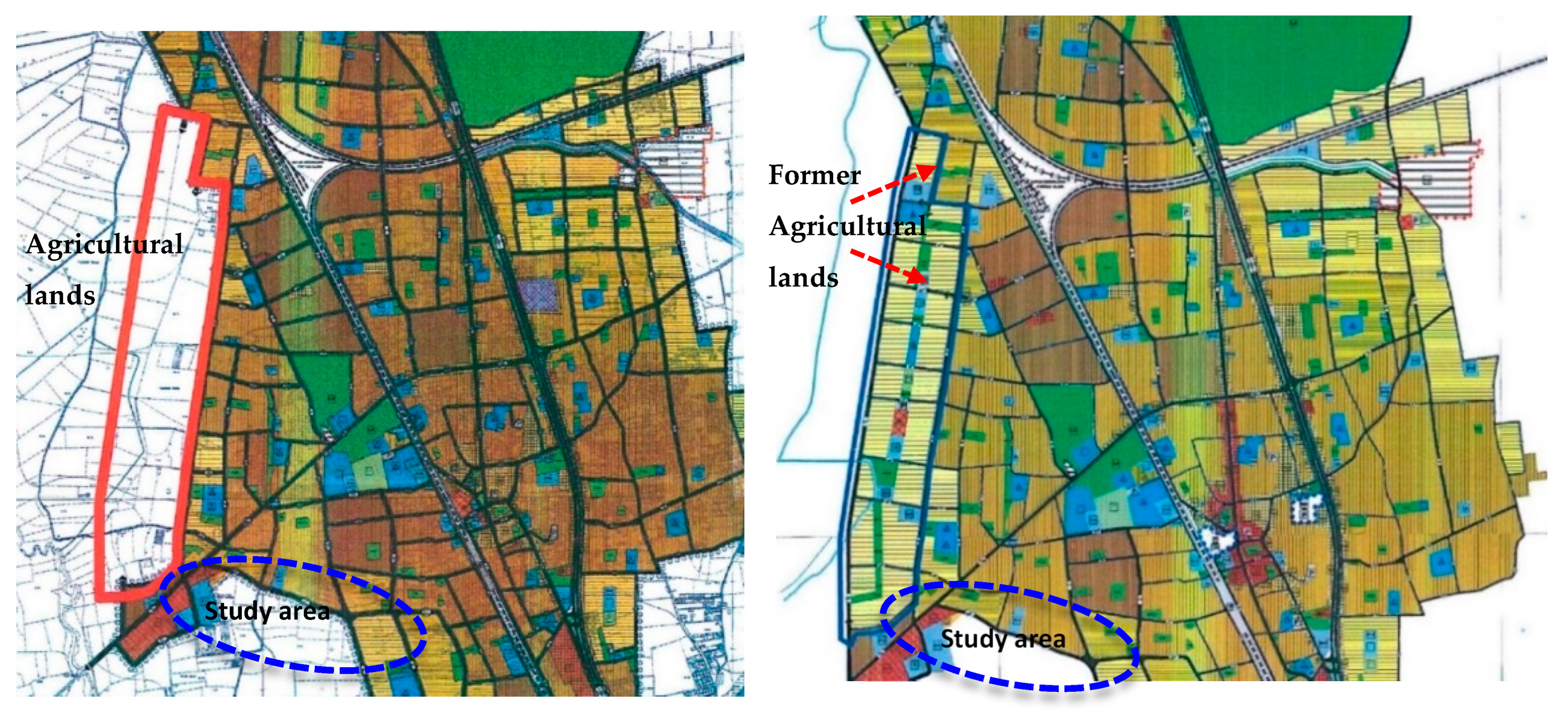
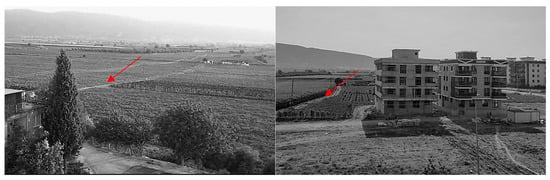
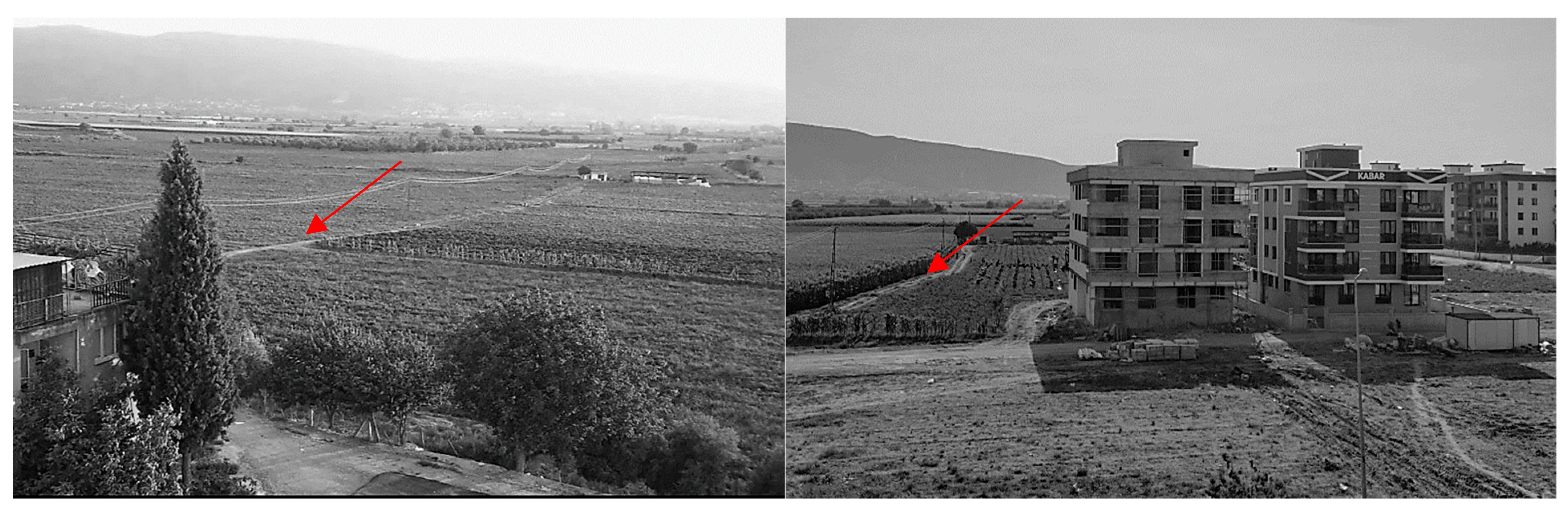
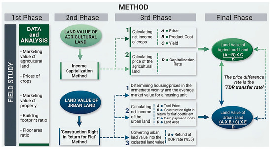
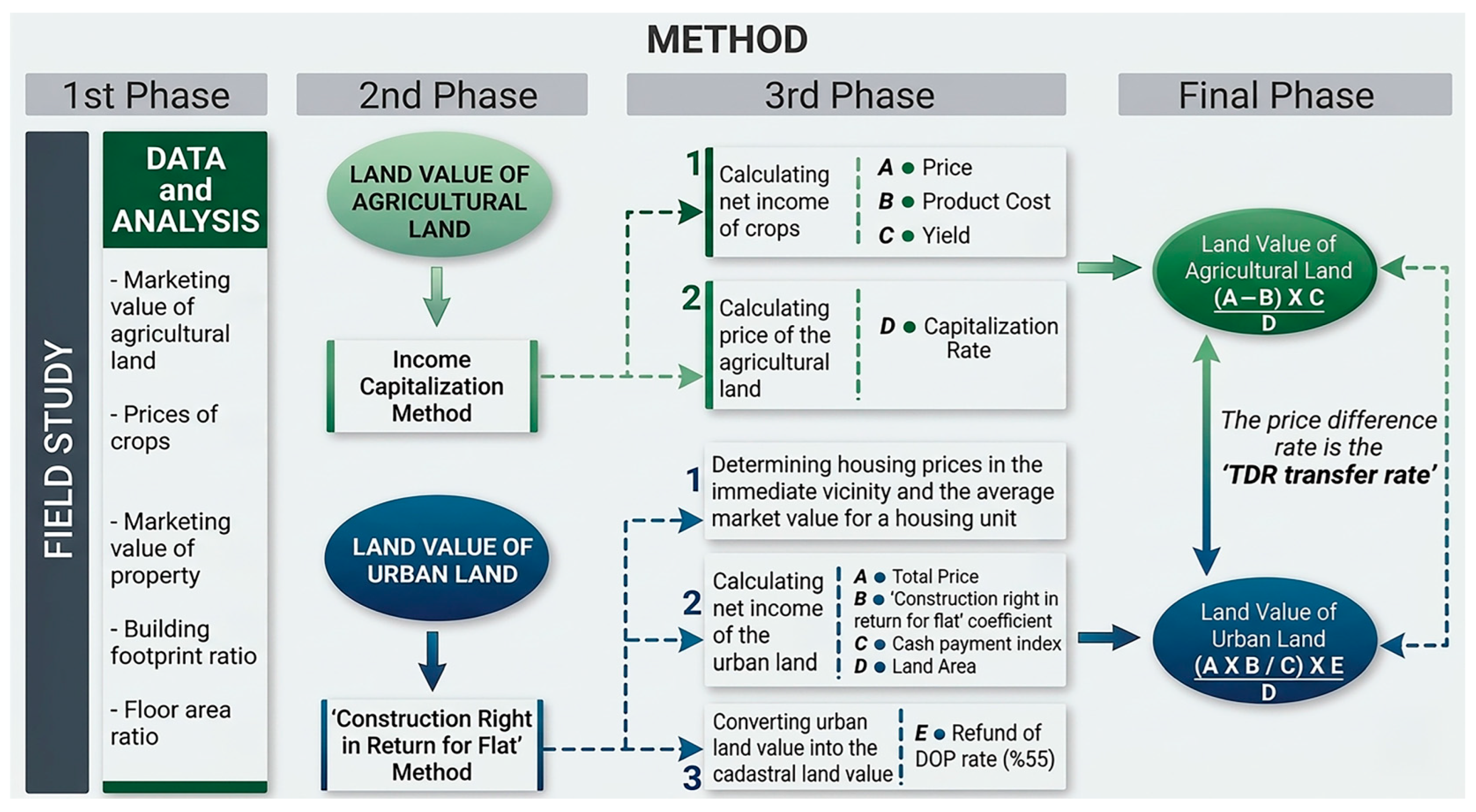
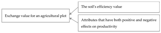
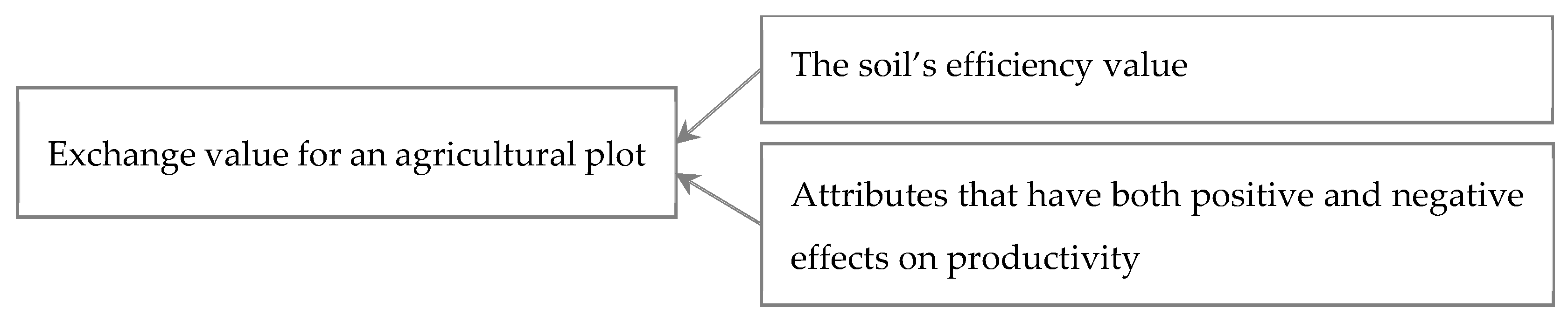
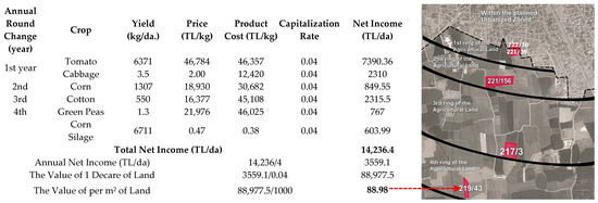
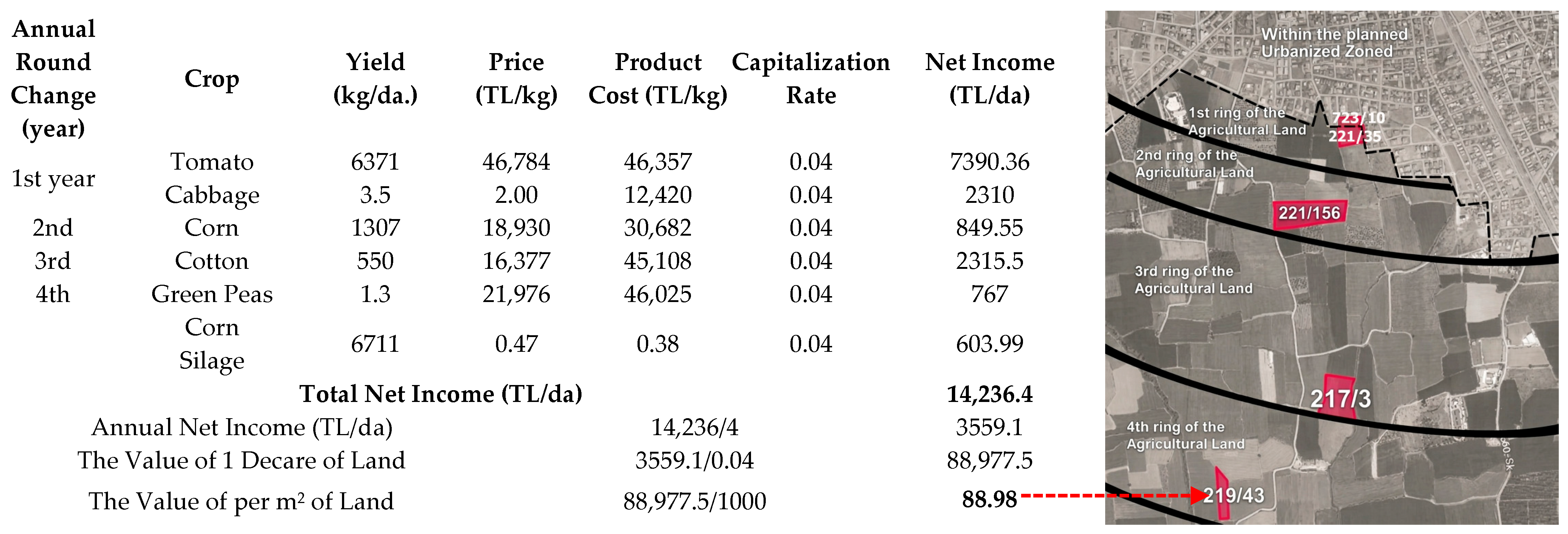
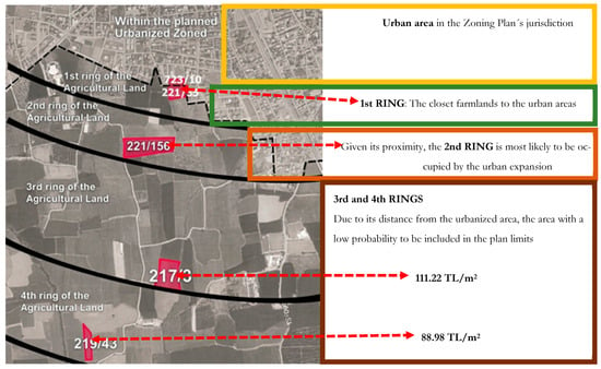
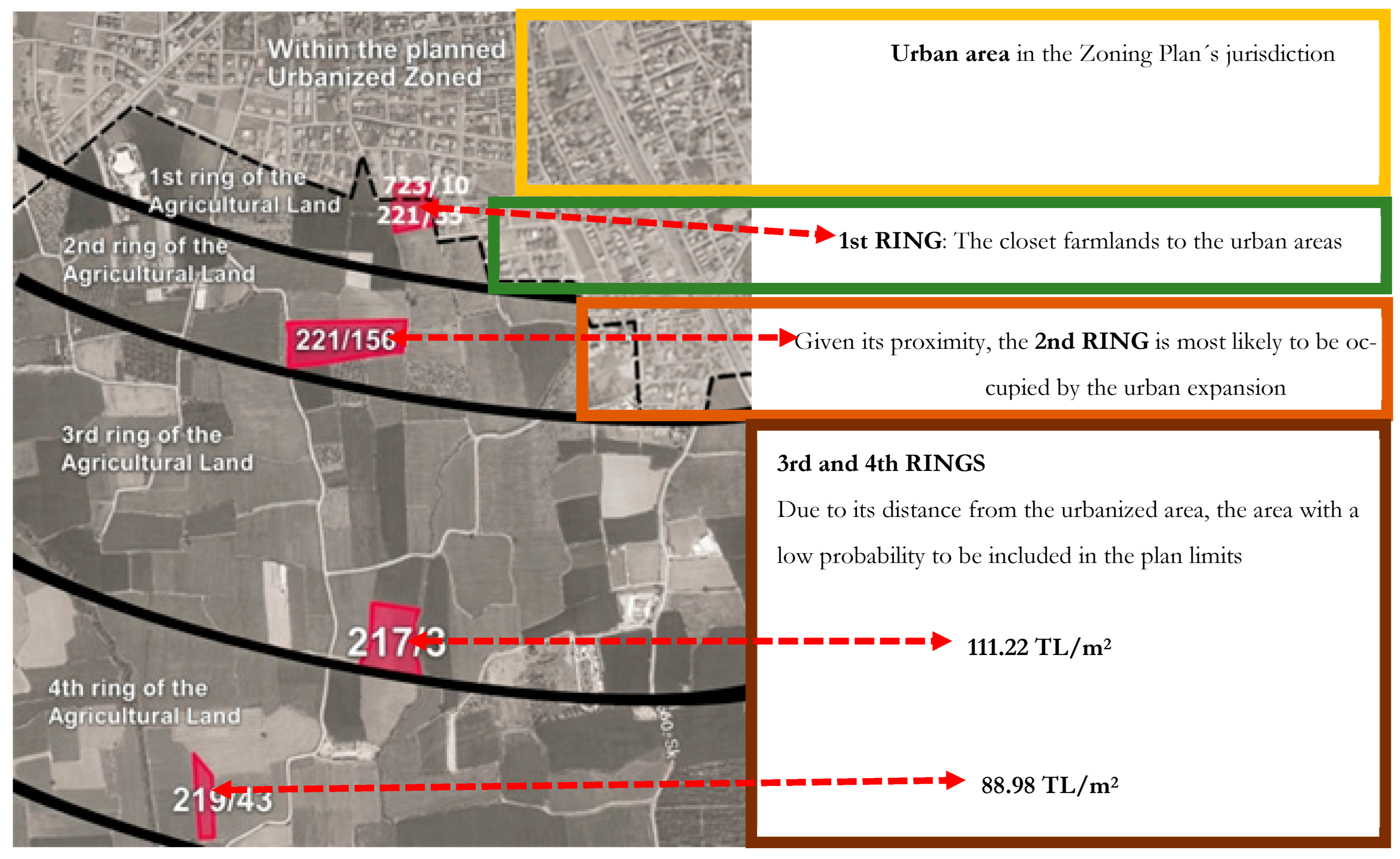
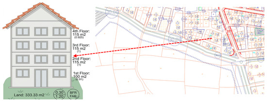
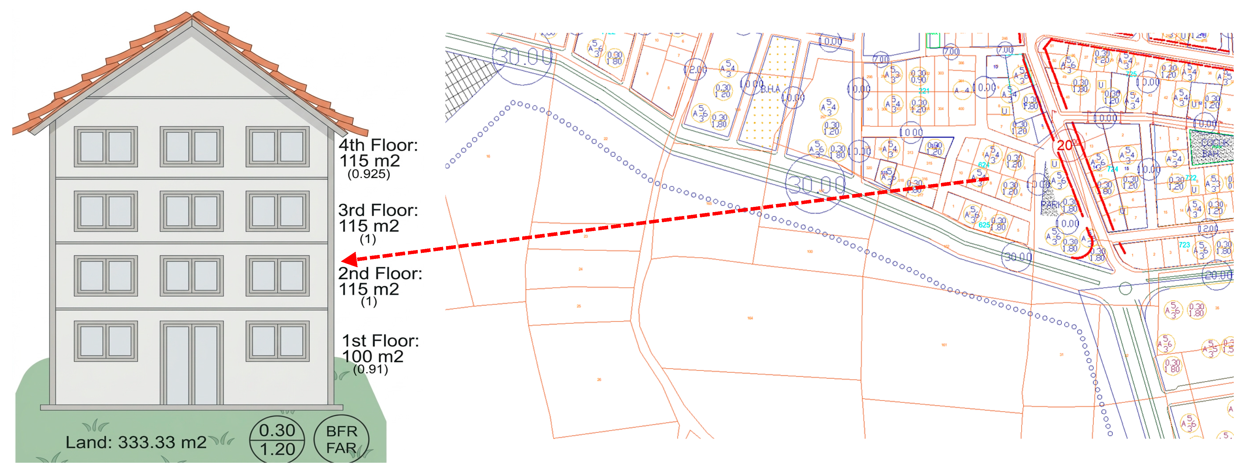
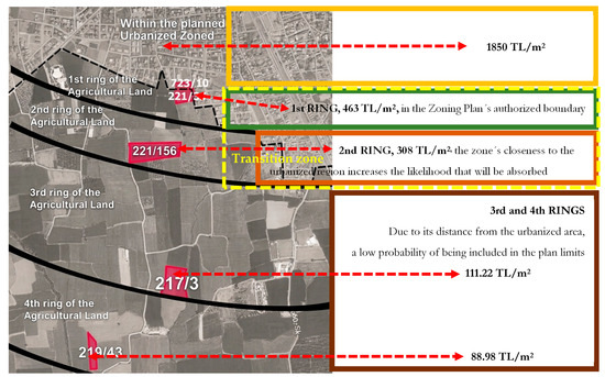
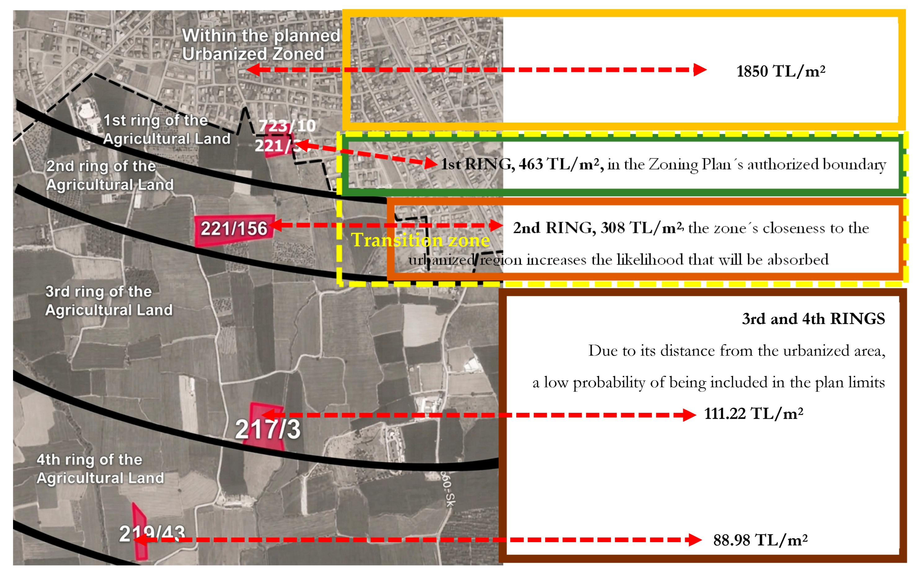

Disclaimer/Publisher’s Note: The statements, opinions and data contained in all publications are solely those of the individual author(s) and contributor(s) and not of MDPI and/or the editor(s). MDPI and/or the editor(s) disclaim responsibility for any injury to people or property resulting from any ideas, methods, instructions or products referred to in the content. |
© 2026 by the authors. Licensee MDPI, Basel, Switzerland. This article is an open access article distributed under the terms and conditions of the Creative Commons Attribution (CC BY) license.