


Abstract
With the development of geological data analysis and big data technology, intelligent mineral prospectivity mapping (MPM) has become a key direction in the integration of geoscience and artificial intelligence, showing promising applications in the identification and evaluation of strategic mineral resources such as gold. To address the limitations of conventional methods—including insufficient training samples, complex model structures, and weak capability in recognizing anomalous zones—this study proposes an improved convolutional neural network (CNN) approach for mineral prediction. A lightweight, modular CNN structure with repeatable stacking is designed to reduce computational cost while enhancing model robustness and generalization. In addition, a dynamic learning rate scheduling strategy is adopted to optimize the training process, significantly improving convergence speed and training stability. Furthermore, high-probability prediction samples and low-probability background samples are combined to form a new training dataset for regional prospectivity evaluation, yielding a high area under the curve (AUC) score. The method is applied and validated in the Xiong’ershan region, and the predicted high-potential zones account for 30% of the study area and contain 81.4% of the known gold deposits. These results demonstrate the method’s effectiveness in mineral information extraction and blind-area targeting, offering a new approach for mineral prospectivity mapping.
1. Introduction
In the era of big data, reducing risk and uncertainty in decision-making has become a key driver in the development of predictive algorithms. Grounded in the principle of learning from historical observations to anticipate future outcomes, classical mathematical methods—such as linear regression and Bayesian inference—have established the theoretical foundations of data-driven prediction. With the continuous advancement of artificial intelligence and deep learning, neural network architectures have progressed from early perceptrons to more complex forms, including convolutional neural networks (CNNs) and recurrent neural networks (RNNs), providing powerful tools for modeling complex nonlinear relationships [1]. At present, research on neural networks is marked by the parallel progression of algorithmic innovation, interdisciplinary integration, and engineering applications [2,3]. Its applications have expanded far beyond traditional domains such as computer vision and natural language processing, penetrating into fields with high uncertainty, including medical diagnostics, financial risk assessment, and mineral prospectivity mapping (MPM). Particularly in MPM studies, deep learning approaches integrate heterogeneous data sources—such as geological, geophysical, and geochemical data—to automatically extract implicit mineralization controls and spatial correlation patterns, thereby facilitating the identification of concealed deposits and improving the accuracy of target delineation [4,5,6].
Mineral resource formation is controlled by specific geological settings and metallogenic processes, leading to inherently complex and heterogeneous spatial patterns. Within a single metallogenic period, mineralization styles may vary across different regions, whereas within the same spatial domain, the intensity and expression of mineralization may evolve markedly through successive metallogenic stages [7]. These multiscale, nonlinear, and stage-dependent characteristics give rise to highly complex spatiotemporal structures in geological data, and different mineral prospectivity mapping methods place emphasis on information representation and utilization in distinct ways [8]. In addition, limited exploration coverage, the uneven spatial distribution of orebodies, and the inherent complexity and variability of mineralization collectively impose significant constraints on exploration effectiveness and efficiency. Although increasing exploration intensity may enhance discovery success rates, it is typically associated with substantial cost escalation. Consequently, achieving an optimal balance between exploration expenditure and prospecting efficiency remains a central challenge in mineral exploration.
MPM fundamentally seeks to uncover latent spatial associations and metallogenic patterns from high-dimensional, discrete geological data [9]. While traditional statistical methods and classical machine learning models have demonstrated a certain capacity for mineral favorability assessment, the former depend strongly on prior geological assumptions and thus exhibit limited generalization ability. These approaches are primarily data-driven, learning statistical relationships between known mineralization occurrences and multidimensional features to support prediction. However, they are largely confined to pattern recognition in feature space and therefore remain limited in capturing the complex nonlinear processes and spatial structural controls inherent to metallogenesis [10]. In contrast, deep learning-based prospectivity methods utilize multilayer neural network architectures to automatically capture high-order nonlinear relationships inherent in geological, geophysical, and geochemical data, iteratively refining feature representations and predictive performance during training. Consequently, they constitute an intelligent and advanced paradigm for data-driven MPM [11]. However, most existing deep learning-based mineral prospectivity studies rely on generic network architectures. In particular, conventional convolutional neural networks often attenuate latent structural relationships among variables during feature flattening and fully connected processing, thereby limiting their capacity to represent geological spatial structures and diminishing the interpretability of the prediction results from a geological perspective [12,13]. Against this background, it is essential to develop a deep learning architecture that balances modeling efficiency for tabular data with the capacity to preserve and represent latent structural information. Although multisource geological data within a study area are typically organized in tabular form, implicit inter-variable relationships reflecting metallogenic processes remain embedded in these datasets. By incorporating tabular data into a lightweight, repeatedly stacked convolutional neural network (CNN) framework, local associations among variables can be progressively extracted and nonlinear coupling relationships effectively captured, while maintaining overall parameter scale within manageable bounds. Compared with conventional network designs that rely heavily on deep, fully connected layers, lightweight repetitive convolutional architectures offer distinct advantages in parameter sharing, training stability, and adaptability to limited samples. This provides a more robust and rational technical solution for MPM based on high-dimensional tabular geological data.
Guided by integrated information-based mineral prospectivity theory, this study targets gold mineralization prediction in the Xiong’ershan area and develops a lightweight two-dimensional fully convolutional network (FCN) specifically designed for mineral prospectivity mapping. Unlike previous studies that primarily focused on comparing model performance, this study aims to explore the applicability of a lightweight CNN framework for capturing spatial associations embedded in tabular geological data. The proposed architecture eliminates fully connected layers and achieves coordinated optimization between modular feature extraction components and data reconstruction mechanisms, thereby establishing an end-to-end modeling framework that transforms discrete geological attributes into latent spatial representations and prospectivity outputs. By preserving spatial neighborhood relationships among geological variables, the model enhances generalization capability under small-sample conditions and provides a computationally efficient and robust framework for the precise delineation of mineralization targets. The methodological workflow comprises three principal stages: (1) constructing a conceptual geological prospecting model grounded in ore-controlling factors to identify critical metallogenic elements and establish a deposit-scale predictive framework; (2) defining the prediction domain within this framework, extracting key ore-controlling variables, and optimizing the configuration of predictive factors; and (3) selecting an appropriate network architecture in accordance with the geological characteristics of the study area to translate the conceptual prospecting model into a quantitative, data-driven prediction system. Through the development of a CNN-based mineral prospectivity model, the proposed approach enables refined identification of mineral enrichment zones. Beyond improving spatial targeting accuracy, the method contributes to the optimization of exploration strategies, increases discovery efficiency, and reduces both geological uncertainty and exploration costs, thereby offering a technically sound solution for data-driven mineral resource assessment.
2. Geologic Setting
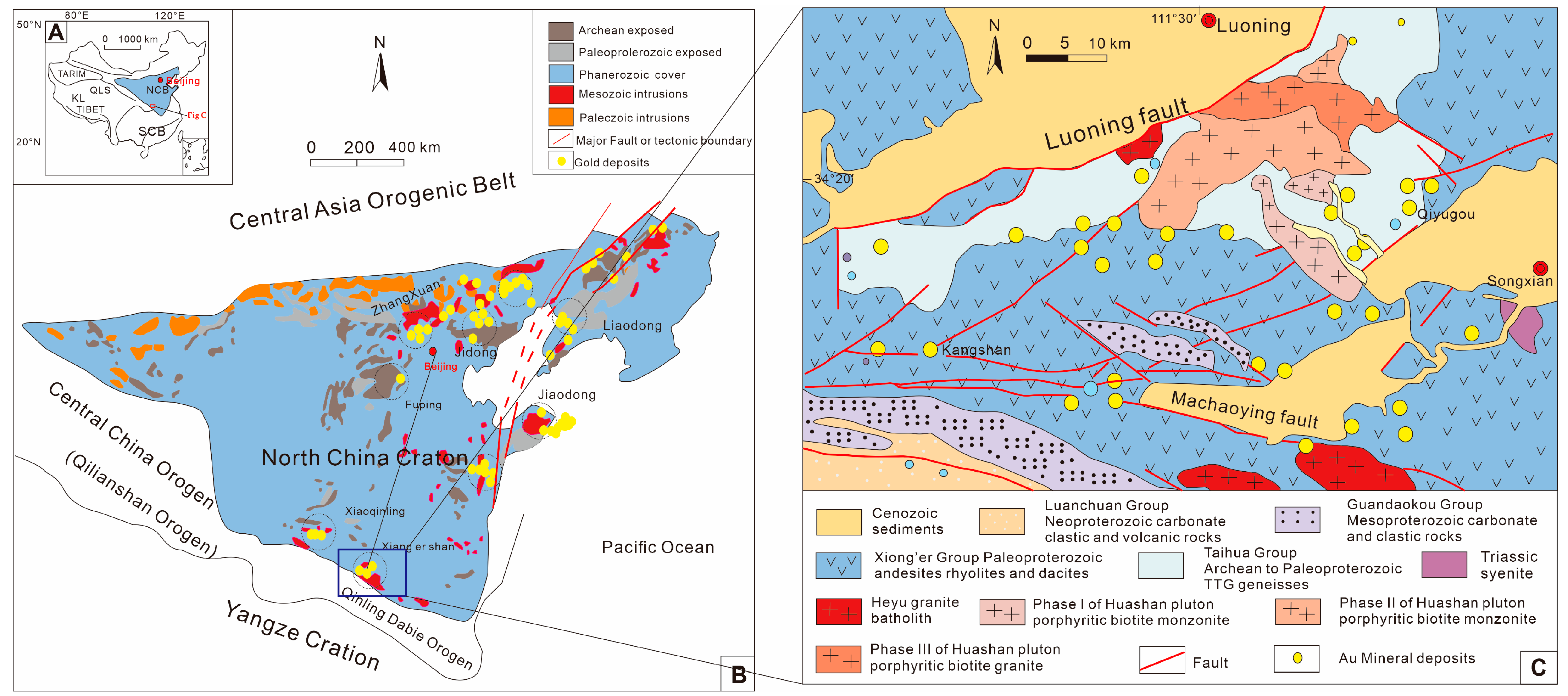
The study area is situated along the southern margin of the North China Craton and tectonically belongs to the northern segment of the Qinling Orogenic Belt, positioned between the North China and Yangtze cratons. To the north, the North China Craton is bordered by the Central Asian Orogenic Belt, whereas to the south it is principally adjacent to the Qilian and Qinling–Dabie orogenic belts (Figure 1). This tectonic framework encompasses several major gold mineralization districts, including Liaodong, Zhangxuan, Jidong, Jiaodong, Luxi, Xiaoqinling, and Xiong’ershan. Since the Paleoproterozoic, this region has experienced multiple phases of tectonic deformation, magmatic activity, and hydrothermal processes, which together have created favorable geological conditions for gold mineralization [14,15].
The Xiong’ershan area is notably enriched in molybdenum, gold, lead, zinc, and silver and represents an important nonferrous metal metallogenic province, characterized by substantial resource potential, diverse mineralization styles, and considerable economic significance [16].
The region is characterized by a typical basement–cover stratigraphic architecture. The principal exposed stratigraphic units, arranged in ascending chronological order, comprise: (1) the Taihua Group (Late Archean–Early Paleoproterozoic); (2) the Xiong’er Group (Mesoproterozoic); and (3) the Guandaokou and Luanchuan groups (Neoproterozoic), although the latter exert only limited control on local mineralization [17]. Tectonically, the study area lies within the Xiong’ershan foreland tectonic block, where the regional structural framework is defined by near-east–west-trending detachment systems and metamorphic core complexes. These detachment faults have produced an unconformable relationship between the Taihua and Xiong’er groups. Fault structures in the area predominantly trend east–west, northeast, northwest, and nearly north–south. Among them, the east–west-striking Machaoying fault zone is the most prominent, consisting of multiple subparallel faults and associated fracture systems. During the tectonic evolution of the North China Block, the Machaoying fault zone experienced at least five major deformation stages and seven distinct tectonic episodes [18]. Around 500 Ma, the fault zone underwent a significant thrusting event that produced ductile deformation in portions of its rocks. Subsequently, at approximately 120 Ma, brittle deformation affected the fault rocks, establishing the fault zone as a primary ore-controlling and mineral-hosting structure in the region [19,20]. The near-northeast-trending fault zones consist of a set of nearly evenly spaced faults, each roughly 2 km apart, whose formation is closely linked to the activity of the Machaoying fault zone; mineralization enrichment is commonly observed along these faults [21,22]. In contrast, near-northwest and near-north–south faults are less abundant in the area. The near-northwest faults are primarily represented by two structures in the northwest, whereas the near-north–south faults are restricted to the eastern and western margins of the Xiong’ershan area, with the largest exposed fault located west of Longbo, along the contact between the Taihua and Xiong’er groups. Since the Paleoarchean, the region has experienced frequent, multi-phase magmatic activity. Archean magmatism was dominated by intermediate-to-mafic volcanic eruptions, followed by widespread metamorphism of the protoliths induced by subsequent plate compression [23,24]. Paleoproterozoic magmatism was dominated by intermediate to acidic volcanic activity, producing extensive andesitic volcanics (Xiong’er Group volcanic rocks), accompanied by late-stage mafic dike intrusions. Mesozoic magmatic activity, closely associated with the major metallogenic flare-up along the southern margin of the North China Craton, represents the most significant magmatic event linked to mineralization in the region, supplying critical thermal energy for ore formation [25]. Triassic magmatism is marked by the emplacement of intermediate to shallow-seated alkaline plutons and dikes, including the Mogou pluton and hornblende diorite dikes within the Gongyu gold district [26]. During the Yanshanian orogeny, the Xiong’ershan area developed numerous small porphyry bodies, stocks, and dikes, as well as large, widely exposed granite massifs, including Wuzhangshan, Huashan, Heyu, and Taishanmiao.
Figure 1.
(A) Tectonic map of China, showing the location of North China Craton; (B) Tectonic subdivision of the North China Craton, showing the location of the Xiong’ershan area [25]; (C) Geological map of the Xiong’ershan ore concentration area (modified by [26,27,28,29]).
The formation of ore deposits is governed by multiple geological processes, including tectonic evolution, magmatic–hydrothermal activity, and material migration, resulting in highly complex and nonlinear system responses. Even under similar geological and metallogenic conditions, the occurrence and scale of ore deposits may vary significantly, and this inherent variability further complicates accurate metallogenic prediction [30,31]. Therefore, in metallogenic prediction, it is necessary not only to rely on genetic studies of typical ore deposits but also to strengthen the comprehensive evaluation of multisource data, including geophysical and geochemical information within the study area, and to construct a regional-scale, comprehensive prospectivity model guided by metallogenic regularities. By converting the prospectivity model into quantifiable feature layers, the standardized representation and integration of metallogenic information are achieved, providing a foundation for quantitative prediction. This comprehensive information prospectivity model can guide both qualitative understanding and quantitative analysis of the study area. Its core lies in the systematic processing and interpretation of multisource data, including geological, geochemical, and geophysical datasets, to identify and optimize effective prospecting information, screen key predictive factors, and ultimately enable the quantitative prediction of metallogenic potential through mathematical modeling [32,33]. In previous studies [28], the study area has generally been classified as an orogenic gold-related hydrothermal system. Based on this framework, a comprehensive prospectivity model was developed using 16 predictive variables linked to gold mineralization. These variables used to construct the mineral prospectivity model (Table 1) include the distance to related rock masses; distance to faults; fault strike; fault intersection density; geochemical single-element concentrations of Au, Ag, Mo, Pb, Zn, W, Hg, Sb, and As; geochemical multi-element assemblages represented by PC1 and PC2; and aeromagnetic data.
Table 1.
Quantitative geological prospectivity model of the gold deposit in the Xiong’ershan area.
3. Methodology
3.1. Datasets
Given the limited availability of original ore occurrence data, direct model training is prone to poor generalization [34]. Therefore, data augmentation is necessary to enhance model robustness. In the field of computer vision, mainstream data augmentation techniques typically involve geometric transformations, such as rotation, translation, and cropping of raw data. However, due to the strong spatial dependence and heterogeneity of geoscientific data, these techniques are often unsuitable for geological applications [35]. For this reason, it is necessary to develop a data augmentation strategy that is highly compatible with the diverse geological attributes and accounts for the spatial characteristics of geoscientific data in order to optimize model performance and enhance the reliability of prediction results. For the construction of the training dataset, we adopted the knowledge-driven synthetic minority over-sampling technique (K-SMOTE), which is based on the classic synthetic minority over-sampling technique (SMOTE) and incorporates geological knowledge constraints [28,36]. We generated an 1845-sample training dataset (KSM) using K-SMOTE and an 1800-sample counterpart (SM) with the original SMOTE method and then trained the model separately on these two datasets. For all training procedures, the ratio of the training set to the test set was set at 2:8.
3.2. Knowledge-Driven Synthetic Minority Over-Sampling Technique (K-SMOTE)
To construct a geologically consistent and class-balanced dataset, a knowledge-constrained K-SMOTE strategy is employed. High-confidence positive and negative candidate samples are first defined as
where x denotes the feature, is the prospectivity function, and D(x) is the distance to major structures; and are high-confidence thresholds for selecting positive and negative samples, respectively; and defines the minimum separation distance from known mineral occurrences.
Synthetic samples are then generated via a K-nearest neighbor interpolation scheme:
With the same geological constraints applied to retain valid samples, yielding a balanced dataset D with . The overall process can be compactly expressed as
3.3. Convolutional Neural Network (CNN) Algorithm
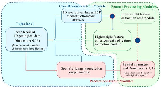
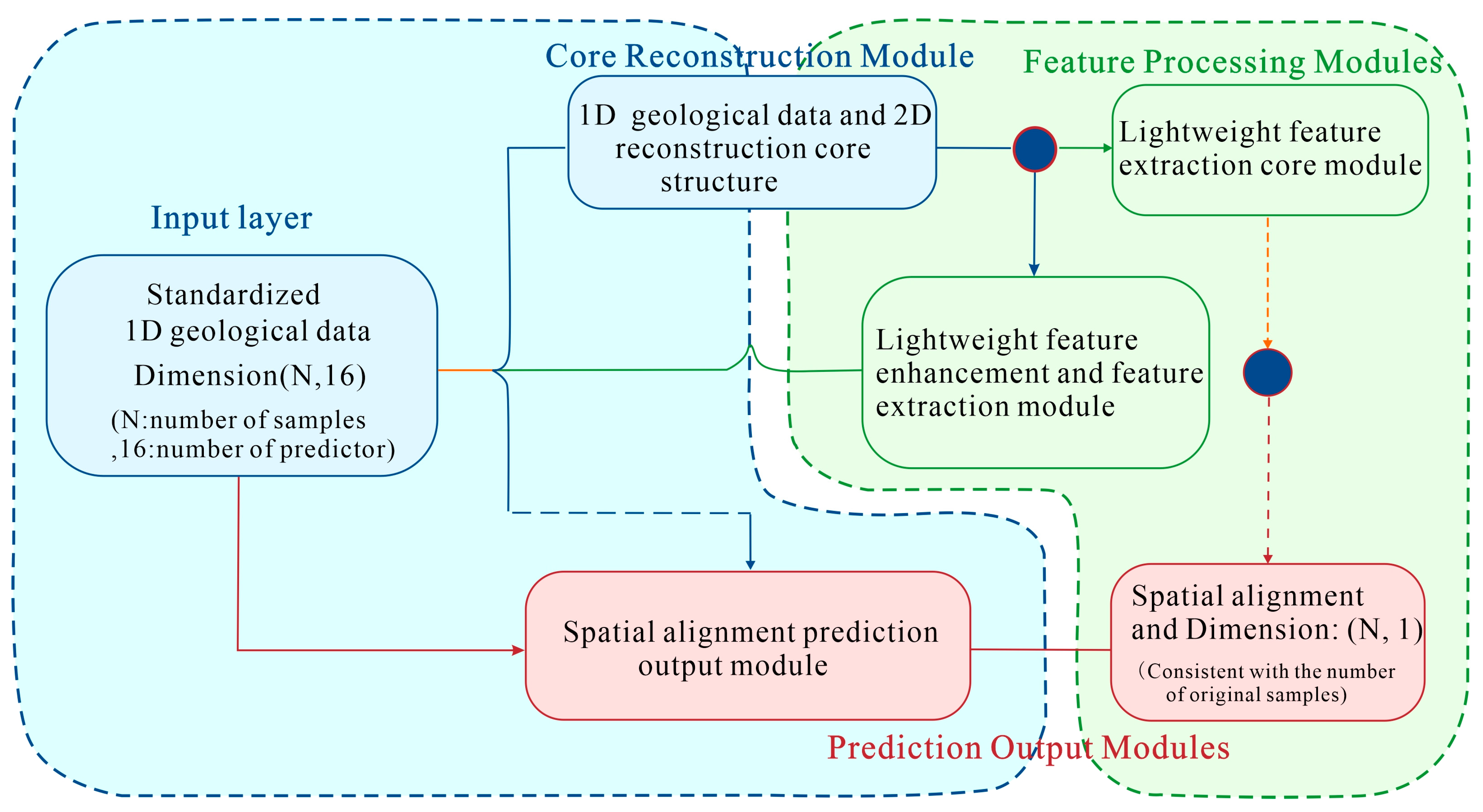
Convolutional neural networks (CNNs) are a class of neural networks specifically designed to process data with grid-like structures. Instead of conventional matrix multiplication, CNNs employ convolution operations within network layers, making them a representative algorithm in deep learning [37]. They have been widely applied to various computer vision tasks, including image classification, object detection, and image segmentation, as well as to speech recognition. In recent years, CNNs have also emerged as a research focus in the field of mineralization prediction [38,39,40]. The 2D CNN model proposed in this study is constructed based on the concept of fully convolutional networks (FCNs), which eliminate the fully connected layers and feature-flattening operations typical of traditional CNNs. Its core framework comprises three components: the “1D Geological Data to 2D Reconstruction Module,” the “Lightweight Feature Extraction Module,” and the “Spatial Alignment Prediction Output Module” (Figure 2). The specific process is as follows.
Figure 2.
Core architecture and training workflow of the 2D CNN model.
First, the original tabular data are normalized and reconstructed into a regular 2D matrix according to feature dimensions. To capture the inherent spatial correlations in the multisource geological data, 1D feature vectors are reconstructed into geologically meaningful 2D matrices. Guided by the mineral systems framework, features are arranged according to their roles as source, pathway, and trap elements (Table 1). Genetically related variables—such as Au together with its pathfinder elements Ag, Sb, and Hg and structural features aligned with elemental anomalies—are adjacently arranged to preserve local spatial associations, allowing convolution operations to effectively model ore-forming processes. The reconstructed matrix is then fed into the 2D-CNN model, which consists of convolutional layers, pooling layers, and output layers. Hierarchical feature learning enables the model to extract high-order geological associations from complex data. Through layer-by-layer convolution, the network automatically learns potential high-order feature combinations, enabling a nonlinear mapping from the original feature space to the abstract representation space.
During the model training phase, the cross-entropy loss function is employed, with parameters optimized via the Adam algorithm within the Python 3.9.2, due to its robustness in handling sparse and heterogeneous geoscientific data. The learning rate plays a critical role in controlling convergence behavior [41]. To balance convergence speed and stability, a step-wise decay schedule is adopted:
where is the initial learning rate, is the learning rate at epoch t, is the decay factor, and s denotes the decay step. This strategy enables rapid convergence in early iterations and stable refinement in later stages. In addition, to further improve generalization and training stability, batch normalization (BatchNorm) and early stopping are incorporated.
Through this training strategy, the 2D-CNN effectively captures multiscale and multidimensional correlations within tabular geoscientific data, enabling high-precision prediction for binary classification tasks.
- (1)
- 2DCNN Representation of Geological Evidence Factors:
- (2)
- Nonlinear Activation for Feature Enhancement
Subsequent to the convolutional computation, the rectified linear unit (ReLU) is adopted as the activation function to perform a nonlinear transformation on the convolutional features:
where x represents the convolutional response, and f(x) is the activated output.
In this context, the ReLU function sets all negative values to zero, retaining only positive response features. From a geoscientific perspective, this is analogous to emphasizing robust mineralization signals while suppressing background noise: negative or weak anomalies, which may correspond to background areas, are set to zero, whereas positive responses—such as local high Au concentrations or strong magnetic anomalies—are preserved. This allows the model to focus on anomaly-enhanced information of mineralization significance, thereby improving the sparsity and interpretability of feature representations [42].
- (3)
- Batch Normalization (BatchNorm2d): Normalization of Geological Evidence Factor/Predictor Distributions
Batch normalization (BatchNorm) is applied to stabilize feature distributions:
where is the input feature at layer l, and denote the mean and standard of the mini-batch, and and are learnable parameters. This process reduces internal distribution shifts and improves the robustness of feature extraction from heterogeneous geoscientific data.
- (4)
- Mineralization Probability Estimation
The model output is transformed into mineralization probability using a sigmoid function:
where represents the integrated response of all evidential features at spatial location i, and denotes the predicted probability of mineralization occurrence.
- (5)
- Cross-Entropy Loss Function
- (6)
- Model Optimization
Model parameters θ, including convolution kernels and normalization parameters, are updated using
where denotes all trainable parameters, and and are moment estimates of gradients. This optimization process enables the model to learn spatial patterns that distinguish mineralized from non-mineralized regions.
- (7)
- Spatial Reconstruction of Prospectivity
The predicted probabilities are mapped back to the spatial domain:
where P represents the mineral prospectivity map, and corresponds to the mineralization probability at spatial location i. This output provides a continuous spatial prediction of mineral potential across the study area.
4. Results
4.1. Convolutional Neural Network (CNN) Model Framework
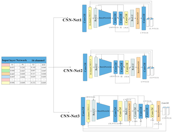
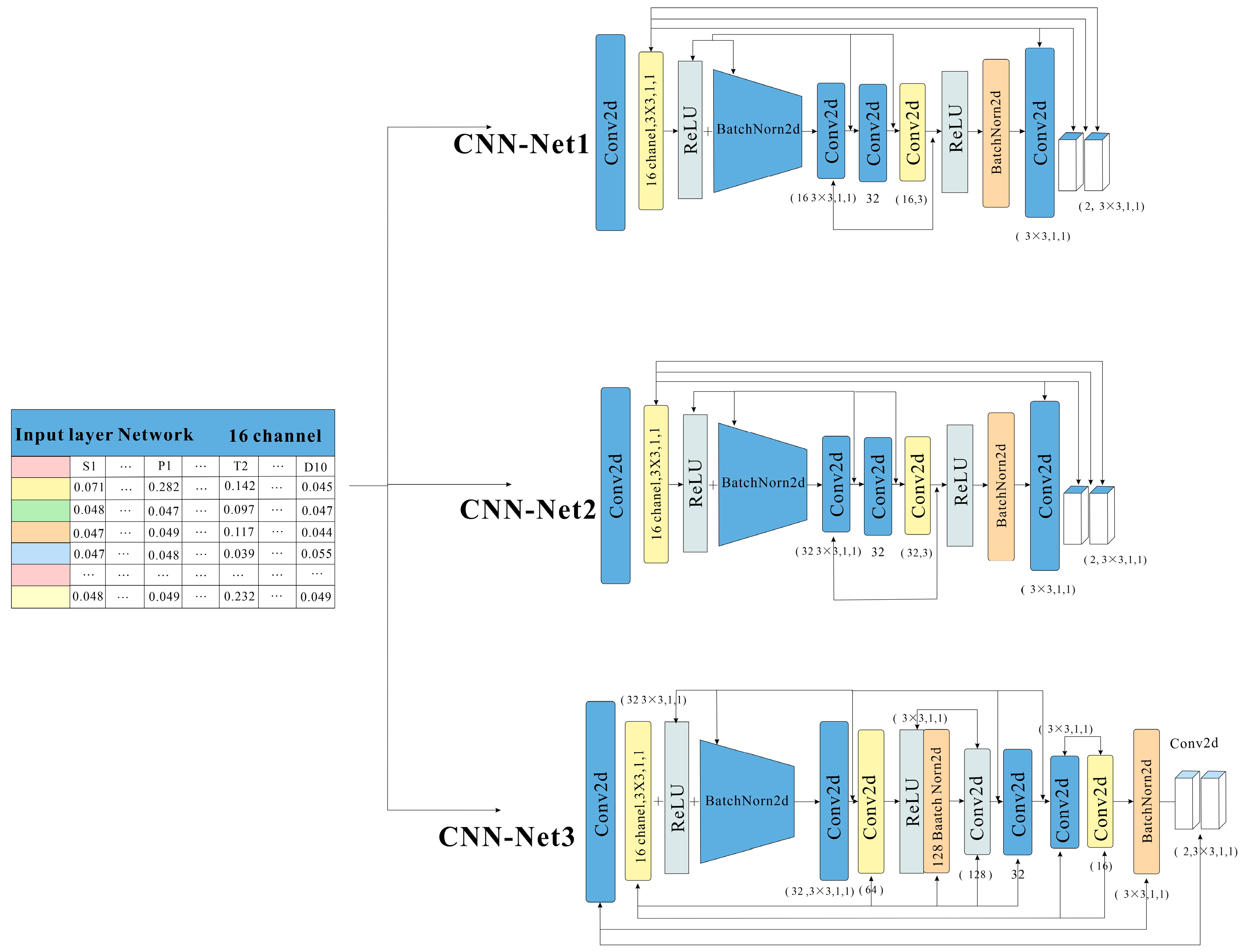
A custom-designed network framework was implemented for the convolutional neural network (CNN) in this study. Based on the characteristics of the study area data (16 predictive variables), three sets of CNNs were developed to investigate the effects of network parameters—such as the number of convolutional layers and learning rate—on the classification and prediction performance across different datasets. The network depths were set to 4, 6, and 10 layers, and the learning rates were selected as 0.1, 0.01, 0.001, and 0.0001 using an exponential scheduling strategy. Each layer comprised a convolutional layer, a ReLU activation function, and a BatchNorm layer (Figure 3). Details are presented in Table A1.
Figure 3.
Framework of a convolutional neural network.
4.2. Analysis of Prediction Results
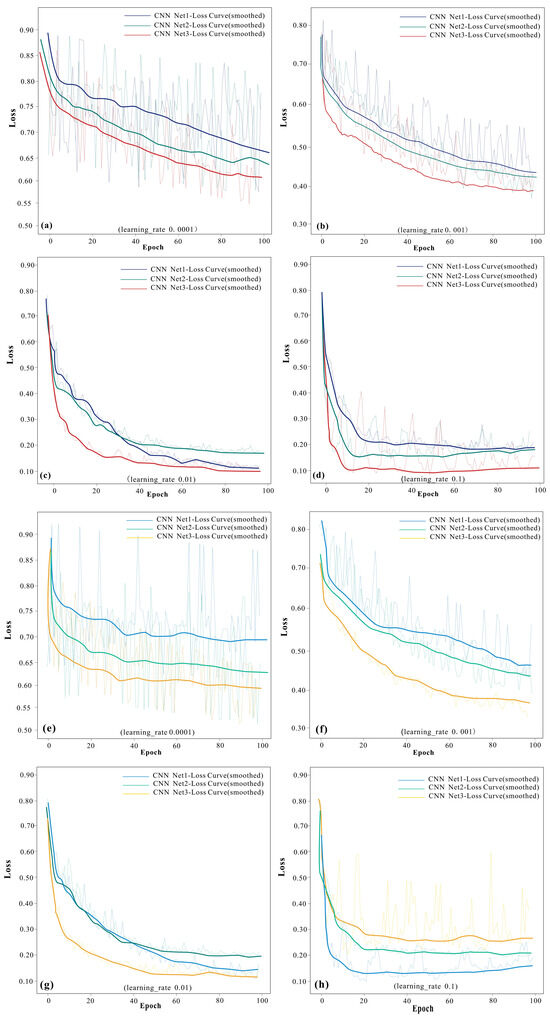
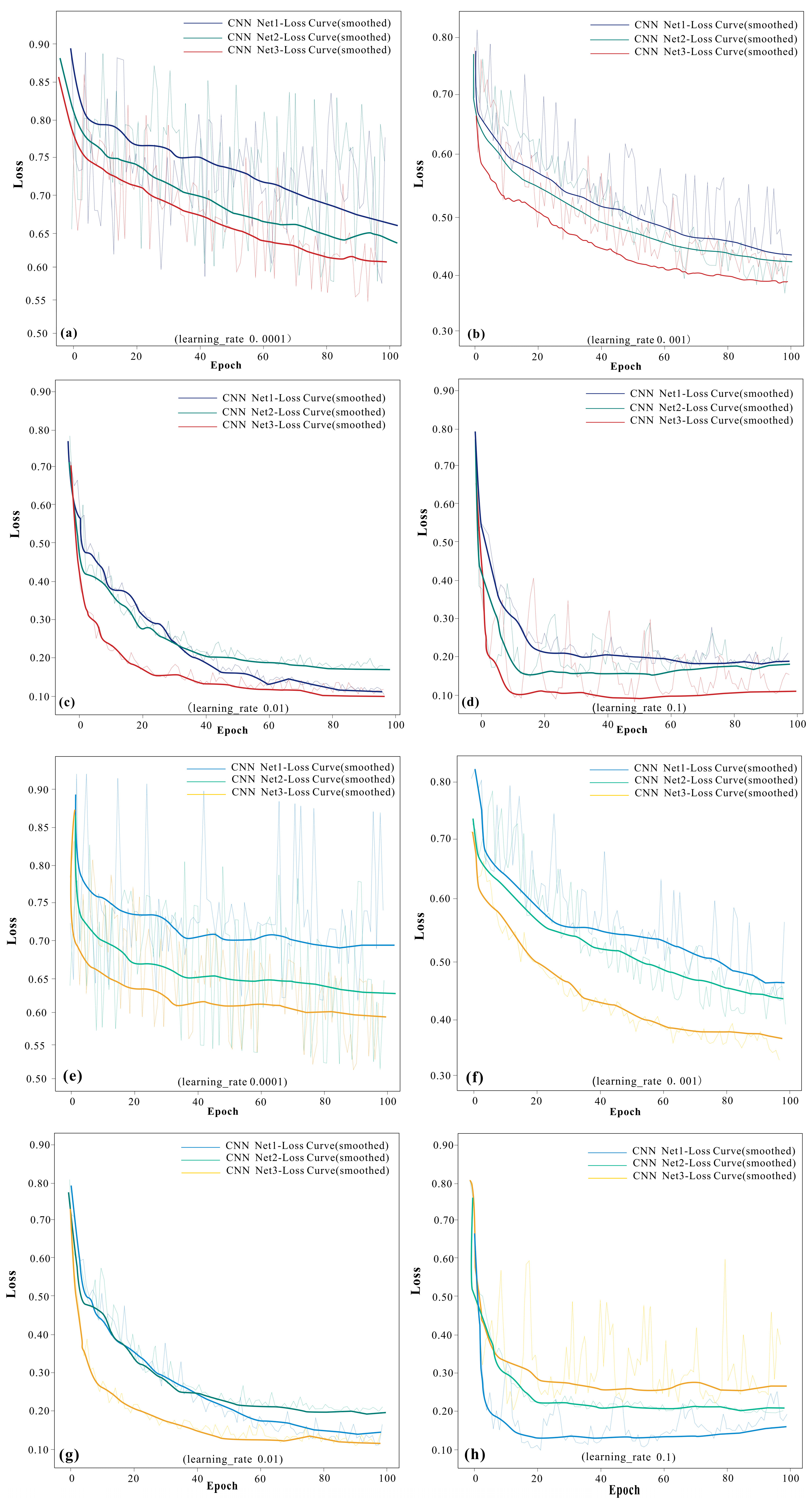
The loss curves were smoothed using a moving average (window size = 5) to suppress stochastic fluctuations and clarify convergence behavior. Through iterative training with different datasets and network architectures in the previous section, a relatively large learning rate exerted a positive impact on the training results of the model when the convolutional neural network (CNN) architecture was shallow. From the perspective of the loss function curves (Figure 4), a learning rate of 0.1 resulted in fast and stable convergence in both the SM and KSM datasets (Figure 4d,h). For the deeper CNN (CNN Net3), the loss function curve exhibited optimal performance when the learning rate was set to 0.01 (Figure 4c,g).
Figure 4.
CNN loss function curve based on SM and KSM datasets ((a–d) are SM datasets; (e–h) are KSM datasets).
It can therefore be concluded that, for mineralization prediction in the Xiong’ershan area, moderately small learning rates are preferable for deeper CNNs, whereas relatively larger learning rates are suitable for shallower networks. Accordingly, a learning rate of 0.1 was adopted for network architectures 1 (CNN Net1) and 2 (CNN Net2) and 0.01 for network architecture 3 (CNN Net3) during model optimization training. Based on these settings, the mineralization probability map of the Xiong’ershan area was generated.
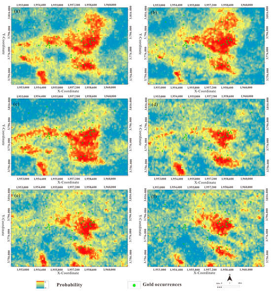
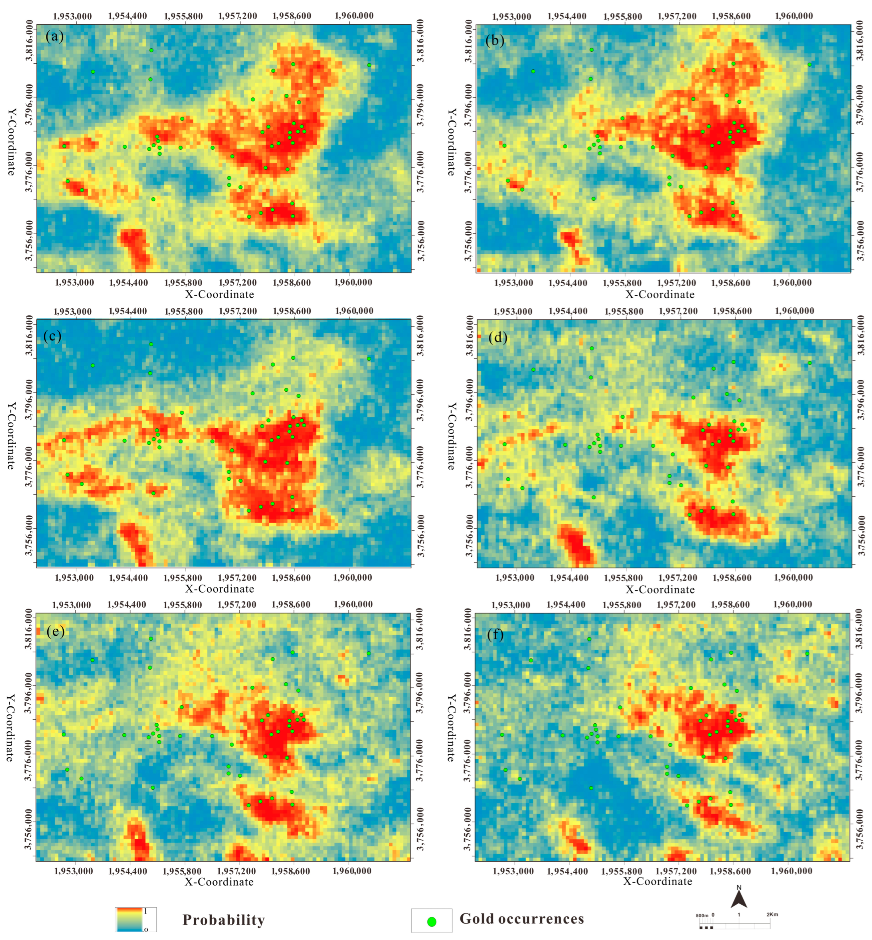
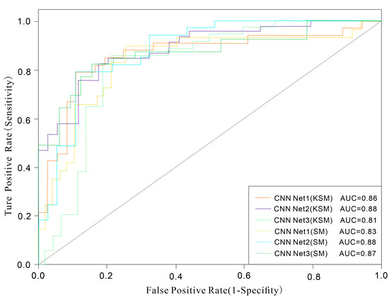
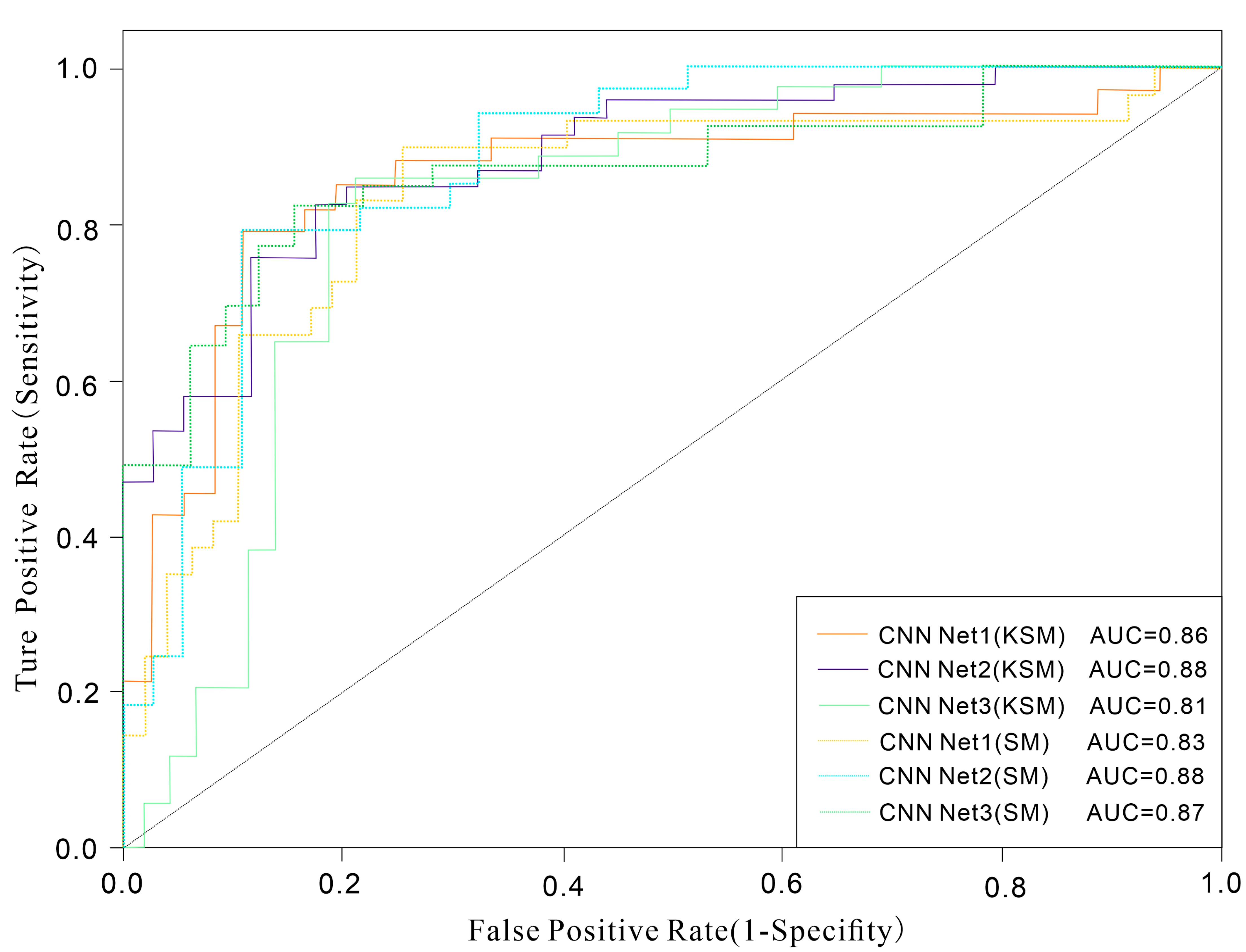
Figure 5a–c show the mineralization prediction results obtained from CNNs with different architectures based on the SM dataset. The high-anomaly zones display a generally consistent spatial distribution. Compared with the predictions based on the KSM dataset, the high-value zones in the SM dataset cover a larger area and are primarily located in regions with relatively dense mineral occurrences, such as around the Huashan rock mass. The mineralization predictions from CNNs with different architectures using the KSM dataset are largely similar, with network architecture 1 (Figure 5d) providing the best correspondence with the locations of known gold deposits. The high-value zones shown in Figure 5e,f align well with the distribution of mineral occurrences, concentrating in four main regions: around the central Huashan rock mass, the northern side of the Heyuyu rock mass in the south, the Shagou–Haopinggou ore concentration area in the west, and the vicinity of the Machaoying Fault in the southwest. As indicated by the receiver operating characteristic (ROC) curves of the prediction results in Figure 6, both datasets evaluated using CNN Net 2 yield identical AUC values, which are also higher than those obtained from CNNs with other architectures.
Figure 5.
Mineral potential map by CNN with the SM and KSM datasets ((a–c) based on the SM; (d–f) based on the KSM).
Figure 6.
ROC curves of the CNN model.
4.3. Evaluation of Prediction Results
The predictive performance of the models was quantitatively evaluated using receiver operating characteristic (ROC) curves. With respect to network depth, on the KSM dataset, CNN Net1 achieved an AUC of 0.86, CNN Net2 reached 0.88, whereas CNN Net3 declined to 0.81. On the SM dataset, the corresponding AUC values were 0.83, 0.88, and 0.87 for CNN Net 1, CNN Net 2, and CNN Net 3, respectively (Figure 6). The results indicate that increasing network depth does not lead to a substantial improvement in training accuracy. By contrast, models employing repeated architectural blocks achieved higher training accuracy than their deeper counterparts, providing important implications for network architecture design in future mineralization prediction studies.
It should be emphasized that this study primarily examines the effects of learning rate, convolutional deepening strategies, and repeated architectural configurations on model performance. In practical applications of convolutional neural networks to mineralization prediction, however, hyperparameter optimization extends beyond the learning rate to include factors such as batch size, activation functions, and network depth. These hyperparameters collectively influence model performance, underscoring the necessity of systematic experimental evaluation for rigorous hyperparameter tuning in subsequent research [43].
4.4. Mineralization Potential Analysis
Finally, to reduce sample ambiguity and improve class separability, a probability-guided sample selection strategy was adopted. Specifically, only high mineralization probabilities (>0.9) within the optimal structural buffer zone and low-probability samples (<0.2) were selected to construct a refined dataset. This process can be regarded as a form of pseudo-labeling or self-training, which has been widely used in semi-supervised learning to leverage high-confidence predictions for model refinement [44,45]. To mitigate the risk of confirmation bias introduced by model-derived labels [46], strict probability thresholds were applied to ensure that only reliable samples were included. Furthermore, this refined dataset was used exclusively for model training, while independent data were reserved for validation, thereby reducing the potential for circularity.
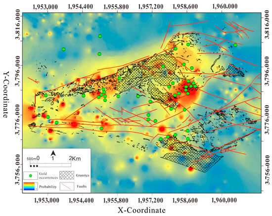
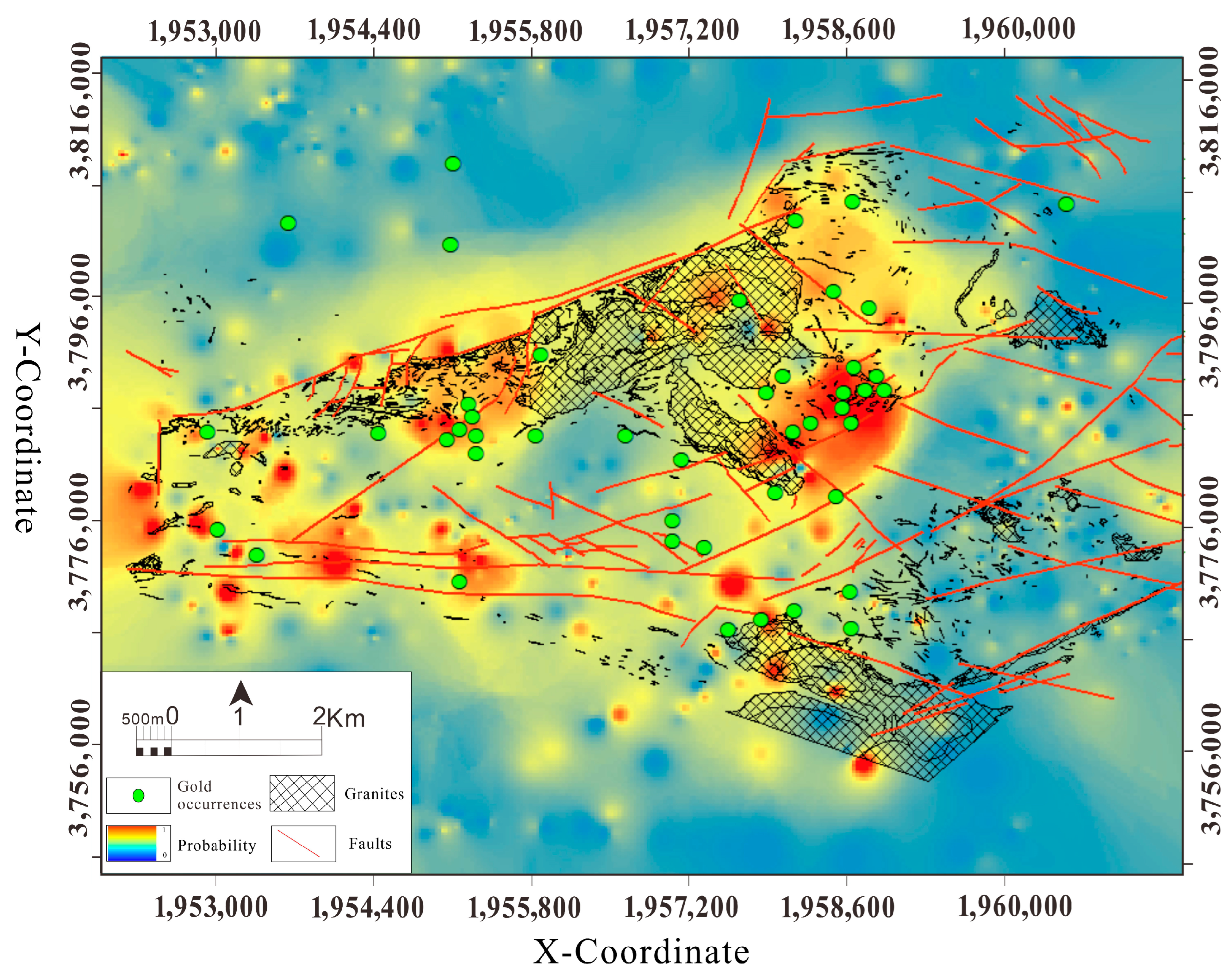
Network 2 of the CNN was subsequently employed to perform mineralization prospectivity analysis for the study area. As shown in Figure 7, the high-probability zones show strong spatial correspondence with known mineral occurrences. The convolutional neural network prediction delineates pronounced zonal anomalies surrounding the granite intrusions and along the faults on the southeastern margin of the Haopinggou ore district in the Shagou area. It should be noted that the objective of this study is not to demonstrate the superiority of CNN over conventional machine learning models but to investigate its potential in representing spatial structural information. Comparative evaluations with traditional models have been reported in our previous studies [28]. Additional localized anomalies have also been identified in the vicinity of the Heyuyu rock mass in the southeastern part of the study area.
Figure 7.
Mineral potential map obtained by the CNN Net 2 model.
The high-prospectivity domains are predominantly aligned along major fault systems and are spatially associated with granite intrusions, indicating that the model effectively captures structurally controlled mineralization signals. Notably, the high-value areas are concentrated in structurally complex segments characterized by fault intersections and intrusive contacts, which are consistent with the recognized metallogenic framework of the region. In contrast, extensive areas distal from major structural corridors and intrusive bodies are characterized by relatively low predicted probabilities, suggesting that the model is capable of discriminating favorable from unfavorable domains at the regional scale and thus represents priority targets for subsequent prospecting and exploration activities.
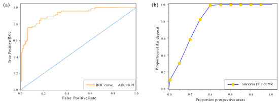
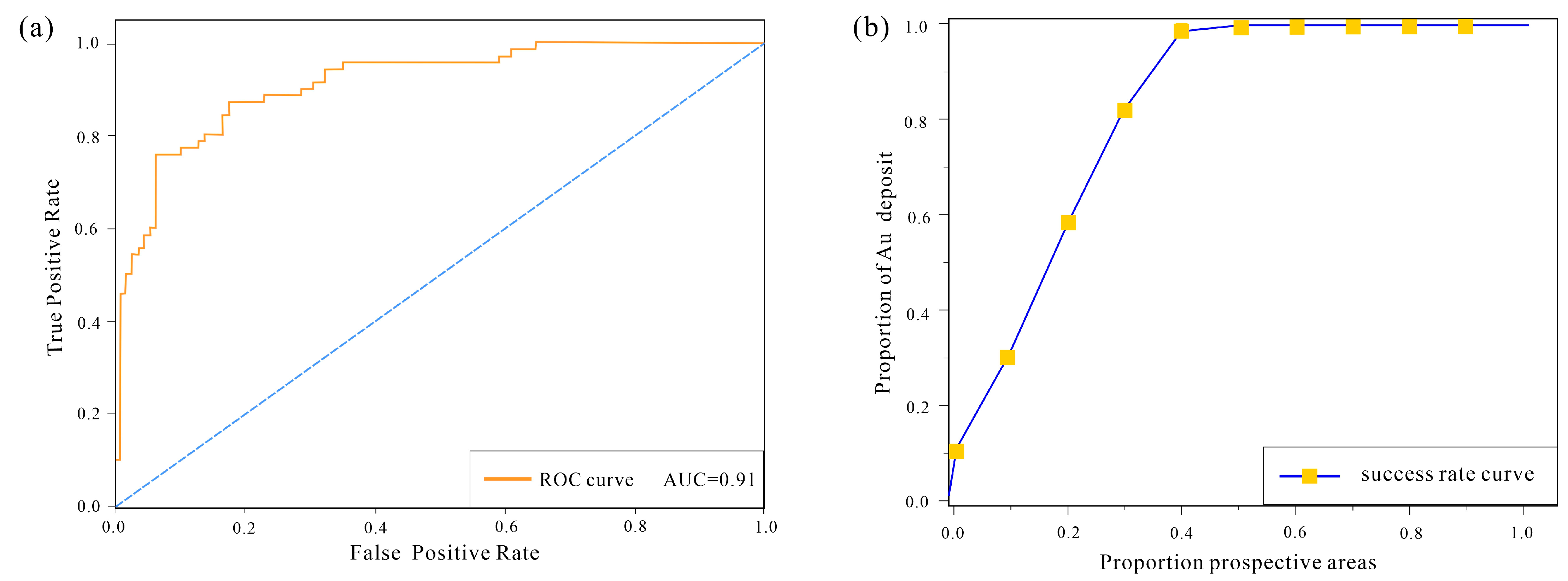
The ROC curve presented in Figure 8 shows that the model achieved an AUC value of 0.91 for this dataset, which is slightly higher than those obtained from the previous two datasets. The corresponding success-rate curve shows that the predicted prospective areas account for 29.8% of the study area while encompassing 82.1% of the known Au deposits. These results demonstrate the feasibility of using samples with high model-predicted probability values as the training dataset.
Figure 8.
(a) ROC curve and (b) success-rate curve of the CNN Net 2 model.
5. Conclusions
Building on previous studies, this research systematically compiled geological datasets and relevant scientific outputs from the Xiong’ershan gold ore concentration area. Guided by metallogenic series theory and the methodology of comprehensive information-based mineralization prediction, a technical framework of “prospecting model construction–multisource data fusion–machine learning-based mineralization prediction” was established to investigate the applicability of convolutional neural networks (CNNs) in mineralization prospectivity assessment.
With the comprehensive information prospecting model serving as prior geological knowledge, a customized two-dimensional CNN architecture was implemented as the data-driven component. This approach established a dual-driven mineralization prediction paradigm integrating knowledge-driven and data-driven strategies, thereby enhancing predictive robustness and reducing uncertainty. The principal conclusions of this study are summarized as follows:
- (1)
- During optimization of the training process using a dynamic adjustment strategy of hyperparameter learning rate, it was found that an excessively large learning rate leads to poor model convergence. Moreover, with the deepening of network depth, a smaller learning rate cannot reduce the model loss rate. For gold deposit prediction in the Xiong’ershan area, the model achieves better convergence when the learning rate is set to 0.1 for network architecture 1 (CNN Net1) and network architecture 2 (CNN Net2), while for network architecture 3 (CNN Net3), a learning rate of 0.01 enables the model to converge quickly and stably.
- (2)
- A lightweight modular CNN structure with repeatable stacking was explored. Based on the prospectivity prediction model for the study area, the effects of different datasets and network architectures on prediction performance were systematically evaluated. Two datasets (SM and KSM) and three convolutional neural network architectures (CNN Net1, Net2, and Net3) were constructed, and model training was performed using the Python 3.9.2 platform. The results indicate that, for predicting gold deposits in the Xiong’ershan area, the repeatably stacked CNN Net 2 outperforms the deeper CNN Net 3. During optimization of the training process using a dynamic learning rate adjustment strategy, it was observed that an excessively high learning rate leads to poor model convergence. Conversely, as network depth increases, a smaller learning rate alone is insufficient to effectively reduce model loss. In this context, optimal convergence is achieved with a learning rate of 0.1 for CNN Net 1 and 2, whereas network architecture 3 requires a learning rate of 0.01 to converge quickly and stably.
- (3)
- Finally, network architecture 2 was selected, and a new dataset was constructed by combining high-probability samples (>0.9) within the optimal structural buffer zone with low-probability samples (<0.2) drawn from the two original datasets. This dataset was then used to perform regional mineralization prediction using convolutional neural networks, yielding favorable results. The study offers practical insights into the design of CNN models for mineralization prediction with similar multisource datasets.
Future research could address the limitations of this study in several ways. Increasing the number and diversity of training samples, particularly through the integration of additional verified mineral occurrences or regional datasets, would improve model robustness. In addition, more rigorous validation strategies, such as spatial cross-validation or independent test regions, could be employed to further assess model generalization. The incorporation of advanced semi-supervised learning techniques may also help mitigate potential bias introduced by pseudo-labeling. Furthermore, integrating geological process-based constraints or physics-informed modeling approaches could enhance the interpretability and geological consistency of prediction results.
Author Contributions
M.F.: Writing—original draft, Data curation, Investigation, Methodology. K.X.: Supervision, Funding acquisition. L.S.: Data curation, Funding acquisition. S.Z.: Writing—review and editing. Y.X.: Visualization, Investigation. All authors have read and agreed to the published version of the manuscript.
Funding
This research was supported by the DeepEarth Probe and Mineral Resources Exploration-National Science and Technology Major Project (No. 2024ZD1002205); the National Natural Science Foundation of China (Grant No. 42502301); the National Key R&D Program of China (Grant Nos. 2024ZD10019020-01, 2023YFC2906404, and 2023YFC2906605); the DeepEarth Probe and Mineral Resources Exploration-National Science and Technology Major Project (No. 2025ZD1007206); the Geological Survey Project of the China Geological Survey (Grant Nos. DD20240055 and DD20230366); and the Research Program of the Ministry of Natural Resources (ZKKJ202404).
Data Availability Statement
No new data were created or analyzed in this study. Data sharing is not applicable to this article.
Conflicts of Interest
The authors declare that there are no conflicts of interest.
Appendix A. CNN and MAB Parameters
Table A1: List of hyperparameters of the CNN in this study. CNN depth represents the total number of layers in the CNN.
Padding is employed to preserve the dimensions of samples and features after convolution, thereby eliminating dimensional loss.
The learning rate denotes the rate at which the loss function gradient modulates the CNN weights during training, which directly determines the step size of weight updates and thus affects the convergence speed and final performance of the model for geological data prediction.
The total number of epochs refers to the number of complete passes the CNN makes through the entire geological training dataset during training, where each pass involves the model learning to map geological features to corresponding labels and updating weights iteratively.
Kernel size refers to the spatial dimensions of the convolutional kernel window, which determines the local range of geological features/samples extracted by the convolution operation.
Stride size refers to the step size at which the convolutional kernel window moves and slides over the 2D geological feature matrix, which determines the sampling interval of local features during the convolution operation.
Table A1.
CNN framework for metallogenic prediction.
References
- Romera-Paredes, B.; Barekatain, M.; Novikov, A.; Balog, M.; Kumar, M.P.; Dupont, E.; Ruiz, F.J.; Ellenberg, J.S.; Wang, P.; Fawzi, O.; et al. Mathematical discoveries from program search with large language models. Nature 2023, 625, 468–475. [Google Scholar] [CrossRef] [Scilit]
- Turing, A.M. Computing Machinery and Intelligence. In Parsing the Turing Test; Epstein, R., Roberts, G., Beber, G., Eds.; Springer: Dordrecht, The Netherlands, 2009; pp. 23–65. [Google Scholar]
- Hinto, G.E.; Salakhutdinov, R.R. Reducing the Dimensionality of Data with Neural Networks. Science 2006, 313, 504–507. [Google Scholar] [CrossRef] [Scilit] [PubMed]
- Elman, J.L. Finding structure in time. Cogn. Sci. 1990, 14, 179–211. [Google Scholar] [CrossRef] [PubMed]
- Hochreiter, S. The Vanishing Gradient Problem During Learning Recurrent Neural Nets andProblem Solutions. Int. J. Uncertain. Fuzziness Knowl.-Based Syst. 1998, 6, 107–116. [Google Scholar] [CrossRef] [Scilit]
- Cooke, M.; Green, P.; Josifovski, L.; Vizinho, A. Robust automatic speech recognition with missing andunreliable acoustic data. Speech Commun. 2001, 34, 267–285. [Google Scholar] [CrossRef] [Scilit]
- Chen, Y.C.; Pei, R.F.; Wang, D.H.; Huang, F. A discussion on minerogenetic series of mineral deposits (VIII). Acta Geol. Sin. 2022, 96, 123–130. [Google Scholar]
- Yu, P.P.; Chen, J.P.; Chai, F.S.; Zheng, X.; Yu, M.; Xu, B. Research on model-driven quantitative prediction and evaluation of mineral resources based on geological big data concept. Geol. Bull. China 2015, 34, 1333–1343. [Google Scholar]
- Zuo, R.G.; Yang, F.F.; Cheng, Q.M.; Kreuzer, O.P. A novel data-knowledge dual-driven model coupling artificial intelligence with a mineral systems approach for mineral prospectivity mapping. Geology 2024, 53, 284–288. [Google Scholar] [CrossRef] [Scilit]
- Ma, Y.; Zhao, J.N. Advances in the application of machine learning methods in mineral prospectivity mapping. Bull. Geol. Sci. Technol. 2021, 40, 132–141. [Google Scholar]
- Sun, K.; Chen, Y.; Geng, G.; Lu, Z.; Zhang, W.; Song, Z.; Guan, J.; Zhao, Y.; Zhang, Z. A Review of Mineral Prospectivity Mapping Using Deep Learning. Minerals 2024, 14, 1021. [Google Scholar] [CrossRef] [Scilit]
- Li, S.; Chen, J.P.; Xiang, J. Prospecting Information Extraction by Text Mining Based on Convolutional Neural Networks:A Case Study of the Lala Copper Deposit, China. IEEE Access 2018, 6, 52286–52297. [Google Scholar]
- Deng, H.; Zhang, Y.; Chen, J.; Yu, S.Y.; Xiao, K.Y.; Mao, X.C. Learning 3D mineral prospectivity from 3D geological models using convolutional neural networks: Application to a structure-controlled hydrothermal gold deposit. Comput. Geosci. 2022, 161, 105074. [Google Scholar] [CrossRef] [Scilit]
- Mao, J.W.; Liu, M.; Yao, F.J.; Xie, G.Q.; Yuan, S.D. Some points concerned in field of prospecting and exploration in China and future considerations. Miner. Depos. 2024, 43, 1211–1222. [Google Scholar]
- Cao, M.P.; Yao, J.M.; Deng, X.H.; Yang, F.J.; Mao, G.Z.; Mathur, R. Diverse and multistage Mo, Au, Ag-Pb-Zn and Cu deposits in the Xiong’er Terrane, East Qinling: From Triassic Cu mineralization. Ore Geol. Rev. 2017, 81, 565–574. [Google Scholar] [CrossRef] [Scilit]
- Fan, H.R.; Hu, F.F.; Wilde, S.A.; Yang, K.F.; Jin, C.W. The Qiyugou gold-bearing breccia pipes, Xiong’ershan region, central China: Fluid-inclusion and stable-isotope evidence for an origin from magmatic fluids. Int. Geol. Rev. 2011, 53, 25–45. [Google Scholar] [CrossRef] [Scilit]
- Tang, K.F. Characteristics, Genesis, and Geodynamic Setting of Representative Gold Deposits in the Xiong’ershan District, Southern Margin of the North China Craton. Ph.D. Thesis, College of Earth Resources, China University of Geosciences Wuhan, Wuhan, China, 2014. [Google Scholar]
- Chen, K.; Jing, Y.K.; Wang, Y.W.; Zhang, L.; Deng, N.; Wu, J.W.; Zhang, Y.; Li, F.W.; Liu, P.W. High temperature and high pressure experimental study on the reaction of silicon-rich melt with mantle olivine and its implications for the property transformation of the subcontinental lithosphere mantle in the North China Craton. North China Geol. 2024, 47, 25–36. [Google Scholar]
- Han, Y.G.; Zhang, S.H.; Bai, Z.D.; Dong, J. Albitization of Volcanic Rocks of the Xiong’er Group, Western Henan, and its Implications. Mineral. Petrol. 2006, 26, 35–42. [Google Scholar]
- Han, Y.G.; Zhang, S.H.; Pirajno, F.; Wang, Y.; Zhang, Y.H. New 40Ar-39Ar age constraints on the deformation along the Machaoying fault zone: Implications for Early Cambrian tectonism in the North China Craton. Gondwana Res. 2009, 16, 255–263. [Google Scholar] [CrossRef] [Scilit]
- Zhang, Y.H.; Zhang, S.H.; Han, Y.; Zhang, H.J. Strik-Slip Features of the Machaoying Fault Zone and Its Evolutionin the HuaxiongTerrane, Southern North China Craton. J. Jilin Univ. (Earth Sci. Ed.) 2006, 35, 169–193. [Google Scholar]
- Meng, X.F. Ore-forming Geological Conditions Analysis and its Appraisement of Gold Deposits in Southern Songxian. Ph.D. Thesis, School of Earth Sciences and Resources, China University of Geosciences (Beijing), Beijing, China, 2007. [Google Scholar]
- Zhai, M.G.; Peng, P. Paleoproterozoic events in North China Craton. Acta Petrol. Sin. 2007, 23, 2665–2682. [Google Scholar]
- Shen, Q.H.; Geng, Y.S.; Song, H.X. Constituents and Evolution of the Metamorphic Basement of the North China Craton. Acta Geosci. Sin. 2016, 37, 387–406. [Google Scholar]
- Li, J.W.; Bi, S.J.; Selby, D.; Chen, L.; Vasconcelos, P.; Thiede, D.; Zhou, M.F.; Zhao, X.F.; Li, Z.K.; Qiu, H.N. Giant Mesozoic gold provinces related to the destruction of the North China craton. Earth Planet. Sci. Lett. 2012, 349–350, 26–37. [Google Scholar] [CrossRef] [Scilit]
- Tang, K.F.; Li, J. Ore-forming Age and Geodynamic Setting of the Gongyu Gold Deposit in the Xiongershan Area: Evidence from Zircon U-Pb Dating. Miner. Depos. 2012, 31, 603–604. [Google Scholar]
- Li, N.; Chen, Y.J.; McNaughton, N.J.; Ling, X.X.; Deng, X.H.; Mao, J.W.; Wu, Y.S. Formation and tectonic evolution of the khondalite series at the southern margin of the North China Craton: Geochronological constraints from a 1. 85-Ga Mo deposit in the Xiong’ershan area. Precambrian Res. 2015, 269, 1–17. [Google Scholar] [CrossRef] [Scilit]
- Fan, M.J.; Xiao, K.Y.; Sun, L.; Xu, Y. Metallogenic prediction based on geological-model driven and data-driven multisource information fusion: A case study of gold deposits in Xiong’ershan area, Henan Province, China. Ore Geol. Rev. 2023, 156, 105390. [Google Scholar] [CrossRef] [Scilit]
- Zhang, X.M.; Zhang, D.; Yang, M.J.; Liu, S.Y.; Hu, B.J.; Wang, X.; Nie, S.Q.; Wei, G.D.; Zheng, B.W.; Chen, G.L. Genesis of Ag–polymetallic mineralization in Xiong’ershan ore-concentrated area, East Qinling, China: Constraints from in-situ pyrite geochemistry. Ore Geol. Geol. Rev. 2024, 172, 106205. [Google Scholar] [CrossRef] [Scilit]
- Yousefi, M.; Carranza, E.J.M. Fuzzification of continuous-value spatial evidence for mineral prospectivity mapping. Comput. Geosci. 2015, 74, 97–109. [Google Scholar] [CrossRef] [Scilit]
- Xiao, K.Y.; Li, C.; Fan, M.J.; Sun, L.; Tang, R.; Li, N.; Song, X.L. Quantitative prediction methods and applications of digital ore deposit models. Ore Geol. Rev. 2024, 168, 106049. [Google Scholar] [CrossRef] [Scilit]
- Wang, S.C. The new development of theory and method of synthetic information mineral resources prognosis. Geol. Bull. China 2010, 29, 1399–1403. [Google Scholar]
- Zhang, S.H. Deep Learning for Mineral Prospectivity Mapping of Lala-type Copper Deposit in the Huili Region, Sichuan. Ph.D. Thesis, School of Earth Sciences and Resources, China University of Geosciences (Beijing), Beijing, China, 2020. [Google Scholar]
- Wang, H.H.; Wu, X.D.; Huang, Z.Y.; Xing, E.P. High-frequency Component Helps Explain the Generalization of Convolutional Neural Networks. In 2020 IEEE/CVF Conference on Computer Vision and Pattern Recognition (CVPR); IEEE: New York, NY, USA, 2020. [Google Scholar]
- Goodchild, M.F.; Li, L. Spatial Data Science: Theory and Practice. Int. J. Geogr. Inf. Sci. 2022, 36, 1–20. [Google Scholar]
- Fan, M.J.; Xiao, K.Y.; Sun, L.; Zhang, S.; Xu, Y. Automated Hyperparameter Optimization of Gradient Boosting Decision Tree Approach for Gold Mineral Prospectivity Mapping in theXiong’ershan Area. Minerals 2022, 12, 1621. [Google Scholar] [CrossRef] [Scilit]
- Xiong, Y.H.; Zuo, R.G.; Carranza, E.J.M. Mapping mineral prospectivity through big data analytics and a deep learning algorithm. Ore Geol. Rev. 2018, 102, 811–817. [Google Scholar] [CrossRef] [Scilit]
- Zhang, B.Y.; Xu, K.; Khan, U.; Li, X.F.; Du, L.Z.; Xu, Z.H. A lightweight convolutional neural network with end-to-end learning for three-dimensional mineral prospectivity modeling: A case study of the Sanhetun Area, Heilongjiang Province, Northeastern China. Ore Geol. Rev. 2023, 163, 105788. [Google Scholar] [CrossRef] [Scilit]
- Li, Q.K.; Chen, G.X.; Luo, L. Mineral prospectivity mapping using attention-based convolutional neural network. Ore Geol. Rev. 2023, 156, 105381. [Google Scholar] [CrossRef] [Scilit]
- Yang, N.; Zhang, Z.K.; Yang, J.H.; Hong, Z.L. Applications of data augmentation in mineral prospectivity prediction based on convolutional neural networks. Comput. Geosci. 2022, 161, 105075. [Google Scholar] [CrossRef] [Scilit]
- Li, T.; Zuo, R.G.; Xiong, Y.H.; Peng, Y. Random-drop data augmentation of deep convolutional neural network for mineral prospectivity mapping. Nat. Resour. Res. 2021, 30, 27–38. [Google Scholar] [CrossRef] [Scilit]
- Parsa, M.; Carranza, E.J.M.; Ahmadi, B. Deep GMDH Neural Networks for Predictive Mapping of Mineral Prospectivity in Terrains Hosting Few but Large Mineral Deposits. Nat. Resour. Res. 2022, 31, 37–50. [Google Scholar] [CrossRef] [Scilit]
- Yang, N.; Zhang, Z.K.; Yang, J.H.; Hong, Z.L.; Shi, J. A Convolutional Neural Network of GoogLeNet Applied in Mineral Prospectivity Prediction Based on Multi-source Geoinformation. Nat. Resour. Res. 2021, 30, 3905–3923. [Google Scholar] [CrossRef] [Scilit]
- Lee, D.H. Pseudo-Label: The Simple and Efficient Semi-Supervised Learning Method for Deep Neural Networks. In Proceedings of the ICML 2013 Workshop: Challenges in Representation Learning (WREPL), Atlanta, GA, USA, 16–21 June 2013; pp. 1–6. [Google Scholar]
- Guo, L.Z.; Han, T.; Li, Y.F. Robust Semi-supervised Representation Learning for Graph-Structured Data. In Advances in Knowledge Discovery and Data Mining; Yang, Q., Zhou, Z.H., Gong, Z., Zhang, M.L., Huang, S.J., Eds.; PAKDD 2019. Lecture Notes in Computer Science; Springer: Cham, Switzerland, 2019; Volume 11441, pp. 131–143. [Google Scholar]
- Arazo, E.; Ortego, D.; Albert, P.; O’Connor, N.; McGuinness, K. Pseudo-Labeling and Confirmation Bias in Deep Semi-Supervised Learning. In 2020 International Joint Conference on Neural Networks (IJCNN); IEEE: New York, NY, USA, 2020; pp. 1–8. [Google Scholar]

Disclaimer/Publisher’s Note: The statements, opinions and data contained in all publications are solely those of the individual author(s) and contributor(s) and not of MDPI and/or the editor(s). MDPI and/or the editor(s) disclaim responsibility for any injury to people or property resulting from any ideas, methods, instructions or products referred to in the content. |
© 2026 by the authors. Licensee MDPI, Basel, Switzerland. This article is an open access article distributed under the terms and conditions of the Creative Commons Attribution (CC BY) license.