Systematic Review

Application of Hydrogeochemistry in Mineral Exploration: A Systematic Review of Global Practices, Emerging Trends, and Future Directions


by
Joseph Ndago Amoldago
1,2 and
Emmanuel Daanoba Sunkari
1,2,3,*
1
Mining Engineering, Faculty of Integrated and Advanced Technology, Sir Padampat Singhania University, Udaipur 313601, Rajasthan, India
2
Centre of Excellence in Environmental Science and Sustainability, Sir Padampat Singhania University, Udaipur 313601, Rajasthan, India
3
Department of Chemical Sciences, Faculty of Science, University of Johannesburg, Auckland Park, P.O. Box 524, Johannesburg 2006, South Africa
*
Author to whom correspondence should be addressed.
Minerals 2026, 16(5), 451; https://doi.org/10.3390/min16050451
Submission received: 2 April 2026 / Revised: 23 April 2026 / Accepted: 24 April 2026 / Published: 26 April 2026
(This article belongs to the Special Issue Novel Methods and Applications for Mineral Exploration, Volume III)

Abstract

Hydrogeochemistry is a practical and low-impact tool for mineral exploration that relies primarily on groundwater as sampling media. It is particularly valuable for blind or deeply buried deposits where surface geochemical methods are ineffective, as groundwater acts as a natural integrator of geochemical signals from depth. This study presents a PRISMA 2020-compliant systematic review of hydrogeochemical exploration practices published between 1946 and 2025, synthesizing 118 empirically screened case studies from diverse geological and climatic settings. The review evaluates the geochemical processes governing aqueous dispersion halos, including sulphide oxidation, water–rock interaction, redox controls, and physicochemical speciation, and assesses how these processes influence pathfinder behaviour and anomaly expression. Quantitative synthesis highlights consistent patterns in hydrogeochemical footprints across major mineral systems and demonstrates the effectiveness of thermodynamically informed and multivariate interpretation strategies over simple concentration-based approaches. Emerging trends identified include the growing application of non-traditional stable isotope fractionation, nanoparticle geochemistry using single-particle ICP-MS, and integration of hydrogeochemical datasets with GIS, geophysics, and machine learning-based prospectivity modelling. Unlike recent narrative reviews, this study provides a fully reproducible, structured evaluation of the global evidence base and formalizes a standardized end-to-end workflow.

1. Introduction

Hydrogeochemistry has emerged as an essential tool in modern mineral exploration [1,2,3]. This is particularly in terrains where conventional methods such as soil sampling, stream sediment surveys, and geophysical techniques are constrained by thick overburden, deeply weathered regolith, or limited surface exposure [4,5]. Traditional surface-based geochemical methods rely on the chemical signature of rocks or sediments that are in direct contact with the mineralized zone [1]. However, in covered or transported terrains, surface materials are often dissociated from the underlying ore bodies, making detection of buried mineralization challenging. Owing to that, hydrogeochemistry provides a cost-effective and practical alternative by analyzing the chemical and isotopic composition of groundwater and surface water, which can transport diagnostic signals from concealed deposits to accessible sampling points [3,6,7,8,9]. Several recent narrative and authoritative reviews have comprehensively documented the historical development, empirical case studies, and methodological evolution of exploration hydrogeochemistry (e.g., [2,3,10]). These reviews provide an expert-driven synthesis of key concepts, case histories, and emerging analytical tools.
The principle underlying hydrogeochemical exploration is straightforward yet powerful. As water moves through rocks and sediments, it interacts with minerals and acquires dissolved elements and isotopic signatures that reflect the surrounding geology [3,4,5,11]. When these waters encounter ore bodies, selective leaching and transport of metals and associated pathfinder elements occur. The resulting chemical anomalies are dispersed into the surrounding hydrosphere, forming three-dimensional geochemical halos that extend far beyond the source deposit [3,12]. These secondary dispersion halos often span several kilometres, providing explorers with targets that are significantly larger than the discrete orebody itself. Case studies have documented detectable anomalies up to 10 km from mineralization, illustrating the potential for regional-scale reconnaissance using relatively low-density sampling networks [2,3,13].
Hydrogeochemical surveys employ a variety of elements as pathfinders, including base metals (Cu, Zn, Pb), precious metals (Au, Ag), and critical or strategic elements such as uranium, molybdenum, lithium, and rare earth elements [14,15,16]. Their mobility in groundwater is governed by complex geochemical processes, including mineral dissolution, adsorption–desorption reactions, redox transformations, complexation, and pH-dependent solubility [6,17]. Understanding these processes is critical to interpreting hydrogeochemical anomalies accurately and avoiding false positives caused by natural background variations or anthropogenic contamination. Thermodynamically based indicators such as mineral saturation indices are commonly applied to characterise groundwater evolution, assess water–rock interaction, and interpret geochemical dispersion processes relevant to mineral exploration [18,19].
Globally, hydrogeochemistry has demonstrated its effectiveness across a wide range of geological and climatic settings. In Canada, groundwater surveys have helped locate gold and base metals beneath glacial cover in shield areas [6]. In Australia, hydrogeochemical methods have been applied in arid regions with deep lateritic regolith, aiding exploration in greenstone belts and other complex terrains [20,21]. Also, in South America, hydrogeochemistry has contributed to the detection of porphyry copper and lithium brine systems in both mountainous and basin environments [22]. Similarly, studies in Africa and Asia have shown that groundwater chemistry can reveal concealed mineralization even in areas with extensive transported cover or limited surface outcrop exposure [3,23]. These examples illustrate the adaptability and robustness of hydrogeochemical approaches under varying environmental, geological, and climatic conditions.
The methodological evolution of hydrogeochemistry has paralleled technological advancements in analytical instrumentation. Traditional colorimetric and spectroscopic methods have largely been replaced or complemented by ultra-trace, multi-element analysis using Inductively Coupled Plasma Mass Spectrometry (ICP-MS), Inductively Coupled Plasma Optical Emission Spectroscopy (ICP-OES), high-resolution isotopic techniques, and complementary mineralogical characterization [17,24]. These tools enhance the detection of subtle geochemical signals and allow the differentiation of true mineralization from natural background variability. The integration of machine learning algorithms and geospatial analysis further enables the interpretation of complex datasets, improving targeting accuracy and reducing false positives [25,26]. Beyond its technical advantages, hydrogeochemistry is environmentally benign and logistically straightforward. Water sampling is minimally invasive, rapid, and suitable for coverage of large areas. This aspect aligns with the growing emphasis on Environmental, Social, and Governance (ESG) principles in mineral exploration programs, where minimizing environmental impact is increasingly prioritized [27,28]. The dual benefit of exploration and environmental monitoring reinforces the strategic value of hydrogeochemistry in contemporary mineral projects.
Despite its proven benefits, hydrogeochemical methods are not uniformly applied worldwide. Countries with well-developed geoscientific infrastructure tend to integrate hydrogeochemistry into national exploration programs, supported by long-term datasets, advanced laboratories, and trained personnel [3,29]. In contrast, frontier regions often face challenges including limited baseline data, technical skill gaps, and weak institutional support [29]. This hinders the widespread adoption of hydrogeochemistry, even in areas where it would be most beneficial [30,31]. Addressing these disparities is critical to ensuring equitable access to modern exploration tools and improving the efficiency of mineral discovery globally. The contemporary relevance of hydrogeochemistry is amplified by a shift in the mineral exploration industry. Near-surface, outcropping deposits in mature exploration provinces are becoming increasingly scarce, prompting the search for resources concealed under post-mineral cover [10,13,23,32,33,34]. Challenging environments, including glacial deposits, deeply weathered regolith, and alluvial plains, often render traditional surface-based techniques ineffective, as the surface material is decoupled from the bedrock [3,10,13,23]. Hydrogeochemistry addresses this limitation by using groundwater and deep spring water as natural sampling media, carrying diagnostic chemical and isotopic signatures from concealed mineralization to accessible points. This ability to “see through cover” provides a three-dimensional perspective on ore distribution and has become indispensable for modern exploration [3,35,36,37].
The global demand for minerals including copper, gold, lithium, and rare earth elements, further underscores the importance of hydrogeochemistry in supporting resource security, high-technology applications, and the transition to sustainable energy [3,14,38]. By combining hydrogeochemical data with GIS, remote sensing, and real-time monitoring, researchers can develop more accurate models, improve targeting efficiency, and reduce exploration risks [2,7,24,37,39,40].
In contrast to recent narrative reviews [3], which synthesize expert knowledge and selected case studies, the present study adopts a PRISMA-2020-compliant systematic review framework to quantitatively evaluate the global evidence base for hydrogeochemical mineral exploration. This approach enables transparent study selection, reproducible data extraction, and formal assessment of methodological quality and bias across a large corpus of empirical studies. By standardizing analytical methods, hydrogeochemical media, pathfinder suites, and interpretive strategies across 118 independently screened studies, this review moves beyond narrative synthesis to provide a defensible, reproducible, and quantitatively grounded framework for evaluating hydrogeochemical exploration effectiveness.
Therefore, the objectives of this review are to: (1) synthesize the global applications of hydrogeochemistry across various mineral systems; (2) unravel and establish fundamental geochemical principles governing anomalies: their formation, key pathfinder elements, analytical techniques, and practical case studies across diverse geological and climatic settings; and (3) examine emerging trends, technological advancements, and global challenges, offering insights into the future trajectory of hydrogeochemistry as a core tool in modern, sustainable, and efficient mineral exploration.

2. Literature Search and Methodology

This study was conducted as a systematic review in accordance with the Preferred Reporting Items for Systematic Reviews and Meta-Analyses (PRISMA 2020) guidelines [41,42]. A comprehensive and reproducible literature search was undertaken to identify peer-reviewed studies examining the application of hydrogeochemistry in mineral and critical mineral exploration, with particular emphasis on exploration effectiveness, geochemical dispersion processes, and emerging approaches that support sustainable exploration workflows. This systematic structure enables direct comparison of hydrogeochemical practices, analytical approaches, and exploration outcomes across studies in a manner not achievable through a narrative review alone. The study followed the 27-item PRISMA 2020 checklist for systematic reviews, which is provided in Supplementary Table S1.

2.1. Search Strategy and Data Sources

A comprehensive and systematic literature search was conducted across major international scientific databases, including Scopus, Web of Science Core Collection, ScienceDirect, and Google Scholar, covering publications from 1946 to March 2025. The search strategy was designed to capture peer-reviewed empirical studies at the intersection of hydrogeochemistry and mineral exploration and combined controlled vocabulary with free-text keywords. Core thematic concepts included hydrogeochemistry, groundwater and water geochemistry, mineral and critical mineral exploration, geochemical dispersion processes, hydrogeochemical anomalies, pathfinder elements, multivariate geochemical analysis, and sustainable exploration technologies.
For the Scopus database, searches were applied to the title, abstract, and author-keywords fields using a nested Boolean structure as follows: TITLE-ABS-KEY (“hydrogeochemistry” OR “groundwater geochemistry” OR “water geochemistry”) AND TITLE-ABS-KEY (“mineral exploration” OR “ore exploration” OR “critical minerals”) AND TITLE-ABS-KEY (“geochemical dispersion” OR “hydrogeochemical anomalies” OR “pathfinder elements” OR “multivariate geochemical analysis”).
In the Web of Science Core Collection, the search was conducted using the Topic field (TS), which queries titles, abstracts, and keywords. The applied search string was: TS = (“hydrogeochemistry” OR “groundwater geochemistry” OR “water geochemistry”) AND TS = (“mineral exploration” OR “ore exploration” OR “critical minerals”) AND TS = (“geochemical dispersion” OR “hydrogeochemical anomalies” OR “pathfinder elements” OR “multivariate geochemical analysis”).
For ScienceDirect, which does not support fully nested Boolean logic across indexed fields, keyword combinations consistent with the core conceptual groups were applied through the full-text search interface using the following structure: (“hydrogeochemistry” OR “groundwater geochemistry”) AND (“mineral exploration” OR “critical minerals”) AND (“geochemical dispersion” OR “hydrogeochemical anomalies”). While syntax constraints varied across databases, conceptual consistency was maintained to ensure comparable retrieval of relevant studies.
Google Scholar was used selectively to capture grey literature, early access publications, and relevant sources not indexed in subscription-based databases. Owing to platform limitations, Google Scholar does not support fully reproducible database-specific Boolean logic, field-restricted queries, or controlled vocabulary searches. Accordingly, simplified keyword combinations reflecting the primary search concepts were employed using phrase-based queries and basic Boolean operators. The exact search string applied in Google Scholar was: “hydrogeochemistry” AND (“mineral exploration” OR “critical mineral exploration”) AND (“groundwater” OR “water chemistry”).
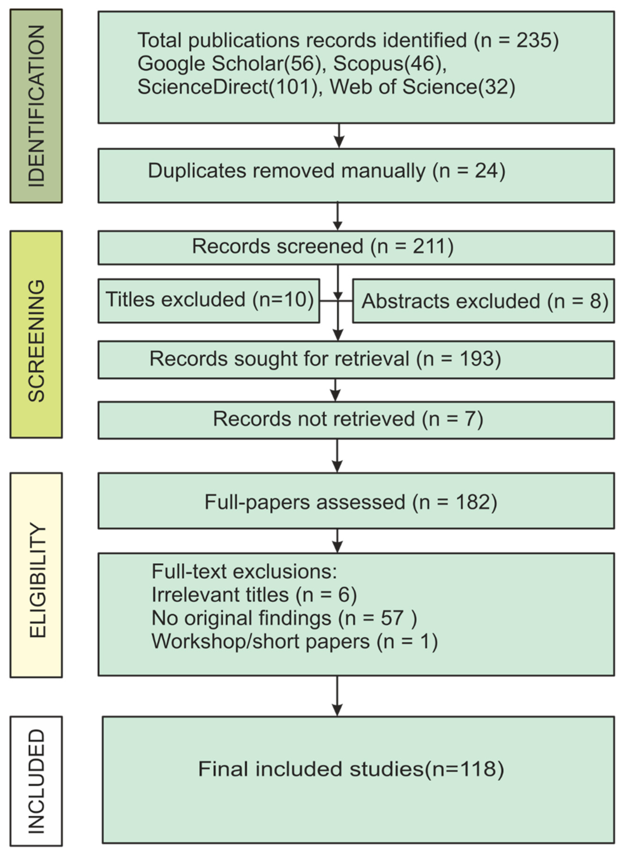
The database search yielded 235 records in total, comprising ScienceDirect (n = 101), Google Scholar (n = 56), Scopus (n = 46), and Web of Science (n = 32). After manual removal of 24 duplicate records, 211 publications were screened based on titles and abstracts (Figure 1). During this screening stage, 18 records were excluded (10 on the basis of title and 8 based on abstract content), leaving 193 records for full-text retrieval. Of these, 7 articles could not be accessed, and 182 full-text articles were assessed for eligibility.
Following full-text evaluation, 64 studies were excluded, including papers irrelevant to the scope of the review (n = 6), publications lacking original empirical data (n = 57), and short or workshop papers (n = 1). Ultimately, 118 empirical studies met all inclusion criteria and were retained for qualitative synthesis. The study identification, screening, and selection process is summarized in the PRISMA flow diagram (Figure 1), which also presents the reasons for exclusion at the full-text stage; individual excluded studies are not listed but are available upon request.

2.2. Eligibility Criteria and Study Selection

After removal of duplicate records, the remaining studies were screened at the title and abstract level to assess relevance to the objectives of the review. Studies were retained for further consideration only if they clearly addressed the use of hydrogeochemical data or methods in the context of mineral or critical-mineral exploration and demonstrated relevance to exploration workflows, such as reconnaissance surveys, target delineation, or geochemical vectoring under cover. Eligible studies were required to present original hydrogeochemical data, methodological frameworks, or modelling approaches that contributed interpretive value to understanding geochemical dispersion systems in an exploration context.
Records were excluded at this stage if they consisted solely of conference abstracts without full peer-reviewed papers, lacked sufficient methodological clarity, or focused exclusively on groundwater quality, contamination, or environmental and health impacts without explicit exploration relevance. Publications centred on analytical method development, machine-learning or GIS techniques, or conceptual reviews without application to hydrogeochemical mineral exploration case studies were similarly excluded from extraction. Non-English publications were also excluded. Studies meeting the initial screening criteria proceeded to full-text assessment.
Full-text evaluation further refined the selection by excluding papers that did not present substantive hydrogeochemical datasets, did not demonstrate direct applicability to mineral exploration objectives, or addressed hydrogeochemical processes solely within environmental or hydrogeological frameworks without a link to exploration decision-making. The background literature of this nature was retained for contextual discussion but excluded from formal data extraction and synthesis. The final set of eligible studies constituted the evidence base for the systematic synthesis presented in this review, and the complete study selection process is summarized in the PRISMA flow diagram (Figure 1).

2.3. Review Protocol and Screening Procedure

A structured review protocol defining the search strategy, eligibility criteria, screening procedures, and synthesis objectives was established prior to data extraction. Titles and abstracts were independently screened for eligibility by two reviewers, followed by full-text assessment.
The review protocol was not registered in a public repository, as currently available registration platforms such as PROSPERO are primarily designed for health-related systematic reviews and do not provide tailored pathways for geoscience-focused evidence syntheses. All stages of screening and eligibility assessment were conducted manually, without the use of automation tools. Study selection followed a two-stage process consisting of title and abstract screening followed by full-text evaluation, and any uncertainties regarding eligibility were resolved through discussion. These procedures were implemented to ensure transparency, consistency, and adherence to PRISMA 2020 methodological standards.

2.4. Data Extraction and Quality Assessment

Data extraction was conducted using a standardized template developed a priori to ensure consistency across studies. Extracted information included bibliographic details, geographic and geological settings, hydrogeochemical media, analytical techniques, exploration objectives, key findings, and reported limitations. One reviewer performed the initial data extraction, which was independently verified by a second reviewer to ensure accuracy and consistency; discrepancies were resolved through discussion and consensus, following a primary extractor–secondary verifier approach. Extracted data were subsequently harmonized within a consistent framework by standardizing terminology related to hydrogeochemical media, analytical methods, and mineral system classifications. Where necessary, reported values and interpretations were conceptually normalized to facilitate cross-study comparison. Missing or incomplete data were not imputed but were instead documented and considered qualitatively during synthesis. The complete extracted dataset for all included studies is provided in Supplementary Table S2.
To evaluate the robustness of the evidence base, each included study was further assessed for methodological quality and potential risk of bias using an adapted framework appropriate for hydrogeochemical and exploration-geochemistry research. Assessment considered sampling design and representativeness, analytical reliability and QA/QC reporting, transparency of data interpretation, and clarity of the linkage between hydrogeochemical signals and mineralization. Risk of bias was assessed qualitatively, with overall study quality considered during evidence synthesis rather than used as a basis for exclusion. Potential reporting bias was evaluated by examining the diversity of study locations, mineral systems, and publication sources. Although formal statistical assessments of reporting bias were not applicable, inclusion of studies spanning a broad temporal range (1946–2025) and multiple geographic regions was used to reduce the risk of selection bias. Summary results of the bias and quality assessments are presented in Supplementary Table S2.
As this study is a qualitative systematic review without meta-analysis, no standardized effect measures (e.g., risk ratios or mean differences) were defined. Instead, outcomes were synthesized based on reported hydrogeochemical patterns, geochemical indicators, and exploration effectiveness metrics described in the included studies. Also, sensitivity analyses were not conducted, as the review did not involve quantitative synthesis or statistical modelling. Instead, robustness of findings was evaluated qualitatively through consistency of reported patterns across multiple independent studies and geological settings.
The certainty of evidence was assessed qualitatively based on consistency of findings across studies, methodological rigor, analytical reliability, and strength of linkage between hydrogeochemical signatures and mineralization. Given the observational and heterogeneous nature of the included studies, a formal grading framework (e.g., GRADE) was not applied.
Possible causes of heterogeneity among study results were explored qualitatively through comparative analysis of key study characteristics. This included examination of differences in geological settings, mineral system types, hydrogeochemical parameters measured, analytical techniques, spatial and temporal sampling scales, and study objectives. Variability in environmental context (e.g., climatic conditions and hydrogeological regimes) and methodological approaches were considered when interpreting differences in reported hydrogeochemical signatures and exploration outcomes. Formal statistical assessment of heterogeneity was not undertaken due to the qualitative and descriptive nature of the evidence base.

2.5. Data Synthesis and Analytical Approach

The synthesis of results was conducted using a qualitative, narrative approach, appropriate for the heterogeneous and predominantly observational nature of the included studies. Extracted data were systematically organized and grouped according to key thematic domains, including mineral system types, hydrogeochemical processes, analytical techniques, and exploration outcomes. Comparative analysis was employed to identify recurring patterns, consistencies, and divergences in hydrogeochemical signatures across different geological and climatic settings. Where appropriate, findings were further structured into process-based and commodity-specific categories to facilitate interpretation and cross-study comparison. This approach was selected in preference to quantitative meta-analysis due to substantial variability in study design, sampling media, analytical methods, and reported variables, which precluded meaningful statistical aggregation. The qualitative synthesis enabled integration of diverse evidence while preserving contextual geological and methodological nuances critical for interpreting hydrogeochemical exploration effectiveness.

2.6. Reporting and Transparency

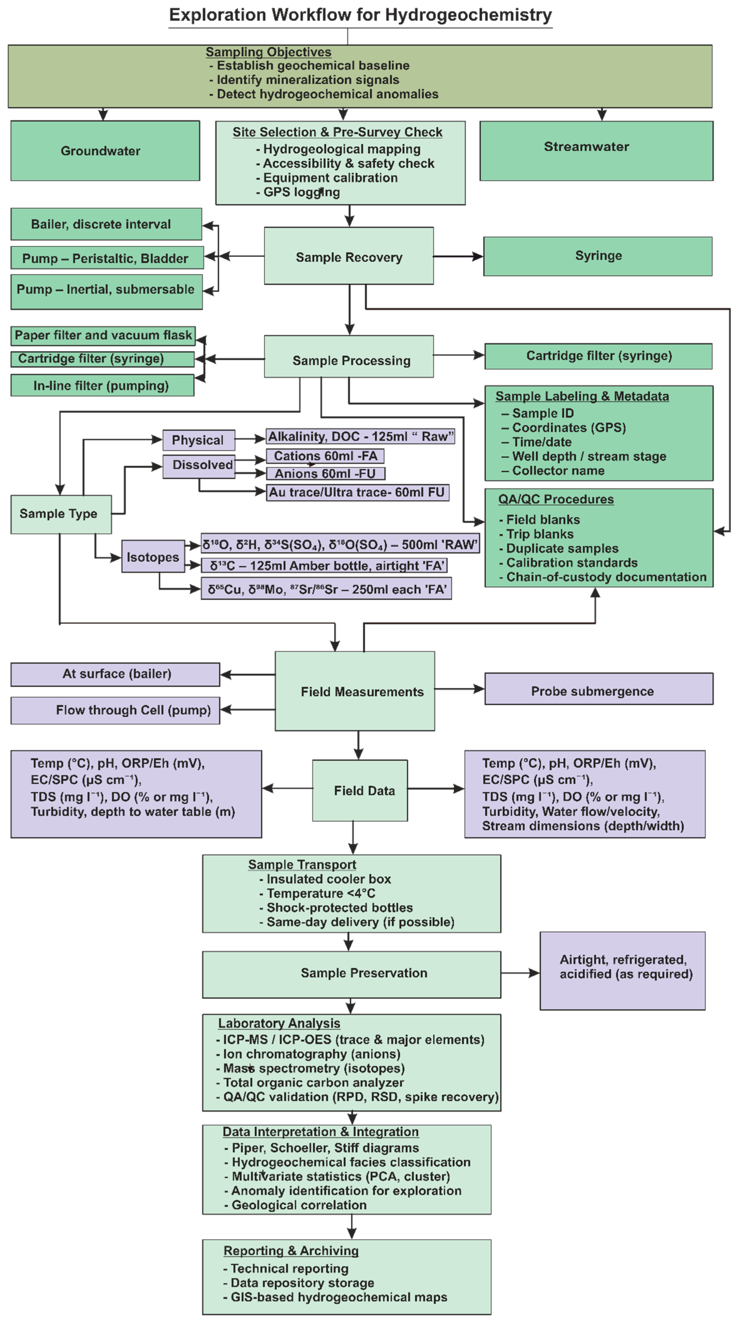
This systematic review adheres fully to the PRISMA 2020 reporting standards. The completed PRISMA checklist is provided in Supplementary Table S1, and the flow diagram illustrating the identification, screening, eligibility, and inclusion of studies is presented in Figure 1. Collectively, these procedures ensure transparency, reproducibility, and methodological rigor consistent with best practices for systematic reviews in hydrogeochemistry and mineral exploration research.

3. Systematic Review Findings

3.1. Study Selection and Characteristics

The database search (1946–2025) retrieved 235 records; after deduplication, title/abstract screening, and full-text assessment under PRISMA, 118 studies were included for the synthesis (Figure 1). Screening and eligibility were conducted manually using predefined criteria [41,42].

3.2. Analytical Techniques and Detection Capabilities

Eligible studies are clustered into six analytical families (Table 1). ICP-OES is a robust atomic emission spectroscopic technique that is particularly well suited for the analysis of high-total dissolved solids (TDS) matrices such as saline groundwater, brines, and salt-rich waters, owing to its high matrix tolerance and reduced susceptibility to plasma instability. While its detection limits are higher than those of ICP-MS, ICP-OES remain an effective and widely applied screening and quantification tool for major and trace elements in exploration settings where sample salinity exceeds the practical tolerance of ICP-MS and extensive dilution would compromise analytical efficiency [14,43]. HR-ICP-MS provides sub-ppt (ppq) sensitivity and improved interference resolution [39,44]. ICP-OES is preferentially used for high-TDS matrices (tolerance to ~30%) with high- to low-ppb detection limits [10,45]. MC-ICP-MS/isotope-ratio MS supports high-precision radiogenic/stable isotopes (Pb, Sr; δ65Cu, δ98Mo) for source/process tracing [2,33,43,46,47]. Single-particle ICP-MS (spICP-MS) and TEM are reported for detecting/characterizing ore-related nanoparticles in groundwater [48,49]. Ion Chromatography remains standard for the quantification of major anions including Cl and SO42−, as well as halide tracers such as Br and I that are useful for distinguishing fluid sources and salinity evolution [5,14].

3.3. Empirical Patterns Consistently Reported

Across climates and deposit types, three observation-based patterns occur.
(i)
Zoned halos: Proximal enrichment of less mobile cations (Cu, Pb, Zn) and distal enrichment of more mobile oxyanions (Mo, Re, As, Se) are commonly mapped; element ratios between species of contrasting mobility are frequently used to sharpen vectors [2,4,6,10,52].
(ii)
Systematic association with field chemistry: higher dissolved Cu/Zn are reported in acidic waters, whereas Mo/As/U are commonly elevated in near-neutral to alkaline, carbonate-buffered waters; sharp dissolved U step-changes coincide with redox boundaries [2,5,10,53,54].
(iii)
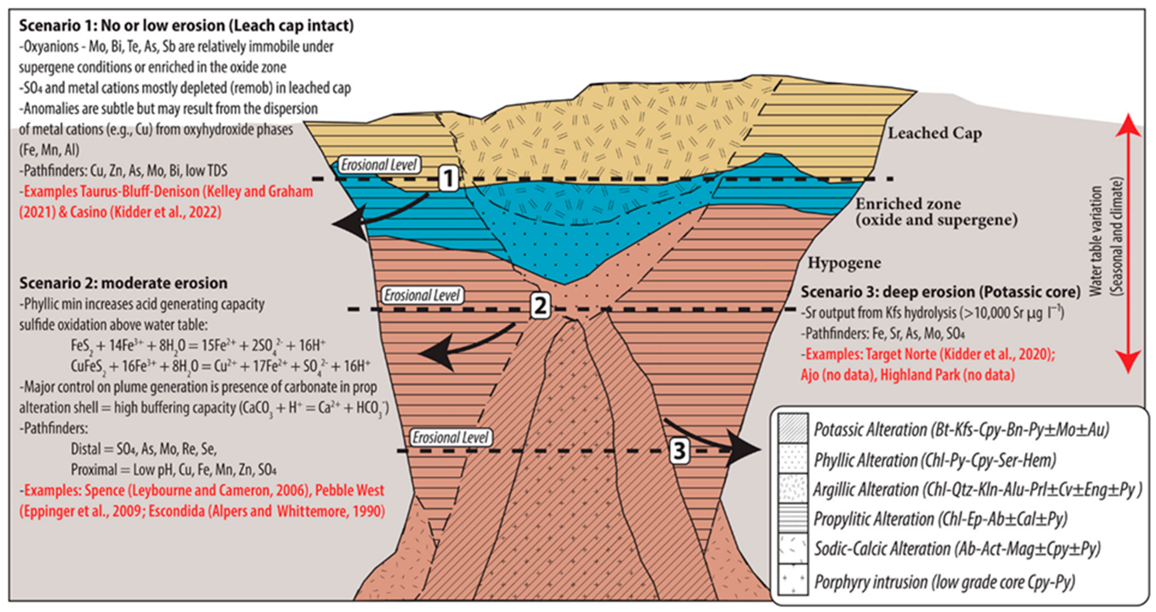
Salinity/climate effects on noble metals: in arid, saline terrains, shallow groundwaters frequently contain detectable Ag (and locally Au), whereas oxidizing, near-neutral freshwaters more often show short-range, subtle dissolved Au anomalies [10,14,55]. Attenuation of cationic metals along flow paths via adsorption to Fe–Mn (oxyhydr)oxides and secondary mineral precipitation is widely documented [4,14,56]. Deposit-specific examples are illustrated in Figure 2.

3.4. Commodity-Specific Hydrogeochemical Footprints

3.4.1. Porphyry Cu–Mo–Au Systems

Deposit and district-scale surveys frequently document a proximal Cu–Zn–Co halo with an enveloping distal Mo–Re–As–Se plume over kilometers scales (Figure 2) [2,6,10,52]. At Pebble (Alaska), acidic waters over thin cover show Cu–Cd–Re–SO42−, whereas near-neutral waters over deeper cover exhibit Mo–As–Sb–W at ultra-trace levels [39,58,59,60]. At Spence (Chile), reported groundwater ranges include Cu commonly ~103 µg/L (local maximum 28,991 µg/L), Mo frequently >100 µg/L, with pH ≈ 4.7 and TDS > 25,000 mg/L in parts of the plume; Re is detected down-gradient at ultra-trace levels [6,10,61].

3.4.2. Volcanogenic Massive Sulphide (VMS) Systems

Shield-lake surveys in permafrost/boreal settings consistently note very low dissolved metal backgrounds (often < 2 ppb) and stronger Zn than Cu anomalies in the dissolved fraction [4,62].

3.4.3. Sediment-Hosted Pb–Zn (SEDEX/MVT) Systems

In neutral, carbonate-buffered terrains, studies report the utility of normalizations (e.g., Zn/Cl, SO42−/Cl) and the mapping of radiogenic Pb-isotope outliers beneath cover; representative models are summarized in Table 2 [35,38,63,64].

3.4.4. Epithermal Au–Ag Systems

In arid, saline basins (e.g., parts of the Great Basin), shallow groundwater surveys report broad Ag halos [55]. In oxidizing, near-neutral systems (e.g., Sardinia), dissolved Au anomalies are typically ≤ ~0.5 km, while As/Sb provide more consistent aqueous footprints [14].

3.4.5. Orogenic and Carlin-Type Au Systems

Continental- to camp-scale surveys (e.g., Yilgarn Craton) report background dissolved Au on the order of single-digit ng/L, with local maxima up to ~2 µg/L (Carosue Dam) and ~52 ng/L (St Ives); co-occurrence of As, Sb, Te, W near Au systems is frequently documented [20,29,70]. In Carlin-type terrains, groundwater suites of As, Sb, Hg, Tl are consistently mapped where dissolved Au is weak; representative hydrochemical facies distributions are shown for Getchell [71,72,73,74].

3.4.6. Uranium Systems

For roll-front deposits, mapping of calculated Saturation Index (SI) for uraninite is repeatedly reported as delineating ore trends more effectively than raw dissolved U [66,75]. For unconformity-related systems, elevated 234U/238U activity ratios, Ra-isotope anomalies, and Normalized Magnesium (NMg) signals are documented as hydrogeochemical indicators [46,67,76,77].

3.4.7. Lithium and Rare-Earth Elements (REE)

In lithium brines, appraisal emphasizes absolute Li and Mg/Li as primary evaluation metrics; dispersion of Li, Rb, Cs is reported in shallow groundwater proximal to LCT pegmatites [22,68,78,79,80,81,82]. For REE, vectors are described using normalized REE patterns with LREE/HREE fractionation and Eu/Ce anomalies [69,83,84].

3.5. Sampling, QA/QC, and Data-Handling Practices Reported

Field protocols commonly include acid-rinsed containers, 0.45 µm filtration for the dissolved fraction, acidification of cation/trace aliquots, dedicated bottles for anions, and in situ measurement of pH, Eh, EC, and temperature [16,76,85]. UAV-enabled sampling and peristaltic pumps for point-source filtration are reported in remote settings [24,86,87]. Data workflows frequently acknowledge the compositional nature of aqueous geochemical data and therefore apply log-ratio (clr) transformations prior to PCA or cluster analysis. Thermodynamic modelling by calculation of saturation indices and metal speciation by codes, e.g., PHREEQC [88], is also widely used. These approaches are often combined with GIS-based integration of other prospectivity layers. Such workflows are well documented in the literature (a summary of interpretation approaches is provided in Table 3; see Section 4.6.3) [19,88,89].

3.6. Evidence Synthesis

Across the compiled studies, evidence supports that: (i) zoned dispersion halos with predictable element partitioning are observed across hydrogeological settings; (ii) ultra-trace analytical capability routinely resolves subtle footprints; and (iii) standardized field/laboratory protocols coupled with multivariate and geospatial synthesis are widely implemented for aqueous anomaly delineation [3,4,10,39].
Overall, the certainty of evidence is considered moderate to high for well-established hydrogeochemical processes (e.g., sulphide oxidation, pH–Eh controls, dispersion halos), supported by consistent observations across diverse geological settings. Emerging approaches such as isotope geochemistry and nanoparticle analysis show promising but comparatively lower certainty due to limited datasets and evolving methodologies.

4. Discussion

4.1. Principles and Evolution of Hydrogeochemistry in Mineral Exploration

The effectiveness of hydrogeochemistry as an exploration tool is rooted in a series of interconnected geochemical processes that transfer the chemical signature of a mineral deposit into the surrounding aqueous environment [1]. A thorough understanding of these processes, from the initial release of ore-related elements at the source, through their transport and modification along a groundwater flow path, to their eventual attenuation, is fundamental to the design of effective survey strategies and the accurate interpretation of hydrogeochemical data [95,96,97]. These mechanisms also explain why groundwater can detect deeply buried or concealed mineralization, as demonstrated by studies in hyper-arid terrains and complex geological settings [7].
The application of hydrogeochemistry as a distinct scientific discipline has a history spanning over 70 years, marked by cycles of intense interest and relative dormancy, each cycle defined by the alignment of exploration challenges with available technology [3,12,98]. The discipline’s modern origins can be traced to the systematic work of Russian geochemists in the 1930s and 1940s, who pioneered concepts of “physicochemical prospecting” by formally testing the use of water chemistry to detect secondary dispersion from ore bodies [62,98,99,100,101,102,103]. One of the first documented case studies was conducted in 1941 by A. Reznikov, who used dithizone-based colorimetric reagents to estimate trace concentrations of base metals in water, successfully identifying anomalies related to polymetallic deposits in Altai, Russia [23,99].
A significant boom in its application occurred during the global search for uranium in the 1970s, driven by a clear “problem-technology fit” [3,12,24,96,104,105]. The target, uranium, is highly mobile in aqueous environments, and the analytical methods of the time, such as fluorometry and delayed neutron counting, were sufficiently sensitive to detect its anomalies [3,12]. Large-scale programs like the Hydrogeochemical and Stream Sediment Reconnaissance (HSSR) in North America proved highly successful, cementing the technique’s value for specific commodities [3,12,96,104].
Following this period, the discipline’s broader application waned, particularly as exploration shifted to less mobile commodities like gold [3,98]. The existing analytical technologies, such as Atomic Absorption Spectrometry (AAS), often lacked sensitivity to detect the extremely subtle anomalies generated by these elements, limiting the technique’s perceived utility [3,98,106]. This led to a “crisis of confidence” in the early 1980s, when researchers began to recognize that simply measuring the concentration of a metal in water was often insufficient and led to inconsistent or misleading results [66,67]. Early methods frequently failed because they relied on a simple anomaly threshold for an element like uranium or copper, without accounting for the profound influence of the local geochemical environment [37,66,67,107]. For example, studies found a poor correlation between dissolved uranium and a known orebody because local redox conditions and pH had a stronger effect on uranium’s solubility than proximity to the source [37,66,107]. This crisis necessitated a move beyond simple anomaly hunting and forced a fundamental paradigm shift. The scientific focus evolved from asking what the concentration was to a more sophisticated inquiry: why it was that value [66]. This shift from empirical measurement to process-based understanding gave rise to new interpretive philosophies that remain central to the discipline today [65,66,67,107]. Three distinct but complementary strategies emerged to overcome the limitations of simple concentration data: the use of computer models to calculate a mineral’s Saturation Index (SI), a thermodynamic measure of stability; a focus on the chemical fingerprint of alteration halos using major ion ratios; and the employment of a suite of mobile pathfinder elements to identify the broader signature of a mineralizing system [37,65,66,67].
The contemporary resurgence of hydrogeochemistry has been driven by a new problem–technology fit. The modern challenge of discovering deposits concealed deep beneath post-mineral cover created a pressing need for depth-penetrating methods, and a concurrent revolution in analytical geochemistry provided the solution [3,13]. The development and commercialization of Inductively Coupled Plasma-Mass Spectrometry (ICP-MS) in the 1980s, and its subsequent refinement, fundamentally transformed the field [7,23,108,109]. The ability of ICP-MS and its high-resolution variants to provide rapid, multi-element analysis at extremely low detection limits down to parts-per-trillion (ppt) or nanograms-per-litre (ng L−1) levels has dramatically expanded the detectable footprint of mineral deposits [3,23,24,37,39,58,109]. This technological leap overcame historical limitations and enabled the discovery of subtle anomalies from deeply buried systems that were previously undetectable, making hydrogeochemistry a routine and cost-effective tool for modern exploration [3,23,37,39,96,110]. This history reveals a clear pattern: the viability of hydrogeochemistry as a solution to exploration problems has been paced by technology, suggesting that future breakthroughs will also be driven by the next generation of analytical and computational tools [3,23,98].
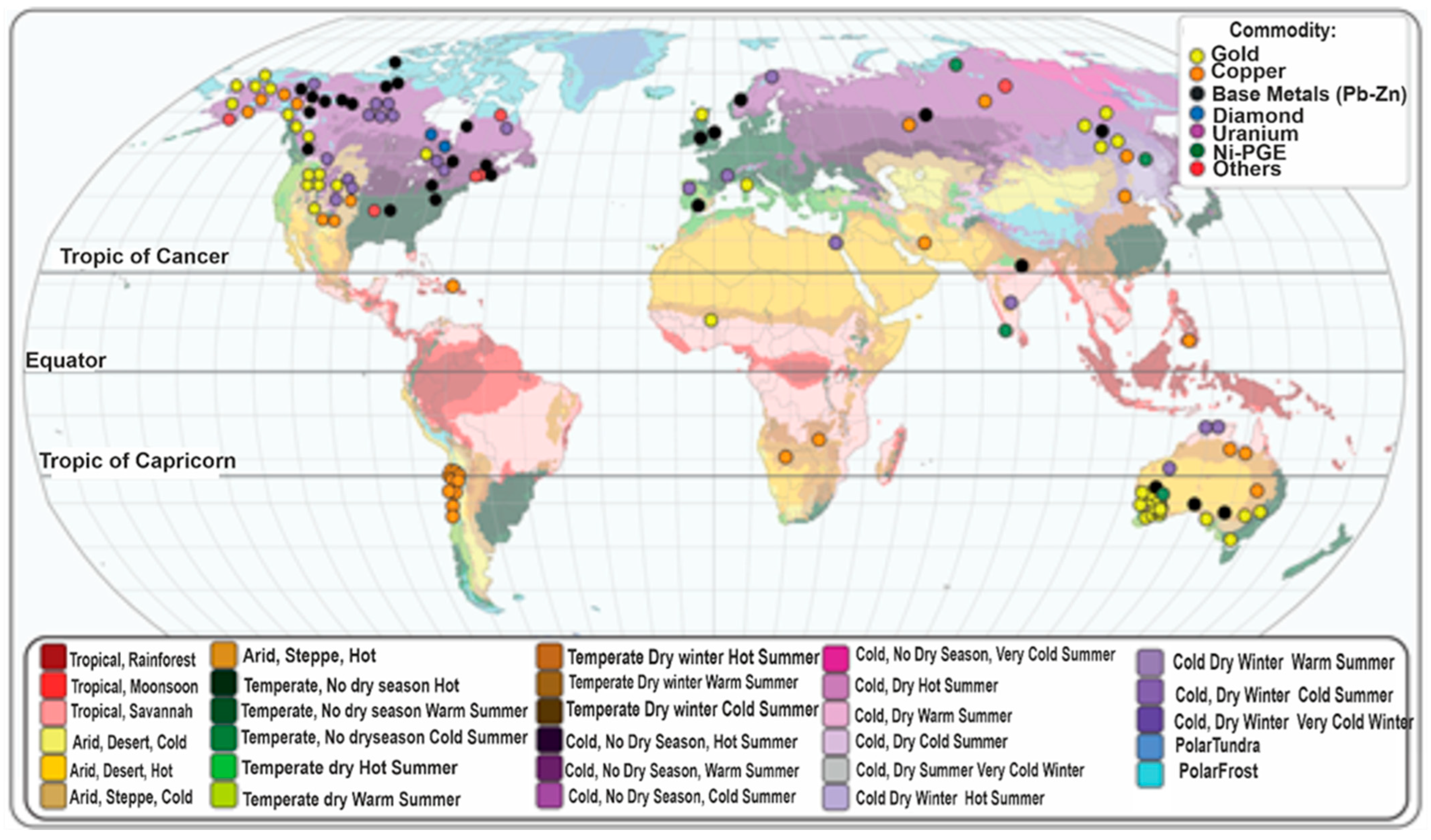
Figure 3 illustrates the global distribution of major mineral commodities relative to Köppen–Geiger climate zones, highlighting clear concentrations in temperate and cold continental regions as well as secondary clusters across arid and tropical belts. This climatic diversity is directly relevant to the historical development of hydrogeochemistry. The application of hydrogeochemistry as a scientific discipline, spans more than seven decades, marked by cycles of strong adoption and periods of decline, each driven by how well analytical technologies matched the geochemical challenges presented by different climatic settings [3,12,98]. Early successes such as those documented by Russian geochemists in the 1930s and the uranium exploration boom of the 1970s were primarily achieved in environments where groundwater flow and physicochemical conditions reliably mobilized target elements. However, as exploration expanded into tropical and arid terrains, where complex hydrology and extreme weathering altered metal dispersion pathways, the limitations of early technologies became apparent, contributing to the “crisis of confidence” of the 1980s [66,67]. The climatic patterns in Figure 3 therefore reinforce a central historical theme: hydrogeochemistry has always been constrained by both environmental setting and technological capability. The subsequent development of high-sensitivity, multi-element ICP-MS analysis has now largely overcome these limitations, enabling the detection of ppt-level anomalies across a far broader range of climatic environments [3,23,37,58,109]. As a result, the modern resurgence of hydrogeochemistry reflects a renewed “problem–technology fit,” aligning advanced analytical tools with the challenges posed by concealed mineral systems in diverse climatic zones.

4.2. Geochemical Processes Influencing Groundwater Composition

The formation of a hydrogeochemical anomaly begins with the direct interaction between water and minerals, a process that includes dissolution, hydrolysis, and oxidation [11,111]. While the background chemical composition of any groundwater sample is a composite signature derived from multiple sources, including meteoric recharge and dissolution of non-mineralized host rock, the dominant process in the context of mineral exploration is the selective leaching of elements from an orebody [10,112].
In many of the world’s most significant base and precious metal systems, the primary engine for this element mobilization is the oxidation of sulphide minerals [2,4,33,55,65]. When sulphide minerals such as pyrite (FeS2) or chalcopyrite (CuFeS2) are exposed to oxygenated groundwater, they undergo oxidative weathering [2,33,54,113,114]. This reaction is critical because it releases three key components into the surrounding water: dissolved metals (such as Cu, Zn) and sulphate (SO42−), a highly mobile and stable indicator of the process, and acidity (H+), which dramatically alters the local chemical environment and accelerates the dissolution of other minerals [2,4,65,115,116,117,118,119,120]. This process is often exothermic, a factor of particular importance in cold environments like the Canadian Shield, where the heat generated can create thawed channels within permafrost, enhancing water flow and element dispersion even in sub-zero conditions [4,116,121].

4.3. Physicochemical Controls on Element Mobility and Transport

Once an element is released from its host mineral, its ability to travel in water, its mobility, is governed by a suite of external physicochemical conditions [10,12,66]. The two master variables controlling most geochemical reactions are pH (the measure of acidity or alkalinity) and Eh (the oxidation-reduction potential) [2,122]. The pH of the water is a critical control determined by the balance between acid generation from sulfide oxidation and the natural buffering capacity of the host rocks [4,115,123]. In regions dominated by base-poor lithologies such as certain granites, the water becomes acidic (pH < 5.5), which significantly increases the solubility and mobility of many metal cations, including copper (Cu), zinc (Zn), and aluminium (Al) [5,116,124,125]. Conversely, where the geology includes carbonate-bearing rocks like limestone, the acid is neutralized, resulting in near-neutral or even slightly alkaline waters that limit the mobility of these cations but favor the mobility of elements that form stable, soluble oxyanions, such as molybdenum (Mo), arsenic (As), and uranium (U) [2,4,5,10,89,126,127].
The redox potential (Eh) is paramount for elements that can exist in multiple valence states [2,66]. The classic example is uranium, which is highly soluble and mobile as the hexavalent uranyl ion (UO22+) under oxidizing conditions but becomes highly insoluble and precipitates as U(IV) minerals like uraninite (UO2) in reducing environments [53,66,77,114]. Exploration for certain uranium deposit types is therefore fundamentally a search for these redox boundaries [77]. The mobility of metallic ions is also significantly enhanced by the formation of soluble aqueous complexes with various ligands naturally present in water [66,111,128,129]. This process of complexation can keep a metal dissolved in conditions where it would normally precipitate [66,129]. The nature of the dominant ligand creates a natural geochemical separation of elements during transport. For instance, in the low-salinity, acidic waters of the Canadian Shield, the relative mobility of base metals is largely controlled by pH, making Zn a more mobile pathfinder than Cu [4,124]. In stark contrast, in the arid, saline groundwaters of the Great Basin, the high concentration of chloride (Cl) becomes the dominant control. Here, metals like gold (Au) and silver (Ag) form stable, soluble chloride complexes (for example, AuCl2 and AgCl2), which dramatically increases their mobility and allows them to be transported far from their source [3,55]. This demonstrates that the best pathfinder is not an intrinsic property of an element but is a context-dependent variable dictated by the local hydrogeochemical environment.

Formation of Dispersion Halos and Reduction Processes

The distance an element can travel from its source, its dispersion train, is ultimately limited by reduction processes, or sinks, that remove it from solution [4,12,35,46,89,130]. The interplay between mobilization, transport, and attenuation results in the formation of structured, zoned geochemical anomalies, or dispersion halos, in groundwater and surface water systems [3,10]. Geochemical dispersion is not a simple dilution process; it is an active process of geochemical fractionation that spatially separates elements based on their chemical properties, creating predictable patterns that can be used for vectoring [2,3].
The most significant attenuation process in many freshwater systems is the adsorption of dissolved metal cations onto the surfaces of solid particles, particularly freshly precipitated hydrous iron (Fe) and manganese (Mn) oxides [4,14,56,131,132,133]. This process is highly pH-dependent and further contributes to the geochemical separation of elements. For example, Cu tends to adsorb at a lower pH than Zn, which explains why Cu anomalies are often less extensive than Zn anomalies originating from the same sulphide source [4,132]. The other primary attenuation mechanism is the precipitation of secondary minerals, which occurs when the water becomes supersaturated with respect to a particular mineral phase as physicochemical conditions change along a flow path [10,12,35].
These attenuation processes are often viewed as a limitation, but they also represent a concentrating mechanism that transfers the anomaly from the dissolved phase to the solid phase. The adsorption of metals onto Fe-Mn oxides, for example, relocates the anomaly to the suspended particulate matter or the active stream sediment, creating a new exploration opportunity [14]. This dynamic interplay results in characteristically zone geochemical footprints. Less mobile elements that are readily removed from solution, such as Cu, lead (Pb), and Zn, tend to form proximal anomalies closer to the orebody [2,10]. In contrast, highly mobile elements that form stable, soluble oxyanions, such as Mo, rhenium (Re), and As, are less affected by these processes and can travel significant distances, forming extensive distal anomalies that create a much larger exploration target [2,10]. The most valuable information in a hydrogeochemical survey is therefore often found not in the absolute concentration of a single element, but in the ratios between elements of differing mobility, which can point directly toward the source [2,3].

4.4. Hydrogeological Controls on Hydrogeochemical Vectoring

A physically consistent interpretation of hydrogeochemical anomalies in mineral exploration requires explicit consideration of groundwater flow system theory, particularly the framework developed by Tóth, which establishes groundwater as a fundamental geologic agent responsible for mass transport across a hierarchy of spatial scales [134,135]. Within this framework, groundwater flow occurs in nested local, intermediate, and regional systems, each characterized by distinct flow path lengths, hydraulic gradients, residence times, and degrees of geochemical evolution. This distinction provides the hydrogeological context necessary to understand both the spatial resolution and the exploration significance of hydrogeochemical anomalies.
In local groundwater flow systems, groundwater circulates over relatively short distances and timescales, allowing dissolved constituents to remain closely coupled to their source lithologies. Under these conditions, hydrogeochemical signatures primarily reflect proximal water–rock interaction with altered and mineralized zones. Thermodynamically meaningful indicators such as mineral saturation indices, aqueous speciation, and redox conditions can therefore directly record equilibrium or near equilibrium with ore-related mineral assemblages [122,126]. As a result, hydrogeochemical anomalies identified within local flow regimes provide high-resolution vectoring toward concealed mineralization and represent direct exploration targets suitable for focused follow-up.
In contrast, regional groundwater flow systems operate over basin-scale distances and long residence times, during which groundwater chemistry is progressively modified through reactions with multiple lithologies, dilution, mixing, and buffering processes. Metals and pathfinder elements released from mineralized sources may be transported tens to hundreds of kilometers before discharging at topographic or structural lows. Hydrogeochemical anomalies observed in such discharge zones therefore integrate geochemical signals over large source areas and prolonged transport histories, reflecting basin fertility rather than spatial proximity to specific ore bodies [134,135]. While regional anomalies are valuable for identifying metallogenically favorable basins, they inherently provide low spatial resolution for direct vectoring to concealed deposits.
Failure to differentiate between local and regional groundwater flow regimes commonly leads to misinterpretation of hydrogeochemical data, particularly the expectation that all groundwater anomalies should directly indicate ore body locations. Incorporating Tóth’s framework clarifies that the effectiveness of hydrogeochemical vectoring is fundamentally governed by flow system scale and residence time. Local systems support precise mineral targeting, whereas regional systems support strategic, basin-scale exploration assessment [135]. This distinction also explains why thermodynamic indicators retain strong diagnostic value in local flow systems but become increasingly overprinted by integrated basin processes in regional settings.
Accordingly, this review frames hydrogeochemical mineral exploration within a mechanistic model that integrates thermodynamic geochemistry with groundwater flow system theory, recognizing groundwater as a geologic agent operating across nested spatial scales. This framework provides a coherent explanation for contrasting exploration outcomes reported in the literature and establishes a robust conceptual basis for interpreting hydrogeochemical data in covered and basin-hosted mineral systems [53,122,134,135].

4.5. Key Geochemical Indicators in Exploration

The practical goal of a hydrogeochemical survey is to identify a chemical anomaly, a change in water chemistry that stands out from the local background and indicates the presence of mineralization [3,4,5,136]. The evolution of geochemical indicators reflects the core challenge of discipline, moving from simple detection of an anomaly to confident attribution of its source. Each step up the hierarchy of indicators, from simple elements to complex isotopic systems, is designed to reduce interpretive uncertainty [2,33].

4.5.1. Elemental Pathfinders and the Definition of Geochemical Anomalies

Hydrogeochemical exploration targets can be categorized as either direct indicators (anomalous concentrations of the ore elements themselves) or, more commonly, pathfinder elements, associated elements that are often more abundant, more mobile in the local environment, or easier to detect, thereby creating a larger and more robust chemical halo [5,10,14,16]. A classic example is the use of As and Sb for certain types of gold deposits; a study in Sardinia found that while dissolved gold created a faint and restricted anomaly (~500 m), As and Sb were present in much higher concentrations and formed a clearer, more widespread pattern that pointed directly to the gold-bearing veins [14,16]. Other broad-spectrum pathfinders, such as high concentrations of sulphate (SO42−) and low pH, point to the larger mineralizing system rather than a specific metal, making them excellent tools for regional surveys [38,65].
An anomaly is formally defined as a concentration that is statistically significant relative to the regional geochemical background [4,137,138]. A critical principle is that the threshold for what constitutes an anomaly is entirely context dependent. In the pristine terrane of the northern Canadian Shield, background levels for Zn in lake water are often less than 2 parts per billion (ppb), making any value consistently above this level potentially significant [4,110,137,138,139,140]. In contrast, in a region with complex geology and a history of industrial and agricultural activity like the UK, anomalies must be defined against a much higher and more variable background [5]. This environmental complexity necessitates a multi-element approach to avoid false positives. A single high metal value could be part of a lithological signature or derive from anthropogenic sources; by analyzing a broad suite of elements, geochemists can recognize these distinct geochemical fingerprints and differentiate them from true mineralization-related anomalies, which often present as a specific, coherent suite of elements [5,19,89].

4.5.2. Process-Based Indicators Integrating Alteration Signatures and Thermodynamic Modelling

The recognition that simple concentration data could be misleading led to the development of more robust, process-based indicators that fingerprint the entire mineralizing system [65,66,67]. These indicators are more powerful because they fingerprint a system (a thermodynamic state, an alteration halo), which is less ambiguous than a single element concentration. One such approach is the use of alteration-related indicators, which come from the chemical signature that water acquires from interacting with the large alteration halo surrounding an orebody [3,67,141]. The classic example is the Normalized Magnesium (NMg) ratio, developed for unconformity-related uranium deposits in Australia. The rocks around these deposits are intensely altered and enriched with magnesium; groundwater leaching these rocks acquires a distinct high-Mg signature, which is a robust indicator that works even in local chemical conditions where uranium itself is immobile [67]. A second, more quantitative approach involves the use of model-derived indicators calculated using geochemical computer models such as WATEQ4F or PHREEQC [66,142,143]. The most well-known of these is the Saturation Index (SI), which measures how close a water sample is to being in thermodynamic equilibrium with a specific ore mineral [66]. A positive SI suggests the water is supersaturated and the mineral could precipitate, while a negative SI suggests it is undersaturated and the mineral could dissolve [66,143,144,145]. The SI is powerful because it integrates the effects of pH, Eh, temperature, and complexation into a single, meaningful number [66,145]. A map of the SI for an ore mineral like uraninite can provide a much clearer exploration target than a map of raw uranium concentrations, as it effectively corrects for local variations in the physicochemical environment that control solubility [46,66,144].

4.5.3. Advanced Tracers Integrating Isotopic Systems and Nanoparticle Geochemistry

In recent decades, the exploration toolkit has been expanded with advanced tracers that provide unprecedented levels of information on the source of elements and the specific processes they have undergone, providing a direct, often unambiguous, link to the source [2,46,49,51]. Radiogenic isotopes are used for source tracing. For example, the analysis of Pb isotopes can identify the distinctive radiogenic signature (206Pb/204Pb) of groundwater that has interacted with a uranium deposit, while strontium (Sr) isotopes (87Sr/86Sr) can be used to trace water-rock interaction pathways [2,38,46,146]. Uranium-series disequilibrium provides several tools for process tracing. The 234U/238U activity ratio (UAR) can distinguish between reducing conditions near an orebody and oxidizing zones where ore is actively dissolving, while Radium (Ra) isotopes (223Ra/226Ra) can act as a geochemical clock to estimate groundwater travel time from the source, providing a vector toward mineralization [46,91,147].
Traditional stable isotopes, such as Sulphur (δ34S) and oxygen (δ18O) in dissolved sulphate, are used to trace the process of sulphide oxidation. Since hydrothermal sulphide minerals typically have a mantle-like Sulphur signature, this method allows explorers to distinguish a true ore-related sulphate anomaly from background sulphate derived from other sources, such as marine evaporites or agricultural contamination, as demonstrated at the Vaquillas deposit [2,10,51,148]. Non-traditional stable isotopes represent an emerging frontier, focusing on heavy metals like copper (δ65Cu) and molybdenum (δ98Mo) [2,33]. Research has shown that redox processes during the oxidative weathering of copper-sulphide minerals cause isotopic fractionation, preferentially releasing the heavier 65Cu isotope into solution. This creates a distinct positive δ65Cu anomaly in groundwater that can serve as a direct, process-specific vector toward the orebody [33]. Nanoparticle geochemistry has introduced a new paradigm of physical dispersion alongside chemical dispersion [49]. Studies have demonstrated that ore-related metals can be transported not only as dissolved ions but also as solid-phase nanoparticles (e.g., native metals, sulphides like Ag2S) suspended in groundwater. This provides a viable transport mechanism for elements with very low solubility (like Au and Ag) and means the anomaly is a direct physical sample of the ore and its weathering products, retaining an unambiguous source fingerprint [49]. This opens new avenues for exploration, such as analyzing the unfiltered or colloidal fraction of water samples using advanced techniques like single-particle ICP-MS (spICP-MS) [48,49]. The future of high-stakes exploration targeting will increasingly rely on these diagnostically powerful tools to justify the cost and risk of drilling.

4.6. Methodologies from Field Data to Exploration Targets

The successful execution of a hydrogeochemical exploration program hinges on a meticulously planned workflow that encompasses survey design, rigorous sampling, appropriate analytical techniques, and sophisticated data interpretation strategies. Each stage must be conducted with precision to ensure the integrity of the data and the validity of the resulting exploration targets [3,149,150].

4.6.1. Survey Design, Sampling Protocols, and Field Measurements

The design of a hydrogeochemical survey is dictated by the exploration scale, regional climate, and the local hydrogeological context [150]. A critical first step in any program is the execution of an orientation survey over a known mineral occurrence within the target terrain [10,151]. This preliminary work is essential for understanding local dispersion mechanisms, identifying the most effective pathfinder elements, establishing the expected scale of the anomaly footprint, and validating protocols [10,151]. A wide array of sample media can be utilized, including water from streams, lakes, springs, seeps, and wells [85]. Regardless of the source, proper sampling protocols are paramount to data quality [16]. Standard procedure involves the use of clean, acid-rinsed plastic bottles, on-site filtration through a 0.45 µm membrane to separate the dissolved fraction, and preservation of cation and trace-element aliquots by acidification with ultra-pure acid to prevent adsorption onto container walls, following established international protocols for water sampling and analysis [76,85,152]. A separate, unacidified sample is collected for anion analysis. Equally critical are the in-situ field measurements of unstable physicochemical parameters such as pH, redox potential (Eh), temperature, and electrical conductivity (EC), which can change rapidly once a sample is exposed to the atmosphere and must be measured at the time of sampling using calibrated portable meters [76,85]. Obtaining reliable field Eh measurements can be particularly challenging and is complicated by the frequent ambiguity in the literature between probe-measured oxidation–reduction potential (ORP) and true Eh values referenced to the standard hydrogen electrode (SHE). Modern redox probes can be calibrated using solutions of known redox potential, allowing correction for temperature effects and improving the reliability of Eh estimates; however, contamination from atmospheric oxygen during sampling remains a significant source of uncertainty. To minimize this effect and obtain more representative in situ redox conditions, the use of down-hole probes, flow-through chambers, and closed measurement systems is recommended, and in some cases Eh may be constrained indirectly from measured redox couples for high-stakes interpretations [46,76]. It is important to distinguish between field oxidation–reduction potential (ORP) readings obtained using probe-based sensors and true Eh values referenced to the standard hydrogen electrode (SHE). ORP measurements are instrument-specific and require calibration against redox standards to derive meaningful Eh estimates. Atmospheric oxygen contamination during sampling can further bias redox measurements; therefore, the use of flow-through cells and closed measurement systems is recommended to better approximate in situ groundwater redox conditions.
Recent technological innovations in sampling are transforming field logistics. The development of a helicopter-mounted water sampling system in the Canadian Shield was a pioneering approach to cost-effective surveying in remote terrain [4]. More recently, the advent of Unmanned Aerial Vehicles (UAVs), or drones, offers disruptive technology for water sampling, providing enhanced safety and significant cost savings [24,86,87]. Methodological comparisons have shown that advanced, closed-loop systems featuring a peristaltic pump are superior, as the pump’s ability to perform point-source filtration is essential for obtaining a true dissolved fraction and ensuring the accurate analysis of redox-sensitive elements [24].

4.6.2. Advanced Analytical Techniques and Instrumentation in Hydrogeochemical Exploration

The effectiveness of hydrogeochemistry is intrinsically linked to the advancement of analytical technology capable of detecting ultra-trace concentrations of elements in water [10,24,98]. The modern workhorse for most hydrogeochemical exploration programs is Inductively Coupled Plasma-Mass Spectrometry (ICP-MS) Table 1 [10,43]. This technique offers superior sensitivity, with routine detection limits in the parts-per-billion (ppb, or μg L−1) to parts-per-trillion (ppt, or ng L−1) range, combined with high-throughput, simultaneous analysis of more than 50 elements [10,14]. This sensitivity is essential for detecting subtle anomalies of critical pathfinder elements, particularly gold, which often occur at concentrations of just a few nanograms per litre [14,21]. The primary limitation of ICP-MS is its low tolerance for high total dissolved solids (TDS), typically requiring dilution for samples with more than ~0.2% dissolved solids [45]. For analyzing high-salinity waters like brines, the more robust ICP-OES is often the instrument of choice due to its exceptional matrix tolerance Table 1 [10,45]. In contrast, ICP-MS performance deteriorates rapidly in high-salinity matrices due to signal suppression, cone fouling, and increased polyatomic interferences, making ICP-OES the preferred technique for routine analysis of brine and saline waters in both hydrogeochemical exploration and lithium-brine resource evaluation.
At the cutting edge of analytical science are more specialized instruments. High-Resolution ICP-MS (HR-ICP-MS) provides even lower detection limits (sub-ppt) and superior capabilities for resolving problematic spectral interferences Table 1 [39,44]. Multi-Collector ICP-MS (MC-ICP-MS) allows for the extremely precise isotope ratio measurements required for non-traditional stable isotope geochemistry Table 1 [2,33,43]. For the direct analysis of solid-phase indicators, techniques such as Transmission Electron Microscopy (TEM) and Single Particle ICP-MS (spICP-MS) for nanoparticles are employed Table 1 [48,49]. Finally, Ion Chromatography (IC) remains the standard method for the precise measurement of major anions like chloride (Cl) and sulphate (SO42−), which are essential for classifying water types and identifying alteration halos Table 1 [5,14,19,36].

4.6.3. Modern Data Interpretation Strategies

The transformation of raw analytical data into geologically meaningful information is a critical and complex step [66,89]. A fundamental first step is to establish the geochemical baseline and define context-specific anomaly thresholds, ideally by partitioning the dataset by the underlying bedrock geology and defining separate thresholds for each lithology (Table 3) [10,89,90].
Geochemical data are inherently compositional, meaning the variables are proportions of a whole, which can create spurious correlations if not handled correctly [153]. The modern approach is to apply log-ratio transformations (centered log-ratio, clr) to the data prior to statistical analysis, which opens the data and allows for valid calculations [153].
With properly transformed data, a range of interpretive tools can be applied. Thermodynamic modelling, using software such as PHREEQC, provides a process-based, physical chemistry framework for interpreting data [66,142,143]. By calculating element speciation and the Saturation Index (SI) for various minerals, this approach can assess whether a groundwater sample is in equilibrium with an ore body, providing a powerful interpretive tool that is less sensitive to simple concentration variations [46,55,66].
Complementing this theoretical framework, multivariate statistical analysis offers a data-driven approach to understanding complex hydrogeochemical systems [19,38,89,154]. Techniques such as Principal Component Analysis (PCA) and Factor Analysis (FA) are used to reduce the dimensionality of large, multi-element datasets and identify the underlying processes (weathering, pollution, mineralization) that control the water chemistry [19,63,89]. Q-mode Cluster Analysis can then be used to group individual water samples into distinct water types based on their shared genetic history, allowing for the definition of separate background and threshold values for each water type and isolating the subtle signature of mineralization [89].
Ultimately, exploration is a spatial science, and the Geographic Information System (GIS) is the essential platform for the final stage of data integration and visualization [5,92,93,94,155]. Plotting hydrogeochemical data on geological and topographic maps allows for direct comparison with known mineral occurrences, faults, or specific rock types [19]. The true power of this approach is realized when hydrogeochemical anomaly maps are overlaid with other prospectivity layers such as alteration patterns from remote sensing or subsurface structures from geophysics to identify areas where multiple lines of evidence converge, significantly increasing confidence in a potential target [5,94]. A summary and comparison of modern hydrogeochemical data interpretation techniques is given in Table 3.

4.7. Global Applications in Critical and Strategic Mineral Commodities

The scientific principles of hydrogeochemistry have been validated through successful application in a wide range of geological and climatic environments across the globe [3,37]. The following case studies, organized by mineral system type, illustrate how the technique is applied in practice and highlight the specific chemical signatures and exploration models associated with different kinds of mineralization. A summary of the global hydrogeochemical exploration models is also presented in Table 2.

4.7.1. Base Metal Systems

Hydrogeochemical methods are particularly well-suited for exploring for large-tonnage base metal deposits, such as porphyry copper, Volcanogenic Massive Sulphide (VMS), and sediment-hosted systems, which frequently generate strong and widespread chemical anomalies in water upon weathering [3,4,65].
Porphyry Copper (Cu-Au-Mo)
Research on world-class deposits in the hyper-arid Atacama Desert of Chile has defined a classic hydrogeochemical footprint featuring a zoned dispersion halo with a proximal anomaly of less mobile cations (Cu, Zn, Co). It contains a more extensive distal plume of highly mobile oxyanions (Mo, Re, As, Se) that can be detected many kilometers down-gradient [2,10,52]. At the giant, concealed Pebble deposit in Alaska, a study demonstrated the power of high-resolution ICP-MS to detect ultra-low (ng/L) anomalies under glacial cover and revealed a crucial principle of pH-dependent zonation. Over the thinly covered, sulfide-bearing Pebble West zone, the waters were acidic with a Cu-Cd-Re-sulphate anomaly, while over the more deeply buried Pebble East zone, waters were near-neutral, and the anomaly was defined by elements more mobile under those conditions (Mo, As, Sb, W) [39,58,59,60]. The integration of non-traditional stable isotope molybdenum and copper isotope compositions (δ98Mo and δ65Cu) has been shown to be a powerful tool for fingerprinting and vectoring at Iron Oxide Copper Gold (IOCG) deposits in Zambia and sediment-hosted Cu deposits in Australia [2,33].
Cobalt generally exhibits only weak anomalism in most documented studies [6], while fluoride can serve as an indicator of mineralized zones under low-pH conditions [58]. Molybdenum commonly functions as a reliable vector toward mineralization, except in acidic plume environments [65,156] or in stream drainages where its concentrations tend to be inconsistent [2,157]. Arsenic consistently emerges as a key pathfinder element across nearly all case studies (Figure 3). Rhenium, typically occurring as a trace constituent in molybdenite and generally present in groundwater at <1 µg/L [6,61], has proven to be a sensitive indicator for porphyry Cu–Mo systems in both groundwater and surface-water surveys [2,6,10,157,158] (Figure 3). Its potential as a vector was first recognized at the Spence Cu–Mo deposit in northern Chile, where pronounced downgradient Re enrichment was identified (Figure 3). In some investigations [58], Re anomalies are detectable only due to the very low detection limits of HR-ICP-MS, implying that Rhenium may be a more significant pathfinder than previously appreciated.
At the Spence deposit, metal mobility is strongly influenced by variations in salinity and ligand availability. Elevated salinity results from the dissolution of buried evaporite horizons, remnants of ancient salars, by circulating groundwater [159]. These “recycled brines” can be transferred upward into shallower aquifers along structural pathways, particularly during seismic events [13,52,61,160,161,162]. Local mixing between these deep, reduced brines and more oxidized near-surface waters produces extreme salinity, with TDS commonly exceeding 25,000 mg/L (relative to ~2500 mg/L up-gradient of the deposit), and creates a sharp redox transition [3,61]. This process generates an acidic geochemical footprint close to the mineralized system, characterized by pH values down to 4.73, Cu concentrations typically on the order of 1000 µg/L (locally reaching 28,991 µg/L), and Mo values frequently surpassing 100 µg/L [3,61]. Groundwaters at Spence reach equilibrium or supersaturation with respect to several secondary Cu minerals, including atacamite, malachite, azurite, brochantite, antlerite and chalcanthite [3,61].
Volcanogenic Massive Sulphide (VMS) Deposits
Foundational work in the permafrost landscape of the northern Canadian Shield demonstrated the effectiveness of lake water sampling in pristine environments with exceptionally low background metal concentrations (<2 ppb) [4,62]. Zinc (Zn) was established as a superior pathfinder to Cu due to its greater chemical mobility in typically acidic-to-neutral surface waters [4]. Exploration in the Abitibi Greenstone Belt faces the challenge of deep, saline groundwaters that can mask mineralization signatures, requiring sophisticated modelling to correct for salinization effects and reveal subtle but diagnostic alteration-related anomalies [163].
Sediment-Hosted (SEDEX/MVT) (Pb-Zn)
A pilot study in North Wales showcased the challenges of exploration in complex brownfields settings, demonstrating the absolute necessity of a comprehensive, multi-element approach to deconvolve overlapping signals from bedrock geology, mineralization, and anthropogenic inputs [5]. In carbonate-buffered, neutral-pH systems in India and Australia where metal mobility is limited, more sophisticated indicators are required, such as normalizing ore-related elements to a stable element like chloride (e.g., calculating Zn/Cl and SO42−/Cl molar ratios) or using highly radiogenic Pb-isotope outliers to delineate prospective areas under cover [35,38,63,64].

4.7.2. Precious Metal Systems

Exploring precious metals with hydrogeochemistry presents a significant analytical challenge due to their extremely low solubility and mobility, but modern ultra-trace techniques have made it a viable method [3,14,55].
Epithermal Gold–Silver (Au-Ag)
Two primary exploration models have been developed. In arid, saline environments like the Great Basin, USA, the investigation of the Sleeper deposit provides a classic model where Au and Ag are transported as stable, soluble chloride complexes (AuCl2 and AgCl2) [55]. Silver precipitates upon dilution, creating a broad, detectable halo in shallow groundwater that serves as a powerful vector to blind epithermal deposits [55]. In contrast, a study of an epithermal system in the oxidizing, near-neutral freshwaters of Sardinia found that dissolved gold mobility was very limited, creating a subtle anomaly of only about 500 m [14]. In this environment, hydrogeochemistry is best used for prospect-scale targeting, relying on more robust and widespread pathfinder elements like As and Sb [14].
Orogenic and Carlin-Type Gold (Au)
Hydrogeochemical surveys in the deeply weathered Yilgarn Craton of Australia have shown that while dissolved Au can be an effective pathfinder, exploration more consistently relies on a suite of pathfinder elements, notably As, Sb, Te, and W, which form more extensive halos than gold itself [20,21]. For Carlin-type gold deposits in Nevada, where gold mobility is very limited in the carbonate-hosted environment, exploration relies on detecting the highly mobile pathfinder suite of As, Sb, Hg, and Tl [71,72,73,74,164].
Orogenic (mesothermal) gold systems have also been the subject of substantial hydrogeochemical investigation in Australia, particularly across the Yilgarn Craton [165]. These efforts have underpinned several continent-scale hydrogeochemical mapping initiatives [16,28,163,166,167]. Owing to Australia’s arid climate, hydrogeochemical exploration is largely restricted to subsurface environments where groundwater is plentiful, and the physicochemical variability between groundwater types exerts a critical influence on the solubility, transport, and stability of Au and associated pathfinder elements.
Studies conducted around known mineralized systems within the Yilgarn Craton commonly reveal sharp geochemical contrasts when compared to the regional baseline of approximately 3 ng/L Au [20,29,168,169]. At the Carosue Dam deposit, oxygenated and acidic groundwaters contain up to 2 µg/L Au [70], while concentrations near Au mineralization in the Black Flag district reach about 7 ng/L [20]. In the St Ives system, acidic brines interacting with Au-bearing units generate pronounced Au anomalies of up to 52 ng/L, although these signals are spatially restricted and show weak associations with common pathfinders such as Sb, Bi, and Te [168]. Ref. [168] attributed this behavior to adsorption onto amorphous Fe (oxy)hydroxides, driven by a shift in Au speciation from AuCl3 to mixed chloro-hydroxide complexes as pH rises from 4 to 7.
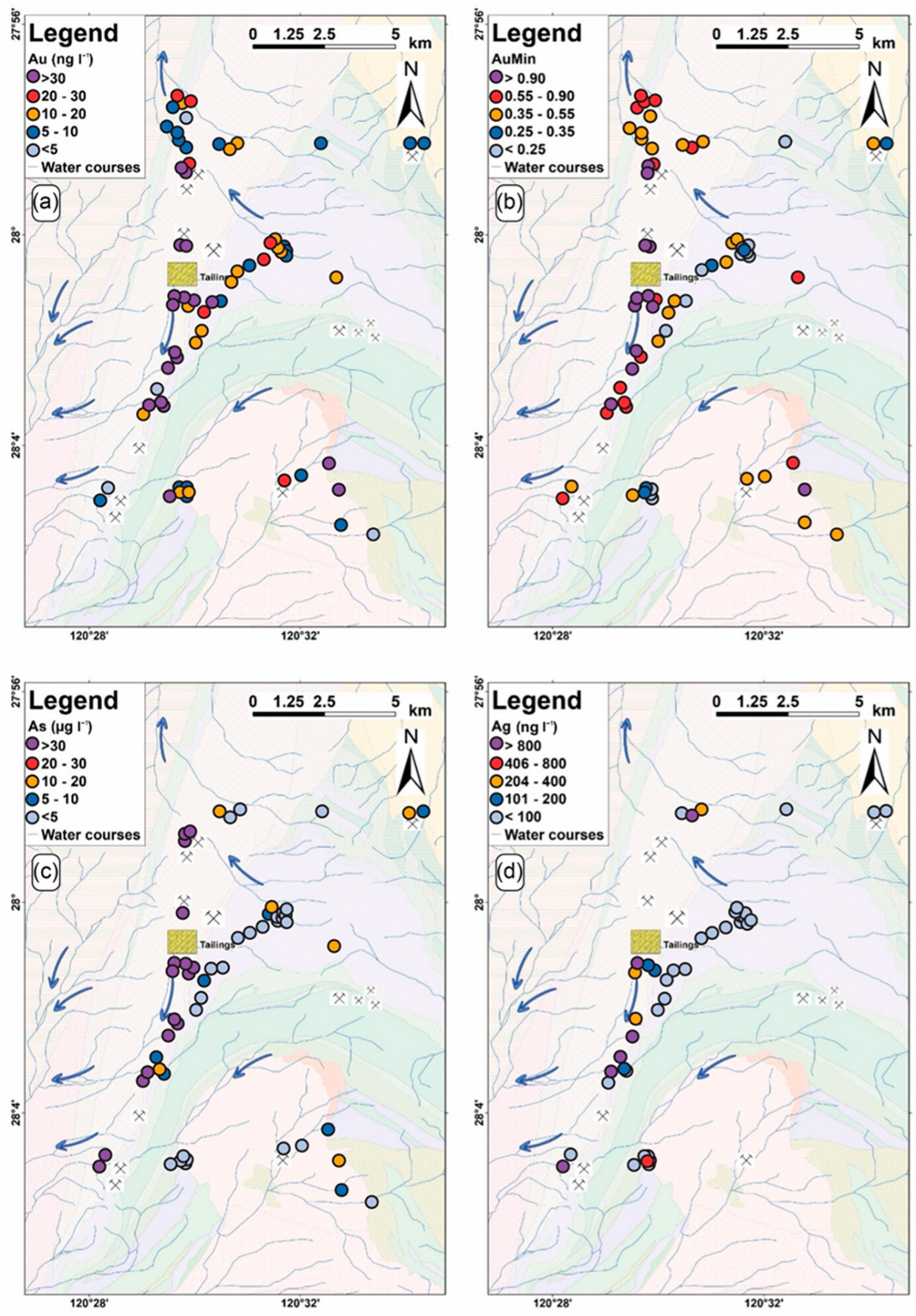
As with other Au deposit classes, leaching of mineralized zones can release a broad suite of pathfinders capable of forming extensive hydrogeochemical halos. At the Agnew deposit, elevated concentrations of dissolved Au, Ag, As, W, Co, and Mn have been documented [29], corresponding to major components of the Au ore system [29]. These anomalies commonly exceed regional background levels by two to five orders of magnitude, with some values representing the highest recorded in the northern Yilgarn region (Figure 4) [20]. Comparable multi-element signatures occur at the Harmony deposit, where Mo, W, and Rb anomalism have been reported [170], and Au enrichment aligns closely with hydrothermal alteration zones [20]. In the Black Flag district, pathfinders such as As, Mo, and Sb occur alongside Au mineralization [169]. Conversely, in South Australia, Ag and As are inconsistently distributed and only sporadically anomalous near Au camps. Groundwaters near the Tunkilla deposit exhibit elevated Au together with V and Te anomalies [70].

4.7.3. Critical Mineral Systems

Hydrogeochemistry is playing an increasingly vital role in the search for critical minerals essential for the green energy transition and high-tech industries [3].
Uranium (U)
The exploration model for sandstone-hosted roll-front deposits is fundamentally a search for a mobile redox interface, where uranium is leached by oxidizing groundwaters and precipitates at a reducing barrier [66,75,77]. Here, thermodynamic modelling has proven powerful, with maps of the calculated Saturation Index (SI) for uraninite accurately outlining ore trends where maps of raw dissolved uranium were ineffective [66]. Exploration for deeply buried unconformity-related deposits requires a multi-faceted approach, utilizing a combination of direct U anomalies, mobile pathfinders (Ra, Rn, He, As), advanced isotopic tracers (high 234U/238U activity ratios), and the chemical fingerprint of the surrounding alteration halo (the Normalized Magnesium ratio) [46,63,67,76].
Lithium (Li)
The role of hydrogeochemistry differs dramatically between deposit types. For lithium brine deposits in arid, closed tectonic basins like the Andean Lithium Triangle, hydrogeochemistry is the primary method of resource evaluation, as the ore is the lithium-enriched saline groundwater itself [22,68,78,171]. Exploration involves directly analyzing brines for economic concentrations of Li and for key economic viability ratios, particularly a low magnesium-to-lithium (Mg/Li) ratio [22,171]. For hard-rock Li-Cs-Ta (LCT) pegmatites, exploration relies primarily on lithogeochemistry (e.g., K/Rb ratios in rock), but hydrogeochemistry can detect dispersion halos of Li, Rb, and Cs in shallow groundwater from associated alteration zones [80,81,82,172].
Rare Earth Elements (REEs)
Hydrogeochemical exploration for REEs is a newer field that relies on interpreting the unique chemical behavior of the lanthanide series [69,83,84,173,174]. Exploration focuses not on the absolute concentration of a single element but on the patterns of the entire REE group when normalized to a standard like chondrite [83,84]. These patterns provide a powerful fingerprint of the water’s interaction history. Key diagnostic features include the degree of fractionation between light REEs (LREE) and heavy REEs (HREE), and the presence of specific elemental anomalies (e.g., Eu, Ce), which can provide a vector toward a source like a carbonatite [69,83,84,175].

4.8. Synthesis of Trends, Challenges, and Future Directions

Unlike narrative syntheses that rely on expert selection and thematic emphasis, the PRISMA-based approach adopted here enables quantitative evaluation of trends, consistency, and gaps across the global literature. The systematic extraction of analytical methods, hydrogeochemical indicators, and interpretive frameworks reveals not only dominant practices, but also under-represented approaches and emerging techniques. This distinction is critical for objectively assessing methodological maturity and guiding future research priorities.
The evolution of hydrogeochemistry reveals a clear trajectory toward more sophisticated, integrated, and predictive methodologies. This synthesis also highlights a set of persistent challenges that continue to shape research and practice, while pointing toward significant opportunities for the future of the discipline. The central challenge has matured from one of detecting whether a subtle anomaly can be measured to one of confident attribution and unambiguously determining what that measurement means [33].

4.8.1. Emerging Trends in Data Integration, Predictive Modelling, and Technological Innovation

Among the most significant emerging trends identified through this systematic review are the increasing application of non-traditional stable isotope fractionation (e.g., δ65Cu, δ98Mo) and nanoparticle geochemistry using spICP-MS, which provide process-specific and source-diagnostic signals not accessible through conventional dissolved-phase analysis.
A dominant trend is the shift away from simplistic, single-element anomaly hunting toward integrated exploration frameworks [2,5,94]. The early call to merge water chemistry with geological maps, stream sediment geochemistry, and remote sensing imagery within a GIS platform was a forward-looking vision of the multi-layered, data-driven approach that is now fundamental to modern exploration targeting [5,94]. This holistic approach allows for more robust target validation, as anomalies can be supported by multiple, independent lines of evidence.
Concurrently, the discipline has moved toward a more data-driven and predictive science [26,40,55,66]. This trend has accelerated dramatically with the rise of Artificial Intelligence (AI) and Machine Learning (ML) [26,40,176,177,178]. Algorithms like Random Forest and Neural Networks can analyze massive, multi-parameter datasets to find the subtle, non-linear patterns that often signal a geochemical anomaly, generating quantitative prospectivity maps that represent a leap beyond traditional anomaly detection [25,26,38,40].
This evolution is enabled by new frontiers in tracing and sampling technologies. The development and application of advanced tracers, particularly non-traditional stable isotopes and nanoparticles, provide unprecedented, process-specific information that reduces ambiguity [2,33,49]. At the same time, new sampling platforms like UAVs and the development of in-field sensors for real-time monitoring are revolutionizing data acquisition [24,179,180,181]. This move toward continuous monitoring transforms the practice from taking a single “snapshot” to creating a “movie” of the hydrogeochemical system, incorporating the fourth dimension of time to reveal powerful, transient anomalies that would be missed by conventional surveys.

4.8.2. Persistent Challenges in Hydrogeochemical Exploration

Despite its successes, hydrogeochemistry is subject to inherent challenges. A primary manifestation of this is seasonal and temporal variability. Spring snowmelt, for example, can drastically alter water chemistry, variously diluting, concentrating, or physically displacing anomalies from their source [4]. This temporal instability necessitates strict sampling protocols, such as collecting all samples within a narrow time window during stable, low-flow conditions, to ensure data comparability [4,5]. Technical and logistical hurdles, such as the ever-present risk of contamination at ultra-trace levels and the difficulty of obtaining representative samples from deep, fractured-rock environments, also remain significant challenges [4,76,85]. Background concentrations in many pristine environments are often in the low-ppb or sub-ppb range, so even minor contamination from sample containers, preservatives, or handling can lead to misleading anomalies [4,85].
Perhaps the greatest and most persistent challenge is the robust interpretation of anomalies against a complex and highly variable geochemical background [5,19,89,136,182]. Disentangling a subtle anomaly related to mineralization from the strong chemical signatures of different rock types, industrial pollution, or agricultural runoff requires sophisticated statistical analysis and a deep understanding of all potential sources within a catchment [5,19,89]. Distinguishing a true mineralization-related anomaly from a “false” anomaly generated by these other processes remains a primary focus of hydrogeochemical interpretation and is the driver behind the adoption of more advanced interpretive tools [2,89,182].

4.8.3. Exploration Workflow for Hydrogeochemistry

The workflow presented in Figure 5 provides a structured framework for the application of hydrogeochemistry in mineral exploration. It illustrates systematic progression from defining sampling objectives to the final stages of data interpretation and reporting, ensuring that each step is scientifically coherent and operationally robust. The process begins with sampling objectives, which establish the purpose of the survey, whether to define geochemical baselines, detect mineralization signals, or identify hydrogeochemical anomalies. These objectives guide subsequent decisions on site selection and pre-survey checks, including hydrogeological mapping, accessibility and safety assessments, equipment calibration, and GPS logging. Such preparatory steps are critical for ensuring both data quality and field efficiency.
Sample recovery and processing are central to the workflow. Groundwater is typically collected using bailers or pumps (peristaltic, bladder, inertial, or submersible), while stream water is recovered using syringes. Filtration methods, paper vacuums, cartridges, or in-line systems, are employed to separate dissolved and particulate fractions. Rigorous sample labelling and metadata recording (ID, coordinates, time/date, well depth or stream stage, collector name) ensure traceability and reproducibility.
To maintain analytical integrity, the workflow incorporates QA/QC procedures, including field blanks, trip blanks, duplicates, calibration standards, and chain-of-custody documentation. Samples are categorized into physical, dissolved, and isotopic types, with specific volumes and preservation requirements tailored to each analytical target. For example, δ13C requires airtight amber bottles, while isotopes such as δ65Cu, δ98Mo, and 87Sr/86Sr demand precise volumes and acidified preservation.
Field measurements and data acquisition are conducted in situ, using bailer readings, flow-through cells, or submerged probes. Parameters such as temperature, pH, redox potential (Eh), conductivity, total dissolved solids, dissolved oxygen, turbidity, and hydrological metrics (water table depth, stream velocity, stream dimensions) provide essential contextual information for interpreting chemical anomalies.
The workflow emphasizes sample transport and preservation, requiring insulated coolers, temperature control (<4 °C), shock-protected bottles, and same-day delivery where possible. Preservation strategies, airtight sealing, refrigeration, and acidification, are applied as appropriate to maintain sample integrity until laboratory analysis (Figure 5).
In the laboratory, advanced techniques such as ICP-MS and ICP-OES (for trace and major elements), ion chromatography (for anions), isotope ratio mass spectrometry, and TOC analysis are employed. QA/QC validation metrics, including relative percent difference, relative standard deviation, and spike recovery, ensure analytical reliability (Figure 5).
The final stages of the workflow focus on data interpretation and integration. Hydrochemical facies are classified using Piper, Schoeller, and Stiff diagrams, which are appropriate for characterizing groundwater types and dominant geochemical evolution trends relevant to mineral exploration, while multivariate statistical approaches (PCA, clustering) are applied to log-ratio transformed datasets (Figure 5). These methods facilitate anomaly identification and geological correlation. Results are then synthesized into technical reports and GIS-based hydrogeochemical maps, ensuring that findings are archived and accessible for long-term exploration planning.

4.8.4. Outlook and Future Research Priorities

The foundational research and emerging trends point toward several key opportunities for advancing the field. The most significant future direction is the deepening of multi-disciplinary integration. The next frontier involves moving beyond simple 2D map overlays to incorporating hydrogeochemical data into dynamic 3D and 4D models of geological systems, combining water chemistry with deep-penetrating geophysical methods to trace fluid pathways from large-scale crustal structures to the surface [10,112]. There is also a clear opportunity for the expansion of the geochemical toolkit. As the demand for critical minerals grows, research is needed to define reliable hydrogeochemical pathfinder suites and isotopic systems for under-explored commodities like cobalt, indium, and gallium [2,37]. The continued development and validation of non-traditional stable isotope systems and nanoparticle analysis across different deposit types will be crucial [2,33,49].
The accelerated adoption of new technologies will be critical. The exploration industry should continue to embrace the power of Artificial Intelligence (AI) and machine learning (ML), not just for post-survey data analysis, but for guiding exploration strategy in real-time [26,178,183]. To enable these data-intensive approaches, there is a pressing need for greater international collaboration and data-sharing initiatives. The creation of comprehensive, standardized, publicly accessible geochemical databases is crucial for establishing robust global baselines and for training the powerful AI models that will drive the next generation of mineral discovery [163,184]. This fundamentally changes the skillset required of an exploration geochemist; today, core competencies must include data science, multivariate statistics, isotopic geochemistry, and integrated 3D thinking [32].
The evidence base is subject to several limitations, including variability in sampling density, analytical methods, and reporting standards across studies. In some cases, incomplete metadata or limited QA/QC documentation restricts the ability to fully assess data reliability. Additionally, geographic bias toward well-studied regions may limit the generalizability of findings to underexplored terrains.

5. Conclusions

The PRISMA-2020-compliant systematic review synthesized evidence from 118 empirically screened studies published between 1946 and 2025, providing a structured evaluation of hydrogeochemical methods used in mineral exploration across diverse geological, hydrogeological, and climatic settings. The systematic synthesis demonstrates that hydrogeochemistry is most effective when interpreted as a process-based exploration tool, rather than as a simple concentration-driven anomaly detection method.
Across the reviewed studies, consistent empirical patterns were identified, including the development of zoned aqueous dispersion halos, predictable partitioning of mobile and immobile elements, and strong dependence of anomaly expression on groundwater flow regime, redox state, pH, and ligand availability. These findings, repeatedly documented across base-metal, precious-metal, critical mineral, and REE systems, confirm that hydrogeochemical anomalies reflect integrated mineralization processes rather than isolated geochemical signals.
The systematic comparison of methodologies shows clear convergence toward thermodynamically informed interpretation, multivariate compositional data analysis, and explicit consideration of groundwater flow systems. Studies employing mineral saturation indices, alteration-related ratios, isotopic tracers, and flow-system context consistently achieved higher interpretive confidence than those relying on single-element thresholds alone. Emerging approaches identified through the extracted literature, including non-traditional stable isotope fractionation and nanoparticle geochemistry using spICP-MS, provide enhanced source specificity and represent a significant methodological advance supported by a growing empirical evidence base.
A key contribution of this review is the formalization of a standardized, reproducible exploration workflow, grounded in the practices most consistently reported across the screened studies. By explicitly linking survey design, sampling protocols, analytical strategies, and data interpretation within a single framework, this synthesis moves beyond narrative reviews to provide an evidence-based foundation for reproducible hydrogeochemical exploration.
Collectively, the systematic evidence confirms that hydrogeochemistry is a scalable, low-impact, and scientifically robust exploration approach for detecting concealed mineral systems. When implemented using process-based interpretation and modern analytical tools, hydrogeochemistry provides reliable vectoring information that complements geophysical and geological datasets, supporting efficient and sustainable mineral exploration under increasing cover conditions.
Future research should prioritize quantitative inter-comparison of emerging isotopic and nanoparticle tracers across deposit types, expanded validation in under-represented climatic regions, and integration of hydrogeochemical datasets into dynamic 3D and 4D prospectivity models. These directions directly follow from gaps identified through the systematic synthesis rather than from conceptual extrapolation.

Supplementary Materials

The following supporting information can be downloaded at https://www.mdpi.com/article/10.3390/min16050451/s1, Table S1: PRISMA 2020 Reporting Checklist for the Systematic Review of Hydrogeochemistry in Mineral Exploration. Table S2: Data Extraction Framework, Study Sources, and Quality Assessment of Included Studies.

Author Contributions

Conceptualization, J.N.A. and E.D.S.; methodology, J.N.A.; software, J.N.A.; validation, E.D.S.; formal analysis, J.N.A.; investigation, J.N.A.; resources, E.D.S.; data curation, E.D.S.; writing—original draft preparation, J.N.A. and E.D.S.; writing—review and editing, J.N.A. and E.D.S.; visualization, J.N.A.; supervision, E.D.S.; project administration, E.D.S. All authors have read and agreed to the published version of the manuscript.

Funding

The authors acknowledge the institutional support provided by Sir Padampat Singhania University (SPSU) under the Seed Grant initiative (Ref. No. SPSU/2025-26/03/4708), which facilitated the development of the conceptual and methodological framework underpinning this study.

Data Availability Statement

No new data were created or analyzed in this study. Data sharing is not applicable to this article.

Acknowledgments

The authors acknowledge the Centre of Excellence in Environmental Science and Sustainability, Sir Padampat Singhania University, for providing an enabling academic and research environment for this research.

Conflicts of Interest

The authors declare no conflicts of interest.

Abbreviations

The following abbreviations are used in this manuscript:
PRISMAPreferred Reporting Items for Systematic reviews and Meta-Analyses
ICP-MSInductively Coupled Plasma Mass Spectrometry
GISGeographic Information System
ESGEnvironmental, Social, and Governance
HRICPMSHigh-Resolution Inductively Coupled Plasma Mass Spectrometry
ICP-OESInductively Coupled Plasma Optical Emission Spectrometry
MC-ICPMSMulti-Collector Inductively Coupled Plasma Mass Spectrometry
SEDEXSedimentary Exhalative Deposits
REERare Earth Elements
LCTLithium-Cesium-Tantalum
LREE/HREELight/Heavy Rare Earth Elements
UAVsUnmanned Aerial Vehicle(s)
PHREEQCpH, REdox, Equilibrium, and Chemistry
MVTMississippi Valley Type Deposits
SISaturation Index
AASAtomic Absorption Spectrometry
WATEQFCWater Aqueous Thermodynamic Equilibrium Computer Program
spICP-MSSingle-Particle Inductively Coupled Plasma Mass Spectrometry
TDS Total Dissolved Solids
GFAASGraphite Furnace Atomic Absorption Spectrometry
PCAPrincipal Component Analysis
FAFactor Analysis
VMSVolcanogenic Massive Sulphide
IOCGIron Oxide Copper Gold
AIArtificial Intelligence
MLMachine Learning
QA/QCQuality Assurance/Quality Control

References

  1. Pazand, K.; Javanshir, A.R. Orientation hydrogeochemical survey in Jebal-e-Barez area, SE Iran. Sustain. Water Resour. Manag. 2015, 1, 167–180. [Google Scholar] [CrossRef]
  2. Kidder, J.A.; Sullivan, K.; Leybourne, M.I.; Voinot, A.; Layton-Matthews, D.; Stoltze, A.; Bowell, R.J. Hydrogeochemical mineral exploration in deeply weathered terrains: An example from Mumbwa, Zambia. Sci. Total Environ. 2022, 810, 151215. [Google Scholar] [CrossRef]
  3. Kidder, J.A.; Leybourne, M.I.; Layton-Matthews, D.; Voinot, A.; Sullivan, K.; Stoltze, A.; Bowell, R.J. A review of hydrogeochemical techniques for mineral exploration: History, present and future. Geochem. Explor. Environ. Anal. 2025, 25, geochem2024-065. [Google Scholar] [CrossRef]
  4. Cameron, E.M. Hydrogeochemical methods for base metal exploration in the northern Canadian Shield. J. Geochem. Explor. 1978, 10, 219–243. [Google Scholar] [CrossRef]
  5. Simpson, P.R.; Edmunds, W.M.; Breward, N.; Cook, J.M.; Flight, D.; Hall, G.E.M.; Lister, T.R. Geochemical mapping of stream water for environmental studies and mineral exploration in the UK. J. Geochem. Explor. 1993, 49, 63–88. [Google Scholar] [CrossRef]
  6. Davranche, M.; Pourret, O.; Gruau, G.; Dia, A.; Jin, D.; Gaertner, D. Competitive binding of REE to humic acid and manganese oxide: Impact of reaction kinetics on development of cerium anomaly and REE adsorption. Chem. Geol. 2008, 247, 154–170. [Google Scholar] [CrossRef]
  7. Leybourne, M.I.; Cameron, E.M. Groundwater in geochemical exploration. Geochem. Explor. Environ. Anal. 2010, 10, 99–118. [Google Scholar] [CrossRef]
  8. Sharma, S.; Agrawal, V.; Akondi, R.N.; Wang, Y.; Hakala, A. Understanding controls on the geochemistry of hydrocarbon produced waters from different basins across the US. Environ. Sci. Process. Impacts 2021, 23, 28–47. [Google Scholar] [CrossRef]
  9. Lederer, G.; Schulz, K.J.; DeYoung, J.H.; Seal, R.R.; Piatak, N.M.; McCafferty, A.E.; Woodruff, L.G.; Bradley, D.C.; Verplanck, P.L.; Day, W.C.; et al. USGS critical minerals review. Min. Eng. 2024, 76, 29–42. [Google Scholar] [CrossRef]
  10. Kidder, J.A.; Leybourne, M.I.; Layton-Matthews, D.; Bowell, R.J.; Rissmann, C.F.W. A review of hydrogeochemical mineral exploration in the Atacama Desert, Chile. Ore Geol. Rev. 2020, 124, 103562. [Google Scholar] [CrossRef]
  11. Stumm, W.; Morgan, J.J. Aquatic Chemistry: Chemical Equilibria and Rates in Natural Waters, 3rd ed.; John Wiley & Sons: New York, NY, USA, 1996. [Google Scholar]
  12. Taufen, P.M. The role of hydrogeochemistry in mineral exploration in arid and semi-arid terrains. J. Geochem. Explor. 1997, 58, 115–132. [Google Scholar]
  13. Cameron, E.M.; Hamilton, S.M.; Leybourne, M.I.; Hall, G.E.M.; McClenaghan, M.B. Finding deeply buried deposits using geochemistry. Geochem. Explor. Environ. Anal. 2004, 4, 7–32. [Google Scholar] [CrossRef]
  14. Cidu, R.; Fanfani, L.; Shand, P.; Edmunds, W.M.; Dack, L.V.; Gijbels, R. Hydrogeochemical exploration for gold in the Osilo area, Sardinia, Italy. Appl. Geochem. 1995, 10, 517–529. [Google Scholar] [CrossRef]
  15. Hall, G.E.M. Analytical perspective on trace element species of interest in exploration. J. Geochem. Explor. 1998, 61, 1–19. [Google Scholar] [CrossRef]
  16. Noble, R.R.P.; Gray, D.J.; Reid, N. Regional exploration for channel and playa uranium deposits in Western Australia using groundwater. Appl. Geochem. 2011, 26, 1956–1974. [Google Scholar] [CrossRef]
  17. Islam, M.S. Hydrogeochemical Evaluation and Groundwater Quality; Springer: Berlin/Heidelberg, Germany, 2023. [Google Scholar] [CrossRef]
  18. Subramani, T.; Rajmohan, N.; Elango, L. Groundwater geochemistry and identification of hydrogeochemical processes in a hard rock region, southern India. Environ. Monit. Assess. 2010, 162, 123–137. [Google Scholar] [CrossRef]
  19. Sunkari, E.D.; Abu, M.; Zango, M.S.; Wani, A.M.L.L. Hydrogeochemical characterization and assessment of groundwater quality in the Kwahu-Bombouaka Group of the Voltaian Supergroup, Ghana. J. Afr. Earth Sci. 2020, 169, 103899. [Google Scholar] [CrossRef]
  20. Noble, R.R.P.; Gray, D.J. Hydrogeochemistry for mineral exploration in Western Australia (I): Methods and equipment. Explore 2010, 146, 2–11. [Google Scholar] [CrossRef]
  21. Gray, D.J.; Reid, N.; Fidler, R.; Fairclough, M.; Wilson, T. Hydrogeochemistry: A regional prospecting tool in South Australia? MESA J. 2012, 64, 14–17. [Google Scholar]
  22. Munk, L.A.; Hynek, S.A.; Bradley, D.C.; Boutt, D.; Labay, K.A.; Jochens, H. Lithium brines—A global perspective. In Rare Earth and Critical Elements in Ore Deposits; Verplanck, P.L., Hitzman, M.W., Eds.; Society of Economic Geologists: Littleton, CO, USA, 2016; Volume 18, pp. 339–365. [Google Scholar] [CrossRef]
  23. Buskard, J.; Reid, N.; Gray, D.J. Parts per trillion (ppt) gold in groundwater: Can we believe it, what is anomalous and how do we use it? Geochem. Explor. Environ. Anal. 2020, 20, 189–198. [Google Scholar] [CrossRef]
  24. Kidder, J.A.; Sullivan, K.; Leybourne, M.I.; Layton-Matthews, D.; Stoltze, A.; Bowell, R.J. Using UAVs to collect filtered water samples for mineral exploration: Will it take off? J. Geochem. Explor. 2025, 269, 107617. [Google Scholar] [CrossRef]
  25. Zuo, R. Machine learning of mineralization-related geochemical anomalies: A review of potential methods. Nat. Resour. Res. 2017, 26, 457–464. [Google Scholar] [CrossRef]
  26. Zuo, R.; Xiong, Y. Big data analytics of identifying geochemical anomalies supported by machine learning methods. Nat. Resour. Res. 2018, 27, 5–13. [Google Scholar] [CrossRef]
  27. Barbosa, A.d.S.; da Silva, M.C.B.C.; da Silva, L.B.; Morioka, S.N.; de Souza, V.F. Integration of environmental, social, and governance (ESG) criteria: Their impacts on corporate sustainability performance. Humanit. Soc. Sci. Commun. 2023, 10, 410. [Google Scholar] [CrossRef]
  28. Grunsky, E.C. The interpretation of geochemical survey data. Geochem. Explor. Environ. Anal. 2010, 10, 27–74. [Google Scholar] [CrossRef]
  29. Reid, N.; Buskard, J.; Gray, D.J. Gold exploration using groundwater in Western Australia. Geochem. Explor. Environ. Anal. 2023, 23, 1–18. [Google Scholar] [CrossRef]
  30. Jowitt, S.M.; Mudd, G.M.; Thompson, J.F.H. Future availability of non-renewable metal resources and the influence of environmental, social, and governance conflicts on metal production. Commun. Earth Environ. 2020, 1, 13. [Google Scholar] [CrossRef]
  31. Obiri-Nyarko, F.; Asugre, S.J.; Asare, S.V.; Duah, A.A.; Karikari, A.Y.; Kwiatkowska-Malina, J.; Malina, G. Hydrogeochemical studies to assess the suitability of groundwater for drinking and irrigation purposes: The Upper East Region of Ghana case study. Agriculture 2022, 12, 1973. [Google Scholar] [CrossRef]
  32. Cohen, D.R.; Kelley, D.L.; Anand, R.R.; Coker, W.B. Major advances in exploration geochemistry, 1998–2007. Geochem. Explor. Environ. Anal. 2010, 10, 3–16. [Google Scholar] [CrossRef]
  33. Mahan, B.; Mathur, R.; Sanislav, I.; Rea, P.; Dirks, P.J.A.G. Cu isotopes in groundwater for hydrogeochemical mineral exploration: A case study using the world-class Mount Isa Cu–Pb–Zn deposit (Australia). Appl. Geochem. 2023, 148, 105519. [Google Scholar] [CrossRef]
  34. Kelley, K.D.; Graham, G.E.; Pfaff, K.; Lowers, H.A.; Koenig, A.E. Indicator mineral analyses of stream-sediment samples using automated mineralogy and mineral chemistry: Applicability to exploration in covered terranes in eastern Alaska, USA. Ore Geol. Rev. 2022, 148, 105021. [Google Scholar] [CrossRef]
  35. de Caritat, P.; McPhail, D.C.; Kyser, K.; Oates, C.J. Using groundwater chemical and isotopic composition in the search for base metal deposits: Hydrogeochemical investigations in the Hinta and Kayar Pb–Zn districts, India. Geochem. Explor. Environ. Anal. 2009, 9, 215–226. [Google Scholar] [CrossRef]
  36. Balaram, V.; Satyanarayanan, M.; Anbarasu, K.; Venkata Subba Rao, D.; Mohammed Dar, A.; Tirumala Kamala, C.; Nirmal Charan, S. Hydrogeochemistry as a tool for platinum group element (PGE) exploration—A case study from Sittampundi anorthosite complex, Southern India. J. Geol. Soc. India 2019, 94, 341–350. [Google Scholar] [CrossRef]
  37. Kidder, J.A.; Garrett, R.G.; McClenaghan, M.B.; Beckett-Brown, C.E.; Day, S.J.A. Exploration Hydrogeochemistry: Case Studies 1935 to 2024; Natural Resources Canada: Ottawa, ON, Canada, 2024. [Google Scholar] [CrossRef]
  38. Schroder, I.F.; Caritat, P.; Huston, D.; Champion, D. Multivariate compositional analysis of groundwater geochemistry in the Georgina Basin: New insights for sediment-hosted mineral systems. J. Geochem. Explor. 2025, 278, 107857. [Google Scholar] [CrossRef]
  39. Eppinger, R.G.; Fey, D.L.; Giles, S.A.; Grunsky, E.C.; Kelley, K.D.; Minsley, B.J.; Munk, L.; Smith, S.M.; Graham, G.E.; Taylor, R.D.; et al. Summary of exploration geochemical and mineralogical studies at the giant Pebble porphyry Cu–Au–Mo deposit, Alaska: Implications for exploration under cover. Econ. Geol. 2013, 108, 495–527. [Google Scholar] [CrossRef]
  40. Carranza, E.J.M.; Laborte, A.G. Data-driven predictive modeling of mineral prospectivity using random forests: A case study in Catanduanes Island (Philippines). Nat. Resour. Res. 2016, 25, 35–50. [Google Scholar] [CrossRef]
  41. Moher, D.; Liberati, A.; Tetzlaff, J.; Altman, D.G.; PRISMA Group. Preferred Reporting Items for Systematic Reviews and Meta-Analyses: The PRISMA statement. Int. J. Surg. 2010, 8, 336–341. [Google Scholar] [CrossRef] [PubMed]
  42. Sunkari, E.D.; Ambushe, A.A. Groundwater fluoride contamination, sources, hotspots, health hazards, and sustainable containment measures: A systematic review of the Ghanaian context. Groundw. Sustain. Dev. 2024, 27, 101352. [Google Scholar] [CrossRef]
  43. Balaram, V. Current and emerging analytical techniques for geochemical and geochronological studies. Geol. J. 2020, 56, 2300–2359. [Google Scholar] [CrossRef]
  44. Balaram, V. Advances in analytical techniques and applications in exploration, mining, extraction, and metallurgical studies of rare earth elements. Minerals 2023, 13, 1031. [Google Scholar] [CrossRef]
  45. Bolea-Fernandez, E.; Clough, R.; Fisher, A.; Gibson, B.; Russell, B. Atomic spectrometry update: Review of advances in the analysis of metals, chemicals and materials. J. Anal. At. Spectrom. 2024, 39, 2617–2693. [Google Scholar] [CrossRef]
  46. Toulhoat, P.; Beaucaire, C. Comparison between lead isotopes 234U/238U activity ratio and saturation index in hydrogeochemical exploration for concealed uranium deposits. J. Geochem. Explor. 1991, 41, 181–196. [Google Scholar] [CrossRef]
  47. Balaram, V.; Sawant, S.S. Indicator Minerals, Pathfinder Elements, and portable analytical instruments in mineral exploration studies. Minerals 2022, 12, 394. [Google Scholar] [CrossRef]
  48. Pace, H.E.; Rogers, N.J.; Jarolimek, C.; Coleman, V.A.; Higgins, C.P.; Ranville, J.F. Single particle inductively coupled plasma-mass spectrometry: A performance evaluation and method comparison in the determination of nanoparticle size. Environ. Sci. Technol. 2012, 46, 12272–12280. [Google Scholar] [CrossRef]
  49. Goodman, A.J.; Warix, S.; Ahabchane, H.E.; Hadioui, M.; Wilkinson, K.J. Advancing exploration hydrogeochemistry using single particle inductively coupled plasma–time-of-flight mass spectrometry at the Bear Lodge alkaline complex, Wyoming, USA. Geochem. Explor. Environ. Anal. 2025, 25, geochem2025-032. [Google Scholar] [CrossRef]
  50. Clough, R.; Fisher, A.; Gibson, B.; Russell, B. Atomic spectrometry update: Review of advances in the analysis of metals, chemicals and materials. J. Anal. At. Spectrom. 2023, 38, 2215–2279. [Google Scholar] [CrossRef]
  51. Kirste, D.; de Caritat, P.; Dann, R. The application of the stable isotopes of sulfur and oxygen in groundwater sulfate to mineral exploration in the Broken Hill region of Australia. J. Geochem. Explor. 2003, 78–79, 81–84. [Google Scholar] [CrossRef]
  52. Palacios, C.; Guerra, N.; Townley, B.; Lahsen, A.; Parada, M. Copper geochemistry in salt from evaporite soils, Coastal Range of the Atacama Desert, northern Chile: An exploration tool for blind Cu deposits. Geochem. Explor. Environ. Anal. 2005, 5, 371–378. [Google Scholar] [CrossRef]
  53. Langmuir, D. Solution Uranium solution-mineral equilibria at low temperatures with applications to sedimentary ore deposits. Uranium Geochim. Cosmochim. Acta 1978, 42, 547–569. [Google Scholar] [CrossRef]
  54. Leybourne, M.; Goodfellow, W.; Boyle, D. Hydrogeochemical, isotopic, and rare earth element evidence for contrasting water–rock interactions at two undisturbed Zn–Pb massive sulphide deposits, Bathurst Mining Camp, N.B., Canada. J. Geochem. Explor. 1998, 64, 237–261. [Google Scholar] [CrossRef]
  55. Saunders, J.A. Supergene oxidation of bonanza Au-Ag veins at the Sleeper Deposit, Nevada, USA: Implications for hydrogeochemical exploration in the Great Basin. J. Geochem. Explor. 1993, 47, 359–375. [Google Scholar] [CrossRef]
  56. Lalinská-Voleková, B.; Majerová, H.; Kautmanová, I.; Brachtýř, O.; Szabóová, D.; Arendt, D.; Brčeková, J.; Šottník, P. Hydrous ferric oxides (HFO’s) precipitated from contaminated waters at several abandoned Sb deposits—Interdisciplinary assessment. Sci. Total Environ. 2022, 821, 153248. [Google Scholar] [CrossRef]
  57. Plouffe, A.; Ferbey, T. Porphyry Cu indicator minerals in till: A method to discover buried mineralization. In Indicator Minerals in Till and Stream Sediments of the Canadian Cordillera; Ferbey, T., Plouffe, A., Hickin, A.S., Eds.; Geological Association of Canada: St. John’s, NL, Canada, 2017; pp. 129–159. [Google Scholar]
  58. Eppinger, R.G.; Fey, D.L.; Giles, S.A.; Kelley, K.D.; Smith, S.M. An exploration hydrogeochemical study at the giant Pebble porphyry Cu-Au-Mo deposit, Alaska, USA, using high resolution ICP-MS. Geochem. Explor. Environ. Anal. 2012, 12, 211–226. [Google Scholar] [CrossRef]
  59. Ayuso, R.A.; Kelley, K.D.; Eppinger, R.G.; Forni, F. Pb-Sr-Nd isotopes in surficial materials at the Pebble Porphyry Cu-Au-Mo deposit, southwestern Alaska: Can the mineralizing fingerprint be detected through cover? Econ. Geol. 2013, 108, 543–562. [Google Scholar] [CrossRef]
  60. Mathur, R.; Munk, L.; Nguyen, M.; Gregory, M.; Annell, H.; Lang, J. Modern and paleofluid pathways revealed by Cu isotope compositions in surface waters and ores of the Pebble porphyry Cu-Au-Mo deposit, Alaska. Econ. Geol. 2013, 108, 529–541. [Google Scholar] [CrossRef]
  61. Leybourne, M.I.; Cameron, E.M. Composition of groundwaters associated with porphyry-Cu deposits, Atacama Desert, Chile: Elemental and isotopic constraints on water sources and water–rock reactions. Geochim. Cosmochim. Acta 2006, 70, 1616–1635. [Google Scholar] [CrossRef]
  62. Boyle, R.W.; Hornbrook, E.H.W.; Allan, R.J.; Dyck, W.; Smith, A.Y. Hydrogeochemical methods—Application in the Canadian Shield. Bull. Can. Inst. Min. Metall. 1971, 64, 60–71. [Google Scholar]
  63. Singh, R.V.; Sinha, R.M.; Bisht, B.S.; Banerjee, D.C. Hydrogeochemical exploration for unconformity-related uranium mineralization: Example from Palnadu sub-basin, Cuddapah Basin, Andhra Pradesh, India. J. Geochem. Explor. 2002, 76, 71–92. [Google Scholar] [CrossRef]
  64. Leach, D.L.; Taylor, R.D.; Fey, D.L.; Diehl, S.F.; Saltus, R.W. A deposit model for Mississippi valley-type lead–zinc ores. In Scientific Investigations Report; United States Geological Survey: Reston, VA, USA, 2010. [Google Scholar] [CrossRef]
  65. Miller, W.R.; Ficklin, W.H.; Learned, R.E. Hydrogeochemical prospecting for porphyry copper deposits in the tropical-marine climate of Puerto Rico. J. Geochem. Explor. 1982, 16, 217–233. [Google Scholar] [CrossRef]
  66. Runnells, D.D.; Lindberg, R.D. Hydrogeochemical exploration for uranium ore deposits: Use of the computer model WATEQFC. J. Geochem. Explor. 1981, 15, 37–50. [Google Scholar] [CrossRef]
  67. Giblin, A.M.; Snelling, A.A. Application of hydrogeochemistry to uranium exploration in the Pine Creek geosyncline, Northern Territory, Australia. J. Geochem. Explor. 1983, 19, 33–55. [Google Scholar] [CrossRef]
  68. Munk, L.A.; Boutt, D.; Butler, K.; Russo, A.; Jenckes, J.; Moran, B.; Kirshen, A. Lithium brines: Origin, characteristics, and global distribution. Econ. Geol. 2025, 120, 575–597. [Google Scholar] [CrossRef]
  69. Medas, D.; Cidu, R.; De Giudici, G.; Podda, F. Geochemical behaviour of rare earth elements in mining environments under non-acidic conditions. Procedia Earth Planet. Sci. 2013, 7, 578–581. [Google Scholar] [CrossRef]
  70. Gray, D.J.; Pirlo, M.C. Hydrogeochemistry of the Tunkillia Gold Prospect, South Australia; Exploration and Mining, Report P2005/326; CSIRO: Canberra, Australia, 2005. [Google Scholar]
  71. Radtke, A.S.; Scheiner, B.J. Studies of hydrothermal gold deposition—(pt.) 1, carlin gold deposit, nevada, the role of carbonaceous materials in gold deposition. Econ. Geol. 1970, 65, 87–102. [Google Scholar] [CrossRef]
  72. Grimes, D.J.; Ficklin, W.H.; Meier, A.L.; McHugh, J.B. Anomalous gold, antimony, arsenic, and tungsten in ground water and alluvium around disseminated gold deposits along the Getchell Trend, Humboldt County, Nevada. J. Geochem. Explor. 1995, 52, 351–371. [Google Scholar] [CrossRef]
  73. Cline, J.S.; Hofstra, A.H.; Muntean, J.L.; Tosdal, R.M.; Hickey, K.A. Carlin-Type Gold Deposits in Nevada—Critical Geologic Characteristics and Viable Models. In One Hundredth Anniversary Volume; Hedenquist, J.W., Thompson, J.F.H., Goldfarb, R.J., Richards, J.P., Eds.; Society of Economic Geologists: Littleton, CO, USA, 2005; pp. 451–484. [Google Scholar] [CrossRef]
  74. Cassinerio, M.D.; Muntean, J.L.; Steininger, R.; Pennell, B. Patterns of lithology, structure, alteration and trace elements around high-grade ore zones at the Turquoise Ridge gold deposit, Getchell district, Nevada. Gr. Basin Evol. Metallog. 2011, 2, 949–978. [Google Scholar]
  75. Langmuir, D.; Chatham, J.R. Groundwater prospecting for sandstone-type uranium deposits: A preliminary comparison of the merits of mineral-solution equilibria, and single-element tracer methods. J. Geochem. Explor. 1980, 13, 201–219. [Google Scholar] [CrossRef]
  76. Earle, S.A.M.; Drever, G.L. Hydrogeochemical exploration for uranium within the Athabasca Basin, northern Saskatchewan. J. Geochem. Explor. 1983, 19, 57–73. [Google Scholar] [CrossRef]
  77. Dang, H.; Tong, H.; Sun, P.; Ma, D.; Ren, X. Evolution of oxidized ore-forming fluids and uranium mineralization mechanisms in sandstone-type uranium deposits: Insights from the Lenghu Area, Qaidam Basin. Ore Geol. Rev. 2025, 186, 106924. [Google Scholar] [CrossRef]
  78. Kesler, S.E.; Gruber, P.W.; Medina, P.A.; Keoleian, G.A.; Everson, M.P.; Wallington, T.J. Global lithium resources: Relative importance of pegmatite, brine and other deposits. Ore Geol. Rev. 2012, 48, 55–69. [Google Scholar] [CrossRef]
  79. Steinmetz, R.L.L.; Salvi, S.; Sarchi, C.; Santamans, C.; Steinmetz, L.C.L. Lithium and brine geochemistry in the Salars of the Southern Puna, Andean Plateau of Argentina. Econ. Geol. 2020, 115, 1079–1096. [Google Scholar] [CrossRef]
  80. Selway, J.B. A review of rare-element (Li-Cs-Ta) pegmatite exploration techniques for the Superior Province, Canada, and large worldwide tantalum deposits. Explor. Min. Geol. 2005, 14, 1–30. [Google Scholar] [CrossRef]
  81. Leinonen, S.; Pokki, J. Geochemical sampling in Kaustinen, Finland—Indications of new lithium sources. J. Geochem. Explor. 2025, 278, 107856. [Google Scholar] [CrossRef]
  82. Moilanen, M. Hydrogeochemistry of Lithium—Implications for Li-Cs-Ta-Pegmatite Exploration in Finland. Master’s Thesis, University of Helsinki, Helsingfors, Finland, 2025. Available online: http://hdl.handle.net/10138/601024 (accessed on 15 March 2026).
  83. Balaram, V. Rare earth elements: A review of applications, occurrence, exploration, analysis, recycling, and environmental impact. Geosci. Front. 2019, 10, 1285–1303. [Google Scholar] [CrossRef]
  84. Wei, S.; Liu, Z.; Chen, J.; Xu, B.; Zhang, H. Geochemical characteristics of rare earth elements in the Chaluo Hot Springs in Western Sichuan Province, China. Front. Earth Sci. 2022, 10, 865322. [Google Scholar] [CrossRef]
  85. Steele, K.F.; Dilday, T.F., III. Hydrogeochemical exploration for Mississippi valley-type deposits, Arkansas, U.S.A. J. Geochem. Explor. 1985, 23, 71–79. [Google Scholar] [CrossRef]
  86. Koparan, C.; Koc, A.B.; Privette, C.V.; Sawyer, C.B. In situ water quality measurements using an unmanned aerial vehicle (UAV) system. Water 2018, 10, 264. [Google Scholar] [CrossRef]
  87. Koparan, C.; Koc, A.B.; Privette, C.V.; Sawyer, C.B. Autonomous in situ measurements of noncontaminant water quality indicators and sample collection with a UAV. Water 2019, 11, 604. [Google Scholar] [CrossRef]
  88. Parkhurst, D.L.; Appelo, C.A.J. Techniques and Methods 6-A43. In Description of Input and Examples for PHREEQC Version 3-A Computer Program for Speciation, Batch-Reaction, One-Dimensional Transport, and Inverse Geochemical Calculations; U.S. Geological Survey: Reston, VA, USA, 2013; 497p. Available online: https://pubs.usgs.gov/publication/tm6A43 (accessed on 11 April 2026).
  89. Dekkers, M.J.; Vriend, S.P.; van der Weijden, C.H.; van Gaans, P.F.M. Uranium anomaly evaluation in groundwaters: A hydrogeochemical study in the Nisa region, Portugal. Appl. Geochem. 1989, 4, 375–394. [Google Scholar] [CrossRef]
  90. Rose, A.W.; Hawkes, H.E.; Webb, J.S. Geochemistry in Mineral Exploration; Academic Press: New York, NY, USA, 1979; Volume 1, pp. 490–517. [Google Scholar]
  91. Dean, J.R.; Bland, C.J.; Levinson, A.A. The measurement of 226Ra/223Ra activity ratios in ground water as a uranium exploration technique. J. Geochem. Explor. 1983, 19, 187–193. [Google Scholar] [CrossRef]
  92. Sener, E.; Davraz, A.; Ozcelik, M. An integration of GIS and remote sensing in groundwater investigations: A case study in Burdur, Turkey. Hydrogeol. J. 2005, 13, 826–834. [Google Scholar] [CrossRef]
  93. Tagwai, M.G.; Jimoh, O.A.; Shehu, S.A.; Zabidi, H. Application of GIS and remote sensing in mineral exploration: Current and future perspectives. World J. Eng. 2024, 21, 487–502. [Google Scholar] [CrossRef]
  94. Abdelkareem, M.; Al-Arifi, N. Synergy of remote sensing data for exploring hydrothermal mineral resources using GIS-based fuzzy logic approach. Remote Sens. 2021, 13, 4492. [Google Scholar] [CrossRef]
  95. Nordstrom, D.K. Hydrogeochemical processes governing the origin, transport and fate of major and trace elements from mine wastes and mineralized rock to surface waters. Appl. Geochem. 2011, 26, 1777–1791. [Google Scholar] [CrossRef]
  96. Blake, J.M.; Ranville, J.F.; Higgins, C.P.; Fortner, J.D.; Turner, A.; Hageman, P.L.; Verplanck, P.L.; Day, W.C.; Plumlee, G.S.; Smith, K.S.; et al. New geochemical framework and geographic information system methodologies to assess element occurrence, persistence, and mobility in groundwater and surface water. Minerals 2022, 12, 411. [Google Scholar] [CrossRef]
  97. Talay, N.; Yolcubal, İ. Hydrogeochemical characterization and determination of arsenic sources in the groundwater of the alluvial plain of the lower Sakarya River Basin, Turkey. Water 2025, 17, 1931. [Google Scholar] [CrossRef]
  98. Boyle, R.W.; Garrett, R.G. Geochemical prospecting—A review of its status and future. Earth-Sci. Rev. 1970, 6, 51–75. [Google Scholar] [CrossRef]
  99. Sergeev, E.A.; Hawkes, H.E. Water analysis as a means of prospecting for metallic ore deposits. Open File Rep. 1946. [Google Scholar] [CrossRef]
  100. Fersman, A.Y. Geochemical and mineralogical methods of prospecting for mineral deposits. Circular 1952, 127, 37. [Google Scholar] [CrossRef]
  101. Marchant, J.W. An aid to prospecting for base metals in the African Shield. Trans. Inst. Min. Metall. Sect. B Appl. Earth Sci. 1980, 89, B133–B145. [Google Scholar]
  102. Kolotov, V.P.; Bezaeva, N.S. (Eds.) Advances in Geochemistry, Analytical Chemistry, and Planetary Sciences: 75th Anniversary of the Vernadsky Institute of the Russian Academy of Sciences; Springer: Berlin/Heidelberg, Germany, 2023. [Google Scholar] [CrossRef]
  103. Osedakh, A.G. Mineral resource exploration in the European North-East of the USSR, led by AA Chernov (1930s–1940s). Vopr. Istor. Estestvozn. Tekh. 2025, 46, 433–444. [Google Scholar]
  104. Smith, S.M. National Geochemical Database: Reformatted Data from the National Uranium Resource Evaluation (NURE) Hydrogeochemical and Stream Sediment Reconnaissance (HSSR) Program (No. 97–492); United States Geological Survey: Reston, VA, USA, 1997. [CrossRef]
  105. Rathore, D.P.S.; Tarafder, P.K.; Balaram, V. Challenges for reliable analysis of uranium in natural waters using laser-induced fluorimetry/LED-fluorimetry in the presence of fluoride and diverse humic substances in hot arid regions and future advances-Review. Environ. Sci. Adv. 2024, 3, 511–521. [Google Scholar] [CrossRef]
  106. Walsh, A. The application of atomic absorption spectra to chemical analysis. Spectrochim. Acta 1955, 7, 108–117. [Google Scholar] [CrossRef]
  107. Griffioen, J. History of the hydrogeochemical study of groundwater in the Netherlands and the research motives. Hydrogeol. J. 2023, 32, 679–689. [Google Scholar] [CrossRef]
  108. Houk, R.S.; Fassel, V.A.; Flesch, G.D.; Svec, H.J.; Gray, A.L.; Taylor, C.E. Inductively coupled argon plasma as an ion source for mass spectrometric determination of trace elements. Anal. Chem. 1980, 52, 2283–2289. [Google Scholar] [CrossRef]
  109. Sader, J.A.; Ryan, S. Advances in ICP-MS technology and the application of multi-element geochemistry to exploration. Geochem. Explor. Environ. Anal. 2020, 20, 167–175. [Google Scholar] [CrossRef]
  110. Wang, J.; Zuo, R.; Liu, Q. Mapping geochemical anomalies by accounting for the uncertainty of mineralization-related elemental associations. Solid Earth 2024, 15, 731–746. [Google Scholar] [CrossRef]
  111. White, D.E. Magmatic, connate, and metamorphic waters. Geol. Soc. Am. Bull. 1957, 68, 1659–1682. [Google Scholar] [CrossRef]
  112. Liu, J.; Zhang, Y.; Wang, Y.; Li, X.; Chen, J. Hydrogeochemistry and genetic mechanisms of the geothermal system in the Xi’an depression of the southern Weihe Basin, China. Geothermics 2024, 122, 103090. [Google Scholar] [CrossRef]
  113. Poot, J.; Felten, A.; Colaux, J.L.; Gouttebaron, R.; Lepêcheur, G.; Rochez, G.; Yans, J. Experimental timing of pyrite oxidation under various leaching conditions: Consequences for rates of weathering in geological profiles. Environ. Earth Sci. 2024, 83, 9. [Google Scholar] [CrossRef]
  114. Zhang, B.; Yan, T.; Wang, X.; Qiao, Y.; Liu, H.; Zhang, B. Hydrogeochemical characteristics and enrichment regularities of groundwater uranium in the Erlian basin, China. Appl. Geochem. 2024, 170, 106094. [Google Scholar] [CrossRef]
  115. Haas, L.; Ginder-Vogel, M.; Zambito, J.J.; Hart, D.; Roden, E.E. Microbially-mediated aerobic oxidation of trace element-bearing pyrite in neutral-pH sandstone aquifer sediments. Environ. Sci. Adv. 2024, 3, 833–849. [Google Scholar] [CrossRef]
  116. Skierszkan, E.K.; Dockrey, J.W.; Lindsay, M.B.J. Metal mobilization from thawing permafrost is an emergent risk to water resources. ACS ES&T Water 2024, 5, 20–32. [Google Scholar] [CrossRef] [PubMed]
  117. Zhang, Q.; Liang, X.; Xiao, C. The hydrogeochemical characteristic of mineral water associated with water-rock interaction in Jingyu County, China. Procedia Earth Planet. Sci. 2017, 17, 726–729. [Google Scholar] [CrossRef]
  118. Natali, S.; Franceschi, L.; Giannecchini, R.; D’Orazio, M.; Delgado-Huertas, A.; Zanchetta, G.; Doveri, M. Tracing contamination in mining areas through sulfur and oxygen isotopes in groundwater sulfates: A case study from the Apuan Alps (Italy). Environ. Geochem. Health 2025, 47, 249. [Google Scholar] [CrossRef] [PubMed]
  119. Jenner, A.-K.; Malik, C.; Böttcher, G.; Roeser, P.; Gehre, M.; Schmiedinger, I.; Böttcher, M.E. Sources and fate of dissolved sulphate, carbonate, and nitrate in groundwater of the temperate climate zone: A high-resolution multi-isotope (H, C, O, S) study in north-eastern Germany. Isot. Environ. Health Stud. 2025, 61, 20–41. [Google Scholar] [CrossRef] [PubMed]
  120. Qiao, W.; Liu, J.; Wang, H.; Chen, G.; Zuo, R.; Li, S.; Liu, Q.; Wang, J. Groundwater arsenic and antimony mobility from an antimony mining area: Controls of sulfide oxidation, carbonate and silicate weathering, and secondary mineral precipitation. Water Res. 2025, 273, 123086. [Google Scholar] [CrossRef]
  121. Kemeny, P.C.; Li, G.K.; Douglas, M.; Berelson, W.; Chadwick, A.J.; Dalleska, N.F.; Lamb, M.P.; Larsen, W.; Magyar, J.S.; Rollins, N.E.; et al. Arctic permafrost thawing enhances sulfide oxidation. Glob. Biogeochem. Cycles 2023, 37, GB007644. [Google Scholar] [CrossRef]
  122. Garrels, R.M.; Christ, C.L. Solutions, Minerals, and Equilibria; Harper & Row: New York, NY, USA, 1965. [Google Scholar]
  123. Lin, K.; Yu, T.; Ji, W.; Li, B.; Wu, Z.; Liu, X.; Li, C.; Yang, Z. Carbonate rocks as natural buffers: Exploring their environmental impact on heavy metals in sulfide deposits. Environ. Pollut. 2023, 336, 122506. [Google Scholar] [CrossRef]
  124. Grieco, G.; Cocomazzi, G.; Naitza, S.; Bussolesi, M.; Deidda, M.L.; Ferrari, E.S.; Destefanis, E. Recycling feldspar mining waste as buffering agent for acid mine drainage mitigation. Minerals 2024, 14, 552. [Google Scholar] [CrossRef]
  125. Nartowska, E.; Podlasek, A.; Vaverková, M.D.; Koda, E.; Jakimiuk, A.; Kowalik, R.; Kozłowski, T. Mobility of Zn and Cu in bentonites: Implications for environmental remediation. Materials 2024, 17, 2957. [Google Scholar] [CrossRef]
  126. Langmuir, D. Aqueous Environmental Geochemistry; Prentice Hall: Englewood Cliffs, NJ, USA, 1997. [Google Scholar]
  127. Luis Manrique Carreño, J. Geochemistry Applied to the Exploration of Mineral Deposits. In Geochemistry and Mineral Resources; Saleh, H.M., Hassan, A.I., Eds.; IntechOpen: London, UK, 2022. [Google Scholar] [CrossRef]
  128. Worch, E. Preface. In Hydrochemistry: Basic Concepts and Exercises; De Gruyter: Berlin, Germany, 2023; pp. V–VI. [Google Scholar] [CrossRef]
  129. Kong, C.; Zhao, J.; Li, B.; Wu, C.; Xu, K. Manganese mineral prospectivity mapping based on semi-supervised learning and multi-source geoscientific-sample Wasserstein generative adversarial network (Geo-WGAN) in Songtao of Guizhou, South China. Ore Geol. Rev. 2025, 186, 106933. [Google Scholar] [CrossRef]
  130. Del Rio-Salas, R.; Moreno-Rodríguez, V.; Loredo-Portales, R.; Salgado-Souto, S.A.; Valencia-Moreno, M.; Ochoa-Landín, L.; Romo-Morales, D. Traceability and dispersion of highly toxic soluble phases from historical mine tailings: Insights from Pb isotope systematics. Environ. Geochem. Health 2024, 46, 395. [Google Scholar] [CrossRef] [PubMed]
  131. Borisover, M.; Davis, J.A. Adsorption of inorganic and organic solutes by clay minerals. In Natural and Engineered Clay Barriers; Elsevier: Amsterdam, The Netherlands, 2015; pp. 33–70. [Google Scholar] [CrossRef]
  132. Hu, H.; Li, X.; Gao, X.; Wang, L.; Li, B.; Zhan, F.; He, Y.; Qin, L.; Liang, X. A review on the multifaceted effects of δ-MnO2 on heavy metals, organic matter, and other soil components. RSC Adv. 2024, 14, 37752–37762. [Google Scholar] [CrossRef]
  133. Sodzidzi, Z.; Phiri, Z.; Nure, J.F.; Msagati, T.A.M.; de Kock, L.A. Adsorption of toxic metals using hydrous ferric oxide nanoparticles embedded in hybrid ion-exchange resins. Materials 2024, 17, 1168. [Google Scholar] [CrossRef]
  134. Tóth, J. A theoretical analysis of groundwater flow in small drainage basins. J. Geophys. Res. 1963, 68, 4795–4812. [Google Scholar] [CrossRef]
  135. Tóth, J. Groundwater as a geologic agent: An overview of the causes, processes, and manifestations. Hydrogeol. J. 1999, 7, 1–14. [Google Scholar] [CrossRef]
  136. Sunkari, E.D.; Abu, M.; Bayowobie, P.S.; Dokuz, U.E. Hydrogeochemical appraisal of groundwater quality in the Ga west municipality, Ghana: Implication for domestic and irrigation purposes. Groundw. Sustain. Dev. 2019, 8, 501–511. [Google Scholar] [CrossRef]
  137. Miesch, A.T. Estimation of the geochemical threshold and its statistical significance. J. Geochem. Explor. 1981, 16, 49–76. [Google Scholar] [CrossRef]
  138. Roquin, C.; Zeegers, H. Improving anomaly selection by statistical estimation of background variations in regional geochemical prospecting. J. Geochem. Explor. 1987, 29, 295–316. [Google Scholar] [CrossRef]
  139. Wang, Q.; Cheng, Z.; Li, H.; Yang, T.; Yan, T.; Bing, M.; Yuan, H.; Lin, C. Mineral exploration in the Central Xicheng ore Field, China, using the Tectono-geochemistry, staged factor analysis, and fractal model. Minerals 2025, 15, 691. [Google Scholar] [CrossRef]
  140. Shahrestani, S.; Sanislav, I. Delineation of geochemical anomalies through empirical cumulative distribution function for mineral exploration. J. Geochem. Explor. 2025, 270, 107662. [Google Scholar] [CrossRef]
  141. Wilkinson, J.J.; Baker, M.J.; Cooke, D.R.; Wilkinson, C.C. Exploration targeting in porphyry Cu systems using propylitic mineral chemistry: A case study of the El Teniente deposit, Chile. Econ. Geol. 2020, 115, 771–791. [Google Scholar] [CrossRef]
  142. Seibert, S.L.; Massmann, G.; Meyer, R.; Post, V.E.A.; Greskowiak, J. Impact of mineral reactions and surface complexation on the transport of dissolved species in a subterranean estuary: Application of a comprehensive reactive transport modeling approach. Adv. Water Resour. 2024, 191, 104763. [Google Scholar] [CrossRef]
  143. Parkhurst, D.L.; Thorstenson, D.C.; Plummer, L.N. PHREEQE: A Computer Program for Geochemical Calculations; United States Geological Survey, Water Resources Division: Reston, VA, USA, 1982; Volume 80.
  144. Kitessa, W.M.; Kebede, A.B.; Tufa, F.G.; Gudeta, B.G.; Yenehun, A.; Chelkeba, B.; Debela, S.K.; Feyessa, F.F.; Walraevens, K. Hydrogeochemical characterization and processes controlling groundwater chemistry of complex volcanic rock of Jimma Area, Ethiopia. Water 2024, 16, 3470. [Google Scholar] [CrossRef]
  145. Wali, S.U.; Alias, N.; Harun, S.B.; Mohammed, I.U.; Garba, M.L.; Atiku, M. Application of geochemical modelling and multiple regression analysis to reassess groundwater evolution in Kaduna Basin, NW Nigeria. Discov. Water 2024, 4, 99. [Google Scholar] [CrossRef]
  146. Gulson, B.L. Lead Isotopes in Mineral Exploration; Elsevier: Amsterdam, The Netherlands, 1986; Volume 23. [Google Scholar]
  147. Dickson, B.L.; Meakins, R.L.; Bland, C.J. Evaluation of radioactive anomalies using radium isotopes in ground waters. In Geochemical Exploration 1982; Elsevier: Amsterdam, The Netherlands, 1984; Volume 17. [Google Scholar] [CrossRef]
  148. Seal, R.R. Sulfur isotope geochemistry of sulfide minerals. Rev. Mineral. Geochem. 2006, 61, 633–677. [Google Scholar] [CrossRef]
  149. Grunsky, E.C.; Caritat, P. State-of-the-art analysis of geochemical data for mineral exploration. Geochem. Explor. Environ. Anal. 2020, 20, 217–232. [Google Scholar] [CrossRef]
  150. Bourdeau, J.E.; Zhang, S.E.; Nwaila, G.T.; Ghorbani, Y. Data generation for exploration geochemistry: Past, present and future. Appl. Geochem. 2024, 172, 106124. [Google Scholar] [CrossRef]
  151. Miller, W.R.; Ficklin, W.H.; McHugh, J.B. Geochemical exploration for copper–nickel deposits in the cool-humid climate of northeastern Minnesota. J. Geochem. Explor. 1992, 42, 327–344. [Google Scholar] [CrossRef]
  152. APHA. AWWA–WEF. In Standard Methods for the Examination of Water and Wastewater, 24th ed.; Lipps, W.C., Baxter, T.E., Braun-Howland, E., Eds.; American Public Health Association: Washington, DC, USA; American Water Works Association: Denver, CO, USA; Water Environment Federation: Alexandria, VA, USA, 2023; Available online: https://www.standardmethods.org (accessed on 11 April 2026).
  153. Sunkari, E.D.; Amoldago, J.N.; Yeboah, H.N.L.; Okyere, M.B. Hydrogeochemical evolution and quality assessment of groundwater in the Voltaian aquifer, Krachi East Municipality, Ghana using chemometric and geochemical modeling approaches. Discover Environ. 2026, 4, 145. [Google Scholar] [CrossRef]
  154. Cloutier, V.; Lefebvre, R.; Therrien, R.; Savard, M.M. Multivariate statistical analysis of geochemical data as indicative of the hydrogeochemical evolution of groundwater in a sedimentary rock aquifer system. J. Hydrol. 2008, 353, 294–313. [Google Scholar] [CrossRef]
  155. Ganguly, P. Applications of remote sensing and GIS in mineral exploration. Int. J. Res. Appl. Sci. Eng. Technol. 2023, 11, 844–859. [Google Scholar] [CrossRef]
  156. Alpers, C.N.; Whittemore, D.O. Hydrogeochemistry and stable isotopes of ground and surface waters from two adjacent closed basins, Atacama Desert, northern Chile. Appl. Geochem. 1990, 5, 719–734. [Google Scholar] [CrossRef]
  157. Kelley, K.D.; Graham, G.E. Hydrogeochemistry in the Yukon–Tanana upland region of east-central Alaska: Possible exploration tool for porphyry-style deposits. Appl. Geochem. 2021, 124, 104821. [Google Scholar] [CrossRef]
  158. Graham, G.E.; Taylor, R.D.; Buckley, S. Hydrogeochemical exploration: A reconnaissance study on northeastern Seward Peninsula, Alaska. In Professional Paper; US Geological Survey: Reston, VA, USA, 2015; p. 1814. [Google Scholar] [CrossRef]
  159. Risacher, F.; Fritz, B. Origin of salts and brine evolution of Bolivian and Chilean Salars. Aquat. Geochem. 2009, 15, 123–157. [Google Scholar] [CrossRef]
  160. Cameron, E.M.; Leybourne, M.I.; Kelley, D.L. Exploring for deeply covered mineral deposits: Formation of geochemical anomalies in northern Chile by earthquake-induced surface flooding of mineralized groundwaters. Geology 2002, 30, 1007–1010. [Google Scholar] [CrossRef]
  161. Ma, R.; Wang, Y.; Sun, Z.; Zheng, C.; Ma, T.; Prommer, H. Geochemical evolution of groundwater in carbonate aquifers in Taiyuan, northern China. Appl. Geochem. 2011, 26, 884–897. [Google Scholar] [CrossRef]
  162. Zhuravlev, A.; Berto, M.; Arabadzhi, M.; Gabrieli, J.; Turetta, C.; Cozzi, G.; Barbante, C. Trace and rare-earth elements in natural ground waters: Weathering effect of water-rock interaction. Int. J. Environ. Res. 2016, 10, 561–574. [Google Scholar]
  163. Richard, D.; Rafini, S.; Walter, J. Natural metal contents and influence of salinization in deep Canadian Shield groundwater: Base level versus mineral deposit enrichment halos. Appl. Geochem. 2024, 170, 106078. [Google Scholar] [CrossRef]
  164. Muntean, J.L.; Cline, J.; Johnston, M.K.; Ressel, M.W.; Seedorff, E.; Barton, M.D. Controversies on the Origin of World-Class Gold Deposits, Part I: Carlin-Type Gold Deposits in Nevada; SEG Discovery: Littleton, CO, USA, 2004; pp. 1–18. [Google Scholar] [CrossRef]
  165. Noble, R.R.P.; Gray, D.J.; Robertson, I.D.M.; Reid, N. Hydrogeochemistry for mineral exploration in Western Australia (II): Case studies. Explore 2010, 146, 12–17. [Google Scholar] [CrossRef]
  166. Gray, D.J. Hydrogeochemistry in the Yilgarn Craton. Geochem. Explor. Environ. Anal. 2001, 1, 253–264. [Google Scholar] [CrossRef]
  167. Gray, D.J.; Noble, R.R.P.; Reid, N.; Sutton, G.J.; Pirlo, M.C. Regional scale hydrogeochemical mapping of the northern Yilgarn Craton, Western Australia: A new technology for exploration in arid Australia. Geochem. Explor. Environ. Anal. 2016, 16, 100–115. [Google Scholar] [CrossRef]
  168. Carey, M.L.; McPhail, D.C.; Taufen, P.M. Groundwater flow in playa lake environments: Impact on gold and pathfinder element distributions in groundwaters surrounding mesothermal gold deposits, St. Ives area, Eastern Goldfields, Western Australia. Geochem. Explor. Environ. Anal. 2003, 3, 57–71. [Google Scholar] [CrossRef]
  169. Giblin, A.M.; Mazzucchelli, R.H. Groundwater geochemistry in exploration: An investigation in the Black Flag district, Western Australia. Aust. J. Earth Sci. 1997, 44, 433–443. [Google Scholar] [CrossRef]
  170. Wu, R.; Chen, J.; Zhao, J.; Chen, J.; Chen, S. Identifying geochemical anomalies associated with gold mineralization using factor analysis and spectrum–area multifractal model in Laowan District, Qinling-Dabie metallogenic belt, central China. Minerals 2020, 10, 229. [Google Scholar] [CrossRef]
  171. Steinmetz, R.L.L.; Salvi, S. Brine grades in Andean Salars: When basin size matters A review of the lithium Triangle. Earth-Sci. Rev. 2021, 217, 103615. [Google Scholar] [CrossRef]
  172. Sweetapple, M.T.; Vanstone, P.J.; Lumpkin, G.R.; Collins, P.L.F. A review of lithogeochemical dispersion haloes of LCT pegmatites, and their application to rare metal exploration, with special reference to lithium in an Australian context. Aust. J. Earth Sci. 2024, 71, 1050–1084. [Google Scholar] [CrossRef]
  173. Guo, H.; Liu, H.; Pourret, O.; Ri, M.; Wang, Z. Hydrogeochemical and health implications of rare earth elements in groundwater: A review. J. Hydrol. 2025, 652, 132704. [Google Scholar] [CrossRef]
  174. Vesković, J.; Lučić, M.; Ristić, M.; Perić-Grujić, A.; Onjia, A. Spatial variability of rare earth elements in groundwater in the vicinity of a coal-fired power plant and associated health risk. Toxics 2024, 12, 62. [Google Scholar] [CrossRef]
  175. Verplanck, P.L.; Mariano, A.N.; Mariano, A. Rare earth element ore geology of carbonatites. In Rare Earth and Critical Elements in Ore Deposits; Society of Economic Geologists: Littleton, CO, USA, 2016. [Google Scholar] [CrossRef]
  176. Dumakor-Dupey, N.K.; Arya, S. Machine learning—A review of applications in mineral resource estimation. Energies 2021, 14, 4079. [Google Scholar] [CrossRef]
  177. Haggerty, R.; Sun, J.; Yu, H.; Li, Y. Application of machine learning in groundwater quality modeling—A comprehensive review. Water Res. 2023, 233, 119745. [Google Scholar] [CrossRef]
  178. Davies, R.S.; Trott, M.; Georgi, J.; Farrar, A. Artificial intelligence and machine learning to enhance critical mineral deposit discovery. Geosyst. Geoenviron. 2025, 4, 100361. [Google Scholar] [CrossRef]
  179. Ho, C.K.; Hughes, R.C. In-situ chemiresistor sensor package for real-time detection of volatile organic compounds in soil and groundwater. Sensors 2002, 2, 23–34. [Google Scholar] [CrossRef]
  180. Yaroshenko, I.; Kirsanov, D.; Marjanovic, M.; Lieberzeit, P.A.; Korostynska, O.; Mason, A.; Frau, I.; Legin, A. Real-time water quality monitoring with chemical sensors. Sensors 2020, 20, 3432. [Google Scholar] [CrossRef] [PubMed]
  181. Rozemeijer, J.; Jordan, P.; Hooijboer, A.; Kronvang, B.; Glendell, M.; Hensley, R.; Rinke, K.; Stutter, M.; Bieroza, M.; Turner, R.; et al. Best practice in high-frequency water quality monitoring for improved management and assessment; a novel decision workflow. Environ. Monit. Assess. 2025, 197, 353. [Google Scholar] [CrossRef]
  182. Giblin, A.M.; Dickson, B.L. Hydrogeochemical interpretations of apparent anomalies in base metals and radium in groundwater near Lake Maurice in the Great Victoria Desert. J. Geochem. Explor. 1984, 22, 361–362. [Google Scholar] [CrossRef]
  183. Zuo, R.; Xia, Q.; Wang, H. Compositional data analysis in the study of integrated geochemical anomalies associated with mineralization. Appl. Geochem. 2013, 28, 202–211. [Google Scholar] [CrossRef]
  184. Dinelli, E.; Lima, A.; De Vivo, B.; Albanese, S.; Cicchella, D.; Valera, P. Hydrogeochemical analysis on Italian bottled mineral waters: Effects of geology. J. Geochem. Explor. 2010, 107, 317–335. [Google Scholar] [CrossRef]
Figure 1. PRISMA 2020 flow diagram of the literature search process.
Minerals 16 00451 g001
Figure 2. Hydrogeochemical dispersion patterns associated with porphyry systems under varying stages of erosion (after [3,57]).
Minerals 16 00451 g002
Figure 3. Global distribution of major mineral deposits overlaid on the Köppen–Geiger climate classification (modified after [3]).
Minerals 16 00451 g003
Figure 4. Spatial distribution maps for the Agnew gold camp illustrating concentrations of (a) Au, (b) AuMin, (c) As and (d) Ag. Interpreted groundwater flow directions are indicated by blue arrows, current mine pits are shown by mine symbols, and the yellow polygon delineates the extent of the tailing’s storage facility (after [3,29]).
Minerals 16 00451 g004
Figure 5. Systematic workflow for hydrogeochemistry in mineral exploration.
Minerals 16 00451 g005
Table 1. Comparative review of analytical techniques.
TechniquePrincipleTypical Detection LimitsThroughputMatrix Tolerance (TDS)Relative CostPrimary Exploration ApplicationReference
Flame AASAtomic Absorptionppm–high ppbSingle element (Sequential)HighLowTargeted analysis for base metals in contaminated or high-concentration settings [14,50]
GFAASAtomic Absorptionppb–low ppbSingle element (Sequential)ModerateLow-MediumAnalysis of specific trace elements (e.g., Pb, Cd, Au) where ICP is unavailable[14,50]
ICP-OESOptical Emissionhigh ppb–low ppbMulti-element (Simultaneous)Very High (up to 30%)MediumRegional screening for major and trace elements; analysis of high-salinity waters (brines, wastewaters) [10,45]
ICP-MSMass Spectrometryppb–pptMulti-element (Simultaneous)Low (~0.2%)HighStandard for most exploration surveys; ultra-trace pathfinders (Au, PGE), REE, isotopes[10,36,43,45]
HR-ICP-MSMass Spectrometryppt–sub-ppt (ppq)Multi-element (Simultaneous)Low (~0.2%)Very HighResearch applications; resolving complex interferences; ultra-trace analysis for concealed deposits[36,39,44]
Isotope MSMass SpectrometryIsotopic Ratios (%)VariesVariesHighSource and process fingerprinting; direct vectoring to ore [2,43,46,51]
TEM/spICP-MSElectron Microscopy/Mass SpectrometryNanoparticle analysisSingle particleLowVery HighDirect detection and characterization of ore-related solid particles in groundwater[48,49]
Table 2. Summary of global hydrogeochemical exploration models.
Commodity/Deposit TypeLocation/EnvironmentSample MediumKey Indicators/Pathfinder SuiteDominant Geochemical ProcessKey Innovation/OutcomeReferences
Base Metals
VMS (Cu, Zn)Canadian Shield (Permafrost, Pristine)Lake WaterZn > CuSulphide oxidation in low-salinity, acidic-to-neutral water; Adsorption on Fe-oxides.Helicopter-based rapid sampling system; Model for detailed follow-up surveys.[4]
Porphyry CuPuerto Rico (Tropical, High Weathering)Stream WaterRegional: SO42− Detailed: Cu, Zn, FTiered approach using regional (SO42−) and detailed (Cu, Zn) pathfinders are effective.Pathfinder Element Suite model for high-weathering environments.[65]
Pb-ZnNorth Wales, UK (Temperate, Complex)Stream WaterMulti-element suites (Pb, Zn, Cd, As)Multiple overlapping signals: Mineralization, bedrock weathering, atmospheric, and anthropogenic inputs.Model for exploration in complex terrains; Call for integration of multi-source data in GIS.[5]
Cu-Au (IOCG)Mumbwa, Zambia (Deeply weathered) GroundwaterAs, Mo, Fe, Mn, Zn, δ98Mo, δ65CuLeaching of alteration halo and ore; Isotopic fractionation during weathering.Highlighted the utility of non-traditional stable isotopes for fingerprinting and vectoring.[2]
Precious Metals
Epithermal Au-AgGreat Basin, USA (Arid, Saline)Shallow GroundwaterAgSupergene oxidation; Transport as chloride complexes in saline water.Predictive modelling of mineral solubility; Ag in groundwater as a pathfinder for buried deposits.[55]
Epithermal AuSardinia, Italy (Semi-Arid, Neutral pH) Stream WaterAs, Sb > AuLimited mobility of Au in near-neutral freshwaters; greater mobility of As and Sb.Model for prospect-scale targeting using robust pathfinders for a restricted Au halo.[14]
Critical Minerals
Roll-Front UTexas/Wyoming, USA (Semi-arid)GroundwaterSaturation Index (SI) for UraniniteRedox-controlled dissolution and precipitation of uranium at a mobile front.Thermodynamic Modelling (SI maps) are superior to raw concentration maps for target delineation.[66]
Unconformity UPine Creek, Australia (Monsoonal)GroundwaterNormalized Magnesium (NMg)Leaching of distinctive Mg-rich alteration halo around the orebody.Alteration Geochemistry Signature (NMg ratio) is a robust indicator, especially where U is immobile.[67]
Lithium BrineAndean Plateau, South America (Hyper-arid)BrineDirect Li concentration; Low Mg/Li ratioEvaporative concentration in a closed basin with a Li source.Direct resource evaluation model based on major ion ratios for economic viability.[22,68]
REECarbonatite-Hosted (Sardinia, Italy)GroundwaterREE Fractionation Patterns (HREE enrichment)HREE enrichment via Carbonate complexation provides a vector to mineralization.Use of normalized REE patterns as a vectoring tool.[69]
Table 3. Comparison of data interpretation methodologies.
MethodologyPrimary FunctionStrengthsLimitationsData RequirementsReferences
Single-Element ThresholdingIdentify statistical outliers in a single variable’s distribution.Simple, fast, and easy to visualize (on maps)Highly prone to false anomalies; ignores covariance and underlying processes Single-element concentration data.[5,89,90]
Pathfinder RatiosNormalize for background effects or highlight specific processes.Can reduce effects of dilution/evaporation; can enhance mineralization signatureCan be misleading if the denominator is not a true conservative tracer for the process being correctedAt least two element concentrations.[10,63,89]
Thermodynamic Modelling (SI)Model mineral-solution equilibria and element speciation.Provides a process-based chemical framework; can identify prospective waters near saturation (SI ≈ 0) even with low concentrations Assumes equilibrium, which is often not met; highly sensitive to quality of Eh, pH, and temperature dataFull major and minor analysis, plus field parameters (pH, T, Eh).[46,66,76,89]
Multivariate Statistics (PCA/Cluster)Deconstruct complex datasets to identify dominant processes and group samples by genetic type.Identifies underlying processes (weathering, pollution); allows for context-specific anomaly definition, reducing false anomaliesRequires a large, complete dataset; results can be abstract and require expert interpretationComprehensive multi-element dataset for a large number of samples.[19,38,89]
Isotopic AnalysisTrace the source of solutes and the processes they have undergone.Provides direct, unambiguous information on source (e.g., radiogenic Pb) and process (e.g., UAR); can provide temporal data (e.g., Ra isotopes)Higher analytical cost; requires specialized laboratory facilities and expert interpretationHigh-precision isotope ratio data.[2,46,91]
Geospatial Integration (GIS)Spatially integrate and analyse multiple georeferenced datasets to identify converging evidence.Reveals spatial relationships between anomalies and geological features; enhances target confidenceEffectiveness depends on the quality and relevance of the integrated datasets.Georeferenced hydrogeochemical, geological, geophysical, and
remote sensing data.
[5,92,93,94]
Disclaimer/Publisher’s Note: The statements, opinions and data contained in all publications are solely those of the individual author(s) and contributor(s) and not of MDPI and/or the editor(s). MDPI and/or the editor(s) disclaim responsibility for any injury to people or property resulting from any ideas, methods, instructions or products referred to in the content.