


Abstract
Landscape Character Assessment (LCA) has struggled with scale mismatches and inadequate treatment of cultural expression when applied to high-density cultural landscapes in Asia. On the Chengdu Plain, Western Sichuan, China, remote sensing shows convergent settlement patterns across case sites, but fieldwork reveals substantial divergences in landscape character. We examined five cases representing different rural development models in the Chengdu metropolitan area. By integrating 10 m Sentinel-2 imagery and with systematic fieldwork (3200 photographs and 42 semi-structured interviews, July–August 2023), we constructed a framework that combines macro-scale spatial analysis with micro-scale field investigation. For macro-level quantification, six landscape pattern indices were adopted: number of patches (NP), patch density (PD), contagion index (CONTAG), aggregation index (AI), Shannon’s diversity index (SHDI), and Shannon’s evenness index (SHEI). The micro-level investigation followed a three-tier scheme (natural environment, settlement space, architectural details) to record vertical ecological communities, spatial expressions of cultural embeddedness, and visual landscape character. Indicator screening employed the KJ method and two rounds of Delphi consultation with ten experts; weights were then determined through the Analytic Hierarchy Process (AHP). Macro-level results display a clustered, low-fragmentation pattern (woodland AI = 97.48, water body AI = 99.40), anchored by a stable mosaic of Linpan, farmland, water bodies, and homesteads. Micro-level features include multi-strata vertical communities of trees, shrubs, grasses, and water, along with cultural embeddedness expressed through irrigation systems, farming patterns, and courtyard layouts. The VLEAS (Vernacular Landscape Elements Assessment System) framework encompasses three dimensions (natural, cultural, and visual) and comprises 12 indicators. The cultural dimension receives the highest weight (0.42), followed by natural (0.32) and visual (0.26) dimensions. Comparative analysis shows that the framework differentiates cases with similar macro-scale patterns but divergent micro-features, capturing differences that a purely macro-index benchmark misses, and it also reveals trade-offs among ecological integrity, cultural heritage, and visual quality. Sensitivity analysis displays that case rankings remain stable across four extreme weighting scenarios (cultural, ecological, visual, equal), with only one swap (Xingfu Pastoral Park and Nongke Village) under ecological priority and no rank change greater than one position, confirming that the results are not driven by any specific weight assignment. This approach extends the utility of LCA in high-density rural cultural landscapes and offers a practical tool for differentiated conservation and management, especially in tourism-influenced rural settings on the Chengdu Plain. Transferability to other regions would require recalibration of locally relevant indicators.
1. Introduction
In the 1970s, J.B. Jackson introduced the term vernacular landscape to recognize and draw value from landscapes that had long been seen as ordinary or banal [1,2,3]. He set it apart from the political landscape, a type marked by formal planning, grand scale, and permanence. The vernacular landscapes, by contrast, takes shape organically through the routines of everyday life and work, which makes it dynamic and subject to continual change [3]. Crucially, Jackson’s distinction is not geographical. A vernacular landscape is defined by its process of creation rather than by its location, and could therefore appear in both rural and urban settings [4,5]. The concept holds across both urban and rural settings, but this study focuses on its rural expression within agricultural settlements. The point is not to lock the term into a geographic category, but to explore how habitual, bottom-up processes have shaped a specific subset of vernacular landscapes under rural conditions.
Since the implementation of China’s Rural Revitalization Strategy, rural areas have undergone profound spatial restructuring and functional transformation [4]. In this process, rapid urbanization and tourism development have led to landscape homogenization and the weakening of local characteristics in some regions, with traditional vernacular textures becoming increasingly fragmented or disappearing altogether [5]. This challenge is global in nature, that is, the impact of urbanization and tourism development on vernacular landscape diversity is a core issue that the European Landscape Convention (ELC) has consistently addressed [6,7,8,9].
Landscape Character Assessment (LCA) was formally proposed by the UK Countryside Agency in the 1990s and subsequently established by the ELC as a core technical instrument for member states to implement landscape conservation and management [10,11,12]. The ELC defines landscape as an area perceived by people, whose character results from the action and interaction of natural and/or human factors. This definition explicitly centers human perception and the interplay of natural and cultural forces in landscape understanding. Methodologically, LCA emphasizes the overlay of natural elements, such as geology and geomorphology, with human elements, such as land use and settlement morphology. This overlay constitutes a standardized process of identification, description, judgment, and guidance [10]. The approach has been widely applied in the management of vernacular landscapes across Europe and globally [13,14,15]. However, LCA applications involve certain theoretical tensions, most notably the challenge of synthesizing qualitative and quantitative methods, and the debate over objectivity versus subjectivity in landscape characterization. These issues have been the subject of sustained scholarly attention.
In recent years, Asian countries such as Japan and South Korea have undertaken localized adaptations of LCA for their high-density vernacular landscapes, supplementing the indicator system with cultural perception and micro-scale landscape elements [16,17]. Nevertheless, two core controversies in cross-regional application have yet to be adequately resolved. A scale mismatch limits LCA’s applicability: developed for low-density European vernacular landscapes, its macro-analytical scales often fail to capture the fine-grained character of Asia’s high-density, fragmented landscapes [18,19,20]. A cultural translation dilemma further complicates the assessment: by treating culture as static heritage, traditional LCA struggles to express its dynamic embedding in everyday life, leaving procedures replicable but meaning difficult to ground [21,22].
From a methodological perspective, existing landscape character identification studies display significant divergence in technical approaches. Some focus on holistic interpretations of public perception and sociocultural meaning [23,24], some emphasize categorical descriptions of biophysical elements [25,26,27], and others introduce statistical models or data-driven methods for landscape characterization [22,26,28]. Each of these approaches has its applicable contexts, yet they collectively face challenges such as subjectivity in indicator selection, the comparability of classification strategies, and normative integration of qualitative and quantitative methods [29]. In recent years, emerging multi-source data fusion and machine learning techniques have demonstrated potential for refined urban landscape characterization, but they also impose higher demands on data quality, analytical unit specification, and model interpretability, while similarly confronting the calibration difficulty between algorithmic output and local knowledge [30,31].
LCA research in China has grown rapidly in recent years, with applications spanning national-scale landscape type identification, protected area zoning, urban landscape feature extraction, and linear cultural heritage characterization [5,8,23,29,32,33,34]. Focusing on the Chengdu Plain in Sichuan Province, Western Sichuan Linpan, as a core vernacular landscape type, has benefited from useful explorations of its spatial morphology, ecological values, and conservation models, with preliminary attempts at LCA application [35,36,37,38]. It is widely recognized that the Sichuan Linpan is a composite vernacular landscape unit unique to the Chengdu Plain, characterized by the organic mosaic of forest–farmland–water–homestead as its structural framework, and also serves as a living cultural-ecological spatial carrier co-shaped by the Dujiangyan irrigation system and millennia of farming practices [35]. However, existing work still shows three critical gaps. A key gap is the absence of a scale coupling mechanism. Most studies rely on macro-scale remote sensing analysis, with fieldwork serving only as auxiliary verification; they have not established a systematic integration between macro-patterns and micro-features at the assessment level, resulting in substantial loss of fine-grained information from the densely mosaic Linpan landscape. Another limitation is the weak treatment of the cultural dimension. Cultural elements continue to be presented as static heritage sites, failing to capture the spatial expressions of the core regional gene of Linpan landscapes, namely culture embedded throughout the entire process of production and life [39,40]. The third blind spot is the visual dimension. Visual elements that determine local landscape perception and stylistic identity are rarely incorporated into assessment frameworks, rendering it impossible to effectively distinguish sites with similar macro-patterns but divergent micro-morphologies [14,17,22,41]. These problems are not unique to Chengdu; they are equally prominent in China’s other high-density agricultural landscapes, such as the Jiangnan water towns and southern Fujian settlements [29,42,43].
The Chengdu Plain, with Western Sichuan Linpan as its representative, has formed a highly recognizable vernacular landscape pattern. This region is among the most densely populated and agriculturally productive in China, home to more than 20 million people across an area of roughly 23,000 km2. Within this region, Linpan settlements form the core vernacular landscape units; they exhibit the smallest patch sizes and the highest occurrence densities in the flatlands of the Dujiangyan irrigation system. The deeply integrated spatial configuration of the Linpan–farmland–water–homestead mosaic is the outcome of millennia of interaction between the Dujiangyan irrigation system and local dwelling philosophy [36,37,44]. Unlike the low-density, expansive vernacular landscapes of Europe where LCA was originally developed [38], the high-density, fine-grained Linpan mosaic on the Chengdu Plain imposes more stringent demands on LCA’s scale specification and dimensional selection, as the fine-grained spatial units risk being masked by statistical averaging when analysis relies solely on macro-scale remote sensing [29,38]. Moreover, if analysis relies solely on macro-scale thematic layers, the importance of micro-elements and embedded cultural processes will be systematically underestimated, failing to truthfully reflect the complex intertwining of natural and human elements [45].
Although the studies discussed above have advanced LCA applications in Chinese vernacular landscapes, one critical question remains underexplored. Does the integration of macro- and micro-scale analyses itself constitute a methodological innovation? Existing multi-scale LCA approaches, predominantly developed in European contexts, typically employ a top-down nesting logic. Regional character typologies are progressively disaggregated to local levels, and fieldwork serves mainly to verify or refine desk-based classifications [18,23,29,45]. Several Asian adaptations have incorporated cultural perception and micro-scale elements [16,17], but they largely retain this unidirectional analytical logic.
Against this background, this study takes five typical sites as case studies. It aims to address three progressive questions: (i) What dual characteristics do the vernacular landscapes of the Chengdu Plain display at both the macro-pattern and micro-feature levels? (ii) How can a complementary–interpretive analytical pathway between macro-scale pattern analysis and micro-scale field investigation be established to overcome the scale-adaptation limitations of traditional LCA? (iii) Could a quantifiable and transferable localized assessment framework be constructed, in which macro-scale indices provide contextual interpretation for micro-scale indicators, to effectively express the spatial manifestations of cultural embeddedness and refined visual characteristics? In particular, cultural embeddedness refers to the way cultural practices are structurally integrated into everyday productive and living processes, thereby shaping the spatial character of the landscape (adapted from [46]). The core innovation of this work is twofold. The work quantitatively reveals the dual character of Chengdu’s vernacular landscapes, as well as macro-scale clustered connectivity alongside micro-scale cultural embeddedness, and establishes the VLEAS framework (Vernacular Landscape Elements Assessment System), a localized assessment framework covering natural, cultural, and visual dimensions. This conceptual structure is designed to facilitate adaptation to other high-density Asian agricultural landscapes, but such adaptation would require localized indicator recalibration and re-validation.
To address these two challenges, this study establishes a framework that (i) inverts the conventional analytical sequence by using macro-pattern analysis to identify blind spots that direct systematic fieldwork, while micro-scale findings reciprocally inform the interpretation of macro-indices; (ii) operationalizes cultural embeddedness through indicators capturing spatial expressions of everyday practices [47]; and (iii) incorporates systematic visual indicators to capture perception-determining micro-elements. This study is, however, a methodological development and an exploratory application. It aims to establish the conceptual plausibility and operational feasibility of the VLEAS framework rather than to achieve statistical generalization. The five cases were selected for typological diversity, not for statistical representativeness. The findings should therefore be read as suggestive patterns and a proof of concept. They require further validation with larger, independently sampled sets of cases.
2. Materials and Methods
2.1. Study Area
Chengdu is lies in the Western Sichuan Basin and has a subtropical humid monsoon climate. The terrain is mostly flat, with hills and low mountains. A well-developed network of rivers, including the Minjiang, Tuojiang, and Jinjiang, runs through the area., This makes Chengdu a core beneficiary of the Dujiangyan water conservancy project and a region with a long history of agricultural civilization.
In the study, case study sites were selected according to three principles including full type coverage, regional representativeness, and gradient differentiation. We started by selecting Chengdu’s A-level tourist attractions that are located in rural settings and still possess a legible vernacular landscape matrix, essentially the distinctive Linpan mosaic. Five typical development models were then covered to reflect the main types and intensity gradients of vernacular landscape-based tourism in the region. These include agritourism integration, resort complex, the birthplace of vernacular landscape-based. The selected sites are distributed across Wenjiang, Pidu, and Longquanyi districts, all situated in the core area of the Chengdu Plain. Their shared climatic and geographic conditions effectively control for interference from natural background differences. Site accessibility and data availability were also considered. For this study, the five sites ultimately selected were Xingfu Pastoral Park (XPP), Shili Pastoral Park (SPP), Nongke Village (NKV), Haonongren Farmstead (HNF), and Qinggangshu Village (QGV; Table 1, Figure 1).
Table 1.
Overview of the five case study sites. XPP, Xingfu Pastoral Park; SPP, Shili Pastoral Park; NKV, Nongke Village; HNF, Haonongren Farmstead; QGV, Qinggangshu Village.
Figure 1.
Study area and distribution of research sites in Chengdu. These sites are Xingfu Pastoral Park (XPP), Shili Pastoral Park (SPP), Nongke Village (NKV), Haonongren Farmstead (HNF), and Qinggangshu Village (QGV).
The five selected cases are not meant to represent a statistical average of all rural settlements on the Chengdu Plain, nor are they claimed to be pristine vernacular landscapes untouched by external intervention. Rather, they were chosen as diagnostic cases. Together they span a gradient of development intensity. At one end is the ecologically oriented QGV, an example of pristine Linpan conservation. At the other end are the more intensively developed HNF and SPP. Occupying the middle range are the culturally embedded NKV, known as the birthplace of farm-stay tourism, and the agritourism-integrated XPP. This gradient design allows the VLEAS framework to demonstrate its capacity to differentiate among cases that share the same Linpan spatial grammar but diverge in their cultural and visual expressions. In doing so, it captures the trade-offs among ecological integrity, cultural heritage, and visual quality that are central to our research objectives. The framework is therefore intended for tourism-influenced vernacular landscapes, which represent the dominant condition of peri-urban rural settlements on the Chengdu Plain today, rather than for describing or conserving an idealized pre-modern state.
2.2. Data Sources and Processing
This study draws on four foundational data sources. (i) Remote sensing imagery comprised Sentinel-2 Level-2A multispectral data acquired in September 2021 from the Copernicus Open Access Hub. September was selected because rice in the Chengdu Plain was at the grain-filling stage, which maximizes spectral separability among cropland, woodland, and built-up land. The imagery was atmospherically corrected using Sen2Cor and mosaicked with the nearest-neighbor method. We performed supervised classification with the maximum likelihood algorithm on the composite image (bands 2, 3, 4, 5, 6, 7, 8, 8A, 11, 12) rather than using the Esri Land Cover product directly. The Esri product, with its 10 m resolution and predefined legend, cannot distinguish the fine-grained cropland-woodland mosaics that characterize Linpan landscapes. (ii) Topographic data came from the 30 m resolution DEM (Digital Elevation Model) available at the Geospatial Data Cloud. (iii) Field survey data were collected during July August 2023. These primary data include interview records, photographic materials, and observation notes. (iv) Land use change data for 2021–2023 were used to verify the stability of the landscape matrix during the study period. The area change rates for each land cover type across the five sample cases ranged from 0.82% to 4.37%, all remaining below the 5% threshold, indicating a good matching between the remote sensing data and the landscape matrix during the fieldwork.
Land use classification according to the standard of Current Land Use Classification of China [GB/T 21010-2017; Published in 2017 by the General Administration of Quality Supervision, Inspection and Quarantine of the People’s Republic of China (AQSIQ) and the Standardization Administration of the People’s Republic of China (SAC)], adapted to the actual vernacular landscape of the Chengdu Plain. The study area was divided into six categories: Cropland, Woodland, Grassland, Water body, Built-up land, and Unused land. Supervised classification employed the maximum likelihood algorithm. Stratified random sampling was used to select 200 ground truth points for accuracy assessment, with the sample size per type proportional to its areal extent. Overall classification accuracy was 88.32%, and the Kappa coefficient was 0.85.
2.3. Research Methods
This study constructs an integrated framework combining macro-scale spatial quantification with micro-scale fieldwork framework to accurately identify vernacular landscape element characteristics at different scales and to develop the VLEAS localized assessment framework (Figure 2). The specific methods are detailed below.
Figure 2.
The framework of this study. Sites A, B, C, D, and E are the five sites examined in this study. Thin arrows indicate logical relationships within each sub-framework, thick arrows indicate logical relationships between sub-frameworks, thick plus signs indicate synergistic effects among sub-frameworks, and different colors represent different factors within the sub-frameworks.
2.3.1. Macro-Micro Complementary Analytical Framework
The procedure runs in three stages. It begins with macro-scale pattern analysis, which identifies land-use structures and landscape indices for each site, revealing blind spots that remote sensing alone cannot resolve and thus directing the focus of fieldwork. Multi-level fieldwork follows, collecting micro-scale data on natural, cultural and visual attributes. Finally, the micro-scale findings inform the indicator system, while macro indices provide contextual information to help interpret whether the indicator-based scores align with actual spatial patterns. The value of this complementarity lies at the assessment-framework level: the two scales complement one another in description of landscape characteristics, rather than being linked through a formal mathematical inversion.
In specific operations, micro-scale data were used for a limited calibration procedure: the vertical community structure data (n = 45 sample points) recorded with GPS during fieldwork were compared point-by-point with the remote sensing classification results. For the forest-cropland mixed pixels with the highest error in the confusion matrix, the classifier was re-run after adjusting the label definitions of the training samples. The revised woodland classification accuracy improved from 86.7% to 92.3%. This demonstrates the critical but constrained calibrating role of micro-information for macro-classification. Beyond this technical step, the two-scale complementarity in this study operates at the assessment-framework level, aiming for complementarity of two-scale information rather than numerical mutual derivation.
In the final assessment, this complementarity operates as a juxtaposition-interpretation process rather than a numerical mutual derivation. Macro-level indices, such as high woodland AI, establish the overall landscape matrix context and signaling structural integrity. Micro-level indicators, such as the landscape ecological integrity score derived from field observations of vertical community structure, then qualify or constrain that context. They reveal whether that structural integrity translates into actual habitat quality. A site may present high macro connectivity yet score low on micro-level ecological quality if its woodlands are simplified plantations. Conversely, a site with moderate macro indices may score high on micro-level natural uniqueness because of well-preserved field–water ecotones. The framework thus does not merge the two scales mathematically. Instead, it juxtaposes them so that contradictions and consistencies between scales become analytically visible.
2.3.2. Landscape Spatial Pattern Analysis
Using Fragstats 4.2 software, landscape pattern indices were selected at the patch level, class level, and landscape level. Given the character of Chengdu’s vernacular landscapes as finely mosaic and clustered connectivity, six indices were selected from the three dimensions of fragmentation, connectivity, and diversity, including Number of Patches (NP) and Patch Density (PD) to characterize fragmentation; Contagion Index (CONTAG) and Aggregation Index (AI) to measure connectivity and aggregation; and Shannon’s Diversity Index (SHDI) and Shannon’s Evenness Index (SHEI) to reflect type richness and distribution evenness. Landscape-level metrics were computed for each case boundary; class-level metrics were computed separately for each land-cover category. All indices were calculated in Fragstats 4.2 using the 8-neighbor rule. The ecological significance and calculation methods for each index are summarized in Table 2.
Table 2.
Landscape pattern indices and their ecological significance.
2.3.3. Field Survey and Feature Extraction
During July–August 2023, a 15-day systematic field survey was conducted by a team of five researchers specializing in landscape architecture and landscape ecology. The survey encompassed three-level spatial reconnaissance, photographic documentation, and semi-structured interviews, yielding over 3200 photographs (validity criteria: clear and stable images, complete coverage of fixed-direction views at preset sampling points, and absence of non-research-related temporary obstructions such as construction fencing or tourist group photos), 42 semi-structured interview records, and over 80,000 words of observation notes.
(i) Multi-level field investigation. A three-tier survey system of natural environment-settlement space-architectural details was established. The first tier focused on the overall integration of cases with surrounding farmland, water systems, and woodland networks. The second tier focused on the layout, function, and usage conditions of public spaces within the case. The third tier documented micro-scale visual symbols such as building materials, colors, and decorative motifs. Photographic documentation followed a standardized protocol: uniform equipment, comparable weather conditions, and 24 mm wide-angle lens (simulating the human visual field), with three sets of photographs taken at each sampling point along fixed directions for subsequent cross-comparison. Semi-structured interviews employed stratified purposeful sampling, covering collective administrators (n = 10), local villagers (n = 15), tourists (n = 12), and rural planning designers (n = 5), with consideration for diversity in gender, age groups, and livelihood types. The interviews focused on three themes: perceptions of core vernacular landscape features, cultural value cognition, and landscape conservation needs. The complete semi-structured interview guide is provided in Supplementary Attachment S1.
(ii) Photographic documentation and graphic analysis. A dual photographic documentation system was established: panoramic photography to record overall landscape character and spatial scale, and macro-photography to capture regional cultural details such as sculptures and traditional farming implements, supplemented by hand-drawn sketches for layered deconstruction of complex spaces (Supplementary Tables S1–S3).
(iii) The KJ method and Delphi expert consultation. This study employed the KJ method, also known as the Affinity Diagram method, together with Delphi expert consultation. The KJ method is a non-quantitative analytical technique that synthesizes and categorizes information based on intrinsic relationships, forming a structured framework from disordered data through hierarchical induction. Primary data for this study included interview records, observation notes, and photographs. These were systematically organized, and fragmented landscape perception elements were progressively coded according to information affinity. Initial coding was carried out independently by research team members, after which group discussions resolved discrepancies and established a unified coding framework. On this basis, two rounds of Delphi expert consultation were conducted. The ten invited experts spanned landscape ecology (four experts), landscape architecture (three), rural geography (two), and cultural heritage conservation (one). All held the rank of associate professor or higher and had long-term research experience in rural areas of southwestern China, ensuring both domain relevance and regional specificity in their judgments. This panel size aligns with the common scale for homogeneous expert panels in Delphi studies, where 8 to 15 experts can yield stable professional judgments. Indicators were retained when the mean importance value was 4.0 or higher and the coefficient of variation was 0.25 or lower. This process yielded 12 core indicators: four for the natural dimension (landscape ecological integrity, species diversity, water landscape diversity, and natural landscape uniqueness), four for the cultural dimension (cultural appeal, vernacular landscape regionality, historical relic integrity, and tourism activity diversity), and four for the visual dimension (vernacular architectural esthetics, public space coherence, residential detailing decoration, and visual prominence). The full definitions, scoring rubrics, and the hierarchical structure of the constructed VLEAS framework are presented in Table 3. The expert authority coefficient (Cr) was 0.87. The indicator screening threshold references operational conventions in prior Delphi studies [26,48].
Table 3.
The constructed VLEAS framework for vernacular landscape assessment. VLEAS, Vernacular Landscape Elements Assessment System.
Several embedded control measures were implemented to minimize the risk of bias introduced by the research team during indicator development and scoring. During the KJ coding process, the four team members performed initial coding independently. Group discussion was then used to resolve discrepancies and form a unified framework. This multi-stage coding approach is standard in qualitative methodology and prevents any single researcher’s preconceptions from dominating the indicator structure [29,40]. For the visual dimension scoring, three researchers specializing in landscape architecture independently evaluated the standardized photograph libraries using the rubrics defined in Table 3. Inter-rater reliability was assessed with Cronbach’s α coefficient (α = 0.88), which indicated good scoring consistency. AHP weights were derived from pairwise comparison judgments provided by the ten external Delphi experts, not by the research team. All judgment matrices satisfied the consistency ratio threshold (CR < 0.1). The external expert panel was drawn from landscape ecology, landscape architecture, rural geography, and cultural heritage conservation. These experts had not participated in the framework development process, thus providing an independent check on the weighting structure. Additionally, semi-structured interviews were conducted with diverse stakeholder groups, including village administrators, local villagers, tourists, and rural planning designers. This approach avoided reliance solely on the research team’s field observations and incorporated multiple perspectives into the qualitative characterization of landscape features.
2.3.4. VLEAS Framework Weight Determination and Preliminary Comparative Analysis
The AHP was employed to determine indicator weights. AHP was chosen over the Analytic Network Process (ANP) because the criterion layer and indicator layer in this framework are presupposed as an independent hierarchical structure, without requiring the handling of feedback and dependency relationships among indicators, making AHP more suitable for the current concise hierarchical architecture [2,49,50]. A hierarchical structure of goal layer-criterion layer-indicator layer was constructed. The ten experts who participated in the Delphi consultation were invited to perform pairwise comparisons of indicators using the 1–9 scale method to construct judgment matrices. Weights were calculated using Yaahp 10.3 software with consistency testing; all matrices had CR < 0.1. Each indicator was scored from 0 to 100 using a standardized rubric (Table 3). A score below 60 indicated that the indicator was either absent or severely degraded; 60–74 indicated partial presence or moderate quality; 75–89 indicated good quality; and 90–100 indicated excellent quality consistent with a pristine or well-conserved condition. Dimensional scores and the overall score were obtained by weighted summation.
To preliminarily assess the added value of integrating micro-scale dimensions, we compared the VLEAS rankings with a simplified benchmark derived solely from macro-scale landscape pattern indices. The macro-index composite was computed as a weighted sum: CONTAG (weight 0.4) + SHDI (weight 0.4) − PD (weight 0.2), with all indices normalized to 0–1. This benchmark serves as a heuristic contrast representing a purely spatial-pattern-oriented characterization, not a full LCA process. The purpose is to observe whether the inclusion of cultural and visual dimensions alters the differentiation among cases that share similar macro patterns.
No statistical test was performed due to the small sample size; the comparison is illustrative. Given the exploratory nature of this study, all comparisons are intended to be illustrative, not inferential. The small sample size (n = 5) precludes statistical hypothesis testing. Observed ranking patterns should not be taken as evidence of statistically significant differences among cases. Instead, the comparisons serve to demonstrate the logical consistency and analytical plausibility of the VLEAS framework and to generate hypotheses for testing with larger samples. The rankings are presented as heuristic patterns that warrant further investigation, not as definitive judgments of landscape quality.
3. Results
3.1. Spatial Pattern Characteristics of Chengdu’s Vernacular Landscapes and the Identification Limitations of Traditional LCA
Land use classification reveals that built-up land (37.70%) and woodland (35.80%) dominate the study area (Table 4 and Table 5; Figure 3 and Figure 4). This pattern reflects the coexistence of development-driven construction and ecological conservation resulting from vernacular landscape-based tourism. Cropland accounts for 19.60% and preserve the core agricultural matrix of the traditional Chengdu Plain farming landscape. Grassland, water bodies, and unused land cover 4.20%, 2.30%, and 0.40%, respectively. Land use structure varies significantly across different development models. QGV, with its pristine Linpan landscape style, has the highest cropland share (32.15%), indicating the best-preserved agricultural matrix. SPP, as a resort complex type, has the highest built-up land share (48.62%), reflecting the greatest development intensity. HNF, as an organic farming experience type, has the highest woodland share (42.37%), indicating the optimal ecological matrix.
Table 4.
Land use classification statistics for Chengdu.
Table 5.
Distribution of landscape feature types across the five study sites. According to the slope classification of the United States Department of Agriculture (USDA), it is commonly divided into six classes, including nearly level (NL, 0–2% slope), gently sloping (GS, 2–5%), moderately steep (MS, 5–12%), steep (ST, 12–18%), very steep (VS, 18–35%), and extremely steep (ES, 35% and above). XPP, Xingfu Pastoral Park; SPP, Shili Pastoral Park; NKV, Nongke Village; HNF, Haonongren Farmstead; QGV, Qinggangshu Village. / indicates that the corresponding land cover type is absent or negligible in area.
Figure 3.
Land use analysis map of Chengdu. The land use status classification follows the standard GB/T 21010-2017 established by the AQSIQ and the SAC.
Figure 4.
Land use analysis map, slope analysis map, and distribution map of landscape character types for the five studied sites. (A) HNF, (B) NKV, (C) QGV, (D) SPP, (E) XPP. Sloping categories refers to any terrain with a noticeable incline. According to the USDA slope classification, it is commonly divided into six classes, including nearly level (NL, 0–2% slope), gently sloping (GS, 2–5%), moderately steep (MS, 5–12%), steep (ST, 12–18%), very steep (VS, 18–35%), and extremely steep (ES, 35% and above). The land use status classification follows the standard GB/T 21010-2017 established by the AQSIQ and the SAC.
Landscape pattern index calculations (Table 6) reveal significant differences in spatial patterns among landscape types in the study area. Cropland has the highest NP (39,346) and PD (2.74), reflecting fragmentation caused by the subdivision of agricultural production and rural construction. Woodland shows high AI (97.48) and CONTAG (44.61), with good patch connectivity, highly consistent with the Western Sichuan Linpan spatial pattern of woodland surrounding homesteads, homesteads embedded in farmland. Water bodies have AI and CONTAG reaching 99.40 and 90.08, respectively, indicating excellent connectivity of the reticulated water system as an important carrier of ecological processes in the vernacular landscape. Moreover, built-up land has the highest NP (40794) and the lowest CONTAG (40.85), presenting fragmented expansion characteristics.
Table 6.
Landscape pattern indices for different land cover types in Chengdu and the study area. Study area (n = 5) represents data from five study sites. NP, Number of Patches; PD, Patch Density; CONTAG; Contagion Index; AI, Aggregation Index; SHDI, Shannon’s Diversity Index; SHEI, Shannon’s Evenness Index.
While the above macro-pattern analysis effectively describes land use structure and landscape index differences, it also exposes identification blind spots that traditional LCA struggles to handle. QGV and HNF have similar woodland share and connectivity indices, yet macro-analysis cannot capture the substantive differences in their vertical community structures. Both NKV and SPP have relatively high built-up land shares, but the differences in cultural heritage transmission and cultural scene creation between the farm-stay birthplace and the newly built resort cannot be quantified. SPP presents the highest degree of landscape fragmentation, yet its visual coherence is remains strong, which is equally inaccessible through macro-pattern indices. These blind spots oriented the subsequent micro-field survey, i.e., the investigation needed to focus on collecting data on vertical ecological structures, the spatial manifestations of cultural embeddedness, and visual landscape character to compensate for the deficiencies of macro-analysis.
3.2. Micro-Dimensional Analysis of Vernacular Landscape Characteristics
Based upon the primary data obtained from fieldwork, the following sections present the core characteristics of each case across the natural, cultural, and visual dimensions. The identification and scoring of characteristics in each dimension are holistic judgments according to systematic field survey data. Every description of a characteristic is backed up by corresponding photos, interview transcripts, or field reconnaissance notes. The scoring was done independently by the researchers, using standardized photo libraries and their field records.
3.2.1. Natural Dimension
The natural characteristics of Chengdu’s vernacular landscapes transcend the single planar cropping pattern of plain agriculture, instead forming composite tree-shrub-grass-water vertical ecological communities (Table 7; see also Table S1 for scoring details).
Table 7.
Comparison between pure landscape-index assessment and the VLEAS framework assessment results. XPP, Xingfu Pastoral Park; SPP, Shili Pastoral Park; NKV, Nongke Village; HNF, Haonongren Farmstead; QGV, Qinggangshu Village. PD, Patch Density; CONTAG; SHDI, Shannon’s Diversity Index. VLEAS, Vernacular Landscape Elements Assessment System. In the table, the arrows represent upward movement (↑), downward movement (↓), and no change (→) in ranking.
In terms of landscape ecological integrity, HNF utilizes the native tree layer to form visual enclosure, with flowering herbs and natural shrubs in the understory, constituting a three-layer stable ecological interface. NKV uses fallow farmland to create extensive herbaceous layers, maintaining farmland ecosystem connectivity. QGV and XPP have well-developed water networks with prominent paddy-upland rotation characteristics, where rice paddies and surrounding Linpan mutually permeate, forming species-rich waterfront ecological corridors.
From the perspective of species diversity, HNF brings together ornamental and economic species such as roses, lotus, and verbena, accommodating both aquatic and terrestrial plants with the highest richness. XPP forms a complete vertical structure of herbs-shrubs-deciduous trees. QGV integrates crops, native wild plants, and trees, highlighting the characteristics of productive native species.
As to water landscape diversity, each case presents a diversified pattern integrating ecological function-landscape function-experiential function: HNF combines waterfront platforms, art installations, and aquatic plants; NKV integrates rockeries, pavilions, and aquatic plants, presenting Western Sichuan classical garden waterscapes; the SPP uses waterfront platforms, boardwalks, and arched bridges to enrich spatial layering; XPP enhances waterfronts with stepping stones, boardwalks, and pavilions paired with native flowering plants.
Concerning natural landscape uniqueness, QGV completely preserves the original ecological characteristics of Western Sichuan Linpan through deep integration of the Linpan–farmland–water–homestead mosaic. The HNF integrates natural farming with native flowering plants to create ornamental agricultural landscapes. the SPP combines regionally characteristic bamboo groves with open lawns. XPP achieves the integration of paddy-field wetlands and rural living spaces (Tables S4–S7).
3.2.2. Cultural Dimension
Fieldwork showed that cultural attributes in Chengdu’s vernacular landscapes are not isolated heritage sites (Table S1). Instead, their spatial patterns are shaped by everyday farming, water management, courtyard layout and the routine use of local materials. We term this phenomenon cultural embeddedness: cultural elements are structurally tied to specific spaces through ongoing productive and living practices (Table S8). The present study captures the spatial expressions of this embeddedness through the following indicators, while acknowledging that the dynamic process itself requires further qualitative examination. The four indicators selected through the Delphi process capture the spatial expressions and functional imprints of cultural embeddedness, that is, what cultural practices have produced and left on the landscape, rather than the practices themselves. The dynamic processes of irrigation scheduling, seasonal crop rotation, and communal water management that continuously (re)shape the Linpan are only indirectly reflected through indicators such as vernacular landscape regionality and historical relic integrity (Tables S9–S12).
In terms of cultural appeal, NKV, centered on its farm-stay birthplace culture, integrates historical culture with landscape space through vernacular architecture and miniature waterscapes. The SPP uses traditional waterwheels as symbols to demonstrate the heritage of Dujiangyan irrigation civilization, while HNF uses bronze farming sculptures to recreate traditional farming activities. In addition, XPP repurposes retired trains into public spaces, achieving integration of industrial memory and vernacular culture.
Regarding vernacular landscape regionality, XPP presents the blending of traditional Linpan courtyards and garden elements in Western Sichuan. NKV preserves traditional vernacular structures such as thatched pavilions. The SPP uses native bamboo groves and bamboo-woven structures to showcase bamboo cultural characteristics.
Regarding historical relic integrity, NKV preserves the commemorative landscape of the farm-stay birthplace and puts it to active adaptive reuse. HNF maintains traditional irrigation implements such as waterwheels, and XPP has repurposed historic train cars as themed restaurants.
In terms of tourism activity diversity, each case has developed a distinct set of experiential offerings. QGV combines rural sightseeing, science education, and leisure vacations. HNF focuses on family oriented parent–child activities. NKV emphasizes historical and cultural experiences, and SPP features a range of resort scenarios.
3.2.3. Visual Dimension
The visual characteristics that shape local landscape perception are expressed primarily at two levels, including public space sequences and architectural detail craftsmanship (Table S3).
For vernacular architectural esthetics, NKV integrates vernacular texture and garden aesthetics through a mix of yellow-brown timber, plain wall surfaces, and thatched roofs. XPP uses carbon-black roofs and burnt-brown eaves, helping architectural tones blend into the Linpan natural environment. QGV employs daylily-yellow walls paired with persimmon-red beams and columns, seamlessly combining modern materials with vernacular colors.
With respect to public space coherence, NKV establishes spatial axes through symmetrical planting and central waterscapes, creating the ordered sense of traditional courtyards. SPP uses paving material variations to delineate spatial functions and coordinate the relationship between architecture and public activity areas. HNF introduces landscape installations into open green spaces to strengthen continuity and interactivity. QGV integrates recreational and agricultural production functions, reflecting practicality and minimalist esthetics.
Residential detailing decoration varies across the five cases, NKV features layered and orderly arrangements of wooden beams and corridors, reflecting the rhythmic sense of traditional residential structures. SPP uses local materials to reshape courtyard entrances, preserving the esthetic of Western Sichuan eaves. XPP highlights native woodworking craftsmanship through the refined combination of overhanging roof beams and doors and windows. QGV uses rhythmically varied eave forms to create a sense of belonging.
In terms of visual prominence, each case has formed highly recognizable regional visual focal points. NKV creates a strong visual anchor through water-buffalo sculptures paired with wooden carved backdrop walls. Their large scale and distinct form make them effective spatial orientation references. HNF uses a traditionally decorated gateway as an entrance landmark that visually marks the threshold. QGV places distinctive stone carvings amid natural vegetation, producing visually salient settings that aid place identification (Tables S13–S16).
3.3. VLEAS Framework Construction and Exploratory Comparative Analysis
To explore the framework’s differentiation capability in a preliminary way, we developed a simplified heuristic benchmark derived solely from macro-scale landscape pattern indices. This benchmark illustrates what a purely spatial-pattern-oriented characterization would overlook. It removes cultural, perceptual, and visual dimensions and generates a ranking from three macro-pattern indices: PD (negative contribution), CONTAG (positive contribution), and SHDI (moderately positive contribution; Table 7). The weighting scheme emphasizes dimensions commonly associated with landscape ecological integrity, though other specifications would yield different rankings. The comparison serves an illustrative purpose. It examines whether incorporating micro-scale dimensions reveals differences in case rankings that macro indices alone cannot show and highlights the explanatory capacity these additional dimensions provide. This exercise reflects an internal consistency check rather than external validation. The results should be interpreted as suggestive patterns that require further confirmation.
The comparison reveals notable differences in rankings between the two approaches. In the pure landscape index ranking, NKV ranks first by virtue of its highest landscape diversity (SHDI = 1.24) and heterogeneity, with QGV second. However, the VLEAS framework presents a different picture: QGV rises to first place with a comprehensive score of 92.78, while the NKV drops to second. The reason for this shift is that although the NKV’s macro-pattern heterogeneity is prominent, its natural dimension score is only 87.50, ranking fourth, that is, long-term floriculture and seedling industries coupled with farm-stay development, while enriching landscape types, have also fragmented the connectivity of the farmland ecosystem. The VLEAS framework captures this ecological cost, invisible to macro-indices, through micro-indicators in the natural dimension.
The ranking change for HNF is equally noteworthy. Its macro-connectivity is strong, with a CONTAG value of 56.85, which places it third when considering only landscape indices. But it drops to fourth in the VLEAS assessment. This decline stems from cultural and visual dimension scores of only 86.24 and 86.40, respectively, which become notable weaknesses in the overall score. Fieldwork confirms that the site has an excellent ecological matrix, with a natural dimension score of 91.75 that ranks second. However, ecological development detached from regional cultural support creates a predicament of high ecology but low identity. This trade-off is entirely undetectable by a pure macro-index assessment.
SPP case reveals a further contradiction. At the class level, its built-up land PD reaches 8.34, the highest among all cases, indicating severe patch-level fragmentation. Yet its visual dimension score of 88.90 in the VLEAS assessment ranks third. The newly built resort achieves visual coherence through unified architectural style guidelines and refined public space design. This coherence, however, sacrifices the integrity of the pristine Linpan pattern. Through independent three-dimensional scoring, the VLEAS framework brings this latent contradiction explicitly into view: high visual quality but low ecological integrity.
Overall, under the simplified macro-index benchmark, the scores of the five cases are tightly clustered. With the introduction of cultural and visual dimensions, the VLEAS framework distinguishes case types with similar macro-patterns more clearly, and the assessment ranking shows improved consistency with field-survey-based on-site impressions. This enhanced differentiation suggests the value of incorporating micro-scale dimensions into the assessment and aligns with the qualitative observations documented during fieldwork. Notably, the on-site impressions served only as a qualitative reference; a rigorous validation against independently quantified perception data was beyond the scope of this study. Given the small sample size (n = 5), these ranking differences cannot be tested statistically and should be interpreted as illustrative patterns rather than conclusive evidence. The observed alignment with field impressions is a qualitative observation that warrants more rigorous testing in future studies with larger samples and independently quantified perceptual data.
3.4. Sensitivity Analysis of Indicator Weights
We tested the robustness of the VLEAS framework against the subjectivity of AHP-derived weights using a one-at-a-time sensitivity analysis. The dimensional weights (Natural: 0.32, Cultural: 0.42, Visual: 0.26) were perturbed under four contrasting scenarios: (A) Cultural-dominated (0.25/0.50/0.25), (B) Ecology-prioritized (0.45/0.35/0.20), (C) Visual-emphasized (0.25/0.30/0.45), and (D) Equal-weighted (0.333 each). Milder perturbations would likely produce smaller ranking variations, so the scenarios were chosen to be intentionally extreme. They test the framework’s robustness under near-maximum reasonable weight changes. Comprehensive scores under each scenario were recalculated and ranked (Table 8).
Table 8.
Ranking stability of the five case sites under different weight scenarios. XPP, Xingfu Pastoral Park; SPP, Shili Pastoral Park; NKV, Nongke Village; HNF, Haonongren Farmstead; QGV, Qinggangshu Village. Upward arrows indicate that the weights of the natural, cultural, or visual dimensions are higher than the base dimension weight (natural: 0.32, cultural: 0.42, visual: 0.26).
The results show that the top-ranked case (QGV) and the bottom-ranked case (SPP) remain unchanged across all scenarios. This indicates high robustness at the framework’s extreme ends. A notable trade-off, however, emerged between NKV and XPP under Scenario B (ecology-prioritized). NKV dropped from second to third, while XPP rose to second. This suggests that XPP’s superior natural dimension score (89.00 vs. NKV’s 87.50) would be rewarded if ecological conservation became the overriding policy priority. Crucially, no scenario altered the ranking by more than one position. The VLEAS assessment outcomes are therefore not arbitrarily driven by the specific AHP weights. They reflect intrinsic landscape qualities.
4. Discussion
4.1. Applicability Boundaries of Traditional LCA in Vernacular Landscape Research
The empirical findings point to three identification blind spots that traditional LCA encounters in Linpan landscapes. The first is a scale-adaptability constraint, in which fine-grained mosaics are masked by statistical averaging. The second is a dimensional-expression constraint, in which cultural content tends to be treated statically. The third is a visual-coherence paradox, where fragmentation and visual quality diverge. The scale-adaptability constraint reflects the challenge of cross-scale inference, where patterns identified at the macro-scale may not hold, and fine-grained heterogeneity is averaged out at coarser resolutions [29,38,51,52]. This problem is particularly acute in high-density vernacular landscapes such as the Chengdu Plain. The exceptionally high population density and the dense, fine-grained spatial mosaic of Linpan settlements create a landscape structure fundamentally different from the low-density European contexts for which LCA was originally designed [38]. The dimensional-expression constraint originates from LCA’s development in those low-density European settings, where cultural elements could reasonably be treated as overlay attributes. In high-density Asian cultural landscapes, by contrast, culture functions as a co-constitutive force embedded in everyday productive practices [21,22,39]. These constraints are not technical flaws. They reflect mismatches between the assumptions underlying LCA and the actual structure of Linpan landscapes.
In LCA practice, cultural content is often treated as a static attribute, reduced to heritage sites or narrative elements. This approach fail to conceptualize culture as a dynamic mechanism, one that is continuously embedded in productive and living processes and perceived through everyday use [12,39,53]. The cultural embeddedness defined in this study points to a concretely identifiable fact. The landscape character of Chengdu’s Linpan is not a case of space existing first, with culture added later. Rather, cultural practices have shaped the spatial structure itself over long histories [54,55]. For instance, the core cultural carrier of NKV is not a historic building but the intimate integration of the farm-stay birthplace culture with the everyday living spaces of its residents. This is a dynamic, embedded relationship, and it cannot be identified through layer overlay [56,57,58]. Traditional LCA performs poorly on the Chengdu Plain. The problem stems not from technical flaws but from underlying assumptions do not match the actual structure of these regional landscapes.
4.2. Methodological Contributions of the VLEAS Framework
The VLEAS framework extends existing LCA practice in three interconnected ways, as previewed in the Introduction. Below we elaborate on each with reference to the empirical results.
It establishes an analytical pathway that systematically combines macro-scale spatial analysis and micro-scale field investigation at the assessment level. Traditional LCA’s fieldwork tends to be subordinate to macro-analysis. This study integrates the two data types through progressive mutual enrichment: macro-pattern analysis identifies blind spots, fieldwork directionally acquires micro-features, and the combination of the two yields a more comprehensive characterization. While the calibration of mixed-pixel labels improved woodland classification accuracy, the principal contribution lies in structuring the assessment framework so that landscape pattern indices and field-derived indicators inform the final evaluation jointly [59]. Our design addresses a key deficiency in localized LCA applications: the frequent addition of micro-indicators without explicit integration with macro-metrics [60]. It provides an operable pathway for LCA scale adaptation in fragmented landscapes. It should also be stressed that this integration remains primarily interpretive: the framework provides a structured platform for comparing scale-specific information rather than a formal multiscale model. Its value lies in making cross-scale inconsistencies, such as the SPP’s high fragmentation yet high visual coherence, explicit and discussable, which is a prerequisite for informed management.
The framework also shifts the cultural dimension from point-based heritage to quantifiable indicators that capture the spatial expressions of cultural embeddedness. This dimension is broken down into four observable indicators: cultural appeal, vernacular landscape regionality, historical relic integrity, and tourism activity diversity. Scenario-based cues such as farming imagery, water conservancy symbols, courtyard spaces, and field interfaces are incorporated into the assessment system. The empirical result that the cultural dimension receives the highest weight (0.42) aligns with the expert panel’s emphasis on the cultural identity of long-settled agricultural landscapes.
A tension remains, however, between cultural embeddedness as a dynamic theoretical construct and its operationalization through static indicators. The current indicators largely capture the physical imprints and functional attributes that cultural practices have left on the landscape, not the ongoing practices themselves. For example, the presence of traditional waterwheels (captured under historical relic integrity) signals the legacy of Dujiangyan irrigation culture. It does not, however, indicate whether the associated water management knowledge is still actively transmitted or practiced. This operational gap is not unique to this study. It reflects a broader challenge in landscape assessment, namely the difficulty of translating process-oriented cultural concepts into measurable variables [22,39,55]. Future research could address this by incorporating ethnographic indicators. Examples include the continuity of traditional farming calendars, the intergenerational transmission of ecological knowledge, and the extent of community participation in water governance. Such indicators would more directly capture the dynamic dimension of cultural embeddedness that this study has theorized but only partially measured. We acknowledge this limitation and position it as a frontier for refinement, not as a failure of the framework.
The framework also establishes systematic indicators for the visual dimension. Prior work has shown that visual quality and the organization of spatial elements directly shape how vernacular landscapes are recognized and evaluated by the public [14,23,31,60]. Attention Restoration Theory (ART) underscores the role of visual attributes in environmental perception. In the present framework, visual attributes are assessed through formal esthetic properties and spatial organization, not through symbolic cultural meaning. In particular, visual prominence (formerly termed iconicity) is defined as the degree to which landscape elements provide visual distinctiveness and serve as spatial orientation references, rather than their symbolic cultural meaning, which is accounted for under the cultural dimension. This separation aims to reduce conceptual overlap between dimensions [61,62]. Given the character of Chengdu’s vernacular landscapes as micro-elements determining perception, this study supplements the natural and cultural dimensions with four visual indicators, including vernacular architectural esthetics, public space coherence, residential detailing decoration, and visual prominence, incorporating micro-architectural details, spatial organization, and visual symbols into standardized assessment [63,64]. Unlike the treatment of visual sensitivity as a single indicator in existing LCA studies, the systematic visual evaluation system constructed in this study aims to capture the multidimensional visual characteristics that determine local perception. The visual prominence in this framework is not equivalent to the purely physical-morphological landmark features in traditional LCA, but refers to combinations of landscape elements with high recognizability capable of carrying regional collective memory and cultural identity. For example, the water-buffalo sculptures and carved backdrop wall at NKV serve as visually prominent elements due to their scale and distinct forms; their cultural associations are captured under the cultural dimension. Thus, the visual prominence score reflects formal visual salience alone, avoiding overlap with cultural evaluation.
Collectively, the LCA approach developed by the UK Countryside Agency [10,59] relies on a top-down nesting logic. Regional character areas are progressively disaggregated to the local level. This logic works effectively in low-density European vernacular landscapes but encounters limitations in high-density Asian contexts, where fine-grained mosaics and cultural embeddedness are central features. Asian adaptations [16,17,29] have supplemented cultural perception and micro-scale elements yet largely retained the unidirectional analytical logic. The VLEAS framework differs from these established practices in three ways. First, it adopts a bidirectional analytical logic rather than top-down refinement. Second, it operationalizes cultural embeddedness through indicators that capture the spatial expressions of everyday practices. Third, it explicitly includes visual indicators to capture perception-determining micro-elements. The framework shares core principles of landscape characterization and multi-criteria assessment with existing LCA approaches. Its distinctive contribution lies in addressing the scale-adaptability and cultural-expression constraints specific to high-density cultural vernacular landscapes.
4.3. Trade-Offs in Multidimensional Landscape Quality in Vernacular Landscape-Based Tourism Development
The assessment brought to light contradictions that ecological indicators alone cannot capture. SPP was the most heavily developed case, with 48.62% built-up land, an NP of approximately 228, and a PD of 8.34, making it the most fragmented as well. Yet its visual quality score reached 88.9, the third highest among the five cases. Uniform architectural and public-space standards imposed by the resort development held the visual appearance together but broke apart the original Linpan pattern of woods, farmland, water, and homesteads. High visual quality and high ecological quality pulled in opposite directions here, a trade-off that standard LCA indices fail to detect. NKV displayed the highest heterogeneity, with an SHDI of 1.24 and an SHEI of 0.89, but its natural dimension score was only 87.50, ranking fourth. Flower and seedling farming combined with farm-stay tourism added landscape variety. At the same time, it disrupted cropland connectivity, reflected in a CONTAG value of just 55.24, producing diversity without ecological stability. HNF achieved a natural dimension score of 91.75, the second highest, yet its overall rank dropped to fourth, pulled down by a cultural score of 86.24. Pursuing ecological gains without cultural grounding yields landscapes that satisfy ecological metrics but remain culturally hollow.
The trade-offs observed across the five cases reflect broader tensions in vernacular landscape-based tourism development, tensions that have been documented in diverse geographical contexts [7,65,66]. The SPP case, where high visual coherence came at the cost of ecological fragmentation, exemplifies what Hatan et al. [65] term the economic valuation of landscape esthetics. Visual quality becomes a commodity, one that can be produced through design interventions independently of ecological integrity. This form of aesthetic production risks creating what might be called landscape surfaces: visually coherent environments that are ecologically and culturally shallow, catering to tourist gazes while eroding the vernacular characteristics that attracted visitors in the first place. The NKV case presents a different tension. High landscape heterogeneity (SHDI = 1.24) coexists with low natural dimension scores, illustrating that biodiversity and landscape diversity are not synonymous. This finding aligns with landscape ecology principles holding that diversity metrics must be interpreted alongside connectivity and fragmentation indices to assess ecosystem health [8,52]. The HNF case, marked by high ecological quality but low cultural and visual scores, reveals a further risk. Ecological conservation detached from cultural meaning production can yield high-ecology, low-identity landscapes that lack the distinctiveness necessary for place-based conservation. Collectively, these patterns suggest that sustainable vernacular landscape management requires not the maximization of any single dimension but a functional balance across ecological, cultural, and visual attributes. This conclusion resonates with the European Landscape Convention’s emphasis on landscape as an integrated entity shaped by both natural and human factors [7,53].
In addition, tourism-oriented cases such as SPP and XPP do not simply display a vernacular landscape in the same sense as QGV. Rather, they present landscapes that selectively appropriate and commodify vernacular elements for tourist consumption. The VLEAS framework assesses both intact and commodified vernacular landscapes using the same scoring rubrics. This is a deliberate design choice. It enables systematic comparison of what is lost, what is retained, and what is newly produced as vernacular landscapes undergo tourism-driven transformation [30,34,57]. This design also implies, however, that the framework treats vernacularity as a graded attribute rather than a binary condition, a stance that may be contested from a purist conservation perspective.
The sensitivity analysis further corroborates the reliability of our findings. Despite substantial weight perturbations (up to ±40% for individual dimensions), the relative ordering of cases remained largely stable across all scenarios. Importantly, the ranking change between NKV and XPP under the ecology-prioritized scenario does not signal methodological fragility. Rather, it reveals a substantive, policy-relevant trade-off. Cases with stronger natural assets, such as XPP, may outperform culturally dominant cases like NKV if management priorities shift toward ecological conservation. This finding reinforces the value of multidimensional assessment frameworks in exposing latent trade-offs that would remain invisible under single-criterion evaluations.
Therefore, in guiding practice, the VLEAS framework should pay particular attention to whether such unsustainable extreme trade-offs emerge among dimensions, steering vernacular landscapes toward synergistic coexistence of ecology, culture, and visual quality [66]. Further, the identification of these trade-offs is based upon scores assigned by the research team, and independent verification by external evaluators would strengthen confidence in these pattern interpretations. The qualitative consistency of the trade-off patterns with field observations and interview records provides some internal assurance, but independent assessment remains a necessary next step.
4.4. Research Limitations and Future Directions
4.4.1. Limitations of the Validation Strategy
The VLEAS framework was developed and tested on five typologically diverse case sites. It offers an initial proof of concept but requires external validation with an independent case sample before its broader applicability can be confirmed. We acknowledge this limitation explicitly and stress that the current results should be read as proof-of-concept findings. They demonstrate internal consistency and analytical plausibility rather than generalizable evidence of the framework’s effectiveness.
The comparative analysis that contrasts VLEAS rankings with a simplified macro-index benchmark serves a deliberately illustrative heuristic purpose, not a formal validation exercise. This benchmark was constructed to reveal what a purely spatial-pattern-oriented characterization would overlook in the absence of cultural and visual dimensions. The value of the comparison lies in showing that incorporating micro-scale dimensions uncovers trade-offs and distinctions that remain invisible to macro indices alone. However, we reiterate that this is an internal consistency check, not external validation. The ranking differences should be interpreted as suggestive patterns that require further confirmation, not as conclusive evidence of the framework’s superiority [26,29].
Future validation work calls for three lines of inquiry. First, independent perceptual validation would test whether the framework’s rankings align with independently measured landscape preferences. This could be done using quantified preference surveys or visual quality assessments that can be compared against VLEAS comprehensive scores [47,60]. Second, external validation is needed. Applying the framework to an independent set of cases outside the development sample, ideally spanning from pristine traditional Linpan to highly developed tourism cases, would assess the stability and transferability of the indicator structure and weights. Third, comparative validation with established LCA frameworks would provide a benchmark for evaluating how well VLEAS distinguishes village-level landscape character types. Examples include the UK Countryside Agency’s Character Assessment or the character area typology approaches common in Europe [10,18,59]. Until such studies are completed, the VLEAS framework should be regarded as a methodologically innovative but preliminary tool that requires further empirical grounding.
4.4.2. Expanded Limitations on Assessment Independence
In this study, the same research team carried out all field surveys, indicator scoring, and framework evaluation. Several bias control measures were built into the research design: independent initial coding in the KJ method, multi-evaluator scoring of visual indicators with inter-rater reliability testing (α = 0.88), and external expert weighting through the Delphi-AHP. Still, true independence would require external evaluators, not affiliated with the research team, to apply the framework without access to the team’s scores. Without such independent application, the framework remains open to confirmation bias, where the team’s familiarity with and commitment to the framework may influence scoring and interpretation [24,29]. We emphasize that this limitation is inherent to the methodological development phase of the study and should not be overlooked when interpreting the findings.
4.4.3. Limitations of Geographical Applicability and Transferability Boundaries
The VLEAS framework was developed, calibrated, and tested exclusively on five cases in the Chengdu Plain. Four of these cases hold official tourist attraction status. This selection was methodologically suitable for testing the framework’s discriminatory power across a gradient of development intensities. It does, however, limit the generalizability of our findings to the broader population of Chengdu Plain cases, especially those that have not experienced tourism-oriented landscape interventions. Villages in more remote or economically marginalized areas may exhibit landscape character dynamics different from those of the tourism-engaged cases examined here. The framework’s applicability to such contexts remains untested.
Moreover, the indicator system and weights were built around the specific characteristics of Linpan landscapes. These features share conceptual similarities with other high-density Asian agricultural landscapes, including Jiangnan water towns [29,42] and southern Fujian settlements [43,58]. They are not identical, however, and the framework’s transferability cannot be assumed.
Meaningful transfer to other regions requires four methodological steps. First, the indicator system needs recalibration through participatory processes involving local experts and stakeholders; indicators may be added or removed as necessary. Second, indicator weights must be re-determined using a context-specific Delphi-AHP process. Third, the recalibrated framework requires validation against local landscape character typologies and independently collected perceptual data. Fourth, the framework’s discriminatory power must be retested with an appropriately sized local case sample. Until these steps are taken, the VLEAS framework should be regarded as a proof of concept specific to the Chengdu Plain, designed to facilitate adaptation, rather than as a validated tool for application across Asia.
Furthermore, the macro-index benchmark serves a deliberately illustrative purpose. It is not a formal comparative baseline. The benchmark was constructed as a heuristic contrast, intended to reveal what a purely spatial-pattern-oriented characterization would overlook, not to serve as a fully specified LCA process. The benchmark’s weighting scheme (CONTAG, SHDI, and PD) emphasizes dimensions commonly linked to landscape ecological integrity; alternative specifications would produce different rankings, for example by giving greater weight to fragmentation or by excluding diversity entirely. The value of the comparison lies not in the absolute ranks. It lies in demonstrating that the inclusion of cultural and visual dimensions reveals trade-offs and distinctions that remain invisible when analysis is confined to macro-pattern indices [67]. Future work with larger samples could employ more rigorous validation designs, including independent perceptual surveys, to confirm the framework’s discriminatory power.
4.4.4. Regarding Data and Technical Improvements
In this study, remote sensing data were acquired from a single temporal phase, which does not account for the impact of seasonal landscape changes on classification accuracy. Future research could employ multi-temporal remote sensing data to capture landscape dynamics.
The Delphi method and AHP employed here rely on expert knowledge, a recognized methodological characteristic of such approaches. To assess how much expert judgments drive the evaluation outcomes, we introduced a sensitivity analysis. This analysis tested ranking stability across five cases under four extreme weight scenarios, including culture-dominated, ecology-prioritized, visual-emphasized, and equal-weighted. The results show that the top-ranked case (QGV) and bottom-ranked case (SPP) remained unchanged across all scenarios. No scenario altered any case ranking by more than one position. This confirms that the assessment conclusions are robust against specific weight assignments. While the sensitivity analysis establishes robustness against variations in dimensional weights, the sensitivity of individual indicator layer weights remains untested.
We acknowledge that a full uncertainty quantification, such as bootstrap confidence intervals for expert-derived weights, and an independent reproducibility assessment across multiple research teams are yet to be implemented in future studies. Moreover, while the sensitivity analysis examined the stability of dimensional-level weights, the sensitivity of the twelve individual indicator layer weights has not yet been tested. As we expand our case base from the current five tourism-developed sites to include traditional Linpan settlements and other high-density agricultural landscapes, we plan to conduct more comprehensive robustness checks. These will include cross-validation of AHP with objective weighting methods, multi-observer reproducibility tests, and indicator layer sensitivity analyses. These steps will further enhance the framework’s credibility and transferability.
These limitations are not unique to this study. They include sample size, validation deficits, assessment independence concerns, and transferability boundaries. Such challenges are inherent to methodological development in landscape assessment. We have positioned the VLEAS framework as a proof of concept that demonstrates internal consistency and analytical plausibility, not as a validated operational tool. This positioning is appropriate for the exploratory phase of research and provides a foundation for subsequent validation and refinement studies. The limitations identified here do not weaken the framework’s value. Rather, they define the research priorities for its future development.
5. Conclusions
The multi-scale analysis confirms that Chengdu’s vernacular landscapes exhibit a dual character. Macro-scale structural connectivity, reflected in the high AI values of woodland (97.48) and water bodies (99.40), coexists with micro-scale cultural embeddedness. This embeddedness appears in everyday spatial practices such as irrigation, farming, and courtyard layouts. Such a dual nature calls for assessment frameworks that work across both scales, and the VLEAS framework is designed to do exactly that.
The VLEAS assessment framework developed in this study covers three dimensions (natural, cultural, and visual) and includes 12 indicators in total (Figure 5). It establishes an analytical pathway that links macro-pattern and micro-feature analysis in a complementary way at the assessment level. It also incorporates the spatial expressions of cultural embeddedness and refined visual characteristics into a standardized evaluation. A preliminary comparative analysis shows that the framework differentiates case types with similar macro-patterns but divergent micro-features more effectively than a simplified benchmark based solely on macro indices.
Figure 5.
Framework of the VLEAS framework constructed in this study. Different colored symbols within each sub-framework denote different factors; the blue arrow in the middle sub-framework indicates the superposition of the three factors; and the thick plus signs indicate synergy among different sub-frameworks.
The assessment results reveal that vernacular landscapes on the Chengdu Plain, shaped by different development models, involve significant trade-offs among ecological conservation, cultural heritage, and visual construction. Based on their dimensional score profiles, the cases could be tentatively grouped into four types, each suggesting a distinct strategic emphasis. The ecological matrix type (QGV) calls for strict conservation of pristine patterns. The culture-led type (NKV) should prioritize maintaining the living transmission of cultural embeddedness. The visually coherent type (SPP) needs to strengthen its ecological and cultural connotation. The comprehensive development type (XPP) requires balanced progress across all three dimensions. This categorization is preliminary and heuristic. It is drawn from a specific five-case sample and meant to illustrate how the VLEAS framework might support the generation of differentiated management strategies. The four types should not be taken as an exhaustive or statistically validated classification of all cases on the Chengdu Plain. Future research with larger samples, including cases not influenced by tourism development, is needed to test whether these types prove stable and replicable.
This study shows the value of integrating macro-pattern and micro-feature analysis within a single LCA framework for high-density cultural vernacular landscapes. The VLEAS framework, developed and tested on five tourism-developed cases on the Chengdu Plain, offers a structured proof-of-concept whose conceptual architecture is designed to facilitate adaptation to other regions.
One point to clarify is that our empirical use of the VLEAS framework concentrates solely on the rural subset of vernacular landscapes. We recognize that vernacular landscapes are not geographically exclusive; they also encompass urban forms. Yet, the challenges of scale mismatch and cultural embeddedness we address here become most pronounced in the high-density, finely grained mosaic of agricultural areas on the Chengdu Plain. Consequently, the findings and the framework are intended mainly for this rural context. Even so, the methodological logic of linking macro-patterns with micro-features could well be transferable to other types of vernacular landscapes, including urban ones, provided it is suitably recalibrated.
Further work should test the framework’s transferability beyond the Chengdu Plain, particularly in Jiangnan water towns and southern Fujian settlements. For those contexts, localized recalibration of the indicator system and re-validation against regional landscape character typologies are necessary prerequisites. The framework should not be applied to other regions without such context-specific recalibration and validation.
Supplementary Materials
The following supporting information can be downloaded at: https://www.mdpi.com/article/10.3390/land15081476/s1, Table S1. Natural-dimension feature extraction and scoring of vernacular landscape elements; Table S2. Cultural-dimension feature extraction and scoring of vernacular landscape elements; Table S3. Visual-dimension feature extraction and scoring of vernacular landscape elements; Table S4. The landscape ecological integrity of natural dimension (ND) in Chengdu; Table S5. The species diversity of natural dimension (ND) in Chengdu; Table S6. The aquatic landscape diversity of natural dimension (ND) in Chengdu; Table S7. The natural landscape uniqueness of natural dimension (ND) in Chengdu; Table S8. Qualitative themes and illustrative evidence of cultural embeddedness; Table S9. The cultural appeal of cultural dimension (CD) in Chengdu; Table S10. The vernacular landscape regionality of cultural dimension (CD) in Chengdu; Table S11. The historical relics of cultural dimension (CD) in Chengdu; Table S12. The diversity of tourism activities of cultural dimension (CD) in Chengdu; Table S13. The aesthetic quality of vernacular architecture in the visual dimension (VD) in Chengdu; Table S14. The spatial coherence of public spaces in the visual dimension (VD) in Chengdu; Table S15. The residential detailing/ornamentation of visual dimension (VD) in Chengdu; Table S16. The landscape visual prominence of visual dimension (VD) in Chengdu; Attachment S1. Semi-Structured Interview Guide for Vernacular Landscape Characteristics and Conservation in the Chengdu Plain.
Author Contributions
Conceptualization, S.L., Q.L. and Q.C.; methodology, S.L., Q.L.; software, S.L., Y.X., Q.L. and X.W.; validation, S.L. and Q.L.; formal analysis, S.L., Y.X., W.M., and Q.L.; investigation, S.L., Q.L. and X.C.; resources, S.L.; data curation, S.L., Y.X., Q.L. and C.M.; writing—original draft preparation, S.L., Y.X. and Q.L.; writing—review and editing, S.L., W.M., and Q.C.; visualization, S.L. and Q.L.; supervision, S.L. and Q.C.; project administration, S.L. and Q.C.; funding acquisition, S.L. and Q.C. All authors have read and agreed to the published version of the manuscript.
Funding
This study was partially supported by the Sichuan Province Tianfu-Emei Plan Talent Project (No. 2105), the High-End Talent Introduction Project under the Sichuan Hai-Ju Plan of the Sichuan Provincial Department of Science and Technology (Grant No. 2026JDHJ0050), the Yi Culture Research Center of the Key Research Base of Philosophy and Social Sciences in Sichuan Province (No. YZWH2626), and the funding for cultivating master’s theses at Sichuan Agricultural University (for Q. Liu).
Data Availability Statement
Data can be made available on request to the authors of this article.
Acknowledgments
We would like to thank the two anonymous reviewers for their constructive and valuable suggestions on the early draft of this manuscript, as well as all participants who provided assistance during the research process. We also thank the administrative bodies of the five case sites for their assistance during the field surveys, interviews, and other research activities.
Conflicts of Interest
The authors declare no conflicts of interest.
References
- Jackson, J.B. Discovering the Vernacular Landscape; Yale University Press: New Haven, CT, USA, 1984. [Google Scholar]
- Xiao, X.; Zhuang, J.; Wang, M.; Wang, L. A Symbiosis Theory-Based Strategic Framework for Rural Landscape Assessment: A Case Study Utilizing AHP and System Dynamics. Front. Environ. Sci. 2025, 13, 1613364. [Google Scholar] [CrossRef] [Scilit]
- Gong, J.; Deng, B.; Zhang, Q.; Chen, H. Construction of a Rural Landscape Heritage Assessment System from a Multidisciplinary Perspective—A Case Study of Xingtai City. J. Resour. Ecol. 2025, 16, 1695–1706. [Google Scholar] [CrossRef] [Scilit]
- Wang, Y.; Cao, X. Village Evaluation and Classification Guidance of a County in Southeast Gansu Based on the Rural Revitalization Strategy. Land 2022, 11, 857. [Google Scholar] [CrossRef] [Scilit]
- Wu, Y.; Pan, Y.; Li, M.; Sun, Y. Construction of Regional Rural Landscape Character Identification System: A Case of a Riverine Area Along the Middle Reaches of the Yangtze River, China. Ecol. Indic. 2025, 177, 113760. [Google Scholar] [CrossRef] [Scilit]
- Moore, T.; Guichard, V.; Álvarez Sanchís, J. The Place of Archaeology in Integrated Cultural Landscape Management. A Case Study Comparing Landscapes with Iron Age Oppida in England, France and Spain. J. Eur. Landsc. 2020, 1, 9–28. [Google Scholar]
- Pătru-Stupariu, I.; Nita, A. Impacts of the European Landscape Convention on Interdisciplinary and Transdisciplinary Research. Landsc. Ecol. 2022, 37, 1211–1225. [Google Scholar] [CrossRef] [Scilit]
- Ren, Y.; Zhu, P.; Molla, A.; Zuo, S. Evaluating the Effects of Urbanization on Land Use and Landscape Patterns in Southern China (1990–2020). Sci. Rep. 2025, 15, 42220. [Google Scholar] [CrossRef] [Scilit] [PubMed]
- Zhao, X.; Zou, Z.; Shen, W.; Qin, Y. Decoupling and Recoupling: The Evolving Relationship Between Landscape Pattern and Ecological Resilience Under Urbanization in the Yangtze River Delta. Humanit. Soc. Sci. Commun. 2026, 13, 1265. [Google Scholar] [CrossRef] [Scilit]
- Countryside Agency. Landscape Character Assessment: Guidance for England and Scotland; Countryside Agency: Cheltenham, UK, 2002.
- Koblet, O.; Purves, R.S. From Online Texts to Landscape Character Assessment: Collecting and Analysing First-Person Landscape Perception Computationally. Landsc. Urban Plan. 2020, 197, 103757. [Google Scholar] [CrossRef] [Scilit]
- Nevzati, F.; Veldi, M.; Külvik, M.; Bell, S. Analysis of Landscape Character Assessment and Cultural Ecosystem Services Evaluation Frameworks for Peri-Urban Landscape Planning: A Case Study of Harku Municipality, Estonia. Land 2023, 12, 1825. [Google Scholar] [CrossRef] [Scilit]
- Tara, A.; Lawson, G.; Davies, W.; Chenoweth, A.; Pratten, G. Integrating Landscape Character Assessment with Community Values in a Scenic Evaluation Methodology for Regional Landscape Planning. Land 2024, 13, 169. [Google Scholar] [CrossRef] [Scilit]
- Huang, T.; Huang, B.; Li, S.; Zhao, H.; Yang, X.; Zhu, J. SwinClustering: A New Paradigm for Landscape Character Assessment Through Visual Segmentation. Front. Environ. Sci. 2025, 13, 1509113. [Google Scholar] [CrossRef] [Scilit]
- Ge, M.; Yuan, J.; Qi, J. Experience-Oriented Landscape Character Assessment for Scenic Roads: A Perceptual-Cognitive Complementary Approach. Front. Archit. Res. 2026. [Google Scholar] [CrossRef] [Scilit]
- Kim, K.-H.; Pauleit, S. Landscape Character, Biodiversity and Land Use Planning: The Case of Kwangju City Region, South Korea. Land Use Policy 2007, 24, 264–274. [Google Scholar] [CrossRef] [Scilit]
- Zhuang, Q.D.; Hussein, M.K.; Ariffin, N.F.M.; Yunos, M.Y.M. Landscape Character: A Knowledge Mapping Analysis Using CiteSpace. Int. J. Environ. Sci. Technol. 2022, 19, 10477–10492. [Google Scholar] [CrossRef] [Scilit]
- Martín, B.; Ortega, E.; Otero, I.; Arce, R.M. Landscape Character Assessment with GIS Using Map-Based Indicators and Photographs in the Relationship Between Landscape and Roads. J. Environ. Manag. 2016, 180, 324–334. [Google Scholar] [CrossRef] [Scilit] [PubMed]
- Mohammed, W.E.; Mohammad, O.H.; Alabdulla, M.M. GIS-Based Landscape Character Assessment as a Tool for Landscape Architecture Design: A Case Study from Saudi Arabia. Land 2025, 14, 2173. [Google Scholar] [CrossRef] [Scilit]
- Ding, D.; Jiang, Y.; Wu, Y.; Shi, T. Landscape Character Assessment of Water-Land Ecotone in an Island Area for Landscape Environment Promotion. J. Clean. Prod. 2020, 259, 120934. [Google Scholar] [CrossRef] [Scilit]
- Gkoltsiou, A.; Paraskevopoulou, A. Landscape Character Assessment, Perception Surveys of Stakeholders and SWOT Analysis: A Holistic Approach to Historical Public Park Management. J. Outdoor Recreat. Tour. 2021, 35, 100418. [Google Scholar] [CrossRef] [Scilit]
- Alkhateeb, G.; Veldi, M.; Storie, J.T.; Külvik, M. AI-Assisted Landscape Character Assessment: A Structured Framework for Text Generation, Scenario Building, and Stakeholder Engagement Using ChatGPT. Land 2025, 14, 1842. [Google Scholar] [CrossRef] [Scilit]
- Kang, N.; Liu, C. Assessment of Visual Quality and Social Perception of Cultural Landscapes: Application to Anyi Traditional Villages, China. Herit. Sci. 2024, 12, 235. [Google Scholar] [CrossRef] [Scilit]
- Terkenli, T.S.; Gkoltsiou, A.; Kavroudakis, D. The Interplay of Objectivity and Subjectivity in Landscape Character Assessment: Qualitative and Quantitative Approaches and Challenges. Land 2021, 10, 53. [Google Scholar] [CrossRef] [Scilit]
- Simensen, T.; Halvorsen, R.; Erikstad, L. Methods for Landscape Characterisation and Mapping: A Systematic Review. Land Use Policy 2018, 75, 557–569. [Google Scholar] [CrossRef] [Scilit]
- Huang, T.; Griffiths, G.; Huang, B.; Zhu, J.; Warnock, S.; Lukac, M. Advancing Landscape Characterisation: A Comparative Study of Machine Learning and Manual Classification Methods. Ecol. Inform. 2025, 90, 103349. [Google Scholar] [CrossRef] [Scilit]
- Shen, J.; Li, Y.; Wang, Y. Nesting Landscape Character and Personality Assessment to Intensify Rural Landscape Regionality and Uniqueness. Environ. Impact Assess. Rev. 2025, 110, 107705. [Google Scholar] [CrossRef] [Scilit]
- Lu, Y.; Xu, S.; Liu, S.; Wu, J. An Approach to Urban Landscape Character Assessment: Linking Urban Big Data and Machine Learning. Sustain. Cities Soc. 2022, 83, 103983. [Google Scholar] [CrossRef] [Scilit]
- Yang, D.; Gao, C.; Li, L.; Van Eetvelde, V. Multi-Scaled Identification of Landscape Character Types and Areas in Lushan National Park and Its Fringes, China. Landsc. Urban Plan. 2020, 201, 103844. [Google Scholar] [CrossRef] [Scilit]
- Gedecho, K.A.; Yasin, A.S.; Kovács, B.H.; Bacsi, Z. Rural Tourism and Land Use: Unveiling Global Research Trends, Gaps, and Future Pathways. Land 2025, 14, 1934. [Google Scholar] [CrossRef] [Scilit]
- Zhao, X.; Lin, L.; Guo, X.; Wang, Z.; Li, R. Evaluation of Rural Visual Landscape Quality Based on Multi-Source Affective Computing. Appl. Sci. 2025, 15, 4905. [Google Scholar] [CrossRef] [Scilit]
- Yang, X.; Shen, J. Integrating Historic Landscape Characterization for Historic District Assessment Through Multi-Source Data: A Case Study from Hangzhou, China. npj Herit. Sci. 2025, 13, 33. [Google Scholar] [CrossRef] [Scilit]
- Hu, Z.; Tan, M. A Parameter to Featuring the Cultural Landscape Genes of Traditional Settlements in China: A Perspective of Geographical Information. Herit. Sci. 2024, 12, 140. [Google Scholar] [CrossRef] [Scilit]
- Zhang, W.D.; Liu, J.C. Rural Public Space Design in China’s Western Regions: Territorial Landscape Aesthetics and Sustainable Development from a Tourism Perspective. Urban Resil. Sustain. 2023, 1, 188–213. [Google Scholar] [CrossRef] [Scilit]
- Du, J.; Zhou, X.; Li, G.; Zhou, H.; Tao, S.; Su, W.; Gao, Y. Analysis of the Spatial Pattern and Driving Forces of Linpan in Western Sichuan. Int. Arch. Photogramm. Remote Sens. Spat. Inf. Sci. 2024, XLVIII-4-2024, 161–168. [Google Scholar]
- Zhou, L.; Huang, X.; Zhang, L. The Influences of Various Factors and Interest Demands on Linpan Landscape Evolution in the Chengdu Plain: A Qualitative Study Based on Oral Histories. J. Resour. Ecol. 2023, 14, 124–136. [Google Scholar] [CrossRef] [Scilit]
- Li, Q.; Wumaier, K.; Ishikawa, M. The Spatial Analysis and Sustainability of Rural Cultural Landscapes: Linpan Settlements in China’s Chengdu Plain. Sustainability 2019, 11, 4431. [Google Scholar] [CrossRef] [Scilit]
- Wu, S.; Wu, N.; Zhong, B. What Ecosystem Services Flowing from Linpan System—A Cultural Landscape in Chengdu Plain, Southwest China. Sustainability 2020, 12, 4122. [Google Scholar] [CrossRef] [Scilit]
- Fan, J.; Li, K.; Gu, T. Landscape Character Assessment of Urban Historical and Cultural Blocks and Landscape Design for Place Attachment Enhancement—A Case Study of Sanxuejie Historical and Cultural Block in Xi’an, China. J. Asian Archit. Build. Eng. 2026, 25, 3761–3779. [Google Scholar] [CrossRef] [Scilit]
- Hong, Z.; Cao, W.; Chen, Y.; Zhu, S.; Zheng, W. Identifying Rural Landscape Heritage Character Types and Areas: A Case Study of the Li River Basin in Guilin, China. Sustainability 2024, 16, 1626. [Google Scholar] [CrossRef] [Scilit]
- Misthos, L.M.; Krassanakis, V.; Merlemis, N.; Kesidis, A.L. Modeling the Visual Landscape: A Review on Approaches, Methods and Techniques. Sensors 2023, 23, 8135. [Google Scholar] [CrossRef] [Scilit] [PubMed]
- Zhang, J.; Shi, Y.; Zhao, L.; Cai, C.; Furuya, K. Toward Sustainable and Differentiated Protection of Cultural Heritage Illustrated by a Multisensory Analysis of Suzhou and Kyoto Using Deep Learning. npj Herit. Sci. 2025, 13, 287. [Google Scholar] [CrossRef] [Scilit]
- Qin, W.; Li, W.; Zhang, Z.; Chen, W.; Wan, M. Landscape Character Classification with a Deep Neural Network: A Case Study of the Jianghan Plain. Land 2024, 13, 2024. [Google Scholar] [CrossRef] [Scilit]
- Zhou, L.; Huang, X.; Zhao, C.; Pu, T.; Zhang, L. Regional Landscape Transformation and Sustainability of the Rural Homegarden Agroforestry System in the Chengdu Plain, China. Reg. Sustain. 2022, 3, 68–81. [Google Scholar] [CrossRef] [Scilit]
- Su, H.; Wang, Y.; Zhang, Z.; Dong, W. Characteristics and Influencing Factors of Traditional Village Distribution in China. Land 2022, 11, 1631. [Google Scholar] [CrossRef] [Scilit]
- Dequech, D. Cognitive and cultural embeddedness: Combining institutional economics and economic sociology. J. Econ. Issues 2003, 37, 37461–37470. [Google Scholar] [CrossRef] [Scilit]
- Sasaki, I.; Nummela, N.; Ravasi, D. Managing cultural specificity and cultural embeddedness when internationalizing: Cultural strategies of Japanese craft firms. J. Int. Bus. Stud. 2021, 52, 245–281. [Google Scholar] [CrossRef] [Scilit]
- Chumg, H.F.; Huang, C.J. Investigating the Relationships Between Cultural Embeddedness, Happiness, and Knowledge Management Practices in an Inter-Organizational Virtual Team. Front. Psychol. 2021, 11, 512288. [Google Scholar] [CrossRef] [Scilit] [PubMed]
- Zhou, C.; Mohamed Afla, M.R.; Zhu, J. Informing Rural Landscape Design Through the Analytic Hierarchy Process (AHP): A Case Study of Wukeshu Village. J. Asian Archit. Build. Eng. 2026. [Google Scholar] [CrossRef] [Scilit]
- Cheng, Q.; Li, Q. The Application of Grey Statistical Method and Analytic Hierarchy Process in the Evaluation of Community Park Rehabilitation Landscapes. Humanit. Soc. Sci. Commun. 2025, 12, 158. [Google Scholar] [CrossRef] [Scilit]
- Jellema, A.; Stobbelaar, D.-J.; Groot, J.C.J.; Rossing, W.A.H. Landscape Character Assessment Using Region Growing Techniques in Geographical Information Systems. J. Environ. Manag. 2009, 90, S161–S174. [Google Scholar] [CrossRef] [Scilit] [PubMed]
- Koç, A.; Yılmaz, S. Landscape Character Analysis and Assessment at the Lower Basin-Scale. Appl. Geogr. 2020, 125, 102359. [Google Scholar] [CrossRef] [Scilit]
- Kühne, O.; Jenal, C. European Landscape Convention. In Landscape Handbook; Kühne, O., Weber, F., Berr, K., Jenal, C., Eds.; Springer: Cham, Switzerland, 2025. [Google Scholar]
- Butler, A.; Berglund, U. Landscape Character Assessment as an Approach to Understanding Public Interests Within the European Landscape Convention. Landsc. Res. 2014, 39, 219–236. [Google Scholar] [CrossRef] [Scilit]
- Bartlett, D.M.F. Landscape Character Assessment: A Method to Include Community Perspectives and Ecosystem Services in Land-Use Planning. In Nature-Based Solutions for Resilient Ecosystems and Societies; Dhyani, S., Gupta, A., Karki, M., Eds.; Springer: Singapore, 2020. [Google Scholar]
- He, D.; Lu, L.; Wang, J.; Zhang, J. Landscape Character Identification in Large-Scale Linear Heritage Areas: A Case Study of Beijing Great Wall Cultural Belt. Landsc. Archit. 2022, 29, 99–106. [Google Scholar]
- Wu, Z.; Mu, D.; Sun, M.; Xiong, Q.; Xiao, S. Evaluating Rural Tourism Landscapes in World Heritage Buffer Zones Using PLES (Production-Living-Ecological Space) Theory. npj Herit. Sci. 2025, 13, 464. [Google Scholar] [CrossRef] [Scilit]
- Pan, Z.; Chen, Y.; Huang, Y.; Zheng, L. The Vernacular Cultural Landscape in Traditional Villages: Global Hotspots, Emerging Trends, and a Case Study of China’s Qilu Cultural District. Front. Earth Sci. 2024, 12, 1511292. [Google Scholar] [CrossRef] [Scilit]
- Griffiths, G. Transferring Landscape Character Assessment from the UK to the Eastern Mediterranean: Challenges and Perspectives. Land 2018, 7, 36. [Google Scholar] [CrossRef] [Scilit]
- Ma, B.; Hauer, R.J.; Xu, C.; Li, W. Visualizing Evaluation Model of Human Perceptions and Characteristic Indicators of Landscape Visual Quality in Urban Green Spaces by Using Nomograms. Urban For. Urban Green. 2021, 65, 127314. [Google Scholar] [CrossRef] [Scilit]
- Stevenson, M.P.; Schilhab, T.; Bentsen, P. Attention Restoration Theory II: A Systematic Review to Clarify Attention Processes Affected by Exposure to Natural Environments. J. Toxicol. Environ. Health Part B 2018, 21, 227–268. [Google Scholar] [CrossRef] [Scilit] [PubMed]
- Collins, S.A.; McDonnell, A.S.; Scott, E.E.; McNay, G.D.; Shannon, M.F.; Augustin, L.; Hoffmann, J.N.; Johnson, S.; Strayer, D.L.; LoTemplio, S.B. Nature Imagery’s Influence on ERN Amplitude: An Examination of Attention Restoration Theory Using EEG. Front. Hum. Neurosci. 2025, 19, 1567689. [Google Scholar] [CrossRef] [Scilit] [PubMed]
- Yang, Y.; Duan, W. An Interpretation of Landscape Preferences Based on Geographic and Social Media Data to Understand Different Cultural Ecosystem Services. Land 2024, 13, 125. [Google Scholar] [CrossRef] [Scilit]
- Liu, S.; Ge, J.; Bai, M.; Yao, M.; He, L.; Chen, M. Toward Classification-Based Sustainable Revitalization: Assessing the Vitality of Traditional Villages. Land Use Policy 2022, 116, 106060. [Google Scholar] [CrossRef] [Scilit]
- Hatan, S.; Fleischer, A.; Tchetchik, A. Economic Valuation of Cultural Ecosystem Services: The Case of Landscape Aesthetics in the Agritourism Market. Ecol. Econ. 2021, 184, 107005. [Google Scholar] [CrossRef] [Scilit]
- Zhang, X.; Xiong, X.; Chi, M.; Yang, S.; Liu, L. Research on Visual Quality Assessment and Landscape Elements Influence Mechanism of Rural Greenways. Ecol. Indic. 2024, 160, 111844. [Google Scholar] [CrossRef] [Scilit]
- Uchida, Y.; Norasakkunkit, V.; Kitayama, S. Cultural constructions of happiness: Theory and empirical evidence. J. Happiness Stud. 2004, 5, 223–239. [Google Scholar] [CrossRef] [Scilit]
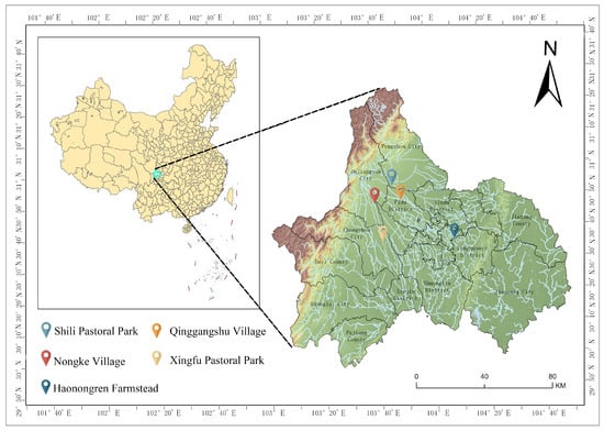
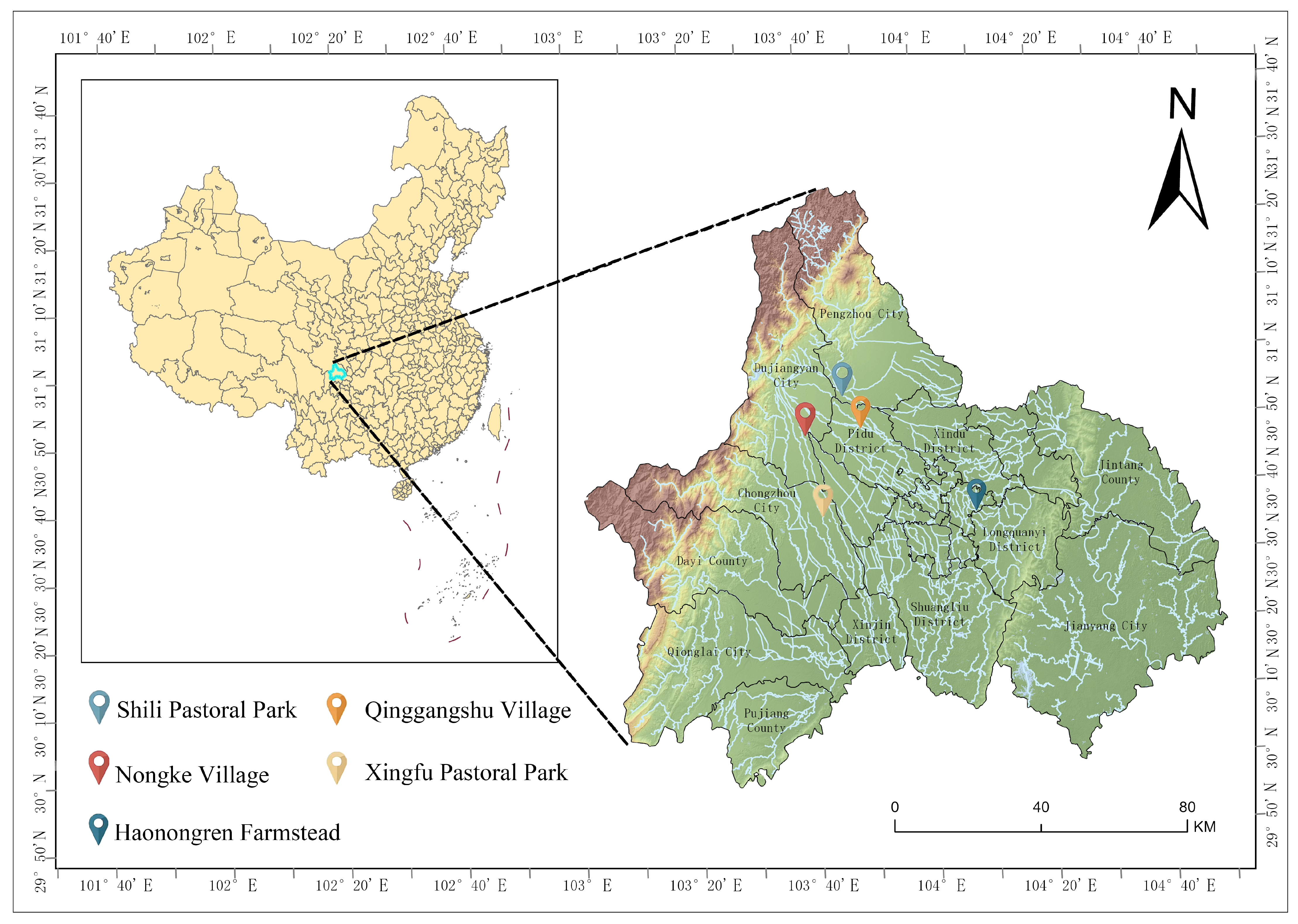
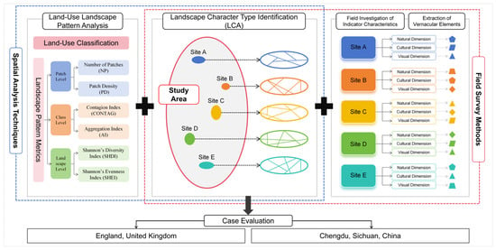
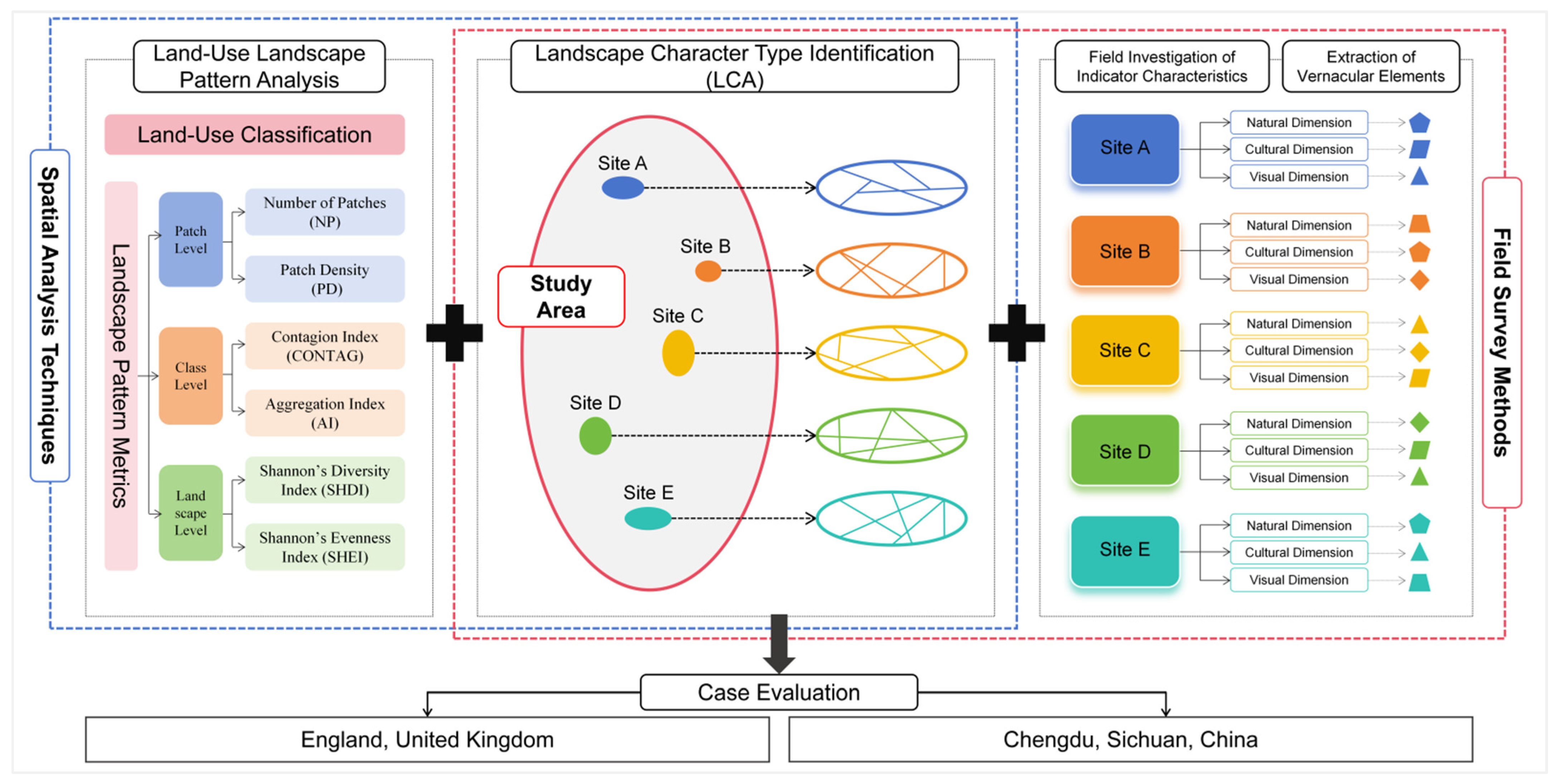
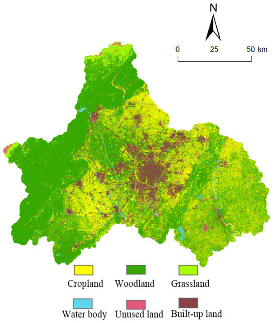
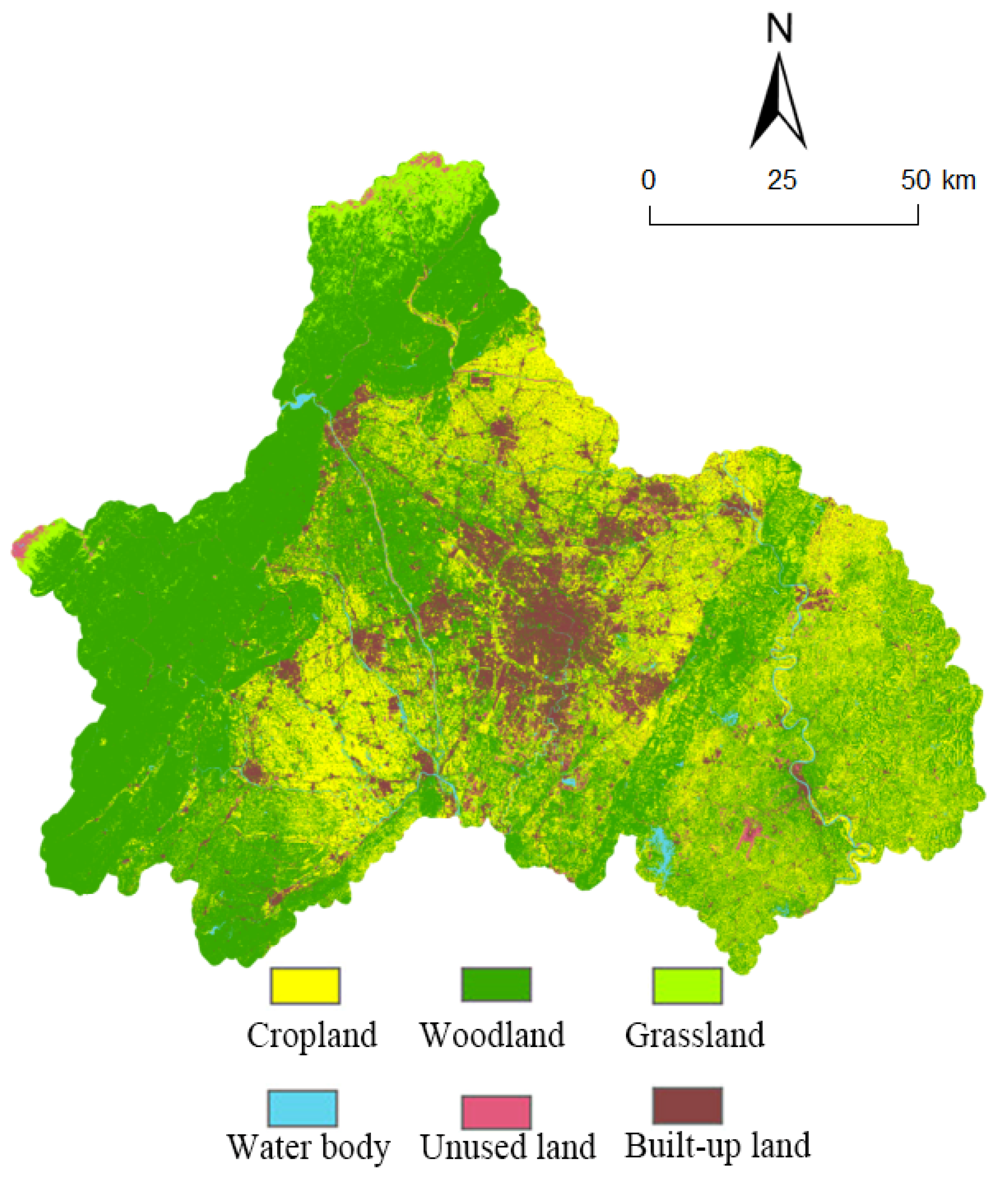
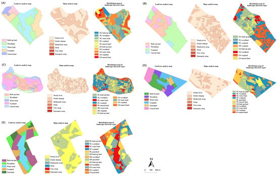
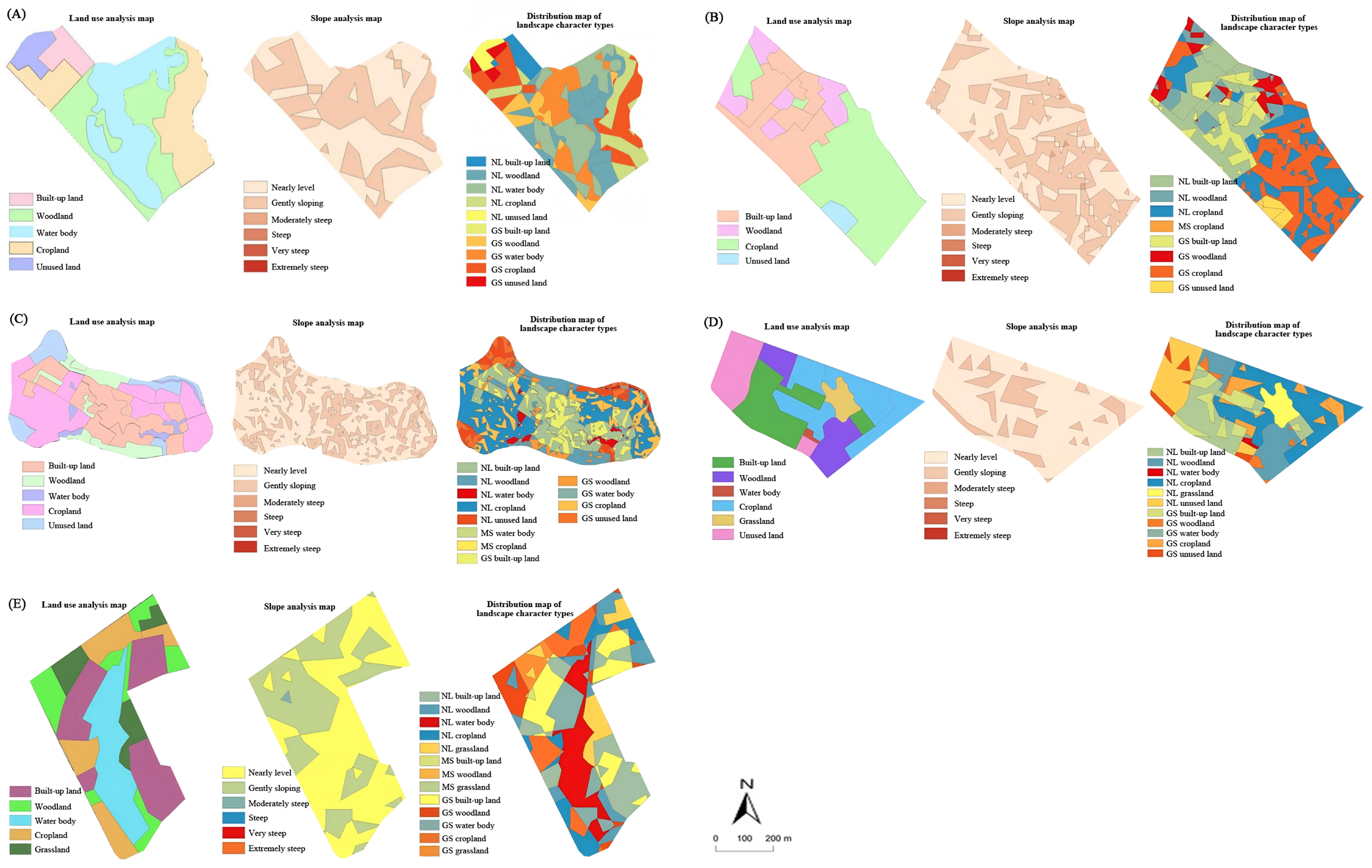
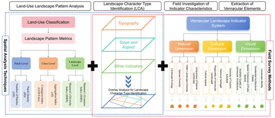
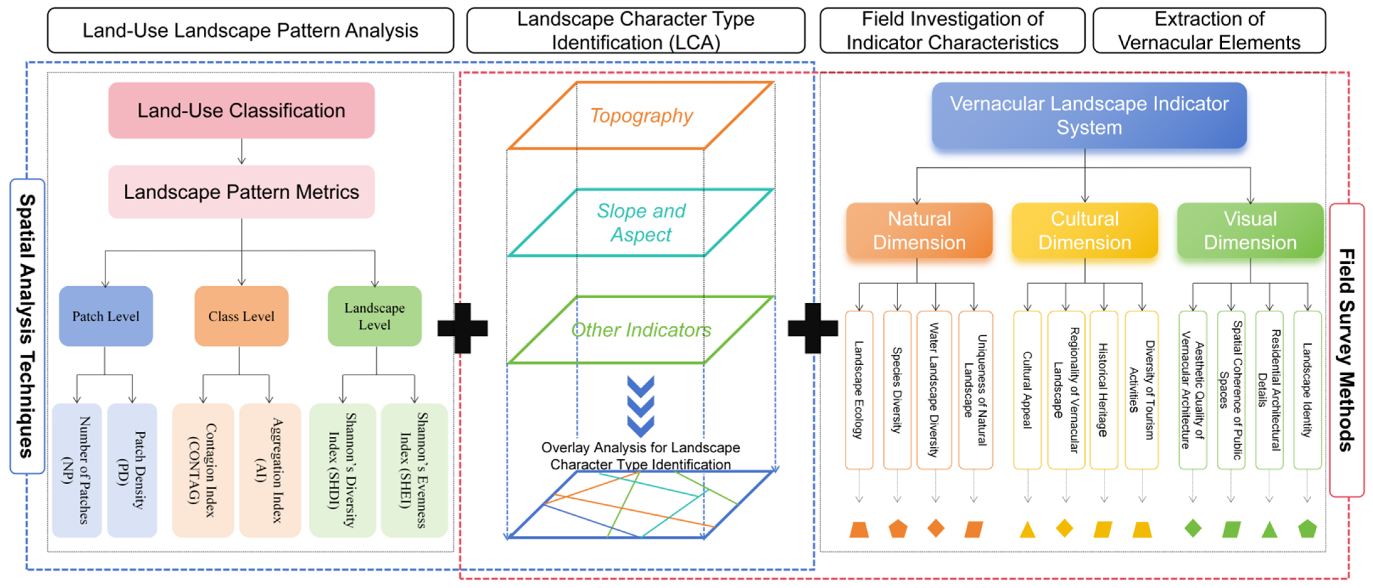

Disclaimer/Publisher’s Note: The statements, opinions and data contained in all publications are solely those of the individual author(s) and contributor(s) and not of MDPI and/or the editor(s). MDPI and/or the editor(s) disclaim responsibility for any injury to people or property resulting from any ideas, methods, instructions or products referred to in the content. |
© 2026 by the authors. Licensee MDPI, Basel, Switzerland. This article is an open access article distributed under the terms and conditions of the Creative Commons Attribution (CC BY) license.