


Abstract
Urban–rural governance and planning systems, as viewed through the lens of online public attention, are reshaping approaches to achieving coordinated development of cultural heritage conservation and urban space. Taking Nanchang as a case study, this paper investigates the application mechanism of online public attention in the evaluation of heritage corridor nodes and the formulation of optimization strategies. Employing multi-source data collection, we extracted textual content from online travelogues. We quantified the online attention level of each cultural heritage unit and analyzed its spatial distribution using kernel density estimation and standard deviational ellipse methods. We then applied a minimum resistance model, incorporating geographic data on land use and transportation networks, to identify potential heritage corridor routes. Based on attention classification, we propose a three-tier optimization strategy: core-leading, marginal-activating, and gradient-linking. Specifically, high-attention heritage units are positioned as central nodes that reinforce corridor connectivity; low-attention nodes are targeted for activation through corridor links to overcome spatial isolation; and attention gradients serve as the basis for hierarchical integration across the network. Our results reveal a pronounced spatial pattern of “core agglomeration and peripheral dispersion” in Nanchang’s heritage corridors. High-attention resources are heavily concentrated in the historic urban core, anchoring the main corridor axes, whereas low-attention resources are scattered across peripheral counties, exhibiting a clear urban–rural attention gradient. Importantly, attention levels show a positive correlation with corridor hierarchy. These findings provide a novel perspective for heritage corridor spatial planning and offer practical insights for sustainable cultural heritage governance and culture–tourism integration in an era of pervasive internet and urban expansion.
1. Introduction
Against the background of cultural heritage conservation shifting from individual building restoration to integrated management, active utilization, and regional coordination, the continuity and accessibility of urban–rural heritage spaces have progressively become important topics in planning research. Heritage corridors, using linear spaces as organizational carriers, integrate scattered cultural heritage protection units, historical environments, ecological baselines, and cultural tourism service elements into a networked spatial system, embodying multiple social, cultural, and economic values. Socially, they provide residents in both urban and rural areas with public leisure spaces that integrate cultural and ecological elements, helping to strengthen local cultural identity and community cohesion and to promote equalization of urban–rural public cultural services. Culturally, they link fragmented heritage resources through linear narratives, presenting a coherent regional cultural context, which not only enhances the public accessibility and display efficiency of heritage but also offers visitors a continuous immersive cultural experience route. Economically, the corridor network can stimulate the extension of cultural tourism consumption scenarios along the route, empower industrial development in peripheral counties and rural communities, and provide a spatial lever for reducing urban–rural development disparities.
As a nationally renowned historical and cultural city, Nanchang possesses a diverse array of heritage protection units, with a high concentration of heritage in the old urban area and a co-existence of Red culture, Jiangyou culture, Jiangxi vernacular architecture, and river-basin culture [1]. However, at the municipal scale, heritage spaces still exhibit a pattern of central agglomeration alongside peripheral dispersion, insufficient connectivity among county-level nodes, discontinuity of cultural experience routes, and marked disparities in public attention. The comprehensive value of heritage resources has not yet been fully released through systematic spatial organization. Therefore, how to identify corridor networks and optimize node connections under the premise of prioritizing conservation, and how to translate online public attention into spatial planning evidence, constitute urgent practical issues that need to be addressed in the integrated development of heritage conservation, livelihood improvement, and regional coordination in Nanchang’s urban–rural heritage corridor construction.
Heritage corridors represent a comprehensive model that integrates greenway concepts with regional heritage conservation. Originating from heritage and landscape conservation practices in the United States in the late 20th century and emerging from the greenway movement, they initially focused on ecological connectivity functions and gradually evolved into “heritage greenways,” with their conservation scope expanding to encompass historical and cultural resources [2]. Concurrently, international heritage conservation concepts shifted from the protection of individual buildings to the integrated conservation of cultural and natural heritage, with increasing emphasis on heritage interpretation, public participation, and regional coordinated development, thereby establishing a theoretical foundation for the development of heritage corridors. In 1984, the first National Heritage Corridor was established in the United States, advancing this model from theory to practice and progressively forming a comprehensive framework that synergizes ecological conservation, cultural inheritance, tourism utilization, and community development. The role of heritage corridors in enhancing residents’ well-being, improving visitor experience, and stimulating local economies has been continuously validated through global practice.
Relying on linear spaces such as rivers and roads, heritage corridors integrate heritage, ecological, and service elements, achieving a transformation from point-based protection to linear connectivity and regional synergy, and serving multiple functions including ecology, culture, tourism, and community development. From the perspective of cultural tourism integration, heritage corridors serve not only as carriers for holistic heritage conservation but also as important platforms for creating continuous cultural experiences, organizing themed tourism routes, and translating cultural values. Domestic scholars, in light of local practices, have developed research approaches centered on natural foundation, heritage core, cultural connotations, and tourism experience, providing important references for linear heritage conservation and cultural tourism integration. The heritage corridor concept offers an innovative pathway to address these challenges. Originating from the American greenway movement, the heritage corridor was formulated by Fabos (2004) as an “ecology-culture-economy” triadic model to counter heritage fragmentation, and this model aligns closely with the sustainable development goals of synergistic economic, social, and environmental progress [2]. As research has deepened, attention has shifted to the connections between heritage corridors and everyday life and social needs. Elia et al. (2024) in the United States proposed a greenway site-selection method centered on residents’ individual mobility, emphasizing that greenway planning should shift from a purely ecological orientation to a comprehensive model that accommodates daily transportation needs [3]. In the field of cultural route planning, Cem et al. (2024), taking the ancient water supply system of Istanbul as an example, developed an optimization model integrating heritage value, spatial connectivity, and visitor flow factors to derive optimal cultural routes for historical water heritage [4]. Justyna et al. (2025), using the Camino de Santiago as a case, pointed out that cultural routes can enhance local identity and promote spatial revitalization by linking historical resources, natural environments, and public activities [5]. In recent years, domestic research has achieved notable progress in the field of heritage corridors: at the theoretical level, Wang Kai et al. (2024) proposed a “precision matching” framework for cross-basin corridors [6], and Yang Tao (2020) established a linkage mechanism between heritage conservation and spatial planning [7]; at the technical and methodological level, Chen Lin et al. (2022) applied the minimum cumulative resistance (MCR) model to analyze settlement patterns [8]; He Ding (2022) integrated MCR with polycentric assessment [9]; and Li Xinyi et al. (2023) constructed a “node-place-linkage” evaluation system [10]; at the practical level, cases such as the Grand Canal, the Yellow River National Cultural Park, and the Zhangxi River Basin have verified the effectiveness of corridor planning in promoting the sustainable development of heritage.
However, existing research still exhibits clear limitations: the homogeneous treatment of heritage sites ignores disparities in tourism potential [11]; the construction of resistance surfaces over-relies on natural factors while neglecting socio-economic dimensions [12]; and the quantitative evaluation system for corridor centrality remains underdeveloped. For instance, He Ding’s (2022) model did not incorporate tourist sentiment factors, and Chen Zhiru’s (2023) network analysis lacked an implementation timeline, deficiencies that constrain the full potential of heritage corridors in achieving sustainable development goals [9,13].
Taking 114 cultural heritage protection units in Nanchang City as the research object, this paper constructs a data-driven framework for identifying and optimizing urban–rural heritage corridors. First, the study collects online travelogue texts and multi-source geographic data including POIs, transportation, and land use, quantifies the online attention of heritage protection units, and employs kernel density analysis and standard deviational ellipse methods to characterize their spatial differentiation. Second, a resistance surface is constructed by integrating factors such as natural environment, transportation accessibility, and service facilities; the MCR model is coupled with circuit theory to identify potential corridors and conduct centrality-based grading. Finally, in conjunction with attention grading results, a spatial optimization concept of “core-leading, periphery-activating, and gradient-linking” is proposed. The main contribution of this paper is the incorporation of public online attention into the heritage corridor planning process, avoiding homogeneous treatment of heritage nodes and breaking away from the traditional evaluation model that relies primarily on resource grades and spatial accessibility—a model that predominantly considers objective factors such as resource rank, ecological baselines, transportation conditions, and spatial accessibility, while giving little consideration to dynamic feedback from public perception, online dissemination, and social concern. Introducing online public attention as an evaluation indicator to measure the societal awareness and dissemination potential of heritage, this study employs public online behavioral data as a crucial supplement to conventional spatial analysis. It thereby establishes a social sensing basis for the classification of heritage nodes and the subsequent formulation of optimization strategies, achieving the integration of public online behavioral data with spatial planning optimization. Meanwhile, multi-source geographic information and connectivity models support corridor alignment and grading, providing an operational technical pathway for the integration of urban–rural heritage resources, the organization of cultural tourism routes, and smart planning practices in Nanchang. Figure 1 illustrates the specific research framework. In summary, this paper builds a heritage corridor framework of “data acquisition–spatial identification–planning optimization”: first, evaluating heritage attention based on multi-source data; second, identifying potential corridors using the MCR model and circuit theory; and finally, proposing optimization directions based on node characteristics, thus achieving the integration of heritage resource evaluation and spatial planning.
Figure 1.
Flowchart of heritage corridor construction in Nanchang City. Source: drawn by the authors.
2. Research Steps
2.1. Study Area and Research Objects
This study takes Nanchang City, Jiangxi Province, as the study area (Figure 2). Nanchang is situated at the intersection of the alluvial plain of the Gan and Fu rivers and the southwestern shore of Poyang Lake. It serves as a key node city in the middle Yangtze urban agglomeration and is also a national-level historic and cultural city. The overall topography of the city is relatively flat, but the Meiling area in the northwest, the Gan–Fu river system, and the traditional settlements in outlying counties together form a relatively complex natural and cultural spatial foundation. Administratively, Nanchang governs six districts and three counties, and pronounced disparities exist between the central urban area and rural counties in terms of transportation conditions, public services, and cultural tourism development levels—a contrast that provides a typical sample for urban–rural heritage corridor research.
Figure 2.
Analysis of Nanchang’s Location. Source: drawn by the authors.
From the perspective of historical and cultural foundations, Nanchang has a long urban history and has long served as the political, cultural, and transportation center of Jiangxi, accumulating diverse heritage resources including red culture, Jiangyou culture, Gan-style architectural culture, religious culture, and river basin commercial culture. The central urban area is home to iconic heritage sites such as the sites related to the August 1 Nanchang Uprising, Shengjin Pagoda, and Youmin Temple, whereas the outlying counties feature regionally distinctive cultural resources such as Anyi Ancient Village, Wangshan Earth Fortress, the Lidu Distillery Workshop Site, and the remains associated with the Marquis of Haihun. The spatial agglomeration, extension, and dispersion of different heritage types provide a practical foundation for constructing a heritage corridor network that spans urban and rural areas and crosses districts [14].
This study takes all national, provincial and municipal cultural relic protection units in Nanchang City as the cultural heritage sites for constructing the heritage corridor, with a total of 114 sites. The research objects cover renowned cultural and tourist attractions in Nanchang, including the August 1st Nanchang Uprising Monument, Shengjin Pagoda and Wanshou Palace (Figure 3). Their spatial distribution presents distinct gradient characteristics: in the central urban area, a highly polarized zone is formed by the triangular framework of Tengwang Pavilion–Wanshou Palace–August 1 Nanchang Uprising Memorial Hall, concentrating the majority of high-level heritage protection units in the city and reflecting the 2200-year urban development axis; extending to the northwest, the Meiling–Liao River basin forms a secondary agglomeration belt, anchored by the Xishan Wanshou Palace Taoist holy site and remnants of post roads from the Ming and Qing dynasties, manifesting a historical spatial logic of “mountain–water–Tao” integration; the Fu River basin forms a correlation zone supported by nodes such as Houwan Village Wharf and Wenzhen Guild Hall, confirming the shaping role of Gan–Fu river shipping on settlement distribution; meanwhile, heritage sites such as Jinxian Qing Dynasty academies and Anyi Ancient Village are scattered as points in peripheral areas, reflecting the in situ persistence of county-level culture. This pattern of “core polarization–axis extension–edge dispersion” is essentially a spatial manifestation of the co-construction of historical processes and physical geography—the Gan River terrace gave birth to the urban axis, the Meiling mountain barrier nourished a religious enclave, and the Fu River water network drove linear commercial growth, profoundly revealing the human–land relationship gene of Jiangyou civilization and providing critical spatial grounds for subsequent heritage corridor construction: the central area needs intensified functional integration, the peripheral zones urgently require thematic connection, and river basin corridors will become the core medium to overcome spatial fragmentation. According to the kernel density map, heritage sites in Nanchang are most concentrated in the central urban area, followed by the western Meiling area and the Liao River basin area, and then by the Fu River basin area, while other areas exhibit a sporadic distribution.
Figure 3.
Current Status of Selected Historical and Cultural Heritage in Nanchang City. (a) August 1st Uprising Memorial Tower; (b) Former Site of the New Fourth Army Headquarters in Nanchang; (c) Xinghua Tower; (d) Yulong Wanshou Palace; (e) Shengjinta Pagoda; (f) Wangshan Tuku.
2.2. Data Acquisition and Cleaning
The data used in this study include the following:
- (1)
- DEM data of Nanchang City, NDVI data for 2023 at 30 m resolution, and land use status data were obtained from the Geospatial Data Cloud platform of the Computer Network Information Center, Chinese Academy of Sciences.
- (2)
- POI data for national 5A- and 4A-level scenic spots, excluding heritage sites, comprise a total of 19 points. Given the limited data volume, coordinate data were directly captured from the Baidu Maps Open Platform.
- (3)
- POI data for accommodation areas, commercial shopping points, transportation stations, and heritage sites in 2023, obtained from the AutoNavi Maps official website. Commercial shopping points include shopping malls and specialty commercial streets; accommodation points include residential compounds, inns, and hotels; transportation stations include subway stations, high-speed railway stations, bus stations, railway stations, and airports. These data were processed using deep-learning-based NLP (natural language processing) techniques, including sampling verification, deduplication, and coordinate correction (File S2). The commercial shopping points amounted to 461 records, and transportation stations to 152 records. Among these, accommodation and residential POIs totaled 9299, which were classified into two categories by functional attributes: (a) tourist-accommodation facilities, comprising 3263 hotels and 1186 guesthouses/inns (4449 in total), corresponding to the overnight consumption and leisure service needs of external visitors; and (b) residential community facilities, comprising 4376 residential areas and 474 business-residential related points (4850 in total), representing the local population agglomeration and basic public service support along the corridor. Including both categories aligns with the dual function of urban–rural heritage corridors—serving both daily recreation for residents and cultural experiences for tourists—and more accurately reflects the human-settlement service capacity in peripheral rural areas.
- (4)
- Road network data were obtained from the OpenStreetMap (OSM) website. The latest vector data for highways, railways, national roads, provincial roads, county roads, township roads, and primary urban roads were downloaded and calibrated against satellite raster maps. For corridor route selection, Euclidean distance analysis was performed for each road type using the Euclidean Distance tool in ArcGIS 10.8.
- (5)
- Scenic spot and catering service data, obtained from the Dianping App, including comprehensive user ratings and review counts. Using Python 3.11, we scraped locations with an overall rating greater than 3 stars and a review count of no less than 50 (File S3). The acquired POI data were further cleaned with NLP techniques, and POIs within a distance threshold of 50 m were merged.
2.3. Research Methods
2.3.1. Big Data Acquisition and Analysis Techniques
A web crawler is a program or script that automatically fetches internet information according to specific rules. Using the Python language and specialized web scraping tools, this study systematically collected data from multiple open platforms. Specifically, by leveraging the open application programming interfaces (APIs) provided by Amap and Baidu Maps, road network data and point of interest (POI) data were acquired in batches, covering the spatial distribution and attribute information of transportation structures and public service facilities within the study area. These data provided a critical foundation for identifying key connection points during heritage corridor route selection and for constructing the comprehensive resistance model [15].
In the data cleaning phase, natural language processing (NLP) techniques were introduced for two primary purposes: first, to filter candidate locations that met the research requirements from the raw crawling results; second, to perform semantic cleaning and spatial aggregation on the POI data, such as merging POI entities with identical or highly similar names within a 100 m range, so as to improve data quality and accuracy. Through a dual matching mechanism based on character and semantic similarity, combined with a spatial grid clustering method, coordinated control of consistency between geographic locations and textual attributes was achieved, ultimately completing the normalization of the POI data.
2.3.2. Kernel Density Estimation
Kernel density estimation (KDE) is a commonly used method for analyzing the distribution of point features in space, primarily reflecting their degree of concentration and spatial clustering, as well as the intensity of the kernel’s influence on its surrounding area. A larger kernel density estimate indicates a higher density of points and a higher probability of event occurrence within the area. In this paper, KDE is applied to analyze the spatial distribution of heritage points and to delineate heritage source areas [16]. The formula is as follows:
where n is the number of points within the bandwidth, h is the bandwidth, x − xi represents the Euclidean distance between two points, and K is the weight function; a larger K value indicates a higher density of the feature points.
2.3.3. Average Nearest Neighbor Analysis
When studying the spatial distribution of historical and cultural heritage, the average nearest neighbor (ANN) analysis typically treats heritage sites as point features. The common spatial distribution types of point features—dispersed, random, and clustered—can be distinguished by nearest neighbor distance: dispersed distributions exhibit the largest nearest neighbor distance, followed by random distributions, with clustered distributions showing the smallest [17]. The nearest neighbor distance is a geographic index indicating the degree of proximity among point features in geographic space. The nearest neighbor ratio can effectively reflect the spatial distribution characteristics of point features and is calculated as the ratio of the observed average nearest neighbor distance to the theoretical nearest neighbor distance (i.e., the expected value under random distribution). The formula is as follows:
where is the mean observed distance between each point and its nearest neighbor, and is the expected mean distance for a random distribution.
Based on the calculation, three scenarios can be identified:
(1) When NNI = 1, the spatial distribution of points is random, indicating no significant clustering or dispersion trend. (2) When NNI < 1, the observed average nearest neighbor distance is smaller than the expected distance under random distribution, indicating a clustered distribution. The smaller the value, the higher the degree of clustering. (3) When NNI > 1, the observed average nearest neighbor distance is larger than the expected distance under random distribution, indicating a dispersed or uniform distribution. The larger the value, the higher the degree of dispersion.
The nearest neighbor analysis is used to rank cultural heritage points, determine their distribution pattern, and thereby identify the main concentration areas of cultural heritage in Nanchang, expressed as the ratio of the observed average distance to the expected average distance. The expected average distance is the average distance between neighbors under the assumption of random distribution.
2.3.4. MCR Model
The comprehensive resistance surface in this study is constructed based on the MCR model. This model was first proposed by Dutch ecologist Knappen for studying species dispersal processes and has since been widely applied in ecological conservation, landscape pattern analysis, and related fields [18]. The MCR model calculates the minimum cumulative cost, or the least work, required to move from a “source” across different landscape types with varying resistance values [19]. In essence, it identifies low-resistance paths connecting heritage nodes by comparing movement costs under different spatial environmental conditions. Higher resistance indicates lower suitability for corridor construction in that area, while lower resistance indicates higher suitability. The calculation formula for the MCR model is expressed as follows:
where MCR represents the minimum cumulative resistance value of a species dispersing from the source to a certain point in space; f denotes the corresponding functional relationship; min indicates that the minimum value is taken; ∑ represents the cumulative sum of the distance and resistance coefficient of all units traversed by species A moving from source j to landscape unit i; Dij is the dispersal distance; and Ri is the resistance coefficient. The MCR model is implemented through the raster calculator module in GIS. In this model, the selection of sources and the construction of the resistance surface and resistance coefficients are the key components.
2.3.5. Standard Deviational Ellipse Analysis
Standard Deviational Ellipse analysis (Directional Distribution Analysis) reflects the global spatial differentiation characteristics of geographic research elements from multiple perspectives. Its graphical features include the standard deviations along the major and minor axes, the mean center coordinates, and the rotation angle. The major axis indicates the trend direction, the minor axis indicates the degree of dispersion, and the mean center coordinates represent the relative spatial position of the geographic elements. The formula is as follows [20]:
where SDx and SDy represent the standard deviations along the x-axis and y-axis, respectively; Δxi and Δyi represent the deviations of the x- and y-coordinates of each point feature from their mean center; θ represents the rotation angle of the ellipse; and n denotes the total number of cultural heritage protection units.
2.3.6. Multi-Distance Spatial Cluster Analysis
Multi-Distance Spatial Cluster Analysis (Ripley’s K function) is a method used to identify clustering characteristics of spatial data at different scales. It involves calculating spatial point patterns at varying distance scales to reveal clustering features across spatial scale [21]. The formula for multi-distance spatial cluster analysis is:
where d is the distance, n is the total number of features, A represents the total area of the features, and ki,j is the weight. Without edge correction, the weight equals 1 when the distance between i and j is less than d, and 0 otherwise. When a specific edge correction method is applied, the weight ki,j varies slightly.
2.3.7. Linkage Mapper Tool
In this study, both corridor generation and corridor optimization were accomplished using the Linkage Mapper tool. The identification of potential heritage corridors primarily relied on the Build Network and Map Linkages module. Based on circuit theory, this module abstracts discretely distributed cultural heritage source areas as circuit nodes and transforms the spatial resistance surface reflecting cultural transmission resistance into a conductance surface. By simulating the random walk process of cultural flow within the resistance landscape, the current density along multiple possible paths between nodes is calculated, thereby generating a raster output that characterizes the strength of heritage spatial connections and the corridor structure (Figure 4) [22]. Circuit theory further simulates the spatial flow relationships among heritage nodes, treating them as connection nodes in the network and converting spatial resistance into “impedance conditions” that affect cultural flow—a process analogous to the propagation of electric current in a circuit. In the corridor optimization phase, the Centrality Mapper module was further employed to conduct centrality analysis. By calculating the frequency of current passing through each corridor segment in the overall network, core corridors and core areas with high centrality, as well as peripheral areas with weak connectivity, were identified, providing a quantitative basis for the functional grading and spatial optimization of the heritage network [23]. Since its introduction into landscape connectivity research, circuit theory has become an important method for simulating spatial flows and functional connections. In this paper, cultural heritage core areas are treated as current injection points. A transmission resistance surface is constructed by integrating factors such as historical spatial continuity, walking accessibility, visual corridor integrity, and cultural identity. The current density distribution is then used to identify the dominant paths and network patterns of the heritage corridor, where high-value areas correspond to efficient channels of cultural transmission and low-value areas reflect marginal connection zones.
Figure 4.
Schematic diagram of the data formats for the circuit theory model raster (a) and graph theory (b). Source: Adapted from Liu 2018 [24].
3. Results
3.1. Overview of Cultural Heritage Protection Units in Nanchang
3.1.1. Quantitative Statistics of Different Types of Heritage Protection Units
Based strictly on the official list, the 114 units were classified into six major types. Among them, ancient buildings constitute the largest category, totaling 66 units and accounting for 57.9% of the total. This category encompasses various forms such as memorial archways, vernacular dwellings, ancestral halls, bridges, pagodas, and temples, serving as the core physical carriers of Nanchang’s historical landscape. The second largest category is important modern and contemporary historical sites and representative buildings, comprising 30 units (26.3%), and mainly includes revolutionary sites, former residences of notable figures, and industrial heritage sites, which collectively embody Nanchang’s modern historical identity as the “City of Heroes.” Ancient sites account for 11 units (9.6%) and provide important evidence for tracing the region’s early history. In addition, there are 4 ancient tombs, 3 cave temples and stone carvings, and 1 site classified as other (Table 1).
Table 1.
Statistical classification by heritage type. Source: drawn by the authors.
The data distribution above reveals several notable characteristics of Nanchang’s cultural heritage landscape. First, the resource structure is highly concentrated: ancient buildings and modern and contemporary historical sites together account for 84.2% of the total, forming the absolute mainstay and distinctive dual core of the local cultural heritage. Second, this structure is directly associated with the core challenges in current conservation management. The large number and spatially extensive distribution of ancient buildings—especially vernacular dwellings and ancestral halls scattered across rural areas—constitute the primary targets of resource fragmentation and management difficulty. Although modern and contemporary historical sites also face the problem of spatial dispersion, they possess strong intrinsic thematic connections, such as the red revolutionary lineage, which offers a potential advantage for integrated utilization through thematic route planning (Table 1).
This classification not only completed the resource inventory but also, at a structural level, elucidated the causes of the current problems. It suggests that future conservation and revitalization efforts require differentiated strategies: for the large number of ancient buildings, regional connectivity should be explored through ecological and cultural routes on the premise of ensuring basic safety; for modern and contemporary historical sites, priority should be given to strengthening their thematic narratives and creating coherent cultural experience routes, thereby serving as a breakthrough in overcoming the overall fragmentation. This study maintains that the analytical pathway from classification statistics to problem analysis and then to strategy linkage can provide a useful reference for implementing more precise cultural heritage management in Nanchang.
3.1.2. Spatial Distribution Characteristics of Cultural Heritage Protection Units
The combined results of kernel density estimation, average nearest neighbor analysis, standard deviational ellipse analysis, and multi-distance spatial cluster analysis reveal that the spatial distribution of cultural heritage protection units in Nanchang exhibits pronounced clustering, directionality, and hierarchy. Overall, the spatial pattern is characterized by high-density clustering centered on the main urban area, a secondary agglomeration zone in the western area, and a multi-node dispersed distribution across other counties.
According to the kernel density estimation results (Figure 5), areas with high kernel density values are primarily concentrated in the old urban area and its adjacent areas, covering Donghu District, Xihu District, and Qingyunpu District, and extending to western Qingshanhu District, southeastern Honggutan District, and the southern fringe of Xinjian District, forming the most prominent high-density core area in the city. This area gathers a large number of high-level cultural heritage protection units and important modern and contemporary historical remains, reflecting the long-standing historical role of Nanchang’s old urban area as the political, cultural, and urban activity center. Beyond the central urban area, a distinct secondary agglomeration zone has formed along the Anyi–Meiling–peripheral Honggutan belt, indicating a relative concentration of traditional settlements, religious remains, and ancient buildings in this region. In contrast, Nanchang County, Jinxian County, and other peripheral areas mostly exhibit scattered point-like or small-patch distributions, with an overall clustering intensity significantly weaker than that of the central urban area and the western zone.The standard deviational ellipse analysis results (Figure 6) show that the spatial mean center of cultural heritage protection units in Nanchang is located in the core area of the main urban area, near Donghu District, Xihu District, and Qingyunpu District, suggesting that heritage resources are largely concentrated in the historic urban area. The major axis of the ellipse displays a distinct northwest–southeast orientation, indicating strong spatial extensibility in this direction; the minor axis is relatively short, reflecting a lower degree of dispersion in the northeast–southwest direction. Overall, the cultural heritage protection units in Nanchang exhibit a spatial structural characteristic centered on the central urban area and extending along the northwest–southeast axis, which is broadly consistent with the urban development pattern and the distribution of traditional settlements in the western region.
Figure 5.
Kernel density analysis of cultural heritage protection units in Nanchang City.
Figure 6.
Standard deviational ellipse analysis of cultural heritage protection units in Nanchang City.
The average nearest neighbor analysis further demonstrates (Figure 7) that, overall, the cultural heritage protection units in Nanchang are not randomly distributed but display significant spatial clustering. The results show an ANN value of 0.674, which is less than 1, indicating that the observed average nearest neighbor distance is smaller than the expected distance under random distribution, and that stronger proximity exists among the points. At the same time, the Z-score of −6.102 and the p-value approaching zero indicate that this clustering pattern is statistically highly significant, essentially ruling out the possibility of random formation. Therefore, the overall distribution of cultural heritage protection units in Nanchang should be characterized as significantly clustered rather than dispersed or random.
Figure 7.
Results of average nearest neighbor analysis of cultural heritage protection units in Nanchang City. Source: drawn by the authors.
The multi-distance spatial cluster analysis results further corroborate the above findings (Figure 8). The K-function plot shows that the observed curve consistently lies above the expected theoretical curve across the study scale range, indicating that the cultural heritage protection units in Nanchang deviate markedly from complete spatial randomness at various distance scales and persistently display significant clustering characteristics. This suggests that the spatial distribution not only exhibits hotspot clustering at local scales but also demonstrates strong spatial dependence and clustering stability over larger scales.
Figure 8.
Results of multi-distance spatial cluster analysis of cultural heritage protection units in Nanchang City. Source: drawn by the authors.
In summary, the cultural heritage protection units in Nanchang have formed a spatial structure characterized by a high-density core in the historic urban area, an important secondary agglomeration zone in the western Anyi–Meiling area, and a multi-node dispersed distribution across other counties. This pattern not only reflects the core status of Nanchang’s old urban area in the long course of historical development, but also demonstrates the significant supporting role played by the traditional settlement cultural zone in the west and the local cultural heritage in peripheral counties within the city’s overall heritage protection system.
3.2. Quantity Statistics and Spatial Characteristics of Cultural Heritage Protection Sites with Different Popularity Levels
3.2.1. Quantity Statistics of Popularity-Classified Cultural Heritage Protection Sites
This study used travel notes from the Weibo platform over the past five years (1 January 2020–1 January 2025) as the primary data source. Using Python web scraping techniques, we collected notes containing the names of the 114 cultural heritage protection units in Nanchang. After deduplication—removing duplicate posts and content-homogeneous notes—and cleaning to filter out irrelevant mentions and correct name aliases [25], we counted the effective mention frequency of each heritage unit to quantify online attention. The results show a pronounced hierarchical differentiation and type-specific concentration (Table 2). In this study, heritage units with a mention frequency of 100 or more were classified as high-attention, totaling 13; those with a frequency of 10 or more but less than 100 were classified as medium-attention, totaling 27; those with a frequency of 1 to 9 were classified as low-attention, totaling 54; and those with a frequency of 0 were classified as zero-attention, totaling 20 (Figure 9).
Table 2.
Presents classified statistical results grouped by heritage periods. Note: The ellipsis (…) indicates that some entries between the displayed ranks have been omitted due to space limitations.
Figure 9.
Distribution of cultural heritage protection units by attention level in Nanchang City. Source: drawn by the authors.
Overall, the 114 sites receive 48,623 total mentions, with an average of 426.52 mentions per site. The frequency distribution exhibits a distinct power-law pattern with extreme disparities: the top 10% of sites (11 sites) account for 68.3% of total mentions, whereas the bottom 50% (57 sites) contribute merely 8.7%. This manifests the feature of high concentration among a core minority and low coverage among peripheral majorities.
In terms of protection grades, national-level cultural heritage protection sites register the highest average mention frequency (1892.67 times per site). Revolutionary heritage sites with iconic attributes, such as the Site of the General Headquarters of the August 1st Uprising, serve as core references in Weibo travel notes. Provincial-level sites average 385.42 mentions per site; clustered ancient architectural complexes including the Anyi Ancient Village Group and Wangshan Tuku achieve high mention frequency owing to the prevalence of off-the-beaten-path in-depth tourism. Municipal-level sites only average 102.83 mentions per site. Over 60% of municipal heritage sites, such as the Site of Dengjiabu Rice Original Seed Farm in Nanchang County and Huanggu Tomb under Wanli Administrative Bureau, receive fewer than 50 mentions due to low public recognition and insufficient experiential value.
Notably, two sites exceed their protection-grade limitations and emerge as ultra-high-attention nodes: the Site of the Former Exhibition Hall Long Live the Victory of Mao Zedong Thought (Present-day Jiangxi Art Museum) and Nanchang Shengjin Pagoda. The former has a mention frequency of 1705 times, with its core advantage lying in the functional integration of Red heritage, contemporary art, and social media check-in tourism. As a surviving Red architectural site around Bayi Square, its retro appearance satisfies the demand for Red-themed check-ins. Since its conversion into an art museum, regular art exhibitions and cultural and creative markets have attracted younger demographics, with this dual value facilitating viral dissemination of Weibo topics. The latter has a mention frequency of 1346 times, benefiting from its landmark status and deep activation of the vernacular urban scene. As a core landmark in the old city, its historical and cultural district integrates the conservation of ancient architecture with temple fairs, intangible cultural heritage performances, and Jiangxi cuisine. Nighttime light shows, festival markets, and other scenes have become popular sharing subjects. Coupled with its central location and convenient transportation, it caters to both residents’ leisure needs and tourists’ check-in demands.
This study identifies 20 zero-attention cultural heritage protection sites, whose underperformance stems from three core factors. First, remote geographical locations and poor accessibility: sites such as the Ruins of Qizuo Liancheng in Jinxian County and Tongluoshan Ruins in Anyi County are situated in remote townships with no direct public transit, imposing high visiting costs on tourists. Second, monotonous display modes and weak experiential value: sites including the Site of Dengjiabu Rice Original Seed Farm and Huanggu Tomb merely retain physical structures, lacking interpretive and guided-tour facilities and online-sharing value. Third, low cultural recognition and inadequate promotion: some small ancestral halls and scattered ancient bridges in Xinjian District possess no unique historical connotations and are excluded from cultural-tourism promotion systems, falling into a vicious cycle of being unknown, unvisited and unshared.
From the perspective of communication themes, attention distribution of cultural heritage protection sites generally follows a clear pattern: revolutionary cultural sites and classical architectural sites gain relatively high amounts of online attention, while vernacular heritage and modern industrial heritage sites receive less attention. Revolutionary cultural sites are frequently mentioned in online travel texts due to high urban brand recognition and explicit educational functions. Classical architectural sites achieve extensive communication by virtue of their landscape value and scenario-oriented consumption. By contrast, despite high historical value, vernacular and industrial heritage sites suffer from low online visibility constrained by location disadvantages, monotonous display modes and limited experiential content.
The polarization of online attention to Nanchang’s cultural heritage protection sites essentially reflects disparities in the capacity to externalize implicit cultural values. Ultra-high-attention nodes transform cultural values into experiential and shareable content via functional revitalization and scenario construction, whereas zero-attention nodes are restricted by drawbacks in location, experiential design and promotion. This pattern provides practical implications for improving online attention of Nanchang’s cultural heritage protection sites. Specific strategies include implementing micro-renovation and lightweight operation for remote heritage sites, promoting functional transformation of industrial heritage sites, and realizing explicit expressions of cultural values through diversified revitalization approaches.
3.2.2. Kernel Density Spatial Analysis of Heritage Protection Units by Attention Level
Based on the kernel density estimation results for the four attention-level categories, the online attention to cultural heritage protection units in Nanchang exhibits pronounced spatial stratification: high-attention sites are highly concentrated in the central urban area, medium-attention sites extend into the counties, and low-attention and zero-attention sites are predominantly distributed in peripheral towns and villages, reflecting a core–periphery disparity in the cultural tourism dissemination of heritage resources.
The high-value kernel density areas of high-attention heritage protection units are concentrated in Donghu District, Xihu District, Qingyunpu District, and the junction zone of Qingshanhu District, forming the most prominent communication core in the city (Figure 10). This region hosts high-frequency cultural heritage protection sites, including the Site of the Former Exhibition Hall Long Live the Victory of Mao Zedong Thought, Shengjin Pagoda, and sites related to the August 1st Uprising. Specifically, the Site of the Former Exhibition Hall Long Live the Victory of Mao Zedong Thought, now serving as the Jiangxi Art Museum, has formed an integrated communication scenario featuring “revolutionary heritage + art exhibitions + urban check-ins.” Shengjin Pagoda, leveraging its status as an old-town landmark, historical district, nighttime consumption hub, and urban cultural space, continuously attracts tourists to document and share their experiences. Evidently, the formation of high-attention kernel density hotspots is not solely determined by heritage classification, but rather the combined effect of heritage value, locational advantages, functional revitalization, and cultural tourism consumption. Beyond the central urban area, only scattered weak hotspots emerge in Xinjian District, southern Honggutan District, and southern Jinxian County, indicating that the communication of high-attention heritage sites still relies significantly on the main urban area.
Figure 10.
Kernel density analysis of high-attention points.
Compared with high-attention sites, the kernel density distribution of medium-attention heritage protection units extends further outward, presenting a pattern of “central continuity and peripheral supplementation” (Figure 11). The central urban area still maintains a certain density base, while western Anyi County, parts of Xinjian District, and some areas of Nanchang County and Jinxian County form secondary hotspots. The agglomeration in western Anyi County is associated with traditional architectural and vernacular cultural resources such as the Anyi Ancient Village Cluster, Jingtai Opera Stage, and Xishan Stone Chamber, indicating that although this area lacks the visitor flow advantages of the central city, it has acquired a certain communication foundation by virtue of ancient village landscapes and suburban leisure tourism. The medium-attention patches in Nanchang County and Jinxian County mostly appear as scattered points, suggesting that some county-level heritage sites have entered the travelogue communication system but have yet to form stable high-frequency hotspots.
Figure 11.
Kernel density analysis of medium-attention points.
The kernel density distribution of low-attention heritage protection units covers a wider range, with hotspots primarily appearing in western Anyi County, southern Honggutan District, southern Nanchang County, and parts of Jinxian County, exhibiting an overall characteristic of “small-scale clustering and large-scale dispersion” (Figure 12). Such heritage protection units are mostly ancient bridges, memorial archways, tombs, small-scale sites, and vernacular buildings, such as Xiufeng Bridge in Nanchang, Deng Bridge, and some village remains and tomb sites. They possess certain historical value, but due to scattered locations, monotonous presentation, and insufficient guided interpretation, they struggle to generate content that tourists actively share. The diffusion of low values in the kernel density map precisely reflects the reality of grassroots heritage featuring “ample resources but weak presentation and low dissemination [26].”
Figure 12.
Kernel density analysis of low-attention points.
The high-value kernel density areas of zero-attention heritage protection units are mainly concentrated in western Anyi County, with scattered patches in Xinjian District, Nanchang County, and parts of Jinxian County, involving sites such as the Anyi Tongluoshan Site, Qizuo Liancheng Site, Jinxian Qingshi Bridge, Nanchang Huanggu Tomb, and Nanchang Zheliu Bridge (Figure 13). This type of heritage is mostly located in towns or villages and is commonly found among ancient bridges, tombs, and sites. Constrained by transportation accessibility, display facilities, and promotional channels, it has not yet effectively entered the realm of mass tourism. Zero attention does not imply an absence of heritage value; rather, it indicates that the cultural information has not yet been effectively interpreted and transformed.
Figure 13.
Kernel density analysis of zero-attention points.
Overall, the kernel density distribution of heritage protection units at different attention levels in Nanchang presents a spatial pattern of “high-density concentration in the center, patches in the counties, and weak visibility in the periphery.” High-attention nodes constitute the core of cultural tourism communication, medium-attention nodes possess the potential for route connectivity, and low-attention and zero-attention nodes are the key targets for heritage corridor construction and the enhancement of cultural tourism integration. Future efforts should take the high-density areas in the central urban area as the traffic-driving core [27], integrate medium- and low-attention agglomeration areas such as western Anyi, southern Nanchang County, and parts of Jinxian County, and promote the transformation of peripheral heritage protection units from “listed heritage points” into publicly identifiable, accessible, and experiential cultural nodes through themed tour routes, improved guiding services, lightweight exhibitions, and enhanced transportation connections.
3.2.3. Spatial Differentiation Characteristics of Heritage Protection Units by Attention Level
Based on the results of standard deviational ellipse analysis, the cultural heritage protection units at different attention levels in Nanchang exhibit notable differences in spatial dispersion, distributional orientation, and mean center location, reflecting the coupling relationships among online attention levels, urban core locations, county-level heritage distribution, and the degree of cultural tourism utilization.
In terms of ellipse area, zero-attention heritage protection units have the largest distribution range, with an ellipse area of 8126.34 km2, a semi-major axis of 64.28 km, and a semi-minor axis of 40.25 km, indicating that zero-attention heritage is the most dispersed across the city and extends extensively into peripheral counties. Low-attention heritage protection units have an ellipse area of 6847.52 km2, with a semi-major axis of 58.76 km and a semi-minor axis of 37.09 km, ranking second in distribution range and exhibiting strong peripheral diffusion characteristics. Medium-attention heritage protection units have an ellipse area of 5728.46 km2, with a semi-major axis of 53.42 km and a semi-minor axis of 34.13 km, displaying a relatively expansive spatial distribution that assumes a transitional linkage between the central urban area and county-level heritage. High-attention heritage protection units have the smallest ellipse area of 2615.83 km2, with a semi-major axis of 42.61 km and a semi-minor axis of 19.54 km, demonstrating that high-attention heritage is highly concentrated in the central urban area with a relatively limited spatial spillover range (Figure 14).
Figure 14.
Standard deviational ellipse and mean center of cultural heritage protection units in Nanchang City. Source: drawn by the authors.
In terms of distribution orientation, the azimuth angle of the major axis of the standard deviational ellipse for high-attention cultural heritage protection sites is 84.37°, extending nearly north–south. It mainly covers Donghu District, Xihu District, Qingyunpu District and the surrounding areas of Qingshanhu District, which is highly consistent with the distribution of Nanchang’s old-town cultural core zone and urban public cultural spaces. High-attention nodes including the Site of the Former Exhibition Hall Long Live the Victory of Mao Zedong Thought, Shengjin Pagoda and August 1st Uprising-related relics all fall within the core of this ellipse, indicating their online popularity is primarily supported by well-developed transportation, public services and cultural-tourism consumption scenarios in the central urban area. For medium-attention cultural heritage protection sites, the standard deviational ellipse features an azimuth angle of 27.64° and stretches northwest-southeast, linking Anyi County, Xinjian District, the central urban area, Nanchang County and parts of Jinxian County. This demonstrates that traditional architectural and vernacular cultural resources such as the Anyi Ancient Village Cluster, Jingtai Opera Stage and Xishan Stone Chamber have formed a solid communication foundation, serving as key nodes for cultural spillover from the central urban area to county-level spatial units. The standard deviational ellipse for low-attention cultural heritage protection sites has an azimuth angle of 31.82°, also extending northwest-southeast yet covering a broader area. It reveals that low-visibility heritage sites are predominantly distributed in western Anyi County, southern Honggutan District, southern Nanchang County and parts of Jinxian County, whose spatial pattern is strongly shaped by township settlements, historical transport corridors and natural topographic conditions [28]. The standard deviational ellipse for zero-attention cultural heritage protection sites shows the most distinct directional feature, with an azimuth angle of 24.53°. Its scope stretches from western Anyi County to Nanchang County, southern Jinxian County and the southeastern fringe of Nanchang City, covering sites including Tongluoshan Ruins (Anyi), Ruins of Qizuo Liancheng, Qingshi Bridge (Jinxian), Huanggu Tomb (Nanchang) and Zheliu Bridge (Nanchang). It suggests that zero-attention heritage sites are not scattered in isolation but form a continuous low-visibility spatial zone across peripheral county-level regions.
In terms of the spatial mean center, the centroids of the four attention-level categories are all located near the central urban area, but they tend to shift toward the south and the periphery as the attention level decreases. The centroid of high-attention heritage is near the junction of Xihu District and Qingshanhu District, anchoring the core of Nanchang’s urban cultural presentation and tourism consumption. The centroid of medium-attention heritage shifts slightly toward Donghu District and the periphery of the central urban area, reflecting its transitional role in connecting the main city with county-level heritage. The centroid of low-attention heritage is near Qingyunpu District, and that of zero-attention heritage further deviates to the southern part of Qingyunpu District, indicating that the spatial center of low-frequency heritage has gradually moved away from the old city core toward suburban and peripheral county spaces.
Overall, the standard deviational ellipse results reveal a spatial gradient of attention to cultural heritage protection units in Nanchang, shifting from “core agglomeration” to “peripheral diffusion [29].” High-attention heritage, with its high concentration, serves as the core engine of cultural tourism communication; medium-attention heritage possesses potential for route connectivity and area expansion; and low-attention and zero-attention heritage, with their broad distribution and distinct directionality, are the priority areas for subsequent heritage corridor construction, guiding service improvement, and cultural tourism revitalization [30].
3.3. Generation of the Comprehensive Resistance Surface
3.3.1. Selection of Resistance Factors
From the perspective of cultural tourism integration, relevant studies have been dedicated to deeply interpreting the deep structure and value connotations of cultural heritage and systematically analyzing the interactive mechanism between cultural heritage and the tourism industry, so as to fully explore the intrinsic value of cultural heritage resources in the process of conservation and development, and to identify a synergistic development path that is culture-led and tourism-driven [31]. When constructing a heritage corridor based on this perspective, the selection of resistance factors must closely center on four major objective dimensions: heritage conservation, cultural experience, ecological sustainability, and tourism function synergy. Drawing on heritage corridor theory and integrating the practical demands of cultural tourism integration, and building upon existing research, this paper ultimately identifies 16 types of resistance factors across three dimensions: natural environment suitability, heritage site accessibility, and service facility coverage.
Regarding the natural environment suitability resistance layer, three types of factors are included (Table 3). Areas with higher elevation, slope, and topographic relief are assigned higher resistance values. The main reason is that heritage corridor routing must balance the protection of ecologically sensitive areas and visitor accessibility; topographic relief directly affects the engineering cost of corridor construction and the comfort of visitor movement, thereby influencing the continuity of the cultural tourism experience. Land use types are assigned different resistance values based on their compatibility with heritage conservation and tourism development: grassland and forest land, possessing high ecological value but subject to development restrictions, are assigned higher resistance; agricultural land such as cropland can serve as a cultural landscape transition zone and is assigned moderate resistance; built-up land and unused land are assigned lower resistance due to their high accessibility and development suitability. This configuration aims to promote the integration of production, ecology, and cultural functions through the organic mixing of land use.
Table 3.
Weight coefficients of resistance factors.
In the heritage site accessibility resistance layer, eight types of factors are selected (Table 3). These include six distance variables related to the road network, because the essence of a heritage corridor is to effectively connect discretely distributed cultural nodes through transportation infrastructure. Expressways and railways primarily affect the accessibility of external tourists to the region, while county roads and urban roads are more crucial to the micro-circulation efficiency for local residents and independent travelers. Taking the Nanchang West High-Speed Railway Hub as an example, its spatial distance directly constrains the convenience with which cross-province tourists can enter the corridor system; the “rapid transit” arteries (expressways, railways) play a supporting role in organizing macro-level visitor flows. Moreover, the distance to national-level scenic spots reflects the spatial agglomeration effect generated by core attractions (e.g., the Marquis of Haihun Site) as corridor anchors: the closer the distance, the lower the risk of spatial fragmentation, although caution is needed to avoid exceeding environmental carrying capacity due to excessive agglomeration, requiring a balance of spatial density through resistance value assignment. Historically, the urban and rural settlements and cultural heritage of Nanchang have predominantly developed along the Gan–Fu river system. The resulting waterfront spaces embody both cultural continuity and high ecological landscape value, making them inherently superior carriers for heritage corridors. Consequently, proximity to water bodies corresponds to increased spatial suitability for corridor construction, and thus lower resistance values are assigned. Flood risk is regarded as a localized constraint relevant only to the detailed corridor alignment design stage; it can be effectively mitigated through route micro-adjustments and ecological flood control measures and is therefore excluded from the primary logic governing the macroscopic resistance surface assignment [32].
For the service facility coverage resistance layer, five types of resistance factors based on kernel density estimation are introduced (Table 3). The kernel density of scenic spots reflects the degree of spatial agglomeration of cultural heritage, and high-density areas require optimized visitor flow distribution through branch design of the corridor. The density of dining and accommodation facilities directly affects visitor dwell time and consumption depth. The density of bus stops and subway stations is related to the level of public transit service; high-density areas contribute to improving the overall accessibility of the corridor.
3.3.2. Construction of the Resistance Surface
Based on the 16 resistance factors selected above, 15 experts from the fields of urban and rural planning, landscape architecture, and tourism management were invited to conduct multiple rounds of scoring and iterative validation of the weights assigned to each resistance factor in the construction of the heritage corridor, taking into account the characteristics of Nanchang’s cultural heritage and the current ecological conditions (File S1). This process ultimately yielded a scientifically sound and well-justified weighting system [33]. It should be emphasized that the resistance surface developed in this study does not represent a conventional land-development suitability assessment. Rather, it is a spatial cost framework designed to quantify the relative costs of establishing spatial connectivity within the heritage corridor network [32]. The resistance values integrate multiple dimensions, including ecological conservation constraints, engineering feasibility, the connectivity among heritage resources, and the availability of tourism service support. On this basis, all resistance factors were standardized and classified using the ArcGIS platform. Specifically, the 11 factors under natural environment suitability and heritage site accessibility were graded according to measured data, while the 5 factors under service facility coverage were classified using the natural breaks method.
Based on the classification and weighting system described above, the 16 single-factor resistance surfaces were overlaid through weighted summation using the ArcGIS raster calculator (Figure 15) to generate the comprehensive resistance surface for Nanchang’s cultural heritage corridors (Figure 16). The results show that the comprehensive resistance values within the study area range from 1.23 to 3.71. The resistance surface was further divided into five levels—highly suitable, moderately high suitable, moderately suitable, moderately low suitable, and low suitable areas—using the natural breaks method, so as to systematically identify suitable spaces for corridor construction [34].
Figure 15.
(a) Resistance classification by elevation; (b) resistance classification by slope; (c) resistance classification by land use; (d) resistance classification by distance to expressway; (e) resistance classification by distance to national road; (f) resistance classification by distance to provincial road; (g) resistance classification by distance to county road; (h) resistance classification by distance to urban road; (i) resistance classification by distance to water system; (j) resistance classification by distance to railway; (k) resistance classification by distance to 5A/4A scenic spots; (l) resistance classification by dining density; (m) resistance classification by accommodation density; (n) resistance classification by scenic spot density; (o) resistance classification by transportation density; (p) resistance classification by commercial density.
Figure 16.
Comprehensive resistance surface of Nanchang City.
The spatial distribution of heritage corridor suitability in Nanchang is significantly influenced by natural topographic factors such as elevation and slope, exhibiting an overall concentric zonal structure that declines from the geographic center toward peripheral areas and forming a network pattern of axial extensions along major transportation arteries. Specifically, highly suitable areas are concentrated in the central urban area of Nanchang, where the terrain is flat, the built environment is dense, and the transportation network is highly developed, resulting in the lowest spatial resistance to heritage leisure activities and the highest feasibility for implementation. Nanchang County shows generally high suitability throughout, whereas Jinxian County has relatively low overall suitability due to constraints imposed by natural topography and infrastructure conditions. In addition, highly suitable areas exhibit distinct linear distribution characteristics, mostly extending along transportation corridors such as highways and railways, and closely matching the spatial alignment of potential heritage corridors. These areas can thus serve as priority zones for constructing a future heritage trail system.
Through the built-in “Reclassify” tool in ArcGIS 10.8, the comprehensive resistance surface was reclassified into five suitability categories. The suitability distribution exhibits a concentric pattern declining from the urban center outward, influenced by elevation and slope, and radiating outward along major roads. The highly suitable area covers 504 km2, accounting for 7% of the total city area; the moderately high suitable area covers 935 km2, accounting for 13%; the moderately suitable area covers 1801 km2, accounting for 25%; the moderately low suitable area covers 2518 km2, accounting for 35%; and the low suitable area covers 1438 km2, accounting for 20% (Figure 17).
Figure 17.
Suitability evaluation of heritage corridors in Nanchang City. Source: drawn by the authors.
Areas with higher suitability are mainly concentrated in the center of Nanchang, where flat terrain and well-developed infrastructure effectively reduce spatial resistance. Nanchang County shows relatively high overall suitability, while Jinxian County has relatively low suitability due to constraints imposed by topography, natural factors, and infrastructure. Linear highly suitable areas extending along expressways and railway lines coincide with potential corridor routes, indicating that these areas are priority zones for heritage trail development.
3.4. Construction of Heritage Corridors in Nanchang City
3.4.1. Generation of Potential Corridors
Linkage Mapper in GIS is an integrated connectivity analysis toolbox based on circuit theory. Compared with traditional least-cost path methods and manual delineation approaches, it offers advantages including a high degree of automation, fewer redundant paths, clear hierarchical structure, and greater efficiency, thereby providing efficient technical support for the construction of linear spatial networks such as cultural heritage corridors. In this study, the Build Network and Map Linkages tool within the Linkage Mapper toolbox was used to generate heritage corridors by inputting 114 heritage source points and the comprehensive resistance surface, producing the potential heritage corridor distribution map through its core module (Figure 18). The analysis results show that a total of 250 potential heritage corridors were identified, with a total length of 2947.26 km.
Figure 18.
Generation of potential heritage corridors in Nanchang City. Source: drawn by the authors.
From the perspective of spatial layout, this heritage corridor system exhibits a radial network pattern with the central urban area as the core, extending along major transportation arteries. This spatial structure indicates that transportation infrastructure plays a dominant role in shaping heritage corridors, while topographic factors influence their local alignments. Specifically, a dense mesh network has formed in the central urban area, while the southern region presents linear branches along major roads, with main corridors radiating outward from the urban core. A comparative analysis between the potential heritage corridors and the existing national and provincial roads in Nanchang reveals that these corridors largely align with major road orientations, connecting important heritage sites with recreational spaces. This layout characteristic is highly consistent with the core positioning of heritage corridors—namely, integrating the three functions of cultural heritage conservation, ecological recreation, and cultural presentation. The heritage sites along Nanchang’s corridors coexist harmoniously with the natural environment, possessing both high cultural tourism value and leisure and recreational functions.
3.4.2. Corridor Classification Based on Centrality Analysis
In this study, the Centrality Mapper module in the Linkage Mapper toolbox was employed for corridor centrality analysis, providing a scientific basis for grading cultural heritage spatial networks. Centrality Mapper, based on circuit theory, quantifies the importance of each corridor in maintaining overall network connectivity by calculating current density distribution across the network. Using the preliminary corridor network generated by Linkage Mapper, Centrality Mapper further computes network-wide current centrality, thereby identifying the priority levels of corridors and nodes [35].
The core principle is as follows: Centrality Mapper reads the least-cost paths and Euclidean distance vectors output by Linkage Mapper, and combines them with Circuitscape to calculate the current centrality of the corridor network [35]. Each core area is regarded as a node, and the resistance of each connecting corridor is assigned as the cost-weighted distance of the corresponding least-cost corridor. By injecting a current of 1 amp into a single core area and setting all other core areas to ground, the centrality computation for all core areas and connecting corridors across the entire area is completed. The final output is the current flow centrality, which intuitively reflects the criticality of different corridors in the process of cultural transmission [36].
Current density is significantly positively correlated with the relative importance of corridors. High current density areas correspond to the arterial pathways of cultural heritage spatial connections, playing a core role in sustaining the cultural circulation function of the entire network.
In the specific implementation, based on the initial corridor network generated by Linkage Mapper, this study used Centrality Mapper to calculate the current centrality values of ecological nodes and corridors. Higher values indicate that a corridor plays a more critical role in maintaining network connectivity and has greater potential to carry cultural flows [37]. Based on the calculation results, the Natural Breaks method was adopted to scientifically classify the corridors, which were ultimately divided into two levels: 84 primary corridors and 166 secondary corridors.
The density of high-centrality primary corridors in Nanchang’s heritage corridor network exhibits a pattern of “five-belt extension” (Figure 19), with the central urban area of Nanchang serving as the core hub, radiating across the entire city along five major axes. The Fu River basin section in Anyi County runs northwest–southeast along the tributaries of the Fu River in western Anyi; the Haihun Marquis historical area–Xishan Meiling section runs northeast–southwest through northern Xinjian District to Xishan Meiling; the Xishan Meiling–Nanchang central urban area–Nanchang County section traverses the central city area along a northwest–southeast orientation; the Nanchang central urban area–Nanchang County–Jinxian County section extends northeast–southwest, forming a corridor linking the ancient and the modern between the core area and the eastern counties; and the Nanchang County–Jinxian County Fu River basin section runs east–west along the southern Fu River ecological belt, completing the heritage network in the southern part of the city. The concentrated zones of these five corridors constitute the embryonic form for the subsequent construction of the spatial pattern.
Figure 19.
Distribution analysis diagram of main routes of the heritage corridors.
To enhance the practicality and spatial coherence of the corridor network, redundant and overlapping pathways were manually removed based on an optimization criterion that maximized the coverage of heritage sites while minimizing the overall corridor length. Meanwhile, locally infeasible corridor segments were eliminated, and the network was further refined by integrating historical and cultural attributes with existing landscape characteristics. The final MCR-based potential heritage corridor network for Nanchang is presented in Figure 20. Statistical analysis shows that there are 36 primary corridor segments with a total length of 279.67 km, encompassing 86 cultural heritage protection units, accounting for 75.4%; and 49 secondary corridor segments with a total length of 656.38 km, encompassing 28 cultural heritage protection units, accounting for 24.6%.
Figure 20.
Optimized route selection map of heritage corridors in Nanchang City.
4. Discussion
4.1. Spatial Pattern Planning of Heritage Corridors in Nanchang City
4.1.1. Planning Principles
Given that the potential cultural heritage corridors simulated by ArcGIS are mathematical results derived under idealized conditions, certain issues such as path duplication, intersection, and insufficient compatibility with actual spatial conditions are inevitable. Therefore, this study systematically optimizes and screens the simulation results through manual interpretation, taking into account the natural, social, and economic realities of Nanchang, in accordance with the following principles:
First, maximization of heritage resource coverage. Priority is given to retaining paths that can connect a greater number of core heritage nodes from different periods and of different types, so as to ensure the breadth of coverage and connection efficiency of the corridors for key heritage sites such as Han Dynasty ruins, red historical sites, and Ming–Qing ancient villages, thereby strengthening the integrity of the heritage network.
Second, prioritization of the ecological environment. The layout relies heavily on natural landscape elements such as the Gan River and its tributaries, preferentially retaining corridors that pass through areas with low ecological sensitivity and high landscape value. At the same time, corridors linking heritage nodes with high connectivity and frequent interactions are emphatically preserved to consolidate the stability and ecological resilience of Nanchang’s heritage network.
Third, economic feasibility and support from existing roads. Taking into account economic construction costs and the accessibility of heritage sources, existing national and provincial roads are used as the primary access routes to heritage sites, fully integrating with the current urban–rural road system and infrastructure to avoid large-scale new construction. Key paths with high current density that directly connect core heritage subgroups in the potential corridor network are optimized and adjusted, while highly redundant and severely fragmented segments are removed, thereby enhancing the economic viability and implementability of corridor construction.
Fourth, synergistic tourism development. The corridors are proactively connected to Nanchang’s existing thematic tourism routes (e.g., the Red Tourism Route, the Haihun Marquis Cultural Tourism Route). Based on actual highway conditions, high-resistance, low-efficiency potential corridors are integrated and optimized to promote the joint development of heritage corridors and existing cultural tourism resources, enhancing regional tourism competitiveness.
Drawing on the theoretical research of several renowned scholars and the preliminary findings of this study, and through systematic analysis and manual optimization of the simulation results in combination with the actual geographical location, transportation layout, water network system, and natural environment, five core corridors and a number of secondary and tertiary corridors are ultimately identified. The core area serves as the cultural pole and service hub of Nanchang’s heritage corridor, undertaking the functions of core heritage presentation, comprehensive services, and cultural lineage guidance. The five core corridors constitute the main framework of the corridor system, connecting key cultural heritage protection units and distinctive cultural circles, governing the overall spatial pattern of heritage across the entire city, and linking the core cultural veins of urban and rural areas. The secondary corridors inherit the radiation of the core corridors, linking key heritage areas and county-level cultural nodes to fill gaps in regional cultural connectivity. The tertiary corridors function as capillary branches, covering scattered cultural heritage protection units and rural heritage sites, thereby weaving a dense network for city-wide heritage conservation and recreational services, and achieving balanced, full-area coverage of the heritage corridor system.
4.1.2. Planning Basis
Building on the spatial structure of potential heritage corridors in Nanchang identified through the MCR model simulation, this chapter first clarifies the basic alignments of the five core corridors. On this basis, with the kernel density distribution of heritage sites as the core reference, and by overlaying the potential corridors, the city’s physical geographical substrate, and the demands of cultural tourism development, a multi-factor comprehensive analysis is conducted. This analysis culminates in the delineation of one historical and cultural core area, five relatively large cultural agglomeration zones, five relatively small cultural circles, and a number of secondary and tertiary corridors providing supplementary support, thereby constructing a clearly hierarchical spatial pattern for the heritage corridors.
The area with the highest kernel density of heritage sites is concentrated in the old urban area of Nanchang in Donghu District, and radiates toward Xihu District, Qingyunpu District, Qingshanhu District, and Honggutan District. According to the simulation results of the potential corridors, this area is the core hub of the city’s densest and highest-centrality corridors. Simultaneously, as it is located in the central urban area of Nanchang, it is the core bearer of the city’s millennia-long urban history and red culture. Through a comprehensive multi-dimensional analysis, it is designated as the Nanchang Historical and Cultural Core Area, serving as the value center and guiding node for the entire city’s heritage corridors.
The area with the second-highest kernel density is the Anyi County–Xishan Meiling belt, which covers a wide range and involves most parts of Anyi County and Xinjian District. Based on the natural environmental characteristics of the city and the cultural tourism functional positioning of the heritage corridors, this area is further refined: the Xishan–Meiling Ecological and Cultural Zone is delineated based on the mountainous ecological foundation, and the Liao River Basin Ecological and Cultural Zone is delineated based on the river basin space, forming two large cultural agglomeration zones. Simultaneously, one small cultural circle with a diameter not exceeding 10 km is designated to form a supporting plate that links ecology and culture.
The areas in the third kernel density tier include the Liyuzhou (Nanchang County)–Sanli Township (Jinxian County) area, the Sanjiang Town (Nanchang County)–Lidu Town (Jinxian County) area, and the area around Chenjia Village in Aixi, Jinxian County. The first two areas, supported by natural ecological factors such as river basins and waterfronts and adapted to cultural tourism development needs, are designated respectively as the Fu River Basin Ecological and Cultural Zone and the Poyang Lake Shore Ecological and Cultural Zone, forming two large cultural agglomeration zones. The area around Chenjia Village in Aixi, Jinxian County, with Gan-style vernacular dwelling culture as its core feature, is designated as the Gan-style Vernacular Dwelling Culture Small Cultural Circle.
For areas with medium to low kernel density, after eliminating scattered and isolated heritage sites, and taking into account regional cultural heritage characteristics and geographical features, three small cultural circles are designated: the Haihun Marquis Historical and Cultural Circle, the Nanchang County Red Culture Circle, and the Gangshang Town Historical and Cultural Circle. Concurrently, based on the natural ecological foundation and cultural resources of Junshan Lake, the Junshan Lake Ecological and Cultural Zone is designated as one large cultural agglomeration zone.
4.1.3. Planning Outcomes
The spatial pattern of the heritage corridor in Nanchang City is constructed with academic support from the pole-axis system theory, core–periphery theory, and heritage corridor conservation theory. Integrating the preceding analysis of the spatial distribution and historical and cultural connotations of cultural heritage, and building upon the city’s cultural heritage resource endowment, natural ecological baseline pattern, and urban–rural spatial development trajectory, this study scientifically establishes an overall spatial pattern of “one core leading, five belts extending, five zones supporting, and five circles interconnecting” (Figure 21).
Figure 21.
Spatial Protection Pattern of the Heritage Corridor in Nanchang.
One core leading: Following the core logic of the pole-axis system theory that a core growth pole drives regional development, aligning with the spatial requirement in urban–rural regional development that the central urban area radiates and drives urban–rural integration, and anchoring the functional positioning in heritage corridor theory that the core source area carries the cultural value of the entire region, this study establishes the Nanchang Old Town Historical and Cultural Core Area as the power source and value core of the city-wide heritage network. As the birthplace of Nanchang’s urban cultural lineage, the Nanchang Old Town radiates across the entire central urban area of Nanchang, and is equipped with a convenient comprehensive transportation network, well-developed urban public service facilities, and a mature foundation for cultural tourism industry development, providing solid factor support for heritage conservation and utilization, cultural tourism service operations, public cultural provision, and the operation and management of heritage corridors. This area hosts the highest density of cultural heritage protection units in the city and possesses complete historical and cultural bearing functions, serving as the core carrier of Nanchang’s urban spirit and historical lineage. Leveraging its advantageous location, economic vitality, and transportation conditions, the core area fully exerts its radiating, driving, coordinating, and guiding role as a cultural pole, promoting a transformation from “scattered individual site protection” to “city-wide collaborative conservation and integrated development” by using points to drive axes and axes to boost areas, thereby providing core momentum and value leadership for the entire heritage corridor network.
Five belts extending: Grounded in the spatial structural logic of the pole-axis system theory that axis belts connect core and secondary nodes to drive coordinated regional development, closely aligned with the development requirement of “linking urban and rural areas and integrating the whole region” in urban–rural regional development, and consistent with the core connotation of heritage corridor theory that linear spaces connect heritage resources and carry cultural narratives, five heritage conservation and development extension belts serve as the main framework of the corridor network. The five extension belts radiate outward along the natural alignment of the Gan River–Fu River system, the topographic pattern of the Meiling mountain area, and the city’s major transportation arteries, relying on natural ecological corridors such as water systems and terrain. As key linear linkages connecting the core pole and secondary nodes, the five belts connect the city’s core heritage areas, county-level characteristic cultural nodes, and scattered heritage protection resources, linking the cultural spaces of the central urban area and rural counties, anchoring the overall development direction of the heritage corridor, and constructing a pole-axis linkage pattern of “core leading, axis-belt connection.” The specific corridor alignments and the cultural heritage protection units they cover are shown in the table below (Table 4).
Table 4.
Details of cultural heritage protection units covered by the five core corridors.
Five zones supporting: On the basis of the concept of “coordinated management and coupled development of ecological and cultural spaces” in urban–rural regional development and planning, in conformity with the core requirement in heritage corridor theory that the ecological substrate ensures corridor sustainability and carries cultural value, and as area-based support carriers for the axes and nodes, five major ecological–cultural composite zones—the Meiling Ecological–Cultural Zone, the Junshan Lake Ecological–Cultural Zone, the Poyang Lake Shore Ecological–Cultural Zone, the Liao River Basin Cultural Zone, and the Fu River Basin Cultural Zone—are constructed by relying on the high-quality ecological endowments of Meiling, Junshan Lake, and Poyang Lake, as well as the profound historical and cultural contexts of the Liao and Fu river basins. These five zones serve not only as crucial ecological security barriers for the city, providing ecological buffering, biodiversity conservation, and ecological resilience support for the heritage corridor system, but also as core spatial carriers of river basin culture, ecological culture, and regional culture, infusing profound cultural connotations into the heritage corridors. Through the spatial coupling of ecology and culture, the synergy between ecological environmental protection and cultural heritage inheritance is realized, creating an aerial ecological and cultural foundation for the city-wide heritage corridor network.
Five circles interconnecting: Aligned with the requirement in urban–rural regional development that “county-level clusters drive rural revitalization and coordinate urban–rural development,” and consistent with the functional positioning in heritage corridor theory that “secondary heritage node clusters enrich cultural narratives and improve network hierarchy,” five distinctive cultural circles—the Haihun Marquis Historical and Cultural Circle, the Nanchang County Red Culture Circle, the Xinjian Dao Culture Circle, the Nanchang Gan-style Architectural Culture Circle, and the Lower Gan River Culture Circle—serve as clustered functional units. As secondary cultural growth poles along the axis belts, these five circles focus on the agglomerative conservation and characteristic adaptive reuse of their respective themed heritage resources, respectively carrying differentiated regional cultural themes such as Han Dynasty historical culture, red revolutionary culture, Daoist culture, Gan-style architectural culture, and Gan River basin culture. Through functional mutual reinforcement, resource sharing, and coordinated linkage among the circles, the cultural spatial gaps between the central urban area and peripheral villages are bridged, the hierarchical coverage of the entire city’s heritage space is improved, and the development predicament of marginalized and fragmented county-level heritage resources is effectively resolved, and thereby a hierarchical heritage network of “core–axis belt–circle–periphery” is constructed.
4.1.4. Validation of Rationality
A systematic comparison is conducted between the planned spatial pattern of Nanchang’s heritage corridors—formulated as “one core leading, five belts extending, five zones supporting, and five circles interconnecting” based on the route selection results simulated by the MCR model and the Linkage Mapper tool—and the “one core, three belts, six zones, and multiple points” city-wide historical and cultural conservation pattern proposed in the officially published draft of the Nanchang Historical and Cultural City Conservation Plan (2021–2035) by the Nanchang Municipal People’s Government (released on 31 October 2025) (Figure 22). The comparison reveals a high degree of homology between the two in terms of the core spatial framework and conservation logic. Building upon and extending the concepts of the superior plan, the present planning further achieves a deepening and upgrading of network hierarchy, functional refinement, and scientific substantiation.
Figure 22.
Overall structure of historical and cultural conservation in Nanchang City. Source: Adapted from Nanchang Bureau of Natural Resources and Planning 2025 [38].
At the level of spatial framework continuity, the heritage corridor pattern of this study is strictly grounded in the core foundation of the superior plan, thereby realizing the continuity of planning concepts and spatial context. The “one core leading” in this study fully corresponds to the “cultural core of the Nanchang historical urban area and environmental coordination zone” in the superior plan; both take the birthplace of the urban cultural lineage and the concentrated area of high-level cultural heritage protection units as the core pole, strengthening the radiating and leading role of the core area and ensuring the historical continuity of the heritage conservation pattern. In terms of the main framework, the superior plan designates the three major cultural belts of the Gan River, Liao River, and Fu River as the main cultural arteries of the city. The overall alignments of the five primary core corridors in this study’s “five belts extending” are highly consistent with these belts: the Gan River Cultural Belt corresponds to core corridor segments A and B, the Liao River Cultural Belt corresponds to core corridor segments C and E, and the Fu River Cultural Belt corresponds to core corridor segment D, accurately perpetuating Nanchang’s historical spatial pattern of “prospering by water and developing along the rivers.” With respect to the ecological and cultural foundation, the six major functional heritage zones in the superior plan—including Xishan Meiling, the Liao River basin, the Fu River basin, and Junshan Lake—correspond comprehensively to the ecological–cultural zones of this study’s “five zones supporting,” namely the Meiling, Junshan Lake, Liao River basin, and Fu River basin zones. Additionally, functional heritage zones such as Haihun Marquis and Gangshang are integrated into the distinctive cultural circles of the “five circles interconnecting,” achieving a thematic continuation of functional areas. At the level of conservation objects, the superior plan takes all levels of cultural heritage protection units and important heritage resources across the city as the “multiple points” core. This study adopts 114 statutorily designated cultural heritage protection units as its research carriers, precisely representing a systematic inventory and statutory affirmation of these “multiple points,” thereby ensuring that the corridor construction is anchored to the conservation requirements of the superior plan and enabling the precise implementation of heritage conservation.
4.2. Tourism Development Strategies for Heritage Corridors in Nanchang from the Perspective of Online Attention
Based on the classification results of online attention for the 114 cultural heritage protection units in Nanchang, it is evident that units with different attention levels play distinct spatial roles within the heritage corridor network. High-attention units are relatively few in number—only 13 sites—but are mostly located in urban core areas, at major corridor intersections, or at nodes with strong historical symbolic significance, thereby possessing significant tourist attraction and brand-leading functions. Medium-attention units total 27 sites, predominantly distributed along major corridors and at important county-level nodes, serving as a crucial transitional layer that connects core nodes with peripheral resources. Low-attention units are the most numerous, with 54 sites widely distributed along primary and secondary corridors and in peripheral districts and counties, forming an important resource foundation for network extension and content supplementation. Zero-attention units total 20 sites, mainly located in areas far from core tour routes, with weak transportation accessibility or insufficient online dissemination, reflecting a “visibility fracture” of heritage resources in cyberspace.
Therefore, the construction of heritage corridors in Nanchang should not remain merely at the level of traffic route connection and spatial linkage; rather, online attention should serve as an important basis for identifying node functions, organizing tourism routes, allocating public services, and formulating communication strategies. Cultural heritage protection units with different attention levels should assume differentiated functions within the corridor network, forming a hierarchical development pattern of “high-attention nodes attracting visitor flows, medium-attention nodes bridging and connecting, low-attention nodes supplementing, and zero-attention nodes cultivating.”
4.2.1. Developing Core Visitor-Attracting Nodes of Corridor Networks Using High-Attention Cultural Heritage Protection Sites
High-attention cultural heritage protection sites are nodes with the highest tourist recognizability and communication capacity within heritage corridor networks. Spatially, key high-attention sites including the Exhibition Hall of the Former Nanchang Headquarters of the New Fourth Army, the Site of the General Headquarters of the August 1st Uprising, Shengjin Pagoda, the Site of the Former Jiangxi Provincial Library, and the Site of the Former Exhibition Hall Long Live the Victory of Mao Zedong Thought are predominantly concentrated in Nanchang’s central urban area and highly overlapped with major corridors. This indicates that high-visibility heritage resources usually gain strong online attention by relying on urban core spaces, accessible transportation, and well-established public service systems (Figure 23).
Figure 23.
Overlay analysis of high-attention points and the heritage corridor network.
Within heritage corridor networks, such nodes should function as both gateways and driving engines. On the one hand, they serve as concentrated showcases of Nanchang’s urban cultural identity, attracting initial tourist arrivals and disseminating the city’s cultural brand. For example, the Site of the General Headquarters of the August 1st Uprising, endowed with profound symbolic connotations of revolutionary culture and located within the central urban transportation and tourism system, is well-suited as the core node of the revolutionary heritage corridor. It can divert tourist flows to surrounding heritage sites, namely the Exhibition Hall of the Former Nanchang Headquarters of the New Fourth Army, the Site of the Former Jiangxi Provincial Library, and the Site of the Former Exhibition Hall Long Live the Victory of Mao Zedong Thought. On the other hand, high-attention nodes should not be developed in isolation; instead, they should act as traffic hubs to stimulate medium- and low-attention surrounding heritage sites. By constructing themed tourist routes, pedestrian paths, urban strolling trails, and digital interpretation systems, online attention toward high-popularity sites can be converted into on-site visits and further transmitted to adjacent cultural heritage protection sites.
For high-attention cultural heritage protection sites in peripheral areas, such as the Site of the Lidu Baijiu Distillery of the Yuan Dynasty, Xishan Wanshou Palace, and Wangshan Tuku (Wangshan Earth Compound), their fulcrum role in regional corridors should be prioritized. Though located outside the central urban area, these sites feature distinctive cultural themes and high resource recognizability, enabling them to become core attractions for peripheral heritage corridors. In particular, the Site of the Lidu Baijiu Distillery of the Yuan Dynasty can boost the integrated development of corridor resources in the Jinxian area by virtue of liquor culture, traditional craftsmanship, and historical relic value, forming unique themed routes distinct from the revolutionary cultural corridors in the central urban area.
4.2.2. Strengthening the Transfer and Connection Function of the Corridor Network Through Medium-Attention Cultural Heritage Protection Units
Medium-attention cultural heritage protection units are pivotal nodes that form a connecting link between the preceding and following segments within the heritage corridor network. Compared with high-attention resources, the online popularity of medium-attention units has not yet reached the level of city-wide hotspots, but they already possess a certain foundation of public recognition. Compared with low-attention and zero-attention resources, they exhibit stronger development potential and route organization value. According to the inventory, sites such as the Former Residence of Mei Ruao, the Former Site of the Jiangxi Branch of Tsinghua University, the Former Site of the Jiangxi Branch of Peking University, the Former Site of the Southeast Bureau of the CPC Central Committee, Hongya Stone Carvings, the Bronze Bell of Youmin Temple, Wenfeng Pagoda, Anyi Ancient Road, and Wengang Writing Brush Workshop all fall into the medium-attention category. The spatial distribution of these resources is relatively scattered, but many are located near major corridors or county-level cultural nodes, making them suitable as secondary nodes within the corridor network (Figure 24).
Figure 24.
Overlay analysis of medium-attention points and the heritage corridor network.
From the perspective of heritage corridor construction, the value of medium-attention cultural heritage protection units lies not only in their individual attractiveness but also in their capacity to supplement the corridor narrative, extend the duration of tourist stays, and connect core areas with peripheral regions. For instance, the Former Site of the Southeast Bureau of the CPC Central Committee is located near the central urban area and can, together with high-attention Red heritage sites such as the Former Site of the General Headquarters of the August 1 Nanchang Uprising and the Exhibition Hall of the Former Site of the New Fourth Army Headquarters in Nanchang, form a continuous narrative chain along the Red cultural corridor. Although its attention level is lower than that of core Red heritage sites, it can enrich the historical depth of Nanchang’s Red culture, spanning revolutionary mobilization, organizational activities, and urban memory.
Similarly, medium-attention resources such as Anyi Ancient Road, Wenfeng Pagoda, Jingtai Opera Stage, and Hongya Stone Carvings are mainly distributed in the periphery of the central urban area and at the county level. They can serve as nodes extending from the main corridors into villages, natural landscapes, and traditional settlements, fulfilling the receiving function of diverting urban tourists to peripheral areas. By organizing routes in a pattern of “core scenic area—medium-attention node—surrounding low-attention resources,” overconcentration of tourist activities in the central urban area can be avoided, while simultaneously enhancing the utilization efficiency of peripheral heritage resources.
Thus, the development strategy for medium-attention cultural heritage protection units should focus on “embedding within routes” and “enhancing the experience.” On one hand, they should be incorporated into mature tourist routes to prevent them from being overlooked due to insufficient recognition. On the other hand, interpretive systems, cultural exhibitions, educational tourism activities, and public transportation connections should be strengthened, transforming them from isolated heritage protection sites into stopping points and experiential nodes along the corridor.
4.2.3. Enhancing the Spatial Coverage and Cultural Depth of the Corridor Network Through Low-Attention Cultural Heritage Protection Units
Low-attention cultural heritage protection units, the most numerous category, constitute the broadest resource foundation for Nanchang’s heritage corridor network. Sites such as the Residence of Huang Qiuyuan, the Aircraft Runway Remains, the Eastern Wu Tomb of the Three Kingdoms, the Deng Clan Ancestral Hall, the Wu Family Ancestral Temple in Gangshang Town of Nanchang County, the Sun Lv City Site of the Three Kingdoms in Anyi County, Zhuzi Pagoda, the Jiao Family Chastity and Filial Piety Archway of the Wanjia Clan, the Lei Family Residence in Sanli, the Shidafudi Mansion in Luotian, the Yuqingtang Residence in Shuinan, the Production Workshop Site of New China’s First Aircraft, the Former Residence and Workshop of Chen Yun, the Nanchang Post Building, and the Xiong Shihui Mansion all belong to low-attention units. Although the online popularity of these resources is not high, they are rich in typological diversity, covering categories such as ancient sites, ancient buildings, important modern and contemporary historical sites, industrial heritage, former residences of notable figures, and ancestral halls and vernacular dwellings (Figure 25).
Figure 25.
Overlay analysis of low-attention points and the heritage corridor network.
In terms of their relationship with the heritage corridor network, low-attention cultural heritage protection units hold twofold significance. First, they function as supplementary nodes ensuring the spatial continuity of the corridor network. Many low-attention resources are distributed between main and secondary corridors, filling the spatial gaps between high- and medium-attention nodes. This allows the heritage corridors to evolve beyond a mere linear connection of a few hotspot resources into a network structure characterized by hierarchy and density. Second, they serve as extension nodes enriching the cultural content of the corridors. High-attention resources are typically highly iconic but often thematically concentrated. Low-attention resources, despite their weak dissemination, can reflect local social life, clan culture, traditional architecture, modern industrial memory, and rural historical landscapes, thereby enhancing the richness of the corridor narrative.
For example, the Nanchang Post Building and Xiong Shihui Mansion, although classified as low-attention resources, are located in or near the central urban area and possess favorable transportation conditions and value for urban historical display. If combined with high-attention sites such as the Former Site of the General Headquarters of the August 1 Nanchang Uprising and the Former Site of the Jiangxi Provincial Library, they could form a modern urban historical tour route, thereby increasing the content density of the heritage corridors in the central urban area. Similarly, low-attention traditional architectural resources such as the Shidafudi Mansion in Luotian, the Yuqingtang Residence in Shuinan, the “Xilu” Residence in Jingtai, and the Liu Clan Ancestral Hall, although individually low in attention, exhibit clustered spatial distribution and are suitable for integrated development through ancient village tours, traditional residence tours, and clan culture tours.
Therefore, low-attention cultural heritage protection units should not simply be regarded as low-value resources; rather, they should be treated as “potential nodes” and “supplementary nodes” within the heritage corridor network. A “cluster-based enhancement” strategy can be adopted, which does not emphasize turning every single low-attention site into an independent tourist hotspot, but instead organizes multiple sites into small-scale routes that are visitable, understandable, and communicable through thematic classification and spatial connection. Simultaneously, signage systems, digital interpretation, map navigation, and basic service facilities should be improved to enhance their accessibility and identifiability during tourist travel.
4.2.4. Repairing the Visibility Breaks in the Corridor Network Through Zero-Attention Cultural Heritage Protection Units
Zero-attention cultural heritage protection units reveal the weak links within the heritage corridor network. Sites such as the Nigu Mountain Pagoda Tombs, the Tomb of Prince Yong of the Tang Dynasty, the Huangmen Dujian Stone Archway, the Chastity Archway House, the Zhaizixia Site, the Qizuo Liancheng Site, Qingshi Bridge, the Five Bridges and Four Wells, Runxi Bridge, the Tongluo Mountain Site, the Tomb of Wei Songshan, Dangshan Bridge, the Tomb of Yang Zhenggao, the Songjie Jingcang Chastity Archway, Wulong Bridge, Maojia Bridge in Luoqiao Village, and Liujia Bridge all belong to zero-attention resources. It is not that these cultural heritage protection units lack historical value; rather, due to remote locations, weak transportation links, inadequate display conditions, missing online information, or lack of transformation into tourism products, they are nearly invisible in cyberspace (Figure 26).
Figure 26.
Overlay analysis of zero-attention points and the heritage corridor network.
The relationship between zero-attention resources and the heritage corridor network can be primarily characterized as “spatial presence but online absence.” That is, they already form a part of the heritage resources in geographic space, and some are even located near secondary corridors, but they lack a sense of presence in tourist searches, social media dissemination, map platform displays, and tourism route design. This situation leads to breakpoints in the corridor network: it is difficult for tourists to perceive the surrounding heritage resources as they move along the main corridors, and it is equally challenging for heritage protection units in peripheral areas to gain visitor flows and attention through the corridors.
For zero-attention cultural heritage protection units, a strategy of “conservation priority, moderate activation, and digital-first” should be adopted. First, their suitability for tourism development should be differentiated. For sites with poor transportation conditions, fragile remains, or insufficient carrying capacity, it is unwise to blindly introduce large numbers of tourists; instead, conservation and basic information archiving should take precedence. Second, the construction of basic online visibility should be strengthened, including improving map platform annotations, supplementing text and image descriptions, establishing QR code-based self-guided tours, and incorporating them into local cultural tourism databases, so that they can first be “searched” and “identified” by the public. Third, for zero-attention sites with connectivity value, progressive activation can be carried out by leveraging adjacent low-attention or medium-attention resources. For instance, although bridges, archways, and tombs possess limited individual attractiveness, they can be transformed into landscape nodes and cultural interpretation points along the corridor when combined with traditional villages, ancient roads, water systems, or rural tour routes.
In the long term, zero-attention cultural heritage protection units represent an important reserve for the future expansion of the heritage corridor network. Their value lies not in immediately creating large-scale tourist attractions, but in gradually repairing the blank areas of the heritage corridor network through digital display and branch-line organization, thereby shifting Nanchang’s heritage tourism from “hotspot-driven” to “network-coordinated.”
4.2.5. Strategy Summary
In summary, there is a clear hierarchical correspondence between the online attention levels of cultural heritage protection units in Nanchang and the heritage corridor network. High-attention units are mostly situated along main corridors and at urban core nodes, undertaking the functions of visitor flow concentration and brand leadership. Medium-attention units are largely located along main corridor extension areas and county-level nodes, performing route connection and thematic supplementation functions. Low-attention units are widely distributed, providing a critical foundation for enhancing corridor density and cultural depth. Zero-attention units reflect the visibility breaks in the heritage corridor network and represent spaces for future cultivation.
Therefore, the tourism development of heritage corridors in Nanchang should be based on online attention levels to construct a tiered utilization system: high-attention nodes should drive the branding of main corridors, medium-attention nodes should strengthen the connections between main and secondary corridors, low-attention nodes should enrich the content of the corridors, and zero-attention nodes should improve resource reserves and digital display. Through this approach, the radiating and driving effect of high-popularity resources can be enhanced, while preventing a large number of medium- and low-attention cultural heritage protection units from being marginalized, ultimately facilitating the transformation of Nanchang’s heritage corridors from “spot-based display” to “network-based collaborative utilization.”
5. Conclusions
This study takes 114 cultural heritage protection units in Nanchang as the research object and constructs a technical pathway encompassing “online attention identification—spatial pattern analysis—resistance surface construction—potential corridor generation—corridor grading and optimization” to systematically conduct spatial identification and optimization of urban–rural heritage corridors. The empirical results show that Nanchang’s heritage protection units exhibit significant spatial agglomeration, with an overall gradient structure of “high-density agglomeration in the old urban core—secondary agglomeration in the western Anyi–Meiling area—multi-point dispersed distribution in peripheral counties.” The spatial extension direction is highly coupled with the city’s historical development axis and the Ganjiang–Fuhe river system pattern. Online attention to heritage resources displays marked hierarchical differentiation and urban–rural gradient disparities. High-attention nodes are concentrated in the central urban area, demonstrating strong cultural tourism communication and visitor attraction capacity, whereas low- and zero-attention nodes are widely scattered across peripheral townships, revealing a significant mismatch between the historical value of heritage assets and their online popularity. The citywide potential heritage corridors identified based on the MCR model and circuit theory exhibit a radial network pattern, extending outward from the central urban area along major transportation arteries and river systems. After centrality grading and manual optimization, a spatial configuration of “one core leading, five belts extending, five areas supporting, and five clusters interlinking” is formed, with attention levels positively coupled with corridor hierarchies. The proposed heritage corridor network has the potential to improve residents’ everyday access to cultural heritage resources, strengthen connections between urban and rural communities, and reinforce local identity through enhanced cultural continuity.
At the methodological level, this study introduces online public attention into the evaluation of heritage nodes and the formulation of corridor optimization strategies, establishing a two-stage analytical framework of “objective spatial base identification—social perception graded optimization.” It integrates multi-source geographic data—including natural terrain, land use, transportation networks, and service facilities—to construct a comprehensive resistance surface, and couples the MCR model with the Linkage Mapper toolbox to achieve quantitative corridor identification and hierarchical division, thereby expanding the application of social perception data in guiding the optimization of urban and rural heritage spatial planning. The research findings can provide spatial decision-making support for the classified conservation of heritage resources, corridor functional organization, and coordinated urban–rural cultural tourism development in Nanchang. They also offer methodological references and practical insights for intelligent heritage corridor planning and high-quality culture–tourism integration development in similar historical and cultural cities.
Nevertheless, this study has certain limitations. Online travelogue data, constrained by digital participation thresholds, cannot fully capture the authentic cultural perceptions of all age groups and population segments; the evaluation results predominantly reflect the online dissemination characteristics of heritage and cannot completely substitute for offline social cognition surveys. Although the resistance factor weights were established through comprehensive deliberation, they remain inevitably influenced by expert subjective judgment and the precision of base data. Moreover, online attention is currently applied primarily to heritage node grading and corridor optimization, without being deeply integrated into the resistance surface construction of the MCR model—indicating room for further integration of social perception data with spatial physical models. The corridor planning schemes are the outcomes of simulation analyses and should be further validated and refined in practical implementation, taking into account land-use controls, transportation infrastructure development, community participation, and heritage carrying capacity constraints. Future research could explore spatial translation pathways for social perception data—such as public attention and visitor sentiment preferences—to construct a multidimensional comprehensive resistance surface that couples “natural–social–facility” factors, advancing the technical pathway from “two-stage stepwise optimization” to “full-process data-driven” approaches. Additionally, integrating multi-source data—including mobile signaling, street-view imagery, visitor trajectories, and resident interviews—could optimize model parameters and establish a dynamic corridor evaluation and implementation feedback mechanism, thereby further enhancing the scenario adaptability of planning schemes and providing more robust technical support for the conservation and sustainable utilization of urban–rural heritage.
Supplementary Materials
The following supporting information can be downloaded at: https://www.mdpi.com/article/10.3390/land15081466/s1, File S1: Expert Scoring Process and Calculation Description for Index System Weights Based on the Analytic Hierarchy Process (AHP). File S2: Code for scraping Amap POI data. File S3: Dianping app overall ratings and review volumes.
Author Contributions
F.X. made revisions to improve the manuscript; J.G. conducted all experimental procedures and manuscript composition; S.Y. participated in data collection and translation work; Y.F. reviewed the entire text and provided comments and suggestions for its improvement. All authors have read and agreed to the published version of the manuscript.
Funding
This research received no external funding.
Data Availability Statement
The raw data supporting the conclusions of this article will be made available by the authors on request.
Conflicts of Interest
The authors declare no conflict of interest.
References
- Zhong, L.J. Research on high-quality development strategies of cultural tourism in Nanchang metropolitan area. West. Tour. 2024, 11, 60–62. [Google Scholar]
- Fábos, J.G. Greenway planning in the United States: Its origins and recent case studies. Landsc. Urban Plan. 2004, 68, 321–342. [Google Scholar] [CrossRef] [Scilit]
- Vatanparast, E.; Shataee Joibari, S.; Salmanmahiny, A.; Hansen, R. Urban greenway planning: Identifying optimal locations for active travel corridors through individual mobility assessment. Urban For. Urban Green. 2024, 101, 128464. [Google Scholar] [CrossRef] [Scilit]
- Balcan, C.; Özlem Aydın, E.; Ünsal, Ö. Value-based optimization model for cultural route design: Ancient Water Supply Heritage of Istanbul (Türkiye). J. Cult. Herit. 2024, 70, 97–110. [Google Scholar] [CrossRef] [Scilit]
- Chodkowska-Miszczuk, J.M.; Roszak, P.; Mróz, F. The urban pilgrimage route in the co-production of walkable cities: Essence, challenges, and outline. The case of the Camino de Santiago. Cities 2025, 165, 106177. [Google Scholar] [CrossRef] [Scilit]
- Wang, K.; Wang, J.; Zhou, Y.J. Thoughts on the conservation of urban and rural historical and cultural heritage from a regional perspective. City Plan. Rev. 2024, 48, 4–13. [Google Scholar]
- Yang, T. Reflections on the construction of a national cultural heritage spatial system from the perspective of territorial spatial planning. Urban Plan. Forum 2020, 3, 81–87. [Google Scholar] [CrossRef]
- Chen, L.; Hu, X.J.; Wei, B.J.; Long, J.; Luo, Z.W. Spatial distribution of traditional settlements and suitability analysis of heritage corridors in the Yuan River Basin, Hunan. Mod. Urban Res. 2022, 7, 112–119. [Google Scholar]
- He, D.; Wang, Z.Y.; Wu, H.Y. Construction of the porcelain heritage corridor system in Jingdezhen based on MCR and MCA models. Geogr. Geo-Inf. Sci. 2022, 38, 74–82. [Google Scholar]
- Li, X.Y.; Xia, H.S. Evaluation of the regenerative value of railway heritage corridors: A case study of the Beijing–Zhangjiakou Railway (Beijing section). South. Archit. 2023, 3, 40–51. [Google Scholar]
- Wang, J.C.; Zhang, H.Y.; Xie, C.Y.; Chen, M. Suitability evaluation for constructing an intangible cultural heritage corridor in the Grand Canal cultural belt based on GIS. Acta Ecol. Sin. 2025, 45, 5322–5339. [Google Scholar] [CrossRef]
- Wang, F.; Lyu, R.; Zhang, B.; Tang, Y.; Jiao, J.R.; Meng, H.D. Research on the construction path of the spatial pattern of the heritage corridor along the Zhengzhou section of the Yellow River. Yellow River 2024, 46, 103–108. [Google Scholar]
- Chen, Z.R.; Chen, L.; Tan, L. Research on the spatial network construction of well-salt cultural heritage under regional collaborative development: A case study of Zigong. Chin. Landsc. Archit. 2023, 39, 124–130. [Google Scholar] [CrossRef]
- Zhang, G.H.; Zhang, K.; Yang, Z.M. Key interpretation of the “Grand Canal National Cultural Park Construction and Protection Plan”. Archit. Pract. 2024, 6, 8–15. [Google Scholar]
- Wang, Z.F.; Sun, P. Heritage corridor: A relatively new approach to heritage conservation. Chin. Landsc. Archit. 2001, 5, 86–89. [Google Scholar]
- Li, H.P.; Wang, Z. Exploring the Anti-Japanese War heritage corridor system based on GIS spatial analysis. Urban Dev. Stud. 2017, 24, 86–93. [Google Scholar]
- Wei, W.; Wang, S.; Li, X.; Zhou, J.; Zhong, Y.; Li, P.; Zhang, Z. Identification and Analysis of Ecological Corridors in the Central Urban Area of Xuchang Based on Multi-Source Geospatial Data. ISPRS Int. J. Geo-Inf. 2024, 13, 322. [Google Scholar] [CrossRef] [Scilit]
- Tang, Y.; Gao, C.; Wu, X. Urban Ecological Corridor Network Construction: An Integration of the Least Cost Path Model and the InVEST Model. ISPRS Int. J. Geo-Inf. 2020, 9, 33. [Google Scholar] [CrossRef] [Scilit]
- Chen, R.; Zhang, S.; Huang, X.; Li, X.; Peng, J. Ecological Network Construction Based on Red, Green and Blue Space: A Case Study of Dali City, China. ISPRS Int. J. Geo-Inf. 2024, 13, 279. [Google Scholar] [CrossRef] [Scilit]
- Yang, P.F.; Lu, Y.T.; Yang, D.; Zhang, Q.Y. Protection and revitalization of cultural heritage from the perspective of heritage corridors: A case study of the Dazhangxi River (Fuzhou section). Planners 2024, 40, 123–130. [Google Scholar]
- Wang, X.B.; Ma, Y.; Xiao, B.H.; Guo, H. Distribution characteristics and protection suggestions of immovable cultural relics and intangible cultural heritage in Foshan. South. Archit. 2023, 11, 50–59. [Google Scholar]
- McRae, B.H.; Beier, P. Circuit theory predicts gene flow in plant and animal populations. Proc. Natl. Acad. Sci. USA 2007, 104, 19885–19890. [Google Scholar] [CrossRef] [Scilit] [PubMed]
- McRae, B.H.; Dickson, B.G.; Keitt, T.H.; Shah, V.B. Using circuit theory to model connectivity in ecology, evolution, and conservation. Ecology 2008, 89, 2712–2724. [Google Scholar] [CrossRef] [Scilit] [PubMed]
- Liu, J. Structure Optimization of Green Infrastructure Based on Circuit Theory in Nanjing, China; Nanjing University: Nanjing, China, 2018. [Google Scholar]
- Zhao, Y.F.; Bian, L.; Cong, X. A review of data cleaning methods. Softw. Guide 2017, 16, 222–224. [Google Scholar]
- Su, Y.; Zhang, B.; Zhou, Z.Z. Practice of park city construction in Nanchang from the perspective of urban history. In Proceedings of the 2020 Annual Conference of the Chinese Society of Landscape Architecture, Chengdu, China, 21 November 2020; Volume 2, p. 520. [Google Scholar] [CrossRef]
- General Office of the People’s Government of Jiangxi Province. Notice on issuing the “14th Five-Year” comprehensive transportation system development plan of Jiangxi Province. Jiangxi Prov. People’s Gov. Gaz. 2022, Z3, 50–98. [Google Scholar]
- Liu, W.J.; Liu, M.; Xiao, Z. Continuing the historical context to empower urban renewal. Nanchang Dly. 2024, 1, 520. [Google Scholar] [CrossRef]
- Yang, X.K.; Chen, J.H. Construction of a linear intangible cultural heritage corridor for the “Silk Road Economic Belt. J. Arid Land Resour. Environ. 2021, 35, 202–208. [Google Scholar] [CrossRef]
- Yang, L.X.; Yu, X.C. A review of research on the conservation and utilization of cultural heritage in China. Tour. Trib. 2004, 4, 85–91. [Google Scholar]
- Du, Y.Y. Route Selection for Cultural Heritage Trails in Lin’an District, Hangzhou under the Goal of Ancient Road Reactivation and Utilization. Master’s Thesis, Zhejiang A&F University, Hangzhou, China, 2024. [Google Scholar] [CrossRef]
- Harms, B. Estimating habitat isolation in landscape planning. Landsc. Urban Plan. 1992, 23, 1–16. [Google Scholar] [CrossRef] [Scilit]
- Forman, R. Land Mosaics: The Ecology of the Landscapes and Regions; Cambridge University Press: Cambridge, UK, 1995. [Google Scholar]
- Xu, X.Z.; Xue, J.H. Aesthetic Evaluation of Plant Landscapes in Urban Wetland Parks Based on AHP-Fuzzy Comprehensive Evaluation. J. Northwest For. Univ. 2012, 27, 213–216. [Google Scholar]
- Geng, J.W. Construction and Optimization of Ecological Corridors in the Main Urban Area of Fuzhou City. Master’s Thesis, Fujian Agriculture and Forestry University, Fuzhou, China, 2023. [Google Scholar] [CrossRef]
- McRae, B.H.; Shah, V.B. Circuitscape User’s Guide; ONLINE; The University of California: Santa Barbara, CA, USA, 2009. [Google Scholar]
- Carroll, C.; McRAE, B.H.; Brookes, A. Use of linkage mapping and centrality analysis across habitat gradients to conserve connectivity of gray wolf populations in western North America. Conserv. Biol. 2012, 26, 78–87. [Google Scholar] [CrossRef] [Scilit] [PubMed]
- Nanchang Bureau of Natural Resources and Planning. Nanchang Historical and Cultural City Conservation Plan (2021–2035); Nanchang Bureau of Natural Resources and Planning: Nanchang, China, 2025.
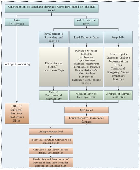
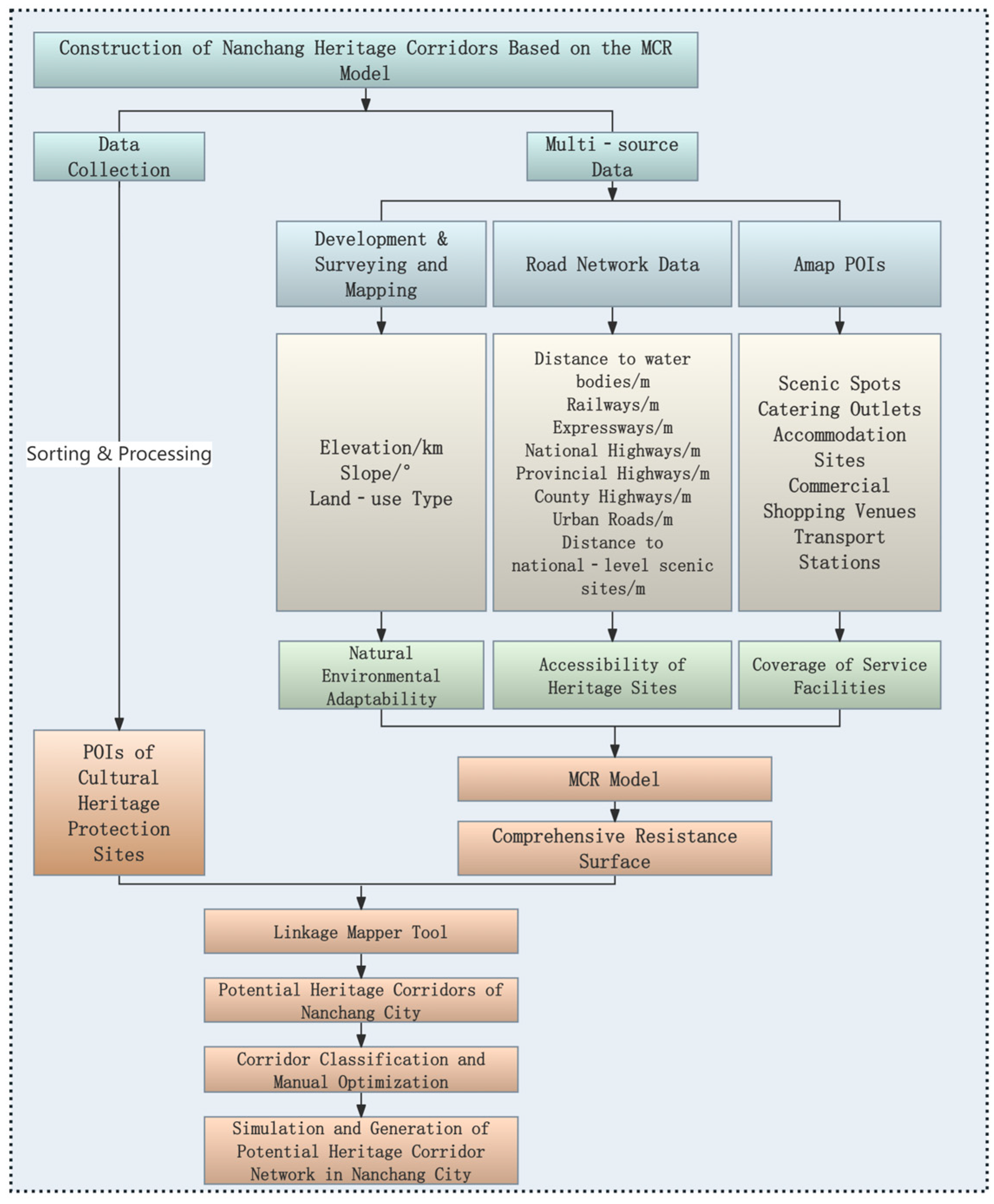
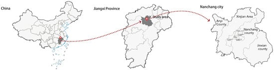
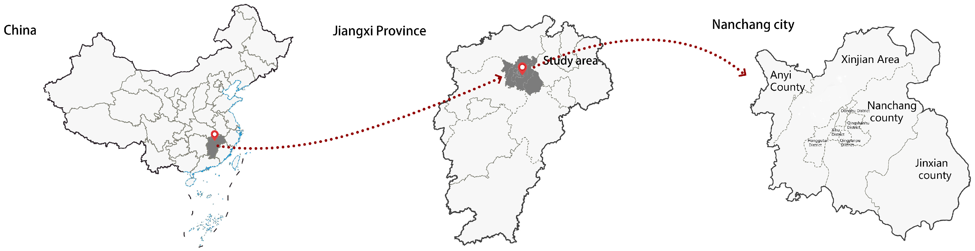
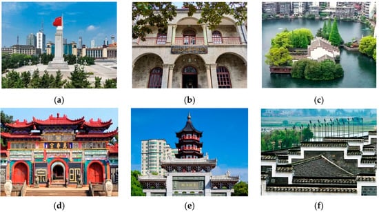
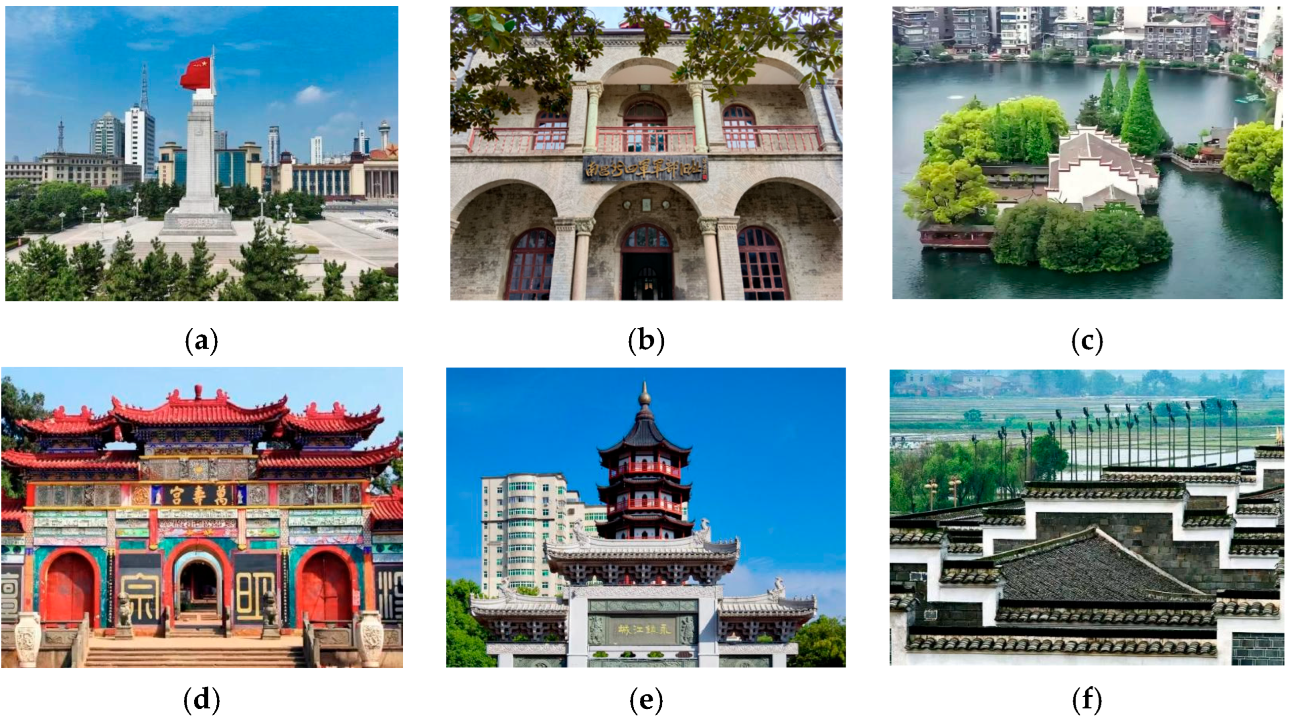
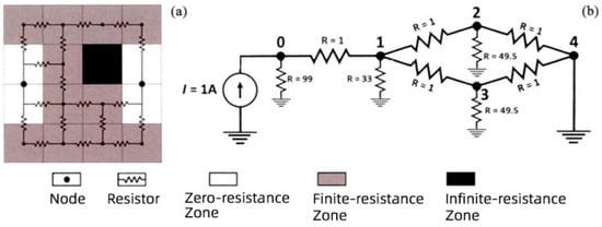
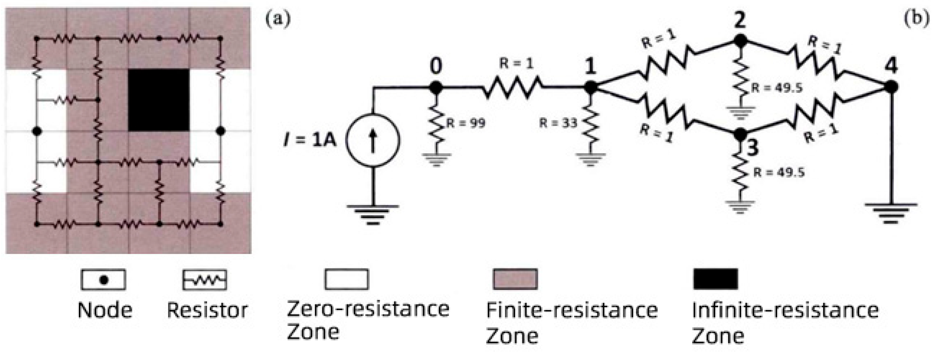
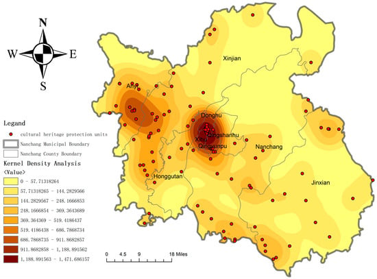
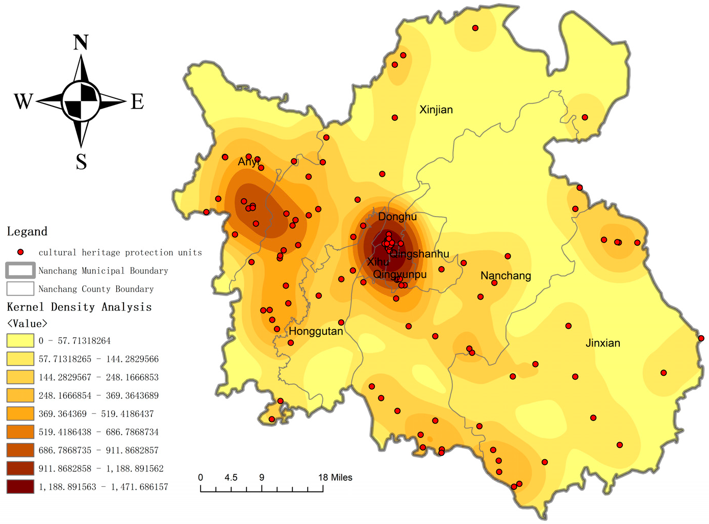
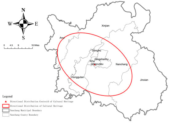
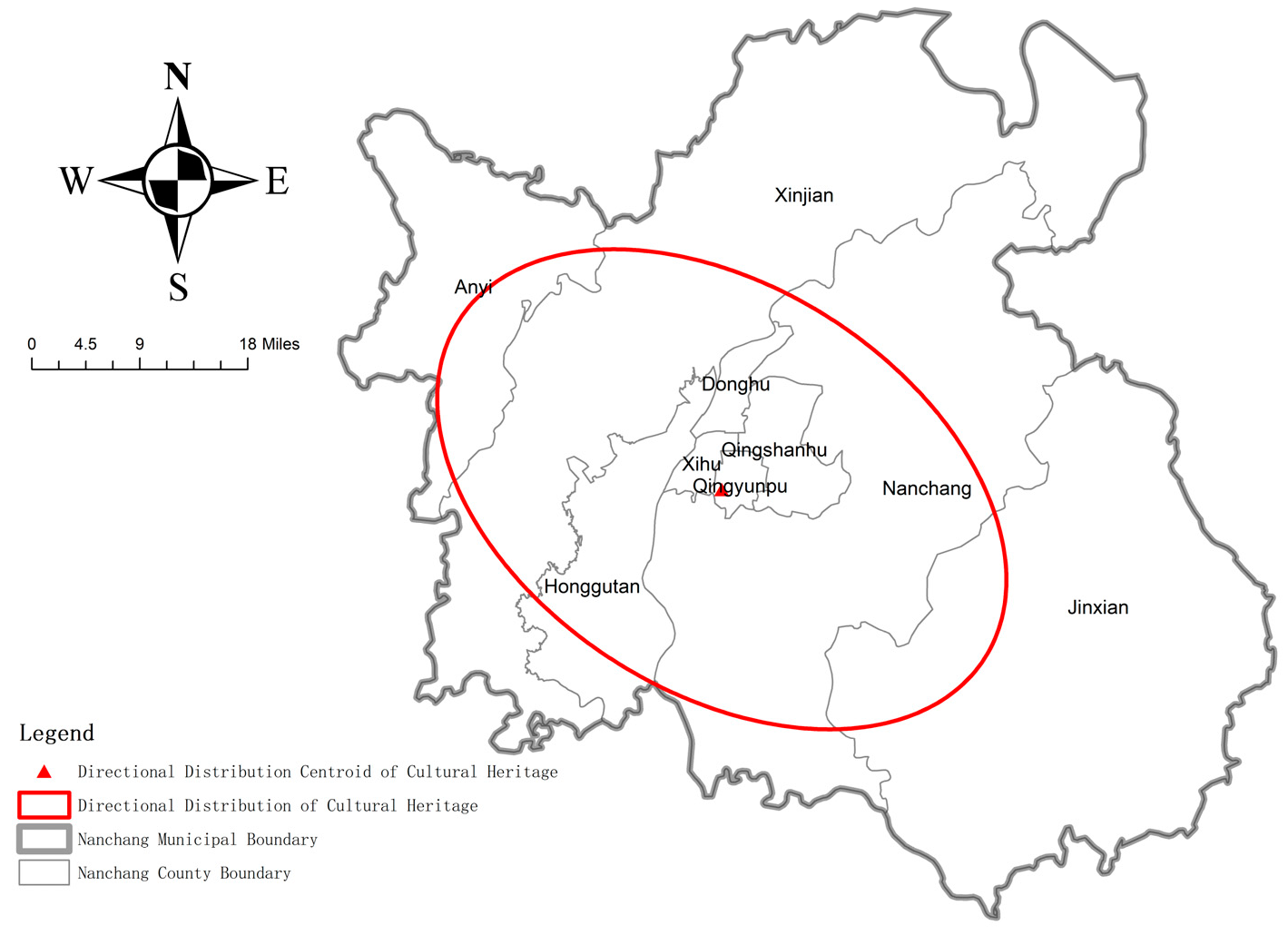
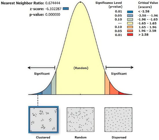
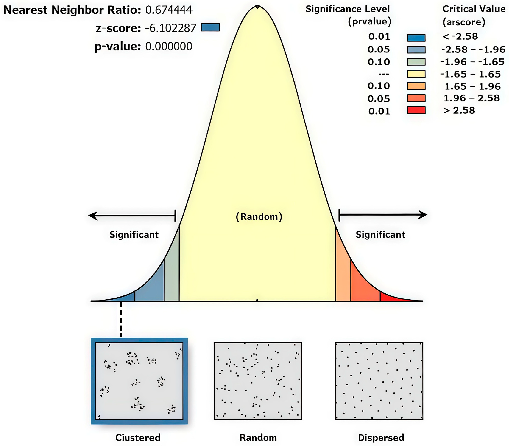
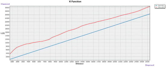
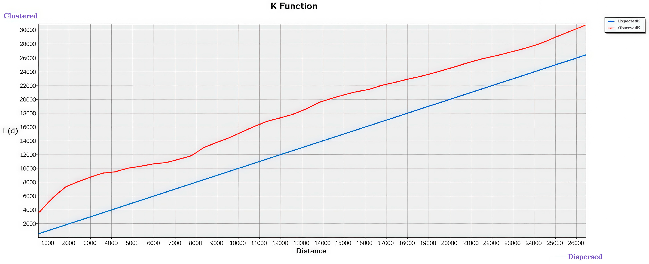
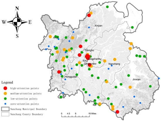
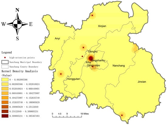
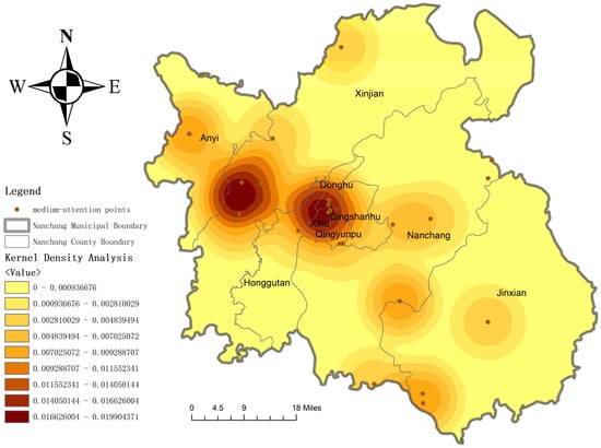
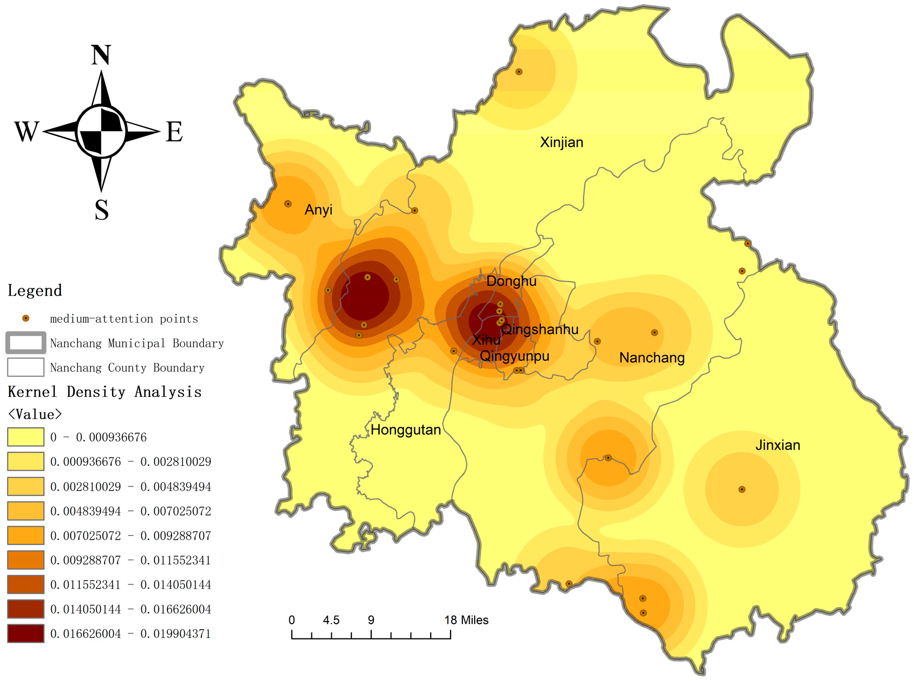
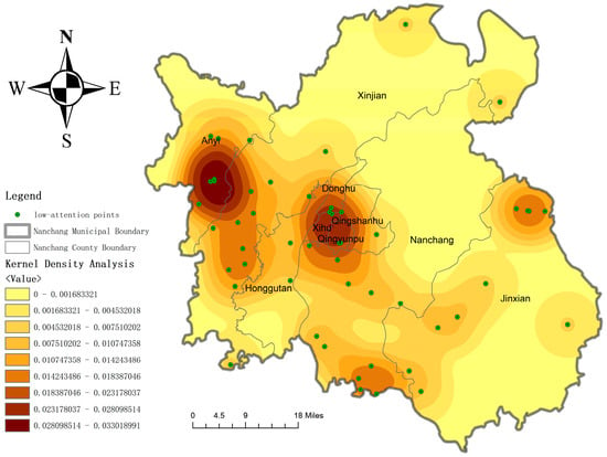
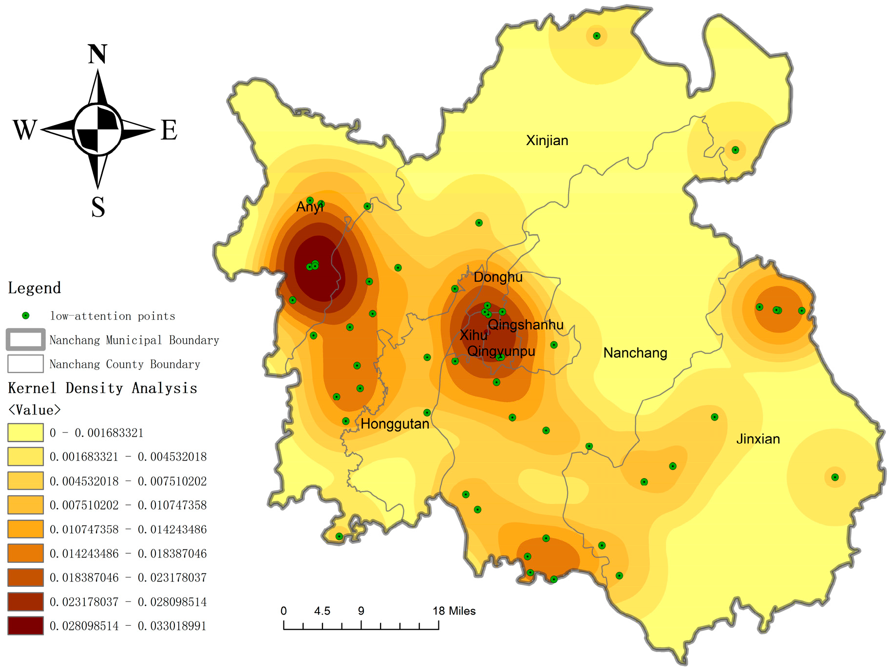
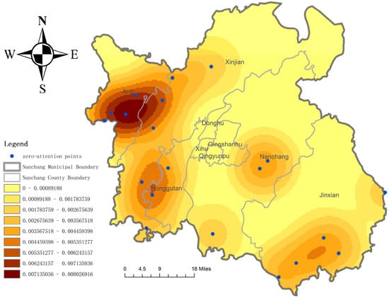
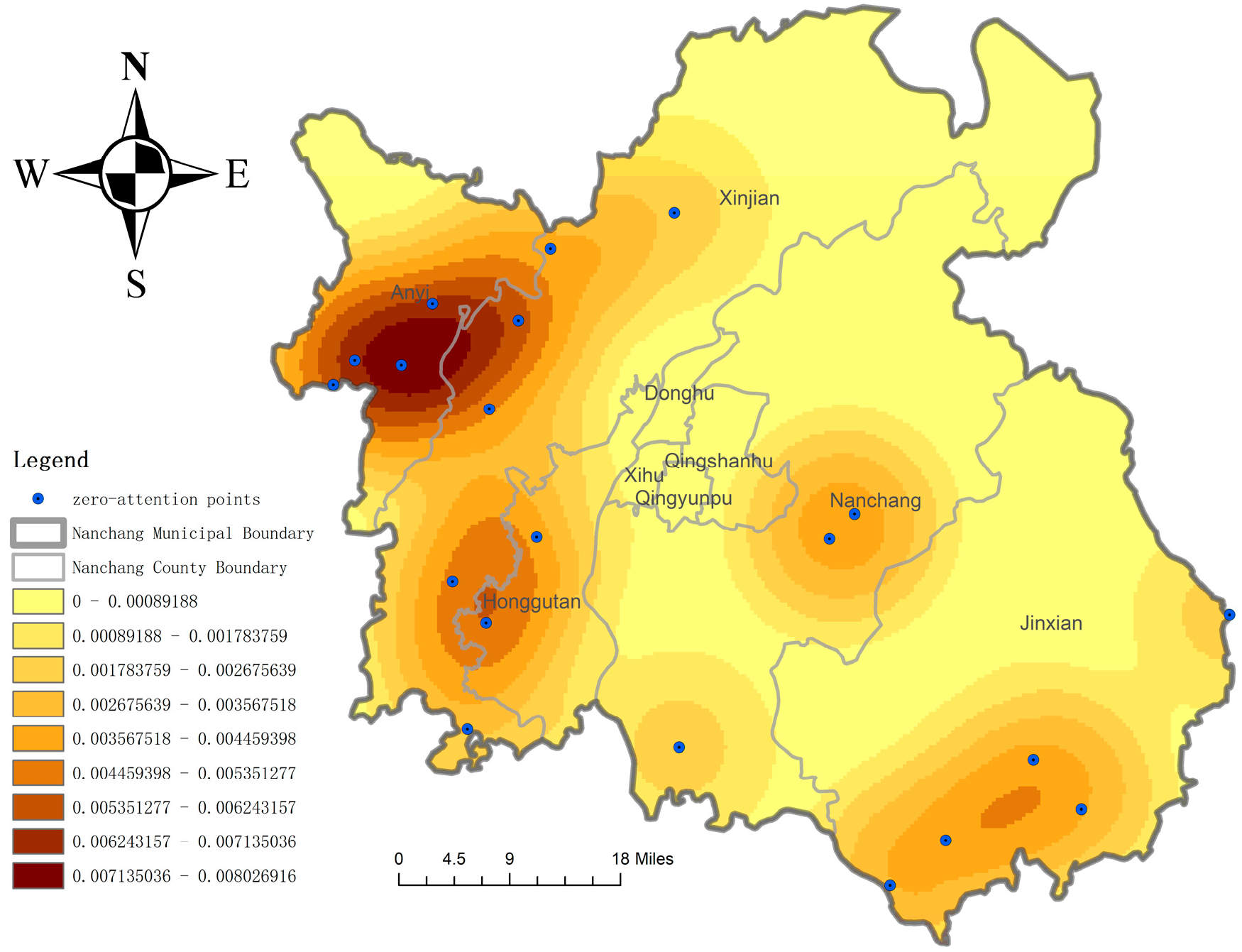
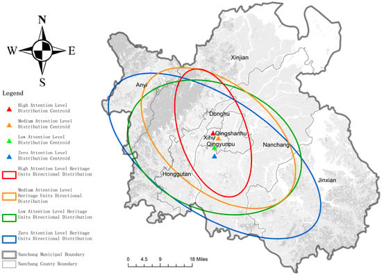
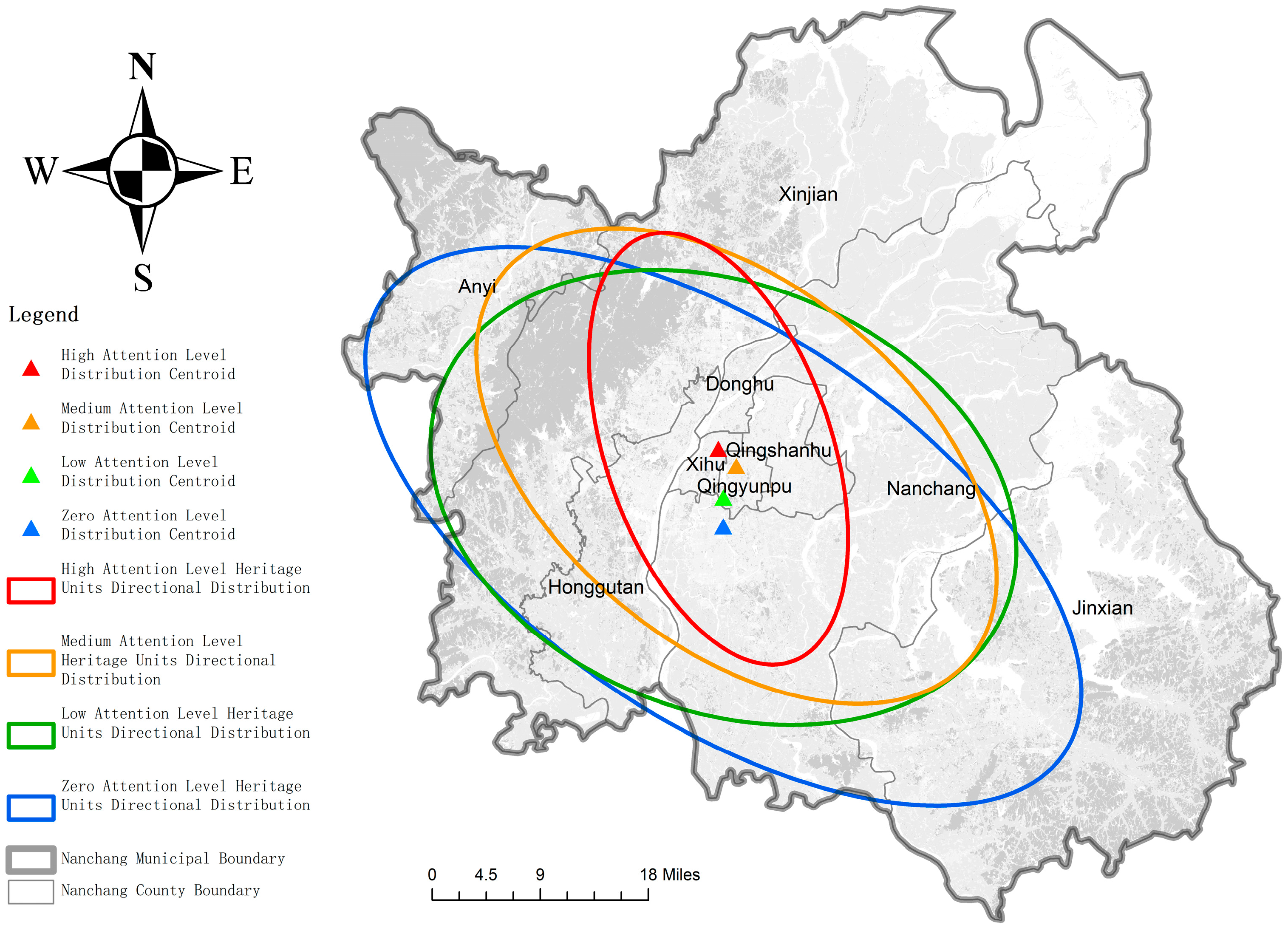
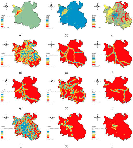
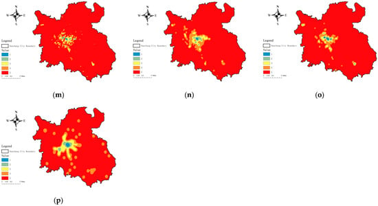
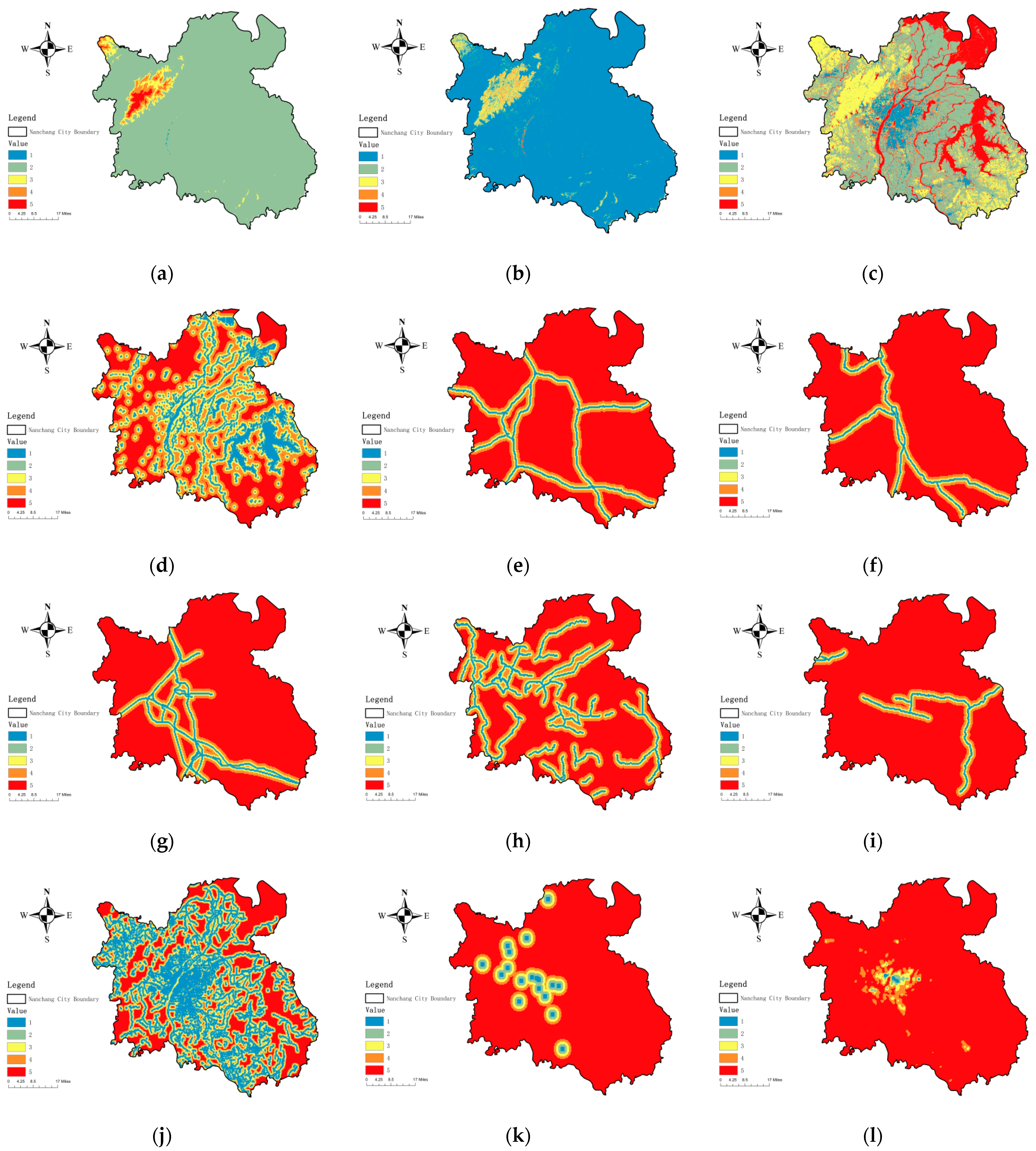
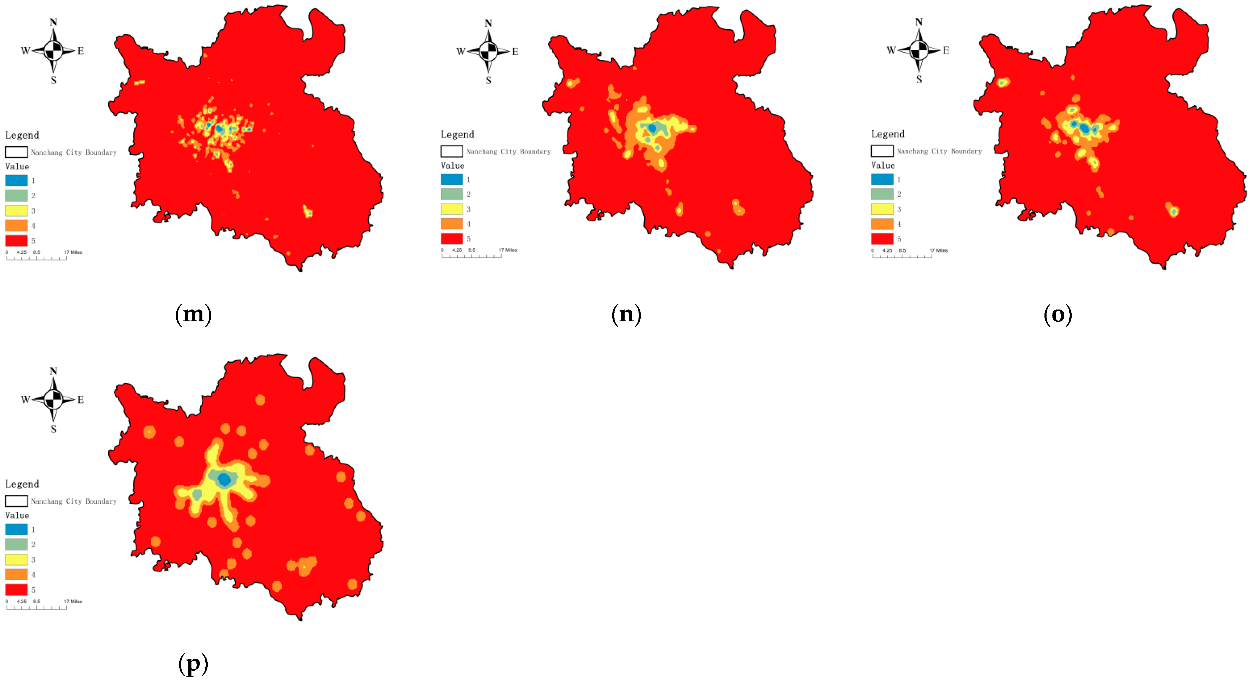
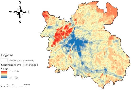
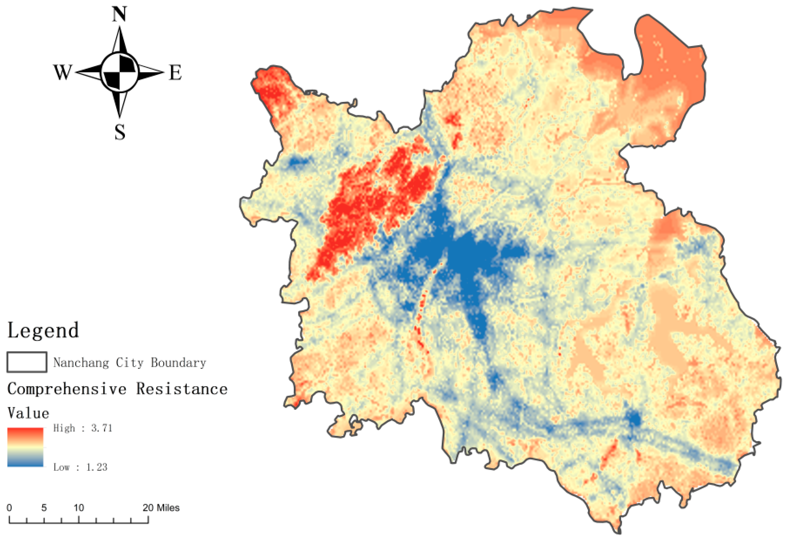
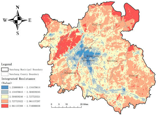
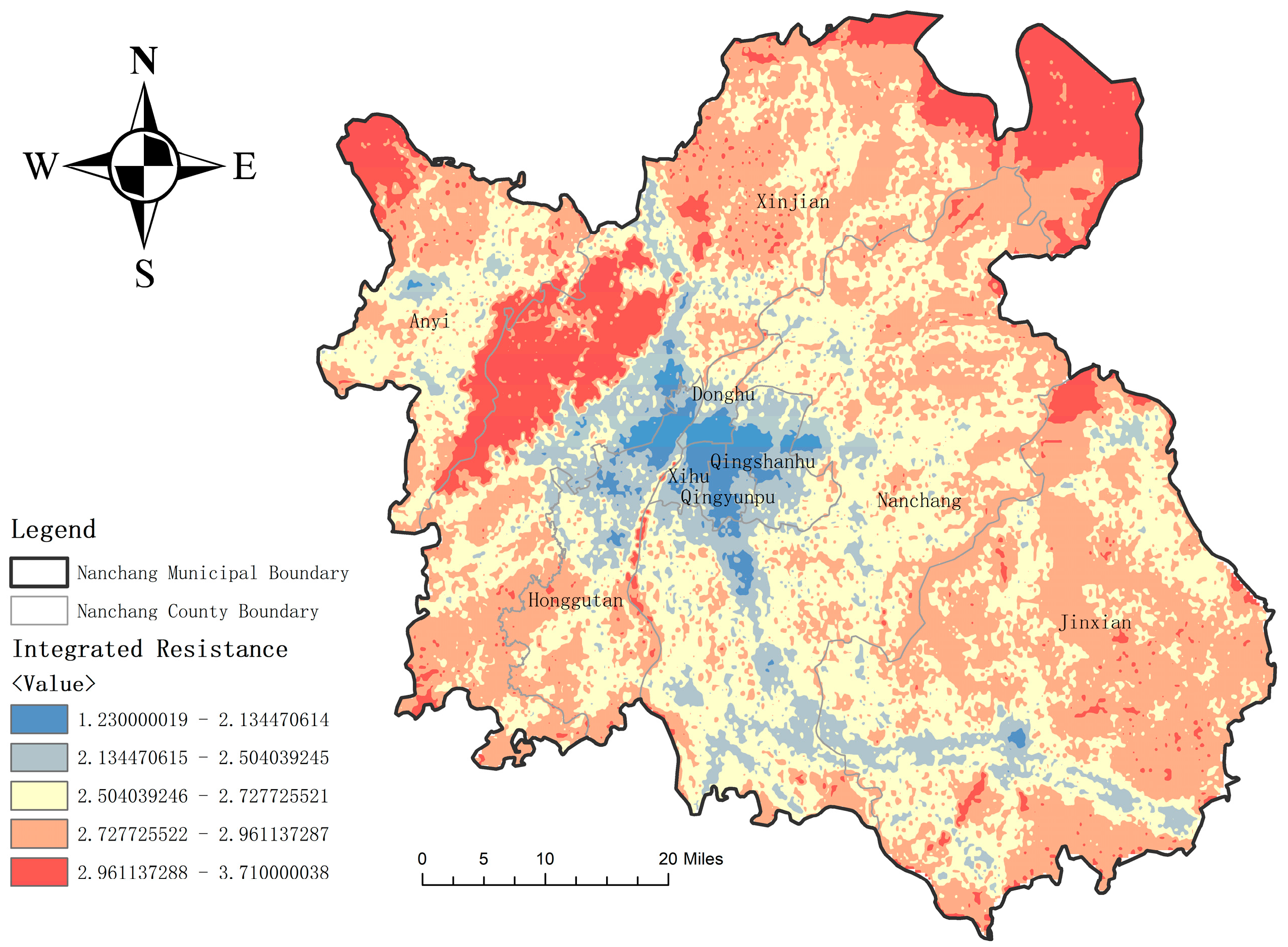
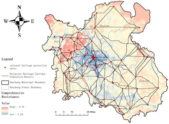
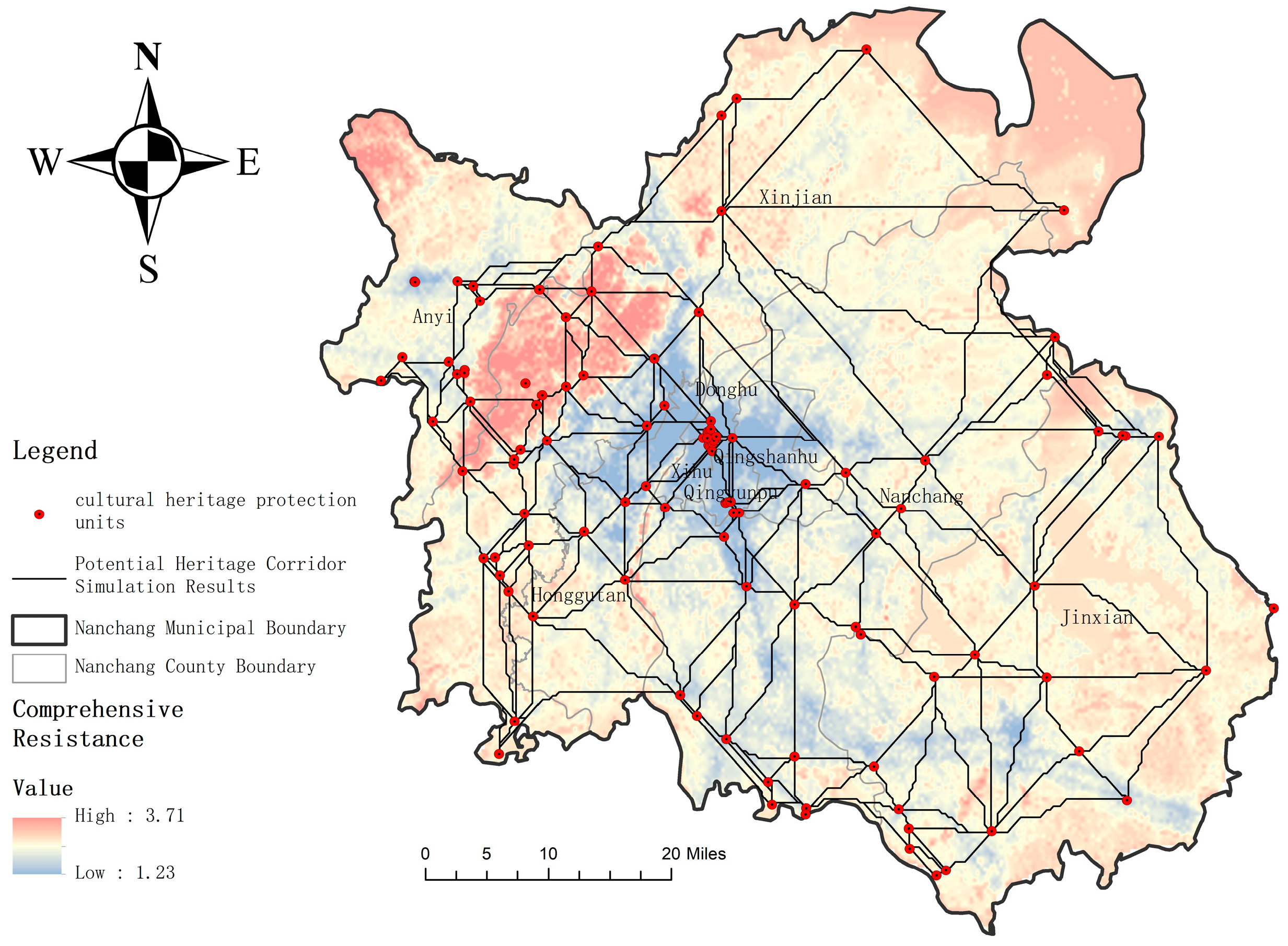
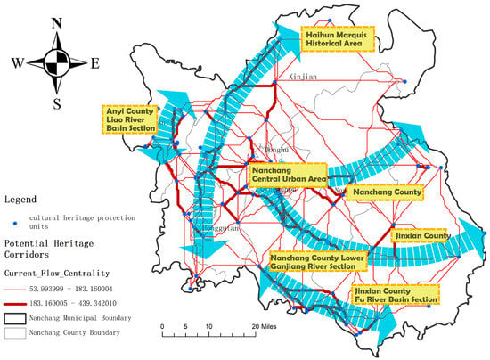
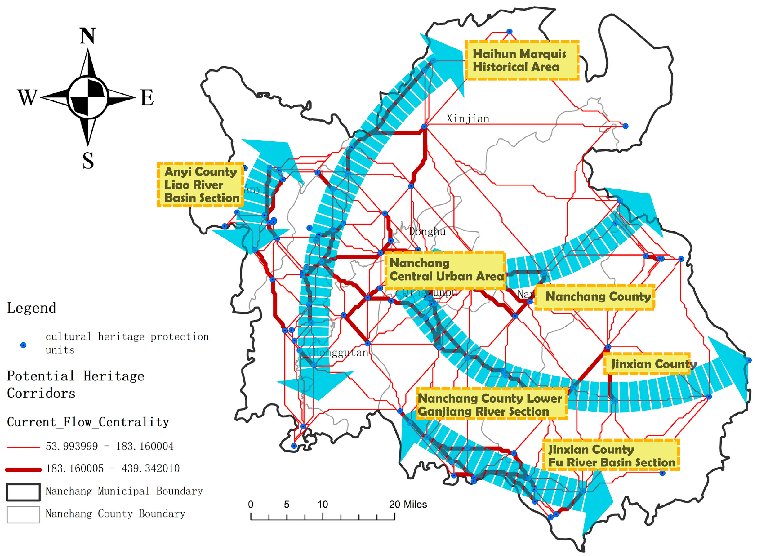
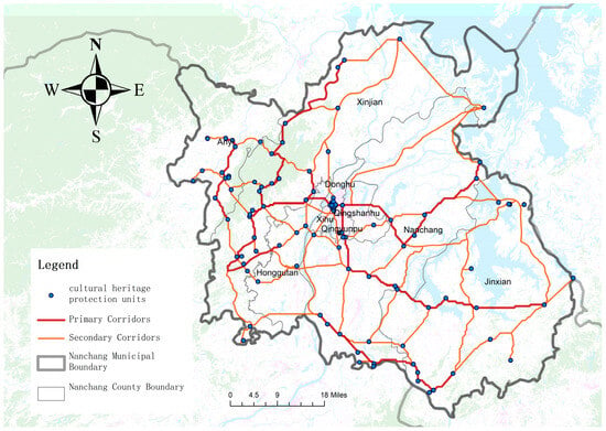
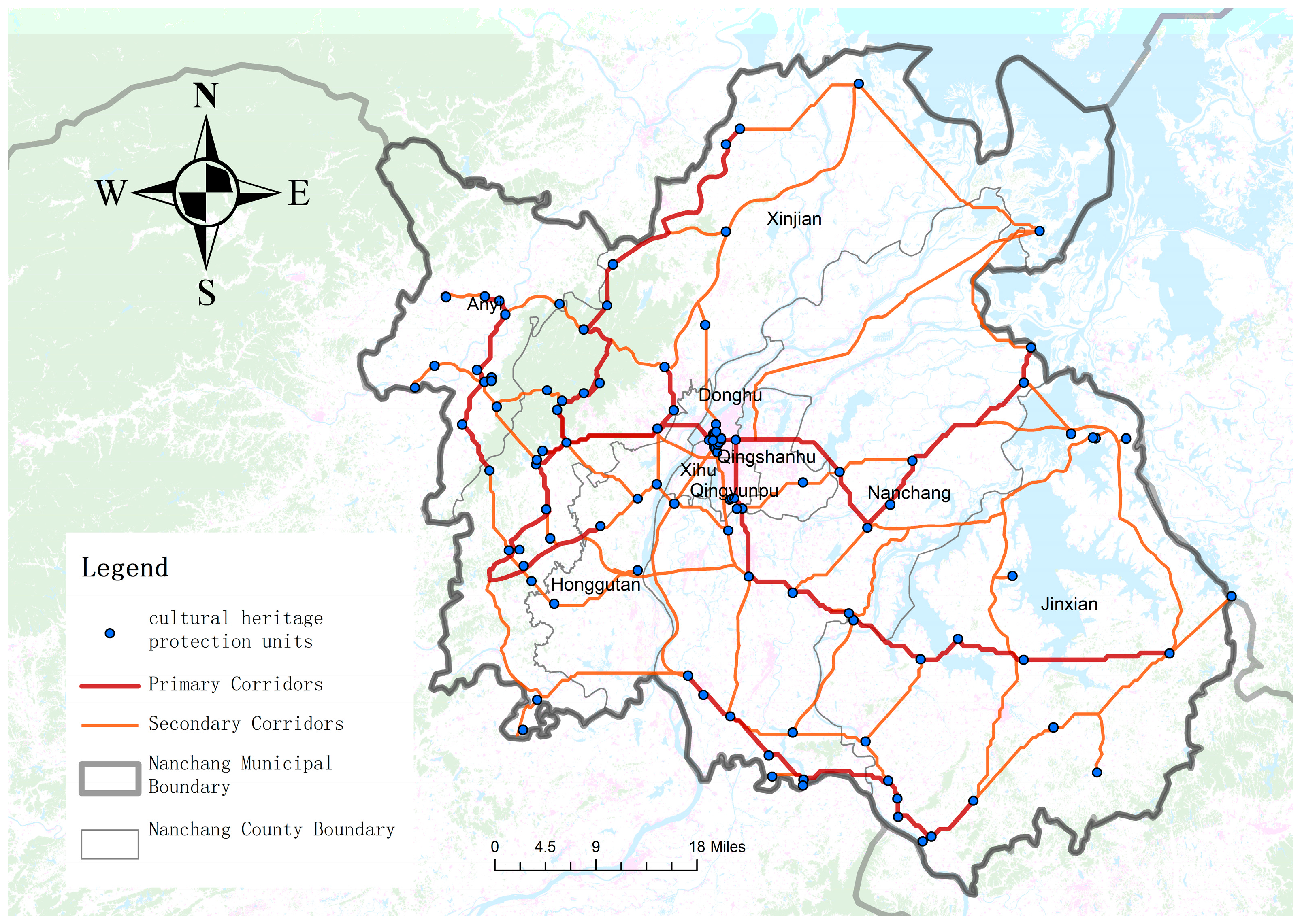
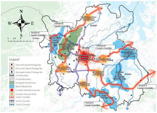
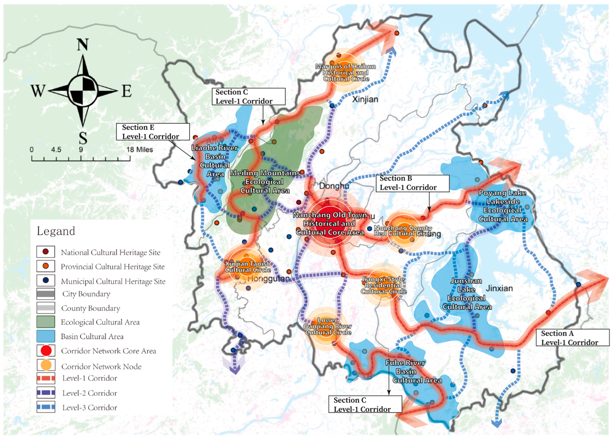
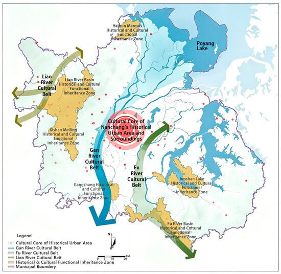
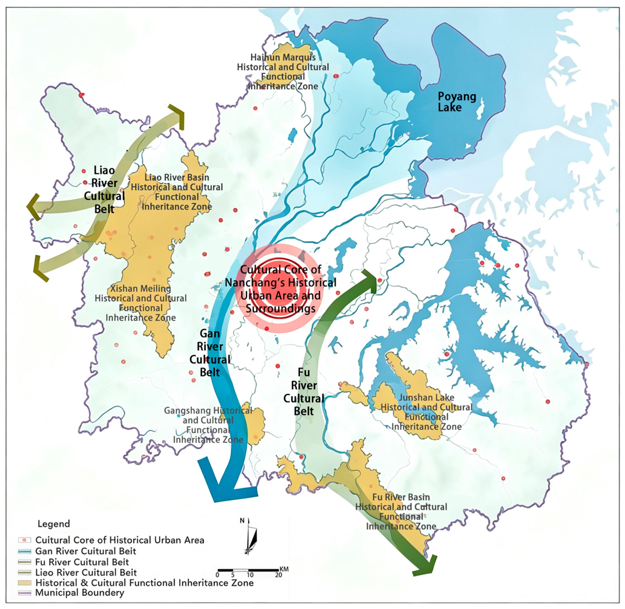
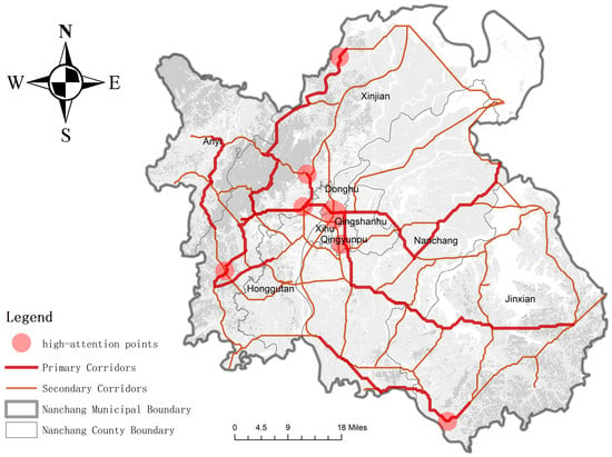
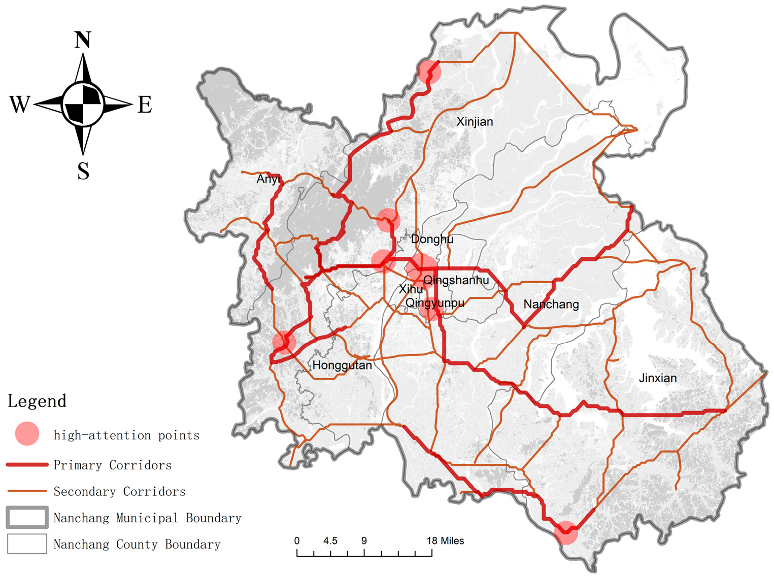
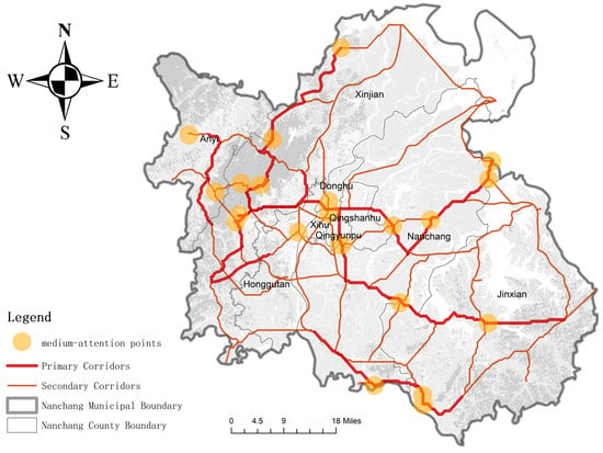
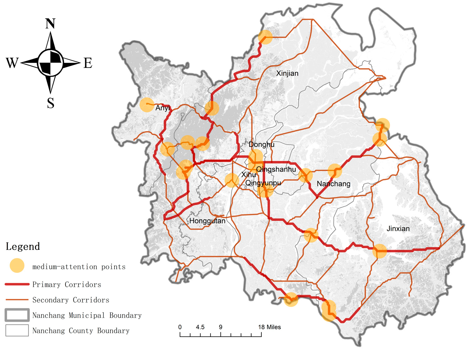
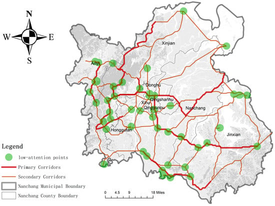
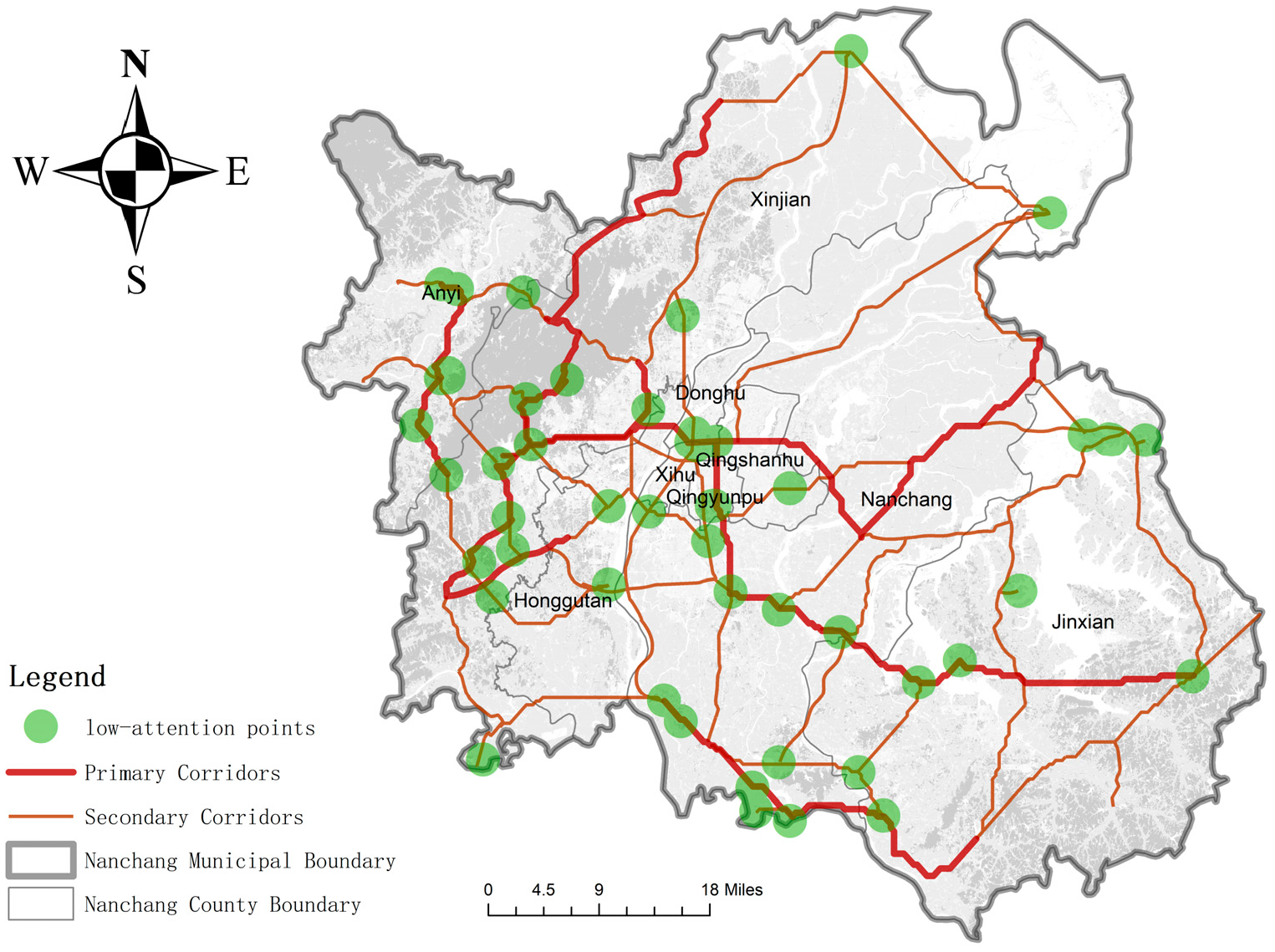
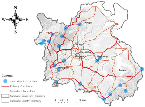
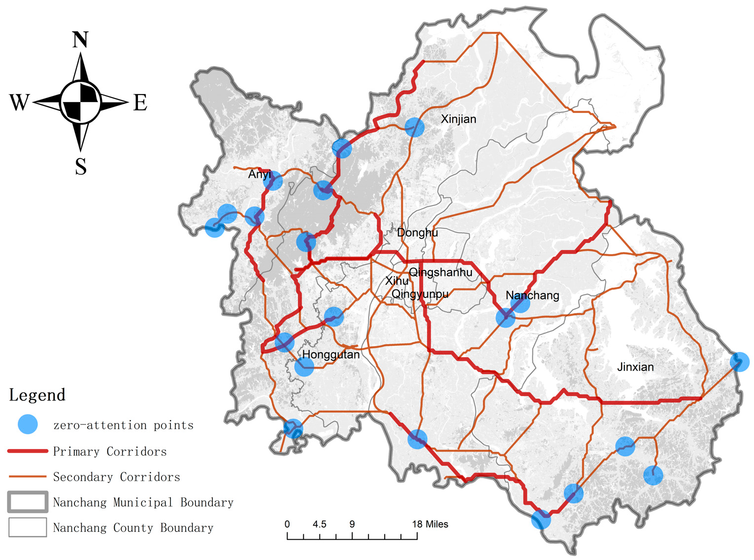

Disclaimer/Publisher’s Note: The statements, opinions and data contained in all publications are solely those of the individual author(s) and contributor(s) and not of MDPI and/or the editor(s). MDPI and/or the editor(s) disclaim responsibility for any injury to people or property resulting from any ideas, methods, instructions or products referred to in the content. |
© 2026 by the authors. Licensee MDPI, Basel, Switzerland. This article is an open access article distributed under the terms and conditions of the Creative Commons Attribution (CC BY) license.