


Abstract
Accurately identifying the spatial differentiation mechanisms of rural homesteads in ecologically fragile mountainous areas is essential for implementing United Nations Sustainable Development Goal 11—building inclusive, safe, resilient, and sustainable human settlements—and for advancing differentiated rural revitalization strategies. Taking Zhaotong City in Yunnan Province as a case study, this study innovatively couples the binary logistic regression model with the geographic detector model to systematically analyze the spatial patterns and driving mechanisms of rural homesteads from the dual perspectives of “occurrence probability” and “agglomeration intensity.” The results show that: (1) Spatial pattern analysis reveals a macro-level distribution characterized by “higher density in the east than the west, and higher elevation in the south than the north.” At the local level, high-density small-scale clusters coexist with low-density large-scale clusters. The landscape is highly fragmented and morphologically complex, and can be classified into two regional types: “regular-dense” and “complex-expansive.” (2) The driving mechanism analysis reveals that the spatial differentiation of rural homesteads is closely linked to rigid topographic constraints, elastic responses to accessibility for both production and daily life, and adaptive adjustments to climatic conditions. Geodetector analysis further identifies widespread nonlinearly enhanced interactions among these factors, reflecting the synergistic interplay between natural and human elements. Building on these findings, this study proposes a three-tiered analytical framework—“rigid constraints–elastic responses–coupled amplification”—to characterize the multidimensional driving logic underlying homestead spatial differentiation in mountainous regions. This framework advances empirical understanding of mountain settlement dynamics in ecologically fragile developing countries and yields actionable governance insights: in areas exhibiting high landscape fragmentation, complex morphological patterns, and low agglomeration intensity, priority should be given to remediation strategies such as voluntary homestead withdrawal and ecological relocation. The findings provide a scientific basis for revitalizing existing homestead land, spatial restructuring, and refined governance in Southwest China’s mountainous regions. Furthermore, this research offers a transferable analytical framework and practical reference for sustainable human settlement development in similar contexts, including the Qinba and Hengduan Mountains, as well as ecologically fragile zones globally.
1. Introduction
Rural homesteads refer to collectively owned construction land allocated to villagers for housing construction and associated ancillary facilities, including residential plots, auxiliary structures, and courtyard spaces [1]. As a key spatial carrier integrating natural and socio-economic systems, the spatial pattern of rural homesteads land not only reflects villagers’ residential behaviors shaped by specific natural conditions, levels of economic development, and institutional arrangements [2], but also represents an important manifestation of the long-term evolution of human–land relationships [3]. The distribution patterns and evolutionary trajectories of rural homesteads are jointly influenced by multiple factors, such as the natural environment, socioeconomic conditions, and cultural traditions [4]. However, under China’s long-standing urban–rural dual structure, rural areas have remained relatively marginalized in terms of development strategies, resource allocation, and industrial layout. This structural imbalance has resulted in increasingly prominent challenges, including widening urban–rural disparities and mismatches between population distribution and land use. Consequently, a range of so-called “rural ailments” has emerged, such as village depopulation, dispersed settlement patterns, and the extensive underutilization and inefficient use of homestead land [5]. These issues not only intensify the contradiction between land supply and demand, but also severely constrain improvements in the intensive use of rural construction land, posing a serious challenge to the implementation of the United Nations Sustainable Development Goal of “building inclusive, safe, resilient, and sustainable human settlements” [6,7]. This challenge has become particularly acute after 2019, when, following the introduction of local regulations such as the Measures for the Administration of Rural Homesteads, the focus of homestead management has shifted from expansion to revitalization. Consequently, there is an urgent need to scientifically identify the spatial differentiation mechanisms of homesteads to support refined governance. Against this backdrop, in-depth analysis of the spatial patterns of homestead land and their driving mechanisms holds significant theoretical and practical implications for optimizing rural spatial structures, enhancing land use efficiency, and advancing rural transformation and development [8].
Research on rural residential space in Western scholarship began relatively early but seldom employs the specific term “homestead.” Instead, studies typically examine the topic from the perspectives of rural settlements or rural residential land, with a focus on urban–rural governance structures [9], historical institutional path dependence [10], topographical and resource constraints [11], and the evolution of housing forms [12]. There is a broad scholarly consensus that the spatial patterns of rural settlements emerge from the long-term interactions among institutional arrangements, historical processes, and geographical environments [13]. For example, the Mediterranean region developed highly concentrated “agricultural towns” as a consequence of the historical latifundia system, whereas Eastern European countries experienced significant spatial restructuring—from traditional wooden dwellings to modern reinforced concrete housing—during periods of socio-economic transition. In recent years, international rural settlement research has witnessed three major paradigm shifts. First, research has shifted from physical space to socio-spatial dimensions. Rather than focusing solely on settlement morphology, scholars now treat settlements as embodiments of social relations, power structures, and everyday practices. Lynam et al. have developed a multidimensional methodological framework integrating commuting mobility, spatial accessibility, and actor-network analysis, which effectively reveals socio-spatial inequalities in rural areas undergoing urbanization [14]. Second, there has been a shift from administrative boundaries to functional spatial boundaries. Traditional approaches defining rural areas by administrative divisions are being replaced by methods grounded in functional connections. Barbosa et al. have developed objective criteria that integrate built density, land use diversity, and public service accessibility to delineate equitable and sustainable rural settlement boundaries, providing robust scientific support for land use optimization [15]. Third, attention has turned from generalized rural contexts to ecologically fragile mountain settlements. Studies of global mountain regions increasingly emphasize their unique human–land interaction mechanisms. In the Himalayas, out-migration has transformed traditionally compact settlements into fragmented, functionally degraded forms, highlighting the close coupling between livelihood security and settlement morphology [16]. These communities depend heavily on ecosystem services—such as forests and water sources—forming a complex “livelihood–ecology” dependency network, while tensions between formal and informal governance frameworks continue to undermine sustainable resource use [17]. In western Rwanda’s highlands, research using a “landscape gene mapping” approach has revealed that settlements prefer moderate elevations, gentle slopes, and access to water, identifying kinship-based clustering as a key “social gene” that sustains community resilience [18]. In the South American Andes, scholars have developed advanced models that integrate deep learning with Gaussian convolutional networks to simulate complex transboundary urban expansion and peri-urban fringe morphologies, offering powerful tools for understanding the dynamic evolution of mountain human settlement systems [19]. Furthermore, research increasingly emphasizes situating rural living spaces within the broader framework of the urban–rural continuum and regional ecological networks, focusing on their connectivity with ecological patches and recognizing the significant role of non-traditional settlement forms—such as dispersed settlements and temporary housing areas—in human–land interactions [20,21]. Collectively, these advances indicate that contemporary rural settlement research has transcended mere morphological description, evolving toward an integrated paradigm that encompasses social equity, functional delineation, ecological resilience, and global comparison.
In China, with the continuous advancement of the New Rural Construction initiative and the Rural Revitalization Strategy, rural homesteads have become a prominent topic in rural geography and land resource management. Existing studies span multiple spatial scales—including provincial [22], municipal [23], county [24], township [25], and village levels [26]—and focus on spatial distribution patterns [27,28], spatiotemporal evolution [29,30], land use characteristics [31], spatial layout optimization pathways [32,33], rural settlement transformation [34,35], and underlying driving mechanisms [36,37]. To examine the spatial layout of rural homesteads, scholars commonly employ tools from spatial econometrics and landscape ecology—including kernel density estimation, centroid migration analysis [38], spatial autocorrelation, landscape pattern indices, and fractal analysis [39]—to characterize their agglomeration and fragmentation patterns [40,41]. In analyzing driving mechanisms, researchers typically draw on indicators encompassing the natural environment [42], resource endowments [43], locational advantages [44], and socioeconomic conditions [45], employing geographic detectors [46] and spatial regression models [47] to identify key determinants. As research paradigms have deepened, Chinese scholars focusing on mountainous rural settlements have increasingly integrated global comparative perspectives, aligning their work with international cutting-edge research agendas. For instance, in the karst mountainous regions of Southwest China, researchers have identified a decoupling phenomenon characterized by “population decline concurrent with settlement expansion,” underscoring the distinctiveness of human–land relationships in ecologically fragile areas. While this pattern parallels livelihood-driven settlement expansion in the Himalayas, it follows a distinct trajectory shaped by China’s robust policy interventions [48]. In the Three Gorges Reservoir area, studies employing system dynamics modeling to simulate the coupled dynamics of settlement–cropland systems directly address global concerns regarding “mountain human–land system resilience” [49]. Meanwhile, in the oasis–desert ecotone of Northwest China, scholars adopt a water-constrained land allocation framework to project future settlement configurations under varying water availability scenarios—an approach highly consistent with sustainable settlement planning in arid regions worldwide [50]. Collectively, these studies mark a pivotal transition in China’s settlement geography—from localized description toward globally engaged, comparative scholarship.
In China, mountainous terrain—including hills and plateaus—accounts for approximately 70% of the national land area and sustains about one-third of the population [6]. For decades, national economic development has prioritized urban areas, driving a sustained out-migration of rural populations, labor, and other production factors to cities and towns. This trend has imposed severe challenges on the social fabric, economic vitality, resource utilization, and ecological sustainability of rural regions, with these pressures being particularly acute in impoverished mountainous areas [5]. Despite these concerns, existing research exhibits notable limitations. First, existing research has predominantly focused on economically advanced regions [51], metropolitan fringe zones [52,53], or specific geomorphic settings—including arid oases [54], karst valleys [55], broader karst systems [56], and the Loess Plateau [57]. As a result, the deeply dissected, ecologically fragile high mountain valleys of Southwest China—where human–land conflicts are particularly intense—have received scant scholarly attention, and empirical studies remain scarce. Second, many studies conceptualize rural homesteads as isolated land use patches [58], neglecting their multifaceted roles as integrated carriers of productive, residential, and social functions. Such an analytical lens constrains the formulation of refined and differentiated rural revitalization strategies. Third, analyses of driving mechanisms often fail to adequately address cross-scale interactions and internal coupling among drivers [59], undermining the scientific rigor and contextual specificity of spatial optimization strategies. To systematically disentangle the dual logic underlying homestead distribution and address these gaps, this study adopts a “dual-model coupling” approach. First, a binary logistic regression model is employed to identify key determinants of homestead occurrence—and the direction of their effects—from the perspective of “presence versus absence of built structures.” Subsequently, a geographic detector model reveals internal spatial differentiation patterns based on “clustering intensity,” quantifying nonlinear interactive effects among drivers. This integrated framework captures both linear probability relationships and nonlinear interactions while accounting for spatial heterogeneity, thereby overcoming the inherent limitations of single-model approaches [47,53]. This is particularly evident in Zhaotong, a representative mountainous city where rural development challenges have drawn local attention. However, existing studies remain largely confined to policy implementation practices or single-county case observations, with no systematic empirical research to date examining the city-wide spatial patterns of rural homesteads and their underlying driving mechanisms. To bridge this gap, this study presents the first city-scale analysis leveraging high-precision vector data of rural homesteads across the entire Zhaotong City in 2019. Moving beyond fragmented or qualitative approaches, we adopt a coupled modeling framework integrating binary logistic regression and geographic detector to systematically decipher the spatial differentiation characteristics and multidimensional driving mechanisms of homesteads from the dual perspectives of “occurrence probability” and “agglomeration intensity.”
Against this backdrop, this study focuses on Zhaotong in Yunnan Province as a representative mountainous region and employs exploratory spatial analysis alongside landscape pattern indices to systematically characterize the spatial distribution, clustering, and morphological features of rural homesteads in 2019. Building on this foundation, we integrate multidimensional factors—including topography, climate, hydrology, and transportation accessibility—to transcend descriptive spatial pattern analysis and advance toward mechanistic understanding. The empirical analysis centers on three testable core questions: (1) What spatial differentiation patterns and morphological characteristics do rural homesteads exhibit at the regional scale in the high mountain–deep valley areas of Southwest China? (2) Under the joint influence of natural and locational conditions, which factors determine “homestead occurrence,” and what are the sign and strength of their effects? (3) Within areas where homesteads have already been established, what is the explanatory power of different combinations of driving factors in accounting for the spatial differentiation of agglomeration intensity? To address these questions, we adopt a dual-perspective framework: a binary logistic regression model to analyze homestead occurrence probability, and a geographic detector model to assess spatial clustering intensity. In contrast to conventional “terrain–economy” dualistic models or general human–land coupling theories [60], this study focuses on mountainous regions, a relatively underexplored context, and proposes a three-tiered analytical framework: “rigid constraints–elastic responses–coupling amplification.” Compared to existing macro-paradigms such as “topographic constraints” or “human–land coupling,” this framework advances theoretical understanding in two key respects: (1) Mechanistically, it distinguishes between natural rigid constraints (e.g., steep slopes, high relief) and human elastic responses (e.g., road accessibility, policy-driven relocation). Geodetector analysis further reveals significant nonlinearly enhanced interactions between these dimensions, indicating that the synergistic interplay of natural and human factors collectively shapes the spatial organization of rural homesteads. (2) At the county scale, two distinct homestead patterns emerge: “ordered-dense” and “complex-expansive.” The findings provide a scientific basis for optimizing rural homestead layouts, revitalizing underutilized homestead land, and implementing differentiated spatial governance strategies in the mountainous southwest, thereby contributing to the achievement of sustainable development goals [61].
2. Study Area and Research Methods
2.1. Overview of the Study Area
This study takes the entire administrative area of Zhaotong City, Yunnan Province, as its research domain, encompassing all 11 constituent counties and districts: Zhaoyang District, Ludian, Qiaojia, Yanjin, Daguan, Yongshan, Suijiang, Zhenxiong, Yiliang, Weixin counties, and Shuifu City, covering a total area of approximately 23,000 km2. Zhaotong was selected as a case study because it encapsulates the core contradictions and defining characteristics of the high mountain–deep valley regions of Southwest China. Located in northeastern Yunnan Province at the tri-junction of Yunnan, Guizhou, and Sichuan (26°52′ N–28°36′ N, 103°09′ E–105°26′ E), Zhaotong forms a critical part of the ecological barrier in the upper Yangtze River basin (Figure 1). Physically, mountainous terrain covers 96.4% of Zhaotong’s area (Yunnan Statistical Yearbook), with elevations spanning an extreme range from 216 m to 3997 m. The region features highly rugged topography, steep slopes, and a pronounced vertical climate gradient, exhibiting complex vertical climatic zonation with coexisting subtropical and warm temperate zones. Annual precipitation ranges from 800 mm to 1400 mm, with warm-season rainfall coinciding with peak temperatures—conditions favorable for agriculture. Socioeconomically, the rural population exceeds 70% of the total, making Zhaotong one of Yunnan’s prefecture-level cities with the highest proportion of agricultural residents. The local economy has long been dominated by traditional agriculture, while industrialization and urbanization remain underdeveloped, resulting in pronounced regional imbalances. In terms of policy implementation, Zhaotong hosts the highest concentration of nationally designated key counties for rural revitalization assistance among Yunnan’s prefecture-level cities. In recent years, large-scale poverty alleviation resettlement programs have profoundly reshaped the spatial configuration of rural homesteads, giving rise to the coexistence of homestead expansion and underutilization—a typical manifestation of “rural malaise.”
Figure 1.
Location of Zhaotong City, China.
In summary, Zhaotong embodies three defining features—“fragmented terrain, ecological sensitivity, and developmental lag”—that not only reflect the national macro-pattern of mountainous regions occupying 70% of China’s land and supporting one-third of its population, but also epitomize the pervasive challenges of intense human–land conflicts and inefficient homestead use in Southwest China’s high mountain–deep valley areas. The city thus demonstrates exceptional regional representativeness and research typicality.
2.2. Data Sources
This study integrates multi-source, multi-scale spatial data to construct a comprehensive database encompassing the natural environment, transportation accessibility, and land use. The specific data sources are as follows: (1) Rural homesteads data for Zhaotong were obtained from field survey vector data conducted by the Yunnan Provincial Geological and Mineral Resources Survey and Mapping Institute. The dataset includes attributes such as parcel location and homesteads area. A note on data timeliness is warranted: although the dataset is limited to 2019, it remains highly representative for this study. On one hand, 2019 marked the final year of the “13th Five-Year Plan” poverty alleviation resettlement program. As a region facing one of the nation’s most demanding poverty alleviation mandates, Zhaotong had largely completed large-scale centralized resettlement by that year, resulting in a stabilized spatial configuration of rural homesteads. On the other hand, national and local homestead management policies from 2020 to 2023 have primarily emphasized “prudent and gradual revitalization of existing stocks,” explicitly prohibiting forced adjustments to established homesteads against villagers’ will (Notice of the Office of the Central Rural Work Leading Group and the Ministry of Agriculture and Rural Affairs on Further Strengthening the Administration of Rural Homesteads, Zhongnongfa (2019) No. 11). According to the Zhaotong Territorial Spatial Planning Implementation Assessment Report, no citywide resettlement or village consolidation initiatives have been launched since 2019, and the homestead layout has remained structurally unchanged. Consequently, the 2019 data effectively capture the current macro-level distribution patterns of homesteads and the underlying geographic drivers. (2) DEM data were derived from ASTER GDEM V2 (30 m resolution) and used to extract topographic variables, including elevation, slope, aspect, and terrain roughness (https://search.earthdata.nasa.gov/, accessed on 15 January 2026). The original 30 m resolution was retained without resampling. (3) Meteorological data were obtained from the 1 km resolution monthly mean temperature and precipitation dataset for China, shared by the National Tibetan Plateau Science Data Center. These data were used to calculate annual mean temperature and precipitation (https://data.tpdc.ac.cn/zh-hans/data/faae7605-a0f2-4d18-b28f-5cee413766a2, accessed on 15 January 2026). To ensure spatial consistency with other input layers in the analysis, the meteorological rasters were resampled to 30 m resolution using bilinear interpolation—a widely adopted technique in multi-source remote sensing data fusion that preserves the spatial patterns of climate variables while meeting the requirements of high-resolution modeling. (4) Transportation and river data were sourced from OpenStreetMap (https://www.openstreetmap.org, accessed on 15 January 2026). After topological verification and classification, the road network was categorized into primary, secondary, and tertiary roads to compute road density and transportation accessibility. Rivers and streams were represented as linear features, while lakes and reservoirs were digitized as polygonal water bodies, enabling measurement of homestead proximity to different water system types. Given that OpenStreetMap provides volunteered geographic information (VGI) and may exhibit localized gaps in underdeveloped western mountainous areas, we cross-referenced major transportation routes and primary watercourses against the National 1:4,000,000 Fundamental Geographic Database. The comparison revealed high consistency in the spatial alignment and topological integrity of national highways, provincial roads, and first-order streams, confirming that the data accuracy meets the study’s requirements [62]. (5) County center point data were obtained via reverse geocoding based on county names published by the National Bureau of Statistics. (6) Cropland data were derived from 30 m resolution land use data provided by the Resource and Environmental Science Data Center (RESDC) of the Chinese Academy of Sciences (https://www.resdc.cn, accessed on 15 January 2026). The distribution of dryland within the study area was extracted to serve as the spatial background for agricultural production.
This study adopts an analytical framework of “pattern identification–feature characterization–mechanism interpretation,” integrating multi-scale spatial analysis, landscape pattern quantification, and driving-factor detection. All spatial analyses were conducted using ArcGIS Pro (v3.0.2), FragStats (v4.2), and R (v4.3.1). Specifically, data preprocessing, coordinate transformation, topological repair, kernel density estimation, and hotspot analysis were performed in ArcGIS Pro; landscape pattern metrics were computed using FragStats; and binary logistic regression modeling, principal component analysis, hierarchical clustering, and geodetector analysis were executed in R. First, data preprocessing includes coordinate system unification, data integration, and topological correction to construct a standardized geospatial database. Second, spatial pattern analysis employs methods such as the average nearest neighbor index, kernel density estimation, and hotspot analysis to systematically identify the overall distribution characteristics and clustering patterns of rural homesteads. Third, landscape pattern characterization and typology identification utilize landscape pattern indices to quantitatively describe the spatial structural features of homesteads, followed by regional typology classification using principal component analysis and hierarchical clustering. Finally, driving mechanisms are investigated by coupling binary logistic regression with geographic detector models to identify key influencing factors and quantify their explanatory power with respect to homesteads occurrence probability and spatial differentiation intensity. Through this stepwise progression from macro-scale patterns to micro-scale mechanisms, the framework comprehensively reveals the spatial differentiation characteristics and underlying driving forces of rural homesteads in Zhaotong.
2.2.1. Average Nearest Neighbor Index (ANN)
The average nearest neighbor index is employed to evaluate the overall spatial distribution pattern of homesteads. It calculates the average distance between the centroid of each homestead patch and its nearest neighbor. This observed average is then compared with the expected average distance for a random distribution to determine whether homesteads exhibit clustering [63]. The ANN value ranges from −1 to 1, with values less than 1 indicating a clustered distribution and values greater than 1 suggesting a dispersed pattern. The ANN is calculated as follows:
where is the observed mean distance between each homestead centroid and its nearest neighbor; is the expected mean distance under a random spatial distribution; is the total number of homesteads patches; is the distance between centroids; is the study area. If < 1, the homesteads distribution is clustered; otherwise, they tend toward random distribution.
2.2.2. Kernel Density Estimation (KDE)
Kernel Density Estimation is a nonparametric statistical method used to analyze and quantify the spatial density of rural homesteads [64]. The KDE at a given location is calculated as follows:
where is the kernel density value at location ; is the total number of homestead patches; is the bandwidth controlling the smoothing effect; is the kernel function; is the distance from location to the -th homestead patch. Higher KDE values indicate greater spatial density of homesteads, whereas lower values indicate sparser distribution.
2.2.3. Spatial Hotspot Analysis
Building on previous research [45], this study conducts a spatial hotspot analysis of homestead areas in Zhaotong using global autocorrelation methods. This analysis identifies spatial “hotspot” and “coldspot” zones of homesteads. The calculation formulas are as follows:
where is the spatial weight defined by a distance-based rule; is the homestead area; and are the expected value and variance of , respectively. For interpretation, is normalized to obtain . A positive and significant indicates that location is surrounded by a hotspot area with high-value aggregation, reflecting large-scale local clustering of homestead patches. Conversely, a negative and significant indicates that location is surrounded by a coldspot area with low-value aggregation, reflecting low-scale patch clustering.
2.2.4. Landscape Pattern Indices
Landscape pattern refers to the spatial distribution characteristics of landscapes shaped by natural or human processes, reflecting landscape heterogeneity and the combined influence of multiple disturbance factors across different scales [65]. Landscape ecology emphasizes both spatial structure and ecological processes, using a series of landscape pattern indices to quantify these characteristics [66]. In mountainous rural areas, homestead landscapes constitute a complex system integrating social, economic, resource, and ecological elements, whose spatial arrangement is influenced by both human activities and natural factors. Consequently, employing landscape indices to describe the scale, morphology, and spatial distribution of rural homesteads has become a central method for analyzing their spatial structure.
To comprehensively characterize homestead spatial structure, nine representative landscape pattern indices were selected: number of patches (NP), largest patch index (LPI), mean patch area (AREA_MN), patch density (PD), mean nearest neighbor distance (ENN_MN), mean patch shape index (SHAPE_MN), area-weighted shape index (SHAPE_AM), mean fractal dimension (FRAC_MN), and fragmentation index (FS). These indices collectively capture three dimensions of landscape structure: scale, aggregation, and shape [67]. To calculate the landscape pattern indices, the homestead vector data were first converted to raster format. The resulting raster files were then imported into Fragstats software for landscape pattern analysis, adopting the 8-cell neighborhood rule (Queen’s case). Sampling and edge correction were not applied, and only class-level metrics were computed.
2.2.5. Binary Logistic Regression Model and Geodetector
This study employs a combined approach of binary logistic regression and geodetector to analyze the driving mechanisms of homesteads distribution from two complementary perspectives: occurrence probability and spatial differentiation. The former identifies key factors influencing the likelihood of homesteads emergence and their directional effects, while the latter quantifies each factor’s explanatory power and interactive effects on spatial differentiation [47]. The binary logistic regression model is expressed as:
where is the probability of rural homesteads occurrence in each grid cell; represents the influencing factors; is the constant term; is the regression coefficient for each variable.
Geodetector is a statistical method designed to detect spatial differentiation and reveal its underlying drivers. Its core principle posits that if an independent variable significantly influences a dependent variable, their spatial distributions should exhibit similarity [68]. The explanatory power of each factor is quantified using the statistic, defined as:
where is the number of categories for a given factor; and are the sample size and variance of the dependent variable within category ; and are the total sample size and variance across the study area. The value ranges from 0 to 1, with higher values indicating a stronger influence of the independent variable on the spatial variation of the dependent variable.
3. Spatial Pattern Characteristics of Rural Homesteads in Zhaotong
3.1. Overall Spatial Distribution Patterns
This study systematically reveals the spatial pattern characteristics of rural homesteads in Zhaotong using an integrated application of the average nearest neighbor index (ANN), kernel density estimation, and spatial hotspot analysis (Figure 2a).
Figure 2.
Spatial Pattern Characteristics of Rural Homesteads: (a) Spatial Distribution of Rural Homesteads; (b) Density Distributon Characteristics; (c) Hotspot Analysis Results.
The ANN analysis quantifies the degree of spatial clustering of homesteads. The results show (Table 1) that the overall ANN value for Zhaotong is 0.27, which is significantly less than 1 (p < 0.01, |Z| > 2.58), indicating a highly significant clustered distribution of rural homesteads. Furthermore, the global Moran’s I index of 0.316 (p < 0.01) further confirms the presence of significant positive spatial autocorrelation in homestead distribution. This indicates that similar values (high-high or low-low) tend to cluster spatially, thereby rejecting the hypothesis of random distribution. At the county level, all counties exhibit ANN values below 1 and pass the 1% significance test, suggesting that homestead within each administrative unit also display clustered patterns. Notably, substantial inter-county differences in clustering intensity are observed. Counties such as Yongshan, Zhaoyang, and Ludian have ANN values lower than the citywide average, reflecting stronger clustering tendencies. In contrast, eight counties, including Yanjin and Weixin, exhibit relatively higher ANN values and weaker clustering. These results indicate that the spatial distribution of rural homesteads in Zhaotong is characterized not only by overall clustering but also by pronounced regional heterogeneity, likely resulting from the combined influences of topography, transportation accessibility, and land use patterns.
Table 1.
Nearest Neighbor Index and Rankings by Region in Zhaotong.
3.2. Spatial Aggregation and Scale Differentiation Patterns
Kernel density estimation and spatial hotspot analysis further elucidate the spatial aggregation patterns and scale differentiation of rural homesteads in Zhaotong.
Kernel density analysis employs the natural breakpoint method (Jenks) to ensure statistical optimality of density partitions. The spatial distribution of homesteads exhibits a pronounced core–periphery structure characterized by “high density in the east, sparsity in the west, concentration in the south, and dispersion in the north” (Figure 2b). High-density clusters are concentrated in the river valleys of Zhaoyang, Zhenxiong, Weixin, and Ludian—specifically within the narrow alluvial basins along the main stems of the Jinsha and Niulan Rivers. These areas feature relatively gentle slopes and abundant water resources, serving not only as traditional agricultural cores but also as key nodes in Zhaotong’s “one core, two axes” urban development framework. Medium-density zones appear as scattered patches, whereas low-density areas are widely distributed across the northwestern mountainous regions and central hilly areas. Overall, this pattern reflects the traditional settlement preference of “proximity to mountains and water and alignment with transportation corridors.”
To further identify local clustering patterns, hotspot analysis was performed using the Getis-Ord Gi* statistic. Hotspot areas (Z > 1.96, p < 0.05) are primarily located in Qiaojia, Suijiang, Yanjin, and Weixin, exhibiting extensive spatial coverage, high homestead density, and large individual parcel sizes. These zones substantially overlap with national “13th Five-Year Plan” key resettlement sites for poverty alleviation (e.g., Xintan in Suijiang, Jintang in Qiaojia, Doushaguan in Yanjin). Their high-density patterns arise not only from the construction space afforded by river valley topography but also from targeted investments in infrastructure and public services under centralized resettlement policies, resulting in a dual-driven settlement restructuring shaped by “policy guidance and terrain suitability.” In contrast, coldspot areas (Z < –1.96, p < 0.05) are concentrated in Zhenxiong, Yiliang, and Yongshan, where homesteads are fewer, smaller, and sparsely distributed (Figure 2c). These regions predominantly lie in high-altitude (>2500 m), cold mountain zones or geologically hazardous areas, subject to dual constraints from rigid topographic limitations and ecological redline regulations. Persistent out-migration has led to the co-occurrence of homestead hollowing and fragmentation. Notably, the study reveals a dual coexistence pattern: high-density, small-scale clusters (e.g., in Zhenxiong and Zhaoyang) driven by population return, peri-urban integration, and intensive land use under extreme scarcity; and low-density, large-scale clusters (e.g., along the Qiaojia riverside and southern Weixin) primarily induced by concentrated poverty-alleviation resettlement or village expansion spurred by mineral resource development. This duality profoundly reflects a complex spatial response mechanism jointly shaped by natural constraints, major policy interventions, and urban–rural integration dynamics.
3.3. Landscape Pattern Characteristics and Regional Typology Classification
To systematically examine the spatial organization and regional differentiation of rural homesteads in Zhaotong, landscape pattern indices were calculated at the county level using Fragstats 4.2. These indices quantify the spatial structural characteristics of homesteads across three dimensions: scale, aggregation, and morphology. Based on these indices, principal component analysis (PCA) and hierarchical clustering were applied to identify spatial differentiation patterns in homestead landscapes and to classify them into distinct regional types.
3.3.1. Landscape Pattern Index Results
Overall, rural homesteads in Zhaotong exhibit high fragmentation, complex morphology, and uneven spatial distribution, with pronounced inter-county differences in landscape patterns (Table 2). Zhenxiong has the largest number of patches and the most severe fragmentation. Shuifu is characterized by a high largest patch index, indicating strong landscape dominance. Zhaoyang and Zhenxiong display the most irregular patch shapes and pronounced spatial dispersion, while Yiliang and Shuifu show greater inter-patch distances and relatively sparse settlement layouts.
Table 2.
Results of Landscape Pattern Indices by County.
3.3.2. Indicator Standardization and Principal Component Analysis
To eliminate dimensional inconsistencies among variables, the nine landscape pattern indicators were standardized using Z-scores before principal component analysis (PCA). The KMO measure was 0.43, slightly below the conventional threshold of 0.5; however, Bartlett’s test of sphericity was statistically significant (X2 = 186.31, p < 0.001), indicating that the data were acceptable for dimensionality reduction.
The first two principal components exhibited eigenvalues greater than 1 and together explained 87.28% of the total variance, effectively capturing the dominant information of the original variables (Figure 3a). The first principal component (PC1) showed strong positive loadings on SHAPE_MN, FS, and AREA_MN, and negative loadings on PD and ENN_MN. This component represents a gradient transition from “high density–small patches–regular morphology” to “low density–large patches–complex morphology,” and was defined as the Scale–Morphological Complexity Dimension. The second principal component (PC2) was positively associated with LPI and FRAC_MN and negatively associated with NP, reflecting the trade-off between maximum patch dominance and landscape fragmentation. Accordingly, PC2 was termed the Dominance–Fragmentation Dimension (Table 3). The PCA biplot further illustrates the spatial relationships between counties and landscape variables (Figure 3b). Zhenxiong and Zhaoyang are located at the positive end of PC1, indicating highly fragmented and morphologically complex landscapes, whereas Shuifu lies at the positive end of PC2, reflecting pronounced patch dominance—consistent with observed spatial patterns.
Figure 3.
Results of Principal Component Analysis (PCA).
Table 3.
Component Loading Matrix.
3.3.3. Regional Classification and Characteristic Analysis of Homestead Landscape Types
To ensure the objectivity and robustness of the classification results, statistical indicators were employed to validate the clustering scheme. Hierarchical clustering was performed using the scores of the first two principal components, which together explained 87.28% of the cumulative variance. The clustering procedure applied Euclidean distance and the average linkage method to construct a dendrogram, with cluster quality assessed via the silhouette coefficient. The results show that when partitioned into two types, the average silhouette coefficient reached 0.62 (>0.5), indicating good intra-cluster cohesion and inter-cluster separation. Further analysis of variance confirmed that among the nine original landscape pattern indices, seven (NP, PD, ENN_MN, SHAPE_MN, FRAC_MN, SHAPE_AM, FS) exhibited highly significant differences between the two types (p < 0.01), demonstrating that the classification effectively captures the essential differentiation in landscape patterns. Based on these results, the 11 counties of Zhaotong were ultimately classified into two types: (I) Regular and Dense: Daguan, Ludian, Shuifu, Yanjin, Yiliang, and Yongshan; (II) Complex and Expansive: Qiaojia, Suijiang, Weixin, Zhaoyang, and Zhenxiong (Figure 4a).
Figure 4.
Regional Classification and Spatial Characteristics Comparison of Homestead Landscape Patterns.
Distinct differences in landscape patterns are evident between these two types (Figure 4b). Regular-and-dense areas are characterized by high residential density, small average patch sizes, and regular patch shapes, forming compact agglomeration patterns. These characteristics reflect strong constraints on construction space imposed by steep terrain and deeply incised valleys, resulting in intensive land use. Such areas are mainly concentrated in central Zhaotong and generally exhibit lower development resilience capacity; future efforts should therefore prioritize the optimization of existing land resources and the mitigation of geological hazards. In contrast, complex and expansive areas display large patch sizes, irregular boundaries, high fractal dimensions, and strong spatial connectivity, indicating pronounced outward expansion tendencies. These areas are predominantly located in relatively gentle terrain or along urban peripheries and are strongly influenced by urbanization processes, population mobility, and policy interventions. Spatially, they form a “triangular” distribution along the margins of the city, posing a potential risk of disorderly spatial expansion (Figure 4c).
4. Analysis of Influencing Factors
4.1. Construction of the Influencing Factor System
The spatial pattern of rural homesteads emerges from the long-term interaction between natural environmental constraints and socioeconomic processes [69]. Located on the northeastern margin of the Yungui Plateau, Zhaotong is characterized by pronounced topographic relief and limited developable land, with its mountainous terrain constituting the primary constraint on settlement distribution. Within this context, multiple dimensions—including topography, climate, hydrology, and transportation—jointly shape the spatial organization of homestead sites.
From the perspective of natural geography, elevation, slope, and terrain relief directly affect residential suitability and construction costs. Steep slopes are more susceptible to geological hazards, leading residents to preferentially select gentle slopes for settlement. Aspect influences residential comfort through its effects on local microclimates, while temperature and precipitation regulate agricultural productivity and settlement carrying capacity [70]. From the perspective of human geography, the location of homesteads follows the traditional principle of “settling near farmland and building close to water.” Distance to cropland reflects agricultural accessibility, whereas proximity to rivers is associated with domestic water supply as well as flood risk. Transportation accessibility strongly promotes the clustering of homesteads along road networks. County seats function as centers of public services and economic activity, exerting a spatial spillover effect that can be captured by distance to county seat [44]. Based on these considerations, a driving factor system comprising ten indicators was constructed across three dimensions—natural environment, transportation location, and resource endowment (Table 4). This system integrates variables related to topography, climate, hydrology, transportation, and land use, providing a robust analytical foundation for subsequent binary logistic regression and geodetector analyses.
Table 4.
Influencing Factors and Indicators of Rural Homesteads Spatial Distribution.
This study conducted descriptive statistical analyses of ten influencing factors and constructed a correlation heatmap based on Pearson correlation coefficients. The results reveal substantial heterogeneity among the explanatory variables (Figure 5a). Elevation (X1) is mainly distributed between 1000 and 3000 m, with rural residential activities concentrated at elevations of 1500–2000 m. Slope (X2) is predominantly below 30°, although locally steep terrain persists, indicating strong constraints on construction land suitability. Aspect (X3) is dominated by south-facing slopes, consistent with the traditional preference for sunlit sites. Terrain ruggedness (X4) is generally low, but exhibits localized intensification in river valleys and ridge zones, which restricts the formation of contiguous settlement spaces. Climatically, mean annual temperature (X5) primarily ranges from 10 to 15 °C, while annual precipitation (X6) is concentrated between 1000 and 1100 mm, reflecting the characteristics of a humid mountainous climate. Socioeconomic and locational factors indicate that most homesteads are situated within 1 km of roads (X7) and within 500 m of cropland (X10), reflecting a spatial organization pattern of “building along roads and settling near farmland.” Distances to county seats (X8) are mainly between 10 and 30 km, suggesting a relatively limited influence of urban service centers. In addition, nearly half of the homestead areas are located within 500 m of rivers (X9), underscoring the importance of water resource accessibility.
Figure 5.
Descriptive Statistics and Correlation Analysis of Independent Variables.
Correlation analysis (Figure 5b) reveals significant negative correlations between elevation and slope, terrain ruggedness, temperature, and precipitation, consistent with vertical zonation effects in mountainous environments. Transportation infrastructure, county seats, cropland, and river systems exhibit spatially coordinated relationships, indicating strong coupling among human activity factors. By contrast, weak correlations between aspect and climatic variables suggest a limited regulatory effect on climate at this spatial scale. Overall, the influencing factors demonstrate substantial spatial heterogeneity and interdependence in both their statistical distributions and spatial configurations.
4.2. Driving Mechanisms of Homestead Distribution Probability Based on Binary Logistic Regression
4.2.1. Model Construction and Performance Evaluation
To investigate the driving mechanisms underlying the probability of rural homesteads occurrence, a binary logistic regression model was employed. Homesteads occurrence was specified as the dependent variable (1 = presence, 0 = absence), while ten independent variables representing topographic, climatic, and locational conditions were incorporated to construct the predictive model. All continuous variables were standardized using Z-score normalization before analysis.
Model performance was assessed using a random split of the dataset, with 70% of the samples allocated to the training set and 30% to the test set. The model achieved an overall classification accuracy of 69.3%, indicating a satisfactory capacity to distinguish homestead from non-homestead areas. The predicted probability distribution shows that homestead samples are predominantly concentrated above 0.5, with a peak around 0.7, reflecting relatively high prediction confidence. In contrast, non-homestead samples are largely distributed below 0.3, demonstrating clear separation between the two classes in probability space (Figure 6a). The area under the ROC curve (AUC) reached 0.751, with sensitivity (0.719) exceeding specificity (0.664), indicating stronger performance in correctly identifying homestead locations (Figure 6b). In addition, an F1 score of 0.715 suggests a favorable balance between precision and recall. The Kappa coefficient was 0.382, reflecting moderate agreement beyond chance. Given the highly fragmented and spatially heterogeneous nature of rural homestead patches (Table 5), this level of agreement is considered acceptable.
Figure 6.
Performance Prediction and Diagnostic Results of the Binary Logistic Regression Model.
Table 5.
Model Performance Metrics.
Further diagnostic tests indicate that model residuals are randomly distributed, no influential outliers are present, and multicollinearity among explanatory variables remains within acceptable limits, collectively supporting the robustness and reliability of the regression results (Figure 6c–f).
4.2.2. Regression Coefficients and Odds Ratio Analysis
To accurately characterize the directional influence of slope aspect on homesteads distribution, the study applied a sine–cosine transformation to decompose slope aspect into east–west (X3_sin) and north–south (X3_cos) components (X3_sin = sin(Aspect × π/180), X3_cos = cos(Aspect × π/180)). Multicollinearity diagnostics revealed that, although the variance inflation factors (VIFs) for elevation (VIF = 10.9) and mean annual temperature (VIF = 10.2) slightly exceeded the commonly used threshold of 10, all other variables remained well below this value. Although some collinearity exists between elevation (X1) and mean annual temperature (X5), this relationship has a clear natural basis in mountainous environments—higher elevations are typically associated with lower temperatures, reflecting a characteristic topo-climatic coupling effect. Geographically, these two variables capture vertical spatial constraints and thermal suitability conditions, respectively, representing distinct dimensions of the underlying driving mechanisms. Eliminating either variable would result in a one-sided interpretation of homestead site selection logic. Nevertheless, the model demonstrates robust statistical performance: (1) the signs of all regression coefficients align with geographical reasoning; (2) all variables are highly significant at the p < 0.01 level; and (3) the model exhibits satisfactory predictive accuracy (AUC = 0.751, F1 = 0.715). These results indicate that, despite the presence of multicollinearity, coefficient estimates remain unbiased and statistical significance is preserved. Following O’Brien (2007), a VIF exceeding 10 is not an absolute criterion for variable exclusion, particularly when variables are theoretically well-justified and the overall model performance remains robust [71]. Therefore, this study retains all variables to fully capture the multidimensional driving mechanisms underlying homestead distribution.
Binary logistic regression results show that all ten influencing factors are statistically significant at the p < 0.01 level, with most exhibiting negative effects on homesteads occurrence probability (Table 6). Elevation (X1) exerted the strongest influence: a one-standard-deviation increase reduced the probability of homesteads occurrence by 66.5%, underscoring the rigid constraint of altitude on settlement location in mountainous areas. Terrain ruggedness (X4) and distance to cropland (X10) were also strongly inhibitory, reflecting the effects of complex terrain on construction feasibility and the proximity preference of households to cultivated fields. Among climatic factors, mean annual temperature (X5) and mean annual precipitation (X6) both had significant negative effects, indicating that extremely cold–wet or hot–dry conditions are unfavorable for sustained settlement. Distance to road (X7) and rivers (X9) similarly exerted inhibitory effects, highlighting the critical role of transportation infrastructure and water resource accessibility. By contrast, slope (X2) and distance to county seat (X8) exhibited marginally positive effects. This may reflect the drainage advantages of moderate slopes and the relatively lower degree of urban intervention in remote villages, which supports more autonomous settlement patterns. Notably, the north–south slope aspect component (X3_cos) exhibited a significant negative effect, confirming a preference for sun-facing locations in site selection.
Table 6.
Binary Logistic Regression Coefficients and Significance Tests.
4.2.3. Analysis of the Driving Mechanisms in Homesteads Distribution Probability
Based on the absolute values of regression coefficients, the driving factors for homesteads occurrence were ranked in order of importance as follows: elevation > distance to cropland > terrain ruggedness > mean annual temperature > distance to road > mean annual precipitation > aspect > distance to river > slope > distance to county seat (Figure 7a). From this ranking, a triple-constraint theoretical framework for homesteads distribution in southwestern mountainous regions is proposed: “Topography Dominance—Location Synergy—Climate Adaptation” (Figure 7b). First Constraint: Rigid Topographic Control. High elevation and complex terrain constitute physical barriers that strictly limit habitable space, acting as threshold conditions for homesteads viability. Second Constraint: Accessibility for Production and Daily Life. Proximity to key resources, such as cropland and roads, determines the efficiency of daily and productive activities, shaping settlement patterns that cluster along roads and around agricultural fields. Third Constraint: Climate Comfort. Temperature–humidity combinations influence human perception and agricultural productivity, indirectly regulating settlement preferences and reflecting higher-level livability requirements. This framework illustrates the synergistic interaction between natural constraints and human responses, providing a conceptual basis for optimizing rural settlement layouts in mountainous areas and for implementing differentiated spatial governance strategies.
Figure 7.
Factor Importance Ranking and Triple Constraint Conceptual Framework.
4.3. Driving Mechanisms of Homesteads Spatial Differentiation Based on Geodetector
4.3.1. Model Setup and Variable Processing
To investigate the driving mechanisms underlying homestead spatial patterns, a 500 m × 500 m grid (91,343 cells) was applied across Zhaotong as the basic analytical unit. The factor detection and interaction detection functions of Geodetector were employed. All continuous variables were discretized using the Jenks natural breaks method. To balance information loss against interpretability, each variable was classified into eight classes. This approach effectively identifies intrinsic thresholds and natural groupings within the data, preserving the underlying spatial differentiation while avoiding biases associated with arbitrary classification schemes [72]. Patch density (PD), defined as the proportion of homestead area within each grid cell, was used as the dependent variable to represent the spatial clustering intensity of homesteads. PD was selected as the core dependent variable based on three key considerations: (I) Ecological significance: PD is a robust indicator of human settlement intensity and land use intensification, effectively reflecting the spatial organization patterns of homesteads. (II) Geographical implications: In the complex topography of southwestern mountainous regions, PD captures the characteristic distribution pattern of “small-scale clustering within large-scale dispersion,” reflecting human site-selection preferences constrained by terrain. (III) Policy relevance: PD closely relates to rural construction land optimization, remediation of depopulated villages, and spatial planning for rural revitalization, providing strong practical guidance for policy and management decisions.
4.3.2. Factor Detection and Interaction Detection Results
Factor detection results indicate that all driving factors are statistically significant at the p < 0.01 level, although their explanatory power varies considerably (Figure 8a). Overall, topographic factors dominate, with terrain ruggedness (X4) exhibiting the strongest explanatory power (q = 0.050), followed by slope (X2, q = 0.035) and elevation (X1, q = 0.025), indicating that terrain complexity and transportation accessibility constitute core constraints on homestead site selection. Aspect (X3, q = 0.003) exerts a negligible influence, suggesting that slope orientation preferences are insignificant at the regional scale. Among anthropogenic location factors, distance to roads (X7, q = 0.042) displays the highest explanatory power, underscoring the central role of transportation networks in guiding settlement agglomeration. Distance to cropland (X10, q = 0.026) and mean annual precipitation (X6, q = 0.028) follow, reflecting that agricultural production and water availability remain key considerations for rural households in site selection. In contrast, distance to county seats (X8, q = 0.016) and distance to rivers (X9, q = 0.017) exhibit relatively low explanatory power, likely due to gentle spatial gradients. Climatic factors contribute modestly in isolation, with their influence primarily mediated through interactions with other variables.
Figure 8.
Results of factor detection and interaction detection.
Interaction detection further reveals that most factor combinations exhibit nonlinear enhancement, with a minority showing dual-factor enhancement and no evidence of weakening effects (Figure 8b). The interaction matrix demonstrates that the joint explanatory power of most factor pairs substantially exceeds the sum of their individual contributions. For instance, the interaction between elevation and terrain ruggedness (X1∩X4, q = 0.1043) exhibits nonlinear enhancement, representing a 317% increase relative to elevation alone (q = 0.025). This suggests that in high-altitude areas, pronounced topographic relief intensifies site selection constraints. The interaction between distance to cropland and distance to roads (X10∩X7, q = 0.0622) shows dual-factor enhancement, reflecting a 139% increase over distance to cropland alone (q = 0.026), indicative of strong synergy between agricultural viability and transport access in shaping a spatial pattern conducive to “both farming and habitation.” The interaction between mean annual precipitation and terrain ruggedness (X6∩X4, q = 0.1016) demonstrates nonlinear enhancement, corresponding to a 408% increase compared to precipitation alone (q = 0.020), highlighting the pronounced moderating role of climate in topographically complex regions.
Collectively, these interactions constitute a multi-scale coupling mechanism underlying homestead spatial patterns in Zhaotong. At the macro scale, topographic factors establish the fundamental structural framework of homesteads distribution. At the meso–micro scale, transportation networks and cropland resources refine the spatial logic of settlements. At the local scale, climate and water systems provide regulatory functions. This hierarchical interplay produces a spatially differentiated pattern characterized by high-density agglomeration in eastern river valleys and low-density dispersion in western high mountains.
Further statistical analysis of homestead distributions across factor intervals validated the model’s key threshold identifications. Topographically, 68.5% of homesteads are concentrated in areas with elevations between 1000 and 2000 m and slopes less than 20°, while flat terrain (<50 m surface undulation) accounts for 60% of settlements, highlighting a strong preference for stable construction conditions (Figure 9a–d). Climatically, 57.7% of homesteads are located within the 13–16 °C annual average temperature range, and 90.1% fall within 950–1250 mm of annual precipitation, indicating that a habitable climate constitutes a crucial supporting condition for settlement (Figure 9e,f). In terms of location, 57.0% of homesteads are situated within 10–30 km of county seats, and 65.9% are within 2 km of major roads, reflecting both the dominance of transportation networks and urban–rural gradient effects (Figure 9g,h). In terms of resource endowment, 86.7% of homesteads are located within 600 m of cropland, illustrating the subsistence-driven logic of settlements near cultivated land (Figure 9i,j). Overall, rural homesteads in Zhaotong demonstrate a spatial preference for moderate elevation, gentle slopes, proximity to cropland, road accessibility, and suitable climatic conditions, resulting from the synergistic interaction between natural constraints and human decision-making.
Figure 9.
Proportion of Homestead Area across Factor Ranges.
In summary, the dual-model analysis integrating binary logistic regression and Geodetector reveals a three-tiered driving mechanism underlying Zhaotong’s homestead spatial patterns: “Rigid Constraints—Elastic Responses—Coupled Amplification.” Topographic factors establish thresholds determining “whether to build”, locational and resource factors guide functional site selection determining “where to build”, and environmental factors, such as climate, while limited in independent influence, significantly modulate homesteads clustering intensity at local scales through strong coupling with topography and transportation. This framework explains both the individual decision logic of “why build here” and the regional differentiation pattern of “why density occurs here”, providing a comprehensive conceptual basis for spatial governance of mountainous rural settlements—from point to plane, from cause to effect (Figure 10).
Figure 10.
Conceptual Framework of Driving Mechanisms Underlying Homestead Spatial Patterns.
5. Discussion and Conclusions
5.1. Discussion
5.1.1. Mechanism Interpretation: Dual-Model Coupling Reveals the Dual Logic of Homestead Spatial Differentiation
By coupling binary logistic regression with a geographic detector model, this study effectively deconstructs the dual mechanisms underlying rural homestead spatial differentiation. The former identifies, from the perspective of “whether construction occurs,” that elevation and terrain ruggedness significantly reduce the probability of homestead occurrence, confirming the core role of topography as a rigid constraint. Meanwhile, the positive effect of distance to roads reflects the elastic guidance of transportation accessibility on rural household site selection behavior. The latter reveals, from the dimension of “agglomeration intensity,” that terrain ruggedness is the dominant driver of regional differentiation, and that its interaction with transportation factors substantially exceeds the sum of their individual effects. This suggests that human responses can amplify spatial agglomeration differences within the boundaries imposed by natural constraints. This finding aligns closely with the methodology advocated by Verburg et al.—“transcending linear assumptions to capture nonlinear interactions”—and effectively overcomes the limitations of traditional regression models in depicting the coupled mechanisms of complex human–land systems [73].
It should be noted that the binary logistic regression model and the geographic detector model employed in this study differ fundamentally in their objectives, logic, and interpretive dimensions. Consequently, their results are not contradictory but rather complementary. The former focuses on predicting the probability of homestead occurrence (i.e., “whether to build”), with regression coefficients reflecting the direction and magnitude of the marginal effect of each factor on individual site selection decisions. The latter addresses the spatial differentiation of homestead agglomeration intensity (i.e., “where density is higher”), with q-values quantifying each factor’s explanatory power for regional-scale pattern variation. This methodological divergence explains why certain factors exhibit seemingly inconsistent performance across the two models—yet it is precisely this inconsistency that reveals the complexity of homestead spatial organization in mountainous areas.
5.1.2. Scholarly Dialog: Comparison and Innovation in International Mountain Settlement Research
This study engages in deep scholarly dialog with international mountain settlement research through its theoretical positioning and methodological approach. Globally, settlement fragmentation driven by livelihood pressures in the southern Himalayas [16] and policy-induced morphological evolution of urban–rural fringes in the Andes [19] both underscore the coupled logic of “natural foundation–human disturbance.” However, existing studies have largely relied on remote sensing imagery or administrative statistics, making it difficult to precisely align natural and human elements at the micro scale [74]. In contrast, this study integrates high-precision homestead vector data from field surveys with a 30 m digital elevation model (DEM), enabling—for the first time in Southwest China’s high mountain–deep valley regions—the spatial integration of multi-source heterogeneous data. This approach addresses a critical gap in empirical research on the fine-scale driving mechanisms of mountain settlements [45].
5.1.3. Theoretical Extension: The Contribution of the “Rigid Constraints—Elastic Responses—Coupled Amplification” Framework
Compared to conventional “terrain–economy” dualistic models [75] or generalized “human–land coupling” theories [76], the “rigid constraints—elastic responses—coupled amplification” framework proposed herein achieves theoretical advancement. This framework not only inherits the notion of natural foundations exerting rigid control over settlement morphology but also empirically demonstrates—through geographic detector analysis—that human factors such as transportation accessibility can reshape spatial organization within topographic constraints via nonlinear interactions. This elevates the static “constraint–response” relationship to a dynamic “coupled amplification” process. Crucially, through the logical chain of “pattern quantification → type classification → mechanism analysis,” the study reveals that the essential difference between Type I (regular-dense) and Type II (complex-expansive) regions stems from differential intensities of natural–human coupling rather than the influence of any single factor. This provides a novel theoretical lens for understanding the complexity of mountain human–land systems and resonates with recent scholarly perspectives on “institutional embeddedness modulating the effectiveness of natural constraints” [77].
5.1.4. Practical Insights: Differentiated Governance Strategies Informed by International Experience
Building on the distinct landscape pattern characteristics of the two types, this study proposes differentiated governance pathways informed by international mountain governance experience to enhance feasibility. For Type I areas (e.g., Yongshan, Yiliang)—strongly constrained by high mountains and deep valleys, with highly intensive land use yet pronounced disaster risks—efforts should prioritize optimizing existing land use stock and mitigating geological hazards. Drawing on the Swiss Alpine model of “geological risk mapping combined with floor area ratio regulation” [78], priority should be given to relocating high-risk settlements situated above 1800 m elevation, on slopes exceeding 25°, and with terrain ruggedness greater than 50 m. Within safe zones, flexible floor area ratio controls should guide scattered homesteads toward aggregation in central villages. For Type II areas (e.g., Zhenxiong, Zhaoyang)—characterized by outward expansion driven by urbanization and policy interventions—urgent measures are needed to promote orderly agglomeration while curbing unplanned sprawl. Nepal’s Himalayan community practice of “buffer zones combined with centralized resettlement planning” [79] offers a valuable reference: highly fragmented areas with patch density (PD) exceeding 8 patches/km2 and contagion index (CONTAG; a measure of landscape connectivity) below 0.6 should be prioritized for ecological restoration and relocation. Centralized resettlement sites must be developed along major transportation corridors to avoid “relocation without agglomeration.” These differentiated pathways can directly support Zhaotong’s ongoing efforts toward “comprehensive village planning coverage” and geological disaster risk–avoidance relocation programs. In Type I areas, high-risk homesteads should be prioritized for inclusion in annual disaster risk–avoidance plans. In Type II areas, territorial spatial planning must explicitly delineate homestead control boundaries in highly fragmented zones, thereby ensuring that governance strategies effectively translate technical identification into actionable policy implementation. Accordingly, mountainous regions in Southwest China should adopt the principle of “differentiated governance and targeted policy implementation,” establishing an assessment framework that integrates “natural constraint intensity” and “human response capacity.” This approach offers a transferable analytical paradigm for differentiated spatial governance in ecologically fragile regions such as the Qinba and Hengduan Mountains, thus directly supporting the localized implementation of United Nations Sustainable Development Goal 11 (SDG 11) [80].
5.1.5. Limitations and Future Prospects
This study has several limitations. First, the cross-sectional data cannot capture the dynamic evolutionary effects of major policies such as poverty alleviation and relocation-based resettlement. Future research should integrate time-series high-resolution remote sensing imagery with policy documents to construct spatiotemporal panel models that reveal temporal shifts in underlying mechanisms. Second, constrained by data availability, socioeconomic and cultural variables—such as ethnic customs and local institutional preferences—could not be incorporated. Subsequent studies could combine multi-source big data, including mobile phone signaling and household surveys, to develop a comprehensive analytical framework encompassing “nature–economy–institutions–culture.” Third, this study employed a 500 m grid for driving mechanism analysis. Although this resolution represents a practical compromise between computational efficiency and regional coverage, it exhibits notable limitations in highly fragmented, deeply dissected mountainous regions such as Zhaotong, where rural settlements are extremely dispersed. On one hand, the 500 m grid may obscure the fine-scale regulatory influence of micro-topographic features—such as small gullies and terraces—on homestead site selection. On the other hand, within steep slope transition zones (e.g., the 25–35° gradient interval), a single grid cell often contains a mixture of pixels suitable and unsuitable for construction, leading to biased mean values of topographic factors and consequently dampening the accuracy in identifying rigid constraints. Future research should conduct multi-scale sensitivity experiments (e.g., at 100 m, 300 m, and 1 km resolutions) to systematically assess the robustness of explanatory power across driving factors. Moreover, irregular zoning approaches based on natural terrain units—such as small watersheds or slope aspect classes—should be explored to more authentically capture the spatial logic of human–land interactions in complex mountain environments.
Despite reliance on 2019 cross-sectional data, reasonable inferences regarding homestead pattern evolution during 2020–2025 can be drawn by synthesizing policy trajectories with preliminary field observations. The nationwide completion of the poverty alleviation campaign (2020) and the deepening implementation of follow-up support policies for relocation-based poverty reduction have significantly accelerated the concentration of high-altitude households along river valley transportation corridors, reinforcing agglomeration characteristics in Type I areas. Concurrently, the “Special Action to Curb Illegal Occupation of Farmland for Rural Housing Construction” (launched in 2020) and Yunnan Province’s “Village Planning Coverage” initiative (initiated in 2023) have effectively curbed unplanned expansion in Type II areas (e.g., Zhenxiong, Zhaoyang). According to preliminary statistics from the Yunnan Department of Natural Resources, the average annual growth rate of rural construction land in Zhaotong during 2020–2022 declined by more than one-third compared to the 2015–2019 period, indicating that strong policy interventions are systematically reshaping the boundary between “rigid constraints” and “elastic responses.” Future research urgently needs to integrate time-series high-resolution remote sensing imagery, land use change survey data, and policy documents to construct spatiotemporal panel models that empirically test the dynamic evolutionary pathways of these mechanisms in the post-poverty-alleviation era, thereby providing real-time decision support for territorial spatial governance in mountainous regions.
5.2. Conclusions
This study systematically reveals the spatial differentiation characteristics and multidimensional driving mechanisms of residential homesteads in the high-mountain deep-valley regions of Southwest China. Based on high-precision vector data of rural homesteads in Zhaotong, Yunnan Province, collected in 2019, it comprehensively employs kernel density estimation, spatial hotspot analysis, landscape pattern indices, binary logistic regression, and geographic detector models. The key findings are as follows:
(1) Homesteads exhibit an overall “radial-striped” composite pattern, characterized at the macro-scale by eastern density and western sparseness, southern elevation and northern lowlands, with high concentration in river valley basins and riverine transportation corridors. Local-scale differentiation is pronounced: Zhenxiong County and Zhaoyang District feature high-density small-scale settlements, while Qiaojia County and Weixin County display low-density large-scale patchy expansion, reflecting regional heterogeneity in natural constraints.
(2) Through principal component analysis and systematic clustering, two typical spatial types were identified. Type I, “Regularly Dense,” is strongly constrained by high mountains and deep valleys, exhibiting compact layouts, regular forms, and intensive land use. It has low development resilience but high disaster risk. Type II, “Complex Expansive,” features large patch areas, tortuous boundaries, and strong expansion tendencies, posing risks of disorderly sprawl and ecological encroachment. This differentiation pattern confirms the underlying structural logic of mountain villages—characterized by “large-scale dispersion with small-scale settlements”—providing a spatial identification basis for differentiated governance.
(3) Homestead distribution is shaped by a triple mechanism: “terrain rigid control—location elastic guidance—climate synergistic regulation.” Geographic detectors confirm that combinations of elevation ∩ surface undulation, road ∩ gradient, and cultivated land ∩ precipitation exhibit nonlinear enhanced interactive effects, indicating that human responses can significantly amplify spatial aggregation differences within natural constraints. This finding challenges the linear assumptions of traditional “terrain–economy” dual-driver models, revealing that the differentiation of mountain settlements fundamentally stems from variations in the coupling intensity between natural and human factors, rather than the influence of a single determinant. This coupled process manifests concretely in Zhaotong as follows: in topographically permissive river valley areas (e.g., Zhenxiong, Qiaojia), the government has channeled infrastructure investments through targeted poverty-alleviation resettlement programs, guiding rural households to agglomerate along transportation corridors. In contrast, in high mountain–deep valley regions (e.g., Yiliang, Yongshan), households—constrained by the collective land tenure system—are compelled to build intensively on scattered, safe terraces, resulting in a pattern of “passive adaptation.” It is precisely this asymmetric response dynamic—“active policy guidance” versus “passive household adaptation”—that gives rise to the nonlinear, asymmetric amplification of human factors across divergent natural contexts.
The theoretical value of this study lies in proposing a “rigid constraints-elastic responses-coupling amplification” triple-drive mechanism framework and validating its strong explanatory power in mountainous regions characterized by ecological fragility, fragmented topography, and intense policy interventions. This framework is applicable to similar human–land tension zones in Southwest China, the Qinling-Baba Mountains, and the Hengduan Mountains, though its universality highly depends on the degree of alignment between local institutional environments and natural foundations. In countries with private land ownership (e.g., Nepal, Switzerland), stronger farmer autonomy may amplify the “elastic response”; in arid or karst regions, hydrological or soil factors may supplant topography as dominant rigid constraints; while in highly urbanized fringe areas, economic drivers may even override natural constraints. Therefore, this mechanism is not a universal formula but rather an analytical lens requiring localized adaptation based on property rights systems, ecological foundations, and developmental stages. It provides a transferable theoretical tool for studying the complexities of global mountain human–land systems.
Author Contributions
J.L.: Conceptualization, Methodology, Investigation, Writing—original draft, Writing—review and editing, Funding acquisition. B.S.: Methodology, Data curation, Software, Writing—original draft, Writing—review and editing. C.C.: Conceptualization, Formal analysis, Data curation, Validation, Writing—review and editing, Funding acquisition. All authors have read and agreed to the published version of the manuscript.
Funding
This work was supported by the Program of Yunnan Key Laboratory of Intelligent Monitoring and Spatiotemporal Big Data Governance of Natural Resources [202449CE340023]; the National Natural Science Foundation of China [42271192, 2023]; the Think Tank Research Projects of Higher Education Institutions in Henan Province [2022ZKYJ05, 2022].
Data Availability Statement
The datasets generated during the current study are available from the corresponding author on reasonable request.
Conflicts of Interest
Author Chonglin Chen was employed by the company Yunnan Institute of Geology and Mineral Surveying and Mapping Co., Ltd. The remaining authors declare that the research was conducted in the absence of any commercial or financial relationships that could be construed as a potential conflict of interest.
References
- Kong, X.; Liu, Y.; Jiang, P.; Tian, Y.; Zou, Y. A Novel Framework for Rural Homestead Land Transfer under Collective Ownership in China. Land Use Policy 2018, 78, 138–146. [Google Scholar] [CrossRef] [Scilit]
- Li, J.; Li, X.J. Spatial Distribution Changes and Influencing Factors of Rural Residential Land under Integrated Regional Environmental Impacts: A Case Study of Gongyi City, Henan Province. Resour. Sci. 2009, 31, 1195–1204. (In Chinese) [Google Scholar]
- Jiao, B.B.; Shi, P.J.; Liu, C.F.; Li, L.; Liu, H.M. Relationship between Rural Residential Land Distribution and Topographic Factors in the Low-Hilly Loess Plateau: A Case Study of Qilihe District, Lanzhou City. Resour. Sci. 2013, 35, 1719–1727. (In Chinese) [Google Scholar]
- Yang, R.; Liu, Y.; Long, H.; Qiao, L. Spatio-Temporal Characteristics of Rural Settlements and Land Use in the Bohai Rim of China. J. Geogr. Sci. 2015, 25, 559–572. [Google Scholar] [CrossRef] [Scilit]
- Liu, Y.S. Urban-Rural Integration and Rural Revitalization in the New Era of China. Acta Geogr. Sin. 2018, 73, 637–650. (In Chinese) [Google Scholar]
- Liu, Y.; Li, Y. Revitalize the World’s Countryside. Nature 2017, 548, 275–277. [Google Scholar] [CrossRef] [Scilit] [PubMed]
- Dong, X.; Jiang, G.; Xing, Y.; Chen, T.; Qu, Y. Integrating Global and Local Goals: Decoding Dynamic Evolution and Influencing Factors of Rural Settlement Sustainable Development. Habitat Int. 2025, 162, 103435. [Google Scholar] [CrossRef] [Scilit]
- Li, Y.; Liu, Y.; Long, H.; Cui, W. Community-Based Rural Residential Land Consolidation and Allocation Can Help to Revitalize Hollowed Villages in Traditional Agricultural Areas of China: Evidence from Dancheng County, Henan Province. Land Use Policy 2014, 39, 188–198. [Google Scholar] [CrossRef] [Scilit]
- Harrison, J.; Heley, J. Governing beyond the Metropolis: Placing the Rural in City-Region Development. Urban Stud. 2015, 52, 1113–1133. [Google Scholar] [CrossRef] [Scilit]
- Martínez De La Fuente, J.L.; Infante-Amate, J.; Travieso, E. Historical Changes in Mediterranean Rural Settlements (Southern Spain, 1787–2019). J. Rural. Stud. 2024, 106, 103217. [Google Scholar] [CrossRef] [Scilit]
- Erturk, S.A. The Settlement Characteristics of Bursa Plain and Its Environs. Procedia-Soc. Behav. Sci. 2011, 19, 371–380. [Google Scholar] [CrossRef] [Scilit]
- Bański, J.; Wesołowska, M. Transformations in Housing Construction in Rural Areas of Poland’s Lublin Region—Influence on the Spatial Settlement Structure and Landscape Aesthetics. Landsc. Urban Plan. 2010, 94, 116–126. [Google Scholar] [CrossRef] [Scilit]
- Li, H.B.; Zhang, X.L. Advances and Recent Trends in International Research on Rural Settlement Geography. Hum. Geogr. 2012, 27, 103–108. (In Chinese) [Google Scholar] [CrossRef]
- Lynam, A.; Li, F.; Xiao, G.; Fei, L.; Huang, H.; Utzig, L. Capturing Socio-Spatial Inequality in Planetary Urbanisation: A Multi-Dimensional Methodological Framework. Cities 2023, 132, 104076. [Google Scholar] [CrossRef] [Scilit]
- Barbosa, V.; Santé-Riveira, I.; Crecente-Maseda, R.; Redondo, C.D.; Trinidad, J.P.; López, J.P.; Biempica, R.D.; Ferreira Neto, J.A. A New Spatial Criteria Method to Delimit Rural Settlements towards Boundaries Equity: Land Use Optimization for Decision Making in Galicia, NW Spain. Land 2022, 11, 800. [Google Scholar] [CrossRef] [Scilit]
- Shahi, D.K. Morphological and Functional Change of Rural Settlements in the High Himalayan Region: A Case Study of Arakot, Uttarkashi. Res. J. Humanit. Soc. Sci. 2022, 10, 45–50. [Google Scholar] [CrossRef] [Scilit]
- Everard, M.; Gupta, N.; Scott, C.A.; Tiwari, P.C.; Joshi, B.; Kataria, G.; Kumar, S. Assessing Livelihood-Ecosystem Interdependencies and Natural Resource Governance in Indian Villages in the Middle Himalayas. Reg. Env. Change 2019, 19, 165–177. [Google Scholar] [CrossRef] [Scilit]
- Niyogakiza, A.; Qibo, L. Integrating Landscape Gene Mapping and Environmental Adaptation for Sustainable Rural Settlements in Rwanda’s Western Highlands. Sustain. Dev. 2025; Early View. [CrossRef] [Scilit]
- Peña Zamalloa, G.R.; Tan, Y.; He, L. Modelling Human Settlement Growth and Fringe Patterns in the Andes through Remote Sensing and Deep Learning. Cities 2026, 170, 106660. [Google Scholar] [CrossRef] [Scilit]
- De Montis, A.; Caschili, S.; Mulas, M.; Modica, G.; Ganciu, A.; Bardi, A.; Ledda, A.; Dessena, L.; Laudari, L.; Fichera, C.R. Urban–Rural Ecological Networks for Landscape Planning. Land Use Policy 2016, 50, 312–327. [Google Scholar] [CrossRef] [Scilit]
- Huang, Y.; Xia, J.; Chen, Y.; Hong, J. Global Research Progress on Rural Settlement Spatial Patterns from 2000–2024: A Comprehensive Review of Hotspots, Frontiers, and Emerging Trends. Front. Earth Sci. 2024, 12, 1505570. [Google Scholar] [CrossRef] [Scilit]
- Zhang, Y.; Duan, S.; Dong, L.; Ding, X. Spatial Sustainability of Agricultural Rural Settlements: An Analysis of Rural Spatial Patterns and Influencing Factors in Three Northeastern Provinces of China. Sustainability 2025, 17, 5597. [Google Scholar] [CrossRef] [Scilit]
- Tan, X.L.; Zhou, G.H.; Zhu, S.H.; Ou, C. Landscape Pattern Changes and Regional Differentiation of Rural Residential Land in Changsha City. Sci. Geogr. Sin. 2015, 35, 204–210. (In Chinese) [Google Scholar] [CrossRef]
- Zhang, R.; Zhang, X. Spatial Pattern Evolution and Driving Mechanism of Rural Settlements in Rapidly Urbanized Areas: A Case Study of Jiangning District in Nanjing City, China. Land 2023, 12, 749. [Google Scholar] [CrossRef] [Scilit]
- Zou, Y.F.; Li, Y.J.; Ma, T.J.; Yuan, Z.H.; Liu, J. Optimization of Rural Residential Land Spatial Layout under Township Planning Regulation. Trans. Chin. Soc. Agric. Eng. 2018, 34, 238–244. (In Chinese) [Google Scholar]
- Zeng, Y.W.; Ding, Y.; Hu, Y.; Chen, J.; Duan, S.J. Spatial Layout and Optimization Analysis of Rural Residential Land: A Case Study of Niejia Village, Shitan Town, Hechuan District, Chongqing. Remote Sens. Land Resour. 2018, 30, 113–119. (In Chinese) [Google Scholar]
- Qu, Y.; Jiang, G.; Yang, Y.; Zheng, Q.; Li, Y.; Ma, W. Multi-Scale Analysis on Spatial Morphology Differentiation and Formation Mechanism of Rural Residential Land: A Case Study in Shandong Province, China. Habitat Int. 2018, 71, 135–146. [Google Scholar] [CrossRef] [Scilit]
- Yin, J.; Li, H.; Wang, D.; Liu, S. Optimization of Rural Settlement Distributions Based On the Ecological Security Pattern: A Case Study of Da’an City in Jilin Province of China. Chin. Geogr. Sci. 2020, 30, 824–838. [Google Scholar] [CrossRef] [Scilit]
- Song, W.; Li, H. Spatial Pattern Evolution of Rural Settlements from 1961 to 2030 in Tongzhou District, China. Land Use Policy 2020, 99, 105044. [Google Scholar] [CrossRef] [Scilit]
- Sun, P.; Xu, Y.; Liu, Q.; Liu, C.; Wang, H. Spatiotemporal Evolution and Driving Forces of Changes in Rural Settlements in the Poverty Belt around Beijing and Tianjin: A Case Study of Zhangjiakou City, Hebei Province. J. Mt. Sci. 2017, 14, 980–997. [Google Scholar] [CrossRef] [Scilit]
- Lin, F.; Cheng, P.; Kong, X. Spatiotemporal Interaction Between Rural Settlements and Cultivated Land in Karst Mountainous Area, China. Chin. Geogr. Sci. 2023, 33, 946–965. [Google Scholar] [CrossRef] [Scilit]
- Yang, R.; Xu, Q.; Long, H. Spatial Distribution Characteristics and Optimized Reconstruction Analysis of China’s Rural Settlements during the Process of Rapid Urbanization. J. Rural. Stud. 2016, 47, 413–424. [Google Scholar] [CrossRef] [Scilit]
- Lu, M.; Wei, L.; Ge, D.; Sun, D.; Zhang, Z.; Lu, Y. Spatial Optimization of Rural Settlements Based on the Perspective of Appropriateness–Domination: A Case of Xinyi City. Habitat Int. 2020, 98, 102148. [Google Scholar] [CrossRef] [Scilit]
- Qu, Y.; Jiang, G.; Ma, W.; Li, Z. How Does the Rural Settlement Transition Contribute to Shaping Sustainable Rural Development? Evidence from Shandong, China. J. Rural. Stud. 2021, 82, 279–293. [Google Scholar] [CrossRef] [Scilit]
- Qu, Y.; Dong, X.; Zhan, L.; Si, H.; Ping, Z.; Zhu, W. Scale Transition and Structure–Function Synergy Differentiation of Rural Residential Land: A Dimensionality Reduction Transmission Process from Macro to Micro Scale. Land 2021, 10, 647. [Google Scholar] [CrossRef] [Scilit]
- Zou, Y.; Rao, Y.; Luo, F.; Yi, C.; Du, P.; Liu, H.; Wu, P.; Song, Y.; Zhou, Y. Evolution of Rural Settlements and Its Influencing Mechanism in the Farming-Pastoral Ecotone of Inner Mongolia from a Production-Living-Ecology Perspective. Habitat Int. 2024, 151, 103137. [Google Scholar] [CrossRef] [Scilit]
- Qu, Y.B.; He, X.H.; Dong, X.Z.; Liu, C.Q.; Yang, Y.; Li, Y.C. Transformation Characteristics and Driving Mechanisms of Different Types of Rural Residential Land in Plain Agricultural Areas. Resour. Sci. 2025, 47, 68–83. (In Chinese) [Google Scholar]
- Zhou, H.T.; Ning, X.L.; Na, X.D.; Zhang, X.F.; Li, W.J. Spatial Distribution Changes and Influencing Factors of Residential Land in Damao Banner, Baotou City. Trans. Chin. Soc. Agric. Eng. 2019, 35, 276–286. (In Chinese) [Google Scholar]
- Che, M.L.; Nie, Y.M.; Jiang, S.Q.; Zhang, J.H.; Duan, R.J.; Zhao, M. Fractal Characteristics and Influencing Factors of Rural Residential Land in Pingyi Mountainous Area. Trans. Chin. Soc. Agric. Eng. 2010, 26, 360–365. (In Chinese) [Google Scholar]
- Rao, Y.; Wu, C.; He, Q. Uneven Diffusion: A Multi-Scale Analysis of Rural Settlement Evolution and Its Driving Forces in China from 2000–2020. Humanit. Soc. Sci. Commun. 2025, 12, 319. [Google Scholar] [CrossRef] [Scilit]
- Geng, B.; Tian, Y.; Zhang, L.; Chen, B. Evolution and Its Driving Forces of Rural Settlements along the Roadsides in the Northeast of Jianghan Plain, China. Land Use Policy 2023, 129, 106658. [Google Scholar] [CrossRef] [Scilit]
- Wang, Y.; Deng, Q.; Yang, H.; Liu, H.; Yang, F.; Zhao, Y. Spatial-Temporal Differentiation and Influencing Factors of Rural Settlements in Mountainous Areas: An Example of Liangshan Yi Autonomous Prefecture, Southwestern China. J. Mt. Sci. 2024, 21, 218–235. [Google Scholar] [CrossRef] [Scilit]
- Li, N.; Jiang, S. Study on Spatial Pattern of Rural Settlements in Wuling Mountainous Area Based on GIS. Wirel. Pers. Commun. 2018, 102, 2745–2757. [Google Scholar] [CrossRef] [Scilit]
- Yang, R.; Xu, Q.; Xu, X.; Chen, Y. Rural Settlement Spatial Patterns and Effects: Road Traffic Accessibility and Geographic Factors in Guangdong Province, China. J. Geogr. Sci. 2019, 29, 213–230. [Google Scholar] [CrossRef] [Scilit]
- Chen, Z.; Dong, H. Spatial and Temporal Evolution Patterns and Driving Mechanisms of Rural Settlements: A Case Study of Xunwu County, Jiangxi Province, China. Sci. Rep. 2024, 14, 24342. [Google Scholar] [CrossRef] [Scilit]
- Jia, L.; Liu, Z.; Li, Y. Spatiotemporal Dynamics of Rural Settlement Evolution in Guangdong Province, China. Sci. Rep. 2025, 15, 18244. [Google Scholar] [CrossRef] [Scilit]
- Chen, Z.; Liu, X.; Lu, Z.; Li, Y. The Expansion Mechanism of Rural Residential Land and Implications for Sustainable Re-gional Development: Evidence from the Baota District in China’s Loess Plateau. Land 2021, 10, 172. [Google Scholar] [CrossRef] [Scilit]
- Ren, X.; Li, Y.; Luo, G.; Huang, J.; Zhang, Y.; Xu, Q.; Yang, L. The Rural Human-Land Relationship Transition in Southwest Karst Mountainous Areas Based on Rural Population, Agricultural Production Land, and Rural Settlement Coupling. Habitat Int. 2025, 163, 103493. [Google Scholar] [CrossRef] [Scilit]
- Qu, L. Coupling Coordination Evolution of the Settlements-Farming System and Its Optimization Path: Keys to Sustainable Rural Development in the Three Gorges Reservoir Area of China. Habitat Int. 2025, 163, 103456. [Google Scholar] [CrossRef] [Scilit]
- Zhang, W.; Ma, L.; Li, H.; Wang, X. Trends in the Future Evolution of Rural Settlements in Oasis-Desert Areas under Water Use Simulation Scenarios: Take the Hexi Corridor Region of China as an Example. Landsc. Urban Plan. 2024, 248, 105110. [Google Scholar] [CrossRef] [Scilit]
- Li, H.; Yuan, Y.; Zhang, X.; Li, Z.; Wang, Y.; Hu, X. Evolution and Transformation Mechanism of the Spatial Structure of Rural Settlements from the Perspective of Long-Term Economic and Social Change: A Case Study of the Sunan Region, China. J. Rural. Stud. 2022, 93, 234–243. [Google Scholar] [CrossRef] [Scilit]
- Zhang, R.; Zhang, X. Distribution Characteristics and Influencing Factors of Rural Settlements in Metropolitan Fringe Area: A Case Study of Nanjing, China. Land 2022, 11, 1989. [Google Scholar] [CrossRef] [Scilit]
- Chen, S.; Wang, X.; Lin, Q. Spatial Pattern Characteristics and Influencing Factors of Mountainous Rural Settlements in Metropolitan Fringe Area: A Case Study of Pingnan County, Fujian Province. Heliyon 2024, 10, e26606. [Google Scholar] [CrossRef] [Scilit]
- Shi, M.J.; Xie, Y.W.; Cao, Q. Landscape Pattern Evolution and Mechanism Analysis of Rural Residential Land in Oasis Areas of Arid Regions. Geogr. Res. 2016, 35, 692–702. (In Chinese) [Google Scholar]
- Tang, F.; Li, Y.B.; Wang, Q.; Liu, X.M.; Wang, S.J. Spatio-Temporal Distribution Characteristics and Driving Mechanisms of Rural Residential Land in Karst Trough Valleys. J. Nat. Resour. 2021, 36, 978–992. (In Chinese) [Google Scholar]
- Zou, Y.; Du, P.; Liu, Y.; Luo, Z.; Liu, H.; Luo, F.; Yi, C.; Wu, P.; Song, Y. Evolution of Rural Settlements and Its Mechanism under the Influence of A-Class Scenic Spots in Karst Region: A Case Study of Guizhou Province in Southwestern China. Habitat Int. 2025, 164, 103504. [Google Scholar] [CrossRef] [Scilit]
- Shi, Z.; Ma, L.; Zhang, W.; Gong, M. Differentiation and Correlation of Spatial Pattern and Multifunction in Rural Settle-ments Considering Topographic Gradients: Evidence from Loess Hilly Region, China. J. Environ. Manag. 2022, 315, 115127. [Google Scholar] [CrossRef] [Scilit]
- Chen, Y.; Li, W.F.; Ren, L.Y.; Li, J.L.; Ma, R.F. Spatial Distribution Changes and Driving Factors of Rural Residential Land from a Spatial Statistics Perspective: A Case Study of Binhai Plain, Yinzhou District. Resour. Sci. 2014, 36, 2273–2281. (In Chinese) [Google Scholar]
- Shang, R.; Qu, Y.B.; Jiang, H.L. Spatio-Temporal Characteristics and Formation Mechanism of Rural Residential Land Transformation from a Human-Land Relationship Perspective. Resour. Sci. 2020, 42, 672–684. (In Chinese) [Google Scholar]
- Lu, D.D. On the “Man-Land System” Theory in Geography. Geogr. Res. 2002, 135–145. (In Chinese) [Google Scholar]
- Long, H.L.; Liu, Y.S.; Zou, J. Types of Rural Development and Ruralness Evaluation in Eastern Coastal China. Acta Geogr. Sin. 2009, 64, 426–434. (In Chinese) [Google Scholar]
- Zheng, S.; Zheng, J. Assessing the Completeness and Positional Accuracy of OpenStreetMap in China. In Thematic Cartography for the Society; Springer International Publishing: Cham, Switzerland, 2014; pp. 171–189. [Google Scholar]
- Chen, S.; Mehmood, M.S.; Liu, S.; Gao, Y. Spatial Pattern and Influencing Factors of Rural Settlements in Qinba Mountains, Shaanxi Province, China. Sustainability 2022, 14, 10095. [Google Scholar] [CrossRef] [Scilit]
- Hai, B.B.; Li, X.J.; Xu, J.W. Spatial Pattern Evolution and Influencing Factors of Rural Residential Land in Gongyi City. Geogr. Res. 2013, 32, 2257–2269. (In Chinese) [Google Scholar]
- Fu, B.J.; Lü, Y.H.; Chen, L.D.; Su, C.H.; Yao, X.L.; Liu, Y. Advances in International Landscape Ecology Research. Acta Ecol. Sin. 2008, 798–804. (In Chinese) [Google Scholar]
- Zheng, W.W.; Liu, P.L.; Zhou, Y.M.; He, Q.H.; Han, Q.; Shu, H.Q. Spatial Pattern and Influencing Factors of Rural Settlements in Southern Rice Terraces: A Case Study of Shuiche Town, Xinhua County, Hunan Province. Econ. Geogr. 2016, 36, 153–158, 200. (In Chinese) [Google Scholar] [CrossRef]
- Jiang, G.H.; Zhang, F.R.; Qin, J.; Zhang, L.; Gong, P. Changes in Rural Residential Land Distribution and Its Relationship with Environment in Beijing Mountainous Areas. Trans. Chin. Soc. Agric. Eng. 2006, 85–92. (In Chinese) [Google Scholar]
- Wang, J.F.; Xu, C.D. Geodetector: Principle and Prospects. Acta Geogr. Sin. 2017, 72, 116–134. (In Chinese) [Google Scholar]
- Yang, Y.; Deng, X.Z.; Wu, F.; Chen, T. Evolution of Rural Residential Land and Socioeconomic Influencing Factors in the North China Plain. Hum. Geogr. 2019, 34, 116–124. (In Chinese) [Google Scholar] [CrossRef]
- Xu, J.; Zheng, L.; Ma, R.; Tian, H. Correlation between Distribution of Rural Settlements and Topography in Plateau-Mountain Area: A Study of Yunnan Province, China. Sustainability 2023, 15, 3458. [Google Scholar] [CrossRef] [Scilit]
- O’brien, R.M. A Caution Regarding Rules of Thumb for Variance Inflation Factors. Qual. Quant. 2007, 41, 673–690. [Google Scholar] [CrossRef] [Scilit]
- Yang, B.; Wang, Z.Q.; Zhang, H.W.; Tan, L. Spatial Pattern Evolution and Driving Mechanism of Rural Residential Land in High Mountain Poverty-Stricken Areas. Trans. Chin. Soc. Agric. Eng. 2021, 37, 285–293. (In Chinese) [Google Scholar]
- Verburg, P.H.; Dearing, J.A.; Dyke, J.G.; Leeuw, S.V.D.; Seitzinger, S.; Steffen, W.; Syvitski, J. Methods and Approaches to Modelling the Anthropocene. Glob. Environ. Chang. 2016, 39, 328–340. [Google Scholar] [CrossRef] [Scilit]
- Eakin, H.; DeFries, R.; Kerr, S.; Lambin, E.F.; Liu, J.; Marcotullio, P.J.; Messerli, P.; Reenberg, A.; Rueda, X.; Swaffifield, S.R.; et al. Significance of Telecoupling for Exploration of Land-Use Change. In Rethinking Global Land Use in an Urban Era; MIT Press: Cambridge, MA, USA, 2014. [Google Scholar]
- Qin, Y.; Luo, G.; Li, Y.; Tan, Q.; Zheng, C.; Yu, M.; Liao, J.; Li, M. Assessment of Sustainable Development of Rural Settle-ments in Mountainous Areas: A Case Study of the Miaoling Mountains in Southwestern China. Land 2022, 11, 1666. [Google Scholar] [CrossRef] [Scilit]
- Wu, C.J. On the Core of Geographical Research—The Territorial System of Man-Land Relationship. Econ. Geogr. 1991, 11, 1–6. (In Chinese) [Google Scholar] [CrossRef]
- Tu, S.S.; Long, H.L. Theoretical Interpretation of Rural Settlement Spatial Restructuring. Sci. Geogr. Sin. 2020, 40, 509–517. (In Chinese) [Google Scholar] [CrossRef]
- Fuchs, S.; Keiler, M.; Zischg, A. A Spatiotemporal Multi-Hazard Exposure Assessment Based on Property Data. Nat. Hazards Earth Syst. Sci. 2015, 15, 2127–2142. [Google Scholar] [CrossRef] [Scilit]
- Long, B.; Grein, G.; Boedicker, N.; Singh, R. Balancing Conservation and Development in Nepal’s Protected Area Buffer Zones. Parks 2016, 22, 83–93. [Google Scholar] [CrossRef] [Scilit]
- Tu, W.; Chen, D.; Cao, R.; Xia, J.; Zhang, Y.; Li, Q. Towards SDG 11: Large-Scale Geographic and Demographic Characterisa-tion of Informal Settlements Fusing Remote Sensing, POI, and Open Geo-Data. ISPRS J. Photogramm. Remote Sens. 2024, 217, 199–215. [Google Scholar] [CrossRef] [Scilit]
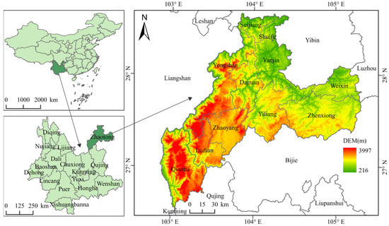
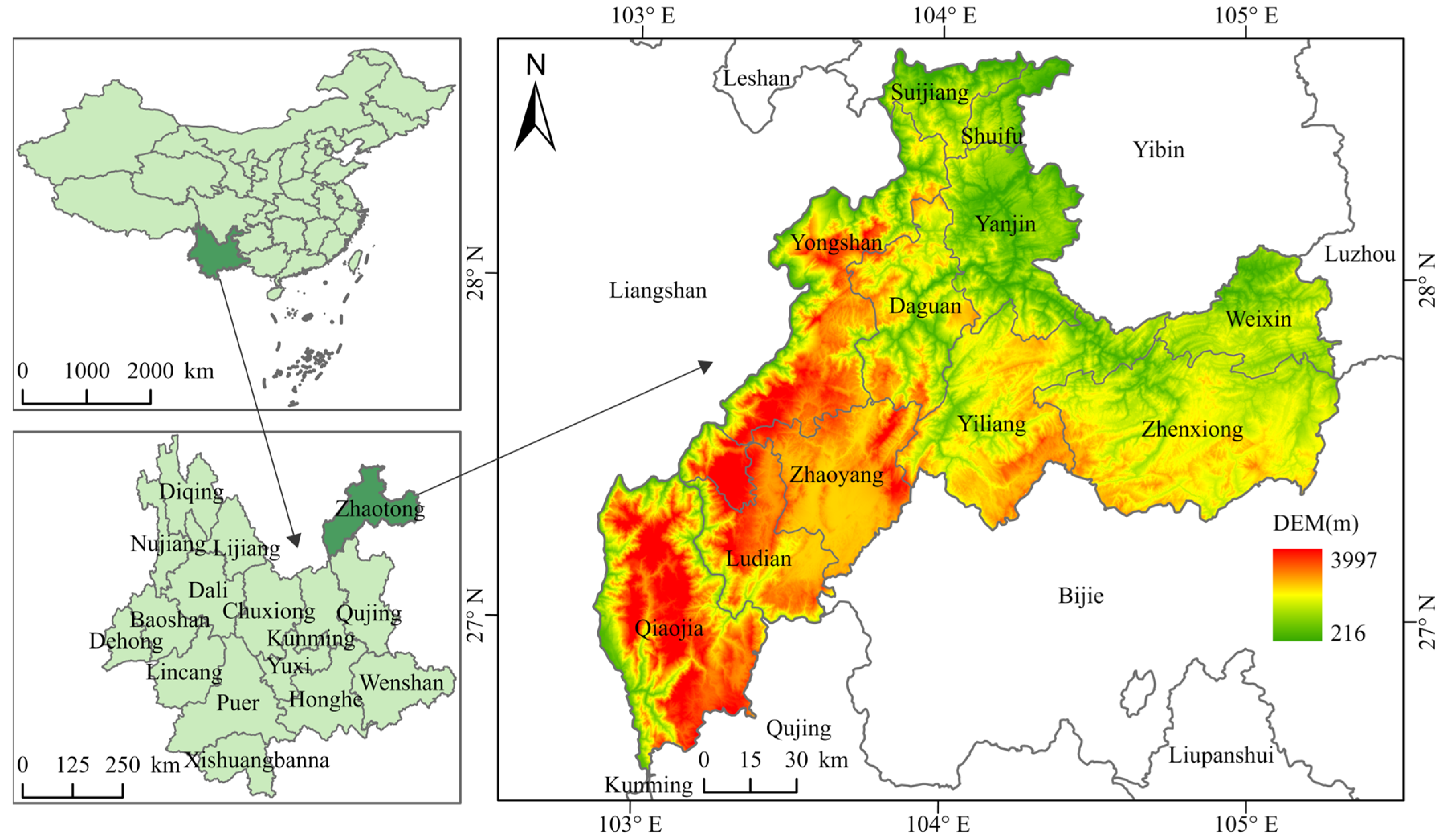
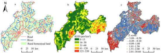
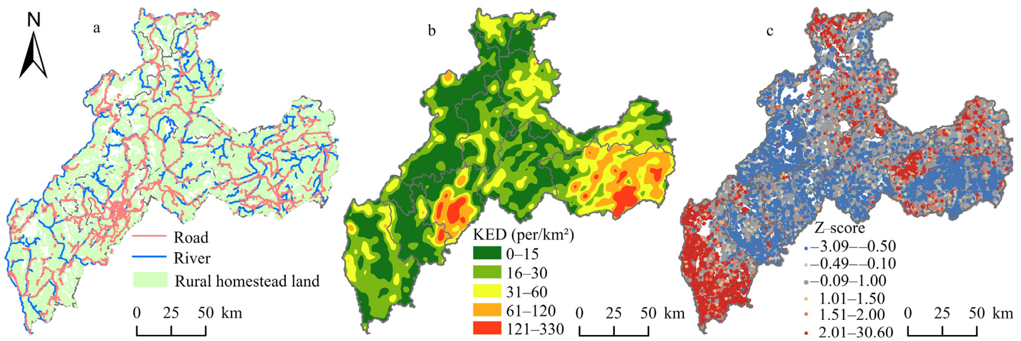
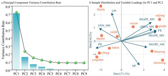
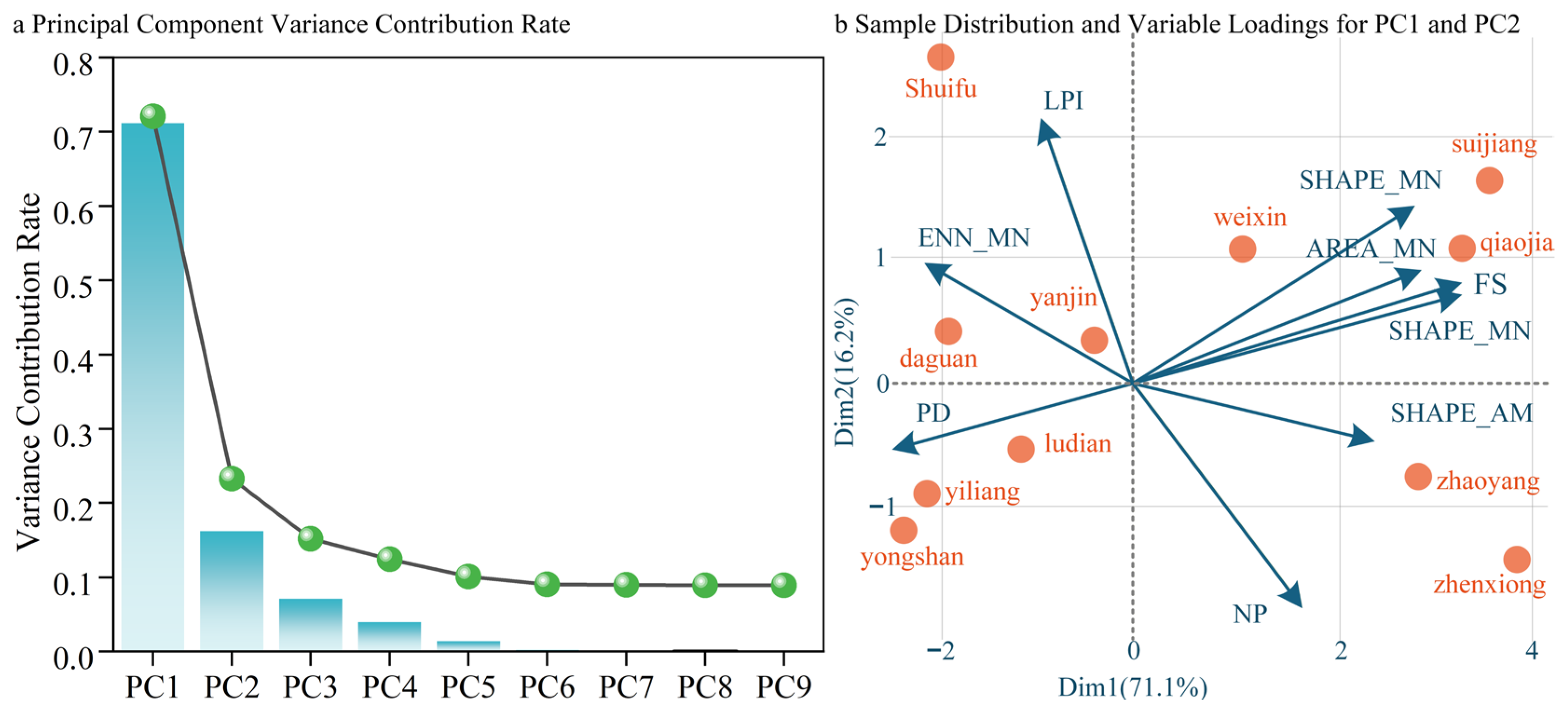
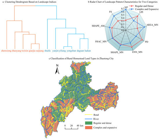
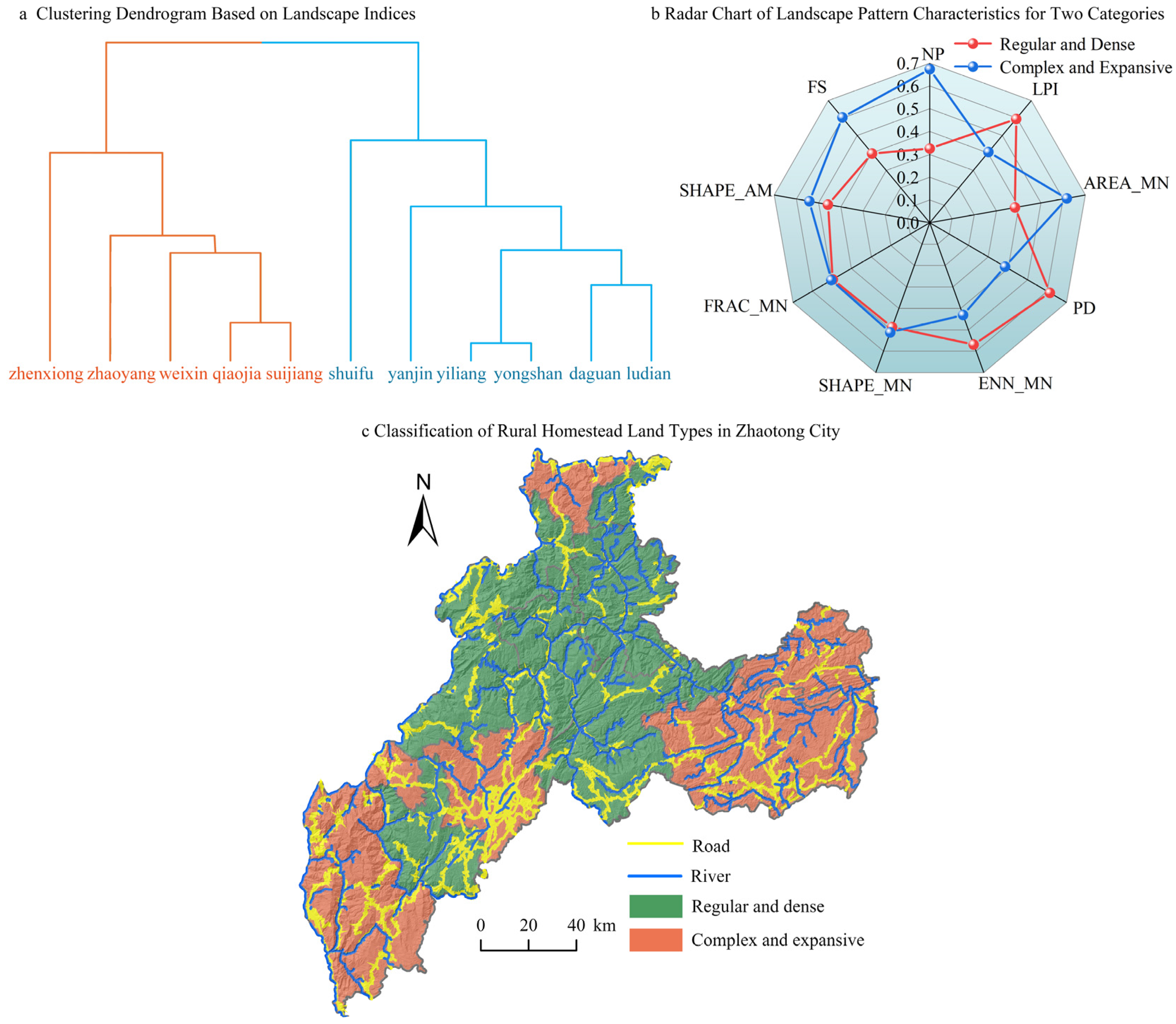
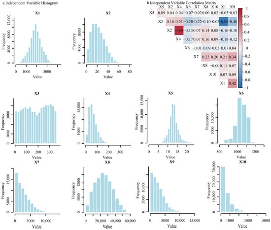
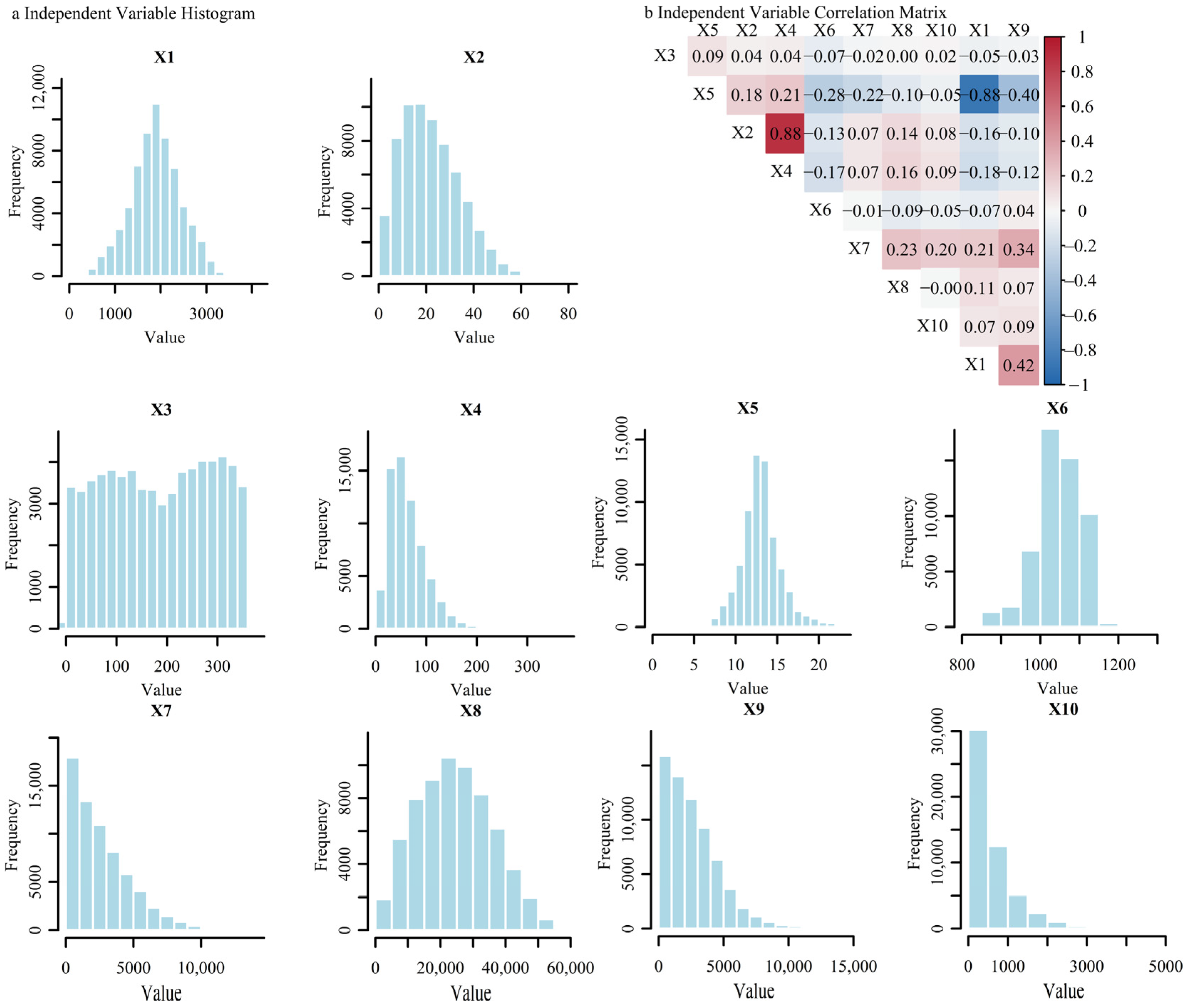
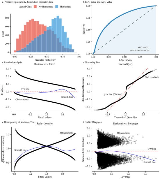
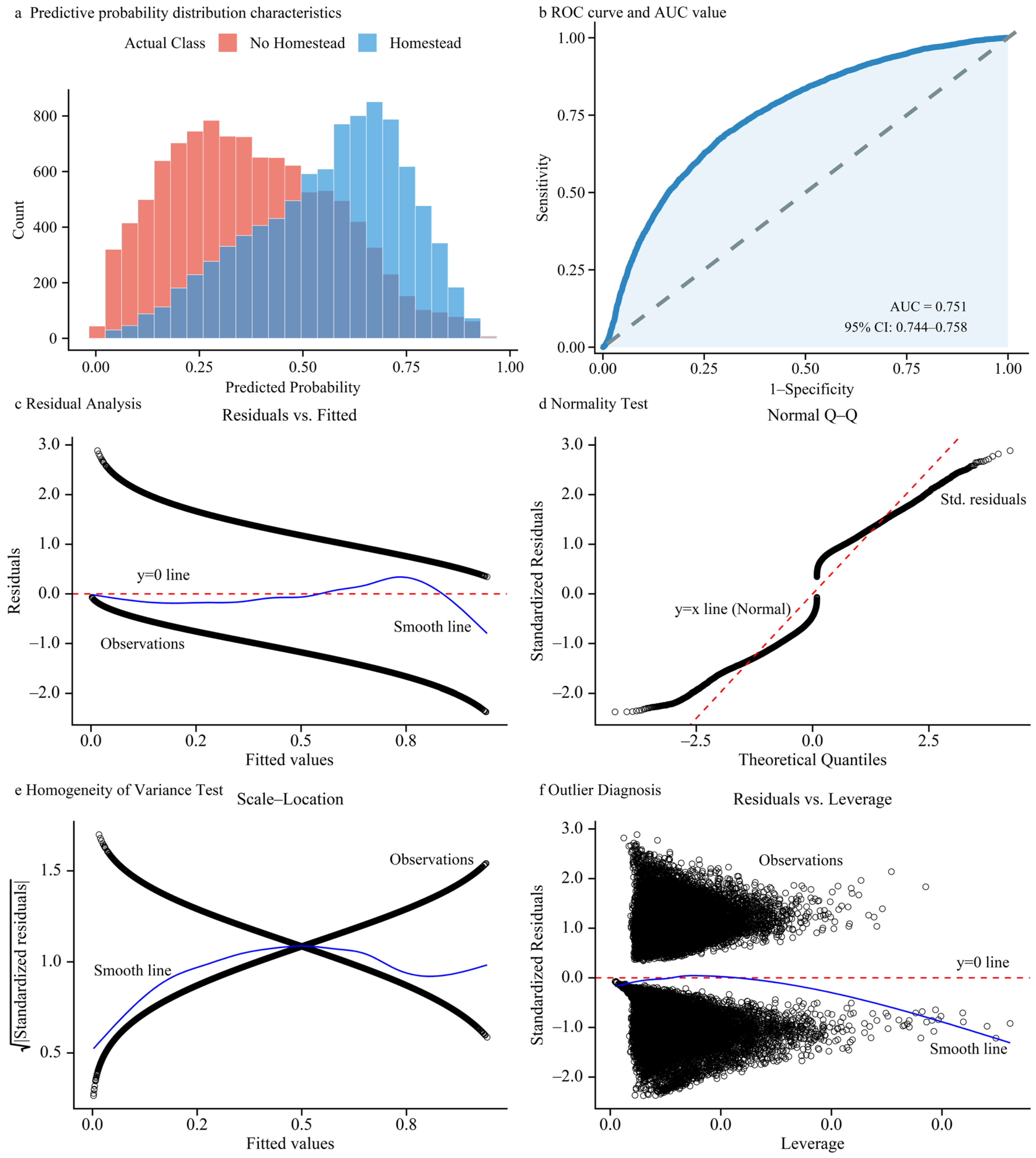
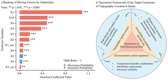
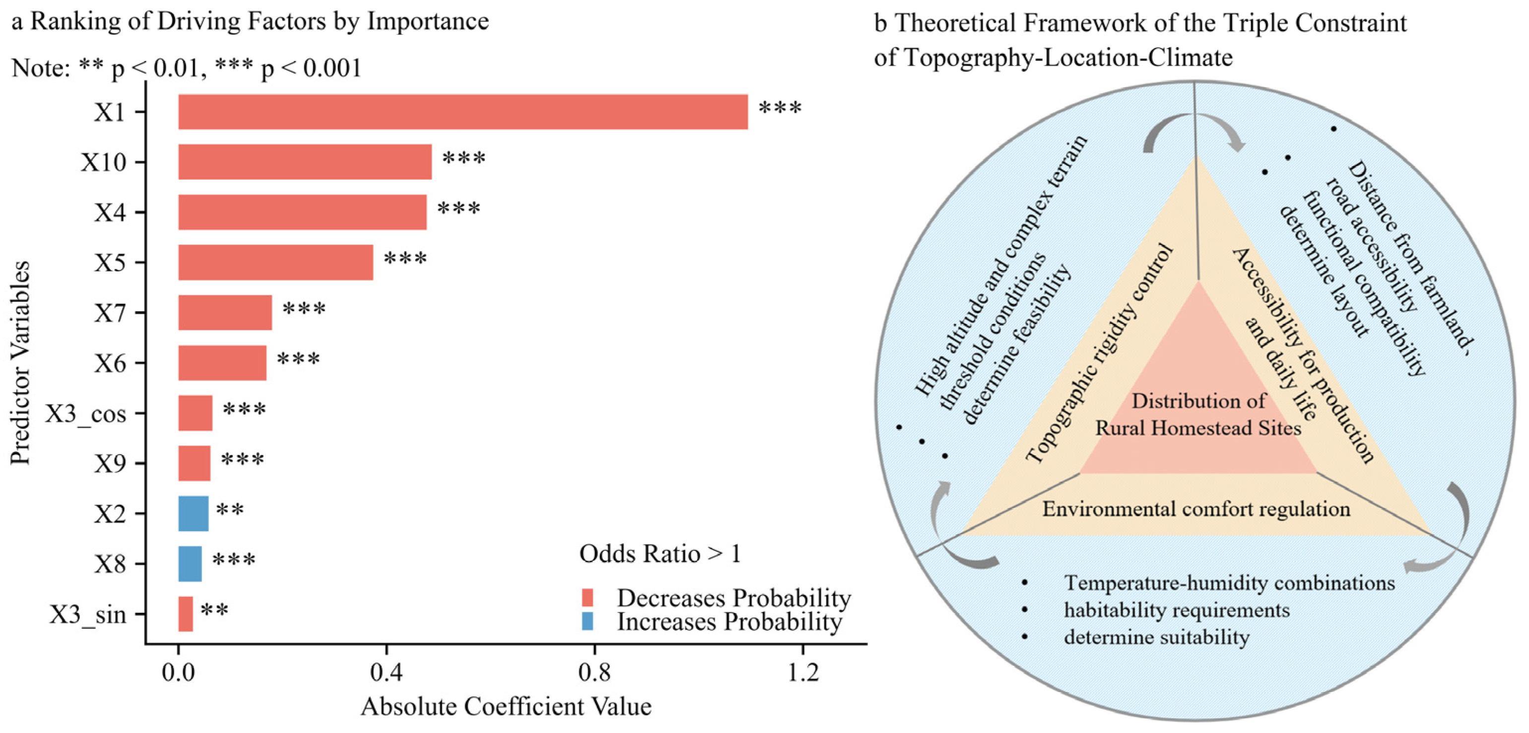
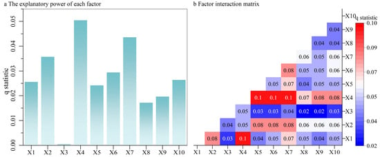
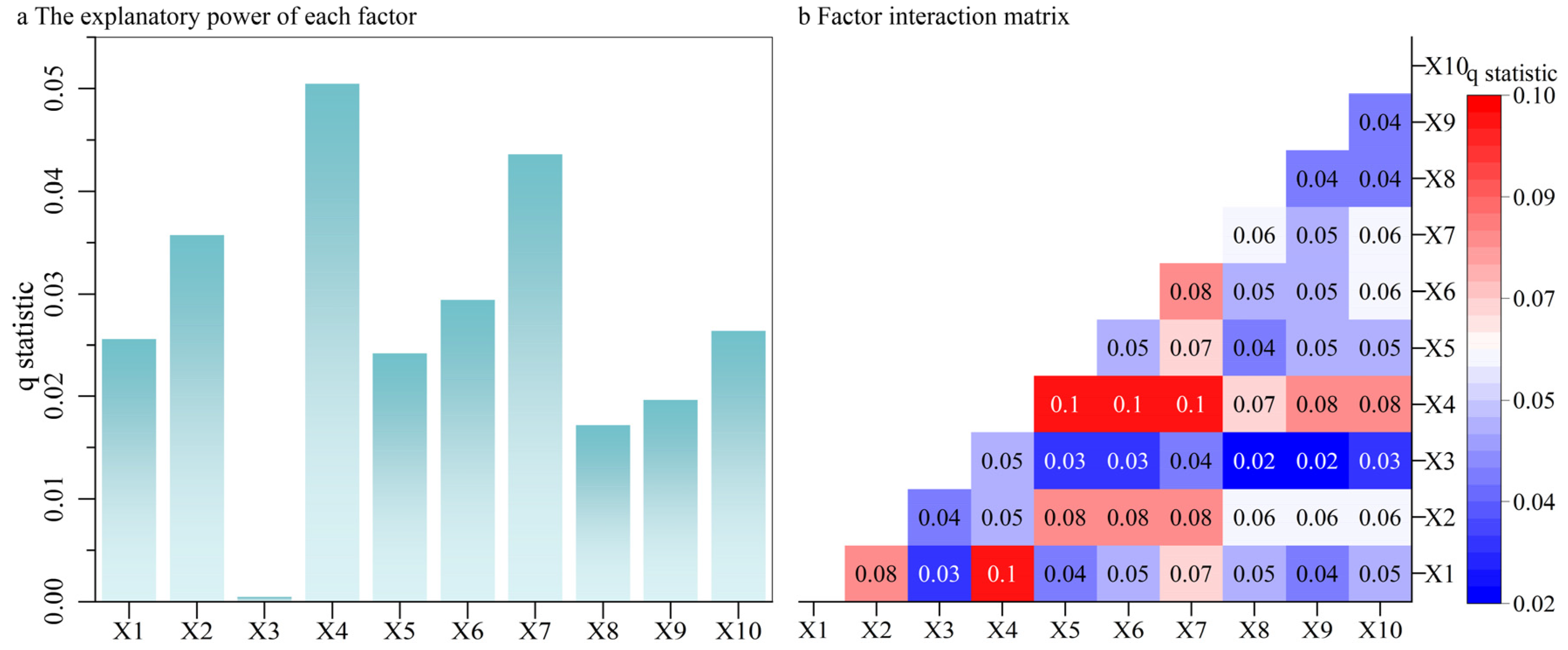
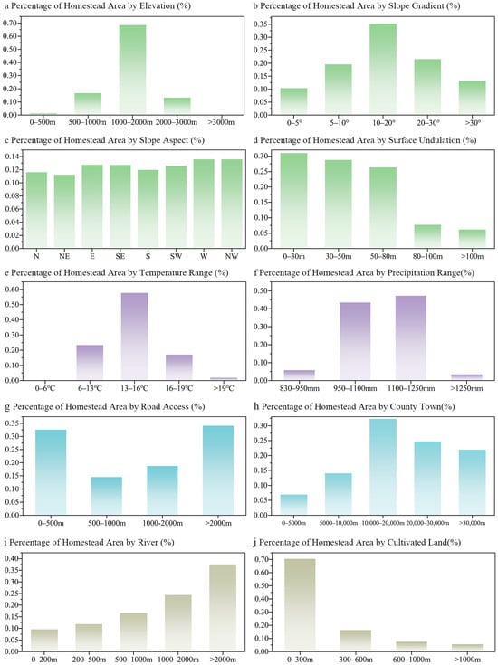
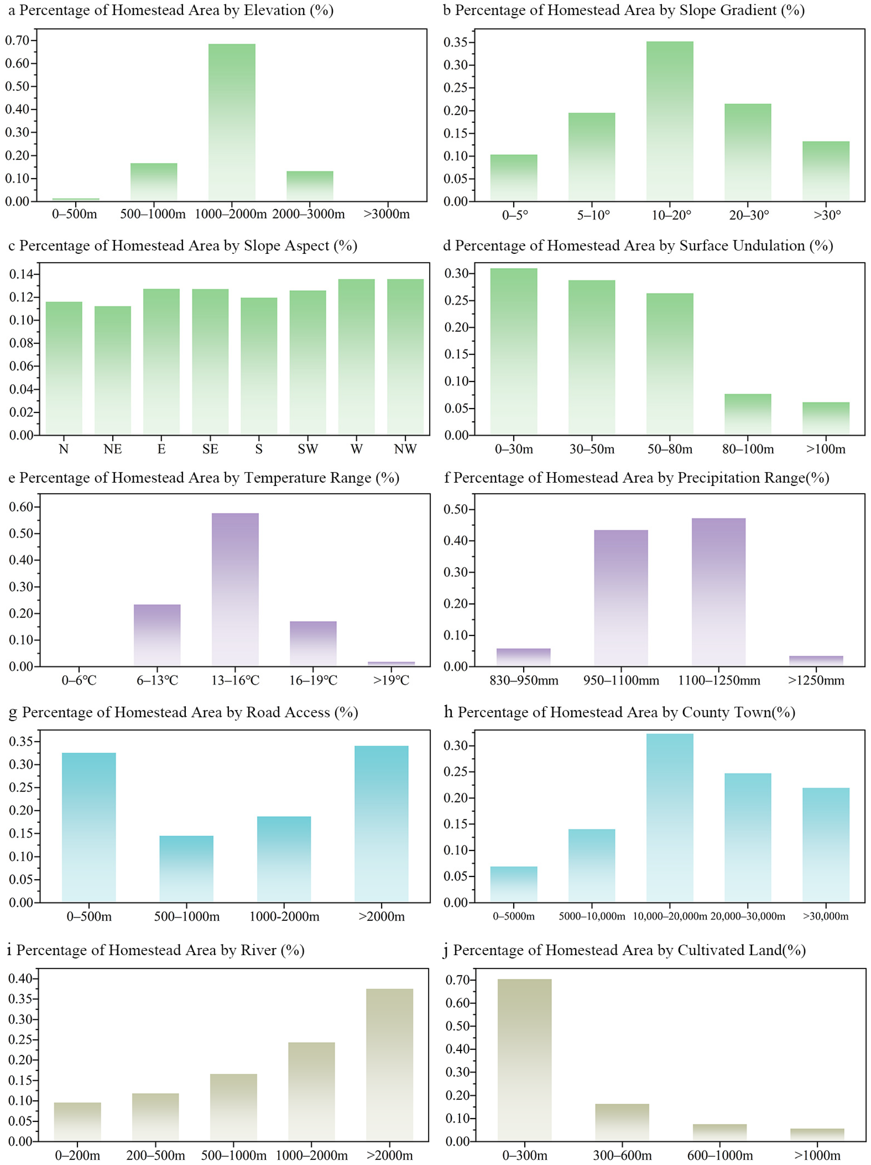
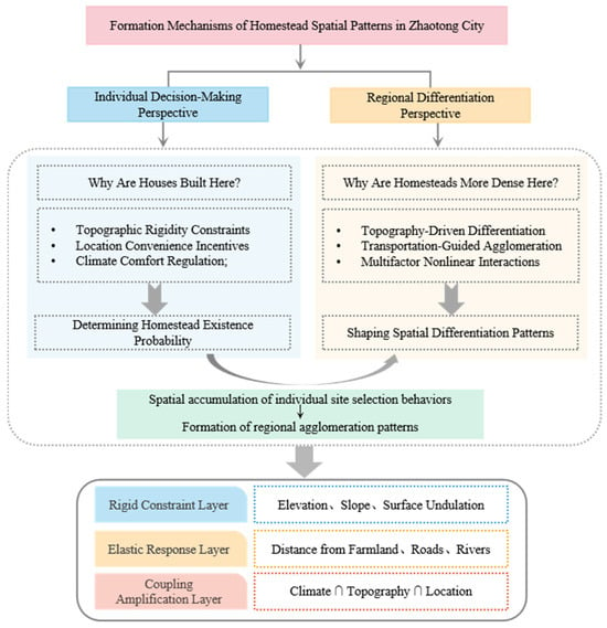
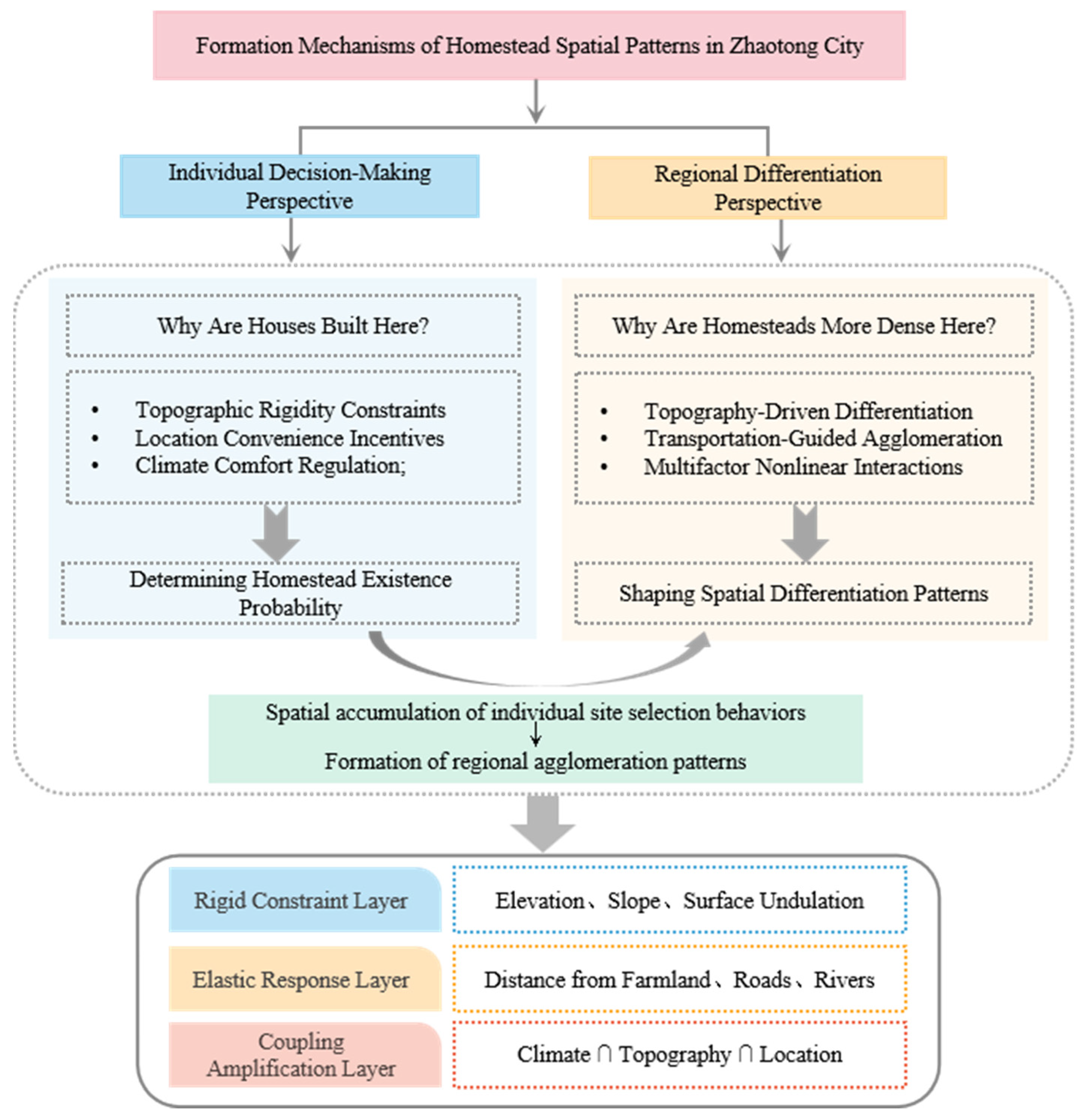

Disclaimer/Publisher’s Note: The statements, opinions and data contained in all publications are solely those of the individual author(s) and contributor(s) and not of MDPI and/or the editor(s). MDPI and/or the editor(s) disclaim responsibility for any injury to people or property resulting from any ideas, methods, instructions or products referred to in the content. |
© 2026 by the authors. Licensee MDPI, Basel, Switzerland. This article is an open access article distributed under the terms and conditions of the Creative Commons Attribution (CC BY) license.