Review

Urban- and Block-Scale Road Network Quality from the Perspective of Walking Needs: Research Progress and Future Directions


School of Architecture & Fine Art, Dalian University of Technology, Dalian 116024, China
*
Author to whom correspondence should be addressed.
Land 2026, 15(9), 1730; https://doi.org/10.3390/land15091730
Submission received: 25 July 2026 / Revised: 10 September 2026 / Accepted: 14 September 2026 / Published: 17 September 2026

Abstract

Road transport is indispensable to urban functioning. As people-centered development and community-oriented planning have gained prominence, pedestrian environments and road network quality have received increasing attention. Existing reviews, however, generally examine either city-scale networks or street-level environments in isolation, leaving a gap in cross-scale synthesis centered on walking needs. Using Web of Science (WOS) as the data source, this review screened 31,650 records and retained 508 publications; CiteSpace 6.4 was used to map the knowledge structure and major research themes. Drawing on the hierarchy-of-needs framework, walking needs are classified into basic needs for feasibility and safety and higher-order needs for convenience, comfort, and experience, with differences interpreted in relation to walking characteristics. City-scale research is reviewed in terms of road network layout, density, hierarchy, and utility, whereas block-scale research is examined through pedestrian routes and intersections, street frontages, and street furniture. The literature indicates that macro-scale attributes such as connectivity, density, and hierarchical structure affect the feasibility and safety of walking at the city scale. At the block scale, attention has expanded from continuity and safety to the convenience of daily travel, environmental comfort, and heterogeneity in perception. Walking, however, is an individual behavior jointly supported by macro-scale road networks and micro-scale street environments. Current research provides limited integration between these scales, often treats each travel mode or road-user group in isolation, and relies heavily on static data that cannot adequately explain temporal changes in environmental conditions or provide timely feedback on network modifications. Future research should therefore develop cross-scale, multimodal, and dynamic analytical frameworks supported by diverse data sources.

1. Introduction

Urban road networks are the spatial configurations of roads provided in response to transport demand and can be broadly divided into networks within and outside urban blocks [1,2]. Walking is the most fundamental mode of travel. Research on urban- and block-scale road network quality from the perspective of walking needs emerged alongside the expansion of motorization, and its priorities and planning approaches have changed with economic development and shifts in social thought. Since the beginning of the twenty-first century, people-centered development has gained greater prominence, drawing increasing scholarly attention to the evaluation and improvement of road network quality for walking. Multi-source data, including mobile-phone signaling, street-view imagery, and open-source maps, have provided more detailed and robust empirical support for this work [3]. Existing reviews of urban road network quality generally address either citywide or localized demands and discuss theories, methods, or data separately; a systematic cross-scale synthesis centered on walking needs remains lacking.
This review examines research on urban- and block-scale road networks from the perspective of walking needs. Web of Science (WOS) was used as the data source. The search combined the topic terms “city,” “block,” “road,” “road network,” “transportation,” “walking,” “pedestrian,” “walkability,” “sidewalk,” and “travel environment.” Journal articles and conference papers published or indexed online up to December 2025 were included in the statistical analysis; studies published or first available online in 2026 were considered only in the supplementary discussion. The search returned 31,650 records. After deduplication, title and abstract screening, and full-text review, 508 publications were retained (Table 1). CiteSpace 6.4 was then used for bibliometric analysis. As shown in Figure 1, the literature clusters around travel by specific population groups, travel behavior, street networks and route choice, the built environment, and urban design. The subsequent review is organized according to walking characteristics and the distinct concerns at the city and block scales.

2. Walking Characteristics and Needs

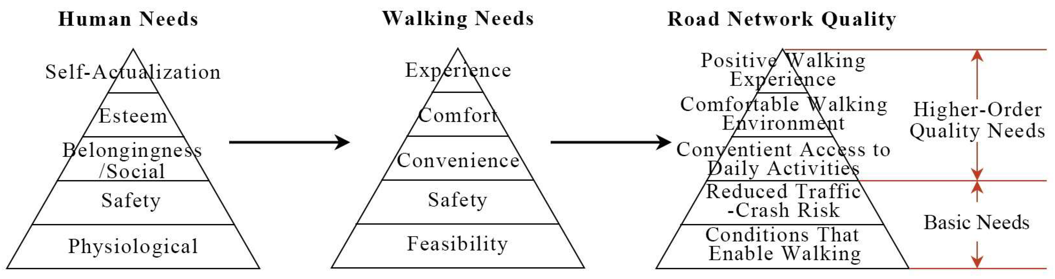
Maslow proposed a general theory of human motivation organized around a hierarchy of needs [4]. Drawing on this perspective, Alfonzo developed a hierarchy of walking needs comprising feasibility, accessibility, safety, comfort, and pleasurability [5]. This review adapts Alfonzo’s framework into five categories for examining road network quality: feasibility, safety, convenience, comfort, and experience. In this adaptation, feasibility is examined in relation to trip characteristics and the spatial conditions that enable walking, including route continuity and barriers to movement. Safety encompasses both traffic-crash risk and perceived safety and is placed before convenience to reflect the review’s treatment of feasibility and safety as basic walking requirements. Destination accessibility is addressed under convenience, with attention to access to daily activities. Comfort concerns environmental conditions that reduce physical discomfort during walking. The term experience replaces pleasurability to organize discussion of the perceptual qualities of streets and opportunities for everyday social interaction. These interpretations link walking needs to the road network qualities examined in this review (Figure 2). The five categories are grouped into basic needs for feasibility and safety and higher-order quality needs for convenience, comfort, and experience. This grouping serves to organize the review without assuming a fixed sequence of need fulfilment. The content and relative importance of these needs may vary with trip characteristics and road-environment conditions.

2.1. Travel Characteristics and Basic Needs

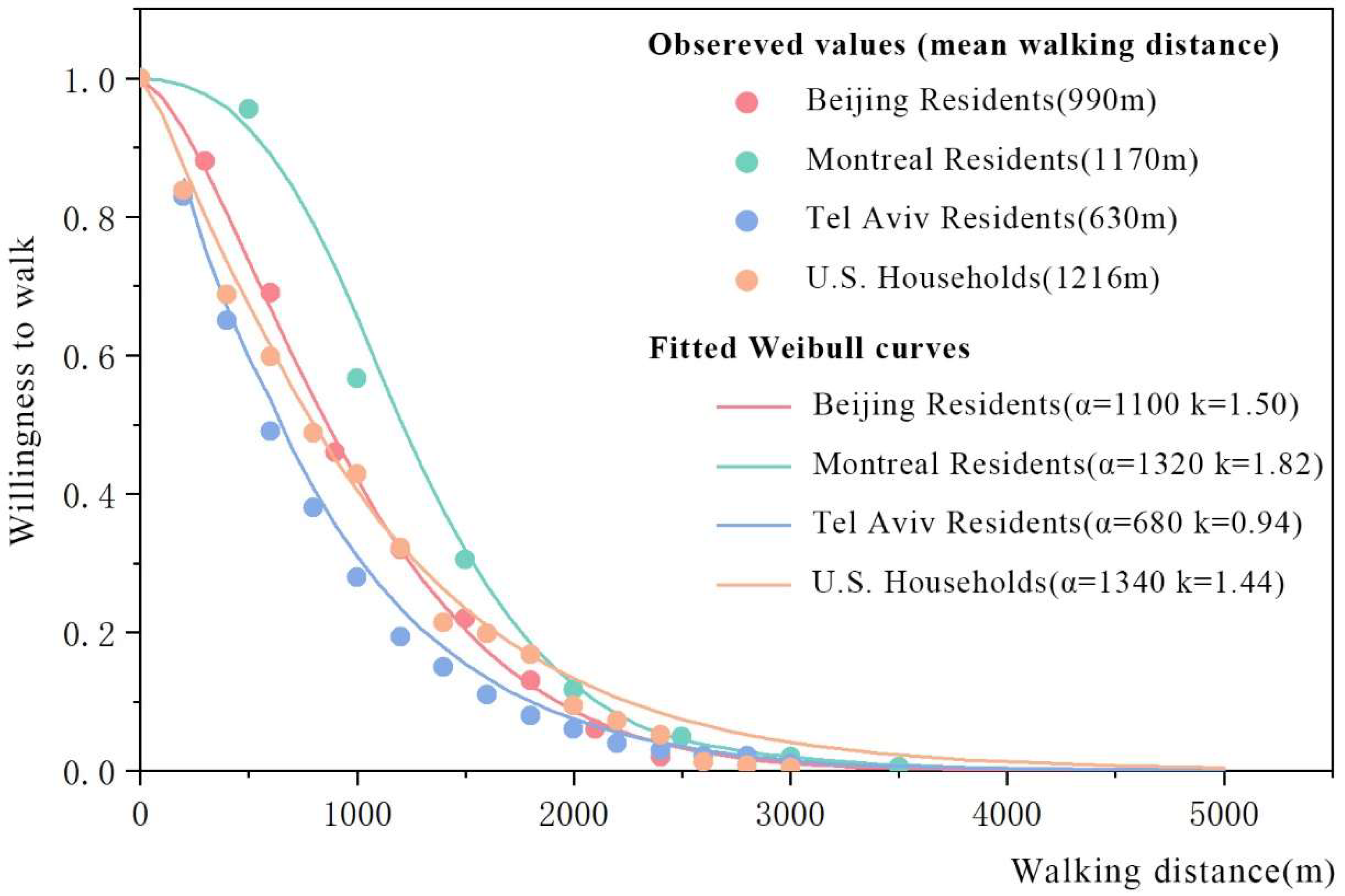
Walking is generally a short-distance component of daily travel, including trips to nearby facilities and the access, egress, and transfer stages of public-transport journeys. Distance is a primary determinant of willingness to walk [6,7]. Walking-trip data for Beijing [8], Montréal [9], Tel Aviv [10], and U.S. households [11], although these datasets differ in data-collection methods, collection years, and trip purposes, they exhibit similar distance–decay patterns in willingness to walk. Relevant walking-trip data were extracted from these studies through graph digitization. The survival function of the Weibull distribution was then used to characterize how willingness to walk changes with distance:
P s = e ( s / α ) k , s 0
where P denotes willingness to walk and ranges from 0 to 1; s is walking distance; α is the scale parameter; and k is the shape parameter. Both α and k are greater than zero and determine the steepness and shape of the fitted decay curve, respectively.
The parameters α and k of each distance–decay model were estimated using nonlinear least squares by minimizing the sum of squared errors (SSE) between predicted and observed values. The function provided a good fit to the relationship between walking distance and willingness to walk, with all R2 values exceeding 0.98 and mean absolute errors ranging from 1.3% to 2.3%.
The fitted results indicate both similarities and differences in distance decay across the four study areas. Willingness to walk declined markedly over the 500–1500 m range in all four cases. The mean walking distances for Beijing, Montréal, and U.S. households were 990 m, 1170 m, and 1216 m, respectively. With shape parameters k > 1, their decay curves generally exhibited a gradual–steep–gradual pattern (Figure 3). In contrast, Tel Aviv had a mean walking distance of only 630 m and a shape parameter k < 1, indicating a stronger concentration of walking trips at short distances. This empirical formulation helps illustrate how reductions in walking distance affect willingness to walk.
Trip purpose affects both walking distance and willingness to walk. Although existing studies classify trip purposes differently, they generally distinguish work, school, leisure, and shopping trips. Comparisons between mandatory and discretionary trips have produced partly inconsistent results [11]. Willingness to walk for work trips declines most slowly with distance, indicating substantially greater tolerance of longer distances than for other purposes [12]; school trips generally rank second. Findings for leisure and shopping vary because these purposes are defined differently across studies [13,14]. Particular attention has also been paid to access trips to public transport and to the daily travel of children and older adults. An analysis of actual walking distances to metro stations, population coverage, and distance decay in Madrid found that metro-access demand declined by 6.9% for every additional 100 m from a station, with the 90th percentile at approximately 770 m. Distance decay was weaker for men, younger travelers, and public-transport users, whereas children and older adults were most sensitive to distance [15]. Beyond the basic association between distance and willingness, GPS-based route-choice analyses in Boston and San Francisco showed that a greater number of turns increases perceived distance and affects route choice [16]. Arterials, walls, and other separating structures can disrupt direct connections between pedestrian origins and destinations, producing a “barrier effect” or “community severance.” Such separation lengthens walking routes, increases the number of turns, and reduces willingness to walk [17].
Under actual urban conditions, arterial spacing is a principal constraint on walking feasibility, as it directly determines block size and influences walking distance and route choice. Where arterials are widely spaced, road network density is lower, pedestrian routes between origins and destinations are limited, crossing opportunities are fewer, and unnecessary detours are longer, reducing willingness to walk [17]. When the relationship between walking distance and willingness to walk is also considered, smaller arterial spacing should be adopted to improve walking feasibility at the city scale [18]. Appropriate arterial spacing should also be complemented by the spatial planning and optimization of pedestrian facilities to meet basic walking needs [19]. Beyond feasibility, walking must satisfy the basic need for safety. This includes both objectively reducing crash risk and creating an environment that supports perceived safety [20]. Pedestrian–vehicle conflicts are a primary cause of crashes and are concentrated at intersections. Shorter crossing distances, shorter waiting times, and appropriately designed facilities can reduce direct conflicts and improve pedestrian safety [21,22]. Street lighting, the visibility of street frontages, pedestrian activity and “eyes on the street,” facility maintenance, and environmental cleanliness also influence perceived safety [23,24]. Meeting basic safety needs therefore requires both engineering measures that reduce pedestrian–vehicle conflicts and a street environment that strengthens pedestrians’ sense of safety [18].

2.2. Road Environment and Higher-Order Quality Needs
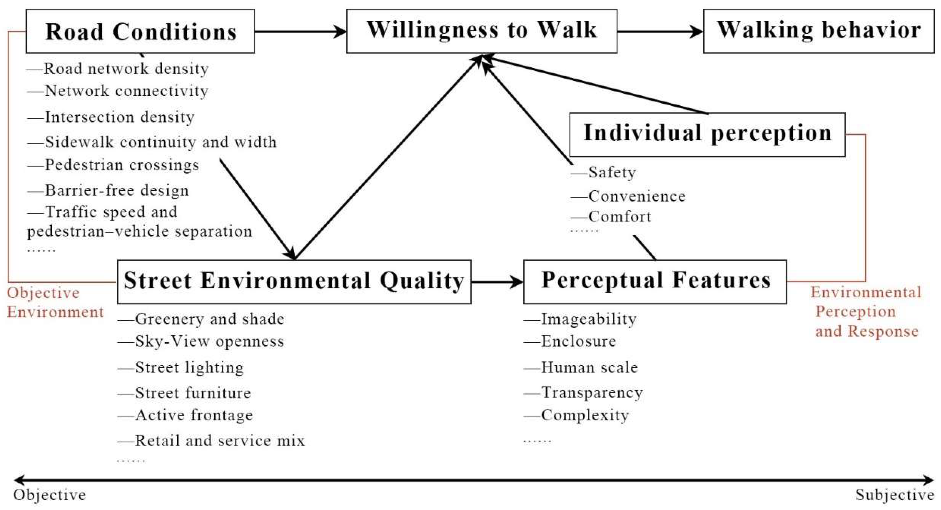
Feasibility and safety constitute the basic constraints on walking, whereas the road environment affects willingness to walk primarily through higher-order quality needs. Drawing on the hierarchy-of-needs framework, convenience in daily activities, environmental comfort, and a pleasurable walking experience are treated as three higher-order levels, reflecting a progression from feasible and safe walking toward more qualitative requirements (Figure 4).
Objective attributes such as road network density, network connectivity, intersection density, sidewalk width, and roadside greenery are basic indicators of walking feasibility [25,26]. In addition, surrounding land-use activities, sky-view openness, street furniture, and nighttime lighting influence not only the convenience of walking but also pedestrians’ judgments of spatial openness, continuity, diversity, and legibility, thereby shaping perceptions of safety, convenience, and comfort [27]. Ewing and Handy summarized these experiential dimensions as imageability, enclosure, human scale, transparency, and complexity, incorporating spatial perception into the assessment of the physical street environment [28]. A supportive road environment must accommodate continuous movement, short stays, and everyday social interaction. Continuous pedestrian space and accessible facilities provide basic mobility conditions; street trees and other greenery modify the pedestrian thermal environment [29]; lighting affects nighttime visibility; benches and other street furniture support short stays and rest [30,31]; and the surrounding mix of uses determines the range of destinations and activities available to pedestrians [6]. Studies of the built environment and walking consistently associate transport-related walking with proximity to non-residential destinations and land-use mix. Areas with shorter origin-destination distances and more mixed functions generally generate more walking, while commercial, food-service, and everyday-service uses along streets provide a wider range of accessible destinations and diversify walking purposes [25].
Improving the road environment can increase willingness to walk, but objective environmental conditions and walking behavior do not change in lockstep. De Vos et al. distinguish objective walkability from perceived walkability [26]. Their review found that perceived walkability is more strongly associated with walking frequency and duration than objective environmental indicators alone [26]. Even under comparable environmental conditions, pedestrians of different ages, trip purposes, and preferences evaluate feasibility, safety, and comfort differently; this heterogeneity is also evident in large-scale observed walking behavior [32]. Environmental attributes indicate the spatial support provided for continuous movement, stopping, and social interaction, while a diverse mix of street-facing uses offers more destinations and choices. These physical characteristics shape the opportunities and constraints for walking. Whether an environment is considered suitable for walking ultimately reflects a combined judgment of road conditions and individual perception. Walking needs translate into actual behavior only when physical improvements are experienced as greater safety, convenience, and comfort [18].
Figure 4. Pathways linking road-environment characteristics to willingness to walk and walking behavior (adapted from [28]).
Land 15 01730 g004

3. Research Progress and Key Issues at the City and Block Scales

Improving road network quality can satisfy walking needs to varying degrees, but the principal concerns and intervention tools differ between the city and block scales. City-scale studies focus on network structure and system-wide utility, seeking to maintain or improve urban circulation through changes in layout, density, connectivity, and related attributes. Block-scale studies focus more directly on street space, actual conditions of use, and walking experience, addressing specific issues such as crossing facilities, street frontages, and environmental amenities.

3.1. Key Issues and Utility Evaluation at the City Scale

City-scale road planning must accommodate interdistrict travel, local access and distribution, and active travel. Rather than directly altering local attributes such as lighting, greenery, and street furniture, planning at this scale establishes the basic spatial conditions for walking through network layout, density, hierarchy, and utility [33,34].
(1)
Road Network Layout
The mass adoption of private automobiles and motorized transport beginning in the 1920s gradually transformed previously walking-dominated urban travel, and road planning placed greater emphasis on the spatial separation of motor vehicles from other modes [35]. To reduce crashes arising from conflicts between through motor traffic and residential activities, European and North American planning moved away from traditional high-density grid networks and adopted the principles of road hierarchy and the neighborhood unit [36,37]. Arterial spacing was increased, internal local-street density was reduced, and cul-de-sacs were introduced (Table 2), confining through traffic to the perimeter of residential units. This layout sought to reduce direct interference from motor vehicles within neighborhoods [38]. However, large blocks, dendritic network structures, hierarchical connections, and cul-de-sacs reduced network permeability [39], often forcing pedestrians and cyclists to detour through a limited number of access points.
After the 1990s, active travel and public transport again received broad attention. From the pedestrian pocket concept [41] to transit-oriented development (TOD) [42], network connectivity became a central criterion. Highly connected grid networks offer more travel directions and route choices and reduce the additional distance imposed by network organization between origins and destinations [43]. Large neighborhood-unit blocks, gated communities, continuous walls, and arterials lacking cross-connections can create substantial barriers to walking. Network form alone does not determine connectivity or walking quality; block size, street function, and crossing conditions are also influential [6]. Research on city-scale network layout from the perspective of walking needs has therefore shifted from judging the formal rationality of network shape to evaluating whether network structure provides short, continuous, and selectable pedestrian routes [44].
(2)
Road Network Density
Road network density is a principal indicator of road-resource allocation and a key measure of urban network layout [45]. It is generally expressed as the total centerline length of roads at all hierarchical levels divided by the area of developed land, in km/km2. The Global Public Space Toolkit issued by UN-Habitat in 2015 proposed five criteria for sustainable urban neighborhoods, including a minimum road network density of 18 km/km2 [36]. China’s 2023 Guiding Opinions on Comprehensively Advancing the Construction of Urban Integrated Transportation Systems, building on the densities recommended in the Code for Planning and Design of Urban Road Traffic, specified that the average road network density in built-up urban areas should exceed 8 km/km2. It also called for optimization of the network hierarchy and improvements in connectivity and accessibility [37]. Densifying road networks, strengthening local-street systems, and improving active-travel networks have consequently become common directions in urban road network planning and renewal [46].
From the perspective of walking, road network density primarily reflects block size and route organization. Low-density networks generally correspond to large blocks, fewer intersections and crossing locations, and limited route choice between pedestrian origins and destinations, which increases the likelihood of detours. Small blocks and dense networks can promote walking by shortening street spacing, reducing barriers, and increasing route options. Existing studies commonly use static indicators such as intersections [47], nodes [48], and facility points to characterize urban network structure [49]. In a travel survey of 14,431 residents in the San Francisco Bay Area, Reilly and Landis reported a positive association between intersection density and road network density; a 0.25 increase in intersection density was associated with a 45% increase in the probability of choosing walking [50]. When road network capacity and level of service are considered jointly, and the road-area ratio and distribution of travel demand are held constant, the reliability of network service increases with density [51]. Theoretically, an optimal density exists at which capacity and level of service are jointly maximized; this value depends on the travel mode. For walking, the corresponding network spacing has been estimated at 70–100 m [52].
Block size is an important intermediate variable between macro-scale road network density and actual walking behavior. Smaller blocks increase opportunities for intersections and changes in direction and reduce network circuity relative to straight-line distance. Ewing and Cervero’s analysis of the relationship between the built environment and travel showed direct associations of walking with block size, intersection density, destination density, and land-use mix [6]. Evaluations centered on walking needs should therefore extend beyond aggregate road network density to include block size, intersection density, and other indicators of the network that pedestrians can actually use [33,44].
(3)
Road Network Hierarchy
Road network hierarchy coordinates the functional relationships among urban streets. Existing classifications largely retain systems oriented toward motor-vehicle movement [53]. They distinguish road classes by function, mobility, and accessibility, forming a quasi-pyramidal hierarchy from arterials to local streets: higher-order roads carry long-distance movement, whereas lower-order streets provide distribution and short-distance access [54]. In practice, this management-oriented and long-distance-focused hierarchy has produced problems such as unbalanced class structures, low network density, and poorly functioning nodes. Wide arterials also create pronounced barriers to pedestrian connections between opposite sides of the road.
To support more equitable mobility among travel modes, the role of motor vehicles has been relatively reduced, and road classification and functional organization have expanded beyond a motor-vehicle orientation [34]. Building on conventional classifications based on network role and vehicular capacity, countries such as the Netherlands and New Zealand increasingly relate street function to operating speed, traffic safety, and street activity, emphasizing place functions alongside movement functions (Table 3).
(4)
Road Network Utility
Investment and benefit constitute the basic mechanism for improving road network quality and the two principal dimensions of road network utility. Investment can be estimated for alternative planning schemes by accounting for facility construction, demolition, reconstruction, and related costs; established methods are available. Utility evaluation primarily considers reductions in negative transport externalities [64], such as travel-time losses, crashes, noise, and pollution, together with increases in positive benefits, including shifts toward more desirable modes, greater land-use vitality, and property-value appreciation [64,65].
The value of time is a primary component of road network utility [66,67]. According to the Handbook on the External Costs of Transport issued by the European Union in 2019, congestion-related time losses accounted for 60.4% of external transport costs, while delays in urban passenger and freight transport represented 1.46% of GDP [68]. The 2019 Urban Mobility Report estimated that congestion in the 494 U.S. urban areas covered by the report resulted in 8.8 billion hours of travel delay and 3.3 billion U.S. gallons of additional fuel consumption in 2017 [69]. According to the 2020 Q1 Traffic Analysis Report for Major Chinese Cities published by Amap [70], the estimated monthly time cost of traffic congestion in Beijing was equivalent to 10.14% of the average monthly wage in the first quarter of 2019. This proportion declined to 6.92% in the first quarter of 2020 amid the COVID-19 pandemic, although the estimated monthly time cost still amounted to CNY 841 [70]. The value attributable to travel-time savings can be proportionally greater for walking and cycling [71,72,73]. Urban transport policy commonly addresses congestion through infrastructure expansion and travel demand management [74]. Where the spatial expansion of transport infrastructure is constrained, resources must be balanced between arterials and local streets and between main and auxiliary lanes, while existing road space is more carefully allocated to reduce travel-time losses.
Improving road safety and reducing traffic crashes have long been central objectives of road planning, construction, and management and are also major dimensions of road network utility [75]. According to WHO estimates for 2021, road traffic fatality rates were 17.4 per 100,000 population in China, 14.2 in the United States, 2.4 in the United Kingdom, 2.7 in Japan, and 2.1 in Sweden [76]. Road development has not kept pace with traffic growth, and crashes result from interactions among road users, vehicles, roads, and the surrounding environment [77,78]. Accountability and management should therefore not focus solely on individual behavior; the physical and institutional urban environment also requires improvement [79]. Urban crash rates are associated with multiple design attributes, including road class, cross-sectional form, network density, and intersection type. At the city scale, the geometric and topological characteristics of road networks are related to crashes. Increasing closeness centrality and reducing clustering and average geodesic distance have been associated with lower crash counts. Measures such as appropriately increasing network density, reducing road width, creating an active-travel-friendly environment, improving accessibility, and reducing detours may also improve safety, although their effects depend on road width, operating speed, intersection form, and land-use context [80].
Urban road networks and land use interact, and land use constitutes the “source” of travel demand [81]. The layout, planning, and construction of road networks and transport facilities influence urban land area, development intensity, and spatial structure [82]; consistency between land-use planning and road network planning is therefore an important criterion for sustainable urban transport. In Alonso’s bid-rent theory, higher-value uses displace lower-value uses, and land prices decline from the urban center toward the periphery [83]. In modern cities, travel time has increasingly replaced physical distance as a principal determinant of urban land value [84]. Lower travel-time costs around TOD stations can produce localized land-price “peaks” [85], indicating that high-capacity public transport shapes the overall urban network and guides spatial expansion. Using rental transaction data within Beijing’s Sixth Ring Road, Wang et al. applied spatial regression models and found that rail-based job accessibility was positively associated with housing rents. Associations with station density and distance differed between shared and whole-unit rentals [86]. A related Shanghai study applied a semi-log hedonic price model to test spatial variation in rail-transit premiums and found a wider area of influence in suburban than in central districts, with stronger effects around interchange stations [87].
City-scale road network utility is commonly evaluated in terms of motor-vehicle efficiency, using capacity, travel time, congestion, and level of service to judge whether network resources are appropriately allocated. From the perspective of walking needs, assessment has expanded to route directness, the range of accessible destinations, public-transport connections, the modal share of active travel, and traffic safety. Research on the 15 min city further links time budgets to the spatial distribution of urban functions, asking whether residents can reach daily services on foot rather than considering only the operating speed of roads. City-scale utility for walking can be assessed through three questions: (1) Does the network reduce unnecessary detours caused by oversized blocks, insufficient connections, and spatial barriers? (2) Can the pedestrian network provide access to public transport and daily destinations? (3) Can the network maintain system-wide transport operations while reducing the effects of motor traffic on pedestrian continuity and safety? These criteria directly indicate how the urban road network responds to walking needs.

3.2. Key Issues and Improvement Approaches at the Block Scale

A block is a localized spatial–social unit within a city, enclosed by the street network and defined by pedestrian accessibility and everyday social interaction, with relatively identifiable boundaries and a sense of place. Blocks directly accommodate residents’ daily activities. Research on road networks at the block scale has shifted from addressing the basic requirements for a walkable environment toward a more comprehensive focus on walking quality and user experience [28]. The report Walkability Evaluation of Chinese Cities: Walkability in Urban Vitality Centers [88], prepared by the Natural Resources Defense Council and the School of Architecture at Tsinghua University, treats crossing facilities, sidewalk width, and encroachment as basic indicators of whether pedestrians have a usable route. It also assesses environmental-quality attributes such as greenery, building height-to-width ratios, and street furniture, reflecting a shift from mere passability toward service quality [88]. Studies further show that, once safety and comfort are provided, street-facing commerce, building frontages, and social activity influence walking behavior and environmental experience [89].
Comparable indicator hierarchies appear in planning standards and street-design guidance. China’s Standard for Planning of Urban Pedestrian and Bicycle Transportation Systems (GB/T 51439-2021) divides the pedestrian transport system into the transport network, movement space, crossing facilities, waiting and resting spaces, and the traffic environment [90]. Sidewalk width, continuous passage, crossings, and traffic separation primarily address feasibility and safety; greenery, paving, street furniture, and lighting further shape environmental quality and experience. Pedestrian-design guidance in the United States, the United Kingdom, and New Zealand follows a similar hierarchy (Table 4).
(1)
Pedestrian Routes and Intersections
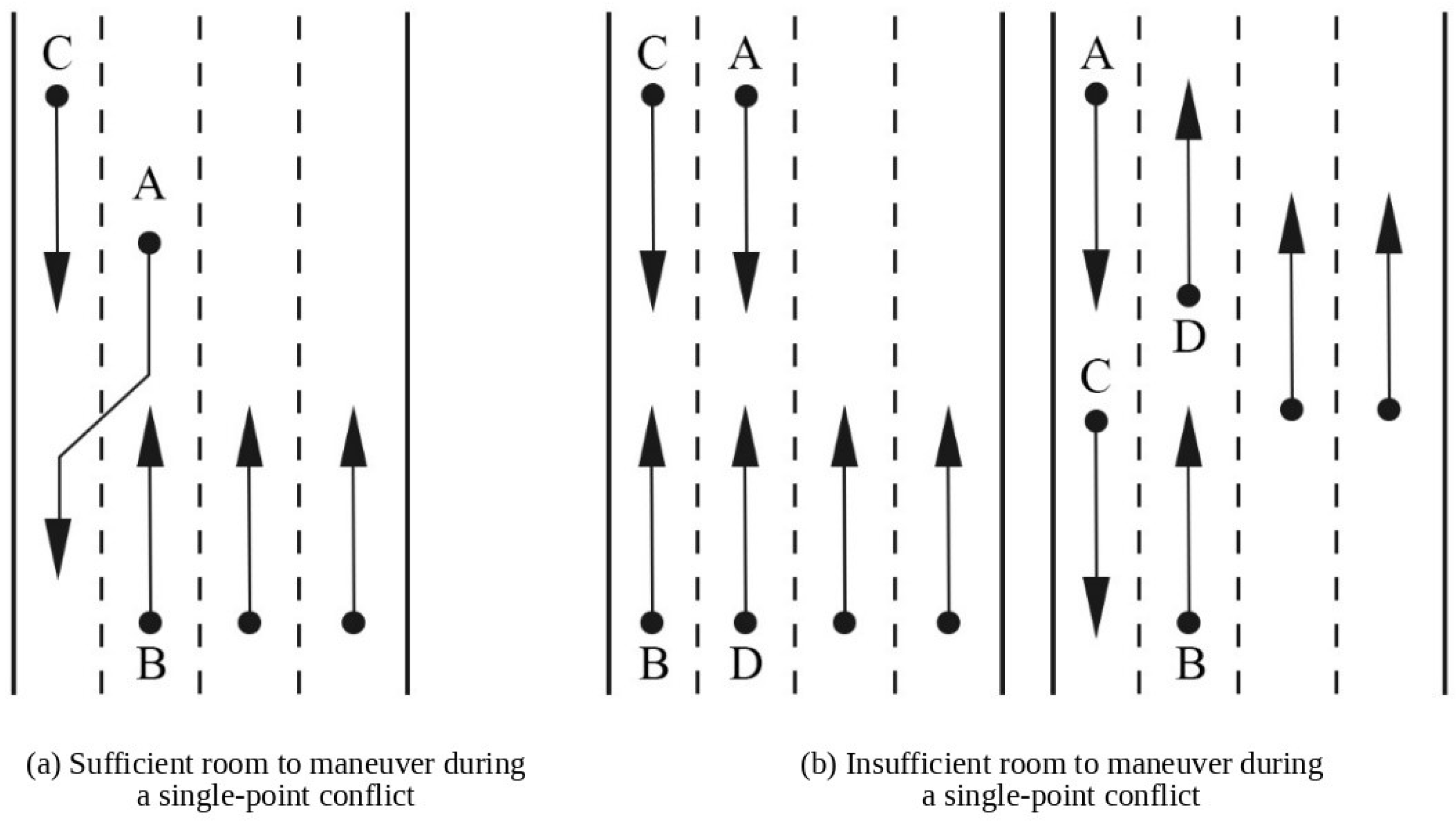
Motor-vehicle lanes have long occupied most urban road space, making the allocation of street space among travel modes a primary concern in block-scale improvement. Sidewalks are the most basic pedestrian facility and should be continuous, even, and wide enough to accommodate passage, encounters, and short stays [95]. Adequate width is required not only for pedestrian movement but also for a satisfactory walking experience [95]. Based on pedestrian movement characteristics, studies have argued that clear sidewalk width should account for pedestrian volume, opposing flows, the width occupied by functional facilities, and the effects of bus stops (Figure 5), and should not be less than 1.5 m [96]. Another study examined the relationships among pedestrian flow, walking speed, and per-person occupation space, considering differences by age and sex [97]. The study classified pedestrians into three age groups: children and adolescents (≤17 years), adults (18–59 years), and older adults (≥60 years). It developed age-specific criteria for sidewalk level of service and proposed sidewalk-width recommendations for different use scenarios, pedestrian groups, and flow demands [97]. Under the influence of Complete Streets, shared-street concepts, and road-space renewal, sidewalk provision has shifted from simply enabling movement to ensuring effective width and continuity. Tree pits, lighting columns, waste bins, transit facilities, and parked vehicles all occupy usable walking space. After basic feasibility and safety are secured, sidewalk design should also respond to pedestrian-flow characteristics, bus stops, and the stopping and social interaction generated by street-front uses. Discontinuities, pavement damage, and commercial encroachment should be addressed to form a continuous, accessible, and dedicated pedestrian route [98].
Intersections concentrate pedestrian–vehicle conflicts and are also the points at which continuous pedestrian facilities are most likely to be interrupted. Intersection size and crossing facilities, including channelization, signals, and crosswalks, directly affect conflict and pedestrian safety. WHO’s pedestrian safety manual identifies vehicle speed, inadequate pedestrian visibility, and the absence of dedicated walking and crossing facilities as factors relevant to pedestrian injury risk [99]. Existing interventions aim mainly to shorten pedestrians’ exposure to hazardous areas and reduce pedestrian–vehicle conflicts. Measures include reducing vehicle turning radii, providing grade-separated crossings, installing pedestrian refuge islands and two-stage crossing systems, and optimizing crosswalk locations [100]. Because willingness to walk declines with distance and footbridges and underpasses increase perceived walking distance, crossing safety and convenience cannot be treated separately. Grade-separated facilities reduce at-grade conflicts with motor vehicles, but they also increase detour distance and require costly accessible vertical circulation, which may reduce convenience and discourage use [101]. Intersection redesign should therefore account for pedestrian-flow characteristics, crossing distance, pedestrian–vehicle conflict, crash risk, reconstruction cost, and local spatial constraints.
(2)
Street Frontages and Street Furniture
Daily walking is concentrated around residences, commercial and everyday-service facilities, and public-transport stops. Block streets connect these origins and destinations, and mixed street-front uses can provide a wider range of travel choices [25]. Beyond increasing land-use mix, willingness to walk is influenced by the locations of residential entrances, the layout and density of street-facing facilities, the continuity and visibility of street space, and the use of ground-floor space. Facility planning should therefore be coordinated with frontage improvement, particularly around major transport nodes and areas of concentrated pedestrian activity, while the adverse effects of long, continuously closed frontages on walking experience should be reduced [89].
Street greenery and street furniture do not alter network layout, but they directly affect route choice and walking experience [28]. Street greenery includes street trees, hedges, flower beds, and pocket parks. These elements provide shade, modify the pedestrian environment, offer visual amenity and a sense of nature, reduce stress and fatigue, and may partly attenuate noise and vehicle emissions [29]. Their effects, however, depend on climate, species, canopy size, and spatial placement. Greenery design should therefore balance shade, ventilation, sightlines, and effective sidewalk width [102]. Street furniture primarily supports stopping, resting, and wayfinding. Streetlights, benches, waste bins, planted strips, and signage can enhance walking experience while forming part of the broader street environment [89]. Seating can reduce fatigue among older pedestrians and long-distance walkers and may encourage trips by groups with specific needs. Effective nighttime lighting on sidewalks and around intersections and public-transport stops can support nighttime activity and reduce crash risk associated with restricted visibility.

4. Future Research Directions for Urban- and Block-Scale Road Networks in Relation to Walking Needs

Existing city- and block-scale research has concentrated, respectively, on overall network layout and local street environments. Although this literature is extensive, stable links between macro-scale network indicators and the street environments encountered by pedestrians remain underdeveloped. First, city-scale road indicators and block-scale concerns differ in their analytical units and evaluation methods, and a clear explanatory chain from macro-scale network conditions to actual walking routes is still lacking; results are therefore sensitive to the choice of spatial unit. Second, road space accommodates multiple trip purposes and modes, so optimizing one mode may change the generalized cost of others. Third, most studies remain static evaluations based on data from a particular period and cannot adequately represent dynamic changes in travel after network or environmental improvements. Future research should therefore focus on dynamic relationships across multiple scales and complex travel needs.

4.1. From Scale Separation to Multidimensional Integration

Walking has an inherently cross-scale character. City-scale attributes such as network layout and density provide basic structural support and influence detours between origins and destinations and the baseline willingness to walk. At the block scale, facility layout, intersections, and greenery shape actual safety and experience. To ensure consistency and comparability, studies commonly use predefined administrative districts, blocks, or traffic analysis zones as basic analytical units, construct evaluation systems at a selected scale, and examine spatial relationships between walking and the road environment. Because spatial units are delineated differently across study areas, the same environmental factor may exhibit different effects at different analytical scales.
The modifiable areal unit problem has been demonstrated in research on the built environment and walking. Using space-time activity data from Halifax, Canada, Clark and Scott measured built-environment characteristics at 14 different scales and showed that changes in scale can alter statistical results [103]. Subsequent studies have used multiple methods to examine how measurement scale affects observed relationships [104]. A fixed scale does not necessarily represent the environment actually encountered by pedestrians [105]. For urban- and block-scale road network research centered on pedestrian needs, the primary task is therefore not simply to add more analytical scales, but to identify the spatial range over which environmental attributes operate and to select units appropriate to the research question.
Administrative districts and conventional blocks have been shown in many studies to be poorly suited to multidimensional analysis of pedestrian environments. Traffic analysis zones bounded by urban arterials were once considered a relatively reasonable multiscale unit linking existing roads with walking needs, but this delineation remains derivative of the motor-vehicle network [98]. Defining analytical units directly by arterial centerlines overlooks the complex internal organization and coordination of pedestrian networks. Units delineated from multidimensional attributes such as facility distribution and street-environment characteristics can better represent local walking conditions and travel quality [106].
Multidimensional cross-scale analysis should be grounded in the actual travel behavior of road users rather than in simple changes to unit size or comparisons among differently sized units. Pedestrian decisions integrate multiple environmental dimensions. Evaluation systems should therefore represent spatial connections and nested relationships, allowing the effects of network improvements to be traced to specific links and nodes while also showing how local environmental interventions affect system-wide travel. Such an approach can more fully represent the consequences of changes to city- and block-scale road networks for walking.

4.2. From Single-Mode Optimization to Coordinated Allocation

Pedestrian networks do not exist independently. They share finite street cross-sections with bicycle lanes, bus lanes, motor-vehicle lanes, and parking, so reallocating space to any one mode affects the others. De Gruyter et al. examined 57 sites in 36 activity centers in Melbourne and found a mismatch between the allocation and use of street space: walking demand was high, but the space available to pedestrians was clearly insufficient [107]. A related 2025 study measured the actual space occupied by different modes and did not treat motor-vehicle volume or the quantity of a particular facility as the sole performance criterion [108]. Functional, use-based allocation of street space must account for the effects of improving one mode on others. Research specifically addressing pedestrian networks remains limited, while more work has examined the joint changes produced by bicycle-network or motor-vehicle-lane interventions. Modes are not only competitors for space; they can also be complementary. Bicycles can address the “last mile” of public-transport trips, extend the service area of transit, and improve accessibility, although outcomes depend on the bicycle network, the level of public-transport service, and the built environment [109]. Short walking trips are also closely linked to transit access. Integrated development around residential areas and transit stops, together with selective opening of gated communities to groups with specific access needs, can reduce pedestrian detours and expand the accessibility and service area of public-transport stops.
A walking-friendly environment must first satisfy basic feasibility and safety needs, treating sidewalk width, accessibility, and safety facilities as minimum constraints. Higher-order quality and experiential needs should then be incorporated into a multidimensional evaluation framework alongside the spatial requirements of cycling, public transport, and motorized travel. Beyond traffic volume, greater attention should be paid to actual space occupancy and temporal changes in accessibility [110]. De Gruyter et al. have begun to develop such approaches, providing a basis for allocating limited street space under competing travel demands [108]. Emerging technologies now support multi-scenario simulation and multi-objective analysis and can represent the multidimensional transport effects of street reconstruction. The research focus should therefore move from the isolated effect of a single facility on walking toward the allocation of limited street space under multiple travel demands, the resulting changes in mode choice, and the cross-modal or synergistic effects of interventions.

4.3. From Static Measurement to Dynamic Simulation

Most studies of road network quality use road density, connectivity, land use, points of interest (POIs), street-view imagery, and survey data from one or several time slices to measure overall network layout and street environments statically [111]. They then examine spatial associations between these indicators and walking frequency, distance, willingness, and other behaviors [112]. Such methods are suitable for comparisons across large areas, long periods, or different regions, but they cannot represent changes in pedestrian and vehicle flows at different times within the same area. High-resolution mobility data from GPS and mobile-phone signaling have partly addressed this limitation [113]. Open datasets for Shenzhen, Boston, San Francisco, and other cities have enabled walking dynamics and the mechanisms and relative influence of environmental factors to be examined from multiple perspectives [16,112]. Dynamic data nevertheless remain limited over longer periods, and many dynamic studies are still only extensions of static cross-sectional analysis. Although the literature has established positive associations of walking with street connectivity, destination accessibility, and public-transport layout, age and sex differences in these relationships remain insufficiently examined.
Future work should extend static measurement toward real-time observation of changes in travel demand and road conditions. Citywide network states, changes in the block-scale walking environment, and multidimensional individual-level data on travel time, routes, and stops should be integrated to represent spatiotemporal variation at the city, block, and individual scales and to support dynamic simulation. Technological development has reduced many technical barriers. The widespread use of smartphones and wearable devices, together with evolving rules for data sharing and disclosure, has lowered some obstacles to data access and changed the scope of possible analysis [113]. Data accuracy and privacy, however, remain major constraints on large-scale application.

5. Conclusions

This review classifies walking needs into five levels—feasibility, safety, convenience, comfort, and experience—and synthesizes the principal concerns in research on pedestrian road network quality at the city and block scales. At the city scale, studies examine how network layout, density, hierarchy, and utility, together with the overall allocation and operation of road resources, satisfy or constrain basic needs for feasibility and safety. At the block scale, research focuses on detailed elements such as pedestrian routes, intersections, street frontages, street furniture, and green space, assessing how existing conditions support continuous, safe, and comfortable walking and respond to needs for convenience, comfort, and individual experience. The two scales are closely related, but their integration remains constrained in practice. Three recurring problems are the modifiable areal unit problem created by the choice of analytical scale, cross-modal effects when one travel condition is improved, and the limited capacity of static data to provide feedback on changing conditions. These issues define the main directions for further research.

Supplementary Materials

The following supporting information can be downloaded at: https://www.mdpi.com/article/10.3390/land15091730/s1.

Author Contributions

Y.W., conceptualization and design of the manuscript, literature search and analysis, drafting of the manuscript; J.C., conceptualization and design of the manuscript, review and editing; J.X., literature collection and screening; H.T., literature collection and screening; M.W., literature collection and screening; M.D., literature collection and screening; Q.Y., review and editing of the manuscript; L.L., review and editing of the manuscript. All authors have read and agreed to the published version of the manuscript.

Funding

This research was funded by the National Natural Science Foundation of China, project “Planning Theory and Smart Methods for Road Network Quality Improvement from the Dual-Dynamic Perspective of City and Block”, grant number 52278048. The APC was funded by the National Natural Science Foundation of China.

Data Availability Statement

The raw data supporting the conclusions of this article will be made available by the authors on request.

Acknowledgments

The authors declare that no generative AI was used in the preparation of this manuscript.

Conflicts of Interest

The authors declare no conflicts of interest.

References

  1. Samaniego, H.; Moses, M.E. Cities as organisms: Allometric scaling of urban road networks. J. Transp. Land Use 2008, 1, 21–39. [Google Scholar] [CrossRef] [Scilit]
  2. Wegener, M. Overview of Land Use Transport Models. In Handbook of Transport Geography and Spatial Systems; Hensher, D.A., Button, K.J., Haynes, K.E., Stopher, P.R., Eds.; Pergamon/Elsevier Science: Kidlington, UK, 2004; Volume 5, pp. 127–146. [Google Scholar]
  3. He, X.; He, S.Y. Using mobile phone big data and street view images to explore the mismatch between walkability and walking behavior. Transp. Res. Part A Policy Pract. 2024, 180, 103946. [Google Scholar] [CrossRef] [Scilit]
  4. Maslow, A.H. A Theory of Human Motivation. Psychol. Rev. 1943, 50, 370–396. [Google Scholar] [CrossRef] [Scilit]
  5. Alfonzo, M.A. To walk or not to walk? The hierarchy of walking needs. Environ. Behav. 2005, 37, 808–836. [Google Scholar] [CrossRef] [Scilit]
  6. Ewing, R.; Cervero, R. Travel and the built environment: A meta-analysis. J. Am. Plan. Assoc. 2010, 76, 265–294. [Google Scholar] [CrossRef] [Scilit]
  7. Clifton, K.J.; Singleton, P.A.; Muhs, C.D.; Schneider, R.J. Development of destination choice models for pedestrian travel. Transp. Res. Part A Policy Pract. 2016, 94, 255–265. [Google Scholar] [CrossRef] [Scilit]
  8. Dandan, X.; Yang, B.; Shinan, S.; Jian, R. The walking distance decay law of amenity selection based on binary logistic model. J. Southeast Univ. (Engl. Ed.) 2020, 36, 88. [Google Scholar] [CrossRef]
  9. Larsen, J.; El-Geneidy, A.; Yasmin, F. Beyond the Quarter Mile: Re-Examining Travel Distances by Active Transportation. Can. J. Urban Res. Can. Plan. Policy 2010, 19, 70–88. [Google Scholar]
  10. Almagor, J.; Omer, I.; Omer, N.; Birenboim, A. How far will you go? From empirical findings to formalization of walking route distances. Comput. Environ. Urban Syst. 2024, 110, 102117. [Google Scholar] [CrossRef] [Scilit]
  11. Yang, Y.; Diez-Roux, A.V. Walking distance by trip purpose and population subgroups. Am. J. Prev. Med. 2012, 43, 11–19. [Google Scholar] [CrossRef] [Scilit] [PubMed]
  12. Macioszek, E.; Karami, A.; Farzin, I.; Abbasi, M.; Mamdoohi, A.R.; Piccioni, C. The effect of distance intervals on walking likelihood in different trip purposes. Sustainability 2022, 14, 3406. [Google Scholar] [CrossRef] [Scilit]
  13. Iacono, M.; Krizek, K.; El-Geneidy, A.M. Access to Destinations: How Close Is Close Enough? Estimating Accurate Distance Decay Functions for Multiple Modes and Different Purposes; Minnesota Department of Transportation, Research Services Section: St. Paul, MN, USA, 2008; p. 76.
  14. Kim, E.J.; Kim, J.; Kim, H. Neighborhood walkability and active transportation: A correlation study in leisure and shopping purposes. Int. J. Environ. Res. Public Health 2020, 17, 2178. [Google Scholar] [CrossRef] [Scilit] [PubMed]
  15. García-Palomares, J.C.; Gutiérrez, J.; Cardozo, O.D. Walking accessibility to public transport: An analysis based on microdata and GIS. Environ. Plan. B Plan. Des. 2013, 40, 1087–1102. [Google Scholar] [CrossRef] [Scilit]
  16. Basu, R.; Sevtsuk, A. How do street attributes affect willingness-to-walk? City-wide pedestrian route choice analysis using big data from Boston and San Francisco. Transp. Res. Part A Policy Pract. 2022, 163, 1–19. [Google Scholar] [CrossRef] [Scilit]
  17. Anciaes, P.; Jones, P. A comprehensive approach for the appraisal of the barrier effect of roads on pedestrians. Transp. Res. Part A Policy Pract. 2020, 134, 227–250. [Google Scholar] [CrossRef] [Scilit]
  18. Arellana, J.; Saltarín, M.; Larrañaga, A.M.; Alvarez, V.; Henao, C.A. Urban walkability considering pedestrians’ perceptions of the built environment: A 10-year review and a case study in a medium-sized city in Latin America. Transp. Rev. 2020, 40, 183–203. [Google Scholar] [CrossRef] [Scilit]
  19. Alawadi, K.; Hong Nguyen, N.; Alrubaei, E.; Scoppa, M. Streets, density, and the superblock: Neighborhood planning units and street connectivity in Abu Dhabi. J. Urban. Int. Res. Placemaking Urban Sustain. 2023, 16, 168–195. [Google Scholar] [CrossRef] [Scilit]
  20. Rothman, L.; Buliung, R.; Macarthur, C.; To, T.; Howard, A. Walking and child pedestrian injury: A systematic review of built environment correlates of safe walking. Inj. Prev. 2014, 20, 41–49. [Google Scholar] [CrossRef] [Scilit] [PubMed]
  21. Thakur, S.; Biswas, S. Assessment of Pedestrian-Vehicle Interaction on Urban Roads: A Critical Review. Arch. Transp. 2019, 51, 49–63. [Google Scholar] [CrossRef] [Scilit]
  22. Brosseau, M.; Zangenehpour, S.; Saunier, N.; Miranda-Moreno, L. The impact of waiting time and other factors on dangerous pedestrian crossings and violations at signalized intersections: A case study in Montreal. Transp. Res. Part F Traffic Psychol. Behav. 2013, 21, 159–172. [Google Scholar] [CrossRef] [Scilit]
  23. Trop, T.; Shoshany Tavory, S.; Portnov, B.A. Factors affecting pedestrians’ perceptions of safety, comfort, and pleasantness induced by public space lighting: A systematic literature review. Environ. Behav. 2023, 55, 3–46. [Google Scholar] [CrossRef] [Scilit]
  24. Fuller, M.; Moore, R. An Analysis of Jane Jacobs’s the Death and Life of Great American Cities; CRC Press: Boca Raton, FL, USA, 2017. [Google Scholar]
  25. Hahm, Y.; Yoon, H.; Jung, D.; Kwon, H. Do built environments affect pedestrians’ choices of walking routes in retail districts? A study with GPS experiments in Hongdae retail district in Seoul, South Korea. Habitat Int. 2017, 70, 50–60. [Google Scholar] [CrossRef] [Scilit]
  26. De Vos, J.; Lättman, K.; Van der Vlugt, A.-L.; Welsch, J.; Otsuka, N. Determinants and effects of perceived walkability: A literature review, conceptual model and research agenda. Transp. Rev. 2023, 43, 303–324. [Google Scholar] [CrossRef] [Scilit]
  27. Shields, R.; Gomes da Silva, E.J.; Lima e Lima, T.; Osorio, N. Walkability: A review of trends. J. Urban. Int. Res. Placemaking Urban Sustain. 2023, 16, 19–41. [Google Scholar] [CrossRef] [Scilit]
  28. Ewing, R.; Handy, S. Measuring the unmeasurable: Urban design qualities related to walkability. J. Urban Des. 2009, 14, 65–84. [Google Scholar] [CrossRef] [Scilit]
  29. De Quadros, B.M.; Mizgier, M.G.O. Urban green infrastructures to improve pedestrian thermal comfort: A systematic review. Urban For. Urban Green. 2023, 88, 128091. [Google Scholar] [CrossRef] [Scilit]
  30. Liu, C.; Liu, L.; Wang, X.; Han, B.; Chen, L. Evaluating Urban Nighttime Lighting and Perceived Safety in Residential Areas: An Empirical Investigation in Xi’an City. Build. Environ. 2026, 289, 114044. [Google Scholar] [CrossRef] [Scilit]
  31. Park, S.-H.; Kim, J.-H.; Choi, Y.-M.; Seo, H.-L. Design elements to improve pleasantness, vitality, safety, and complexity of the pedestrian environment: Evidence from a Korean neighbourhood walkability case study. Int. J. Urban Sci. 2013, 17, 142–160. [Google Scholar] [CrossRef] [Scilit]
  32. Shigematsu, R.; Sallis, J.F.; Conway, T.L.; Saelens, B.E.; Frank, L.D.; Cain, K.L.; Chapman, J.E.; King, A.C. Age differences in the relation of perceived neighborhood environment to walking. Med. Sci. Sports Exerc. 2009, 41, 314. [Google Scholar] [CrossRef] [Scilit] [PubMed]
  33. Liang, Z.; Lo, H.K.; Ng, K.F. On modeling and enhancing walkability: A review of transport planning and network design elements. Int. J. Sustain. Transp. 2024, 18, 827–842. [Google Scholar] [CrossRef] [Scilit]
  34. Tsigdinos, S.; Nikitas, A.; Bakogiannis, E. Contextualizing urban road network hierarchy and its role for sustainable transport futures: A systematic literature review using bibliometric analysis and content analysis tools. Front. Eng. Manag. 2025, 12, 361–393. [Google Scholar] [CrossRef] [Scilit]
  35. Norton, P.D. Fighting Traffic: The Dawn of the Motor Age in the American City; Mit Press: Cambridge, MA, USA, 2011. [Google Scholar]
  36. Habitat, U. Global Public Space Toolkit from Global Principles to Local Policies and Practice; United Nations Human Settlements Programme (UN-Habitat): Nairobi, Kenya, 2015. [Google Scholar]
  37. Ministry of Housing and Urban-Rural Development of the People’s Republic of China. Guiding Opinions on Comprehensively Advancing the Construction of Urban Integrated Transportation Systems; Ministry of Housing and Urban-Rural Development of the People’s Republic of China: Beijing, China, 2023.
  38. Kenworthy, J.R. The good, the bad and the ugly in urban transport: Comparing global cities for dependence on the automobile. In Methods for Sustainability Research; Edward Elgar Publishing: Cheltenham, UK, 2017; pp. 46–62. [Google Scholar]
  39. Mehaffy, M.W.; Porta, S.; Romice, O. The “neighborhood unit” on trial: A case study in the impacts of urban morphology. J. Urban. Int. Res. Placemaking Urban Sustain. 2015, 8, 199–217. [Google Scholar] [CrossRef] [Scilit]
  40. Southworth, M.; Owens, P.M. The evolving metropolis: Studies of community, neighborhood, and street form at the urban edge. J. Am. Plan. Assoc. 1993, 59, 271–287. [Google Scholar] [CrossRef] [Scilit]
  41. Calthorpe, P. Pedestrian Pockets: New Strategies for Suburban Growth. In The Pedestrian Pocket Book: A New Suburban Design Strategy; Kelbaugh, D., Ed.; Princeton Architectural Press: New York, NY, USA, 1989; pp. 7–20. [Google Scholar]
  42. Calthorpe, P. The Next American Metropolis: Ecology, Community, and the American Dream; Princeton Architectural Press: New York, NY, USA, 1993. [Google Scholar]
  43. Sun, G.; Webster, C.; Chiaradia, A. Ungating the city: A permeability perspective. Urban Stud. 2018, 55, 2586–2602. [Google Scholar] [CrossRef] [Scilit]
  44. Jabbari, M.; Fonseca, F.; Smith, G.; Conticelli, E.; Tondelli, S.; Ribeiro, P.; Ahmadi, Z.; Papageorgiou, G.; Ramos, R. The pedestrian network concept: A systematic literature review. J. Urban Mobil. 2023, 3, 100051. [Google Scholar] [CrossRef] [Scilit]
  45. Strano, E.; Nicosia, V.; Latora, V.; Porta, S.; Barthélemy, M. Elementary processes governing the evolution of road networks. Sci. Rep. 2012, 2, 296. [Google Scholar] [CrossRef] [Scilit] [PubMed]
  46. Tian, G. Smart growth and travel behavior—A synthesis with a focus on the United States. In Advances in Transport Policy and Planning; Elsevier: Amsterdam, The Netherlands, 2022; Volume 9, pp. 9–27. [Google Scholar]
  47. Zhao, Z.; Tang, L.; Yang, X.; Zhang, H.; Li, G.; Li, Q. Identifying critical urban intersections from a fine-grained spatio-temporal perspective. Travel Behav. Soc. 2024, 34, 100649. [Google Scholar] [CrossRef] [Scilit]
  48. Zhang, L.; Li, S.; Liu, Y.; Huang, H.; Van de Weghe, N. From grids to dendrites: Quantifying spatial heterogeneity in urban road networks. Comput. Environ. Urban Syst. 2025, 121, 102309. [Google Scholar] [CrossRef] [Scilit]
  49. Lay Maw, T.T.; Seo, D. Multi-Scale Space Syntax Analysis of Hybrid Urban Street Networks for Accessibility and Mobility Efficiency: The Case of Mandalay in Myanmar. ISPRS Int. J. Geo-Inf. 2026, 15, 62. [Google Scholar] [CrossRef] [Scilit]
  50. Reilly, M.K.; Landis, J. Influence of urban form and land use on mode choice: Evidence from the 1996 Bay area travel survey. In Proceedings of the 81st Annual Meeting of the Transportation Research Board, Washington, DC, USA, 13–17 January 2002. [Google Scholar]
  51. Keller, M. How the Road Network Determines Traffic Capacity; ETH Zurich: Zurich, Switzerland, 2019. [Google Scholar]
  52. Cai, J. Determining Efficient Resident Travel and Appropriate Road Network Spacing. Ph.D. Thesis, Tongji University, Shanghai, China, 2005. [Google Scholar]
  53. Tsigdinos, S.; Salamouras, G.; Chatziioannou, I.; Bakogiannis, E.; Nikitas, A. A worldwide review of formal national street classification plans enhanced via an analytical hierarchy process: Street classification as a tool for more sustainable cities. Cities 2024, 154, 105371. [Google Scholar] [CrossRef] [Scilit]
  54. American Association of State Highway and Transportation Officials (AASHTO). A Policy on Geometric Design of Highways and Streets, 7th ed.; American Association of State Highway and Transportation Officials: Washington, DC, USA, 2018. [Google Scholar]
  55. Ministry of Housing and Urban-Rural Development of the People’s Republic of China. Code for Design of Urban Road Engineering; China Architecture & Building Press: Beijing, China, 2016. [Google Scholar]
  56. Ministry of Housing and Urban-Rural Development of the People’s Republic of China. Project Code for Urban Road and Transportation Engineering; China Architecture & Building Press: Beijing, China, 2021. [Google Scholar]
  57. U.S. Department of Transportation, Federal Highway Administration. Highway Functional Classification: Concepts, Criteria and Procedures; Federal Highway Administration: Washington, DC, USA, 2023.
  58. Texas Department of Transportation. Roadway Design Manual; Texas Department of Transportation: Austin, TX, USA, 2024.
  59. SWOV Institute for Road Safety Research. Principles for a Safe Road Network; SWOV Institute for Road Safety Research: The Hague, The Netherlands, 2023. [Google Scholar]
  60. CROW. ASVV, Version 2021; CROW: Ede, The Netherlands, 2021. [Google Scholar]
  61. Waka Kotahi NZ Transport Agency. One Network Framework—Quick Reference Tables; Waka Kotahi NZ Transport Agency: Wellington, New Zealand, 2022.
  62. Waka Kotahi NZ Transport Agency. One Network Framework (ONF)—Classification Guidance; Waka Kotahi NZ Transport Agency: Wellington, New Zealand, 2022.
  63. Department of Transport Victoria. Movement and Place in Victoria; Department of Transport: Melbourne, Australia, 2019.
  64. Gallo, M. Estimating external costs of transportation in regional areas using available statistical data: The case of the region of Campania. TEMA 2010, 3, 107–120. [Google Scholar] [CrossRef] [Scilit]
  65. Idris, M.; Ramli, M.I.; Latief, R.U.; Aly, S.H. A Model for the Economic Feasibility Assessment of Urban Road Development in Agglomeration Areas based on Land Value Changes. Eng. Technol. Appl. Sci. Res. 2025, 15, 23486–23498. [Google Scholar] [CrossRef] [Scilit]
  66. Gwilliam, K.M. The Value of Time in Economic Evaluation of Transport Projects: Lessons from Recent Research; World Bank: Washington, DC, USA, 1997. [Google Scholar]
  67. Kim, N.S.; Yook, D. Enhancing the economic benefit assessment of roadway investment through the application of value of time by trip length. Transp. Policy 2018, 68, 28–36. [Google Scholar] [CrossRef] [Scilit]
  68. Directorate-General for Mobility and Transport, European Commission. Handbook on the External Costs of Transport: Version 2019; Publications Office of the European Union: Luxembourg, 2019. [Google Scholar]
  69. Schrank, D.; Eisele, B.; Lomax, T. Urban Mobility Report 2019; Texas A&M Transportation Institute: College Station, TX, USA, 2019. [Google Scholar]
  70. Amap. 2020 Q1 Traffic Analysis Report of Major Cities in China; Amap: Beijing, China, 2020. [Google Scholar]
  71. Krizec, K.J. Estimating the economic benefits of bicycling and bicycle facilities: An interpretive review and proposed methods. In Essays on Transport Economics; Physica Heidelberg: Heidelberg, Germany, 2007; pp. 219–248. [Google Scholar]
  72. Mela, G.; Girardi, P. Health effects of active mobility and their economic value: Unit benefit factor estimates for Italy. J. Transp. Health 2022, 26, 101487. [Google Scholar] [CrossRef] [Scilit]
  73. Schmid, B.; Jokubauskaite, S.; Aschauer, F.; Peer, S.; Hössinger, R.; Gerike, R.; Jara-Diaz, S.R.; Axhausen, K.W. A pooled RP/SP mode, route and destination choice model to investigate mode and user-type effects in the value of travel time savings. Transp. Res. Part A Policy Pract. 2019, 124, 262–294. [Google Scholar] [CrossRef] [Scilit]
  74. Zhang, W.J.; Wang, M.M. A review of spatial and infrastructure policies for traffic congestion management. Hum. Geogr. 2021, 36, 20–26. [Google Scholar] [CrossRef]
  75. Rivera-Royero, D.; Galindo, G.; Jaller, M.; Reyes, J.B. Road network performance: A review on relevant concepts. Comput. Ind. Eng. 2022, 165, 107927. [Google Scholar] [CrossRef] [Scilit]
  76. World Health Organization. Global Status Report on Road Safety 2023; World Health Organization: Geneva, Switzerland, 2023; p. 81. ISBN 978-92-4-008651-7. [Google Scholar]
  77. Cai, J. Traffic accident patterns and the planning and design of urban road systems. China Saf. Sci. J. 2005, 15, 16–20. [Google Scholar]
  78. Ling, C.; Xie, B.; An, Z. Traffic safety in relation to multidimensional street network and land use features: A nonlinear analysis with population heterogeneity. Appl. Geogr. 2025, 183, 103737. [Google Scholar] [CrossRef] [Scilit]
  79. Mogridge, M.J. The self-defeating nature of urban road capacity policy: A review of theories, disputes and available evidence. Transp. Policy 1997, 4, 5–23. [Google Scholar] [CrossRef] [Scilit]
  80. Marshall, W.E.; Garrick, N.W. Does street network design affect traffic safety? Accid. Anal. Prev. 2011, 43, 769–781. [Google Scholar] [CrossRef] [Scilit] [PubMed]
  81. Mitchell, R.B.; Rapkin, C. Urban Traffic: A Function of Land Use; Columbia University Press: New York, NY, USA, 1954. [Google Scholar]
  82. Waddell, P. Integrated land use and transportation planning and modelling: Addressing challenges in research and practice. Transp. Rev. 2011, 31, 209–229. [Google Scholar] [CrossRef] [Scilit]
  83. Alonso, W. Location and Land Use: Toward a General Theory of Land Rent; Harvard University Press: Cambridge, MA, USA, 2013. [Google Scholar]
  84. Higgins, C.D. A 4D spatio-temporal approach to modelling land value uplift from rapid transit in high density and topographically-rich cities. Landsc. Urban Plan. 2019, 185, 68–82. [Google Scholar] [CrossRef] [Scilit]
  85. Murat Celik, H.; Yankaya, U. The impact of rail transit investment on the residential property values in developing countries: The case of Izmir subway, Turkey. Prop. Manag. 2006, 24, 369–382. [Google Scholar] [CrossRef] [Scilit]
  86. Wang, Q.; Feng, C.-c.; Su, L.-x.; Cui, N.-n. The Impact of the Urban Rail Transit System on Housing Rent: A Case Study of Beijing Metro. Hum. Geogr. 2021, 36, 151–158. [Google Scholar] [CrossRef]
  87. Wang, H.W.; Han, Z.L. Spatial heterogeneity measurement on the housing prices influenced by subways: Taking subway line 11 of Shanghai city for example. Urban Probl. 2015, 36–42. [Google Scholar] [CrossRef]
  88. Natural Resources Defense Council; School of Architecture, Tsinghua University. Walkability of Chinese Cities: Evaluating Live-Work-Play Centers; Natural Resources Defense Council: New York, NY, USA; Tsinghua University: Beijing, China, 2019. [Google Scholar]
  89. Mehta, V. Walkable streets: Pedestrian behavior, perceptions and attitudes. J. Urban. 2008, 1, 217–245. [Google Scholar] [CrossRef] [Scilit]
  90. Ministry of Housing and Urban-Rural Development of the People’s Republic of China; State Administration for Market Regulation. Standard for Urban Pedestrian and Bicycle Transport System Planning; China Architecture Publishing & Media Co., Ltd.: Beijing, China, 2021. [Google Scholar]
  91. Zegeer, C.V. Pedestrian Facilities Users Guide: Providing Safety and Mobility; Diane Publishing: Darby, PA, USA, 2002. [Google Scholar]
  92. Great Britain. Department for Transport Manual For Streets; Thomas Telford Limited: London, UK, 2007. [Google Scholar]
  93. Department for Transport. Inclusive Mobility: A Guide to Best Practice on Access to Pedestrian and Transport Infrastructure; Department for Transport: London, UK, 2021.
  94. NZ Transport Agency Waka Kotahi. Pedestrian Network Guidance; NZ Transport Agency: Wellington, New Zealand, 2025.
  95. Kim, S.; Choi, J.; Kim, Y. Determining the sidewalk pavement width by using pedestrian discomfort levels and movement characteristics. KSCE J. Civ. Eng. 2011, 15, 883–889. [Google Scholar] [CrossRef] [Scilit]
  96. Feng, S.M.; Li, Z.; Zhang, W. Width of Pavement in the City. J. Harbin Inst. Technol. 2008, 40, 585–588. [Google Scholar]
  97. Lei, X.; Bai, Y.; Zhang, J.; Li, C.; Du, H. Width Design of Urban Sidewalks for Improving Pedestrian Walking Quality. J. Traffic Transp. Eng. 2025, 23, 61–72, 127. [Google Scholar] [CrossRef]
  98. Rhoads, D.; Rames, C.; Solé-Ribalta, A.; González, M.C.; Szell, M.; Borge-Holthoefer, J. Sidewalk networks: Review and outlook. Comput. Environ. Urban Syst. 2023, 106, 102031. [Google Scholar] [CrossRef] [Scilit]
  99. World Health Organization. Pedestrian Safety: A Road Safety Manual for Decision-Makers and Practitioners; World Health Organization: Geneva, Switzerland, 2023; p. 41. ISBN 978-92-4-007249-7. [Google Scholar]
  100. Saneinejad, S.; Lo, J. Leading pedestrian interval: Assessment and implementation guidelines. Transp. Res. Rec. 2015, 2519, 85–94. [Google Scholar] [CrossRef] [Scilit]
  101. Zhu, M.; Sze, N.; Newnam, S.; Zhu, D. Do footbridge and underpass improve pedestrian safety? A Hong Kong case study using three-dimensional digital map of pedestrian network. Accid. Anal. Prev. 2023, 186, 107064. [Google Scholar] [CrossRef] [Scilit] [PubMed]
  102. Yu, J.; Zhang, H.; Dong, X.; Shen, J. The impact of street greenery on active travel: A narrative systematic review. Front. Public Health 2024, 12, 1337804. [Google Scholar] [CrossRef] [Scilit] [PubMed]
  103. Clark, A.; Scott, D. Understanding the impact of the modifiable areal unit problem on the relationship between active travel and the built environment. Urban Stud. 2014, 51, 284–299. [Google Scholar] [CrossRef] [Scilit]
  104. Gehrke, S.R.; Wang, L. Operationalizing the neighborhood effects of the built environment on travel behavior. J. Transp. Geogr. 2020, 82, 102561. [Google Scholar] [CrossRef] [Scilit]
  105. Li, J.; Auchincloss, A.H.; Hirsch, J.A.; Melly, S.J.; Moore, K.A.; Peterson, A.; Sánchez, B.N. Exploring the spatial scale effects of built environments on transport walking: Multi-Ethnic Study of Atherosclerosis. Health Place 2022, 73, 102722. [Google Scholar] [CrossRef] [Scilit] [PubMed]
  106. Moran, M.E.; Laefer, D.F. Multiscale analysis of pedestrian crossing distance. J. Am. Plan. Assoc. 2026, 92, 290–304. [Google Scholar] [CrossRef] [Scilit]
  107. De Gruyter, C.; Zahraee, S.M.; Young, W. Understanding the allocation and use of street space in areas of high people activity. J. Transp. Geogr. 2022, 101, 103339. [Google Scholar] [CrossRef] [Scilit]
  108. De Gruyter, C.; Davies, L.; Li, X.; Jafari, A.; Yacoubian, A.; Amati, M. Measuring use of the street space in central city areas. J. Transp. Geogr. 2025, 125, 104197. [Google Scholar] [CrossRef] [Scilit]
  109. Kosmidis, I.; Müller-Eie, D. The synergy of bicycles and public transport: A systematic literature review. Transp. Rev. 2024, 44, 34–68. [Google Scholar] [CrossRef] [Scilit]
  110. Pearson, L.; Page, M.J.; Gerhard, R.; Clarke, N.; Winters, M.; Bauman, A.; Arogundade, L.; Beck, B. Effectiveness of interventions for modal shift to walking and bike riding: A systematic review with meta-analysis. Transp. Rev. 2025, 45, 482–513. [Google Scholar] [CrossRef] [Scilit]
  111. Wang, M.; Haworth, J.; Chen, H.; Liu, Y.; Shi, Z. Investigating the potential of crowdsourced street-level imagery in understanding the spatiotemporal dynamics of cities: A case study of walkability in Inner London. Cities 2024, 153, 105243. [Google Scholar] [CrossRef] [Scilit]
  112. He, X.; He, S.Y. How does the effect of walkability on walking behavior vary with the time of day? A study of Shenzhen, China. J. Transp. Geogr. 2025, 126, 104210. [Google Scholar] [CrossRef] [Scilit]
  113. Rout, A.; Nitoslawski, S.; Ladle, A.; Galpern, P. Using smartphone-GPS data to understand pedestrian-scale behavior in urban settings: A review of themes and approaches. Comput. Environ. Urban Syst. 2021, 90, 101705. [Google Scholar] [CrossRef] [Scilit]
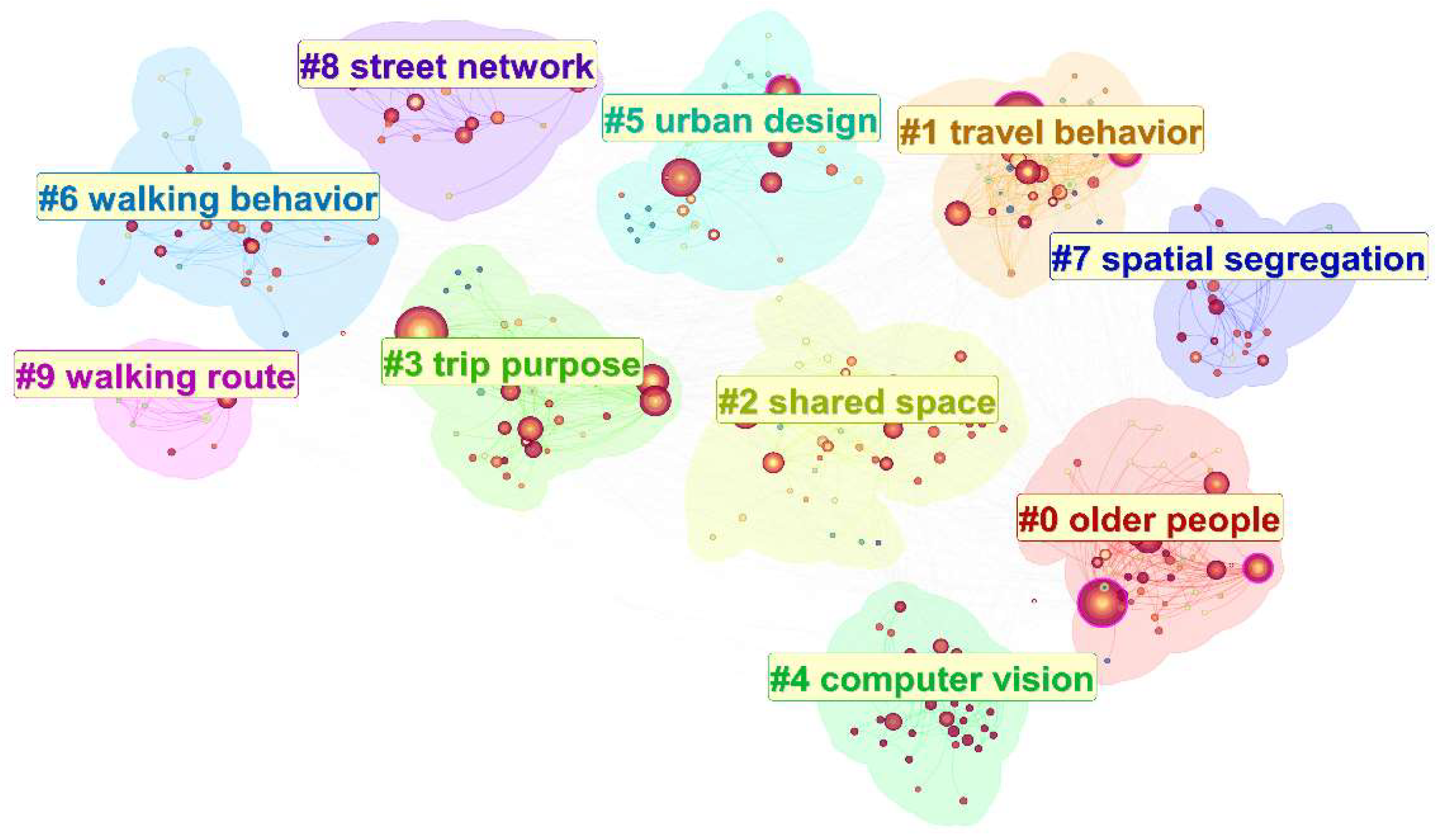
Figure 1. Keyword co-occurrence clusters in the reviewed literature.
Land 15 01730 g001
Figure 2. Hierarchy of road network quality based on human needs (adapted from [4,5]).
Land 15 01730 g002
Figure 3. Observed and fitted changes in willingness to walk with distance (redrawn using data from [8,9,10,11]).
Land 15 01730 g003
Figure 5. Schematic representation of pedestrian encounters on sidewalks (adapted from [96]).
Land 15 01730 g005
Table 1. Reasons for exclusion during literature screening.
Exclusion ReasonRecords Excluded (n)
Duplicate records284
Irrelevant keyword matches20,633
Transport or road-network studies outside the walking-related scope8189
Out-of-scope disciplinary, social, cultural, or governance topics1353
Health, physical activity, or psychological studies without a direct pedestrian-environment focus552
Technical, methodological, or engineering studies without direct relevance to road network quality78
Accessibility-focused or highly specific-setting studies with limited relevance or generalizability53
Table 2. Schematic evolution of road network structures in the United States (adapted from [40]).
Network TypeGridBroken ParallelCurvilinear ParallelLoop + Cul-de-SacFishbone + Cul-de-Sac
DiagramLand 15 01730 i001Land 15 01730 i002Land 15 01730 i003Land 15 01730 i004Land 15 01730 i005
EraEarly 20th century1950s1960s1970s1980s
Number of roads281914128
Number of intersections262214128
Number of loops and cul-de-sacs012824
Table 3. Representative road classification systems and their underlying logic (adapted from [55,56,57,58,59,60,61,62,63]).
Country/RegionClassification SystemPrincipal Street TypesClassification BasisRelevance to Walking
China [55,56]Urban road classificationExpressway, arterial, secondary arterial, local roadNetwork role and traffic functionPedestrian movement remains subordinate to traffic functions
United States [57,58]FHWA Functional ClassificationArterial, collector, local roadMobility–access balancePedestrian and place functions receive limited consideration
Netherlands [59,60]Sustainable SafetyThrough road, distributor road, access roadFunction, speed, and safetyLow-speed access roads support walking and cycling
New Zealand [61,62]One Network FrameworkLocal street, urban connector, activity street, main street, civic space, city hub, transit corridorMovement and placeWalking and street activity are explicit classification dimensions
Victoria, Australia [63]Movement and Place FrameworkCity hub, activity street/boulevard, connector, local streetMovement and place significanceActive travel and place quality are explicitly considered
Table 4. Mapping pedestrian-environment elements in representative guidelines to basic and higher-order quality needs (adapted from [90,91,92,93,94]).
CountrySourceElements Addressing Basic NeedsElements Addressing Higher-Order Quality Needs
China [90]Standard for Planning of Urban Pedestrian and Bicycle Transportation SystemsNetwork continuity; sidewalk width and clear space; pedestrian crossings; traffic separation; accessibility; signals and markingsWaiting and resting spaces; greenery; paving; street furniture; lighting
United States [91]FHWA Pedestrian Facilities Users Guide: Providing Safety and MobilitySidewalks and walkways; curb ramps; accessible routes; crosswalks; pedestrian signals; traffic calming; crossing islandsStreet lighting; landscaping; street furniture; an attractive and inviting walking environment
United Kingdom [92,93]Manual for Streets/Inclusive MobilityPedestrian priority; clear and accessible footways; accessible crossings; tactile paving; traffic-speed controlActive frontages; planting; seating and street furniture; lighting; local character and place quality
New Zealand [94]Pedestrian Network GuidanceSafe; inclusive; connected; direct; sufficient walking space; crossings and intersectionsLegible; attractive; comfortable; landscaping; wayfinding; street furniture; lighting
Disclaimer/Publisher’s Note: The statements, opinions and data contained in all publications are solely those of the individual author(s) and contributor(s) and not of MDPI and/or the editor(s). MDPI and/or the editor(s) disclaim responsibility for any injury to people or property resulting from any ideas, methods, instructions or products referred to in the content.