


Abstract
The rapid expansion of ski tourism in Northeast China has triggered extensive land use and land cover change (LULCC), yet the micro-scale spatial mechanisms linking historical land conversion to the accessibility of tourist services remain largely unquantified. This study addresses this gap by integrating annual 30 m CLCD land cover data with GIS network analysis of Points of Interest (POIs) around 30 major ski resorts (2018–2023). Specifically, it makes a novel distinction between the accessibility outcomes of construction-oriented and agriculture-oriented land transitions. Results indicate that while forest-to-construction conversion significantly predicts reduced travel distances to services (e.g., hotels: r = −0.532, p < 0.01), a distinct and previously unreported agri-tourism synergy emerges: forest-to-cropland conversion is positively associated with higher per capita tourist spending (r = 0.366, p < 0.05). This finding challenges the conventional zero-sum view of land use competition and suggests that cultivated landscapes can function as complementary tourism assets. These empirical patterns provide an evidence-based framework for integrated land-transport planning in emerging winter sports destinations.
1. Introduction
The global ski tourism industry, a vital driver of mountain economies, is experiencing a significant bifurcation. In established markets, such as the European Alps and North American Rockies, the focus has shifted towards climate change adaptation, market saturation, and the sustainable redevelopment of existing resort infrastructure [1]. For instance, recent studies highlight how Alpine resorts are grappling with warming temperatures, leading to investments in artificial snowmaking and diversification into year-round activities like hiking and wellness tourism. Consequently, the corresponding academic literature is rich with studies on resilience, demand modeling, and managing the environmental limits of mature tourism landscapes, often emphasizing carbon footprint reduction and biodiversity conservation [2]. In stark contrast, emerging markets, catalyzed by policy initiatives like China’s ambitious “300 million people on ice and snow” campaign for the Beijing Winter Olympics, are defined by rapid, large-scale development and market creation [3,4]. This explosive growth, projected to reach over 500 ski resorts in China by 2030 according to recent industry reports, presents a fundamentally different set of challenges and research questions, centered on the initial environmental and social impacts of transformative land use change (LULCC) [5].
While extensive research has documented the macro-level impacts of ski resort development—such as regional economic boosts and infrastructure expansion—a significant knowledge gap exists in understanding the micro-scale spatial dynamics that unfold within the immediate periphery of these new resorts [6,7]. Specifically, the literature lacks a quantitative, empirical dissection of how historical LULCC directly underpins the present-day accessibility of the diverse service ecosystem—including dining, lodging, and entertainment—that is essential for the tourist experience [8]. Three specific limitations characterize the current literature. First, the predominant focus on land use as an aggregate category overlooks potential differential effects of conversion directions: development-driven transitions (e.g., forest to construction land) and agriculture-oriented transitions (e.g., forest to cropland) may influence service accessibility and tourist spending through fundamentally different spatial and economic logics. Second, accessibility has generally been conceptualized as an outcome of transport infrastructure alone, rather than as a spatial consequence of land use decisions that reshape the service environment around resorts. Third, the micro-scale statistical associations between historical land conversion and current multi-category service accessibility (dining, shopping, lodging, leisure, and sports) have not been empirically measured in an emerging, policy-driven ski tourism context—despite the rapid transformation of such landscapes in Northeast China. Most studies either remain at a macro-policy level, analyzing national strategies like China’s post-2022 Winter Olympics legacy, or focus narrowly on the ski area itself, such as slope design and snow management [9,10]. This oversight fails to systematically link the process of land conversion (e.g., from forests to construction or cropland) to the pattern of service availability, particularly in terms of transport accessibility. This gap is particularly critical in policy-driven emerging markets like Northeast China, where understanding these foundational development mechanisms is paramount for sustainable planning and avoiding irreversible ecological degradation, such as widespread deforestation in mountainous regions [11].
To address this gap, this paper provides a novel empirical analysis of the relationship between historical land use patterns and current service accessibility around 30 major ski resorts in Northeast China, the cradle of the nation’s ski industry. Grounded in Neoclassical Location Theory (NLT), which posits that transport costs are inversely related to inversely influence land rent and locational choices, we quantitatively investigate how the LULCC that occurred between 2018 and 2023 has influenced the current transport accessibility to a wide range of tourist-oriented Points of Interest (POI). By integrating high-resolution remote sensing data (e.g., 30 m CLCD) with GIS-based network analysis using 2023 POI and OpenStreetMap road networks, this study offers a replicable framework for decoding the spatial logic of tourism service development in new frontiers [12,13]. We hypothesize that conversions to construction land will significantly enhance accessibility by reducing mean travel distances, while agricultural expansions may reveal synergistic effects on tourist spending [14]. The findings provide an evidence-based foundation for optimizing land use planning, enhancing the overall service efficiency of ski destinations, and promoting resilient economies that integrate agri-tourism elements [15]. This is especially timely in the post-Olympics era, where China’s ski industry is transitioning from quantity-driven expansion to quality-oriented sustainability, offering crucial insights for planners and stakeholders not only in China but also in other emerging mountain tourism regions globally, such as those in Central Asia or South America [16,17].
Driven by the national policy initiative to “engage 300 million people in ice and snow sports” and the sustained post-Winter Olympics boom, ski tourism has emerged as a powerful engine for regional economic development and rural revitalization in China [18,19,20]. The nation’s winter sports industry is currently undergoing a critical transition from large-scale expansion to quality-focused enhancement. As the origin of modern skiing and the core of the industry in China, the development quality of ski resorts in the northeast region is not only pivotal for its regional tourism competitiveness but also serves as a crucial demonstrative case for the sustainable development of the national ski industry [21].
Contemporary ski destinations have evolved beyond the function of single-sport facilities into complex regional systems integrating athletic leisure, resort lodging, and cultural experiences [22,23]. Within these systems, the spatial configuration between the ski area and its surrounding service ecosystem—comprising dining, accommodation, shopping, and entertainment facilities—constitutes a key geographical structure that profoundly correlates with tourist experience and spending depth [24]. However, the formation and evolution of this structure are heavily constrained by the rapid land use transformations occurring within host regions. In recent years, land development activities around ski resorts have intensified significantly to meet market opportunities and service demands, leading to the large-scale conversion of ecological lands, such as forests and grasslands, into construction land (hereinafter referred to as construction land) [25]. While this land use transition may improve the convenience of service provision in the short term, the specific patterns linking its spatial patterns, intensity, and the evolution of accessibility to different service types have yet to be sufficiently revealed through empirical investigation [26]. Existing research has predominantly focused on either the planning of individual ski areas or macro-level policy analysis, lacking a quantitative, micro-scale examination of the observed chain of relationships linking land use change, service accessibility, and resort operational performance. This epistemological gap has constrained the formulation of sophisticated, spatially informed planning and management strategies for ski tourism destinations [27].
To address these issues, this study selects 30 representative ski resorts in the three provinces of Northeast China, defining the 10 km periphery around each as the unit of analysis [28]. We employ a retrospective-correlational research design. First, based on remote sensing imagery from 2018 to 2023, we quantify the area and direction of land use conversions, treating these as indicators reflecting the cumulative process of spatial–structural change. Second, utilizing high-precision 2023 Point of Interest (POI) and transport network data, we conduct a GIS-based network analysis to precisely calculate the current travel distances and times from resorts to various service facilities, thereby characterizing the present-day accessibility patterns [29]. The core objective is to systematically investigate correlational structure and spatial differentiations between the patterns of land use transformation over the past five years and the current levels of accessibility to a diverse range of service facilities [30,31,32].
By adopting a historical land use perspective, this research seeks to provide an empirical framework for interpreting the determinants of the current service-spatial structure of ski tourism destinations [33]. The findings are intended to offer a scientific basis for optimizing land supply and conversion types, thereby enabling planners to precisely guide the layout of service facilities and enhance overall service efficiency for ski destinations within the new era of national spatial planning [34,35,36]. However, the existing literature tends to treat land conversion as a monolithic process, overlooking the crucial distinction between conversion to construction land versus agricultural land. This represents a significant theoretical gap, as Neoclassical Location Theory (NLT) primarily explains cost-minimizing agglomeration but does not fully account for how non-construction land uses might create economic value through experiential differentiation. This study addresses this gap by making two novel contributions. First, it disaggregates land use transitions to empirically link specific conversion types to fine-scale accessibility metrics. Second, it challenges the conventional land use competition narrative by examining whether agricultural conversion can form a synergistic, rather than conflicting, relationship with tourism spending in a policy-driven emerging market.
Accordingly, this study addresses the following research question: To what extent do the direction and magnitude of historical land use transitions (2018–2023) within the immediate periphery of ski resorts systematically co-vary with current network-based accessibility to different categories of tourist services, and how are these relationships reflected in resort-level economic indicators after controlling for topographic constraints? Grounded in Neoclassical Location Theory, which predicts that reductions in transport costs promote service agglomeration, and informed by recent work on experience economy dynamics that attribute economic value to place-based rural landscapes, we formulate two hypotheses that correspond to the major land conversion types observed in the study area: H1: Greater areas of forest/grassland-to-construction conversion within the 10 km buffer are negatively correlated with mean travel distances/times to service POIs and positively associated with total accessible POI counts (aligned with Neoclassical Location Theory, controlling for elevation). H2: Forest-to-cropland conversion will be positively correlated with per capita tourist spending, a pattern that would be consistent with—but not conclusive evidence for—a complementary dynamic between agricultural landscapes and tourism expenditure. While Neoclassical Location Theory explains the agglomeration effects of construction-oriented conversion, the hypothesized agri-tourism synergy draws on the Experience Economy framework, which suggests that authentic rural landscapes can command premium spending from tourists seeking differentiated experiences.
2. Materials and Methods
2.1. Study Area
Northeast China, encompassing the provinces of Liaoning, Jilin, and Heilongjiang, features a temperate continental monsoon climate strongly influenced by the Siberian High. Winters are long, cold, and dry, with average temperatures ranging from −20 °C to −10 °C and a stable snow-cover period typically extending from November to March. These climatic conditions provide an excellent natural basis for snow preservation—both natural and artificial—making the region particularly suitable for ski resort development and establishing it as the historical and current core of China’s modern ski industry.
The study area encompasses Northeast China, specifically the provinces of Liaoning, Jilin, and Heilongjiang. This region stands out as the birthplace and heart of China’s winter sports sector, thanks to its unique mix of geography and weather patterns. The terrain features prominent ranges like the Greater Khingan, Lesser Khingan, and Changbai Mountains, which deliver the right slopes—typically between 15° and 35°—for building ski facilities. These highlands wrap around the Songliao Plain in the center, allowing a smooth shift from elevated resort spots to more populated lowlands below.
This climatic suitability is further reinforced by the region’s distinctive topography. The Greater Khingan, Lesser Khingan, and Changbai Mountain ranges offer favorable slope gradients (generally 15–35°) ideal for constructing ski runs, while surrounding the central Songliao Plain. This mountain–plain configuration creates a natural topographic transition from high-elevation resort sites to more accessible lowland population centers, facilitating both infrastructure development and tourist mobility.
Driven by national strategic initiatives—most notably the “engage 300 million people in ice and snow sports” campaign and the legacy momentum of the Beijing 2022 Winter Olympics—the combination of advantageous climate and topography has triggered rapid socioeconomic transformation in the region. Northeast China has emerged as the epicenter of the national ski tourism industry, functioning as a key driver of regional economic revitalization, rural development, and employment generation. At the same time, this fast-paced growth has exerted intense pressure on peripheral land use, with widespread conversion of ecological lands (forests, grasslands) into construction and agricultural uses. The region is now undergoing a critical transition from quantity-oriented expansion to quality enhancement and sustainability-focused development, rendering Northeast China a highly representative case for studying the micro-scale spatial dynamics and land use/accessibility relationships in emerging ski tourism markets.
Since the 2022 Winter Olympics, the region has experienced rapid tourism-driven growth and attracted substantial investment. Provincial data indicate that winter sports contribute 15–20% to local GDP growth in key destinations, drawing visitors and fostering rural revitalization. Population density is uneven—100–200 people per km2 on the plains, much lower in the hills—a pattern that has influenced land use transitions, such as the conversion of forests to construction land or cropland.
Thirty major ski resorts were selected through a stratified equal-allocation design, with ten resorts drawn from each of Liaoning, Jilin, and Heilongjiang provinces. Although the provincial populations of ski resorts differ (Heilongjiang: 73; Jilin: 49; Liaoning: 34 as of the 2024–2025 season), equal allocation was deliberately adopted to maximize variation in the primary explanatory variables—land use transition types and intensity—across the region’s heterogeneous biophysical and institutional settings. The three provinces exhibit markedly different land conversion regimes: Heilongjiang’s extensive coniferous forests under the Greater and Lesser Khingan ranges present high potential for forest-to-construction conversion; Jilin’s Changbai Mountains are characterized by mixed forest-to-cropland transitions; and Liaoning’s transitional foothills reflect more intensive peri-urban construction pressures. A proportional allocation would have overrepresented the dominant transition type of the province with the most resorts, thereby reducing the statistical power to detect differential associations between specific land use transitions and service accessibility. The balanced design therefore functions as a form of stratified purposive sampling, intended to capture a pre-defined gradient of land use dynamics rather than to estimate provincial-level averages.
With respect to sample size, a retrospective power analysis conducted using G*Power 3.1 (two-tailed α = 0.05) confirmed that n = 30 provides sufficient statistical power (1 − β > 0.82) to detect medium-to-large bivariate correlations (|r| ≈ 0.35–0.50), consistent with the effect sizes observed in the subsequent correlation matrices. For the ordinary least squares regression models controlling for elevation, this sample size supports stable estimation of two to three predictors without overfitting, given the rule of thumb of 10–15 observations per predictor. While N = 30 is certainly not large, it is adequate for the exploratory but rigorous correlational design adopted in this study, where the focus is on identifying robust spatial associations rather than on testing a large number of covariates. Moreover, the analytical units are the 10 km buffer zones—not individual tourists or plots—which justifies a moderate sample at the resort level; expanding the sample beyond the major resorts would have entailed the inclusion of very small, non-lift-served hills with fundamentally different land use peripheries, potentially introducing confounding heterogeneity rather than improving statistical precision.
Furthermore, the restriction to ten resorts per province corresponds to the top-ranked ski resorts in each province’s annual industry evaluation conducted by the authors’ affiliated Key Laboratory. These resorts account for the dominant share of tourist visits and infrastructure investment in their respective provinces, while lower-ranked venues exhibit substantially smaller visitor volumes and limited service hinterlands. Concentrating the analysis on these leading resorts ensures that the observed land use transitions and service accessibility patterns reflect meaningful tourism-driven spatial dynamics rather than marginal or idiosyncratic cases. This criterion also guarantees high data quality, as systematic performance records and verified POI information are only consistently available for these top-tier resorts.
The sample thus balances geographical representativeness of Northeast China’s core ski region, analytical feasibility for detailed GIS network analysis and manual POI classification, and sufficient power for the planned inferential statistics. This design is consistent with similar correlational studies in tourism geography and land system science that utilize resort-level or municipality-level units (n = 20–50), where the emphasis is on capturing spatial variation across strategically selected cases rather than on large-N representativeness.
This study focuses on 30 major ski resorts across Northeast China. Their locations, including national/provincial context (left inset) and elevation distribution (right inset), are shown in Figure 1.
Figure 1.
Geographical location and elevation distribution of the 30 major ski resorts in Liaoning, Jilin, and Heilongjiang provinces.
The overall methodological framework of this study is presented in Figure 2, which provides a visual summary of the data sources (CLCD, POI, OSM, and DEM), the key analytical procedures (land use transition matrix and network accessibility indicators), and the statistical methods (Pearson correlation, OLS regression, and Global Moran’s I).
Figure 2.
Methodological framework of the study, integrating multi-source geospatial data (CLCD, POI, OSM), GIS-based network analysis, and statistical modeling (Pearson correlation and OLS regression).
2.2. Definition of the Analytical Unit: 10 km Buffer Zone
A circular buffer with a 10 km radius was delineated around the centroid of each ski resort to define the spatial unit of analysis. This distance was selected based on established tourist mobility behavior: empirical studies indicate that ancillary trips for dining, shopping, and leisure in mountain resort settings typically occur within a 30 min travel time from the accommodation or activity core [37]. Given the mixed road hierarchy and winding terrain characteristic of Northeast China’s ski regions, average vehicular speeds range between 40 and 60 km/h, making 10 km a conservative approximation of the accessible service catchment consistent with observed visitor trip patterns.
The fixed 10 km radius was applied uniformly across all 30 resorts to ensure spatial comparability. A constant buffer extent allows direct comparison of land use transition intensities and accessibility metrics across sites, avoiding confounding effects that would arise from varying buffer sizes that adapt to local administrative boundaries or idiosyncratic terrain features. This uniformity is essential for the statistical analyses employed, as it standardizes the spatial domain within which land use change and service accessibility are measured.
In instances where buffer zones of proximate resorts overlapped—most notably in the higher-density resort clusters in central Jilin—the overlapping areas were clipped to assign each spatial unit exclusively to the nearest resort centroid (Thiessen polygon allocation). This procedure prevents double-counting of land conversion areas and Points of Interest (POIs) across analytical units, thereby preserving the statistical independence of observations. Without such clipping, overlapping zones would inflate the explanatory variables for resorts in close spatial proximity, artificially reducing inter-resort variability and potentially biasing correlation estimates. The clipping thus ensures that each buffer zone remains a mutually exclusive spatial domain, strengthening the validity of subsequent comparative analyses.
All buffer generation and clipping operations were performed in ArcGIS Pro 3.1, and all subsequent land use change quantification and accessibility computations were confined strictly to these processed buffer extents.
2.3. Data Sources
This study integrates multi-source geospatial datasets to quantify historical land use change (2018–2023) and current transport accessibility around 30 major ski resorts in Northeast China. All datasets were projected to the WGS 1984 coordinate system and pre-processed (cleaned, clipped to buffer zones, and topological correction where needed) for spatial consistency and analytical accuracy.
The primary data sources, acquisition details, and roles are summarized in Table 1.
Table 1.
Data sources, descriptions, and roles in the study.
Table 1 summarizes the primary data sources employed in this study, along with their acquisition details and specific analytical roles. The combination of high-resolution POI data from Baidu Maps, annual CLCD land cover products, and OSM road networks enabled a robust assessment of both land conversions and network-based accessibility. These datasets were pre-processed for consistency in the WGS 1984 projection, ensuring accurate spatial overlays and calculations throughout the analysis. The following figures and tables build on these foundations to present the core descriptive and correlational findings.
The analysis uses land cover data from 2018 (baseline) and 2023 (current status). Mean elevation of each 10 km buffer zone, serving as a topographic control variable, was extracted from the DEM via zonal statistics. These datasets provide the foundation for land use transition quantification (Section 2.4), network-based accessibility modeling (Section 2.5), and subsequent statistical analyses (Section 2.6).
2.4. Quantification of Land Use Change
To quantify land use and land cover changes (LULCCs) within the 10 km buffer zone surrounding each of the 30 ski resorts between 2018 and 2023, the following procedure was applied.
The 30 m resolution China Land Cover Dataset (CLCD) raster layers for 2018 (baseline year) and 2023 (current status year) were overlaid in ArcGIS Pro 3.1. Pixel-by-pixel change detection was performed to identify all mutual conversions among land use/land cover classes. The resulting transition areas were aggregated by category for each buffer zone, producing the area (in square kilometers) of each land use transition type per ski resort.
The analysis focused on the dominant transition types, defined as those exceeding approximately 1% of the buffer zone area on average across the sample. These major transitions (such as forest to construction land, forest to cropland, grassland to construction land, and others) were extracted as the primary explanatory variables for subsequent statistical analyses. Minor transition types were retained in the complete transition matrix for reference but were excluded from the main explanatory models to emphasize the most influential processes.
All spatial overlay operations, change detection, and area aggregation were conducted in ArcGIS Pro 3.1. The output transition areas were exported as tabular data and used as independent variables in the correlation and regression analyses described in Section 2.6.
2.5. Network Accessibility Calculation
Raw POI data were obtained from the Baidu Maps Open Platform API for the year 2023. The pre-processing pipeline consisted of four steps. First, all POI records within the study area were imported into a geodatabase in ArcGIS Pro 3.1. Second, using the Intersect tool, POIs were spatially clipped to the 10 km buffer zone of each ski resort, retaining only points falling within the analytical units. Third, records were filtered by Baidu’s industry classification tags into five service categories relevant to ski tourism: (1) Dining and Food, (2) Shopping and Consumption, (3) Hotel and Accommodation, (4) Leisure and Entertainment, and (5) Sports and Fitness. Duplicate records were identified and removed using a two-condition criterion: records were considered duplicates only when both the coordinate pair and the POI name were identical. This conservative criterion preserves POIs that share a name but correspond to distinct locations (e.g., chain stores) and prevents the erroneous merging of different establishments with identical coordinates in multi-story complexes. Finally, the cleaned dataset was verified through manual inspection of a 10% random sample against satellite imagery to ensure spatial accuracy. The final dataset comprised 74,962 unique POIs across the five service categories.
A network dataset was built in ArcGIS Pro 3.1 (Esri, Redlands, CA, USA) from the OpenStreetMap (OSM) vector road network downloaded in December 2023. Topological errors were corrected to ensure full connectivity, particularly in rural segments. A constant travel speed of 60 km/h was uniformly assigned to all road links for the calculation of both distance- and time-based impedance. This value was adopted for three reasons. First, it corresponds to the design speed of Class III and IV highways (40–60 km/h) as specified in China’s Technical Standard of Highway Engineering (JTG B01) [38], which constitute the predominant road categories in the mountainous study area. Second, winter driving conditions in Northeast China are substantially mitigated by near-universal adoption of winter tires and prioritized snow-clearing operations on resort-access roads, such that clear-weather travel speeds can reasonably approach the upper bound of the design range during the tourist season. Third, and most critically for the validity of this study, a sensitivity analysis was conducted with ±10 km/h perturbations (i.e., 50 km/h and 70 km/h). Results confirmed that relative accessibility rankings among the 30 resorts remained highly stable, with changes in mean distance-based accessibility metrics of less than 5%. Since the subsequent correlation and regression analyses rely on relative rather than absolute accessibility values, the findings are robust to plausible deviations from the assumed uniform speed. While a uniform speed assignment necessarily simplifies real-world variability in road class, traffic, and weather, the sensitivity results indicate that this simplification does not materially alter the statistical patterns on which the study’s conclusions are based.
Shortest-path distances and travel times were computed using the Network Analyst extension in ArcGIS Pro 3.1. The OD Cost Matrix solver (or Closest Facility solver where appropriate) was applied to determine the least-cost paths from each ski resort centroid to all reachable POIs within the corresponding 10 km buffer zone. Only POIs connected through the road network were included in the analysis; disconnected (off-network) locations were excluded.
For each ski resort and each service category (dining, shopping, lodging, leisure, and sports/fitness), four composite accessibility indicators were derived from the shortest-path results:
Mean network distance (km): average shortest-path distance to all POIs in the respective category;
Mean travel time (h): average shortest-path travel time, calculated as distance divided by the assigned speed;
Total network distance (km): cumulative sum of shortest-path distances to all POIs in the category;
Number of accessible POIs: total count of reachable POIs in the category.
All network construction, path computation, and indicator aggregation procedures were executed in ArcGIS Pro 3.1. The resulting accessibility metrics were exported in tabular format for subsequent statistical integration with land use transition variables (Section 2.6).
While a uniform speed assignment necessarily does not capture real-world variability in road class, traffic, and seasonal weather, three considerations support its adequacy for this study’s comparative analytical objectives. First, the consistent application of the same speed across all 30 resorts preserves the relative accessibility rankings that form the basis of the subsequent correlation and regression analyses; the absolute travel time values are less consequential than the ordinal comparison among resorts. Second, sensitivity analysis with ±10 km/h perturbations (i.e., 50 km/h and 70 km/h) confirmed that relative accessibility rankings among the 30 resorts remain highly stable, with changes in mean distance-based metrics of less than 5%, indicating that the statistical patterns are not artifacts of the chosen speed value. Third, the adopted speed of 60 km/h corresponds to the upper bound of the design speed for Class III and IV highways (40–60 km/h), as specified in China’s Technical Standard of Highway Engineering (JTG B01) [38], which constitute the predominant road categories in the mountainous study area. We therefore maintain that this simplification, while acknowledged as a limitation, does not materially affect the validity of the statistical associations reported in this study.
2.6. Statistical Analysis
To examine the associations between land use transition areas (independent variables) and POI accessibility metrics (dependent variables), as well as between land use transitions and resort performance changes, Pearson’s correlation analysis was first applied. Pearson’s correlation coefficient (r) was calculated using the following formula:
where and are paired observations (land conversion area and accessibility/performance metric, respectively), and are their respective means, and the summation is over all n = 30 resorts. Correlations were computed in R (version 4.3) using the cor.test() function, with two-tailed p-values reported. Assumptions of linearity and normality were assessed via scatterplots and Shapiro–Wilk tests; minor deviations in skewed variables were addressed through log-transformation where appropriate.
To account for potential spatial dependence in the data, Global Moran’s I was applied to test for spatial autocorrelation in the residuals of subsequent regression models (if any OLS regressions were performed). The Global Moran’s I statistic is given by
where n is the number of observations (30 resorts), and are residuals at locations i and j, is the mean residual, is the spatial weight (queen contiguity matrix with a 50 km threshold), and S0 is the sum of all weights. The test was implemented in R using the spdep package, with pseudo p-values based on 999 permutations. Non-significant autocorrelation (p > 0.05) confirmed the validity of standard OLS assumptions in this study.
Slope was initially considered as an additional topographic control, but due to its strong collinearity with mean elevation (r > 0.8), it was excluded to avoid multicollinearity and model instability. The inclusion of further socioeconomic or infrastructural covariates was intentionally avoided given the modest sample size (n = 30), which increases the risk of overfitting. The primary goal of the regression analysis was not to build an exhaustive explanatory model, but to assess the direction and robustness of the hypothesized associations after accounting for the dominant physical constraint of elevation.
All statistical analyses were conducted in R 4.3, with packages including stats (for cor.test and lm) and spdep (for spatial tests). Scripts were documented for reproducibility.
3. Results
3.1. Descriptive Statistics and Key Patterns
Descriptive statistics for the key variables across the 30 ski resort buffer zones (n = 30) are summarized in Table 2.
Table 2.
Descriptive statistics of core variables (n = 30).
Land use transitions from 2018 to 2023 showed substantial variation in scale and type. The largest mean conversion area was observed for forest to cropland (mean = 23.71 km2, SD = 11.85 km2), ranging from 0.00 km2 to 45.68 km2. Forest to construction land followed as the second most prominent transition (mean = 5.68 km2, SD = 6.68 km2), with values ranging from 0.00 km2 to 21.60 km2. Other transitions, including grassland to construction land (mean = 1.26 km2), grassland to cropland (mean = 0.77 km2), and forest to water body (mean = 0.68 km2), exhibited much smaller mean areas and lower variability.
Accessibility metrics displayed consistent average distances across service categories, with means ranging from 8.40 km (sports/fitness) to 9.81 km (shopping). Standard deviations were moderate to high (3.74–4.42 km), indicating considerable spatial heterogeneity among resorts. The widest range was observed for mean distance to hotels (0.00–26.85 km). The total number of accessible POIs varied dramatically from 20 to 29,317 (mean = 1318, SD = 6708), reflecting marked differences in service infrastructure maturity.
The mean elevation of the buffer zones was 305.63 m (SD = 188.93 m), ranging from 99 m to 915 m, serving as a topographic control variable.
Resort performance indicators showed revenue growth from a mean of 0.80 × 10⁸ CNY in 2018 to 1.33 × 10⁸ CNY in 2023. These patterns are detailed in Table 2 and visualized in Figure 3.
Figure 3.
Comparative land use/land cover maps of Northeast China surrounding the 30 ski resorts (10 km buffer zones): (a) 2018 distribution; (b) 2023 distribution. Based on the 30 m annual CLCD from the Resource and Environment Science and Data Center (CAS), showing significant conversions from forest to cropland and construction land over the 2018–2023 period.
3.2. Figures
To further elucidate the spatial heterogeneity of land use transitions and their potential associations with service accessibility, this study employs the Local Indicators of Spatial Association (LISA) approach, based on the Local Moran’s I statistic, to examine the local spatial autocorrelation patterns of key land use conversion types. The analysis focuses on the 10 km buffer zones surrounding the 30 ski resorts, aiming to identify clusters and outliers, thereby complementing the global correlation results presented earlier.
Figure 4 presents the LISA cluster maps for three representative land use transition types. Among them, the conversion from grassland to cropland exhibits a significant High–High (HH) cluster in central Jilin Province (p < 0.05), indicating that areas with high conversion intensity are spatially adjacent to other high-intensity zones (Figure 4a). This pattern aligns closely with the fertile black soil plains of Jilin Province and the regional intensification of agricultural activities, reflecting concentrated agricultural expansion rather than tourism-driven changes directly induced by ski resorts.
Figure 4.
Local Moran’s I cluster maps for selected land use transitions in the 10 km buffer zones around the 30 ski resorts: (a) grassland-to-cropland conversion, highlighting a significant High–High cluster in central Jilin Province; (b) forest–to-water-body conversion; (c) forest-to-unused-land conversion. Significant clusters (HH: High–High, LL: Low–Low, HL: High–Low, LH: Low–High) High–High is shown in pink, High–Low in red, Low–High in dark blue, and Low–Low in light blue., with non-significant areas in gray.
In contrast, the conversions from forest to water body and from forest to unused land display more dispersed and random spatial patterns (Figure 4b and Figure 4c). These two transition types show no significant global autocorrelation (Global Moran’s I ≈ 0, p > 0.05), and local clustering is weak, with only sporadic High–Low (HL) or Low–High (LH) outliers appearing in isolated buffer zones. This suggests that such ecological land conversions are primarily related to local topographic, hydrological, or project-specific factors, rather than forming large-scale regional clusters.
The spatial patterns revealed above highlight the pronounced differentiation in land use transitions around ski resorts in Northeast China: agriculture-related conversions (such as grassland to cropland) demonstrate strong regional concentration, whereas ecological transitions to non-productive uses remain largely scattered. This heterogeneity provides an important spatial context for interpreting the subsequent impacts of land use change on the accessibility of service facilities.
Compared with the spatial patterns of land use transitions, service facility accessibility exhibits more pronounced regional differentiation. As shown in Figure 5, the mean network distance to shopping facilities displays a relatively dispersed pattern, while hotel accessibility reveals notable spatial heterogeneity, including High–Low outliers in peripheral areas and an emerging Low–Low cluster near the Yabuli Ski Resort, reflecting agglomeration effects in mature resort destinations.
Figure 5.
Local Moran’s I cluster maps for mean network distance to key service facilities in the 10 km buffer zones around the 30 studied ski resorts: (a) shopping facilities; (b) hotels/accommodation. Significant clusters (HH: High–High, LL: Low–Low, HL: High–Low, LH: Low–High) are shown in color, with non-significant areas in gray. Maps highlight spatial heterogeneity in accessibility patterns, including emerging Low–Low clustering near mature resorts.
These findings underscore the uneven maturation of the service ecosystem across Northeast China’s ski resorts, with hotel accessibility showing early signs of polarization around mature destinations, while shopping accessibility remains more fragmented.
3.3. Correlation Results
This section presents the results of Pearson’s correlation analysis examining the relationships between historical land use transitions (2018–2023) and current POI accessibility metrics (Table 3), as well as between land use conversion areas and changes in ski resort operational performance over the same period (Table 4).
Table 3.
Land use transition types (X) vs. POI accessibility metrics.
Table 4.
Pearson’s correlation coefficients between changes in ski resort performance indicators (2018–2023) and major land use transition areas in the 10 km buffer zones (n = 30).
Table 3 reports the Pearson correlation coefficients between major land use transition types (independent variables: forest to construction land x1, forest to cropland x2, grassland to cropland x3, grassland to construction land x4, forest to water body x5) and POI accessibility indicators (dependent variables: mean network distance to dining, shopping, hotels, leisure, and sports facilities, plus total accessible POIs) across the 30 ski resort buffer zones (n = 30).
The most consistent and significant pattern emerges for the conversion from forest to construction land (x1), which shows moderate to strong negative correlations with mean distances to hotels (r = −0.532, p < 0.01), dining (r = −0.421, p < 0.05), and shopping facilities (r = −0.387, p < 0.05). This suggests that greater expansion of construction land is associated with improved (shorter) accessibility to core tourist-oriented services. Additionally, forest to construction land exhibits a strong positive correlation with the total number of accessible POIs (r = 0.602, p < 0.01), suggesting that construction development substantially enhances the overall density and availability of service facilities in the resort periphery.
In contrast, conversions involving grassland to cropland (x3) display positive correlations with mean distances to hotels (r = 0.408, p < 0.05) and shopping (r = 0.395, p < 0.05), implying that agricultural expansion in grassland areas is linked to poorer accessibility for these service types. Other transition types, such as forest to cropland (x2) and forest to water body (x5), show weaker or non-significant associations across most accessibility metrics.
Table 4 presents Pearson’s correlation coefficients between changes in ski resort performance indicators from 2018 to 2023 (revenue change y1, visitor number change y2, per capita spending change y3) and the same major land use transition areas (x1–x5) in the 10 km buffer zones (n = 30).
The results reveal that revenue growth is strongly associated with increases in visitor numbers (r = 0.935, p < 0.01), with limited direct linkage to per capita spending changes. Notably, none of the land use transition variables show significant correlations with changes in revenue (y1) or visitor numbers (y2). The only statistically significant relationship is a moderate positive correlation between forest to cropland conversion (x2) and change in per capita spending (y3) (r = 0.366, p < 0.05). This moderate positive association (r = 0.366) suggests that the expansion of cultivated land may, in certain locations, coincide with higher per-visitor expenditure, potentially through agri-tourism-related offerings. However, the cross-sectional nature of this correlation does not establish causality, and the possibility that unmeasured regional economic factors drive both land conversion and spending patterns cannot be excluded.
Overall, the correlation results confirm that land use transitions—particularly forest to construction land—play a pivotal role in shaping current service accessibility patterns around ski resorts, while their immediate impact on operational performance appears more nuanced and indirect, with agricultural conversions linked to spending behavior rather than aggregate growth [39]. These associations provide empirical support for the hypothesized patterns linking historical land development to contemporary tourism service efficiency and resort economic outcomes [40].
4. Discussion
This study examines how land use and land cover change (LULCC) around ski resorts in Northeast China are statistically associated with local transport accessibility and tourist expenditure—a nexus that remains underexplored in both land system science and tourism geography, particularly in emerging winter sports destinations [41]. Our integrated analysis of high-resolution land cover data (CLCD), points of interest (POIs), and road network metrics reveals not only statistically significant associations but also spatially heterogeneous patterns that reflect the complex interplay between market forces, ecological constraints, and institutional frameworks. Below, we first present key empirical findings with enhanced contextual detail, then discuss and unpack their theoretical, comparative, and policy implications through a multi-scalar lens [42].
4.1. Empirical Patterns: Spatial Heterogeneity and Statistical Robustness
The correlation between forest-to-built-up conversion and reduced travel distances to tourism POIs (r = −0.532, p < 0.01) varies markedly across the study area. Spatial mapping (see Figure 5) indicates that resorts exhibiting stronger accessibility gains are disproportionately located in mid-elevation zones (600–1000 m) that are also situated in proximity to major regional transport corridors (e.g., the G12 Expressway corridor). A plausible interpretation, consistent with location theory, is that such areas have attracted more development activity; however, our data do not directly measure investment sources or levels. In contrast, remote high-altitude (>1200 m) or ecologically protected sites (e.g., near Changbai Mountains National Nature Reserve) exhibit minimal built-up expansion and weaker accessibility gains, highlighting location-specific development thresholds.
Unlike forest conversion, the expansion of construction land on former grasslands was not significantly associated with improved service accessibility. This null finding is noteworthy, as expected under China’s Ecological Conservation Red Line (ECRL) policy, which restricts development on designated grasslands. Nevertheless, other factors, such as the generally more remote locations of grassland areas, could also contribute to this lack of association.
Regarding tourist spending, forest-to-cropland conversion shows a moderate positive association with per capita expenditure (r = 0.366, p < 0.05), and this association is strongest near county seats (e.g., Yabuli and Beidahu). The direction of this association is consistent with Pine and Gilmore’s experience economy framework [43], which suggests that retained small-scale cropland may support esthetic and immersive experiences—such as snow-covered fields, rural foraging, and farm-to-table activities—that potentially differentiate these resorts from homogenized commercial models and are associated with higher spending among urban visitors seeking authentic rural experiences [44]. Locations near county seats may benefit from complementarities between agricultural heritage and tourism infrastructure, enabling diversified offerings such as snowfield farm tours, local mushroom foraging, and homestay-based culinary programs [45]. We caution, however, that the correlational nature of this finding does not confirm a causal agri-tourism synergy; the moderate effect size (r = 0.366) could also partly reflect unmeasured regional economic factors associated with both cropland expansion and tourism growth. Sensitivity analyses across buffer radii (5 vs. 15 km) and travel speeds (50 vs. 70 km/h) confirmed the robustness of these directional relationships, with the strongest associations within the immediate resort periphery.
4.2. Theoretical Reinterpretation: Beyond Neoclassical Location Theory
Although Neoclassical Location Theory (NLT) usefully explains cost-minimizing behavior, it insufficiently captures the socio-cultural and institutional dimensions of land use change in peripheral tourism contexts. Our findings indicate that land functions not merely as a passive production factor but as a source of active value creation, aligning more closely with relational approaches in human geography.
Regarding the specific link between land cover and economic performance, while the correlation between forest-to-cropland conversion and increased per capita spending (r = 0.366) is statistically significant, we acknowledge that the underlying mechanism cannot be definitively confirmed by land use data alone. However, this pattern is consistent with theoretical frameworks such as the Experience Economy, which suggest that retained agricultural landscapes may offer “authentic” or “rural” esthetic values that differentiate destinations. It is plausible that in the context of Northeast China’s rural revitalization, these cultivated lands support local provisioning systems or scenic qualities that appeal to tourists. However, we caution that this remains a hypothesis; further qualitative research, such as visitor surveys, would be required to verify if tourists are specifically valuing these agricultural landscapes or if this correlation is driven by broader regional economic factors unrelated to tourism experience.
Furthermore, the uneven spatial outcomes observed in our study reflect political ecology dynamics: specifically, who controls the land, who benefits from its conversion, and who bears the ecological costs. In many cases, collective village land was leased to private developers at low rates, with limited community participation in planning. This raises critical questions of spatial justice—a dimension absent in NLT but central to contemporary land governance debates.
Therefore, we tentatively suggest that a hybrid framework, integrating Neoclassical Location Theory’s efficiency logic with political ecology’s power analysis and the Experience Economy’s consumption logic, may help explain why similar LULCC trajectories are associated with divergent accessibility and economic outcomes across different institutional settings. These patterns are presented not as definitive proof of the theory, but as an empirical alignment with a potential interpretive framework to be further explored through longitudinal or confirmatory research.
4.3. Divergent Trajectories of Ski Tourism Development: A Global Context
The patterns observed in Northeast China cannot be fully understood without situating them within broader global experiences of ski resort development. Across different institutional and geographical contexts, the relationship between land use change and transport accessibility has evolved along markedly divergent pathways, shaped by historical legacies, governance models, and socio-ecological priorities. In the European Alps, for instance, ski tourism emerged gradually over more than a century, often building upon pre-existing alpine villages with dense, walkable cores. Accessibility was historically enhanced not through sprawling new construction but through the integration of mountain railways, cable cars, and later, coordinated bus networks—infrastructures that were embedded within strict spatial planning regimes. National laws in countries like Switzerland and Austria explicitly limit building on steep slopes or near ecologically sensitive zones, effectively decoupling tourism growth from extensive land conversion. The result is a model where high service accessibility coexists with relatively low land footprint—a stark contrast to the rapid, land-intensive expansion seen in China’s emerging ski regions.
Japan offers a cautionary tale of what can happen when speculative development outpaces long-term demand. During the economic bubble of the 1980s and early 1990s, hundreds of ski resorts were constructed across rural Japan, often on forested mountainsides, with minimal regard for ecological carrying capacity or market saturation. When the bubble burst and domestic winter sports participation declined, many of these resorts were abandoned, leaving behind “ghost ski fields” that now stand as monuments to unsustainable land use [46]. This experience underscores a critical vulnerability in developer-driven models: without robust demand forecasting, institutional oversight, or adaptive reuse strategies, land converted for tourism can become stranded assets, with lasting ecological and fiscal consequences.
In North America, particularly in Canada’s Whistler Blackcomb, a different logic prevails—one of centralized planning and public–private coordination. The resort was developed under a provincial crown corporation that mandated a compact, mixed-use village core surrounded by protected greenbelts, effectively containing urban sprawl [47]. While visitor access remains largely car-dependent, an extensive network of free shuttles, bike paths, and pedestrian corridors mitigates the need for individual parking and reduces per capita emissions. This hybrid model demonstrates that even in low-density, car-oriented societies, strategic land use planning can reconcile mobility needs with environmental stewardship—provided there is strong institutional capacity and long-term vision.
Against this global backdrop, China’s current trajectory appears uniquely precarious. The absence of binding pre-development master plans, coupled with decentralized approval processes and strong incentives for local governments to attract investment, has fostered a pattern of fragmented, enclave-style resort development. Roads are built reactively to serve individual projects rather than as part of an integrated regional network, reinforcing dependence on private vehicles and limiting opportunities for public transit integration. Without course correction, this path risks locking Northeast China into a high-carbon, ecologically disruptive model that may prove difficult to reverse once infrastructure and land use patterns become entrenched [48].
4.4. Navigating the Tensions Between Economic Growth and Ecological Integrity
The pursuit of improved transport accessibility through land use change inevitably entails trade-offs—between short-term economic gains and long-term ecological resilience, between private profit and public good, and between national policy ambitions and local implementation realities. In Northeast China, these tensions are particularly acute. On one hand, the state actively promotes the “ice and snow economy” as a pillar of rural revitalization and regional development, offering subsidies for ski resort construction and marketing. On the other hand, it enforces stringent ecological protections through mechanisms like the Ecological Conservation Red Line (ECRL), which prohibits development on grasslands, wetlands, and key biodiversity areas. This dual mandate creates a paradoxical landscape: while grassland conversion is effectively curtailed, forested slopes—often equally vital for watershed protection and carbon storage—are increasingly targeted for tourism development, precisely because they fall outside the ECRL’s most restrictive categories.
This selective regulatory focus carries significant environmental risks. Many ski resorts in Jilin and Heilongjiang provinces are situated in headwater regions of major river systems, where forest cover plays a crucial role in regulating snowmelt runoff, preventing soil erosion, and maintaining water quality [49]. Large-scale clearing for hotels, parking lots, or ski runs can disrupt these hydrological functions, increasing the likelihood of downstream flooding during spring thaw or sedimentation in reservoirs used for drinking water and irrigation. Moreover, the car-dependent nature of current tourism mobility generates substantial greenhouse gas emissions, potentially undermining China’s broader climate commitments. A typical weekend trip to Yabuli involves several hundred kilometers of private vehicle travel, resulting in a carbon footprint several times higher than comparable rail-served destinations in the Alps [50].
Beyond ecological concerns, there are also pressing questions of social equity. Land for resort development is frequently acquired through long-term leases from rural collectives, often at below-market rates. While this lowers entry barriers for developers, it also limits the ability of local communities to capture value from tourism. High-skilled, high-wage jobs—such as ski instructors, hospitality managers, or marketing specialists—are typically filled by outsiders, while local residents are relegated to seasonal, low-paid roles in construction or cleaning. This dynamic reproduces existing urban–rural inequalities rather than alleviating them, contradicting the stated goals of rural revitalization. The result is a form of “extractive tourism” in which landscapes are commodified for external consumption, with limited reinvestment in local human or natural capital.
Resolving these tensions requires more than technical fixes; it demands a rethinking of how land is governed in the context of tourism-led development. Rather than treating ecological protection and economic development as opposing forces, policymakers must seek synergies—such as promoting agritourism on marginal lands, incentivizing eco-certified resorts, or channeling a portion of tourism revenue into community conservation funds [51]. Only through such integrative approaches can the ice and snow economy fulfill its promise as a driver of sustainable rural transformation, rather than a source of new spatial and ecological injustices.
4.5. Toward Integrated Land–Transport Governance in China’s Ski Tourism Development
The rapid expansion of ski tourism in Northeast China brings both economic opportunities and spatial governance challenges. Our findings suggest that current development patterns—characterized by fragmented, developer-led land conversion and car-dependent accessibility—are unlikely to be sustainable in the long term without institutional innovation. Rather than treating land use and transport planning as separate domains, policymakers must adopt an integrated territorial approach that aligns tourism growth with ecological integrity, social equity, and low-carbon mobility. This integration is not only technically feasible but also politically timely, given China’s ongoing reform of the territorial spatial planning system and its commitment to “ecological civilization.”
At the core of this integrated approach lies the need to reform land zoning practices at the county level. Existing classifications force a binary choice between “agricultural” and “construction” land, leaving little room for hybrid uses that combine tourism services with small-scale farming or forestry. Introducing a new category—such as “recreational-agricultural mixed-use zones”—could legally enable agritourism models that our data show enhance tourist spending without triggering large-scale built-up sprawl. Such zones should be prioritized on already degraded or marginal lands, such as abandoned mining sites or low-yield sloping fields, rather than on intact forest ecosystems. High-resolution land cover monitoring systems like CLCD can support evidence-based site selection by identifying areas with minimal ecological value but high tourism potential [52].
Equally critical is the coordination between transport infrastructure investment and land development permits. Currently, road expansions often precede or occur independently of land use approvals, creating path dependency toward private vehicle reliance and patterns of speculative construction encouraging speculative construction along new corridors [53]. A more coherent system would require joint review of major road projects and adjacent land conversion applications by both transportation and natural resource authorities. In high-density resort clusters—such as Beidahu or Yabuli—this could be complemented by piloting shuttle-based access models that reduce parking demand, alleviate traffic congestion, and lower per-visitor carbon emissions. Over time, these localized solutions could feed into broader regional public transport master plans, gradually correlating with shifting the mobility paradigm from car-centric to multi-modal, even in remote mountainous areas.
Beyond planning and infrastructure, effective governance also demands robust monitoring and adaptive management mechanisms. The annual updates of the China Land Cover Dataset (CLCD) offer a unique opportunity to establish early-warning systems for unsustainable land conversion [54]. Prefecture-level governments could set dynamic thresholds—for instance, limiting forest loss within 10 km of ski resorts to no more than 2% per year—and associate these thresholds with triggering automatic regulatory reviews when these limits are approached. Furthermore, fiscal incentives for developers, such as tax reductions or expedited permitting, could be explicitly tied to sustainability performance metrics, including the proportion of local hires, investment in ecological restoration, or provision of non-motorized access options like ski-in/ski-out trails or electric shuttle links. Such performance-based regulation would align private profit motives with public sustainability goals, correlating with a shift beyond mere prohibition toward positive reinforcement.
Ultimately, these measures could help operationalize the Chinese state’s vision of the “mountain-water-forest-farmland-lake-grassland life community”—a holistic ecological framework that recognizes the interdependence of natural and human systems. By embedding ski tourism within this broader territorial logic, rather than treating it as an isolated economic sector, China is associated with greater potential to ensure that its “ice and snow economy” contributes to rural revitalization without compromising the very landscapes that make these destinations attractive in the first place.
4.6. Methodological Reflections and Research Limitations
While this study provides novel insights into the micro-scale linkages between land use change and transport accessibility in emerging ski regions, several methodological limitations warrant careful consideration. The cross-sectional nature of our analysis, covering the period from 2018 to 2023, allows us to identify strong correlations but does not establish causality or clear directionality of the relationships. It remains plausible, for instance, that areas with inherently better road access attracted more development, rather than land conversion driving accessibility improvements. Future research employing panel data or quasi-experimental designs—such as comparing resorts affected versus unaffected by a specific transport policy—could help disentangle these endogenous relationships.
Moreover, our accessibility metric, while grounded in network analysis, assumes uniform travel speeds across all road segments. In reality, winter conditions in Northeast China—such as snow accumulation, ice formation, or avalanche risk—can significantly reduce effective speeds, particularly on steep or unpaved mountain roads. Incorporating seasonal speed adjustments or real-time traffic data could be associated with more realistic accessibility estimates. Similarly, our reliance on POI density as a proxy for service availability may overlook qualitative differences in service types; a cluster of budget hostels, for example, may offer different accessibility outcomes than a luxury hotel complex, even if POI counts are similar.
Finally, the absence of direct data on tourist behavior—such as origin, trip purpose, or mode choice—limits our ability to fully interpret the mechanisms underlying the associations between certain land use changes and higher per capita spending [55]. It is possible that visitors drawn to agritourism experiences are systematically different (e.g., higher-income urban families seeking cultural authenticity) from those visiting purely recreational resorts. Integrating mobile phone signaling data or visitor surveys in future studies could shed light on these behavioral dimensions. Additionally, the correlational design and limited sample size restricted our ability to control for a full suite of socioeconomic and infrastructural confounders. Future studies employing panel data across a longer timeframe will be essential to disentangle the endogenous relationships between land use transitions, pre-existing infrastructure, and service accessibility. Furthermore, the equal-allocation sampling strategy (10 resorts per province), while appropriate for systematically capturing diverse land use transition regimes across the three provinces, limits the direct generalizability of the observed associations to the full population of ski resorts in Northeast China. Because Heilongjiang, Jilin, and Liaoning differ substantially in their total numbers of operating resorts, the sample is not proportionally representative of each province’s industry structure. Future research employing a larger, probability-based sample that includes smaller and non-lift-served venues would be valuable to test the robustness and broader generalizability of the land use transition–accessibility relationships identified here.
Despite these limitations, the methodological framework developed here—combining CLCD, OSM, and POI data within a GIS-based accessibility model—offers a scalable and replicable approach for analyzing land–mobility interactions in tourism frontiers across the Global South.
Due to the correlational design and lack of a counterfactual control group, we cannot establish strict causality or fully isolate changes associated with ski tourism from broader regional development policies. Resort-centered 10 km buffers and the post-Olympics timing, however, are associated with a relatively strong localized tourism linkage.
5. Conclusions
This study investigates the micro-scale mechanisms linking historical land use and land cover change (LULCC) to current transport accessibility and economic performance across 30 major ski resorts in Northeast China, which represent the top-tier venues accounting for the dominant share of regional tourist visits and infrastructure investment. The findings are summarized below, followed by policy recommendations, limitations, and future research directions.
First, a significant spatial overlap is observed between areas of forest-to-construction land conversion and those with reduced mean distances to key services, most notably hotels (r = −0.532, p < 0.01) and dining (r = −0.421, p < 0.05), and with higher total accessible POIs (r = 0.602, p < 0.01). Second, forest-to-cropland conversion is positively associated with per capita tourist spending (r = 0.366, p < 0.05), suggesting a complementary rather than competitive role of agricultural landscapes in the ski tourism service ecosystem.
The findings offer actionable guidance for sustainable spatial planning in emerging ski destinations. First, flexible zoning categories, such as recreational–agricultural mixed-use zones, should be introduced to legally enable farmland integration into the tourism ecosystem. Second, to avoid locking regions into a high-carbon, car-dependent model, transport infrastructure investment must be coordinated with land development permits. Prioritizing shuttle-based access models in high-density clusters (e.g., Yabuli, Beidahu) can reduce parking demand and lower per-visitor emissions. Third, agricultural landscapes may be considered as potential complementary tourism assets, and pilot programs testing agri-tourism incentives could explore whether such strategies yield measurable benefits in visitor spending and satisfaction.
While this study offers robust quantitative insights, several limitations warrant acknowledgment. First, the cross-sectional design (2018–2023) captures association but not strict causality; it remains plausible that pre-existing accessibility influenced land conversion decisions. Second, the accessibility metric assumes uniform travel speeds, which may overlook the impact of seasonal winter conditions (e.g., snow, ice) on actual travel times. Third, the reliance on aggregated POI data and revenue statistics lacks granular data on specific tourist demographics or behavioral mechanisms (e.g., why tourists prefer agritourism settings).
Future research should adopt longitudinal and mixed-method designs to address these limitations. Panel data or quasi-experimental designs (e.g., Difference-in-Differences) are recommended to strengthen causal inference regarding the directionality of LULCC and accessibility relationships. Furthermore, integrating real-time traffic data or mobile phone signaling data could elucidate the behavioral mechanisms behind the observed agri-tourism spending premium. Finally, expanding the framework to other biophysical contexts (e.g., the arid regions of Northwest China or the Himalayas) would test the generalizability of the synergistic model identified in this study.
Author Contributions
Conceptualization, B.X. and Z.L.; methodology, Z.L.; software, Z.L.; validation, Z.L., B.X. and W.Z.; formal analysis, Z.L.; investigation, Z.L.; resources, B.X.; data curation, Z.L.; writing—original draft preparation, Z.L.; writing—review and editing, B.X.; visualization, Z.L.; supervision, B.X.; project administration, B.X.; funding acquisition, B.X.; supervision Data curation, Z.W. and S.W. All authors have read and agreed to the published version of the manuscript.
Funding
This research received no external funding.
Data Availability Statement
The data presented in this study are not publicly available due to third-party copyright agreements. Requests to access the data may be directed to the corresponding author.
Conflicts of Interest
The authors declare no conflict of interest.
References
- Meyfroidt, P.; Roy Chowdhury, R.; de Bremond, A.; Ellis, E.C.; Erb, K.H.; Filatova, T.; Garrett, R.D.; Grove, J.M.; Heinimann, A.; Kuemmerle, T.; et al. Middle-range theories of land system change. Glob. Environ. Change 2018, 53, 52–67. [Google Scholar] [CrossRef] [Scilit]
- Beltramo, R.; Duglio, S.; Cappelletti, G.M. Should I Stay or Can I Go? Accessible Tourism and Mountain Huts in Gran Paradiso National Park. Sustainability 2022, 14, 2936. [Google Scholar] [CrossRef] [Scilit]
- He, W.; Gong, J.; Zeng, X. Research Progress on Land Use and Analysis of Green Transformation in China Since the New Century. Agronomy 2024, 14, 2774. [Google Scholar] [CrossRef] [Scilit]
- Timothy, D.J.; Michalkó, G.; Irimiás, A. Unconventional Tourist Mobility: A Geography-Oriented Theoretical Framework. Sustainability 2022, 14, 6494. [Google Scholar] [CrossRef] [Scilit]
- Sugimoto, K.; Ota, K.; Suzuki, S. Visitor Mobility and Spatial Structure in a Local Urban Tourism Destination: GPS Tracking and Network analysis. Sustainability 2019, 11, 919. [Google Scholar] [CrossRef] [Scilit]
- Kłos, M.J.; Staniek, M. Bridging the Accessibility Gap in Green Tourism: A Framework for Sustainable Integration of Specialised Off-Road Wheelchair Services with Public Transport Networks. Sustainability 2025, 17, 9889. [Google Scholar] [CrossRef] [Scilit]
- Dragu, V.; Ruscă, A.; Roşca, M.A. The Spatial Accessibility of High-Capacity Public Transport Networks—The Premise of Sustainable Development. Sustainability 2025, 17, 343. [Google Scholar] [CrossRef] [Scilit]
- Vanat, L.; Yu, L. Current Situation and Future Development Trend of Global Skiing Tourism Market. J. Resour. Ecol. 2022, 14, 207–216. [Google Scholar] [CrossRef] [Scilit]
- Bausch, T.; Peluso, A.M.; Bursa, B.; Mailer, M.; Amegah, M.L. Determinants Encouraging Tourists to Use Public Transport in Their Vacation Destination. Int. J. Tour. Res. 2024, 26, e2791. [Google Scholar] [CrossRef] [Scilit]
- Furdada, G.; Victoriano, A.; Díez-Herrero, A.; Génova, M.; Guinau, M.; De las Heras, Á.; Palau, R.M.; Hürlimann, M.; Khazaradze, G.; Casas, J.M.; et al. Flood Consequences of Land-Use Changes at a Ski Resort: Overcoming a Geomorphological Threshold (Portainé, Eastern Pyrenees, Iberian Peninsula). Water 2020, 12, 368. [Google Scholar] [CrossRef] [Scilit]
- Falk, M.T.; Vieru, M. Short-term hotel room price effects of sporting events. Tour. Econ. 2020, 27, 569–588. [Google Scholar] [CrossRef] [Scilit]
- Chen, J.; Wang, J.; Lin, R.; Lu, L. Assessment of Snowmaking Conditions Based on Meteorological Reconstruction in the Beijing–Zhangjiakou Mountain Area of North China in 1978–2017. J. Appl. Meteorol. Climatol. 2021, 60, 1189–1205. [Google Scholar] [CrossRef] [Scilit]
- Wei, Y.; Li, J.; Luo, D.; Tang, X.; Wu, Z.; Wang, X. Risks and sustainability of outdoor ski resorts in China under climate changes. npj Clim. Atmos. Sci. 2025, 8, 26. [Google Scholar] [CrossRef] [Scilit]
- Fang, Y.; Scott, D.; Steiger, R. The impact of climate change on ski resorts in China. Int. J. Biometeorol. 2019, 65, 677–689. [Google Scholar] [CrossRef] [Scilit] [PubMed]
- Lin, S.; Zhang, H.; Lam, J.F.I. Assessing agritourism-integrated rural human settlement environment under the “dual-carbon” goal: Evidence from Zhejiang, China. J. Asian Archit. Build. Eng. 2025, 24, 5981–6003. [Google Scholar] [CrossRef] [Scilit]
- Deng, J.; Che, T.; Jiang, T.; Dai, L.-Y. Suitability projection for Chinese ski areas under future natural and socioeconomic scenarios. Adv. Clim. Change Res. 2021, 12, 224–239. [Google Scholar] [CrossRef] [Scilit]
- Wang, Q.; Dang, X.; Song, T.; Xiao, G.; Lu, Y. Agro-Tourism Integration and County-Level Sustainability: Mechanisms and Regional Heterogeneity in China. Sustainability 2025, 17, 4549. [Google Scholar] [CrossRef] [Scilit]
- Zhang, B.; Zhou, L.; Yin, Z.; Zhou, A.; Li, J. Study on the Correlation Characteristics between Scenic Byway Network Accessibility and Self-Driving Tourism Spatial Behavior in Western Sichuan. Sustainability 2023, 15, 14167. [Google Scholar] [CrossRef] [Scilit]
- Liu, Z.; Chen, C. Can the integration of agriculture and tourism improve the rural human settlement environment?—Based on panel data of 30 provinces over 2008–2022 in China. Front. Sustain. Food Syst. 2025, 9, 1673999. [Google Scholar] [CrossRef] [Scilit]
- Li, Y.; Gong, G.; Zhang, F.; Gao, L.; Xiao, Y.; Yang, X.; Yu, P. Network Structure Features and Influencing Factors of Tourism Flow in Rural Areas: Evidence from China. Sustainability 2022, 14, 9623. [Google Scholar] [CrossRef] [Scilit]
- Pu, B.; Liu, S.; Guo, Q. Image perception of ice and snow tourism in China and the impact of the Winter Olympics. PLoS ONE 2023, 18, e0287530. [Google Scholar] [CrossRef] [Scilit]
- Xie, X.; Pang, Z.; Zhu, H.; Gao, J.; Zhou, Q. Spatial and Temporal Differences of Climate Suitability of Ice and Snow Sports in Major Ski Tourism Destinations in China. Chin. Geogr. Sci. 2024, 34, 967–982. [Google Scholar] [CrossRef] [Scilit]
- Muhammad, S.; Mitterwallner, V.; Steinbauer, M.; Mathes, G.; Walentowitz, A. Global reduction of snow cover in ski areas under climate change. PLoS ONE 2024, 19, e0299735. [Google Scholar] [CrossRef] [Scilit]
- Xu, X.-W.; Wang, S.-J.; Han, Z.-Y. Potential impacts of climate change on the spatial distribution of Chinese ski resorts. Adv. Clim. Change Res. 2023, 14, 420–428. [Google Scholar] [CrossRef] [Scilit]
- Zeng, H.; Tang, C.; Zhou, C.; Zhou, P. Spatial Analysis of Network Attention on Tourism Resources for Sustainable Tourism Development in Western Hunan, China: A Multi-Source Data Approach. Sustainability 2025, 17, 744. [Google Scholar] [CrossRef] [Scilit]
- Mo, Y.; He, R.; Liu, Q.; Zhao, Y.; Zhuo, S.; Zhou, P. Spatial Configuration and Accessibility Assessment of Recreational Resources in Hainan Tropical Rainforest National Park. Sustainability 2024, 16, 9094. [Google Scholar] [CrossRef] [Scilit]
- Yang, Y.; Sun, X.; Hu, L.; Ma, Y.; Bu, H. How Ski Tourism Involvement Promotes Tourists’ Low-Carbon Behavior? Sustainability 2023, 15, 10277. [Google Scholar] [CrossRef] [Scilit]
- Quijada-Alarcón, J.; Rodríguez-Rodríguez, R.; González-Cancelas, N.; Bethancourt-Lasso, G. Spatial Analysis of Territorial Connectivity and Accessibility in the Province of Coclé in Panama. Sustainability 2023, 15, 11500. [Google Scholar] [CrossRef] [Scilit]
- Yang, G.; Yang, Y.; Gong, G.; Gui, Q. The Spatial Network Structure of Tourism Efficiency and Its Influencing Factors in China: A Social Network Analysis. Sustainability 2022, 14, 9921. [Google Scholar] [CrossRef] [Scilit]
- Li, J.; Cernaianu, S.; Sobry, C.; Liu, X. Ski Tourism: A Case Study as a Booster for the Economic Development of Chongli, in China. Sustainability 2021, 13, 13318. [Google Scholar] [CrossRef] [Scilit]
- Yang, J.; Wang, Y.; Tang, F.; Guo, X.; Chen, H.; Ding, G. Ice-and-snow tourism in China: Trends and influencing factors. Humanit. Soc. Sci. Commun. 2023, 10, 826. [Google Scholar] [CrossRef] [Scilit]
- Qi, D.; Wang, B.; Zhao, Q.; Jin, P. Research on the Spatial Network Structure of Tourist Flows in Hangzhou Based on BERT-BiLSTM-CRF. ISPRS Int. J. Geo-Inf. 2024, 13, 139. [Google Scholar] [CrossRef] [Scilit]
- An, H.-M.; Xiao, C.-D.; Tong, Y.; Fan, J. Ice-and-snow tourism and its sustainable development in China: A new perspective of poverty alleviation. Adv. Clim. Change Res. 2021, 12, 881–893. [Google Scholar] [CrossRef] [Scilit]
- Yeerkenbieke, G.; Chen, C.; He, G. Public Perceived Effects of 2022 Winter Olympics on Host City Sustainability. Sustainability 2021, 13, 3787. [Google Scholar] [CrossRef] [Scilit]
- Taczanowska, K.; Bielański, M.; González, L.-M.; Garcia-Massó, X.; Toca-Herrera, J. Analyzing Spatial Behavior of Backcountry Skiers in Mountain Protected Areas Combining GPS Tracking and Graph Theory. Symmetry 2017, 9, 317. [Google Scholar] [CrossRef] [Scilit]
- Tomej, K.; Liburd, J.J. Sustainable accessibility in rural destinations: A public transport network approach. J. Sustain. Tour. 2019, 28, 222–239. [Google Scholar] [CrossRef] [Scilit]
- Baby, J.; Kim, D.-Y. Sustainable Agritourism for Farm Profitability: Comprehensive Evaluation of Visitors’ Intrinsic Motivation, Environmental Behavior, and Satisfaction. Land 2024, 13, 1466. [Google Scholar] [CrossRef] [Scilit]
- Ministry of Transport of the People’s Republic of China. Technical Standard of Highway Engineering; China Communications Press: Beijing, China, 2023. [Google Scholar]
- Chevrollier, N.; de Graaf, A.; Kaja, F. Experiencing pressures: The transition of ski resorts into year-round sustainable mountain destinations. Curr. Issues Tour. 2025, 1–18. [Google Scholar] [CrossRef] [Scilit]
- Sefa, B.; Mulita, R. Agritourism Management in Sustainable Rural Development and Cultural Heritage Preservation. Econ. Ecol. Socium 2025, 9, 65–76. [Google Scholar] [CrossRef] [Scilit]
- Rabbiosi, C. Tourism (re)configured: Geographical thinking in tourism studies. Pr. Geogr. 2024, 175, 53–73. [Google Scholar] [CrossRef] [Scilit]
- Geng, Y.; Li, X.; Chen, J. Integration of land use resilience and efficiency in China: Analysis of spatial patterns, differential impacts on SDGs, and adaptive management strategies. Appl. Geogr. 2025, 175, 103490. [Google Scholar] [CrossRef] [Scilit]
- Pine, B.J., II; Gilmore, J.H. Welcome to the Experience Economy. Harv. Bus. Rev. 1998, 40, 179–180. [Google Scholar] [CrossRef] [Scilit]
- MacCannell, D. Staged Authenticity: Arrangements of Social Space in Tourist Settings. Am. J. Sociol. 1973, 79, 589–603. [Google Scholar] [CrossRef] [Scilit]
- Shang, Z.; Luo, J.M.; Kong, A. Topic Modelling for Ski Resorts: An Analysis of Experience Attributes and Seasonality. Sustainability 2022, 14, 3533. [Google Scholar] [CrossRef] [Scilit]
- Zientara, P.; Jażdżewska-Gutta, M.; Bąk, M.; Zamojska, A. Examining the Use of Public Transportation by Tourists in Ten European Capitals Through the Lens of Hierarchical Leisure Constraints Theory. J. Travel Res. 2024, 64, 888–911. [Google Scholar] [CrossRef] [Scilit]
- Rizova, T.; Dimova, N. Accessible Tourism in Global Tourist Destinations and Its Relationship with Sustainable Marketing in the Digital Age. Int. J. Curr. Sci. Res. Rev. 2025, 8, 3997–4013. [Google Scholar] [CrossRef] [Scilit]
- Salminen, H.; Huusko, K.; Tukiainen, H.; Varnajot, A.; Alahuhta, J.; Saviranta, M.; Hjort, J.; Maliniemi, T. The effects of land use on fine-scale geodiversity: Ski resorts as an example. Sci. Total Environ. 2025, 988, 179830. [Google Scholar] [CrossRef] [Scilit]
- Jiang, Y.; Wang, T.; Xu, Y. Deciphering Land Use Transitions in Rural China: A Functional Perspective. Land 2024, 13, 809. [Google Scholar] [CrossRef] [Scilit]
- Turtureanu, A.-G.; Crețu, C.-M.; Pripoaie, R.; Marinescu, E.Ș.; Sîrbu, C.-G.; Talaghir, L.-G. Sustainable Development Through Agritourism and Rural Tourism: Research Trends and Future Perspectives in the Pandemic and Post-Pandemic Period. Sustainability 2025, 17, 3998. [Google Scholar] [CrossRef] [Scilit]
- Scott, D.; Steiger, R.; Rutty, M.; Pons, M.; Johnson, P. Climate Change and Ski Tourism Sustainability: An Integrated Model of the Adaptive Dynamics between Ski Area Operations and Skier Demand. Sustainability 2020, 12, 10617. [Google Scholar] [CrossRef] [Scilit]
- Song, M.; Hu, C.; Yuan, J.; Zhang, A.; Liu, X. Toward an ecological civilization: Exploring changes in China’s land use policy over the past 35 years using text mining. J. Clean. Prod. 2023, 427, 139265. [Google Scholar] [CrossRef] [Scilit]
- Rodríguez Guillén, D.; Clemente Soler, J.A.; Solano Lucas, J.C. Building accessible destinations. Tourism, transport and disability in Europe. Soc. Sci. Humanit. Open 2025, 11, 101557. [Google Scholar] [CrossRef] [Scilit]
- Marianov, V.; Eiselt, H.A. Fifty Years of Location Theory—A Selective Review. Eur. J. Oper. Res. 2024, 318, 701–718. [Google Scholar] [CrossRef] [Scilit]
- Davidović, J.; Pantović, D.; Mićović, A. Agritourism as a catalyst for sustainable rural development: A literature review. Eur. J. Appl. Econ. 2025, 22, 99–117. [Google Scholar] [CrossRef] [Scilit]
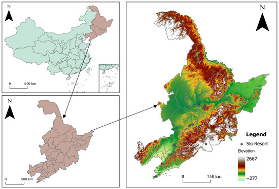
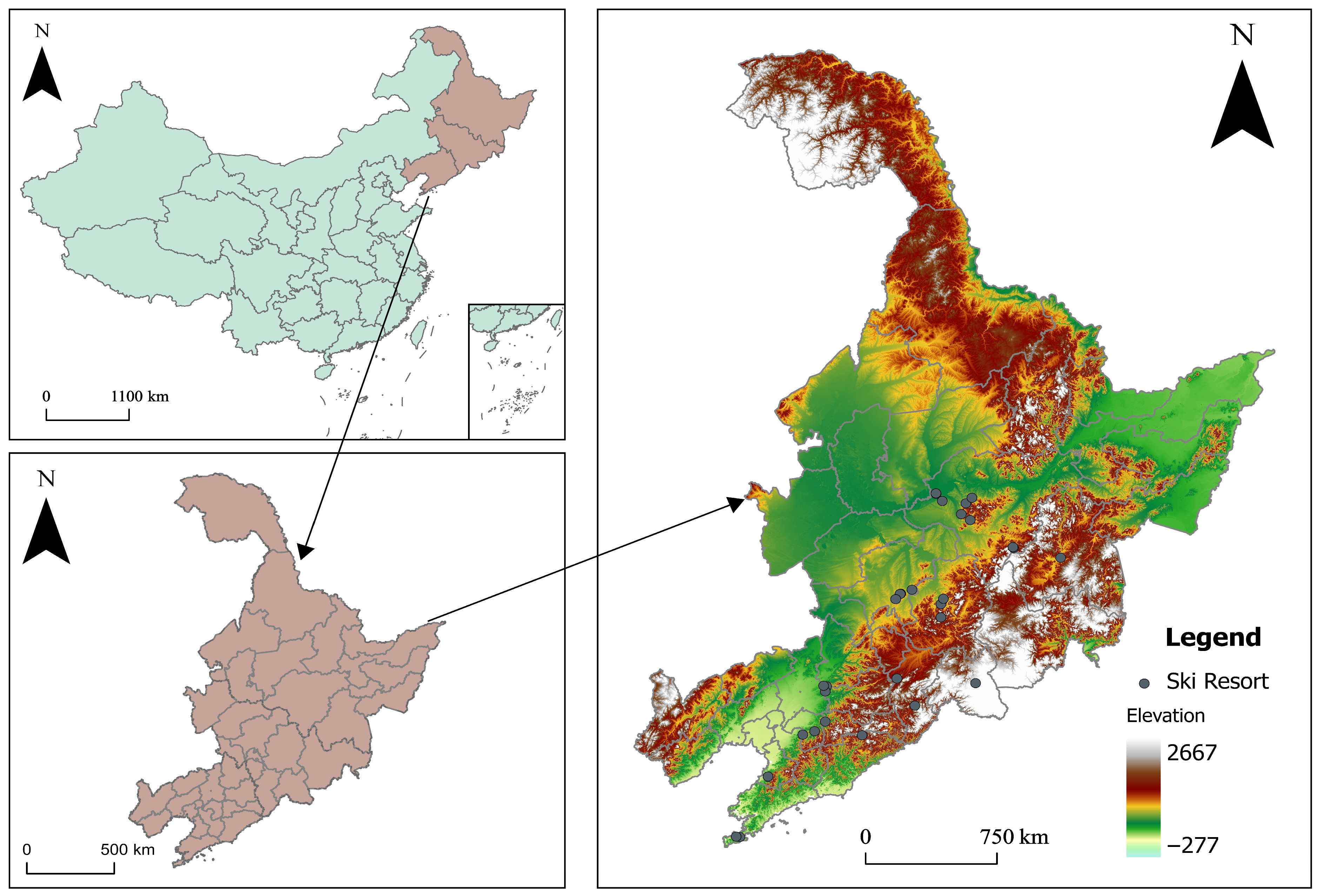
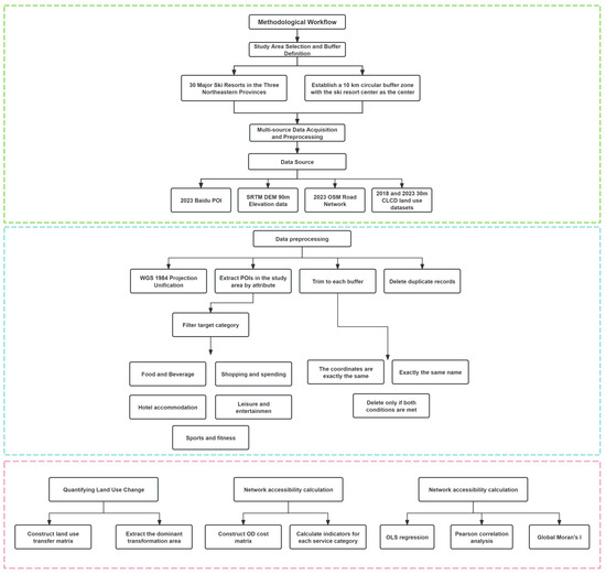
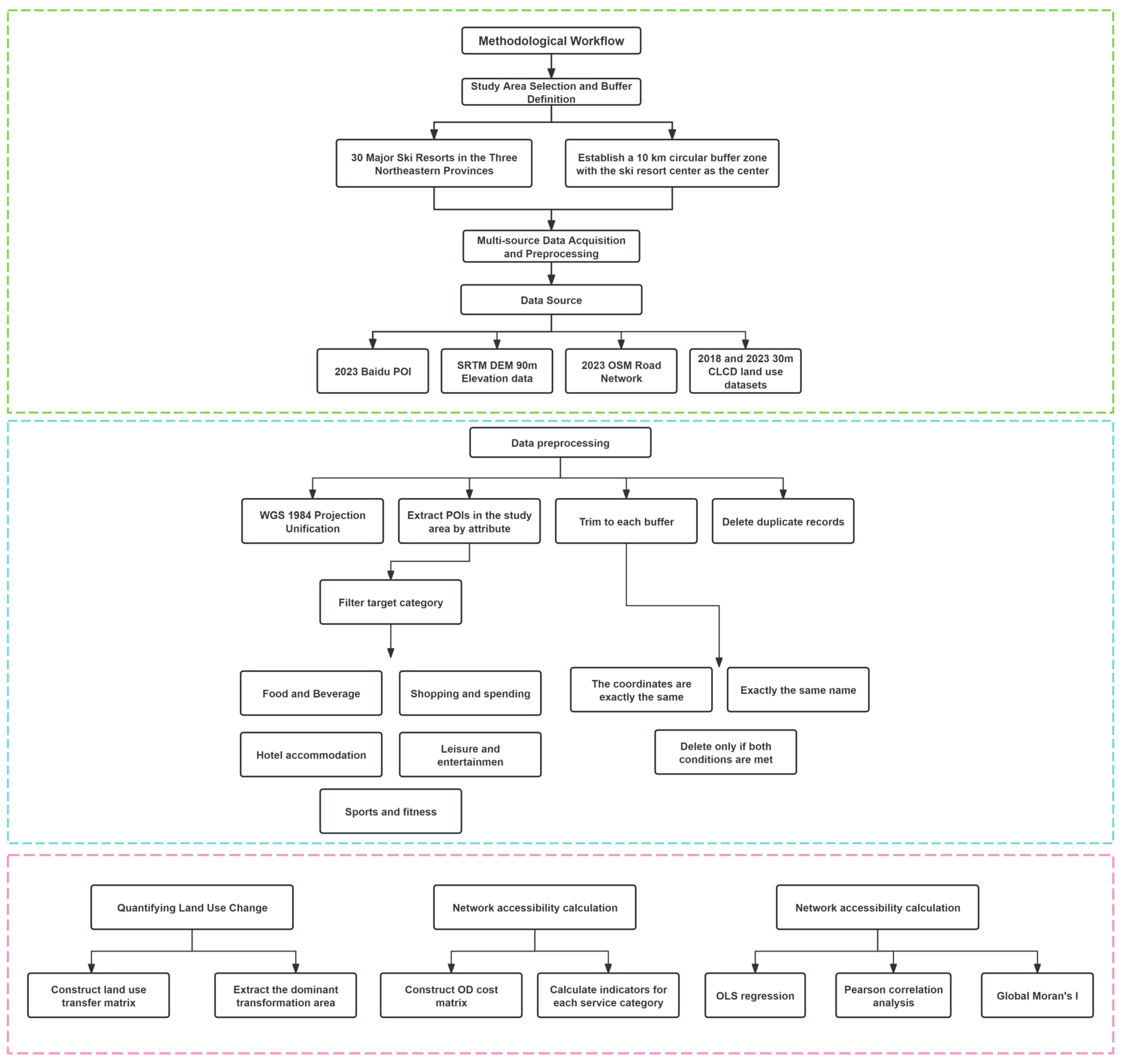
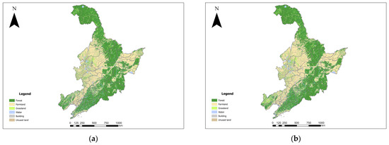
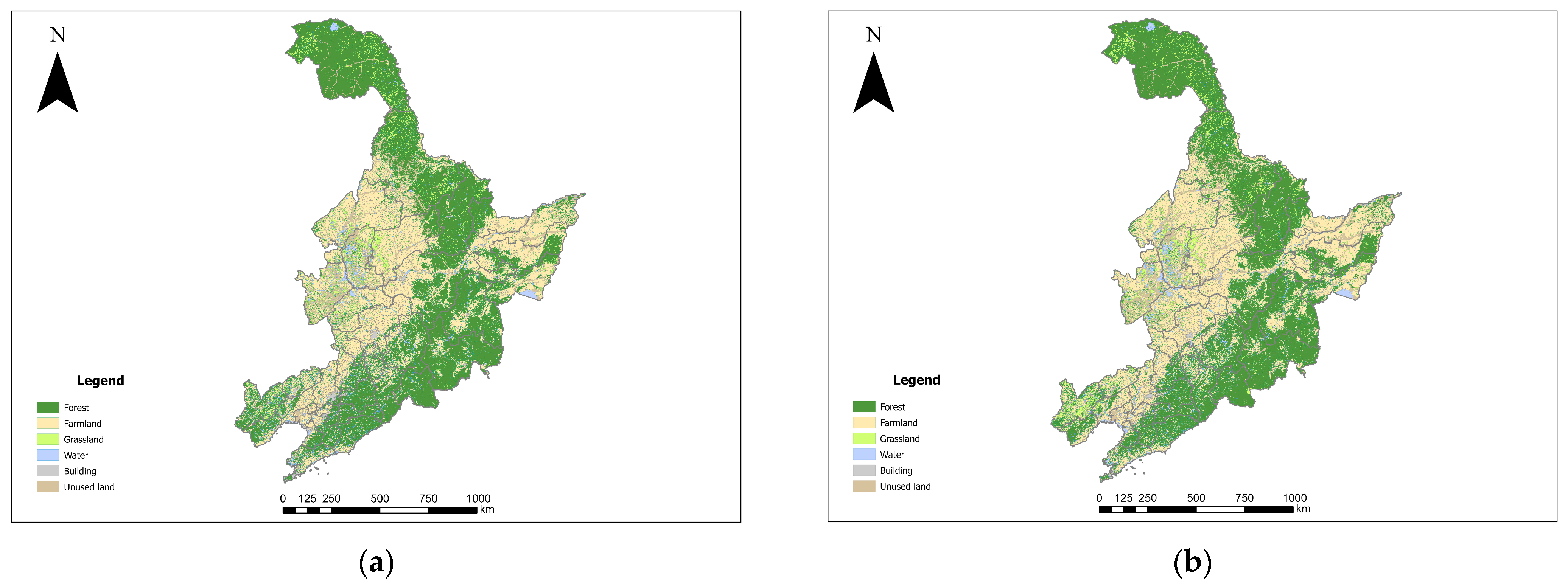
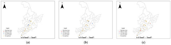
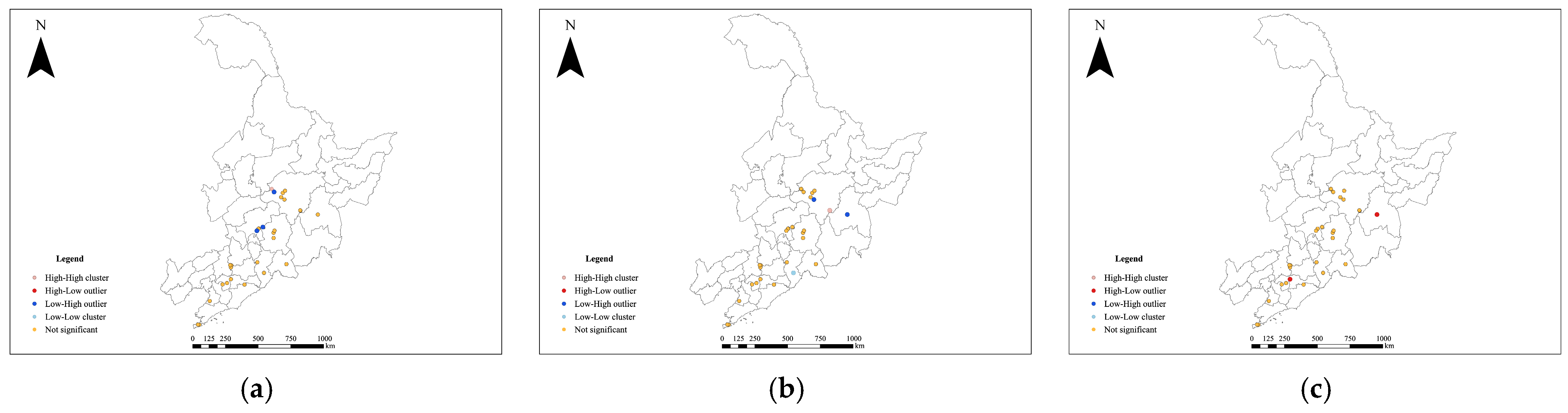
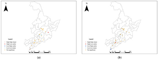
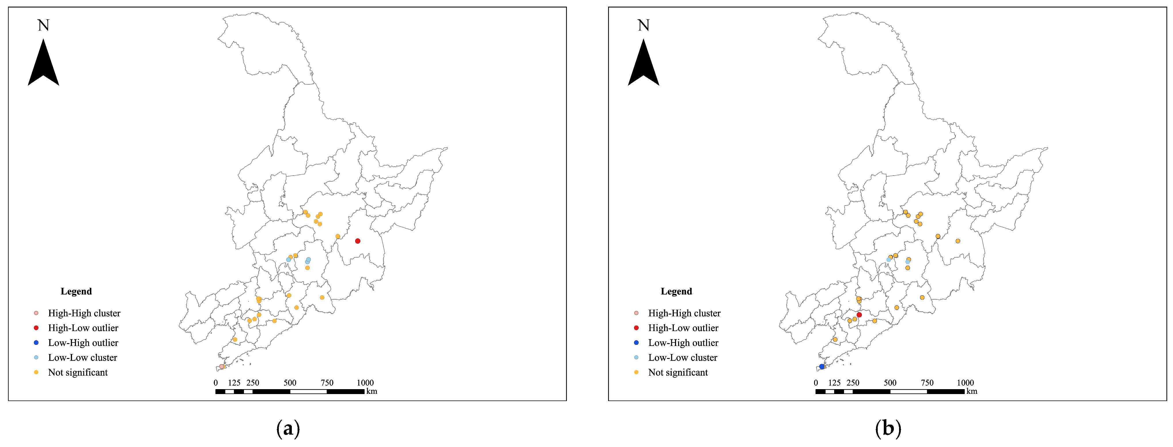

Disclaimer/Publisher’s Note: The statements, opinions and data contained in all publications are solely those of the individual author(s) and contributor(s) and not of MDPI and/or the editor(s). MDPI and/or the editor(s) disclaim responsibility for any injury to people or property resulting from any ideas, methods, instructions or products referred to in the content. |
© 2026 by the authors. Licensee MDPI, Basel, Switzerland. This article is an open access article distributed under the terms and conditions of the Creative Commons Attribution (CC BY) license.