


Abstract
The aspiring United Nations Educational, Scientific and Cultural Organization (UNESCO) Global Geopark of Chefchaouen includes part of the Talassemtane National Park (TNP), classified by UNESCO as an exceptional natural heritage site within the Intercontinental Mediterranean Biosphere Reserve (RBIM). The other section corresponds to the Ghomara Coast (GC), characterized by an outstanding succession of metamorphic rocks. This study identifies and highlights the most significant sites of geological interest (geosites and geodiversity sites) in the territory. Forty-two sites are proposed as geological heritage sites, thirty of which are organized into four accessible georoutes (Oued Laou Valley, Ghomara Coast, Talambote–Akchour, and Chaouen–Ametrasse), while the other twelve are located along trails and forest tracks inside or near the TNP. These sites cover a wide range of geological typologies, including structural geology, stratigraphy–sedimentology, paleontology, geomaterials, petrology, geomorphology, and hydrogeology. To classify and rank the sites objectively, a numerical methodology based on the recent literature was applied. Scientific value (SV), Potential Educational Use (PEU), and Potential Touristic Use (PTU) were quantified using multiple criteria, facilitating route selection according to user needs. Degradation Risk (DR) was also measured, providing managers with essential guidance for an appropriate geoconservation plan. Actions consistent with UNESCO Global Geoparks Network criteria are proposed to improve conservation, support education, and promote sustainable tourism, thereby enhancing economic activity in the region. The initiative aims to promote the region’s exceptional geological, cultural, and natural heritage. The Chefchaouen Geopark was designated a deferred candidate during the UNESCO Global Geoparks Council meeting of 8–9 September 2024. According to Section 5.5 of its guidelines, the Council may defer an application for up to two years to allow improvements without requiring a second field evaluation. To consolidate the Chefchaouen candidacy, we developed a strategy to strengthen compliance with UNESCO requirements, reduce the risk of final rejection, and maintain the territory’s credibility with international networks and partners. This work presents an operational, costed, and scheduled roadmap enabling stakeholders at all levels to converge toward a complete and coherent application.
1. Introduction
Morocco is recognized worldwide for its impressive natural, cultural, and human potential. In 2014, the M’Goun Geopark, located in the Tadla-Azilal region, was awarded the UNESCO Global Geopark label. Morocco thus became the first Arab and African country to join the Global Geoparks Network, which now comprises 229 territories in 50 countries.
A geopark is defined by UNESCO as a territory possessing geological heritage of international significance [1]. This heritage, along with other heritage within its territory (natural, tangible, and intangible cultural heritage) [2], is the subject of development strategies and the implementation of integrated and innovative sustainable development policies [3]. Geoparks are responsible for protecting, conserving, and promoting this heritage [4].
Geoparks must also achieve strategic objectives by stimulating economic activity within the framework of sustainable development [5]. Alongside geoconservation, the creation of sustainable economic development is one of the fundamental pillars of geopark development within UNESCO’s Global Geopark Network (GGN) [6]. All geoparks, therefore, share the mission, with UNESCO’s support, of fostering sustainable socio-economic development that is culturally and environmentally responsible [7].
The establishment of a UNESCO geopark designation policy will have a significant leverage effect on Morocco’s socio-economic development [8] through the creation of geoparks. This designation will encourage the creation of innovative local businesses, small enterprises, and artisanal industries, as well as training for new jobs that generate new sources of income (for example, geoproducts), all while protecting the geological natural resources of the geoparks [9]. Another important aspect that will contribute not only to socio-economic development but also to the international visibility of Moroccan heritage, and which could be part of a “soft power” influence strategy, is geotourism [10]. This is a generic term used to describe new economic opportunities focused on success and new commercial and tourism opportunities within a sustainable economic environment involving strong multidisciplinary cooperation [1] between earth sciences, geography, archaeology, biology, economics, management, tourism, the environment, agriculture, forestry, etc. It is an innovative, intelligent, and holistic territorial approach to sustainable economic development in which geoparks play a special and leading role [11]. This sustainable economic development has a direct positive impact on a geopark’s territory by improving living conditions for people and the rural and urban environment [9,10]. It strengthens the population’s identification with its territory and stimulates pride and a sense of belonging to the place and cultural development, which in turn encourages the appreciation and direct protection of the geological heritage.
Several other initiatives to integrate territories into the geopark network are under development, notably that of Chefchaouen, located in northern Morocco and an integral part of the Intercontinental Biosphere Reserve of the Mediterranean. It is a natural area listed as an exceptional heritage site of Morocco and recognized by UNESCO. A field study conducted by Aoulad-Sidi-Mhend, A. et al. (2019) [12] over several years, divided between scientific research on geological heritage and contact with local stakeholders, revealed high rates of unemployment and illiteracy in this territory [13,14], a lack of medical coverage for almost all women, and unfavorable social and economic conditions. These factors push the population, especially young people, towards illegal activities, even clandestine immigration, and the devaluation of local products [14], which unfortunately does not ensure fair compensation for producers and does not contribute to the development of their activities or improve their standard of living. It is on the basis of these observations made on the ground, and with a view to promoting and preserving its resources, that we proposed a project aimed at integrating the territory of Chefchaouen (Talassemtane Park and the Ghomara Coast) into the Global Geoparks Network, which constitutes an interesting model of sustainable development [12].
This project could contribute to encouragement and development by placing people at the center and focusing on several elements, such as training local youth in good economic practices in rural areas [11]; an educational perspective aimed at promoting the development of education better suited to the realities of the territory; an environmental perspective aimed at preserving, restoring, and improving environmental quality; and an economic perspective aimed at adding value to local products and stimulating geotourism through a range of new products, with cooperation with the local community as a prerequisite [15].
However, the presence of impressive geological sites of international importance is not sufficient in itself to constitute a geopark. A prerequisite for the approval of any geopark proposal [16] is the establishment of an effective management system and an implementation program to develop the territory sustainably. For the success of such a project, it is necessary to have a management plan aligned with the social and economic needs of the local population and cross-sectoral work between the different stakeholders from the political, economic and societal worlds, led by a management body where the partnership must have an effective management infrastructure, adequate qualified staff and sustainable financial support to undertake its mission of sustainable development [16].
Following extensive fieldwork on geological heritage [12,17,18] and consultations with stakeholders, a second nomination dossier for Morocco as a UNESCO Global Geopark was submitted in 2024. Although the dossier highlighted the region’s natural and cultural assets [19], UNESCO’s evaluation concluded that it needed significant strengthening in light of UNESCO’s key criteria, leading to its postponement. Despite the recognized potential of geoparks as instruments for geoheritage conservation and sustainable territorial development, candidates for UNESCO Global Geopark status frequently encounter difficulties in translating their heritage inventories into internationally understandable scientific narratives and operational governance systems. In the case of Chefchaouen, the UNESCO expert assessment provides a structured diagnosis that can serve as a basis for developing a traceable resubmission strategy. Therefore, this study addresses the following question: how to strengthen a deferred nomination for UNESCO Global Geopark status through a reproducible framework linking evaluation findings to corrective actions, implementation planning, and feasibility considerations? The contribution of this article lies in the construction of an evidence-based resubmission framework, integrating criteria mapping, risk mitigation, an 18-month roadmap, and an indicative cost approach. In this context, the present work proposes a structured reinforcement strategy. The objective is twofold: (i) to address the two principal non-compliances identified by UNESCO experts—Criterion (iii) (International geological significance) and Criterion (vii) [5,20] (Governance and sustainable management)—and (ii) to provide an operational, costed and time-bound roadmap for achieving full compliance in anticipation of resubmission.
This strategy is designed to mitigate three critical risks that may compromise the success of the Chefchaouen UNESCO Global Geopark (UGGp) designation process: (i) the definitive rejection of the application in the event of a renewed submission that remains non-compliant with UNESCO requirements; (ii) the potential loss of credibility of the territory within international networks and among institutional and scientific partners; (iii) delays in the implementation of sustainable territorial development pathways that are typically catalyzed by geopark recognition, including geotourism expansion, educational programming and the long-term valorization of geoheritage and associated cultural landscapes.
The approach presented in this paper is grounded in a rigorous and multi-source analytical framework combining: a detailed review of the initial application dossier submitted to UNESCO; a systematic examination of the UNESCO expert assessment report; benchmarking of governance models and operational practices from established UNESCO Global Geoparks; and alignment with international sustainability frameworks, including UNESCO’s 2030 Strategy and the Kumming–Montreal Global Biodiversity Framework [21].
This case study is situated in a national context where sustainability, protected-area management and territorial attractiveness are increasingly emphasized in policy frameworks and international cooperation agendas. While the present paper does not evaluate national policies, this context is relevant insofar as it shapes the institutional environment within which geopark governance models are operationalized, financed and assessed.
2. Study Area
The future Chefchaouen Geopark covers an area of 194,010 ha (1940.1 km2), including a maritime component extending 1 km offshore (46.78 km2). The territory is administratively divided between the provinces of Chefchaouen and Tétouan (Figure 1) and encompasses 14 territorial communes. The area is characterized by a Mediterranean climate with strong mountainous influences, marked by high annual precipitation in elevated zones and pronounced seasonal variability (Figure 2A,B). These conditions have played a key role in shaping erosion patterns (Figure 2C,D), karst development, and slope dynamics, while also supporting high levels of biodiversity. Portions of the study area overlap with protected natural spaces, notably Talassemtane National Park, reinforcing the ecological and conservation significance of the territory.
Figure 1.
Geographical position of the area aspiring to become the Chefchaouen Geopark, its municipal subdivisions and natural potential.
Figure 2.
Climatic characteristics, erosion and formation of karsts, in the study area. (A) Tracks covered with snow (village of Afaska). (B) Cascade of Akchor. (C) Stalagmites and stalactites in a limestone dorsal cave. (D). Gorge and water canyon in Oued Laou.
Beyond its physical and ecological attributes, the study area exhibits a long history of human settlement and land use, which has contributed to the development of a distinctive cultural landscape (Figure 3). Traditional practices such as terraced agriculture (Figure 3A), pastoralism, and the use of local building materials (Figure 3B) reflect enduring interactions between local communities and their physical environment. These human–environment relationships are particularly relevant in the context of geopark development (Figure 3C), as they provide opportunities to link geological heritage with cultural identity, traditional knowledge (Figure 3D), and sustainable livelihoods, in line with the holistic philosophy promoted by the UNESCO Global Geoparks program.
Figure 3.
Cultural, material and intangible characteristics in the study area: (A) crop terraces; (B) kasbah in Chefchaouen; (C) Akchor Water Mill; (D) traditional arts of Chefchaouen.
The geopark encompasses a remarkable mountain range with extensive river and stream networks crossing the Talassemtane National Park, as well as metamorphic formations and the upper Ghomara coastal zone, where geological units plunge directly into the Mediterranean Sea [12,18]. The limestone cliffs surrounding the medieval town of Chefchaouen host endemic species such as Abies marocana [22], alongside holm oaks, cork oaks, firs, and wild olive trees. The area supports diverse fauna, including birds of prey such as the golden eagle, as well as mountain goats, gazelles, and occasional troops of Barbary macaques. Together, the coexistence of geological, ecological, and cultural values highlights the integrated character of the territory and underlines its suitability for geopark designation.
2.1. Geomorphological Features and Geodiversity
The geomorphology of the area reflects the combined influence of lithology, tectonics and climate. Karst landforms are particularly well developed in carbonate formations, including caves, sinkholes, springs and underground drainage systems. These features are complemented by steep valleys, gorges, cliffs and structurally controlled ridges that provide clear visual expressions of geological processes.
Along the Ghomara coastal zone, coastal geomorphological features such as cliffs, marine terraces and erosional platforms illustrate interactions between tectonic uplift, sea-level fluctuations and coastal erosion. Inland, fluvial systems contribute to valley incision and sediment transport, further enhancing landscape heterogeneity.
The diversity and spatial distribution of these features support the identification of multiple geosites representing geomorphological, stratigraphic, tectonic and hydrological themes, forming a coherent basis for geo-interpretation and geo-education initiatives.
2.2. Geological Framework
The territory has an exceptional geological history (Figure 4), benefiting from geological diversity that has been shaped over nearly 400 million years. It is part of the western branch of the Maghreb chain, which was built as a result of the Miocene fragmentation and migration to the African–Iberian–Adrian margins of the Meso-Mediterranean microplate [23], which had been sandwiched between the European and African plates since Jurassic times. The Rif chain forms the southern flank of the Gibraltar arc and is mainly composed of three main nappe tectonic complexes: the inner zones, the Maghreb flysch and the outer zones.
Figure 4.
The main features of the geodiversity of the future Chefchaouen Geopark. (A) Geological map of the study area. (B) Talembote klippes. (C) Crenulations in the Targha micaschist. (D) Structural position of the geological units of the Internal Rif at Kodiat Achacha. (E) Exhumation of peridotites in the Aarabe Valley.
The future geopark is located in the internal Rif domain [24,25,26], more precisely in the part where the limestone ridge is most developed (Figure 4), reaching a width of around 40 km [27,28]. A large part of the geopark lies on the limestone ridge (Figure 4A), which supports klippes belonging to the Ghomarides [29,30] (Figure 2B) and Sebtides domains [31,32] (Figure 4A,D). This is a complex of thrust sheets converging to the south-west. Plio-quaternary formations occupy the Tirinisse basin [33,34] (Figure 4A), located to the north of the park, and consist mainly of marl and conglomerates.
The geologically attractive upper mantle crystalline basement (peridotites) (Figure 4E) and metamorphic basement (kinzigites, gneisses, micaschists and schists) offer a complete history of the evolution of the Alpine orogenic belt (Figure 4C) [18], a mountain chain developed as a result of the Miocene fragmentation (23.5 Ma) and migration to the African–Iberian–Adrian margins [35] of the Meso-Mediterranean microplate that had been sandwiched between the European and African plates since Jurassic times [36,37,38]. This period of the Rif’s geological history is a remarkable testimony to the geological processes that occur in the deep roots of high mountain chains and which are of fundamental importance to the world’s paleogeographic history. These terrains outcrop on the Ghomara Coast and are subdivided into (i) Lower Sebtides and (ii) Upper Sebtides or Federico units [39,40,41,42], which are either detached from their basement or in the form of small klippes on the limestone Dorsale. These are Permian–Triassic deposits, essentially schists and red pelites with little metamorphism. The Sebtides outcrop beneath the Ghomaride nappes and are covered by post-nappe Plio-Quaternary formations.
The Paleozoic terrains in the geopark outcrop to the south of Oued Laou (Figure 4A), in the form of tectonic klippes, the most important of which are the Talembote klippes (Figure 4B) [29,30]. These terrains are affected by the Hercynian orogeny and are folded and recrystallized, with a schistosandstone series that intercalates Devonian carbonate formations. This complex comprises four nappes with different stratigraphies, which are, from bottom to top, the Aakaili nappe, the Koudiat Tizian nappe, the Beni Hozmar nappe and the Talembote nappe.
The secondary sedimentary series cover a period of almost 80 million years. The diversity of lithologies and structures is linked to the diversity of epicontinental marine geological history, marked by a wide range of internal, external and intermediate sedimentary environments. The limestone Dorsale is a complex tectonic domain, corresponding to a complex of several superimposed nappes or scales verging towards the southwest, made up essentially of carbonate terrains. The paleogeographic evolution of this complex is supported by a wealth of paleontological and sedimentological data, which remains well preserved in the geopark. The terrain is predominantly carbonate, with dolomite and massive limestone from the Upper Triassic–Lower Triassic.
The inventory and a qualitative and quantitative self-assessment of the scientific value, potential uses and risk of degradation of the sites [12,18,19,20,43] showed that the 42 geological sites inventoried are scattered over three sectors and lie along 10 carriage and footpaths (Figure 5).
Figure 5.
The territory of the future Chefchaouen Geopark, the position of the 42 geodiversity sites and their distribution along 10 routes, as well as habitats of endemic species.
These sites can also be classified, according to their typology or geological framework, by structural geology, stratigraphy, petrography, paleontology, geomorphology, hydrogeology and geomaterial (Figure 6).
Figure 6.
The five themes in the study area (water and karst, natural risk, coastal dynamics, regional geology, exploitation of resources) that group the 7 GS typologies.
We have retained only 30 of these sites, which have an accessibility criterion equal to 4 and where there is a tourist infrastructure suitable for exploitation [12,18,19,20]. The rest could be developed at a later date. The development of the selected sites has taken the form of four geotours (Figure 5) (the Oued Laou valley geotour (8 stops), the Rueda–Akchour geotour (4 stops), the Chaouen–Ametrasse geotour (12 stops) and the Ghomara Coast geotour (6 stops)), covering various themes (Figure 6) such as regional geology, water and karst, natural and environmental risk, use of natural resources, and coastal dynamics.
The combination of geological diversity, geomorphological richness, ecological significance and cultural heritage positions the Chefchaouen territory as a relevant case study for examining the challenges and opportunities associated with aspiring UNESCO Global Geoparks. However, as highlighted by the UNESCO expert evaluation, the scientific significance of these attributes must be articulated through structured narratives, governance mechanisms and interpretation tools to meet international standards.
In this respect, the study area provides an appropriate spatial and conceptual framework for analyzing how geological heritage can be translated into a coherent geopark model and how institutional and operational factors influence the success of geopark designation processes.
3. Materials and Methods
3.1. Study Design and Analytical Framework
This study adopts a structured documentary analysis approach aimed at identifying: (i) the main compliance gaps that led to the deferral of the Chefchaouen UNESCO Global Geopark (UGGp) application; (ii) the most appropriate corrective measures required to achieve full alignment with UNESCO Global Geoparks Operational Guidelines [44]. The analytical framework was designed to generate an operational reinforcement strategy combining governance restructuring, scientific mediation, community integration and financial planning.
The methodological process consisted of four interconnected phases:
- (1)
- Data sourcing and preparation;
- (2)
- Qualitative and criterion-based analysis;
- (3)
- AI-assisted synthesis and strategy generation;
- (4)
- Cross-validation through benchmarking and expert-aligned verification.
3.2. Data Sources and Documentary Corpus
The documentary corpus analyzed in this study was composed of:
- The official UNESCO Global Geopark application file submitted for Chefchaouen [30] including the territorial description, scientific narratives, governance model, development plan and annexes.
- The UNESCO expert evaluation report including detailed remarks, identified weaknesses, compliance criteria and final decision rationale.
- UNESCO Global Geoparks operational guidelines and evaluation criteria [44,45], including the expected governance standards, geoconservation requirements, interpretation and education criteria, and network engagement expectations [46].
- Supplementary comparative references, including publicly available documentation and case practices from established UNESCO Global Geoparks with similarities in governance complexity, geoheritage profile, or socio-economic context [47].
All documents were reviewed in full to avoid selective interpretation and to ensure that recommendations remained traceable to the initial UNESCO evaluation.
3.3. Criterion-Based Analytical Procedure
A criterion-based assessment was carried out to systematically map the UNESCO remarks against the requirements of the UGGp designation process. Particular emphasis was placed on the two non-compliances explicitly identified by the UNESCO Council:
- Criterion (iii): demonstration and communication of international geological significance [48].
- Criterion (vii): governance maturity and sustainable territorial management capacity [20,49,50].
For each criterion, the analysis followed a standardized procedure:
- Identification of evaluation statements (verbatim remarks or summarized expert findings).
- Translation into structured compliance gaps (what is missing or insufficient).
- Cause–effect analysis (why the gap occurred and what it produces as a risk).
- Corrective measures aligned with UNESCO expectations and geopark best practices.
- Operationalization into a time-bound plan with responsible actors and measurable deliverables.
This framework enabled the conversion of qualitative UNESCO feedback into a structured strategy with actionable outputs.
3.4. AI-Assisted Synthesis and Prompt Engineering Approach
The analytical workflow integrated a structured AI-assisted component to improve traceability, coherence, and the systematic alignment between UNESCO evaluation remarks and corresponding corrective measures. The aim was not to replace expert judgment but to support the synthesis of complex documentation and multi-criteria analyses.
3.4.1. Model Type and Functional Scope
The approach relied on a transformer-based large language model (LLM) capable of contextual semantic analysis, structured extraction, and summarization across extended texts. The system was used strictly as a decision-support tool for:
- Extracting criterion-based information;
- Mapping cause–effect relationships;
- Reformulating expert remarks;
- Drafting risk matrices and action frameworks.
All outputs were validated by humans; no unsupervised or autonomous decisions were accepted.
3.4.2. Controlled Prompt Engineering Design
A constrained prompt engineering protocol ensured methodological rigor through:
- Source restriction: prompts were limited exclusively to the UNESCO expert report and the original application dossier, with no external data.
- Criterion-mapping structure: outputs had to follow a fixed format: (i) finding, (ii) underlying cause, (iii) risk implication, (iv) recommended action, (v) measurable deliverable.
- Non-hallucination constraint: instructions explicitly prevented the generation of information not present in the input documents.
Example: “Extract all remarks related to Criterion (iii) and reorganize them into (1) explicit criticism, (2) governance or narrative gaps, and (3) measurable corrective measures aligned with UNESCO guidelines.”
3.4.3. Human Validation and Iterative Refinement
Experts in geoheritage, governance, and territorial planning reviewed all AI outputs through direct comparison with UNESCO texts, verification of factual accuracy, removal of speculative content, and refinement of terminology. Iterative prompting improved clarity and alignment with UNESCO vocabulary.
3.4.4. Advantages of the Approach
The method improved structural consistency, accelerated the identification of governance gaps, strengthened traceability between findings and actions, and supported risk-classification logic. It helped convert qualitative remarks into an operational resubmission framework.
3.4.5. Limitations
Limitations include dependence on document quality, sensitivity to prompt design, risk of semantic overgeneralization, and the inability to replace contextual institutional knowledge. AI outputs remained drafts requiring expert validation.
3.4.6. Reproducibility Considerations
The criterion-mapping logic and risk-classification rules are detailed in the manuscript, allowing replication in other UNESCO Global Geopark resubmission contexts or similar territorial designation processes.
3.5. Cross-Validation and Contextual Enrichment
To enhance the robustness and credibility of the proposed reinforcement strategy, an additional cross-validation phase was conducted to ensure that AI-assisted outputs remained (i) consistent with UNESCO expectations, (ii) aligned with observed practices in established UNESCO Global Geoparks, and (iii) operationally feasible within the Moroccan institutional context.
This phase involved three complementary validation mechanisms:
3.5.1. Benchmarking Against Reference UNESCO Global Geoparks
A comparative review was conducted using selected UNESCO Global Geoparks recognized for strong governance models, effective scientific mediation and community-based development. Emphasis was placed on geoparks displaying comparable characteristics to Chefchaouen (e.g., mountainous and karst landscapes, multi-commune governance settings, protected-area interfaces and strong cultural identity). Practices related to interpretation design, geoconservation, institutional structuring, education programming and network engagement were systematically extracted and used as reference points.
3.5.2. Alignment with International Sustainability and Policy Frameworks
Recommendations were checked for consistency with UNESCO’s strategic orientations and sustainable development frameworks, particularly those emphasizing local development, environmental education and community empowerment. This ensured that the strategy did not solely address technical compliance but also reinforced the broader socio-environmental purpose expected of UNESCO Global Geoparks.
3.5.3. Feasibility Screening Within the Moroccan Territorial and Institutional Context
Each proposed action was reviewed to assess its institutional realism, resource requirements, stakeholder capacity and implementation constraints. This step supported the transformation of recommendations into an operational 18-month roadmap including governance arrangements, budget estimates and prioritized deliverables.
Through this cross-validation and contextual enrichment phase, the resulting strategy was strengthened to ensure that it was simultaneously UNESCO-compliant, benchmark-informed and locally implementable.
3.6. AI Reproducibility and Safeguards Paragraph
To enhance reproducibility and reduce the risk of uncontrolled generation, the AI-assisted steps were conducted using a constrained prompt design specifying (i) the exclusive use of the application dossier and UNESCO expert report as primary inputs, (ii) criterion-based extraction rules, and (iii) structured output formats (finding → cause → corrective measure → action). Outputs were systematically cross-checked by domain experts against the original source documents to verify factual consistency and to prevent hallucinated claims. The prompt structure and mapping templates are provided as Supplementary Materials to support transparency and replication.
4. Results
4.1. Findings from the UNESCO Expert Evaluation
This section synthesizes the UNESCO expert evaluation into a criterion-based diagnostic, emphasizing the two non-compliances that most strongly condition resubmission success.
4.1.1. Positive Elements Recognized by UNESCO Evaluators
The UNESCO expert evaluation acknowledged that the Chefchaouen territory exhibits strong potential to become a UNESCO Global Geopark. The assessment emphasized the richness and diversity of the geoheritage resources across the proposed area, as well as the strong natural and cultural value of the territory, particularly in the Talassemtane National Park core zone and the Ghomara coastal sector. The evaluators also recognized the presence of multiple geosites with significant scientific, educational and geotourism relevance, as well as promising initiatives already initiated at the local level.
Beyond geoheritage, the evaluation considered that the integration of biodiversity conservation areas and the presence of local cultural identity offer a favorable foundation for geopark development. The involvement of local actors—including associations, cooperatives, municipalities and academic institutions—was also considered a positive driver for future governance consolidation and participatory implementation.
4.1.2. Main Non-Compliances Identified by UNESCO
Despite these strengths, the UNESCO Global Geoparks Council classified the Chefchaouen application as a deferred candidate, indicating that the submission required substantial reinforcement prior to resubmission. The deferral was primarily justified by insufficient compliance with two essential criteria explicitly referenced by UNESCO evaluators:
- Criterion (iii): International geological significance.
- Criterion (vii): Governance and sustainable management capacity.
These two gaps constitute the empirical basis of the reinforcement strategy developed in this study.
4.1.3. Detailed Assessment of Non-Compliance with Criterion (iii): International Geological Significance
The evaluation concluded that the application dossier did not sufficiently demonstrate the international geological significance of the territory. While the area contains notable geological features and has been the subject of research, UNESCO evaluators emphasized that these scientific assets were not clearly expressed in the submitted narrative. The geological story was perceived as overly technical, insufficiently accessible for non-specialists and affected by conceptual inaccuracies that weakened the overall credibility of the international significance argument.
- Cause–effect analysis:
The diagnosis suggests that the non-compliance was primarily driven by the following:
Insufficient scientific mediation: the geological narrative was not translated into a coherent, simplified storyline consistent with UNESCO expectations for public-facing interpretation.
Weak international framing: local geological features were insufficiently positioned within recognized global geodynamic processes (e.g., Alpine orogenesis, Western Mediterranean evolution, and plate convergence).
Lack of dedicated scientific coordination: the absence of a full-time geoscientific coordinator likely contributed to inconsistencies and insufficient peer validation.
The consequence of this gap is critical: UNESCO Global Geopark designation requires the demonstration of a territory’s geological relevance beyond national or regional interest. Failure to explicitly establish international significance weakens the core scientific justification of the geopark concept.
- Corrective measures:
To address Criterion (iii), the reinforcement strategy recommends:
Establishing a multidisciplinary scientific writing team (geoscientists + science communication specialists) to rewrite the geological narrative in a structured and accessible form;
Producing a multilingual illustrated geological storyline, including simplified maps, cross-sections and interpretation tools aligned with educational needs;
Conducting an external scientific validation process through peer review by recognized experts and/or established UNESCO Global Geoparks;
Ensuring a consistent citation of internationally recognized publications supporting the geodynamic relevance of the Rif belt and associated geomorphological systems.
4.1.4. Detailed Assessment of Non-Compliance with Criterion (vii): Governance and Sustainable Management Capacity
The evaluation highlighted that the governance configuration presented in the application was not sufficiently mature for a geopark of this scale. Governance appeared to rely primarily on a single association, without a clearly defined autonomous legal structure or an operational multiannual management plan able to ensure long-term implementation. UNESCO evaluators suggested that the application would have benefited from additional time to mature, particularly regarding institutional structuring, coordination mechanisms and the establishment of a dedicated management team.
- Cause–effect analysis:
The non-compliance with Criterion (vii) can be attributed to the following:
Governance centralization and unclear institutional roles: the distribution of responsibilities among associations, communes and potential institutional partners was not sufficiently formalized.
Insufficient professionalization: the absence of a full geopark management team weakens operational capacity and continuity.
Limited strategic planning and monitoring: the plan of action lacked a clear management framework including measurable objectives, indicators and accountability mechanisms.
Financial sustainability uncertainty: lack of consolidated multiannual budgeting reduces credibility regarding implementation feasibility.
The direct consequence is that UNESCO may consider the territory unable to sustain geopark activities (education, geoconservation, community development and international networking) over the long term, which is a core expectation for UNESCO Global Geoparks.
4.1.5. Recommended Corrective Measures
To address Criterion (vii), the reinforcement strategy recommends:
- Establishing an autonomous governance entity (consortium, agency, public-interest grouping, or equivalent structure) with formal mandates;
- Defining a functional organizational structure, including a director, scientific coordinator, education officer and communication/partnership leads;
- Developing a multiannual management plan (2025–2029) co-built with stakeholders, including measurable targets and monitoring indicators;
- Securing a multiannual funding framework to demonstrate operational sustainability.
4.1.6. Interpretation of the UNESCO Deferral and Lessons Learned
The Chefchaouen deferred candidature demonstrates that the success of a UNESCO Global Geopark application is not determined solely by the intrinsic quality of geoheritage, but also by the capacity to translate scientific value into an internationally framed narrative and to demonstrate mature governance systems. This highlights a recurring pattern observed in geopark evaluation processes: territories may possess exceptional geodiversity yet fail to meet UNESCO expectations when scientific mediation and institutional structuring remain insufficiently developed.
4.1.7. Benchmarking with Established UNESCO Global Geoparks
Comparative benchmarking indicates that successful UNESCO Global Geoparks generally present:
- A clear and public-friendly geological narrative supported by scientific evidence;
- Visible and coherent geopark branding (signage, interpretation panels, and official web platforms);
- Professional governance structures ensuring continuity and accountability;
- Strong community integration through partnerships, education and local economic initiatives;
- Active participation in the Global Geoparks Network (GGN), including exchanges and joint projects.
These best practices provide direct guidance for Chefchaouen, particularly through collaboration and twinning with established geoparks in Morocco and Europe.
4.1.8. Implications for Sustainable Development and Morocco’s International Positioning
Reinforcing the Chefchaouen application contributes to Morocco’s broader strategy of sustainability and international visibility. UNESCO geopark designation offers a practical territorial mechanism for implementing Sustainable Development Goals (SDGs), particularly those related to quality education, sustainable tourism, biodiversity and community resilience. In addition, geoparks constitute tools of environmental diplomacy and international cooperation, consistent with Morocco’s climate and sustainability commitments.
Importantly, this national framing is relevant insofar as it provides the policy and institutional environment within which geopark governance models are operationalized and evaluated and within which territorial sustainability strategies may be implemented at scale.
4.1.9. Limitations and Future Research
This study is primarily based on documentary analysis (application file, UNESCO evaluation report and operational guidelines) and does not replace in situ audits or additional stakeholder interviews that could further refine governance and implementation recommendations. Budget estimates are strategic projections that should be refined through institutional costing and formal budget validation. Future work should focus on piloting interpretation tools, measuring community-based economic impacts and evaluating visitor experience outcomes.
Building on the UNESCO expert evaluation findings and the causal analysis of the two key non-compliances (Criteria (iii) and (vii)), the following section translates the diagnostic into an implementation-oriented resubmission framework. This framework combines a risk mitigation plan, an 18-month action roadmap and governance mechanisms designed to ensure traceability between UNESCO recommendations, corrective measures and operational deliverables.
4.2. Implementation Framework for Resubmission
Risk Mitigation Plan: Risk Matrix and Response Measures
To strengthen the resubmission strategy and ensure long-term compliance with UNESCO Global Geopark standards, a risk-based management approach was adopted. Risks were identified from (i) UNESCO expert remarks, (ii) geopark governance requirements and (iii) implementation constraints typical of multi-commune territories.
Each risk was assessed according to a qualitative likelihood–impact (L–I) matrix, using three levels: Low (L), Medium (M), and High (H). Risk severity was defined as a function of combined likelihood and impact, generating three priority levels (Priority 1: Critical, Priority 2: Significant, and Priority 3: Moderate). This framework enabled traceable decision-making and monitoring over the 18-month implementation period.
Likelihood was defined as the probability that a risk would materialize within the 18-month horizon without mitigation (Low = unlikely; Medium = plausible; High = likely). Impact was defined as the expected consequence on UNESCO compliance, delivery schedule, stakeholder credibility and long-term operational sustainability (Table 1).
- Likelihood–Impact Matrix
Table 1.
Likelihood–impact matrix.
- b.
- Consolidated risk register and mitigation measures
The table bellow (Table 2) presents the consolidation of risk register and mitigation measures, by degree of severity, response measures, risk owners and KPI.
Table 2.
Consolidated risk register and mitigation measures.
- c.
- Priority actions and risk governance mechanism
Based on the severity assessment, Priority 1 risks (R1, R2, R3, R4, and R7) require immediate implementation from Month 1, as they directly relate to UNESCO decision criteria and long-term geopark credibility.
To ensure continuous monitoring, a risk governance mechanism is recommended:
- Quarterly risk review meetings, chaired by the geopark director;
- A risk dashboard tracking KPIs and corrective action progress;
- Integration of the risk register into the 2025–2029 management plan and annual reporting processes.
Eighteen (18)-month operational roadmap for resubmission
To operationalize the reinforcement strategy and enable a credible resubmission process, an 18-month roadmap was developed. The roadmap is structured around four operational axes that directly respond to UNESCO evaluation requirements and geopark standards: (i) scientific reinforcement and geological interpretation; (ii) governance structuring and management planning; (iii) visibility and interpretation infrastructure; (iv) community integration and partnerships.
The roadmap is organized into phased milestones and deliverables, with an emphasis on traceability (linkage to UNESCO criteria), feasibility and measurable outputs. A quarterly monitoring mechanism is recommended (Section 5.1) to ensure timely delivery and adaptive management.
- Roadmap structure and implementation logic
The roadmap follows a sequencing logic designed to address Priority 1 risks early in the process:
- Months 1–6: address the scientific credibility gap under Criterion (iii) and establish the governance foundation under Criterion (vii).
- Months 4–14: deploy core visibility and interpretation infrastructures to demonstrate tangible geopark identity and visitor-oriented delivery.
- Months 6–18: consolidate community integration, education programs and network engagement, ensuring long-term sustainability and UNESCO network readiness.
- b.
- Roadmap by operational axis: actions, deliverables and KPIs
Axis 1—Scientific reinforcement and interpretation (Months 1–6).
Strategic purpose: Address UNESCO Criterion (iii) by strengthening the demonstration and communication of international geological significance.
Key actions and deliverables:
- •
- A1.1. Establish an international scientific committee (Month 1).
- -
- Deliverable: committee mandate, membership list and terms of reference.
- •
- A1.2. Conduct an external audit of the existing geological narrative (Months 1–2).
- -
- Deliverable: gap analysis report aligned with Criterion (iii).
- •
- A1.3. Rewrite the geological narrative (multilingual and visitor-oriented) (Months 2–4).
- -
- Deliverables: revised narrative in English/French/Arabic; simplified geological storyline.
- •
- A1.4. Produce scientific mediation tools (Months 3–6).
- -
- Deliverables: interpretation map, cross-sections, infographics and geosite factsheets.
- •
- A1.5. External peer validation workshops (Months 5–6).
- -
- Deliverables: workshop proceedings; peer validation statement; revised final outputs.
Monitoring indicators (KPIs):
- Geological narrative revised and validated (EN/FR/AR).
- Number of peer-reviewed references integrated.
- Scientific committee formally operational (meetings held and outputs delivered).
- Number of interpretation tools produced (factsheets, maps, and panel content drafts).
Axis 2—Governance structuring and management planning (Months 1–12).
Strategic purpose: Address UNESCO Criterion (vii) by ensuring governance maturity, institutional readability and long-term management capacity.
Key actions and deliverables:
- •
- A2.1. Establish a dedicated legal governance entity (Months 1–4).
- -
- Deliverables: legal status, governance charter, institutional agreements.
- •
- A2.2. Define governance architecture and operational roles (Months 2–5).
- -
- Deliverables: organigram; job descriptions; governance board procedures.
- •
- A2.3. Recruit or formalize the core geopark team (Months 3–8).
- -
- Deliverables: director; scientific coordinator; education officer; communication and partnerships lead; geoguides.
- •
- A2.4. Develop a multiannual management plan (2025–2029) (Months 4–12).
- -
- Deliverables: management plan document; monitoring indicators; reporting mechanism.
Monitoring indicators (KPIs):
- Legal entity created and governance charter signed.
- Number of board meetings and stakeholder coordination sessions.
- Core staff contracted and operational.
- Management plan drafted and formally approved.
Axis 3—Visibility and interpretation infrastructure (Months 4–14).
Strategic purpose: Demonstrate operational geopark delivery through consistent branding, interpretation and visitor-oriented infrastructure (UNESCO expectation for visibility, education and territorial coherence).
Key actions and deliverables:
- •
- A3.1. Develop a trilingual official geopark website (Months 4–7).
- -
- Deliverables: website (EN/FR/AR); geosite database; education resources.
- •
- A3.2. Install interpretation and signage systems (Months 6–14).
- -
- Deliverables: minimum 25 durable interpretation panels; signage guideline.
- •
- A3.3. Publish geopark visitor tools (Months 7–12).
- -
- Deliverables: geopark map; guidebook; brochures; QR-linked digital content.
- •
- A3.4. Participate in international geopark events (Months 8–14).
- -
- Deliverables: participation reports; networking outputs; joint initiatives.
Monitoring indicators (KPIs):
- Website launched and maintained (traffic and downloads).
- Number of panels installed and geosites covered.
- Number of visitor tools distributed and accessed.
- Number of international events attended and outputs produced.
Axis 4—Community integration, education and partnerships (Months 6–18).
Strategic purpose: Consolidate the UNESCO geopark philosophy through local engagement, education and sustainable community-based development.
Key actions and deliverables:
- •
- A4.1. Develop and adopt a “Geopark Partner Charter” (Months 6–10).
- -
- Deliverables: charter document; partner commitments; verification mechanism.
- •
- A4.2. Deploy an education program across schools (Months 8–18).
- -
- Deliverables: educational kits; teacher training; annual geopark learning events.
- •
- A4.3. Support local cooperatives and tourism actors (Months 8–18).
- -
- Deliverables: capacity-building sessions; product valorization; geopark partner labeling scheme.
- •
- A4.4. Formalize twinning agreements with established geoparks (Months 6–12).
- -
- Deliverables: signed agreements (e.g., M’Goun); joint training and exchange program.
Monitoring indicators (KPIs):
- Number of signed geopark partners (cooperatives, guides, guesthouses, and institutions).
- Number of schools engaged and education sessions delivered.
- Evidence of local economic valorization (products, services, and visitor flows).
- Number of exchanges and joint outputs with established geoparks.
- c.
- Milestone schedule (summary timeline):
- Months 1–2: scientific committee established; audit of narrative; governance entity design.
- Months 3–4: narrative rewrite initiated; governance legal structuring; early recruitment.
- Months 5–6: peer validation workshops; interpretation tools finalized; governance board operational.
- Months 7–9: website and visitor tools launched; signage deployment begins; partner charter drafted.
- Months 10–12: management plan finalized; twinning agreements signed; education program scaled.
- Months 13–18: full visibility deployment; education and partnerships consolidated; monitoring reports produced.
- d.
- Reporting and monitoring requirements:
To ensure transparency and UNESCO-aligned accountability, it is recommended that:
- A quarterly progress report be produced using the KPIs above;
- A mid-term review (Month 9) be conducted to adjust activities and budgets;
- An end-of-roadmap synthesis report (Month 18) be produced to support the resubmission narrative and demonstrate readiness.
Because implementation feasibility is closely linked to resource availability, the following section provides an indicative cost framework aligned with the proposed roadmap and the corrective measures required to address Criteria (iii) and (vii).
4.3. Financial Feasibility and Implementation Cost Framework
The feasibility of the proposed reinforcement strategy was assessed through an indicative implementation cost framework (Table 3). The purpose of this exercise is not to provide an audited budget or a standalone business plan, but to estimate the order of magnitude of resources required to ensure effective implementation and long-term sustainability in line with UNESCO Global Geopark governance expectations.
Table 3.
Summary indicative implementation cost framework (USD) for the 18-month reinforcement strategy of the Chefchaouen UNESCO Global Geopark application.
Based on the proposed 18-month roadmap, the estimated implementation envelope amounts to approximately 453,000 USD. This estimate reflects the minimum level of resources required to address the main non-compliances identified during the UNESCO evaluation process, particularly regarding governance maturity (Criterion (vii)) and scientific mediation capacity (Criterion (iii)).
Implementation costs were estimated using a hybrid staffing-based and deliverable-based approach, anchored in Morocco-based salary benchmarks and a simplified employer-cost factor reflecting statutory social contributions (including AMO). The framework prioritizes governance professionalization (Criterion (vii)) and scientific mediation outputs (Criterion (iii)), while international cooperation is costed as output-linked activities consistent with UNESCO reporting expectations.
Note: Figures represent indicative orders of magnitude derived from deliverable-based costing and Morocco-based staffing assumptions; they do not constitute an audited financial plan.
5. Discussion
5.1. Interpretation of the UNESCO Evaluation Findings
The UNESCO expert evaluation of the Chefchaouen Geopark application highlights two critical non-compliances related to Criterion (iii), concerning the demonstration and communication of international geological significance, and Criterion (vii), concerning governance and long-term management capacity. These findings should not be interpreted as isolated shortcomings specific to the Chefchaouen context, but rather reflect recurrent challenges observed in many UNESCO Global Geopark applications. This interpretation is consistent with UNESCO Global Geoparks Council outcomes and operational guidance, which document that applications may be deferred when governance, interpretative capacity, and evidence of international significance are insufficiently demonstrated [44].
In several sessions of the UNESCO Global Geoparks Council, applications have been deferred to allow improvements in governance, scientific documentation and interpretation strategies to meet criteria, and some aspiring geoparks with apparent geological value have not yet been endorsed, particularly in regions with developing institutional capacities.
Previous assessments within the UNESCO Global Geoparks Network have repeatedly emphasized that the transition from a protected natural area or geopark initiative to a fully recognized UNESCO Global Geopark requires a qualitative shift from descriptive inventories toward integrated narratives, institutional maturity and operational coherence [15,51]. In this respect, the Chefchaouen case illustrates a common gap between the existence of substantial geological heritage and the capacity to articulate its significance within an internationally intelligible scientific and educational framework.
The evaluation findings thus reflect a structural issue: geological value alone is insufficient to meet UNESCO Global Geopark standards if it is not supported by robust scientific mediation tools, peer validation mechanisms and a governance structure capable of sustaining long-term implementation. This interpretation aligns with broader observations in the geopark evaluation literature [52], where governance and mediation are increasingly recognized as decisive factors in successful designation and long-term network integration.
5.2. Governance and Scientific Mediation as Critical Success Factors
The proposed analytical framework confirms that governance professionalization and scientific mediation constitute interdependent pillars of UNESCO Global Geopark credibility. Criterion (vii) explicitly requires not only the existence of a management structure, but also demonstrable operational capacity, decision-making clarity, financial sustainability and stakeholder coordination across administrative boundaries [51,52].
In the Chefchaouen case, the absence of a clearly identifiable governance entity and a dedicated multidisciplinary team limited the ability to translate strategic intent into coherent action. This finding resonates with comparative studies of geoparks in both developed and emerging contexts, where weak institutional anchoring has been identified as a recurrent obstacle to sustainable territorial initiatives.
Similarly, Criterion (iii) underscores the importance of moving beyond geological inventories toward structured scientific narratives capable of communicating global significance to diverse audiences. Scientific mediation emerges here as a bridging mechanism between academic knowledge, territorial identity and public engagement. The results suggest that peer-reviewed validation, multilingual interpretation tools and visually coherent storytelling are not ancillary components, but central requirements for UNESCO recognition.
Taken together, these findings reinforce the notion that governance capacity and scientific mediation [53] should be conceptualized as core infrastructural investments rather than peripheral enhancements within geopark development strategies.
5.3. Added Value and Limitations of an AI-Assisted Analytical Framework
An original contribution of this study lies in the use of an AI-assisted analytical framework to structure the diagnostic [54], risk assessment and strategic response to the UNESCO evaluation. The application of artificial intelligence tools facilitated the systematic extraction of evaluation criteria, the identification of causal relationships between non-compliances and underlying institutional gaps, and the construction of a traceable action framework aligned with UNESCO standards.
From a methodological standpoint, the use of AI proved particularly valuable in managing complex, multi-source documentation and ensuring internal coherence across analytical layers (findings, risks, actions, and costs). This approach enhanced transparency and reproducibility, two qualities increasingly valued in applied sustainability research.
However, the study also highlights clear limitations. AI-assisted analysis does not replace expert judgment, field knowledge, or institutional negotiation processes. The quality of outputs remains highly dependent on the quality of input data, the framing of prompts and the critical oversight exercised by domain experts. Consequently, AI should be viewed as a decision-support tool rather than an autonomous analytical agent in geopark planning contexts.
5.4. SWOT Framework for Assessing the Chefchaouen Geopark’s Strengths and Challenges
To complement the criterion-based diagnostic and risk mitigation framework, Table 4, present a structured SWOT analysis to synthesize internal and external factors influencing the resubmission process.
Table 4.
SWOT analysis of the Chefchaouen Geopark Declaration.
The SWOT analysis confirms that the Chefchaouen territory possesses strong intrinsic geological and landscape assets, but that institutional and communicative dimensions require targeted reinforcement. The interaction between internal weaknesses and external threats highlights governance professionalization as the central determinant of resubmission success.
The SWOT synthesis supports the prioritization of actions addressing Criteria (iii) and (vii), reinforcing the coherence between the diagnostic, risk framework and financial feasibility assessment [55].
5.5. Limitations and Directions for Future Research
This study presents several limitations that warrant consideration. First, it is based on a single case study, which constrains the generalizability of the findings. While comparative references were incorporated, future research could benefit from systematic cross-case analyses of unsuccessful and successful geopark applications.
Second, the financial feasibility framework relies on indicative cost estimates rather than audited financial data. Although this approach is appropriate for strategic planning, future studies could explore longitudinal financial performance and funding diversification mechanisms within established geoparks.
Finally, the application of AI-assisted methodologies in geopark planning remains an emerging field. Further research is needed to evaluate the robustness, scalability and ethical implications of such tools, particularly in participatory and community-based planning environments.
6. Conclusions
This study examined the deferred UNESCO Global Geopark application of the Chefchaouen aspiring geopark (NW Morocco) and proposed a structured resubmission framework grounded in the UNESCO expert evaluation report and the submitted application dossier. The analysis confirms that the deferral decision was primarily driven by two interconnected non-compliances: (i) insufficient demonstration and communication of international geological significance (Criterion (iii)) and (ii) governance limitations affecting long-term management credibility and operational sustainability (Criterion (vii)). These shortcomings were not interpreted as isolated deficiencies, but rather as structural gaps frequently encountered in territories where geoheritage potential is not yet supported by mature institutional mechanisms and internationally legible scientific narratives.
Beyond the case-specific diagnosis, the principal contribution of this work lies in the development of a reproducible methodological framework translating qualitative UNESCO evaluation remarks into operational corrective measures. The framework integrates criterion-based mapping, cause–effect reasoning, a risk mitigation matrix, a structured 18-month implementation roadmap and an indicative costing approach. This combined methodology offers an applied yet scientifically traceable model for converting expert evaluation feedback into measurable deliverables, thereby strengthening the feasibility and accountability of resubmission strategies.
The incorporation of an AI-assisted analytical component constitutes an additional methodological contribution. By applying constrained prompt engineering and systematic expert cross-validation, the study demonstrates how large language models can support structured synthesis and improve coherence across complex evaluation-based documentation. In this context, the AI-assisted method was used as a decision-support tool to organize findings, align outputs with UNESCO criteria and reduce inconsistencies in action formulation. Nevertheless, the approach remains dependent on expert oversight and should be understood as an analytical enhancement mechanism rather than an autonomous decision-making process.
The SWOT analysis further highlights that the Chefchaouen territory possesses strong intrinsic assets, including high geodiversity, visible geomorphological features, ecological significance and a culturally integrated landscape. However, the SWOT synthesis also confirms that resubmission success depends primarily on governance consolidation, scientific substantiation, interpretative coherence and international benchmarking rather than on heritage richness alone. In practical terms, the analysis suggests that aspiring geoparks should prioritize institutional professionalization and the production of tangible scientific mediation outputs to demonstrate compliance with UNESCO expectations.
This study has limitations. The analysis relies primarily on documentary sources and expert evaluation feedback rather than longitudinal empirical monitoring of geopark governance performance. In addition, while the proposed roadmap and costing framework provide realistic orders of magnitude, they remain indicative and may vary depending on procurement modalities, stakeholder mobilization and co-financing opportunities. Future research could strengthen this framework through comparative multi-case studies across aspiring geoparks, longitudinal monitoring of governance maturation processes, and quantitative evaluation of the impacts of scientific mediation and geo-education initiatives on sustainable territorial development.
Overall, this research contributes to geopark scholarship by offering a structured model for linking UNESCO evaluation processes with operational planning tools. The proposed framework is transferable to other aspiring UNESCO Global Geoparks and potentially to broader territorial designation processes requiring governance validation, scientific justification and sustainability-driven development planning.
Author Contributions
Conceptualization, A.A.-S.-M. and Y.B.; methodology, A.A.-S.-M. and Y.B.; software, Y.B.; validation, A.A.-S.-M.; formal analysis, Y.B.; investigation, A.A.-S.-M. and Y.B.; resources, A.A.-S.-M.; data curation, A.A.-S.-M.; writing—original draft preparation, A.A.-S.-M. and Y.B.; writing—review and editing, H.L.; supervision, A.A.-S.-M. and H.L. All authors have read and agreed to the published version of the manuscript.
Funding
This research received no external funding.
Data Availability Statement
The original contributions presented in this study are included in the article. Further inquiries can be directed to the corresponding author.
Conflicts of Interest
This research received no external funding.
Correction Statement
This article has been republished with a minor correction to the existing affiliation information. This change does not affect the scientific content of the article.
Abbreviations
The following abbreviations are used in this manuscript:
| UNESCO | United Nations Educational, Scientific and Cultural Organization |
| SDGs | Sustainable Development Goals |
References
- Justice, S.C. UNESCO global geoparks, geotourism and communication of the earth sciences: A case study in the Chablais UNESCO Global Geopark, France. Geosciences 2018, 8, 149. [Google Scholar] [CrossRef] [Scilit]
- Vecco, M. A definition of cultural heritage: From the tangible to the intangible. J. Cult. Herit. 2010, 11, 321–324. [Google Scholar] [CrossRef] [Scilit]
- ICOMOS. Heritage and the Sustainable Development Goals: Policy Guidance for Heritage and Development Actors. ICOMOS. 2021. Available online: https://climateaction.icomos.org/wp-content/uploads/2025/08/ICOMOS-2021-Heritage-and-the-SDGs-Policy-Guidance-for-Heritage-and-Development-Actors-_-downloadable-version-compressed-v2.pdf (accessed on 17 February 2026).
- Xu, K.; Wu, W. Geoparks and geotourism in China: A sustainable approach to geoheritage conservation and local development—A review. Land 2022, 11, 1493. [Google Scholar] [CrossRef] [Scilit]
- Ferreira, D.R.; Valdati, J. Geoparks and sustainable development: Systematic review. Geoheritage 2023, 15, 6. [Google Scholar] [CrossRef] [Scilit]
- Zouros, N. Global geoparks network and the new UNESCO Global Geoparks Programme. Bull. Geol. Soc. Greece 2016, 50, 284–292. [Google Scholar] [CrossRef] [Scilit]
- Hariram, N.P.; Mekha, K.B.; Suganthan, V.; Sudhakar, K. Sustainalism: An integrated socio-economic-environmental model to address sustainable development and sustainability. Sustainability 2023, 15, 10682. [Google Scholar] [CrossRef] [Scilit]
- Wayikpo, K.M.M. Appuis et Obstacles à L’intégration des Savoirs Locaux et du Patrimoine Culturel Immatériel Dans le Système Éducatif au Togo et au Maroc. Ph.D. Thesis, Université d’Aix-Marseille (AMU), Marseille, France, 2021. [Google Scholar]
- Farsani, N.T.; Coelho, C.; Costa, C. Geotourism and geoparks as novel strategies for socio-economic development in rural areas. Int. J. Tour. Res. 2011, 13, 68–81. [Google Scholar] [CrossRef] [Scilit]
- Leung, Y.F.; Spenceley, A.; Hvenegaard, G.; Buckley, R. Gestion du Tourisme et des Visiteurs Dans les Aires Protégées: Lignes Directrices Pour la Durabilité; UICN: Gland, Switzerland, 2019. [Google Scholar]
- Malatyinszki, S.; Kálmán, B.G.; Dávid, L.D. The Role of Geoparks in Sustainable Tourism Development: A Case Study Approach. Geoj. Tour. Geosites 2025, 59, 572–586. [Google Scholar] [CrossRef] [Scilit]
- Aoulad-Sidi-Mhend, A.; Maaté, A.; Amri, I.; Hlila, R.; Chakiri, S.; Maaté, S.; Martín-Martín, M. The Geological Heritage of the Talassemtane National Park and the Ghomara coast Natural Area (NW of Morocco). Geoheritage 2019, 11, 1005–1025. [Google Scholar] [CrossRef] [Scilit]
- Haut-Commissariat au Plan (HCP). Official Website of the High Commission for Planning (HCP). Available online: https://www.hcp.ma/ (accessed on 17 February 2026).
- Jabiot, I. Quand les chèvres quittent la médina. Études Rural. 2021, 207, 120–145. [Google Scholar] [CrossRef] [Scilit]
- Girault, Y. Les Géoparcs Mondiaux UNESCO: Une Mise en Tension Entre Développement des Territoires et Mise en Valeur du Patrimoine; ISTE Group: Wiltshire, UK, 2019. [Google Scholar]
- Bétard, F.; Fagnoni, É. Patrimonialisation de la nature abiotique et mise en tourisme: L’exemple des Géoparcs mondiaux UNESCO. Bull. De L’association Géographes Français Géographies 2024, 101, 403–419. [Google Scholar] [CrossRef] [Scilit]
- Aoulad-Sidi-Mhend, A.; Maaté, A.; Hlila, R.; Martín-Martín, M.; Chakiri, S.; Maaté, S. Un enfoque cuantitativo para la evaluación de geositios del Parque Nacional de Talassemtane (NO de Marruecos). Estud. Geol. 2020, 76, e123. [Google Scholar] [CrossRef] [Scilit]
- Aoulad-Sidi-Mhend, A.; Cherai, B.; Maaté, A.; Hlila, R.; Amri, I.; Chakiri, S.; Maaté, S. Contribution à l’inventaire du patrimoine géologique du Maroc: Les géosites du métamorphisme des Sebtides le long de la côte des Ghomara (Rif interne, NO Maroc). Bull. L’institut Sci. Rabat Sect. Sci. Terre 2022, 44, 71–91. [Google Scholar]
- Aoulad-Sidi-Mhend, A.; Martín-Martín, M.; Hlila, R.; Maaté, A.; Chakiri, S.; Achab, M.; Slimani, H.; Aziz, A.; Mohammadi, M. Methodology for a Moroccan inventory and assessment of geological sites: A proposal to be applyed in other African regions. Estud. Geol. 2023, 36, 16–37. [Google Scholar]
- Mitchell, N.; Leitão, L.; Migon, P.; Denyer, S. Étude sur L’application du Critère (vii): Réflexion sur les Phénomènes Naturels Remarquables et la Beauté Naturelle Exceptionnelle Dans le Cadre de la Convention du Patrimoine Mondial; IUCN: Gland, Switzerland, 2013; 122p. [Google Scholar]
- Convention sur la Diversité Biologique. Cadre Mondial de la Biodiversité de Kunming à Montréal; no CBD/COP/15/L25; UNEP: Montréal, QC, Canada, 2022. [Google Scholar]
- Ben-Said, M. The taxonomy of Moroccan fir Abies marocana (Pinaceae): Conceptual clarifications from phylogenetic studies. Mediterr. Bot. 2022, 43, e71201. [Google Scholar] [CrossRef] [Scilit]
- Martín-Martín, M.; Guerrera, F.; Talmat, S. Deciphering Paleogene platforms from a “Lost Domain” in the Western Neo-Tethys. Earth-Sci. Rev. 2025, 266, 105152. [Google Scholar] [CrossRef] [Scilit]
- Michard, A. Eléments de géologie marocaine. Notes Mém. Serv. Geol. Maroc. 1976, 252, 1–408. [Google Scholar]
- Piqué, A.; Soulaimani, A.; Amrhar, M.; Laville, E.; Bouabdelli, M.; Hoepffner, C.; Chalouan, A. Géologie du Maroc: Les Domaines Régionaux et Leur Evolution Structurale; Collection Terre et Patrimoine; Editions Geode; Geode: Brussels, Belgium, 2007; 271p, Available online: https://www.researchgate.net/publication/236164502_La_Geologie_du_Maroc (accessed on 17 February 2026).
- Guerrera, F.; Martín-Martín, M. Geodynamic events reconstructed in the Betic, Maghrebian, and Apennine chains (central-western Tethys). Bull. Soc. Geol. Fr. 2014, 185, 329–341. [Google Scholar] [CrossRef] [Scilit]
- El Kadiri, K.; Linares, A.; Oloriz, F. La Dorsale calcaire rifaine (Maroc septentrional): Evolution stratigraphique et géodynamique durant le Jurassique-Crétacé. Notes Mémoires Serv. Géologique 1992, 366, 217–265. [Google Scholar]
- Maaté, A.; Martín-Algarra, A.; O’Dogherty, L.; Sandoval, J.; Baumgartner, P.O. Découverte du Dogger dans la Dorsale calcaire interne au S de Tétouan (Rif septentrional, Maroc). Conséquences paléogéographiques. Comptes Rendus Acad. Sci. Paris 1993, 317, 227–233. [Google Scholar]
- Chalouan, A. Les Nappes Ghomarides (Rif Septentrional, Maroc), un Terrain Varisque Dans la Chaîne Alpine. Ph.D. Thesis, Université Louis Pasteur, Strasbourg, France, 1986. [Google Scholar]
- El Kadiri, K. La Dorsale Calcaire (Rif Interne, Maroc). Stratigraphie, Sédimentologie et Evolution Géodynamique D’une Marge Alpine Durant le Mésozoïque. Mise en Evidence d’un Modele. Ph.D. Thesis, University of Abdelmalek Essadi, Tetuan, Morocco, 1991. [Google Scholar]
- Kornprobst, J. Contribution à l’étude pétrographique et structurale de la zone interne du Rif (Maroc septentrional). Notes Mémoires Serv. Géologique Maroc. 1974, 251, 226. [Google Scholar]
- Pearson, D.G.; Davies, G.R.; Nixon, P.H.; Milledge, H.J. Graphitized diamonds from a peridotite massif in Morocco and implications for anomalous diamond occurrences. Nature 1989, 338, 60–62. [Google Scholar] [CrossRef] [Scilit]
- Hlila, R.; Sanz-De-Galdeano, C.; El Kadiri, K.; Guerra-Merchán, A.; Serrano, F. The early Pliocene Tirinesse bassin (SW of Oued Laou, Rif, Morocco): Proposal of a formation model. Geogaceta 2014, 56, 31–34. [Google Scholar]
- Hlila, R.; Sanz-De-Galdeano, C.; El Kadiri, K.; Guerra-Merchán, A.; Serrano, F. Subsidence and uplift during the Plio-Quaternary in the Oued Laou and Tirinesse sectors (Internal Rif, Morocco). Geogaceta 2014, 56, 35–38. [Google Scholar]
- Bouillin, J.P.; Durand-Delga, M.; Olivier, P. Betic-Rifian and Tyrrhenian arcs: Distinctive features, genesis and development stages. In Developments in Geotectonics; Elsevier: Amsterdam, The Netherlands, 1986; Volume 21, pp. 281–304. [Google Scholar]
- Guerrera, F.; Martin-Algarra, A.; Perrone, V. Late Oligocene-Miocene syn-/-late-orogenic successions in Western and Central Mediterranean Chains from the Betic Cordillera to the Southern Apennines. Terra Nova 1993, 5, 525–544. [Google Scholar] [CrossRef] [Scilit]
- Chalouan, A.; Michard, A.; Kadiri, K.E.; Negro, F.; Lamotte, D.F.D.; Soto, J.I.; Saddiqi, O. The rif belt. In Continental Evolution: The Geology of Morocco: Structure, Stratigraphy, and Tectonics of the Africa-Atlantic-Mediterranean Triple Junction; Springer: Berlin/Heidelberg, Germany, 2008; pp. 203–302. [Google Scholar]
- Benmarha, O.; Ammar, A.; Medina, F. The major changes in Alboran Sea and its periphery since the Tortonian. Arab. J. Geosci. 2021, 14, 2708. [Google Scholar] [CrossRef] [Scilit]
- Afiri, A.; Gueydan, F.; Pitra, P.; Essaifi, A.; Precigout, J. Oligo-Miocene exhumation of the Beni-Bousera peridotite through a lithosphere-scale extensional shear zone. Geodin. Acta 2011, 24, 49–60. [Google Scholar] [CrossRef] [Scilit]
- Romagny, A. Évolution des Mouvements Verticaux Néogènes de la Chaîne du Rif (nord-maroc): Apports D’une Analyse Structurale et Thermochronologique. Ph.D. Thesis, Université Nice Sophia Antipolis, Sophia Antipolis, France, 2014. [Google Scholar]
- Chetouani, K.; Bodinier, J.L.; Garrid, C.J.; Marchesi, C.; Amri, I.; Targuisti, K. Spatial variability of pyroxenite layers in the Beni Bousera orogenic peridotite (Morocco) and implications for their origin. Comptes Rendus Geosci. 2016, 348, 619–629. [Google Scholar] [CrossRef] [Scilit]
- El Bakili, A. Evolution Tectono-Metamorphique et Chronologique Des Unités Métamorphiques du Rif Interne (Beni Bousera, Nord du Maroc). Ph.D. Thesis, Université Mohammed V, Rabat, Morocco, 2021. [Google Scholar]
- Brilha, J. Inventory and Quantitative Assessment of Geosites and Geodiversity Sites: A Review. Geoheritage 2016, 8, 119–134. [Google Scholar] [CrossRef] [Scilit]
- UGGp. Operational Guidelines for UNESCO Global Geoparks; UGGp: Satun, Thailand, 2015; 10p. [Google Scholar]
- Aoulad-Sidi-Mhend, A.; Maate, A.; Hlila, R.; Targuisti, K. El futuro geoparque de Chefchaouenen la región Tánger-Tetuán-Alhucemas. Aljamía. Rev. Cons. Educ. Marruecos 2024, 33, 174–184. [Google Scholar]
- Conseil des Géoparcs Mondiaux UNESCO. Organisation des Nations Unies Pour l’éducation, la Science et la Culture, 1st ed.; SC/2016/UGGp/1; Conseil des Géoparcs Mondiaux UNESCO: Torquay, UK, 2016; 37p, Available online: https://unesdoc.unesco.org/ark:/48223/pf0000380647_fre (accessed on 17 February 2026).
- Kottabi, S.E. Inventaire, Évaluation et Mise en Valeur Comparés des Géopatrimoines des Géoparcs UNESCO du M’Goun (Maroc) et du Massif des Bauges (France); Géographie; Université Savoie Mont Blanc: Chambéry, France; Université Sultan Moulay Slimane: Beni Mellal, Morocco, 2025. [Google Scholar]
- UNESCO; Union Internationale des Sciences Géologiques. Guidelines for the Assessment of the International Significance of Geological Heritage in UNESCO Global Geopark Applications; SC/EES/2023/UGGp/4; Geoheritage: Paris, France, 2023; 22p. [Google Scholar]
- Bernacka, J.; Ponnuswamy, I.; Gołembski, M. The impact of organizational maturity on sustainable management capabilities. Econ. Environ. 2025, 94, 1011. [Google Scholar] [CrossRef] [Scilit]
- Lee, Y.; Jayakumar, R. Economic impact of UNESCO Global Geoparks on local communities: Comparative analysis of three UNESCO Global Geoparks in Asia. Int. J. Geoherit. Parks 2021, 9, 189–198. [Google Scholar] [CrossRef] [Scilit]
- Tranquard, M.; Riffon, O. Démarche d’attribution du statut international de géoparc: Proposition d’une méthodologie d’analyse multicritère pour l’évaluation du potentiel des territoires et l’intégration des objectifs de développement durable. Rev. Organ. Territ. 2018, 27, 43–62. [Google Scholar] [CrossRef] [Scilit]
- Rodrigues, J.; Costa e Silva, E.; Pereira, D.Í. Science communication practices in UNESCO Global Geoparks: A benchmark analysis. Geosciences 2025, 15, 78. [Google Scholar] [CrossRef] [Scilit]
- Rodrigues, J.; Costa e Silva, E.; Pereira, D.I. How can geoscience communication foster public engagement with geoconservation? Geoheritage 2023, 15, 32. [Google Scholar] [CrossRef] [Scilit]
- Martínez-Martín, J.E.; Rosado-González, E.M.; Martínez-Martín, B.; Sá, A.A. UNESCO Global Geoparks vs. Generative AI: Challenges for Best Practices in Sustainability and Education. Geosciences 2024, 14, 275. [Google Scholar] [CrossRef] [Scilit]
- Canesin, T.S.; Brilha, J.; Díaz-Martínez, E. Best practices and constraints in geopark management: Comparative analysis of two Spanish UNESCO Global Geoparks. Geoheritage 2020, 12, 14. [Google Scholar] [CrossRef] [Scilit]
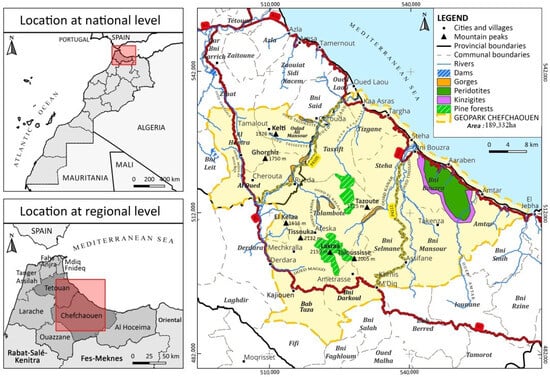
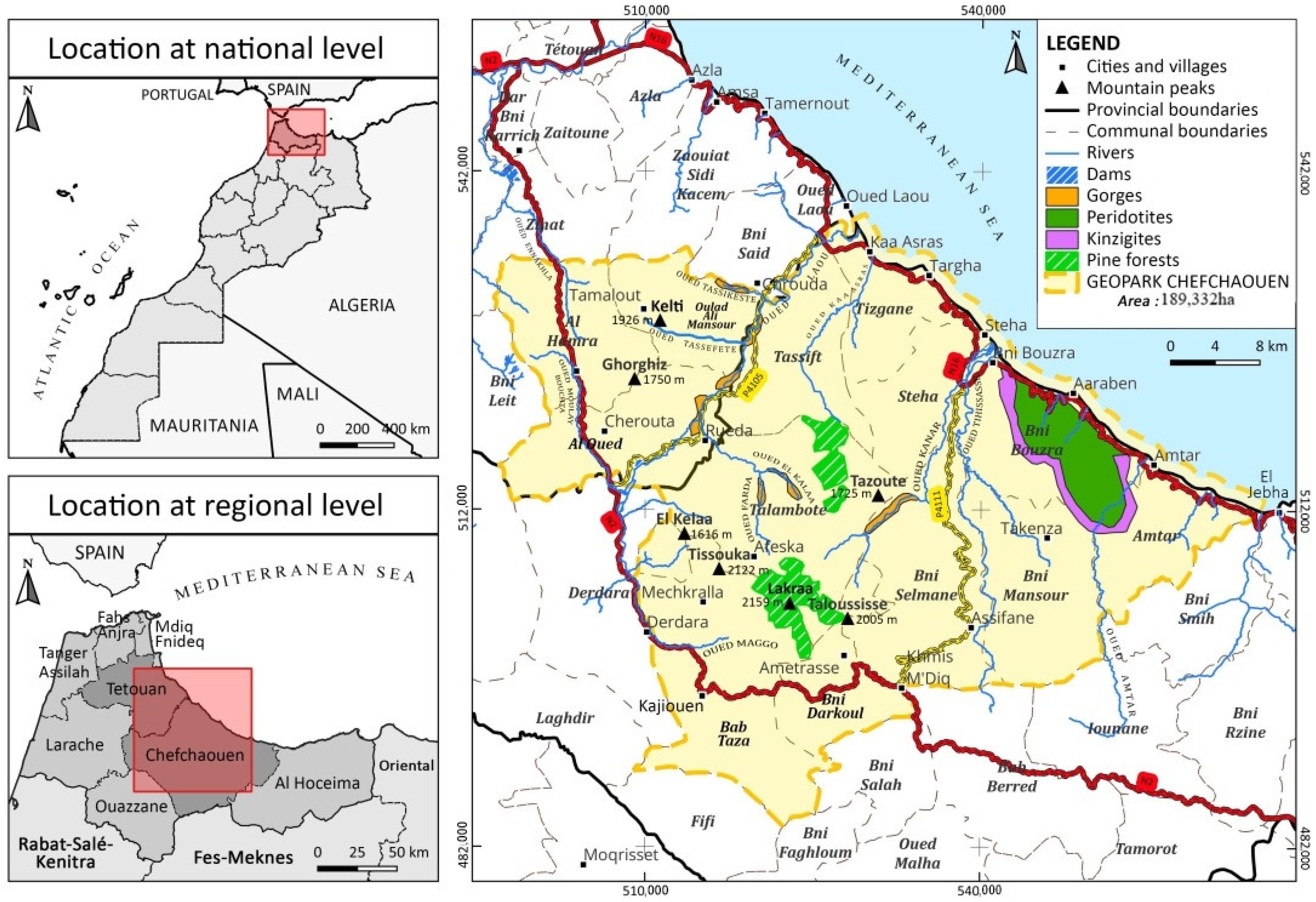
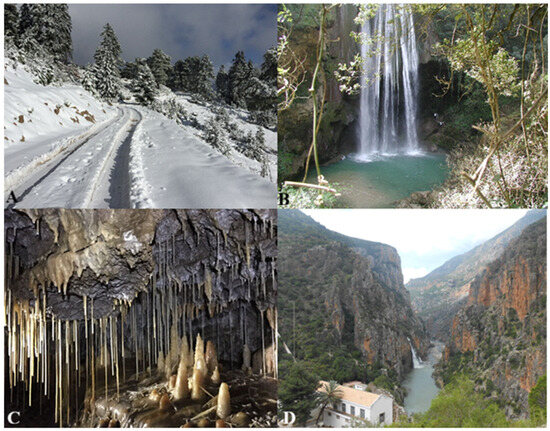
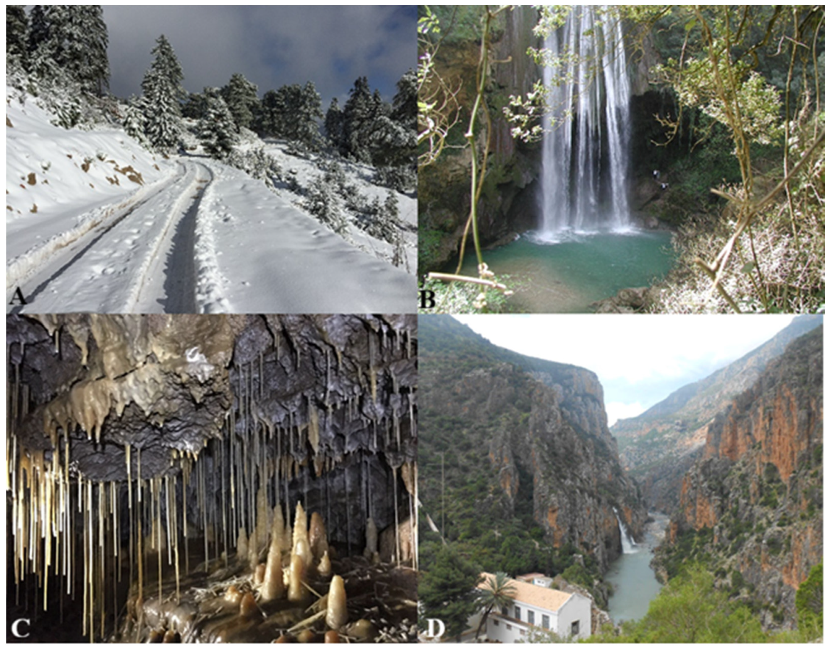
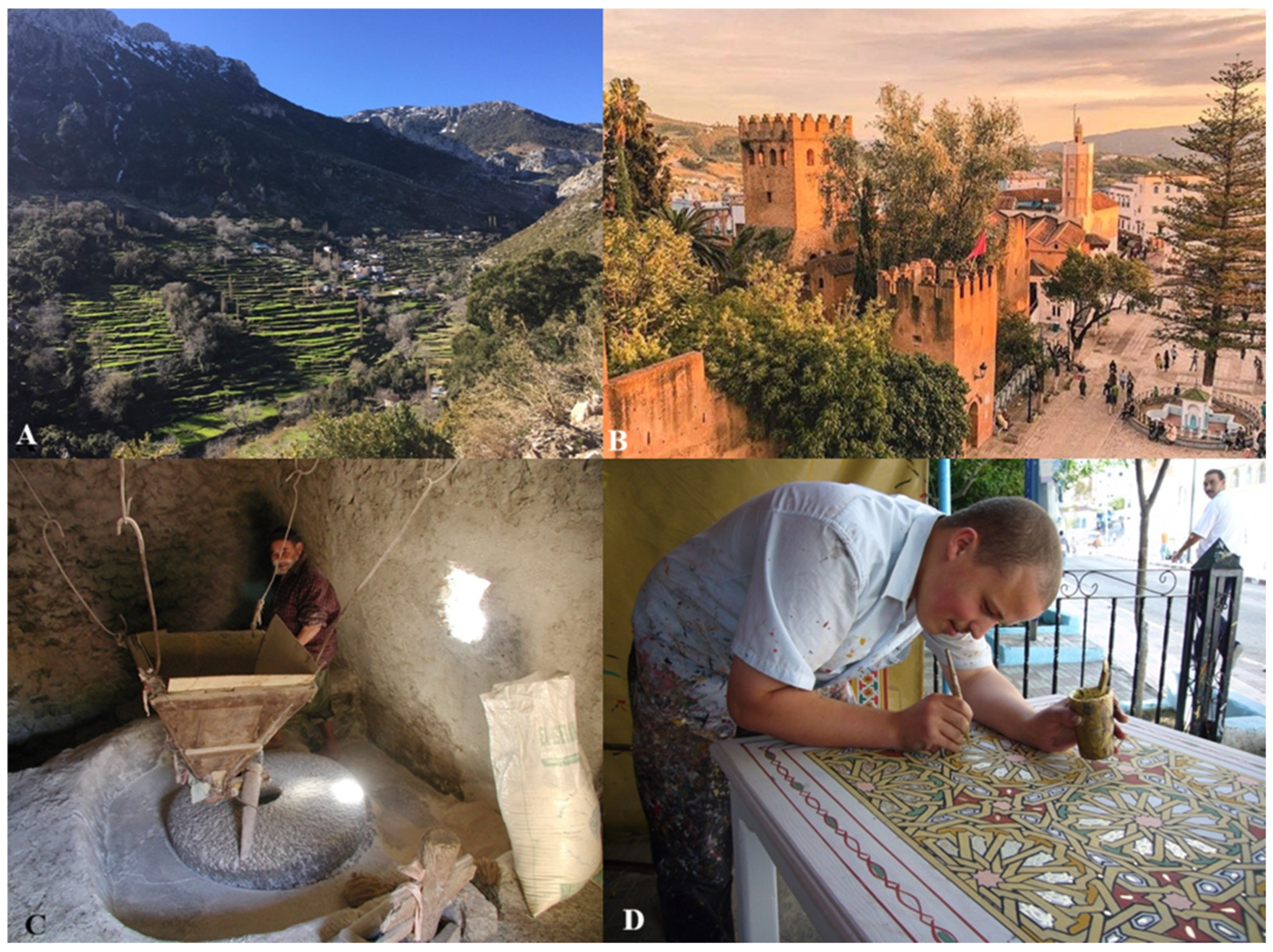
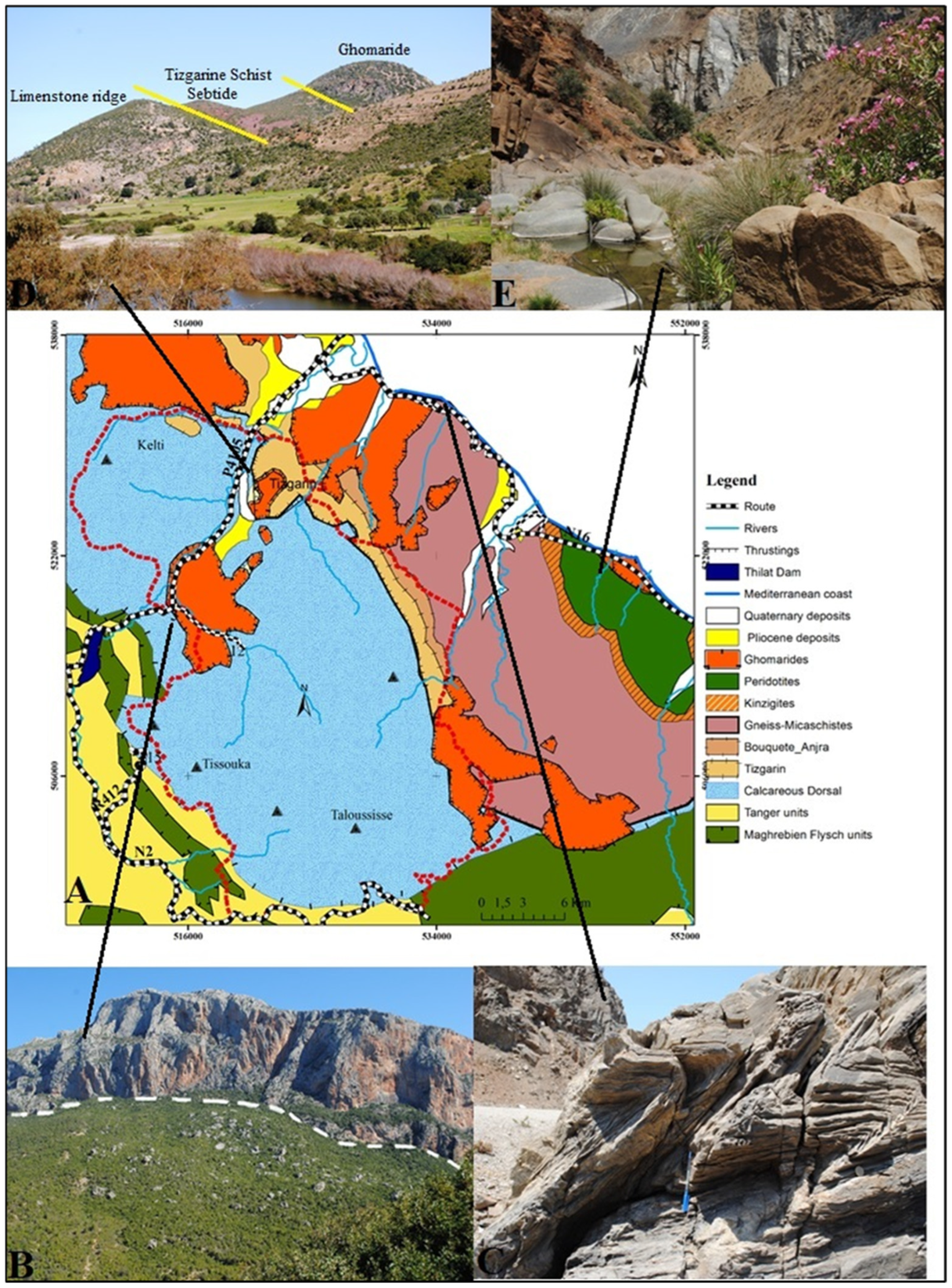
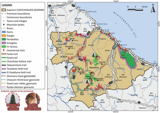
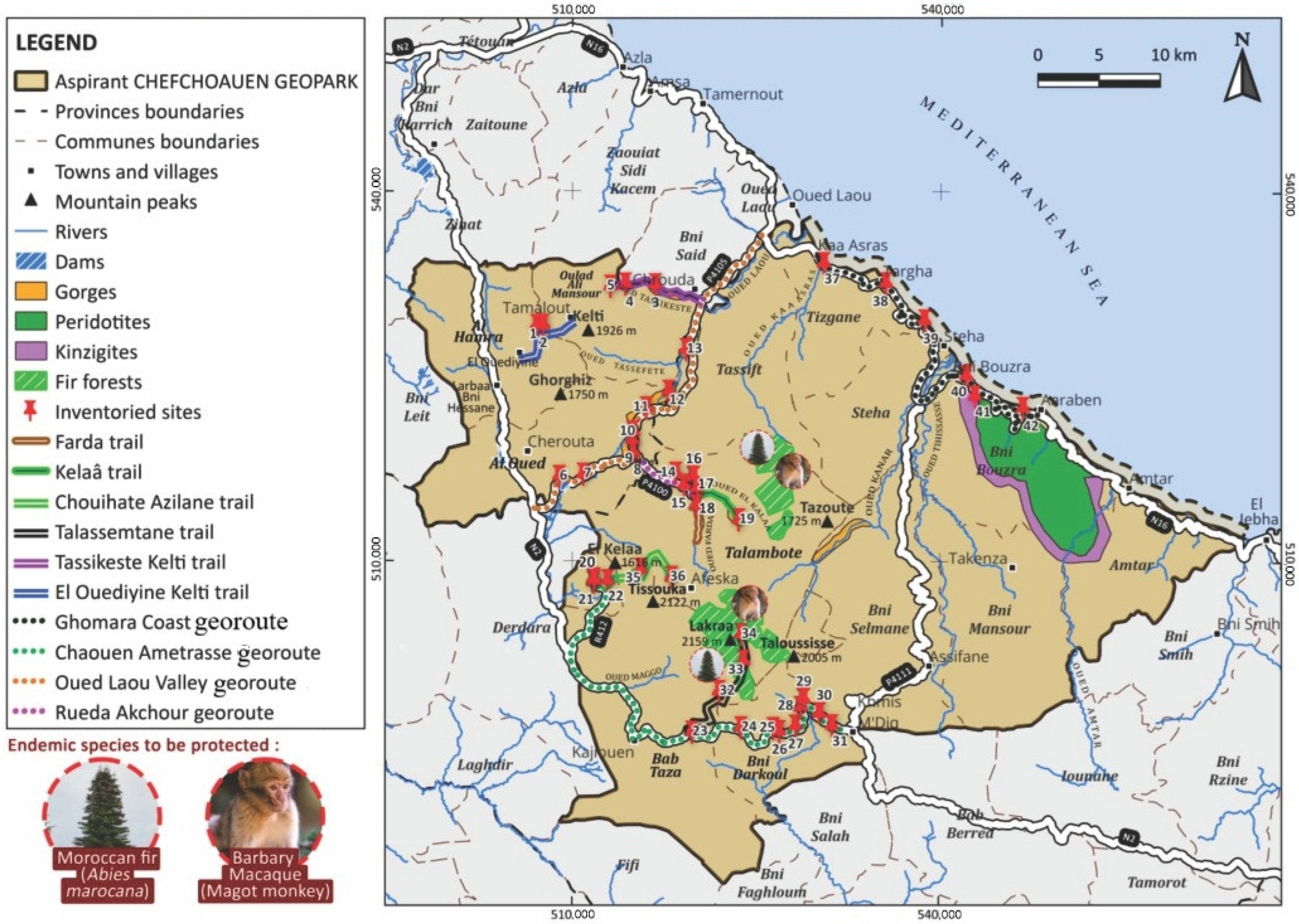
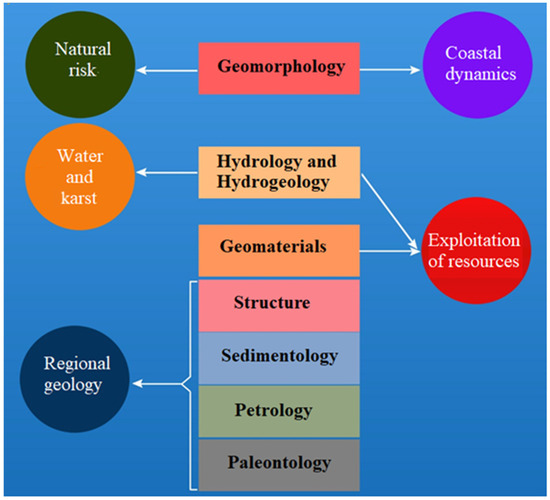
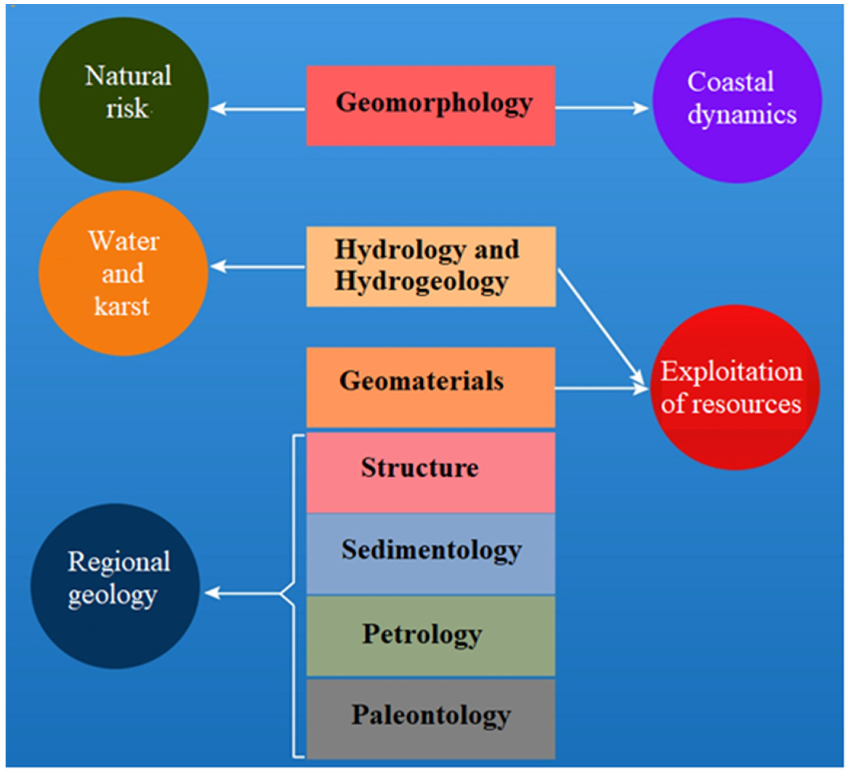

Disclaimer/Publisher’s Note: The statements, opinions and data contained in all publications are solely those of the individual author(s) and contributor(s) and not of MDPI and/or the editor(s). MDPI and/or the editor(s) disclaim responsibility for any injury to people or property resulting from any ideas, methods, instructions or products referred to in the content. |
© 2026 by the authors. Licensee MDPI, Basel, Switzerland. This article is an open access article distributed under the terms and conditions of the Creative Commons Attribution (CC BY) license.