


Abstract
Northern Anhui constitutes a vital component of Anhui’s regional coordinated development and represents a less-developed region requiring focused attention under the high-quality development strategy of the Yangtze River Delta. Endowed with abundant historical resources, culture-tourism integration serves as an effective pathway for comprehensive and high-quality socioeconomic development across the region. Nevertheless, its historical values exhibit latent features embedded within territorial space. Such values underpin local culture-tourism integration through inherent historical genes and geographical similarities. Clarifying the mutual fit between values and territorial space and scientifically facilitating the formation of the Spatial Pattern of Culture-Tourism Integration form the core research issue of this study. Based on the philosophy of coordinated conservation and development, this study adopts the HIA approach, expands the connotation of values, takes “historical space” as the assessment object, and uses the dual evaluations of territorial spatial planning as the source of impacts. The MCR Model is embedded to innovate the HIA framework, identify potential spaces and facilitate the formation of the Spatial Pattern of Culture-Tourism Integration. The results reveal obvious differentiation of impacts within the Spatial Pattern of Culture-Tourism Integration of Northern Anhui. High-potential areas and moderate-potential areas are dominated by positive impacts. These areas can rely on trunk transport routes, including high-speed railways and expressways and link adjacent cities and towns to form an inward-oriented spatial structure. Low-potential areas and marginal-potential areas are dominated by negative impacts; in particular, water systems present notable conflicts with corridors within the Spatial Pattern of Culture-Tourism Integration. Drawing on the assessment findings, this study develops differentiated spatial governance mechanisms and strategies, and implements hierarchical control for corresponding control segments, so as to foster the synergistic improvement of economic, social, ecological and cultural values in Northern Anhui.
1. Introduction
The Outline of the 15th Five-Year Plan (2026–2030) for National Economic and Social Development of the People’s Republic of China proposes to “shape tourism through culture, highlight culture through tourism, and build China into a strong tourism nation,” emphasising the need to tap distinctive resources and cultural connotations and promote deep integration between systematic cultural heritage conservation and tourism development. A consensus has emerged regarding the role of culture-tourism integration in driving regional development [1]. Territorial space provides clear guarantees for culture-tourism development [2], which is embodied in the Spatial Pattern of Culture-Tourism Integration at the regional territorial spatial scale.
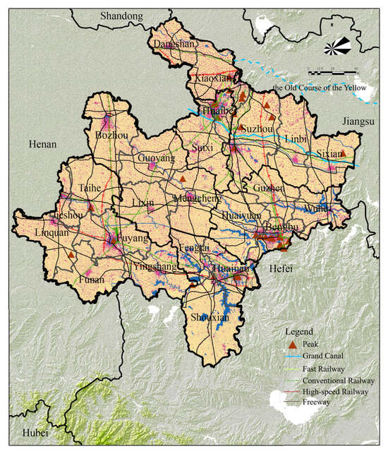
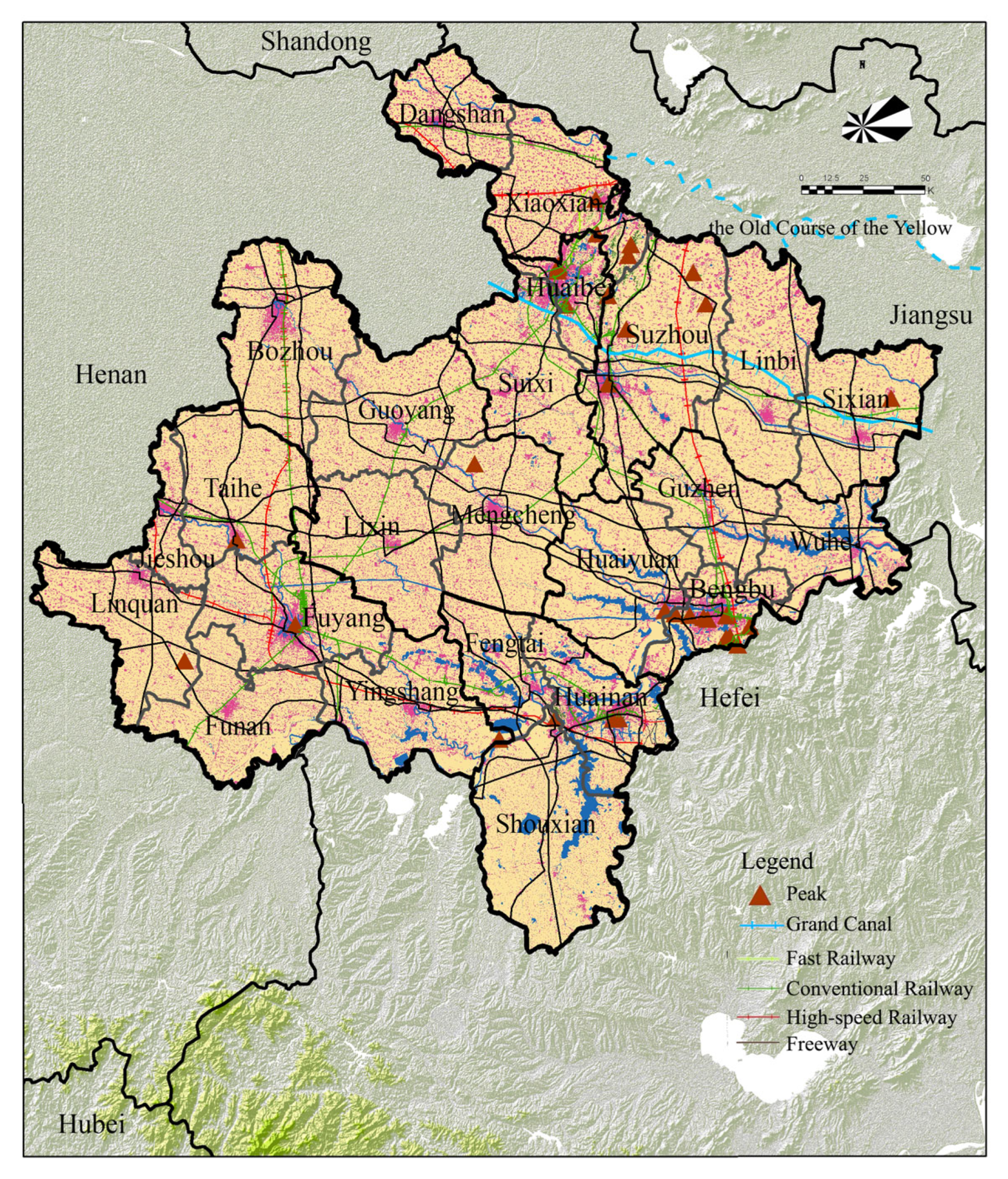
Northern Anhui is located in the northern part of Anhui Province, at the transition zone of the Huaihe River, Yangtze River, and Yellow River basins. It borders Henan, Shandong, and Jiangsu provinces and adjoins Chuzhou, Lu’an, and Hefei within Anhui. It comprises six prefecture-level cities-Suzhou, Huaibei, Bengbu, Fuyang, Huainan, and Bozhou-and includes 18 counties and county-level cities, such as Linquan, Taihe, and Funan (Figure 1). As a zone where Central Plains culture meets Chu culture, Northern Anhui is representative of China’s regional spatial pattern. During the pre-Qin period, the region maintained a rudimentary balance between human society and the environment, providing fertile ground for intellectual and cultural development of that era. From the Han and Tang dynasties to the Northern Song dynasty, it experienced cultural prosperity and a coordinated human–land relationship; from the Southern Song dynasty onward, it remained in a period of cultural decline and transformation until the Republican era [3]. In the early years of the People’s Republic of China, the region developed through industrialisation, but an imbalanced human–land relationship again became a constraint. Northern Anhui is economically underdeveloped yet densely populated, with pronounced social problems and substantial out-migration. Owing to the combined effects of historical legacies, the natural environment, and a weak development base, it has long faced accumulated development deficits and remains an underdeveloped region in the Yangtze River Delta. The integrated development of underdeveloped areas has attracted widespread attention among scholars in China and abroad [4]. It is therefore urgent to activate endogenous drivers and examine regional integration from within the regional system.
Figure 1.
Existing Natural and Built Environments of Northern Anhui. Source: Drawn by the authors.
To establish a coordinated pattern of tourism development, the Department of Culture and Tourism of Anhui Province issued the Plan for the Northern Anhui Culture-Tourism Integrated Development Circle (2023–2027) and the Plan for the Huaihe River Cultural Tourism Development Belt (2023–2027) in 2024. The 2025 Provincial Government Work Report proposed “advancing construction of the Northern Anhui Culture-Tourism Integrated Development Circle and developing the Northern Anhui Grand Tourism Loop” and “launching the construction of a demonstration section of the Northern Anhui Grand Tourism Loop.” To implement the arrangements and requirements issued by the Provincial Party Committee and the Provincial People’s Government, the Anhui Provincial Department of Culture and Tourism and the Anhui Provincial Department of Transport have jointly compiled the Construction Plan for the Northern Anhui Grand Tourism Loop (Draft for Comments). The development of culture-tourism integration in Northern Anhui and the Formation of the Spatial Pattern of Culture-Tourism Integration at the territorial scale have been put on the agenda. There is an urgent need to expand the connotation of value, take territorial space as the carrier of value, integrate, connect and develop historical resources at the territorial scale based on their relevance and integrity via linear natural and transport corridors and pursue coordinated development with surrounding cities and towns.
1.1. Characteristics of Historical Spatial Value in Northern Anhui
Northern Anhui is marked by latent values embedded within territorial space.
First, its values are latent. The region abounds in historical resources, which historically consist mainly of battlefields, archaeological remains, former river channels, Huaihe water-control hydraulic works and agrarian landscapes, while railways and mining areas dominate the modern and contemporary heritage. Some relics were ruined by warfare and disasters and merged with the environment over a long time span; some emerged from natural settings as vestiges that leveraged environmental strengths; others are remnants shaped by human exploitation and regulation of the environment. Their attributes are latent. Accordingly, guided by shared historical and cultural cognition as an intrinsic gene, value-based linkages connect the fragmented territorial spaces of Northern Anhui. Situated along the north–south divide, the area was a strategic territory contested by northern and southern regimes in antiquity. Though endowed with potential for affluence, it repeatedly lost developmental opportunities owing to the Yellow River’s capture of the Huaihe River, successive warfare and constant famines. Parallel major historical events cultivated a resilient and innovative regional ethos. Interrelated historical events and figures constitute the distinctive intrinsic gene of Northern Anhui.
Second, the value attributes of Northern Anhui are attached to surrounding environments and embedded in territorial space. Hu Xiao [5,6] from the Institute of History, Anhui Academy of Social Sciences argues that the natural and human environment of the Huaihe River Basin in Anhui serves as the cradle in which historical and cultural resources are generated, formed, and accumulated, profoundly shaping their meanings and distinctive characteristics. Located in the Huaihe River Basin, Northern Anhui has predominantly flat terrain. In modern times, the meandering incision and channel changes of the Huaihe River and its tributaries, together with repeated southward flooding of the Yellow River, have shaped a shared geomorphological and geographical context across the region. Huaihe River tributaries such as the Ying River and Guo River constitute natural linear attributes. Meanwhile, improved connectivity in Northern Anhui’s territorial spatial network, the integrity of its geographic space, the continuity of its landscape spatial pattern, and shared understandings of history and culture provide a foundation for culture-tourism integration.
Northern Anhui’s culture-tourism integration is underpinned by its intrinsic historical genes and geographical similarities, which endow the region with unique characteristics. Therefore, the integration of historical resources in Northern Anhui should respond to its latent characteristic of values embedded in territorial space. On the basis of existing legal heritage, this study expands the connotation of value and explores the spatial connections between values, surrounding territorial space and adjacent cities and towns. Such connections are regarded as value attributes and resources for tourism development in Northern Anhui.
1.2. Key Issues for Integration in Northern Anhui
The latent values of Northern Anhui embedded in territorial space are carried by associated territorial value attributes that are difficult to perceive. When constructing an integrated pattern via linear corridors, both historical values and ecological values are susceptible to disturbance, which may lead to irreversible damage. Targeting the formation of an integrated pattern, this study treats the inherent constraints of territorial space as influential factors at the strategic level. Lands suitable for formation and development can adapt to the integrated pattern and thereby constitute positive impacts, whereas ecologically sensitive lands that fail to achieve such adaptation generate negative impacts.
To sum up, Northern Anhui features latent values, while the demand for culture-tourism integration is urgent. Several critical questions remain to be clarified: how can the historical spatial values of Northern Anhui be manifested? What impacts will emerge during the integration process? What does the integrated pattern ultimately look like? How can differentiated governance be implemented? Identifying an analytical tool that accounts for both values and impacts has therefore become a core bottleneck.
Guided by the coordination between value conservation and rapid development, and targeting the Formation of the Spatial Pattern of Culture-Tourism Integration at the territorial scale, the subsequent section introduces the HIA for planning practice. It expands the connotation of value, takes historical space as the assessment object, regards the compatibility between values and territorial space as impact, and innovates the impact assessment framework by integrating the MCR model. Differentiated governance strategies are proposed based on assessment outcomes, so as to provide evidence and references for the synergy between heritage conservation and economic development in Northern Anhui.
2. Framework and Methods
2.1. Literature Review
2.1.1. Research on the Formation of the Spatial Pattern of Culture-Tourism Integration
- Expansion of Value Connotation
With the advancement of research on Historic Urban Landscapes (HUL) and cultural landscapes, the wholeness and interconnectedness of heritage values have gradually gained academic consensus. As the concept of urban and rural cultural heritage expands to encompass interactions and influences across diverse cultures, as well as between culture and nature, scholars have explored the multiple composition of values [7] and proposed the notion of associative values [8]. As the scope of value recognition continues to broaden, preliminary holistic assessment of all spatial elements reveals that farmland, woodland, orchard land and other land-use types may function as value attributes. Meanwhile, ordinary or potential historical spaces that previously received limited attention have attracted growing concern due to expanded research perspectives and requirements for pattern integrity [9]. Value attributes have become diverse and complex, where physical entities, surrounding perceptual environments and memory-laden cultural spaces coexist.
On this basis, some scholars have examined the interrelationships of elements within the overarching urban–rural territorial spatial system and its subsystems [10], and identified an anchoring–diffusion mechanism for value transmission across territorial space [11]. Further research analyses the coupling characteristics of conservation and utilisation within historical spaces and proposes the attachment effect of values at the territorial scale [12]. These studies lay a theoretical foundation for this research to externalise latent value spaces in Northern Anhui, analyse value interconnections at the territorial scale, and support the formation of the Spatial Pattern of Culture-Tourism Integration.
- Theories Related to the Formation of the Spatial Pattern of Culture-Tourism Integration
The spatial pattern of culture-tourism integration mainly consists of linear corridors linked by value interactions and associated city and town nodes. Linear cultural heritage lays the groundwork for the analytical framework of this integrated pattern. Rooted in the philosophy of holistic conservation, linear cultural heritage takes tangible or intangible routes as its carriers and presents a linear spatial distribution. Representative forms include heritage corridors and cultural routes. This theoretical perspective regards heritage components and interactively connected cities and towns as joint research subjects. Linear cultural heritage breaks the conventional mindset that conserves isolated point-based heritage sites. It highlights the relationships between heritage and its surrounding environment as well as associated cities and towns, so as to realise the goal of holistic conservation [13].
Landscape ecology offers concrete theoretical references for analysing the spatial pattern. Proposed by Forman and Godron in 1986, landscape ecology conceptualises regional space as a landscape mosaic composed of patches, corridors and matrices [14]. The “patch-corridor-matrix” spatial structure principle provides an important methodological reference for identifying nodes, linear channels and regional contextual relationships within the spatial pattern of culture-tourism integration [15].
2.1.2. Heritage Impact Assessment
Heritage Impact Assessment (HIA) represents a proactive conservation approach with ex ante intervention to address the consequences of external construction activities on heritage conservation. It adapts environmental impact assessment methodologies to the heritage conservation domain. HIA can function as an effective methodological tool to proactively establish mutually compatible relationships between territorial space and values.
- A Proactive Instrument for Spatial Governance
HIA carries dual implications. First, as an integral component of governance systems, it delivers decision-support functions by embedding heritage conservation and management requirements into planning administration [16]. HIA falls into two categories: Strategic-level Heritage Impact Assessment and Project-level Heritage Impact Assessment [17]. Strategic-level Heritage Impact Assessment attaches greater importance to ex ante intervention. Through Strategic-level Heritage Impact Assessment, relevant development activities are brought under the regulatory framework of planning systems, providing evidence for spatial governance. For instance, the Heritage Impact Assessment for Templefields was conducted alongside the Local Development Order (LDO) 1 for the North East Enterprise Zone in England. This arrangement ensures that assessment outputs and mitigation measures can be dynamically updated and fed into the draft Local Development Order and associated design guidance. The Hedon Haven Cultural Heritage Impact Assessment served as an Evidence Base for the East Riding Local Plan. It evaluated the likely heritage effects of future development within allocation area HAV1/2 2, and its findings were integrated into the site Allocation policy. It therefore acts as an effective instrument underpinning spatial governance.
- Establishing Synergistic Relationships between Values and Impacts
HIA operates as a technical assessment procedure. It focuses on the functional relationship between the significance of heritage values and the magnitude of impacts, treating heritage conservation and development utilisation as an integrated whole. HIA comprises three core stages: Attributes of Value, Magnitude of Change, and impact assessments [18]. At the stage of Attributes of Value, practitioners identify which heritage assets are susceptible to change and which attributes carry heritage values. At the Magnitude of Change stage, analysts clarify the sources and types of impacts and distinguish between beneficial change and adverse change. In the impact assessment stage, interpretations of heritage value attributes and disturbances are translated into assessment subjects. Based on the association between values and their attributes and the scale of change imposed on attributes, the net gain or loss of heritage values is synthesised and analysed. The matrix method is widely adopted to examine correlations between attributes and impact variables so as to determine the significance of impacts.
- Applicability and Limitations for Northern Anhui
“Early intervention” is critical for HIA to achieve its full effectiveness [19]. A WHO advisory body recommends that HIA be undertaken at the SEA stage at an early point. As an instrument for governance, HIA interprets impact outcomes from an adaptive perspective and delivers optional, feasible solutions [20]. It is applicable to examining conflicts between conservation and development in Northern Anhui, as well as supporting the formation and governance of the Spatial Pattern of Culture-Tourism Integration. Furthermore, HIA defines assessment subjects to cover legally designated heritage of all categories and any historically significant spaces together with their surrounding settings [21]. This renders it suitable for analysing and judging the latent values characteristic of Northern Anhui.
Nevertheless, HIA also bears limitations in practical application. Although HIA has expanded to incorporate environmental and social dimensions, its judgements largely remain qualitative. For the Chinese context, tools that support integrated and collaborative analysis of value impacts at the territorial scale are still scarce. In particular, existing analyses of value-impact relationships mostly rely on matrix frameworks and lack systematic, quantitative approaches.
2.2. Research Workflow
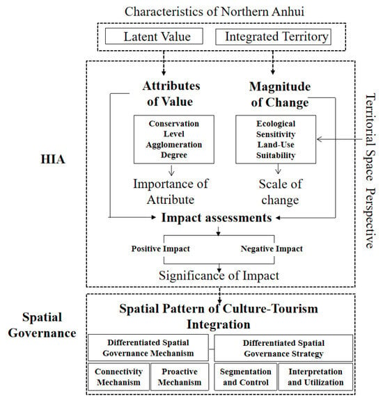
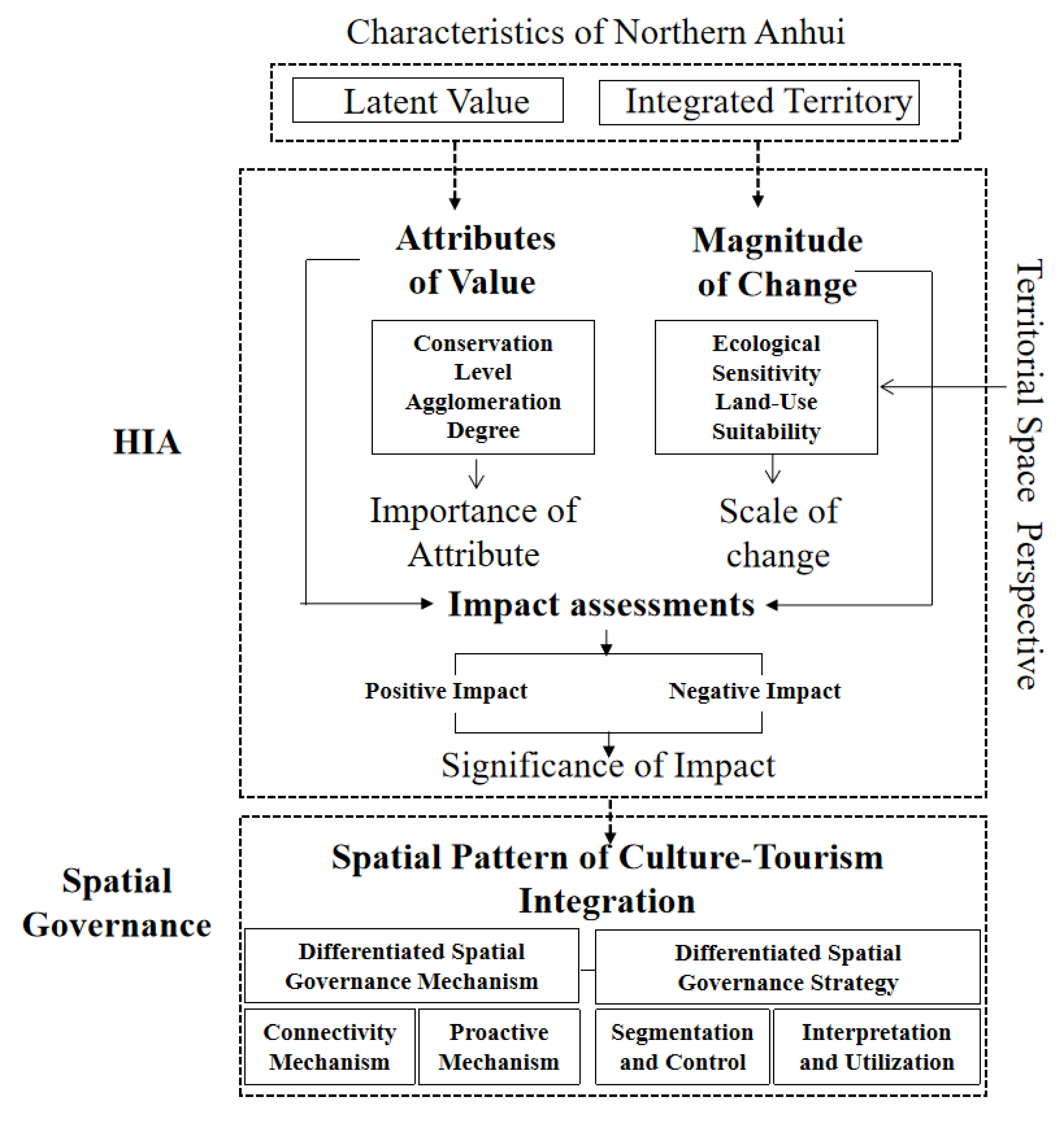
Building upon the foregoing discussion of value expansion and the applicability and limitations of HIA, this study develops a heritage impact assessment workflow at the territorial scale for Northern Anhui and proposes governance strategies derived from assessment outcomes (Figure 2).
Figure 2.
Framework for HIA. Source: Drawn by the authors.
2.2.1. Attributes of Value: Expanding Heritage to Historical Space
Northern Anhui is an important cradle of Chinese civilisation, a bearer of China’s diverse cultures, a major cradle of China’s revolutionary heritage, an important source of scientific and technological innovation, and a microcosm of the country’s distinctive character [22]. This study broadens the connotation of “heritage” as the assessment subject. Given the close linkage between historical values and territorial space in Northern Anhui, heritage clusters and interactively connected cities and towns are jointly incorporated into the assessment scope. The scope covers legally designated heritage, non-designated heritage with values, and all areas affected by value radiation, which corresponds to the concept of Historical Space. Kernel density analysis, spatial overlay and other methods can be adopted to delineate the boundary of historical space.
This study targets the formation of the Spatial Pattern of Culture-Tourism Integration, which requires analysis of linear corridors and the hierarchy of city and town nodes connected by corridors. Accordingly, in the stage of Attributes of Value, kernel density estimation is applied to quantify spatial agglomeration. The importance of the attribute is judged with urban districts and counties as assessment units, and classified into five grades: very high, high, medium, low, and negligible.
2.2.2. Magnitude of Change: Identifying Impacts from the Dual Evaluations of Territorial Spatial Planning
The Resource and Environmental Carrying Capacity Evaluation and Territorial Development Suitability Evaluation, collectively known as the Dual Evaluations, serve as critical support for delineating territorial spatial patterns in territorial spatial planning. Variations in ecological sensitivity and land-use suitability within territorial space can directly shape the formation and evolution of the Spatial Pattern of Culture-Tourism Integration. Grounded in the latent values of Northern Anhui embedded in territorial space and targeting the formation of the Spatial Pattern of Culture-Tourism Integration, this study treats the Dual Evaluations in territorial spatial planning—namely ecological sensitivity and land-use suitability—as sources of impact. That is, territorial space whose inherent constraints match the Spatial Pattern of Culture-Tourism Integration corresponds to Beneficial change, while territorial space incompatible with this pattern corresponds to adverse change.
At the stage of Magnitude of Change, an evaluation factor system for ecological sensitivity and land-use suitability is first established according to the natural and human environments of Northern Anhui. The Analytic Hierarchy Process (AHP) is adopted to assign weights to each factor; individual factors are graded, and weighted overlay analysis is implemented for comprehensive evaluation. Geographic information systems are applied to examine the sensitivity and suitability of the ecological base across the study area [23], characterise their territorial distribution, and define the scale of change. Ecological sensitivity is classified into three grades: high sensitivity, moderate sensitivity, and low sensitivity. Land-use suitability is divided into three categories: suitable areas, generally suitable areas, and unsuitable areas.
2.2.3. Impact Assessments: Integrating the MCR Model to Innovate Territorial-Scale Impact Assessment
In the stage of Impact Assessments, this study analyses gains and losses of values by examining the degree of disturbance to value attributes and comprehensively accounting for positive impacts and negative impacts. This research embeds the MCR Model to develop an innovative impact assessment approach built upon the matrix method.
- Applicable Characteristics of Integrating the MCR Model into HIA
The MCR Model originates from landscape ecology and is widely adopted for constructing ecological security patterns and identifying ecological corridors. Its fundamental logic is to simulate the resistance that material flow, energy flow or species migration encounters across different landscape units when moving between ecological sources [24]. In recent years, the application scope of the MCR Model has expanded from ecological security research to heritage corridors, cultural heritage networks and cultural tourism corridors [25,26]. By translating diverse spatial factors into calculable resistance costs, the MCR Model serves as a quantitative and spatially interpretable method [27,28].
Three strengths support the integration of the MCR Model into Heritage Impact Assessment for Northern Anhui. First, the MCR Model simulates potential connection pathways between value sources and the integrated resistance surface. It fits the context of Northern Anhui with latent values, where surviving relics alone cannot fully represent historical space. Second, the model operates on a continuous spatial resistance surface rather than administrative boundaries. It helps overcome spatial fragmentation caused by administrative divisions, simulates potential connections among value sources from a holistic perspective, and identifies the hierarchical characteristics of cities and towns along the Spatial Pattern of Culture-Tourism Integration. Third, it supports corridor routing under multi-factor constraints. Territorial space within the scope of value radiation is restricted by terrain, water systems, ecological sensitivity, land use, transportation conditions and construction disturbances. The MCR Model unifies multiple factors into resistance costs and enables comparison of the suitability of alternative spatial routes.
Overall, the MCR Model enables a shift from qualitative judgement to quantitative simulation. It translates potential linkages between value sources into calculable pathways defined by spatial resistance costs and articulates the synergistic relationships between values and impacts.
- Integration Framework
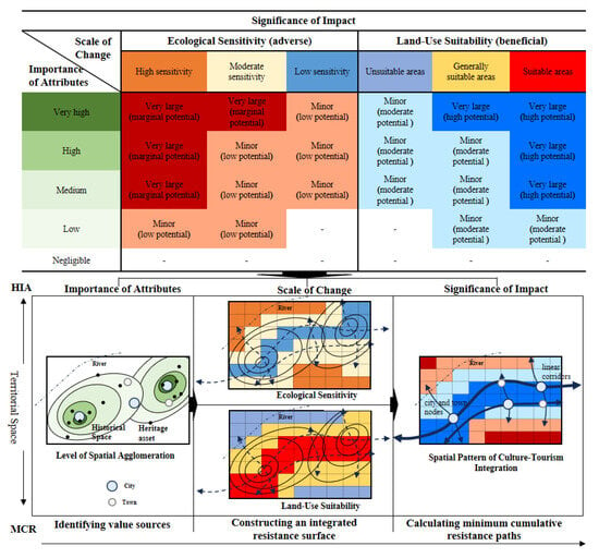
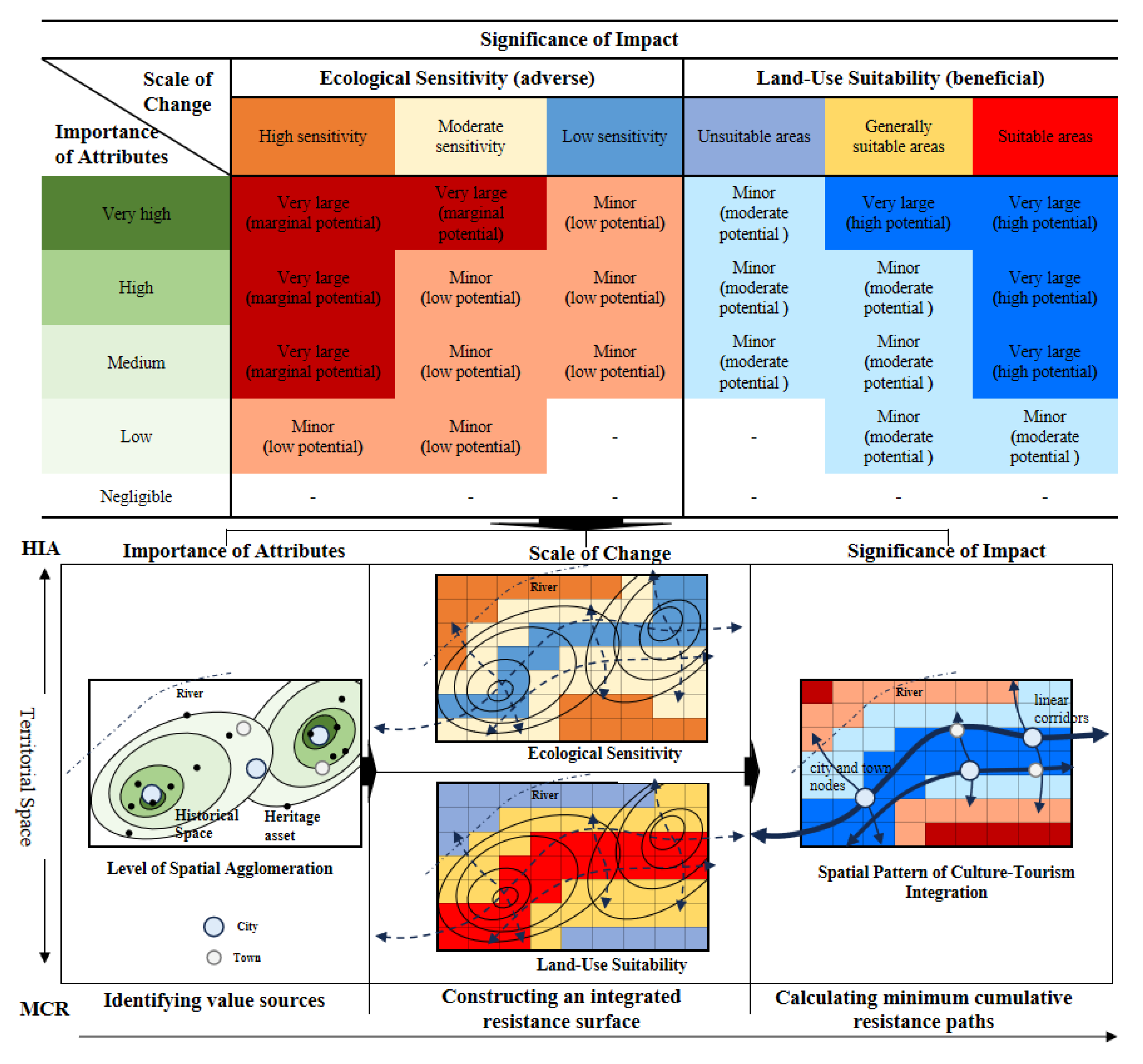
The MCR Model comprises three core procedures: identifying value sources, constructing an integrated resistance surface, and calculating minimum cumulative resistance paths. These procedures correspond to the three core stages of HIA: Attributes of Value, Magnitude of Change, and Impact Assessments. Combined with the matrix of attribute significance and scale of change, the MCR Model visualises the full workflow of impact assessment at the territorial scale, as illustrated in Figure 3.
Figure 3.
HIA-MCR Assessment Framework Source: Drawn by the authors.
Source identification is a prerequisite for model operation. Value sources correspond to spatial agglomeration cores detected via kernel density estimation. Resistance surface construction, the key step of MCR, aligns with the Magnitude of Change stage. The resistance surface quantifies the resistance of each spatial unit to cultural connection, cultural transmission, recreational access or corridor development. Resistance factors for ecological corridors commonly include land-use type, elevation, slope, vegetation coverage and construction disturbance. For cultural corridor research, factor selection requires cultural translation [29].
After defining sources and the resistance surface, GIS tools such as cost-distance and cost-path analysis are adopted in the MCR Model to generate minimum cumulative resistance paths between value sources. Taking agglomeration cores of historical space values as sources, this study examines beneficial change and adverse change induced by ecological sensitivity and land-use suitability while values spill over through linear channels, and establishes synergistic relationships between values and impacts. Territorial space is classified into four levels of land-use potential derived from the MCR Model output: high, moderate, low, and marginal. This potential corresponds to positive impacts compatible with the formation of the Spatial Pattern of Culture-Tourism Integration, whereas incompatibility generates negative impacts.
Finally, according to the spatial distribution of potential land, the significance of impact is categorised into two grades: very large and Minor. Positive impacts rated very large demonstrate the highest compatibility with corridors and land allocation for the integrated pattern; negative impacts rated very large present the severest conflicts with ecological land. Following impact assessment, potential corridors are extracted and optimised for validation.
2.2.4. Governance Responses: Exploring Differentiated Spatial Governance from Assessment Findings
Territorial spatial governance represents a key spatial embodiment of the modernisation of China’s governance system and governance capacity. With the establishment of China’s territorial spatial planning system, territorial spatial governance has evolved toward an integrated governance model characterised by full territorial coverage, all-element coordination and whole-process regulation. Its research scope has expanded from built spaces alone to composite territorial elements including mountains, rivers, forests, farmlands, lakes, grasslands, deserts, urban and rural settlements, transport corridors and historical and cultural resources [30]. Drawing on assessment findings, this study proposes mitigation measures for adverse impacts and enhancement measures for positive impacts to formulate the Spatial Pattern of Culture-Tourism Integration. From the perspective of coordinated conservation and development, differentiated spatial governance mechanisms for governance stakeholders and governance foundations are established at the macro level and delivered through Special Planning. Targeting conflicts between conservation and utilisation, the Spatial Pattern of Culture-Tourism Integration is implemented with segmented control and integrated into territorial spatial planning. Differentiated spatial governance strategies are proposed from the dimensions of land-use regulation and interpretation and utilisation, providing support for the high-quality culture-tourism integration of Northern Anhui.
2.3. Research Methods
2.3.1. MCR Model
The MCR Model quantifies the cost incurred when a species moves from a source to a destination, and its formula is expressed as:
Here, Dij denotes the spatial distance from source j to landscape unit i; Ri denotes the resistance coefficient of landscape unit i to the movement of a given species. ∑ denotes the cumulative distance and resistance of all units traversed between unit i and source j. min denotes the minimum cumulative resistance of the evaluated patch across different sources. f denotes the positive relationship between minimum cumulative resistance and ecological processes.
2.3.2. Spatial Overlay and Multi-Distance Buffer Analysis
Reclassification and other GIS tools are adopted to assign graded values to each indicator and generate single-factor maps. The raster calculator is then used to conduct a weighted overlay of all single factors to obtain composite scores of ecological sensitivity and land-use suitability. The natural breakpoint method is applied for classification.
GIS tools including Intersect, Clip and Buffer are used to identify spatial relationships between potential corridors, cost paths, loops, transport networks and water systems. Multiple distance thresholds are set to compare adjacent coverage levels, and dissolve and deduplication operations are performed to avoid double-counting overlapping zones.
2.3.3. Preprocessing of Spatial Data
This procedure includes unification of spatial reference for multi-source datasets. The coordinate system, spatial extent and geometric integrity of each dataset are checked. Vector datasets are transformed consistently into a metric projected coordinate system and clipped by the unified study boundary. Geometry repair, dissolve and deduplication are implemented to mitigate biases caused by invalid features and redundant records.
It also involves spatial resolution harmonisation and raster alignment. To reconcile resolution discrepancies among DEM, CLCD and other datasets, a common 90 m analysis grid is adopted to standardise pixel size, grid origin and valid extent. Majority resampling is used for categorical variables such as land cover, whereas bilinear interpolation or area-weighted averaging is applied for continuous variables according to analytical requirements, so as to guarantee spatial correspondence for raster overlay.
2.3.4. Multi-Scale Spatial Association and Matching Analysis
Coverage rate and bidirectional matching degree are calculated for validating the Spatial Pattern of Culture-Tourism Integration. For linear features, coverage rate is measured by the proportion of line length within the search neighbourhood; for point features, coverage rate is defined as the proportion of points falling inside the buffer zone. The harmonic mean of bidirectional coverage rates is further used to quantify matching degree, and the Jaccard index and Dice coefficient are adopted to characterise areal overlap within buffers.
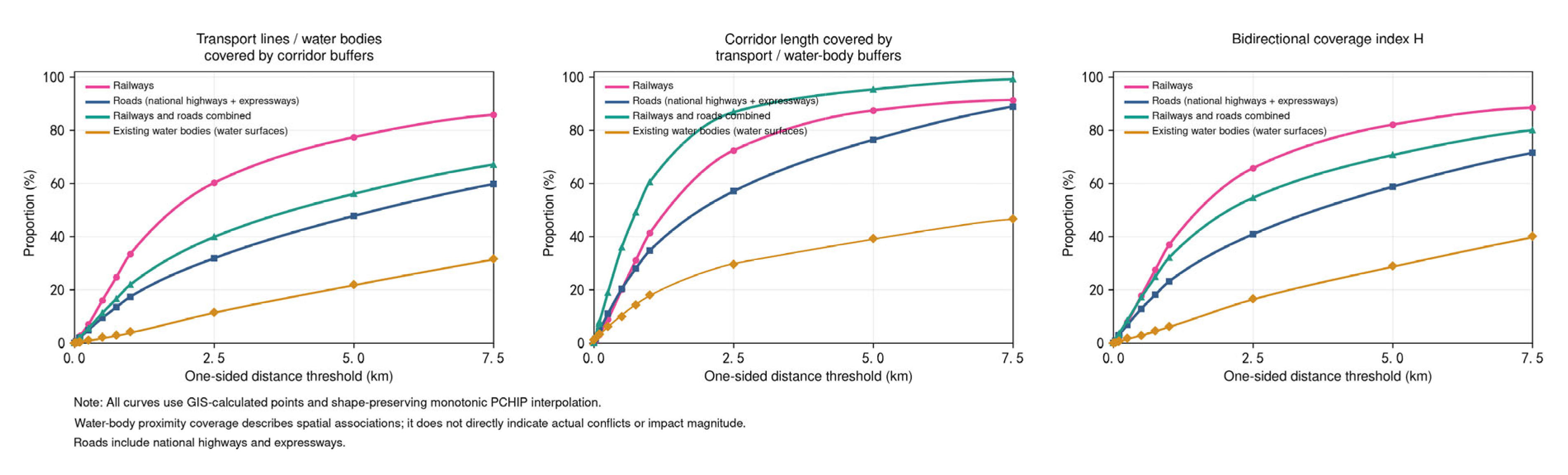
For water-related association identification and scale comparison, the proportions of corridor length within water buffers and water area within corridor buffers are calculated separately to identify waterside segments and water-linked connections. Indicator variations across different buffer distances are compared to examine scale dependence of outcomes, and shape-preserving monotonic interpolation is employed to visualise curve trends.
3. Results
3.1. Data Sources
The basic data used for the HIA of Northern Anhui include DEM and remote sensing imagery data for Northern Anhui (90 m resolution) downloaded from the Geospatial Data Cloud, raster data on land-use types, cultural heritage data at national, provincial, and municipal levels, and road- and water-network data. Detailed information is listed in Table 1.
Table 1.
Data Source Analysis.
This study addresses inconsistencies of multi-source datasets in spatial resolution, coordinate reference and temporal phase by adopting a 90 m grid as the common analytical unit for environmental factors. Spatially, the projected coordinate system, pixel size, grid origin, study extent and mask are harmonised first to ensure consistent spatial correspondence across all indicators. According to variable characteristics, continuous datasets are processed via appropriate interpolation or aggregation methods, while land-cover classification datasets adopt majority aggregation to prevent distortion of class codes caused by numerical interpolation. This procedure unifies the spatial support scale of indicators without introducing spatial details absent from the original datasets. For administrative divisions and infrastructure, area-weighted aggregation and area statistics by grade are performed on raster outputs using consistent administrative boundaries, so as to maintain coherence between spatial overlay analysis and administrative-unit-based analysis.
In terms of temporal harmonisation, the 2022 CLCD dataset represents the land-cover background for assessment. To examine temporal variations in land cover, a grid-aligned comparison is conducted between the 2022 and 2025 CLCD datasets adopted in earlier research. The two original datasets share identical spatial reference, resolution, grid alignment and valid extent. Within the study area covering six cities, the land-cover agreement of the 30 m raw data reaches 98.78%. After resampling both datasets into the unified 90 m test grid through majority resampling, the agreement is 98.75% with a Kappa coefficient of 0.9592. The overall land-cover pattern remains highly stable between the two periods. Heritage records compiled up to 2025 are used to identify conservation and assessment objects. Updates to heritage inventories do not correspond to newly emerged heritage entities in that specific year. Accordingly, the two groups of datasets can jointly support regional-scale spatial relationship identification and planning evaluation.
3.2. Attributes of Value
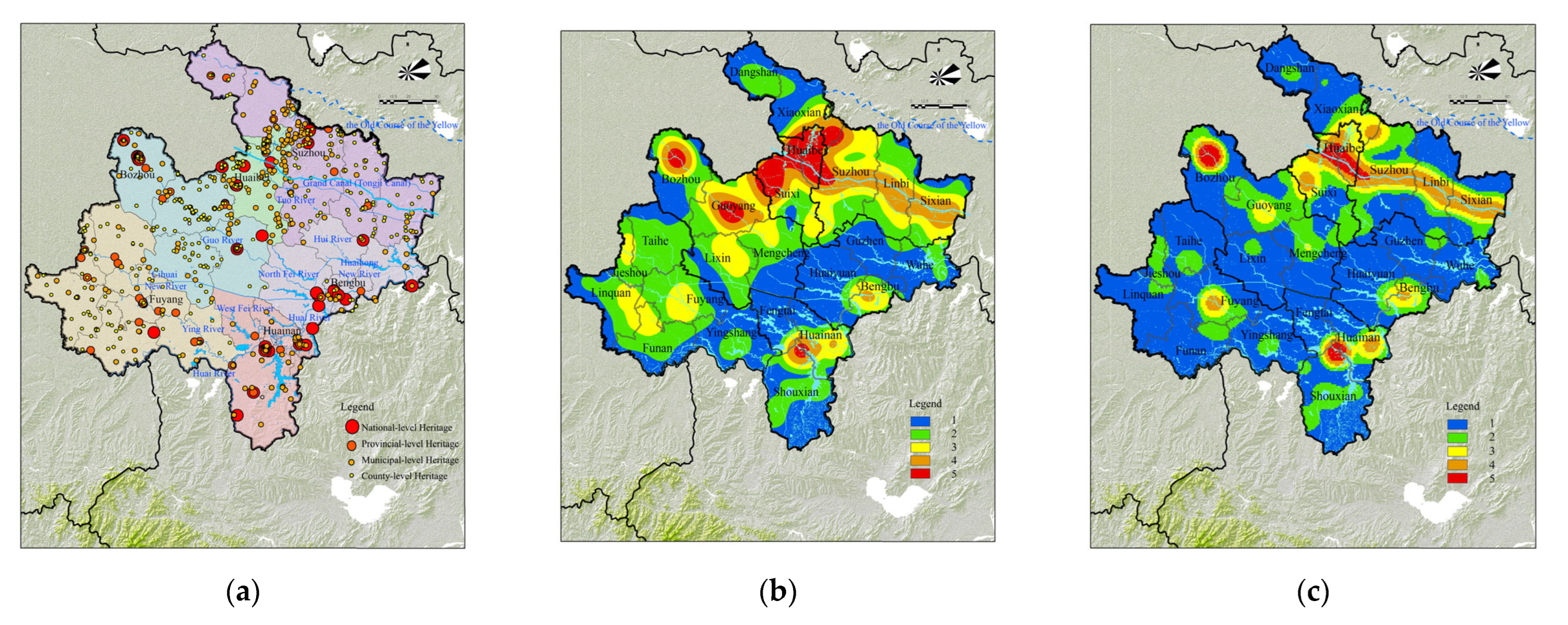
Northern Anhui contains abundant statutory heritage resources, including the World Heritage property Grand Canal (Tongji Canal); the National Historic and Cultural Cities of Bozhou and Shouxian; the Anhui Provincial Historic and Cultural Cities of Guoyang, Mengcheng, and Xiaoxian; 35 national-level cultural relics, including the Liuzi Canal Wharf Site, the Gaixia Site, and Shaopi; 201 provincial-level cultural relics; and 457 municipal- and district-level cultural relics (Figure 4a). Based on field surveys, basic data on statutory heritage across the six municipalities of Northern Anhui were systematically collected, georeferenced on a GIS platform, and used to generate a kernel density map (Figure 4b). At the territorial space scale, three major clusters emerge: the Grand Canal, the Huaihe River, and northern Anhui. The heritage assets were further classified into five hierarchical categories: world, national, provincial, municipal, and county. Kernel density analysis was implemented again with graded weights (Figure 4c) to generate historical space. Value grades were judged according to the concentration of heritage sites within historical space and divided into five levels: very high, high, Medium, low, and Negligible. Their spatial distribution is presented in Table 2.
Figure 4.
Schematic Spatial Distribution of Value in Northern Anhui. (a) Spatial Distribution of Heritage Resources; (b) Kernel Density Map of Heritage Resources (Unweighted); (c) Kernel Density Map of Heritage Resources (Weighted).
Table 2.
Importance of the Attributes.
3.3. Magnitude of Changes
3.3.1. Ecological Sensitivity
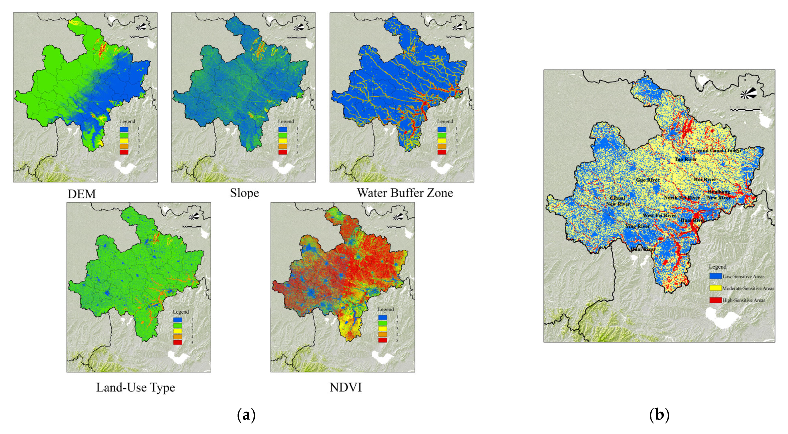
The ecological sensitivity assessment system comprehensively considers three groups of factors: topographic conditions, the natural environment, and human activities. In accordance with the issued by the Ministry of Ecology and Environment of the People’s Republic of China, assessment factors were selected by integrating the ecological characteristics of Northern Anhui (Table 3). The Analytic Hierarchy Process (AHP) was used to determine factor weights. Consistency test: λ ≈ 5.0322, CI = 0.008, CR = 0.0071 < 0.1, and the consistency check passed. After obtaining the raw outputs, the Jenks natural breakpoint method was adopted for classification. The initial results were classified using the Jenks natural breaks method. In conjunction with the region’s geographical conditions, ecological sensitivity was divided into three levels: high sensitivity (15.4–59.5), moderate sensitivity (6.4–15.4), and low sensitivity (1.7–6.4). ArcGIS 10.7 was then used to perform a spatially weighted overlay of the factors and produce the ecological sensitivity analysis map (Figure 5).
Table 3.
Classes of Individual Ecological Sensitivity Factors.
Figure 5.
Ecological Sensitivity Analysis (a) Ecological Sensitivity Factor (b) analysis conclusion. Source: Drawn by the authors.
Owing to the Yellow River’s capture of the Huaihe River and the reclamation and sedimentation of lakes, aquatic ecosystems in Northern Anhui are fragile. Highly sensitive areas are distributed mainly along the Huaihe River and its tributaries, as well as in the mountainous and reservoir areas on the boundary between Suzhou and Huaibei. Moderate-sensitivity areas are relatively concentrated in the central part of the region and consist mainly of cropland. Low-sensitivity areas are found primarily on urban construction land within municipal, county, and district seats. Under the “Dual Evaluations” framework of territorial spatial planning, development and construction should avoid areas of high and moderate ecological sensitivity.
Of particular note, the Guo River, Ying River, Tuo River, and Hui River carry the historical values of Northern Anhui, occupy a vital position in the regional history, and played a pivotal role in shaping the overall spatial pattern of territorial space as typical latent value attributes. Nevertheless, current relevant policies and plans lack targeted conservation measures. Therefore, within the sensitivity analysis, all types of water systems are uniformly designated as zones of high ecological sensitivity and analysed as adverse change factors for culture-tourism integration. This arrangement highlights the priority of ecological conservation and identifies specific conflicts between cultural-tourism development and ecological protection. The outcomes further support adjustments in spatial governance analysis and the formulation of targeted control strategies.
3.3.2. Land-Use Suitability
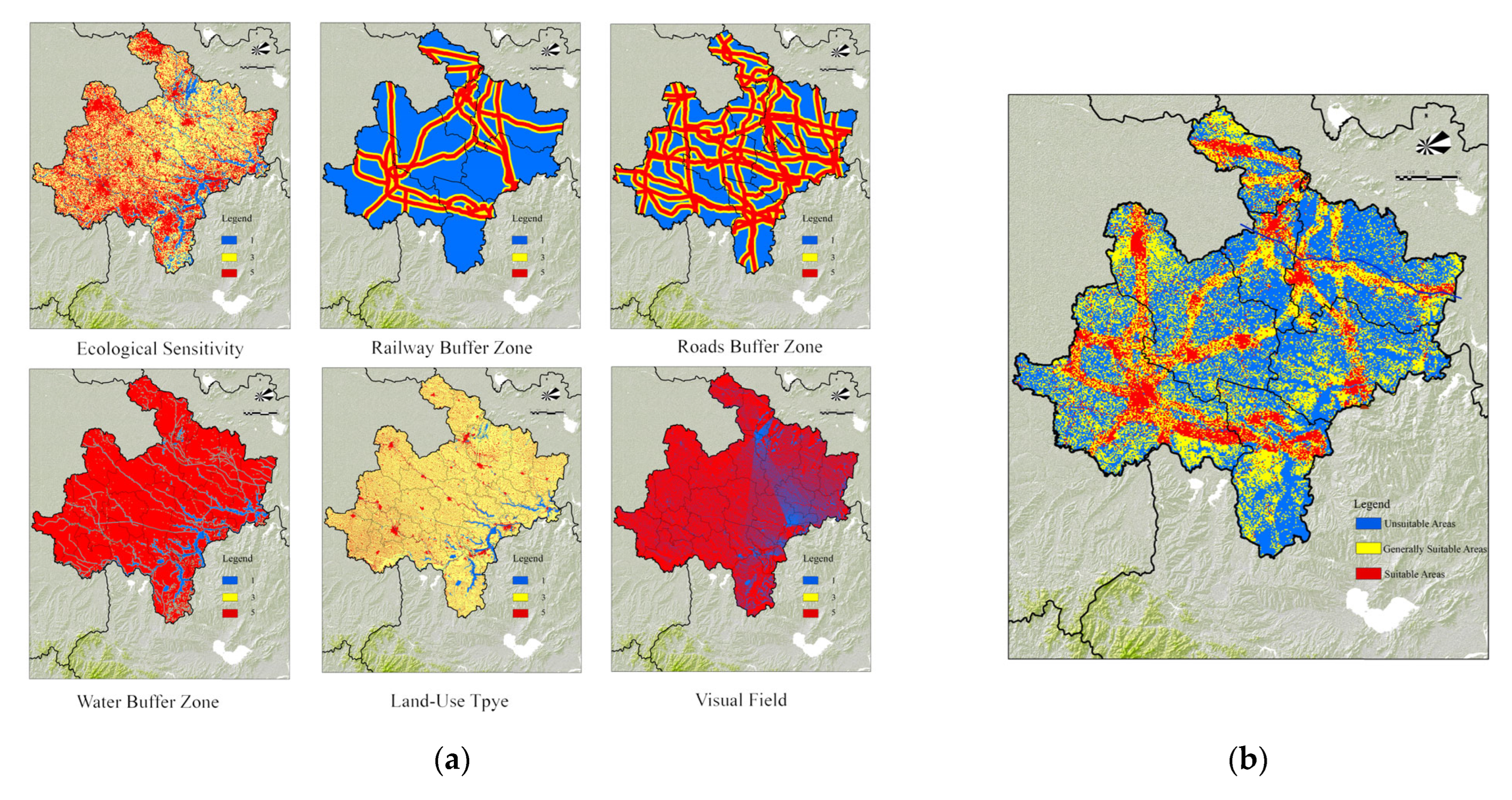
Based on existing land use and land-development needs in Northern Anhui, and with reference to relevant studies, factors were selected for the suitability analysis. Factor weights were determined via the Analytic Hierarchy Process (AHP) (Table 4). Consistency test: λ ≈ 6.2262, CI = 0.0452, CR = 0.0365 < 0.1, and the consistency check passed. ArcGIS was adopted to implement spatial weighted overlay of the above factors for comprehensive land-use suitability analysis (Figure 6).
Table 4.
Categories, Scores, and Weights of Individual Land-Use Suitability Factors.
Figure 6.
Land-use Suitability Analysis. (a) Land-Use Suitability Factor (b) analysis conclusion. Source: Drawn by the authors.
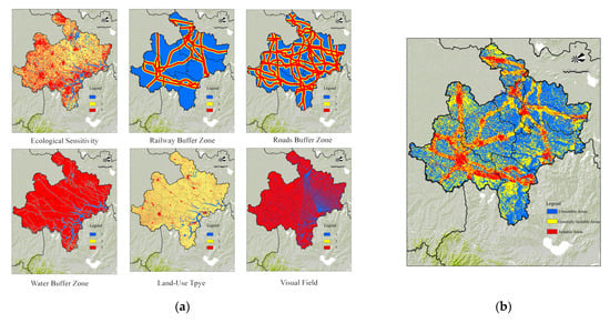
The Jenks natural breaks method was used for classification, and the results were divided according to actual conditions into suitable areas (1–2.5), generally suitable areas (2.5–3.5), and unsuitable areas (3.5–5). Suitable areas display a predominantly linear distribution. In the west, they are concentrated along the Bozhou–Fuyang axis, supported by the Shangqiu–Hefei–Hangzhou High-Speed Railway and the Fuyang–Huanggang High-Speed Railway. In the east, they are concentrated along the Huaibei–Suzhou–Bengbu axis, supported by the Huainan–Suzhou–Bengbu Intercity Railway. In the south, the Fuyang–Huainan axis is served by the Zhengzhou–Fuyang High-Speed Railway. Suitable areas have the strongest association with major transport corridors; railways and roads therefore constitute beneficial change factors for culture-tourism integration. Unsuitable areas are located mainly in cropland at the centre of Northern Anhui, within ecological conservation areas of the Huaihe River Basin, and in the mountainous areas of Huaibei and Suzhou.
3.4. Impact Assessments
3.4.1. Land-Use Potential Analysis
Current applications of the MCR Model to identify culture-tourism integration corridors for HIA generally consider ecological and construction processes. Resistance indicators for the model include elevation, slope, land-use type, and distances to national highways, provincial highways, county roads, township roads and railways [31,32,33]. Based on the preceding value and impact identification, this study integrates the results for heritage value kernel density, ecological sensitivity, and land-use suitability, together with the natural and built environments and relevant plans of Northern Anhui. Cultural heritage kernel density, ecological sensitivity, road-buffer analysis, and railway-buffer analysis were selected to construct the MCR. The Analytic Hierarchy Process was used to determine the classes, resistance values, and weights of indicators at each level (Table 5). This study invited ten experts to complete questionnaire surveys for the Analytic Hierarchy Process (AHP). Pairwise comparison matrices reflecting the relative importance of indicators were obtained from valid responses, and factor weights were calculated (Table 5). Consistency test: λ ≈ 3.0148, CI = 0.0074, CR = 0.0128 < 0.1, and the consistency check passed.
Table 5.
Resistance Factors and Weights.
To test the robustness of indicator weighting results, this study conducts sensitivity analysis via three approaches: single-factor weight perturbation, leave-one-expert-out test, and random perturbation of judgment matrices (Figure 7). Weight adjustments of ±5%, ±10%, and ±15% are implemented separately for primary weights, within-group secondary weights, and composite secondary weights. The sensitivity test based on the leave-one-expert-out scheme reveals heterogeneous responses of indicator weights to variations in expert composition. The baseline composite weight for weighted kernel density is 0.3031. After excluding one expert at a time, its weight ranges from 0.2617 to 0.3671 and remains the highest across all ten scenarios, demonstrating the robust primacy of its importance. The baseline composite weights for highway and railway buffer analysis are 0.2001 and 0.1988, respectively. The two values are close; each ranks relatively higher in five out of ten expert-removal scenarios. Highways and railways carry comparable importance within this evaluation system, and their relative ranks are sensitive to expert composition. The remaining indicators exhibit varying degrees of rank stability in the leave-one-expert-out tests. Although the composite weights of unweighted kernel density, land-use type, water buffer analysis, and vegetation index fluctuate with changes in expert composition, they consistently occupy the 4th, 5th, 6th and 7th ranks across all ten leave-one-expert-out scenarios, indicating satisfactory robustness of their relative importance order.
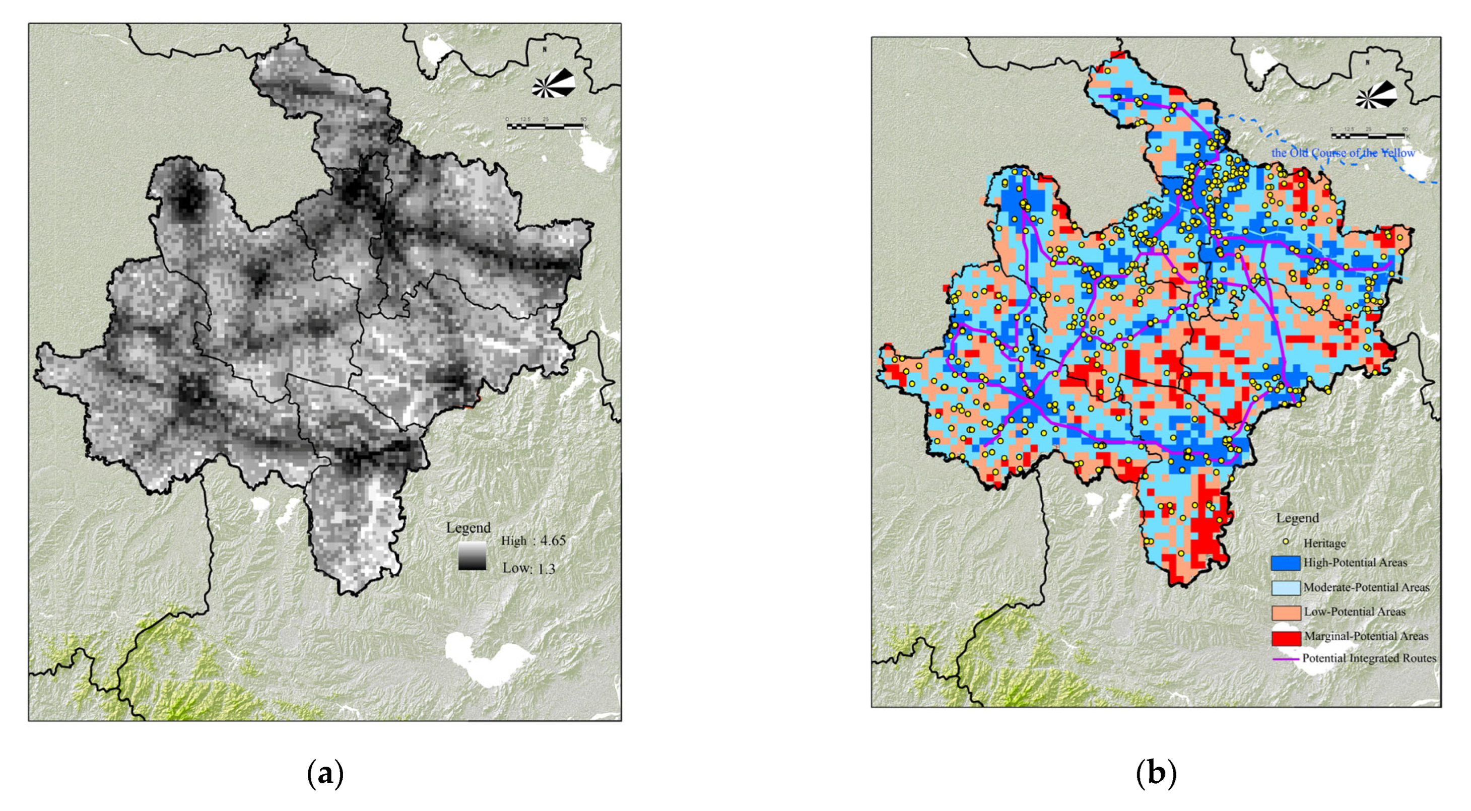
GIS was then used to calculate the integrated resistance values of heritage (Figure 8a). Land on both sides of potential resistance corridors was classified using the Jenks natural breaks method. The Jenks natural breakpoint method is adopted to classify composite resistance values into four classes, aiming to identify relative spatial disparities in culture-tourism connectivity conditions within the study area. Class boundaries are defined according to natural clustering features of the value distribution to minimise intra-class variance and maximise inter-class variance, which suits the graded representation of the integrated resistance surface. Furthermore, considering the requirements of regional-scale spatial identification and zoned management, the results are categorised as high potential (1.15–2.25), moderate potential (2.25–2.75), low potential (2.75–3.35), and marginal potential (3.35–4.8) (Figure 8b).
Figure 7.
Indicator Weights and Robustness Analysis. Source: Drawn by the authors.
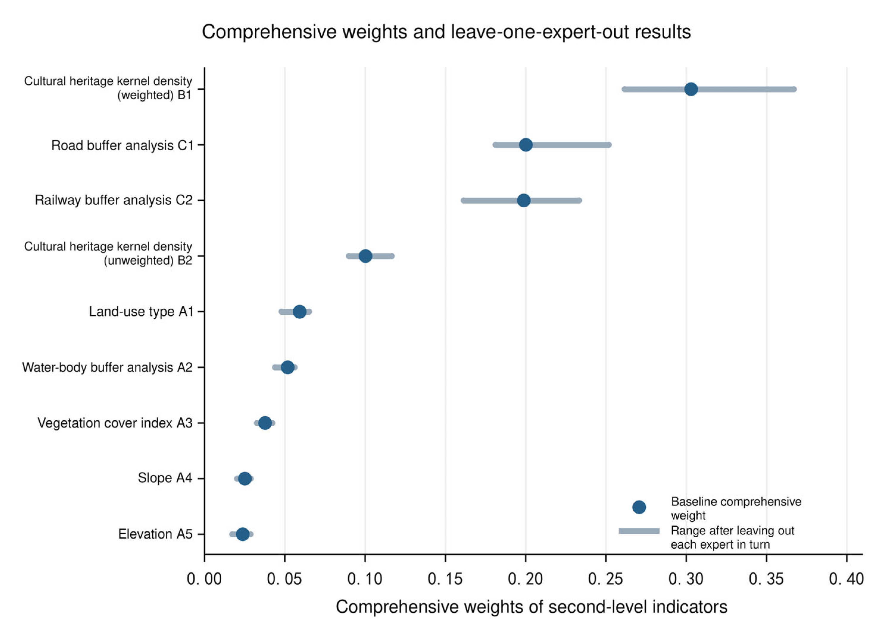
Figure 8.
Potential Zoning Analysis. (a) Integrated Resistance (b) Potential Zoning. Source: Drawn by the authors.
3.4.2. Positive Impacts
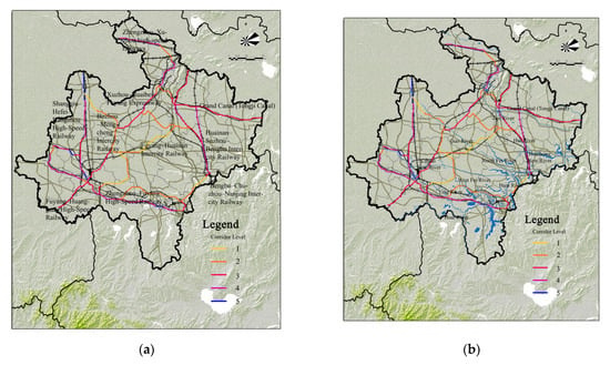
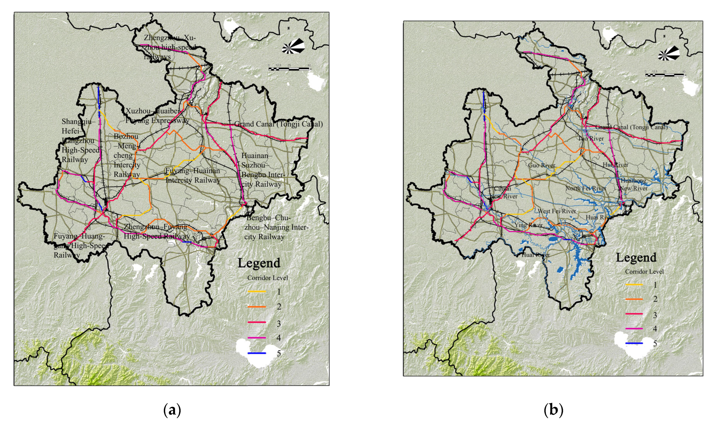
At the territorial spatial level, areas of positive impact primarily comprise high-potential areas and moderate-potential areas and exhibit linear distribution. The nodes within these zones generally coincide with built-up areas of cities and counties and present a scattered point pattern. Cost-path modelling in GIS was implemented (Figure 9a), revealing that potential corridors show strong alignment with high-speed railways and expressways. The significance grade of positive impacts gradually decreases from very high to slight outward from the corridor centre.
Figure 9.
Schematic Conclusions of the Impact Assessments. (a) Positive-Impact Analysis (b) Negative-Impact Analysis. Source: Drawn by the authors.
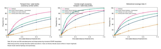
This study validates spatial compatibility against the Northern Anhui Culture-Tourism Integrated Development Circle (2023–2027). GIS spatial overlay, buffer analysis and line-length coverage statistics are adopted to examine the spatial correspondence between potential corridors and existing transport networks (Figure 10). At the 1 km threshold, the combined coverage rate of railways and highways reaches 60.59%, while the coverage rises to 95.37% at the 5 km threshold. These results demonstrate that corridors are spatially adjacent to existing transport routes and exhibit evident scale dependence. The coverage increases with expanding buffer distances, indicating broader spatial correspondence between the two elements at the regional scale.
Figure 10.
Corridor Coverage by Transport Networks and Water Bodies. Source: Drawn by the authors.
3.4.3. Negative Impacts
Areas of negative impact include low-potential and marginal-potential zones, covering river systems and cultivated land in the central part of the study area. Cultivated land is distributed in patchy and interspersed patterns and creates limited conflicts with the Spatial Pattern of Culture-Tourism Integration; its significance grade of negative impact is slight. Rivers flow from the northwest to the southeast and generate substantial conflicts with potential corridors, with a significance grade of negative impact rated very high (Figure 9b). From the perspective of water system association, potential corridors intersect water bodies mainly through partial crossing and adjacency. The total length of corridors directly overlapping with water surfaces is approximately 18.41 km, accounting for 1.24% of the total corridor length, which suggests that direct aquatic intersection occupies a small proportion of the whole network. The proportion of corridors adjacent to water bodies rises gradually as buffer distance increases, with a coverage rate of 18.59% at the 1 km threshold (Figure 10).
4. Discussion
4.1. Formation of the Spatial Pattern of Culture-Tourism Integration
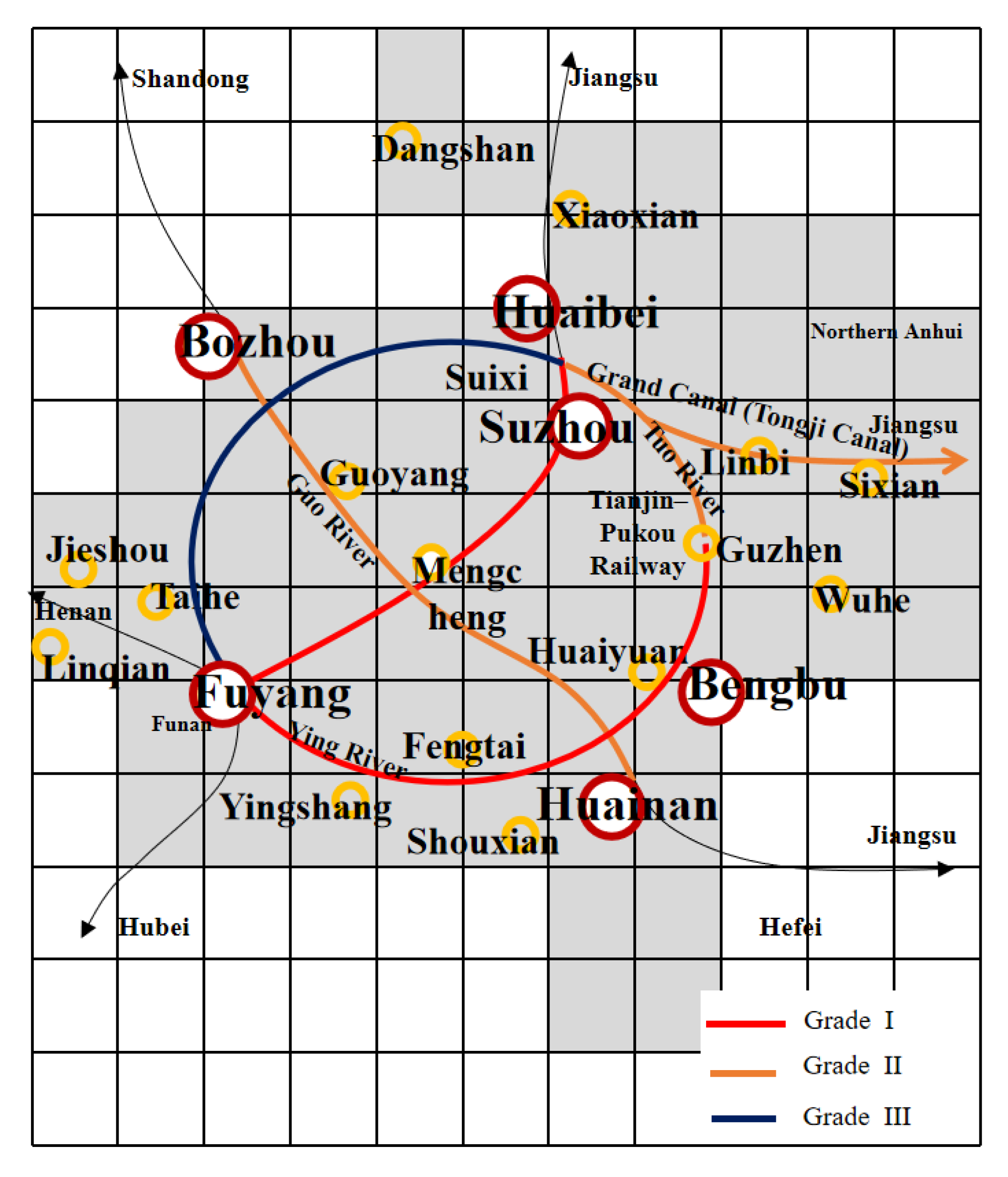
Based on the preceding findings regarding the matching and validation of potential corridors for the Spatial Pattern of Culture-Tourism Integration, this study follows the Territorial Spatial Planning of Anhui Province (2021–2035), and comprehensively considering the Plan for Culture-Tourism Integration Development Circle of Northern Anhui (2023–2027), the Construction Plan for the Northern Anhui Grand Tourism Loop (Draft for Consultation), the Action Plan for Enhancing the Development Level of Anhui’s Integrated Transport System (2024), and the 14th Five-Year Plan for Transport Development in Anhui Province alongside other relevant economic and social development plans, the Spatial Pattern of Culture-Tourism Integration of Northern Anhui are defined into three categories: the outer loop, internal intersecting routes, and external connection routes, which connect six prefecture-level cities and eighteen counties across Northern Anhui.
- Outer loop: Shangqiu–Hefei–Hangzhou High-Speed Railway, Zhengzhou–Fuyang High-Speed Railway, Huai’an–Suzhou–Bengbu Intercity Railway, Jinpu Railway, and Xuzhou–Huaibei–Fuyang Expressway;
- Internal intersecting routes: the Fuyang–Huainan Intercity Railway intersects with the planned Bozhou–Mengcheng Intercity Railway at Mengcheng;
- External connection routes: the southern Fuyang–Huanggang High-Speed Railway links the region with Hubei Province; the Bengbu–Chuzhou–Nanjing Intercity Railway connects to Nanjing; the northern Shangqiu–Hefei–Hangzhou High-Speed Railway and Zhengzhou–Xuzhou High-Speed Railway connect to Henan Province and Xuzhou of Jiangsu Province; and the intra-provincial Zhengzhou–Fuyang High-Speed Railway links to Hefei. In the preceding ecological sensitivity analysis, all types of water systems were uniformly designated as zones of high ecological sensitivity and treated as adverse change factors for development. As a connecting hub between the Central Plains and Jiangnan and a contested territory between northern and southern ancient regimes, Northern Anhui’s history essentially revolves around adaptation to, utilisation of, and competition over water systems. The Tuo River, anciently named “Xiao Shui,” spans roughly 3000 years, and its basin served as the core battlefield of the Battle of Gaixia. Known as “Huan Shui” in the Xia and Shang dynasties and renamed “Qiao Shui” in the Qin and Han dynasties, the Hui River witnessed the construction of grain granaries by Cao Cao at Linhuan alongside the river during the Three Kingdoms period. From the Sui and Tang dynasties to the Ming and Qing dynasties, it adopted the official name of the Hui River and was integrated into the Tongji Canal section of the Grand Canal, linking the Yellow River, Huaihe River and Yangtze River systems. The Yellow River’s capture of the Huaihe River in 1194 fundamentally reshaped the spatial pattern of territorial space in Northern Anhui. Tributaries including the Guo River and Ying River undertook flood drainage tasks, while also serving alternative transport roles and gaining new strategic significance. Accordingly, after sorting out the historical values of river systems in Northern Anhui, this study integrates their spatial orientations with the findings of negative impact analysis, and incorporates the Grand Canal (Tongji Canal), Tuo River, Guo River, and Ying River into the spatial pattern of culture-tourism integration. The Tuo River and Ying River are integrated into the outer loop, the Guo River is incorporated into the internal intersecting routes, and the Grand Canal (Tongji Canal) serves as an external connection route linking the study area with Jiangsu.
The opening of the Tianjin–Pukou Railway in 1912 also fundamentally reshaped the spatial pattern of territorial space in Northern Anhui. In view of the linkage between the Tianjin–Pukou Railway and the Huainan–Suzhou–Bengbu Intercity Railway, this railway corridor is also included in the spatial pattern of culture-tourism integration. The revised Spatial Pattern of Culture-Tourism Integration of Northern Anhui consists of two hierarchical components: corridors represented by trunk transport routes (the outer loop, internal intersecting routes and external connection routes), and nodes comprising six central urban areas and eighteen counties (county-level cities) (Figure 11).
Figure 11.
Spatial Pattern of Culture-Tourism Integration in Northern Anhui. Source: Drawn by the authors.
Corridors within the Spatial Pattern of Culture-Tourism Integration function as follows. The outer loop connects the territorial space of Northern Anhui via railways, highways and water systems to build an inward-oriented spatial structure. The internal intersecting routes link the original eastern and western urban clusters of Northern Anhui and reinforce regional cohesion. The external connection routes secure unobstructed outward links for this inward-oriented structure and facilitate smooth pathways for receiving spillover value activities from outside the region.
For nodes within the Spatial Pattern of Culture-Tourism Integration, from the conservation perspective, the highest-value zones in Northern Anhui concentrate in Bozhou, Huaibei and Shouxian. These areas should evolve into value agglomeration cores in the future to deliver the driving effect of values at the territorial spatial level. From the development perspective, in accordance with the Territorial Spatial Planning of Anhui Province (2021–2035), the Fuyang Urban Circle covers the whole administrative area of Fuyang and surrounding cities and counties. It acts as the core engine steering regional development in Northern Anhui and is positioned as a demonstration zone for coordinated urban development and an emerging growth pole of Northern Anhui. Mengcheng lies at the regional centre and bridges the original eastern and western urban clusters of Northern Anhui, emerging as a notable potential node.
4.2. Differentiated Spatial Governance Mechanism
4.2.1. Connectivity Mechanism
For regional development, a connectivity mechanism should be established. New cultural corridors shall be actively cultivated to fit the territorially compatible Spatial Pattern of Culture-Tourism Integration. In Europe, Cultural Routes have promoted emerging tourism industries, supported integrated development along the routes, and stimulated development in remote areas [34]. In the United States, heritage corridors have played an important role in conserving living landscapes and revitalising local economies [35]. The new cultural corridors should be used to integrate the histories and spaces of districts and counties along them into a dynamic system across time and space, enabling the region to withstand impacts arising from external changes, exercise effective governance over regional space, and promote the overall development of Northern Anhui.
At the territorial space level, the new cultural corridors transform Northern Anhui’s existing outward-oriented, dispersed spatial pattern into an inwardly cohesive one. They endow existing major transport corridors and river systems with a new cultural core and can generate a spatial interaction pattern characterised by clustered concentration, point-surface development, and corridor-based connections. Exploitable tourism land resources alongside new cultural corridors and at nodal cities and counties should be tapped to facilitate coordinated culture-tourism land development across cities and counties. This approach can overcome the interest constraints of individual actors and establish a spatial system of positive interaction among multiple perspectives and stakeholders. Municipalities, districts, and counties across Northern Anhui should form a governance alliance. Collaborative governance bodies implement hierarchical management to establish a multi-stakeholder collaborative governance framework for heritage space. Special emphasis should be placed on the pivotal role of county-level spaces in the overall connectivity network.
4.2.2. Proactive Mechanism
For the conservation of the values of historical space, a proactive mechanism for historical value conservation should be explored. HIA should participate throughout the entire process of cultural-tourism land development and construction, enabling dynamic assessment from project siting to implementation. First, targeting the latent value characteristics of Northern Anhui, proactive standards should be formulated; a special heritage conservation plan for Northern Anhui should be prepared; strict-control zones for heritage conservation should be delineated, and baseline controls implemented as the foundation for spatial governance. Latent values associated with the Guo River, Ying River, Tuo River, and Hui River systems, the Tianjin–Pukou Railway, military historical environments, and other elements within Northern Anhui should be assessed; distinctive heritage identification criteria should be formulated; and coordinated conservation and development strategies should be established for different value levels.
As heritage assets in Northern Anhui are strongly dependent on their surrounding contexts, abundant latent heritage resources remain to be identified. This situation originates from a long-standing paradigm that frames heritage conservation around the perception of systemic vulnerability. The one-dimensional thinking pattern in value recognition has become a bottleneck for heritage designation, leaving some tangible carriers of latent values undiscovered. In response to the latent characteristics of heritage in Northern Anhui, future research should reinterpret value connotations epistemologically, adopt “historical space” to define the spatial existence of such heritage resources, and develop methods for the precise identification of historical space. The boundaries of historical space should be incorporated into the special heritage conservation plan for Northern Anhui, so that the relationships between conservation and impacts can be considered in advance to guide the preparation of detailed territorial spatial plans.
4.3. Differentiated Spatial Governance Strategy
The Spatial Pattern of Culture-Tourism Integration goes beyond conventional heritage conservation instruments and evolves into a composite carrier for spatial governance that integrates value recognition, spatial integration and functional coordination. A governance approach of “excavating latent historical resources—identifying culture-tourism integration routes—fostering distinctive development corridors” should be explored. Meanwhile, in response to conflicts between conservation and development, the corridors are subdivided to formulate segmented control strategies.
4.3.1. Segmentation and Control
Based on the parallel and intersecting relationships between these transport corridors and various rivers, this study subdivides transport corridors and adjacent high- potential areas and moderate-potential areas into three control segments with the highest, moderate and lowest conflict levels, establishing a three-tier control system, namely Grade I, Grade II and Grade III.
Grade I Control Segment is the core governance object, covering the Fuyang–Guzhen section along the southern outer corridor and the Fuyang–Suzhou section of the intersecting corridor. For spaces with tensions between heritage conservation and development, priority should be given to the coordinated governance of historical spaces and production-living-ecological spaces. This study dissects the internal logic of compatibility and conflict between these spatial systems and anticipates potential adverse impacts brought by future development interventions. Special attention shall be paid to the interplay between historical spaces and ecological spaces. Relying on the institutional framework of territorial spatial planning, we delineate historical-ecological characteristic zones and develop differentiated access mechanisms, positive and negative lists within these zones. We formulate regulatory requirements featuring directory management + spatial access + binding indicators, and explore new historical-ecological land-use categories.
Grade II Control Segment covers the Bozhou–Huainan section of the intersecting corridor, the Guzhen–Huaibei section along the eastern outer corridor, and the Grand Canal corridor. Future planning should integrate the construction of the Grand Canal Cultural Belt and national parks, and develop a culture-tourism development model featuring coupling and coordination between water systems and major transport arteries. Mengcheng lies at the junction of Grade I and Grade II Control Segments. Further research should be conducted on integrated development strategies for historical spaces and production-living-ecological spaces, value-based classification of land use for historical spaces, and diversified semi-formal land uses.
Grade III Control Segment includes the Fuyang–Bozhou–Huaibei section along the northern outer corridor. For territorial spaces with development and utilisation potential, we take the construction of the culture-tourism integration spatial pattern as an opportunity to optimise the spatial layout of value elements and form advantageous zones with differentiated gradients of conservation and utilisation. This approach can undertake industrial relocation from developed regions and create a win-win pathway for integrated development in underdeveloped areas. For key potential development zones, such as cultural transition zones of historical spaces and urban development boundaries, regulatory requirements combining negative lists and control lines can be established.
4.3.2. Interpretation and Utilisation
Finally, based on the positive and negative impacts identified through the impact assessment, differentiated pathways for the interpretation and presentation of culture-tourism integration should be explored. Existing approaches to heritage presentation can generally be categorised into physical display and virtual display. According to the spatial control segments derived from mitigation measures, corresponding presentation strategies should be developed. Grade I, where conflicts between development and conservation are most significant, is more suitable for a presentation model based on “scenario design-virtual display -digital dissemination- platform development,” emphasising immersive interpretation and non-invasive transmission of values. Grade III, where conflicts between development and conservation are relatively limited, can adopt a model of “urban design—spatial exhibition—project development—infrastructure support,” enabling intensive cultural-tourism utilisation and place-based economic development. Grade II, characterised by moderate conflicts between development and conservation, should adopt a hybrid approach integrating virtual and physical presentation, with customised interpretation strategies determined according to specific spatial conditions and heritage attributes.
Future efforts should focus on systematically identifying potentially available land resources along the new cultural corridors, planning comprehensive land consolidation projects and tourism development initiatives, and establishing a specialised project-based framework for culture-tourism integration in Northern Anhui. Through coordinated spatial governance and targeted intervention, such strategies aim to achieve synergistic enhancement of economic, social, ecological, and cultural values, thereby supporting sustainable regional development and heritage-led territorial transformation.
5. Conclusions
Northern Anhui’s historical values are latent and embedded within territorial space, accompanied by pressing demands for culture-tourism integration. Clarifying the mutual fit between values and territorial space and scientifically facilitating the formation of the Spatial Pattern of Culture-Tourism Integration constitute the core research issue of this study. Based on the philosophy of coordinated conservation and development, this study adopts the HIA approach, expands the connotation of values, takes “historical space” as the assessment object, and uses the dual evaluations of territorial spatial planning as the source of impacts. The MCR Model is embedded to innovate the HIA framework, identify potential spaces and facilitate the formation of the Spatial Pattern of Culture-Tourism Integration. Drawing on assessment findings, differentiated spatial governance strategies are proposed to support the coexistence of conservation and regional development in Northern Anhui.
The findings indicate obvious differentiation of impacts across the Spatial Pattern of Culture-Tourism Integration of Northern Anhui. High-potential areas and moderate-potential areas are dominated by positive impacts and can form an inward-oriented spatial structure. Low-potential areas and marginal-potential areas are dominated by negative impacts; notably, water systems present notable conflicts with corridors within the Spatial Pattern of Culture-Tourism Integration.
From the perspective of coordinated conservation and development and grounded in assessment findings, this study puts forward differentiated spatial governance mechanisms targeting governance stakeholders and governance foundations at the macro scale, which can be delivered through Special Planning. Focusing on conflicts between conservation and utilisation, the Spatial Pattern of Culture-Tourism Integration is managed via segmented control and integrated into territorial spatial planning. Differentiated spatial governance strategies are proposed from the dimensions of land-use regulation and interpretation and utilisation.
The contributions of this study are as follows. Guided by the dual coordination of value conservation and regional development, this research develops the Spatial Pattern of Culture-Tourism Integration at the territorial scale and establishes the logic of proactive conservation for latent historical spaces. It revises conventional HIA workflows and generates localised practical experience of HIA adapted to Chinese contexts.
This research also has several limitations. First, approaches for identifying historical spaces require further refinement. Second, the node system of the Spatial Pattern of Culture-Tourism Integration can be further improved; secondary and tertiary nodes can be comprehensively delineated according to control grades of corridors and distances from nodes to corridors in follow-up work. Third, the MCR Model prioritises paths with the lowest resistance cost between sources. Its capacity to represent multi-path diffusion, network redundancy, the intensity of cultural connectivity and critical bottleneck zones is limited. Future research can explore coupled multi-model technical schemes to enhance the scientific robustness and comprehensive explanatory capacity of the assessment framework.
Many regions analogous to Northern Anhui face the same contradiction between latent values and accelerating development. The HIA-MCR assessment framework constructed in this study is transferable and can serve as a reference for culture-tourism-oriented impact assessment and differentiated spatial governance in other comparable regions beyond Northern Anhui. Meanwhile, future research can further examine the HIA-MCR assessment framework by integrating diverse methods and conducting case studies in more analogous regions to continuously revise and optimise this assessment framework.
Author Contributions
Conceptualization, Y.F.; methodology, Y.F.; software, T.Y.; validation, D.T., Y.F.; formal analysis, T.Y.; investigation, Y.F., T.Y.; resources, T.Y.; data curation, T.Y.; writing—original draft. preparation, Y.F., T.Y.; writing— review and editing, F.Y; visualization, T.Y.; supervision, D.T.; project administration, D.T.,Y.F.; funding acquisition, D.T. All authors have read and agreed to the published version of the manuscript.
Funding
This research was funded by [Jiangsu Social Science Fund] grant number [26GLB036].
Data Availability Statement
The data presented in this study are available on request from the corresponding author.
Conflicts of Interest
The authors declare no conflict of interest.
Abbreviations
The following abbreviations are used in this manuscript:
| HIA | Heritage Impact Assessment |
| MCR | Minimum Cumulative Resistance |
| PPC | Planned Preventive Conservation |
| AHP | Analytic Hierarchy Process |
References
- Zhao, J.J.; Yu, M.H.; Liu, B.; Wei, L. Effects of integration on the integrated development of culture and tourism in canal cities in the Yangtze River Delta: Internal mechanisms and spatial effects. Areal Res. Dev. 2025, 44, 112–122. [Google Scholar] [CrossRef]
- Zhu, H.; Zhang, Y.G.; Lin, M.S.; Liu, M.; Wang, L.; Wang, L.; Long, F.; Zhang, S.; Yu, W.; Liu, J. High-quality development of the culture and tourism industry in the context of territorial spatial optimization: Characteristics, understanding and key issues. Econ. Geogr. 2021, 41, 1–15. [Google Scholar] [CrossRef]
- Wu, H.T. A History of Environmental Change in the Huai River Basin; Huangshan Publishing House: Hefei, China, 2017; ISBN 9787546163772. [Google Scholar]
- Cui, D.; Wu, H.; Liu, H.H.; Wu, D.Y. Models and pathways for targeted poverty alleviation through tourism in metropolitan poverty belts: A case study of 22 nationally designated poverty-stricken counties in the poverty belt around Beijing and Tianjin. China Soft Sci. 2019, 7, 81–90. [Google Scholar] [CrossRef]
- Hu, X. Influence of the natural and human environment of the Huai River Basin in Anhui on the content and characteristics of historical and cultural resources. Hist. Res. Anhui 2014, 5, 149–160. [Google Scholar] [CrossRef]
- Hu, X. Influence of the natural and human environment of the Huai River Basin in Anhui on historical and cultural resources associated with place names. Hist. Res. Anhui 2016, 3, 144–151. [Google Scholar] [CrossRef]
- Yang, J.Q. Conservation of urban and rural cultural heritage based on cultural ecology and complex systems. City Plan. Rev. 2016, 40, 103–109. [Google Scholar] [CrossRef]
- Feng, Y. A review of research on the interrelationships of traditional villages based on their settings. China Anc. City 2024, 38, 87–92. [Google Scholar] [CrossRef]
- Feng, Y.; Lü, C.X.; Huang, J. Assessing the associative value of traditional villages based on their settings: A case study of Yaogeli Ancient Village in Wuxi. Dev. Small Cities Towns 2025, 43, 12–20. [Google Scholar] [CrossRef]
- Feng, Y.; Li, J.J. Development and application of impact assessment indicators for historic districts from a people–space synergy perspective: A case study of the Yuehe Historic and Cultural District in Jiaxing. Planners 2023, 39, 64–72. [Google Scholar] [CrossRef]
- Feng, Y.; Yao, X.Y.; Chen, H.T.; Zhang, M.; Li, J. Methods for identifying the boundaries of historic spaces oriented toward land-use regulation. Planners 2024, 40, 72–81. [Google Scholar] [CrossRef]
- Xi, X.W.; Feng, Y.; Liu, Y.B. Coupling characteristics of conservation and utilization of historic spaces and their land-use regulation. City Plan. Rev. 2025, 49, 106–114. [Google Scholar]
- Wang, H.Y.; Tao, L.; Li, Y.T.; Huang, Y.F. Constructing the spatial integrity of the Beijing–Hangzhou Grand Canal (Beijing section) from a cultural corridor perspective. Geogr. Res. 2023, 42, 2622–2643. [Google Scholar] [CrossRef]
- Forman, R.T.T.; Godron, M. Landscape Ecology; John Wiley & Sons: New York, NY, USA, 1986; ISBN 9780471870371. [Google Scholar]
- Yu, K.J.; Li, D.H. A landscape ecological model for urban, rural and regional planning. Urban Plan. Overseas 1997, 3, 27–31. [Google Scholar]
- Feng, Y.; Ye, J.W. A review of the development of heritage impact assessments (HIAs) in China and abroad. Urban Dev. Stud. 2017, 24, 130–134. [Google Scholar] [CrossRef]
- Feng, Y.; Kou, H.Y. Sustainable application of cultural heritage impact assessments (CHIAs) in China: A comparative study. Mod. Urban Res. 2021, 5, 126–132. [Google Scholar] [CrossRef]
- Feng, Y.; Li, H.; Ye, J.W. An introduction to the scope of impact assessment for World Cultural Heritage. Urban Plan. Int. 2022, 37, 151–158. [Google Scholar] [CrossRef]
- Wang, L.; Feng, Y. Synergistic conservation and utilization objectives of cultural heritage impact assessments (CHIAs) and mechanisms for their integration. Planners 2024, 40, 1–9. [Google Scholar] [CrossRef]
- Feng, Y. Heritage Impact Assessment Methods and Applications; East China University of Science and Technology Press: Shanghai, China, 2023. [Google Scholar]
- ICOMOS. Guidance on Heritage Impact Assessments for Cultural World Heritage Properties; ICOMOS: Charenton-le-Pont, France, 2011; Available online: https://openarchive.icomos.org/id/eprint/266/ (accessed on 1 October 2026).
- He, J.; Hu, X.L.; Xi, X.W. Pathways for articulating the values of historical and cultural resources in the context of territorial spatial planning: A case study of Anhui Province. Anhui Archit. 2025, 32, 26–29. [Google Scholar] [CrossRef]
- Yu, K.J.; Xi, X.S. Composition of the Grand Canal heritage corridor from a genesis perspective. Prog. Geogr. 2010, 29, 975–986. [Google Scholar]
- Deng, J.J.; Chen, L.X.; Yang, C.Y.; Xu, Z.B. Assessing the importance of ecological corridors in highly urbanized areas: A case study of Shenzhen. Geogr. Res. 2017, 36, 573–582. [Google Scholar]
- Li, X.B.; Zhu, R.; Shi, C.Y.; Yang, X.K.; Chen, J.Z.; Wei, K.X. Research on the construction of intangible cultural heritage corridors in the Yellow River Basin based on geographic information system (GIS) technology and the minimum cumulative resistance (MCR) model. Herit. Sci. 2024, 12, 271. [Google Scholar] [CrossRef] [Scilit]
- Ge, Y.; Liu, Y.; Ma, Y.; Wang, Y.T.; Guo, Y.F.; He, J.; Mao, Y.L. Spatial identification and corridor network analysis of cultural heritage based on multi-model fusion: A case study of western Henan. Ecol. Indic. 2025, 178, 113859. [Google Scholar] [CrossRef] [Scilit]
- Deng, Y.R.; Ma, Q.Y.; Zhang, Y.Y. Identification, evaluation, classification of the Chengdu-Chongqing Ancient Road cultural heritage corridor. npj Herit. Sci. 2025, 13, 621. [Google Scholar] [CrossRef] [Scilit]
- Liu, Y.; Ma, X. Heritage Corridor Construction in the Sui–Tang Grand Canal’s Henan Section Based on the Minimum Cumulative Resistance (MCR) Model. Land 2025, 14, 2128. [Google Scholar] [CrossRef] [Scilit]
- Wu, Y.Y.; Zhu, H.; Li, J.M.; Wu, X.X. Spatial pattern identification and graded evaluation of intangible cultural heritage tourism corridors in the Yangtze River National Cultural Park. Geogr. Res. 2025, 44, 2429–2449. [Google Scholar]
- Sun, S.W. The knowledge base of territorial spatial planning and its structure. Urban Plan. Forum 2020, 6, 11–18. [Google Scholar] [CrossRef]
- Ma, Y.; Chen, L.H.; Guan, Z.Y. Developing a coordinated conservation system for ecological and cultural heritage in the context of territorial spatial planning: A case study of Foshan. Chin. Landsc. Archit. 2024, 40, 106–112. [Google Scholar] [CrossRef]
- Hu, J.L.; Wang, Y.X.; Teng, Y.B. Construction of the Xiaohe Ancient Road heritage corridor network based on the minimum resistance model. Planners 2020, 8, 66–70. [Google Scholar] [CrossRef]
- Wu, J.; Chen, K.; Chen, J.; Peng, C. Construction of cultural heritage corridors in Jiangmen from the perspective of territorial spatial planning. J. Hum. Settl. West China 2020, 35, 7–16. [Google Scholar] [CrossRef]
- Zhang, C.Y.; Zhang, Y.; Lin, Z.H. An overview of the development of cultural routes in Europe. China Cult. Herit. 2016, 5, 88–94. [Google Scholar]
- Wang, K.; Wang, J.; Zhou, Y.J. Reflections on the conservation of urban and rural historical and cultural heritage from a regional perspective. City Plan. Rev. 2024, 48, 4–13. [Google Scholar]

Notes
| 1 | A Local Development Order (LDO) is prepared by a local authority and exempts specified forms of development within designated areas from the requirement to apply for planning permission, generally with the aim of promoting local economic development. |
| 2 | The allocation of HAV12 in The East Riding Local Plan requires the preparation of a new local plan; this impact assessment serves as a preliminary study. |
Disclaimer/Publisher’s Note: The statements, opinions and data contained in all publications are solely those of the individual author(s) and contributor(s) and not of MDPI and/or the editor(s). MDPI and/or the editor(s) disclaim responsibility for any injury to people or property resulting from any ideas, methods, instructions or products referred to in the content. |
© 2026 by the authors. Licensee MDPI, Basel, Switzerland. This article is an open access article distributed under the terms and conditions of the Creative Commons Attribution (CC BY) license.