


Abstract
As complex socio-ecological systems, cultural landscapes face increasing challenges under climate change. Taking the Eight Scenic Spots of Mount Song in Henan Province, China as a case study, this research examines meteorological–cultural genes as integrated expressions of meteorological conditions, cultural meanings, and human perception. Historical texts, meteorological observations, and tourist surveys were analyzed within the framework of landsenses ecology. Historical materials were coded using NVivo, while meteorological and perceptual indicators were standardized and weighted through the entropy-weight method. A dynamic coupling coordination model was then applied to evaluate interactions between meteorological conditions and multisensory landscape perception. The study identified astronomical-calendar, microclimate-adaptation, poetic–symbolic, and ritual–spatial genes. The results reveal strong climate–perception interactions but comparatively weaker coordination, indicating that environmental sensitivity does not necessarily translate into effective climate adaptability. Based on these findings, a meteorological–sensory dynamic coupling framework and a threshold-responsive management pathway are proposed to support gene identification, climate-risk diagnosis, and differentiated adaptive intervention. The study provides a methodological and practical basis for maintaining cultural expression, multisensory experience, and landscape resilience under climate change.
1. Introduction
The cultural landscape concept originated with Ratzel, referring to human-shaped landscapes [1]. Sauer further defined such landscapes as spatio-temporally evolving natural systems modified by human activities [2,3]. Against the combined pressures of globalization, urbanization and climate change, interdisciplinary research on cultural landscapes, cultural genes and meteorological landscapes has expanded across geography, ecology, sociology and other disciplines. Climate hazards such as extreme rainfall continuously damage cultural heritage. Findings from the KERES project reveal that extreme weather impacts cultural heritage at an unprecedented rate and scale, with archeological sites, historic buildings and underground relics severely threatened by intensified precipitation and other meteorological shifts. Integrating climate projections into preventive and emergency management frameworks has thus become imperative [4], and research on meteorological–cultural landscapes delivers critical theoretical support and practical guidance for such work [5,6].
As coupled human–nature systems, cultural landscapes suffer functional vulnerability under compound disturbances, requiring targeted adaptive governance. In the context of cultural heritage, climate adaptation refers to the process of adjusting heritage conservation, management, and associated socio-ecological systems to actual or expected climate change and its impacts, thereby reducing risks, safeguarding heritage values, and strengthening long-term resilience [7]. The U.S. National Park Service’s Vulnerability Assessment model quantifies climate risks and optimizes protection strategies [8], while UNESCO’s dual certification framework offers institutional safeguards: the Historic Centre of Heaven and Earth gained World Heritage status in 2010 with sustainability mandates, and the Twenty-Four Solar Terms (inscribed on the Intangible Heritage List in 2016) serve as the core meteorological–temporal carrier of the Eight Scenic Spots of Mount Song, supporting research on time-dependent meteorological landscapes such as Songmen Moon Viewing and Luya Waterfall [9].
Domestic studies mostly focus on qualitative cultural interpretation and landscape classification, lacking quantitative modelling and interdisciplinary integration. Ai classified meteorological landscapes via textual decoding and scenic name analysis [10], while Zhao proposed culture-oriented climate adaptation strategies [11]. Landsenses ecology provides a multi-dimensional analytical framework covering natural environments, multi-sensory perception, psychology and risk assessment [12,13]. Steward’s environmental adaptation theory established the foundational human–land research paradigm [14], and Head extended this framework to modern climate change research to interpret human–environment coordination [15,16]. However, most existing studies remain descriptive, failing to quantify bidirectional interactions between meteorological landscape preferences and human sensory drivers; current climate analyses of frost and rime around Mount Song only offer basic climatic background for this study [17]. International meteorological landscape research, built on Sauer’s cultural landscape theory [2,18], features mature interdisciplinary systems. Ingold adopted phenomenology to emphasize dynamic nature–culture interactions and landscape temporality [19]. Strauss explored the climate’s shaping effects on cultural customs [20], and archeologists examined ancient meteorology-related settlement and ritual practices [21]. De Freitas constructed climate comfort assessment models [22], and Gómez-Martín proposed a resource–risk classification framework, highlighting transient meteorological scenery’s perceptual value [23]. Machine learning and climate scenario simulation have been applied to monitor and predict alpine meteorological landscapes [24], and the concept of meteorological healing landscapes has further enriched tourism meteorology research [25]. Nevertheless, mainstream international theories rely on European and American cases, with insufficient localized research for Asia–Pacific regions [26]. Landscape perception research attributes sensory differences to individual cultural traits and external meteorological, seasonal conditions, yet few studies analyze their coupled coordination [27,28,29,30,31,32,33,34,35]. This limitation is particularly important for landscapes in which cultural meanings are repeatedly activated by seasonal and meteorological phenomena. Unlike buildings, settlement layouts, or other relatively persistent physical carriers, meteorological phenomena such as temperature, humidity, wind, fog, snow, sunlight, and celestial conditions are temporally dynamic. Nevertheless, when these phenomena repeatedly interact with specific places, cultural practices, historical narratives, and sensory experiences, they may form persistent associations within cultural memory. Existing meteorological landscape studies have examined climatic comfort, tourism resources, visual scenery, and weather-related landscape experience, while landsenses ecology emphasizes the integration of visual, auditory, tactile, olfactory, and psychological responses. However, the dynamic relationship among meteorological variability, cultural gene expression, and multisensory perception has rarely been incorporated into a unified analytical framework. To fill this gap, this study proposes the concept of the meteorological–cultural gene (MCG) as a climate-sensitive extension of landscape gene theory rather than as an alternative to it. The term “gene” is used here in a metaphorical and analytical sense consistent with landscape gene research; it refers to landscape characteristics and cultural associations that display relative persistence, recognizability, and repeated transmission through historical narratives, place naming, ritual practices, environmental knowledge, and landscape experience. The MCG is defined here as a relatively stable association among recurrent meteorological processes, cultural meanings, and perceptual characteristics embedded in a specific cultural landscape through long-term human–environment interaction. Compared with conventional landscape genes, which have primarily been identified through persistent spatial, morphological, and symbolic characteristics, MCGs emphasize the temporally dynamic expression of cultural landscape characteristics under changing meteorological conditions. Guided by landsenses ecology’s four core principles, this paper constructs a coupling model of landscape perception and MCGs for the Eight Scenic Spots of Mount Song, a typical meteorological–cultural landscape embodying traditional Chinese human–nature harmony, to reveal meteorology–culture interaction mechanisms [36,37,38].
This study addresses climate adaptation challenges of the Mount Song cultural landscape. Data from 2020–2025 indicate 35% of core scenic zones face degradation risks and 62% of snow-dependent landscapes are threatened by warming [39]. Its primary objective is to establish an MCG decoding system and dynamic threshold management mechanism to mitigate climate impacts on tourist experience and strengthen heritage conservation. Further goals include calibrating safe meteorological thresholds for key scenic spots and developing a predictive early-warning framework. To overcome single-case limitations, this paper constructs the transferable Meteorological–Sensory Dynamic Coupling Model Index (MSDCMI), integrating meteorological utility variation (Uw = 0.15–0.88) and institutional adaptability as a standardized evaluation tool. The research delivers a universal early-warning diagnostic framework for high-altitude, culturally dense heritage sites worldwide (e.g., the Alps, Andes) [40], achieving a methodological transition from site-specific conservation to transferable research paradigms.
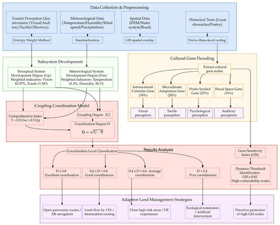
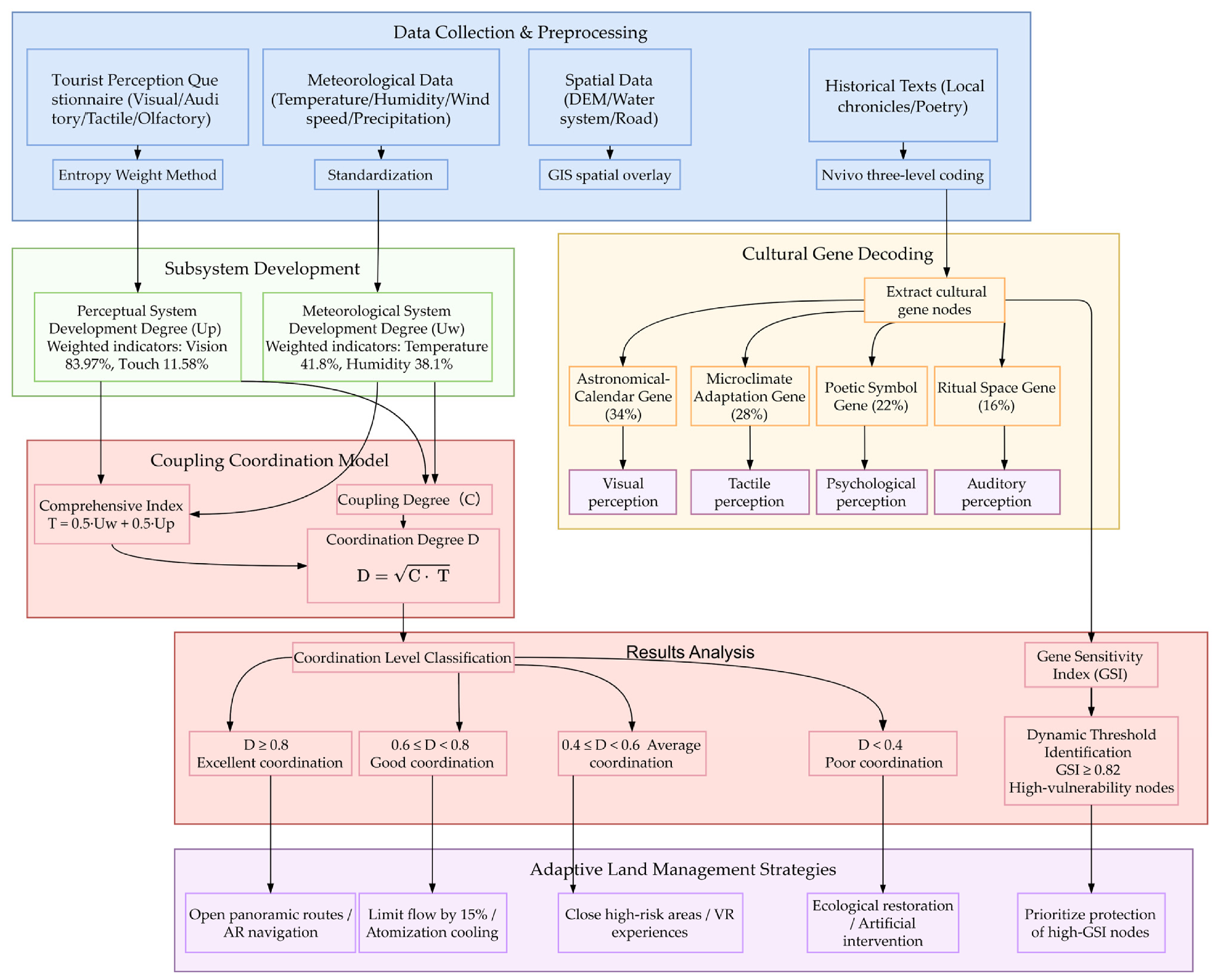
This study summarizes the overall research framework. Multi-source data, including tourist questionnaires, meteorological observations, spatial data, and historical texts, were integrated to identify meteorological–cultural genes and construct perceptual and meteorological subsystems. A coupling coordination model was then used to evaluate meteorological–perceptual relationships and support differentiated adaptive management strategies (Figure 1).
Figure 1.
Research thinking framework.
2. Materials and Methods
2.1. Study Area
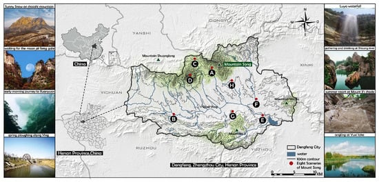
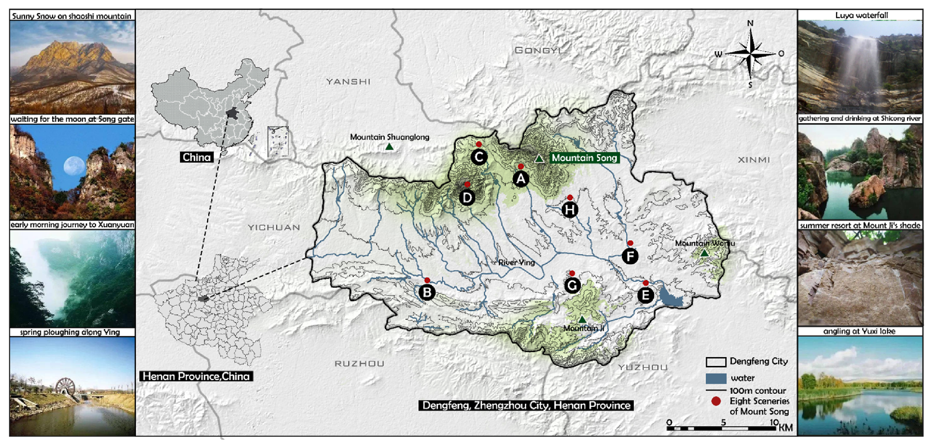
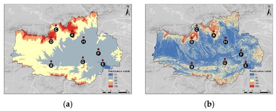
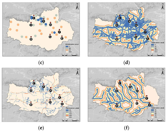
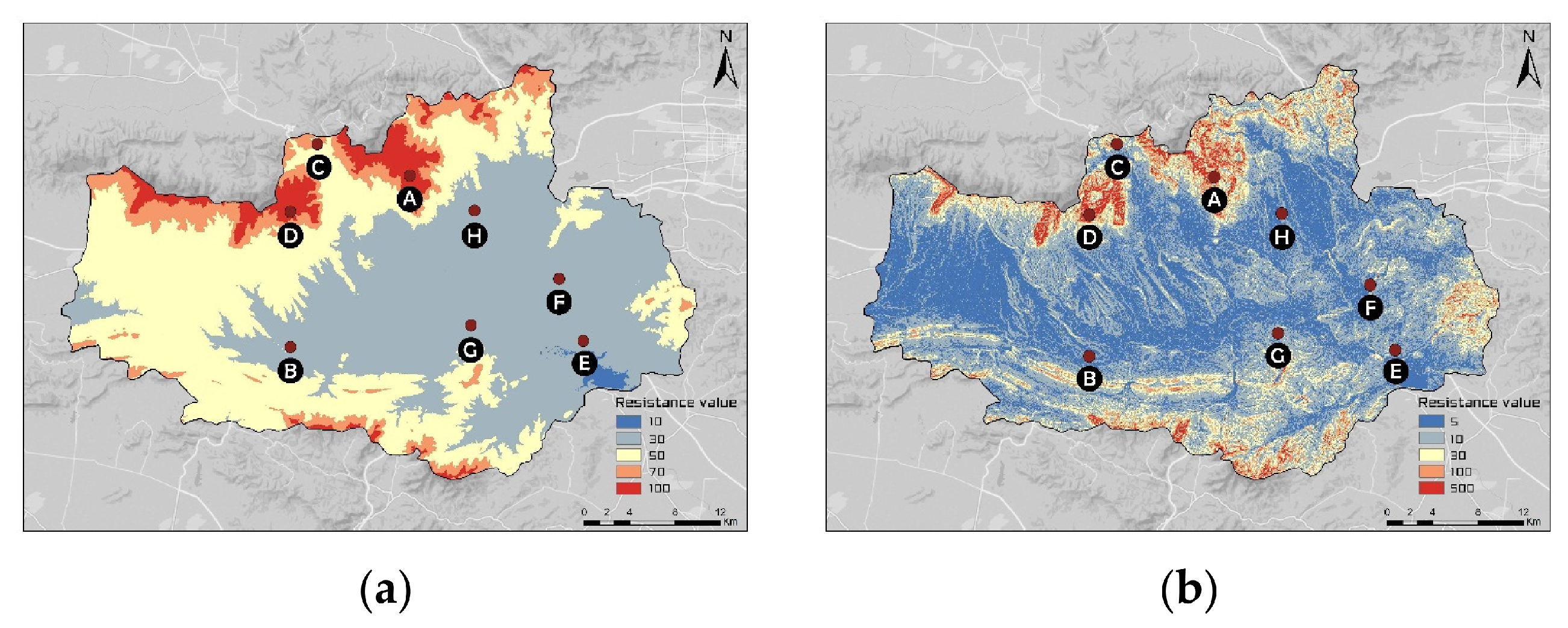
As the core of China’s “Centre of Heaven and Earth” cosmology (UNESCO 2010 World Heritage), the Songshan region demonstrates distinct characteristics in multiple aspects [39], particularly through its dynamic laboratory integrating meteorological and cultural elements. Located at the intersection of three transitional zones, Songshan’s typical continental monsoon climate provides superior natural conditions for the formation of the Eight Scenic Spots. This climatic diversity not only shapes Songshan’s unique natural landscapes but also offers rich adaptive spaces for human activities. A profound perceptual–cultural coding relationship exists between Songshan’s cultural landscapes and meteorological events [41]. Ai Dingzeng identifies meteorological landscapes as temporal sequences, celestial phenomena, climate patterns, and weather phenomena [9]; Liu Huabin categorizes them into seasonal landscapes, temporal landscapes, and meteorological landscapes [42]. Building on these perspectives while considering the Eight Scenic Spots of Mount Song, this study classifies their meteorological landscapes into seasonal landscapes, temporal landscapes, weather phenomena, and celestial phenomena (Table 1). The Eight Scenic Spots of Mount Song, also known as Dengfeng Ancient Eight Scenic Spots, which are located in Dengfeng City, Henan Province (Figure 2), presenting the digital elevation model (DEM) of the Eight Scenic Spots of Mount Song, illustrating the spatial distribution of elevation across the study area. The colour gradient represents elevation ranges from 10 m (blue) to 500 m (dark red) above sea level (Figure 3). As shown in Figure 2, the digital elevation model reveals that the Eight Scenic Spots span an elevation range of approximately 500 m, creating diverse microclimates that contribute to the variation in meteorological elements. The DEM serves as a topographic foundation for explaining the spatial distribution of different scenic views and their associated landscape perception characteristics. The Eight Scenic Spots of Mount Song represent a classical cultural landscape classification from the Tang Dynasty. Each scenery combines natural features with cultural meanings: waiting for the moon at Song gate (moon viewing between twin peaks), early morning journey to Xuanyuan (morning mist linked to the Yellow Emperor), spring ploughing along Ying River (spring ploughing along the Ying River), summer resort at Mount Ji’s shade (summer retreat associated with hermit Xu You), gathering and drinking at Shicong River (the historic imperial banquet site of Empress Wu Zetian from 700 AD), angling at Yuxi Lake (fishing spot connected to Jiang Ziya legend), sunny snow on Shaoshi mountain (post-rain white stone on Shaoshi Peak), and Luya Waterfall (the dramatic waterfall in the northern canyon). These landscapes integrate natural features (peaks, rocks, waterfalls, streams) with meteorological elements (moonlight, fog, rain, sunshine) and deep cultural meanings (Daoist retreat, imperial history, agricultural life, legendary heroes), forming a multi-level perception experience that reflects the integration of nature, Buddhism, Confucianism, and Taoism.
Table 1.
Types of meteorological landscape in Eight Scenic Spots of Mount Song.
Figure 2.
Distribution of the Eight Scenic Spots of Mount Song and the relationship between Mountain and Water. (A) Waiting for the moon at Song gate; (B) spring ploughing along Ying River; (C) early morning journey to Xuanyuan; (D) sunny snow on Shaoshi Mountain; (E) angling at Yuxi Lake; (F) gathering and drinking at Shicong River; (G) summer resort at Mount Ji’s shade; (H) Luya waterfall (source of base map: Dengfeng City Radio and Television Station).
Figure 3.
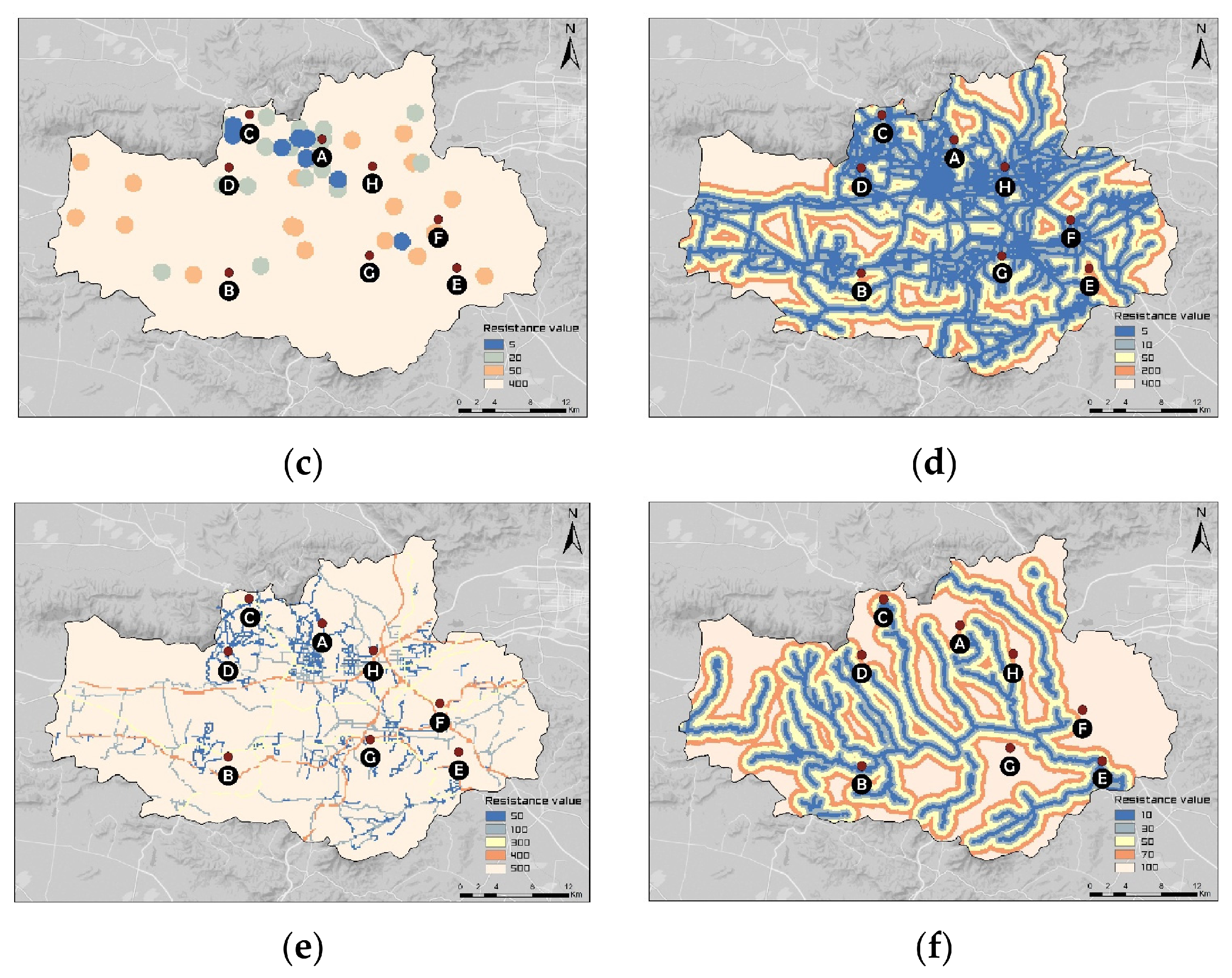
Digital elevation model diagrams of the Eight Scenic Spots of Mount Song: (a) elevation; (b) slope; (c) level of heritage source; (d) distance from the road; (e) road; (f) river.
2.2. Data Sources
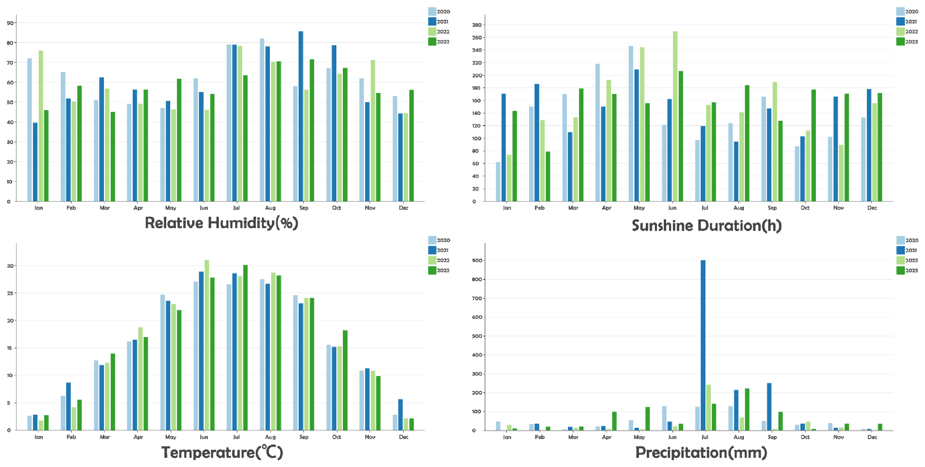
The data sources of this study include historical texts, tourist questionnaire surveys, and long-term meteorological monitoring data, in order to achieve a multi-source comprehensive analysis of meteorological landscape perception. Firstly, a total of approximately 820,000 words of local chronicles and related poetry texts from various dynasties were collected and cleared. NVivo 12 [7] qualitative analysis software was used to extract perceptual dimensions and cultural representations related to meteorological landscapes through a three-level programme of open coding, axial coding, and selective coding. Secondly, a questionnaire based on SBE (Stimulus-Based Evaluation) and SD (Semantic Differential) methods was designed and distributed with a total of 1200 valid samples collected to evaluate tourists’ perception intensity and subjective weight of different meteorological elements (Table 2). Finally, meteorological observation data (humidity, sunshine, temperature, precipitation) from Songshan Scenic Area in recent years (Figure 4) and tourist perception scores (visual, auditory, tactile, olfactory) collected from the China Environmental Meteorological Data Service Platform were obtained, covering all months. The China Meteorological Data Service Centre is a specialized data service platform for environmental impact assessment (CMDC) and scientific research applications. It provides high-precision, long-term meteorological data covering approximately 2100 meteorological stations across China, with temporal resolutions ranging from hourly to annual scales. The platform also integrates air quality monitoring data from the China National Environmental Monitoring Centre. The specific meteorological indicators utilized in this study include temperature, humidity, precipitation, and wind speed, which were sourced from the platform’s ground-based meteorological observation datasets.
Table 2.
Questionnaire—demographic information.
Figure 4.
Meteorological data for Mount Song from 2020 to 2023. Data source: https://data.cma.cn/en2, accessed on 25 July 2025.
2.3. Research Method
2.3.1. Cultural Gene Analysis of the Eight Scenic Spots of Mount Song
Cultural gene analysis is a research method that systematically identifies, extracts, and associates core characteristic units (cultural genes) in cultural landscapes to scientifically reveal their cultural connotations, formation mechanisms, and values [43]. In this study, the term “gene” is treated as a conceptual metaphor rather than a biological entity. Therefore, MCG identification does not rely on biological criteria of genetic replication, mutation, or natural selection. Instead, three analytical characteristics were considered: recurrence, cultural persistence, and place specificity. Recurrence refers to repeated associations between meteorological phenomena and cultural meanings within the textual corpus; cultural persistence refers to the continued representation of such associations through historical narratives, poetry, place names, ritual practices, or traditional environmental knowledge; and place specificity refers to their consistent association with particular landscape settings within the Eight Scenic Spots of Mount Song. Coding units satisfying these characteristics were subsequently classified into the four MCG categories. Applying the method of cultural gene analysis to the study of the Eight Scenic Spots of Mount Song can deeply decode its historical layers and cultural symbols, provide a basis for precise protection and sustainable development, and ultimately achieve the inheritance and sustainable development of cultural heritage. Leveraging human perception as a medium to sense the transformations of the Five Senses of the Eight Scenic Spots and building upon text analysis conducted with NVivo software, the scientific Analytic Hierarchy Process (AHP) method is employed to conduct a qualitative and quantitative assessment of the meteorological landscape value of the Eight Scenic Spots of Mount Song, ultimately distilling their defining characteristics. The AHP procedure was used for the evaluation of meteorological landscape characteristics and was independent of the calculation of MCG proportions. The proportions of the four MCG types were derived from normalized NVivo coding frequencies. The textual data related to the Eight Scenic Spots of Mount Song was imported into NVivo 12 software for analysis. Following the grounded theory approach, a three-level coding process was conducted: first, open coding identified initial concepts from raw text (Level-3 nodes); second, axial coding grouped similar concepts into thematic categories (Level-2 nodes); and finally, selective coding integrated these categories into core thematic dimensions (Level-1 nodes). All coding was performed from the perspective of five land-senses (visual, tactile, auditory, olfactory, and gustatory). The study yielded 5 Level-1 nodes, 12 Level-2 nodes, and 23 Level-3 nodes, and coded 717 reference points.
2.3.2. Coupling Relationship Verification of the Eight Scenic Spots of Mount Song and Sensory Perception
As a typical representative of traditional Chinese landscape scenery, the synergy effect between the meteorological landscapes and multisensory experiences of the Eight Scenic Spots of Mount Song is a key factor in enhancing the quality of ecotourism. This study adopts a meteorology-sensory dynamic coupling model as a methodological approach to analyze the nonlinear interactions between meteorological factors and human sensory perception, which serves as a theoretical foundation for adaptive management of World Heritage sites. Both the multisensory experiences and meteorological landscapes in the Eight Scenic Spots of Mount Song are nonlinear dynamic systems; the interaction between the two constitutes a composite system. Based on the General Systems Theory [44] and the Lyapunov Stability Theory [45], this study defines evolution functions for sensory experience systems and meteorological landscape systems. Monthly meteorological observation data for the Mount Song Scenic Area from January to December 2024 were obtained from the China Environmental Meteorological Data Service Platform. The meteorological variables included air temperature, relative humidity, and wind speed. Tourist perception data were collected separately through questionnaire surveys covering four sensory dimensions: visual, auditory, tactile, and olfactory perception. The survey covered the Eight Scenic Spots of Mount Song, although the mode of evaluation differed according to site accessibility. For accessible scenic spots, responses were based primarily on direct landscape experience, whereas inaccessible or difficult-to-access sites were evaluated indirectly on the basis of respondents’ existing knowledge, visual impressions, and available landscape representations. Therefore, the questionnaire data were treated as a mixed-mode perception dataset and were mainly used to identify aggregate multisensory perception patterns rather than to conduct strict site-to-site statistical comparisons. For sites that were not directly accessible, standardized photographs representing the principal landscape characteristics were used as visual stimuli in accordance with the SBE approach. After data screening and quality control, 1200 valid questionnaires were retained. The meteorological observations and tourist perception scores were subsequently organized and matched by month for the coupling coordination analysis. Through coupling metrics quantifying dynamic synergies between these systems, we formulate a Dynamic Coupling Coordination Model (DCCM) applicable to integrated natural–cultural landscapes [46].
To interpret multidimensional coupling complexities and eliminate dimensional and weighting differences, development indices of subsystems were quantitatively evaluated using the acquired datasets:
The development degree of meteorological systems Uw, where Uw denotes the comprehensive development index of the meteorological or weather subsystem:
Standardized meteorological indicators (temperature, humidity, wind speed).
The weighted entropy method, where temperature (41.8%) and humidity (38.1%) dominated.
The sensory system development degree Up, where Up denotes perceptual system development index:
Standardized sensory indicators (visual, auditory, tactile, olfactory).
The weight determined by entropy weighting method is visual-dominant (83.97%) and tactile second (11.58%).
Finally, a coupling coordination degree model was constructed, comprising coupling degree calculation and coordination degree calculation. The coupling degree (C) quantifies the interaction intensity between two subsystems [47], with its focus on the closeness of their interdependent relationship, while being sensitive to the subsystems’ equilibrium state. The equivalence embodies bidirectional interaction. When Up = Uw, C = 1, indicating fully synchronous evolution. The evolution equation is:
C → 1: High interdependence exists between systems, exemplified by the synergistic interplay between autumn foliage spectacle and clear skies.
C → 0: Systems evolve independently, such as low temperatures in winter inhibiting sensory experience.
Coordination degree (D) represents the coupling intensity between the comprehensive system and its own development level, and the quality of the overall coordinated development of the main body is sensitive to the development level of the system (T) [48]. The evolution equation is:
D ≥ 0.8: High-quality coordination, efficient system collaboration (such as spring and autumn travel season).
D < 0.4: Severe imbalance requiring urgent intervention (e.g., during the winter ecological rest period); the detailed analysis is presented in Table 3.
Table 3.
Interpretation of the D value range.
3. Results
3.1. Spatiotemporal Differentiation of Meteorological Landscapes in the Eight Scenic Spots of Mount Song
A comprehensive evaluation of the meteorological landscape types of the Eight Scenic Spots of Mount Song was conducted, and conclusions were drawn regarding their seasonal phases, temporal sequences, and landscape perceptions. The specific findings are as follows: The Eight Scenic Spots of Mount Song exhibit notably pronounced seasonal and temporal variations. Their landscapes encompass the seasonal shifts in spring (spring ploughing along the Ying River), summer (Luya Waterfall), autumn (waiting for the moon at Song gate), and winter (early morning journey to Xuanyuan). These landscapes reflect the region’s distinctive seasonal characteristics. From a landscape perception standpoint, the Eight Scenic Spots of Mount Song provide striking visual, tactile, and auditory experiences. Visually, the views offer diverse, multilayered stimuli, including mountains, bodies of water, vegetation, celestial phenomena, and human activities. This presents viewers with rich visual experiences. Visitors can also experience tactile sensations such as misty clouds caressing their skin, sunlight illuminating surfaces, and the touch of mountain springs or waterfalls, which enrich the perceptual layers of the landscape. Auditory features include the roar of “Luya Waterfall”, the murmuring stream at “gathering and drinking at Shicong River”, and the interplay of labour sounds and wind in “spring ploughing along Ying River”. Together, these features create a multifaceted, three-dimensional auditory landscape that delivers a comprehensive, multisensory immersive experience for visitors.
3.2. The Meteorology of the Eight Scenic Spots of Mount Song: The Coding Results of Cultural Genes
Gene coding analysis reveals that visual, tactile, and auditory senses dominate at 99.73% among the five land-senses categories at the Level-1 node level. Visual senses lead at 83.97%, with mountain-water landscapes comprising over half, reflecting Mount Song’s landscape-centred character. Architectural (11.79%) and meteorological landscapes (19.27%) represent humanistic and natural variations, respectively.
Tactile (11.58%) and auditory codes (4.18%) show secondary importance. Tactile psychological perception (47 times) exceeds physiological perception (36 times), aligning with Mount Song’s cultural heritage as a sacred mountain. Natural sounds (18 times) and religious artificial sounds (nine times) echo the region’s natural and spiritual character.
Overall, the sensory structure follows “visual dominance, tactile supplementation, auditory embellishment,” with mountain-water landscapes and religious culture as core carriers (Table 4).
Table 4.
Statistical analysis of the sensory coding distribution of the Eight Scenic Spots of Mount Song.
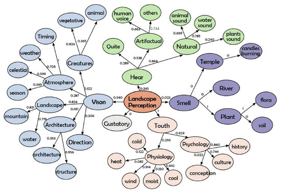
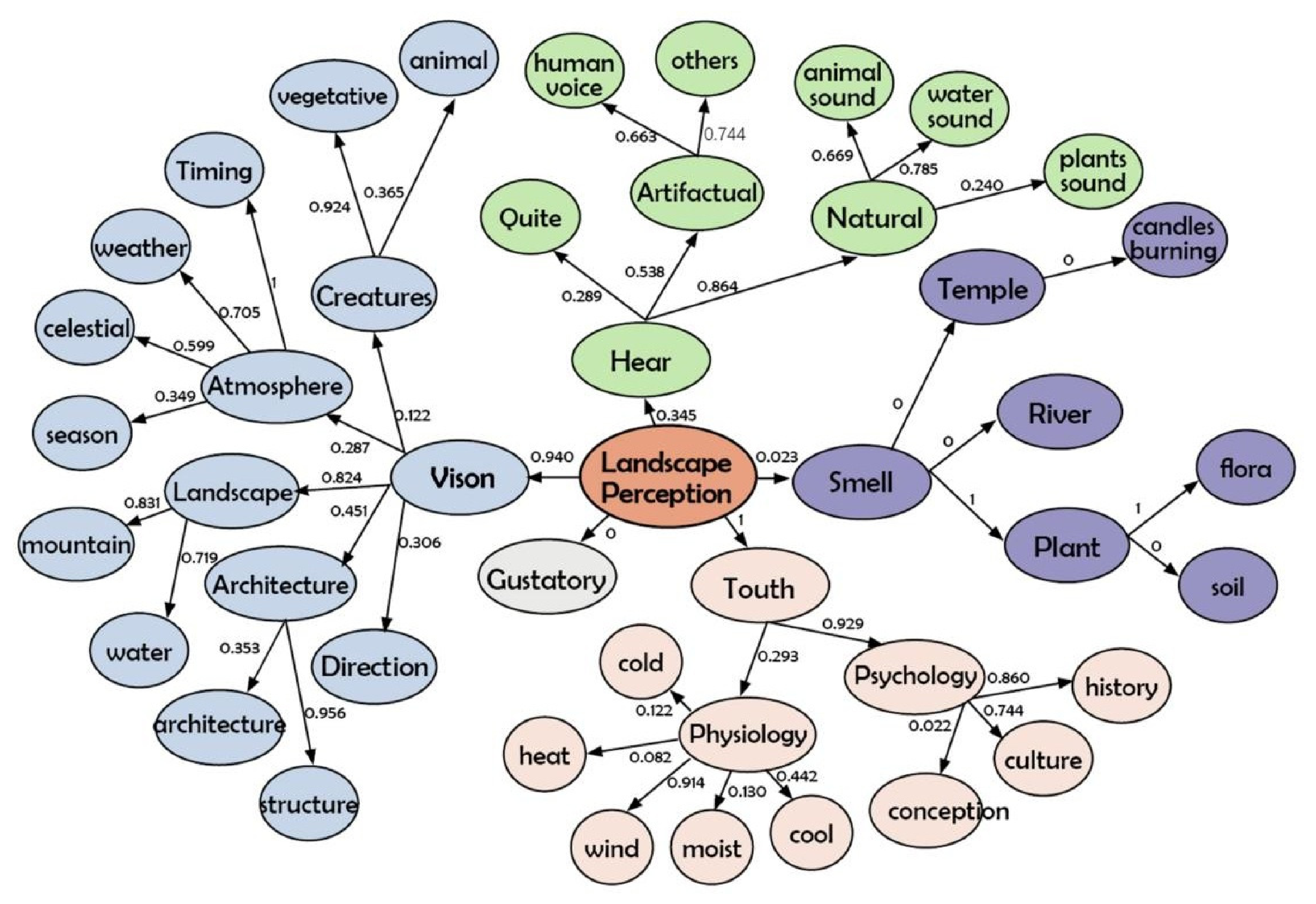
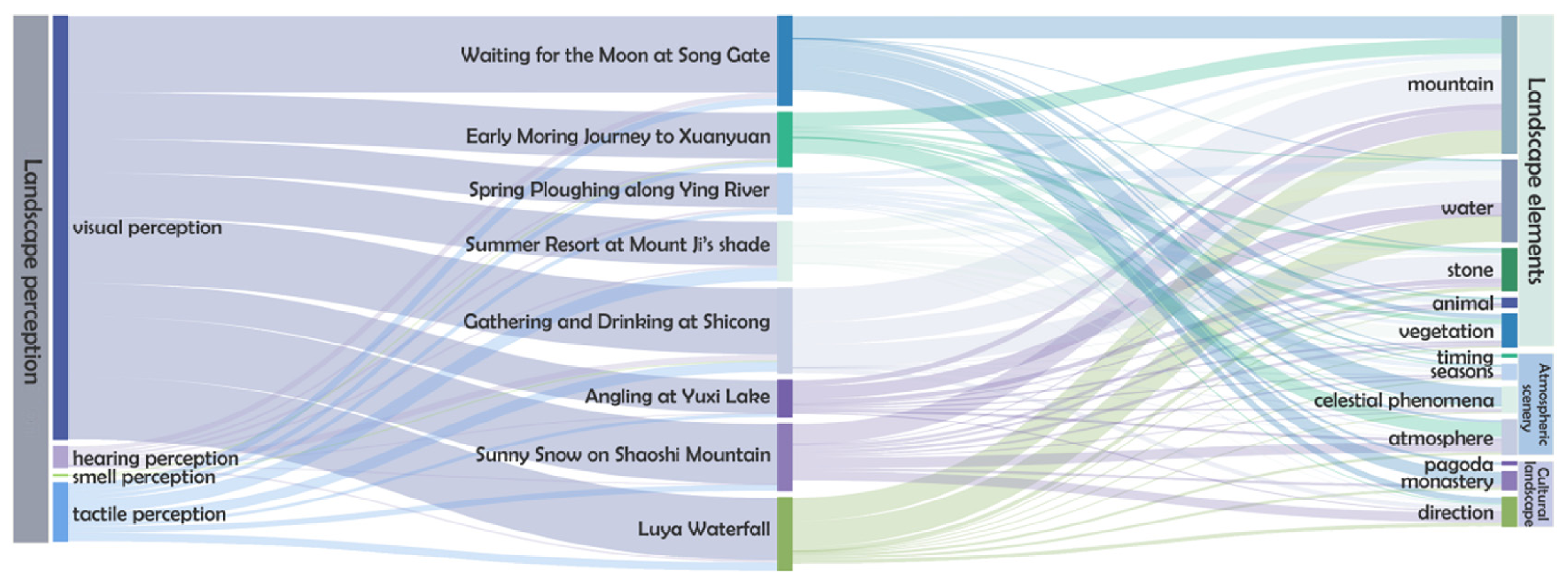
After coding the textual materials related to the Eight Scenic Spots of Mount Song, the Pearson correlation coefficient (characterizing the degree of relevance) between the nodes was extracted and labelled in the landsenses structure map (Figure 5) and the Sankey map (Figure 6) of the Eight Scenic Spots of Mount Song. In the landsenses structure correlation diagram, the secondary nodes of visual, tactile, auditory, olfactory, and taste senses are displayed around the landscape perception as the centre. The layout ratio shows that visual nodes and their association points are dominant, followed by tactile and auditory senses, with fewer smell senses and almost no significant representation of taste. Further analyzing the connection strength between the landsenses and each sub-node, it is found that the correlation between the sense of touch and the sense of sight is the highest (r = 1), followed by the sense of sight (r = 0.940), then the sense of hearing (r = 0.345); the sense of smell is lower (r = 0.023), and the sense of taste shows almost no correlation (r ≈ 0), and the Sankey diagrams below display the correlation strengths and distribution characteristics among each element more intuitively.
Figure 5.
Structural gene of the landsenses of the Eight Scenic Spots of Mount Song.
Figure 6.
Landsenses dimensional matrix and cultural gene affiliation nexus of the Eight Scenic Spots of Mount Song.
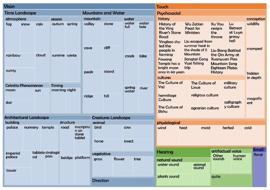
Using the hierarchical chart function of the NVivo12 software [7], the overall landsenses hierarchical chart of the Eight Scenic Spots of Mount Song was generated based on the coded reference points (Figure 7), which shows that visual codes occupy a significant majority of the overall landsenses codes, making it the easiest to quantify and the most obvious category of senses, followed by tactile and auditory—a result which is consistent with that derived from the coding analysis in the previous section. Compared to the simple quantity analysis of landsenses reference points, this hierarchical chart provides a more intuitive visualization, highlighting the differences between the different senses in the experience of the Eight Scenic Spots of Mount Song. The results show that the strong correlation between the senses of touch and sight is most prominent in the sensory experience of the Eight Scenic Spots of Mount Song, fully demonstrating their multi-sensory characteristics of being touchable, visible, and both audible and odorous.
Figure 7.
Hierarchical distribution of the landsenses structure–model gene of the Eight Scenic Spots of Mount Song.
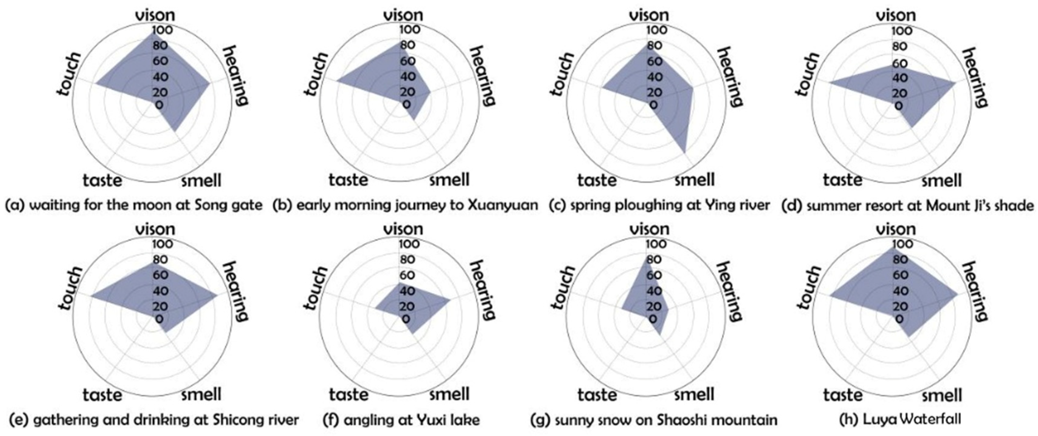
Based on the above subdivided perceptual dimensions—visual, auditory, olfactory, gustatory, and tactile—a summary of the perceptual elements of the Eight Scenic Spots meteorological landscapes in Mount Song was conducted (Table 5). Using the nodes classified in the previous chapter as reference points, each dimension was assigned a maximum score of 100 points. Through quantitative analysis, the research precisely measured the relative importance and performance levels of individual experiences across these dimensions. The evaluation criteria are mainly based on the tourist preference model constructed by Hu Xianke [49] through spontaneous geographic information data (VGI), which integrates two types of variables: tourist trajectory density and photo content encoding. The entropy weight method is used to weight and integrate them. The visual weight is 0.8397, the auditory weight is 0.0418, the tactile weight is 0.1158, and the olfactory weight is 0.0027, ensuring that the evaluation results have both subjective and objective reference basis. In this model, the tourist preference scores corresponding to the Eight Scenic Spots of Mount Song are transformed into five sensory dimensions: for example, “Luya Waterfall” performs outstandingly in the auditory and tactile dimensions due to its water vapour and sound effects, while meteorological Eight Sceneries such as “waiting for the moon at Song gate” and “sunny snow on Shaoshi mountain” have more advantages in the visual dimension and temperature perception. The “summer resort at Mount Ji’s shade “ and “spring ploughing along Ying river” are limited by seasonality and facility conditions and show relatively flat performance in marginal dimensions such as taste and smell. The final summary score was used to construct a multidimensional perceptual quantitative evaluation radar map of the Eight Scenic Spots of Mount Song (Figure 8). The core part of this scale is centred around the intuitive blue area, displaying the score distribution of each attraction on different perceptual dimensions.
Table 5.
Representative multisensory perceptual features of the Eight Scenic Spots of Mount Song.
Figure 8.
The perception scale of meteorological cultural gene types of the Eight Scenic Spots of Mount Song.
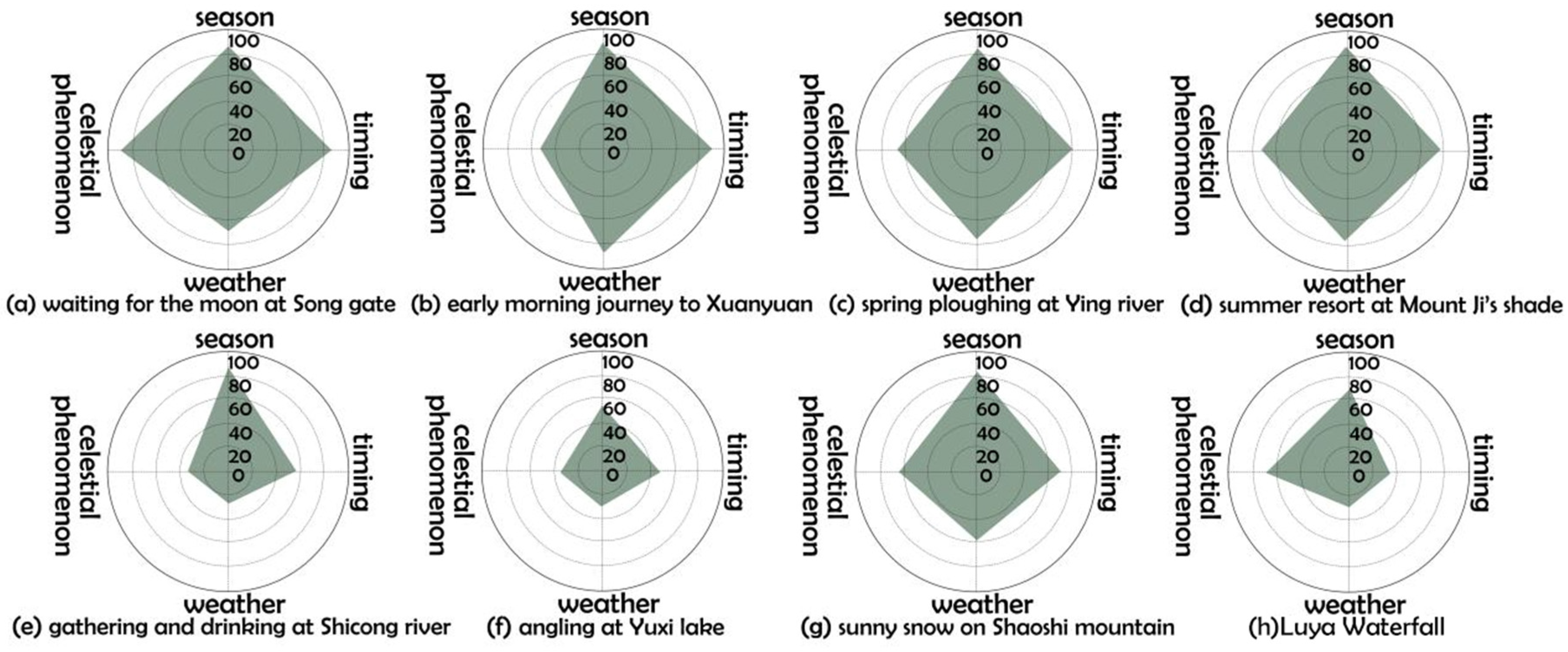
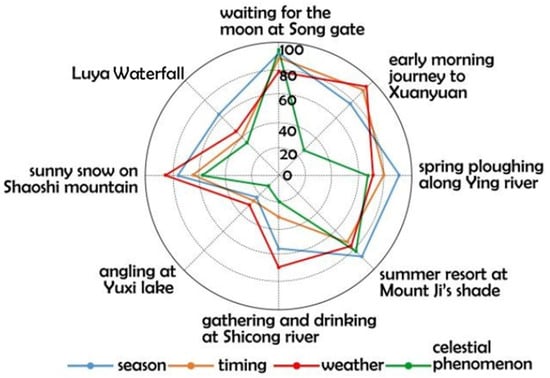
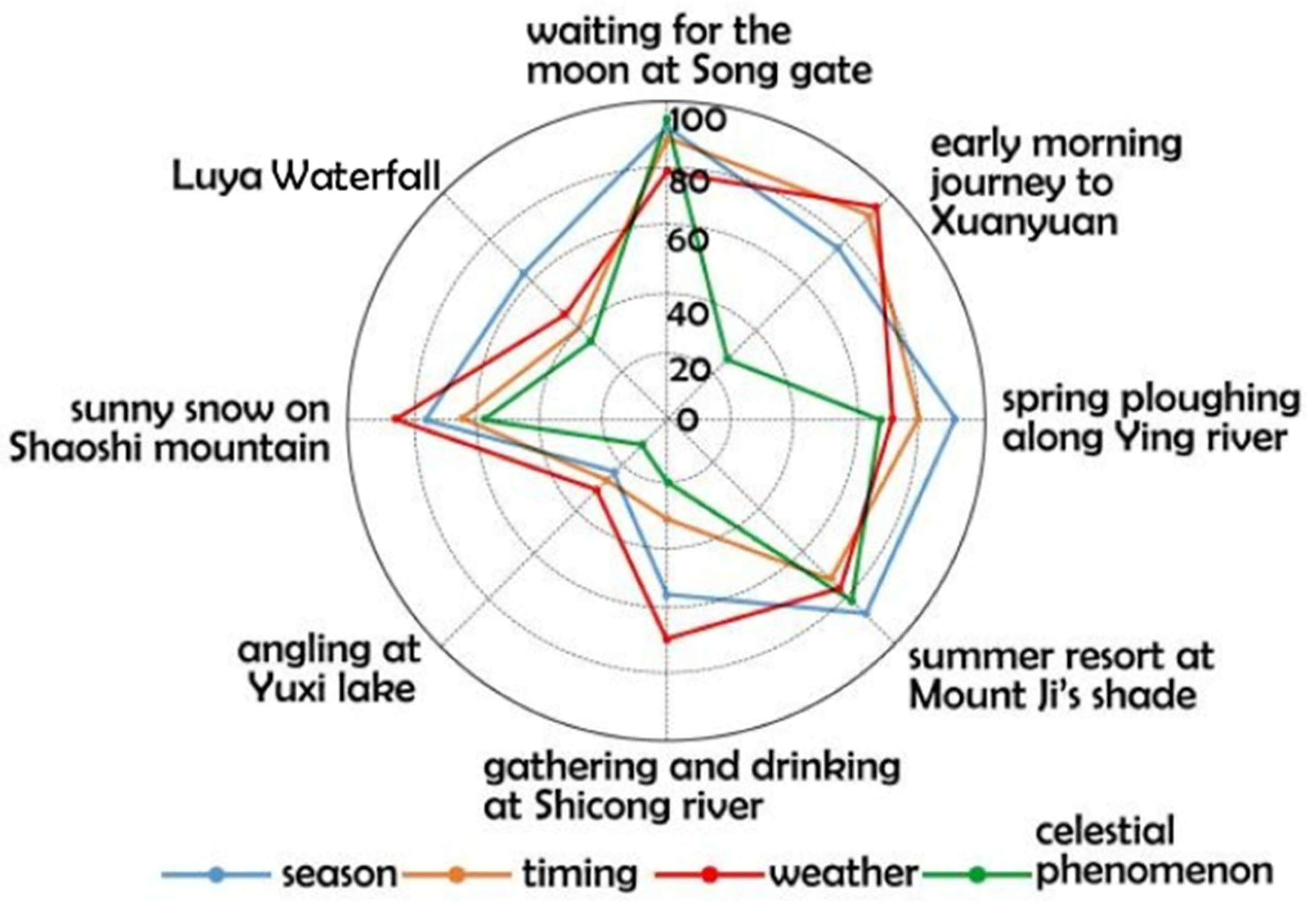
According to the classification criteria of meteorological landscapes of the Eight Scenic Spots of Mount Song proposed in the previous section, namely seasonal phase, time sequence, weather and celestial bodies, each landscape of the Eight Scenic Spots of Mount Song has been sorted and summarized (Table 6), and the typicality of meteorological landscapes has been evaluated, and the evaluation results, as shown in the figure below (Figure 9), are calculated by using a percentage system, calculating the average scores, and scored by the 10 postgraduates in turn.
Table 6.
The meteorological–cultural gene atlas of the Eight Scenic Spots of Mount Song (source of base map: Dengfeng City Radio and Television Station).
Figure 9.
The typicality scale of meteorological cultural gene types of the Eight Scenic Spots of Mount Song.
The following conclusions about the typicality of meteorological landscapes, the richness of landscape perception, and the significance of landscape perception features were obtained from the data of meteorological landscapes and landscape perception levels of the Eight Scenic Spots visualized by the radar map (Figure 10). The evaluation results of each meteorological landscape of the Eight Scenic Spots of Mount Song in the evaluation of typicality are:
(1). Typicality Ranking: “Waiting for the moon at Song Gate” achieved the highest typicality score, followed by “early morning journey to Xuanyuan” and “summer resort at Mount Ji’s Shade”.
(2). Perception Richness: The landscape perception evaluation revealed different patterns, with “waiting for the moon at Song gate” and “Luya Waterfall” ranking highest.
(3). Sensory Dimension Significance: The visual dimension dominated all scenic spots, while the olfactory dimension had the lowest weight. Summer landscapes were characterized by significant auditory sensory feelings.
(4). Summer Landscape Category: “summer resort at Mount Ji’s shade” and “gathering and drinking at Shicong River” were identified as the same characteristic category due to their shared auditory sensory features.
Practical Implications: The findings provide a scientific basis for weather-based tourism planning and sensory landscape management at Mount Song.
Figure 10.
Radar analysis map of the meteorological landscape perception for the Eight Scenic Spots of Mount Song.
3.3. The Meteorological and Cultural Genetic Types and Driving Mechanisms of the Eight Scenic Spots of Mount Song
The astronomical calendar system represents the materialization of temporal order and cosmological perspectives. The Twenty-Four Solar Terms, derived from observations of natural phenomena, guide agricultural production, daily customs, and philosophical expression [50]. As a pivotal site for ancient astronomical observation, Mount Song offered optimal geographical and natural conditions for monitoring the heavens. The concept of the “Centre of Heaven and Earth” transformed astronomical observations such as Gnomon Shadow Measurements into sacred geographic coordinates. The correspondence between celestial phenomena and terrestrial landscapes supports the logic of Dong Zhongshu’s “Heaven–Man Resonance” theory: “Heaven displays signs; the sage follows them.” Microclimate-adaptive features exemplify ecological wisdom. “Summer resort at Mount Ji’s shade” uses topography to create cooling islands in the summer, and “Luya Waterfall” uses its three-tiered cascade to regulate humidity—both of which demonstrate precise responses to local climates, “spring ploughing along Ying River” regulates drought and flooding through a water–field coupling system. These practices align with the technical ethics of “adapting to the terrain and measuring the suitability of the soil” outlined in the Artificers’ Record. The poetic symbol gene represents the spatial translation of literary imagery, expressing admiration for and emotional attachment to nature through literary works and artistic forms. From Empress Wu Zetian’s poetry at the gathering and drinking at Shicong River to Du Fu’s verses on Shaoshi Mountain, scenery names such as “gathering and drinking at Shicong River” and “sunny snow on Shaoshi Mountain” constitute literary codes themselves. The “poetic–pictorial homogeneity” of the Eight Scenic Spots makes them an ideal model of a “walkable, viewable, navigable, and habitable” landscape. Ritual spatial genes represent the spatial coding of power narratives. Archeological evidence confirms that the layout of the “Centre of Heaven and Earth” historical complex embodies a ritual spatial hierarchy centred on the “Centre of Heaven and Earth” cosmological concept, with architectural axes and surrounding landscape forming an integrated sacred–secular spatial system [51]. The “Xuanyuan Pass Ancient Road” served as an imperial transportation hub, and the “Sacrificial Sequence of the Central Peak Temple” reinforced political authority through spatial hierarchy. This process, known as “natural sacralization → politicization of sacred space,” served as the material embodiment of the “divine mandate of the sovereign” ideology under the philosophy of “heaven–human resonance.”
To further clarify how these meteorological–cultural genes are expressed in specific landscape settings, the gene carriers of the Eight Scenic Spots were summarized from four dimensions: representative sensory perception, spiritual–cultural characteristics, social landscape practices, and physical landscape features (Table 7). The results indicate that meteorological–cultural genes are not expressed through isolated landscape elements, but through the combined interaction of sensory experience, cultural meaning, social practice, and physical landscape carriers.
Table 7.
Landscape carriers of meteorological–cultural genes in the Eight Scenic Spots of Mount Song.
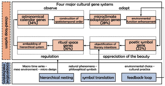
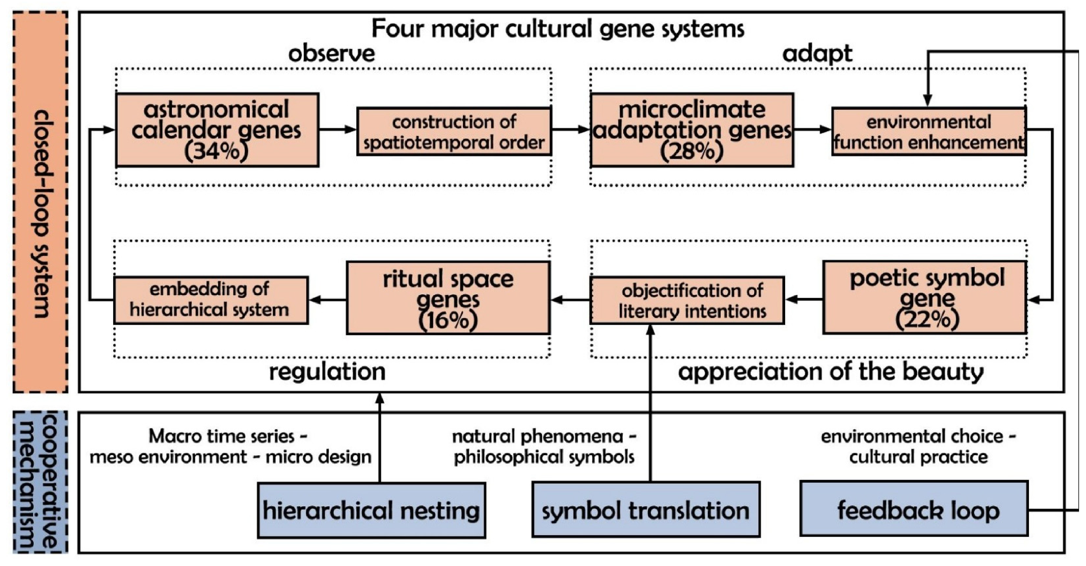
From the perspective of landsenses ecology, the formation and development of the Eight Scenic Spots of Mount Song are systemically driven by four cultural genes: the astronomical–calendric gene governs landscape patterning through spatio-temporal order construction; the microclimatic adaptation gene optimizes environmental functionality via ecological wisdom; the poetic symbol gene materializes literary imagery into tangible landscapes; and the ritual–spatial gene endows scenery with political–ethical connotations. Based on the normalized frequencies of MCG-coded references, the astronomical–calendric gene represented the largest proportion of the coded corpus, followed by the microclimate-adaptation, poetic–symbolic, and ritual–spatial genes. Their relative coding proportions were 34%, 28%, 22%, and 16%, respectively. These proportions indicate the relative prevalence of the four gene categories within the analyzed historical and cultural materials rather than absolute measures of their cultural importance. These four genetic categories operate (Figure 11) synergistically through three mechanisms—hierarchical nesting (macro-temporal → meso-environmental → micro-design scales), feedback loops (environmental selection ⇄ cultural practice interactions), and symbol translation (philosophizing natural phenomena)—ultimately integrating ecological processes, cultural expressions, and social structures within the “Heaven–Human Resonance” framework to form an organic landscape system with distinct spatio-temporal characteristics.
Figure 11.
Cultural gene driving flowchart of the Eight Scenic Spots of Mount Song (percentages indicate normalized proportions of coded references rather than subjective importance weights).
3.4. Meteorological and Sensory Perception Coupling of the Eight Scenic Spots of Mount Song
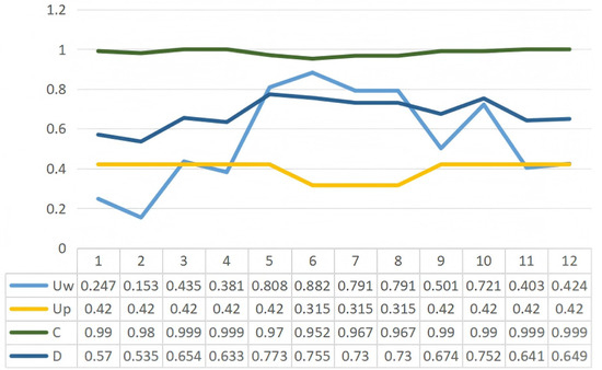
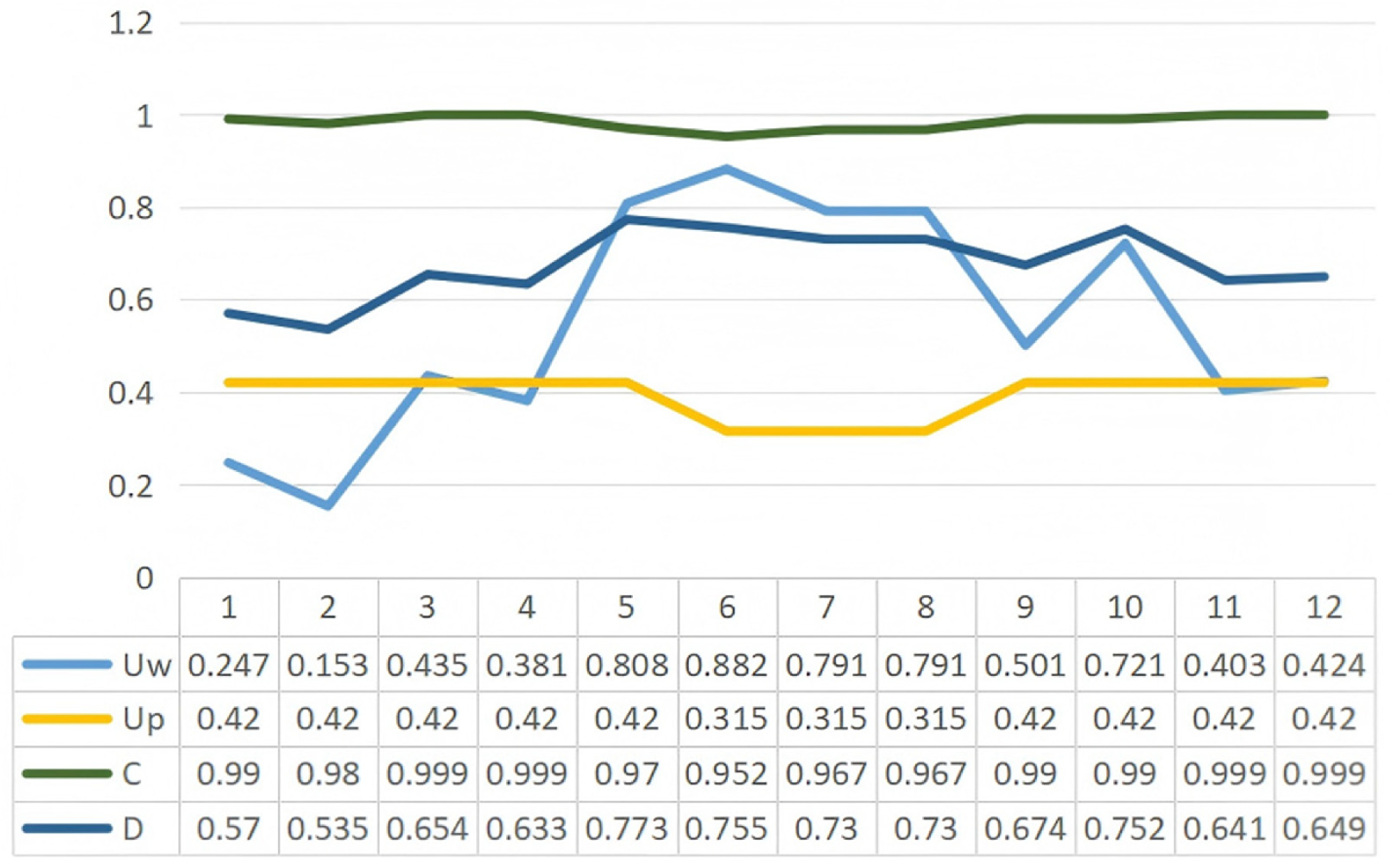
According to the previous equations, the dynamic coupling coordination degree model between the Eight Scenic Spots of Mount Song and perceived weather (Equations (1)–(4)). The results show that most C values approach 1, indicating a strong interaction between the two systems. However, D is also influenced by Uw and Up. Therefore, even with high coupling, D may remain low if Uw or Up is low. The D values range from 0.535 to 0.773. Except for January and February, which exhibit primary coordination (0.4 ≤ D < 0.6), all other months demonstrate good coordination (0.6 ≤ D < 0.8). Based on the coupling coordination evaluation criteria, the coordination degree values falling within the range of [0.60–0.80] are classified as “satisfactory coordination”. The first two months of the year demonstrate weaker coordination with D values below [0.6] compared to other months, suggesting a temporary period of suboptimal system synchronization. In January, Uw = 0.247 and Up = 0.420; in February, Uw decreases to 0.153, while Up remains at 0.420. These values indicate that the utility of the meteorological landscape (Uw) is lower during winter, leading to reduced coordination. Conversely, other months exhibit higher Uw values, particularly from May to August, when Uw exceeds 0.7 or 0.8. This corresponds to higher coordination levels (D). These results suggest that the utility of the meteorological landscape significantly impacts overall coordination.
According to the model coupling results, the coordination between the Mount Song’s meteorological landscape and sensory experiences shows distinct seasonal patterns (Table 8). Winter (January–February) shows the lowest coordination (D ≈ 0.55) due to low temperatures and limited sensory experiences, such as auditory and tactile experiences. Summer (May–August), on the other hand, exhibits the highest coordination (D ≈ 0.73–0.77). Although high temperatures and humidity enhance landscape appeal, they also cause tactile discomfort. The annual fluctuation range of meteorological landscape utility (Uw) (0.15–0.88) far exceeds the stability of sensory experience utility (Up ≈ 0.32–0.42). Although coupling remains high (C ≥ 0.95), it is constrained by differences in subsystem utility, and coordination consistently fails to surpass the optimal threshold (D ≥ 0.8).
Table 8.
Coupling results of meteorological–perceptual coordination.
The esthetic system of the Eight Scenic Spots of Mount Song is constructed through the coordinated coupling associations between various landscape elements, mediated by historical anecdotes and poetic culture. It involves a wide range of elements, including meteorology, architecture, vegetation, mountains and waters, humanistic scenes, and scenes of daily life. The close connection between landscape perception and meteorological landscapes in this system also reflects a profound understanding of the natural environment in the Mount Song area and a unique esthetic sensibility of humans. The preceding section has conducted both qualitative and quantitative analysis of the landsenses elements of the Eight Scenic Spots of Mount Song. The analysis of landsenses texts indicates that the Eight Scenic Spots of Mount Song are primarily perceived through visual senses, supplemented by auditory and tactile perceptions.
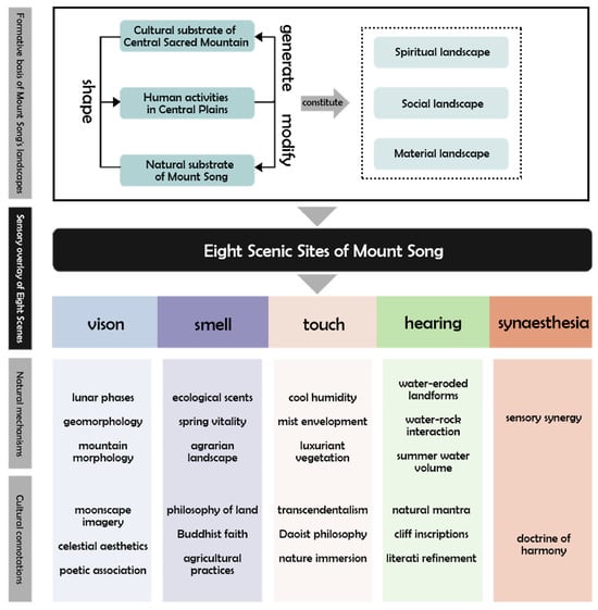
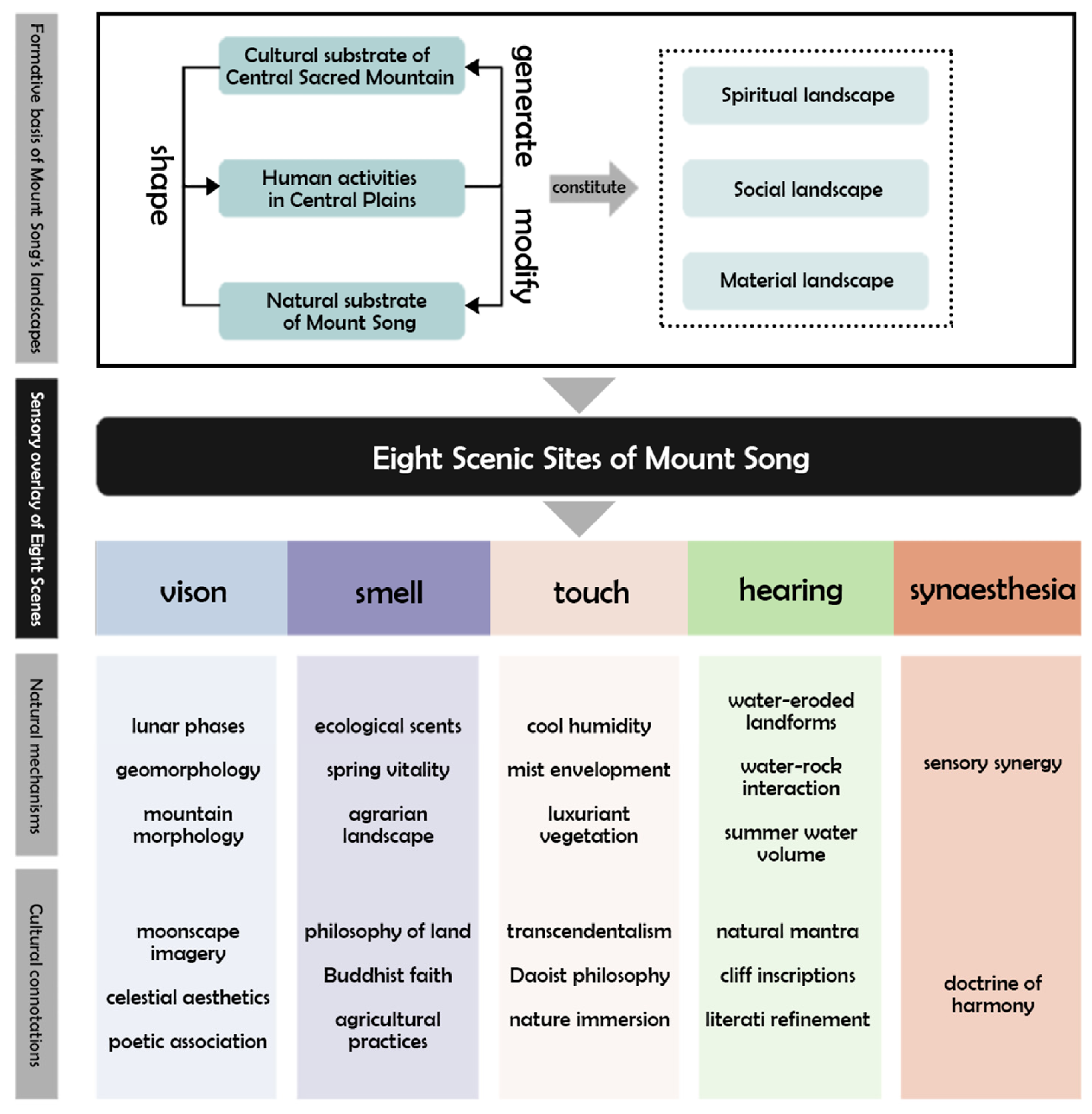
The finding (Figure 12) reveals that the five landscape contents of “waiting for the moon at Song gate”, “spring ploughing along Ying River”, “early morning journey to Xuanyuan”, “gathering and drinking at Shicong River”, and “Luya Waterfall” cover the change in the four seasons, the sun and the moon (two celestial elements), the morning and evening, day and night (four time elements) as well as the clouds and fog and the sunshine (three weather elements), which are all rich in visual experience, integrating the auditory, tactile, olfactory, and other multi-sensory elements. It shows a high degree of typicality and comprehensiveness, respectively, and the landsenses characteristics under the corresponding senses are demonstrated. Details are as follows. In terms of visual perception, vision, which is responsible for most of the landscape perception, is more direct and effective at acquiring landscape information. “Waiting for the moon at Song gate” shows local natural and cultural characteristics in the three aspects of natural conditions, visual field and landscape imagery, which affect the conveyance of visual landsenses information and the expression of landsenses characteristics. At the same time, the landsenses in “spring ploughing along Ying River” have nurtured unique psychological attributes, including the association between the landscape and historical events or social activities for the olfactory perception to stimulate the activation of spatial feelings, natural receptive tactile experience in “early morning journey to Xuanyuan” caused by the associations and memories to achieve psychological feelings, will bring people into the landscape implied by the spirit of the place. The auditory landsenses characteristics can be shaped by the relationship between people and the acoustic environment shown in the landscape and the elements of the auditory experience, and this characteristic of the auditory landscape being consistent with the visual landscape, and the auditory landscape increasing the visual environment, is also embodied in “gathering and drinking at Shicong River”. Therefore, by focusing on the analysis of its landsenses characteristics to see the big picture from small details, the five aspects of sight, smell, touch, hearing and multi-dimensional linkage are classified and discussed to get the scientific conclusions about the landsenses characteristics of the meteorological landscape of the Eight Scenic Spots of Mount Song (Figure 13).
Figure 12.
Visual perception of meteorological and cultural genes of the Eight Scenic Spots of Mount Song.
Figure 13.
Characteristic extraction of landscape genes of the Eight Scenic Spots of Mount Song.
4. Discussion
4.1. Interpretation of the Main Findings
The results indicate that the adaptive performance of cultural landscapes is shaped by interactions among meteorological conditions, cultural gene expression, and human perception. Four meteorological–cultural gene types were identified—astronomical–calendar, microclimate-adaptation, poetic–symbolic, and ritual–spatial genes—accounting for 34%, 28%, 22%, and 16%, respectively. Together, these genes illustrate how traditional societies transformed seasonal, climatic, and celestial conditions into spatial organization, environmental adaptation, cultural symbolism, and social practices. Meteorological conditions therefore function not only as environmental factors but also as carriers of cultural memory and landscape identity.
A notable result is the coexistence of strong coupling and comparatively weaker coordination between meteorological conditions and landscape perception. Coupling remained consistently high, whereas the coordination degree did not reach the high-quality coordination level. Meteorological landscape utility also fluctuated substantially more than sensory perception utility. This suggests that strong interaction between meteorological conditions and human perception does not necessarily correspond to high adaptive performance. Instead, variations in meteorological conditions may constrain the stable expression of cultural and perceptual values.
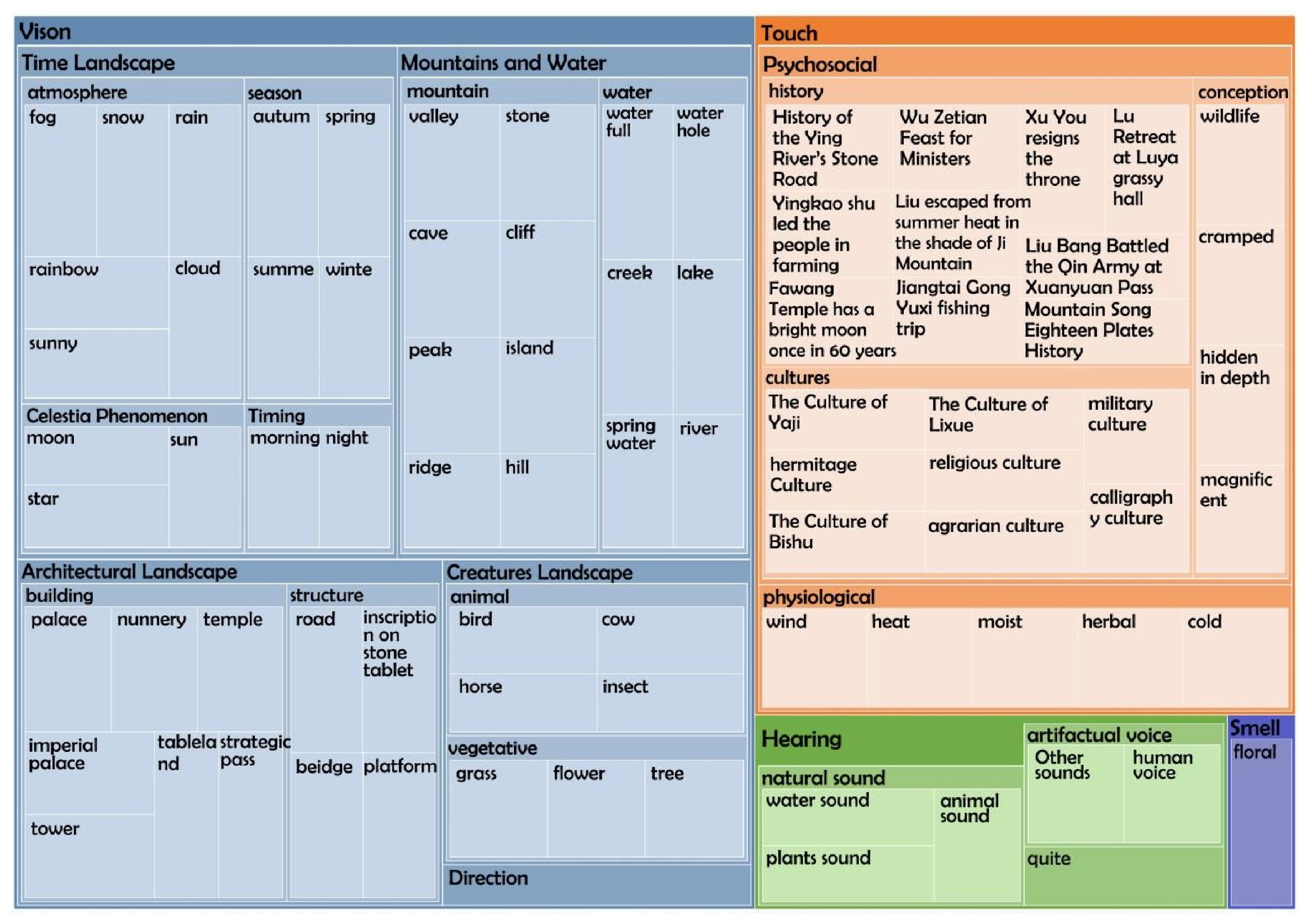
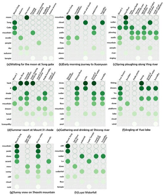
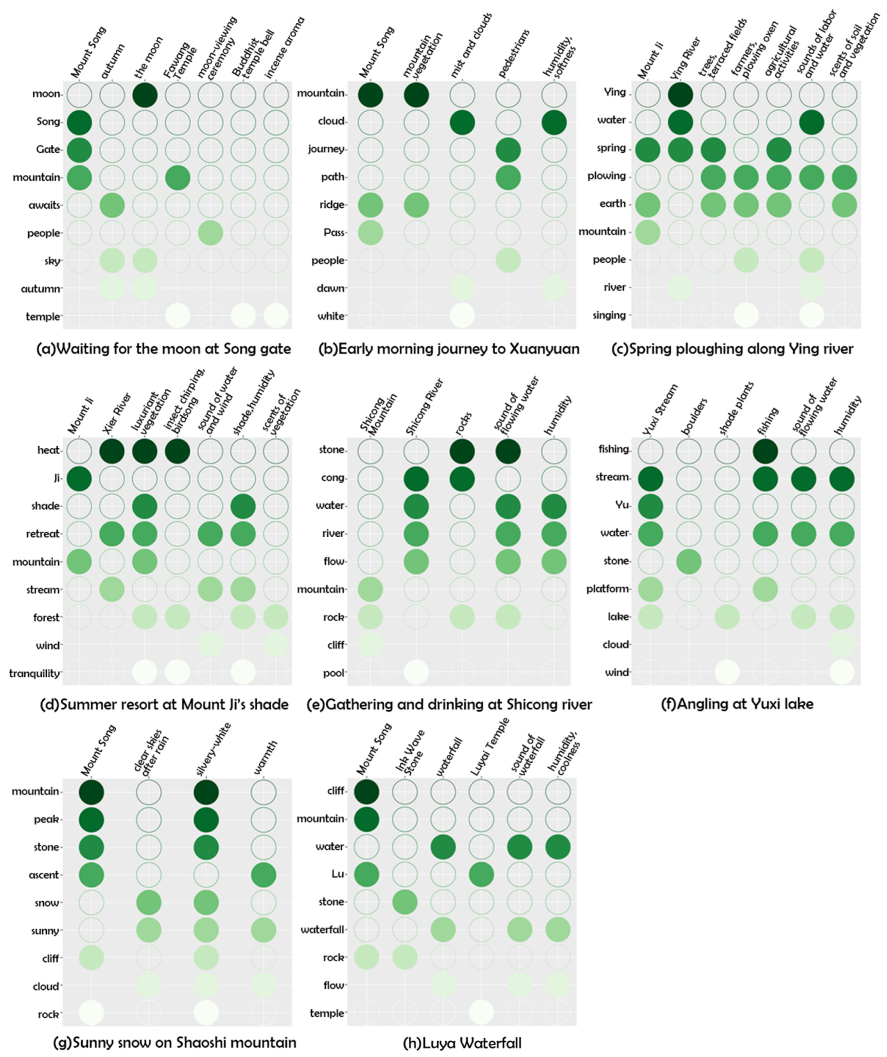
Landscape perception showed a clear sensory hierarchy, with visual perception dominating, followed by tactile and auditory perception. The site-specific distribution of high-frequency perceptual terms further demonstrates this differentiated sensory structure (Figure 14). This pattern is consistent with the strong visual tradition of Chinese mountain landscape appreciation, while the contributions of sound, humidity, wind, and thermal sensation confirm that landscape experience remains multisensory. Climate-adaptive conservation should therefore consider not only visible landscape features but also the environmental conditions that support sensory experience and the continued expression of meteorological–cultural genes.
Figure 14.
Distribution of high-frequency words in landscape perception of the Eight Scenic Spots of Mount Song.
4.2. Comparison with the Existing Literature
The findings support previous research that interprets cultural landscapes as products of long-term human–environment interaction, while extending cultural gene research beyond historical inheritance, settlement form, architecture, and symbolic landscape elements. By incorporating meteorological conditions into cultural gene expression, this study introduces climate sensitivity as an additional dimension for interpreting cultural landscape evolution.
The results also extend the application of landsenses ecology. Previous studies have emphasized the multisensory nature of landscape experience, whereas the present study further shows that sensory responses vary with meteorological conditions. By combining standardized meteorological and perceptual indicators within a coupling coordination model, the study provides a quantitative means of examining relationships between temperature, humidity, wind speed, and multisensory landscape perception. This complements qualitative approaches commonly used in landscape perception research.
Compared with conventional climate-adaptation approaches that mainly emphasize physical vulnerability, environmental monitoring, and engineering protection, the meteorological–cultural gene framework places greater emphasis on the continuity of cultural expression and sensory experience. Integrating meteorological processes, cultural inheritance, and human perception within a common analytical framework can therefore support the identification of climate-sensitive heritage elements and more differentiated adaptive management. This perspective contributes to a transition from predominantly static physical conservation toward adaptive governance that also considers cultural continuity and human experience.
4.3. Limitations and Future Research Directions
Several limitations should be acknowledged. First, the framework was tested only in the Eight Scenic Spots of Mount Song. Although the study area has strong meteorological and cultural characteristics, its transferability to other cultural landscape types and climatic regions requires further validation. Comparative studies across multiple heritage sites would help assess the robustness of the framework.
Second, perception assessment relied mainly on questionnaire data and may therefore be affected by differences in visitors’ cultural backgrounds, preferences, and previous experiences, because some of the Eight Scenic Spots were difficult or impossible to access during the survey, not all respondents evaluated the landscapes through direct on-site experience. Some evaluations were based on indirect impressions or visual representations. Such differences may influence perceptual intensity and reduce strict comparability among scenic spots. Therefore, the questionnaire results are interpreted primarily as aggregate indicators of multisensory perception rather than as equivalent field-based measurements for each site. Future studies could combine questionnaires with physiological and behavioural measurements, such as eye tracking or galvanic skin response, to improve the objectivity of multisensory perception assessment.
Third, the meteorological analysis was based on monthly observations from a single year and therefore cannot fully represent long-term climate trends or extreme-event impacts. Future research should incorporate longer meteorological records, high-resolution environmental monitoring, and climate-projection scenarios to examine the long-term stability of meteorological–cultural genes.
Finally, the identification of meteorological–cultural genes still involves qualitative coding and expert interpretation. Although NVivo-based coding and quantitative weighting procedures improved analytical consistency, interpretive uncertainty remains. Natural language processing, remote sensing, and AI-assisted semantic analysis could be introduced in future studies to improve the reproducibility and efficiency of cultural gene identification.
5. Conclusions
This study investigated the relationships among meteorological conditions, cultural landscape genes, and human perception in the Mount Song World Heritage Site and developed a meteorological–cultural gene framework for assessing climate adaptability in cultural landscapes. By integrating cultural gene analysis, landsenses ecology, and coupling coordination assessment, the study provides an integrated approach for interpreting climate–culture–perception interactions.
Three main conclusions were obtained. First, meteorological–cultural genes reflect the long-term integration of climatic conditions, traditional ecological knowledge, and cultural practices, demonstrating how cultural landscapes have historically adapted to local environmental conditions. Second, meteorological conditions and landscape perception showed strong coupling but comparatively weaker coordination, indicating that strong climate–perception interactions do not necessarily correspond to high adaptive performance. Third, the proposed coupling coordination framework provides a practical means of identifying climate-sensitive landscape elements and supporting differentiated adaptive management.
The main contribution of this study is the introduction of the meteorological–cultural gene concept, which extends conventional cultural gene research by incorporating meteorological processes, human perception, and climate adaptability into cultural landscape assessment. The methodology also has potential applicability beyond Mount Song because its analytical logic is based on the integration of cultural–historical information, meteorological observations, perception data, and coupling analysis rather than on site-specific variables alone. It may therefore be adapted to other cultural landscapes and heritage sites worldwide where climatic conditions influence cultural practices, landscape perception, and heritage values. However, application in other regions requires local recalibration of cultural gene categories, indicator systems, weights, and management thresholds to reflect differences in climate, cultural traditions, landscape structure, and visitor perception.
Several limitations should nevertheless be acknowledged. The framework was tested only in the Eight Scenic Spots of Mount Song, which limits direct generalization to other cultural and climatic contexts. The perception assessment relied primarily on questionnaire data, while the meteorological analysis was based on monthly observations from a single year. In addition, the identification and interpretation of meteorological–cultural genes involved qualitative coding and expert judgement, which may introduce a degree of subjectivity. These limitations should be considered when interpreting the results and applying the proposed methodology in other cultural landscape contexts.
Author Contributions
Conceptualization, H.W.; methodology, H.W. and X.Y.; software, J.L.; validation, X.Y. and Z.L.; formal analysis, J.L.; investigation, X.X. and B.L.; resources, X.Y.; data curation, H.W.; writing—original draft preparation, H.W.; writing—review and editing, J.L.; visualization, J.L., F.K. and X.X.; supervision, X.Y. and B.L.; project administration, X.Y. and Z.L.; funding acquisition, H.W. All authors have read and agreed to the published version of the manuscript.
Funding
This research was funded by the Ministry of Education Youth Fund for Humanities andSocial Sciences Project: Research on the Spatiotemporal Evolution Mechanism of Ancient Luoyang Imperial Gardens Based on Cultural Genes (Project No. 25YJCZH337); the Henan Provincial Key Research andDevelopment Special Project: Research and Application of Simulation System for Dynamic Successionof Cultural Landscape Along the Yellow River Basin of Henan Based on Spatial and Temporal Big Data (Project No. 241111211500); the 2024 Henan Province Xing Culture Project Cultural Research Special Project:Research on the Protection and Utilization of Rural Red Cultural Heritage in Henan (Project No. 2024XWH111); and the Henan Xing Culture Project Cultural Research Special ‘Research on Ming Dynasty PrinceMansion Gardens in Henan Based on the Politics of Feudal Princes’ (Project No. 2024XWH110).
Data Availability Statement
Data is available on request from the corresponding author.
Conflicts of Interest
The authors declare no conflicts of interest.
References
- Wu, J. Landscape of culture and culture of landscape: Does landscape ecology need culture? Landsc. Ecol. 2010, 25, 1147–1150. [Google Scholar] [CrossRef] [Scilit]
- Sauer, C. The morphology of landscape. In The Cultural Geography Reader; Routledge: London, UK, 2008; pp. 108–116. [Google Scholar]
- Sauer, C.O. Land and Life: A Selection from the Writings of Carl Ortwin Sauer; University of California Press: Oakland, CA, USA, 1963. [Google Scholar]
- Kotova, L.; Leissner, J.; Winkler, M.; Kilian, R.; Bichlmair, S.; Antretter, F.; Moßgraber, J.; Reuter, J.; Hellmund, T.; Matheja, K.; et al. Making use of climate information for sustainable preservation of cultural heritage: Applications to the KERES project. Herit. Sci. 2023, 11, 18. [Google Scholar] [CrossRef] [Scilit]
- Laura, D.P.; Roberta, G.M.; Francesca, R.M. Heritage and identity: Technology, values and visitor experiences. J. Herit. Tour. 2018, 13, 97–103. [Google Scholar] [CrossRef] [Scilit]
- Gül, A.; Shirvani, D.A. Cultural Landscapes under the Threat of Climate Change: A Systematic Study of Barriers to Resilience. Sustainability 2021, 13, 9974. [Google Scholar] [CrossRef] [Scilit]
- Intergovernmental Panel on Climate Change (IPCC). Climate Change 2022—Impacts, Adaptation and Vulnerability: Working Group II Contribution to the Sixth Assessment Report of the Intergovernmental Panel on Climate Change; Cambridge University Press: Cambridge, UK, 2023. [Google Scholar]
- Johnson, C.E.; Germano, V. Incorporating Local Knowledge into Vulnerability Assessments for Cultural Landscapes: Case Studies from the Pacific West Region, National Park Service; National Park Service: Washington, DC, USA, 2019. [Google Scholar]
- Qianli, G. Highlighting the poetic essence and distinctive features of “Songshan as the World’s Most Profound Mountain”—An Interpretation of the Master Plan for Songshan Scenic Area (2009–2025). Informatiz. China Constr. 2009, 17, 44–45. [Google Scholar]
- Dingzeng, A. On meteorological landscape. Guangdong Landsc. Archit. 1982, 1, 13–18. [Google Scholar]
- Caijun, Z.; Guoyu, W. Experience of Meteorological Landscape Construction in Chinese Classical Gardens and Its Inspiration to Construction of Climate Resilient Cities. Landsc. Archit. 2018, 25, 45–49. [Google Scholar]
- Holden, A.; Jamal, T.; Burini, F. The Future of Tourism in the Anthropocene. Annu. Rev. Environ. Resour. 2022, 47, 423–447. [Google Scholar] [CrossRef] [Scilit]
- Sun, Y.; Wang, Y.; Liu, L.; Wei, Z.; Li, J.; Cheng, X. Large-scale cultural heritage conservation and utilization based on cultural ecology corridors: A case study of the Dongjiang-Hanjiang River Basin in Guangdong, China. Herit. Sci. 2024, 12, 44. [Google Scholar] [CrossRef] [Scilit]
- Steward, J.H. Theory of Culture Change: The Methodology of Multilinear Evolution; University of Illinois Press: Champaign, IL, USA, 1955. [Google Scholar]
- Head, L. Cultural ecology: Adaptation-retrofitting a concept? Prog. Hum. Geogr. 2010, 34, 234–242. [Google Scholar] [CrossRef] [Scilit]
- Zhao, J.; Liu, X.; Dong, R.; Shao, G. Landsenses ecology and ecological planning toward sustainable development. Int. J. Sustain. Dev. World Ecol. 2016, 23, 293–297. [Google Scholar] [CrossRef] [Scilit]
- Weibin, L. Analysis of the climatic characteristics of rime and fog ice formation in the Songshan region. Farmers Consult. 2020, 15, 121. [Google Scholar]
- Schlüter, O. Über das Verhältnis von Natur und Mensch in der Anthropogeographie. Geogr. Z. 1907, 13, 505–517. [Google Scholar]
- Ingold, T. The temporality of the landscape. World Archaeol. 1993, 25, 152–174. [Google Scholar] [CrossRef] [Scilit]
- Strauss, S.; Orlove, B.S. Weather, Climate, Culture; Routledge: London, UK, 2021. [Google Scholar]
- Turner, N.J.; Clifton, H. “It’s so different today”: Climate change and indigenous lifeways in British Columbia, Canada. Glob. Environ. Change 2009, 19, 180–190. [Google Scholar] [CrossRef] [Scilit]
- de Freitas, C.R. Tourism climatology: Evaluating environmental information for decision making and business planning in the recreation and tourism sector. Int. J. Biometeorol. 2003, 48, 45–54. [Google Scholar] [CrossRef] [Scilit]
- Martín, M.B.G. Weather, climate and tourism a geographical perspective. Ann. Tour. Res. 2005, 32, 571–591. [Google Scholar] [CrossRef] [Scilit]
- Dhinakaran, S.; Crespi, A.; Jacob, A.; Pebesma, E. Enhancing seasonal climate forecasting for the Alpine region through machine learning statistical downscaling. In Proceedings of the IGARSS 2024-2024 IEEE International Geoscience and Remote Sensing Symposium, Athens, Greece, 7–12 July 2024; pp. 1683–1688. [Google Scholar] [CrossRef] [Scilit]
- Smith, M.K.; Diekmann, A. Tourism and wellbeing. Ann. Tour. Res. 2017, 66, 1–13. [Google Scholar] [CrossRef] [Scilit]
- Huiling, Z.; Mei, X.; Xiaoming, L.; Jianghua, H. Research Progress of Cultural Landscape at Home and Abroad. J. Hengyang Norm. Univ. (Nat. Sci.) 2022, 43, 57–65. [Google Scholar]
- Li, X.; Wang, X.; Jiang, X.; Han, J.; Wang, Z.; Wu, D.; Lin, Q.; Li, L.; Zhang, S.; Dong, Y. Prediction of riverside greenway landscape aesthetic quality of urban canalized rivers using environmental modeling. J. Clean. Prod. 2022, 367, 133066. [Google Scholar] [CrossRef] [Scilit]
- Jahani, A.; Saffariha, M. Aesthetic preference and mental restoration prediction in urban parks: An application of environmental modeling approach. Urban For. Urban Green. 2020, 54, 126775. [Google Scholar] [CrossRef] [Scilit]
- Iamtrakul, P.; Chayphong, S.; Hayashi, Y. An Integrative Investigation of Travel Satisfaction, Streetscape Perception, and Mental Health in Urban Environments. Sustainability 2024, 16, 3526. [Google Scholar] [CrossRef] [Scilit]
- Półrolniczak, M.; Kolendowicz, L. The effect of seasonality and weather conditions on human perception of the urban–rural transitional landscape. Sci. Rep. 2023, 13, 15047. [Google Scholar] [CrossRef] [Scilit]
- Bourassa, S.C. The Aesthetics of Landscape; Belhaven Press: London, UK, 1991; p. 168. [Google Scholar]
- Marek, P.; Leszek, K. The influence of weather and level of observer expertise on suburban landscape perception. Build. Environ. 2021, 202, 108016. [Google Scholar] [CrossRef] [Scilit]
- Huang, A.S.-H.; Lin, Y.-J. The effect of landscape colour, complexity and preference on viewing behaviour. Landsc. Res. 2020, 45, 214–227. [Google Scholar] [CrossRef] [Scilit]
- Ingold, T. Footprints through the weather-world: Walking, breathing, knowing. J. R. Anthropol. Inst. 2010, 16, S121–S139. [Google Scholar] [CrossRef] [Scilit]
- Bell, A.H.; Fecteau, J.H.; Munoz, D.P. Using auditory and visual stimuli to investigate the behavioral and neuronal consequences of reflexive covert orienting. J. Neurophysiol. 2004, 91, 2172–2184. [Google Scholar] [CrossRef] [Scilit]
- Opdam, P.; Nassauer, J.I.; Wang, Z.; Albert, C.; Bentrup, G.; Castella, J.-C.; McAlpine, C.; Liu, J.; Sheppard, S.; Swaffield, S. Science for action at the local landscape scale. Landsc. Ecol. 2013, 28, 1439–1445. [Google Scholar] [CrossRef] [Scilit]
- Binyi, L.; Jinglei, F.; Hanshu, M.; Fanying, L.; Zhenyan, X. Research on the Mechanism for Multidimensional Landscape Perception of “Eight Scenes”. Landsc. Archit. 2024, 31, 12–19. [Google Scholar] [CrossRef] [Scilit]
- Shengjie, H. Study on the holistic landscape characterization and protection of Mount Song scenic spot. Beijing For. Univ. 2021, 15, 151. [Google Scholar]
- Soboll, A.; Dingeldey, A. The future impact of climate change on Alpine winter tourism: A high-resolution simulation system in the German and Austrian Alps. J. Sustain. Tour. 2012, 20, 101–120. [Google Scholar] [CrossRef] [Scilit]
- Fan, W.; Yu, W.; Chen, S.; Sun, K. Study on Protection and Sustainable Development of the Historic Monuments in “The Centre of Heaven and Earth”. Sustain. Dev. 2011, 1, 14–19. [Google Scholar]
- Kunshu, Z. The culture of Mount Song is unparalleled in the world. Civiliz. Forum 2008, 9, 8–9. [Google Scholar]
- Huabin, L.; Jiansan, X. Meteorobgical Landscape Analysis of West Lake Scenic Area. J. Landsc. Res. 2009, 1, 82–86. [Google Scholar]
- Fan, D.; Maliki, N.Z.B.; He, C.; Bi, Y.; Yu, S. Cultural gene characterization and mapping of traditional tibetan village landscapes in Western Sichuan, China. npj Herit. Sci. 2025, 13, 317. [Google Scholar] [CrossRef] [Scilit]
- Braziller, G. General system theory. In Foundations, Development, Applications Ludwig von Bertalanffy Prieiga internetu; George Braziller, Inc.: New York, NY, USA, 1968. [Google Scholar]
- Lyapunov, A.M. The general problem of the stability of motion. Int. J. Control 1992, 55, 531–534. [Google Scholar] [CrossRef] [Scilit]
- Wang, D.; Jiang, D.; Fu, J.; Lin, G.; Zhang, J. Comprehensive assessment of production–living–ecological space based on the coupling coordination degree model. Sustainability 2020, 12, 2009. [Google Scholar] [CrossRef] [Scilit]
- Aghajani, H.; Sarkari, F.; Borhani, M. Coupling coordination analysis between urbanization and ecology in Iran. FURP 2024, 2, 5. [Google Scholar] [CrossRef] [Scilit]
- Han, P.; Zheng, C. Spatial spillover effects of the digital economy on high-quality development and carbon emissions: Evidence from prefecture-level cities in Guangdong, China. Front. Clim. 2025, 7, 1670360. [Google Scholar] [CrossRef] [Scilit]
- Xianke, H. Landscape Preference and Optimization Design of Songshan Scenic Area Based on VGI Data. Master’s Thesis, Henan Agricultural University, Zhengzhou, China, 2025. [Google Scholar]
- Juan, F. Review of Research on the Twenty-Four Solar Terms. Anc. Mod. Agric. 2018, 1, 91–108. [Google Scholar]
- Yaohua, C.; Linlin, S. A Study on the World Heritage Value of China’s Five Great Mountains. J. Peking Univ. (Philos. Soc. Sci.) 2011, 48, 108–113. [Google Scholar]




Disclaimer/Publisher’s Note: The statements, opinions and data contained in all publications are solely those of the individual author(s) and contributor(s) and not of MDPI and/or the editor(s). MDPI and/or the editor(s) disclaim responsibility for any injury to people or property resulting from any ideas, methods, instructions or products referred to in the content. |
© 2026 by the authors. Licensee MDPI, Basel, Switzerland. This article is an open access article distributed under the terms and conditions of the Creative Commons Attribution (CC BY) license.