


Abstract
The aim of the study was to assess hydrodynamic conditions in the low-flow channels of the block ramps with regard to the migration potential of brown trout (Salmo trutta). The research was conducted on the Porębianka Stream, where a cascade of 25 block ramps had been constructed in the outlet reach to stabilise the watercourse’s longitudinal profile. The analysis was performed for all 25 block ramps, but the detailed presentation of the results was only shown for four of them (7, 13, 18 and 19). Field measurements were performed under four flow conditions, defined as low, medium–low, medium and high. The analysis included three parameters that determine the potential passability of migration: water depth, flow velocity, and the water-level drop between the stilling basin and the downstream reach. Flow velocities were assessed against threshold values that depend on the length of the section the fish must negotiate. The results showed that the mere presence of a low-flow channel concentrating the discharge does not guarantee the maintenance of ecological continuity in the watercourse. Under low-flow conditions, the main limiting factor was insufficient water depth. In contrast, at higher discharges, the dominant constraints were exceedances of permissible flow velocities and the absence of a continuous corridor of reduced velocity. The most favourable migration conditions were identified in the low-flow channel of block ramp nos. 7 and 19, from medium–low to medium flow and from low to medium–low flow conditions, respectively. Block ramps nos. 13 and 18 acted as complete barriers under all of the analysed water discharges. The assessment of the entire cascade demonstrated that when flow velocity, water depth and water level drop were considered simultaneously, only four of the low-flow channels (nos. 6, 7, 17 and 19) could be classified as passable or conditionally passable. The obtained results indicate the need for a comprehensive assessment of block ramps, including several flow conditions and the continuity of a potential migration trajectory. The modernisation of the most problematic channels should aim to increase water depth, reduce excessive flow velocities, reduce local water-level drops, and introduce a more diverse flow structure that resembles natural hydraulic conditions.
1. Introduction
Ecological continuity of rivers and streams is a fundamental prerequisite for the proper functioning of lotic ecosystems. It encompasses the movement of water, sediment, organic matter and aquatic organisms along the channel, between the channel and the river valley, within the hyporheic zone, and over time under variable hydrological conditions. In this sense, continuity is not solely a biological issue but a property of the entire river system, resulting from the interaction of hydrological, hydraulic, geomorphological, and ecological processes. According to the River Continuum Concept, changes in one section of a watercourse may affect both downstream and upstream reaches, influencing the transport of matter, habitat structure, and the functioning of aquatic communities [1]. Similarly, the concept of the four-dimensional functioning of river ecosystems holds that a river maintains ecological stability when longitudinal, lateral, vertical, and temporal connectivity are preserved [2].
In water management practice, longitudinal channel continuity is most important for fish migration. It is particularly important for rheophilic species, which at different stages of their life cycle use different sections of a watercourse as spawning grounds, feeding areas, shelters, overwintering sites, or refuge reaches. Fish migration is not limited solely to long-distance movements of diadromous species. In many watercourses, short- and medium-distance local movements are equally important, as they enable access to temporarily favourable habitats, avoidance of adverse hydraulic conditions and recolonisation of reaches following hydrological disturbances [3,4,5,6]. For this reason, even small transverse structures may be ecologically significant if they restrict the free movement of fish within the river network.
River fragmentation is one of the most important consequences of anthropogenic channel modification. Transverse structures, such as weirs, sills, drop structures, culverts, technical fords, ramps and bed-stabilisation structures, are most commonly constructed to protect infrastructure, limit bed erosion, stabilise the longitudinal profile of a watercourse, maintain the water-surface level or improve flood protection. Their technical function is therefore often justified, particularly in mountain and foothill streams, where steep gradients, rapid flood events, and intense sediment transport can lead to rapid channel incision and threaten bridges, roads, and buildings. At the same time, these structures may interrupt migratory continuity, alter flow patterns, disrupt sediment transport, and transform habitat conditions upstream and downstream of the structures [7,8,9,10,11].
The impact of a transverse hydraulic structure does not result solely from its height. From the perspective of fish, equally important factors include water depth, flow velocity, the length of the section with elevated velocity, the local water-surface drop, turbulence, flow aeration, the presence of resting areas and the possibility of selecting an alternative migration pathway. A barrier that appears minor from a human perspective may require a fish to leap, sustain a prolonged upstream sprint or pass through a very shallow zone in which full body submergence is impossible. The ability to overcome such obstacles depends on species, individual body size, water temperature, physiological condition and migratory motivation [12,13,14,15]. Therefore, contemporary assessments of the passability of hydraulic structures should consider not only the geometric parameters of the structure, but above all, the actual hydraulic conditions available to fish.
Mountain streams present a particularly complex situation. Steep longitudinal gradients, variable discharges, a substantial proportion of coarse bed material and a rapid catchment response to rainfall and snowmelt naturally characterise these watercourses. Boulder transport, lateral and bed erosion, local sediment accumulation, and sequences of pools and riffles shape the morphology of such channels. Under natural conditions, the heterogeneous bed structure creates a mosaic of microhabitats in which fish may use local scour pools, zones downstream of boulders, near-bank areas and near-bed layers of reduced velocity as resting places or as elements of their migration route [16,17]. However, artificial transverse structures, even when constructed of rock, may simplify this structure, concentrate the flow, and create reaches with uniform hydraulic conditions that are excessively fast or too shallow.
In recent decades, nature-like hydraulic engineering solutions have become increasingly important, aiming to combine technical functions with the mitigation of negative impacts on river ecosystems. Such structures include, among others, high-roughness riffles, rock ramps, step-ramps, nature-like fishways and bypass channels. In contrast to conventional sills, which create a distinct drop in the water surface, riffles and ramps distribute the head difference over a longer reach. As a result, they may reduce the local barrier height, enabling fish to negotiate the structure by actively swimming upstream rather than solely by leaping. However, their effectiveness depends on the appropriate selection of slope, roughness, geometry, flow depth and the spatial arrangement of resting zones [18,19,20,21,22,23,24].
However, the mere use of stones or boulders, or increased roughness, does not guarantee ecological passability. A structure that is formally nature-like may, in practice, act as a barrier if, during periods of low discharge, water spreads as an excessively thin layer. In contrast, during higher discharges, channel velocity exceeds the swimming capabilities of fish [25,26]. Another problem may be the lack of spatial continuity of favourable microzones. If local areas of reduced flow velocity do not connect to form a coherent migration corridor, fish are forced to cross faster-flowing parts of the current, which increases energetic costs and the risk of downstream displacement [27]. For this reason, the effectiveness of such structures should be verified through field measurements spanning the full range of biologically relevant discharges, rather than solely on design assumptions or classification by structure type [14,20,22].
A suitable indicator species for assessing the passability of mountain streams is the brown trout (Salmo trutta). This species is associated with cold, well-oxygenated, flowing waters, and its life cycle requires access to diverse habitats. Adult individuals undertake spawning migrations; younger life stages use shallower, calmer sections of the watercourse; and during periods of elevated discharge or unfavourable thermal conditions, fish may move to refuge reaches. Although brown trout exhibit relatively strong swimming abilities, this does not mean they can successfully negotiate every low hydraulic obstacle. Structures in which high flow velocity occurs over a long section, resting areas are absent, water depth is insufficient, or an excessive water-level drop occurs at the entrance to the channel are particularly problematic [6,12,13].
The present study focuses on a series of block ramps constructed in the mouth reach of the Porębianka Stream, a tributary of the Mszanka River in the Western Beskids. The stream has a mountain character, as reflected in the considerable elevation difference between its source and mouth, steep longitudinal gradients, and the catchment’s dynamic hydrological response [28]. In the Mszana Dolna–Podobin reach, a cascade of 25 block ramps was constructed to limit bed erosion and stabilise the longitudinal profile of the watercourse. Each block ramp is equipped with a low-flow channel, which concentrates discharge on the sloping apron during low-flow periods [29]. In theory, this solution should increase water depth within the potential migration pathway and improve passage conditions for fish.
This study aims to assess hydrodynamic conditions in the low-flow channels (also referred to by the authors as low-flow chutes) of block ramps on the Porębianka Stream in relation to the migration potential of brown trout (Salmo trutta). The analysis includes the simultaneous assessment of three parameters that determine potential passability: water depth, flow velocity, and the water-level drop between the stilling basin and the downstream reach. Particular attention was paid to whether the low-flow chute, which concentrates the flow, creates a continuous migration corridor that fish can use under different water-stage conditions. This goal allows us to verify whether the low-flow channels of the block ramps, designed as a technical solution to ensure migration continuity, actually perform this ecological function under mountain stream conditions.
2. The Study Area
The Porębianka Stream (Figure 1) is a tributary of the Mszanka River, located on the northern slopes of the Gorce Mountains in the Western Beskids. The watercourse is approximately 15.4 km long, and its catchment area is about 71.8 km2. Its headwaters are situated at an elevation close to 1000 m a.s.l., whereas its mouth lies at approximately 400 m a.s.l. This considerable elevation difference over a relatively short distance results in the stream’s mountain character, steep longitudinal gradients, and intensive sediment-transport processes [29].
Figure 1.
The research area.
The Porębianka catchment is characterised by runoff variability typical of Carpathian streams. During rainless periods, discharge may be low, leading to partial bed exposure and the formation of shallow flow threads within the block ramps. Following rainfall events or snowmelt, discharge increases rapidly, and the stabilising structures must convey water with substantially higher energy [30,31]. Such variability is important for fish migration, as fish move within specific hydrological windows, and a structure must remain passable not only at a single design discharge.
In the mouth reach of the stream, along the Mszana Dolna–Podobin section, a cascade of 25 block ramps was constructed (Figure 2). They replaced the former slope structures, which also served a similar function: protecting the riverbed from erosion by reducing its longitudinal slope. Their presence affects the longitudinal profile of the watercourse, sediment transport conditions, and the relationship between upstream and downstream reaches of successive structures.
Figure 2.
The elements that make up the block ramp.
Each block ramp consists of a chute slab, stabilised by two sheet pile walls located above and below it. The chute slab is a key structural element, designed to dissipate excessive energy from the water jet during floods. A low-flow channel has been constructed in the centre of the chute slab to ensure ecological continuity at low water levels. Below the chute slab is a stilling basin, which also serves as a water disperser. Above the upper sheet pile wall is an apron that functions as riverbed reinforcement and does not actively affect flow conditions (e.g., it has been covered or blocked by sediment). All the block ramp elements (except the sheet pile walls) are made of boulders with a mean diameter of 0.90 m (±0.50 m). Figure 3 shows the basic design parameters of the block ramps.
Figure 3.
Measurement cross-sections on the block ramp.
The cascade arrangement of the structures is particularly important for fish migration. A fish moving upstream along the stream must negotiate not a single structure, but an entire sequence of them [32]. Even if an individual block ramp constitutes only a partial barrier, the combined effect of multiple obstacles may lead to cumulative impacts, as each successive chute requires additional energy expenditure [33]. Therefore, in the cascade analysis, it is important to consider not only the number of structures that meet the passability criteria but also the locations of critical structures.
The key structural element of the block ramp is the low-flow channel, which concentrates the discharge on the chute slab. The chute slab is a fundamental issue in wide structures. When discharge is low, water spreads as a thin layer across the entire width of the chute slab, and the flow depth becomes insufficient for fish. Under such conditions, even low flow velocities do not imply good passability because fish cannot fully submerge their bodies, maintain a stable position, or use swimming movements effectively. Particularly unfavourable are shallow, dispersed flow threads passing over an uneven stone surface, where discontinuous sections, local overfalls and dry fragments of riprap may occur [26]. Concentrating the flow within a narrower pathway allows increasing flow depth without raising the water surface across the entire width of the structure.
At first glance, this appears to be a simple and ecologically beneficial solution. The low-flow channel provides a continuous wetted pathway that prevents a wide block ramp from becoming too shallow under low-flow conditions. In this respect, it performs a function similar to the natural concentration of flow in the main current of a stream. In natural channels, during low-flow periods, water also does not flow uniformly across the entire channel width. Instead, it concentrates in bed depressions, between larger stones, and along locally developed deeper zones. The designed low-flow channel is therefore intended to reproduce this mechanism within an artificial or semi-natural structure.
3. Materials and Methods
Field investigations were conducted during four water-flow conditions in the Porębianka Stream, conventionally defined as low, medium–low, medium and high. These terms do not refer to the full range of flow conditions in a river, but to the relationships between them.
Each measurement campaign included six cross-sections (Figure 3) and three longitudinal measurement lines: on the left side of the low-flow channel, in its middle part and on the right side. In this research, we measured all 25 block ramps.
The assessment of migration possibilities was based on the simultaneous consideration of depth, flow velocity, and local differences in water surface elevation.
At each vertical measurement, water depth was measured and flow velocity was recorded at several levels, allowing the velocity profile to be obtained. This enabled the showing of the maximum, mean and minimum velocity (so the entire velocity tachoid), which is important for fish seeking a pathway with the lowest hydraulic resistance [34,35]. A VALEPORT FM-801 hydrodynamic mill(Valeport Ltd., Totnes, UK) was used for hydrodynamic measurement. It measures current flow velocity in the range of ±5 m·s−1, with an accuracy of 5 mm·s−1.
Water depth was recorded at the velocity measurement points. For brown trout (Salmo trutta), a depth of 5 cm was adopted as the minimum threshold for the physical possibility of passage, for fish with a body length of 25–30 cm [36]. It should be emphasised that this represents a lower threshold rather than an optimal value. Depths of 5 cm may be sufficient only over short sections and at moderate flow velocities. In contrast, in a fast-flowing low-flow channel, greater flow depth is required to ensure hydraulic conditions suitable for passage [36,37].
The measurements also included the free water-level drop at the end of the stilling basin (Figure 4). This parameter is crucial because an excessive difference in water levels or the absence of an adequate take-off pool may prevent fish from negotiating the entrance sill, even when water depth and flow velocity in the chute slab’s low-flow channel are optimal [38,39]. According to Schmutz and Mielach [40], the slope value between subsequent structural elements should not exceed 20 cm.
Figure 4.
The water drop between the exit stilling basin and the lower station serves as the background for the block ramps’ structural elements.
Flow velocity was assessed according to Larinier’s criterion [41], in which the admissible threshold velocity is a function of the distance that the fish must negotiate (Figure 5). This means that, as the length of the migration section increases, the permissible velocity decreases because the fish gradually becomes fatigued and is unable to maintain its maximum swimming speed over a long distance. Therefore, the velocity available within the low-flow channel should not exceed the threshold velocity determined as a function of the remaining distance to be negotiated.
Figure 5.
The Larinier graph [41].
The Larinier velocity threshold was compared with measured tachoid velocity values ranging from minimum to average. This approach is consistent with the research of Goerig et al. [42], who demonstrated that brown trout can select corridors with lower-than-average cross-sectional velocities—especially at higher flows. However, this does not mean that they consistently select the absolute minimum in every vertical profile. Under the highest flow conditions analysed, fish selected zones with velocities approximately 40% lower than average, while at lower flows, they often moved in currents with values close to average.
Additionally, we measured flow through the low-flow channels (QLFC) and across the entire width of the block ramps (the low-flow channels + chute slabs; QBR), and determined the QLFC/QBR ratio. The flow through the block ramps (QBR) corresponded to the flow in the river, because this structure spans the entire width of the river. The discharges QLFC and QBR were measured on the upper sheet pile wall in accordance with the measurement methodology presented in the ISO 748:2021 standard [43].
4. Results
4.1. Analysis of Hydrodynamic Conditions in the Aspect of Brown Trout Migration
The analysis was performed on all 25 block ramps, but a detailed description of the results obtained was presented for four selected ones: nos. 7, 13, 18 and 19. The analysis is hydraulic–biological in character. This means that the numerical values obtained from the measurements are not treated solely as descriptions of flow conditions but as parameters that determine the ability of brown trout (Salmo trutta) to negotiate the obstacle. Three groups of variables are particularly important: water depth, flow velocity and the water-level drop between the stilling basin and the downstream reach.
The velocity analysis was carried out with reference to the threshold-velocity curve presented by Larinier [41], rather than to a constant value of 2.00 m·s−1, which is often adopted as a limiting value irrespective of the length of the obstacle to be negotiated. This means that in the further sections of the structure, the threshold curve decreases, reaching a velocity value of 0.92 m·s−1 at the exit of the structure. Therefore, the key issue is whether fish have access to an uninterrupted migration corridor where velocities remain below the threshold along the entire length of the low-flow channel.
4.1.1. Block Ramp No. 7
At low discharge (QLFC = 0.07 m3·s−1), the hydraulic conditions are generally favourable (Figure 6a). In SB and LW cross-sections, all analysed transverse zones—the left side, the middle and the right side—remain clearly below the threshold velocity. Particularly in the LW cross-section, very low velocities are observed, which may serve as local resting zones or as calmer areas guiding fish towards the further part of the low-flow channel. The greatest limitation occurs in the CS 1/4 cross-section, where a marked increase in velocity is observed. The velocity in this cross-section is close to the permissible value, which may be an obstacle for young and weak individuals. Further downstream, in CS 1/2, CS 3/4 and UW cross-sections, velocities again remain below the threshold values. Thus, in terms of flow velocity, the low-water stage may be considered passable, with only a local impediment in the CS 1/4 cross-section. However, the final assessment of this variant should also account for water depths, as under low-discharge conditions, the main limitation to migration may be insufficient flow depth rather than excessive velocity.
Figure 6.
Velocity rates in low-flow channel no. 7 during different flow conditions: (a) low, (b) low–medium, (c) medium and (d) high.
Although flow velocities generally remain within the optimal range, migration may still be restricted by insufficient water depth. Only in the LW cross-section does the depth exceed the adopted threshold value of 5 cm. In the remaining locations, it barely reaches 4 cm. The most unfavourable situation occurs at UW, where the water depth in the central part of the cross-section was only 1 cm, while no flow was present on the left side.
The water-level drop between the stilling basin and the downstream reach was within the optimal range (ΔH = 15 cm). This is particularly important because it is where fish enter the block ramp’s low-flow channel and begin their upstream passage through the structure.
The medium–low discharge (QLFC = 0.27 m3·s−1) also appears favourable among the analysed variants in terms of the relationship between flow velocity and the black threshold-velocity curve (Figure 6b). In SB, LW and CS 1/4 cross-sections, velocities remain below the permissible values. The LW cross-section is particularly favourable, as very low-velocity flow zones occur on both the left and right sides, potentially serving as resting areas or local migration corridors. The only section requiring more cautious interpretation is the CS 1/2 cross-section, where the velocity in the middle of the cross-section exceeds the threshold value. However, this exceedance does not extend across the entire width of the cross-section; both the left and right sides remain below the black threshold curve. Further along the low-flow channel, in CS 3/4 and UW cross-sections, velocities are clearly lower than the threshold values. From a fish-migration perspective, medium–low discharge can be considered the most favourable hydraulic condition. No full-width hydraulic barrier forms, and fish can select zones of reduced flow velocity. Passage through the low-flow channel should therefore be possible for brown trout, with a moderate energetic cost. Water depths in the measurement cross-sections are also slightly above, or equal to, the adopted minimum threshold value.
At medium discharge (QLFC = 0.47 m3·s−1), conditions become more heterogeneous and clearly less stable (Figure 6c). The initial SB and LW cross-sections still do not constitute a significant velocity-related limitation, as all values remain below the threshold-velocity curve. Very low-velocity zones are still evident in the LW cross-section. Key constraints may appear from the CS 1/4 cross-section onwards. At this location, velocities in the middle and on the right side exceed the threshold value, whereas the left side remains distinctly more favourable. This indicates that passage through the middle of the channel or along the right part of the cross-section would be unfavourable for brown trout, while the potential migration corridor shifts towards the left side. In the CS 1/2 cross-section, the transverse pattern changes: an exceedance occurs on the left and right sides, whereas the middle is more favourable. In CS 3/4, in turn, velocities on both the left and right sides are above the black threshold curve, while the central part remains the most favourable. This pattern indicates that, although at least one zone below the threshold value is present in each cross-section, these zones do not form a simple, continuous migration corridor. From a biological perspective, this represents an important limitation. Brown trout would have to change their movement pathway between cross-sections: from the left side in CS 1/4, then towards the middle or the right side in CS 1/2 and in CS 3/4. Such crossing of faster-flowing parts of the current increases energetic costs and the risk of downstream displacement. Therefore, the low-flow channel’s migratory function under medium discharge conditions should be assessed as conditionally passable, with a substantial risk of fatigue.
At high discharge (QLFC = 1.30 m3·s−1), the initial part of the low-flow channel remains relatively favourable (Figure 6d). In SB, LW, and CS 1/4 cross-sections, velocities are generally below the threshold values. This indicates that in the upper and middle parts of the flows, no clear velocity barrier is observed despite the higher discharge. Conditions deteriorate in CS 1/2 and CS 3/4 cross-sections. At this location, all three transverse zones—the left side, the middle and the right side—exceed the threshold velocity. This is the most important critical section during high discharge, because fish do not have access to a clearly defined flow corridor with velocities below the permissible value. This section may act as a local velocity barrier or a zone of severe fatigue. In the final UW cross-section, conditions improve again, with velocities decreasing below the threshold value. This section may serve as a potential resting zone after negotiating the block ramp’s low-flow channel; however, its significance is limited because brown trout must first pass through the critical CS 1/2 and CS 3/4 cross-sections. The high-discharge variant should therefore be assessed as largely impassable, with local barriers. The decisive limitation is the full-width exceedance of the threshold velocity in CS 1/2 and CS 3/4 cross-sections.
The most favourable hydrodynamic conditions occur during medium–low discharge. Under these conditions, all hydrodynamic parameters remain within the optimal range (Table 1). For brown trout (Salmo trutta), the key factor is not the occurrence of a single point with low velocity, but the possibility of maintaining a continuous migration trajectory. In the medium- and high-discharge variants, the most favourable flow zones shift between cross-sections, which may force fish to cross faster-flowing parts of the current. This increases the energetic cost of passage and the risk of downstream displacement, particularly for smaller or weaker individuals, or for fish migrating after previous exertion. The extremely low water-depth values recorded during low discharge prevented the minimum depth criterion from being met, thereby limiting fish migration.
Table 1.
Passability of the low-flow channel no. 7, taking into account all the analysed hydrodynamic parameters.
4.1.2. Block Ramp No. 13
During low discharge (QLFC = 0.10 m3·s−1), flow velocities are favourable (Figure 7a). In most cross-sections, velocities on the left side, in the middle and on the right side remain below the threshold value. This applies to all sections where no clear exceedances capable of forming a velocity barrier are observed. However, the limiting factors are insufficient low-flow channel depth and a drop in water level at the stilling basin entrance. In CS 1/2 and CS 3/4 cross-sections, flow depth does not reach the minimum threshold value across the entire width. In other cross-sections (SB, CS 1/4 and UW), the depth criterion is met only locally. The water-level drop between the end of the stilling basin and the downstream reach of the structure was 30–35 cm, which may pose an obstacle. However, below the block ramp, significant erosion of the bottom reaches depths of up to 1.5 m; therefore, according to some studies [39,44,45], the brown trout could have the opportunity to gain momentum and jump the required height.
Figure 7.
Velocity rates in low-flow channel no. 13 during different flow conditions: (a) low, (b) low–medium, (c) medium and (d) high.
At medium–low discharge (QLFC = 0.28 m3·s−1), migration conditions deteriorate in the middle part of the block ramp (Figure 7b). The initial section, i.e., SB and LW, remains favourable, with velocities lower than the maximum permissible value, and distinct zones of reduced velocity occurring in LW. The key limitation appears in CS 1/4, where the middle of the cross-section exceeds the threshold value. The left and right sides remain below this limit; therefore, fish may bypass the main current, although this requires maintaining an appropriate migration pathway near the margins. The most difficult section occurs in CS 1/2. On the right and in the middle of the cross-section, the velocity values are above the limit value. On the left, the average velocity coincides with the threshold line. This indicates a local hydraulic acceleration zone in which brown trout do not have access to a clearly defined safe flow corridor with velocities below the permissible limit. Although the exceedances in the left parts of the low-flow channel are minor, making this cross-section difficult to assess unequivocally, they will certainly constitute a substantial impediment to fish migration, even if they do not act as a complete barrier. Passage may possibly be limited to individuals in good physiological condition, using short zones of reduced velocity and avoiding the faster central current. In CS 3/4, exceedance mainly occurs in the middle of the channel. Then, the left and right sides are more favourable, but their values are almost on the threshold line. In UW, the most favourable conditions occur on the right and in the middle, while the left side exceeds the threshold line. In this cross-section, the velocities in the middle part of the low-flow channel reach the limit value. The distribution of values in this cross-section is similar to that observed during low discharge.
The situation described above could occur if the fish were already in the low-flow channel. First, however, it must reach the low-flow channel by jumping from the lower perch. In this case, we encounter another problem: the water drop again exceeds the permissible value.
During medium discharge (QLFC = 0.44 m3·s−1), conditions become more heterogeneous (Figure 7c). The initial SB–LW section remains favourable, as all velocities are below the threshold value. In LW, very calm zones are visible, particularly along the channel axis, which may serve as resting or guiding areas. The first clear exceedance of the threshold values occurs in the CS 1/4 cross-section, where the middle of the low-flow channel reaches approximately 2.0 m·s−1. However, the left and right sides remain below the permissible value, indicating that the exceedance is local and mainly associated with the central current. In the CS 1/2 cross-section, the transverse velocity distribution is similar to that observed in CS 1/4: only the middle exceeds the permissible value, although the velocities in the lateral parts of the low-flow channel oscillate around the threshold line. In the CS 3/4 cross-section, the transverse pattern changes. The highest velocity occurs on the right side and exceeds the threshold value, whereas the left side and the middle are more favourable, although the values are still high. Consequently, fish would have to actively search for an optimal migration trajectory and avoid the main current in the central part of the low-flow channel. In the final UW cross-section, exceedances of the threshold values were recorded only in the right part of the low-flow channel, while the left and middle parts remained within the optimal range. This location may therefore serve as a local resting area or as an exit zone from the block ramp.
Water depth is sufficient along the entire length of the low-flow channel. The only potential problem is the water-level drop at the structure’s entrance, which again exceeds the permissible value.
At high discharge (QLFC = 0.51 m3·s−1), the hydrodynamic pattern becomes distinctly less favourable for brown trout (Salmo trutta) migration (Figure 7d). The initial SB cross-section still remains below the threshold velocity, and therefore, the very beginning of the block ramp does not constitute a velocity barrier. However, even in the LW cross-section, values close to the threshold or that locally exceed it are observed, particularly on the left and right sides. The central part remains more favourable, but the transverse pattern is already more demanding than under lower-flow conditions. In CS 1/4, a clear exceedance of the threshold velocity occurs in all three profiles. The left side is relatively more favourable, although the values are also above the threshold. This indicates that brown trout are unable to swim through the analysed section of the low-flow channel. The most problematic section is the CS 1/2–CS 3/4 reach. In these cross-sections, all three transverse zones exceed the threshold, with the right side being the most unfavourable. In UW, the right side shows very low velocity and may represent a resting zone or a calmer exit area from the low-flow channel. However, the left side and the middle remain above the threshold line, meaning that the favourable zone is spatially limited.
The water level in the downstream reach increased substantially relative to the stilling basin, thereby reducing the water-level drop. This parameter reached an optimal value and therefore should no longer limit fish migration.
For the low-flow channel of the block ramp no. 13, favourable velocity conditions for brown trout (Salmo trutta) migration occur at medium–low and medium discharge (Table 2). Under these variants, velocities generally remain below the threshold value, and it is possible to maintain a relatively continuous passage trajectory. However, medium–low discharge already causes significant limitations, especially in the CS 1/2 cross-section, where no clearly defined flow corridor below the threshold value is present. At medium discharge, local exceedances occur, but the system may still be negotiable if an appropriate migration pathway is selected. The high-discharge variant is the least favourable among the analysed flow velocities, as the CS 1/4–CS 3/4 section may act as a barrier. In contrast, during low discharge, velocity values remain optimal along the entire length of the low-flow channel.
Table 2.
Passability of the low-flow channel no. 13, taking into account all the analysed hydrodynamic parameters.
However, when water depth and water-level drop are added to the above velocity-based analysis, the assessment changes. At low discharge, the permissible water-level drop is exceeded, and the water depth does not reach the minimum allowable value. An excessive drop in water level was also observed during medium–low and medium discharges. Therefore, a comprehensive analysis of hydrodynamic parameters, rather than velocity alone, indicates that the low-flow channel is impassable under all analysed discharge conditions.
4.1.3. Block Ramp No. 18
During low discharge (QLFC = 0.18 m3·s−1), migration conditions are relatively the most favourable, although they are not fully optimal along the entire length of the low-flow channel (Figure 8a). In the initial SB and LW cross-sections, velocities on the left side, in the middle and on the right side remain below the threshold-velocity line. Low velocities are particularly evident in the LW cross-section. Limitations occur in the middle part of the low-flow channel. In the CS 1/4 cross-section, velocities in the middle and on the right side exceed the threshold velocity, whereas the left side remains more favourable. In CS 1/2, the main problem occurs in the middle and left part of the low-flow channel, where velocity clearly exceeds the threshold line. However, the most unfavourable conditions occur in the CS 3/4 cross-section, where all three transverse zones exceed the threshold value. In the final UW cross-section, conditions improve again, with velocities decreasing below the threshold value. This section may therefore provide a resting zone after the fish has negotiated the more difficult part of the low-flow channel. From a fish-migration perspective, the low discharge condition may be assessed as impassable.
Figure 8.
Velocity rates in low-flow channel no. 18 during different flow conditions: (a) low, (b) low–medium, (c) medium and (d) high.
Despite the low-discharge conditions, water depth remains optimal along the entire length of the low-flow channel. The water-level drop should also not constitute a barrier to migrating fish.
During the medium–low water stage (QLFC = 0.41 m3·s−1), in the SB cross-section, conditions are favourable, as all three zones remain below the threshold value (Figure 8b). In LW, a very pronounced transverse differentiation occurs: the middle of the channel exceeds the threshold value, whereas the left and right sides show considerably lower velocities. This indicates that the main current is unfavourable, but local bypass zones may occur near the margins. In the CS 1/4 cross-section, conditions deteriorate again. The middle of the channel reaches a high velocity and clearly exceeds the threshold value, while both marginal zones are also above the black threshold curve. In CS 1/2 and CS 3/4, velocities are lower than in the most critical section, but they still exceed the threshold velocity across the entire cross-section. This indicates the absence of a fully safe migration corridor through the middle part of the low-flow channel. Only in the UW cross-section do conditions become clearly favourable, with all transverse zones remaining close to the threshold value. This section may represent a potential resting area or an exit zone from the low-flow channel; however, its function depends on the ability of fish to negotiate the preceding LW–CS 3/4 section. The low-flow channel under medium–low discharge should therefore be assessed as obstructive to migration.
During medium discharge (QLFC = 0.54 m3·s−1), hydraulic conditions deteriorate markedly (Figure 8c). In the SB cross-section, velocities still remain below the threshold value; therefore, the beginning of the low-flow channel does not constitute a major limitation. However, a problem already appears in the LW cross-section, where the velocity along the channel axis clearly exceeds the threshold values. At the same time, local zones of reduced velocity still occur on the left and right sides. Further upstream, in CS 1/4, CS 1/2 and CS 3/4 cross-sections, all analysed transverse zones exceed the threshold velocity. This indicates the absence of a continuous, safe migration corridor in the middle and lower parts of the low-flow channel. In the UW cross-section, conditions improve, with the left side showing low velocities that may provide a local resting zone. However, from the fish’s perspective, the key issue is that this zone can only be reached after passing through sections where threshold values are exceeded.
Under medium discharge conditions, the channel should therefore be assessed as impassable. The greatest limitations occur in the CS 1/4–CS 3/4 reach, where no continuous flow pathway below the adopted threshold is available.
The high-discharge variant (QLFC = 0.80 m3·s−1) is the hydraulically most unfavourable among the analysed water-flow conditions (Figure 8d). In the SB cross-section, velocities remain below the threshold value, but in LW the channel middle already exceeds the adopted limit. Near the margins, conditions remain relatively favourable; however, these zones do not form a sufficiently safe, continuous corridor across the remainder of the low-flow channel. The greatest limitation occurs in the CS 1/4 cross-section, where very high velocities extend across practically the entire cross-section. The left side, the middle and the right side all exceed the threshold-velocity line. Similarly, in CS 1/2, all three zones exceed the permissible value. This reach, therefore, constitutes not only a local constriction of velocity but also a longer zone that requires high swimming effort. In CS 3/4, velocities begin to decrease, yet they still remain above the threshold velocity across the entire cross-section. A clear improvement appears only in UW, particularly on the left side, where velocity is low. However, this zone lies above the most difficult part of the low-flow channel and is therefore limited in significance as a resting area by the preceding barrier.
From a biological perspective, high discharge should be regarded as a barrier. Brown trout would have to move over a relatively long stretch at velocities exceeding the threshold, without the ability to maintain a continuous pathway in slower-flowing water. The CS 1/4–CS 3/4 reach is particularly critical, as the exceedances extend across the full width of the cross-sections.
The most favourable conditions for brown trout (Salmo trutta) migration occur at low discharge. However, even then, the middle part of the low-flow channel is not fully optimal hydraulically (Table 3). At medium–low discharge, a clear limitation to migration is observed within the channel. Passage requires local zones of reduced flow velocity. Medium and high discharges are the most problematic variants, as exceedances of the threshold velocity extend over a long section and across the full width of several cross-sections. The high discharge is not unequivocally the most unfavourable at every point, because calmer marginal zones occur locally; nevertheless, it still does not provide a continuous migration corridor.
Table 3.
Passability of the low-flow channel no. 18, taking into account all the analysed hydrodynamic parameters.
From the perspective of brown trout, the most important problem in the low-flow channel of block ramp no. 18 is therefore the lack of hydraulic continuity of zones with reduced flow velocity. Fish do not move between isolated measurement points, but must maintain a continuous trajectory. If the most favourable zone shifts between cross-sections, brown trout are forced to cross faster-flowing parts of the current, increasing the energetic cost of migration and the risk of downstream displacement.
4.1.4. Block Ramp No. 19
At low discharge (QLFC = 0.17 m3·s−1), migration conditions are very favourable (Figure 9a). In SB and LW cross-sections, all analysed transverse zones remain clearly below the black threshold line representing the limiting velocity. Very low velocities are particularly evident in LW, where they may function as local resting zones or calmer guiding areas for fish. Velocity increases occur in the CS 1/4 cross-section on the left side, where the value exceeds the threshold line. In the CS 1/2 cross-section, the right side remains well below the threshold value; however, the values are exceeded at the middle and left sides of the channel. In CS 3/4, the central part still exceeds the threshold velocity, but both the left and right sides remain below the limiting value. Therefore, these three (CS1/4–CS3/4) cross-sections do not form a complete velocity barrier. The final UW cross-section again shows favourable conditions, with all velocities below the threshold. The right side of the cross-sections forms a relatively continuous corridor of slower flow from the beginning to the end of the analysed reach.
Figure 9.
Velocity rates in low-flow channel no. 19 during different flow conditions: (a) low, (b) low–medium, (c) medium and (d) high.
Under low-flow conditions, insufficient water depth could potentially be a concern. However, the depth criterion is met in all cross-sections. Only locally, at individual measurement points, does the depth equal the threshold value.
The drop in water level at the end of the stilling basin does not constitute a limiting factor for migration. The water surface between the stilling basin and the downstream reach does not form a step-like profile, but transitions smoothly between the structural elements.
During low discharge, the block ramp’s low-flow channel may therefore be assessed as passable.
At medium–low discharge (QLFC = 0.41 m3·s−1), conditions are also favourable (Figure 9b). In the cross-sections from SB to CS 1/4, all values remain below the maximum permissible flow velocity. This indicates that the channel’s initial and middle sections do not form a velocity barrier. In CS 1/2, the right side slightly exceeds the threshold, but the middle and left sides remain more favourable. In CS 3/4, an exceedance occurs on the left side, where the velocity is clearly higher than the threshold line. At the same time, the right side remains below the threshold line, while the velocity in the middle part oscillates around this line. In UW, all velocities again decrease below the acceptable value.
Water depth and water-level drop are within the optimal range and do not constitute barriers for migrating brown trout. The low-flow channel must form a relatively coherent migration corridor, with velocities generally below the threshold. The local exceedance on the left side in CS 3/4 does not block the entire cross-section, because fish can bypass this zone by using the middle or the right side. During medium–low discharge, the low-flow channel of the block ramp is therefore passable for brown trout (Salmo trutta).
At medium discharge (QLFC = 0.47 m3·s−1), migration conditions deteriorate markedly (Figure 9c). The initial part of the low-flow channel, represented by SB and LW cross-sections, is still characterised by velocities below the threshold value. In these locations, brown trout still have access to zones of moderate or low flow velocity. The critical section begins at CS 1/4. In this cross-section, the channel middle clearly exceeds the threshold, and the left side is also above the limit. The right side remains the most favourable zone, with velocities close to the threshold line; however, it represents only a local bypass of the main current. The greatest limitation occurs in CS 1/2. In this cross-section, all three zones exceed the threshold value, indicating the absence of a safe flow corridor across the entire cross-section. For brown trout, this is particularly unfavourable because fish cannot maintain a trajectory within water velocities below the permissible limit. In CS 3/4, exceedances mainly occur on the left side and in the middle, whereas the right side remains distinctly favourable. In UW, conditions improve again, and all velocities fall below the threshold. The problem, however, is that fish must first negotiate the difficult CS 1/4–CS 1/2 section.
The hydraulic performance of the low-flow channel under medium discharge conditions should be assessed as barrier-forming in its middle section. The CS 1/2 section is critical, as threshold exceedances extend across the entire cross-section.
At high discharge (QLFC = 0.61 m3·s−1), hydraulic conditions are the most unfavourable (Figure 9d). Already in the SB cross-section, the middle of the channel exceeds the threshold-velocity line. The left and right sides remain below the threshold, but the initial section is no longer as hydraulically favourable as under lower-flow conditions. In LW, velocities are low and remain below the threshold value. This cross-section may serve as a local resting zone and as a section of temporarily reduced flow intensity. However, this zone is isolated, as velocity increases rapidly immediately downstream. The most difficult part comprises the CS 1/4–CS 3/4 reach. In CS 1/4, all three transverse zones exceed the threshold velocity: high velocities occur on the left, in the middle, and on the right. In CS 1/2, the entire cross-section is above the threshold value, with particularly unfavourable conditions on the right. In CS 3/4, very high velocity occurs on the left side, but the middle part and right side also exceed the threshold value. In the final UW cross-section, conditions are spatially differentiated. The right side shows very low velocity and may constitute a potential resting area, whereas the left side still exceeds the threshold value. This means that a favourable terminal zone exists, but it is spatially limited.
The function of the low-flow channel under high discharge conditions should be regarded as barrier-forming. The CS 1/4–CS 3/4 reach does not provide a continuous migration corridor with flow velocities below the threshold value. Brown trout would have to move over a relatively long section under conditions exceeding the permissible velocity limits, which would substantially increase the energetic cost of passage and the risk of downstream displacement.
For the low-flow channel of block ramp no. 19, the best migration conditions for brown trout (Salmo trutta) occur at low and medium–low discharge (Table 4). Under these variants, local exceedances of the threshold velocity occur. However, they do not extend across the full width of the channel, allowing fish to select a more favourable migration trajectory. At low discharge, the local water depth is insufficient; however, this does not constitute a barrier to migrating fish.
Table 4.
Passability of the low-flow channel no. 19, taking into account all the analysed hydrodynamic parameters.
The continuity of the migration corridor remains the most important biological criterion. Brown trout do not rely on isolated measurement points; instead, they move along a continuous trajectory. During low and medium–low discharge, the favourable flow zones do not change their position between cross-sections; therefore, fish do not have to cross faster-flowing parts of the current, which is undoubtedly beneficial. This reduces the energetic cost of passage and considerably lowers the risk of downstream displacement.
At medium discharge, passability deteriorates significantly, as the entire CS 1/2 cross-section exceeds the threshold velocity. At high discharge, the low-flow channel may function as a barrier, particularly along the CS 1/4–CS 3/4 reach.
4.2. Analysis Summary
The analysis demonstrated that the mere presence of a low-flow channel, which concentrates flow on the chute slab of a block ramp, does not guarantee the maintenance of ecological continuity in the stream. The migratory effectiveness of the structure is determined only when three conditions are met simultaneously: sufficient water depth, flow velocity below the threshold value, and the absence of an excessive water-level drop at the entrance to the low-flow channel. An assessment based on a single parameter alone, especially mean flow velocity, may lead to an overly optimistic interpretation of the structure’s passability [46].
Analysis of passability across the investigated sites revealed that the vast majority of the 25 analysed block ramps act as significant migration barriers for fish under most hydrological conditions, taking into account the velocity criterion (Figure 10). Unrestricted fish passage (No limitation) or passage characterised only by a discontinuous swimming route (No limitation-discontinuous trajectory) was recorded almost exclusively at low discharge values (QLFC ≤ 0.25 m3·s−1).
Figure 10.
Passability analysis for all analysed low-flow channels of block ramps taking into account the velocity.
Notably, no clear or consistent trend was observed regarding the QLFC/QBR ratio, as critical conditions (Exceedance) dominate across the entire spectrum of this parameter.
As discharge QLFC increases, water velocity rises rapidly, leading to breaches of permissible limits for fish (Exceedance). Critical conditions (marked in red) dominate most block ramps across the entire spectrum of investigated flows. Notable exceptions are ramps 7 and 13, whose velocity values remain partially or completely below the limit value for a larger range of flows than in the other structures. The transitional state, where water velocities approach the critical limits for fish (Velocity close to limit), occurs relatively rarely and typically precedes a complete loss of passability as the hydrodynamic load on the channel increases.
The analysis of water depth conditions across the investigated sites revealed that the vast majority of the 25 analysed block ramps provide adequate parameters for fish migration under most hydrological conditions (Figure 11). In contrast to the water velocity criterion, optimal conditions with no hydraulic constraints (No limitation) clearly dominate the depth charts.
Figure 11.
Passability analysis for all analysed low-flow channels of block ramps taking into account the water depth.
Critical breaches of permissible thresholds (Exceedance)—which, in the context of depth, signify insufficient water layers that prevent fish passage—are highly isolated and limited. They occur almost exclusively at the lowest absolute discharge values (QLFC ≤ 0.18 m3·s−1) and are confined to a few specific structures (e.g., block ramps nos. 2, 3, 4, 7, 11, 13). As in the previous observations, no distinct trend or consistent correlation was found in the QLFC/QBR ratio, as the green points representing unrestricted passage are evenly and densely scattered across the entire operational spectrum of this parameter.
The analysis of hydraulic conditions regarding the water drop (water level difference) revealed a highly variable degree of passability, which is strongly dependent on the individual structural characteristics of each block ramp (Figure 12). Although optimal migration conditions with no hydraulic constraints (No limitation) dominate across the systems, repeated breaches of the permissible criteria were recorded at specific structures.
Figure 12.
Passability analysis for all analysed low-flow channels of block ramps taking into account the water drop.
Threshold values of the allowable water drop (Exceedance)—representing an excessive water level difference that creates an impassable vertical barrier for fish—do not show a straightforward, linear correlation with the absolute discharge (QLFC). Critical conditions occur across both low and high flow regimes, suggesting that the vertical alignment of structures is the primary factor causing these exceedances. This issue particularly affects block ramps nos. 1, 9, 14, 20, and 23, where the lower water level in the analysed structures is influenced by the structure located below them.
However, the analysis of the relative QLFC/QBR ratio highlights a notable trend: critical data points are predominantly concentrated within the upper range of this parameter, peaking at QLFC/QBR = 1.0. The described situation depends directly on the river water stage. Under low-stage conditions, the water level in the downstream reach remains low, generating a large water drop. Under these circumstances, most of the discharge is routed to the low-flow channel, as evidenced by high QLFC/QBR ratio values, reaching up to 1.0. As discharge increases, the water level in the downstream reach rises, reducing the water drop at the end of the stilling basin (e.g., block ramps nos. 2 and 13).
In some cases, the downstream water level completely submerges the stilling basin, neutralising the water drop entirely. Consequently, water spills over from the main channel onto the lateral parts of the chute slab, decreasing the QLFC/QBR ratio. Furthermore, the downstream water level at the analysed structure is affected by an object located downstream. The vertical alignment of its upper sheet wall relative to the stilling basin of the upstream structure can, under high river stages, intensify or even directly trigger its submergence.
Table 5 shows the passability of all 25 low-flow channels of block ramps, considering all analysed hydraulic parameters.
Table 5.
Passability analysis for all analysed low-flow channels of block ramps.
Hydraulic parameter analysis revealed that 21 of the 25 examined block ramps remain completely impassable to ichthyofauna throughout the entire flow range. Hydrological conditions strictly determine the passability of these structures (Table 5). Only four structures (nos. 6, 7, 17, and 19) offer limited migration windows. At low discharge, structures nos. 6 and 19 are fully passable, while block ramp no. 17 is only partially passable due to high water velocities that oscillate around the threshold value. At medium–low discharge, structures nos. 7 and 17 become fully passable, and structure no. 19 is also passable, but the migration trajectory changes. At medium flows, only one structure (no. 7) remains passable, but the migration trajectory changes.
An important biological criterion is the continuity of the potential migration trajectory. Brown trout (Salmo trutta) do not negotiate a low-flow channel as a set of individual measurement points, but rather as a continuous section that requires them to maintain position in the current. Even if local zones with favourable hydraulic parameters occur in individual cross-sections, they may not ensure effective migration unless they connect to form a coherent flow corridor. The need to frequently shift between sides of the low-flow channel and cross faster-flowing parts of the current increases the energetic cost of migration and the risk of the fish being displaced downstream through the structure.
At high flow, all 25 structures become absolute barriers.
5. Discussion
The results confirm that block ramps, although they are nature-like hydraulic engineering solutions, cannot automatically be regarded as structures that ensure the ecological continuity of a watercourse. Their effectiveness depends not on the type of structure itself, but on the actual configuration of hydraulic conditions within the migration low-flow channel: water depth, flow velocity, local water-level drop and the spatial continuity of a favourable flow trajectory. In this sense, the results of the study fit well within the broader concept of rivers as multidimensional systems, in which the maintenance of longitudinal, lateral, vertical and temporal connectivity determines the transport of matter, energy and aquatic organisms [1,2,47,48,49,50]. Limitation of one of these dimensions, particularly longitudinal connectivity, may result not only in local obstruction of migration, but also in changes in habitat structure, population functioning and morphodynamic processes within the channel [8,11,49].
A particularly important conclusion is that an assessment of passability based solely on flow velocity provides an overly optimistic picture. In the analysed cascade, some low-flow channels under low-discharge conditions were characterised by velocities that could potentially be negotiated by brown trout; however, water depth was insufficient to allow full-body submergence and stable positioning in the current. After accounting for water depth and water-level drop, the passability classification deteriorated markedly. This confirms that hydraulic parameters should be analysed jointly rather than separately. A similar view is presented in the literature on fishways, where a structure’s effectiveness is associated with the simultaneous fulfilment of biological, hydraulic, and operational requirements [21,22,41,51,52,53,54,55]. This is consistent with the concept of the natural flow regime, according to which riverine organisms respond not only to discharge magnitude but also to its seasonal variability, frequency, duration, and rate of change [47,48]. In the case of rheophilic fish, including brown trout, migration occurs within specific hydrological windows; therefore, a structure should be assessed not for a single design discharge but for a range of biologically relevant water stages [3,4,6].
It is also important that fish do not negotiate a channel as a set of isolated measurement points, but rather as a continuous reach that requires maintaining a movement trajectory. Even if a local zone with favourable velocity occurs in a given cross-section, this does not guarantee passability if that zone is not connected with similar zones in subsequent cross-sections. The need to move from one side of the low-flow channel to the other and to cross faster-flowing parts of the current increases the energetic cost of migration and the risk of downstream displacement. Studies on swimming performance and the negotiation of velocity barriers have repeatedly emphasised the relationship between passage length, flow velocity, and fish fatigue [12,13,15,56]. This means that assessing migration low-flow channels should include not only velocity but also the spatial arrangement of microhabitats and the potential to maintain a continuous passage route.
Analysis of individual low-flow channels in the block ramps shows considerable functional variability among structures within the same cascade. The low-flow channel of block ramp no. 19 may be regarded as an example of a structure that functions relatively well at low and medium discharges, as it allows selection of a favourable trajectory and does not exhibit significant limitations related to water depth or water-level drop. The low-flow channel of block ramp no. 13 functioned differently because the decisive problem was the excessive drop in water level at the low-flow channel entrance, meaning that even potentially favourable conditions within the structure itself did not ensure actual passability. The low-flow channel no. 18, in turn, illustrates a problem typical of smooth structures: as discharge increases, a long section develops in which velocities exceed the migratory capacity of brown trout, without a continuous corridor of slower water. It can even be said that the smooth low-flow channel acts like a gutter. Similar problems have been described for block ramps, where increased roughness alone did not guarantee the maintenance of ecological function if flow was excessively concentrated or resting zones were spaced too far apart [19,25,26].
The results are particularly important in the context of the block ramp cascade along the Porębianka Stream. A single structure may act as a partial barrier, but a sequence of many such structures leads to the accumulation of energetic costs associated with migration. A fish that negotiates one section may be unable to continue its upstream movement if the low-flow channels of subsequent chute slabs require repeated, intensive effort without access to suitable resting reaches. The literature emphasises that river fragmentation often results not only from large dams but also from numerous small barriers, culverts, sills, and ramps, whose impacts are frequently underestimated [10,11,57,58].
Reduced passability has not only behavioural but also population-level consequences. Brown trout use different sections of a watercourse as spawning grounds, feeding areas, shelters and overwintering habitats; therefore, the ability to move between them is a prerequisite for maintaining a local population. Even short-distance migrations may be important for reproductive success, avoiding unfavourable hydraulic conditions, and recolonising reaches after floods or droughts [4,5,6]. Population isolation within river networks may reduce gene flow, increase differentiation between local groups of individuals, and lower population resilience to environmental disturbances [59,60]. For this reason, even low structures that formally do not create a large impoundment should be analysed for their actual impact on habitat connectivity. Maintaining the technical stability of the structures must be combined with maintaining the habitat diversity typical of the sequence of pools and riffles into which the artificial block ramps should be fitted [16,17].
A practical conclusion from the study is that low-flow channels should be designed not as simple, uniform sloping channels but as hydraulically diverse structures. A channel should provide a continuous water depth above the minimum permissible value while limiting excessive velocity concentration. It would be beneficial to introduce deeper local zones, larger boulders that create hydraulic shelters, alternating zones of faster and slower flow, and short resting areas. These solutions align with recommendations for nature-like fishways and rock ramps, which aim to recreate a hydraulic mosaic similar to a natural riffle-pool sequence [23,29,41,50,61,62,63]. Block ramps can combine technical and ecological functions, but only when their geometry ensures a continuous migration corridor with adequate depth, moderate velocity and no excessive local water-level drops. In the case of the Porębianka Stream, the main problems are not only the presence of transverse structures but also their cascade arrangement and the lack of hydraulic continuity in many low-flow channels. Therefore, modernisation should address not isolated measurement points, but entire migration trajectories and the whole cascade reach. Such an approach is consistent with contemporary river-management practice, in which the priority is not only the local improvement of hydraulic parameters, but the restoration of habitat connectivity at the scale of the river network [10,11,58].
When designing new block ramps or modernising existing ones, the water-depth value of 5 cm should be treated only as a technical minimum, not as a target design value. Although a depth of 5 cm was adopted in the present analysis, under conditions of increased flow velocity, such shallow flow may be insufficient for the safe and efficient passage of brown trout, as indicated by Jonsson et al. [36]. The low-flow channel should provide not only local, but continuous flow depth along the entire potential migration pathway. The minimum water depth required for trout passage by swimming, without leaping, is often determined based on the fish’s morphological characteristics. The literature reports a water depth range of 1–3 times the fish’s body height [37,53,64,65,66]. According to Jonsson et al. [36], the optimal water depth should be 16 cm; however, the same authors state that the fish height should equal the depth through which the fish swims. This corresponds to a minimum water depth of 5–6 cm for a brown trout 25–30 cm long [36,40]. If the water depth criterion were to be set at an optimal value of 16 cm, which corresponds to a fish’s length of 70 cm, the number of structures meeting this criterion drops dramatically. At low flow, no structure meets this criterion. During medium–low flow, only one structure meets this criterion (no. 16). During medium and high flow, 5 and 10 structures meet this criterion, respectively [36].
The situation changes substantially when a fish has to negotiate an obstacle by leaping; in such cases, the depth of the take-off pool must be considerably greater. This value may also be determined from trout morphology, amounting to 1.25–2 times the height of the water-level drop the fish must overcome [12,67]. The research by Kondratieff et al. [38] may be surprising, as they found that the smaller the fish, the longer the jump it can make relative to its body length. However, a depth of approximately 40 cm should already be sufficient for trout to leap to nearly the maximum attainable height [38,39]. In our research, we assumed the 20 cm water drop value given by Schmutz and Mielach [40] as one of the more restrictive, but other authors report divergent values ranging from 20 to even 50 cm [68,69,70,71]. Bravo-Córdoba et al.’s study [72] also demonstrated that some brown trout successfully negotiated a fishway whose hydraulic parameters exceeded standard design recommendations. Despite the facility being previously classified as practically impossible to negotiate, approximately 19% of the fish that attempted the entire passage passed. This confirms that the design values ensure a specific level of efficiency, not absolute physiological limits.
When designing hydrodynamic conditions for flows, flow-velocity parameters should be considered in relation to the length of the migration barrier, rather than as isolated, constant values. A key factor determining the flow’s passability is accumulated fatigue. Even a moderate current velocity, sustained over a long, monotonous stretch, can completely exhaust a fish and prevent it from continuing its migration. Hydrodynamic criteria must therefore take into account the relationship between exercise duration and route length to ensure an appropriate distribution of resting areas [12,73]. A key element in ensuring migration continuity is the proper design of the entry zone into the structure (the exit from the lower basin). This transition should be characterised by a gentle, smooth longitudinal profile that eliminates stepped thresholds. Eliminating sudden hydraulic jumps allows fish to enter the structure freely by locomotion alone, without needing to jump. Forcing a jump not only generates excessive, anaerobic energy expenditure in migrating individuals, but also, for many species (especially so-called non-navigable and benthic fish), constitutes a behavioural barrier that completely prevents further migration [74].
The study’s results also indicate the need for post-construction monitoring. In practice, fishway effectiveness may vary considerably, and compliance with design assumptions does not guarantee actual migratory efficiency [14,20,22,75]. Monitoring should include both repeated hydraulic measurements and biological observations. Useful methods may include video recordings, PIT-tagging, telemetry, control catches, and comparisons of population structure below and above the cascade. Only combining hydraulic and biological data enables assessment of whether a low-flow channel is not only potentially passable but also actually used by fish [14,20,76,77,78].
A limitation of the present study is its hydraulic–biological rather than directly behavioural character. The adopted criteria for water depth, flow velocity, and water-level drop allow assessing the potential passability of the low-flow channels. However, actual fish passage also depends on water temperature, oxygen concentration, individual body size, physiological condition, migratory motivation, season, turbulence, light conditions, the presence of shelters, and predation pressure [3,4,12,13,79]. For this reason, further research should include field verification of actual brown trout passage through selected block ramps, particularly through structures classified as conditionally passable. This would allow assessment of whether the applied criteria are sufficiently conservative or require adjustment for Carpathian stream conditions.
6. Conclusions
The study demonstrated that the mere presence of a low-flow channel that concentrates flow on the chute slab of a block ramp does not guarantee the maintenance of ecological continuity in a watercourse. The low-flow channel may improve flow conditions during low-water stages; however, its migratory effectiveness depends on the simultaneous fulfilment of several conditions: adequate water depth, flow velocity not exceeding the threshold for brown trout (Salmo trutta), and the absence of an excessive drop in water level at the structure’s entrance.
The study’s most important conclusion is the need for a comprehensive assessment of passability. An analysis based solely on flow velocity provides an overly optimistic picture. Only when water depth and the water-level drop between the stilling basin and the downstream reach are accounted for does the actual scale of migration limitations become apparent. In many cases, the low-flow channel cannot be classified as passable even when local velocity values remain within the permissible range. This means that a single favourable hydraulic parameter does not determine the entire structure’s functionality.
The results confirm that the main factor limiting migration changes with the water stage. At low discharges, the most common problem is insufficient water depth in the low-flow channel, which prevents full submersion of the body and stable positioning in the current. At medium–low, medium, and high discharges, depth limitations become less important, while flow velocities increase, and calmer hydraulic zones disappear or fail to form a continuous migration corridor.
At the scale of the entire cascade on the Porębianka Stream, the cumulative effect of barriers is particularly important. Brown trout migrating upstream must negotiate not a single block ramp, but a sequence of multiple structures. Even if some low-flow channels are passable or conditionally passable, the occurrence of several impassable structures over a short reach may effectively restrict access to upstream habitats. Therefore, passability should be assessed not only for individual structures, but also for the entire cascade system.
The continuity of the potential migration trajectory proved to be an important biological criterion. Brown trout do not negotiate a block ramp as a set of separate measurement points, but rather as a continuous reach that requires them to maintain position in the current. Local zones with favourable velocity or depth do not ensure effective migration unless they connect to form a coherent flow corridor. The need to frequently move from one side of the low-flow channel to the other and to cross faster-flowing parts of the current increases the energetic cost of passage and the risk of downstream displacement.
From a practical perspective, the results indicate the need to modernise the most problematic low-flow channels, primarily by moving away from designing them as simple, uniform sloping channels. Remedial measures should aim to shape the channels into a more diverse, partly sinuous flow corridor that provides continuous depth, limits excessive drops in water level at the structure’s entrance, and reduces the concentration of flow into a single fast current. Local deepening of the low-flow channels, the introduction of larger stone elements to create hydraulic shelters and short resting zones, and alternating sections of faster and slower flow are also recommended. Such a solution better reflects the natural structure of mountain riffle reaches, where fish use microhabitats, near-bed zones, local velocity reductions downstream of boulders, and sheltered near-bank areas as elements of a continuous migration trajectory.
In conclusion, block ramps can fulfil both technical and ecological functions, but only when their geometry and hydraulic conditions are adapted to fish’s actual migratory capabilities. In the case of the Porębianka Stream, the effectiveness of the analysed low-flow channels is uneven. Some of them improve migration conditions, whereas others still function as complete or selective barriers. For this reason, modernisation should address not only individual structures, but the entire cascade, taking into account the combined effect of successive block ramps on the ecological continuity of the watercourse.
Author Contributions
Conceptualisation, K.P.; methodology, K.P.; formal analysis, K.P. and K.C.; investigation, K.P. and K.C.; data curation, K.P. and K.C.; writing—original draft preparation, K.P. and K.C.; writing—review and editing, K.P.; visualisation, K.P. and K.C.; supervision, K.P.; project administration, K.P. All authors have read and agreed to the published version of the manuscript.
Funding
This research received no external funding.
Data Availability Statement
The data presented in this study are available on request from the corresponding author. The data are not publicly available due to privacy or ethical restrictions.
Conflicts of Interest
The authors declare no conflicts of interest.
Abbreviations
The following abbreviations are used in this manuscript:
| SB | The cross-section located at the end of the stilling basin |
| LW | The cross-section located at the lower sheet pile wall |
| CS 1/4 | The cross-section located on the low-flow channel at a distance of 1/4 from the lower sheet pile wall |
| CS 1/2 | The cross-section located on the low-flow channel at a distance of 1/2 from the lower sheet pile wall |
| CS 3/4 | The cross-section located on the low-flow channel at a distance of 3/4 from the lower sheet pile wall |
| UW | The cross-section located at the upper sheet pile wall |
| QBR | Discharge through the block ramp |
| QLFC | Discharge in the low-flow channel |
| V | Velocity |
| Vmin | Minimum velocity |
| H | Water depth |
| ΔH | Water-level drop between the end of the stilling basin and the downstream reach |
| Designations in Figure 6, Figure 7, Figure 8 and Figure 9: | |
| V_min left | Minimum velocity measured on the left side of the low-flow channel |
| V_min middle | Minimum velocity measured in the middle part of the low-flow channel |
| V_min right | Minimum velocity measured on the right side of the low-flow channel |
| V_m left | Mean velocity measured on the left side of the low-flow channel |
| V_m middle | Mean velocity measured in the middle part of the low-flow channel |
| V_m right | Mean velocity measured on the right side of the low-flow channel |
| V_max left | Maximum velocity measured on the left side of the low-flow channel |
| V_max middle | Maximum velocity measured in the middle part of the low-flow channel |
| V_max right | Maximum velocity measured on the right side of the low-flow channel |
References
- Vannote, R.L.; Minshall, G.W.; Cummins, K.W.; Sedell, J.R.; Cushing, C.E. The river continuum concept. Can. J. Fish. Aquat. Sci. 1980, 37, 130–137. [Google Scholar] [CrossRef] [Scilit]
- Ward, J.V. The four-dimensional nature of lotic ecosystems. J. N. Am. Benthol. Soc. 1989, 8, 2–8. [Google Scholar] [CrossRef] [Scilit] [PubMed]
- Northcote, T.G. Migratory Behaviour of Fish and Its Significance to Movement Through Riverine Fish Passage Facilities. In Fish Migration and Fish Bypasses; Jungwirth, M., Schmutz, S., Weiss, S., Eds.; Fishing News Books: Oxford, UK, 1998; pp. 3–18. [Google Scholar]
- Lucas, M.C.; Baras, E. Migration of Freshwater Fishes; Blackwell Science: Oxford, UK, 2001; p. 420. [Google Scholar] [CrossRef] [Scilit]
- Fausch, K.D.; Torgersen, C.E.; Baxter, C.V.; Li, H.W. Landscapes to riverscapes: Bridging the gap between research and conservation of stream fishes. BioScience 2002, 52, 483–498. [Google Scholar] [CrossRef] [Scilit]
- Gosset, C.; Rives, J.; Labonne, J. Effect of habitat fragmentation on spawning migration of brown trout. Ecol. Freshw. Fish 2006, 15, 247–254. [Google Scholar] [CrossRef] [Scilit]
- Kondolf, G.M. Hungry water: Effects of dams and gravel mining on river channels. Environ. Manag. 1997, 21, 533–551. [Google Scholar] [CrossRef] [Scilit] [PubMed]
- Nilsson, C.; Reidy, C.A.; Dynesius, M.; Revenga, C. Fragmentation and flow regulation of the world’s large river systems. Science 2005, 308, 405–408. [Google Scholar] [CrossRef] [Scilit] [PubMed]
- Church, M. Bed material transport and the morphology of alluvial river channels. Annu. Rev. Earth Planet. Sci. 2006, 34, 325–354. [Google Scholar] [CrossRef] [Scilit]
- Kemp, P.S.; O’Hanley, J.R. Procedures for evaluating and prioritising the removal of fish passage barriers: A synthesis. Fish. Manag. Ecol. 2010, 17, 297–322. [Google Scholar] [CrossRef] [Scilit]
- Belletti, B.; de Leaniz, C.G.; Jones, J.; Bizzi, S.; Börger, L.; Segura, G.; Castelletti, A.; van de Bund, W.; Aarestrup, K.; Barry, J.; et al. More than one million barriers fragment Europe’s rivers. Nature 2020, 588, 436–441. [Google Scholar] [CrossRef] [Scilit] [PubMed]
- Castro-Santos, T. Optimal swim speeds for traversing velocity barriers: An analysis of volitional high-speed swimming behavior of migratory fishes. J. Exp. Biol. 2005, 208, 421–432. [Google Scholar] [CrossRef] [Scilit] [PubMed]
- Tudorache, C.; Viaenen, P.; Blust, R.; De Boeck, G. A comparison of swimming capacity and energy use in seven European freshwater fish species. Ecol. Freshw. Fish 2008, 17, 284–291. [Google Scholar] [CrossRef] [Scilit]
- Noonan, M.J.; Grant, J.W.A.; Jackson, C.D. A quantitative assessment of fish passage efficiency. Fish Fish. 2012, 13, 450–464. [Google Scholar] [CrossRef] [Scilit]
- Williams, J.G.; Armstrong, G.; Katopodis, C.; Larinier, M.; Travade, F. Thinking like a fish: A key ingredient for development of effective fish passage facilities at river obstructions. River Res. Appl. 2012, 28, 407–417. [Google Scholar] [CrossRef] [Scilit]
- Keller, E.A.; Melhorn, W.N. Rhythmic spacing and origin of pools and riffles. Geol. Soc. Am. Bull. 1978, 89, 723–730. [Google Scholar] [CrossRef] [Scilit]
- Montgomery, D.R.; Buffington, J.M. Channel-reach morphology in mountain drainage basins. Geol. Soc. Am. Bull. 1997, 109, 596–611. [Google Scholar] [CrossRef] [Scilit]
- Baki, A.B.M.; Zhu, D.Z.; Rajaratnam, N.; Rajaratnam, N. Mean flow characteristics in a rock-ramp-type fish pass. J. Hydraul. Eng. 2014, 140, 156–168. [Google Scholar] [CrossRef] [Scilit]
- Radecki-Pawlik, A.; Plesiński, K.; Radecki-Pawlik, B.; Kuboń, P.; Manson, J.R. Hydrodynamic parameters in a flood impacted boulder clock ramp: Krzczonówka mountain stream, Polish Carpathians. J. Mt. Sci. 2018, 15, 2335–2346. [Google Scholar] [CrossRef] [Scilit]
- Bunt, C.M.; Castro-Santos, T.; Haro, A. Performance of fish passage structures at upstream barriers to migration. River Res. Appl. 2012, 28, 457–478. [Google Scholar] [CrossRef] [Scilit]
- Katopodis, C.; Williams, J.G. The development of fish passage research in a historical context. Ecol. Eng. 2012, 48, 8–18. [Google Scholar] [CrossRef] [Scilit]
- Silva, A.T.; Lucas, M.C.; Castro-Santos, T.; Katopodis, C.; Baumgartner, L.J.; Thiem, J.D.; Aarestrup, K.; Pompeu, P.S.; O’Brien, G.C.; Braun, D.C.; et al. The future of fish passage science, engineering, and practice. Fish Fish. 2018, 19, 340–362. [Google Scholar] [CrossRef] [Scilit]
- U.S. Bureau of Reclamation. Rock Ramp Design Guidelines, 2nd ed.; Technical Service Center: Denver, CO, USA, 2019; p. 102.
- Radecki-Pawlik, B.; Radecki-Pawlik, A.; Plesiński, K.; Kukuła, K.; Bylak, A. Wybrane problemy eksploatacyjne bystrzy o zwiększonej szorstkości (stopni-ramp) w aspekcie ich projektowania i funkcjonalności biologicznej. Acta Sci. Pol. Form. Circumiectus 2017, 16, 127–147. [Google Scholar] [CrossRef] [Scilit]
- Bylak, A.; Kukuła, K.; Plesiński, K.; Radecki-Pawlik, A. Effect of a baffled chute on stream habitat conditions and biological communities. Ecol. Eng. 2017, 106, 263–272. [Google Scholar] [CrossRef] [Scilit]
- Plesiński, K.; Bylak, A.; Radecki-Pawlik, A.; Mikołajczyk, T.; Kukuła, K. Possibilities of fish passage through the block ramp: Model-based estimation of permeability. Sci. Total Environ. 2018, 631–632, 1201–1211. [Google Scholar] [CrossRef] [Scilit] [PubMed]
- Plesiński, K.; Gibbins, C.N.; Radecki-Pawlik, A. Effects of interlocked carpet ramps on upstream movement of brown trout Salmo trutta in an upland stream. J. Ecohydraulics 2020, 5, 3–30. [Google Scholar] [CrossRef] [Scilit]
- Korpak, J. Rola maksymalnych wezbrań w funkcjonowaniu systemów uregulowanych koryt górskich. Landf. Anal. 2008, 8, 41–44. [Google Scholar]
- Plesiński, K.; Radecki-Pawlik, A.; Kuboń, P.; Tatara, T.; Pachla, F.; Jurkowska, N. Bed Load Transport and Alternation of a Gravel-Bed River Morphology within a Vicinity of Block Ramp: Classical and Numerical Approach. Sustainability 2022, 14, 4665. [Google Scholar] [CrossRef] [Scilit]
- Krzemeń, K. Współczesne zmiany modelowania koryt potoków górskich w Gorcach. Zesz. Nauk. UJ Pr. Geogr. 1984, 59, 83–96. [Google Scholar]
- Kościelniak, J. Zmiany funkcjonowania górskich systemów korytowych w wyniku przeprowadzonych regulacji hydrotechnicznych. Pr. Geogr. 2004, 200, 187–207. [Google Scholar]
- Bylak, A. Wpływ niskich barier na ichtiofaunę–przykłady z potoków karpackich. Rocz. Nauk. Pol. Związku Wędkarskiego 2018, 31, 5–19. Available online: https://w.pzw.pl/brepo/panel_repo/2023/09/21/dgqsue/25207-pliki-001-312018bylak.pdf (accessed on 13 September 2026).
- Castro-Santos, T.; Haro, A. Fish Guidance and Passage at Barriers. In Fish Locomotion; Science Publishers: Boca Raton, FL, USA, 2010; pp. 62–89. [Google Scholar] [CrossRef] [Scilit]
- Liao, J.C. A review of fish swimming mechanics and behaviour in altered flows. Philos. Trans. R. Soc. B 2007, 362, 1973–1993. [Google Scholar] [CrossRef] [Scilit] [PubMed]
- Abdelaziz, S.M.A. Numerical Simulation of Fish Behavior and Fish Movement Through Passages; Technische Universität München: München, Germany, 2012; p. 150. [Google Scholar]
- Jonsson, B.; Jonsson, N.; Jonsson, M. Water level influences migratory patterns of anadromous brown trout in small streams. Ecol. Freshw. Fish 2018, 27, 1066–1075. [Google Scholar] [CrossRef] [Scilit]
- Baudoin, J.-M.; Burgun, V.; Chanseau, M.; Larinier, M.; Ovidio, M.; Sremski, W.; Steinbach, P.; Voegtle, B. Assessing the Passage of Obstacles by Fish. Concepts, Design and Application. In The ICE Protocol for Ecological Continuity; The National Agency for Water and Aquatic Environments: Vincennes, France, 2014; p. 200. [Google Scholar]
- Kondratieff, M.C.; Myrick, C.A. Two Adjustable Waterfalls for Evaluating Fish Jumping Performance. Trans. Am. Fish. Soc. 2005, 134, 503–508. [Google Scholar] [CrossRef] [Scilit]
- Kondratieff, M.C.; Myrick, C.A. How High Can Brook Trout Jump? A Laboratory Evaluation of Brook Trout Jumping Performance. Trans. Am. Fish. Soc. 2006, 135, 361–370. [Google Scholar] [CrossRef] [Scilit]
- Schmutz, S.; Mielach, C. Measures for Ensuring Fish Migration at Transversal Structures; Technical Paper; International Commission for the Protection of the Danube River: Vienna, Austria, 2013; p. 52. [Google Scholar]
- Larinier, M. Biological factors to be taken into account in the design of fishways, the concept of obstructions to upstream migration. Bull. Fr. DE LA Pêch. ET DE LA Piscic. 2002, 364, 28–38. [Google Scholar] [CrossRef] [Scilit]
- Goerig, E.; Bergeron, N.E.; Castro-Santos, T. Swimming behaviour and ascent paths of brook trout in a corrugated culvert. River Res. Appl. 2017, 33, 1463–1471. [Google Scholar] [CrossRef] [Scilit]
- ISO 748:2021; Hydrometry-Measurement of Liquid Flow in Open Channels-Velocity Area Methods Using Point Velocity Measurements. International Standard Published. Technical Committee: ISO/TC 113/SC 1; nternational Organization for Standardization: Geneva, Switzerland; p. 422021.
- García-Díaz, R.; Manzano-Rodriguez, A.; García de Jalón, D. Transversal barrier heights that brown trout are able to overcome during migrations: Application to three mountain rivers of the Iberian peninsula. Ecol. Eng. 2022, 181, 106686. [Google Scholar] [CrossRef] [Scilit]
- Lauritzen, D.V.; Hertel, F.S.; Jordan, L.K.; Gordon, M.S. Salmon jumping: Behavior, kinematics and optimal conditions, with possible implications for fish passageway design. Bioinspir. Biomim. 2010, 5, 035006. [Google Scholar] [CrossRef] [Scilit] [PubMed]
- Vezza, P.; Libardoni, C.; Manes, C.; Tsuzaki, T.; Bertoldi, W.; Kemp, P.S. Rethinking swimming performance tests for bottom-dwelling fish: The case of European glass eel (Anguilla anguilla). Sci. Rep. 2020, 10, 16416. [Google Scholar] [CrossRef] [Scilit] [PubMed]
- Poff, N.L.; Allan, J.D.; Bain, M.B.; Karr, J.R.; Prestegaard, K.L.; Richter, B.D.; Sparks, R.E.; Stromberg, J.C. The natural flow regime. BioScience 1997, 47, 769–784. [Google Scholar] [CrossRef] [Scilit]
- Bunn, S.E.; Arthington, A.H. Basic principles and ecological consequences of altered flow regimes for aquatic biodiversity. Environ. Manag. 2002, 30, 492–507. [Google Scholar] [CrossRef] [Scilit] [PubMed]
- Grill, G.; Lehner, B.; Thieme, M.; Geenen, B.; Tickner, D.; Antonelli, F.; Babu, S.; Borrelli, P.; Cheng, L.; Crochetiere, H.; et al. Mapping the world’s free-flowing rivers. Nature 2019, 569, 215–221. [Google Scholar] [CrossRef] [Scilit] [PubMed]
- Plesiński, K.; Radecki-Pawlik, A.; Rivera-Trejo, F. Using 1D and 2D computer models when predicting hydrodynamic and morphological parameters of a boulder clock ramp: Poniczanka stream, Carpathians. J. Water Land Dev. 2022, 34–48, 2083–4535. [Google Scholar] [CrossRef] [Scilit]
- FAO/DVWK. Fish Passes: Design, Dimensions and Monitoring; Food and Agriculture Organization of the United Nations: Rome, Italy, 2002; p. 119. [Google Scholar]
- Armstrong, G.S.; Aprahamian, M.W.; Fewings, G.A.; Gough, P.J.; Reader, N.A.; Varallo, P.V. Environment Agency Fish Pass Manual: Guidance Notes on the Legislation, Selection and Approval of Fish Passes in England and Wales; Environment Agency: Bristol, UK, 2010; p. 369.
- DWA Merkblätter 509, Fischaufstiegsanlagen und fischpassierbare Bauwerke-Gestaltung, Bemessung, Qualitätssicherung; Deutsche Vereinigung für Wasserwirtschaft: Hennef, Germany; Abwasser und Abfall e. V.: Hennef, Germany; German Association for Water, Wastewater and Waste: Hennef, Germany, 2014; p. 334.
- Weibel, D.; Peter, A. Effectiveness of different types of block ramps for fish upstream movement. Aquat. Sci. 2013, 75, 251–260. [Google Scholar] [CrossRef] [Scilit]
- Stuart, I.G.; Marsden, T.J.; Jones, M.J.; Moore, M.T.; Baumgartner, L.J. Rock fishways: Natural designs for an engineered world. Ecol. Eng. 2024, 206, 107317. [Google Scholar] [CrossRef] [Scilit]
- Peake, S.; McKinley, R.S.; Scruton, D.A. Swimming performance of various freshwater Newfoundland salmonids relative to habitat selection and fishway design. J. Fish Biol. 1997, 51, 710–723. [Google Scholar] [CrossRef]
- Forty, M.; Spees, J.; Lucas, M.C. Not just for adults! Evaluating the performance of multiple fish passage designs at low-head barriers for the upstream movement of juvenile and adult trout Salmo trutta. Ecol. Eng. 2016, 94, 214–224. [Google Scholar] [CrossRef] [Scilit]
- Januchowski-Hartley, S.R.; McIntyre, P.B.; Diebel, M.; Doran, P.J.; Infante, D.M.; Joseph, C.; Allan, J.D. Restoring aquatic ecosystem connectivity requires expanding inventories of both dams and road crossings. Front. Ecol. Environ. 2013, 11, 211–217. [Google Scholar] [CrossRef] [Scilit]
- Wofford, J.E.B.; Gresswell, R.E.; Banks, M.A. Influence of barriers to movement on within-watershed genetic variation of coastal cutthroat trout. Ecol. Appl. 2005, 15, 628–637. [Google Scholar] [CrossRef] [Scilit]
- Horreo, J.L.; Martinez, J.L.; Ayllon, F.; Pola, I.G.; Monteoliva, J.A.; Héland, M.; Garcia-Vazquez, E. Impact of habitat fragmentation on the genetics of populations in dendritic landscapes. Freshw. Biol. 2011, 56, 2567–2579. [Google Scholar] [CrossRef] [Scilit]
- Wyżga, B.; Liro, M.; Mikuś, P.; Radecki-Pawlik, A.; Jeleński, J.; Zawiejska, J.; Plesiński, K. Changes of fluvial processes caused by the restoration of an incised mountain stream. Ecol. Eng. 2021, 168, 106286. [Google Scholar] [CrossRef] [Scilit]
- Calles, O.; Greenberg, L. The use of two nature-like fishways by some fish species in Swedish rivers. Ecol. Freshw. Fish 2007, 16, 183–190. [Google Scholar] [CrossRef] [Scilit]
- Richer, E.E.; Fetherman, E.R.; Krone, E.A.; Wright, F.B., III; Kondratieff, M.C. Multispecies Fish Passage Evaluation at a Rock-Ramp Fishway in a Colorado Transition Zone Stream. N. Am. J. Fish. Manag. 2020, 40, 1510–1522. [Google Scholar] [CrossRef] [Scilit]
- Staas, S.; Paulusch, B. Fish Migration and the Importance of Floodplain Habitats; BfN-Skripten 280; Bundesamt für Naturschutz: Bonn, Germany, 2010; p. 54.
- Wang, R. Aspects of Design and Monitoring of Nature-Like Fish Passes and Bottom Ramps; Technische Universität München: München, Germany, 2008; p. 236. [Google Scholar]
- Cowx, I.; Welcomme, R. Rehabilitation of Rivers for Fish; FAO: Rome, Italy; Fishing News Books: Oxford, UK; Blackwell Science: Oxford, UK, 1998; p. 260. [Google Scholar]
- Smialek, N.; Pander, J.; Geist, J. Environmental threats and conservation implications for Atlantic salmon and brown trout during their critical freshwater phases of spawning, egg development and juvenile emergence. Fish. Manag. Ecol. 2021, 28, 437–467. [Google Scholar] [CrossRef] [Scilit]
- TNV. Zpruchodňování migračních bariér přechody. In Odvětvovà Technická Norma Vodního Hospodářství; TNV 75 2321; TNV: Praha, Czech Republic, 2011; p. 27. [Google Scholar]
- Lusk, S. Rocky chutes and the fish stock of streams. Acta Sci. Nat. Acad. Sci. Bohemoslov. Brno 1979, 13, 1–26. [Google Scholar]
- Lusk, S. Balvanité skluzy a rybí osídlení toků. Vodn. Hospodářství Řada A 1980, 30, 237–240. [Google Scholar]
- Travade, F.; Larinier, M. French Experience in Downstream Migration Devices. In Proceedings of the International DWA Symposium on Water Resources Management; German Association for Water, Wastewater and Waste (DWA): Hennef, Germany, 2006; pp. 50–60. [Google Scholar]
- Bravo-Córdoba, F.J.; Fuentes-Pérez, J.F.; García-Vega, A.; Peñas, F.J.; Barquín, J.; Sanz-Ronda, F.J. Brown Trout Upstream Passage Performance for a Fishway with Water Drops between Pools beyond Fish Passage Design Recommendations. Water 2022, 14, 2750. [Google Scholar] [CrossRef] [Scilit]
- Novak, G.; Pengal, P.; Silva, A.T.; Domínguez, J.M.; Tafuni, A.; Četina, M.; Žagar, D. Interdisciplinary design of a fish ramp using migration routes analysis. Ecol. Model. 2023, 475, 110189. [Google Scholar] [CrossRef] [Scilit]
- Fish, F.E. Swimming Strategies for Energy Economy. In Fish Locomotion. An Eco-Ethological Perspective, 1st ed.; Domenici, P., Ed.; CRC Press: Boca Raton, FL, USA, 2010; pp. 90–122. [Google Scholar]
- Cooke, S.J.; Hinch, S.G. Improving the reliability of fishway attraction and passage efficiency estimates to inform fishway engineering, science, and practice. Ecol. Eng. 2013, 58, 123–132. [Google Scholar] [CrossRef] [Scilit]
- Roni, P.; Liermann, M.; Muhar, S.; Schmutz, S. Monitoring and Evaluation of Restoration Actions. In Stream and Watershed Restoration: A Guide to Restoring Riverine Processes and Habitats, 1st ed.; Roni, P., Beechie, T., Eds.; John Wiley & Sons, Ltd.: Chichester, UK, 2012; p. 300. [Google Scholar]
- Cui, L.; Kou, X.; Sun, J.; Liu, R.; Gao, F.; Tan, J.; Soomro, S.; Wang, Y.; Kattel, G.R.; Shi, X. Fishway assessment and monitoring for endemic migratory fish using multiple techniques in high-altitude river systems: A case study from the Yarlung Zangbo River, Southeastern Tibetan Plateau. Glob. Ecol. Conserv. 2024, 56, e03325. [Google Scholar] [CrossRef] [Scilit]
- Plesiński, K.; Filipczyk, J.; Bień, M.; Karadağ, M. Assessment of migration conditions for fish swimming through a semi-natural fish pass on the Nidzica River in Bronocice. J. Water Land Dev. 2023, 59, 54–65. [Google Scholar] [CrossRef] [Scilit]
- Rajwa-Kuligiewicz, A.; Radecki-Pawlik, A.; Skalski, T.; Plesiński, K.; Rowiński, P.M.; Manson, J.R. Hydromorphologically-driven variability of thermal and oxygen conditions at the block ramp hydraulic structure: The Porębianka River, Polish Carpathians. Sci. Total Environ. 2020, 713, 136661. [Google Scholar] [CrossRef] [Scilit] [PubMed]
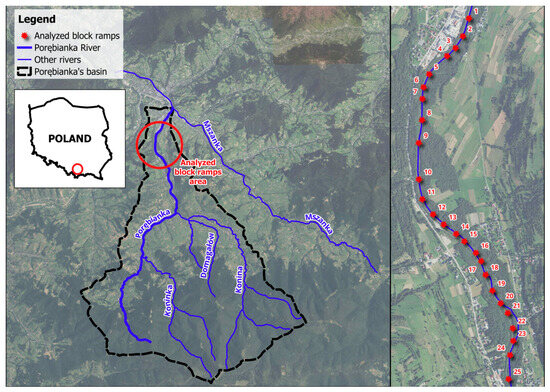
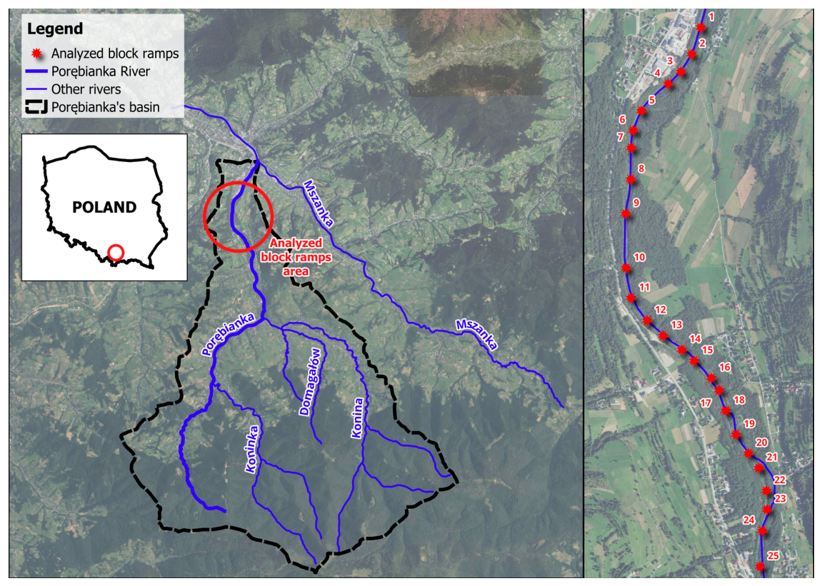
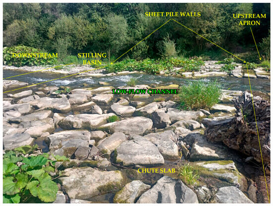
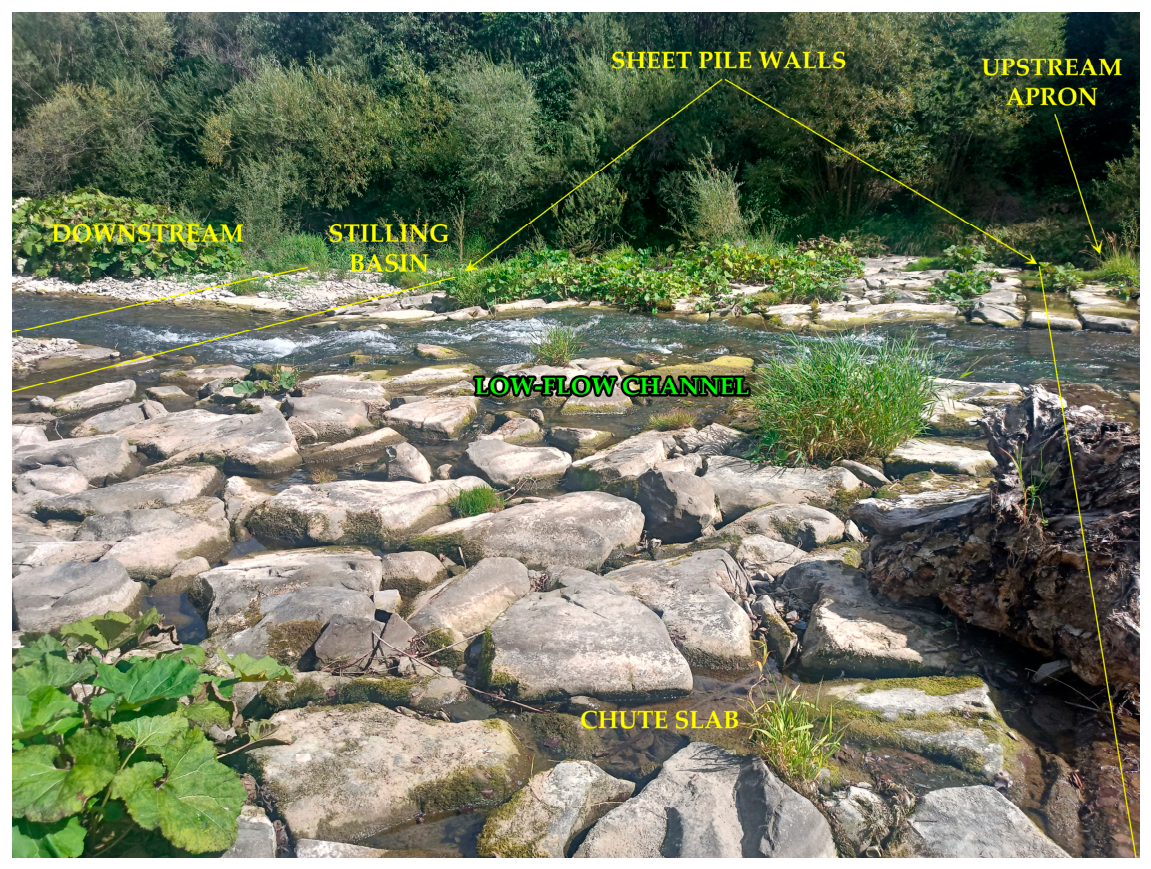
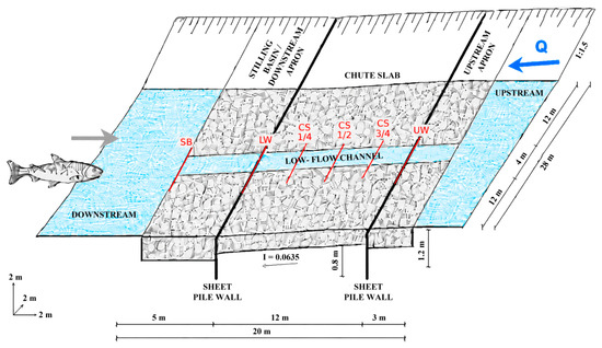
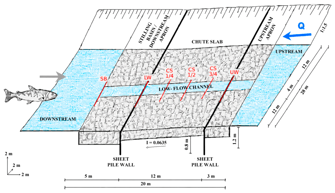
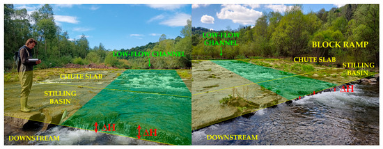
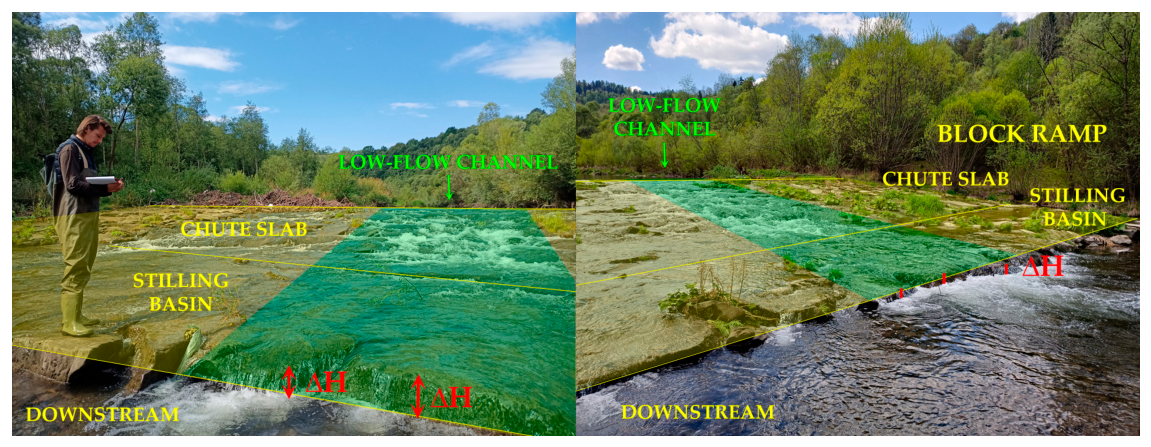
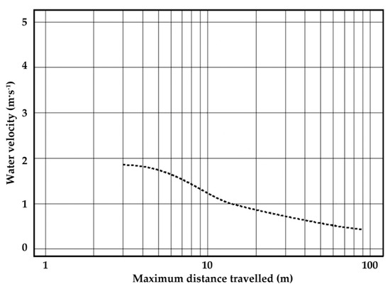
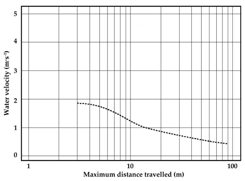
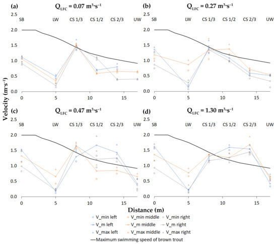
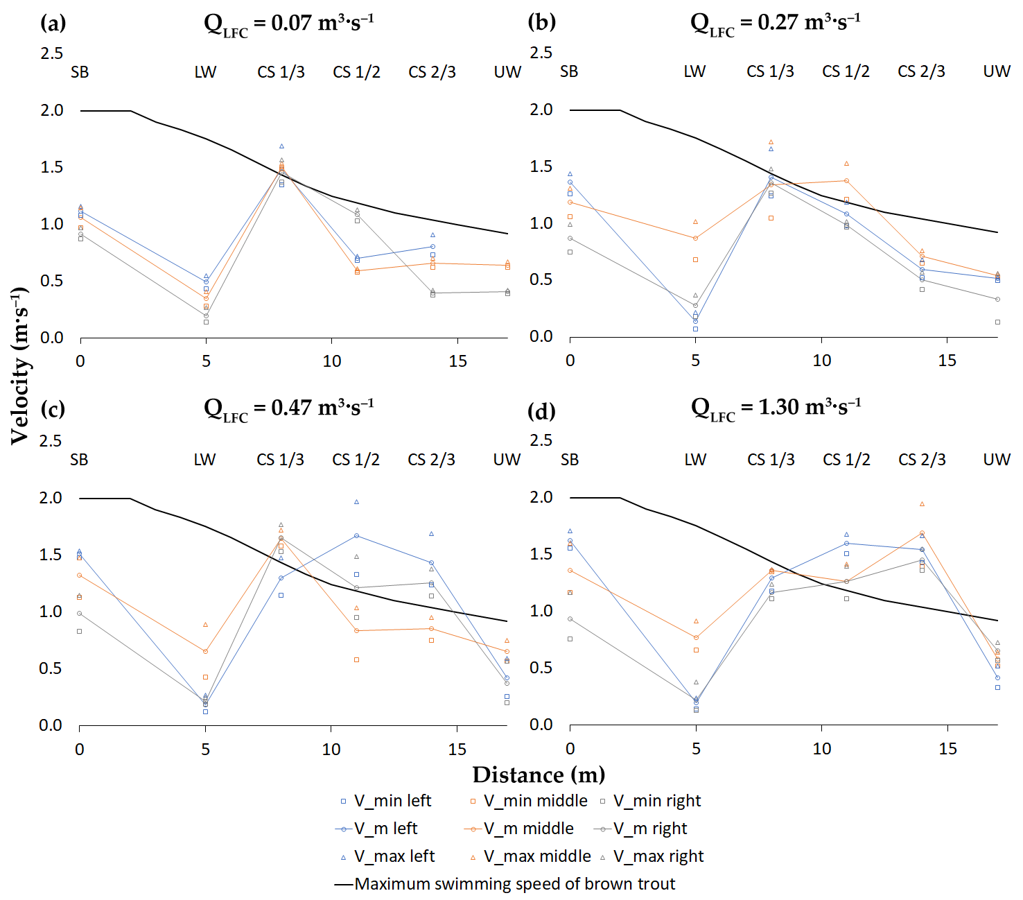
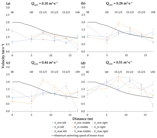
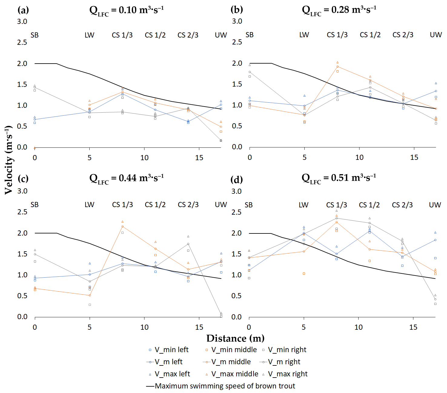
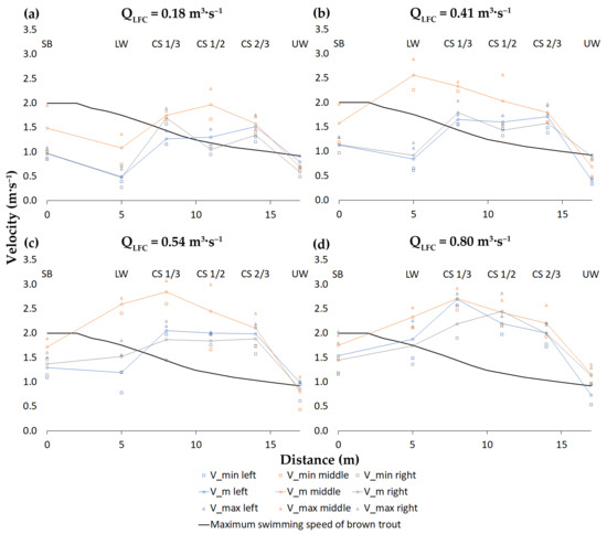
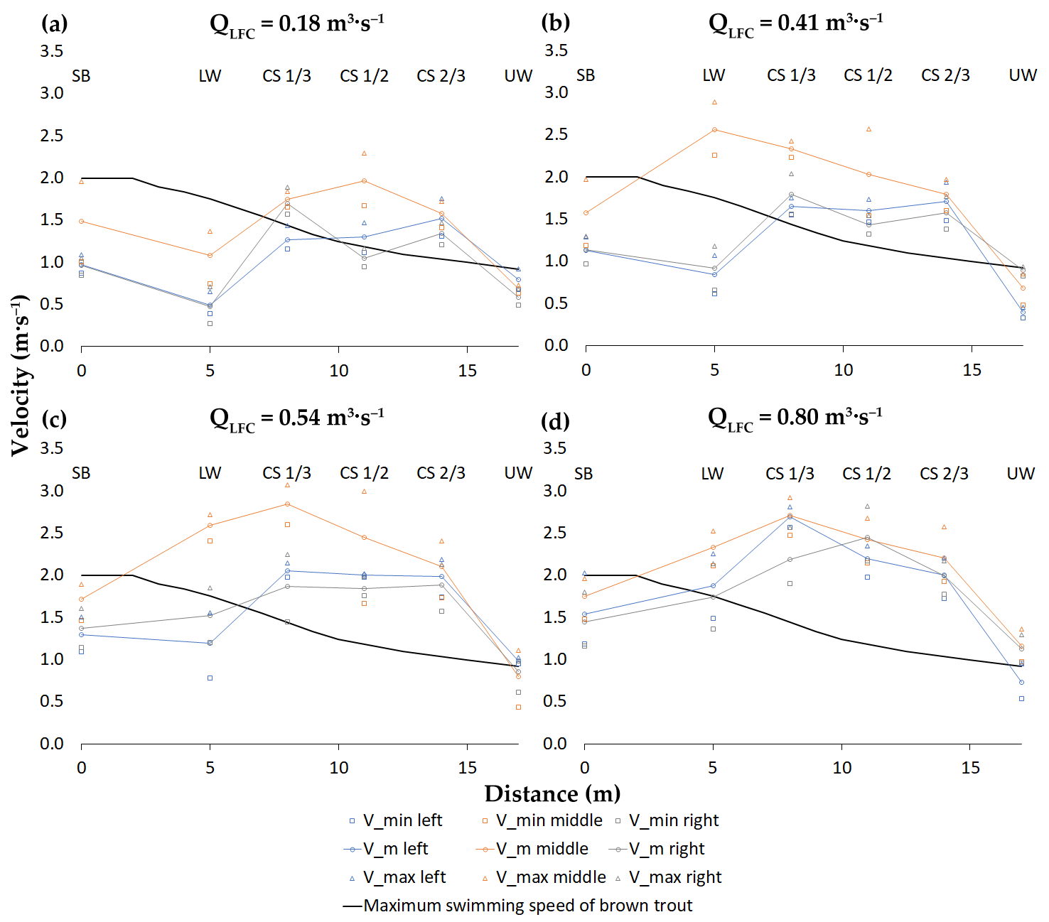
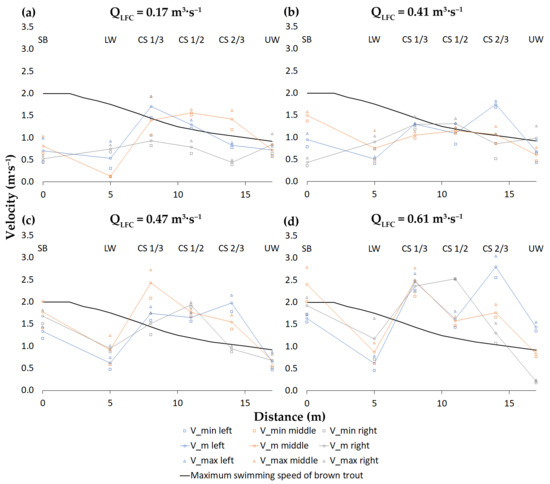
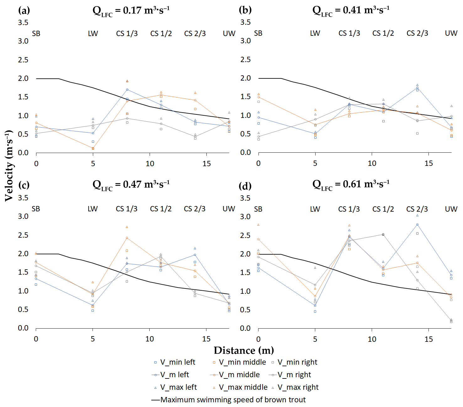
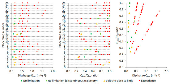
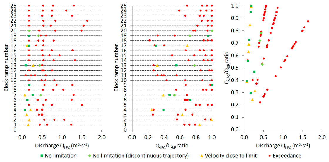
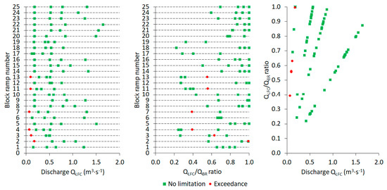
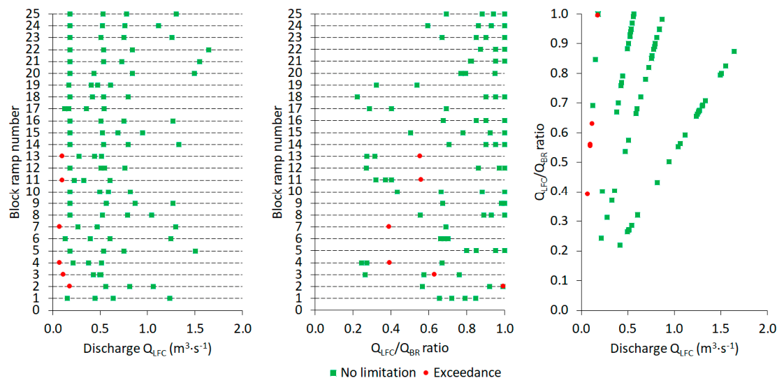
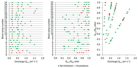
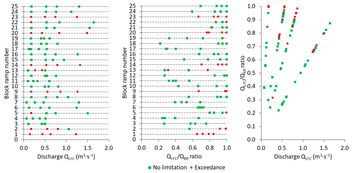

Disclaimer/Publisher’s Note: The statements, opinions and data contained in all publications are solely those of the individual author(s) and contributor(s) and not of MDPI and/or the editor(s). MDPI and/or the editor(s) disclaim responsibility for any injury to people or property resulting from any ideas, methods, instructions or products referred to in the content. |
© 2026 by the authors. Licensee MDPI, Basel, Switzerland. This article is an open access article distributed under the terms and conditions of the Creative Commons Attribution (CC BY) license.