


Abstract
Most of Korea’s precipitation is concentrated between June and September, and 65% of the country’s territory is covered with mountains, which means there is less time for rainfall to reach the surface. These hydrological characteristics pose challenges in securing and managing water resources. Moreover, the Yeongdong Area of Gangwon Province does not easily allow the construction of reservoirs and dams, which adds to the difficulty of developing structural measures to address water shortage caused by water supply restrictions. One measure proposed for addressing damage to residents, as well as social conflicts caused by water shortages, is to use underground dams and other high-capacity underground facilities to secure water for Korea’s eastern coastal areas. Unlike dams and reservoirs above the ground, underground dams are not affected by floods and offer an eco-friendly way to address the continuous water demand growth by storing water in underground spaces. This study prioritizes underground dam sites in six areas in the Yeongdong Area of Gangwon Province (Goseong, Sokcho, Yangyang, Gangneung, Donghae, and Samcheok) by conducting an expert survey and analyzing the results with the analytic hierarchy process (AHP) and fuzzy AHP. The findings indicate that the Sangcheon River in Sokcho, where an underground dam already exists, satisfies the criteria proposed in this study. We expect the study’s findings and methods to be used to determine suitable dam sites and water resource management plans.
1. Introduction
Water is the source of all ecosystems, making it crucial for people’s daily and economic activities. A shortage or excess of water can lead to disasters, such as droughts and floods, as well as national or global crises. As such, finding ways to manage water is necessary to prevent these disasters. Korea’s annual water reserve is around 125 billion tons, 60% of which flows into rivers and seas, and 40% is lost. Slightly less than half of the water flowing into rivers and seas (27% of the total water reserve, 33.7 billion tons) is used as river water, water stored in dams, and underground water. The remaining 33% (41.2 billion tons) flows into the sea [1].
Among the various facilities for securing additional groundwater, underground dams are representative. The term underground dam refers to a kind of underground reservoir in which water barriers are installed in the underground space for the purpose of securing additional groundwater through the existing groundwater level rise. The following section describes the research trends related to underground dams [2] divided the types of dams into underground, groundwater, subsurface, and sand storage. China and Japan have successfully adopted and operated underground dams, and India has built and used underground dams for small irrigation farming operations since the 1960s. Meanwhile, Kenya has built and operated underground dams to secure water for consumption and farming, and small-scale underground dams for drinking water were built in Ethiopia. In Korea, full-fledged R&D efforts on agricultural underground dams began in the 1980s, mostly for small watersheds [3]. Ref. [4] used exclusion criteria and geographic information system (GIS) methods for the site selection of underground dams using geology, topography, land use, and distribution maps of qanats. On the other hand, ref. [5] studied site selection for underground dam construction using multiple parameters using GIS and remote sensing. Ref. [6] selected an underground dam as a suitable location using the spatial multi-criteria evaluation (SMCE) for water supply in the dry basin in southwestern Iran. In addition, ref. [7] reviewed papers on the selection of suitable sites for dams and underground dams, and ref. [8] evaluated the environmental impact of underground dams on groundwater flow.
The research trends on the analytic hierarchy process (AHP) and fuzzy AHP are as follows. Ref. [9] developed AHP in the mid-1970s as a method to support the decision-making process with multiple decision-makers, and government agencies and businesses widely use AHP across the world. On the other hand, ref. [10] used AHP to determine airport sites in Samothrace in Northern Greece based on expert analysis findings, private airport authority evaluations, and the Ministry of Environment and Energy’s findings. Ref. [11] studied the selection of airport sites using fuzzy trigonometric functions. They identified and evaluated four criteria (operation conditions, social and economic conditions, operation support, and execution conditions) by calculating the relevant values with the fuzzy trigonometric function. Then, they used the calculated values to weigh the findings of an expert survey and used the results to shortlist the candidate sites. Meanwhile, Ref. [12] used fuzzy AHP to study site selections for the New Jeju Airport. He fuzzified the weights allocated to the AHP findings and summed up the multiplications of the respective elements to shortlist the candidate sites. Ref. [13] used fuzzy AHP to determine the suitable sites for underground dams to address drought-induced underground water shortage in Iran by defining the relevant indicators, including local inclines, distances to wells, and land use. Ref. [14] utilized fuzzy AHP to determine the suitable location for underground dam construction. They considered watershed inclines, widths, land use areas, and eight alternatives and used six experts’ survey results to prioritize the candidate sites.
For this study, fuzzy AHP was used to prioritize 34 watersheds in six areas (Goseong, Sokcho, Yangyang, Gangneung, Donghae, and Samcheok) along Korea’s east coast.
2. Theoretical Background
2.1. Research Method
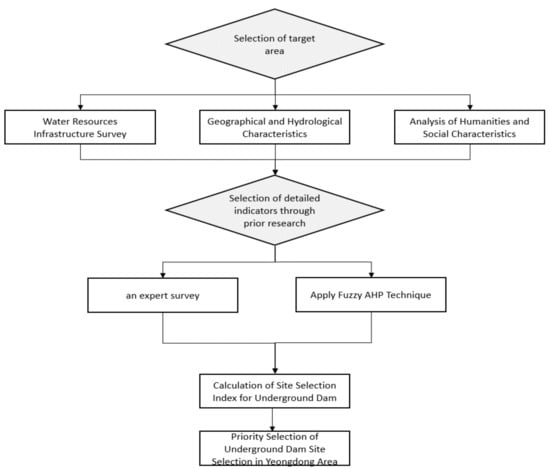
This study aims to analyze the expert survey results using fuzzy AHP to determine suitable underground dam sites among watersheds in six areas along Korea’s eastern coast (Goseong, Sokcho, Yangyang, Gangneung, Donghae, and Samcheok), with consideration of their topographical locations, water resource infrastructure, and other humanistic and hydrological factors. To that end, the humanistic and hydrological characteristics of the target areas were surveyed and analyzed, and the weights to be applied to suitable site determination based on previous studies were selected. Then, the survey findings were used to perform AHP and fuzzy AHP analyses to prioritize the underground dam sites in the research areas (Figure 1).
Figure 1.
Flowchart of study.
2.2. Analysis Hierarchy Process
AHP identifies the significance of different target values under a hierarchy, thereby calculating the significance of each factor or alternative. The process is suitable for prioritizing and resolving issues that include multiple decision-makers, goals, and criteria. It also prioritizes alternatives by calculating the weights or relative significance of higher-tier factors through the pairwise comparison of lower-tier factors. AHP even considers qualitative and quantitative elements, ensuring the consistency of AHP evaluations.
As in Table 1, The pairwise comparison matrix represents the superiority between two factors, and the inverse is established through symmetry.
Table 1.
Pairwise comparison matrix.
Here, a pairwise matrix is a square inverse matrix where all values on the diagonal line are 1.
A decision-maker proposes an index for the pairwise comparison’s reliability to validate the logical consistency of the decisions made. The index is called the consistency ratio (CR).
where CR refers to the consistency ratio, CI is the consistency index, RI is the random index, is the max Eigenvalue, and N is the matrix size. The CR is calculated by dividing CI by the RI, and a CR close to 0 means a higher level of consistency.
The weights calculated for each tier are compiled, and the resulting data can be used to prioritize alternatives and choose the best among them.
AHP has been criticized for uncertainties caused by changes in evaluation scale scores during pairwise comparison, and uncertainties arise from human preference because it uses numbers determined by humans. In addition, it is difficult for decision-makers to make accurate choices concerning comparisons. These uncertainties can be addressed by applying the fuzzy theory to AHP to quantitatively represent qualitative data and minimize the involvement of human preference.
2.3. Fuzzy Theory
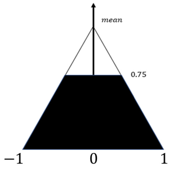
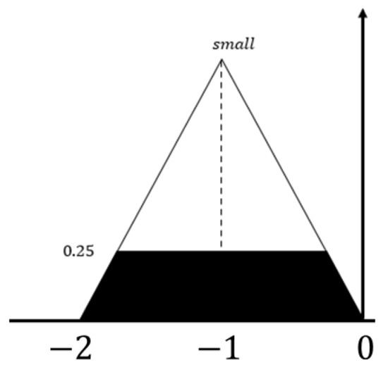
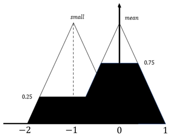
The fuzzy theory, established by [15], is predicated on the possibility that words used in everyday conversations and vague expressions can be quantitatively represented and processed. Among the theory’s many branches, the fuzzy scale theory solves issues by representing the degree of belief based on uncertain information. Before performing a fuzzy AHP analysis, understanding how a fuzzy system works is necessary. In Figure 2, Figure 3 and Figure 4, if certain values are entered for the input variables and , identifying the output of the fuzzy controller, which consists of rules and the membership function, is required.
Figure 2.
Output area from rule (1).
Figure 3.
Output Area from rule (2) [16].
Figure 4.
Output area from rules (1) and (2).
Rule (1) = “average” has membership values and . Then, determine the min value between the two membership values and d. Deliver the output variable of the representative value to the fuzzy set. The area of the colored section is used to calculate the output value.
min(0.75, 1) = 0.75
Rule (2) = “average” has membership values and , and the min value between the two membership values can be determined.
min(0.25, 1) = 0.25
The overall output variable for the two input variables is calculated using the areas from rules (1) and (2), and Figure 4 represents the area of the overall output variable.
2.4. Target Areas
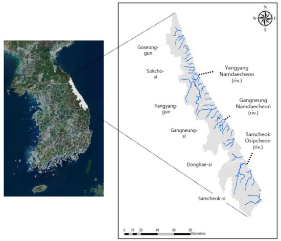
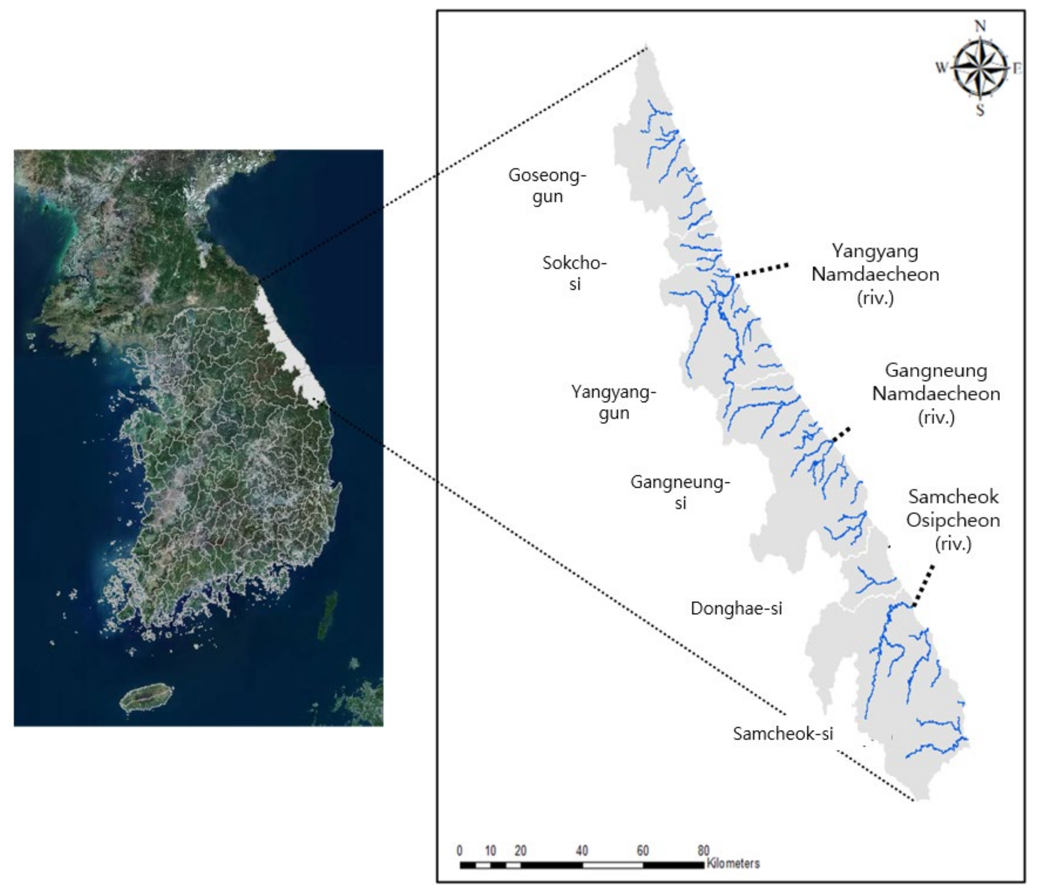
The target areas for this study are Goseong, Sokcho, Yangyang, Gangneung, Donghae, and Samcheok. Across the 6 areas, there are 3 grade 1 rivers (Namdaecheon in Yangyang, Namdaecheon in Gangneung, and Osipcheon in Samcheok) and 31 grade 2 or lower rivers, for a total of 34 watersheds and rivers (Figure 5). These areas are collectively called the Yeongdong Area, which refers to an area on the right side of the Taebaek Mountains. The rivers in the area are characterized by shorter extensions and smaller sizes, resulting in higher runoffs.
Figure 5.
Map of the target areas.
3. Application and Results
3.1. Selection of Indicators
Indexes, indicators, and data for determining suitable underground dam sites in the survey questionnaire were selected, as shown in Table 2, and the following paragraphs explain the meaning of each item. The underground dam suitability index (UDSI) represents the suitability of an underground dam site, and urgency (UG) represents the number of people affected by droughts over the last decade from the National Drought Information Portal. A higher UG value means a larger number of affected individuals. The business requirement (BR) is an indicator that represents the number of humanistic, social, environmental, and ecological elements in a watershed area, where a higher BR means a higher number of those elements. Water supply from underground dams (SU) was calculated using the underground dam development capacity formula developed by the [17]. so a higher development capacity pertains to a higher number of underground dams supplied. Meanwhile, water shortage (WS) was determined based on 2030 water shortage data under the Gangwon Province water resource management plan. A higher WS denotes more severe water shortages. The arrow in the meaning line means that the higher the number, the higher the indicator is defined.
Table 2.
Description of indexes, indicators, and data.
3.2. Weight Calculation Using the AHP and Fuzzy Methods
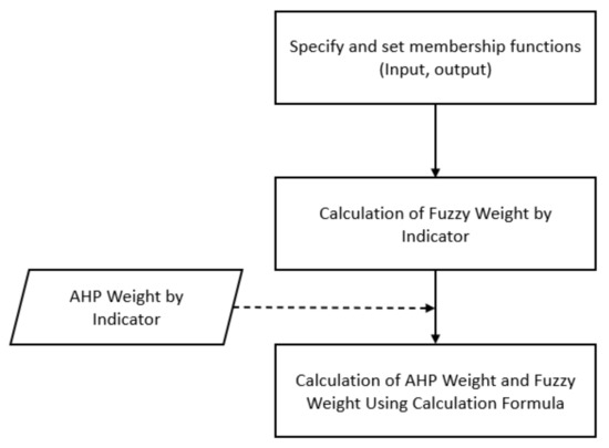
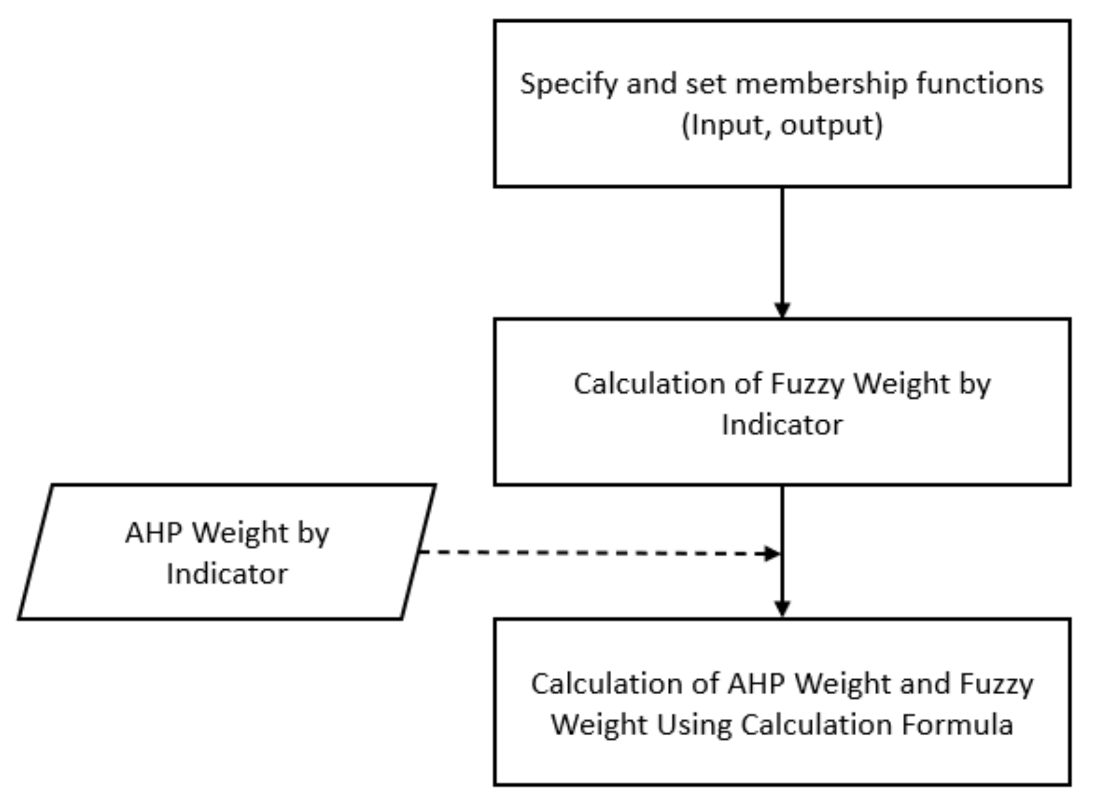
The criteria and weights were calculated using the AHP and fuzzy theory discussed in the preceding sections. In addition, a survey was conducted with 30 water resources, civil engineering, and disaster prevention experts, and the findings were analyzed using the AHP and fuzzy methods. The following represents the weights calculated with the fuzzy method (Figure 6). A membership function was first specified and set to determine the inputs and outputs. Then, the fuzzy weight for each indicator was calculated using a formula to determine the fuzzy and AHP weights.
Figure 6.
Flowchart of weight calculation using AHP and fuzzy methods.
The following formula was developed from the analysis:
Here, UDSI is the underground dam suitability index. It was newly calculated in this study by referring to the evaluation items selected in the existing literature case [17,18]. α is the weight for urgency, and UG is the fuzzy weight for urgency. Meanwhile, β is the weight for business requirements, and BR is the fuzzy weight of business requirements. In addition, γ is the weight for underground dam supply, SU is the fuzzy weight for the underground dam supply, ε is the weight for water shortage, and WS is the fuzzy weight for water supply.
After surveying the 30 experts, the CI of the survey findings was 0.02, which satisfies the CI criteria (CI ≤ 0.1). Table 3 shows the AHP weights calculated.
Table 3.
Weight analysis by indicator.
The urgency weight was 0.239, and the business requirement weight was the lowest at 0.167. Moreover, the weights for underground dam supply and water shortage were 0.198 and 0.396, respectively.
Determining the input and output variables was required to fuzzify each indicator. Four factors were chosen as the priority indicators for underground dam sites (urgency, business requirement, supply from underground dams, and water shortage), and Table 4 lists the membership function of each factor on a five-point scale. The following criteria were determined based on previous literature and the experts’ opinions. Table 4 sets the category range by referring to the existing references [18,19,20].
Table 4.
Membership function scores by indicator.
The membership function scores for urgency were determined based on the number of individuals affected by droughts over the last decade based on the National Drought Information Portal. A higher value indicates a larger number of affected individuals. A watershed is given 5 points if the number of affected people is 100,000 or more; 4 if the number is less than 100,000 but more than or equal to 50,000; 3 if the number is less than 50,000 but more than or equal to 10,000; 2 if the number is less than 10,000 but more than or equal to 5000; and 1 if the number is less than 5000.
The membership function scores for business requirements were determined based on the humanistic, social, environmental, and ecological factors in a watershed (cultural heritage protection zones, national park management zones, and water source protection zones). A watershed was given 4 points if it had three factors, 3 if it had two factors, 2 if it had only one factor, and 1 if there were none.
Moreover, the membership function scores for water supplies from underground dams were determined based on the 2030 water shortage data from the Gangwon Province water resource management plan. Here, 5 points were given if the daily supply was 100,000 m3 or higher; 4 if less than 100,000 m3 but more than or equal to 50,000 m3; 3 if less than 50,000 m3 but more than or equal to 10,000 m3; 2 if less than 10,000 m3 but more than or equal to 5000 m3; and 1 if less than 5000 m3.
The membership function scores for water shortage were determined based on a relation formula of development capacity and watershed areas proposed by the Ministry of Construction and Transport. Here, 5 points were given if the shortage was 24,000 m3 or higher; 4 if it was less than 24,000 m3 but 18,000 m3 or higher; 3 if it was less than 18,000 m3 but 12,000 m3 or higher; 2 if it was less than 12,000 m3 but 6000 m3 or higher; and 1 if it was less than 6000 m3.
3.3. Membership Function Setting
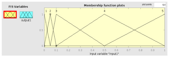
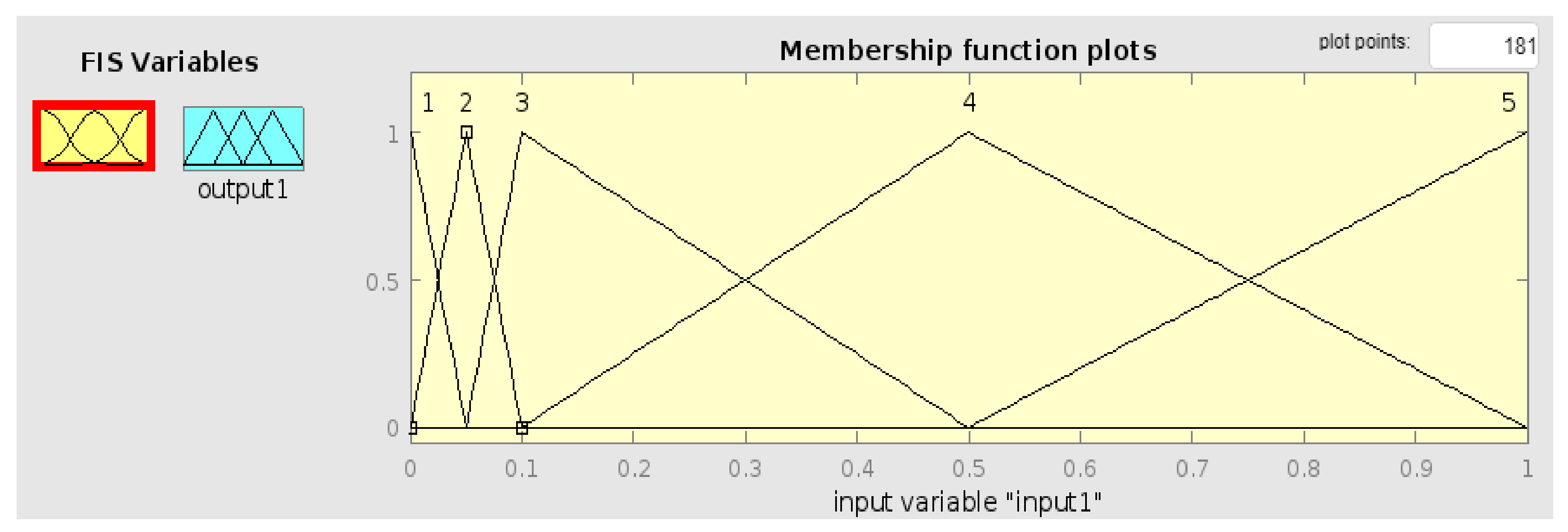
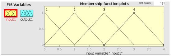
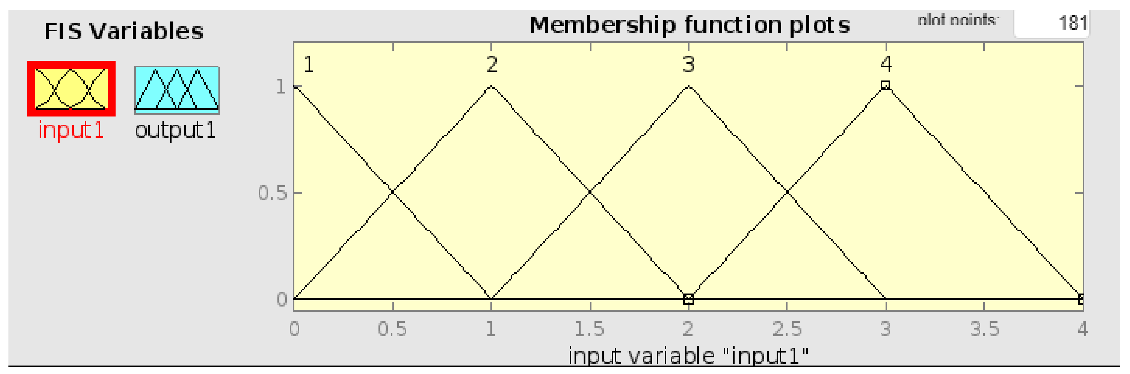
The membership function for each fuzzy range was used, and five fuzzy sets for the membership functions of four input variables (urgency, business requirement, supply from underground dams, and water shortage) and one output variable were defined to evaluate the input variables for each priority indicator. Here, the x-axis was calculated using the category value of Table 4, and the y-axis means belonging and is used to find the height of the area described in Section 2.2.
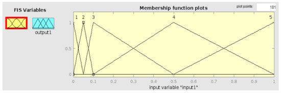
(1) Urgency
Figure 7 shows the findings on urgency, which reflects the number of individuals affected by droughts over the last decade. Here, 100,000 individuals were expressed as 1 to set the membership function, and lower numbers as values were expressed proportionately lower than 1.
Figure 7.
Input variable for urgency.
(2) Business Requirement
Figure 8 shows the results of a business needs survey reflecting whether or not development restrictions within the watershed are included. There are three indicators for business requirements: national park management zones, water source protection zones, and cultural heritage protection zones. All watersheds with three or more of the factors were given 4 points.
Figure 8.
Input variable for business requirements.
(3) Supply from Underground Dams
Information on the 2030 water shortage data from Gangwon Province water resource management plan was used to represent the water supply from underground dams, as shown in Figure 9. For this value, 100,000 m3/day was expressed as 1 to set the membership function, while lower numbers were expressed as values proportionately lower than 1.
Figure 9.
Input variable for underground dams.
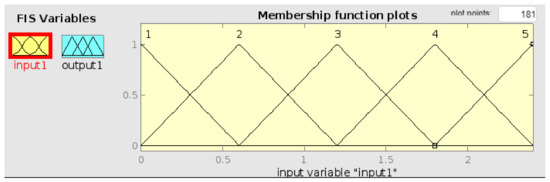
(4) Water Shortage
Water shortage was represented using a development capacity–watershed area relation formula proposed by [17], as shown in Figure 10. The membership function was set at a range between 0 and 2.4.
Figure 10.
Input variable for water shortage.
(5) Output Variable
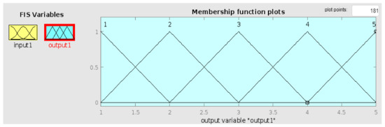
The fuzzy membership functions for the input variables were set to obtain the following outputs, as shown in Figure 11.
Figure 11.
Output variables.
3.4. Analysis Results
The membership function for each indicator to fuzzify the target areas was multiplied with the AHP weights discussed above, and the indicator values were summed up to prioritize underground dam sites and is shown in Table 5.
Table 5.
AHP weight by indicator.
In Table 6, For Sangcheon, the watershed with the highest priority, the weight for urgency was 0.239, the fuzzy weight for urgency was 4.680, the weight for the business requirement was 0.167, and the fuzzy weight for the business requirement was 3.000. Moreover, the weight for water supply was 0.198, the fuzzy weight for water supply was 3.320, the weight for water shortage was 0.396, and the fuzzy weight for water shortage was 3.000. Its total score was 3.465.
Table 6.
Underground dam site prioritization results.
For the watershed with the second highest priority, Yeongokcheon, the weight for urgency was 0.239, the fuzzy weight for urgency was 1.530, the weight for the business requirement was 0.167, and the fuzzy weight for the business requirement was 3.000. In addition, the weight for water supply was 0.198, the fuzzy weight for water supply was 3.320, the weight for water shortage was 0.396, and the fuzzy weight for water shortage was 4.680. Its total score was 3.354.
As for Namdaecheon, the watershed with the third highest priority, the weight for urgency was 0.239, the fuzzy weight for urgency was 1.530, the weight for the business requirement was 0.167, and the fuzzy weight for the business requirement was 1.000. Furthermore, the weight for water supply was 0.198, the fuzzy weight for water supply was 4.680, the weight for water shortage was 0.396, and the fuzzy weight for water shortage was 4.680. Its total score was 3.312.
4. Conclusions
The conclusions of the study drawn based on the above research contents are as follows.
In the Yeongdong region of Gangwon Province, continuous damage occurs due to a lack of living, industrial, and agricultural water. Resident damage and regional conflicts frequently occur, but it is difficult to build new reservoirs and dams. Therefore, in this study, the characteristics of each basin were analyzed by applying spatial analysis techniques for hydrological characteristics and humanities and social characteristics of 34 basins located in the Yeongdong area, and the current status of drought damage and non-supply water was investigated to select suitable sites. The priority of underground dam installation was derived by using it as basic data of priority.
For prioritization of the selection of suitable sites for underground dams, urgency, underground dam supply scale, project requirements, and water shortage were selected as indicators through prior research. A methodology was used to interpret the existing AHP and the level of linguistic judgment by matching it with a fuzzy function.
The above four indicators were divided into a 5-point scale, and the AHP weight for each indicator and the weight using fuzzyization were calculated through the survey results. For each index, water shortage was the highest, followed by urgency, supply from underground dams, and business requirements. Sangcheon Dam, located in Sokcho-si, ranked first with a total score of 3.465, with the highest priority in the installation of underground dams. In addition, Yeongokcheon, which was selected as the second priority with a total score of 3.354, was also possible to feasibly present underground dams that are expected to be installed in the future, have actually been installed, or are in the process of being installed.
The methodology presented in this study is expected to be useful in prioritizing the installation of underground dams at home and abroad, and it is believed that it will be able to provide insight into the potential of underground dams for water security in the Yeongdong area. However, follow-up studies are needed to verify the methodology by analyzing index values suitable for regional characteristics and expanding the target area.
Author Contributions
Methodology, J.-R.C., D.-H.K. and K.-S.C.; Investigation, D.-H.K. and K.-S.C.; Data curation, K.-S.C.; Writing—original draft, J.-R.C.; Writing—review & editing, B.-S.K.; Visualization, J.H.S., D.-H.K. and B.-S.K.; Supervision, J.H.S. and B.-S.K. All authors have read and agreed to the published version of the manuscript.
Funding
This research was supported by (2022-MOIS63-002(RS-2022-ND641012)) of the Cooperative Research Method and Safety Management Technology in National Disaster funded by the Ministry of Interior and Safety (MOIS, Republic of Korea).
Data Availability Statement
The data used in the current study are available from the corresponding author upon reasonable request.
Conflicts of Interest
We declare that we have no competing financial interests or personal relationships that could have appeared to influence the work reported in this study.
References
- Ministry of Land, Infrastructure and Transportation of Korea (MOLIT). (2011–2020): Water Vision 2020. In The Long-Term Comprehensive Water Resource Plan (2011–2020): The Second Revised Water Vision 2020; MOLIT: Sejong, Republic of Korea, 2011. (In Korean) [Google Scholar]
- Hanson, G.; Nilsson, A. Ground-Water Dams for Rural-Water Supplies in Developing Countries. Groundwater 1986, 24, 497–506. [Google Scholar] [CrossRef] [Scilit]
- Korea Rural Community Corporation (KRC). A technical study of groundwater dam development in a small basin area. 1996, pp. 60–61. Available online: https://library.krihs.re.kr/search/detail/CATTOT000000050758 (accessed on 30 July 2023).
- Chezgi, J.; Moradi, H.; Kheirkhah, M.; Ghasemian, D. Site selection for underground dam construction using exclude criteria method in GIS (case study: West of Tehran). In Proceedings of the 2010, 5th National Conf. of Watershed Management Science and Engineering, 10, Gorgan, Iran, 22–23 April 2010; Gorgan University of Agricultural Sciences and Natural Resources: Gorgan, Iran, 2010. (In Persian) [Google Scholar]
- Mumzai, A. Selection of the best capable areas for construction of underground dam using Multi-criteria Decision Making (Case study: Marghmalek-Shahrekord Watershed). Iran. Water Res. J. 2019, 13, 83–92. [Google Scholar]
- Jamali, A.A.; Randhir, T.O.; Nosrati, J. Site Suitability Analysis for Subsurface Dams Using Boolean and Fuzzy Logic in Arid Watersheds. J. Water Resour. Plan. Manag. 2018, 144, 04018047. [Google Scholar] [CrossRef] [Scilit]
- Wang, Y.; Tian, Y.; Cao, Y. Dam Siting: A Review. Water 2021, 13, 2080. [Google Scholar] [CrossRef] [Scilit]
- Sun, Y.; Xu, S.G.; Kang, P.P.; Fu, Y.Z.; Wang, T.X. Impacts of Artificial Underground Reservoir on Groundwater Environment in the Reservoir and Downstream Area. Int. J. Environ. Res. Public Health 2019, 16, 1921. [Google Scholar] [CrossRef] [Scilit] [PubMed]
- Saaty, T. The Analytical Hierarchy Process; McGraw Hill: New York, NY, USA, 1980. [Google Scholar]
- Ballis, A. Airport site selection based on multicriteria analysis: The case study of the island of samothraki. Oper. Res. 2003, 3, 261–279. [Google Scholar] [CrossRef] [Scilit]
- Liao, Y.; Bao, F. Research on Airport Site Selection Based on Triangular Fuzzy Number. Appl. Mech. Mater. 2014, 505, 507–511. [Google Scholar] [CrossRef] [Scilit]
- Lee, S.J. A Study on Selection of an Airport’s Location Using the Fuzzy-AHP Method: Focused on the Location of 2nd Airport in Jeju Island, Korea. Master’s Thesis, Hanseo University, Seosan, Republic of Korea, 2016. [Google Scholar]
- Tavakoli, S.; Khashei-Siuki, A.; Hashemi, S.R.; Khozeyme-Nezhad, H. Comparison of FAHP and FANP Decision-Making Methods in Determining the Appropriate Locations for Constructing an Underground Dam for Water Harvesting. Water Harvest. Res. 2018, 3, 81–91. [Google Scholar]
- Rezaei, P.; Rezaie, K.; Nazari-Shirkouhi, S.; Tajabadi, M.R.J. Application of Fuzzy Multi-Criteria Decision Making Analysis for Evaluating and Selecting the Best Location for Construction of Underground Dam. Acta Polytech. Hung. 2013, 10, 187–205. [Google Scholar]
- Zadeh, L.A. Fuzzy Sets. Inf. Control 1965, 9, 338–353. [Google Scholar] [CrossRef] [Scilit]
- Lee, B.R. Focusing on Fuzzy Neural Network Control Matlab/Simulink; Ulsan University Press: Ulsan, Republic of Korea, 2012. [Google Scholar]
- Report on the Establishment of Underground Dam Development Plan. Ministry of Construction and Transportation/Korea Water Resources Corporation. 2002. Available online: https://www.codil.or.kr/viewDtlConRpt.do?gubun=rpt&pMetaCode=OTMCRKXA208 (accessed on 30 July 2023).
- Lee, S.I. Effective Use of Water Resources Through Conjunctive Use—(I) The Methodology. J. Korea Water Resour. Assoc. 2004, 37, 789–798. [Google Scholar] [CrossRef] [Scilit]
- Myoung, W.H.; Song, S.H. Development of Suitable Sites Assessment Criteria for Agricultural Subsurface Dam for drought Management using Analytic Hierarchy Process (AHP). Korean Soc. Soil Groundw. Environ. 2017, 22, 37–41. [Google Scholar]
- Lee, S.I.; Kim, B.C. Site Suitability Analysis for Underground Dam Using Analytic Hierarchy Process. Soc. Soil Groundw. Environ. 2003, 8, 36–44. [Google Scholar]

Disclaimer/Publisher’s Note: The statements, opinions and data contained in all publications are solely those of the individual author(s) and contributor(s) and not of MDPI and/or the editor(s). MDPI and/or the editor(s) disclaim responsibility for any injury to people or property resulting from any ideas, methods, instructions or products referred to in the content. |
© 2023 by the authors. Licensee MDPI, Basel, Switzerland. This article is an open access article distributed under the terms and conditions of the Creative Commons Attribution (CC BY) license (https://creativecommons.org/licenses/by/4.0/).