


Abstract
Late-ripening citrus exhibits considerable spatiotemporal variation in fruit quality, and implementing zoned management is further complicated by the unique biological and ecological characteristics of the Sichuan Basin. This review provides the first integrated climate–purple soil–terrain synthesis of zoned management for late-ripening citrus in the Sichuan Basin, examined across four dimensions: driving mechanisms, technical approaches, methodological evolution, and limitations. First, the causes of spatiotemporal quality variation are clarified by considering three factors: climate, soil, and topography. Secondly, current monitoring, analysis, and zoned management technologies are assessed for suitability in the frequently cloudy and foggy environment, hilly topography, and scattered orchard plots of the Sichuan Basin. Additionally, the methodological evolution from “general fruit tree methods” to “citrus-specific methods” to “Sichuan scenario-adapted methods” is delineated, and five major research gaps are identified: spatiotemporal data fusion, universality of dynamic zoning, multi-factor interactive modeling, economic feasibility evaluation, and technology dissemination. Based on these findings, future research directions are proposed, including multi-source data fusion, dynamic modeling, cross-regional transferability, economic optimization, and lightweight inclusive solutions, to provide systematic research frameworks and methodological references for zoned management of late-ripening citrus in the Sichuan Basin.
1. Introduction and Background
1.1. Introduction
Citrus is the largest fruit crop worldwide. Late-ripening citrus represents an important sector of the citrus industry, reaching peak maturity from February to June of the following year, during the winter and spring slack season for fresh citrus markets, and it therefore holds considerable economic value [1]. Late-ripening citrus fruits remain on the tree for 12–14 months, experiencing a full annual environmental cycle and multiple phenological cycles, and are highly sensitive to spatiotemporal environmental conditions [1,2,3]. The fruit quality variability between years and among trees at different topographic positions has been recognized as a serious issue for late-ripening citrus production, with major quality traits reported to vary considerably by cultivar, topographic position, and year [3,4]. Because these traits are quantified on different bases and reported under different study conditions, no single, uniformly defined coefficient of variation can be reliably assigned across the literature; the variation is therefore described qualitatively rather than as a fixed numerical range. Traditional water, fertilizer, and harvest management strategies are inadequate for addressing the multidimensional spatiotemporal heterogeneity [3,5,6,7].
In this review, the terms “late-ripening citrus” and “late-maturing citrus” are treated as synonymous, and “late-ripening citrus” is adopted consistently throughout. Late-ripening citrus is defined here as cultivars that reach commercial maturity from February to June of the year following flowering and remain on the tree for approximately 12–14 months, thereby experiencing a complete annual environmental cycle and multiple phenological stages. This review concerns late-ripening cultivars grown in the Sichuan Basin rather than late-ripening citrus in general. Among the diverse late-ripening cultivars, Buzhihuo (Shiranui/Dekopon), Chunjian, and Qingjian are used as representative examples because they are widely planted in the basin and their fruit quality is strongly influenced by regional climatic conditions; they are illustrative rather than exhaustive. Because the proposed zoned management framework depends closely on cultivar-specific phenology and on-tree retention time, this phenological definition and cultivar scope are stated explicitly at the outset.
Terminology. To ensure clarity and consistency, we establish the following terminology convention for this review: A management zone (MZ) is a spatially contiguous subregion of an orchard that exhibits relative homogeneity in soil properties, topography, microclimate, or crop performance and can be managed with a uniform set of practices. Management zone delineation (or zoning) refers to the process of identifying and mapping such zones using data analysis, spatial modeling, or field surveys. Zoned management denotes the practice of applying differentiated agronomic interventions—such as irrigation, fertilization, or frost protection—according to the characteristics of each zone. Precision zoned management is a technology-enhanced form of zoned management that integrates high-resolution spatial data (e.g., UAV multispectral imagery, satellite time series) and advanced quantitative methods (e.g., machine learning, geostatistics) to achieve finer spatial resolution and more accurate zone boundaries. Throughout this manuscript, management zone or MZ refers to the spatial unit itself, delineation or zoning refers to the mapping process, zoned management refers to the differentiated management strategy, and precision zoned management refers specifically to its data-intensive, model-driven implementation.
The region from 28°00′ N to 32°00′ N and 102°30′ E to 108°00′ E is one of China’s most significant areas for late-ripening citrus cultivation [1,8,9]. This production system exhibits six typical biological and ecological traits in response to regional environmental factors, including climate, hilly topography, and parent material, that distinguish it from other systems: First, flower–fruit coexistence occurs on the same tree: flowers from the current spring and the fruit set from the previous spring coexist within the canopy. Competition for water and nutrients is evident between floral organs and overwintered fruit with an on-tree retention time of 12–14 months, particularly during the first two flowering cycles [1,10]. Second, over-wintering occurs on-tree: fruit is left on the tree until the next winter (December–March), during which it is subjected to regular cold waves, frost events, and low temperatures but limited sunlight. In extreme years, ambient minimum temperatures in the region have been reported to fall below −3 °C, and natural fruit drop rates during the overwintering period can reach 20–40% [1,2,11]. Third, a temperature inversion phenomenon often occurs in the hilly area of the Sichuan Basin in winter. The downslope drainage of cold, dense air is assisted by nocturnal radiative cooling, and this cold air will form in the lowest points such as valley bottoms. Under this “cold-lake” effect, lower topographic positions are colder than upper and mid-slope positions, especially when there is no weather front to dissipate inversions and the air is clear and calm with light winds. Topographically related differences in temperature amplify the spatial variation of orchard frost exposure due to frequent and relatively strong inversions in the Sichuan Basin during the winter season. Therefore, the risk of freeze damage to fruit can change considerably over short distances within the same orchard, and valley bottom areas and other cold air accumulation areas may be higher-risk than areas with good ventilation [12,13]. Furthermore, purple soils in the Sichuan Basin are formed from purple sedimentary parent materials, mainly Jurassic and Cretaceous strata, and retain a strong parent rock inheritance in their color, mineral composition, and physicochemical properties. Because they are characterized by short formation times, rapid physical pedogenesis, and relatively weak chemical weathering, they are best described as weakly developed soils with a pronounced lithologic signature. Their fertility appears to depend largely on mineral-derived nutrient supply, especially potassium and phosphorus inherited from or released by the parent material, rather than on specific thresholds of organic matter or exchangeable calcium [14,15,16]. After temperatures recover in spring, on-tree fruit may face an increased risk of regreening and short-term declines in soluble solids, although the exact magnitude and rate of TSS (total soluble solids) loss should be derived from a study that directly reports °Brix changes under March–April field conditions [17,18]. Sichuan’s citrus industry is dominated by late-ripening cultivars, including important hybrid types such as Buzhihuo, Chunjian, and Qingjian, and their fruit quality shows strong sensitivity to regional climatic conditions in the basin. Taken together, the evidence supports a close cultivar–climate–quality relationship in which temperature-related resource endowment is a key determinant of adaptation and quality formation [1,8,19]. Figure 1 summarizes the spatial aspects of the six distinct characteristics of late-ripening citrus in the Sichuan Basin and their relationships with quality variation.
Figure 1.
Conceptual synthesis of the relationships between the six biological/ecological characteristics of late-ripening citrus in the Sichuan Basin and the spatiotemporal heterogeneity of fruit quality (TSS, TA (titratable acidity), sugar–acid balance, and overwintering fruit drop rate). Solid arrows denote relationships directly supported by cited experimental studies; dashed arrows denote conceptual linkages synthesized by the authors that are plausible but not yet directly quantified for Sichuan late-ripening citrus. This figure is a conceptual schematic and does not represent a quantitative causal model. Major quality traits have been reported to show the considerable variation between years and among topographic positions. The magnitude differs by cultivar, trait, and conditions, and no single uniformly defined variation statistic is available across studies.
The six biological and ecological attributes identified for late-ripening citrus in the purple-soil hilly region of the Sichuan Basin are consistent with a broader pattern seen across major citrus-producing regions, including Mediterranean calcareous-soil orchards, Brazilian sandy and Oxisol-based systems, and Florida’s sandy-soil groves, where climate, soil, and topographic conditions interact in region-specific ways to shape fruit quality, soil function, and production sustainability, thereby informing monitoring, orchard management, and land suitability or forecasting approaches [7,20,21,22,23]. Current management zone delineation methods typically combine kriging or other geostatistical interpolation, unsupervised data clustering, and remote sensing covariates. Most of the traditional methods, however, require more uniform field variability and need to be modified for structurally complex perennial fruiting orchards [24,25,26]. The use and reliability of these trees under the unique environmental factors of the Sichuan Basin (such as the frequent cloud and fog, purple soil, hilly landscape, and small orchard blocks), however, still need systematic verification.
This study establishes an analytical framework (driving mechanisms, technical approaches, methodological evolution, and research limitations) and systematically summarizes research findings on zoned management strategies for spatiotemporal variation in late-ripening citrus. This review focuses on three objectives: (1) clarifying the driving mechanisms of climate, soil, and topography in quality variation; (2) comparing the applicability of monitoring technologies, spatial analysis methods, and decision-making management technologies in typical Sichuan Basin production scenarios; and (3) summarizing the evolution of these technologies from general fruit tree methods to citrus-specific methods and then to Sichuan scenario-adapted methods. Existing reviews on citrus zoning have largely focused on general fruit tree precision agriculture or on citrus nutrition under climate change [22,23,26] and have not systematically addressed the coupled climate–soil–terrain mechanisms that operate in the Sichuan Basin. Specifically, no previous evaluation has incorporated (i) basin-level winter temperature inversions, (ii) the buffering capacity of purple-soil nutrients, and (iii) a cultivar-specific climatic sensitivity into a single zoning system. This is important because the zoning rules that are validated in flat and uniform orchards may not work in sloping and broken orchards or in cloudy areas of Sichuan [27,28]. The present review is designed to fill this gap by compiling 165 primary sources in a scenario-specific analytical framework. The main contributions of this review are as follows:
- Zoning synthesis of late-ripening citrus in the Sichuan Basin combined with the climate, purple soil, and hilly terrain.
- Comparative evaluations of monitoring, spatial analysis, and decision support technologies in the face of frequent clouds/fog and small, fragmented farmland.
- A methodological evolution map outlining the evolution of the methods employed within fruit tree, citrus, and Sichuan-adapted methods and explicitly identifying five research gaps.
1.2. Study Area
This review focuses on the late-ripening citrus production region of the Sichuan Basin, located between 28°00′ N–32°00′ N and 102°30′ E–108°00′ E. The 15 counties most important for citrus production are concentrated in the eastern and south-eastern part of the basin, where elevations (approximately 180–800 m on the basin floor and surrounding hills) and climate are most conducive to late-ripening citrus [29,30]. Late-ripening cultivars such as Buzhihuo (Shiranui/Dekopon), Chunjian, and Qingjian dominate this region, each with distinct climatic sensitivities [1,5,31]. As shown in Figure 2, the Sichuan citrus industry is organized into three industrial belts: the Western Sichuan Plain Belt (Pujiang, Danleng, Dongpo), the Southern Sichuan Belt (Renshou, Yibin, Luzhou, Rongxian, Leshan, Jingyan, Zigong), and the Central Sichuan Hilly Belt (Anyue, Ziyang, Zizhong, Nanchong, Guang’an) [29,30,32]. These belts also produce other citrus types (e.g., blood oranges, Ponkan, and lemons); the present review, however, specifically concerns the late-ripening hybrid cultivars grown within them. For cartographic context, the map in Figure 2 displays a larger extent of the region (approximately 25°00′ N–35°00′ N, 97°00′ E–109°00′ E) so that the full provincial boundary and surrounding terrain, including the western mountain regions, rising above 5000 m, are visible. This map extent should not be interpreted as the boundary of the study area, which is confined to the citrus-producing region defined above.
Figure 2.
Study area map of the Sichuan citrus production region. Three industrial belts are shown: the Western Sichuan Plain Belt (Pujiang, Danleng, Dongpo), the Southern Sichuan Belt (Renshou, Yibin, Luzhou, Rongxian, Leshan, Jingyan, Zigong), and the Central Sichuan Hilly Belt (Anyue, Ziyang, Zizhong, Nanchong, Guang’an). Although these belts also produce other citrus types (e.g., blood oranges, Ponkan, and lemons), this review focuses on the late-ripening hybrid cultivars (Buzhihuo, Chunjian, Qingjian) grown within them. The map graticule (approximately 25°00′ N–35°00′ N, 97°00′ E–109°00′ E) indicates the map extent shown for provincial context and is larger than the study area; the late-ripening citrus study region lies within 28°00′ N–32°00′ N, 102°30′ E–108°00′ E.
1.3. Literature Search and Screening
The aim was to carry out a systematic and reproducible synthesis; thus, a structured literature search was performed in Web of Science Core Collection, Scopus, and CNKI databases for the period of January 2000 to June 2026. The search combined three concept blocks—crop, management/zoning, and methods—using database-specific field tags and Boolean operators. The exact search strings are provided in the Supplementary Material (Tables S2–S4). In brief, the Web of Science Core Collection search used TS = and ALL = fields; the Scopus search used TITLE-ABS-KEY; and the CNKI search used SU% = with within-field + operators. Eligibility criteria for the search and screening are described in detail in the Supplementary Material (Table S1). Only peer-reviewed journal articles and official reports were included. Language restrictions were applied as follows: English only for the Web of Science Core Collection; English and Chinese for Scopus; Chinese–English expansion enabled for CNKI; and English or Chinese for backward snowballing. For all sources, the time restriction was 2000 to 2026 (June). The search was conducted on 14 July 2026.
Screening was conducted in two phases (titles and abstracts, then full texts), and two independent reviewers resolved any discrepancies. Retained full texts were then evaluated to determine whether they included the following six required quality criteria: a well-specified research design, validated methods, a large enough sample size and spatial extent, a replicable workflow, statistical rigor, and regional relevance.
The search retrieved 129 records from the Web of Science Core Collection, 174 from Scopus, and 105 from CNKI. An additional 213 records were found by backward snowballing of reference lists, bringing the total number of records to 621. Following the removal of duplicates (n = 180), 441 records were screened by title and abstract and 121 records excluded. The remaining 320 full-text articles were assessed for eligibility, and 155 were excluded for the following reasons: comprising a conference abstract, dissertation, or preprint; being written in a language other than English or Chinese; not being about citrus and having no methodological transferability; or the full text being unavailable. After screening and backward snowballing, 165 primary sources were included. The full flow is presented in Figure 3, and the individual counts and thematic distribution are shown in detail in the Supplementary Material (Tables S4–S6).
Figure 3.
Systematic literature search and screening flowchart for studies on spatiotemporal variability and zoned management of late-ripening citrus in the Sichuan Basin (2000–2026).
2. Formation Mechanism and Driving Factors of Spatiotemporal Differences
Fruit quality formation in late-ripening citrus follows a multi-scale chain of interactions in the Sichuan Basin, where the regional climate determines thermal and moisture regimes, soil nutrient and water heterogeneity drives fruit development, and topography shapes the local microclimate and soil redistribution within orchards [1,8,33,34]. Quality formation in late-ripening citrus in the Sichuan Basin differs from that in many other citrus-growing regions for several reasons: fruit remains on the tree through winter, and low winter temperatures alter sugar–acid metabolism; with a limited buffering capacity, purple soils are sensitive to acidification; the hilly topography causes many microclimatic and soil differences, leading to considerable spatial variability in fruit quality [1,2,7,35,36]. This section analyzes the impacts of climatic factors on interannual and spatial variations in fruit quality, the coupling relationship between spatial differences in soil nutrient and water conditions and fruit quality, and the regulatory effects of topographic factors on micro-domain differences in fruit quality. The mechanisms are illustrated in Figure 4.
Figure 4.
Conceptual three-tier driving chain (climate, soil, terrain) of spatiotemporal quality variation in late-ripening citrusin the Sichuan Basin. Solid arrows: mechanisms supported by cited studies; dashed arrows: author-proposed, unquantified links. This is a conceptual schematic, not a causal model. † Values (e.g., valley frost risk ~3–5 times) are compiled across studies/scales and are indicative only. Soil parameters are described in the following text.
2.1. Interannual and Spatial Driving Effects of Climatic Factors
Macro-scale variation in late-ripening citrus fruit quality is primarily controlled by climate at both interannual and spatial scales; however, the dominant factors differ substantially among climatic zones. Fruit quality in Mediterranean climate zones such as those in Spain and Italy is chiefly influenced by summer drought stress, experiencing differences in TSS and TA associated with the extent of drought stress during the growing season [31,37]. In the Sichuan Basin (which has a subtropical monsoon climate), by contrast, fruit quality is affected both by winter low-temperature stress and by the degree of sugar degradation during spring recovery from low temperatures, a process that is relatively unimportant in Mediterranean climate zones.
In the Sichuan Basin, late-ripening citrus fruit quality is associated with winter chilling accumulation, frost and freeze damage, and reduced winter light. These factors are described in the literature by distinct quantities that should not be interpreted as a single threshold: an ambient extreme minimum temperature below −3 °C was reported at the regional scale; and, under controlled conditions, a freeze-damage temperature of approximately −2.3 °C was reported, and cold-exposure treatments in the range of −1 to −7 °C were applied for 6–15 h, which affected soluble solids content, acidity, firmness, color, and antioxidant profiles [1,11]. As these values were derived from different studies and experimental conditions, they represent a regional climatic extreme, a reported damage threshold, and experimental treatment conditions, respectively. Light also has a measurable effect: total soluble sugars in light-treated sweet oranges are higher than in dark-shaded oranges, and short-day shading (12% light transmittance for 18 days) increased soluble sugars through starch degradation and sugar storage [38,39,40].
Interannual climate variation appears to affect citrus internal quality: higher cumulative temperature tends to promote soluble solids accumulation, whereas lower cumulative temperature and cooler early-season conditions tend to maintain higher acidity and thereby shift the sugar–acid balance [5]. Limited sunlight may further exacerbate interannual quality variation relative to that in Mediterranean production areas with more abundant sunlight. There are also significant differences in climatic sensitivity among cultivars (Table 1). Buzhihuo is most sensitive to winter low-temperature accumulation, showing pronounced differences in soluble solids content between high- and low-temperature years. Chunjian is sensitive to the rate of spring temperature rebound, which promotes sugar degradation and shifts the sugar–acid balance. Qingjian is sensitive to the duration of on-tree fruit retention (approximately 14 months) and shows the most severe cumulative effect of interannual temperature variation on soluble solids content, together with a high natural fruit drop rate [5,31]. These cultivar-level differences in climatic sensitivity indicate that zoned management approaches in the Sichuan Basin will not be accurate unless the cultivar dimension is taken into consideration.
Table 1.
Climatic sensitivity and fruit drop characteristics of major fruit-bearing late-ripening cultivars of citrus in Sichuan.
2.2. Soil Nutrient Heterogeneity and Its Spatial Coupling with Fruit Quality
An important driver of fruit quality differences within orchards is spatial heterogeneity in soil nutrients. In the Sichuan Basin, purple soils are distinguished by their nutrient properties, which are transferred partly from their parent rocks, and their relatively low organic matter or organic carbon levels and comparatively high levels of mineral nutrients, particularly potassium and phosphorus [46,47]. Studies in Southwest China and other agricultural systems indicate that these soil characteristics are spatially variable due to parent material, topography, land use, erosion, and fertilization, resulting in significant within-site and between-site variation that allows for site-specific nutrient management [16,36,47,48,49,50]. Low organic matter content is generally associated with lower cation exchange capacity (CEC) and reduced nutrient buffering capacity. Where buffering capacity is low, spatial heterogeneity in mineral nutrients may translate comparatively directly into spatial differences in tree nutrition, although CEC, nutrient availability, and plant response are also governed by soil texture, mineralogy, pH, exchangeable bases, moisture, rooting depth, fertilization, and landscape position. Because the cited studies largely derive from general soil science and other cropping systems, this mechanism is inferred rather than demonstrated directly in Sichuan citrus orchards, and it therefore requires local verification. The effect of minor nutrient supply differences on quality is intensified by nutrient competition during the flower–fruit coexistence period (an on-tree fruit retention period of up to 12–14 months). Reflecting this lower buffering capacity, the correlation between soil nitrogen and fruit quality is generally reported to be more pronounced in purple soil than in red soil or Oxisol [51,52,53,54,55,56,57]. This contrast is qualitative and is inferred from the buffering-related soil properties summarized in Table 2 rather than from a measured coupling coefficient; accordingly, Table 2 compares soil nutrient characteristics across soil types rather than a quantified nutrient–quality coupling.
Under low sampling intensity, ordinary kriging may be constrained by reduced interpolation accuracy and unstable variogram fitting, while co-kriging and regression kriging approaches can improve orchard soil mapping by incorporating correlated ancillary variables, at the cost of greater data requirements that may reduce field applicability where sampling and auxiliary information are limited [58,59,60].
Table 2.
Comparison of soil nutrient characteristics among orchard soil types relevant to nutrient–quality relationships.
2.3. Regulatory Effect of Topographic Factors on Micro-Domain Differentiation of Fruit Quality
Micro-scale hydrothermal redistribution among topographic positions appears to be the finest link in this three-level framework, and, in the hilly Sichuan Basin, it likely operates against a background of frequent winter temperature inversions and strong terrain-controlled climatic heterogeneity that can amplify frost exposure in low-lying orchard sites and, in turn, amplify spatial variation in fruit quality [12,66,67]. The representation of fine-scale temperature fields in hilly terrain depends strongly on DEM resolution. As DEM resolution becomes coarser, terrain smoothing weakens slope- and aspect-related temperature contrasts and reduces spatial heterogeneity, which can degrade the representation of local cold air accumulation and other topographic thermal effects [68,69]. In complex terrain, models with spatially constant coefficients are often inadequate, whereas geographically weighted and random forest-based approaches better capture nonlinear and spatially heterogeneous temperature relationships when fine-resolution terrain and environmental covariates are available [70,71,72]. However, these methods are black-box in nature, which can conflict with the interpretability required for zoned management [73,74,75].
Table 3 contrasts the dominant topography–quality effects across producing regions. The comparison is qualitative: the reported metrics differ in physical nature and spatial scale and are used to characterize the dominant topographic effect in each region rather than as directly comparable values. Winter temperature inversion in the Sichuan Basin is described by a vertical lapse/inversion rate and occurs predominantly in winter; in the California Central Valley, nocturnal inversions are reported as an absolute temperature difference over a stated elevation range on frost nights; São Paulo uses an altitude-based agroclimatic mapping approach rather than a single temperature value; and Mediterranean regions are characterized by an absolute heat stress threshold in summer. Because these regions rest on different topographic assumptions, methodologies established elsewhere encounter adaptability limitations when transferred to the Sichuan Basin context.
Table 3.
Comparison of dominant factors of topography–quality effects in different producing areas (reported metrics differ in type and are not directly comparable; see note).
3. Key Technical Approaches for Zoned Management
Data acquisition, spatial analysis, zoning delineation, and decision implementation constitute the four steps of the closed-loop technical chain for zoned management of late-ripening citrus [24,82]. Based on the unique characteristics of the Sichuan Basin—including frequent winter cloud and fog, significant gradients in soil nutrients, and small hilly orchard fields—we propose a multi-source collaborative acquisition system integrating satellite remote sensing, unmanned aerial vehicle (UAV) monitoring, and ground sensor calibration. Although satellite–UAV synergy and citrus thermal resource assessment have been reported in general or non-Sichuan contexts, such an integrated framework has not been operationally implemented for Sichuan citrus zoning [1,83,84]. In sloping orchards, image errors can be minimized through terrain-following flight planning, accurate DEM support, and oblique image acquisition, as demonstrated for general high-relief topographic surveys rather than in citrus orchards specifically [85,86,87]. UAV-derived soil, topographic, and crop indicators have been used to delineate citrus management zones in orchards outside Sichuan—for Israeli, Iranian, and Spanish citrus—and fruit quality maps can support localized decisions, but none of these studies was conducted under Sichuan Basin conditions, so the approach has been demonstrated in principle yet requires regional adaptation [7,24,25,26,88]. Citrus zoning is well suited to fuzzy clustering, although the optimal number of management units remains context-dependent [24,25,26,89]. The results are validated for interannual stability and intra-zone homogeneity [89,90,91]. For decision implementation, row-scale prescription maps and lightweight decision support systems (DSS) specifically designed for small, sloping orchards remain to be developed. Variable-rate irrigation and fertilization technologies have been demonstrated in other crops and general contexts, but their calibration for Sichuan purple-soil citrus orchards under cloud and fog conditions requires site-specific validation [90,92,93].
3.1. Data Acquisition: Comparison Between Remote Sensing Monitoring Methods
The accuracy and timeliness of data acquisition are foundational requirements of the zoning management technology chain, as high-quality data are prerequisite for subsequent spatial analysis and zoning delineation. Table 4 systematically compares the six data acquisition techniques studied across five dimensions: spatial resolution, temporal resolution, spectral range, cost, and operational complexity. The reported resolutions are typical values under standard acquisition conditions and vary with sensor model, flight altitude, and atmospheric conditions, while the cost and operational complexity ratings follow the qualitative criteria defined in the table note.
Table 4.
Multidimensional comparison of data acquisition methods.
Beyond these tabulated dimensions, the number of spectral bands should not be equated with usable information for citrus monitoring. Although Sentinel-2 and Landsat provide 13 and 11 bands, respectively, these are distributed across several spatial resolutions, and only a subset is directly useful at the orchard scale—principally, the 10 m visible and near-infrared bands and the red-edge bands relevant to canopy chlorophyll and nutrient status. Several coarse-resolution bands (e.g., the 60 m atmospheric correction bands of Sentinel-2 and the 100 m thermal band of Landsat) contribute little to fruit quality or fine-scale canopy assessment in fragmented hilly orchards.
One of the main difficulties for data acquisition is frequent cloud and fog in winter. This is particularly true for the Sichuan Basin, where frequent cloud cover over the winter period of overwintering (December–February) results in limited optical satellite acquisitions, and other hilly areas in southwestern China have faced similar challenges [105,106]. With on-demand flight capability, UAVs can operate beneath low cloud ceilings or during breaks in cloud cover, providing a scheduling advantage over optical satellites during the critical winter monitoring season. This advantage is not unconditional: flying above a cloud layer does not remove cloud obstruction along the sun–target–sensor path, and low-illumination, overcast conditions reduce and destabilize incoming radiation, compromising radiometric consistency across flights. Reliable winter UAV monitoring therefore requires radiometric calibration (e.g., reference panels or irradiance sensors) to ensure comparability between acquisitions, together with terrain-following flight to maintain a consistent canopy distance over sloping orchards. Due to the complex topography of the Sichuan Basin’s hilly region, there are two challenges for data quality and flight safety. In sloping orchards, the relative height of the UAV above the canopy varies, causing spatial resolution to be higher on lower slopes and lower on upper slopes. These systematic errors are magnified, generating spatial errors in quality prediction when retrieving canopy parameters [107]. This issue is not fully addressed by existing commercial UAV flight planning software but can be partially resolved by flying along contour lines or using terrain-following mode.
3.2. Spatial Analysis: Geostatistics and Fuzzy Clustering Algorithms
Spatial analysis serves as the primary link between data collection and zoning demarcation. Table 5 summarizes the reported characteristics of geostatistical and fuzzy clustering algorithms used in agricultural management zone delineation, including partition boundary flexibility, zone differentiation capacity (assessed variously by ANOVA F-tests for hard clustering or fuzzy validity indices such as the FPI (fuzziness performance index), MPE (modified partition entropy), and NCE (number of extragrades) for probabilistic methods), and computational efficiency. These characteristics are drawn from studies that differ in crop, spatial scale, input variables, and validation approach; the table is therefore descriptive rather than a controlled quantitative comparison.
Table 5.
Comparison of zoning performance between geostatistical and fuzzy clustering methods.
Fuzzy clustering algorithms and geostatistics-coupled k-means two-stage methods differ in zone boundary flexibility and multi-factor fusion capacities. The mixture model delivers variance reduction effects yet imposes high computational costs, restricting its applicability for independent zoning within fragmented orchards. The Gustafson–Kessel algorithm adopts an adaptive distance metric, which enables it to cope with the broad magnitude ranges of mineral nutrients and organic matter present in purple soil.
Based on cluster number sensitivity analysis, the optimal number of management zones in hilly fields in Sichuan and central China was found to be three, as indicated by minima in fuzzy performance metrics such as FPI, MPE, and NCE. A separate commercial citrus plantation study found six optimal zones, showing that optimal zone number varies by orchard context rather than supporting a general flat-orchard benchmark of 5–8 zones [24,27,115]. This aligns with the study of Zeraatpisheh et al. (2020) [24], who reported that six optimal management zones were delineated for a heterogeneous citrus plantation using principal component analysis and fuzzy c-mean clustering, supporting the finding that hilly terrains with smaller, fragmented fields require fewer management zones than large-scale flat orchards. Field parcels within such hilly settings are generally limited in individual plot size. Excessive zoning subdivisions produce overly small individual management units, which hinder the practical implementation of variable-rate field operations. Such a limitation constitutes a key distinguishing feature between the Sichuan study region and plain-based production zones.
3.3. Decision Support System and Variable-Rate Operation Execution
The implementability of zoning management in orchards depends not only on the delineation method but also on the adaptability of downstream execution components, especially DSS and mechanized operation technologies. In the Sichuan Basin, this adaptability is constrained by the predominance of sloping and fragmented farmland, as more than 90% of cultivated land is on slopes and the relative share of 10–25° sloping farmland has increased [28]. Under these conditions, three limitations become prominent: terrain mismatch between zoning prescriptions and fragmented hillside plots, reduced execution reliability of mechanized operations as slope and fragmentation increase, and higher integration and usability requirements for orchard DSS due to the complexity of perennial orchard management [116,117]. The quantitative indicators in Table 6 are drawn largely from studies of hilly agriculture in general rather than from Sichuan citrus orchards specifically, and their exact magnitudes for late-ripening citrus remain to be validated.
Table 6.
Reported adaptability constraints relevant to orchard DSS and mechanization in hilly terrain.
Regarding the applicability of variable-rate irrigation strategies, the three approaches, which are soil moisture sensor-based, evapotranspiration model-based, and canopy temperature-based, respectively, differ in their applicability given the weak water-holding capacity of purple soil (Table 7). The soil moisture sensor-based approach is directly related to the water dynamic of the citrus root zone but requires soil-specific calibration and proper installation as the sensor readings can vary from place to place and depth to depth within the drip zone [121]. Irrigation scheduling based on evapotranspiration (ET) models in the Sichuan Basin seems possible with limited input data, but the resulting model accuracy depends on regional climate conditions, particularly solar radiation and cloudiness, and requires field testing and calibration of the models [122]. The canopy temperature-based approach is physiologically based on crop water stress, which causes stomatal closure and an increase in leaf temperature [123]. However, the canopy temperature–water stress relationship for evergreen citrus canopies differs from that for deciduous crops due to iso-hydric behavior, in which rapid stomatal closure in response to a high vapor pressure deficit (VPD) occurs even under well-watered conditions, as reported in thermography studies of citrus [124,125,126]. In a cross-species comparison of CWSI measurement errors, citrus was reported to have the shallowest non-water stress baseline slope (−0.5 °C kPa−1) among the crops examined [123], rendering CWSI calculations particularly sensitive to measurement errors and requiring species-specific recalibration. These findings come from citrus grown outside the Sichuan Basin, and their applicability under the basin’s humid, frequently overcast conditions has not been established.
Table 7.
Comparison of the applicability of three variable-rate irrigation strategies in purple-soil orchards.
4. Methodological Evolution Pathways and Cross-Scale Comparison
Through systematic synthesis of the existing literature, a gradual evolution from general fruit tree methods to citrus-specific methods and then to Sichuan scenario-adapted methods is revealed. This evolutionary process shows that the approach to zone management has shifted from being crop-centric to being scenario-centric.
4.1. Management Zone Delineation Methods for General Fruit Trees
General fruit tree management zoning methods have developed a relatively unified methodological paradigm across four aspects: sampling strategy, core variables, zoning algorithm, and validation methods. Regarding sampling methods, regular grid sampling (30 m × 30 m) is more commonly used in apple orchards and vineyards, whereas stratified random sampling is preferred in olive orchards due to terrain complexity [135]. As shown in Table 8, soil characteristics like nitrogen, organic matter, and pH are generally used as the major variables, and yield data are included, with fruit quality data included if the zoning classification needs to reflect variation in product quality in addition to production for fruit orchards [136]. Although the k-means method is a still common method for determining management zones, recent zoning studies have increasingly incorporated dimensionality reduction with fuzzy clustering to improve the ability to partition a heterogeneous landscape and to minimize within-zone variability [137]. Zone validation is frequently performed using ANOVA to see if agronomic variables vary significantly between zones, but this test is sensitive to independent observations and can yield false-positive results if there is high spatial autocorrelation [138]. Other validation methods are complementary, such as multivariate tests like MANOVA and classification-based tests like linear discriminant analysis with leave-one-out cross-validation (LOOCV), which, in one study, classified the cultivation zones perfectly both internally and externally.
Table 8.
Comparison of the core frameworks of management zone delineation methods for different fruit trees.
However, the transferability of the general management zone framework to the purple-soil hilly region of the Sichuan Basin is limited by differences in terrain and soil heterogeneity rather than by crop type alone. Sichuan Basin farmland is dominated by hilly landscapes and strong within-field soil variability, and uniform regional recommendations can lead to both under- and over-application of inputs [27]. In the Jianyang hilly field in Sichuan, soil properties showed variation that ranged from low to moderate-to-high and differing spatial dependence, and management zones were delineated using principal component analysis with fuzzy clustering rather than a simple fixed soil–yield template [27]. More broadly, studies in hilly agroecosystems show that yield patterns vary with hillslope position, curvature, wetness, drainage, soil depth, and nutrient redistribution, so the relationship between soil indicators and yield is spatially heterogeneous rather than uniform across the landscape [142]. Accordingly, applying a general framework in Sichuan requires adding locally relevant terrain, nutrient, and, where available, multi-year yield or remote sensing covariates and validating zoning performance with spatial metrics or yield-based criteria rather than assuming that soil organic matter alone is the dominant driver [30,114].
4.2. Applicability Limitations in Citrus Scenarios
The general fruit tree zoning methods serve as a methodological basis, but they are not directly applicable to late-ripening citrus in the Sichuan Basin due to its different canopy structures, phenology, stress, and temporal needs. The contrasts can be presented in four dimensions: remote-sensing retrieval, quality prediction, stress response, and timeliness (Table 9). The comparison is to be interpreted as a contrast to traditional one-season orchard designs or as a general orchard description for all fruit crops.
Table 9.
Four-dimensional differences between general fruit tree methods and the Sichuan late-ripening citrus scenario.
It is more difficult to retrieve evergreen citrus using remote sensing as the persistent canopy cover makes it harder to see the direct soil areas and increases the canopy–background interaction. The integration of the spectral, structural, soil, and terrain data has been commonly integrated in citrus studies in recent years. Leaf nutrient status estimation has been performed using multispectral imagery from UAVs, and the retrieval of the leaf area index and soil moisture has been achieved using multimodal UAV observations [94,143,144]. In the Sichuan Basin, the cloudy, hilly environment can further reduce the temporal continuity of optical satellite data [105].
Therefore, satellite products must not be considered as a primary zoning data source, but rather must be complemented by targeted UAV surveys and ground measurements. There also is a need for an increased temporal element in quality prediction. As late-ripening citrus is exposed to environmental conditions over an extended production cycle, a single-date observation is not sufficient to capture quality formation. China has seen that interannual climatic variation has an impact on internal quality of citrus [5], and time-series remote sensing has been found to enhance characterization of the seasonal variations in yield [145]. Stress response is also multidimensional: the suitability of citrus varieties in Sichuan is determined by the interacting heat, moisture, and radiation conditions [1], and basin temperature inversions and spatially variable purple-soil properties add further stress dimensions [12,36]. Lastly, there should be some stability through time in perennial management. Operational zones need to be maintained long enough and consistently over time to allow for year-on-year management, as dynamic citrus zoning shows that canopies can be changed during the season. The proper framework should thus be a combination of stable terrain and soil layers and dynamic canopy, moisture, and temperature data.
4.3. Research Progress on Citrus-Specific Modeling Methods
Citrus-specific modeling can be considered as three methodological steps which can be seen as overlapping: static sensing and prediction, multi-temporal dynamic zoning, and multi-source or digital-twin integration. In this review, a digital twin denotes a virtual representation of an individual orchard that is continuously updated with multi-source observations and used for prediction and management, which is distinguished from a process-based digital model or simulation that is mechanistic and parameterized but not necessarily linked to continuous observation of a specific orchard. This is conceptual and not a solid historical taxonomy, as there is overlap among the approaches and performance is highly dependent on the prediction target and study context. The first stage is aimed at the extraction of the canopy or production characteristics from single- or few-period remote sensing data. In the citrus sector, UAV multispectral imagery has been used successfully for the estimation of the nutrients of citrus leaves [94], and UAV multimodal imaging has been applied to the retrieval of the leaf area index [143]. Other newer yield models are based on a combination of vegetation indices and texture features and machine learning techniques. Onwude et al. (2024) [146] reported R2 values around 0.79–0.85 for fruit number prediction using XGBoost and CPSO-optimized XGBoost. These methods are effective in mapping spatial heterogeneity; however, most do not reflect the entire process of fruit quality development, but rather predict other fruit parameters, such as canopy status, nutrition, water condition, or yield. The second stage involves repeated observations and introduces temporal variability explicitly in zone delineation. Termin et al. (2023) [26] combined constant terrain variables with canopy nitrogen and tree height in a spatiotemporal fuzzy C-means scheme, using a support vector regression model for canopy nitrogen (reported R2 = 0.771) before applying the estimates in dynamic management zone analysis. This is a positive step from a static zoning approach to one that is time responsive, but it is for nitrogen management and not for the coupled quality processes that are typical of late-ripening citrus. In the third stage, it is integrated into digital representations of orchard systems, where observations are from different sources. Lin (2022) [147] built a Mandarin digital twin integrating weather, soil, management, and fruit data, reporting R2 = 0.43 for sugar content and R2 = 0.84 for fruit size, illustrating that predictive accuracy differs markedly between traits within a single study, with sugar content being inherently harder to predict than fruit size. Avioz al. (2025) [148] developed a digital model of Valencia orange growth, reporting harvest quality predictions within 5% error (as defined in that study). The accuracy metrics cited above (R2, RMSE, and percentage error) are study-specific values obtained for different response variables (fruit number, canopy nitrogen, sugar content, fruit size, and overall harvest quality) with different units, sample sizes, validation strategies, and spatial and temporal scopes. They therefore cannot be compared directly and should not be interpreted as evidence that any one methodological stage is intrinsically more accurate than another; a lower R2 for sugar content, for example, reflects the inherent difficulty of predicting that trait rather than a deficiency of the modeling stage. These values indicate that each approach can perform well for its specific target under its own conditions, not that the stages form an ascending scale of accuracy. Sichuan needs regional adaptation of application. Even in hilly fields, there is a significant soil variability and management zone heterogeneity [27], and field-scale variation in the acidity of the purple soil can be increased by citrus culture [36]. In addition, there is considerable evidence of basin-scale temperature inversions [12], but little is known about orchard-scale cold air patterns and their direct effects on late-ripened fruit quality. A regionally adapted framework should therefore combine the persistent variables that are intrinsic to the landscape (such as relative elevation, slope, aspect, terrain position, and stable soil properties) with the dynamic variables that are part of the environment (canopy condition, soil moisture, soil temperature, and measured fruit quality). Validation should be performed not only to check the model fit, but also to check cross-year stability, cross-orchard and cross-cultivar transferability, and within-zone homogeneity and economic operability. Multi-year field datasets linking terrain, microclimate, purple-soil properties, canopy dynamics, management, and fruit quality in the same spatial scale are thus the most pressing research need for management.
5. Current Challenges and Existing Issues
Zoned management of citrus is still limited in Sichuan due to the lack of winter observation, zone changing from year to year and by cultivar, and inadequate economic and extension capacity in hilly orchards with limited planting areas [1,29]. The five research gaps identified in the Abstract are each addressed in the following subsections and are linked here to the reviewed evidence, the current limitation, and the corresponding future direction. First, spatiotemporal data fusion (Section 5.1) is constrained by the 2–3-month winter gap in optical satellite coverage and by the resolution and geometry mismatch between UAV and satellite data [148]. A multi-source fusion framework that treats UAV data as a distinct, radiometrically and temporally harmonized observation phase is required, and it must be validated for continuity through the overwintering period and for consistency across sensors and years. Second, the universality of dynamic zoning (Section 5.2) is limited because static zones lose reliability under interannual climate and inversion variability [149,150,151]. Incremental updating and time-series clustering, together with a consistently defined interannual overlap metric, are needed for cross-year stability. Third, multi-factor interactive modeling (Section 5.3) remains weak because climate, soil, topography, and cultivar sensitivity are typically modeled individually or by simple superposition, while nonlinear methods that capture their interactions are largely black-box [149,150,151]. Interpretable machine learning and structural or process-based coupling are required, with validation extending to the interpretability of the estimated interactions and their generalization across orchards and cultivars. Fourth, economic feasibility evaluation (Section 5.4) is critical because equipment-intensive precision systems show low smallholder adoption in fragmented hilly orchards [149,150,151]. Lightweight, cooperative-based precision schemes are needed and should be assessed for viability across operating scales [149,150,151]. Fifth, technology dissemination (Section 5.5) is hampered by reliance on single-channel, informal extension. A combined model of cooperative training, local demonstration, and multi-stakeholder platforms is required, validated by adoption rate and willingness across farmer groups [149,150,151]. Table 10 provides a structured synthesis of the five research gaps identified in this review, linking each gap to the reviewed evidence, the current limitation, the required data or method, and the validation requirement. The table is intended to be read alongside Section 5.1, Section 5.2, Section 5.3, Section 5.4 and Section 5.5, which discuss each gap in detail.
Table 10.
Synthesis of research gaps, reviewed evidence, current limitations, required data or methods, and validation requirements for zoned management of late-ripening citrus in the Sichuan Basin.
5.1. Spatiotemporal Data Fusion and Multi-Source Information Standardization
Frequent winter cloud and fog in the Sichuan Basin can create a 2–3-month gap in optical satellite observations during the critical on-tree overwintering period. When the time difference is over 30 days, the manuscript synthesis reports that the accuracy of the representative spatiotemporal fusion approaches can drop by 30–50% [152]. This is significant for evergreen citrus trees because of the lack of direct soil visibility and the presence of canopy–background mixing. When satellite data are not available, UAV observations can contribute centimeter-scale data; however, fusion is challenging because of the difference in spatial resolution, geometry, illumination, and timeliness of the two observation platforms. Such mismatches may cause errors in scale transformation between canopy-level UAV features and satellite pixels. Therefore, within this framework, UAV data should be considered as a separate observation phase and made consistent with satellite and ground data by using appropriate radiometric correction, spatial registration, variable definitions, and temporal matching. A Sichuan-oriented approach should aim to maintain continuity during the overwintering period and maintain comparability between sensors and years.
5.2. Dynamic Zoning and Cross-Variety Transferability
Interannual variations in climate and temperature inversion conditions may cause static zones to become unreliable. The manuscript presents interannual overlap rates of whole-area re-zoning ranging between 40% and 55%, and summarizes three strategies for updating (Table 11). These reported rates derive from different studies, and definitions and are not directly comparable; they are cited to illustrate the relative behavior of each updating strategy rather than to rank their performance.
Table 11.
Comparison of three dynamic zoning update strategies.
Another limitation is the cross-variety transferability. However, as mentioned in Section 2, the temperature accumulation, spring warming, and long on-tree retention have different effects on Buzhihuo, Chunjian, and Qingjian. A model calibrated to one cultivar can thus be misleading for another cultivar as regards its climatic sensitivity. In cases where enough observations exist, cultivar-specific calibration is recommended, but when the labeled data are limited, transfer learning or domain adaptation can be more efficient. Both methods need to be validated independently before use in operation.
5.3. Multi-Factor Interactive Modeling
As established in Section 2, fruit quality variation in late-ripening citrus arises from the coupled action of climate, soil, and topography rather than from any single factor [149,150,151]. Within the Sichuan Basin, these factors are strongly interdependent: terrain governs cold air pooling during winter inversions [149,150,151] and the redistribution of soil water and nutrients across slope positions, so that the water status, low temperature, nutrient supply, and terrain-related microclimate may act on fruit development simultaneously rather than in isolation (Table 9). Their combined influence is therefore unlikely to be additive.
Most zoning studies reviewed here, however, treat the driving factors individually or through simple linear superposition. Geostatistical and fuzzy clustering workflows combine soil, canopy, and terrain covariates into a single feature space (Section 3.2 and Section 4.1) without representing the interaction terms among them, and models with spatially constant coefficients are often inadequate in complex terrain [149,150,151]. Methods that capture nonlinear and spatially heterogeneous relationships, such as geographically weighted regression and random forests, improve predictive skill but are largely black-box, and their limited interpretability conflicts with the transparency required for management zone decisions [149,150,151]. As a result, the relative contribution of each factor and its interactions is rarely disentangled. This gap is especially consequential in the Sichuan Basin, where pronounced field-scale soil variability [149,150,151], citrus-induced purple-soil acidification [149,150,151], and cultivar-specific sensitivity (Table 1) add further interacting dimensions to well-documented basin-scale inversions whose orchard-scale expression remains largely unknown [149,150,151].
Future work should move from single-factor mapping toward explicit interactive modeling. Interpretable machine learning frameworks can quantify both the direction and magnitude of factor interactions while preserving decision transparency [149,150,151]; structural equation models or Bayesian networks can represent the causal pathways of the climate–soil–topography–cultivar chain and test interaction effects directly. Building on the digital-twin integration described in Section 4.3, multi-factor coupling within such representations can further embed these interactions in a process-aware model of the orchard, provided the constituent models are validated against independent observations [149,150,151]. In all cases, validation must extend beyond overall model fit to test the interpretability of the estimated interactions and their generalization across orchards and cultivars.
5.4. Economic Feasibility
In the case of Sichuan citrus production, the economic viability is the most important factor limiting the use of precision management, with the industry still exhibiting high levels of labor, land, and capital inputs in most production regions, suggesting that upgrading based on capital investment is not directly proportional to the total factor productivity benefits [32]. This constraint is further reinforced by the structure of the southwest hilly agriculture production area, which has an average of about 6.16 plots divided into an average of about 6.06 mu (≈0.4 ha) of cultivated land. The total minimum commuting time is about 45 min, while a one-standard-deviation increase in turnover will increase the operating cost by 7.1% for the number of plots, 15.1% for the Simpson index, and 12.2% for commuting time [154]. Costs only start to decline above an average farm size of 47 mu (≈3.13 ha), much higher than that observed, which might help to explain the limited adoption of such equipment-intensive precision systems by most smallholders [154].
A better way forward is to follow a lightweight precision scheme with the assistance of mobile phone-based instruments in conjunction with low-cost remote sensing, cooperative and service provider access to UAVs, and focused technical support, rather than massive hardware investment. This is the direction of the evidence that found that low cost, small scale, and services, subsidies, credit, and training support successful adoption [160,161,162]. It also fits the scale structure of hilly citrus entities nearby in Chongqing, where the estimated moderate operating scale differs by entity type—approximately 1.8–2.7 ha for smallholders, 5.02–7.53 ha for family farms, and 16.88–25.33 ha for cooperatives—and only 47.22% of entities reach their respective moderate scale [163]. For income effects, the most obvious citrus evidence from Sichuan is that one, two, and three green agricultural technologies led to citrus sales income rising by 7.1, 10.5, and 19.8 percentage points, respectively, due to higher yields and sale prices that more than covered the additional costs [164].
5.5. Field Extension and Translation
The majority of farmers in China continue to receive little formal extension but have access to neighbors or local contacts, a pattern similar to the intermediary models found at the village level [155]. Adoption benefits vary by age and farm size, and new media extension can facilitate the adoption process; however, the effects are different on various groups [156]. There is also evidence at the China-wide level of the importance of demonstration and multi-stakeholder platforms. Farmer field schools enhance cognition and adoption of new technologies in practice [165]. The Science and Technology Backyard model uses demonstrations, on-farm research, farmer groups, and extension agents, and its upgraded “one-stop” program involving government, enterprises, universities, and farmers was more effective than traditional extension [157]. Last-mile extension in citrus systems in Sichuan can be reinforced more effectively under a cooperative-based technical training model, a local demonstration model, and a multi-stakeholder service platform model than under a single-channel extension model, as the cooperative-based technical training model can significantly promote the adoption and willingness of the smallholders, and the evidence from China indicates that the model of extension relying on demonstration and integration is more effective than the model of extension solely relying on the top-down method [157,158,159,165].
6. Conclusions
This review provides the first integrated synthesis of climate, purple-soil, and terrain drivers for zoned management of late-ripening citrus in the Sichuan Basin, comparatively evaluates monitoring, spatial analysis, and decision support technologies in areas with frequent cloud and fog and fragmented hilly plots, and delineates the methodological evolution from general fruit tree methods to citrus-specific methods to Sichuan-adapted approaches while identifying five research gaps. Zoned management of late-ripening citrus in the Sichuan Basin must rely on methods that involve consideration of climatic variation as well as purple-soil variation, the hilly terrain, the extended on-tree life, and the varietal reactions. The current approaches have several shortcomings, including a lack of winter remote sensing data, incompleteness in spatial coverage across data sources, variability in zoning across years, uncertainty in cross-variety transferability, and the expense of implementation in a fragmented orchard. These constraints highlight the need to build regionalized, not directly transferred, frameworks of precision agriculture [1]. Future research should combine satellite, UAV, and ground observations, develop dynamic and cultivar-oriented zoning models, perform zone validation over years and orchards, and include technical performance and economic feasibility evaluation. Delivering lightweight and cooperative models could enhance practical adoption.
Supplementary Materials
The following supporting information can be downloaded at: https://www.mdpi.com/article/10.3390/agronomy16212088/s1, Table S1: Eligibility criteria applied during search and screening; Table S2: Web of Science Core Collection Search Strategies; Table S3: Scopus Search Strategies; Table S4: CNKI Search Strategies; Table S5: Time and language restrictions by database; Table S6: Record counts and screening flow; Table S7: Thematic distribution of included studies (n = 165).
Author Contributions
Conceptualization, K.W. and W.M.; methodology, K.W.; validation, X.C. and M.Z.; literature search and data collection, K.W., S.E.K. and X.C.; literature access and provision, S.E.K. and X.L.; literature organization and classification, K.W., X.C. and M.Z.; writing—original draft preparation, K.W.; writing—review and editing, K.W., X.C., S.E.K., M.Z., X.L. and W.M.; visualization (figure and table design), K.W.; supervision, W.M.; project administration, W.M.; funding acquisition, W.M. All authors have read and agreed to the published version of the manuscript.
Funding
This research was funded by the Institute of Urban Agriculture, Chinese Academy of Agriculture Sciences Major Tasks at the Institute Level (grant number SZ202405); the Research and Demonstration of Precision Production Technology and Equipment for Digital Orchards (grant number NASC2024TD04); and the Inner Mongolia Autonomous Region Key Research and Achievement Transformation Program (grant number 2024KJHZ0012).
Data Availability Statement
No new data were created or analyzed in this study. Data sharing is not applicable to this article.
Conflicts of Interest
The authors declare no conflicts of interest. The funders had no role in the design of the study; in the collection, analyses, or interpretation of data; in the writing of the manuscript; or in the decision to publish the results.
References
- He, Y. Assessment of Climate Adaptability in the Late-Maturing Citrus Industry in Sichuan Province. Agriculture 2024, 14, 1101. [Google Scholar] [CrossRef] [Scilit]
- Wu, L.-M.; Wang, C.; He, L.-G.; Wang, Z.-J.; Tong, Z.; Song, F.; Tu, J.-F.; Qiu, W.-M.; Liu, J.-H.; Jiang, Y.-C.; et al. Transcriptome Analysis Unravels Metabolic and Molecular Pathways Related to Fruit Sac Granulation in a Late-Ripening Navel Orange (Citrus sinensis Osbeck). Plants 2020, 9, 95. [Google Scholar] [CrossRef] [Scilit]
- Cavaco, A.M.; Cruz, S.P.; Antunes, M.D.; Guerra, R.; Pires, R.; Afonso, A.M.; Brázio, A.; Silva, L.; Lucas, M.R.; Daniel, M.; et al. Spatiotemporal modelling of the quality and ripening of two cultivars of “Algarve Citrus” orchards at different edaphoclimatic conditions. Postharvest Biol. Technol. 2021, 172, 111386. [Google Scholar] [CrossRef] [Scilit]
- Adhikari, P.; Singh, Z.; Tokala, V.Y.; Kyaw, P.N.; Walsh, B. Fruit canopy position and harvest date influence on colour and quality of Imperial mandarin (Citrus reticulata Blanco). Aust. J. Crop Sci. 2020, 14, 660–666. [Google Scholar] [CrossRef] [Scilit]
- Dong, Z.; Chen, M.; Srivastava, A.K.; Mahmood, U.H.; Ishfaq, M.; Shi, X.; Zhang, Y.; Moussa, M.G.; Li, X.; Hu, C.; et al. Climate changes altered the citrus fruit quality: A 9-year case study in China. Sci. Total Environ. 2024, 923, 171406. [Google Scholar] [CrossRef] [Scilit]
- Serna-Escolano, V.; Giménez, M.; Serrano, M.; Valero, D.; García-Pastor, M.; Dobón-Suarez, A.; Gutiérrez-Pozo, M.; Giménez-Berenguer, M.; Zapata, P. Fruit Position on Tree Canopy Affects Fruit Quality Traits in ‘Sanguinelli’ Blood Oranges. Horticulturae 2024, 10, 949. [Google Scholar] [CrossRef] [Scilit]
- Yu, X.; Du, C.; Wang, X.; Gao, F.; Lu, J.; Di, X.; Zhuang, X.; Cheng, C.; Yao, F. Multivariate analysis between environmental factors and fruit quality of citrus at the core navel orange-producing area in China. Front. Plant Sci. 2024, 15, 1510827. [Google Scholar] [CrossRef] [Scilit]
- Wang, S.; Xie, W.; Yan, X. Effects of Future Climate Change on Citrus Quality and Yield in China. Sustainability 2022, 14, 9366. [Google Scholar] [CrossRef] [Scilit]
- Huang, Z.; Li, Z.; Yao, L.; Yuan, Y.; Hong, Z.; Huang, S.; Wang, Y.; Ye, J.; Zhang, L.; Ding, J. Geographical distribution and potential distribution prediction of thirteen species of Citrus L. in China. Environ. Sci. Pollut. Res. 2023, 31, 6558–6571. [Google Scholar] [CrossRef] [Scilit]
- Agustí, M.; Reig, C.; Martínez-Fuentes, A.; Mesejo, C. Advances in Citrus Flowering: A Review. Front. Plant Sci. 2022, 13, 868831. [Google Scholar] [CrossRef] [Scilit]
- Kim, M.; Moon, Y.-E.; Han, S.G.; Yun, S.K.; Joa, J.-H.; Park, J.-S. Impact of Cold Stress on Physiological Responses and Fruit Quality of Shiranuhi Mandarin in Response to Cold Conditions. Horticulturae 2023, 9, 906. [Google Scholar] [CrossRef] [Scilit]
- Feng, X.; Wei, S.; Wang, S. Temperature inversions in the atmospheric boundary layer and lower troposphere over the Sichuan Basin, China: Climatology and impacts on air pollution. Sci. Total Environ. 2020, 726, 138579. [Google Scholar] [CrossRef] [Scilit]
- Dobos, A.; Farkas, R.; Dobos, E. Terrain-Based High-Resolution Microclimate Modeling for Cold-Air-Pool-Induced Frost Risk Assessment in Karst Depressions. Climate 2025, 13, 205. [Google Scholar] [CrossRef] [Scilit]
- Gao, M.; Tang, J.; Kuang, F. A dataset for geochemical characteristics of purple rock and its weathering crust in the Sichuan Basin (before 1990). China Sci. Data 2021, 6, 21.86101. [Google Scholar] [CrossRef] [Scilit]
- Meng, Q.; Li, S.; Liu, B.; Hu, J.; Liu, J.; Chen, Y.; Ci, E. Appraisal of Soil Taxonomy and the World Reference Base for Soil Resources Applied to Classify Purple Soils from the Eastern Sichuan Basin, China. Agronomy 2023, 13, 1837. [Google Scholar] [CrossRef] [Scilit]
- Peng, Y.; Yu, G.I. Purple soil inheritance and source of parent rock material and tectonic background in the Sichuan Basin, China. Geol. Ecol. Landsc. 2025, 9, 718–731. [Google Scholar] [CrossRef] [Scilit]
- Keawmanee, N.; Ma, G.; Zhang, L.; Kato, M. Regulation of Chlorophyll and Carotenoid Metabolism in Citrus Fruit During Maturation and Regreening. Rev. Agric. Sci. 2023, 11, 203–216. [Google Scholar] [CrossRef] [Scilit]
- Li, H.; Ai, Y.; Zeng, K.; Deng, L. The response of Midknight Valencia oranges to ethephon degreening varies in the turning and regreening stages. J. Sci. Food Agric. 2024, 104, 9569–9580. [Google Scholar] [CrossRef] [Scilit]
- Yuan, Y.; Huang, Z.; Wang, Y.; Deng, L.; Wang, T.; Cao, D.; Liao, L.; Xiong, B.; Tu, M.; Wang, Z.; et al. Variety Effect on Peelability and Mechanisms of Action of Late-Ripening Citrus Fruits. Plants 2025, 14, 1349. [Google Scholar] [CrossRef] [Scilit]
- Díaz-Rivera, J.C.; Aguirre-Salado, C.A.; Miranda-Aragón, L.; Aguirre-Salado, A.I. Some Geospatial Insights on Orange Grove Site Selection in a Portion of the Northern Citrus Belt of Mexico. AgriEngineering 2024, 6, 259–284. [Google Scholar] [CrossRef] [Scilit]
- Pereira, D.G.C.; De Alencar, G.V.; Escobar, M.E.O.; Mendonça, E.D.S.; De Oliveira, T.S. Effect of Organic Farming on Soil Carbon Reserves and Quality in Citrus Groves in the Brazilian Semi-Arid Region. Soil Use Manag. 2025, 41, e70080. [Google Scholar] [CrossRef] [Scilit]
- Barlas, N.T.; Srivastava, A.K. Citrus nutrition under changing climate: Bibliometric trends and insights. J. Plant Nutr. 2026, 49, 1664–1689. [Google Scholar] [CrossRef] [Scilit]
- Srivastava, A.K.; Barlas, N.T.; Wu, Q.-S.; Raveh, E.; Brunetto, G.; Vashisth, T.; Mousavi, S.M.; Acharya, U.K. Climate change and citrus nutrition: Mechanisms, nutrient imbalances, and inclusive management. Front. Plant Sci. 2026, 17, 1798826. [Google Scholar] [CrossRef] [Scilit]
- Zeraatpisheh, M.; Bakhshandeh, E.; Emadi, M.; Li, T.; Xu, M. Integration of PCA and Fuzzy Clustering for Delineation of Soil Management Zones and Cost-Efficiency Analysis in a Citrus Plantation. Sustainability 2020, 12, 5809. [Google Scholar] [CrossRef] [Scilit]
- Ohana-Levi, N.; Ben-Gal, A.; Peeters, A.; Termin, D.; Linker, R.; Baram, S.; Raveh, E.; Paz-Kagan, T. A comparison between spatial clustering models for determining N-fertilization management zones in orchards. Precis. Agric. 2021, 22, 99–123. [Google Scholar] [CrossRef] [Scilit]
- Termin, D.; Linker, R.; Baram, S.; Raveh, E.; Ohana-Levi, N.; Paz-Kagan, T. Dynamic delineation of management zones for site-specific nitrogen fertilization in a citrus orchard. Precis. Agric. 2023, 24, 1570–1592. [Google Scholar] [CrossRef] [Scilit]
- Sun, S.; Zhang, G.; He, T.; Song, S.; Chu, X. Effects of Landscape Positions and Landscape Types on Soil Properties and Chlorophyll Content of Citrus in a Sloping Orchard in the Three Gorges Reservoir Area, China. Sustainability 2021, 13, 4288. [Google Scholar] [CrossRef] [Scilit]
- Chen, F.; Zheng, S.; Cui, N.; Wang, Z.; Jiang, S.; Tan, M.; Li, H.; Zhao, L.; Liu, C. Optimizing deficit irrigation and fertilization at growth stages to improve citrus yield, fruit quality, and water-fertilizer productivity in semi-arid Southwest China. Agric. Water Manag. 2026, 327, 110278. [Google Scholar] [CrossRef] [Scilit]
- He, Y.; Li, W.; Zhu, P.; Wang, M.; Qiu, J.; Sun, H.; Zhang, R.; Liu, P.; Ling, L.; Fu, X.; et al. Comparison between the vegetative and fruit characteristics of “Orah” (Citrus reticulata Blanco) mandarin under different climatic conditions. Sci. Hortic. 2022, 300, 111064. [Google Scholar] [CrossRef] [Scilit]
- Luo, J.; Zhao, J.; Zhou, J.; Li, Z. Marked Spatial Variability in Acidity Characteristics of Purple Soil at Field Scale Induced by Citrus Plantation. Agronomy 2025, 15, 1022. [Google Scholar] [CrossRef] [Scilit]
- Primo-Capella, A.; Molina-Nadal, M.D.; Catalá-Senent, L.; De Miguel-Moreno, A.; Forner-Giner, M.Á.; Martínez-Cuenca, M.-R. Response to Deficit Irrigation of ‘Orogrande’ Mandarin Grafted onto Different Citrus Rootstocks in Spain. Horticulturae 2023, 10, 37. [Google Scholar] [CrossRef] [Scilit]
- Mesejo, C.; Martínez-Fuentes, A.; Reig, C.; El-Otmani, M.; Agustí, M. Examining the impact of dry climates temperature on citrus fruit internal ripening. Sci. Hortic. 2024, 337, 113501. [Google Scholar] [CrossRef] [Scilit]
- Lafuente, M.T.; Romero, P.; Ballester, A.-R. Coordinated activation of the metabolic pathways induced by LED blue light in citrus fruit. Food Chem. 2021, 341, 128050. [Google Scholar] [CrossRef] [Scilit]
- Wang, Y.; Li, Y.; Feng, Y.; Hou, Z.; Xia, R.; Wang, Z.; Liu, N.; Pan, A.; Cong, X.; Qian, G.; et al. Light-based improvement technology for postharvest fruits and vegetables flavor and regulation mechanism: A review. Crit. Rev. Food Sci. Nutr. 2025, 65, 7010–7032. [Google Scholar] [CrossRef] [Scilit]
- Zaman, F.; Liu, D.-H.; Liu, Y.-Z.; Khan, M.A.; Alam, S.M.; Luo, Y.; Han, H.; Li, Y.-T.; Elshahat, A. Short-day shading increases soluble sugar content in citrus fruit primarily through promoting sucrose distribution, starch degradation and sucrose storage ability. Plant Physiol. Biochem. 2025, 223, 109779. [Google Scholar] [CrossRef] [Scilit]
- Nawaz, R.; Abbasi, N.A.; Ahmad Hafiz, I.; Khalid, A. Impact of climate variables on fruit internal quality of Kinnow mandarin (Citrus nobilis Lour × Citrus deliciosa Tenora) in ripening phase grown under varying environmental conditions. Sci. Hortic. 2020, 265, 109235. [Google Scholar] [CrossRef] [Scilit]
- Li, S.; Chen, H.; Yu, H.; Li, Y.; Wang, L. Responses and adaptations of fruit trees to high temperatures. Fruit Res. 2023, 3, 23. [Google Scholar] [CrossRef] [Scilit]
- Han, J.; Fang, S.; Wang, X.; Zhuo, W.; Yu, Y.; Peng, X.; Zhang, Y. The impact of intra-annual temperature fluctuations on agricultural temperature extreme events and attribution analysis in mainland China. Sci. Total Environ. 2024, 949, 174904. [Google Scholar] [CrossRef] [Scilit]
- Singh, N.; Sharma, R.M.; Dubey, A.K.; Awasthi, O.P.; Porat, R.; Saha, S.; Bharadwaj, C.; Sevanthi, A.M.; Kumar, A.; Sharma, N.; et al. Harvesting Maturity Assessment of Newly Developed Citrus Hybrids (Citrus maxima Merr. × Citrus sinensis (L.) Osbeck) for Optimum Juice Quality. Plants 2023, 12, 3978. [Google Scholar] [CrossRef] [Scilit]
- Zacarías-García, J.; Rey, F.; Gil, J.-V.; Rodrigo, M.J.; Zacarías, L. Antioxidant capacity in fruit of Citrus cultivars with marked differences in pulp coloration: Contribution of carotenoids and vitamin C. Food Sci. Technol. Int. 2021, 27, 210–222. [Google Scholar] [CrossRef] [Scilit]
- Zhong, S.; Han, Z.; Du, J.; Ci, E.; Ni, J.; Xie, D.; Wei, C. Relationships between the lithology of purple rocks and the pedogenesis of purple soils in the Sichuan Basin, China. Sci. Rep. 2019, 9, 13272. [Google Scholar] [CrossRef] [Scilit]
- Liu, J.; Gong, C.; Wang, S.; Wang, L.; Tan, C.; Wen, L.; Lu, H. Spatial differentiation of soil nutrients and their ecological chemometrics based on geographic detector in National Agricultural Park of Tangchang, Southwest China. PLoS ONE 2024, 19, e0294568. [Google Scholar] [CrossRef] [Scilit]
- Yang, K.; Yang, W.; Zou, Y.; Zhou, Q.; Zhu, J.; Wu, Q.; Xu, X. Spatial Variability of Soil Nutrients in Walnut Orchards in the Middle and Lower Reaches of the Yarlung Zangbo River Valley and Its Association with Fruit Quality. Agronomy 2026, 16, 952. [Google Scholar] [CrossRef] [Scilit]
- Zheng, C.; Yang, X.; Liu, Z.; Liu, K.; Huang, Y. Spatial distribution of soil nutrients and evaluation of cultivated land in Xuwen county. PeerJ 2022, 10, e13239. [Google Scholar] [CrossRef] [Scilit]
- Liu, Y.; Lv, J.; Zhang, B.; Bi, J. Spatial multi-scale variability of soil nutrients in relation to environmental factors in a typical agricultural region, Eastern China. Sci. Total Environ. 2013, 450–451, 108–119. [Google Scholar] [CrossRef] [Scilit]
- Solly, E.F.; Weber, V.; Zimmermann, S.; Walthert, L.; Hagedorn, F.; Schmidt, M.W.I. A Critical Evaluation of the Relationship Between the Effective Cation Exchange Capacity and Soil Organic Carbon Content in Swiss Forest Soils. Front. For. Glob. Change 2020, 3, 98. [Google Scholar] [CrossRef] [Scilit]
- Mészáros, M.; Hnátková, H.; Čonka, P.; Náměstek, J. Linking Mineral Nutrition and Fruit Quality to Growth Intensity and Crop Load in Apple. Agronomy 2021, 11, 506. [Google Scholar] [CrossRef] [Scilit]
- Matteo, M.; Zoffoli, J.P.; Ayala, M. Calcium Sprays and Crop Load Reduction Increase Fruit Quality and Postharvest Storage in Sweet Cherry (Prunus avium L.). Agronomy 2022, 12, 829. [Google Scholar] [CrossRef] [Scilit]
- Zuza, E.J.; Maseyk, K.; Bhagwat, S.A.; Chemura, A.; Brandenburg, R.L.; Emmott, A.; Rawes, W.; Hancock, W.; Mnthambala, F.; Araya, Y.N. Factors affecting soil quality among smallholder macadamia farms in Malawi. Agric. Food Secur. 2023, 12, 17. [Google Scholar] [CrossRef] [Scilit]
- Li, Q.; Chen, Y.; Zhu, J.; Liu, L.; Liu, J.; Cheng, C.; Li, L. Effects of Organic Substitution on the Yield and Quality of Apples and Residual Nitrate-N Leaching in Soil. Agronomy 2024, 14, 415. [Google Scholar] [CrossRef] [Scilit]
- Yang, M.; Zhou, D.; Hang, H.; Chen, S.; Liu, H.; Su, J.; Lv, H.; Jia, H.; Zhao, G. Effects of Balancing Exchangeable Cations Ca, Mg, and K on the Growth of Tomato Seedlings (Solanum lycopersicum L.) Based on Increased Soil Cation Exchange Capacity. Agronomy 2024, 14, 629. [Google Scholar] [CrossRef] [Scilit]
- Liu, Y.; Teng, Y.; Zheng, J.; Khan, A.; Li, X.; Cui, J.; Verma, K.K.; Guo, Q.; Zhu, K. The impact of long-term mulching cultivation on soil quality, microbial community structure, and fruit quality in “Wanzhou Red Mandarin” citrus orchard. Front. Microbiol. 2025, 16, 1616151. [Google Scholar] [CrossRef] [Scilit]
- Boubehziz, S.; Khanchoul, K.; Benslama, M.; Benslama, A.; Marchetti, A.; Francaviglia, R.; Piccini, C. Predictive mapping of soil organic carbon in Northeast Algeria. CATENA 2020, 190, 104539. [Google Scholar] [CrossRef] [Scilit]
- Fu, C.; Zhang, H.; Tu, C.; Li, L.; Liu, X.; Luo, Y. Spatial interpolation of orchard soil pH using soil type and planting duration as auxiliary information. Pedosphere 2020, 30, 628–637. [Google Scholar] [CrossRef] [Scilit]
- Radočaj, D.; Jug, I.; Vukadinović, V.; Jurišić, M.; Gašparović, M. The Effect of Soil Sampling Density and Spatial Autocorrelation on Interpolation Accuracy of Chemical Soil Properties in Arable Cropland. Agronomy 2021, 11, 2430. [Google Scholar] [CrossRef] [Scilit]
- Li, A.; Li, C.; Zhang, Y.; Deng, Q.; Fang, H.; Zhao, B.; Ran, M.; Song, L.; Xue, J.; Tao, Q.; et al. The driving factors and buffering mechanism regulating cropland soil acidification across the Sichuan Basin of China. CATENA 2023, 220, 106688. [Google Scholar] [CrossRef] [Scilit]
- Song, F.; Xu, M.; Duan, Y.; Cai, Z.; Wen, S.; Chen, X.; Shi, W.; Colinet, G. Spatial variability of soil properties in red soil and its implications for site-specific fertilizer management. J. Integr. Agric. 2020, 19, 2313–2325. [Google Scholar] [CrossRef] [Scilit]
- Yang, W.; He, Y.; Song, X.; Lin, L.; Tian, Z.; Zhou, Y. Soil organic matter characteristics of four soil types under different conservation strategies across Hubei Province. Agric. Environ. Lett. 2024, 9, e70000. [Google Scholar] [CrossRef] [Scilit]
- Curtin, D.; Trolove, S. Predicting pH buffering capacity of New Zealand soils from organic matter content and mineral characteristics. Soil Res. 2013, 51, 494–502. [Google Scholar] [CrossRef] [Scilit]
- Li, K.; Lu, H.; Nkoh, J.N.; Hong, Z.; Xu, R. Aluminum mobilization as influenced by soil organic matter during soil and mineral acidification: A constant pH study. Geoderma 2022, 418, 115853. [Google Scholar] [CrossRef] [Scilit]
- Feng, X.; Wang, S.; Guo, J. Temperature inversions in the lower troposphere over the Sichuan Basin, China: Seasonal feature and relation with regional atmospheric circulations. Atmos. Res. 2022, 271, 106097. [Google Scholar] [CrossRef] [Scilit]
- Gao, M.; Zhu, B.; Wang, Y.; Kuang, F.; Zhang, X.; Zhou, M. A dataset of automatic observations of air temperature and humidity dynamics in the typical agroecosystem of the hilly region in the Sichuan Basin (1997–2022). China Sci. Data 2026, 11, 1–15. [Google Scholar] [CrossRef] [Scilit]
- Cao, B.; Gruber, S.; Zhang, T. REDCAPP (v1.0): Parameterizing valley inversions in air temperature data downscaled from reanalyses. Geosci. Model Dev. 2017, 10, 2905–2923. [Google Scholar] [CrossRef] [Scilit]
- Kimura, K.; Maruyama, A.; Sasaki, K.; Kudo, K.; Tanaka, E.; Fushimi, E.; Nakagawa, H. Fine-scale mapping of daily minimum temperature in a cropland with complex terrains through the combination of a cold flow accumulation model with inversion strength. Agric. For. Meteorol. 2023, 329, 109247. [Google Scholar] [CrossRef] [Scilit]
- Zhao, W.; Duan, S.-B.; Li, A.; Yin, G. A practical method for reducing terrain effect on land surface temperature using random forest regression. Remote Sens. Environ. 2019, 221, 635–649. [Google Scholar] [CrossRef] [Scilit]
- Wang, Y.; Yin, Y.; Gao, B.; Zeng, Y.; Zhao, Y.; Chen, Z.; Feng, Q.; Xu, H.; Yang, J. A Novel Spatial Prediction Method Integrating Exploratory Spatial Data Analysis into Random Forest for Large-Scale Daily Air Temperature Mapping. IEEE Trans. Geosci. Remote Sens. 2025, 63, 3000318. [Google Scholar] [CrossRef] [Scilit]
- Hutengs, C.; Vohland, M. Downscaling land surface temperatures at regional scales with random forest regression. Remote Sens. Environ. 2016, 178, 127–141. [Google Scholar] [CrossRef] [Scilit]
- Du, Z.; Wang, Z.; Wu, S.; Zhang, F.; Liu, R. Geographically neural network weighted regression for the accurate estimation of spatial non-stationarity. Int. J. Geogr. Inf. Sci. 2020, 34, 1353–1377. [Google Scholar] [CrossRef] [Scilit]
- Li, Z. Extracting spatial effects from machine learning model using local interpretation method: An example of SHAP and XGBoost. Comput. Environ. Urban Syst. 2022, 96, 101845. [Google Scholar] [CrossRef] [Scilit]
- Zhong, Z.; Shi, Y.; Yang, Z.; Yan, J. Impact of Digital Elevation Model Resolution on Illumination and Thermal Stability Modeling in the Lunar South Polar Region. Astron. J. 2026, 171, 369. [Google Scholar] [CrossRef] [Scilit]
- Chung, U.; Seo, H.H.; Hwang, K.H.; Hwang, B.S.; Choi, J.; Lee, J.T.; Yun, J.I. Minimum temperature mapping over complex terrain by estimating cold air accumulation potential. Agric. For. Meteorol. 2006, 137, 15–24. [Google Scholar] [CrossRef] [Scilit]
- Ohashi, Y.; Ueyama, H. Numerical simulations of winter cold damage to citrus fruits using the WRF model. Adv. Sci. Res. 2019, 16, 1–6. [Google Scholar] [CrossRef] [Scilit]
- O’Connell, N.V.; Snyder, R.L. Cover crops, mulch lower night temperatures in citrus. Calif. Agric. 1999, 53, 37–40. [Google Scholar] [CrossRef] [Scilit][Green Version]
- Fischer, G.; Parra-Coronado, A.; Balaguera-López, H.E. Altitude as a determinant of fruit quality with emphasis on the Andean tropics of Colombia. A review. Agron. Colomb. 2022, 40, 212–227. [Google Scholar] [CrossRef] [Scilit]
- Balfagón, D.; Gómez-Cadenas, A. Combined abiotic stresses in mediterranean citrus orchards: Impacts, adaptation strategies, and climate-resilient solutions. Sci. Hortic. 2025, 353, 114462. [Google Scholar] [CrossRef] [Scilit]
- Abobatta, W.F. Managing citrus orchards under climate change. MOJ Ecol. Environ. Sci. 2021, 6, 43–44. [Google Scholar] [CrossRef] [Scilit]
- Zhang, C.; Valente, J.; Kooistra, L.; Guo, L.; Wang, W. Orchard management with small unmanned aerial vehicles: A survey of sensing and analysis approaches. Precis. Agric. 2021, 22, 2007–2052. [Google Scholar] [CrossRef] [Scilit]
- Alvarez-Vanhard, E.; Corpetti, T.; Houet, T. UAV & satellite synergies for optical remote sensing applications: A literature review. Sci. Remote Sens. 2021, 3, 100019. [Google Scholar] [CrossRef] [Scilit]
- Katz, L.; Ben-Gal, A.; Litaor, M.I.; Naor, A.; Peres, M.; Peeters, A.; Alchanatis, V.; Cohen, Y. A spatiotemporal decision support protocol based on thermal imagery for variable rate drip irrigation of a peach orchard. Irrig. Sci. 2023, 41, 215–233. [Google Scholar] [CrossRef] [Scilit]
- James, M.R.; Robson, S. Mitigating systematic error in topographic models derived from UAV and ground-based image networks. Earth Surf. Process. Landf. 2014, 39, 1413–1420. [Google Scholar] [CrossRef] [Scilit]
- Nesbit, P.R.; Hugenholtz, C.H. Enhancing UAV–SfM 3D Model Accuracy in High-Relief Landscapes by Incorporating Oblique Images. Remote Sens. 2019, 11, 239. [Google Scholar] [CrossRef] [Scilit]
- Kozmus Trajkovski, K.; Grigillo, D.; Petrovič, D. Optimization of UAV Flight Missions in Steep Terrain. Remote Sens. 2020, 12, 1293. [Google Scholar] [CrossRef] [Scilit]
- González-González, M.G.; Gómez-Sanchis, J.; Blasco, J.; Soria-Olivas, E.; Chueca, P. CitrusYield: A Dashboard for Mapping Yield and Fruit Quality of Citrus in Precision Agriculture. Agronomy 2020, 10, 128. [Google Scholar] [CrossRef] [Scilit]
- Moharana, P.C.; Jena, R.K.; Pradhan, U.K.; Nogiya, M.; Tailor, B.L.; Singh, R.S.; Singh, S.K. Geostatistical and fuzzy clustering approach for delineation of site-specific management zones and yield-limiting factors in irrigated hot arid environment of India. Precis. Agric. 2020, 21, 426–448. [Google Scholar] [CrossRef] [Scilit]
- Bhagwan, P.V.; Anjaiah, T.; Ravali, C.; Chary, D.S.; Zamani, A.T.; Ullah, S.; Rebouh, N.Y.; Tariq, A. Delineation and evaluation of management zones for site-specific nutrient management using a geostatistical and fuzzy C mean cluster approach. Sci. Rep. 2025, 15, 20991. [Google Scholar] [CrossRef] [Scilit]
- Venugopal, A.; Kannan, B.; Ganapati, P.S.; Krishnan, A.; Manikandan, K.; Mathiyazhagan, V.; Jayaraman, S. Nutrient Variability Mapping and Demarcating Management Zones by Employing Fuzzy Clustering in Southern Coastal Region of Tamil Nadu, India. Sustainability 2024, 16, 2095. [Google Scholar] [CrossRef] [Scilit]
- Tagarakis, A.; Liakos, V.; Fountas, S.; Koundouras, S.; Gemtos, T.A. Management zones delineation using fuzzy clustering techniques in grapevines. Precis. Agric. 2013, 14, 18–39. [Google Scholar] [CrossRef] [Scilit]
- Pramod Pawase, P.; Madhukar Nalawade, S.; Balasaheb Bhanage, G.; Ashok Walunj, A.; Bhaskar Kadam, P.; Durgude, A.G.; Patil, M.G. Variable rate fertilizer application technology for nutrient management: A review. Int. J. Agric. Biol. Eng. 2023, 16, 11–19. [Google Scholar] [CrossRef] [Scilit]
- Costa, L.; Kunwar, S.; Ampatzidis, Y.; Albrecht, U. Determining leaf nutrient concentrations in citrus trees using UAV imagery and machine learning. Precis. Agric. 2022, 23, 854–875. [Google Scholar] [CrossRef] [Scilit]
- Donmez, C.; Villi, O.; Berberoglu, S.; Cilek, A. Computer vision-based citrus tree detection in a cultivated environment using UAV imagery. Comput. Electron. Agric. 2021, 187, 106273. [Google Scholar] [CrossRef] [Scilit]
- Montalban-Faet, G.; Navarro-Modesto, E.; Salcedo-Navarro, A.; Fayos-Jordan, R.; Benlloch-Caballero, P.; Garcia-Pineda, M.; Segura-Garcia, J. Dataset for orange fruit detection from UAV in citrus orchards. Data Brief 2026, 66, 112733. [Google Scholar] [CrossRef] [Scilit]
- Deng, X.; Zhu, Z.; Yang, J.; Zheng, Z.; Huang, Z.; Yin, X.; Wei, S.; Lan, Y. Detection of Citrus Huanglongbing Based on Multi-Input Neural Network Model of UAV Hyperspectral Remote Sensing. Remote Sens. 2020, 12, 2678. [Google Scholar] [CrossRef] [Scilit]
- Abdulridha, J.; Batuman, O.; Ampatzidis, Y. UAV-Based Remote Sensing Technique to Detect Citrus Canker Disease Utilizing Hyperspectral Imaging and Machine Learning. Remote Sens. 2019, 11, 1373. [Google Scholar] [CrossRef] [Scilit]
- Yu, G.; Zhang, L.; Luo, L.; Liu, G.; Chen, Z.; Xiong, S. Mapping Insect-Proof Screened Citrus Orchards Using Sentinel-2 MSl Time-Series Images. Remote Sens. 2023, 15, 2867. [Google Scholar] [CrossRef] [Scilit]
- Morell-Monzó, S.; Sebastiá-Frasquet, M.-T.; Estornell, J.; Moltó, E. Detecting abandoned citrus crops using Sentinel-2 time series. A case study in the Comunitat Valenciana region (Spain). ISPRS J. Photogramm. Remote Sens. 2023, 201, 54–66. [Google Scholar] [CrossRef] [Scilit]
- Chaves, M.E.D.; Picoli, M.C.A.; Sanches, I.D. Recent Applications of Landsat 8/OLI and Sentinel-2/MSI for Land Use and Land Cover Mapping: A Systematic Review. Remote Sens. 2020, 12, 3062. [Google Scholar] [CrossRef] [Scilit]
- Xu, H.; Qi, S.; Gong, P.; Liu, C.; Wang, J. Long-term monitoring of citrus orchard dynamics using time-series Landsat data: A case study in southern China. Int. J. Remote Sens. 2018, 39, 8271–8292. [Google Scholar] [CrossRef] [Scilit]
- Zhang, X.; Zhang, J.; Li, L.; Zhang, Y.; Yang, G. Monitoring Citrus Soil Moisture and Nutrients Using an IoT Based System. Sensors 2017, 17, 447. [Google Scholar] [CrossRef] [Scilit]
- Ahmad, N.; Hussain, S.; Ali, M.A.; Minhas, A.; Waheed, W.; Danish, S.; Fahad, S.; Ghafoor, U.; Baig, K.S.; Sultan, H.; et al. Correlation of Soil Characteristics and Citrus Leaf Nutrients Contents in Current Scenario of Layyah District. Horticulturae 2022, 8, 61. [Google Scholar] [CrossRef] [Scilit]
- Wei, Y.; Wen, J.; Zhou, Q.; Zhang, Y.; Dong, G. Mapping Cropland Abandonment in the Cloudy Hilly Regions Surrounding the Southwest Basin of China. Land 2024, 13, 586. [Google Scholar] [CrossRef] [Scilit]
- Ling, X.; Cui, T.; Sheng, Q.; Wang, B.; Li, J.; Liu, X.; Xu, X. Fine-scale mapping of rice distribution in cloud-prone regions: A multi-scale asymmetric fusion network framework based on Sentinel-1/2 imagery. Int. J. Digit. Earth 2026, 19, 2625542. [Google Scholar] [CrossRef] [Scilit]
- Manzoor, M.; Hussain, S.B.; Anjum, M.A.; Naseer, M.; Ahmad, R.; Ziogas, V. Effects of Harvest Time on the Fruit Quality of Kinnow and Feutrell’s Early Mandarins (Citrus reticulata Blanco). Agronomy 2023, 13, 802. [Google Scholar] [CrossRef] [Scilit]
- Salem, H.M.; Schott, L.R.; Piaskowski, J.; Chapagain, A.; Yost, J.L.; Brooks, E.; Kahl, K.; Johnson-Maynard, J. Evaluating Intra-Field Spatial Variability for Nutrient Management Zone Delineation through Geospatial Techniques and Multivariate Analysis. Sustainability 2024, 16, 645. [Google Scholar] [CrossRef] [Scilit]
- Keshavarzi, A.; De Caires, S.A.; Sintim, H.Y.; Kaya, F.; Kusi, N.Y.O.; Gyasi-Agyei, Y.; Kumar, V. Spatial Variability and Management Zones: Leveraging Geostatistics and Fuzzy Clustering. J. Soil Sci. Plant Nutr. 2025, 25, 3633–3651. [Google Scholar] [CrossRef] [Scilit]
- Javadi, S.H.; Guerrero, A.; Mouazen, A.M. Clustering and Smoothing Pipeline for Management Zone Delineation Using Proximal and Remote Sensing. Sensors 2022, 22, 645. [Google Scholar] [CrossRef] [Scilit]
- Zhu, Q.; Lin, H.S. Comparing Ordinary Kriging and Regression Kriging for Soil Properties in Contrasting Landscapes. Pedosphere 2010, 20, 594–606. [Google Scholar] [CrossRef] [Scilit]
- Ouazaa, S.; Jaramillo-Barrios, C.I.; Chaali, N.; Amaya, Y.M.Q.; Carvajal, J.E.C.; Ramos, O.M. Towards site specific management zones delineation in rotational cropping system: Application of multivariate spatial clustering model based on soil properties. Geoderma Reg. 2022, 30, e00564. [Google Scholar] [CrossRef] [Scilit]
- Filintas, A.; Gougoulias, N.; Kourgialas, N.; Hatzichristou, E. Management Zones Delineation, Correct and Incorrect Application Analysis in a Coriander Field Using Precision Agriculture, Soil Chemical, Granular and Hydraulic Analyses, Fuzzy k-Means Zoning, Factor Analysis and Geostatistics. Water 2023, 15, 3278. [Google Scholar] [CrossRef] [Scilit]
- Yuan, Y.; Shi, B.; Yost, R.; Liu, X.; Tian, Y.; Zhu, Y.; Cao, W.; Cao, Q. Optimization of Management Zone Delineation for Precision Crop Management in an Intensive Farming System. Plants 2022, 11, 2611. [Google Scholar] [CrossRef] [Scilit]
- Jiang, H.-L.; Liu, G.-S.; Liu, S.-D.; Li, E.-H.; Wang, R.; Yang, Y.-F.; Hu, H.-C. Delineation of site-specific management zones based on soil properties for a hillside field in central China. Arch. Agron. Soil Sci. 2012, 58, 1075–1090. [Google Scholar] [CrossRef] [Scilit]
- Metwally, M.S.; Shaddad, S.M.; Liu, M.; Yao, R.-J.; Abdo, A.I.; Li, P.; Jiao, J.; Chen, X. Soil Properties Spatial Variability and Delineation of Site-Specific Management Zones Based on Soil Fertility Using Fuzzy Clustering in a Hilly Field in Jianyang, Sichuan, China. Sustainability 2019, 11, 7084. [Google Scholar] [CrossRef] [Scilit]
- Xiao, M.; Zhang, Q.; Qu, L.; Hussain, H.A.; Dong, Y.; Zheng, L. Spatiotemporal Changes and the Driving Forces of Sloping Farmland Areas in the Sichuan Region. Sustainability 2019, 11, 906. [Google Scholar] [CrossRef] [Scilit]
- Dhonju, H.K.; Walsh, K.B.; Bhattarai, T. Management Information Systems for Tree Fruit—1: A Review. Horticulturae 2024, 10, 108. [Google Scholar] [CrossRef] [Scilit]
- Wei, Y.; Jiang, X.; Liu, C.; Li, R. Research on Adaptive Improvement and Promotion Path of Intelligent Agricultural Machinery in Hilly and Mountainous Areas. Digit. Intell. Agric. 2025, 1, 110–119. [Google Scholar] [CrossRef] [Scilit]
- Li, H.; Zhao, Y.; Zheng, F. The framework of an agricultural land-use decision support system based on ecological environmental constraints. Sci. Total Environ. 2020, 717, 137149. [Google Scholar] [CrossRef] [Scilit]
- Wu, W.; Liu, H.-B.; Dai, H.-L.; Li, W.; Sun, P.-S. The management and planning of citrus orchards at a regional scale with GIS. Precis. Agric. 2011, 12, 44–54. [Google Scholar] [CrossRef] [Scilit]
- Li, Z.; Li, C.; Zeng, Y.; Mai, C.; Jiang, R.; Li, J. Design and Realization of an Orchard Operation-Aid Platform: Based on Planting Patterns and Topography. Agriculture 2024, 15, 48. [Google Scholar] [CrossRef] [Scilit]
- Herrera, E.; Guzmán, S.M.; Murcia, E. Common Questions When Using Soil Moisture Sensors for Citrus and Other Fruit Trees. EDIS 2021, 2021, 4. [Google Scholar] [CrossRef] [Scilit]
- Feng, Y.; Jia, Y.; Cui, N.; Zhao, L.; Li, C.; Gong, D. Calibration of Hargreaves model for reference evapotranspiration estimation in Sichuan basin of southwest China. Agric. Water Manag. 2017, 181, 1–9. [Google Scholar] [CrossRef] [Scilit]
- Gonzalez-Dugo, V.; Zarco-Tejada, P.J. Assessing the impact of measurement errors in the calculation of CWSI for characterizing the water status of several crop species. Irrig. Sci. 2024, 42, 431–443. [Google Scholar] [CrossRef] [Scilit]
- Ballester, C.; Jiménez-Bello, M.A.; Castel, J.R.; Intrigliolo, D.S. Usefulness of thermography for plant water stress detection in citrus and persimmon trees. Agric. For. Meteorol. 2013, 168, 120–129. [Google Scholar] [CrossRef] [Scilit]
- Romero-Trigueros, C.; Bayona Gambín, J.M.; Nortes Tortosa, P.A.; Alarcón Cabañero, J.J.; Nicolás Nicolás, E. Determination of Crop Water Stress Index by Infrared Thermometry in Grapefruit Trees Irrigated with Saline Reclaimed Water Combined with Deficit Irrigation. Remote Sens. 2019, 11, 757. [Google Scholar] [CrossRef] [Scilit]
- Mira-García, A.B.; Romero-Trigueros, C.; Gambín, J.M.B.; Sánchez-Iglesias, M.D.P.; Tortosa, P.A.N.; Nicolás, E.N. Estimation of stomatal conductance by infra-red thermometry in citrus trees cultivated under regulated deficit irrigation and reclaimed water. Agric. Water Manag. 2023, 276, 108057. [Google Scholar] [CrossRef] [Scilit]
- Pagano, A.; Amato, F.; Ippolito, M.; De Caro, D.; Croce, D.; Motisi, A.; Provenzano, G.; Tinnirello, I. Machine learning models to predict daily actual evapotranspiration of citrus orchards under regulated deficit irrigation. Ecol. Inform. 2023, 76, 102133. [Google Scholar] [CrossRef] [Scilit]
- Ramos, T.B.; Darouich, H.; Oliveira, A.R.; Farzamian, M.; Monteiro, T.; Castanheira, N.; Paz, A.; Gonçalves, M.C.; Pereira, L.S. Water use and soil water balance of Mediterranean tree crops assessed with the SIMDualKc model in orchards of southern Portugal. Agric. Water Manag. 2023, 279, 108209. [Google Scholar] [CrossRef] [Scilit]
- Dhungel, R.; Anderson, R.G.; French, A.N.; Skaggs, T.H.; Ajami, H.; Wang, D. Intercomparison of citrus evapotranspiration among eddy covariance, OpenET ensemble models, and the Water and Energy Balance Model (BAITSSS). Agric. Water Manag. 2024, 304, 109066. [Google Scholar] [CrossRef] [Scilit]
- Panigrahi, P. Scheduling irrigation for improving water productivity and fruit quality in citrus (cv. Nagpur mandarin) under a dry tropical climate. Irrig. Sci. 2023, 41, 511–520. [Google Scholar] [CrossRef] [Scilit]
- Gonzalez-Dugo, V.; Zarco-Tejada, P.J.; Fereres, E. Applicability and limitations of using the crop water stress index as an indicator of water deficits in citrus orchards. Agric. For. Meteorol. 2014, 198–199, 94–104. [Google Scholar] [CrossRef] [Scilit]
- Pappalardo, S.; Consoli, S.; Longo-Minnolo, G.; Vanella, D.; Longo, D.; Guarrera, S.; D’Emilio, A.; Ramírez-Cuesta, J.M. Performance evaluation of a low-cost thermal camera for citrus water status estimation. Agric. Water Manag. 2023, 288, 108489. [Google Scholar] [CrossRef] [Scilit]
- Martínez-Gimeno, M.A.; Jiménez-Bello, M.A.; Lidón, A.; Manzano, J.; Badal, E.; Pérez-Pérez, J.G.; Bonet, L.; Intrigliolo, D.S.; Esteban, A. Mandarin irrigation scheduling by means of frequency domain reflectometry soil moisture monitoring. Agric. Water Manag. 2020, 235, 106151. [Google Scholar] [CrossRef] [Scilit]
- Domínguez-Niño, J.M.; Oliver-Manera, J.; Arbat, G.; Girona, J.; Casadesús, J. Analysis of the Variability in Soil Moisture Measurements by Capacitance Sensors in a Drip-Irrigated Orchard. Sensors 2020, 20, 5100. [Google Scholar] [CrossRef] [Scilit]
- Trivedi, M.B.; Bates, T.R.; Meyers, J.M.; Shcherbatyuk, N.; Davadant, P.; Chancia, R.; Lohman, R.B.; Heuvel, J.V. Box sampling: A new spatial sampling method for grapevine macronutrients using Sentinel-1 and Sentinel-2 satellite images. Precis. Agric. 2025, 26, 35. [Google Scholar] [CrossRef] [Scilit]
- Aggelopooulou, K.; Castrignanò, A.; Gemtos, T.; Benedetto, D.D. Delineation of management zones in an apple orchard in Greece using a multivariate approach. Comput. Electron. Agric. 2013, 90, 119–130. [Google Scholar] [CrossRef] [Scilit]
- Jena, R.K.; Bandyopadhyay, S.; Pradhan, U.K.; Moharana, P.C.; Kumar, N.; Sharma, G.K.; Roy, P.D.; Ghosh, D.; Ray, P.; Padua, S.; et al. Geospatial Modelling for Delineation of Crop Management Zones Using Local Terrain Attributes and Soil Properties. Remote Sens. 2022, 14, 2101. [Google Scholar] [CrossRef] [Scilit]
- Tisseyre, B.; Leroux, C. How significantly different are your within field zones? Adv. Anim. Biosci. 2017, 8, 620–624. [Google Scholar] [CrossRef] [Scilit]
- González-Fernández, A.B.; Rodríguez-Pérez, J.R.; Sanz-Ablanedo, E.; Valenciano, J.B.; Marcelo, V. Delineating vineyard zones by fuzzy K-means algorithm based on grape sampling variables. Sci. Hortic. 2019, 243, 559–566. [Google Scholar] [CrossRef] [Scilit]
- Oldoni, H.; Silva Terra, V.S.; Timm, L.C.; Júnior, C.R.; Monteiro, A.B. Delineation of management zones in a peach orchard using multivariate and geostatistical analyses. Soil Tillage Res. 2019, 191, 1–10. [Google Scholar] [CrossRef] [Scilit]
- Vahedi, S.; Besharat, S.; Davatgar, N.; Taheri, M. Modeling spatial distribution patterns to delineate irrigation and nutrient management zones for high-density olive orchards. Environ. Dev. Sustain. 2023, 26, 6051–6083. [Google Scholar] [CrossRef] [Scilit]
- Ajami, M.; Heidari, A.; Khormali, F.; Zeraatpisheh, M.; Gorji, M.; Ayoubi, S. Spatial Variability of Rainfed Wheat Production Under the Influence of Topography and Soil Properties in Loess-Derived Soils, Northern Iran. Int. J. Plant Prod. 2020, 14, 597–608. [Google Scholar] [CrossRef] [Scilit]
- Jovanović, D.; Govedarica, M.; Gavrilović, M.; Čabilovski, R.; Van Der Wal, T. Multi-Source Data Integration for Sustainable Management Zone Delineation in Precision Agriculture. Sustainability 2025, 17, 6931. [Google Scholar] [CrossRef] [Scilit]
- Lu, X.; Li, W.; Xiao, J.; Zhu, H.; Yang, D.; Yang, J.; Xu, X.; Lan, Y.; Zhang, Y. Inversion of Leaf Area Index in Citrus Trees Based on Multi-Modal Data Fusion from UAV Platform. Remote Sens. 2023, 15, 3523. [Google Scholar] [CrossRef] [Scilit]
- Wu, Z.; Cui, N.; Zhang, W.; Yang, Y.; Gong, D.; Liu, Q.; Zhao, L.; Xing, L.; He, Q.; Zhu, S.; et al. Estimation of soil moisture in drip-irrigated citrus orchards using multi-modal UAV remote sensing. Agric. Water Manag. 2024, 302, 108972. [Google Scholar] [CrossRef] [Scilit]
- Suarez, L.A.; Robson, A.; Brinkhoff, J. Early-Season forecasting of citrus block-yield using time series remote sensing and machine learning: A case study in Australian orchards. Int. J. Appl. Earth Obs. Geoinf. 2023, 122, 103434. [Google Scholar] [CrossRef] [Scilit]
- Xu, W.; Liu, X.; Dong, J.; Tan, J.; Wang, X.; Wang, X.; Wu, L. Improvement of Citrus Yield Prediction Using UAV Multispectral Images and the CPSO Algorithm. Agronomy 2025, 15, 171. [Google Scholar] [CrossRef] [Scilit]
- Kim, S.; Heo, S. An agricultural digital twin for mandarins demonstrates the potential for individualized agriculture. Nat. Commun. 2024, 15, 1561. [Google Scholar] [CrossRef] [Scilit]
- Onwude, D.; North, J.; Cronje, P.; Schouten, R.; Defraeye, T. Digital twins to quantify the impact of growing variability on the harvest quality of orange. Sci. Hortic. 2024, 331, 113129. [Google Scholar] [CrossRef] [Scilit]
- Lin, Z.; Chen, C.; Liu, Y.; Liu, G.; He, P.; Liao, G.; Gao, W.; Cao, J.; Shao, Z. Simulation of citrus production space based on MaxEnt. Front. Environ. Sci. 2022, 10, 993920. [Google Scholar] [CrossRef] [Scilit]
- Avioz, D.; Linker, R.; Raveh, E.; Baram, S.; Paz-Kagan, T. Multi-scale remote sensing for sustainable citrus farming: Predicting canopy nitrogen content using UAV-satellite data fusion. Smart Agric. Technol. 2025, 11, 100906. [Google Scholar] [CrossRef] [Scilit]
- Longo-Minnolo, G.; Consoli, S.; Vanella, D.; Pappalardo, S.; Guarrera, S.; Manetto, G.; Cerruto, E. Delineating citrus management zones using spatial interpolation and UAV-based multispectral approaches. Comput. Electron. Agric. 2024, 222, 109098. [Google Scholar] [CrossRef] [Scilit]
- Scudiero, E.; Teatini, P.; Manoli, G.; Braga, F.; Skaggs, T.H.; Morari, F. Workflow to Establish Time-Specific Zones in Precision Agriculture by Spatiotemporal Integration of Plant and Soil Sensing Data. Agronomy 2018, 8, 253. [Google Scholar] [CrossRef] [Scilit]
- Blasch, G.; Li, Z.; Taylor, J.A. Multi-temporal yield pattern analysis method for deriving yield zones in crop production systems. Precis. Agric. 2020, 21, 1263–1290. [Google Scholar] [CrossRef] [Scilit]
- Heidari, R.; Khanmohammadi, R.; Samavati, F.F. The Evolution of Data-Driven Management Zone Delineation: A Systematic Review. Sensors 2026, 26, 3249. [Google Scholar] [CrossRef] [Scilit]
- He, Y.; Chen, W. Evaluation of Sustainable Development Policy of Sichuan Citrus Industry in China Based on DEA–Malmquist Index and DID Model. Sustainability 2023, 15, 4260. [Google Scholar] [CrossRef] [Scilit]
- Wang, Y.; Li, X.; Lu, D.; Yan, J. Evaluating the impact of land fragmentation on the cost of agricultural operation in the southwest mountainous areas of China. Land Use Policy 2020, 99, 105099. [Google Scholar] [CrossRef] [Scilit]
- Kendall, H.; Clark, B.; Li, W.; Jin, S.; Jones, G.D.; Chen, J.; Taylor, J.; Li, Z.; Frewer, L.J. Precision agriculture technology adoption: A qualitative study of small-scale commercial “family farms” located in the North China Plain. Precis. Agric. 2022, 23, 319–351. [Google Scholar] [CrossRef] [Scilit]
- Munz, J.; Schuele, H. Influencing the Success of Precision Farming Technology Adoption—A Model-Based Investigation of Economic Success Factors in Small-Scale Agriculture. Agriculture 2022, 12, 1773. [Google Scholar] [CrossRef] [Scilit]
- Chen, Z.; Sarkar, A.; Li, X.; Xia, X. Effects of joint adoption for multiple green production technologies on welfare-a survey of 650 kiwi growers in Shaanxi and Sichuan. Int. J. Clim. Change Strateg. Manag. 2021, 13, 229–249. [Google Scholar] [CrossRef] [Scilit]
- Zhang, X.; Zhang, S.; Liu, J.; Ran, N.; Zhang, X.; Ning, Q. Moderate scale and realization potential of new citrus-planting business entities in hilly and mountainous areas in China. J. Mt. Sci. 2023, 20, 2315–2343. [Google Scholar] [CrossRef] [Scilit]
- Liu, Y.; Chen, R.; Chen, Y.; Yu, T.; Fu, X. Impact of the degree of agricultural green production technology adoption on income: Evidence from Sichuan citrus growers. Humanit. Soc. Sci. Commun. 2024, 11, 1160. [Google Scholar] [CrossRef] [Scilit]
- Juanwen, Y.; Niehof, A. Agricultural Technology Extension and Adoption in China: A Case from Kaizuo Township, Guizhou Province. China Q. 2011, 206, 412–425. [Google Scholar] [CrossRef] [Scilit]
- Gao, Y.; Zhao, D.; Yu, L.; Yang, H. Influence of a new agricultural technology extension mode on farmers’ technology adoption behavior in China. J. Rural Stud. 2020, 76, 173–183. [Google Scholar] [CrossRef] [Scilit]
- Cai, J.; Hu, R.; Hong, Y. Impact of farmer field schools on agricultural technology extension—Evidence from greenhouse vegetable farms in China. Appl. Econ. 2022, 54, 2727–2736. [Google Scholar] [CrossRef] [Scilit]
- An, Z.; Yang, Y.; Yang, X.; Ma, W.; Jiang, W.; Li, Y.; Chen, G.; Zhang, W.; Zhuang, M.; Wang, C.; et al. Promoting sustainable smallholder farming via multistakeholder collaboration. Proc. Natl. Acad. Sci. USA 2024, 121, e2319519121. [Google Scholar] [CrossRef] [Scilit]
- Liu, Y.; Shi, R.; Peng, Y.; Wang, W.; Fu, X. Impacts of Technology Training Provided by Agricultural Cooperatives on Farmers’ Adoption of Biopesticides in China. Agriculture 2022, 12, 316. [Google Scholar] [CrossRef] [Scilit]
- Luo, L.; Qiao, D.; Tang, J.; Wan, A.; Qiu, L.; Liu, X.; Liu, Y.; Fu, X. Training of Farmers’ Cooperatives, Value Perception and Members’ Willingness of Green Production. Agriculture 2022, 12, 1145. [Google Scholar] [CrossRef] [Scilit]
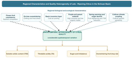
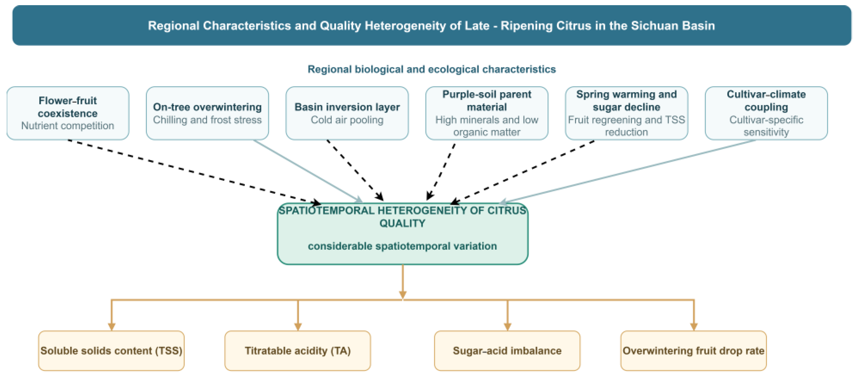
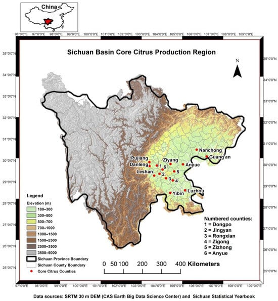
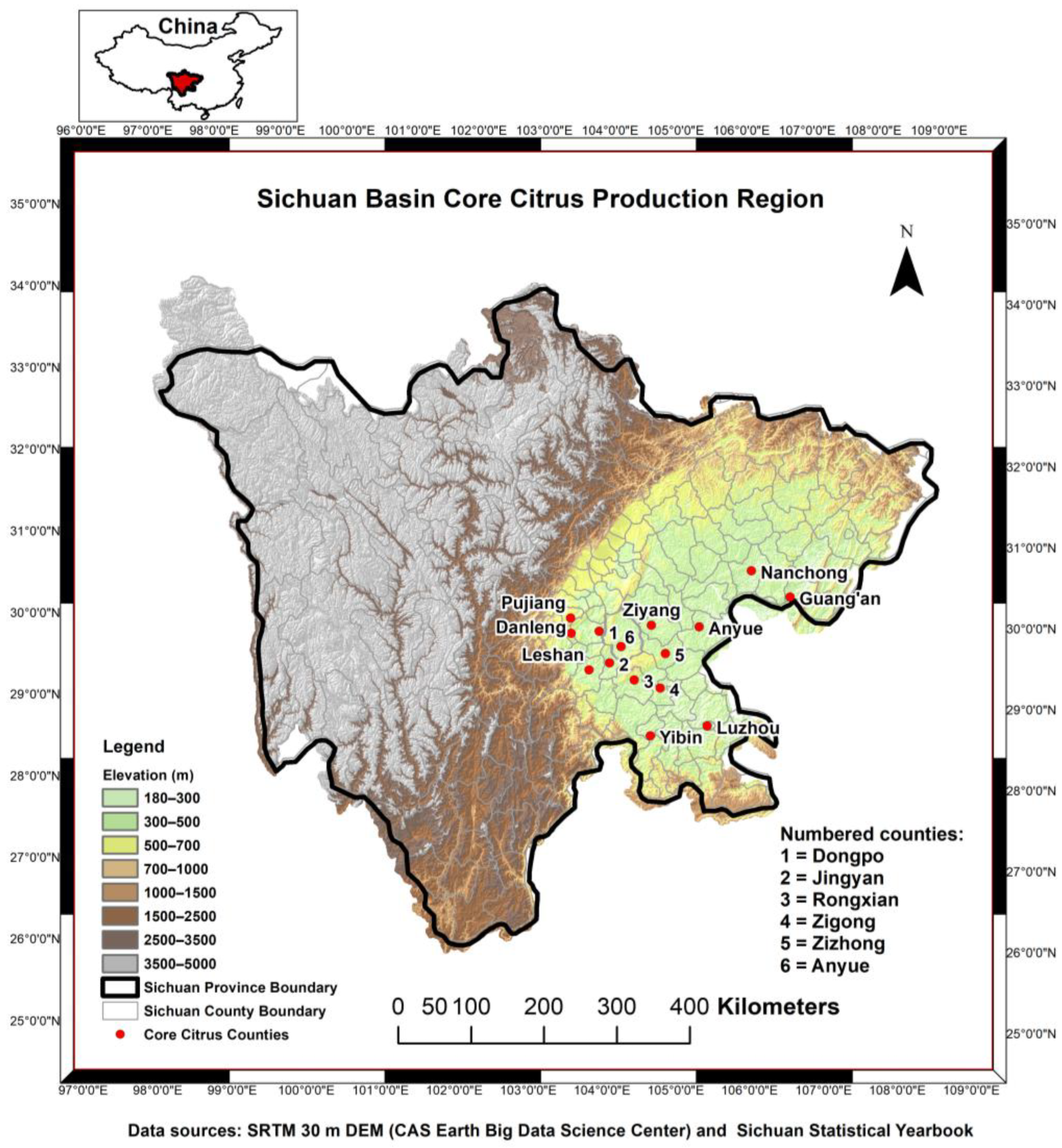
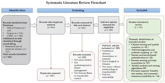
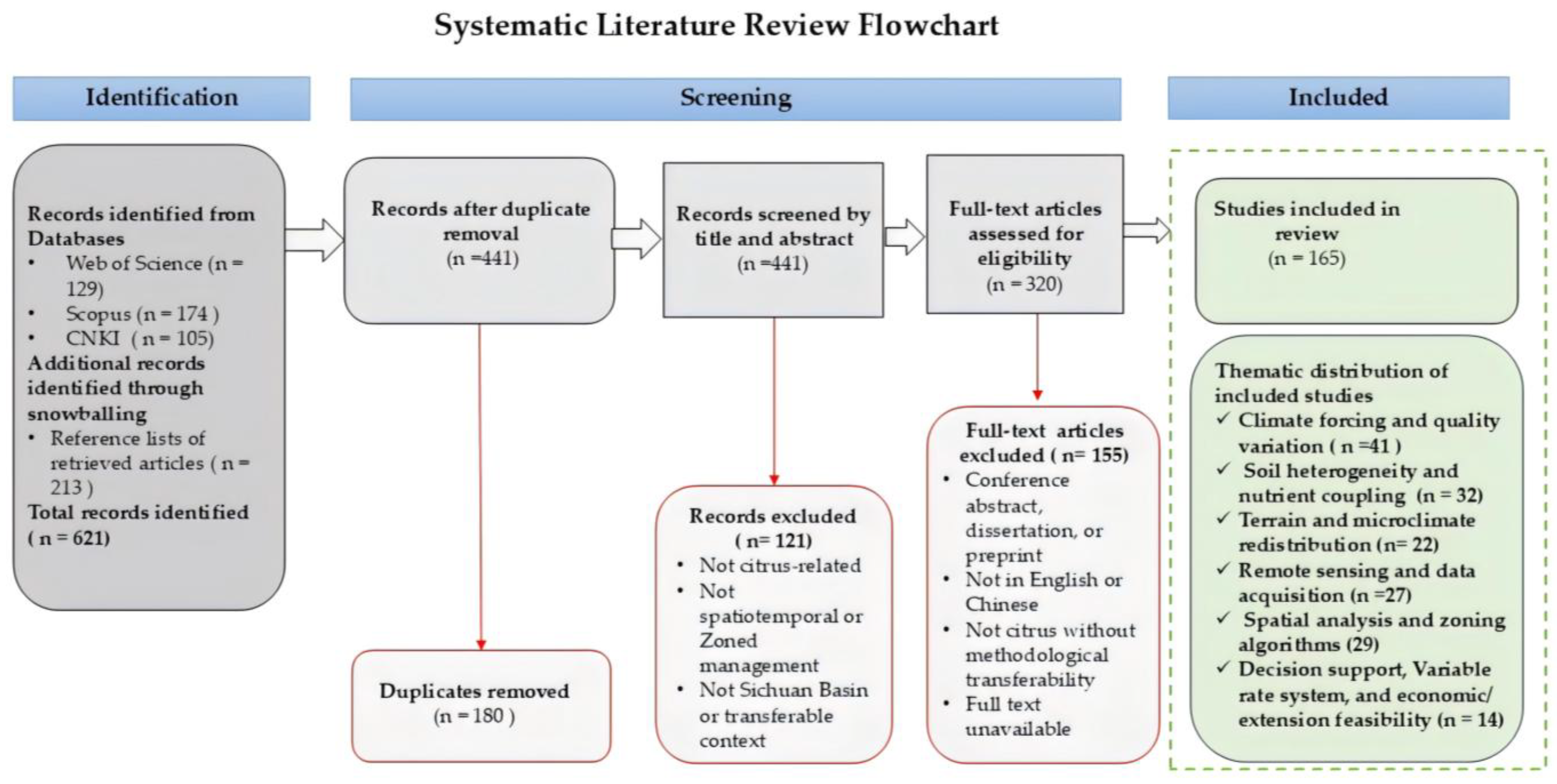
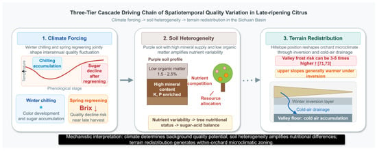
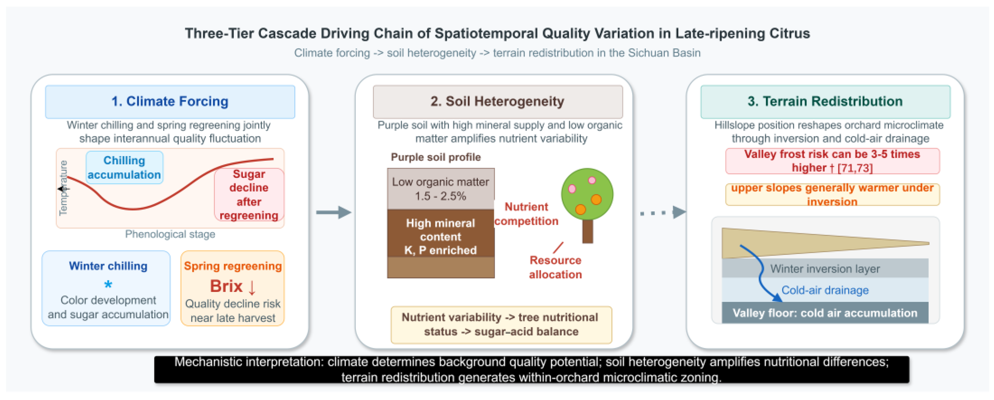

Disclaimer/Publisher’s Note: The statements, opinions and data contained in all publications are solely those of the individual author(s) and contributor(s) and not of MDPI and/or the editor(s). MDPI and/or the editor(s) disclaim responsibility for any injury to people or property resulting from any ideas, methods, instructions or products referred to in the content. |
© 2026 by the authors. Licensee MDPI, Basel, Switzerland. This article is an open access article distributed under the terms and conditions of the Creative Commons Attribution (CC BY) license.