

Remote Sens., Volume 8, Issue 11 (November 2016) – 91 articles
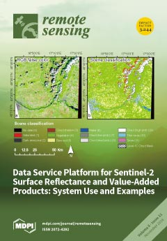
Cover Story (view full-size image):
The first operational Sentinel-2 data service platform for obtaining atmospherically-corrected images and generating value-added products, such as maps of leaf area index (LAI). Using the European Space Agency’s (ESA) Sen2Cor algorithm, the platform processes ESA’s Level-1C top-of-atmosphere reflectance to atmospherically-corrected bottom-of-atmosphere (BoA) reflectance (Level-2A). The processing runs on-demand on the Earth Observation Data Centre (EODC), which is a public–private collaborative IT infrastructure in Austria for archiving, processing, and distributing earth observation data. Users can submit processing requests and access the results via a user-friendly web page or use an application programming interface (API). View this paper
- Issues are regarded as officially published after their release is announced to the table of contents alert mailing list.
- You may sign up for e-mail alerts to receive table of contents of newly released issues.
- PDF is the official format for papers published in both, html and pdf forms. To view the papers in pdf format, click on the "PDF Full-text" link, and use the free Adobe Reader to open them.
Previous Issue
Next Issue