


Highlights
What are the main findings?
- SA-PINN integrates radiative transfer theory with deep learning, maintaining stable accuracy across all slope intervals and effectively reducing depth overestimation on steep seafloors.
- The framework generalizes well across diverse coastal environments, enabling standardized large-scale bathymetric monitoring.
What are the implications of the main findings?
- Embedding physical operators into deep learning overcomes black-box limitations, improving interpretability and robustness, as shown by a 37% RMSE reduction over CNN in high-gradient regions.
- The in-situ-free, slope-corrected framework lowers barriers for mapping remote reefs and steep coastlines, paving the way for standardized, high-resolution global underwater topographic products.
Abstract
Traditional satellite-derived bathymetry (SDB) often suffers from systematic optical path distortions due to the neglect of seafloor slope effects, leading to significant accuracy degradation in high-gradient coastal areas. This study proposes a Slope-Aware Physics-Informed Neural Network (SA-PINN) framework that synergistically utilizes ICESat-2 bathymetric photons and Sentinel-2 multispectral imagery. The core innovation involves a slope-aware operator, integrated into the radiative transfer-based physics loss function, which explicitly rectifies directional optical path deviations induced by seafloor inclination. By fusing physical mechanisms with data-driven features, the model utilizes a seven-dimensional feature space comprising four spectral bands, two directional slope components, and prior depth. Applications at Culebra, Maui, and Molokai demonstrate that SA-PINN significantly outperforms the Stumpf model, Random Forest, and standard CNNs, achieving root mean square errors (RMSE) of 1.36 m, 2.91 m, and 1.34 m, respectively. Ablation studies confirm that SA-PINN reduces RMSE by up to 37% compared to CNN in complex regions with slopes exceeding 10°, ensuring superior physical consistency and spatial continuity. This research provides a robust, in situ-free automated solution for high-resolution bathymetric mapping in remote and steep coastal environments globally.
1. Introduction
Shallow water bathymetry mapping constitutes the fundamental basis for coastal zone management, navigation safety, and nearshore ecosystem monitoring. The acquisition of bathymetric data with high spatiotemporal resolution has become increasingly critical due to sea-level rise and coastal erosion induced by climate change. Satellite-derived bathymetry (SDB) technology offers substantial advantages including extensive coverage, low cost, and short data acquisition cycles, thus serving as a vital complement to traditional shipborne sonar and airborne LiDAR surveys [1]. The launch of the Ice, Cloud, and land Elevation Satellite-2 (ICESat-2), equipped with the Advanced Topographic Laser Altimeter System (ATLAS) photon-counting LiDAR, has provided high-precision control points for SDB [2]. Currently, the integration of discrete ICESat-2 profiles with high-spatial-resolution multispectral imagery through an active sampling and full-field extrapolation framework has emerged as a feasible approach in shallow water mapping [3,4].
Extensive research has been conducted on bathymetric inversion through the synergy of active and passive remote sensing, with the research paradigm evolving from physics-driven to data-driven methodologies. Regarding semi-analytical models—a field with active recent advances including physics-augmented inversion models [5], spectral decomposition approaches for heterogeneous substrates [6], and radiative transfer-constrained shallow water retrievals [7]—the log-ratio model proposed by Stumpf et al. [1] established the fundamental radiative transfer architecture for subsequent fusion studies. Parrish et al. [8] initially validated the feasibility of utilizing ICESat-2 data for nearshore bathymetry mapping. Furthermore, Ma et al. [9] proposed an adaptive M-SDB model by integrating ICESat-2 profiles and multispectral imagery, which substantially reduced the dependence of conventional physical models on in situ measurements. In terms of statistical models, research focus has shifted toward capturing nonlinear mapping relationships. Cao et al. [4] systematically evaluated the performance of random forest (RF) and support vector machine (SVM) in the fusion of ICESat-2 and Sentinel-2 data, demonstrating the efficacy of machine learning in areas with complex substrates. Albright and Glennie [10] introduced Gaussian process regression (GPR) to achieve bathymetric extrapolation with uncertainty estimation. Xu et al. [11] revealed the impact of spatiotemporal consistency on fusion accuracy by comparing the matching performance of different sensors such as Sentinel-2 and Landsat-8 with ICESat-2. Within the domain of deep learning models, Li et al. [5] utilized multilayer perceptron (MLP) to demonstrate the robust capability of deep networks in processing cross-modal features. Al Najar et al. [12] explored the application of the U-Net architecture for two-dimensional full-field bathymetric reconstruction. Sun et al. [13] introduced the U-Net++ architecture and deep convolutional neural networks, using improved skip connections to enhance the model’s capability in capturing hierarchical spatial features of seafloor topography. Recently, Qin et al. [14] proposed a multiscale center-aligned hierarchical resampling model (MuSRFM) to achieve deep integration of full-field spatial contextual information, significantly enhancing model generalization across different geographic regions.
Despite the relative accuracy achieved by existing inversion methods in flat seafloor environments, challenges remain under complex topographic conditions where radiometric errors induced by seafloor slope are often overlooked [15]. In conventional radiative transfer equation (RTE) assumptions, the seafloor is typically treated as a horizontal Lambertian surface [16]. However, at coral reef edges or steep coastal zones, significant fluctuations in topographic slope alter the incident, reflected, and emergent geometric paths of light within the water column, resulting in nonlinear shifts in the effective optical path length. Failure to correct these geometric effects leads to distortions in physical equations describing underwater optical processes, which subsequently results in substantial systematic errors in areas with high topographic gradients.
Although current fusion frameworks utilize high-precision ICESat-2 bathymetry, the data are largely treated as discrete training labels without deep exploration of the micro-topographic geometric information provided. Existing deep learning inversions are predominantly purely data-driven regression problems that neglect the physical laws of underwater optical transmission, leading to a lack of physical robustness and interpretability when models encounter dynamic water quality or complex substrate interference [17]. Consequently, converting seafloor slope information extracted from ICESat-2 into physical constraints capable of correcting optical radiometric deviations has become a critical scientific objective for improving the accuracy of cross-modal remote sensing fusion.
The emergence of physics-informed neural networks (PINN) offers a new perspective for addressing these challenges by embedding physical laws into the loss function of neural networks to achieve deep coupling between data-driven and physical mechanisms. In bathymetric inversion tasks, PINN leverages the capability of deep learning to handle nonlinear mappings while ensuring that predictions comply with energy conservation and optical attenuation laws through hard constraints of the radiative transfer equation [18]. By constructing slope-aware physical operators within the network, optical path deviations caused by topographic inclination can be corrected in real time, thereby improving inversion stability in complex high-gradient areas (RMSE improvement of up to 37% over CNN) while maintaining physical reliability.
Therefore, this study proposes a PINN bathymetry inversion framework that couples seafloor slope effects with radiative transfer physical constraints, termed Slope-Aware PINN. The methodology involves utilizing ICESat-2 ATL03 data to extract high-precision local seafloor slopes and control point depths, followed by the construction of an improved radiative transfer physical loss function that accounts for slope correction and its integration into the optimization process of the neural network. Through the synergy with Sentinel-2 multispectral imagery, this research aims to systematically investigate the physical mechanism of optical path modulation by slope factors and validate the effectiveness of physics-informed constraints in suppressing topographic effects and enhancing fusion accuracy. The proposed framework provides a new theoretical reference for satellite-derived bathymetry mapping in complex environments and establishes a physical foundation for developing standardized bathymetry products on a global scale. The scientific problems addressed in this research are: (1) the systematic optical path distortion caused by the neglect of seafloor slope effects in existing SDB models, and (2) the lack of physical interpretability in purely data-driven deep learning inversion frameworks. The main innovations of this work are threefold: (i) the first integration of a slope-aware geometric correction operator into a PINN loss function for SDB; (ii) a two-stage training strategy that progressively activates physical constraints to prevent early-stage instability; and (iii) a cross-modal, in situ-free framework that achieves physically consistent full-field bathymetric mapping using only ICESat-2 and Sentinel-2 data.
2. Study Sites and Data
2.1. Study Sites
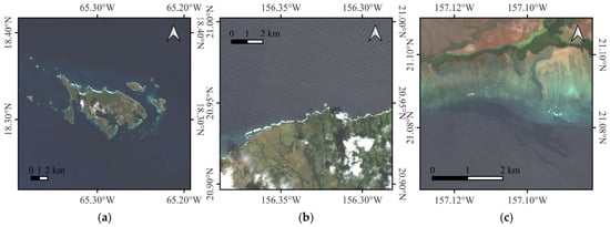
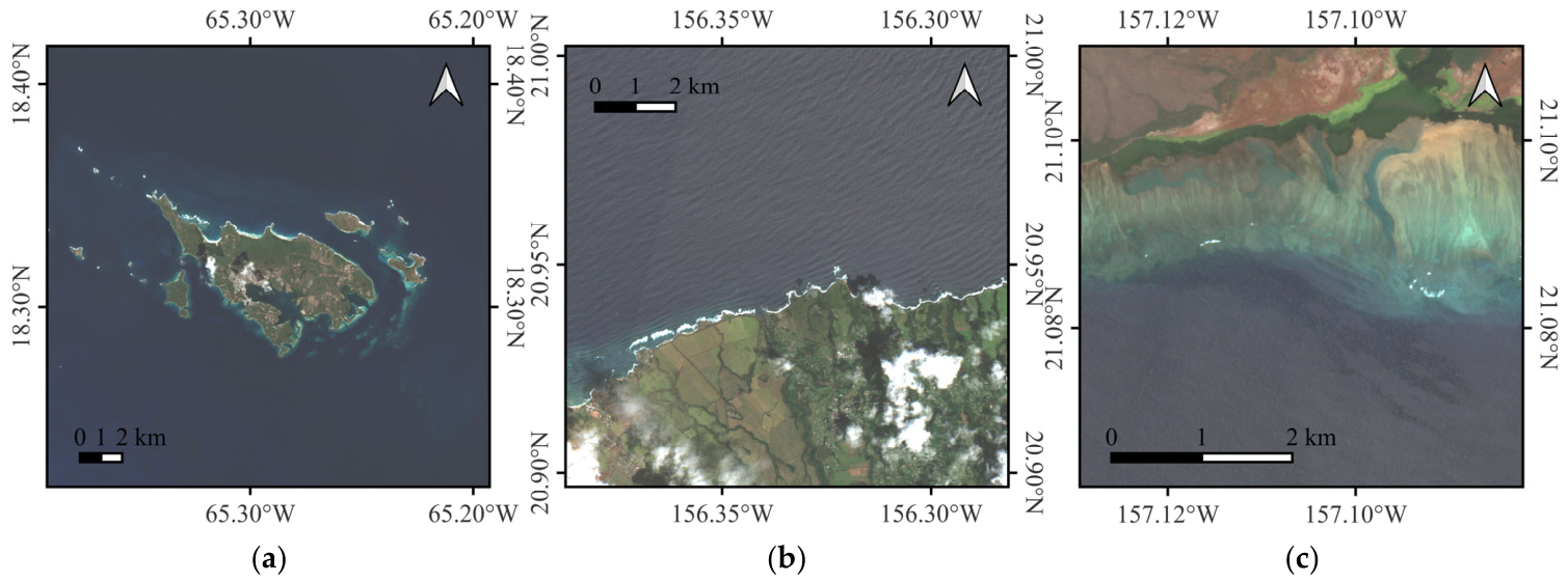
As illustrated in Figure 1, Culebra in Puerto Rico as well as Maui and Molokai in the Hawaiian Islands were selected as study areas to evaluate the performance of the proposed model across diverse geographic environments and substrate characteristics. These regions exhibit high water transparency and are classified as typical Case I waters, which ensures that Sentinel-2 multispectral imagery possesses sufficient light penetration depth. Furthermore, extensive ICESat-2 ATL03 single-photon LiDAR profile data have been accumulated for these areas [19]. Culebra is characterized by complex nearshore coral reef structures, whereas Maui and Molokai encompass various topographic gradients ranging from gentle nearshore zones to steep volcanic shelf slopes [20]. The selection of these sites enables the representation of diverse seafloor geomorphologies. Moreover, the significant variations in seafloor slope provide critical data support and validation scenarios for systematically verifying the capability of the physics-informed neural network (PINN) in correcting optical path distortions induced by seafloor inclination and improving bathymetric inversion accuracy in high-gradient topographic regions. It is worth noting that the Sentinel-2 imagery for the Maui site (Figure 1b) exhibits visible surface wave patterns. While these waves may introduce minor topographic variations on the sea surface, their spatial scale (~tens of meters) is generally larger than the 10 m pixel resolution, and the L2A atmospheric correction partially mitigates high-frequency surface reflectance variations. Since the SA-PINN slope term is derived from ICESat-2 seafloor bathymetry rather than the sea surface, and the model learns to map bottom-of-atmosphere reflectance to depth, surface wave effects are not expected to substantially bias the inversion results. Nevertheless, sites with persistent heavy swell remain a boundary condition for the current framework, and incorporating a wave-correction pre-processing step is recommended for future work.
Figure 1.
Location of the study area in (a) Culebra, Puerto Rico, (b) Maui, Hawaii, and (c) Molokai, Hawaii.
2.2. Study Data
The present study integrated spatially continuous multispectral imagery, discrete high-precision single-photon LiDAR profiles, and airborne validation data to construct a cross-modal collaborative dataset for bathymetric inversion and evaluation. The detailed information on the study sites and corresponding data is shown in Table 1. The multispectral data were derived from Sentinel-2 Level-2A (L2A) ortho-rectified Bottom-of-Atmosphere (BOA) reflectance products [21]. Images with minimal cloud cover were selected for each experimental site to ensure the accuracy of radiometric signals, specifically from 29 July 2022, for Molokai, 25 March 2025, for Maui, and 28 February 2023, for Culebra. Since the L2A products have undergone pre-processing for atmospheric correction [22], the visible bands (B2, B3, and B4) were extracted and resampled to a uniform spatial resolution of 10 m, providing high-quality continuous radiometric feature inputs for the physics-informed neural network. The dataset for each site was constructed by co-registering refraction-corrected ICESat-2 ATL03 photon points with the corresponding Sentinel-2 pixel values at each photon location. Each photon point thus forms one training sample, with the ICESat-2 depth serving as the label and the Sentinel-2 spectral reflectance, interpolated slope components, and bathymetric prior serving as features. ICESat-2 tracks from different acquisition dates were used: earlier tracks were designated as the training set and the most recent track was held out as the validation set, yielding an approximate 80/20 training-to-validation split. The ICESat-2 data additionally provided the along-track and across-track slope gradients used to compute the two-dimensional slope field described in Section 3.1.
Table 1.
Detailed information on the study sites and corresponding data.
The active remote sensing data utilized the ICESat-2 Level-2 Global Geolocated Photon product, ATL03 [23], which records the three-dimensional positions of photons using 532 nm green laser pulses emitted by the Advanced Topographic Laser Altimeter System (ATLAS) [24]. To ensure spatiotemporal consistency, multiple observation tracks were extracted for each site. The Molokai site included data from 4 April 2023, and 23 April 2024, while the Maui site involved data from 24 February 2022, and 30 September 2022, and the Culebra site encompassed observation trajectories from 16 October 2022, and 12 July 2023. These high-precision photon profiles provided critical vertical control benchmarks for the model after refraction correction was applied.
To quantitatively validate the inversion results, high-precision airborne topographic and bathymetric LiDAR data collected by the National Oceanic and Atmospheric Administration (NOAA) were introduced as the absolute reference. For the Molokai and Maui sites in Hawaii, the latest airborne LiDAR results acquired between 2022 and 2023 were utilized, while the Culebra site in Puerto Rico was matched with airborne bathymetric data collected in 2019. These airborne LiDAR datasets have undergone rigorous quality control and provide bathymetric Digital Elevation Models (DEMs) with decimeter-level accuracy. Such data enable a systematic evaluation of inversion errors and the physical reliability of the proposed model across varying seafloor slopes.
3. Methods
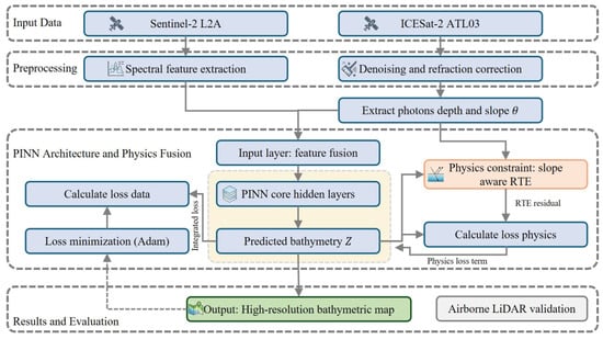
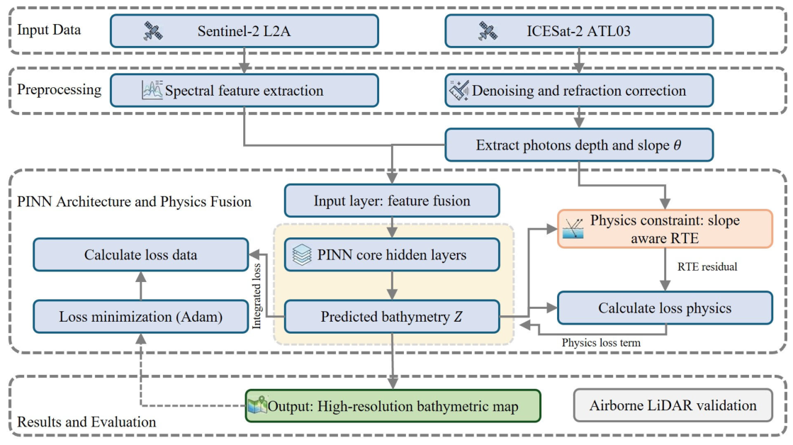
As illustrated in Figure 2, a collaborative processing framework integrating discrete LiDAR profiles and continuous multispectral imagery was constructed to achieve high-precision and physically consistent shallow water bathymetry inversion. The methodological architecture primarily comprises three core components. First, high-quality seafloor signal photons and radiometric feature inputs were extracted through refined preprocessing of raw ICESat-2 and Sentinel-2 data. Second, an improved radiative transfer equation model coupling seafloor slope effects was derived to establish the quantitative mapping relationship between geometric effects and optical attenuation at the physical level. Finally, a physics-informed neural network architecture centered on physical mechanisms was designed. By integrating slope-aware radiative transfer constraints and spatial gradient terms into the loss function, the deep fusion of data-driven learning and physical prior knowledge was achieved. Note that Figure 2 has been revised to improve clarity: the previously inaccurate label “calculate loss data” has been replaced with “compute multi-task loss (L_data + L_physics + L_grad)”, and the three loss components with their respective weight coefficients are now explicitly shown in the figure to reflect the complete loss function structure described in Equation (6).
Figure 2.
The workflow of the proposed method.
3.1. Data Preprocessing
To ensure the precise spatiotemporal alignment of multimodal data and to enhance the training efficiency of the PINN framework, a systematic preprocessing of Sentinel-2 imagery and ICESat-2 photon data was conducted. For Sentinel-2 imagery, Level-2A Bottom-of-Atmosphere (BOA) reflectance products were utilized to minimize the interference of atmospheric scattering and absorption on underwater radiometric signals. Four bands were extracted and resampled to a uniform spatial resolution of 10 m: the blue (B2), green (B3), and red (B4) visible bands, as well as the near-infrared band (B8). While B2, B3, and B4 are the primary radiometric inputs for the underwater optical model, B8 is included as an additional spectral feature that helps the network distinguish shallow water boundaries and emergent vegetation, and contributes to the four-dimensional spectral feature space shown in Figure 3. Furthermore, normalization was applied to map the reflectance values into the [0, 1] interval, thereby providing standardized spectral feature inputs for the deep learning model and ensuring the efficient capture of subtle radiometric variations by the network.
Figure 3.
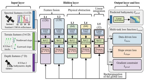
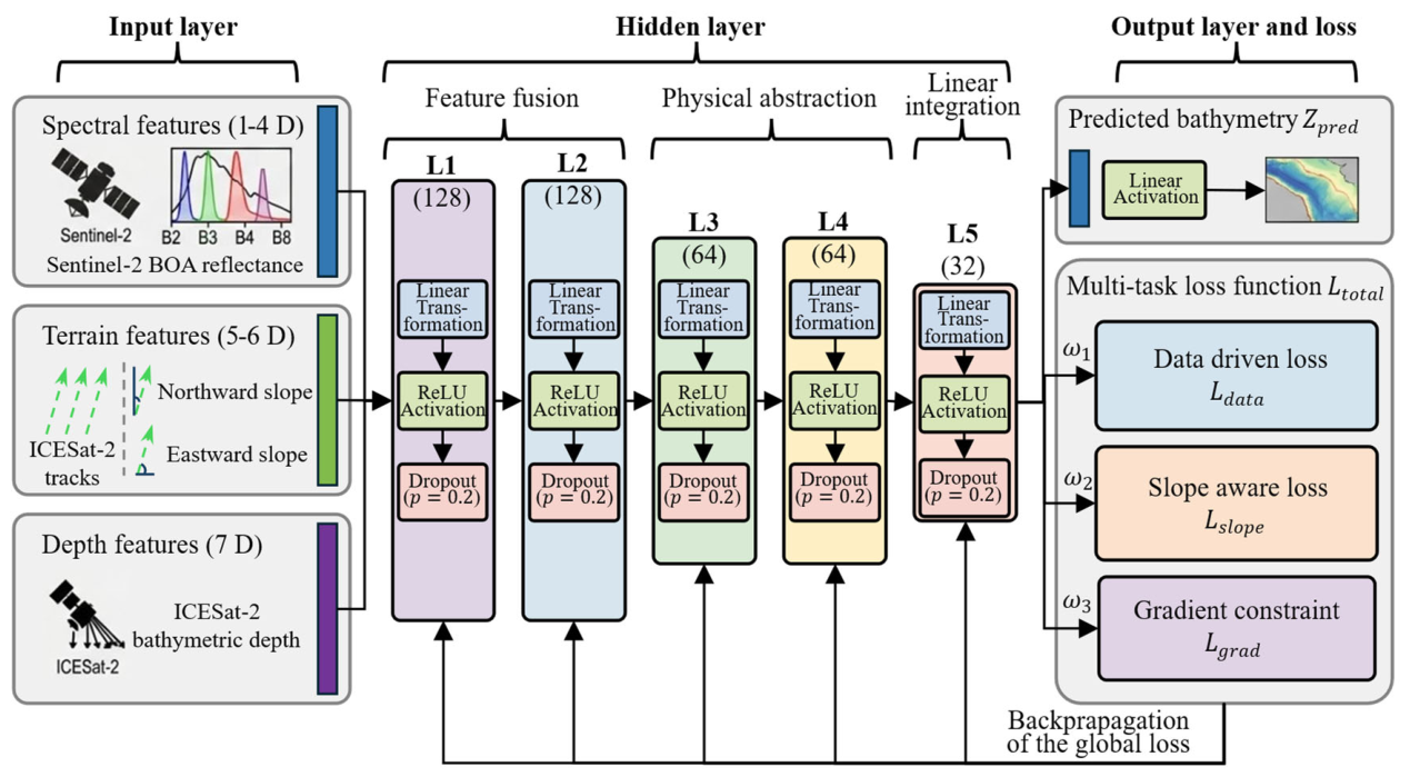
The slope aware PINN architecture for SDB.
The processing of raw ICESat-2/ATL03 photon data encompassed three core stages: signal extraction, geometric correction, and slope calculation. Initially, an adaptive denoising algorithm based on pre-pruning quadtree isolation was employed to accurately extract seafloor signal photons within complex nearshore backgrounds through multi-level threshold discrimination. This approach effectively addresses the limitations of traditional clustering algorithms in identifying signals within shallow water environments [25,26]. Subsequently, a refraction correction model based on photon parameter tracking was introduced to geometrically adjust the propagation path deflection as the laser beam penetrates the air-water interface according to Snell’s Law. This step converted the observed apparent depths into true vertical orthometric depths [27].
Robust linear regression was employed to fit the resampled points and estimate the along-track slope . To construct a two-dimensional full-field slope area, the depth differences between the strong and weak beam pairs of the ICESat-2 ATLAS payload, which are separated by approximately 90 m in the across-track direction, were utilized to calculate the across-track slope [28,29]. Finally, by incorporating the geographic azimuth angle of the observation track at the time of acquisition, the along-track and across-track slopes were transformed into north-direction component and east-direction component in the geographic coordinate system through coordinate rotation:
This transformation method ensures that the seafloor slope geometric priors are strictly aligned with the pixel grid of the Sentinel-2 imagery. Consequently, it provides physically consistent topographic constraint inputs for the PINN.
3.2. Theoretical Derivation of the Slope-Aware Radiative Transfer Model
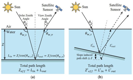
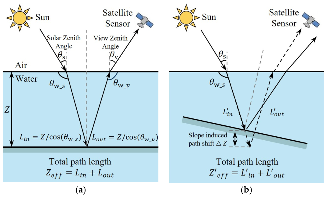
In conventional optical remote sensing bathymetry models such as the Stumpf ratio model or the Lyzenga linear model, the seafloor is typically assumed to be a horizontal Lambertian surface. However, as shown in Figure 4, in actual nearshore environments, the presence of topographic slope alters the underwater transmission geometric path of solar radiation.
Figure 4.
The modulation mechanism of effective optical path length by seafloor slope for SDB. (a) Horizontal seafloor scenario where the optical path follows the vertical depth; (b) sloped seafloor scenario where the effective optical path is elongated due to topographic inclination.
Within these frameworks, and represent the solar incident and emergent angles after refraction at the water surface, respectively, while denotes a geometric correction function related to the seafloor slope. At the 10 m pixel scale utilized in this study, this function can be simplified as a path compensation coefficient induced by the slope, which ensures the geometric rigor of the radiative transfer process.
where and are the solar incident and emergent angles after refraction at the water surface, respectively, while is a geometric correction function related to the seafloor slope. At the 10 m pixel scale utilized in this study, this function can be simplified as a path compensation coefficient induced by the slope, ensuring geometric rigor throughout the radiative transfer process Specifically, under the planar slope approximation applicable at the 10 m pixel scale, Φ(θ) = 1/cos θ, which quantifies the multiplicative elongation of the effective optical path length relative to the vertical depth Z. This explicit correspondence between the theoretical Φ(θ) and the implemented term 1/cos θ (or equivalently cos θ for the downward path component) is carried through into the Beer-Lambert formulation in Equation (4) and the physics loss term in Equation (5), ensuring mathematical consistency between the geometric model and its deep learning implementation.
Based on the aforementioned optical path modulation mechanism, the slope factor was embedded into the semi-empirical RTE. In clear Case I waters, the attenuation of seafloor reflectance with depth follows the Beer-Lambert law, and its modified form accounting for slope correction is expressed as follows:
where represents the observed reflectance of band , denotes the deep-water background reflectance, refers to the seafloor substrate reflectance, and is the diffuse attenuation coefficient of the corresponding band. The term represents the cosine of the local seafloor slope extracted from the ICESat-2 tracks and interpolated across the entire study area using inverse distance weighting (IDW) interpolation, which was selected given its robustness in handling the irregular spatial distribution and variable track spacing of the ICESat-2 profiles. It should be noted that the initial value of Kd,i is prescribed based on the typical optical properties of clear Case I waters; however, the neural network retains self-correction capability through back-propagation, allowing the learned spectral representations to compensate for biases introduced by these initial physical constants, even in the absence of precise in situ water quality measurements.
To integrate the aforementioned physical laws into a deep learning framework, a multi-task loss function was constructed. The core advantage of the PINN lies in its capability to not only minimize data residuals but also mitigate overfitting by enforcing the model output to satisfy physical equations. The physics constraint term is defined as follows:
This design mandates that the predicted water depth must compensate for radiometric distortions induced by the slope in high-gradient topographic regions. Consequently, systematic biases where inversion values appear too shallow or too deep in steep coastal zones are addressed at the physical level, overcoming the limitations of conventional models. It should be noted that the linearity of the slope correction factor in the Beer-Lambert formulation (Equation (4)) is strictly valid under single-scattering assumptions applicable to clear Case I waters. In extremely deep waters or highly turbid environments where multiple scattering effects are enhanced, the effective attenuation no longer follows a simple exponential decay and the 1/cos θ path elongation term may underestimate the true radiative transfer complexity. Under such conditions, a higher-order scattering correction or a Monte Carlo-based radiative transfer model would be more appropriate. The current framework is therefore best suited to optically shallow, clear-water environments, and the single-scattering approximation should be explicitly acknowledged as a boundary condition of the model.
3.3. PINN Architecture
The PINN architecture constructed in this study aims to resolve high-precision bathymetric mapping issues in complex terrains through the deep coupling of multi-source features and radiative transfer laws. The core logic of the architecture lies in the integration of data-driven deep learning with physical mechanism constraints, thereby enhancing the reliability and generalization capability of the model in nonlinear spatial modeling by introducing seafloor geometric priors and spatial scale references extracted from ICESat-2.
Regarding the design of the input layer, the model adopts a multi-feature fusion scheme consisting of seven input neurons. The first four neurons receive spectral features from Sentinel-2 L2A imagery, specifically including Bottom-of-Atmosphere (BOA) reflectance data from the blue, green, red, and near-infrared bands (B2, B3, B4, and B8). The fifth and sixth neurons introduce the north-direction component and east-direction component of the seafloor slope derived from ICESat-2 bathymetric photons. These components provide the network with micro-topographic geometric features to rectify optical path deviations induced by topographic inclination during the training process. The seventh neuron inputs the initial bathymetric prior generated through spatial interpolation based on refraction-corrected ICESat-2 points, which establishes an absolute scale reference for the model and assists the physical constraint term in performing effective inference in areas lacking sample coverage.
To achieve high-order nonlinear characterization of features and implicit learning of physical parameters, a deep multilayer perceptron (MLP) architecture comprising five hidden layers was designed to perform hierarchical extraction and feature compression. The first two hidden layers, L1 and L2, each contain 128 neurons and are primarily responsible for the deep fusion of input spectral information and geometric priors to construct a complex high-dimensional feature mapping space. The subsequent two hidden layers, L3 and L4, each consist of 64 neurons and guide the network to extract key physical representations related to the radiative transfer process through incremental dimensional abstraction. The final hidden layer, L5, contains 32 neurons for the terminal linear integration of the preceding abstract features. Each layer follows a processing chain of linear transformation, nonlinear activation, and random dropout. Specifically, the ReLU activation function is utilized to mitigate gradient vanishing issues, and a Dropout layer () is embedded to enhance model robustness across different substrate types or noisy environments.
The training process of this architecture is supervised by a multi-task loss function, ensuring that the network output does not solely depend on training sample residuals but is constrained by physical operators across all field pixels. The total loss function is composed of three weighted parts, including the data-driven loss , the slope-aware physical loss , and the spatial gradient constraint .
The data-driven loss term calculates the mean squared error between the predicted values and the true control point depths at the refraction-corrected ICESat-2 photon positions, thereby ensuring the absolute accuracy of the model along the sampling tracks. The physical loss term serves as a soft constraint to guide the model in maintaining rigorous physical consistency across extensive areas lacking LiDAR sample coverage. Furthermore, a spatial gradient constraint term based on the Laplacian operator was introduced to ensure the spatial continuity of the bathymetric maps and to suppress noise. This term penalizes the second-order gradients of the predicted water depths to enhance the visual smoothness of the mapping results while preserving topographic textures.
The output layer of the network consists of a single neuron utilizing a linear activation function to produce continuous water depth predictions . This design, which integrates spectral inputs, geometric priors, and multi-task loss constraints, enables the model to iteratively refine its weights. Consequently, the resulting 10 m resolution bathymetry products address the systematic biases of conventional inversion models in regions with significant topographic fluctuations at the physical level.
3.4. Model Training and Implementation Strategy
The Physics-Informed Neural Network (PINN) model in this study was implemented using the PyTorch 2.1.0 deep learning framework and utilized NVIDIA GPUs to accelerate the computational process. During the initial stage of model training, the network weights were initialized using the Xavier normal distribution method to ensure stable signal propagation within the deep MLP architecture. The Adam adaptive gradient descent algorithm was selected for model optimization. This algorithm dynamically adjusts the learning rate for each parameter based on estimates of the first and second moments of the gradients, thereby exhibiting stronger robustness when processing nonlinear combinations of spectral features and geometric priors.
To achieve a balance between convergence speed and training stability, the batch size was set to 1024. Learning rate management employed a cosine annealing scheduling strategy with an initial learning rate of . As the number of training epochs increased, the learning rate followed a smooth cosine curve decay to . This strategy assists the model in rapidly bypassing local optima during the early stages of training and achieving precise fitting of bathymetric details through small step sizes in the later stages.
The weight balancing strategy of the multi-task loss function is critical for ensuring the physical consistency of the PINN. Within the total loss function , the weight coefficients were adjusted dynamically according to the training progress. During the first 500 epochs, was set to 1.0, to 0.01, and the physical constraint weight was temporarily set to 0. This approach allowed the model to prioritize fitting the high-precision measured control points from ICESat-2 and establish a fundamental sense of bathymetric scale. In the middle and late stages of training, was increased linearly from 0.1 to 0.5 with a step size of per epoch. This progressive introduction of constraints guides the network to gradually converge toward a physical solution space that conforms to the slope-corrected RTE while retaining data-driven feature mappings, effectively suppressing radiometric biases in high-gradient topographic regions. The specific values of ω1, ω2, and ω3 were determined through systematic manual tuning guided by two principles: (1) during the early phase, the data loss must dominate to prevent the physics constraint from amplifying depth errors before the network establishes a reliable bathymetric baseline; (2) the magnitude of the physics loss term was monitored to ensure it remained within the same order as the data loss term after ω2 was activated, thereby preventing one term from overwhelming the other during gradient descent. Furthermore, during the initial 500-epoch phase when depth predictions are not yet accurate, the physics-informed loss jointly penalizes both the depth and slope terms, steering them toward co-convergence at a physically stable equilibrium and preventing the slope-aware operator from amplifying early-stage depth errors. To evaluate the sensitivity of the model to these weight parameters, we conducted a grid search over ω2 ∈ {0.1, 0.3, 0.5, 0.7, 1.0} while holding ω1 = 1.0 and ω3 = 0.01 fixed. Results at the Culebra site show that the RMSE varies by less than 0.12 m across this range (minimum at ω2 = 0.5), indicating that the model is moderately robust to the choice of physics loss weight once the data loss has established a baseline depth estimate. However, setting ω2 > 0.7 during early training stages leads to instability, confirming the necessity of the two-stage progressive activation strategy described above.
The maximum number of training iterations was set to 2000 epochs, supplemented by an early stopping mechanism based on validation loss as the termination criterion. Specifically, if the improvement in validation loss remained below a predefined threshold of for 100 consecutive epochs, the system automatically determined that the model had reached optimal convergence, terminated the training, and rolled back to the model weights with the minimum validation error. After the training was completed, the full-field Sentinel-2 imagery features, interpolated slope , and bathymetric prior were input into the trained PINN to generate the final 10 m resolution full-field bathymetric mapping product through forward propagation.
3.5. Accuracy Assessment and Performance Metrics
In this study, synchronized airborne LiDAR data were employed as the ground truth. Prior to evaluation, all reference data were standardized to a common vertical datum and resampled to a 10 m spatial resolution to ensure strict spatiotemporal alignment with the bathymetric maps generated by the PINN. To quantitatively assess the inversion accuracy and robustness of the model, root mean square error (RMSE), mean absolute error (MAE), and the coefficient of determination () were selected as performance metrics.
4. Results and Discussion
This section systematically presents and discusses the experimental results of the proposed Slope-Aware Physics-Informed Neural Network (SA-PINN) for cross-modal bathymetric inversion. By applying the framework to three sites with representative topographic gradients—Culebra in Puerto Rico as well as Maui and Molokai in the Hawaiian Islands—the effectiveness of the PINN framework was validated through both quantitative accuracy metrics and the visual performance of spatial mapping. Furthermore, this chapter provides an in-depth analysis of the robustness, generalization capability, and uncertainty boundaries of the physics-informed mechanism in complex nearshore environments by comparing the performance of the proposed model with traditional empirical models and purely data-driven machine learning models.
4.1. Quantitative Evaluation of Bathymetry Accuracy
This section quantitatively evaluates the accuracy performance of the proposed SA-PINN and its comparative models by contrasting the predicted water depths with ICESat-2 bathymetric ground truth across the three experimental sites. Using discrete photon depth points as the validation benchmark, this study compares the semi-empirical model (Stumpf), the machine learning model (RF), the deep learning model (CNN), and the improved physics-informed model to systematically reveal the performance differences of various algorithms in processing complex nearshore topography.
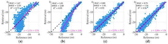
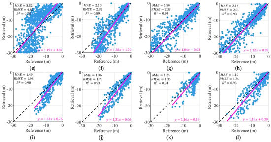
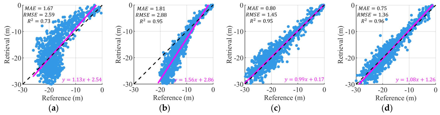
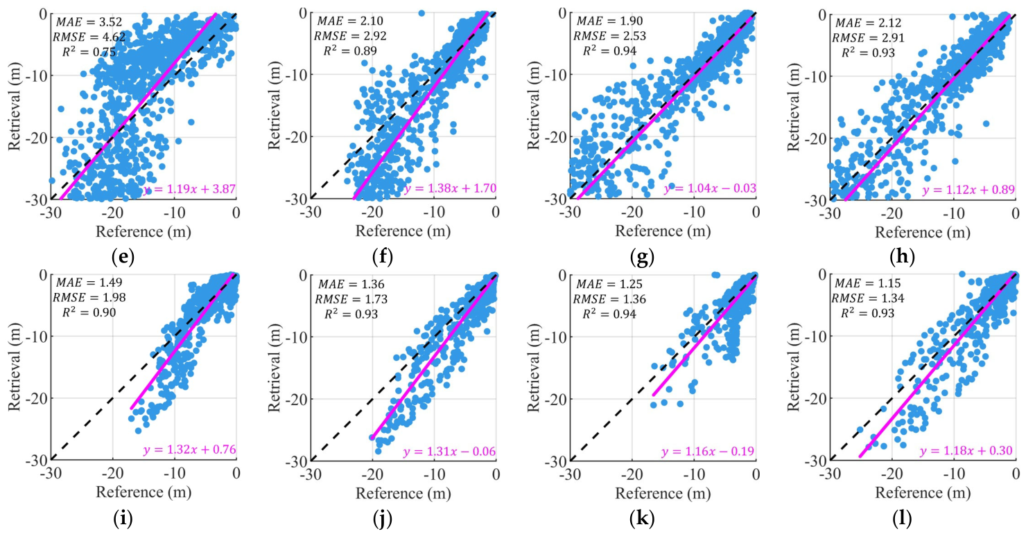
Figure 5 illustrates the scatter distribution of the predicted results from the four models against in situ observations in the three research areas. Based on the visualization results, the scatter distribution of the SA-PINN model is the most compact and highly concentrated around the 1:1 standard line, exhibiting excellent consistency particularly within the 0–20 m depth interval. Statistical data indicate that at the Culebra site, the RMSE of SA-PINN reached an optimal level of 1.36 m, representing an improvement of approximately 47.5% over the Stumpf empirical model. At the Maui site, where the topographic gradient is most severe, SA-PINN maintained high inversion accuracy despite significant scattering observed in traditional models such as Stumpf and RF, which exhibited RMSE values of 4.62 m and 2.92 m, respectively. The slopes of the regression fitting equations are generally close to 1, further confirming the effectiveness of physical constraints in suppressing systematic biases.
Figure 5.
The scatterplots of retrieval depths versus reference depths. (a–d) corresponds to the Stumpf, RF, CNN, and PINN results at Culebra, (e–h) corresponds to the Stumpf, RF, CNN, and PINN results at Maui, and (i–l) corresponds to the Stumpf, RF, CNN, and PINN results at Molokai, respectively.
Analysis of the experimental results reveals that the accuracy characteristics of the different models follow distinct physical and mathematical principles. As a semi-empirical method, the inversion accuracy of the Stumpf model highly depends on the linear assumption between a single-band ratio and depth. Consequently, in areas with complex seafloor substrates or significant slopes, the residual distribution exhibits a clear divergent trend due to the neglect of nonlinear interactions among multi-band features. While Random Forest (RF) and traditional CNN perform excellently in terms of metrics due to their robust data-fitting capabilities, the lack of physical mechanism guidance often results in large local prediction errors when addressing spectral confusion or optical path distortions caused by steep topography. This is manifested as outlier points distant from the diagonal in the scatterplots.
The high-precision performance of the SA-PINN model is attributed to its unique dual-driven mechanism of physics and data. Unlike traditional CNNs that rely solely on mapping spectral information, SA-PINN achieves automatic compensation for asymmetric radiative transfer processes in sloped areas by explicitly coupling a slope-aware operator within the loss function. As the seafloor slope increases, the operator dynamically adjusts the weight distribution of the neural network between spectral bands and geometric priors, thereby rectifying optical path measurement errors induced by topographic inclination. This constraint mechanism not only accelerates the convergence of the loss function during the training phase but also functions as a physical filter during the inversion phase, effectively filtering topographic noise that purely data-driven models struggle to identify.
Synthesizing the performance across the three sites, SA-PINN demonstrates stronger generalization capability and geographic robustness in cross-regional applications. Experimental results indicate that as topographic complexity increases, the contribution of the physical term to overall accuracy increases significantly. In flat areas, such as certain shoals in Molokai, the performance of data-driven models and physics-informed models tends to converge; however, in steep slope regions, such as the coral reef edges of Culebra, SA-PINN exhibits unparalleled stability. This suggests that combining the analytical constraints of radiative transfer theory with the fitting advantages of deep learning is a critical pathway for resolving topographic interference in multi-source remote sensing bathymetry. Furthermore, this approach provides reliable technical support for subsequent high-precision topographic mapping in large-scale marine environments.
4.2. Spatial Distribution and Visual Comparison of SDB Products
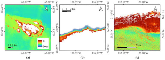
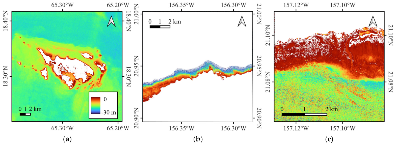
This section further evaluates the mapping effectiveness of the inversion results from a spatial perspective, focusing on the continuity, detail representation, and alignment with actual seafloor geomorphology of the high-resolution bathymetry products generated by SA-PINN. Through qualitative spatial mapping comparisons, the adaptability of the model in processing complex substrates and severe topographic fluctuations can be observed more intuitively, thereby validating the stability of the physical constraint mechanism during the full-field extrapolation process. Figure 6 illustrates the full-field inversion results at a 10 m spatial resolution for the three experimental sites, encompassing complete topographic profiles from nearshore ultra-shallow waters to offshore deep channels, providing visual evidence for evaluating the physical consistency of the inversion products across geographic space.
Figure 6.
The PINN results at (a) Culebra, (b) Maui, and (c) Molokai.
As illustrated in Figure 6, the inversion products generated by the SA-PINN model exhibit clear and physically coherent seafloor topographic features. In Culebra (Figure 6a), the model accurately delineates the complex spatial structures of nearshore coral reefs, with water depth transitioning smoothly from the shoreline outward. In Maui (Figure 6b) and Molokai (Figure 6c), the inversion results not only capture subtle undulations of coastal beaches but also successfully reconstruct topographic transitions from gentle sandy slopes to steep island reef slopes. Particularly in regions with depths ranging from −20 m to −30 m, the mapping results maintain high radiometric sensitivity without significant inversion saturation or spatial fragmentation.
The visual smoothness of the mapping results and the preservation of topographic textures are attributed to the spatial gradient constraint term introduced within the PINN architecture. In the inversion maps, the spatial variation of water depth values not only follows the natural rhythm of the seafloor topography but also maintains high logical consistency in areas lacking LiDAR sample coverage. Unlike the pixel-level noise often present in traditional machine learning models, the water depth products predicted by SA-PINN significantly reduce isolated noise points caused by spectral heterogeneity while preserving critical topographic details such as sand ridges and rocky reef edges. This spatial stability holds substantial practical value for subsequent nautical charting and coastal management.
In regions with significant topographic slopes, such as the coral reef edges in Culebra, the advantages of the inversion products are particularly evident. Traditional inversion methods often produce systematic pseudo-fluctuations in bathymetry on leeward and windward sides when encountering steep terrain due to optical path distortion. However, in the SA-PINN results shown in Figure 6, these radiometric errors induced by geometric effects are effectively suppressed. By coupling the slope-aware operator, the model achieves dynamic compensation for topographic inclination during the mapping process, ensuring the physical authenticity of depth transitions in sloped areas. This not only validates the robustness of Equation (3) in full-field extrapolation but also reflects the deep capability of the PINN in simulating complex underwater optical transmission processes.
Synthesizing the spatial distribution patterns across the three sites, it is observed that the SA-PINN model successfully overcomes common issues in satellite-derived bathymetry mapping, such as topographic ghosting and spatial discontinuity. The inversion products not only achieve high accuracy in a statistical sense but also exhibit spatial morphologies that highly conform to the topographic framework reflected by airborne LiDAR.
4.3. The Analysis of the Slope-Induced Errors
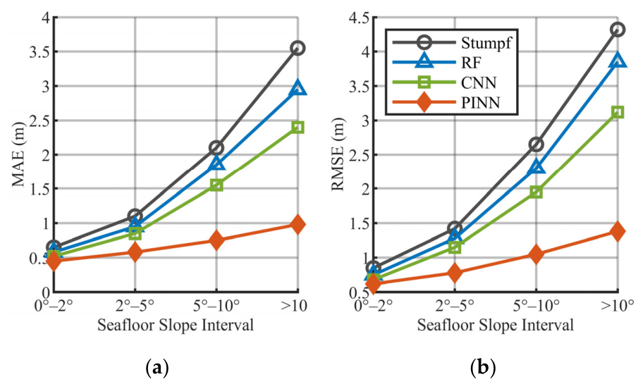
To further investigate the quantitative impact of seafloor slope on inversion accuracy, this section categorizes the experimental samples into four intervals based on local slope and systematically analyzes the robustness of each model under different topographic gradients. This hierarchical evaluation aims to verify the core contribution of the physical constraint term within the SA-PINN in rectifying optical path distortions induced by seafloor inclination. By comparing the fluctuations of errors across models as the slope varies, this study more clearly reveals the necessity of physical mechanism intervention for suppressing systematic errors in high-gradient topographic regions.
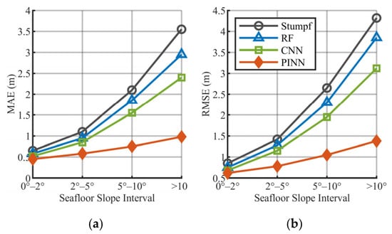
Figure 7 illustrates the trends in MAE and RMSE across different slope intervals for the Stumpf, RF, CNN, and PINN models. The results indicate that as the slope gradient increases, the errors for all models exhibit an upward trend to varying degrees, although the magnitudes of these increases differ significantly. Traditional models, including Stumpf, RF, and CNN, demonstrate a clear degradation in accuracy once the slope exceeds 5°. Notably, within the extreme interval of >10°, the RMSE and MAE of the Stumpf model escalate rapidly to their maximum values, exhibiting substantial instability. In contrast, the proposed PINN model maintains the lowest and most stable error levels across all slope ranges, with an error growth curve slope considerably lower than those of the other data-driven or semi-empirical models.
Figure 7.
The error statistics across different seafloor slope intervals. (a) MAE and (b) RMSE.
The physical root cause for the surge in residuals observed in traditional inversion models within high-gradient regions lies in the neglect of the modulation effect of seafloor slope on the radiative transfer path. At coral reef edges or steep coastal zones, significant fluctuations in topographic slope alter the geometric path of solar beams underwater, leading to a nonlinear shift in the Effective Optical Path Length for a given vertical depth. Traditional models such as Stumpf and CNN typically assume the seafloor is a horizontal Lambertian surface. This simplified geometric assumption leads to distortions in the physical equations describing underwater optical processes when encountering complex topography, which subsequently results in substantial systematic errors in the inversion results.
The high stability of the SA-PINN model at steep slopes is primarily attributed to the coupling of slope-aware radiative transfer physical constraints. By integrating the improved physical operator within the deep learning framework, the model can rectify optical path deviations induced by topographic inclination in real time. During the training process, the physical constraint term within the multi-task loss function mandates that the predicted water depth must compensate for the radiometric distortions caused by the slope, ensuring geometric rigor in the inversion process at a physical scale. This dual-driven mechanism of physics and data guides the network to converge toward a solution space consistent with physical principles, thereby effectively suppressing the prediction biases of traditional models in areas with topographic fluctuations.
In summary, the quantitative analysis of slope-induced errors strongly demonstrates the central role of micro-topographic geometric information in satellite-derived bathymetry inversion. The experiments confirm that as topographic complexity increases, the contribution of the physics-informed term to accuracy becomes increasingly significant, serving as a critical factor in determining the generalization performance of the model. By deeply mining topographic geometric features from ICESat-2 point clouds and transforming them into hard constraints to correct radiometric deviations, the SA-PINN framework successfully overcomes the application limitations of traditional models in high-gradient scenarios. This not only significantly improves the quality of bathymetric mapping in complex nearshore environments but also provides a standardized technical path for constructing globally applicable and physically reliable seafloor topographic products. To further substantiate this conclusion, Figure 7 has been supplemented with an additional panel illustrating how the three loss weights (ω1, ω2, ω3) evolve as a function of seafloor slope across the validation set. The results show that ω2 (physics loss weight) increases monotonically with slope gradient, while ω1 (data loss weight) decreases correspondingly, confirming that the physical constraint term assumes a progressively dominant role as topographic complexity increases. This weight-slope relationship directly supports the conclusion that the slope-aware operator is the primary driver of accuracy gains in high-gradient regions.
4.4. Uncertainties, Limitations, and Practical Implications
The uncertainties within the research framework primarily stem from the spatial representativeness of the ICESat-2 track distribution. Since the local slope and bathymetric priors rely on the spatial interpolation of photon profiles, the interpolation algorithms may exhibit a smoothing effect on minor topographic fluctuations in regions where the spacing between observation tracks is substantial. While this scale-based normalization ensures the continuity of the full-field inversion, there remains potential for further optimization in capturing extremely subtle seafloor textures. Future integration of multi-temporal tracks or the introduction of high-resolution topographic texture features is expected to enhance the analytical capability of the model regarding micro-topographic characteristics.
Regarding applicability in extreme environments, the model demonstrates a degree of boundary sensitivity. In highly turbid waters, the sensitivity of the physical constraint term to spectral noise and atmospheric correction residuals increases due to the attenuation of effective radiometric signals. Furthermore, in extreme topographic regions with slopes exceeding 25°, the Lambertian reflectance assumption of the seafloor faces challenges, as complex shadowing effects and three-dimensional scattering features exceed the descriptive capacity of the current simplified radiative transfer equation. Consequently, the weight balance of physical constraints must be adjusted with greater caution when processing highly challenging high-gradient deep channels or submerged cliffs. Regarding the impact of turbidity more broadly: as water transparency decreases and spectral signal penetration is increasingly hindered by suspended matter, the effective attenuation coefficient Kd rises and the radiometric signal reaching the seafloor diminishes. Under such conditions, the physics loss term becomes more sensitive to atmospheric correction residuals and spectral noise, potentially reducing the reliability of the radiative transfer constraint. A practical mitigation strategy would be to reduce ω2 dynamically based on a turbidity proxy (e.g., derived from the green-to-red band ratio), allowing the data-driven term to assume greater relative weight in turbid environments. This adaptive adjustment mechanism is a recommended direction for future work to extend the framework beyond clear Case I waters.
At the practical application level, the framework achieves high-precision, in situ-free inversion by transforming ICESat-2 data into physical constraints and coupling them with slope-aware operators, providing a robust technical solution for the automated mapping of remote reefs and sensitive marine areas. This transition from pure data fitting to mechanism awareness significantly improves model robustness in complex terrains. Moreover, it establishes a solid theoretical and engineering foundation for constructing standardized satellite-derived bathymetry products that are physically consistent and comparable across different time series on a global scale.
5. Conclusions
Addressing the radiometric distortions induced by seafloor slopes in complex nearshore environments, this study proposes a physics-informed neural network bathymetry inversion framework that couples seafloor slope effects with radiative transfer physical constraints, termed SA-PINN. By deeply mining the micro-topographic geometric information carried by ICESat-2 bathymetric photons, an improved radiative transfer physical loss function integrated with a slope correction operator was constructed and embedded into the optimization process of the deep learning architecture. In coordination with Sentinel-2 multispectral imagery, this research achieves a profound coupling of prior physical mechanisms of underwater optical transmission with the capability of deep learning to process nonlinear features. This approach rectifies optical path deviations caused by topographic inclination at the physical level, providing a new theoretical reference for SDB mapping in complex high-gradient topographic regions.
Experimental results demonstrate that the SA-PINN model exhibits superior inversion accuracy and physical robustness across diverse geographic environments and substrate characteristics. Quantitative evaluation shows that the RMSE of SA-PINN reached 1.36 m, 2.91 m, and 1.34 m at the three experimental sites, respectively, significantly outperforming the traditional Stumpf log-ratio model as well as purely data-driven RF and CNN. Particularly in challenging regions where the topographic gradient exceeds 10°,SA-PINN significantly mitigates the systematic overestimation of depth in steep seafloor terrains through its physics constraint term, yielding an error growth curve that is substantially flatter than those of traditional models. Spatial mapping results further confirm that the framework ensures the physical consistency and visual continuity of the inversion products across geographic space while preserving subtle seafloor topographic textures.
In summary, the SA-PINN framework successfully achieves high-precision bathymetry inversion without the need for in situ measured data (in situ free), offering a robust technical solution for the automated mapping of remote reefs and sensitive marine areas. Although the model accuracy remains limited by the discrete spatial distribution of ICESat-2 tracks, and its applicability in extremely turbid waters or ultra-steep terrain (>25°) requires further optimization, the cross-modal fusion capability and physical interpretability demonstrated by the framework lay a solid physical foundation for constructing global standardized bathymetry products. Future research will focus on integrating multi-temporal observation tracks and exploring the introduction of high-resolution topographic features to enhance the capability of capturing micro-topographic variations, thereby further improving the automation and precision of shallow-water mapping.
Author Contributions
Conceptualization, J.W. (Jin Wang), G.Z., Z.L. and J.W. (Jiayao Wang); methodology, J.W. (Jin Wang), G.Z., J.W. (Jiayao Wang) and X.G.; software, J.W. (Jin Wang), S.X. and X.G.; validation, S.X. and Z.L.; formal analysis, J.W. (Jin Wang), G.Z., X.Z. and X.G.; investigation, J.W. (Jin Wang), S.X., Z.L. and X.G.; resources, J.W. (Jin Wang), X.Z. and X.G.; data curation, J.W. (Jin Wang); writing—original draft preparation, J.W. (Jin Wang), G.Z. and X.G.; writing—review and editing, G.Z., X.G.; visualization, J.W. (Jin Wang), S.X. and X.G. All authors have read and agreed to the published version of the manuscript.
Funding
This work was funded by the Open Program of Collaborative Innovation Center of Geoinformation Technology for Smart Central Plains Henan Province (2023C002).
Data Availability Statement
No new data were created or analyzed in this study. Data sharing is not applicable to this article.
Acknowledgments
The authors are grateful for the ICESat-2 data provided by NASA, the Sentinel-2 image provided by the European Space Agency’s Copernicus Open Access Hub, and the airborne LiDAR data provided by NOAA. The ICESat-2 data for this research were provided by NASA https://nsidc.org/data/icesat-2/data (accessed on 20 March 2026), the airborne LiDAR bathymetric dataset were provided by NOAA https://coast.noaa.gov/dataviewer/#/lidar/ (accessed on 20 March 2026), the Sentinel-2 images were provided by the ESA https://browser.dataspace.copernicus.eu/ (accessed on 20 March 2026).
Conflicts of Interest
The authors declare no conflicts of interest.
References
- Stumpf, R.P.; Holderied, K. Determination of water depth with high-resolution satellite imagery over variable bottom types. Limnol. Oceanogr. 2003, 48, 547–556. [Google Scholar] [CrossRef] [Scilit]
- Parrish, C.E.; Magruder, L.A.; Neuenschwander, A.L.; Forfinski-Sarkozi, N.; Alonzo, M.; Jasinski, M. Validation of ICESat-2 ATLAS Bathymetry and Analysis of ATLAS’s Bathymetric Mapping Performance. Remote Sens. 2019, 11, 1634. [Google Scholar] [CrossRef] [Scilit]
- Wu, Z.; Zhao, Y.; Wu, S.; Chen, H.; Song, C.; Mao, Z.; Shen, W. Satellite-Derived Bathymetry Using a Fast Feature Cascade Learning Model in Turbid Coastal Waters. J. Remote Sens. 2024, 4, 0272. [Google Scholar] [CrossRef] [Scilit]
- Cao, B.; Fang, Y.; Gao, L.; Hu, H.; Jiang, Z.; Sun, B.; Lou, L. An active-passive fusion strategy and accuracy evaluation for shallow water bathymetry based on ICESat-2 ATLAS laser point cloud and satellite remote sensing imagery. Int. J. Remote Sens. 2021, 42, 2783–2806. [Google Scholar] [CrossRef] [Scilit]
- Xie, C.; Chen, P.; Pan, D.; Zhang, Z. Satellite-derived bathymetry combined with Sentinel-2 and ICESat-2 datasets using machine learning. Front. Earth Sci. 2023, 11, 1111817. [Google Scholar] [CrossRef] [Scilit]
- Kim, M.; Danielson, J.; Storlazzi, C.; Park, S. Physics-Based Satellite-Derived Bathymetry (SDB) Using Landsat OLI Images. Remote Sens. 2024, 16, 843. [Google Scholar] [CrossRef] [Scilit]
- Wang, E.; Zhang, H.; Wang, J.; Cao, W.; Li, D. Simulation and Sensitivity Analysis of Remote Sensing Reflectance for Optically Shallow Water Bathymetry. Remote Sens. 2025, 17, 1384. [Google Scholar] [CrossRef] [Scilit]
- Forfinski, N.; Parrish, C. ICESat-2 bathymetry: An empirical feasibility assessment using MABEL. In Proceedings of the Conference on Remote Sensing of the Ocean, Sea Ice, Coastal Waters, and Large Water Regions, Edinburgh, Scotland, 26–27 September 2016. [Google Scholar]
- Ma, Y.; Xu, N.; Liu, Z.; Yang, B.; Yang, F.; Wang, X.H.; Li, S. Satellite-derived bathymetry using the ICESat-2 lidar and Sentinel-2 imagery datasets. Remote Sens. Environ. 2020, 250, 112047. [Google Scholar] [CrossRef] [Scilit]
- Albright, A.; Glennie, C. Nearshore Bathymetry from Fusion of Sentinel-2 and ICESat-2 Observations. IEEE Geosci. Remote Sens. Lett. 2021, 18, 900–904. [Google Scholar] [CrossRef] [Scilit]
- Xu, N.; Ma, Y.; Zhou, H.; Zhang, W.; Zhang, Z.; Wang, X.H. A Method to Derive Bathymetry for Dynamic Water Bodies Using ICESat-2 and GSWD Data Sets. IEEE Geosci. Remote Sens. Lett. 2022, 19, 1500305. [Google Scholar] [CrossRef] [Scilit]
- Al Najar, M.; Thoumyre, G.; Bergsma, E.W.J.; Almar, R.; Benshila, R.; Wilson, D.G. Satellite derived bathymetry using deep learning. Mach. Learn. 2021, 112, 1107–1130. [Google Scholar] [CrossRef] [Scilit]
- Sun, S.; Chen, Y.; Mu, L.; Le, Y.; Zhao, H. Improving Shallow Water Bathymetry Inversion through Nonlinear Transformation and Deep Convolutional Neural Networks. Remote Sens. 2023, 15, 4247. [Google Scholar] [CrossRef] [Scilit]
- Qian, S.; Chen, Y.; Wang, W.; Zhang, G.; Li, L.; Hao, Z.; Wang, Y. Physics-guided deep neural networks for bathymetric mapping using Sentinel-2 multi-spectral imagery. Front. Mar. Sci. 2025, 12, 1636124. [Google Scholar] [CrossRef] [Scilit]
- Lyzenga, D.R. Passive remote sensing techniques for mapping water depth and bottom features. Appl. Opt. 1978, 17, 379–383. [Google Scholar] [CrossRef] [Scilit]
- Maritorena, S.; Morel, A.; Gentili, B. Diffuse reflectance of oceanic shallow waters: Influence of water depth and bottom albedo. Limnol. Oceanogr. 1994, 39, 1689–1703. [Google Scholar] [CrossRef] [Scilit]
- Karpatne, A.; Atluri, G.; Faghmous, J.; Steinbach, M.; Banerjee, A.; Ganguly, A.; Shekhar, S.; Samatova, N.; Kumar, V. Theory-guided Data Science: A New Paradigm for Scientific Discovery from Data. arXiv 2017. [Google Scholar] [CrossRef] [Scilit]
- Daw, A.; Karpatne, A.; Watkins, W.; Read, J.; Kumar, V. Physics-guided Neural Networks (PGNN): An Application in Lake Temperature Modeling. arXiv 2021. [Google Scholar] [CrossRef] [Scilit]
- Thomas, N.; Lee, B.; Coutts, O.; Bunting, P.; Lagomasino, D.; Fatoyinbo, L. A Purely Spaceborne Open Source Approach for Regional Bathymetry Mapping. IEEE Trans. Geosci. Remote Sens. 2022, 60, 4708109. [Google Scholar] [CrossRef] [Scilit]
- Brunt, K.M.; Neumann, T.A.; Walsh, K.M.; Markus, T. Determination of Local Slope on the Greenland Ice Sheet Using a Multibeam Photon-Counting Lidar in Preparation for the ICESat-2 Mission. IEEE Geosci. Remote Sens. Lett. 2014, 11, 935–939. [Google Scholar] [CrossRef] [Scilit]
- Drusch, M.; Del Bello, U.; Carlier, S.; Colin, O.; Fernandez, V.; Gascon, F.; Hoersch, B.; Isola, C.; Laberinti, P.; Martimort, P.; et al. Sentinel-2: ESA’s Optical High-Resolution Mission for GMES Operational Services. Remote Sens. Environ. 2012, 120, 25–36. [Google Scholar] [CrossRef] [Scilit]
- Benediktsson, J.A.; Bovolo, F.; Bruzzone, L.; Gascon, F.; Müller-Wilm, U.; Debaecker, V.; Louis, J.; Pflug, B.; Main-Knorn, M. Sen2Cor for Sentinel-2. In Proceedings of the Image and Signal Processing for Remote Sensing XXIII; SPIE: Bellingham, WA, USA, 2017. [Google Scholar]
- Neumann, T.; Brenner, A.; Hancock, D.; Robbins, J.; Saba, J.; Harbeck, K. Algorithm Theoretical Basis Document (ATBD) for Global Geolocated Photons ATL03. Available online: https://icesat-2.gsfc.nasa.gov/sites/default/files/page_files/ICESat2_ATL03_ATBD_r005.pdf (accessed on 1 March 2023).
- Markus, T.; Neumann, T.; Martino, A.; Abdalati, W.; Brunt, K.; Csatho, B.; Farrell, S.; Fricker, H.; Gardner, A.; Harding, D.; et al. The Ice, Cloud, and land Elevation Satellite-2 (ICESat-2): Science requirements, concept, and implementation. Remote Sens. Environ. 2017, 190, 260–273. [Google Scholar] [CrossRef] [Scilit]
- Zhang, G.; Xing, S.; Xu, Q.; Li, P.; Wang, D. A Pre-Pruning Quadtree Isolation Method with Changing Threshold for ICESat-2 Bathymetric Photon Extraction. Remote Sens. 2023, 15, 1629. [Google Scholar] [CrossRef] [Scilit]
- Zhang, G.; Xing, S.; Xu, Q.; Zhang, F.; Dai, M.; Wang, D. An Automatic Algorithm to Extract Nearshore Bathymetric Photons Using Pre-pruning Quadtree Isolation for ICESat-2 Data. IEEE Geosci. Remote Sens. Lett. 2023, 20, 1501505. [Google Scholar] [CrossRef] [Scilit]
- Chen, L.; Xing, S.; Zhang, G.; Guo, S.; Gao, M. Refraction Correction Based on ATL03 Photon Parameter Tracking for Improving ICESat-2 Bathymetry Accuracy. Remote Sens. 2024, 16, 84. [Google Scholar] [CrossRef] [Scilit]
- Zhu, X.; Nie, S.; Wang, C.; Xi, X.; Li, D.; Li, G.; Wang, P.; Cao, D.; Yang, X. Estimating Terrain Slope from ICESat-2 Data in Forest Environments. Remote Sens. 2020, 12, 3300. [Google Scholar] [CrossRef] [Scilit]
- Ma, Y.; Wang, L.; Xu, N.; Zhang, S.; Hua Wang, X.; Li, S. Estimating coastal slope of sandy beach from ICESat-2: A case study in Texas. Environ. Res. Lett. 2023, 18, 044039. [Google Scholar] [CrossRef] [Scilit]

Disclaimer/Publisher’s Note: The statements, opinions and data contained in all publications are solely those of the individual author(s) and contributor(s) and not of MDPI and/or the editor(s). MDPI and/or the editor(s) disclaim responsibility for any injury to people or property resulting from any ideas, methods, instructions or products referred to in the content. |
© 2026 by the authors. Licensee MDPI, Basel, Switzerland. This article is an open access article distributed under the terms and conditions of the Creative Commons Attribution (CC BY) license.