Review

Artificial Intelligence and Machine Learning in Remote Sensing for Tropical Forest Monitoring: Applications, Challenges, and Emerging Solutions

by
Belachew Gizachew
Norwegian Institute of Bioeconomy Research (NIBIO), Høgskoleveien 8, NO-1431 Ås, Norway
Remote Sens. 2026, 18(8), 1193; https://doi.org/10.3390/rs18081193
Submission received: 12 December 2025 / Revised: 24 March 2026 / Accepted: 28 March 2026 / Published: 16 April 2026

Highlights

What are the main findings?
  • Artificial Intelligence (AI) and Machine Learning (ML) have become key enabling components of remote sensing–based tropical forest monitoring, substantially improving the automation, scalability, and speed of detecting deforestation, forest degradation, and biomass and carbon dynamics at national and large spatial scales.
  • The effective adoption of AI/ML in tropical forest contexts remains constrained by structural barriers, including limited and uneven training and validation data, dependence on proprietary platforms and data, uneven technical capacity, and unresolved governance and ethical challenges.
What are the implications of the main findings?
  • Addressing these barriers through open and representative training datasets, platform-agnostic processing infrastructures, sustained capacity building, and inclusive data-governance frameworks is critical for scaling AI/ML-enabled forest monitoring in support of national MRV systems and climate-finance mechanisms.
  • If these barriers are removed, AI/ML-enabled monitoring can support credible, transparent, and nationally owned forest-monitoring systems that strengthen climate mitigation, biodiversity conservation, and informed decision-making in tropical forested countries.

Abstract

Tropical forests, despite their critical environmental and socio-economic roles, remain highly vulnerable to deforestation, forest degradation, and climate-related disturbances. There is a growing demand for robust and transparent forest monitoring systems, particularly under REDD+, the Paris Agreement’s Enhanced Transparency Framework (ETF), and emerging climate-finance mechanisms. Conventional approaches based on field inventories and traditional remote sensing are often constrained by limited or uneven field data, persistent cloud cover, complex forest conditions, and limited institutional and technical capacity. This review examines how artificial intelligence (AI) and machine learning (ML) are being integrated into remote sensing–based tropical forest monitoring to address these structural constraints. Using a semi-systematic synthesis of peer-reviewed studies, complemented by operational platforms and grey literature, the review assesses AI/ML approaches, remote sensing datasets, and applications relevant to national and large-scale monitoring. Evidence is synthesized across five analytical dimensions: AI/ML model families and workflows, multi-sensor datasets and training resources, operational monitoring platforms, application domains (including deforestation, degradation, and biomass/carbon estimation), and cross-cutting technical, institutional, and governance barriers. The review finds that AI/ML-enabled remote sensing, particularly those combining optical, radar, and LiDAR time series within cloud-based platforms, has substantially improved the automation, scalability, and speed of tropical forest monitoring. However, effective and equitable adoption remains constrained by limitations in training and validation data, dependence on proprietary platforms and data, uneven technical capacity, and unresolved governance and ethical challenges. Emerging solutions, including open and representative training datasets, platform-agnostic processing infrastructures, long-term capacity building, and inclusive data-governance frameworks, are identified as critical enablers of credible and nationally owned AI/ML-enabled forest-monitoring systems. The review highlights that AI/ML can play a transformative role in supporting climate mitigation, biodiversity conservation, and informed decision-making. This potential, however, depends on transparent data governance arrangements, long-term capacity building, and platform-agnostic infrastructures that support national ownership.


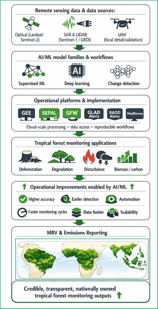
Graphical Abstract

1. Introduction and Background

1.1. Tropical Forests in the Context of Climate Change

Tropical forests comprise approximately 45% of the world’s forest area, spanning a wide range of ecological zones, from humid rainforests and moist forests to dry forests, shrublands, and tropical mountain systems [1]. Their critical role in global climate regulation, carbon cycling, hydrology, and biodiversity has been recognized in major international reports and agreements, such as the Brundtland Report [2] and the Rio Earth Summit [3], which formally brought tropical forests into the mainstream global climate and environment debates, through the UNFCCC, Agenda 21, and the Forest Principles. Subsequent IPCC Assessment Reports [4,5] have provided robust evidence that tropical forests are among the planet’s most significant natural carbon sinks and store the highest biomass of any terrestrial ecosystem
Despite their importance, tropical forests face escalating threats from both anthropogenic pressures, mainly deforestation, primarily due to agricultural expansion, infrastructure development, and climate-related disturbances such as forest fires, drought, and pests. Between 1990 and 2025, an estimated 489 million hectares of forest were lost globally, with 88% of this loss occurring in tropical regions [1]. In response, policy mechanisms such as REDD+ (Reducing Emissions from Deforestation and Forest Degradation, and the conservation, sustainable management of forests, and enhancement of forest carbon stocks), which was later recognized in Article 5 of the Paris Agreement [6]. These developments highlighted the critical need for robust and transparent monitoring systems.

1.2. Tropical Forest Monitoring: Advances and Limitations

1.2.1. Historical Contexts and Policy

Under REDD+ and the Paris Agreement’s Enhanced Transparency Framework (ETF), the UNFCCC requires countries to implement robust, transparent systems for monitoring and reporting forest area, changes, and carbon stocks [6,7]. As a result, forest monitoring has become a cornerstone of REDD+ and a prerequisite for tropical countries’ participation in global climate initiatives [7]. In temperate and boreal regions, National Forest Inventories (NFIs) provide the foundation for monitoring by employing statistically rigorous sampling to generate reliable estimates of forest extent, biomass, and carbon stocks, supporting long-term greenhouse gas reporting [8]. NFIs are widely adopted by Annex S1 countries and are recommended as a core component of greenhouse gas reporting from the Land Use, Land Cover, and Forestry (LULUCF) sector, particularly when integrated with remote sensing to estimate emission factors and calibrate forest-change assessments [9].

1.2.2. National Forest Inventories—Strengths and Constraints

Integrating National Forest Inventory (NFI) field measurements with satellite data is recognized as international best practice for greenhouse gas reporting and has been effectively implemented by forest-rich Annex S1 countries with strong institutional capacity, such as Norway, Sweden, and Finland. In these countries, long-term investment, stable institutions, and accessible forest areas have enabled NFIs to provide high-quality data for forest monitoring. Among tropical forested regions, however, NFIs are far less common [1]. Tropical forests are often remote and difficult to access, making plot establishment and remeasurement both costly and logistically challenging. Designing and maintaining NFIs requires substantial financial and technical resources—investments most tropical countries struggle to prioritize. As a result, the scarcity of high-quality field data limits the accuracy of emission-factor estimates and constrains the development, training, and validation of spatial models for tropical forest monitoring.

1.2.3. Remote Sensing and the Emergence of AI/ML-Enabled Forest Monitoring

Remote sensing has become the core data source for tropical forest monitoring, particularly where National Forest Inventories (NFIs) are sparse, outdated, or prohibitively expensive to maintain. Satellite imagery provides consistent and repeatable observations of forest extent, disturbance, and land-use change over large areas [10], forming the backbone of REDD+ activity data and national Forest Reference Emission Levels [11,12]. In tropical regions where accessibility, security challenges, and ecological complexity limit comprehensive field measurements, remote sensing offers a practical alternative by supplying long-term time series of forest cover and change. Freely available optical data, such as Landsat and MODIS, have been central to generating historical deforestation baselines, while medium- and high-resolution imagery (e.g., RapidEye, SPOT) has supported finer-scale assessments in Brazil, Guyana, Ecuador, Tanzania, Zambia, and the Congo Basin. Remote sensing has proven more scalable than ground-based inventories even in low-income regions, enabling continent-wide land-cover mapping and biomass estimation [13,14,15].
Despite these advantages, traditional optical remote sensing faces well-known limitations in the tropics. Persistent cloud cover, saturation in high-biomass forests, and the difficulty of detecting subtle degradation constrain the effectiveness of optical remote sensing data [16]. To overcome these challenges, LiDAR and Synthetic Aperture Radar (SAR) sensors emerged to provide three-dimensional structural information critical for estimating biomass and identifying degradation [12]. However, LiDAR and SAR data remain unevenly available in many tropical regions and typically require specialized instruments, high-performance computing, and advanced processing skills, which limit their routine use in national forest monitoring systems.
Climate-finance initiatives such as REDD+ and emerging “smart monitoring” frameworks under the newly (2025) established Tropical Forests Forever Facility (TFFF) place increasing demands on national forest-monitoring systems to deliver robust, transparent, and timely MRV at large spatial scales. Meeting these demands using conventional remote sensing and field-based inventories alone has proven challenging in tropical contexts. Forest landscapes are characterized by persistent cloud cover, heterogeneous forest conditions, limited and uneven field data, and constrained institutional and technical capacity. In this context, artificial intelligence (AI) and machine learning (ML) are increasingly framed as a response to structural monitoring constraints for tropical forests. Artificial intelligence (AI) and machine learning (ML), abbreviated jointly as AI/ML hereafter, enable the automated analysis of dense multi-sensor time series, the integration of optical, radar, and LiDAR observations, and the scaling of monitoring workflows across national and regional extents—capabilities that are difficult to achieve using traditional or manually intensive methods. Consequently, AI/ML-enabled remote sensing is emerging as a key enabling component of contemporary tropical forest monitoring, complementing existing inventory and remote sensing practices by addressing persistent limitations related to data availability, scalability, timeliness, and operational sustainability.
The scope of the review is remote sensing–based AI/ML applications relevant to national or large-scale tropical forest monitoring, with particular emphasis on systems supporting deforestation and degradation detection, biomass and carbon estimation, and MRV-oriented monitoring. The review is limited to applications designed for large-area, repeatable monitoring, and does not address local-scale ecological modeling, species-level analyses, or non-forest land-use applications.

2. Aim and Objectives

This review examines how artificial intelligence (AI) and machine learning (ML) are integrated into remote sensing–based monitoring of tropical forests, with a focus on their role in detecting and analyzing forest changes, including deforestation, forest degradation, and biomass and carbon dynamics. The review addresses the following specific objectives: (1) identify and analyze current and emerging AI/ML approaches and AI/ML-powered platforms applied in tropical forest monitoring, including supervised and unsupervised classifiers, deep-learning architectures, time-series and change-detection frameworks, multi-sensor data-fusion approaches, and operational forest monitoring platforms; (2) assess the remote sensing datasets, training data resources, and implementation environments used in AI/ML-based tropical forest monitoring, and examine how data availability, sensor integration, and validation practices influence model performance, benchmarking, and transferability; (3) evaluate technical, data-related, institutional, and governance barriers that limit the adoption and scaling of AI/ML approaches in tropical forest monitoring; and (4) develop evidence-based recommendations for advancing effective and equitable AI/ML-enabled tropical forest monitoring, drawing on insights from operational monitoring systems, international policy, MRV frameworks, and best practices.

3. Materials and Methods

This review adopts a semi-systematic approach where evidence was drawn from two complementary sources: (i) peer-reviewed scientific literature, which provides the core analytical basis for assessing AI/ML approaches and datasets; and (ii) grey-literature sources and documentation from operational forest-monitoring platforms, which capture implementation contexts, governance arrangements, and real-world applications of AI/ML-enabled tropical forest monitoring. A semi-systematic approach was adopted to enable structured screening and transparent synthesis while allowing the integration of methodological studies, operational platforms, and governance-related evidence that would otherwise be excluded under strict systematic review protocols. The review follows PRISMA 2020 [17] reporting guidelines for the peer-reviewed literature component, while the technical platforms, monitoring systems, and grey literature stream were selected based on documented operational relevance and demonstrated application in tropical forest monitoring contexts.
Data collection and synthesis were guided by three overarching research questions: (a) What is the current state of AI/ML applications in tropical forest monitoring? (b) What technical, institutional, and data-related barriers constrain the adoption and scaling of AI/ML in tropical forest monitoring? (c) What emerging solutions and technological developments are shaping the future of AI/ML-enabled tropical forest monitoring?

3.1. Literature Search and Screening

A semi-systematic literature search was conducted using the Web of Science Core Collection as the primary database, supplemented by Google Scholar. The search targeted English-language peer-reviewed publications published since 2010, a period corresponding to the expansion of machine-learning and deep-learning approaches in remote sensing–based forest monitoring.
The search strategy was designed to capture both methodological advances and applied AI/ML applications relevant to tropical forest monitoring using structured Boolean search strings combining four conceptual dimensions: (i) tropical forest or pan-tropical context; (ii) forest-related monitoring objectives; (iii) Earth observation and remote sensing data sources; and (iv) artificial intelligence and machine-learning approaches. These dimensions were operationalized through Boolean combinations that prioritized thematic specificity over exhaustive recall and were combined using logical AND operators to construct the operational search strings applied in the Web of Science Core Collection. Searches were executed within the Topic field (title, abstract, and keywords), ensuring that retrieved studies explicitly addressed ecosystem context, data sources, analytical approaches, and monitoring objectives. The Boolean search strings and term combinations used in the literature search are provided in Supplementary Material (Annex S1).
Google Scholar was used as a supplementary search engine to identify additional peer-reviewed articles and support backward and forward citation tracking of key synthesis studies and highly cited publications. This includes papers emphasizing analytical frameworks, operational monitoring platforms, cross-cutting methodological developments, or governance and institutional considerations that do not systematically use forest- or tropical-specific terminology in titles or abstracts. Database searches were further complemented by targeted identification of peer-reviewed literature associated with major analytical frameworks and widely used monitoring approaches.
Screening and inclusion criteria: Titles and abstracts were screened by the author in accordance with a semi-systematic review design to identify peer-reviewed studies that met at least one of the following criteria: (a) applied artificial intelligence or machine-learning (AI/ML) approaches to remote sensing–based monitoring of tropical forests; (b) addressed operational monitoring objectives, including deforestation or forest-degradation detection, biomass or carbon estimation, and time series–based analyses. Studies focusing exclusively on temperate or boreal regions, or on agricultural applications without a tropical forest component, were excluded.
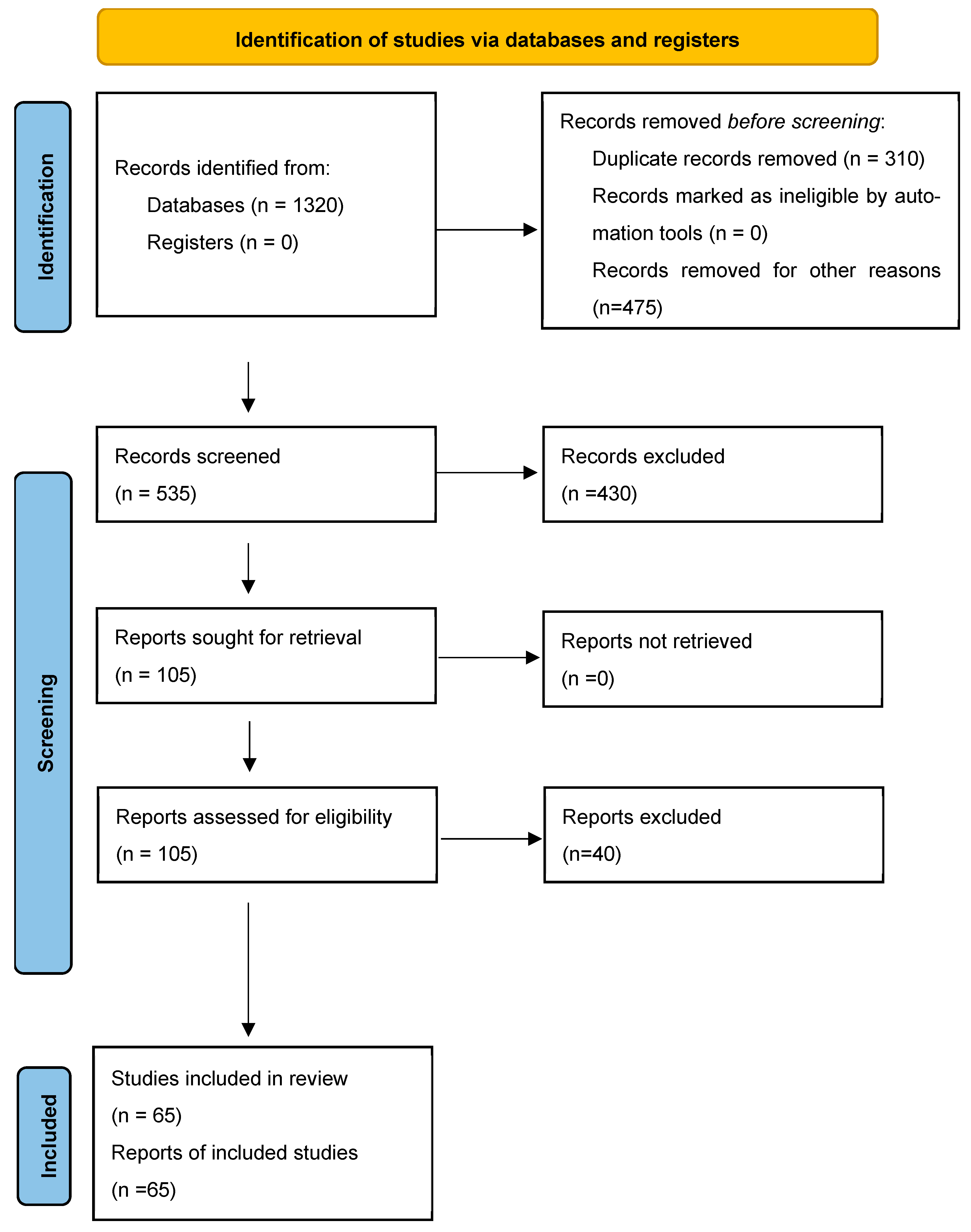
The initial database search produced >1300 records from the Web of Science Core Collection. Following the removal of duplicates and title–abstract screening based on the predefined inclusion criteria, and after complementary searches and citation tracking using Google Scholar, 65 peer-reviewed journal articles provided the evidence base for the review. The flow diagram (Figure 1) illustrates the selection process and reflects the expanded and refined search strategy. The complete PRISMA 2020 checklist is given in Annex S2.

3.2. Technical Platforms, Monitoring Systems, and Grey Literature

The peer-reviewed literature was complemented by grey literature sources. These include policy documents, technical reports, institutional publications, and documentation from operational forest-monitoring platforms to capture implementation contexts, governance arrangements, and real-world deployment characteristics that are not fully represented in academic publications. These sources were analyzed separately from the peer-reviewed literature to inform the assessment of how AI/ML-based forest monitoring systems are operationalized in tropical regions, particularly in relation to national forest monitoring systems, MRV requirements, and policy use.
A relevance-based selection strategy was applied to identify operational platforms, monitoring systems, and supporting documentation with demonstrated use in tropical forest contexts. This included global and national-scale forest-monitoring platforms, including the Global Forest Watch (GFW), System for Earth Observation Data Access, Processing and Analysis for Land Monitoring (SEPAL), Global Land Analysis & Discovery (GLAD) alerts, MapBiomas, TerraBrasilis/DETER), Radar for Detecting Deforestation (RADD) and other cloud-based processing infrastructures and analytics environments (e.g., Google Earth Engine, Planet-based services), open-source (e.g., Collect Earth Online), and documentation from multilateral and international initiatives (e.g., NICFI, UN-REDD, UNFCCC, FAO, IPCC, World Bank, and UNESCO). Sources were included based on their documented operational relevance in tropical regions and their contribution to understanding AI/ML-enabled monitoring workflows, data governance, institutional arrangements, and policy integration. Where possible, the reliability of grey literature and platform documentation was assessed through cross-reference with peer-reviewed studies, official technical reports, and multiple independent sources. This approach aimed to reduce reliance on single-source descriptions and to improve confidence in the interpretation of platform capabilities and limitations.
Limitations of this evidence base include a potential bias toward well-documented and highly visible platforms, major multilateral programs, and initiatives with publicly available English-language documentation, as well as the exclusion of unpublished or internally reported systems. These limitations are acknowledged and considered when interpreting results related to platform coverage, governance models, and implementation experience.

3.3. Synthesis of Evidence

Extracted information from peer-reviewed studies, operational platforms, and grey-literature sources was analyzed using qualitative thematic synthesis. The synthesis was guided by the review’s research questions and focused on (i) categories of AI/ML approaches and analytical workflows; (ii) remote sensing datasets, training data, and validation practices; (iii) implementation environments and operational monitoring platforms; and (iv) technical, institutional, and governance constraints affecting practical applications. Evidence was iteratively grouped into thematic categories that directly informed the structure of the results (Section 4), including the taxonomy of AI/ML approaches (Section 4.1), datasets and training resources (Section 4.2), platform implementations (Section 4.3), and application areas (Section 4.4). Cross-cutting barriers, enabling conditions, and emerging solutions were identified across these themes and synthesized to inform the Discussion (Section 5) and the development of evidence-based recommendations (Section 6).

4. Results

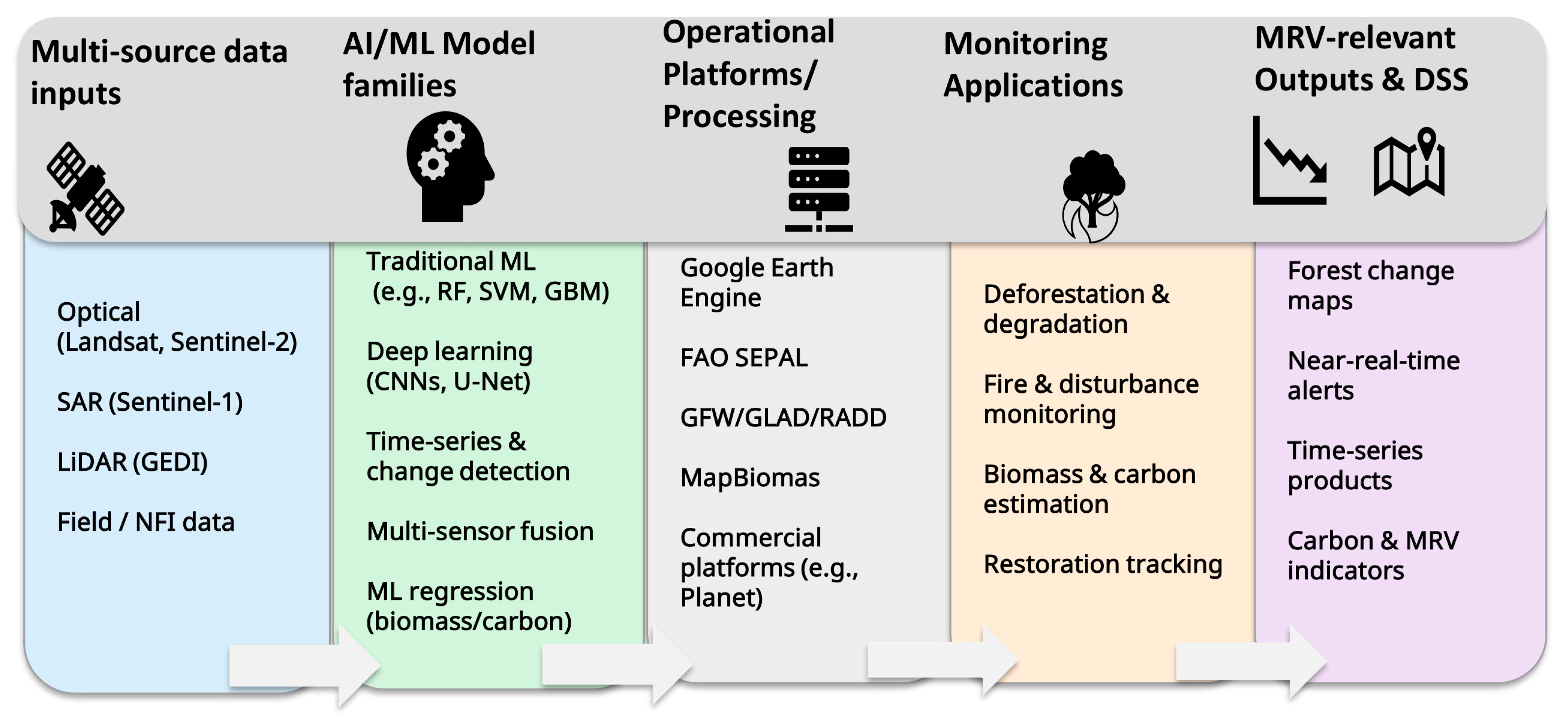
Section 4 presents a structured synthesis of evidence from the literature and selected operational forest-monitoring systems on the application of artificial intelligence and machine learning (AI/ML) in tropical forest monitoring. The results are organized thematically (Section 4.1, Section 4.2, Section 4.3 and Section 4.4) to reflect how different AI/ML model families, analytical workflows, and implementation contexts are applied across key monitoring objectives. Figure 2 provides a conceptual overview linking data inputs, AI/ML model families, processing platforms, and monitoring applications to MRV-relevant outputs, and serves as a structural guide for Section 4.

4.1. AI/ML Model Families in Tropical Forest Monitoring

The literature identifies a set of AI/ML model families used to derive tropical forest monitoring products from remote sensing or Earth-observation data. To support a systematic synthesis and reduce ambiguity between algorithms, software frameworks, and data sources in remote sensing of Tropical forests, evidence is organized into five categories: (i) traditional supervised ML classifiers, (ii) deep learning models for image analysis, (iii) time-series change detection and predictive modeling, (iv) multi-sensor data fusion, and (v) ML regression for biomass and carbon estimation. These categories reflect how studies typically structure an end-to-end monitoring pipeline, from feature extraction and model training to mapping, alert generation, and biophysical estimation, rather than implying a strict hierarchy or mutually exclusive classes. Table 1 summarizes the main AI/ML model families used in tropical forest monitoring, linking each model category to typical applications and commonly used remote sensing inputs. The table is intended as a conceptual taxonomy rather than an exhaustive algorithmic comparison.

4.1.1. Supervised and Unsupervised ML Classifiers

Supervised classifiers, including Random Forest (RF), Support Vector Machines (SVMs), Classification and Regression Trees (CARTs), and gradient-boosting methods, are widely applied for land-cover mapping, forest/non-forest classification, and deforestation detection in tropical forests using multispectral and radar predictors. Supervised ML approaches applied to high-resolution imagery have been shown to improve the detection of tropical forest disturbances and support fine-scale monitoring of deforestation and forest change [18,19]. Unsupervised approaches, including clustering and anomaly-detection techniques, are applied for exploratory mapping and identifying candidate disturbance areas in heterogeneous tropical forest landscapes, although such outputs typically require independent validation [20].

4.1.2. Deep Learning and Advanced Pattern-Recognition Models

Deep learning methods, particularly Convolutional Neural Networks (CNNs), have enabled improved spatial pattern recognition for high-resolution mapping of forest change. For instance, CNN-based semantic segmentation approaches (e.g., U-Net architectures) are increasingly used to delineate deforestation and degradation footprints, including small clearings and subtle canopy disturbance signals that are difficult to detect using pixel-based methods alone. For example, deep learning with high-resolution Planet/NICFI imagery has been used to map tropical forest degradation associated with logging and fire processes [21]. CNN-based workflows are also used for detailed feature extraction and object-level characterization in very-high-resolution imagery, supporting enforcement-relevant monitoring of deforestation and forest change in fragmented tropical landscapes [18,21].

4.1.3. Time-Series Analytics, Anomaly Detection, and Predictive Modelling

Time-series approaches are central to tropical forest monitoring because they support the detection of both abrupt and gradual change trajectories and provide information on disturbance timing. Recent studies show that near-real-time disturbance monitoring can be strengthened through dense time-series fusion across Landsat, Sentinel-2, and Sentinel-1, enabling improved detection of short-duration or rapidly evolving events [22]. For radar-based operational monitoring, Sentinel-1 time series have supported the development of disturbance alert systems in cloud-prone tropical regions such as the Congo Basin [23]. Beyond detection, predictive AI/ML approaches are increasingly applied to estimate deforestation and fire risk, particularly when integrating EO predictors with ancillary data, such as accessibility and climate covariates [24,25], although model transferability remains sensitive to training data representativeness and validation design.

4.1.4. Multi-Sensor Data Fusion

Data fusion is increasingly being used to combine complementary information from optical, SAR, and LiDAR sensors to overcome the limitations of single-sensor approaches in tropical forest environments characterized by persistent cloud cover, complex canopy structure, and heterogeneous disturbance patterns. In recent studies, feature-level or model-level fusion strategies integrate spectral information from Landsat or Sentinel-2 with structural sensitivity from Sentinel-1 SAR and vertical metrics from LiDAR to improve the robustness of forest change detection and degradation mapping. For example, previous authors demonstrated that fusion between optical and SAR time series significantly improved the detection of tropical forest characteristics compared to single-sensor inputs [22,26]. Yang, Liu, and Chen [26] and Chamberlin, et al. [27] demonstrated that LiDAR-anchored fusion with optical and SAR predictors supports spatially consistent estimation of forest biomass or canopy height mapping across large tropical landscapes. Furthermore, combining optical and SAR data improves forest disturbance detection accuracy compared to single-sensor approaches in tropical environments such as the Amazon and West Africa [20,28]. Multi-sensor fusion is also increasingly applied to support cloud-robust operational monitoring and near-real-time alert systems [23,29]. These studies show that AI/ML-enabled fusion approaches have consistently resulted in higher detection rates and reduced false alarms relative to individual data streams.

4.1.5. AI/ML Regression Approaches for Forest Biomass Estimation and Mapping

AI/ML regression models are widely applied to estimate above-ground biomass in tropical forests by calibrating non-linear algorithms—most commonly Random Forest, gradient-boosting, and deep-learning models—using field-based measurements and LiDAR-derived structural metrics. In tropical forest applications, tree-based ensemble models outperform linear regression and traditional allometric approaches in capturing non–linear biomass–structure relationships across evergreen broadleaf, dry deciduous, and mixed forest types [30,31]. LiDAR-calibrated deep-learning and ensemble ML models demonstrate higher predictive performance than optical- or SAR-only approaches in structurally complex tropical forests and underpin GEDI-based multisensor frameworks that generate spatially continuous, wall-to-wall biomass maps at regional scales [26,32]. Across these studies, reported uncertainty is primarily associated with the density and spatial distribution of field or LiDAR calibration data, sensor saturation in dense tropical canopies, or reduced model performance when applied beyond the ecological and structural conditions represented in the training data.

4.1.6. Benchmarking and Performance Metrics

Across the reviewed studies, performance benchmarking practices vary according to monitoring tasks and analytical approach. Classification- and alert-oriented applications predominantly rely on confusion-matrix-based metrics. Segmentation-focused deep-learning studies emphasize spatial-overlap measures, and regression-based applications report continuous error statistics. Table 2 provides representative examples of performance metrics reported across selected (not exhaustive) peer-reviewed studies across monitoring tasks. The table is intended to illustrate common benchmarking practices across AI/ML model families. Direct cross-study comparison is constrained by differences in reference data, spatial sampling design, validation strategies, and monitoring objectives.
Table 2. Quantitative evidence synthesis: reported performance metrics across selected peer-reviewed studies. Metrics and values are reported as presented in the original studies.
Monitoring Task (Study Example)AI/ML Model FamilyReported Metric(s) and Indicative Performance (As Reported)
Operational near-real-time disturbance warnings (Sentinel-1 time series) [33]Time-series anomaly detection; operational alert system96.7% warnings deemed valid; mean issuing delay 24 days; <0.2% of detected area corresponds to false positives (human validation)
Global forest land-use change alert (Sentinel-1 SAR) [34]SAR time-series change detection + ML analyticsArea-adjusted UA; PA: UA 83%; PA 63% (1 ha minimum mapping unit)
Selective logging/degradation detection (X-band SAR) [35]Supervised ML classifiers (RF, AdaBoost, MLP-ANN)Accuracy: Best model (MLP-ANN): 88% accuracy (training pair and generalization test)
Change detection of alluvial gold mining (Amazon) [36]Deep learning (CNN on Sentinel-2; supervised)Kappa; Jaccard; F1 (focal class)—Kappa 0.92; Jaccard 0.88; F1 0.88 (focal class); out-of-sample F1 0.77
Tree cover & deforestation mapping (Planet NICFI, 5 m) [18]Deep learning segmentation (U-Net CNN)F1-score > 0.98 for tree-cover model; LiDAR confirmation: 95% of tree-cover pixels > 5 m height and 98% of non-tree pixels < 5 m height
Tropical forest top height mapping from GEDI [37]ML regression (Random Forest feature selection + regression)RMSE ~5 m (comparison to airborne LiDAR)
Mangrove mapping with multi-temporal, multi-source EO [38]Artificial Neural Network (ANN) classificationBest ANN: F-score = 0.97 (best ANN)
Above-ground biomass estimation from UAV-LiDAR [39]ML regression (SVR, KNN) + regression baselinesBest ML (SVR): R2 0.868; RMSE 7.932 t/ha; RRMSE 0.231

4.2. Remote Sensing Datasets and Training Data Resources

The reviewed studies consistently identify a set of remote sensing datasets (Table 3) that underpin AI/ML-based tropical forest monitoring, with each sensor type contributing distinct spatial, temporal, or structural information required for model development in applications to tropical forest metrics.
Optical satellite time-series data remain the most widely used foundation for mapping forest extent and disturbance dynamics. Landsat (30 m) and Sentinel-2 (10–20 m) provide long-term, harmonized multispectral observations that support annual mapping, historical baselines, and dense time-series change detection. Several studies show that combining Landsat and Sentinel-2 improves the detection of short-duration disturbance events in tropical forests, particularly when temporal compositing and cloud-masking approaches are applied to counter persistent cloud cover [22]. Near-real-time monitoring systems increasingly integrate optical data with radar-based alerts to maintain temporal continuity during cloudy periods.
Synthetic Aperture Radar (SAR) time series—most prominently Sentinel-1 C-band—are widely used to overcome optical data limitations and provide cloud-independent observations of forest structure. SAR-based disturbance alert systems are operational in cloud-prone regions such as the Congo Basin [23], and Sentinel-1 Analysis-Ready Data products have enabled standardized ML workflows in global monitoring applications [29,34]. L-band SAR from ALOS PALSAR and PALSAR-2 is also used to enhance sensitivity to woody biomass and to improve degradation detection [40].
Spaceborne LiDAR provides the principal source of vertical canopy-structure information for AI/ML calibration. Multiple studies report that integrating GEDI with optical and SAR predictors improves the spatial consistency and robustness of biomass maps across heterogeneous tropical forests. GEDI footprints and canopy-height metrics are widely used to train regression models for biomass and carbon estimation [26,41] and to derive training layers for canopy-height prediction within data-fusion-based workflows [27,37].
Moderate-resolution thermal and fire-detection products, including MODIS and VIIRS, provide active-fire detections and thermal anomalies that are linked with higher-resolution disturbance layers to support attribution analyses in the Amazon and other fire-affected tropical regions [24,25]. Very-high-resolution (VHR) commercial imagery—including PlanetScope, SkySat, WorldView, and monthly Planet and NICFI mosaics—supports the creation of training labels, independent validation of model outputs, and the detection of small-scale disturbances. Deep-learning-based studies demonstrate that VHR data substantially improve the detection of selective logging, small clearings, and degradation features that are not reliably identifiable in 10–30 m data [18,21]. Initiatives such as Radiant Earth MLHub [42] and MapBiomass [43] provide curated labeled datasets, annual land-cover products, and open training samples that support benchmarking and cross-regional comparison.
The major remote sensing datasets used in AI/ML-based tropical forest monitoring are summarized in Table 3, which groups dataset families and labeled training resources together with their typical spatial scales and reported applications.
Table 3. Summary of remote sensing dataset groups used in AI/ML-enabled tropical forest monitoring.
Dataset GroupCommon Examples (Data Spatial Scale)Primary AI/ML ApplicationsExample References
Optical time seriesLandsat; Sentinel-2
(10–30 m)
Forest cover mapping; time-series disturbance detection[22,43,44]
SAR time seriesSentinel-1; (optional) ALOS PALSAR/PALSAR-2
(~10–25 m)
Cloud-robust disturbance alerts; degradation proxies[23,29,40]
LiDAR/structureGEDI footprints; derived canopy height products (Footprints/derived grids)Biomass/carbon calibration; canopy structure mapping[26,37]
Fire/thermalMODIS; VIIRS (375 m–1 km)Active fire; thermal anomalies; early warning[23,24,25]
VHR/basemapsPlanet NICFI; PlanetScope; WorldView
(~0.3–5 m)
Fine-scale training/validation; small clearings/degradation[18,19,21]
Labels/benchmarksRadiant Earth MLHub; MapBiomas
(Varies)
Training, benchmarking, validation[42,43]

4.3. AI/ML-Enabled Platforms and Implementation

AI/ML algorithms used in tropical forest monitoring are increasingly deployed through cloud-based geospatial platforms that provide large-scale data access and processing capacity. Google Earth Engine (GEE) [45,46] is widely used as an implementation environment for ML workflows, offering integrated access to multisensor satellite archives and scalable computational infrastructure. Building on the capabilities of GEE and similar cloud infrastructures, several forest-monitoring platforms—such as the System for Earth Observation Data Access, Processing, and Analysis for Land Monitoring (SEPAL), Global Forest Watch (GFW), Global Land Analysis and Discovery (GLAD) alerts, Radar for Detecting Deforestation (RADD), Collect Earth Online (CEO), and commercial analytics services offered by Planet—apply AI/ML models for deforestation alerts, land-cover mapping, change detection, and carbon-related assessments. These platforms operationalize AI/ML methods for national, regional, and global monitoring applications, enabling large-area and high-frequency analysis of tropical forest dynamics. While these platforms demonstrate how AI/ML methods are operationalized at scale, reported capabilities and performance are often derived from platform documentation or case-specific implementations. Independent validation and systematic cross-platform benchmarking are needed but limited in the literature. A brief overview of the most common AI/ML-enabled platforms is provided below, and Table 4 summarizes their primary functions and data inputs.
Global Forest Watch (GFW) [10] is widely recognized for processing multi-year global tree-cover datasets to generate high-resolution maps of forest extent, loss, and gain. Building on this foundation, GFW integrates GEE-based processing and a range of AI/ML approaches to support near-real-time forest monitoring and thematic analyses. According to platform documentation, for instance, deep-learning models have been applied to distinguish plantations from natural forests using texture and spatial-pattern analysis of high-resolution imagery, including applications to industrial oil-palm plantation mapping [47].
The System for Earth Observation Data Access, Processing, and Analysis for Land Monitoring (SEPAL) [48] is a cloud-based geospatial platform developed by FAO to provide access to satellite data, cloud computing, and advanced analysis tools for forestry and land-use applications in tropical regions. Built on GEE-based processing, SEPAL enables users to implement AI/ML workflows using Python and R and offers interoperability with open-source tools such as QGIS and SNAP. The platform has been adopted within the national forest-monitoring systems of Uganda [49], where it supports the production of national satellite mosaics and land-cover change assessments, and Indonesia, where it is used within the national peatland-monitoring system [50].
High-resolution forest canopy-height products developed by Meta and the World Resources Institute (WRI) provide an example of AI/ML-enabled global datasets with increasing application in tropical forest regions. These 1 m resolution canopy-height maps cover the period 2009–2020, with most imagery acquired between 2018 and 2020, and were generated using a self-supervised vision model (DiNOv2) trained to predict canopy height from optical imagery [51,52]. The dataset and underlying model are publicly available, allowing reuse in subsequent analyses, including canopy-height change assessment.
Commercial platforms such as the Planet Insights Platform [53] integrate AI/ML algorithms with high-resolution satellite imagery to support forest-change detection, canopy-structure analysis, and carbon-related products. According to provider documentation, Planet products are used by commercial service providers to assess commodity-driven deforestation risks and support compliance with emerging regulations such as the EU Deforestation Regulation (EUDR). Access to these services typically requires a commercial subscription, which may limit their routine use by national forest institutions in many tropical countries. An overview of selected AI/ML-enabled platforms, their primary functions, and the main remote sensing data sources they integrate is summarized in Table 4.

4.4. Application Areas and Case Studies Classified by Monitoring Objectives

Applications of AI/ML tools for tropical forest landscape monitoring illustrate how these approaches are operationally deployed across distinct monitoring objectives, ranging from near-real-time detection of forest loss to the assessment of specific land-use pressures, restoration outcomes, and complementary ground-based observations. Drawing on evidence from operational monitoring platforms and supported by peer-reviewed literature, four categories of AI/ML applications are identified (Section 4.4.1, Section 4.4.2, Section 4.4.3 and Section 4.4.4).

4.4.1. AI-Assisted Early-Warning Systems for Deforestation and Fires

Early-warning systems are among the most operationalized and widely implemented in operational monitoring contexts, particularly in regions where rapid response enforcement is essential. For example, the Global Land Analysis & Discovery (GLAD) alert system provides Landsat-based forest-loss alerts at 30 m spatial resolution, while the Radar for Detecting Deforestation (RADD) alert system applies cloud-penetrating C-band Sentinel-1 SAR data to generate disturbance alerts at 10 m resolution [23,44,54]. GLAD and RADD have been widely applied to detect deforestation events across tropical regions and have been evaluated with respect to timeliness, sensitivity, and accuracy [23,44].
Building on these global alert systems, the Monitoring of the Andean Amazon Project (MAAP) is an initiative that operationalizes early-warning outputs by integrating supervised machine-learning classification, thermal-anomaly detection, and multi-sensor time-series analysis to generate near–real–time alerts for deforestation, fires, road expansion, and illegal mining across multiple Amazonian countries [55,56]. Using diverse datasets, including Landsat, Sentinel-1/2, VIIRS, and Planet imagery, within cloud-computing environments, MAAP translates AI-generated alerts that are used to inform enforcement and response activities, environmental prosecution, and rapid decision-making.
Consistent with this approach, peer-reviewed studies demonstrate that the MAAP model, as part of a broader transition from standalone alert products toward high-frequency, policy-relevant forest monitoring systems, dense multi-sensor time-series analysis combining optical and SAR data, substantially improves the timeliness and reliability of tropical forest-disturbance detection. Near-real-time alert systems based on Sentinel-1 SAR and optical data have been shown to detect deforestation under persistent cloud cover and reduce detection latency relative to systems based on optical images only [23,33,54]. Recent deep-learning and data-fusion studies further show that integrating Sentinel-1, Sentinel-2, Landsat, and high-resolution imagery enhances the detection of small-scale and rapidly evolving disturbances such as fires, roads, and mining activities in the Amazon [18,21,22].

4.4.2. Thematic Monitoring Systems of Specific Land Use Pressures

Beyond detecting forest loss, AI/ML tools are increasingly deployed to monitor specific land-use pressures, such as degradation, that global deforestation alerts could not detect. These thematic systems target subtle, heterogeneous, or spatially concentrated forms of degradation caused by drivers such as illegal mining and peatland degradation. Two illustrative cases are illegal mining detection in the western Amazon and peatland monitoring in Indonesia.
Illegal mining detection in the western Amazon: This is a case where ML-based mining-detection systems apply spectral indices, object-oriented segmentation, and supervised classifiers to identify mining-related disturbances such as turbidity plumes, exposed sediments, and vegetation removal. The Amazon Mining Watch initiative applies AI/ML to Sentinel-2 imagery to detect and map mining-driven deforestation across the Amazon biome, generating updated annual alerts from 2018 to 2023 [56]. Consistent with this operational approach, refs. [36,57] demonstrate that supervised classification and object-based/data-mining workflows using Sentinel-2 can reliably delineate artisanal alluvial gold-mining scars and mining ponds in Amazonian forests, including small and spatially fragmented features that are difficult to capture with generic deforestation detection products.
Peatland monitoring in Indonesia: In Indonesia, AI/ML methods are increasingly used for peatland monitoring, a tropical landscape that requires specialized analytical approaches due to subtle spectral signatures and frequent cloud cover. In the Indonesian Peatland Monitoring initiative, ML classifiers are applied to Sentinel-1 and Sentinel-2 time series to distinguish intact peat swamp forest from degraded peatlands and agro-industrial mosaics, while predictive models identify fire-prone hotspots associated with drainage canals and land-conversion pressures. Consistent with the operational workflows of the peatland monitoring initiative, AI/ML-based approaches support peatland condition assessment, hydrological monitoring, and fire-risk mapping in Indonesian peatland landscapes. For instance, deep-learning models have been used to estimate historical peatland distribution in Indonesia [58], while machine-learning models driven by groundwater-level observations and spatial predictors identify hydrological stress and fire-susceptibility hotspots [59,60].

4.4.3. Restoration and Carbon-Verification Initiatives

AI/ML approaches are increasingly applied to quantify and verify positive ecosystem outcomes, enabling spatially explicit assessments of restoration performance and carbon dynamics in tropical forests, including coastal mangroves. A growing body of evidence from both operational initiatives and scientific literature highlights the expanding role of AI/ML-supported monitoring in carbon markets, nature-based solutions, and corporate sustainability frameworks, where robust, transparent, and scalable verification is essential.
In the operational setting, the Regenera América initiative in Brazil [61] applies ML-supported biomass estimation, canopy-structure modeling, and high-resolution change detection to assess the performance of corporate-funded reforestation and natural regeneration projects. The initiative partners with Pachama [62], whose AI-driven platform integrates satellite imagery with UAV-based photogrammetry and ML-derived canopy metrics to quantify biomass increments, canopy height, and regeneration trajectories.
Consistent with these operational deployments, recent literature demonstrates that AI/ML methods support spatially explicit biomass estimation and carbon-stock monitoring in restored and recovering tropical forests. The ReforesTree [63] presents a curated dataset and deep-learning framework for estimating above-ground carbon stocks from high-resolution aerial imagery, showing that neural networks can capture complex structure–carbon relationships across restored and degraded landscapes. Similarly, deep-learning models applied to multispectral satellite data have been shown to quantify carbon-sequestration dynamics and structural change in restoration contexts [41,64]. For tropical mangrove forest monitoring, AI/ML methods support integrating multi-sensor SAR and optical data with UAV- and field-based calibration to map mangrove structure and condition. Random Forest regression using Sentinel-1, Sentinel-2, and L-band SAR predictors has been applied to generate spatially explicit estimates of canopy height and above-ground biomass in restored mangrove landscapes [65]. Artificial neural networks applied to multi-temporal SAR and optical data achieved a high reported classification performance (F-score = 0.97) under study-specific conditions [38].

4.4.4. Non-Satellite AI Tools: Complementing Satellite-Based Monitoring

Non-satellite AI applications complement satellite-based remote sensing by providing ground-level observations and signals that are not directly observable from space. These include acoustic sensing, mobile reporting tools, and in situ IoT-based systems. These have been applied to support community-based monitoring and enforcement by detecting anthropogenic activities beneath dense forest canopies or during periods of persistent cloud cover in tropical forest regions.
Operational examples include Rainforest Connection (RFCx) [66] and the Forest Watcher mobile application [67], which integrate AI-based acoustic sensing and community reporting with satellite-derived alerts. According to platform documentation, RFCx uses convolutional neural networks trained on annotated acoustic datasets to detect chainsaw and vehicle sounds in near-real-time, while the Forest Watcher application enables field-based verification of satellite alerts such as GLAD and RADD, including offline navigation.
Emerging literature demonstrates that non-satellite AI/ML methods increasingly complement satellite-based forest monitoring by detecting ground-level signals associated with illegal logging and other anthropogenic disturbances. Acoustic sensor networks integrated with machine-learning classifiers have achieved high detection accuracy (>90%) for chainsaw and tree-cutting sounds in operational forest environments [68]. IoT-based monitoring systems similarly combine distributed environmental and acoustic sensors with cloud- or edge-based ML models to classify disturbance events in real time, providing early warnings not visible to satellite observations [69]. Temporal-frequency CNN models deployed on IoT architectures further improve the discrimination of anthropogenic sounds within complex tropical soundscapes [70]. These non-satellite AI tools function as a complementary “sense layer” that enhances situational awareness, supporting rapid response efforts in remote or canopy-dense forests.

5. Discussion

The Results (Section 4.1, Section 4.2, Section 4.3 and Section 4.4) present evidence from peer-reviewed studies and operational platforms, revealing a rapidly evolving landscape of AI/ML applications in tropical forest monitoring. Key findings highlight the central role of multi-sensor remote sensing datasets, the widespread use of supervised machine-learning and deep-learning models, and the integration of operational platforms, such as Global Forest Watch, SEPAL, MapBiomas, and Planet. Monitoring objectives are also expanding beyond early-warning systems to include deforestation and forest-degradation assessment, restoration monitoring, and non-satellite sensor networks. Building on this evidence, the following sections examine the added value of AI/ML-enabled monitoring relative to conventional approaches, assess emerging analytical capabilities in relation to tropical forest constraints, and discuss the structural, institutional, and governance factors that shape the adoption, scalability, and long-term sustainability of AI/ML-enabled tropical forest monitoring.

5.1. The Added Benefits of AI/ML Approaches for Tropical Forest Monitoring

Evidence from the reviewed studies and operational examples indicates that AI/ML approaches can offer tangible benefits for tropical forest monitoring, particularly with respect to forest change or disturbance detection, improved operational efficiency, and analytical depth. These reported benefits are most commonly assessed using standard classification and segmentation metrics, such as precision, recall, F1-score, overall accuracy, and Intersection-over-Union (IoU)/Dice coefficient, as well as reductions in detection latency for near-real-time alert systems. However, the extent and comparability of reported performance gains vary across studies due to differences in training data availability, class definitions, spatial sampling designs, sensor combinations, and validation strategies. As a result, cross-study comparison remains limited, suggesting the need for more standardized benchmarking protocols, transparent validation strategies, and clearer reporting of uncertainty when evaluating AI/ML applications in tropical forest monitoring. Despite these constraints, the reviewed evidence allows the added benefits of AI/ML-enabled tropical forest monitoring to be interpreted across four broad categories, which are discussed in the following subsections (Section 5.1.1, Section 5.1.2, Section 5.1.3 and Section 5.1.4).

5.1.1. Improved Accuracy and Early Detection

AI/ML methods consistently improve the accuracy and timeliness of tropical forest-disturbance detection compared with traditional pixel-based, threshold-based, or manual interpretation approaches. These gains are mainly due to the ability of supervised ML classifiers and deep learning models to learn complex spatial, spectral, and temporal patterns that conventional methods often fail to detect. Operational platforms illustrate these reported improvements. For example, MapBiomas applies Random Forest classification within Google Earth Engine to produce long-term annual land-cover maps for Brazil and other Amazonian countries with greater thematic consistency than the earlier manual or heuristic mapping approaches [43]. Similarly, the GLAD alert system uses automated Landsat time-series analysis to generate high-sensitivity forest-loss alerts across humid tropical regions [44]. Deep learning models used in the GFW–Orbital Insight collaboration distinguish between plantations and natural forests using high-resolution texture and contextual features, enabling more precise mapping of forest conversion and forest degradation [47].
Evidence from peer-reviewed studies provides independent support for these platform-reported trends, showing improvements in early detection and disturbance-mapping accuracy when AI/ML models integrate multi-sensor or high-resolution data. In particular, combining optical and radar time series, most commonly, Landsat, Sentinel-2, and Sentinel-1, has been shown to improve disturbance sensitivity and reduce detection delays in cloud-prone tropical regions [22,23]. Deep-learning applications using very-high-resolution imagery reinforce these findings, while also highlighting scale- and data-dependency effects. Studies by Dalagnol, Wagner, Galvão, Braga, Osborn, da Conceição Bispo, Payne, Junior, Favrichon, and Silgueiro [21] and Wagner, Dalagnol, Silva, Carter, Ritz, Hirye, Ometto, and Saatchi [18] show that CNN-based models can reliably capture fine-scale degradation and deforestation patterns that medium-resolution pixel-based methods frequently miss. Similarly, optical–SAR fusion studies [20,28] reported higher accuracy and fewer omission errors than single-sensor baselines. Across the reviewed evidence, however, accuracy gains are not uniform. Model performance depends strongly on data availability, sensor combinations, feature selection, and calibration strategies, as well as on institutional factors influencing data access and validation. Nevertheless, when models are appropriately calibrated and supported by suitable multi-sensor data and training data, AI/ML approaches generally enable earlier and more accurate detection of tropical forest disturbance than conventional methods, particularly in cloud-prone and heterogeneous forest landscapes of the tropics.

5.1.2. Enhanced Efficiency, Automation, and Speed

A consistent finding across the reviewed literature is that AI/ML–enabled approaches are widely reported to improve the efficiency and speed of tropical forest monitoring relative to conventional, manually intensive approaches. These gains are primarily due to the automation of large-volume satellite data, preprocessing, and classification, which reduces reliance on manual interpretation and enables more frequent forest-change reporting over large and often inaccessible regions in the tropics.
At the operational level, cloud-based platforms illustrate how these efficiency gains are realized in practice. For example, the System for Earth Observation Data Access, Processing, and Analysis for Land Monitoring (SEPAL) [48] has enabled national forest monitoring programs in Uganda to generate satellite mosaics and forest-change products more rapidly than traditional desktop GIS workflows by combining automated preprocessing, batch classification, and scalable computing resources. Similarly, near-real-time alert systems such as MAAP and radar-based disturbance alerts (RADD) demonstrate how automated processing pipelines can reduce detection latency, allowing earlier identification of deforestation events in cloud-prone regions, such as the Amazon and Congo Basin. High-frequency commercial imagery (e.g., PlanetScope) further contributes to this acceleration by increasing revisit rates for monitoring fires, illegal logging, road expansion, and restoration dynamics, thereby supporting more timely operational responses.
Evidence from peer-reviewed studies provides independent support for these observations from operational platforms. Automated Sentinel-1 time-series pipelines enable basin-scale near-real-time disturbance detection [23,54], while automated temporal compositing and multi-sensor fusion approaches improve monitoring frequency and reduce detection delays compared with optical-only workflows [22]. Automation also extends to preprocessing stages, where standardized analysis-ready data pipelines implemented in cloud environments such as Google Earth Engine substantially reduce preprocessing time relative to traditional desktop-based methods [23,29,34]. Automated changepoint-detection approaches, including BEAST, further enhance efficiency by accelerating the identification of abrupt and gradual disturbance trajectories and minimizing manual inspection [71].
This body of evidence indicates that automation, cloud scalability, and ML-driven workflows can shorten monitoring cycles and support more timely enforcement, risk mitigation, and community-based monitoring of tropical forests. However, the gains in efficiency and speed are not uniform across contexts and remain dependent on access to cloud infrastructure, reliable data streams, and well-designed validation protocols. Increased automation may also amplify false positives or propagate preprocessing errors, highlighting the need to balance speed with robustness in operational tropical forest-monitoring systems. Overall, AI/ML-enabled approaches represent a substantial advance in efficiency, automation, and speed of monitoring.

5.1.3. Multi-Source Data Fusion and Increased Analytical Depth

AI and machine-learning approaches increasingly rely on the integration of optical, radar, LiDAR, UAV, and ancillary environmental data to overcome the limitations of single-sensor remote sensing in tropical forest environments. Across the reviewed literature, multi-sensor fusion consistently emerges as a key mechanism for enhancing analytical depth, particularly for characterizing forest structure, disturbance processes, and biophysical properties that are difficult to capture using optical imagery alone. Consequently, fusion-based workflows reflect a broader shift toward exploiting complementary sensor sensitivities to improve robustness under conditions of persistent cloud cover, complex canopy structure, and heterogeneous disturbance patterns in tropical forest environments.
In advancing the remote sensing methodology, deep-learning architectures, most notably convolutional neural networks (CNNs) applied to high-resolution imagery, have improved spatial-pattern recognition for canopy-structure mapping, detection of fine-scale degradation, and object-level feature extraction [18,21,72]. Time-series models such as Bayesian Estimator of Abrupt change, Seasonality, and Trend (BEAST) further extend this analytical capability by automating the detection of nonlinear vegetation trajectories and abrupt disturbance events, reducing reliance on manual interpretation and enabling more temporally explicit monitoring [71]. When combined with dense optical–radar time series, these approaches improve sensitivity to short-duration or disturbances that are often missed by medium-resolution optical products alone [20,28].
Multi-sensor fusion has been particularly influential in applications for biomass or carbon estimation and mapping, where machine-learning regression models calibrated with spaceborne LiDAR data (e.g., GEDI) consistently achieve lower prediction error and greater spatial consistency than traditional parametric approaches [26,27,41]. Similar gains have been reported for ML-assisted processing of LiDAR and UAV data, which improves individual-tree detection, canopy-height modeling, and biomass estimation across restoration and degraded forest landscapes [73,74]. However, these improvements remain strongly dependent on the availability and representativeness of calibration data, and model performance can degrade when LiDAR sampling density is sparse or when models are transferred beyond their training domain.
Operational platforms such as SEPAL illustrate how fusion-based AI/ML workflows can be implemented at a national scale. By integrating optical and Sentinel-1 SAR data within cloud-based processing environments, SEPAL supports multi-sensor analyses for applications such as peatland vegetation recovery and soil-moisture dynamics in Indonesia [48]. While these platforms demonstrate the practical feasibility of multi-source fusion, their effectiveness ultimately depends on sustained data accessibility, institutional capacity, and transparent validation practice, factors that shape how increased analytical depth translates into reliable and operational tropical forest monitoring.

5.1.4. Enhanced Scalability, Transparency, and Cost Efficiency

AI/ML-enabled methods increasingly allow tropical forest monitoring to scale from localized analyses to national and continental applications, supporting more transparent and cost-effective monitoring systems. Across the reviewed literature, this scalability is primarily enabled by cloud-native infrastructures, standardized analysis-ready data (ARD), and automated ML pipelines that support large-area, high-frequency processing while maintaining methodological consistency.
Several studies demonstrate how these technical enablers support wide-area monitoring. Basin-scale disturbance alerts based on Sentinel-1 SAR illustrate how cloud-based processing enables near-real-time analysis across extensive tropical forests [23]. Similarly, automated Sentinel-1 ARD implemented in Google Earth Engine supports consistent and scalable ML by standardizing preprocessing across space and time [29]. Automated changepoint detection and multi-sensor fusion approaches further enhance scalability by accelerating wide-area disturbance reporting and reducing manual intervention [22,71]. In the context of biomass and carbon estimation, multi-sensor ML regression models calibrated with LiDAR data are reported to demonstrate how harmonized predictor frameworks can be extrapolated to produce region-wide estimates [26,27]. At the continental scale, standardized data infrastructures, such as Earth Observation Data Cubes, illustrate how structured data pipelines facilitate reproducible, cross-regional ML analytics [75,76].
Operational platforms such as Global Forest Watch, SEPAL, and MapBiomas demonstrate the feasibility of large-scale, automated forest monitoring and provide transparent processing chains that enable independent validation, replication, and reuse by governments, NGOs, and civil society. Commercial services, including Planet Insights and CTrees, extend these capabilities by delivering global-scale ML-based disturbance and carbon monitoring built on harmonized multi-sensor datasets. Their transparency and reproducibility, however, depend on data accessibility, licensing conditions, and the availability of documented processing workflows.
AI/ML-enabled scalability can reduce long-term monitoring costs by decreasing reliance on extensive field campaigns and enabling persistent observation across remote, extensive tropical regions such as the Amazon, Congo Basin, and Indonesia. However, these cost efficiencies are not immediate or universal. Initial investments in cloud infrastructure, technical training, and access to high-resolution or commercial datasets can be substantial. As a result, realized cost savings depend on sustained institutional capacity, long-term funding, and stable access to digital infrastructure. Consequently, scalability and cost efficiency should be understood as outcomes of system-level maturation and sustained implementation, rather than as automatic consequences of AI/ML adoption alone.

5.2. Emerging Capabilities and Future Directions

The evidence from both peer-reviewed studies and operational platforms reviewed in Section 5.1 demonstrates that AI/ML is already reshaping tropical forest monitoring. At the same time, recent developments point to a new generation of capabilities that extend current monitoring practices beyond detection toward more integrated, scalable, and policy-relevant systems. This section highlights emerging capabilities and future directions that build directly on current evidence and reflect ongoing advances in analytics, data integration, and system design, as discussed in Section 5.2.1, Section 5.2.2, Section 5.2.3, Section 5.2.4 and Section 5.2.5.

5.2.1. Digital MRV for Carbon Markets and GHG Reporting

Digital MRV (D-MRV) in the context of forest monitoring has been conceptualized as the integration of satellite remote sensing, AI/ML analytics, cloud computing, and complementary data streams to support more automated, traceable, and timely emissions reporting [6]. As tropical forest countries expand their participation in REDD+ and the Enhanced Transparency Framework (ETF) Measurement, Reporting, and Verification (MRV) systems increasingly require digital and automated architectures. This transition is reflected in both policy developments and operational practice and has been reinforced by recent initiatives, including the Tropical Forests Forever Facility (TFFF), emphasizing “smart monitoring”.
Emerging AI-enabled D-MRV frameworks are expected to strengthen MRV systems primarily by improving the consistency, transparency, and scalability of forest-related activity data and estimates of emission factors. A central capability is multi-sensor data fusion for biomass and greenhouse-gas estimation, whereby optical, SAR, and LiDAR time series are combined using AI/ML models to better characterize above-ground biomass, forest degradation, or emission factors [22,41]. In parallel, AI/ML-enabled change-detection systems (e.g., [23,33]) increasingly support automated generation of activity-data layers for deforestation, degradation, regeneration, and fire impacts, enabling more frequent and standardized reporting at the national scale. ML calibration approaches further contribute by harmonizing field measurements with satellite observations, reducing uncertainty, and improving the internal consistency of carbon-stock and emissions estimates.
Beyond analytical performance, a defining feature of AI/ML-driven next-generation D-MRV is the emphasis on reproducibility and Transparency. Cloud-based AI/ML methods allow standardized preprocessing, model execution, and versioned outputs that can be documented, audited, and integrated into national forest monitoring systems in line with international GHG reporting requirements (e.g., [48]). While such systems already underpin established carbon-market infrastructures, including the EU Emissions Trading System [77], their effective deployment in tropical forest contexts will depend on institutional capacity, clear data-governance arrangements, and independent validation to ensure that increased automation translates into credible and policy-relevant MRV outcomes in the tropical forested countries.

5.2.2. Open Datasets, Transparent AI, and Platform-Agnostic Infrastructures

A recurring challenge in operational AI/ML-based tropical forest monitoring is the reliance on proprietary or non-transparent model implementations, including commercial analytics pipelines and closed AutoML services where training data, feature selection, and validation strategies are not fully disclosed. Such opacity constrains independent validation, limits methodological reproducibility, and can undermine national ownership of monitoring outputs. This is particularly relevant in MRV contexts where transparency, auditability, and long-term institutional use are essential.
In response to these challenges, open datasets, transparent AI practices, and platform-agnostic infrastructures are increasingly recognized as enabling solutions. High-quality, openly available training datasets are a prerequisite for fair, reproducible, and locally relevant AI/ML applications in tropical forest monitoring. Initiatives such as MapBiomas, which publishes land-cover products together with associated training data [43], the Radiant Earth MLHub [42], and Digital Earth Africa [76] (Digital Earth Africa, 2025) illustrate how shared geospatial datasets and regional data-cube infrastructures can lower entry barriers for governments, researchers, and civil society while supporting benchmarking, cross-regional comparison, and methodological transparency. At the same time, the operation of such regional data infrastructures requires technical enablers, including cloud-native earth observation (EO) data streaming and interoperability between local and regional EO data cubes, to ensure scalability and reuse across institutional contexts [75].
However, the utility of open and platform-agnostic approaches depends on well-documented metadata, consistent labeling standards, and governance arrangements that clarify data ownership, access rights, and long-term stewardship. Without these safeguards, open datasets risk uneven quality, limited transferability, or concentration of analytical capacity within a small number of institutions. This highlights that open data must be coupled with transparent models, shared validation, and sustained capacity to support credible and nationally owned AI-enabled forest monitoring.

5.2.3. Advanced Analytics for Forest Degradation and Fire Monitoring

Monitoring forest degradation using the most commonly used low-to medium-resolution optical imagery remains one of the most persistent challenges in tropical forest monitoring. Forest disturbances associated with selective logging and understory damage often fall below the detection threshold of optical sensors, particularly in heterogeneous and cloud-prone tropical environments. Emerging AI/ML approaches increasingly target this limitation by combining complementary data sources, including SAR (e.g., Sentinel-1 and X-band SAR), hyperspectral, and LiDAR observations, with dense optical time series. Recent evidence demonstrates the value of spatio-temporal deep-learning models applied to dense Landsat time series for characterizing land-use and degradation trajectories following deforestation at pan-tropical scales, highlighting the importance of jointly modeling spatial and temporal patterns to improve generalization across regions [78]. Studies using multitemporal SAR data show that machine-learning classifiers applied to X-band SAR time series can reliably detect selective logging under persistent cloud cover, with comparative assessments revealing both the strengths and algorithm-specific limitations of different ML approaches for degradation mapping in Amazonian forests [35]. Early-warning systems such as the Monitoring of the Andean Amazon Project (MAAP) illustrate how these analytical advances can be operationalized, enabling more timely detection of degradation dynamics relevant for enforcement and monitoring [55].
Advances in AI-based fire analytics further extend these capabilities by integrating vegetation dryness indices, meteorological variables, soil-moisture information, and historical fire activity to support spatially explicit assessments of fire risk and ignition probability. Multi-source frameworks, such as NASA’s Global Fire Weather Database (GFWED) and WRF-SFIRE [79], as well as the deep-learning-based SeasFire system of the European Space Agency [80], demonstrate how data fusion and AI-driven modeling can inform fire early-warning and preparedness in fire-prone tropical dry forests.
A further emerging capability is the integration of UAV- and LiDAR-derived point clouds into AI-enabled monitoring in forests where satellite visibility and accessibility are often limited. UAV and LiDAR provide fine-scale structural information that complements satellite observations in remote, cloud-prone tropical forests, such as coastal mangroves, peatlands, and mountainous forests. Recent studies further demonstrate how AI-enhanced processing of point clouds can automate three-dimensional reconstruction, canopy-height estimation, and biomass mapping [39] (Yan et al., 2024), as well as support forest-restoration monitoring and regeneration assessment using UAV imagery [74]. However, their operational use remains constrained by data availability, quality, and model calibration requirements, as well as by data-acquisition costs, scalability limitations, and the continued need for standardized validation frameworks.

5.2.4. Biodiversity and Ecosystem Monitoring

The structural complexity and poor accessibility of tropical forest ecosystems pose significant challenges for biodiversity monitoring using traditional optical remote sensing approaches, particularly for ecological processes occurring beneath closed canopies. As a result, biodiversity monitoring increasingly relies on the integration of data sources, including satellite imagery, camera traps, acoustic sensors, and UAV observations, to capture ecological dynamics that are not directly observable through top-of-canopy remote sensing alone.
Emerging AI/ML approaches enable automated species recognition from large, annotated multimedia datasets and support the integration of LiDAR, hyperspectral, and UAV imagery to characterize forest structure and species distributions across spatial scales. Recent studies demonstrate the analytical potential of these approaches. Deep-learning analysis of tropical soundscapes shows that bioacoustic data can track biodiversity recovery gradients, with automated acoustic indices and convolutional neural networks providing robust indicators of faunal community composition [81]. Analytics combining robotics, remote sensing, and machine-learning approaches are emerging, highlighting pathways for scaling biodiversity monitoring across large and inaccessible tropical rainforests through autonomous platforms, environmental sensors, and AI-based analytics [82,83]. Organizations such as the Wildlife Conservation Society are piloting AI-enabled platforms, including the Spatial Monitoring and Reporting Tool (SMART), to support species detection and threat mapping, while acoustic-AI approaches show particular promise in dense tropical forests where visual monitoring is constrained [84] (Wildlife Conservation Society, n.d.). AI/ML capabilities can therefore complement digital MRV systems by providing additional indicators of ecosystem integrity and conservation outcomes.
Nevertheless, large-scale operational deployment of AI-enabled platforms for biodiversity and ecosystem monitoring remains constrained by data availability, the need for extensive labeled training datasets, sensor maintenance requirements, and persistent challenges related to validation, standardization, and long-term scalability across large and remote tropical landscapes.

5.2.5. IoT Sensors, Smart Monitoring, and Human–AI Collaboration

AI-enabled IoT networks function as a complementary layer to satellite monitoring by capturing signals beneath the forest canopy that are otherwise difficult to observe remotely. A recent work on acoustic sensor networks combined with edge computing demonstrates that distributed audio nodes can automatically detect chainsaw and tree-cutting sounds for near-real-time illegal-logging surveillance [68]. Smart-forest and wildfire early-warning prototypes integrate IoT microclimate sensors—such as temperature, humidity, and smoke—with ML-based analytics to identify fire-prone conditions and ignition events [85], illustrating how ground-based sensor networks can enhance satellite- and airborne-based monitoring.
In addition to technical capabilities, community co-production is increasingly recognized as a prerequisite for sustainable AI/ML deployment in tropical forests, where local knowledge and long-term stewardship are essential. Emerging research highlights that integrating Indigenous and place-based knowledge into AI-supported environmental monitoring can improve both monitoring accuracy and cultural legitimacy, particularly when hybrid systems combine automated detection with human interpretation and validation [86]. Future smart-monitoring systems, therefore, need to be accessible and inclusive, enabling local communities to interpret outputs, validate detected changes, and participate in the co-creation of monitoring tools. AI-enabled spatial dashboards and language-model–based interfaces may support the translation of technical outputs into local languages, facilitate participatory monitoring and ground validation, and strengthen the integration of Indigenous knowledge into forest-management decision-making.

5.3. Barriers to Effective and Equitable AI/ML Adoption

Despite the analytical advances and emerging capabilities of AI/ML for tropical forest monitoring discussed in Section 5.1 and Section 5.2, their adoption and scalability remain constrained by a set of persistent barriers. Synthesizing evidence from peer-reviewed studies and operational platforms, this review identifies four categories of barriers (Table 5) and Section 5.3.1, Section 5.3.2, Section 5.3.3 and Section 5.3.4. These barriers affect not only model performance and transferability but also the credibility, reproducibility, and policy relevance of AI/ML-based monitoring outputs, particularly within national forest monitoring systems and MRV frameworks in tropical forested countries.

5.3.1. Limited Availability and Representativeness of Training and Validation Data

AI/ML models depend on large, well-labeled, and regionally representative datasets to perform reliably, yet such resources remain scarce across much of the tropics. Persistent cloud cover, heterogeneous land-use patterns, and fragmented data ownership restrict access to consistent reference data. Very high-resolution commercial imagery (e.g., PlanetScope, Maxar WorldView) is often prohibitively expensive or subject to restrictive licensing, limiting its use for model development and independent validation. Although National Forest Inventories (NFIs) could, in principle, provide locally relevant calibration and validation data, only a limited number of tropical countries maintain continuous or nationally representative NFI programs. In the absence of shared reference datasets, some widely used operational monitoring and alert systems (e.g., GLAD and RADD deforestation alerts implemented through Global Forest Watch) rely on internally curated training and validation data that are not fully accessible, constraining reproducibility and limiting adoption by national forest institutions.
These limitations have broader implications for the credibility and policy relevance of AI/ML-enabled monitoring systems. Models trained on globally aggregated, simulated, or geographically clustered reference data often fail to capture local ecological and socio-economic conditions, resulting in spatial bias and reduced generalization when applied to new contexts. Dependence on opaque or “black-box” training data further undermines accountability and trust in AI-derived monitoring outputs, particularly when such outputs inform enforcement actions or MRV reporting [87]. In addition, the absence of transparent governance frameworks for documenting training-data provenance, validation design, and accessibility exacerbates these challenges, limiting confidence in AI/ML-enabled forest-monitoring products and their suitability for policy and reporting purposes [88].

5.3.2. Dependence on Proprietary Platforms and Restricted Data Access

Access to very-high-resolution (VHR) satellite imagery is critical for training, benchmarking, and validating AI/ML models used in tropical forest monitoring. However, most VHR imagery is controlled by a small number of private providers, notably Maxar Technologies (e.g., WorldView, GeoEye) and Planet Labs (PlanetScope, SkySat). Their commercial licensing models and pricing structures restrict access for many national forest institutions, particularly in low- and middle-income tropical countries, limiting the availability of datasets required for model development, calibration, and independent validation. This concentration of essential reference data constrains reproducibility and reinforces asymmetries in analytical capacity between data providers, global platforms, and national forest-monitoring agencies [42].
A parallel dependency has emerged around proprietary cloud-processing environments, most notably Google Earth Engine (GEE), a dominant platform for large-scale geospatial analysis and AI/ML workflow implementation. While such platforms substantially lower technical barriers to entry, access to computational resources, data storage, and long-term system continuity is governed by provider-specific licensing and service policies, creating risks of vendor lock-in. This dependence can limit institutional flexibility, constrain methodological transparency, and complicate long-term system sustainability, particularly for national forest-monitoring systems that must operate autonomously and consistently over time.
Assessments of digital MRV systems by the World Bank emphasize that reliance on proprietary service providers may undermine national ownership of data and infrastructure and reduce the capacity of countries to adapt monitoring systems to evolving policy and reporting requirements [89]. As a result, the concentration of data access and analytical capacity within proprietary platforms represents one of the key structural barriers to the development of robust, transparent, and nationally owned AI/ML-enabled forest-monitoring systems.

5.3.3. Technical Capacity, Infrastructure, and Financial Constraints

Effective implementation of AI/ML-based forest-monitoring systems requires advanced computational infrastructure and specialized expertise, both of which remain unevenly distributed globally. AI/ML-related skills, research capacity, and digital infrastructure are heavily concentrated in the global North, where most cloud-computing facilities, AI research groups, and satellite analytics companies are based. In contrast, many tropical forest countries face persistent constraints in access to high-performance computing, reliable electricity, and high-bandwidth internet connectivity, limiting their ability to develop, deploy, and maintain AI/ML-enabled forest-monitoring systems at scale.
These infrastructure gaps are compounded by limited technical capacity. The UN-REDD Results Framework (2021–2025) notes that many national forest-monitoring systems continue to depend on external experts and international partners to operate key components of their MRV systems, highlighting constrained local expertise as a persistent barrier to institutionalization and long-term system ownership [90]. As a result, even where AI/ML tools are technically available, their effective integration into routine national monitoring systems remains uneven.
Financial constraints further exacerbate these challenges. Adoption and maintaining AI/ML technologies require substantial investment in software, hardware, data infrastructure, and human resources, costs that are prohibitive for many budget-constrained countries and organizations in the tropics. Consequently, AI/ML-based monitoring initiatives in the tropics rely on short-term donor funding, raising concerns about the long-term sustainability and continuity of operational systems once external support ends [89].
The operational reliability of AI-enabled monitoring systems, particularly non-satellite AI tools, also shapes adoption and long-term sustainability. Reported limitations include sensitivity to false positives arising from overlapping natural sounds, power-supply and maintenance requirements for sensor networks, and reduced performance when training data are not locally representative. These constraints suggest the continued need for field validation and tighter integration between non-satellite AI tools and satellite-based alert systems to improve operational reliability.

5.3.4. Ethical, Regulatory, and Socio-Cultural Barriers

Indigenous Peoples and local communities in the tropical forests depend on forests for livelihoods, cultural identity, and territorial rights. When AI-driven forest-monitoring systems are designed or implemented without their meaningful involvement, they risk marginalizing local actors, reducing participation in decision-making processes, and limiting access to potential benefits from conservation and climate-finance mechanisms. UNESCO’s Recommendation on the Ethics of Artificial Intelligence emphasizes that AI systems can reinforce existing inequalities when Indigenous and local perspectives are excluded or when socio-economic biases are embedded in training data and model design [91,92].
Several tropical forest countries, including Brazil and Indonesia, maintain strict regulations governing the sharing of environmental and spatial data to safeguard national sovereignty and control over land-use information. In Brazil, national monitoring programs such as PRODES and DETER provide open access to publicly funded deforestation data through platforms such as TerraBrasilis [93]. However, high-resolution commercial imagery and auxiliary datasets acquired through institutional agreements (e.g., PlanetScope or Maxar scenes) are often subject to licensing restrictions that prevent redistribution. While such regulatory measures support data sovereignty, they can simultaneously constrain access to key reference datasets required for AI model development, benchmarking, and independent validation.
Socio-cultural factors, including language, trust, and accessibility, also influence the adoption of AI/ML technologies in tropical forest monitoring. Language barriers and the absence of culturally appropriate interfaces can reduce adoption among local agencies and communities, including Indigenous groups [92]. Most AI/ML platforms, documentation, and training resources are available primarily in English or other high-resource languages, limiting accessibility for practitioners and institutions in forested regions of the tropics, such as Brazil, Indonesia, and the Democratic Republic of Congo.

5.4. Trust, Explainability, and Data Governance Implications for MRV

Beyond the structural barriers discussed in Section 5.3, effective adoption of AI/ML-based tropical forest monitoring within MRV frameworks depends not only on predictive accuracy but also on trust, interpretability, and governance, including the ability to interpret, independently assess, and institutionalize model outputs for long-term reporting and verification. These requirements are consistent with guidance from the UNFCCC [94], FAO [95], and UN-REDD [90], which emphasize transparency, consistency, and traceability as core elements of credible MRV systems.
Recent advances in explainable artificial intelligence (XAI) provide practical approaches for improving the interpretability of AI/ML models used in remote sensing for tropical forest monitoring [96,97]. Feature-attribution and visualization techniques are increasingly applied to clarify how different sensor inputs and predictors contribute to classification and prediction outcomes, enhancing transparency in automated mapping processes [97]. Empirical applications demonstrate that XAI can be integrated into standardized remote sensing workflows in tropical forest monitoring. For example, XAI-supported species-distribution modeling in the Amazon has been used to improve interpretability and methodological transparency in presence-only ecological analyses [98]. Similarly, spatially explicit SHapley Additive exPlanations (SHAP)-based analyses have enabled the identification and interpretation of key environmental and anthropogenic drivers of wildfire occurrence in mountainous regions of Southwest China, strengthening the transparency of ML-based fire-risk mapping under complex environmental conditions [99]. Consistent with these findings, a recent review [96] identifies interpretability as a key requirement for operational deployment of AI in remote sensing, alongside continued improvements in automation and accuracy. In MRV contexts, XAI should therefore be regarded as a complementary tool that supports uncertainty analysis and independent validation and methodological transparency.
The governance context in which AI/ML outputs are generated and maintained is equally critical. Within national forest monitoring systems (NFMS), data governance encompasses stewardship roles, data access and sharing arrangements, provenance and licensing conditions, metadata standards, version control, and quality-assurance procedures. The UN-REDD guidance [100] stresses that clear and consistent management of activity data and reference information is essential for MRV outputs to be suitable for technical assessment and international reporting. Similarly, FAO highlights that effective forest monitoring relies on stable, institutionalized systems capable of producing comparable information over time, rather than on ad hoc analytical outputs [95]. The integration of XAI with well-defined data-governance arrangements, therefore, enhances the transparency, traceability, and institutional credibility of AI/ML-derived forest-monitoring products. These attributes are central to ensuring that advanced AI-based analyses meet the accountability requirements of MRV systems in tropical forest contexts.

6. Recommendations: Translating Barriers to Solutions

Building on the structural barriers identified in Section 5.3 and the cross-cutting trust and governance implications discussed in Section 5.4, this section outlines priority response areas and enabling measures for advancing effective and equitable AI/ML-enabled tropical forest monitoring. Each subsection translates one of the four barrier categories into a corresponding response area, focusing on system-level conditions related to data availability, processing infrastructure, institutional capacity, and governance. The recommendations (Section 6.1, Section 6.2, Section 6.3 and Section 6.4) emphasize enabling frameworks, institutional arrangements, and targeted investments required to support the adoption of AI/ML technologies for robust, transparent, and sustainable national forest-monitoring systems and MRV.

6.1. Developing Open and Representative Training and Validation Data Resources

A key priority for overcoming data-related barriers identified in Section 5.3.1 is the development and sustained availability of open, representative training and validation datasets for tropical forest monitoring. Advancing AI/ML-enabled monitoring at scale requires coordinated efforts to establish standardized, openly licensed data resources that integrate satellite imagery, field-based measurements, and relevant socio-ecological information, and that are governed through transparent, well-documented, and participatory frameworks. Multilateral and donor-supported initiatives, such as those associated with NICFI, UN-REDD, and World Bank programs, can play an enabling role by supporting shared data infrastructures and reducing reliance on proprietary reference datasets.
The World Bank emphasizes that open MRV infrastructures and transparent data-sharing mechanisms are essential for credible and equitable participation in emerging carbon markets [89]. Operational experiences demonstrate the value of such approaches. Initiatives such as Radiant MLHub [42], MapBiomas [43], and NICFI data [101] illustrate how shared training datasets can accelerate methodological innovation, lower entry barriers, and improve the ecological and socio-economic relevance of monitoring outputs. Recognizing training and validation data as global public goods is therefore a foundational enabling condition, supporting the development of vendor-agnostic AI/ML models and strengthening nationally owned forest-monitoring systems.

6.2. Promoting Platform-Agnostic and Open Processing Infrastructures

To reduce the structural dependence on proprietary platforms identified in Section 5.3.2, a key priority is the development and adoption of platform-agnostic, vendor-neutral processing infrastructures for tropical forest monitoring. Such infrastructures should enable data, models, and workflows to be shared, validated, and deployed across multiple computational environments, thereby supporting reproducibility, institutional flexibility, and long-term system sustainability. International partnerships and donor-supported programs can play an enabling role by investing in interoperable, open infrastructures that reduce reliance on single providers and strengthen national ownership of monitoring systems.
Operational experience demonstrates the feasibility of this approach. Open-source platforms such as the Open Data Cube [75,102] and FAO’s SEPAL [48] illustrate how large-scale satellite data processing and AI/ML workflows can be implemented within open, modular environments that support national forest monitoring systems. Complementing these platforms with open-source machine-learning frameworks (e.g., TensorFlow, PyTorch) and standardized data interfaces can further reduce long-term costs, enhance transparency, and facilitate independent validation. Treating data processing infrastructures and core analytical tools as shared public digital infrastructure is therefore an important condition for enabling transparent, reproducible, and equitable participation in AI/ML-enabled tropical forest monitoring.

6.3. Strengthening Technical Capacity and Sustainable Financing

Strengthening technical capacity and institutional resources is a critical requirement for reducing the capacity-related constraints identified in Section 5.3.3. Priority efforts should focus on sustained investment in human capital and institutional capacity, including the expansion of specialized training programs, integration of AI- and remote sensing-related curricula within national universities, and long-term technical partnerships with research institutions. While targeted workshops and online courses can support immediate operational needs, longer-term academic collaboration and research-exchange programs are essential for building country expertise and reducing dependence on external technical support.
Investments in digital and computational infrastructure are equally important to support the deployment and maintenance of AI/ML workflows. Expanding access to scalable, cloud-based platforms (e.g., FAO’s SEPAL) and open-source analytical tools can help overcome local hardware limitations while reducing reliance on proprietary systems. Public–private partnerships may further support access to computing resources and data storage when explicitly aligned with national ownership, data governance, and sustainability objectives.
Sustainable financing mechanisms are essential to ensure the continuity of operational monitoring systems beyond short-term project cycles. Engagement with international finance instruments—including the Green Climate Fund, the Global Environment Facility, and emerging initiatives such as the Tropical Forests Forever Facility—offers potential pathways for long-term funding aligned with MRV and national forest monitoring priorities. Supporting regional innovation hubs and data Cubes (e.g., Digital Earth Africa) and strengthening nationally mandated institutions (e.g., National Institute for Space Research (INPE) of Brazil, National Carbon Monitoring Center (NCMC) of Tanzania) can further help align investments with regional needs, reinforce institutional ownership, and support the long-term sustainability of AI/ML-enabled forest monitoring systems.

6.4. Enhancing Governance, Ethical Frameworks, and Inclusive Participation

Addressing governance, ethical, and socio-cultural barriers identified in Section 5.3.4 requires strengthening policy frameworks that ensure equitable access to AI/ML technologies while safeguarding national sovereignty and community rights. Clear data-governance policies can empower countries to retain control over environmental and spatial information, while still enabling regional and international collaboration. Coordinated negotiation frameworks, particularly with major data and AI service providers, can help reduce licensing costs and improve access to critical datasets and infrastructure. Strengthening open data and open-source policies is equally important to enhance transparency, reproducibility, and equitable participation. Open data sharing between governments, researchers, and civil society reduces dependency on proprietary platforms and supports local innovation capacity.
Ensuring culturally appropriate and inclusive AI deployment is equally essential for the legitimacy and long-term sustainability of tropical forest monitoring systems. International guidance, including UNESCO’s Recommendation on the Ethics of AI [91] and its guidance on Indigenous data sovereignty [92], emphasizes that AI systems must be developed and implemented through participatory approaches that respect community rights and knowledge systems. Practical measures include providing multilingual interfaces and training materials, integrating local facilitation and feedback mechanisms, and applying Indigenous data-governance safeguards such as Free, Prior, and Informed Consent (FPIC), clear data ownership and residency terms, and fair benefit-sharing arrangements. These actions help build trust, strengthen local ownership, and ensure that AI/ML tools support the rights, priorities, and governance structures of Indigenous peoples and local communities.

7. Conclusions

Artificial intelligence (AI) and machine learning (ML) are reshaping tropical forest monitoring by advancing the analytical capacity of remote sensing to detect, characterize, and quantify forest change at unprecedented spatial and temporal scales. Evidence synthesized in this review shows that AI/ML approaches are no longer experimental but are increasingly operational across key applications in tropical forest monitoring, including early warning systems for deforestation and fires, multi-sensor data fusion, biomass and carbon estimation, and emerging digital MRV architectures. These developments are particularly important in tropical regions, where persistent cloud cover, limited field inventory data, and complex forest types and their dynamics have historically constrained monitoring accuracy and efficiency.
The main contribution of this review is an integrated system-level synthesis of AI/ML-enabled tropical forest monitoring across technical, institutional, and governance dimensions relevant to national and large-scale applications. The review demonstrates that the effectiveness and scalability of AI/ML-enabled monitoring are shaped not only by analytical performance but also by the structural and institutional conditions. Persistent constraints related to training-data availability and representativeness, dependence on proprietary data and platforms, uneven technical capacity, and unresolved governance and ethical challenges continue to limit rapid adoption, particularly within national forest monitoring systems. Addressing these constraints requires a shift from viewing AI/ML as standalone technical solutions toward recognizing them as parts of the broader socio-technical systems integrated in policy, institutional, and governance contexts.
Looking forward, the review identifies enabling conditions that are critical for advancing transparent, interoperable, and nationally owned AI/ML-enabled forest monitoring systems. These include strengthening open and regionally representative training datasets, promoting platform-agnostic processing infrastructures, investing in long-term human and institutional capacity, and embedding robust data governance and ethical frameworks. Explainable AI (XAI) and clear governance arrangements emerge as operational mechanisms for building trust, supporting independent validation, and ensuring that AI-derived outputs are suitable for use within MRV frameworks.
In conclusion, when these enabling conditions are addressed, AI/ML-enabled monitoring systems can support a new generation of tropical forest information that is not only scientifically robust but also transparent, trusted, and locally owned. By clarifying both the opportunities and the structural constraints associated with AI/ML adoption, this review guides the alignment of technological innovation with the long-term goals of national forest monitoring—contributing to climate mitigation, biodiversity conservation, and informed decision-making in tropical forested countries.

Supplementary Materials

The following supporting information can be downloaded at: https://www.mdpi.com/article/10.3390/rs18081193/s1, Annex S1. Structured Boolean search strategy for identifying peer-reviewed. literature on AI/ML-based tropical forest monitoring. Annex S2. Completed PRISMA 2020 Checklist.

Funding

This work was supported by the Norwegian Ministry of Climate and Environment and the Norwegian Institute of Bioeconomy Research (NIBIO) through the project “KI og skogovervåkning” (#9270SOG). The manuscript builds on a report prepared under this project and was subsequently expanded and revised for journal publication.

Data Availability Statement

The original contributions presented in the study are included in the article/Supplementary Material, further inquiries can be directed to the corresponding author.

Acknowledgments

During the preparation of this manuscript, the author used Copilot for Microsoft 365 to assist with outlining and structuring the manuscript, language editing and reference checks. The author has reviewed and edited all Copilot outputs and takes full responsibility for the content of this publication. The author also thanks the three anonymous reviewers for their constructive comments, which helped improve the manuscript.

Conflicts of Interest

The author declares no conflict of interest.

References

  1. FAO. Global Forest Resources Assessment 2025; Food and Agriculture Organization of the United Nations: Rome, Italy, 2025; Available online: https://openknowledge.fao.org/handle/20.500.14283/ct5079en (accessed on 27 November 2025).
  2. World Commission on Environment and Development. Our Common Future; Oxford University Press: Oxford, UK, 1987. [Google Scholar]
  3. UNCED. United Nations Conference on Environment and Development. Rio Earth Summit Outcomes: Agenda 21, the Forest Principles, and the United Nations Framework Convention on Climate Change. United Nations. Int. Leg. Mater. 1992, 31, 814–817. [Google Scholar]
  4. IPCC. Intergovernmental Panel on Climate Change. Cross-Chapter Paper 7: Tropical Forests. In Climate Change 2022: Impacts, Adaptation and Vulnerability; Pörtner, H.-O., Roberts, D.C., Tignor, M., Poloczanska, E.S., Mintenbeck, K., Alegría, A., Craig, M., Langsdorf, S., Löschke, S., Möller, V., et al., Eds.; Contribution of Working Group Ii to the Sixth Assessment Report of the Intergovernmental Panel on Climate Change; Cambridge University Press: Cambridge, UK, 2022; Available online: https://www.ipcc.ch/report/ar6/wg2/chapter/ccp7/ (accessed on 25 January 2025).
  5. IPCC. Climate Change 2014: Synthesis Report. In Contribution of Working Groups I, Ii and Iii to the Fifth Assessment Report of the Intergovernmental Panel on Climate Change; Core Writing Team, Pachauri, R.K., Meyer, L.A., Eds.; IPCC: Geneva, Switzerland, 2014; p. 151. [Google Scholar]
  6. UNFCCC. United Nations Framework Convention on Climate Change. The Paris Agreement. 2015. Available online: https://unfccc.int/process-and-meetings/the-paris-agreement/the-paris-agreement (accessed on 20 January 2025).
  7. United Nations Framework Convention on Climate Change. National Mrv Systems in the Context of Unfccc and Paris Agreement. 2020. Available online: https://unfccc.int/documents/231987 (accessed on 18 November 2024).
  8. McRoberts, R.E.; Tomppo, E.O.; Næsset, E. Advances and Emerging Issues in National Forest Inventories. Scand. J. For. Res. 2010, 25, 368–381. [Google Scholar] [CrossRef]
  9. UNFCCC. Methodological Guidance for Activities Relating to Reducing Emissions from Deforestation and Forest Degradation and the Role of Conservation, Sustainable Management of Forests and Enhancement of Forest Carbon Stocks in Developing Countries (Decision 4/Cp.15); United Nations Framework Convention on Climate Change: Bonn, Germany, 2009. [Google Scholar]
  10. Hansen, M.C.; Potapov, P.V.; Moore, R.; Hancher, M.; Turubanova, S.A.; Tyukavina, A.; Thau, D.; Stehman, S.V.; Goetz, S.J.; Loveland, T.R.; et al. High-Resolution Global Maps of 21st-Century Forest Cover Change. Science 2013, 342, 850–853. [Google Scholar] [CrossRef]
  11. Goetz, S.; Hansen, M.; Houghton, R.; Walker, W.; Laporte, N.T.; Busch, J. Measurement and Monitoring for Redd+: The Needs, Current Technological Capabilities, and Future Potential. In Center for Global Development Working Paper No. 392; Center for Global Development: Washington, DC, USA, 2014. [Google Scholar] [CrossRef]
  12. De Sy, V.; Herold, M.; Achard, F.; Asner, G.P.; Held, A.; Kellndorfer, J.; Verbesselt, J. Synergies of Multiple Remote Sensing Data Sources for Redd+ Monitoring. Curr. Opin. Environ. Sustain. 2012, 4, 696–706. [Google Scholar] [CrossRef]
  13. Achard, F.; Stibig, H.-J.; Eva, H.D.; Lindquist, E.J.; Bouvet, A.; Arino, O.; Mayaux, P. Estimating Tropical Deforestation from Earth Observation Data. Carbon Manag. 2010, 1, 271–287. [Google Scholar] [CrossRef]
  14. Baccini, A.; Goetz, S.J.; Walker, W.S.; Laporte, N.T.; Sun, M.; Sulla-Menashe, D.; Hackler, J.; Beck, P.S.A.; Dubayah, R.; Friedl, M.A.; et al. Estimated Carbon Dioxide Emissions from Tropical Deforestation Improved by Carbon-Density Maps. Nat. Clim. Chang. 2012, 2, 182–185. [Google Scholar] [CrossRef]
  15. Saatchi, S.S.; Harris, N.L.; Brown, S.; Lefsky, M.; Mitchard, E.T.A.; Salas, W.; Zutta, B.R.; Buermann, W.; Lewis, S.L.; Hagen, S.; et al. Benchmark Map of Forest Carbon Stocks in Tropical Regions across Three Continents. Proc. Natl. Acad. Sci. USA 2011, 108, 9899–9904. [Google Scholar] [CrossRef] [PubMed]
  16. Gibbs, H.K.; Brown, S.; Niles, J.O.; Foley, J.A. Monitoring and Estimating Tropical Forest Carbon Stocks: Making Redd a Reality. Environ. Res. Lett. 2007, 2, 045023. [Google Scholar] [CrossRef]
  17. Page, M.J.; McKenzie, J.E.; Bossuyt, P.M.; Boutron, I.; Hoffmann, T.C.; Mulrow, C.D.; Shamseer, L.; Tetzlaff, J.M.; Akl, E.A.; Brennan, S.E.; et al. The PRISMA 2020 statement: An updated guideline for reporting systematic reviews. BMJ 2021, 372, n71. [Google Scholar] [CrossRef]
  18. Wagner, F.H.; Dalagnol, R.; Silva-Junior, C.H.L.; Carter, G.; Ritz, A.L.; Hirye, M.C.M.; Ometto, J.P.H.B.; Saatchi, S. Mapping Tropical Forest Cover and Deforestation with Planet Nicfi Satellite Images and Deep Learning in Mato Grosso State (Brazil) from 2015 to 2021. Remote Sens. 2023, 15, 521. [Google Scholar] [CrossRef]
  19. Jackson, C.M.; Adam, E. Machine Learning Classification of Endangered Tree Species in a Tropical Submontane Forest Using Worldview-2 Multispectral Satellite Imagery and Imbalanced Dataset. Remote Sens. 2021, 13, 4970. [Google Scholar] [CrossRef]
  20. Hirschmugl, M.; Deutscher, J.; Sobe, C.; Bouvet, A.; Mermoz, S.; Schardt, M. Use of Sar and Optical Time Series for Tropical Forest Disturbance Mapping. Remote Sens. 2020, 12, 727. [Google Scholar] [CrossRef]
  21. Dalagnol, R.; Wagner, F.H.; Galvão, L.S.; Braga, D.; Osborn, F.; Sagang, L.B.; Bispo, P.d.C.; Payne, M.; Junior, C.S.; Favrichon, S.; et al. Mapping Tropical Forest Degradation with Deep Learning and Planet Nicfi Data. Remote Sens. Environ. 2023, 298, 113798. [Google Scholar] [CrossRef]
  22. Tang, X.; Bratley, K.H.; Cho, K.; Bullock, E.L.; Olofsson, P.; Woodcock, C.E. Near Real-Time Monitoring of Tropical Forest Disturbance by Fusion of Landsat, Sentinel-2, and Sentinel-1 Data. Remote Sens. Environ. 2022, 294, 113626. [Google Scholar] [CrossRef]
  23. Reiche, J.; Mullissa, A.; Slagter, B.; Gou, Y.; Tsendbazar, N.-E.; Odongo-Braun, C.; Vollrath, A.; Weisse, M.J.; Stolle, F.; Pickens, A.; et al. Forest Disturbance Alerts for the Congo Basin Using Sentinel-1. Environ. Res. Lett. 2021, 16, 024005. [Google Scholar] [CrossRef]
  24. Andela, N.; Morton, D.C.; Schroeder, W.; Chen, Y.; Brando, P.M.; Randerson, J.T. Tracking and Classifying Amazon Fire Events in near Real Time. Sci. Adv. 2022, 8, eabd2713. [Google Scholar] [CrossRef]
  25. Xu, W.; Liu, Y.; Veraverbeke, S.; Wu, W.; Dong, Y.; Lu, W. Active Fire Dynamics in the Amazon: New Perspectives from High-Resolution Satellite Observations. Geophys. Res. Lett. 2021, 48, e2021GL093789. [Google Scholar] [CrossRef]
  26. Yang, C.; Liu, A.; Chen, Y. Seventeen-Year Reconstruction of Tropical Forest Aboveground Biomass Dynamics in Borneo Using Gedi L4b and Multi-Sensor Data Fusion. Remote Sens. 2025, 17, 3231. [Google Scholar] [CrossRef]
  27. Chamberlin, A.J.; Liu, Z.Y.-C.; Cross, C.G.L.; Pourtois, J.; Siregar, I.Z.; Nurrochmat, D.R.; Setiawan, Y.; Webb, K.; Hopkins, S.R.; Sokolow, S.H.; et al. A Deep Learning Approach for High-Resolution Canopy Height Mapping in Indonesian Borneo by Fusing Multi-Source Remote Sensing Data. Remote Sens. 2025, 17, 3592. [Google Scholar] [CrossRef]
  28. Tarazona, Y.; Zabala, A.; Pons, X.; Broquetas, A.; Nowosad, J.; Zurqani, H.A. Fusing Landsat and Sar Data for Mapping Tropical Deforestation through Machine Learning Classification and the Pvts-Β Non-Seasonal Detection Approach. Can. J. Remote Sens. 2021, 47, 677–696. [Google Scholar] [CrossRef]
  29. Mullissa, A.; Vollrath, A.; Odongo-Braun, C.; Slagter, B.; Balling, J.; Gou, Y.; Gorelick, N.; Reiche, J. Sentinel-1 Sar Backscatter Analysis Ready Data Preparation in Google Earth Engine. Remote Sens. 2021, 13, 1954. [Google Scholar] [CrossRef]
  30. Roy, A.D.; Debbarma, S. Comparing the Allometric Model to Machine Learning Algorithms for Aboveground Biomass Estimation in Tropical Forests. Ecol. Front. 2024, 44, 1069–1078. [Google Scholar]
  31. Singh, C.; Karan, S.K.; Sardar, P.; Samadder, S.R. Remote Sensing-Based Biomass Estimation of Dry Deciduous Tropical Forest Using Machine Learning and Ensemble Analysis. J. Environ. Manag. 2022, 308, 114639. [Google Scholar] [CrossRef]
  32. Huy, B.; Truong, N.Q.; Khiem, N.Q.; Poudel, K.P.; Temesgen, H. Deep Learning Models for Improved Reliability of Tree Aboveground Biomass Prediction in the Tropical Evergreen Broadleaf Forests. For. Ecol. Manag. 2022, 508, 120031. [Google Scholar] [CrossRef]
  33. Doblas, J.; Reis, M.S.; Belluzzo, A.P.; Quadros, C.B.; Moraes, D.R.V.; Almeida, C.A.; Maurano, L.E.P.; Carvalho, A.F.A.; Sant’anna, S.J.S.; Shimabukuro, Y.E. Deter-R: An Operational near-Real Time Tropical Forest Disturbance Warning System Based on Sentinel-1 Time Series Analysis. Remote Sens. 2022, 14, 3658. [Google Scholar] [CrossRef]
  34. Mullissa, A.; Saatchi, S.; Dalagnol, R.; Erickson, T.; Provost, N.; Osborn, F.; Ashary, A.; Moon, V.; Melling, D. Luca: A Sentinel-1 Sar-Based Global Forest Land Use Change Alert. Remote Sens. 2024, 16, 2151. [Google Scholar] [CrossRef]
  35. Kuck, T.N.; Sano, E.E.; Bispo, P.d.C.; Shiguemori, E.H.; Filho, P.F.F.S.; Matricardi, E.A.T. A Comparative Assessment of Machine-Learning Techniques for Forest Degradation Caused by Selective Logging in an Amazon Region Using Multitemporal X-Band Sar Images. Remote Sens. 2021, 13, 3341. [Google Scholar] [CrossRef]
  36. Camalan, S.; Cui, K.; Pauca, V.P.; Alqahtani, S.; Silman, M.; Chan, R.; Plemmons, R.J.; Dethier, E.N.; Fernandez, L.E.; Lutz, D.A. Change Detection of Amazonian Alluvial Gold Mining Using Deep Learning and Sentinel-2 Imagery. Remote Sens. 2022, 14, 1746. [Google Scholar] [CrossRef]
  37. Ngo, Y.-N.; Minh, D.H.T.; Baghdadi, N.; Fayad, I. Tropical Forest Top Height by Gedi: From Sparse Coverage to Continuous Data. Remote Sens. 2023, 15, 975. [Google Scholar] [CrossRef]
  38. Ghorbanian, A.; Ahmadi, S.A.; Amani, M.; Mohammadzadeh, A.; Jamali, S. Application of Artificial Neural Networks for Mangrove Mapping Using Multi-Temporal and Multi-Source Remote Sensing Imagery. Water 2022, 14, 244. [Google Scholar] [CrossRef]
  39. Yan, Y.; Lei, J.; Huang, Y. Forest Aboveground Biomass Estimation Based on Unmanned Aerial Vehicle–Light Detection and Ranging and Machine Learning. Sensors 2024, 24, 7071. [Google Scholar] [CrossRef]
  40. Balling, J.; Slagter, B.; van der Woude, S.; Herold, M.; Reiche, J. Alos-2 Palsar-2 Scansar and Sentinel-1 Data for Timely Tropical Forest Disturbance Mapping: A Case Study for Sumatra, Indonesia. Int. J. Appl. Earth Obs. 2024, 132, 103994. [Google Scholar] [CrossRef]
  41. Chamberlin, A.J.; Liu, Z.Y.-C.; Cross, C.G.; Pourtois, J.; Siregar, I.Z.; Nurrochmat, D.R.; Setiawan, Y.; Webb, K.; Hopkins, S.; Sokolow, S.H. Improving remote monitoring of carbon stock in tropical forests using machine learning: A case study in Indonesian Borneo. Preprints 2024, 2024060671. [Google Scholar] [CrossRef]
  42. Radiant Earth Foundation. Annual Report 2021. Radiant Earth Foundation, 2022. Available online: https://s3-us-west-2.amazonaws.com/radiant-blog-assets/wp-content/uploads/2022/02/28181845/Radiant-Earth-Annual-Report-2021.pdf (accessed on 9 September 2025).
  43. MapBiomas. Technical Documentation: Understanding Each Stage (Atbd). Available online: https://brasil.mapbiomas.org/en/atbd-entenda-cada-etapa (accessed on 24 February 2025).
  44. Hansen, M.C.; Krylov, A.; Tyukavina, A.; Potapov, P.V.; Turubanova, S.; Zutta, B.; Ifo, S.; Margono, B.; Stolle, F.; Moore, R. Humid Tropical Forest Disturbance Alerts Using Landsat Data. Environ. Res. Lett. 2016, 11, 034008. [Google Scholar] [CrossRef]
  45. Google Earth Engine Team. Google Earth Engine: A Planetary-Scale Geospatial Analysis Platform. 2017. Available online: https://earthengine.google.com (accessed on 12 January 2026).
  46. Gorelick, N.; Hancher, M.; Dixon, M.; Ilyushchenko, S.; Thau, D.; Moore, R. Google Earth Engine: Planetary-Scale Geospatial Analysis for Everyone. Remote Sens. Environ. 2017, 202, 18–27. [Google Scholar] [CrossRef]
  47. Global Forest Watch. Artificial Intelligence Helps Distinguish the Forest from the Trees: Part 1—Deep Learning for Oil Palm Plantation Detection. Available online: https://www.globalforestwatch.org/blog/data-and-tools/artificial-intelligence-helps-distinguish-the-forest-from-the-trees-part-1/ (accessed on 10 November 2025).
  48. Food and Agriculture Organization of the United Nations (FAO). Sepal: System for Earth Observation Data Access, Processing, and Analysis for Land Monitoring. Available online: https://www.fao.org/in-action/sepal/en (accessed on 5 December 2025).
  49. Food and Agriculture Organization of the United Nations (FAO). Integration of Sepal into Uganda’s National Forest Monitoring System. Available online: https://openknowledge.fao.org/server/api/core/bitstreams/2b088daf-99e8-40e5-be10-123bee77251e/content (accessed on 12 January 2026).
  50. Food and Agriculture Organization of the United Nations (FAO). Practical Guidance for Peatland Monitoring in Indonesia. A Remote Sensing Approach Using Fao-Sepal Platform. A Technical Working Papaer. Available online: https://www.fao.org/in-action/sepal/resources/publications/ (accessed on 5 November 2024).
  51. Meta. Using Artificial Intelligence to Map the Earth’s Forests. Meta Sustainability. 22 April 2024. Available online: https://sustainability.atmeta.com/blog/2024/04/22/using-artificial-intelligence-to-map-the-earths-forests/ (accessed on 27 March 2026).
  52. Tolan, J.; Yang, H.-I.; Nosarzewski, B.; Couairon, G.; Vo, H.V.; Brandt, J.; Spore, J.; Majumdar, S.; Haziza, D.; Vamaraju, J.; et al. Very High Resolution Canopy Height Maps from Rgb Imagery Using Self-Supervised Vision Transformer and Convolutional Decoder Trained on Aerial Lidar. Remote Sens. Environ. 2024, 300, 113888. [Google Scholar] [CrossRef]
  53. Planet Labs PBC. Tracking Forests Globally: High-Quality, Accessible, and Consistent Data on Global Forest Change. Available online: https://www.planet.com/products/forest-carbon/?utm_medium=email&utm_source=govdelivery&restored=1726179596175&restored=1726501133544&restored=1727117835308 (accessed on 5 November 2024).
  54. Reiche, J.; Hamunyela, E.; Verbesselt, J.; Hoekman, D.; Herold, M. Improving near-Real Time Deforestation Monitoring in Tropical Dry Forests by Combining Dense Sentinel-1 Time Series with Landsat and Alos-2 Palsar-2. Remote Sens. Environ. 2018, 204, 147–161. [Google Scholar] [CrossRef]
  55. Amazon Conservation Association. MAAP #229: Amazon Deforestation & Fire Hotspots 2024. Monitoring of the Andes Amazon Program (MAAP), 22 June 2025. Available online: https://www.maapprogram.org/amazon-deforestation-fire-hotspots-2024/ (accessed on 13 November 2024).
  56. Amazon Mining Watch. Track Mining in the Rainforest. Available online: https://amazonminingwatch.org/en/ (accessed on 5 December 2025).
  57. Simionato, J.; Bertani, G.; Osako, L.S. Identification of Artisanal Mining Sites in the Amazon Rainforest Using Geographic Object-Based Image Analysis (Geobia) and Data Mining Techniques. Remote Sens. Appl. Soc. Environ. 2021, 24, 100633. [Google Scholar] [CrossRef]
  58. Cha, S.; Lee, J.; Choi, E.; Lim, J. Unveiling the Past: Deep-Learning-Based Estimation of Historical Peatland Distribution. Land 2024, 13, 328. [Google Scholar] [CrossRef]
  59. Li, L.; Sali, A.; Liew, J.T.; Saleh, N.L.; Ali, A.M. Machine Learning for Peatland Ground Water Level (Gwl) Prediction Via Iot System. IEEE Access 2024, 12, 89585–89598. [Google Scholar] [CrossRef]
  60. Sekarjati, D.; Putklang, W.; Wattanakij, N. Assessing Peatland Fire Susceptibility Using Gis and Machine Learning in Riau Province, Indonesia. Int. J. Geoinformatics 2025, 21, 75–98. [Google Scholar]
  61. Mercado Libre. Regenera América. Conservation and Regeneration of Biomes. Available online: https://sustentabilidadmercadolibre.com/en/iniciativas/regenera-america (accessed on 28 November 2024).
  62. Pachama. Verified Carbon Credits: Ai-Enabled Forest Monitoring and Carbon Verification. Available online: https://pachama.com (accessed on 12 January 2026).
  63. Reiersen, G.; Dao, D.; Lütjens, B.; Klemmer, K.; Amara, K.; Steinegger, A.; Zhang, C.; Zhu, X. Reforestree: A Dataset for Estimating Tropical Forest Carbon Stock with Deep Learning and Aerial Imagery. In Proceedings of AAAI Conference on Artificial Intelligence, Online, 22 February–1 March 2022. [Google Scholar]
  64. Yu, B.; Isleem, H.F. Deep Learning Applications for Multispectral Remote Sensing Analysis of Carbon Sequestration Dynamics in Restored Forest Landscapes. Mitig. Adapt. Strat. Glob. Chang. 2025, 30, 59. [Google Scholar] [CrossRef]
  65. Pradisty, N.A.; Schlund, M.; Horstman, E.M.; Willemen, L. Estimating Canopy Height and Aboveground Biomass in Tropical Mangrove Restoration Areas through Multisource Remote Sensing. Ecol. Informatics 2025, 92, 103522. [Google Scholar] [CrossRef]
  66. Rainforest Connection. Guardian Platform. Available online: https://rfcx.org/guardian (accessed on 5 December 2025).
  67. Global Forest Watch. Forest Watcher. Available online: https://forestwatcher.globalforestwatch.org/ (accessed on 20 February 2025).
  68. Mporas, I.; Perikos, I.; Kelefouras, V.; Paraskevas, M. Illegal Logging Detection Based on Acoustic Surveillance of Forest. Appl. Sci. 2020, 10, 7379. [Google Scholar] [CrossRef]
  69. Arion, I.D.; Morar, I.M.; Truta, A.M.; Chereches, I.A.; Isarie, V.I.; Arion, F.H. Internet of Things (Iot)-Based Applications in Smart Forestry: A Conceptual and Technological Analysis. Forests 2026, 17, 44. [Google Scholar] [CrossRef]
  70. Simiyu, D.; Vikiru, A.; Muchiri, H.; Gu, F.; Butime, J. A Chainsaw-Sound Recognition Model for Detecting Illegal Logging Activities in Forests. In Proceedings of the International conference on the Efficiency and Performance Engineering Network, Huddersfield, UK, 29 August–1 September 2023. [Google Scholar]
  71. Wendelberger, L.J.; Gray, J.M.; Reich, B.J.; Wilson, A.G. Monitoring Deforestation Using Multivariate Bayesian Online Changepoint Detection with Outliers. arXiv 2021, arXiv:2112.12899. [Google Scholar]
  72. Sefrin, O.; Riese, F.M.; Keller, S. Deep Learning for Land Cover Change Detection. Remote Sens. 2020, 13, 78. [Google Scholar] [CrossRef]
  73. Albuquerque, R.W.; Vieira, D.L.M.; Ferreira, M.E.; Soares, L.P.; Olsen, S.I.; Araujo, L.S.; Vicente, L.E.; Tymus, J.R.C.; Balieiro, C.P.; Matsumoto, M.H.; et al. Mapping Key Indicators of Forest Restoration in the Amazon Using a Low-Cost Drone and Artificial Intelligence. Remote Sens. 2022, 14, 830. [Google Scholar] [CrossRef]
  74. Buchelt, A.; Adrowitzer, A.; Kieseberg, P.; Gollob, C.; Nothdurft, A.; Eresheim, S.; Tschiatschek, S.; Stampfer, K.; Holzinger, A. Exploring Artificial Intelligence for Applications of Drones in Forest Ecology and Management. For. Ecol. Manag. 2024, 551, 121530. [Google Scholar] [CrossRef]
  75. Sudmanns, M.; Augustin, H.; Killough, B.; Giuliani, G.; Tiede, D.; Leith, A.; Yuan, F.; Lewis, A. Think Global, Cube Local: An Earth Observation Data Cube’s Contribution to the Digital Earth Vision. Big Earth Data 2023, 7, 831–859. [Google Scholar] [CrossRef]
  76. Digital Earth Africa. Digital Earth Africa: Unlocking the Promise of Tomorrow from Patterns of the Past. 2025. Available online: https://digitalearthafrica.org/en_za/ (accessed on 25 November 2025).
  77. EU. European Commission. Monitoring, Reporting and Verification of Eu Ets Emissions. 2021. Available online: https://climate.ec.europa.eu/eu-action/eu-emissions-trading-system-eu-ets/monitoring-reporting-and-verification-eu-ets-emissions_en (accessed on 22 November 2024).
  78. Masolele, R.N.; De Sy, V.; Herold, M.; Marcos, D.; Verbesselt, J.; Gieseke, F.; Mullissa, A.G.; Martius, C. Spatial and Temporal Deep Learning Methods for Deriving Land-Use Following Deforestation: A Pan-Tropical Case Study Using Landsat Time Series. Remote Sens. Environ. 2021, 264, 112600. [Google Scholar] [CrossRef]
  79. NASA. Nasa Earth Observatory. Global Fire Weather Database (Gfwed). Nasa. 2020. Available online: https://earthobservatory.nasa.gov/features/globalfireweather (accessed on 2 April 2025).
  80. European Space Agency (ESA). Forecasting Fires with SMOS. ESA, 14 June 2023. Available online: https://www.esa.int/Applications/Observing_the_Earth/FutureEO/SMOS/Forecasting_fires_with_SMOS (accessed on 4 April 2025).
  81. Müller, J.; Mitesser, O.; Schaefer, H.M.; Seibold, S.; Busse, A.; Kriegel, P.; Rabl, D.; Gelis, R.; Arteaga, A.; Freile, J.; et al. Soundscapes and Deep Learning Enable Tracking Biodiversity Recovery in Tropical Forests. Nat. Commun. 2023, 14, 6191. [Google Scholar] [CrossRef]
  82. Pettorelli, N.; Williams, J.; Bühne, H.S.T.; Crowson, M. Deep Learning and Satellite Remote Sensing for Biodiversity Monitoring and Conservation. Remote Sens. Ecol. Conserv. 2024, 11, 123–132. [Google Scholar] [CrossRef]
  83. Santos, I.A.D.; de Sousa, G.B.; Caldas, K.A.Q.; Pereira, R.R.D.; Campos, L.J.E.; Morais, P.H.C.; Francelino, E.H.; Inoue, R.S.; Terra, M.H. Integrating Robotics, Remote Sensing, and Machine Learning for Scalable Biodiversity Monitoring in Tropical Rainforests. IEEE Trans. Field Robot. 2025, 3, 125–140. [Google Scholar] [CrossRef]
  84. Wildlife Conservation Society (WCS). Smart Conservation Tools. Available online: https://smartconservationtools.org/en-us/ (accessed on 5 December 2024).
  85. Moradi, S.; Hafezi, M.; Sheikhi, A. Early Wildfire Detection Using Different Machine Learning Algorithms. Remote Sens. Appl.-Soc. Environ. 2024, 36, 101346. [Google Scholar] [CrossRef]
  86. Roy, K. Indigenous Knowledge Meets Ai: A Hybrid Mode for Biodiversity Conservation. J. Inf. Syst. Eng. Manag. 2025, 10, 681–692. [Google Scholar]
  87. Gebru, T.; Morgenstern, J.; Vecchione, B.; Vaughan, J.W.; Wallach, H.; Iii, H.D.; Crawford, K. Datasheets for Datasets. Commun. ACM 2021, 64, 86–92. [Google Scholar] [CrossRef]
  88. Pasetti, M.; Santos, J.W.; Corrêa, N.K.; de Oliveira, N.; Barbosa, C.P. Technical, Legal, and Ethical Challenges of Generative Artificial Intelligence: An Analysis of the Governance of Training Data and Copyrights. Discov. Artif. Intell. 2025, 5, 193. [Google Scholar] [CrossRef]
  89. World Bank. Digital Monitoring, Reporting, and Verification Systems and Their Application in Future Carbon Markets; World Bank: Washington, DC, USA, 2022; Available online: http://hdl.handle.net/10986/37622 (accessed on 25 November 2025).
  90. UN-REDD. Un-Redd Results Framework 2021–2025 Eng. 2022. Available online: https://www.un-redd.org/document-library/un-redd-results-framework-2021-2025-eng (accessed on 25 November 2024).
  91. UNESCO. Ethics of Artificial Intelligence: The Recommendation. 2021. Available online: https://www.unesco.org/en/artificial-intelligence/recommendation-ethics (accessed on 25 November 2024).
  92. New Report and Guidelines for Indigenous Data Sovereignty in Artificial Intelligence Developments. 2023. Available online: https://www.unesco.org/en/articles/new-report-and-guidelines-indigenous-data-sovereignty-artificial-intelligence-developments (accessed on 4 September 2025).
  93. INPE. Instituto Nacional De Pesquisas Espaciais (Inpe). Terrabrasilis–Plataforma De Dados Espaciais. Available online: http://terrabrasilis.dpi.inpe.br (accessed on 4 February 2026).
  94. UNFCCC. Ai for Climate Action: Technology Mechanism Supports Transformational Climate Solutions. 2023. Available online: https://unfccc.int/news/ai-for-climate-action-technology-mechanism-supports-transformational-climate-solutions (accessed on 25 November 2024).
  95. FAO. National Forest Monitoring System. Food and Agriculture Organization of the United Nations. Available online: https://www.fao.org/redd/areas-of-work/national-forest-monitoring-system/en/ (accessed on 23 January 2026).
  96. Kazanskiy, N.; Khabibullin, R.; Nikonorov, A.; Khonina, S. A Comprehensive Review of Remote Sensing and Artificial Intelligence Integration: Advances, Applications, and Challenges. Sensors 2025, 25, 5965. [Google Scholar] [CrossRef]
  97. Höhl, A.; Obadic, I.; Fernández-Torres, M.; Najjar, H.; Oliveira, D.A.B.; Akata, Z.; Dengel, A.; Zhu, X.X. Opening the Black Box: A Systematic Review on Explainable Artificial Intelligence in Remote Sensing. IEEE Geosci. Remote Sens. Mag. 2024, 12, 261–304. [Google Scholar] [CrossRef]
  98. Miyaji, R.O.; de Almeida, F.V.; Corrêa, P.L.P. Standardized Ml and Xai Workflow for Presence-Only Species Distribution Modeling: A Case Study in the Amazon. IEEE Access 2026, 14, 8344–8353. [Google Scholar] [CrossRef]
  99. Liu, J.; Wang, Y.; Lu, Y.; Zhao, P.; Wang, S.; Sun, Y.; Luo, Y. Application of Remote Sensing and Explainable Artificial Intelligence (Xai) for Wildfire Occurrence Mapping in the Mountainous Region of Southwest China. Remote Sens. 2024, 16, 3602. [Google Scholar] [CrossRef]
  100. UN-REDD. National Forest Monitoring Systems: Monitoring and Measurement, Reporting and Verification (M&MRV) in the Context of REDD+ Activities. UN-REDD Programme, Rome, 2013. Available online: https://www.un-redd.org/sites/default/files/2021-10/NFMS-V02-web.pdf (accessed on 23 January 2026).
  101. Norway’s International Climate and Forests Initiative (NICFI). How to Save Rainforests with Satellites: Highlights of the NICFI Satellite Imagery Program. Available online: https://www.nicfi.no/2022/03/16/how-to-save-rainforests-with-satellites-highlights-of-the-nicfi-satellite-imagery-program/ (accessed on 10 January 2025).
  102. Fotakidis, V.; Roustanis, T.; Panayiotou, K.; Chrysafis, I.; Fitoka, E.; Mallinis, G. The El-Bios Earth Observation Data Cube for Supporting Biodiversity Monitoring in Greece. Remote Sens. 2024, 16, 377. [Google Scholar] [CrossRef]
Figure 1. PRISMA 2020 flow diagram illustrates the literature search, screening, eligibility assessment, and inclusion process for studies included in this review.
Remotesensing 18 01193 g001
Figure 2. Conceptual overview of AI/ML-enabled tropical forest monitoring systems.
Remotesensing 18 01193 g002
Table 1. Taxonomy of AI/ML model families and their applications in tropical forest monitoring.
Taxonomy CategoryModel Family (Examples)Typical Use in Tropical Forest MonitoringCommonly Used Data Inputs
Traditional supervised MLRandom Forest (RF), SVM, CART, Gradient Boosting (e.g., XGBoost)Forest/non-forest mapping; deforestation classification; degradation proxies; risk modellingLandsat series/Sentinel-2 spectral bands, indices (e.g., NDVI/EVI), texture, topography, SAR
Deep learning (CNN-based)CNN classification; semantic segmentation (e.g., U-Net); object detection (e.g., YOLO)Fine-scale deforestation mapping; road/mining footprint detection; detailed land-cover segmentationSentinel-2 stacks; very-high-resolution (VHR) imagery; UAV mosaics
Time-series ML & change detectionTime-series classification; break/change detection (ML-assisted)Near-real-time disturbance detection; forest change timing; regrowth monitoringDense Landsat/Sentinel time series; SAR time series
Multi-sensor fusionFeature- or model-level fusion of optical, SAR, and LiDAR dataCloud-robust monitoring; degradation mapping; biomass/carbon estimation supportSentinel-1 and Sentinel-2; GEDI/LiDAR; terrain
ML regression for biomass and carbon estimation RF/XGBoost regression + LiDAR calibrationBiomass and carbon stock estimation for MRVLiDAR metrics (e.g., Canopy height, canopy cover) combined with SAR backscatter and texture predictors (e.g., Temporal coherence)
Table 4. Selected AI/ML-enabled platforms and implementation contexts for tropical forest monitoring.
Platform (Developer)/Platform TypePrimary AI/ML-Enabled FunctionsMain Remote Sensing Data Sources
Global Forest Watch (World Resources Institute)/Global operational monitoring platformML-based processing of satellite time series to generate near–real-time deforestation alerts, forest cover change maps, and thematic analysesLandsat, Sentinel-2, MODIS, PlanetScope, NICFI
SEPAL (FAO)/Cloud-based NFMS support platformML-assisted time-series analysis and large-scale satellite data processing (e.g., BFAST-GPU, SE.PAFE modules) to support national forest monitoring and land-use planningLandsat, Sentinel-2, PlanetScope, NICFI
MapBiomas (Brazil, multi-institutional network)/National land-cover mapping initiativeSupervised ML and deep-learning classification workflows implemented in Google Earth Engine for annual land-cover and deforestation mappingLandsat, Sentinel-1
Planet Insights Platform (Planet Labs PBC)/Commercial analytics platformAI-enabled processing of high-resolution imagery for forest change detection, canopy structure, and carbon-related productsPlanetScope, SkySat, RapidEye
Collect Earth Online (FAO/SERVIR—NASA & USAID)/Human-in-the-loop interpretation and validation platformSupports visual interpretation and validation of land-use and land-cover change, with limited AI-assisted sampling and classification supportLandsat, Sentinel-2, PlanetScope, NICFI
RADD—Radar for Detecting Deforestation (WUR, WRI, Google)/SAR-based alert systemRadar-based ML algorithms for near–real-time detection of forest disturbance under persistent cloud coverSentinel-1
CTrees LUCA—Land-Use Change Alerts (CTrees)/Global alert serviceML-based processing of SAR time series to deliver near–real-time global forest disturbance alertsSentinel-1
Table 5. Key structural barriers to effective and equitable AI/ML adoption in tropical forest monitoring and corresponding emerging response directions.
Key Structural BarriersEmerging Response Directions
Limited availability and representativeness of training and validation dataDevelopment and use of shared, open training datasets (e.g., Radiant Earth MLHub, MapBiomas; Digital Earth Africa); increasing recognition of training data as global public goods; improved documentation of data provenance, sampling design, and validation strategies
Dependence on proprietary platforms and restricted data accessDevelopment of platform-agnostic processing infrastructures; expansion of open-source environments (e.g., Open Data Cube, SEPAL); coordinated licensing and access arrangements for high-resolution training data
Technical capacity and infrastructure constraintsLong-term capacity-building initiatives and academic partnerships; use of cloud-based open infrastructures to reduce local hardware constraints; reliance on international climate-finance mechanisms, e.g., Green Climate Fund (GCF), Global Environment Facility (GEF), Tropical Forests Forever Facility (TFFF)
Ethical, governance, and socio-cultural barriersStrengthening national data-governance frameworks; application of Free, Prior and Informed Consent (FPIC) and Indigenous data-sovereignty principles; development of multilingual tools and inclusive co-design approaches.
Disclaimer/Publisher’s Note: The statements, opinions and data contained in all publications are solely those of the individual author(s) and contributor(s) and not of MDPI and/or the editor(s). MDPI and/or the editor(s) disclaim responsibility for any injury to people or property resulting from any ideas, methods, instructions or products referred to in the content.