A Two-Tier Zoning Framework for Cropland and Crop-Type Classification in China

Highlights
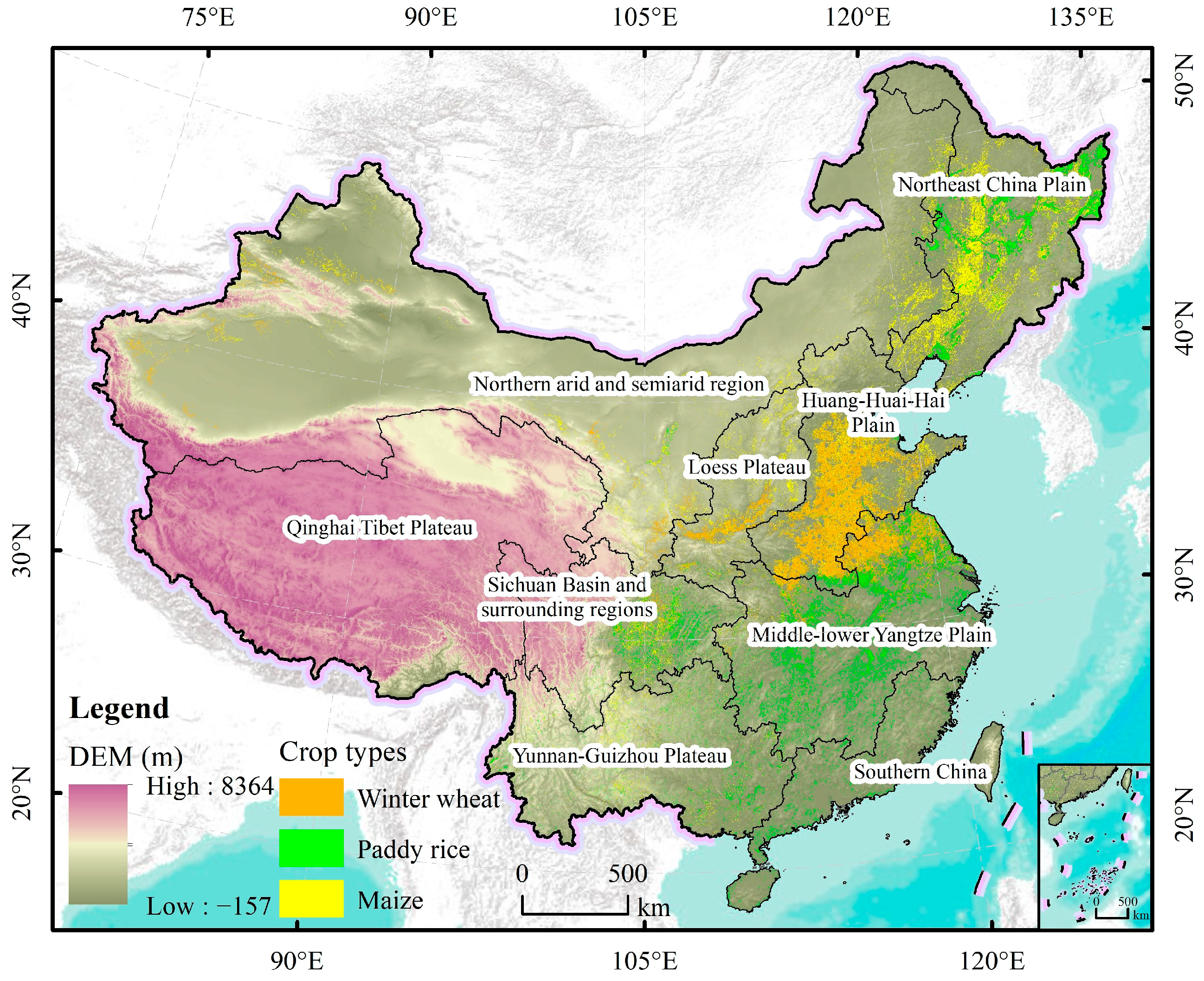
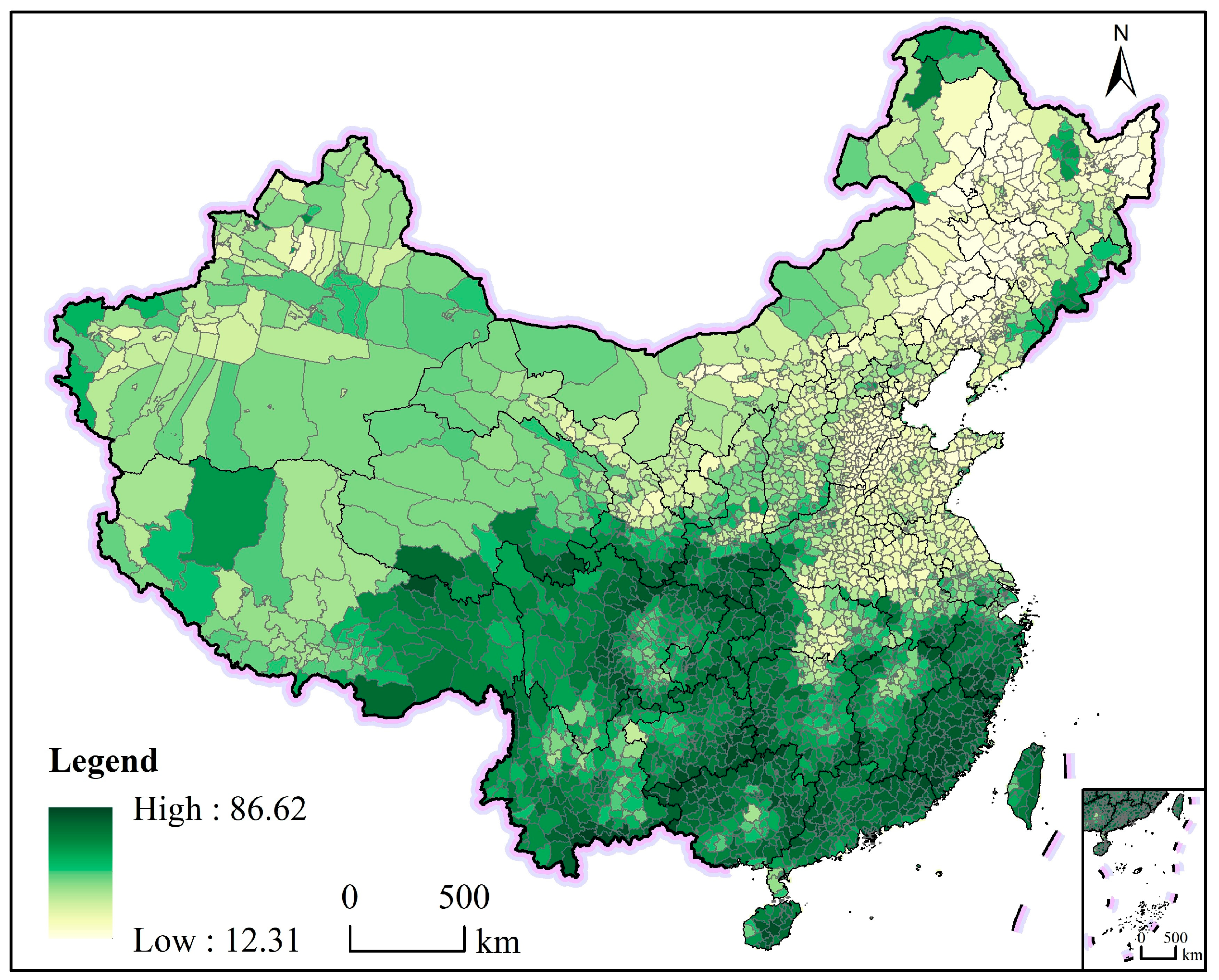
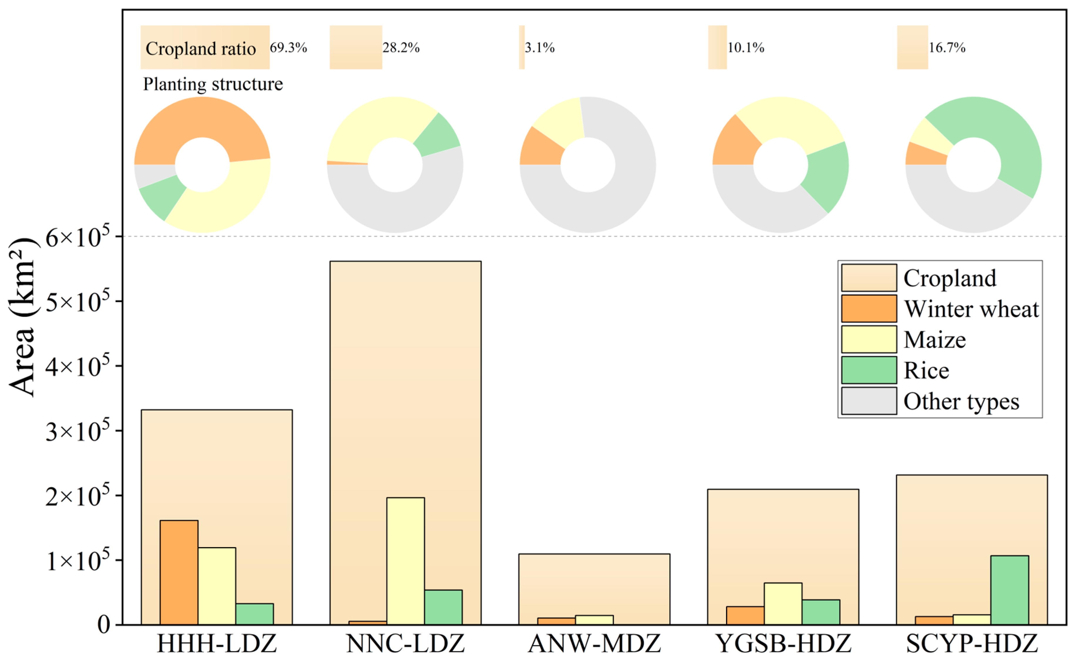
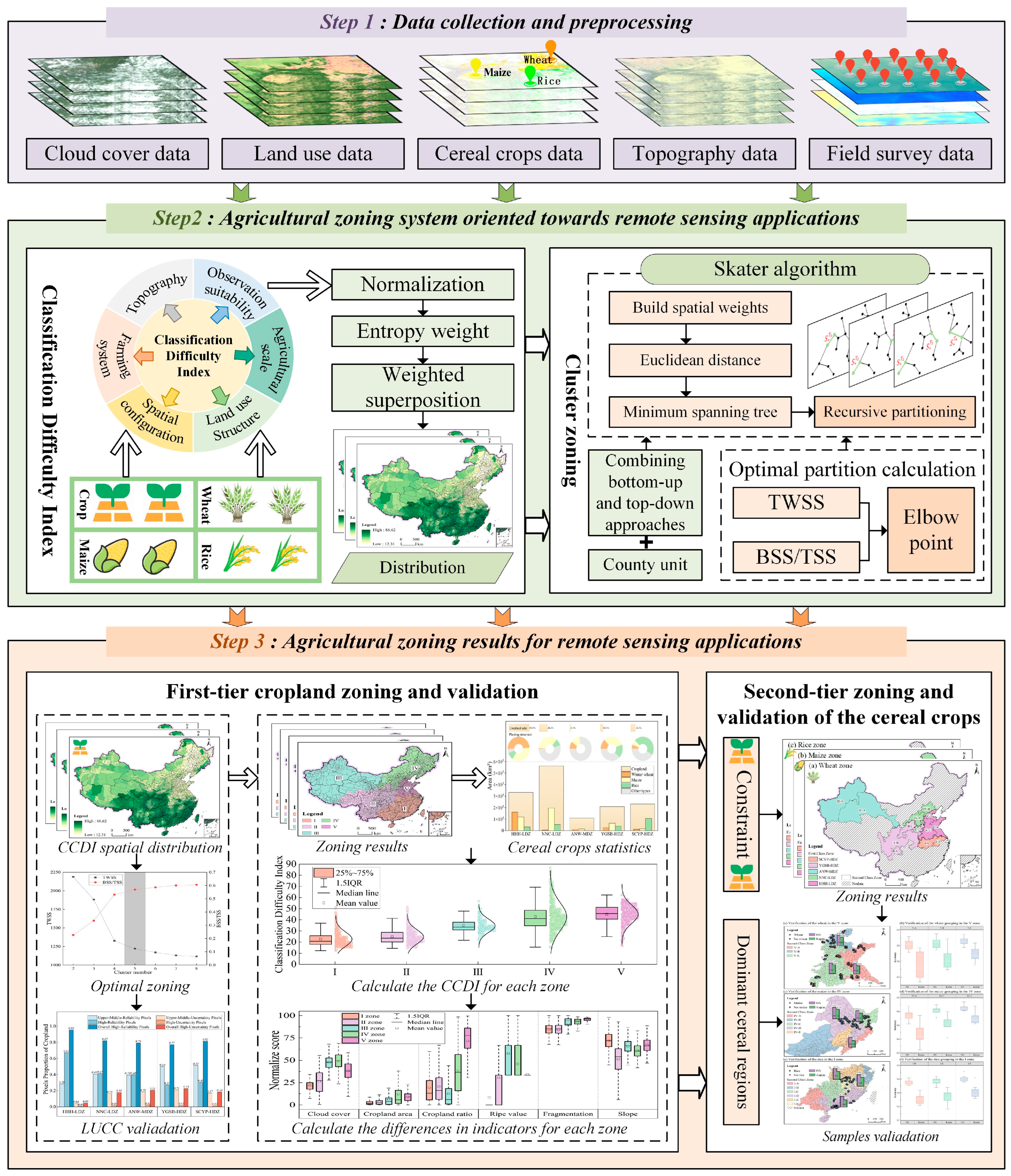
- A hierarchical “cropland–major cereal crops” zoning framework was developed by integrating multi-source Earth observation data with agricultural statistics, effectively capturing the spatial heterogeneity in remote sensing-based cropland and crop-type classification difficulty across China.
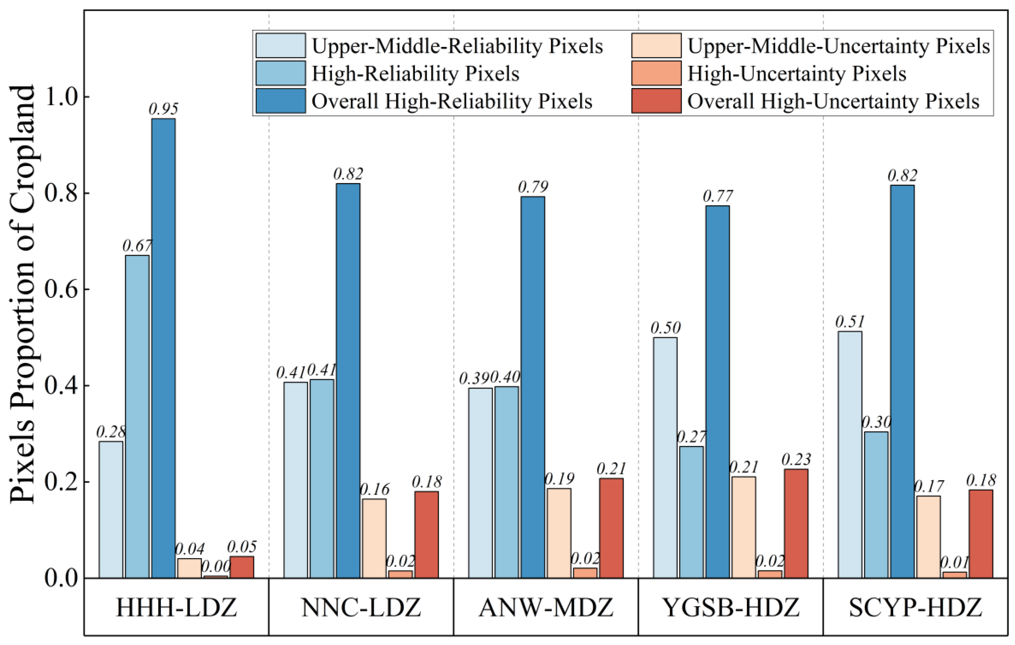
- The proposed entropy-weighted, spatially constrained Skater clustering outperforms conventional clustering methods by achieving an optimal balance between within-zone homogeneity and spatial continuity, and provides preliminary evidence of an inverse relationship between crop-type classification difficulty and classification accuracy for cropland and major cereal crops.
- The zoning framework provides a directly operational spatial basis for stratified sampling, region-specific algorithm calibration, and sensor selection in large-scale cropland and crop-type classification.
- The identified spatial differentiation of classification difficulty supports differentiated remote sensing strategies, enabling more efficient data acquisition and improved classification performance under complex climatic and environmental conditions.
Abstract
1. Introduction
2. Study Area and Data
2.1. Study Area
2.2. Data and Pre-Processing
2.2.1. Remote Sensing Datasets
2.2.2. Land Cover and Land Use Datasets
2.2.3. Crop Datasets
2.2.4. Topographic Data
2.2.5. Affiliated Data
3. Methods
3.1. Indicators for Remote-Sensing-Oriented Agricultural Zoning
3.2. Methodology for Remote-Sensing-Oriented Agricultural Zoning
3.2.1. Agricultural Zoning Based on the Skater Algorithm
3.2.2. First-Tier Zoning Scheme
3.2.3. Second-Tier Zoning Scheme
3.3. Accuracy Assessment
3.3.1. Accuracy Evaluation for the First-Tier Zoning Scheme
3.3.2. Accuracy Evaluation for the Second-Tier Zoning Scheme
3.4. Comparison of Clustering Methods and Rationale for Method Selection
4. Results and Analysis
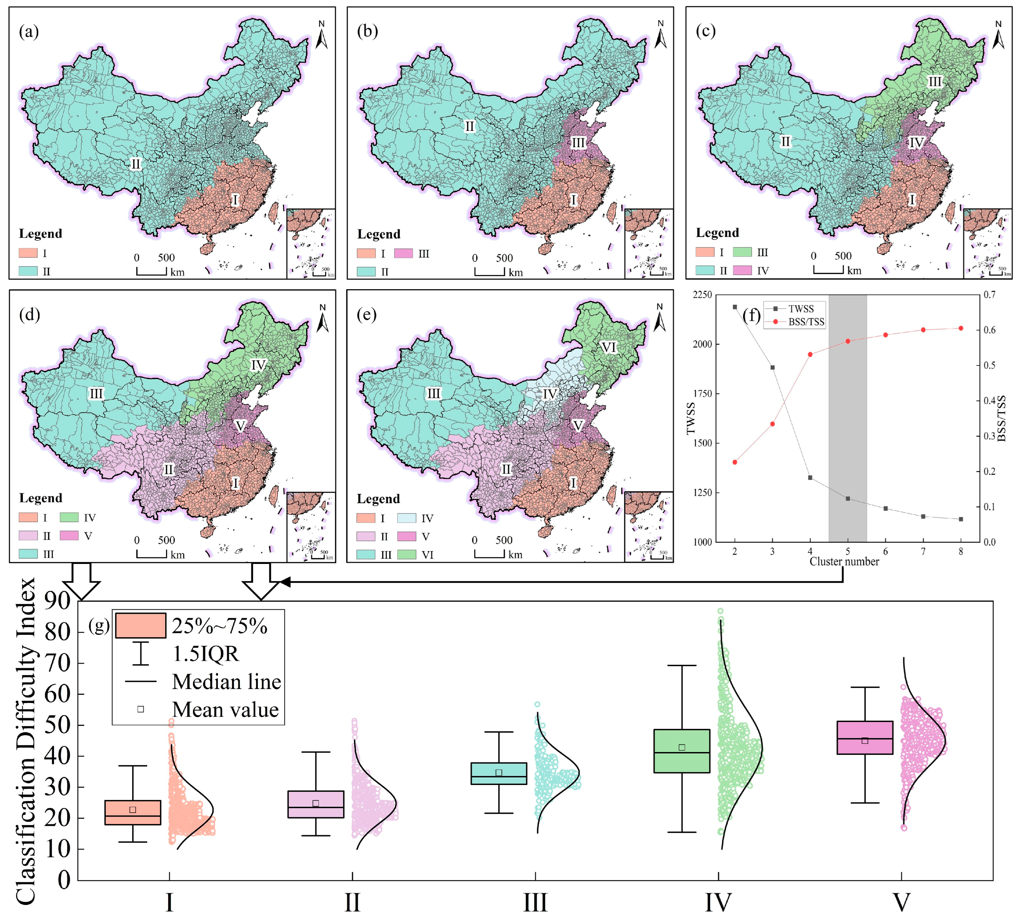
4.1. First-Tier Cropland Zoning and Validation
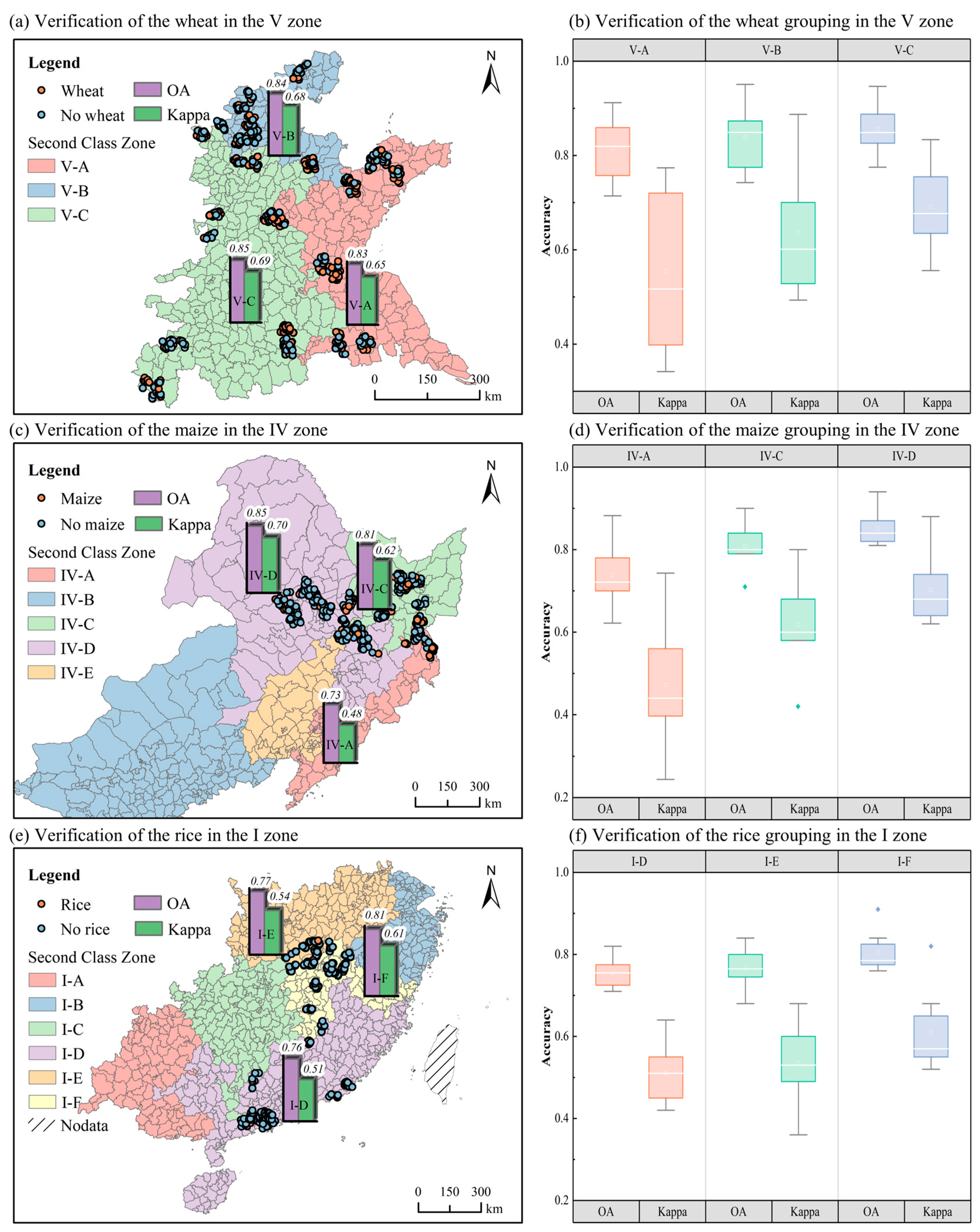
4.2. Second-Tier Zoning and Validation of the Major Cereal Crops
5. Discussion
5.1. Advantages and Limitations
5.1.1. Contributions and Advantages
5.1.2. Limitations
5.2. Influence of the Zoning Methods and Zoning Numbers
5.2.1. Influence of the Zoning Methods
5.2.2. Influence of the Zoning Numbers
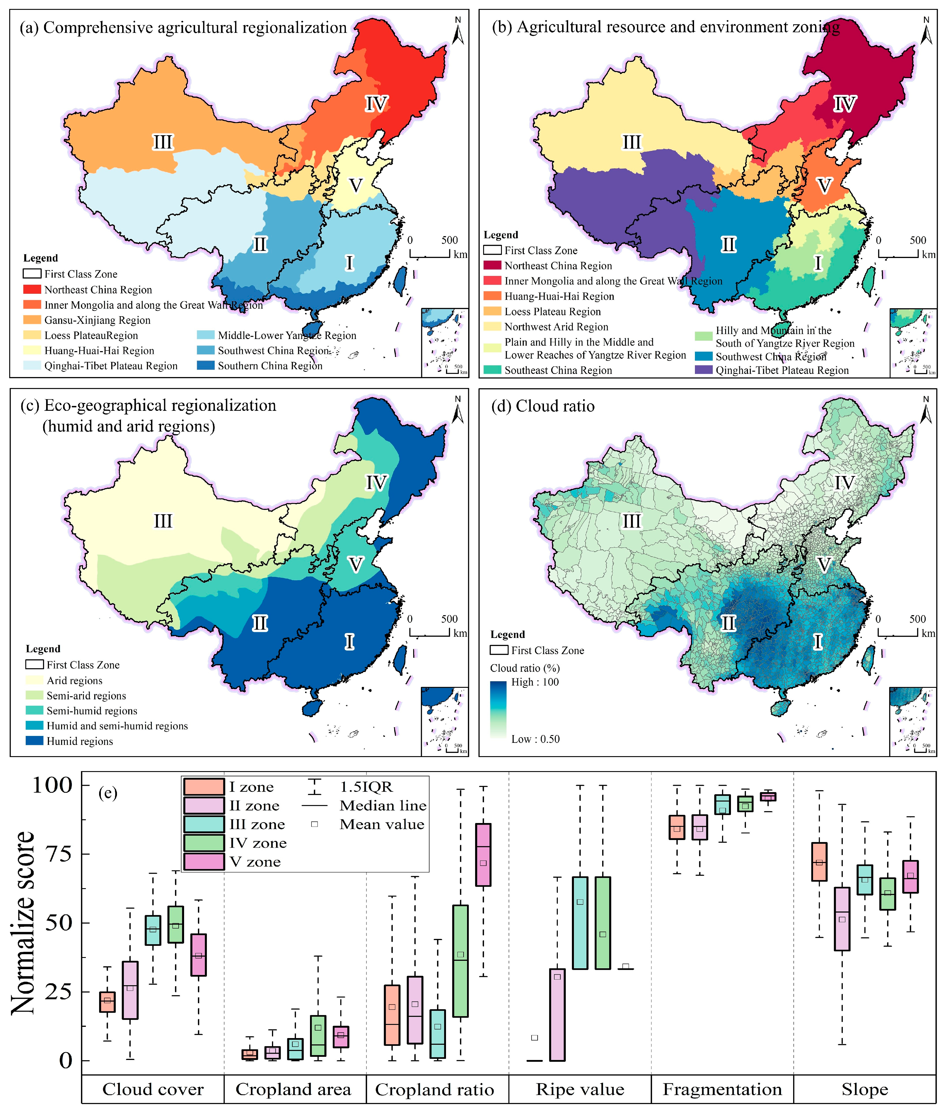
5.3. Consistency Between the Proposed Zoning Scheme and Existing Zoning Frameworks
6. Conclusions
Author Contributions
Funding
Data Availability Statement
Acknowledgments
Conflicts of Interest
Abbreviations
| ARCDI | Agricultural Remote-sensing Classification Difficulty Index |
| NEP | Northeast China Plain |
| YGP | Yunnan–Guizhou Plateau |
| NAS | Northern Arid and Semiarid Region |
| SC | Southern China |
| SBS | Sichuan Basin and Surrounding Regions |
| MYP | Middle–Lower Yangtze Plain |
| QTP | Qinghai–Tibet Plateau |
| LP | Loess Plateau |
| HHH | Huang–Huai–Hai Plain |
| ESA | European Space Agency |
| GEE | Google Earth Engine |
| GAEZ | Global Agro-Ecological Zones |
| AEZ | Agro-Ecological Zones |
| GDEM | Global Digital Elevation Model |
| CRCDI | Cropland Remote-sensing Classification Difficulty Index |
| MCCRCDI | Major Cereal Crops Remote-sensing Classification Difficulty Index |
| MST | Minimum Spanning Tree |
| TWSS | Total Within-Cluster Sum of Squares |
| BSS/TSS | Between-Cluster Sum of Squares to the Total Sum of Squares |
| OA | Overall Accuracy |
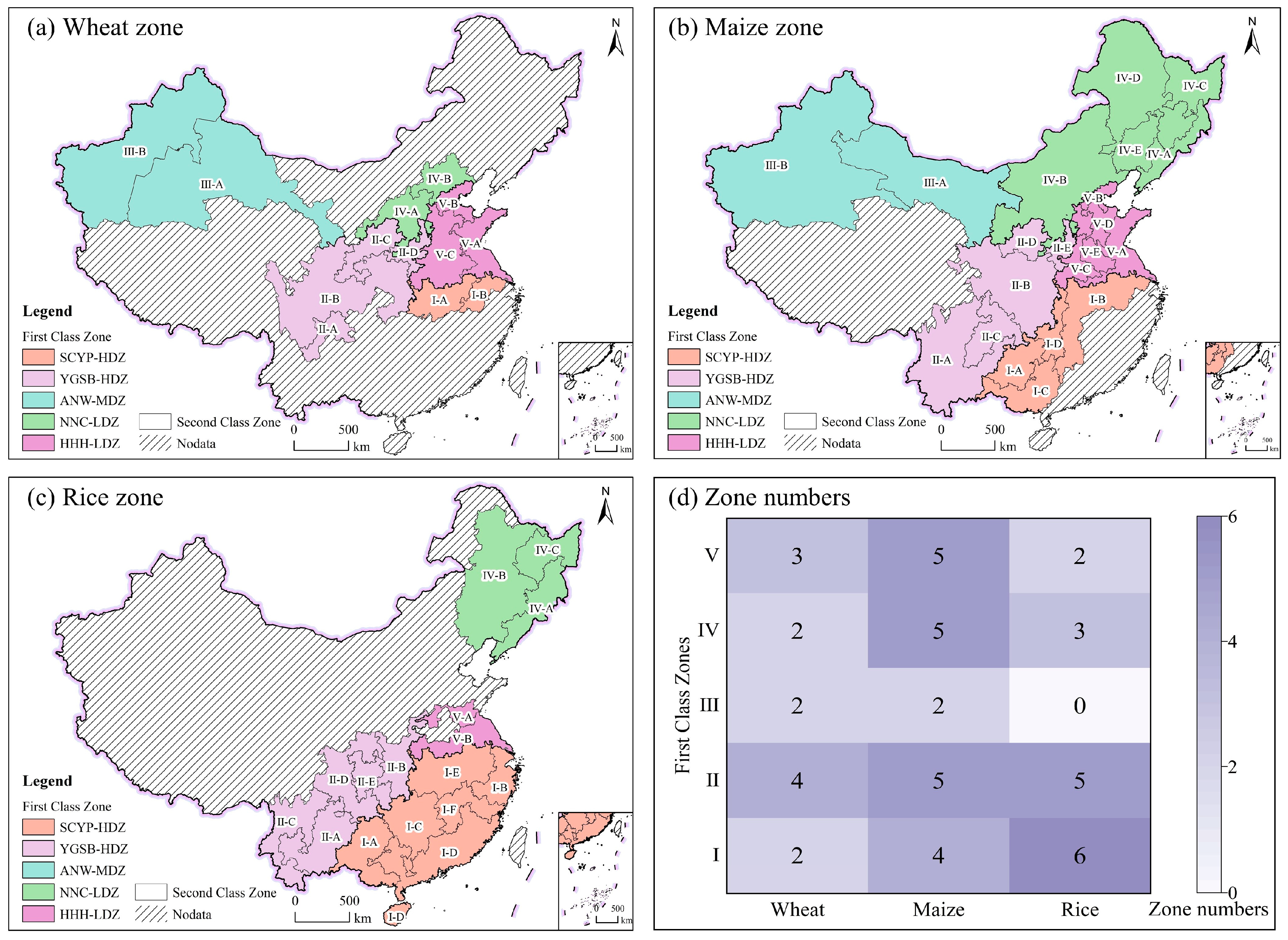
| SCYP-HDZ | South China and Yangtze Plain High Difficulty Zone |
| YGSB-HDZ | Yunnan–Guizhou Plateau–Sichuan Basin High Difficulty Zone |
| ANW-MDZ | Arid Northwest Moderate Difficulty Zone |
| NNC-LDZ | Northeast and North China Margin Low Difficulty Zone |
| HHH-LDZ | Huang-Huai-Hai Plain Low Difficulty Zone |
| QA | Quality Assessment |
| LUCC | Land use/cover change |
References
- López-Lozano, R.; Baruth, B. An evaluation framework to build a cost-efficient crop monitoring system. Experiences from the extension of the European crop monitoring system. Agric. Syst. 2019, 168, 231–246. [Google Scholar] [CrossRef] [Scilit]
- Lu, J.; Li, J.; Fu, H.; Zou, W.; Kang, J.; Yu, H.; Lin, X. Estimation of rice yield using multi-source remote sensing data combined with crop growth model and deep learning algorithm. Agric. For. Meteorol. 2025, 370, 110600. [Google Scholar] [CrossRef] [Scilit]
- Wu, B.; Tian, F.; Zeng, H.; Zhang, M.; Yan, N.; Qin, X.; Ma, Z. Recent advancements of cloud-based global crop monitoring system (CropWatch). Natl. Remote Sens. Bull. 2025, 29, 1918–1937. [Google Scholar] [CrossRef] [Scilit]
- Xu, S.; Zhu, X.; Chen, J.; Zhu, X.; Duan, M.; Qiu, B.; Wan, L.; Tan, X.; Xu, Y.N.; Cao, R. A robust index to extract paddy fields in cloudy regions from SAR time series. Remote Sens. Environ. 2023, 285, 113374. [Google Scholar]
- Liu, T.; Yu, L.; Liu, X.; Peng, D.; Chen, X.; Du, Z.; Tu, Y.; Wu, H.; Zhao, Q. A Global Review of Monitoring Cropland Abandonment Using Remote Sensing: Temporal–Spatial Patterns, Causes, Ecological Effects, and Future Prospects. J. Remote Sens. 2025, 5, 0584. [Google Scholar] [CrossRef] [Scilit]
- Macdonald, R.B.; Hall, F.G. Global Crop Forecasting. Science 1980, 208, 670–679. [Google Scholar] [CrossRef] [Scilit]
- Wu, B.; Zhang, M.; Zeng, H.; Tian, F.; Potgieter, A.B.; Qin, X.; Yan, N.; Chang, S.; Zhao, Y.; Dong, Q.; et al. Challenges and opportunities in remote sensing-based crop monitoring: A review. Natl. Sci. Rev. 2022, 10, nwac290. [Google Scholar] [CrossRef] [Scilit]
- Zhang, H.; Xu, Y.; Lu, Y.; Hasi, E.; Zhang, H.; Zhang, S.; Wang, W. Spatiotemporal variations and driving factors of crop productivity in China from 2001 to 2020. J. Environ. Manag. 2024, 371, 123344. [Google Scholar] [CrossRef] [Scilit]
- Jiang, Y.; Wang, X.; Huo, M.; Chen, F.; He, X. Changes of cropping structure lead diversity decline in China during 1985–2015. J. Environ. Manag. 2023, 346, 119051. [Google Scholar] [CrossRef] [Scilit]
- Wang, X.; Hao, J.-Q.; Dai, Z.-Z.; Haider, S.; Chang, S.; Zhu, Z.-Y.; Duan, J.-j.; Ren, G.-X. Spatial-temporal characteristics of cropland distribution and its landscape fragmentation in China. Farming Syst. 2024, 2, 100078. [Google Scholar] [CrossRef] [Scilit]
- Liu, X.; Wang, Z.; Yang, X.; Cheng, W.; Zhang, J.; Liu, Y.; Liu, B.; Meng, D.; Zeng, X. Remotely-sensed phenology pattern regionalization for land cover classification of natural scenes: A case study in China. Acta Geogr. Sin. 2024, 79, 2206–2229. [Google Scholar] [CrossRef]
- Wang, Z.; Yang, X.; Zhang, J.; Liu, X.; Li, L.; Dong, W.; He, W. A Remote Sensing Intelligent Interpretation Framework Through Geo-Science Zoning for Complex Nature Scenes and Its Preliminary Experiments. J. Geo-Inf. Sci. 2025, 27, 305–330. [Google Scholar] [CrossRef]
- Lan, X.; Wang, J.; Liu, H.; Liu, X.; Guo, H. Research on zonal protection of cultivated land quality in agricultural counties based on spatial heterogeneity. J. Agric. Resour. Environ. 2025, 42, 844–854. [Google Scholar] [CrossRef]
- Liao, Y.; Xie, E.; Chen, W.; Yao, D.; Lei, M.; Dang, Y.; Li, L.; Zhao, J.; Kong, X. Comprehensive zoning of cultivated land quality improvement based on synergistic production characteristics and ecological stress in China. Trans. Chin. Soc. Agric. Eng. 2025, 41, 208–217. [Google Scholar] [CrossRef]
- Xie, Y.; Nhu, A.N.; Song, X.-P.; Jia, X.; Skakun, S.; Li, H.; Wang, Z. Accounting for spatial variability with geo-aware random forest: A case study for US major crop mapping. Remote Sens. Environ. 2025, 319, 114585. [Google Scholar] [CrossRef] [Scilit]
- Sun, H.; Huang, J.; Li, B.; Wang, H. Study on the Regionalization of Paddy Rice Information Acquirement Through Remote Sensing Technology in China. Sci. Agric. Sin. 2008, 41, 4039–4047. [Google Scholar] [CrossRef]
- Liu, Y.; Chen, X.; Chen, J.; Zang, Y.; Wang, J.; Lu, M.; Sun, L.; Dong, Q.; Qiu, B.; Zhu, X. Long-term (2013–2022) mapping of winter wheat in the North China Plain using Landsat data: Classification with optimal zoning strategy. Big Earth Data 2024, 8, 494–521. [Google Scholar] [CrossRef] [Scilit]
- Wang, Y.; Yuan, Y.; Yuan, F.; Liu, X.; Tian, Y.; Zhu, Y.; Cao, W.; Cao, Q. Optimizing management zone delineation through advanced dimensionality reduction models and clustering algorithms. Precis. Agric. 2025, 26, 68. [Google Scholar] [CrossRef] [Scilit]
- Wang, Y.; Yu, H.; Lu, L. Spatio-temporal pattern and functional zoning of ecosystem services in the Yangtze River Delta region based on spatially constrained K-means. Acta Ecol. Sin. 2024, 44, 7087–7104. [Google Scholar] [CrossRef]
- Li, X.; Luo, M.; Zhao, Y.; Zhang, H.; Ge, E.; Huang, Z.; Wu, S.; Wang, P.; Wang, X.; Tang, Y. A daily high-resolution (1 km) human thermal index collection over the North China Plain from 2003 to 2020. Sci. Data 2023, 10, 634. [Google Scholar] [CrossRef] [Scilit]
- Meng, F.; Chen, H.; Tan, Y.; Xiong, W. Changes in crop mix and the effects on agricultural carbon emissions in China. Int. J. Agric. Sustain. 2024, 22, 2335141. [Google Scholar] [CrossRef] [Scilit]
- Qiu, B.; Hu, X.; Chen, C.; Tang, Z.; Yang, P.; Zhu, X.; Yan, C.; Jian, Z. Maps of cropping patterns in China during 2015–2021. Sci. Data 2022, 9, 479. [Google Scholar] [CrossRef] [Scilit]
- AssunÇão, R.M.; Neves, M.C.; Câmara, G.; Da Costa Freitas, C. Efficient regionalization techniques for socio-economic geographical units using minimum spanning trees. Int. J. Geogr. Inf. Sci. 2006, 20, 797–811. [Google Scholar] [CrossRef] [Scilit]
- Aydin, O.; Janikas, M.V.; Assunção, R.M.; Lee, T.-H. A quantitative comparison of regionalization methods. Int. J. Geogr. Inf. Sci. 2021, 35, 2287–2315. [Google Scholar] [CrossRef] [Scilit]
- Lage, J.P.; Assunção, R.M.; Reis, E.A. A Minimal Spanning Tree Algorithm Applied to Spatial Cluster Analysis. Electron. Notes Discret. Math. 2001, 7, 162–165. [Google Scholar] [CrossRef] [Scilit]
- Amoroso, N.; Cilli, R.; Nitti, D.O.; Nutricato, R.; Iban, M.C.; Maggipinto, T.; Tangaro, S.; Monaco, A.; Bellotti, R. PSI Spatially Constrained Clustering: The Sibari and Metaponto Coastal Plains. Remote Sens. 2023, 15, 2560. [Google Scholar] [CrossRef] [Scilit]
- Huang, C.; You, S.; Liu, A.; Li, P.; Zhang, J.; Deng, J. High-Resolution National-Scale Mapping of Paddy Rice Based on Sentinel-1/2 Data. Remote Sens. 2023, 15, 4055. [Google Scholar] [CrossRef] [Scilit]
- Tang, K.; Chen, X.; Liu, T.; Li, A.; Tang, Y.; Yang, P.; Chen, J. AnytimeFormer: Fusing irregular and asynchronous SAR-optical time series to reconstruct reflectance at any given time. Remote Sens. Environ. 2026, 333, 115120. [Google Scholar] [CrossRef] [Scilit]
- Li, C.; Lei, L.; Jia, X.; Xiong, X.; Zhang, X. Accuracy and applicability assessment of vegetation types of the land cover products produced in China. Ecol. Indic. 2025, 174, 113506. [Google Scholar] [CrossRef] [Scilit]
- Li, P.; Wang, Y.; Wang, C.; Tian, L.; Lin, M.; Xu, S.; Zhu, C. A Comparison of Recent Global Time-Series Land Cover Products. Remote Sens. 2025, 17, 1417. [Google Scholar] [CrossRef] [Scilit]
- Xue, J.; Zhang, X.; Chen, S.; Hu, B.; Wang, N.; Shi, Z. Quantifying the agreement and accuracy characteristics of four satellite-based LULC products for cropland classification in China. J. Integr. Agric. 2024, 23, 283–297. [Google Scholar] [CrossRef] [Scilit]
- Shi, P.; Wang, J.; Zhang, G.; Kong, F.; Wang, J. Research review and prospects of natural disasters regionalization in China. Geogr. Res. 2017, 36, 1401–1414. [Google Scholar]
- Zhu, Q.; Ran, L.; Zhang, Y.; Guan, Q. Integrating geographic knowledge into deep learning for spatiotemporal local climate zone mapping derived thermal environment exploration across Chinese climate zones. ISPRS J. Photogramm. Remote Sens. 2024, 217, 53–75. [Google Scholar] [CrossRef] [Scilit]
- Hao, G.; Lei, D.; Lun, W.; Yu, L. Tackling spatial heterogeneity in geographical analysis: An overview. Acta Geogr. Sin. 2025, 80, 567–585. [Google Scholar] [CrossRef]
- Kim, N.; Yoon, Y. Regionalization for urban air mobility application with analyses of 3D urban space and geodemography in San Francisco and New York. Procedia Comput. Sci. 2021, 184, 388–395. [Google Scholar] [CrossRef] [Scilit]
- Xu, E. Dataset of Agricultural Resource and Environment Zoning of China. J. Glob. Change Data Discov. 2021, 5, 19–26. [Google Scholar] [CrossRef] [Scilit]
- Wang, F.; Li, B.; Tian, S.; Zheng, D.; Ge, Q. Updated scheme for eco-geographical regionalization in China. Acta Geogr. Sin. 2024, 79, 3–16. [Google Scholar] [CrossRef]







| Element Layer | Indicator Layer | Indicator Description | Effect Direction | Weight (%) |
|---|---|---|---|---|
| Remote sensing image availability | Cropland cloud cover frequency | Ratio of cloud-covered days to total days over cropland | Negative | 14.126 |
| Agricultural scale | Cropland area | Total area of cropland within the region | Positive | 38.787 |
| Land use structure | Cropland proportion | Ratio of cropland area to total regional area | Positive | 23.421 |
| Farming system | Cropping intensity | Frequency and rhythm of land use and planting within a year | Negative | 13.521 |
| Spatial configuration | Cropland fragmentation | Degree to which cropland is subdivided by other land-cover types | Negative | 5.609 |
| Topographic conditions | Cropland slope | Mean slope of cropland within the region | Negative | 4.535 |
| Element Layer | Indicator Layer | Indicator Description | Effect Direction | Weight (%) |
|---|---|---|---|---|
| Remote sensing image availability | Major cereal crop cloud cover frequency | Total area of major crop within the region | Negative | 14.126 |
| Agricultural scale | Major cereal crop area | Ratio of major crop area to total regional area | Positive | 38.787 |
| Land use structure | Major cereal crop proportion | Frequency and rhythm of land use and planting within a year | Positive | 23.421 |
| Farming system | Cropping intensity | Degree to which major crop is subdivided by other land-cover types | Negative | 13.521 |
| Spatial configuration | Major cereal crop fragmentation | Mean slope of major crop within the region | Negative | 5.609 |
| Topographic conditions | Major cereal crop slope | Total area of major crop within the region | Negative | 4.535 |
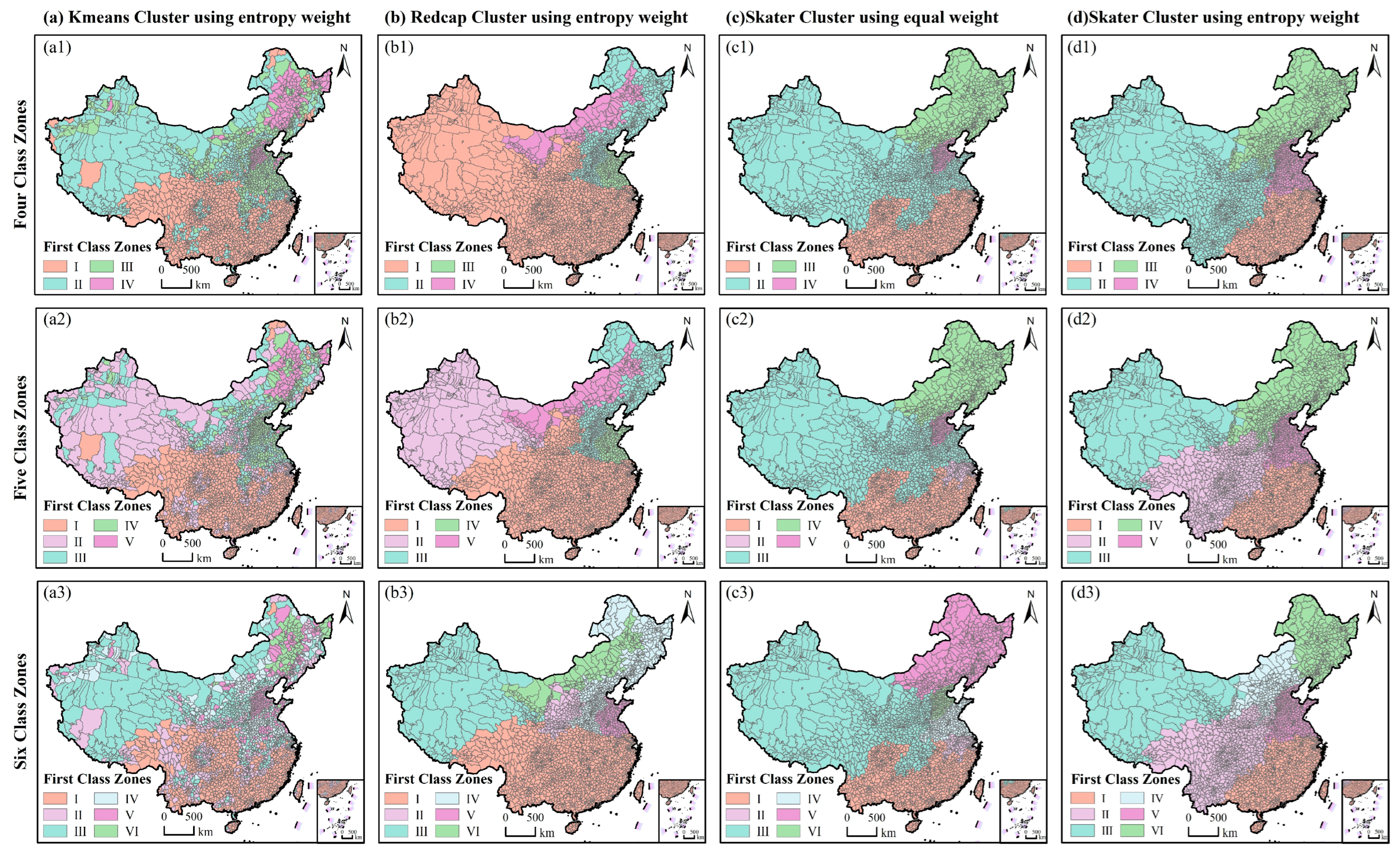
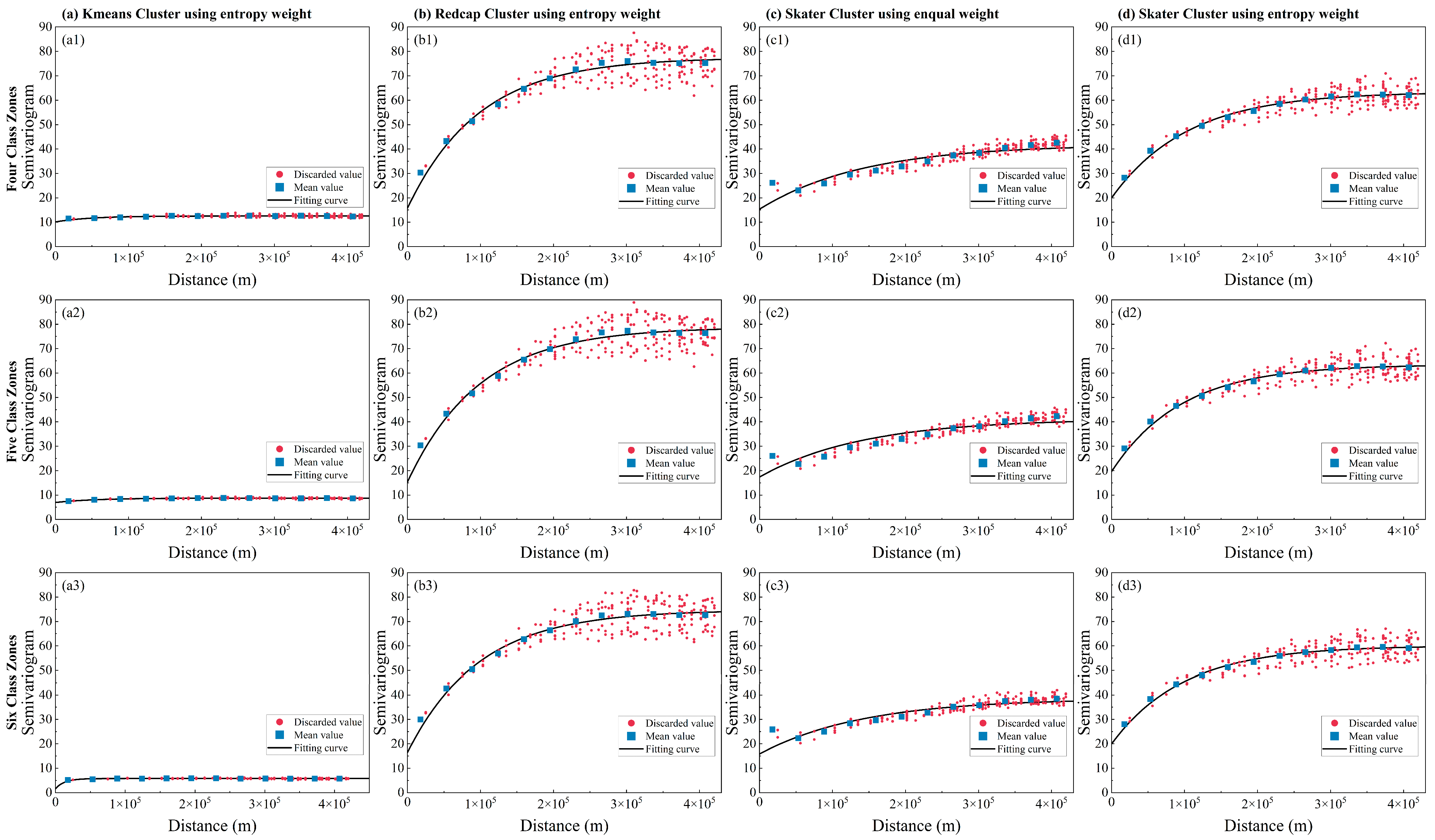
| Moran Index | Kmeans (Entropy Weight) | Redcap (Entropy Weight) | Skater (Equal Weight) | Skater (Entropy Weight) |
|---|---|---|---|---|
| Four Class Zones | 0.04 | 0.14 | 0.19 | 0.11 |
| Five Class Zones | 0.04 | 0.12 | 0.14 | 0.10 |
| Six Class Zones | 0.02 | 0.11 | 0.12 | 0.10 |
Disclaimer/Publisher’s Note: The statements, opinions and data contained in all publications are solely those of the individual author(s) and contributor(s) and not of MDPI and/or the editor(s). MDPI and/or the editor(s) disclaim responsibility for any injury to people or property resulting from any ideas, methods, instructions or products referred to in the content. |
© 2026 by the authors. Licensee MDPI, Basel, Switzerland. This article is an open access article distributed under the terms and conditions of the Creative Commons Attribution (CC BY) license.
Share and Cite
Zheng, X.; Chen, Y.; Pan, Y.; Zhu, X.; Li, L. A Two-Tier Zoning Framework for Cropland and Crop-Type Classification in China. Remote Sens. 2026, 18, 831. https://doi.org/10.3390/rs18050831
Zheng X, Chen Y, Pan Y, Zhu X, Li L. A Two-Tier Zoning Framework for Cropland and Crop-Type Classification in China. Remote Sensing. 2026; 18(5):831. https://doi.org/10.3390/rs18050831
Chicago/Turabian StyleZheng, Xuechang, Yixin Chen, Yaozhong Pan, Xiufang Zhu, and Le Li. 2026. "A Two-Tier Zoning Framework for Cropland and Crop-Type Classification in China" Remote Sensing 18, no. 5: 831. https://doi.org/10.3390/rs18050831
APA StyleZheng, X., Chen, Y., Pan, Y., Zhu, X., & Li, L. (2026). A Two-Tier Zoning Framework for Cropland and Crop-Type Classification in China. Remote Sensing, 18(5), 831. https://doi.org/10.3390/rs18050831