


Highlights
What are the main findings?
- A saliency-constrained multi-peak Doppler spectrum decomposition and classification method is developed to separate mixed Doppler power spectra into independent subpeaks, and each subpeak is classified using polarimetric features to identify bird motion subpeaks.
- The proposed Bird Roost Index (BRI), integrating the number of bird motion subgroups and their radial velocity dispersion, enables reliable identification of communal bird roosting activity.
What are the implications of the main findings?
- The proposed method provides a multi-peak Doppler spectral analysis framework that breaks through the limitations of classifying mixed biological echoes within a single weather radar resolution cell.
- The BRI derived from sub-spectral features enables robust identification of bird roosts under weak echo intensity or incomplete structures, supporting the monitoring of public bird roosts in the Dongting Lake Basin.
Abstract
Monitoring bird activity at public roosts is essential for understanding stopover behavior during migration, assessing ecological change, and supporting conservation strategies. Existing weather radar-based roost detection methods primarily rely on high-reflectivity ring-shaped echoes, which can lead to missed detections when roost-related echo structures are weak or indistinct. To address this limitation, this study proposes a saliency-constrained multi-peak spectral approach for monitoring and identifying public bird roosts using weather radar. At the radar resolution-cell scale, a saliency-constrained multi-peak Doppler spectrum decomposition and classification method is developed. Mixed Doppler power spectra are decomposed into multiple independent subpeaks through spectral peak saliency detection, and spectral polarimetric features are utilized to identify bird-related subpeaks, yielding a set of bird motion subgroups within each resolution cell. On this basis, a Bird Roost Index (BRI) is introduced, which couples the number of bird subgroups with their radial velocity dispersion to quantitatively characterize the complexity of bird motion modes in local airspace. Finally, the proposed method is applied to operational S-band weather radar observations collected over the Dongting Lake Basin roosts region during the spring season. The results demonstrate that the BRI exhibits strong spatial consistency and coherent temporal evolution, enabling robust characterization of communal roosting activity. This confirms the robustness of the proposed approach and highlights its potential for operational monitoring of migratory bird communal roosts using weather radar spectral data.
1. Introduction
Each year, hundreds of billions of birds, insects, and bats migrate over hundreds to thousands of kilometers to locate favorable habitats [1]. Animal migration is a key component of terrestrial ecosystems that contributes to pollination [2], food web formation [3], pathogen transmission [4], and directly affects human activities. China forms a major global corridor for animal migration and a critical stopover for Asian migratory birds [5]. The middle and lower Yangtze River region hosts at least 23 key wetlands providing roosts for over one million overwintering waterbirds annually, making it one of the most important waterbird wintering areas in China and Asia [6]. Monitoring bird activity in public roosts is essential to determine migration onset assess environmental changes, and guide conservation measures [7].
Compared with specialized entomological and ornithological radars, operational weather radars offer high temporal resolution, wide coverage, and stable operation, making them a key tool for tracking aerial migration routes and public roosts [8,9]. Current weather radar networks capable of large-scale monitoring of migratory animals are concentrated in Europe [10], the United States [11,12], and China [13], providing networked coverage at national and regional scales [14]. With the comprehensive upgrade of weather radar networks, dual-polarization radars measure both horizontal (H) and vertical (V) scattering properties, providing distinctive base products for biological echo discrimination [15,16]. Polarimetric variables such as differential reflectivity (ZDR), differential phase (), and correlation coefficient (ρhv) characterize scatterer shape, orientation, stability, and dielectric properties, thereby enhancing the identification of biological targets [17,18]. Biological targets exhibit low correlation between polarimetric channels due to their nonspherical shape and dynamic motion. Precipitation is nearly spherical with , . Furthermore dual-polarization parameters further enhance discrimination of insect and bird scatterers [15,19,20]. Zrinc et al. identified ZDR and δ as the primary parameters for distinguishing birds from insects [21], with birds exhibiting low ZDR values between −1 and 3 dB while insects can reach up to 10 dB during warm seasons. Birds show significantly higher exceeding 100° whereas insects remain below 40°. Muller et al. reported that nocturnal insects observed by S/X-band weather radars can exhibit ZDR up to 7 dB [22]. Dockter et al. designated echo regions with or as non-bird scatterer areas and proposed radial velocity features as another key criterion for bird identification using a threshold of radial velocity standard deviation σr < 2 m/s to exclude mixed insect echoes [23].
Synchronous departures of birds from roosting sites produce short-lived radial expansions that appear as localized ring-shaped high-reflectivity signatures in weather radar observations. In 1998 Gauthreaux et al. analyzed bird echo characteristics and migration quantification using WSR-88D base products [24] and showed that localized ring-shaped echoes associated with mass departures or returns can indicate the locations of bird roosting sites. Subsequently, the high-reflectivity ring-shaped echoes observed by weather radar were used to locate purple martin roosts and to analyze their pre-migratory roosting behavior [25]. Precious Jatau et al. [26] developed a fuzzy logic classification algorithm based on polarimetric features and spatial texture differences between birds and insects. They applied the algorithm to clear-air radar echoes across the United States in September 2017 and successfully identified purple martin roosting sites from high-reflectivity ring-shaped echo regions. Carmen Chilson et al. [27] first applied neural networks to radar imagery using ring-shaped high-reflectivity signatures during mass departures to detect purple martin and tree swallow roosts. However, weak bird echoes often produce indistinct rings resulting in missed detections. Cheng et al. [28] rendered multi-elevation reflectivity and radial velocity as radar images and developed an intelligent system for roost ring detection based on a pretrained neural network. Subsequently Perez et al. [29] used a Fast-RCNN model to detect dynamic ring-shaped echoes in consecutive radar frames and developed an automated annotation tool to identify departing bird activity. Sun et al. [7] proposed a method to identify localized bird echoes using differential phase from S-band dual-polarization radar and employed unsupervised learning with Bayesian posterior inference to detect and quantify bird activity at public roosts in the middle Huai River basin and near the Liao River delta.
High-reflectivity annular echo patterns derived from weather radar base data have been widely used for large-scale monitoring of biological roosting activity [27,28]. However, they exhibit inherent limitations for operational and fine-scale identification. In practical observations, echoes associated with bird roosts do not always present clear and continuous ring-shaped structures. Influenced by factors such as a bird’s size, synchronization of takeoff, and background clutter, roost-related echoes often appear with low reflectivity, fragmented structures, or incomplete spatial morphology, leading structure-based detection approaches to miss weak signal or nontypical roosting scenarios. Moreover, under the approximately 250 m volumetric resolution of an S-band weather radar, bird echoes frequently coexist with insect scatterers within the same resolution volume. As a result, base data products represent only the aggregated response of multiple scatterer types, and the annular echo signature is further attenuated through spectral integration and spatial smoothing. In contrast, raw radar IQ data preserve the full Doppler spectral structure. Even when reflectivity is weak or spatial patterns are indistinct, different targets can still form multi-peak features in the spectral domain due to differences in radial velocity and motion coherence. This provides data basis for extracting bird roost activity from mixed biological echoes.
Motivated by the intrinsic limitation of base data-level biological echo classification under mixed scattering conditions, this study proposes a spectral-domain framework for communal bird roost monitoring using weather radar IQ data. Instead of operating on reflectivity ring structures, the proposed method resolves coexisting motion components directly at the Doppler spectral level. A saliency-constrained multi-peak Doppler spectrum decomposition and classification method is developed to separate mixed power spectra within each radar resolution volume into independent subpeaks under noise-adaptive significance constraints, and each subpeak is classified using polarimetric features to identify bird-dominated motion components within a single radar resolution cell. Based on the resolved bird motion subgroups, a Bird Roost Index (BRI) is constructed from subgroup count and radial velocity dispersion, characterizing the collective kinematic complexity of bird assemblages in the local airspace. This formulation shifts roost detection from reflectivity-structure recognition to motion-mode inference. The spatial consistency of BRI derived from operational S-band radar observations is further examined to confirm stable overwintering waterbird roost locations near Dongting Lake.
2. Materials and Methods
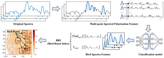
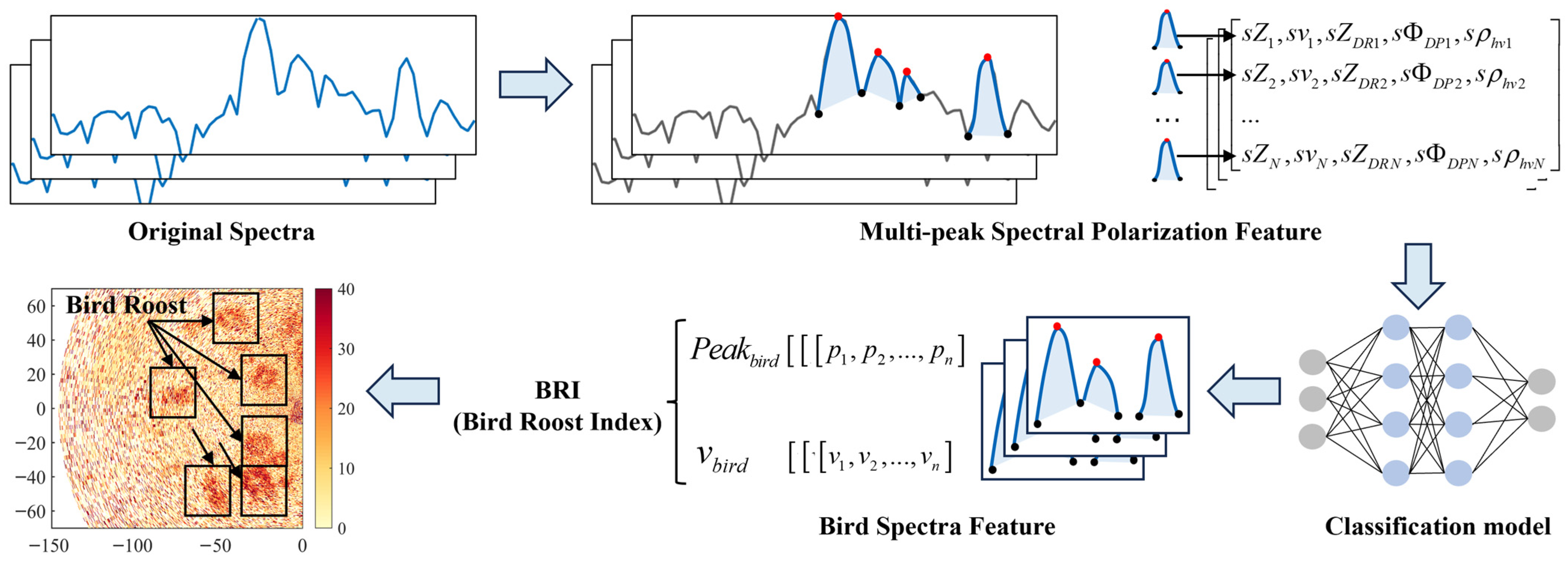
This section presents the specific implementation of the proposed algorithm. First, the computation of spectral polarimetric features is introduced. Next, a saliency-constrained multi-peak Doppler spectrum decomposition and classification method is presented, which is used to extract subpeak spectral features and identify bird-related spectral intervals from mixed spectra. Finally, a Bird Roost Index retrieval method is presented to quantitatively represent the spatial distribution of bird roosts in radar PPI image. The overall processing framework is illustrated in Figure 1.
Figure 1.
The overall processing framework of the proposed method.
2.1. Spectral Polarization Feature Extraction
Operational weather radars possess Doppler measurement capabilities. Spectral polarimetric analysis combines Doppler measurements with polarimetric parameters to study the polarization response within a radar resolution volume. The radar receiver samples echoes to obtain I and Q channels, yield the complex echo signal , where and are the in-phase and quadrature components of the nth pulse. For M transmitted pulses, each resolution volume contains M spectral coefficients , which are obtained by performing a column-wise FFT on the IQ signals [30]:
where M denotes the number of accumulated pulses used for Doppler processing within a resolution volume. denotes the complex voltage and the window length used in the DFT. For an operational China New Generation Weather Radar (CINRAD) S-band radar in VCP21 mode, M is typically 64. Larger M improves Doppler frequency resolution but reduces temporal resolution and increases scan time. The time-series IQ signal is transformed via DFT into k spectral coefficients mapping to radial velocities, and the squared magnitude of each coefficient yields the echo power spectral density :
The statistical characteristics of the power spectral density in the frequency domain can be described by its spectral moments, which correspond to key physical parameters of weather radar echoes. In this study, the prefix s denotes spectral-domain quantities derived from Doppler spectra [31,32]. The spectral power is derived from the zeroth-order spectral moment:
The spectral velocity is derived from the first-order spectral moment, corresponding to the target’s radial Doppler velocity or the mean radial motion observed by the radar:
where denotes the velocity corresponding to the k-th spectral point, and is the Doppler spectrum centered at zero frequency.
The spectrum width is derived from the second-order central moment of the power spectral density, which describes the dispersion of spectral energy around the mean velocity. It characterizes the variability of velocities within the target ensemble and reflects the coherence of their motion.
The radar reflectivity spectrum is determined by the received echo power and the radar system constant, and can be expressed as:
where denotes the received echo power, N denotes the system noise, R denotes the range to the target, A is the two-way atmospheric attenuation (dB), and is the system calibration constant representing the equivalent reflectivity of a standard target at 0 dB SNR [33]. For operational weather radar, system calibration must be periodically calibrated to compensate for transmitter power decay, variations in system noise, and receiver gain drift, ensuring long-term stability and quantitative consistency of reflectivity products.
Dual-polarization weather radars transmit and receive H and V channels polarized waves, capturing the scattering properties of airborne targets along orthogonal directions. Compared to single-polarization radars, dual-polarization systems provide additional variables such as ZDR, and ρhv to characterize target geometry and orientation, offering a basis for inferring size, shape, and other properties of non-spherical biological scatterers [17,18].
The spectral differential reflectivity is defined as the difference between the H and V spectral reflectivity:
The spectral differential phase arises from two contributions: the propagation phase shift induced by medium anisotropy (Kdp) and the backscattering phase shift δ generated during target–wave interaction. δ directly reflects the intrinsic polarimetric scattering properties of the target and is particularly sensitive to the nonspherical geometry and orientation of biological scatterers.
The spectral copolar correlation coefficient sρhv quantifies the correlation between the echo signals received in the horizontal and vertical polarization channels:
sρhv characterizes the morphological symmetry of scatterers along two orthogonal polarization directions, indicating whether the target behaves as a near-isotropic (quasi-spherical) scatterer.
2.2. Saliency-Constrained Multi-Peak Doppler Spectrum Decomposition and Classification Method
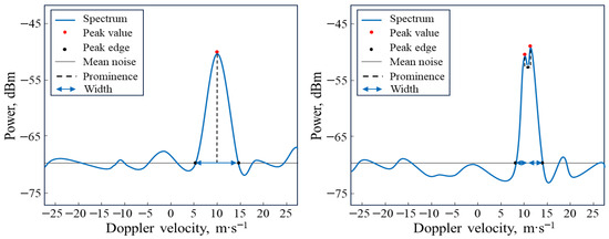
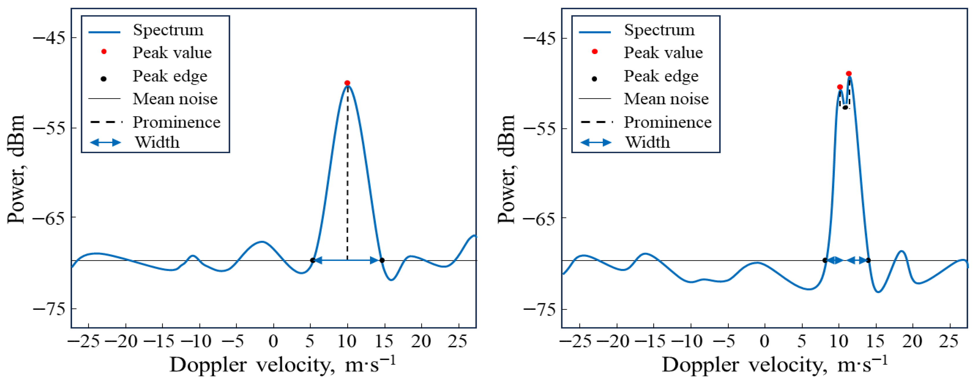
This study proposes a saliency-constrained multi-peak Doppler spectrum decomposition method. By applying spectral peak saliency-based energy de-mixing to multi-peak power spectra, multiple independent scattering motion modes can be resolved within a single radar resolution volume. The process is shown in Figure 2.
Figure 2.
Saliency-constrained multi-peak Doppler spectrum decomposition method.
The low-power portion of the radar spectrum is dominated by thermal noise and FFT leakage. After obtaining the power spectral density within a resolution volume (Equation (3)), the noise threshold Tn is estimated using the GMAP method [34]. Only spectral points with are retained as the candidate spectrum , corresponding to the spectral interval , where M is the total number of original spectral points. Local maxima are then detected within the valid interval to form a set of candidate spectral peaks .
To quantify the separability between a spectral peak and its surrounding mixed background, a spectral peak saliency metric is introduced. For each candidate peak , the spectrum is searched to the left and right to identify the minimum-power points connecting to its adjacent peaks, denoted as and , respectively. The saliency of the spectral peak is then defined as:
Spectral prominence quantifies the energetic separability between a spectral peak and its local background, enabling distinguishment of independent velocity scatterers from internal fluctuations within a mixed group. For an independent velocity population, the Doppler spectrum is typically separated from adjacent peaks by a distinct power minimum, resulting in a shallow valley and high peak prominence . In this case, the peak can be uniquely delineated by the interval . In contrast, peaks arising from intra-group fluctuations lack clear valley separation from neighboring peaks, exhibiting deeper valleys and low prominence . Such peaks are not treated as independent populations but are merged with adjacent peaks, and the search is extended to more distant minima to determine the true spectral extent of the physical group. Accordingly, candidate peaks are required to satisfy joint constraints on the spectral power structure:
where denotes the spectral width is required to span at least three spectral points. The width constraint is imposed to ensure reliable Doppler-domain estimation of spectral polarimetric parameters. The computation of the spectral correlation coefficient requires sample averaging along the Doppler dimension to suppress clutter contamination and reduce estimation variance. A minimum of three contiguous Doppler bins is therefore required to obtain stable polarimetric estimates [31]. The nonzero prominence constraint enforces a necessary condition for physical separability: a candidate peak must be separated from adjacent components by at least one local minimum in the Doppler power spectrum. This allows the retention of weak scatterers with low peak power, such as individual birds or small insect groups, provided that a resolvable valley exists. The proposed peak detection scheme is not based on a fixed empirical threshold. The prominence of each candidate peak is computed relative to its adjacent local minima rather than compared against an absolute power level. Under different signal-to-noise ratio conditions, both the peak amplitude and the valley depth are related to the current noise level, thereby maintaining the prominence of the independent sub-spectra groups. Peak separability is thus determined by the spectral structure instead of a fixed amplitude threshold.
Finally, the algorithm outputs the interval of each independent spectral peak . For a given peak interval , all spectral points within the interval are used to compute the spectral polarimetric parameters of the corresponding subpeak, while the peak magnitude and its associated peak velocity are also obtained.
After the multi-peak Doppler spectrum decomposition, the resulting spectral peaks exhibit systematic differences in radial velocity location, power distribution, and polarimetric response. These differences reflect the superposition of distinct scatterer types within a single radar resolution volume, such as insects, birds, and other targets. Consequently, echo components must be classified at the sub-spectral level to enable fine-grained echo discrimination within all resolution cells across PPI scans.
Dual-polarization radar variables have been widely demonstrated to be effective for distinguishing insect and bird echoes [15,19,20]. In this study, a feature dataset is constructed from the spectral polarimetric parameters of individual spectral peaks within each resolution cell. To achieve accurate identification of bird roosting activity, biological migration cases under non-meteorological conditions are selected using base radar products. Localized bird roosting echoes and insect-dominated echoes are manually annotated using the interactive labeling tool EISeg, assisted by the publicly available high-accuracy model HRNet18-OCR64, to segment reflectivity images. The labeling criteria are established based on previously reported dual-polarization radar characteristics of bird and insect echoes, ensuring that annotations are grounded in validated polarimetric features. All samples are labeled by experienced team members with long-term expertise in weather radar ecological monitoring. To ensure annotation consistency, labeling standards are unified by a designated senior researcher who conducts systematic quality control checks. Discrepancies are resolved through joint review to achieve consensus. Ambiguous mixed bird–insect cases with overlapping spectral characteristics are carefully examined, and samples without clear category dominance are excluded from the final training dataset. The resulting high-quality annotations are subsequently used to train the spectral polarimetric classifier.
In this study, a spectral polarimetric feature classification model is developed using the XGBoost framework based on gradient-boosted decision trees (GBDT). The model was implemented in a Python 3.9 environment with XGBoost 1.4.2 and scikit-learn 1.4.2. Structurally, XGBoost incrementally constructs an ensemble of classification and regression tree (CART). Each newly added tree is optimized against the residuals from the previous iteration, thereby improving classification accuracy while maintaining robust generalization performance. The XGBoost hyperparameters were configured as follows: the maximum tree depth was 10, the learning rate was 0.05, and the minimum child weight was 2. The minimum loss reduction for node splitting was set to 0.15. Row subsampling and feature subsampling ratios were both set to 0.75. L1 regularization was set to 1, and L2 regularization was set to 5.
Compared with deep neural networks, XGBoost is more robust under small-sample and class-imbalanced conditions and can operate directly on radar spectral polarimetric variables. This avoids the information loss and computational overhead introduced by image-based representations, making XGBoost better suited for continuous operational radar monitoring [35,36]. In this study, the classifier primarily serves as a spectral-peak filtering operator between the multi-peak decomposition and Bird Roost Index (BRI) retrieval stages. It automatically isolates bird-associated biological spectral peaks from mixed spectra, ensuring that the subsequent roost index inversion is driven exclusively by bird motion spectral components.
2.3. Roost Index Retrieval Method Based on Metrics of Bird Motion Modes
In weather radar observations, the intensity of bird roosting activity cannot be directly measured, but it can be inferred from statistical features of collective motion modes. During stable migration, individual birds exhibit similar velocities, resulting in a single velocity mode for the group. In contrast, during roost departure, large numbers of individuals simultaneously take off, circle, and land, causing the group to split into multiple subpopulations in radial velocity space. This generates multiple independent subpeaks in the Doppler spectrum. Therefore, both the number of spectral peaks and their velocity dispersion can serve as observable proxies for the intensity of bird roosting activity.
Within a radar resolution volume, Doppler spectral peaks can be interpreted as energy projections of scatterer subgroups with relatively uniform radial velocities. The simultaneous presence of multiple peaks indicates that the resolution volume contains several independent motion modes [37,38]. Based on the preceding spectral peak decomposition and classification, we extract the set of spectral peaks classified as birds for each resolution volume. The complexity of bird motion within the volume is then characterized jointly by the number of peaks and their velocity distribution. For each spectral peak interval in a resolution volume, the bird peak set output by the classifier is obtained, and the velocity dispersion of the bird peaks is defined as:
where represents the number of independent bird spectral peaks within a resolution volume, and is the mean radial velocity of all detected peaks in the volume. quantifies the dispersion of different bird subgroups along the radial velocity dimension and increases with the spread of their motion modes.
Based on the above mechanism, the detection of bird roosting activity is formulated by analyzing the organization of spectral peaks, which provides observable features related to the number of bird subgroups and their velocity distributions. The Bird Roost Index (BRI) is then defined as follows:
The BRI quantifies the dynamical complexity of bird groups within a radar resolution volume by coupling the number of spectral peaks with their velocity dispersion. This index carries clear ecological and radar-based significance: the number of peaks reflects the count of independently moving subgroups, while the velocity dispersion characterizes the degree of separation among these subgroups in their motion states. Their combination effectively distinguishes between collective migratory flight and localized roosting activity. The BRI is defined from structural spectral properties rather than absolute reflectivity magnitude, which reduces sensitivity to calibration offsets.
The roost detection in this study is performed within the same radar scan configuration and primarily relies on local spatial contrasts. Under a fixed spectral resolution and processing pipeline, the subpeak decomposition remains consistent, allowing BRI to be compared across ranges within the effective biological observation region. During typical migratory flights, birds usually travel long distances with relatively uniform speed and direction. In this case, a single dominant spectral peak typically appears within a radar resolution volume , and the velocity dispersion , reflecting a highly ordered motion structure. In contrast, in roost departure areas, individuals take off, circle, and reorganize, resulting in subgroups with distinct radial velocities. This produces multiple simultaneous spectral peaks with dispersed velocities in the Doppler spectrum, leading to a substantially higher BRI. These high-BRI regions spatially correspond to areas of concentrated bird activity at the roost. It should be noted that this study focuses on the relative variation of bird motion modes within a resolution volume rather than the precise classification of individual peaks. Therefore, the BRI is robust to occasional misclassification of peaks. For example, if a few insect peaks are mistakenly labeled as bird peaks, their contribution to the overall peak count and velocity dispersion is minimal and does not affect the discrimination between roosting and migratory regions. Because peak identification relies on relative valley separation within the Doppler spectrum, moderate noise fluctuations do not change the detected motion structure. BRI remains stable as long as distinct motion modes are spectrally resolvable.
3. Experiments and Results
3.1. Experimental Dataset and Quantitative Algorithm Results
The Dongting Lake basin lies along the central axis of China’s migratory bird flyway, covering an area of 18,800 km2, and represents one of the country’s primary overwintering habitats. According to the Hunan Provincial Forestry Bureau, over 380,000 waterbirds migrated through the lake in winter 2024, with both abundance and species diversity showing an increasing trend in recent years. These overwintering birds remain at the lake from November to March each year before continuing their northward migration [39]. Anatidae waterbirds account for 76% of the overwintering waterbirds [40]. During spring evenings, the Changsha weather radar detected notable localized roosting activity of overwintering waterbirds around the Dongting Lake region [41].
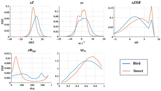
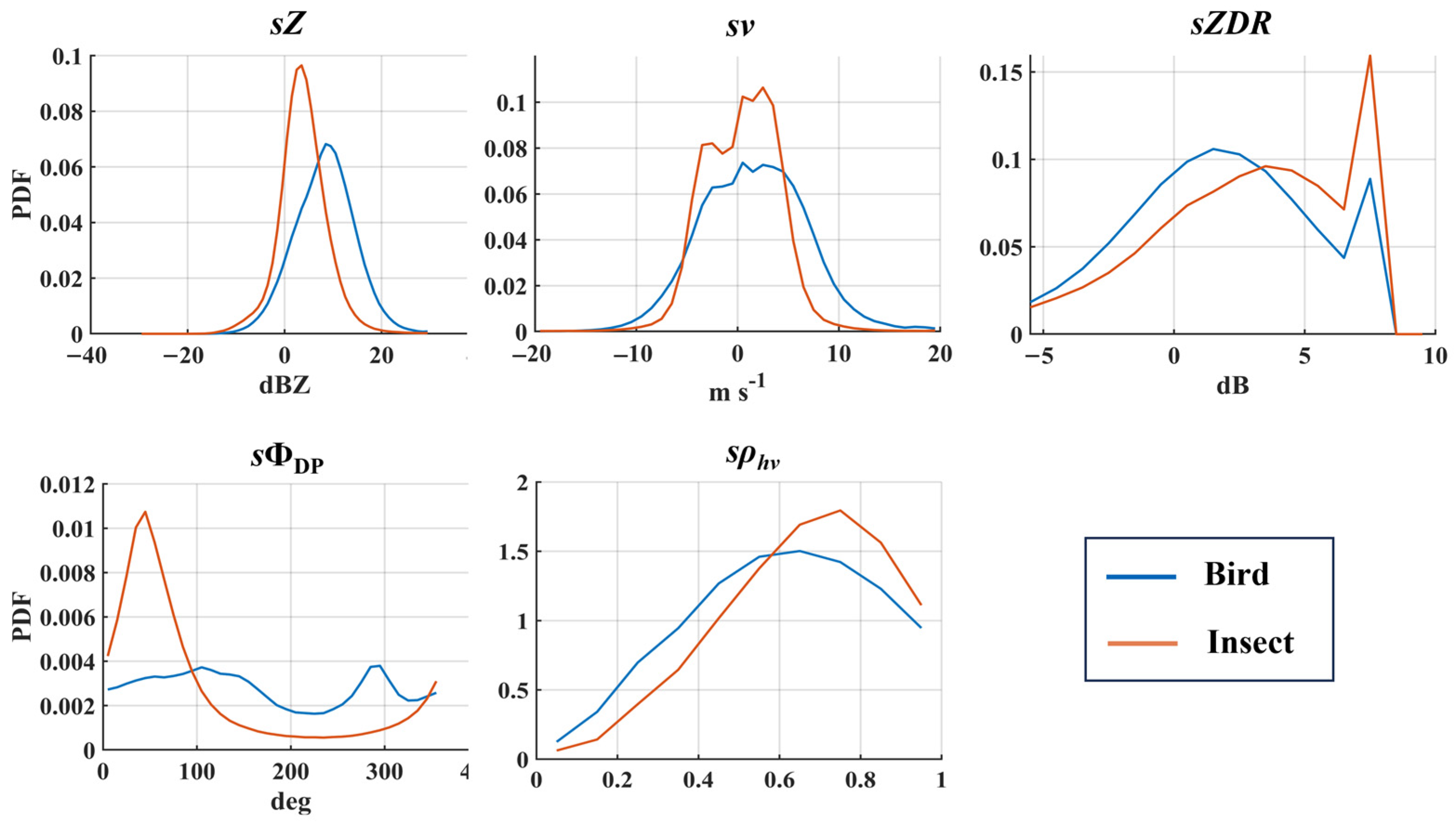
The Changsha station is equipped with an S-band dual-polarization Doppler weather radar operating at a wavelength of approximately 10 cm. The radar has a peak transmit power of 650 kW and a one-way half-power beamwidth of 1°. The transmitted pulse width is 1.57 μs, and the range resolution is 250 m. The system employs simultaneous dual-linear polarization, enabling the acquisition of polarimetric variable. The azimuthal resolution is primarily determined by the 1° antenna beamwidth. In this study, we analyzed weather radar observations from Changsha station at the end of March. The experimental dataset used for training the classification model comprises 2,735,136 valid spectral feature samples, including 1,325,177 bird samples and 1,409,959 insect samples, resulting in a balanced class distribution. To avoid spatial and temporal leakage, the train–validation split was performed at the radar volume-scan level rather than at the individual feature-sample level. All spectral peaks extracted from the same scan were assigned to the same subset. The dataset was divided into training and validation sets with a ratio of 3:1 based on volume scans. Statistical analyses of the spectral polarimetric features of the identified targets were subsequently performed, and the distributions are illustrated in the Figure 3.
Figure 3.
The spectral polarization feature distribution.
To quantitatively evaluate the classification performance of the proposed algorithm on the dataset, the bird–insect identification accuracy is adopted as the evaluation metric, defined as follows:
where TP (True Positive) and TN (True Negative) denote the numbers of correctly identified positive and negative samples, respectively, while FN (False Negative) represents positive samples misclassified as negative, and FP (False Positive) corresponds to negative samples misclassified as positive.
Table 1 summarizes the bird–insect identification accuracy obtained from weather radar observations collected in different months, including representative cases from March, April, and June. The dataset covers scenarios involving independent bird and insect activity as well as mixed bird–insect echoes. Specifically, the March dataset includes both migratory and roost-related bird activity, April is dominated by large-scale broad-front bird migration events, and the June data are characterized by enhanced insect activity with mixed bird echoes prevailing. Across all months, the algorithm demonstrates stable classification performance under diverse biological activity regimes, achieving an average identification accuracy of 85.8% for birds and 84.6% for insects.
Table 1.
Accuracy rate of insect and bird identification for different months.
Deployment of the proposed algorithm in operational weather radar systems requires appropriate hardware support to ensure real-time performance. Direct processing of IQ data yields significantly higher computational complexity than conventional radar base data products. For a typical radar resolution volume containing 64 IQ samples and two spectral channels, the computational cost per scan is in the order of 107 floating-point operations (FLOPs), compared with approximately 105 FLOPs for standard moment-based methods, indicating an increase of roughly two orders of magnitude.
To evaluate practical feasibility, the algorithm was implemented on a heterogeneous GPU-CPU platform equipped with an NVIDIA RTX 3080 GPU and an 8-core CPU. Under this configuration, ecological products were generated within approximately 1.6 s per radar volume scan. This performance level satisfies near-real-time operational requirements when moderate GPU acceleration or multi-core parallelization is available. In contrast, CPU-only configurations typical of legacy weather radar systems are unlikely to achieve comparable processing speed without hardware upgrades. However, for CPU-only configurations typical of legacy weather radar systems, hardware upgrades would be required to achieve comparable performance.
3.2. Controlled Bird Release Experiments and Analysis
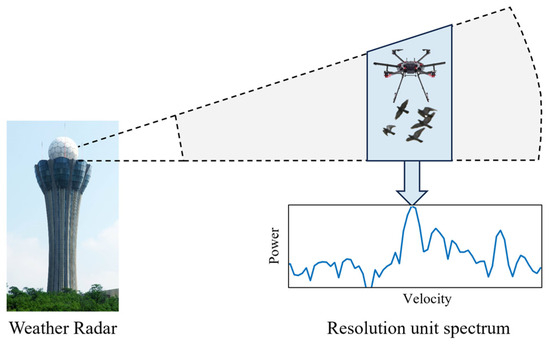
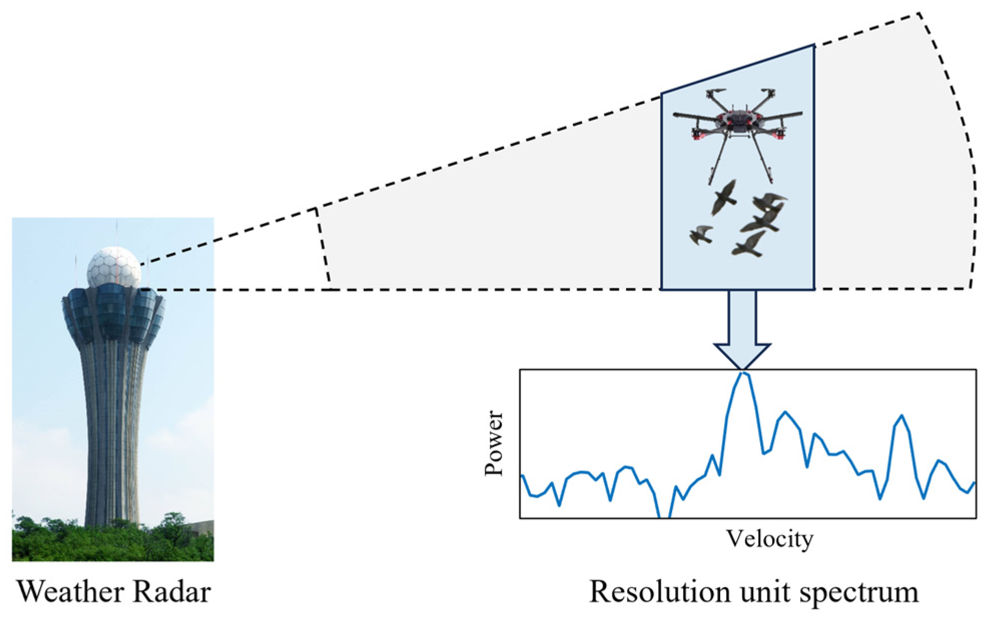
This section presents a series of controlled bird release experiments conducted to jointly validate the proposed saliency-constrained multi-peak Doppler spectrum decomposition method. The experiments were carried out using data from the Changsha S-band new-generation weather radar, in coordination with a DJI M600 Pro hexacopter unmanned aerial vehicle (UAV) as illustrated in Figure 4.
Figure 4.
Schematic of the UAV-Based Controlled Bird Release Experiment and Radar Observation.
A total of seven independent pigeon release experiments were conducted on 18 July 2025. During each experiment, the UAV executed hovering and fixed-point release operations at a prescribed altitude and location, ensuring that the released birds were fully embedded within the effective radar beam coverage while minimizing interference from non-target scatterers. Owing to constraints imposed by the UAV’s payload capacity (approximately 6 kg), as well as requirements for flight stability and operational safety, the number of pigeons released in each experiment was limited to four. This configuration strikes a balance between radar detectability and experimental controllability, while ensuring consistency across repeated trials, thereby providing a reliable reference dataset for the quantitative evaluation of the proposed algorithm.
The experiment was conducted at an open and unobstructed site approximately 5 km from the radar to ensure that the released targets remained within the effective radar beam coverage. An UAV was employed as the aerial release platform, equipped with a remotely triggered release cage. The UAV performed stationary hovering and bird release at an altitude of 410 m. This altitude corresponds to the main-lobe coverage of the radar’s low-elevation beam at a range of 5 km, thereby geometrically ensuring that the released birds were consistently located within the effective radar sampling volume. During each experiment, the UAV ascended to the designated altitude within the radar observation domain and maintained a hovering state before triggering the release mechanism to deploy the birds, after which it immediately returned to avoid prolonged interference with radar observations. The weather radar station continuously operated in routine scanning mode throughout the experiment, simultaneously acquiring IQ data and conventional base data products. In parallel, high-definition ground-based cameras were deployed to record the release timing and the flight behavior of the birds, providing independent references for spatiotemporal alignment and cross-validation with the weather radar observations.
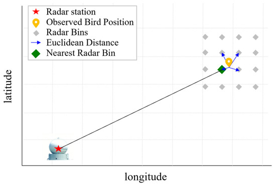
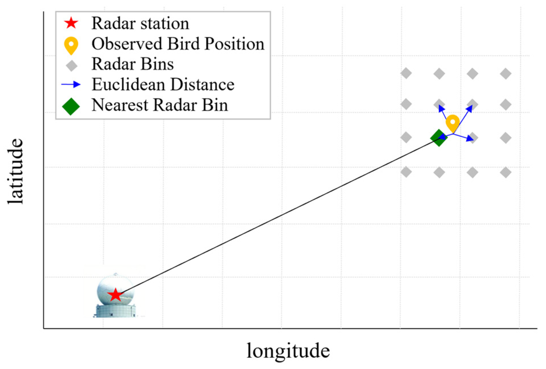
To achieve spatial alignment between the observation locations and radar sampling volumes, the geographic coordinates of the release points were transformed into the radar sampling coordinate system. Latitude and longitude were converted to planar coordinates using the Gauss–Krüger projection, a standard geodetic projection widely adopted in China that introduces minimal distortion at mid-latitudes and is well suited for weather radar applications. The projected observation locations were then matched to the nearest radar resolution volumes by minimizing the Euclidean distance to the centers of the radar sampling grid. Figure 5 illustrates the mapping of the observation point (yellow marker) to the closest radar resolution cell (green square), where gray grids denote the radar sampling volumes. This spatial registration enables the extraction of IQ spectral polarimetric parameters from the radar resolution volume corresponding to each observation.
Figure 5.
Gauss–Krüger projection positioning method.
After locating the corresponding radar resolution volume, an eight-neighborhood around the target cell was selected for joint spectral feature analysis to mitigate potential uncertainties arising from manual positioning. The Doppler spectrum of the UAV echo was used as a spatiotemporal reference for the neighborhood analysis. Owing to the stable position of the UAV during hovering and release, its radar echo exhibits distinct and identifiable spectral signatures in the Doppler domain, enabling verification of the accuracy of the matched radar resolution volume.
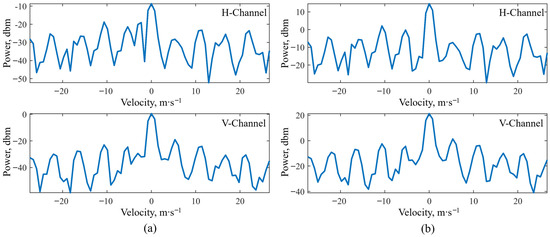
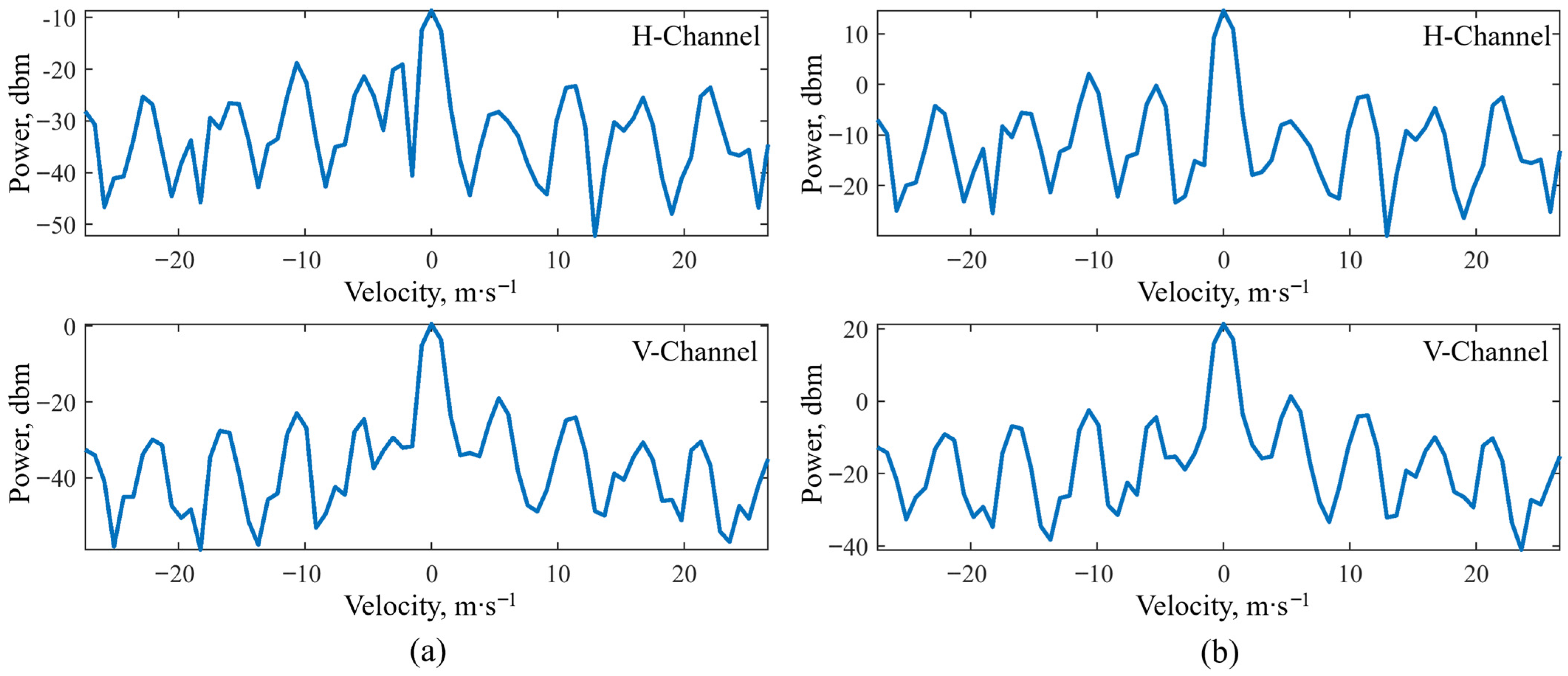
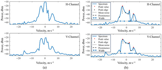
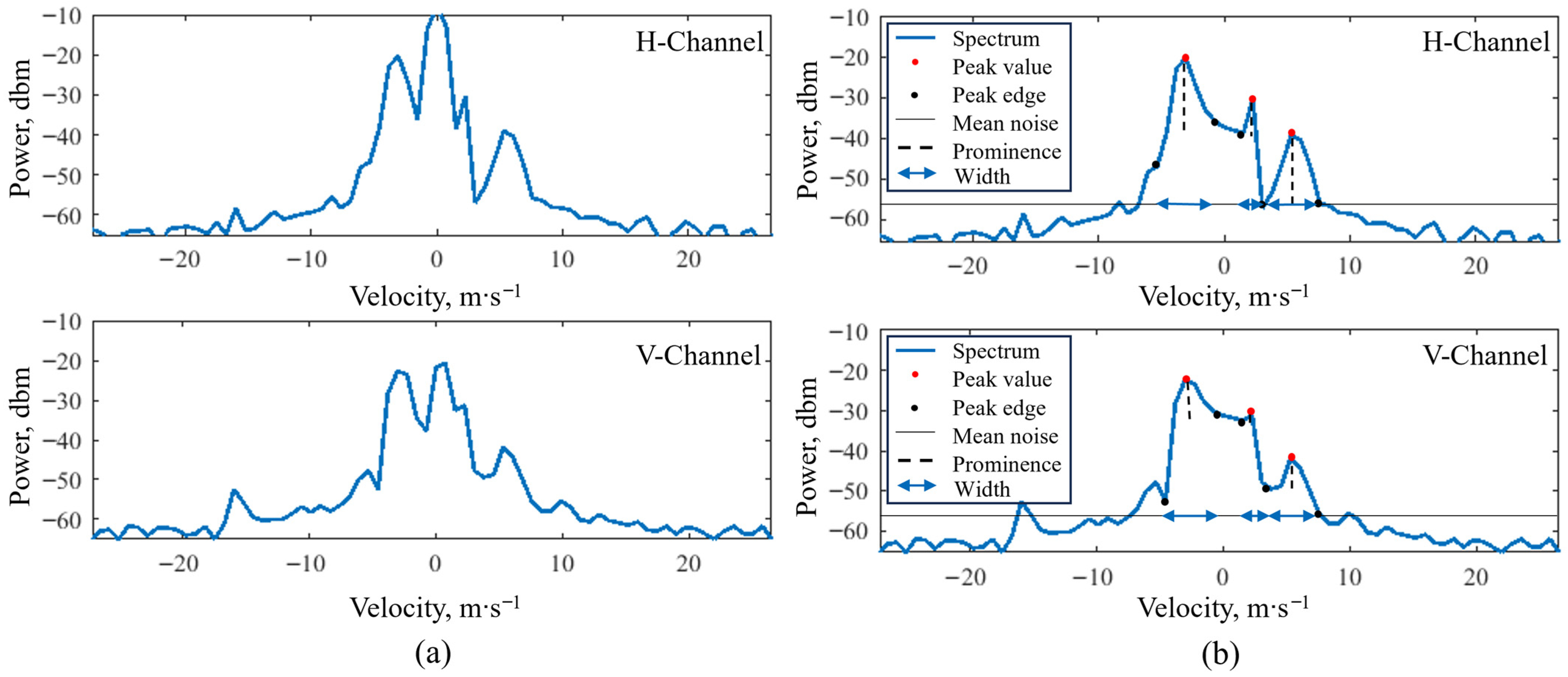
Figure 6 presents the UAV Doppler spectra detected in the target and neighboring resolution volumes. Figure 6a,b show the spectra extracted from the located resolution cell and its adjacent cell, respectively. Due to the pronounced micro-Doppler modulation induced by the rotation of the multirotor propellers, the Doppler spectra in both H and V polarization channels display symmetric sideband structures centered around a dominant frequency. This spectral pattern remains stable across consecutive scans and therefore serves as a reliable reference for validating both the release timing and spatial positioning. The identification of the UAV spectrum within the target resolution volume further confirms the effectiveness of the Gauss–Krüger projection and nearest-neighbor matching approach for spatial localization. Once the UAV spectral signature was identified, bird Doppler spectra in the neighboring resolution volumes were further analyzed. The saliency-constrained multi-peak Doppler spectrum decomposition method was then applied to extract bird spectral peak intervals, as illustrated in Figure 7.
Figure 6.
The Doppler spectrum of the unmanned aerial vehicle identified at the locating point. (a) Located point spectrum (b) Adjacent resolution cell spectrum.
Figure 7.
Bird Doppler spectrum. (a) Original spectrum (b) The spectral interval identification result based on the filtered spectrum.
3.3. Detection Results of Bird Roosts at Dongting Lake
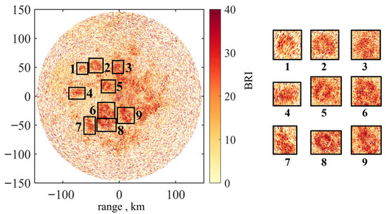
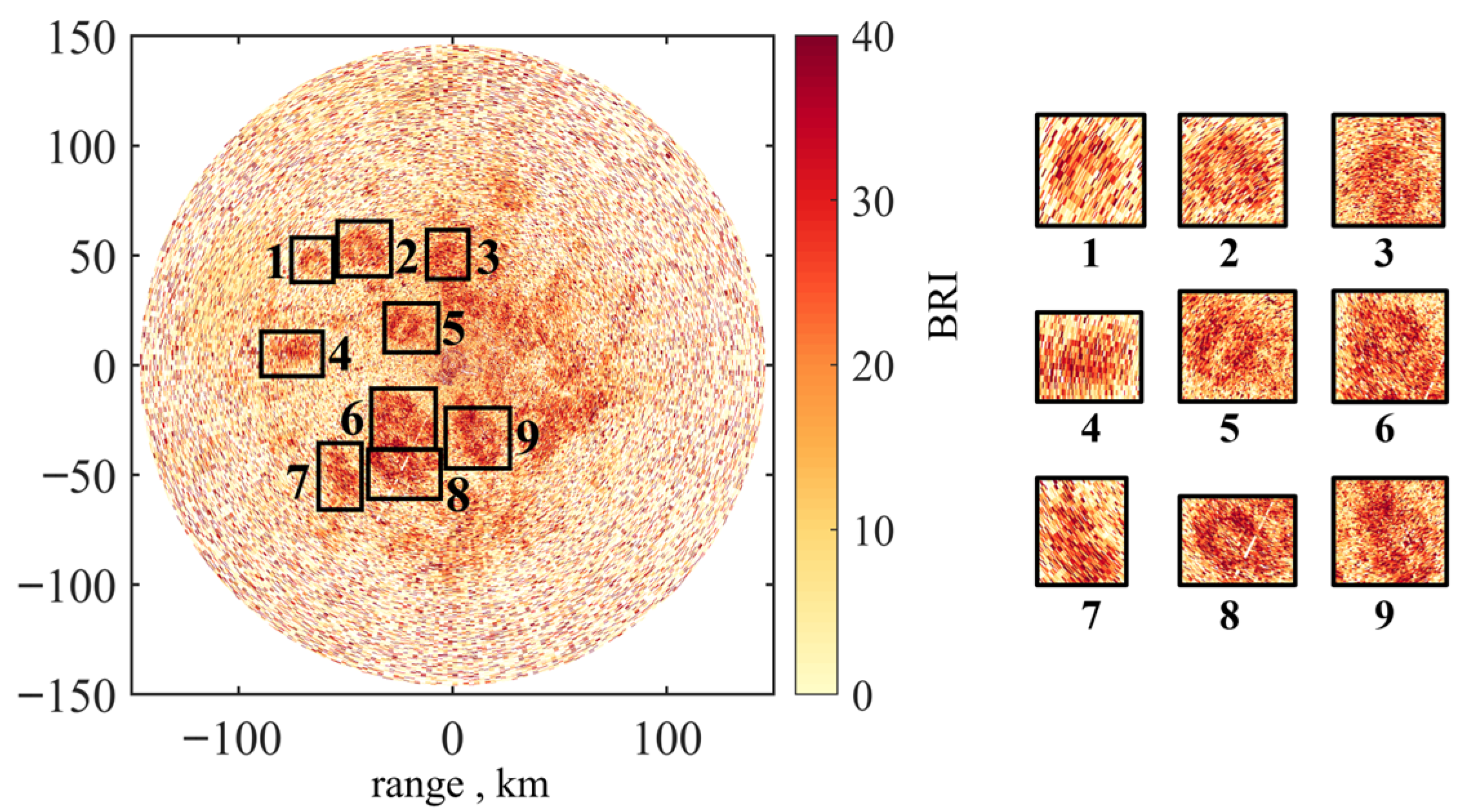
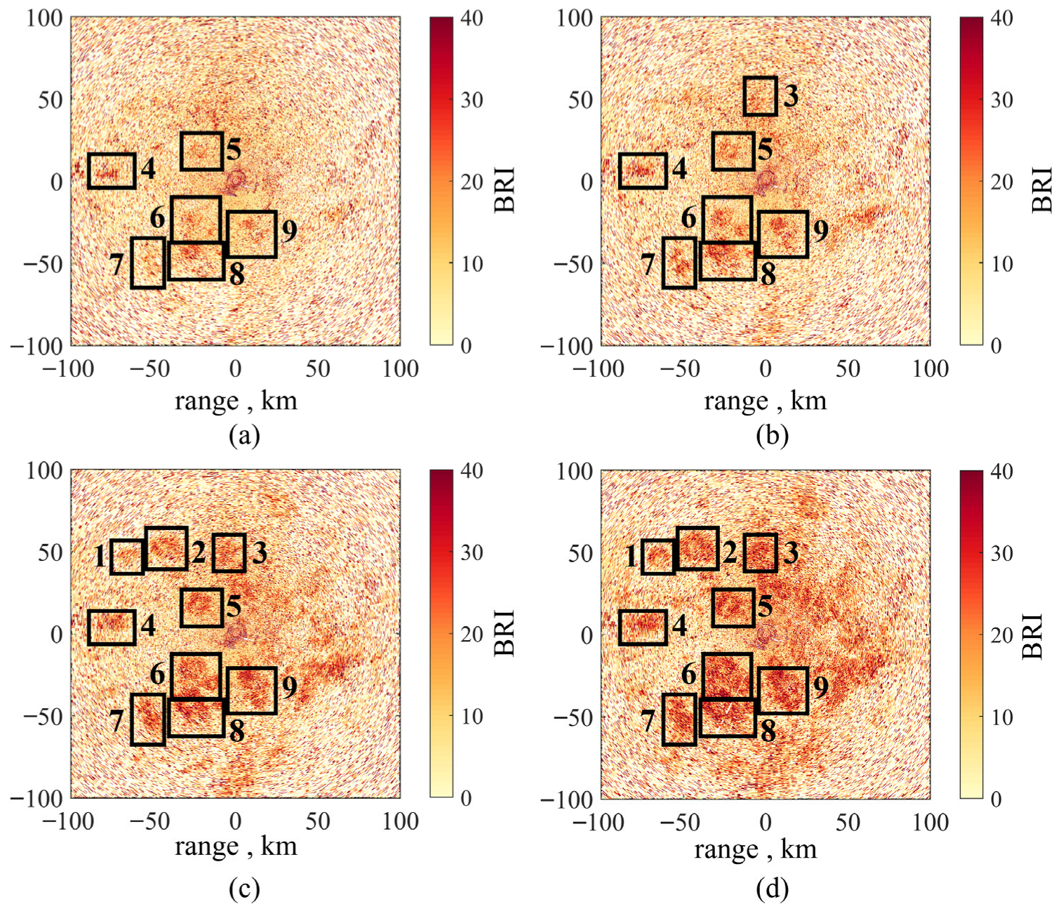
Based on continuous weather radar spectral data from 26–28 March 2024, in the Dongting Lake basin, this study conducted a systematic comparative analysis of the Bird Roost Index (BRI) during the sunset period (17:00–19:00). This time window corresponds to the typical transition when birds return from daytime foraging areas to nocturnal roosts or leave their roosts, providing a clear behavioral indicator. Figure 8 shows nine prominent bird roosts detected at 18:48 on 28 March, with the radar station positioned at the origin (0, 0). To facilitate detailed analysis of the temporal evolution of roosting activity, subsequent results focus on a 100 km radius area centered on the radar, with each roosting site assigned a unique number for cross-time and cross-date spatiotemporal matching and consistency assessment.
Figure 8.
Distribution and numbering of bird roosts.
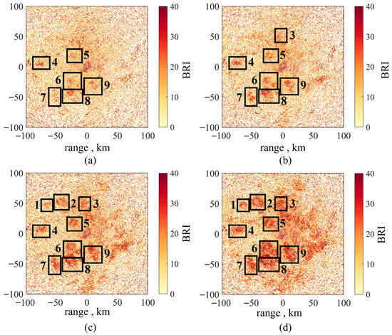
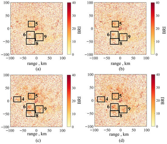
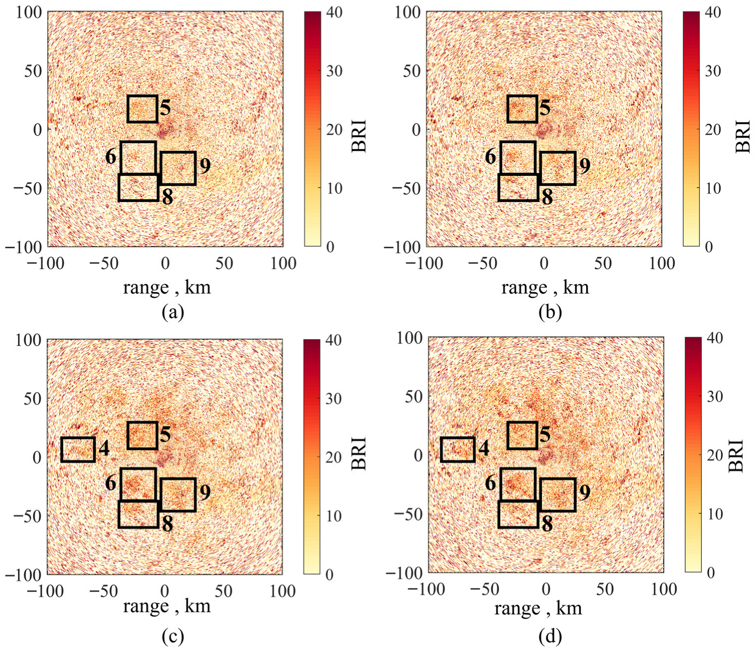
The observations indicate that high-reflectivity echoes associated with bird roosts exhibit pronounced spontaneity and organized structure, typically developing rapidly within a short period into clearly defined, stable ring-shaped echo regions, consistent with previous studies [24,26]. To further investigate the formation process of the high-BRI ring echoes shown in Figure 8, radar observations from the same area preceding their formation were analyzed. Four consecutive radar PPI slices at 18:30, 18:36, 18:42, and 18:48 were compared to characterize the temporal evolution of roosting activity, as shown in Figure 9. At 18:30, the ring-shaped high-BRI roosts numbered 4–9 had already begun to exhibit their basic structural patterns. By 18:36, the structure of roost 3 became clearly discernible (Figure 9a,b). After 18:42, the high-energy ring echoes corresponding to all nine roosts were essentially formed, and by 18:48, they expanded outward from the ring centers. Subsequently, these echo structures dissipated in the radar imagery, corresponding to the completion of the birds’ departure from the roosts.
Figure 9.
The results of continuous radar monitoring of BRI by the Changsha Radar Station on 28 March. (a) 18:30, (b) 18:36, (c) 18:42, (d) 18:48.
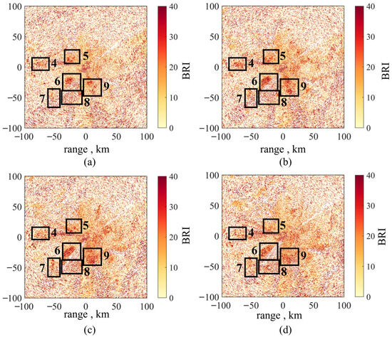
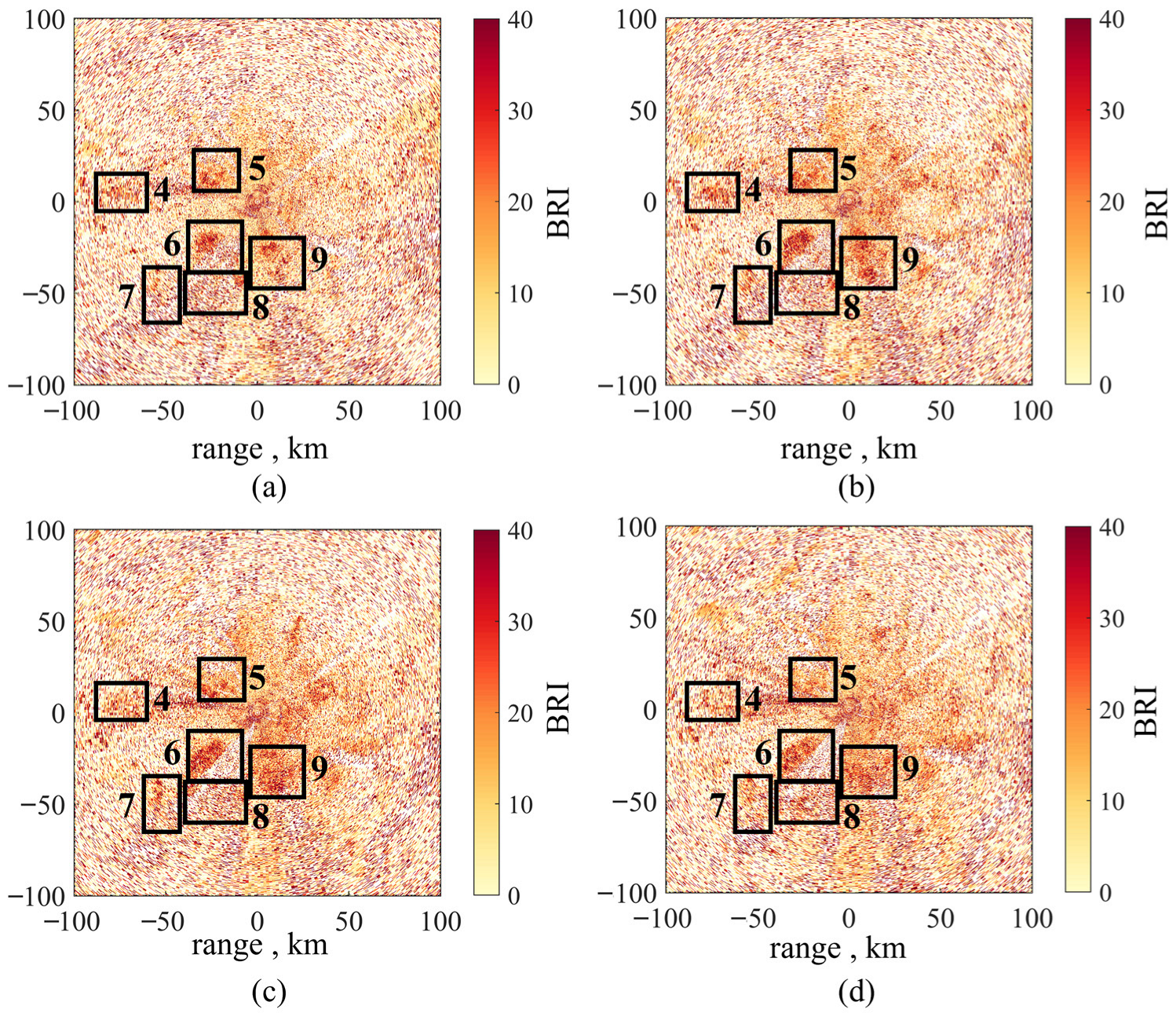
Figure 10 presents the results of consecutive radar scans at 6-min intervals from 18:24 to 18:42 on 27 March, showing six prominent high-BRI areas within the same region, corresponding to roosts numbered 4, 5, 6, 7, 8, and 9. These areas consistently exhibited stable, ring-shaped high-BRI structures during the first three scans, gradually dissipating by 18:42, which corresponds to the completion of birds leaving the roosts. Within each scan, the radial velocity distribution evolved over time from concentrated to dispersed patterns, reflecting the dynamic behavior of birds departing from fixed roosting points. Figure 10 illustrates the high-BRI regions detected in the same monitoring area on 26 March between 18:36 and 18:54. Although the overall biological echo on 26 March was weaker, ring-shaped structures are still identifiable in roosts 4, 5, 6, 8, and 9. The spatial distribution of high-BRI regions closely matches that observed on 27 March, indicating that these areas represent consistently occupied roosts rather than transient aggregations caused by short-term fluctuations in bird density.
Figure 10.
The results of continuous radar monitoring of BRI by the Changsha Radar Station on 27 March. (a) 18:24, (b) 18:30, (c) 18:36, (d) 18:42.
A comparison of BRI detection results from 26 to 28 March reveals that multiple high-BRI areas persisted across consecutive 6-min radar scans, exhibiting characteristic ring-shaped echoes expanding outward from central points. This pattern indicates that echo energy disperses from localized fixed positions, consistent with the formation of multi-modal velocity fields as birds take off collectively from roosting sites. Cross-day analysis shows that on 28 March (Figure 9), a greater number of roosting sites were detected with elevated BRI values, indicating heightened nocturnal roosting and departure activity. On 27 March (Figure 10) and 26 March (Figure 11), several high-BRI areas spatially coincided with the primary roosting locations identified on 28 March. Despite notable variations in overall biological activity between dates, the main high-BRI regions exhibited stable spatial distributions and consistent temporal evolution across all three days.
Figure 11.
The results of continuous radar monitoring of BRI by the Changsha Radar Station on 26 March. (a) 18:36, (b) 18:42, (c) 18:48, (d) 18:54.
The observed cross-day stability rules out spurious signals caused by transient migratory flows or short-term bird aggregations, confirming that the high-BRI regions correspond to long-standing, spatially fixed bird roosts within the Dongting Lake basin. The recurring pattern of multi-day co-located, same-time, ring-shaped echoes represents a typical manifestation of fixed bird roosts in operational weather radar observations, thereby validating the effectiveness of the proposed BRI based on multi-peak Doppler spectral motion mode analysis for roost site identification.
4. Discussion
The saliency-constrained multi-peak spectral approach proposed in this study enables fine-scale monitoring of bird communal roosting activity at the radar resolution-cell level using weather radar IQ data. Unlike conventional methods that rely on high-reflectivity ring-shaped echo structures, the proposed approach decomposes multiple bird motion modes directly in the Doppler spectral domain. As a result, roost-related activity can be robustly identified even when spatial echo structures are weak or indistinct.
Theoretically, the proposed method framework can be transferred to other regions and radar systems. Nevertheless, the generalization performance is influenced by local ecological conditions: dominant species vary in body size and flight behavior, which directly affect polarimetric scattering signatures, while radar wavelength and polarization mode also alter feature distributions. As a result, applying the method in different geographic regions or with non-S-band or single-polarization radars will require region-specific sample collection and retraining of the classifier. Such adaptations are necessary to ensure robust performance across diverse ecological and operational settings.
It should also be noted that operational weather radar base products do not routinely provide IQ data. Due to the current availability of weather radar IQ data, the algorithm was evaluated using the Dongting Lake region as a representative case. Although this area provides a typical example of large-scale communal roosting, further applications across different regions and ecological settings are required to comprehensively assess the generality and robustness of the method. With the ongoing enhancement of IQ data acquisition and processing capabilities in weather radar systems, the proposed framework has the potential to be extended to broader operational applications. Future work will focus on multiple weather radar stations IQ data collection to support regional scale and networked monitoring of bird communal roosts.
5. Conclusions
This study addresses the requirements of fine-scale ecological monitoring using weather radar and proposes a method for monitoring public bird roosts based on saliency-constrained multi-peak Doppler spectral analysis of weather radar. At the resolution cell scale, a saliency-constrained multi-peak Doppler spectrum decomposition is employed to separate mixed scattering signals and extract distinct bird motion subgroups. Spectral polarimetric features dataset are then used to perform intelligent classification of bird-related spectral peaks. On this basis, a Bird Roost Index (BRI) is constructed by coupling the number of bird spectral peaks with their radial velocity dispersion, enabling a quantitative inversion of roosting activity intensity and the complexity of bird motion modes.
In this study, we analyzed consecutive days of operational weather radar observations over overwintering waterbird roosting areas in the Dongting Lake region. The results demonstrate that high-BRI regions exhibit strong spatial persistence, consistent temporal evolution, and characteristic outward-expanding ring-shaped echo structures. These features are highly consistent with the dynamical behavior of bird departure from fixed roosting sites. Cross-day comparisons further exclude the influence of transient migratory flows or random aggregations, confirming the robustness of BRI as a reliable indicator of long-term, fixed bird roosting locations.
Existing ring-echo-based roost detection and biological echo classification methods operate on base data products and assign a single label to each resolution volume. The proposed framework instead performs sub-spectral separation of mixed biological echoes within each radar resolution volume using IQ data, thereby enabling discrimination of multiple motion populations within a single radar resolution volume. Therefore, it should be viewed as complementary rather than directly comparable to existing base-product approaches. The proposed method enables stable identification based on Doppler spectral structure even when ring-shaped signatures are incomplete, reflectivity is weak, or birds and insects coexist within the same radar resolution volume.
Author Contributions
Conceptualization, Z.Y., K.C., X.L., K.X. and C.H.; methodology, Z.Y., K.C., X.L., K.X., X.D., R.W. and C.H.; software, Z.Y., K.X. and Z.L.; validation, Z.Y., X.L., K.C. and X.D.; investigation, Z.Y., K.C., X.L., K.X., Z.L. and X.D.; resources, K.C., X.D., R.W. and C.H.; data curation, Z.Y., K.C., X.L. and K.X.; writing—original draft preparation, Z.Y.; writing—review and editing, Z.Y., K.C., X.L., K.X., Z.L., X.D., R.W. and C.H. All authors have read and agreed to the published version of the manuscript.
Funding
This work was supported by the National Natural Science Foundation of China under Grants 62301048, 62225104, Shandong Provincial Natural Science Foundation under Grant ZR2023QF035, and Shandong Long Island National Climate Observatory Open Fund under Grant 2023cdkfz03.
Data Availability Statement
In this paper, we utilized the weather radar data provided by the China Meteorological Administration. However, due to the confidentiality of the data, we do not intend to make the dataset public.
Acknowledgments
The authors would like to express the gratitude to the Meteorological Observation Center, China Meteorological Administration, Beijing, China, for providing weather radar data.
Conflicts of Interest
The authors declare no conflicts of interest.
References
- Drake, V.A.; Gatehouse, A.G. Insect Migration: Tracking Resources Through Space and Time; Cambridge University Press: Cambridge, UK, 1995. [Google Scholar]
- Hu, G.; Lim, K.S.; Horvitz, N.; Clark, S.J.; Reynolds, D.R.; Sapir, N.; Chapman, J.W. Mass seasonal bioflows of high-flying insect migrants. Science 2016, 354, 1584–1587. [Google Scholar] [CrossRef] [Scilit]
- Bauer, S.; Hoye, B.J. Migratory animals couple biodiversity and ecosystem functioning worldwide. Science 2014, 344, 1242552. [Google Scholar] [CrossRef] [Scilit]
- Bauer, S.; Chapman, J.W.; Reynolds, D.R.; Alves, J.A.; Dokter, A.M.; Menz, M.M. From agricultural benefits to aviation safety: Realizing the potential of continent-wide radar networks. BioScience 2017, 67, 912–918. [Google Scholar] [CrossRef] [Scilit] [PubMed]
- Hu, C.; Cui, K.; Wang, R.; Long, T.; Wu, D.; Wu, K. Review of Weather Radar Aeroecology Monitoring. J. Signal Process. 2024, 40, 94–113. [Google Scholar]
- Barter, M.; Chen, L.; Cao, L.; Lei, G. Waterbird Survey of the Middle and Lower Yangtze River Floodplain in Late January and Early February 2004; China Forestry Pulishing House: Beijing, China, 2004. [Google Scholar]
- Sun, Z.; Hu, C.; Cui, K.; Wang, R.; Ding, M.; Yan, Z.; Wu, D. Extracting Diurnal Activity Patterns of Birds in Communal Roosts from Polarimetric Weather Radar Data. IEEE Trans. Geosci. Remote Sens. 2024, 62, 5112412. [Google Scholar] [CrossRef] [Scilit]
- Cui, K.; Hu, C.; Wang, R.; Sui, Y.; Mao, H.; Li, H. Deep-learning-based extraction of the animal migration patterns from weather radar images. Sci. China Inf. Sci. 2020, 63, 140304. [Google Scholar] [CrossRef] [Scilit]
- Notaros, B. Polarimetric Weather Radar: Overview of Principles and Applications. IEEE Antennas Propag. Mag. 2022, 64, 43–54. [Google Scholar] [CrossRef] [Scilit]
- Huuskonen, A.; Saltikoff, E.; Holleman, I. The Operational Weather Radar Network in Europe. Bull. Am. Meteorol. Soc. 2014, 95, 897–907. [Google Scholar] [CrossRef] [Scilit]
- Ansari, S.; Del Greco, S.; Kearns, E.; Brown, O.; Wilkins, S.; Ramamurthy, M.; Weber, J.; May, R.; Sundwall, J.; Layton, J.; et al. Unlocking the Potential of NEXRAD Data through NOAA’s Big Data Partnership. Bull. Am. Meteorol. Soc. 2018, 99, 189–204. [Google Scholar] [CrossRef] [Scilit]
- Diehl, R.H.; Larkin, R.P. Introduction to the WSR-88D (NEXRAD) for ornithological research. In Proceedings of the Bird Conservation Implementation and Integration in the Americas: Proceedings of the Third International Partners in Flight Conference, Pacific Grove, CA, USA, 20–24 March 2002; U.S. Department of Agriculture: Albany, CA, USA, 2005. [Google Scholar]
- He, G.; Li, G.; Zou, X.; Ray, P.S. Applications of a velocity dealiasing scheme to data from the China new generation weather radar system (CINRAD). Weather Forecast. 2012, 27, 218–230. [Google Scholar] [CrossRef] [Scilit]
- Saltikoff, E.; Friedrich, K.; Soderholm, J.; Lengfeld, K.; Nelson, B.; Becker, A.; Hollmann, R.; Urban, B.; Heistermann, M.; Tassone, C. An Overview of Using Weather Radar for Climatological Studies: Successes, Challenges, and Potential. Bull. Am. Meteorol. Soc. 2019, 100, 1739–1752. [Google Scholar] [CrossRef] [Scilit]
- Stepanian, P.M.; Horton, K.G.; Melnikov, V.M.; Zrnić, D.S.; Gauthreaux, S.A., Jr. Dual-polarization radar products for biological applications. Ecosphere 2016, 7, e01539. [Google Scholar] [CrossRef] [Scilit]
- Kumjian, M.R. Principles and Applications of Dual-Polarization Weather Radar. Part I: Description of the Polarimetric Radar Variables. J. Oper. Meteorol. 2013, 1, 226–242. [Google Scholar] [CrossRef] [Scilit]
- Kilambi, A.; Fabry, F.; Meunier, V. A simple and effective method for separating meteorological from nonmeteorological targets using dual-polarization data. J. Atmos. Ocean. Technol. 2018, 35, 1415–1424. [Google Scholar] [CrossRef] [Scilit]
- Ryzhkov, A.; Matrosov, S.Y.; Melnikov, V.; Zrnic, D.; Zhang, P.; Cao, Q.; Knight, M.; Simmer, C.; Troemel, S. Estimation of Depolarization Ratio Using Weather Radars with Simultaneous Transmission/Reception. J. Appl. Meteorol. Clim. 2017, 56, 1797–1816. [Google Scholar] [CrossRef] [Scilit]
- Gauthreaux, S.; Diehl, R. Discrimination of biological scatterers in polarimetric weather radar data: Opportunities and challenges. Remote Sens. 2020, 12, 545. [Google Scholar]
- Jatau, P.; Melnikov, V.; Yu, T.-Y. A Machine Learning Approach for Classifying Bird and Insect Radar Echoes with S-Band Polarimetric Weather Radar. J. Atmos. Ocean. Technol. 2021, 38, 1797–1812. [Google Scholar] [CrossRef] [Scilit]
- Zrnic, D.S.; Rhyhkov, A.V. Polarimetry for weather surveillance radars. Bull. Am. Meteorol. Soc. 1999, 80, 389. [Google Scholar] [CrossRef] [Scilit]
- Mueller, E.A.; Larkin, R.P. Insects observed using dual-polarization radar. J. Atmos. Ocean. Technol. 1985, 2, 49–54. [Google Scholar] [CrossRef] [Scilit]
- Dokter, A.M.; Liechti, F.; Stark, H.; Delobbe, L.; Tabary, P.; Holleman, I. Bird migration flight altitudes studied by a network of operational weather radars. J. R. Soc. Interface 2011, 8, 30–43. [Google Scholar] [CrossRef] [Scilit]
- Gauthreaux, S.A.; Belser, C.G. Displays of bird movements on the WSR-88D: Patterns and quantification. Weather Forecast. 1998, 13, 453–464. [Google Scholar] [CrossRef] [Scilit]
- Russell, K.R.; Gauthreaux, S.A. Spatial and temporal dynamics of a Purple Martin pre-migratory roost. Wilson J. Ornithol. 1999, 111, 354–362. [Google Scholar]
- Jatau, P.; Melnikov, V. Classifying bird and insect radar echoes at S band. In Proceedings of the American Meteorological Society Meeting Abstracts, Phoenix, Arizona, 6–10 January 2019. [Google Scholar]
- Chilson, C.; Avery, K.; McGovern, A.; Bridge, E.; Sheldon, D.; Kelly, J.; Horning, N.; Liu, X. Automated detection of bird roosts using NEXRAD radar data and Convolutional Neural Networks. Remote Sens. Ecol. Conserv. 2019, 5, 20–32. [Google Scholar] [CrossRef] [Scilit]
- Cheng, Z.; Gabriel, S.; Bhambhani, P.; Sheldon, D.; Maji, S.; Laughlin, A.; Winkler, D. Detecting and tracking communal bird roosts in weather radar data. In Proceedings of the AAAI Conference on Artificial Intelligence, New York, NY, USA, 7–12 February 2020. [Google Scholar]
- Perez, G.; Zhao, W.; Cheng, Z.; Belotti, M.C.T.D.; Deng, Y.; Simons, V.F.; Tielens, E.; Kelly, J.F.; Horton, K.G.; Maji, S.; et al. Using spatiotemporal information in weather radar data to detect and track communal roosts. Remote Sens. Ecol. Conserv. 2024, 10, 567–583. [Google Scholar] [CrossRef] [Scilit]
- Doviak, R.J.; Zrnić, D.S. Doppler Radar and Weather Observations, 2nd ed.; Academic Press: San Diego, CA, USA, 1993. [Google Scholar]
- Yin, J.; Unal, C.; Russchenberg, H. Object-orientated filter design in spectral domain for polarimetric weather radar. IEEE Trans. Geosci. Remote Sens. 2018, 57, 2725–2740. [Google Scholar] [CrossRef]
- Yin, J.; Unal, C.M.H.; Russchenberg, H.W.J. Narrow-Band Clutter Mitigation in Spectral Polarimetric Weather Radar. IEEE Trans. Geosci. Remote Sens. 2017, 55, 4655–4667. [Google Scholar] [CrossRef]
- Free, A.D.; Patel, N.K.; Macemon, R.W. 9.3 Open Radar Data Acquisition (ORDA) Calibration Consistency. Way 2006, 50, R52. [Google Scholar]
- Siggia, A.; Passarelli, R. Gaussian model adaptive processing (GMAP) for improved ground clutter cancellation and moment calculation. Proc. ERAD 2004, 67–73. [Google Scholar]
- Rosa, I.M.D.; Marques, A.T.; Palminha, G.; Costa, H.; Mascarenhas, M.; Fonseca, C.; Bernardino, J. Classification success of six machine learning algorithms in radar ornithology. Ibis 2016, 158, 28–42. [Google Scholar] [CrossRef] [Scilit]
- Yan, Z.; Hu, C.; Cui, K.; Wang, R.; Yang, Z.; Zhang, C. Utilizing Range-Doppler Characteristics for Classifying Insect and Bird Echoes in Weather Radar. IEEE Trans. Geosci. Remote Sens. 2025, 63, 5105513. [Google Scholar] [CrossRef] [Scilit]
- Williams, C.R.; Maahn, M.; Hardin, J.C.; de Boer, G. Clutter mitigation, multiple peaks, and high-order spectral moments in 35 GHz vertically pointing radar velocity spectra. Atmos. Meas. Tech. 2018, 11, 4963–4980. [Google Scholar] [CrossRef] [Scilit]
- Bachmann, S.; DeBrunner, V.; Zrnic, D.; Yeary, M. Spectral analysis of polarimetric weather radar data with multiple processes in a resolution volume. In Proceedings of the 2007 IEEE International Conference on Acoustics, Speech and Signal Processing-ICASSP’07, Honolulu, HI, USA, 15–20 April 2007. [Google Scholar]
- Wang, G.; Wu, H.; Dai, J.; Xiong, Y.; Long, Y.; Cai, X.; Mo, S.; Yang, R.; Liu, Y. Priorities identification of habitat restoration for migratory birds under the increased water level during the middle of dry season: A case study of Poyang Lake and Dongting Lake wetlands, China. Ecol. Indic. 2023, 151, 110322. [Google Scholar] [CrossRef] [Scilit]
- Yuan, Y.; Zeng, G.; Liang, J.; Li, X.; Li, Z.; Zhang, C.; Huang, L.; Lai, X.; Lu, L.; Wu, H. Effects of landscape structure, habitat and human disturbance on birds: A case study in East Dongting Lake wetland. Ecol. Eng. 2014, 67, 67–75. [Google Scholar] [CrossRef] [Scilit]
- Yan, Z.; Cui, K.; Zhang, J.; Jia, Y.; Wang, R.; Yang, Z. Aerial Insect and Bird Identification Method based on Spectrum Estimation of Weather Radar IQ data. In Proceedings of the 2024 IEEE International Conference on Signal, Information and Data Processing (ICSIDP), Zhuhai, China, 22–24 November 2024. [Google Scholar]

Disclaimer/Publisher’s Note: The statements, opinions and data contained in all publications are solely those of the individual author(s) and contributor(s) and not of MDPI and/or the editor(s). MDPI and/or the editor(s) disclaim responsibility for any injury to people or property resulting from any ideas, methods, instructions or products referred to in the content. |
© 2026 by the authors. Licensee MDPI, Basel, Switzerland. This article is an open access article distributed under the terms and conditions of the Creative Commons Attribution (CC BY) license.