Reconstructing Horizontal Displacement Through Deep Learning in Multiple-Pairwise Satellite Image Correlation


Highlights
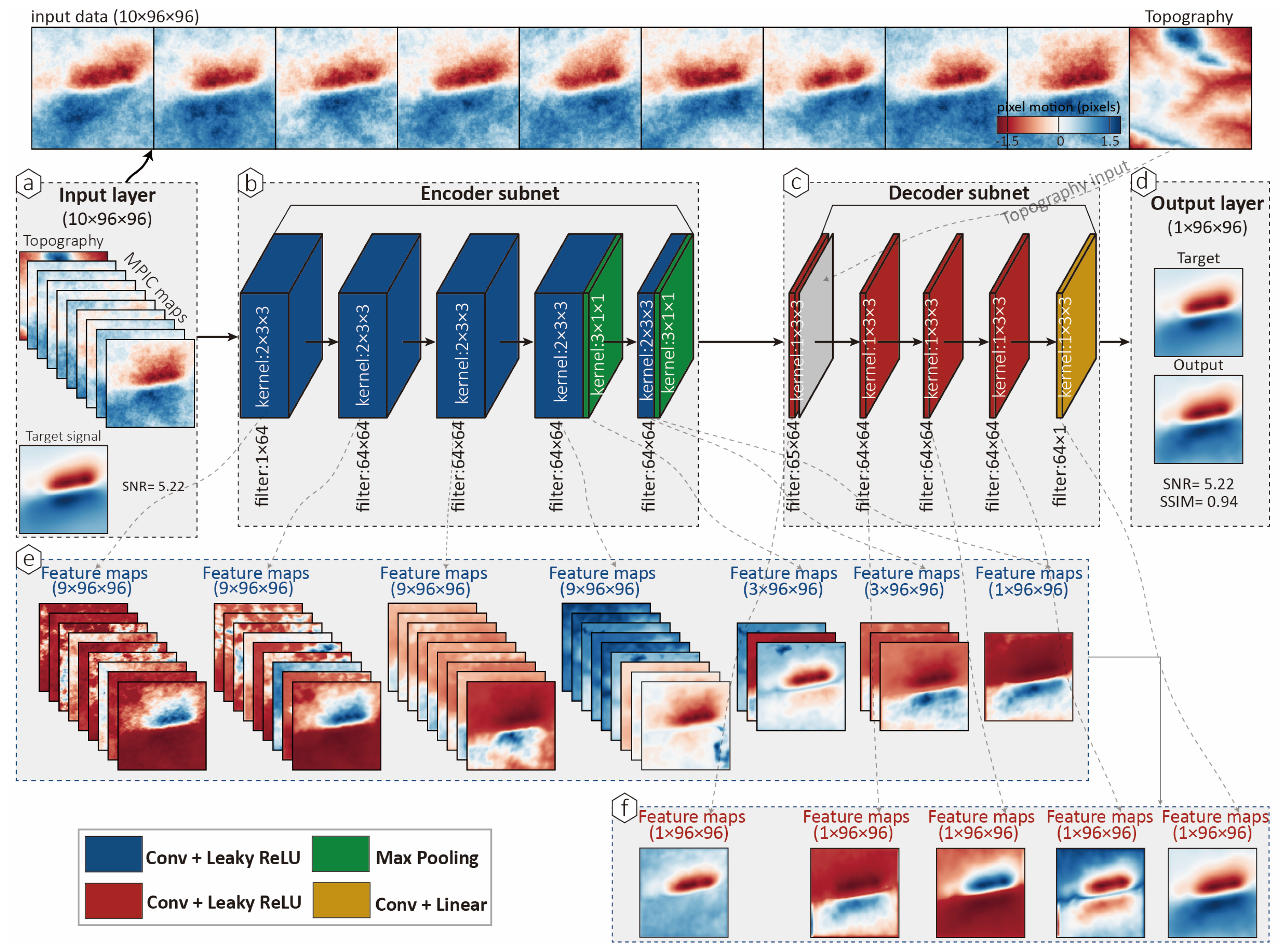
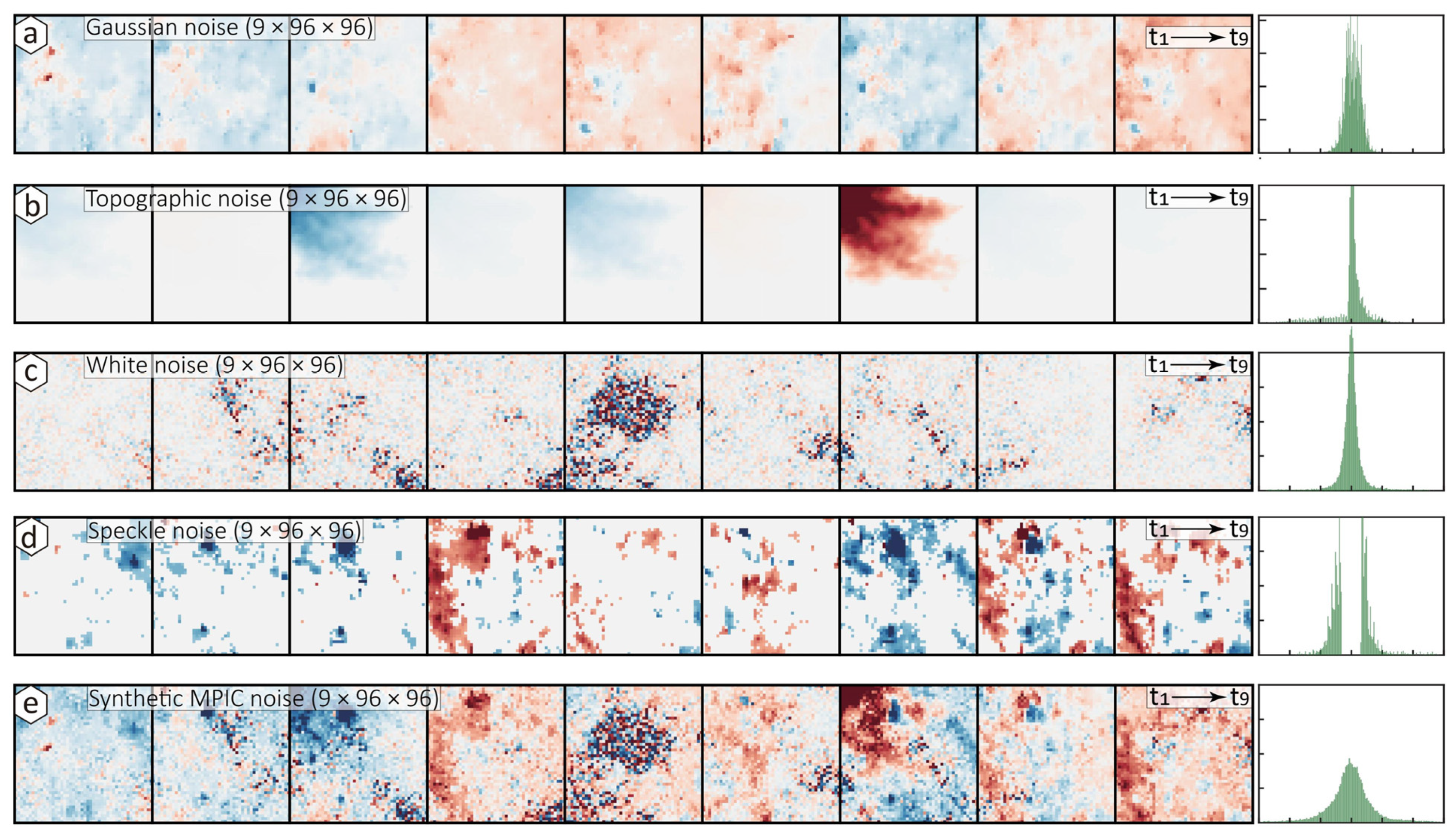
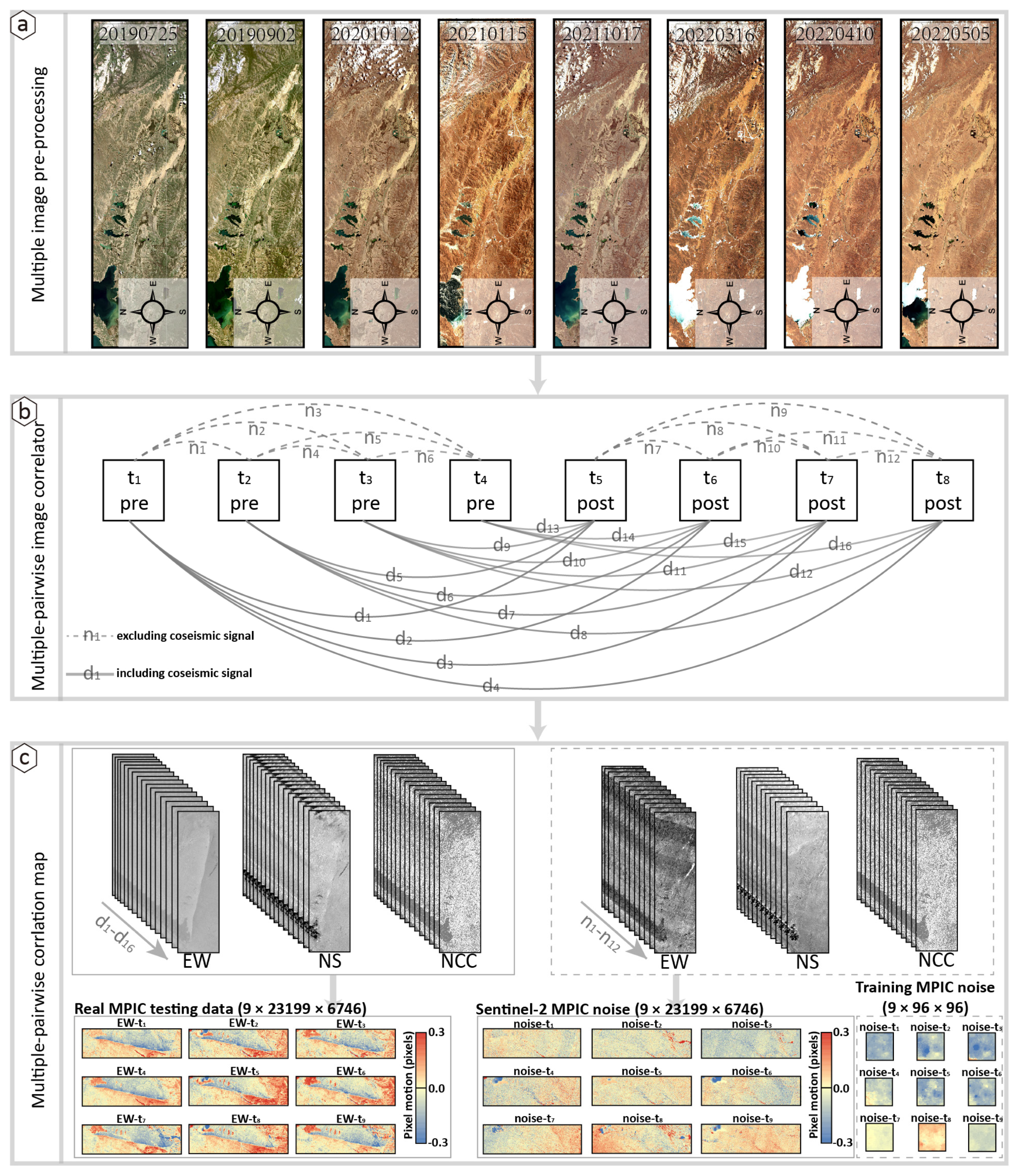
- A deep-learning autoencoder is trained to remove Sentinel-2 correlated noise, enabling the recovery of clean displacement signals from any multiple-pairwise satellite image correlation (MPIC).
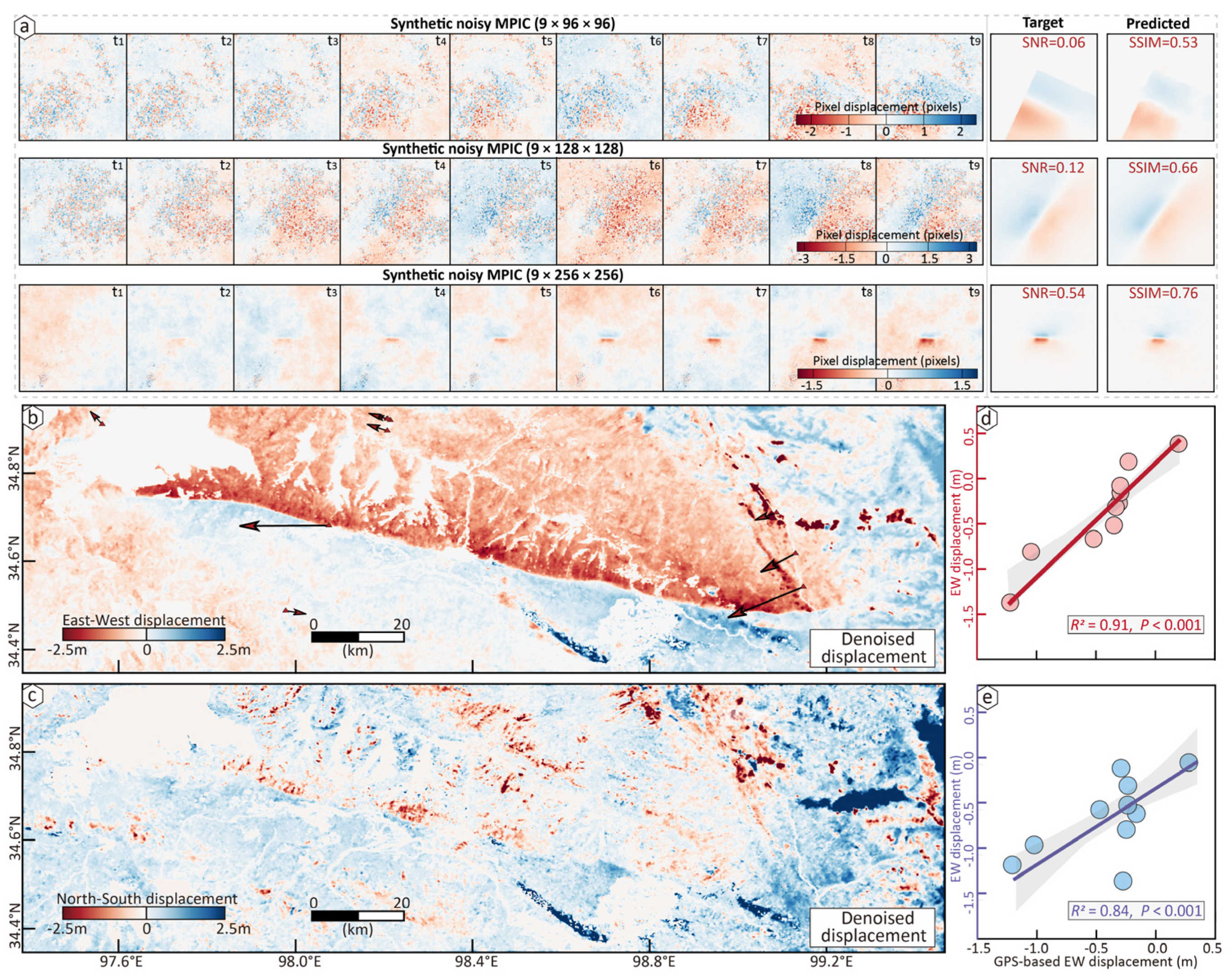
- The autoencoder can effectively remove correlated noises in the input MPICs, and accurately reconstruct denoised surface displacement in synthetic and real datasets.
- The method enables robust, automatic displacement extraction without manual intervention or prior knowledge of fault kinematics, improving the usability and accuracy of optical image correlation.
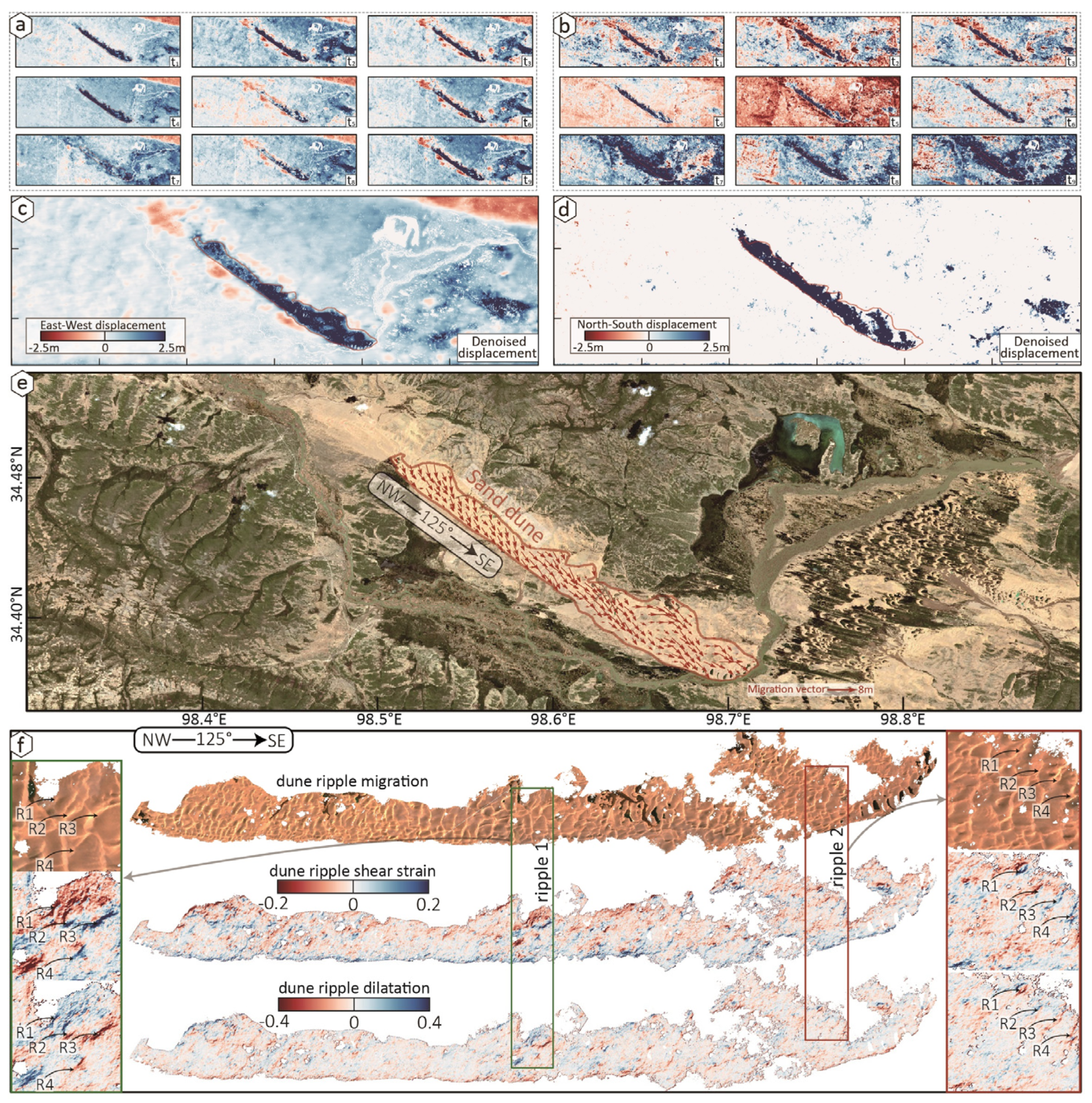
- The approach shows broad potential for reconstructing high-quality horizontal displacements across various tectonic and geomorphological processes, including earthquake ruptures, glacier flow, dune migration, and slow-moving landslides.
Abstract
1. Introduction
2. Methodology
2.1. Learnability Analysis of Optical MPIC
2.2. Architecture of Neural Network
2.3. Loss Function
3. Training and Testing Datasets
3.1. Simulation of MPIC Noise Datasets
3.2. Generating Training and Testing Datasets
3.3. Synthetic MPIC Displacement Data
4. Training and Testing Neural Network
4.1. Training the Neural Network
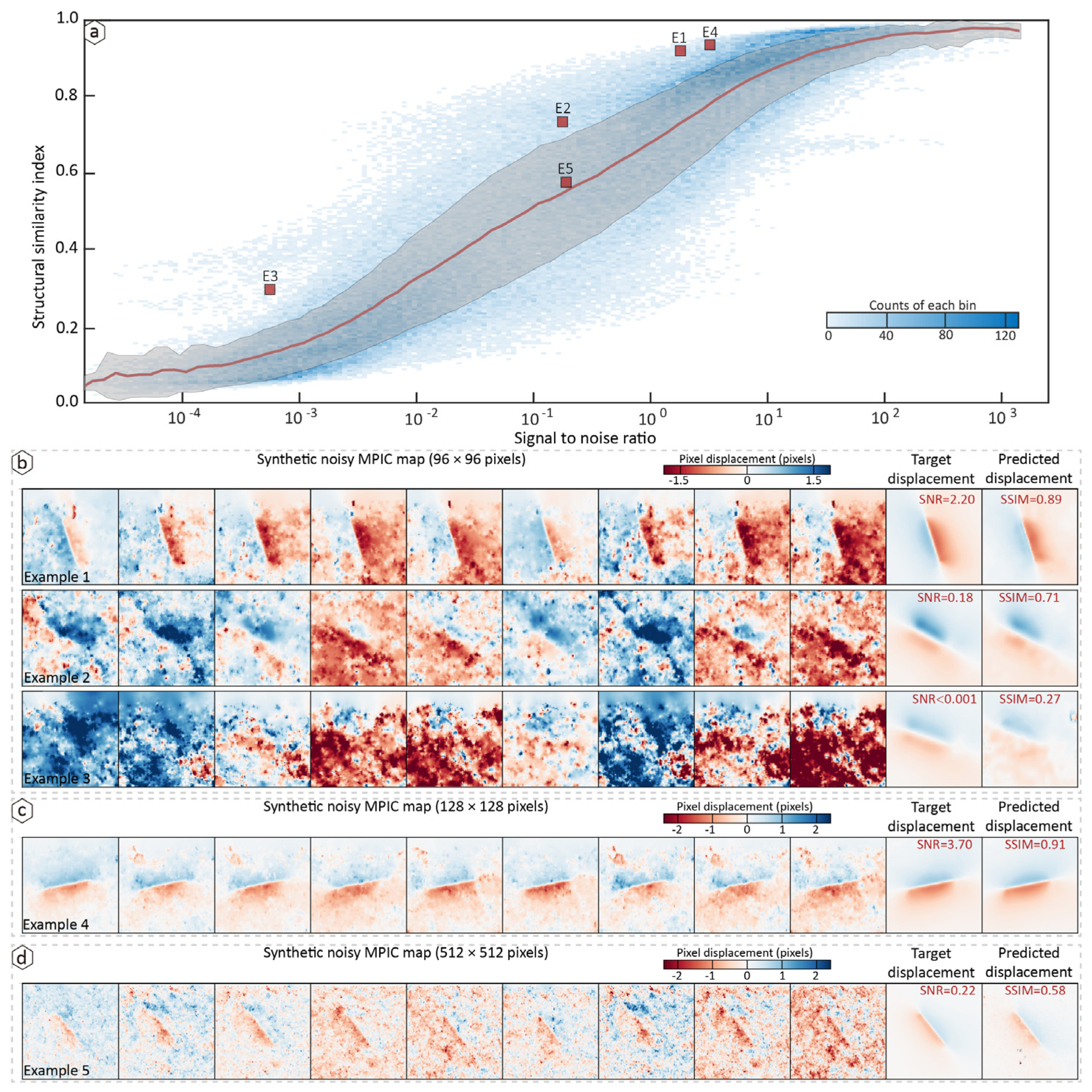
4.2. Performance on MPIC with Simulated Noise
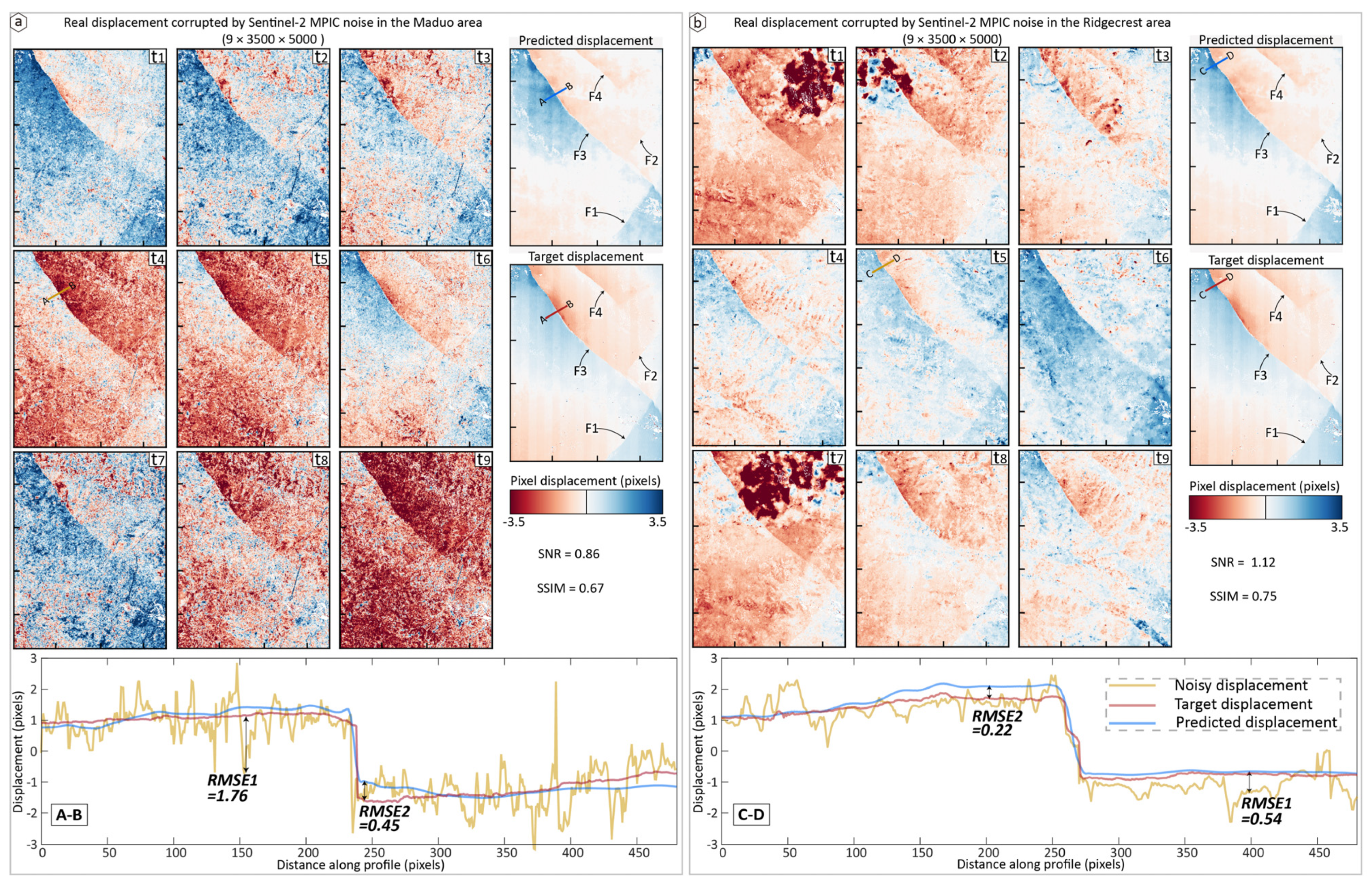
4.3. Application to a Real Displacement: The 2019 Ridgecrest Earthquakes
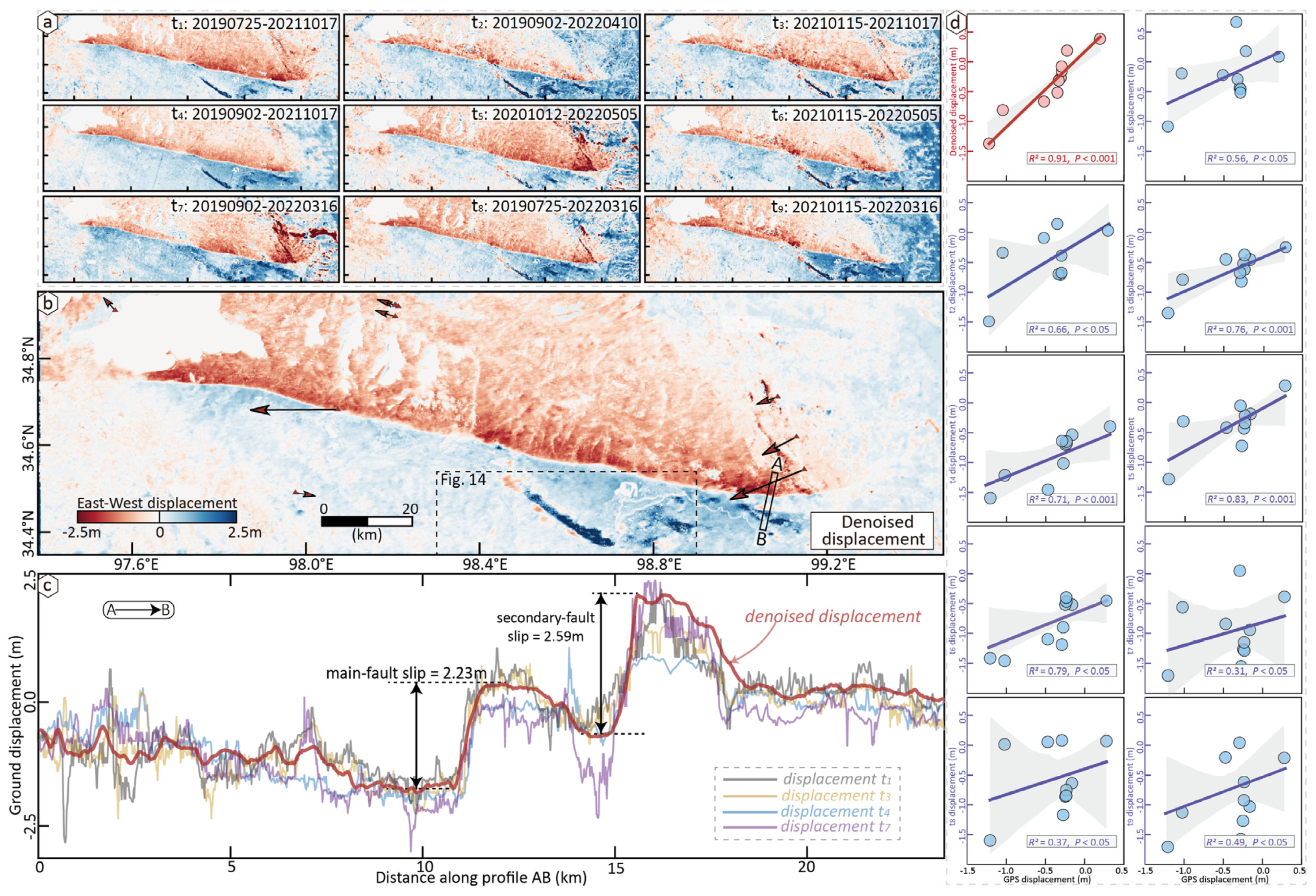
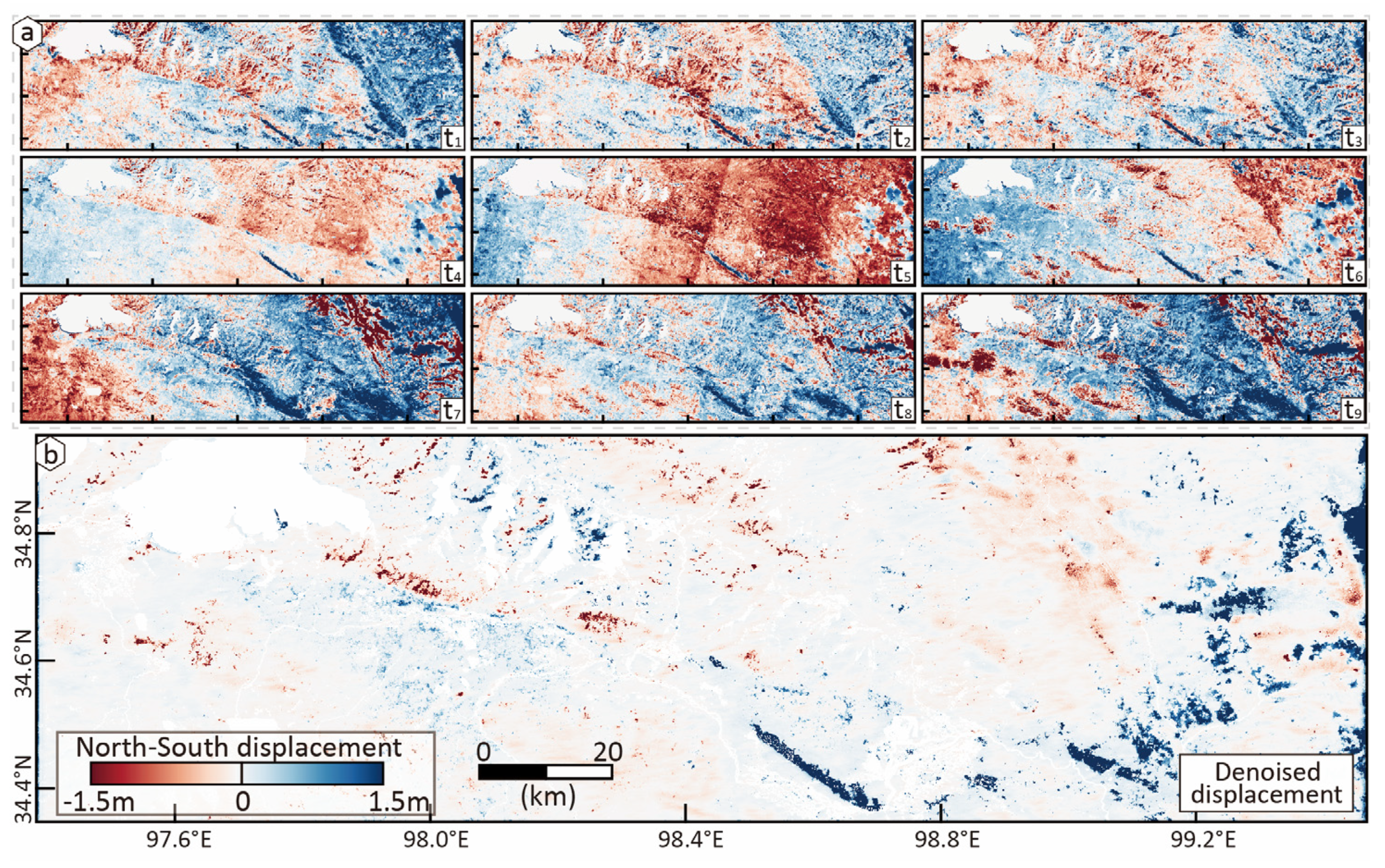
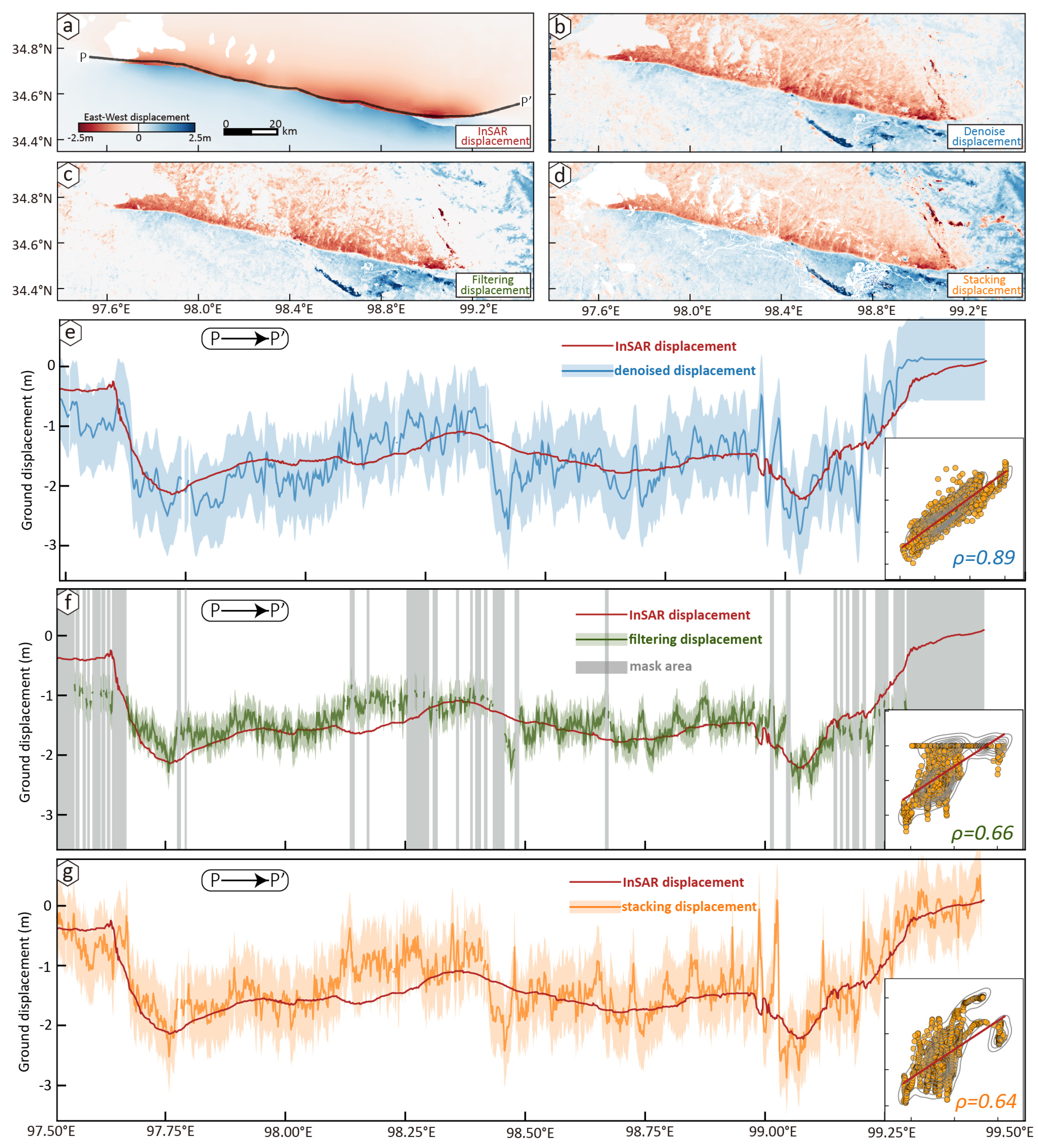
4.4. Application to a Real Testing Case: The 2021 Maduo Earthquake
5. Discussions
6. Conclusions
Author Contributions
Funding
Data Availability Statement
Acknowledgments
Conflicts of Interest
References
- Elliott, J.R.; Walters, R.J.; Wright, T.J. The role of space-based observation in understanding and responding to active tectonics and earthquakes. Nat. Commun. 2016, 7, 13844. [Google Scholar] [CrossRef] [Scilit]
- Marchandon, M.; Vergnolle, M.; Sudhaus, H.; Cavalié, O. Fault geometry and slip distribution at depth of the 1997 Mw7.2 Zirkuh earthquake: Contribution of near-field displacement data. J. Geophys. Res. Solid Earth 2018, 123, 1904–1924. [Google Scholar] [CrossRef] [Scilit]
- Milliner, C.; Donnellan, A.; Aati, S.; Avouac, J.-A.; Zinke, R.; Dolan, J.F.; Wang, K.; Bürgmann, R. Bookshelf kinematics and the effect of dilatation on fault zone inelastic deformation: Examples from optical image correlation measurements of the 2019 Ridgecrest earthquake sequence. J. Geophys. Res. Solid Earth 2021, 126, e2020JB020551. [Google Scholar] [CrossRef] [Scilit]
- Socquet, A.; Hollingsworth, J.; Pathier, E.; Bouchon, M. Evidence of supershear during the 2018 magnitude 7.5 Palu earthquake from space geodesy. Nat. Geosci. 2019, 12, 192–199. [Google Scholar] [CrossRef] [Scilit]
- Klinger, Y.; Okubo, K.; Vallage, A.; Champenois, J.; Delorme, A.; Rougier, E.; Lei, Z.; Knight, E.E.; Munjiza, A.; Satriano, C.; et al. Earthquake damage patterns resolve complex rupture processes. Geophys. Res. Lett. 2018, 45, 10–279. [Google Scholar] [CrossRef] [Scilit]
- Rosu, A.-M.; Pierrot-Deseilligny, M.; Delorme, A.; Binet, R.; Klinger, Y. Measurement of surface displacement from optical satellite image correlation using the free open-source software MicMac. ISPRS J. Photogramm. Remote Sens. 2015, 100, 48–59. [Google Scholar] [CrossRef] [Scilit]
- Provost, F.; Michéa, D.; Malet, J.-P.; Boissier, E.; Pointal, E.; Stumpf, A.; Pacini, F.; Doin, M.-P.; Lacroix, P.; Proy, C.; et al. Terrain deformation measurements from optical satellite imagery: The MPIC-OPT processing services for geohazards monitoring. Remote Sens. Environ. 2022, 274, 112949. [Google Scholar] [CrossRef] [Scilit]
- Avouac, J.P.; Ayoub, F.; Leprince, S.; Konca, O.; Helmberger, D. The 2005, Mw7.6 Kashmir earthquake: Sub-pixel correlation of ASTER images and seismic waveforms analysis. Earth Planet. Sci. Lett. 2006, 249, 514–528. [Google Scholar] [CrossRef] [Scilit]
- Antoine, S.L.; Klinger, Y.; Delorme, A.; Gold, R.F. Off-Fault Deformation in Regions of Complex Fault Geometries: The 2013, Mw7.7, Baluchistan Rupture (Pakistan). J. Geophys. Res. Solid Earth 2022, 127, e2022JB024480. [Google Scholar] [CrossRef] [Scilit]
- Lauer, B.; Grandin, R.; Klinger, Y. Fault geometry and slip distribution of the 2013 Mw7.7 Balochistan earthquake from inversions of SAR and optical data. J. Geophys. Res. Solid Earth 2020, 125, e2019JB018380. [Google Scholar] [CrossRef] [Scilit]
- Barnhart, W.D.; Gold, R.D.; Hollingsworth, J. Localized fault-zone dilatancy and surface inelasticity of the 2019 Ridgecrest earthquakes. Nat. Geosci. 2020, 13, 699–704. [Google Scholar] [CrossRef] [Scilit]
- Liu, J.G.; Mason, P.J.; Ma, J. Measurement of the left-lateral displacement of Ms 8.1 Kunlun earthquake on 14 November 2001 using Landsat-7 ETM+ imagery. Int. J. Remote Sens. 2006, 27, 1875–1891. [Google Scholar] [CrossRef] [Scilit]
- Avouac, J.P.; Leprince, S. Geodetic Imaging Using Optical Systems. In Geodesy; Elsevier Inc.: Amsterdam, The Netherlands, 2015; pp. 387–424. [Google Scholar]
- Beyer, R.A.; Alexandrov, O.; McMichael, S. The Ames Stereo Pipeline: NASA’s open source software for deriving and processing terrain data. Earth Space Sci. 2018, 5, 537–548. [Google Scholar] [CrossRef] [Scilit]
- Stumpf, A.; Michéa, D.; Malet, J.-P. Improved co-registration of Sentinel-2 and Landsat-8 imagery for Earth surface motion measurements. Remote Sens. 2018, 10, 160. [Google Scholar] [CrossRef] [Scilit]
- Leprince, S.; Musé, P.; Avouac, J.-P. In-flight CCD distortion calibration for pushbroom satellites based on subpixel correlation. IEEE Trans. Geosci. Remote Sens. 2008, 46, 2675–2683. [Google Scholar] [CrossRef]
- Ding, C.; Feng, G.; Li, Z.; Shan, X.; Du, Y.; Wang, H. Spatio-temporal error sources analysis and accuracy improvement in landsat 8 image surface displacement measurements. Remote Sens. 2016, 8, 937. [Google Scholar] [CrossRef] [Scilit]
- Aati, S.; Milliner, C.; Avouac, J.-P. A new approach for 2-D and 3-D precise measurements of ground deformation from optimized registration and correlation of optical images and ICA-based filtering of image geometry artifacts. Remote Sens. Environ. 2022, 277, 113038. [Google Scholar] [CrossRef] [Scilit]
- Scherler, D.; Leprince, S.; Strecker, M.R. Glacier-surface velocities in alpine terrain from optical satellite imagery—Accuracy improvement and quality assessment. Remote Sens. Environ. 2008, 112, 3806–3819. [Google Scholar] [CrossRef] [Scilit]
- Huang, M.; Zhou, Y.; Lu, L.; Zheng, W.; Zhang, P. Some Thoughts on Measuring Earthquake Deformation Using Optical Imagery. IEEE Trans. Geosci. Remote Sens. 2019, 58, 1052–1062. [Google Scholar] [CrossRef]
- Chang, Y.; Yan, L.; Wu, T.; Zhong, S. Remote sensing image stripe noise removal: From image decomposition perspective. IEEE Trans. Geosci. Remote Sens. 2016, 54, 7018–7031. [Google Scholar] [CrossRef] [Scilit]
- Huang, Z.; Zhang, Y.; Li, Q.; Li, Z.; Zhang, T.; Sang, N.; Xiong, S. Unidirectional variation and deep CNN denoiser priors for simultaneously destriping and denoising optical remote sensing images. Int. J. Remote Sens. 2019, 40, 5737–5748. [Google Scholar] [CrossRef] [Scilit]
- Dematteis, N.; Giordan, D. Comparison of digital image correlation methods and the impact of noise in geoscience applications. Remote Sens. 2021, 13, 327. [Google Scholar] [CrossRef] [Scilit]
- Mahmud, M.; Kaiser, M.S.; Hussain, A.; Vassanelli, S. Applications of deep learning and reinforcement learning to biological data. IEEE Trans. Neural Netw. Learn Syst. 2018, 29, 2063–2079. [Google Scholar] [CrossRef] [Scilit] [PubMed]
- Anantrasirichai, A.; Biggs, J.; Kelevitz, K.; Sadeghi, Z.; Wright, T.; Thompson, J.; Achim, A.M.; Bull, D. Detecting ground deformation in the built environment using sparse satellite InSAR data with a convolutional neural network. IEEE Trans. Geosci. Remote Sens. 2020, 59, 2940–2950. [Google Scholar] [CrossRef] [Scilit]
- Anantrasirichai, N.; Biggs, J.; Albino, F.; Bull, D. The application of convolutional neural networks to detect slow, sustained deformation in InSAR time series. Geophys. Res. Lett. 2019, 46, 11850–11858. [Google Scholar] [CrossRef] [Scilit]
- Zhang, K.; Zuo, W.; Chen, Y.; Meng, D.; Zhang, L. Beyond a gaussian denoiser: Residual learning of deep cnn for image denoising. IEEE Trans. Image Process. 2017, 26, 3142–3155. [Google Scholar] [CrossRef] [Scilit]
- Tan, S.; Zhang, X.; Wang, H.; Yu, L.; Du, Y.; Yin, J.; Wu, B. A CNN-based self-supervised synthetic aperture radar image denoising approach. IEEE Trans. Geosci. Remote Sens. 2021, 60, 5213615. [Google Scholar] [CrossRef] [Scilit]
- Wang, D.; Zhang, Q.; Xu, Y.; Zhang, J.; Du, B.; Tao, D.; Zhang, L. Advancing plain vision transformer toward remote sensing foundation model. IEEE Trans. Geosci. Remote Sens. 2022, 61, 5607315. [Google Scholar] [CrossRef] [Scilit]
- Zhang, C.; Jiang, W.; Zhang, Y.; Wang, W.; Zhao, Q.; Wang, C. Transformer and CNN hybrid deep neural network for semantic segmentation of very-high-resolution remote sensing imagery. IEEE Trans. Geosci. Remote. Sens. 2022, 60, 4408820. [Google Scholar] [CrossRef] [Scilit]
- Huang, M.; Luo, S.; Wang, S.; Guo, J.; Wang, J. Htcnet: Hybrid transformer-cnn for sar image denoising. IEEE J. Sel. Top. Appl. Earth Obs. Remote. Sens. 2024, 17, 19380–19394. [Google Scholar] [CrossRef] [Scilit]
- Wang, C.; Xu, M.; Jiang, Y.; Zhang, G.; Cui, H.; Li, L.; Li, D. Translution-SNet: A semisupervised hyperspectral image stripe noise removal based on transformer and CNN. IEEE Trans. Geosci. Remote Sens. 2022, 60, 5533114. [Google Scholar] [CrossRef] [Scilit]
- Fan, C.-M.; Liu, T.-J.; Liu, K.-H. SUNet: Swin transformer UNet for image denoising. In Proceedings of the 2022 IEEE International Symposium on Circuits and Systems (ISCAS), Austin, TX, USA, 7 May–1 June 2022; IEEE: Piscataway, NJ, USA, 2022; pp. 2333–2337. [Google Scholar]
- Anantrasirichai, N.; Biggs, J.; Albino, F.; Bull, D. A deep learning approach to detecting volcano deformation from satellite imagery using synthetic datasets. Remote Sens. Environ. 2019, 230, 111179. [Google Scholar] [CrossRef] [Scilit]
- Sun, J.; Wauthier, C.; Stephens, K.; Gervais, M.; Cervone, G.; La Femina, P.; Higgins, M. Automatic detection of volcanic surface deformation using deep learning. J. Geophys. Res. Solid Earth 2020, 125, e2020JB019840. [Google Scholar] [CrossRef] [Scilit]
- Zhao, Z.; Wu, Z.; Zheng, Y.; Ma, P. Recurrent neural networks for atmospheric noise removal from InSAR time series with missing values ISPRS. J. Photogramm. Remote Sens. 2021, 180, 227–237. [Google Scholar] [CrossRef] [Scilit]
- Wei, G.; Chen, K.; Lyu, M.; Gong, W.; Zilio, L.D.; Ye, L.; Tu, H. Complex strike-slip faulting during the 2021 Mw7.4 Maduo earthquake. Commun. Earth Environ. 2023, 4, 319. [Google Scholar] [CrossRef] [Scilit]
- Wang, Z.; Bovik, A.C.; Sheikh, H.R.; Simoncelli, E.P. Image quality assessment: From error visibility to structural similarity. IEEE Trans. Image Process. 2004, 13, 600–612. [Google Scholar] [CrossRef] [Scilit]
- Gondara, L. Medical image denoising using convolutional denoising autoencoders. In Proceedings of the 2016 IEEE 16th International Conference on Data Mining Workshops (ICDMW), Barcelona, Spain, 12–15 December 2016; IEEE: Piscataway, NJ, USA, 2016; pp. 241–246. [Google Scholar]
- Sara, U.; Akter, M.; Uddin, M.S. Image quality assessment through FSIM, SSIM, MSE and PSNR—A comparative study. J. Comput. Commun. 2019, 7, 8–18. [Google Scholar] [CrossRef]
- Adam, K.D.B.J. A method for stochastic optimization. arXiv 2014, arXiv:1412.6980. [Google Scholar] [CrossRef] [Scilit]
- Pan, J.; Li, H.; Chevalier, M.-L.; Tapponnier, P.; Bai, M.; Li, C.; Liu, F.; Liu, D.; Wu, K.; Wang, P.; et al. Co-seismic rupture of the 2021, Mw7.4 Maduo earthquake (northern Tibet): Short-cutting of the Kunlun fault big bend. Earth Planet Sci. Lett. 2022, 594, 117703. [Google Scholar] [CrossRef] [Scilit]
- Yuan, Z.; Li, T.; Su, P.; Sun, H.; Ha, G.; Guo, P.; Chen, G.; Thompson Jobe, J. Large Surface-Rupture Gaps and Low Surface Fault Slip of the 2021 Mw7.4 Maduo Earthquake Along a Low-Activity Strike-Slip Fault, Tibetan Plateau. Geophys. Res. Lett. 2022, 49, e2021GL096874. [Google Scholar] [CrossRef] [Scilit]
- Hu, J.; Li, Z.; Ma, Z.; Wu, L.; Jiang, W.; Feng, G.; Zhu, J. Complete three-dimensional coseismic displacements due to the 2021 Maduo earthquake in Qinghai Province, China from Sentinel-1 and ALOS-2 SAR images. Sci. China Earth Sci. 2022, 65, 687–697. [Google Scholar] [CrossRef] [Scilit]
- Li, C.; Li, T.; Shan, X.; Zhang, G. Extremely Large Off-Fault Deformation during the 2021 Mw7.4 Maduo, Tibetan Plateau, Earthquake. Seismol. Res. Lett. 2023, 94, 39–51. [Google Scholar] [CrossRef] [Scilit]
- Wei, S.; Zeng, H.; Shi, Q.; Liu, J.; Luo, H.; Hu, W.; Li, Y.; Wang, W.; Ma, Z.; Liu-Zeng, J.; et al. Simultaneous rupture propagation through fault bifurcation of the 2021 Mw7.4 Maduo earthquake. Geophys. Res. Lett. 2022, 49, e2022GL100283. [Google Scholar] [CrossRef] [Scilit]
- Rupnik, E.; Daakir, M.; Deseilligny, M.P. MicMac–A free, open-source solution for photogrammetry. Open Geospat. Data Softw. Stand. 2017, 2, 14. [Google Scholar] [CrossRef] [Scilit]
- Aleissaee, A.A.; Kumar, A.; Anwer, R.M.; Khan, S.; Cholakkal, H.; Xia, G.S.; Khan, F.S. Transformers in remote sensing: A survey. Remote Sens. 2023, 15, 1860. [Google Scholar] [CrossRef] [Scilit]
- Gorelick, N.; Hancher, M.; Dixon, M.; Ilyushchenko, S.; Thau, D.; Moore, R. Google Earth Engine: Planetary-scale geospatial analysis for everyone. Remote Sens. Environ. 2017, 202, 18–27. [Google Scholar] [CrossRef] [Scilit]
- Okada, Y. Internal deformation due to shear and tensile faults in a half-space. Bull. Seismol. Soc. Am. 1992, 82, 1018–1040. [Google Scholar] [CrossRef] [Scilit]
- Brengman, C.M.J.; Barnhart, W.D.; Mankin, E.H.; Miller, C.N. Earthquake-scaling relationships from geodetically derived slip distributions. Bull. Seismol. Soc. Am. 2019, 109, 1701–1715. [Google Scholar] [CrossRef] [Scilit]
- Abadi, M.; Barham, P.; Chen, J.; Chen, Z.; Davis, A.; Dean, J.; Devin, M.; Ghemawat, S.; Irving, G.; Isard, M. Tensorflow: A System for Large-Scale Machine Learning. In Proceedings of the Osdi, Savannah, GA, USA, 2–4 November 2016; USENIX: Berkeley, CA, USA; Volume 16, pp. 265–283.
- Xiong, W.; Chen, W.; Wang, D.; Wen, Y.; Nie, Z.; Liu, G.; Wang, D.; Yu, P.; Qiao, X.; Zhao, B. Coseismic slip and early afterslip of the 2021 Mw7.4 Maduo, China earthquake constrained by GPS and InSAR data. Tectonophysics 2022, 840, 229558. [Google Scholar] [CrossRef] [Scilit]
- Baird, T.; Bristow, C.S.; Vermeesch, P. Measuring sand dune migration rates with COSI-Corr and Landsat: Opportunities and challenges. Remote Sens. 2019, 11, 2423. [Google Scholar] [CrossRef] [Scilit]
- Ding, C.; Zhang, L.; Liao, M.; Feng, G.; Yu, Y. Quantifying the spatio-temporal patterns of dune migration near Minqin Oasis in northwestern China with time series of Landsat-8 and Sentinel-2 observations. Remote Sens. Environ. 2020, 236, 111498. [Google Scholar] [CrossRef] [Scilit]
- Dong, P.L. Automated measurement of sand dune migration using multi-temporal lidar data and GIS. Int. J. Remote Sens. 2015, 36, 5426–5447. [Google Scholar] [CrossRef] [Scilit]
- Bridges, N.T.; Ayoub, F.; Avouac, J.P.; Leprince, S.; Lucas, A.; Mattson, S. Earth-like sand fluxes on Mars. Nature 2012, 485, 339–342. [Google Scholar] [CrossRef] [Scilit]
- Ewing, R.C.; Kocurek, G. Aeolian dune-field pattern boundary conditions. Geomorphology 2010, 114, 175–187. [Google Scholar] [CrossRef] [Scilit]
- Wang, J.; Chen, K.; Michel, S.; Zilio, L.D.; Zhu, H.; Xia, L.; Xie, J.; Hu, S. Secondary acceleration of slip fronts driven by slow slip event coalescence in subduction zones. Nat. Commun. 2025, 16, 9561. [Google Scholar] [CrossRef] [Scilit]





Disclaimer/Publisher’s Note: The statements, opinions and data contained in all publications are solely those of the individual author(s) and contributor(s) and not of MDPI and/or the editor(s). MDPI and/or the editor(s) disclaim responsibility for any injury to people or property resulting from any ideas, methods, instructions or products referred to in the content. |
© 2026 by the authors. Licensee MDPI, Basel, Switzerland. This article is an open access article distributed under the terms and conditions of the Creative Commons Attribution (CC BY) license.
Share and Cite
Li, C.; Wu, Y.; Wang, X.; Xi, X.; Zhang, G. Reconstructing Horizontal Displacement Through Deep Learning in Multiple-Pairwise Satellite Image Correlation. Remote Sens. 2026, 18, 704. https://doi.org/10.3390/rs18050704
Li C, Wu Y, Wang X, Xi X, Zhang G. Reconstructing Horizontal Displacement Through Deep Learning in Multiple-Pairwise Satellite Image Correlation. Remote Sensing. 2026; 18(5):704. https://doi.org/10.3390/rs18050704
Chicago/Turabian StyleLi, Chenglong, Yanxing Wu, Xingyan Wang, Xi Xi, and Guohong Zhang. 2026. "Reconstructing Horizontal Displacement Through Deep Learning in Multiple-Pairwise Satellite Image Correlation" Remote Sensing 18, no. 5: 704. https://doi.org/10.3390/rs18050704
APA StyleLi, C., Wu, Y., Wang, X., Xi, X., & Zhang, G. (2026). Reconstructing Horizontal Displacement Through Deep Learning in Multiple-Pairwise Satellite Image Correlation. Remote Sensing, 18(5), 704. https://doi.org/10.3390/rs18050704