1. Introduction
River ice develops when the water in rivers undergoes freezing during the cold season and constitutes a significant element of the cryosphere [
1,
2]. Variations in river ice demonstrate distinct seasonal patterns, characterized by notable differences in ice thickness, temperature, and classification across various sites [
3,
4,
5]. Given the intricate nature of river ice, its monitoring holds significant importance. The observation and analysis of river ice serve as a critical reference for studies related to the hydrological cycle and the management of water resources in cold regions. Furthermore, such monitoring provides essential foundational data to support the planning and implementation of hydraulic engineering projects and to ensure navigational safety within these cold environments [
6]. As a major seasonally frozen river in northern China, the processes of ice formation and melting on the Yellow River exert a substantial influence on water resource management, the mitigation of ice jam-related hazards, and the dynamics of ecological environmental change. The segment of the Yellow River situated within Inner Mongolia represents the northernmost portion of the Yellow River basin. Owing to variations in river channel morphology, as well as the region’s complex meteorological and hydrological characteristics, this section experiences the most severe ice phenomena. Consequently, it is particularly susceptible to the formation of ice jams and ice dams during periods of freezing and thawing [
7]. The segment of the Yellow River situated in Inner Mongolia is characterized by its high latitude, extended freezing duration, substantial ice thickness, and significant fluctuations in water levels. Consequently, monitoring river ice in this region is essential for informing strategies aimed at the prevention and management of ice jam floods. Owing to the unique environmental conditions present in the Inner Mongolia section, various forms of ice develop throughout the freezing period. Juxtaposed ice, consolidated ice, and open water represent prevalent ice surface formations observed during the river freezing period. The occurrence, progression, spatial distribution, and extent of these various ice types constitute critical information for assessing and forecasting the formation and positioning of ice jams and ice dams. Furthermore, these parameters serve as essential foundations for the prediction and monitoring of river ice conditions, including the processes of river freezing and thawing [
8].
Conventional approaches to acquiring data on river ice conditions predominantly rely on field inspections and observations conducted at hydrological stations. These methods are labor-intensive and characterized by extended observation periods. Constraints arising from factors such as the natural environment, transportation accessibility, the dynamic nature of riverine settings, and substantial visual obstructions result in limited availability of river ice observational data, thereby presenting a significant challenge. Remote sensing technology constitutes an observational technique that facilitates simultaneous data acquisition without physical contact. Due to their extensive spatial coverage and high temporal and spatial resolution, remote sensing images serve as a fundamental and efficient means for acquiring information regarding river ice conditions [
9,
10]. Optical remote sensing imagery offers several advantages, including high spatial resolution, frequent revisit intervals, multispectral capabilities, and a wealth of data sources, establishing it as a primary tool for monitoring river ice conditions [
11,
12]. Ice demonstrates markedly distinct spectral properties relative to water within the visible and near-infrared regions of the electromagnetic spectrum, offering a critical theoretical foundation for the remote sensing-based monitoring of river ice. Leveraging these spectral response disparities, researchers worldwide have extensively utilized thresholding techniques to develop automated models for river ice detection. These approaches typically involve defining specific threshold values for reflectance in the visible and near-infrared bands such as those employed in the Normalized Difference Snow Index (NDSI) and Normalized Difference Water Index (NDWI) in conjunction with supplementary parameters including pixel brightness and temperature, thereby enabling the effective discrimination between ice and water pixels [
13,
14]. This method has been widely used in river ice monitoring using medium- and high-resolution remote sensing data such as MODIS, Landsat, and Sentinel. Utilizing MODIS satellite imagery, Chaouch investigated river ice dynamics along the Susquehanna River. The analysis of specific spectral bands enabled a clear distinction between ice and water, which facilitated a detailed delineation of the temporal progression of river ice conditions [
15]. The monitoring of ice conditions on the plateau is constrained by numerous challenges and presents significant difficulties. In response, Li et al. employed Landsat satellite imagery to examine the spatial distribution and temporal dynamics of river ice on the Tibetan Plateau over a period of twenty years. This approach offers a novel methodology and valuable reference for the study and observation of ice conditions in this region [
16]. Yang et al. [
17] proposed the utilization of high-resolution Sentinel-2 imagery to delineate the ice sheet and glacial rivers in Greenland and its adjacent regions. Their findings indicate that Sentinel-2 images represent a significant approach for ice surface extraction, offering enhanced capabilities for accurately characterizing and analyzing the dynamics of ice surface changes. Remote sensing technology enables macroscopic, real-time, and dynamic monitoring, making it ideal for deriving spectral indices as a foundation for inversion and for tracking environmental changes. Extracting albedo from remote imagery thus provides detailed parameters for accurate classification and analysis [
18,
19]. With the application of remote sensing technology, significant progress has been made in recent years in distinguishing and identifying river ice using various parameters such as albedo. Du et al. [
20] used Sentinel-2 images to invert the surface albedo of lake ice, thus providing a new method for monitoring the heat balance during the process of lake ice changes, and compared the albedo of some lake ice in Northeast China. Feng et al. employed an integrated approach utilizing Landsat and Sentinel satellite imagery to derive partial ice surface albedo across Greenland and the Arctic region. Furthermore, they investigated the influence of spatial window size on the assessment of ice surface homogeneity and the validation of albedo measurements at both local and regional scales [
21]. Kathrin Naegeli [
22] examined the implications of utilizing Sentinel-2 and Landsat 8 satellite data for mapping dynamic glacier processes and monitoring glacier surface albedo across extensive spatial domains and at higher temporal frequencies. This approach offers enhanced theoretical foundations for deriving albedo measurements from various remote sensing datasets.
In recent years, remote sensing technology has emerged as a fundamental methodological approach for monitoring the spatiotemporal distribution and dynamic variations in river ice within the Yellow River Basin, establishing itself as an indispensable tool in this domain. The application of remote sensing enables rapid, intuitive, real time, comprehensive, and large-scale observation of ice conditions, facilitating timely tracking and monitoring of the onset and progression of ice phenomena and associated ice floods. Consequently, this technology offers more efficient and expedited scientific and technological support for ice hazard prevention efforts along the Yellow River. Sun et al. [
23] provide a summary of the methodologies and content related to the remote sensing monitoring of ice conditions in the Yellow River. The findings indicate that remote sensing techniques are effective for tracking ice floes and can significantly contribute to ice prevention efforts. Yan Junjie et al. examined and synthesized the properties of MODIS data alongside its utilization in monitoring ice jams on the Yellow River. Their findings indicate that MODIS data possesses significant potential for the detection of ice and snow. Nevertheless, the limited width of the river channel results in its representation by only a few pixels within MODIS imagery, thereby constraining the effectiveness of MODIS for observing ice conditions on the Yellow River [
24]. Liu et al. [
25] used remote sensing data to invert ice thickness at the Shisifenzi bend within the Inner Mongolia segment of the Yellow River. By comparing these estimations with in situ measurements, they were able to assess spatial variations in ice thickness. This approach offers a novel methodology for utilizing remote sensing data in the study of the Yellow River. Li et al. [
26] used Sentinel-2 satellite imagery to investigate the alterations in the open water areas of the Yellow River bend and utilized airborne radar to measure ice thickness at a cross-sectional location adjacent to these open waters. By integrating aerial and satellite data, they developed a novel approach and theoretical framework to enhance the monitoring of river ice dynamics during both the ice drift and freezing periods. Yang [
27] proposed using the “four-star three-source” model to monitor the Yellow River ice jam flood. He found that the side-swing function of CBERS-02 can quickly monitor the Yellow River ice jam disaster, providing scientific and timely information support for Yellow River ice jam prevention.
Due to the influence of climate change and human activities, the spatiotemporal distribution characteristics and dynamic change patterns of ice in the Yellow River are becoming increasingly complex. In recent years, advancements in multi-source satellite remote sensing technologies, including optical, radar, and thermal infrared sensors, as well as unmanned aerial vehicle (UAV) remote sensing, have facilitated substantial progress in the study of river ice thickness estimation, ice condition classification, and early warning systems for ice storm disasters. Nevertheless, the inherent heterogeneity, rapid temporal variability, and complex environmental context of the Yellow River ice continue to present significant challenges to the precision of remote sensing inversion methodologies. The utilization of ice classification methodologies in the Yellow River has been relatively constrained. The majority of existing research has concentrated primarily on delineating the ice surface area via ice–water separation within the river channel, with comparatively minimal attention devoted to the categorization of ice types. Consequently, there is a pressing need for comprehensive investigations into ice classification and the dynamic processes governing river ice variations. Given the complexity of the various types and transformations of ice in the Yellow River, this study focuses on the Inner Mongolia segment of the river as the research area. By examining the characteristics of ice types within the river channel, a supervised classification algorithm is employed to develop a method for categorizing ice types based on high-resolution Sentinel-2 satellite imagery. Additionally, the temporal variations in different ice types during the stable freezing period are analyzed. The objective is to offer technical support for the rapid interpretation of ice information in the Yellow River and to provide a scientific basis for the precise monitoring of ice conditions, as well as for disaster prevention and management.
2. Materials and Methods
2.1. Study Area
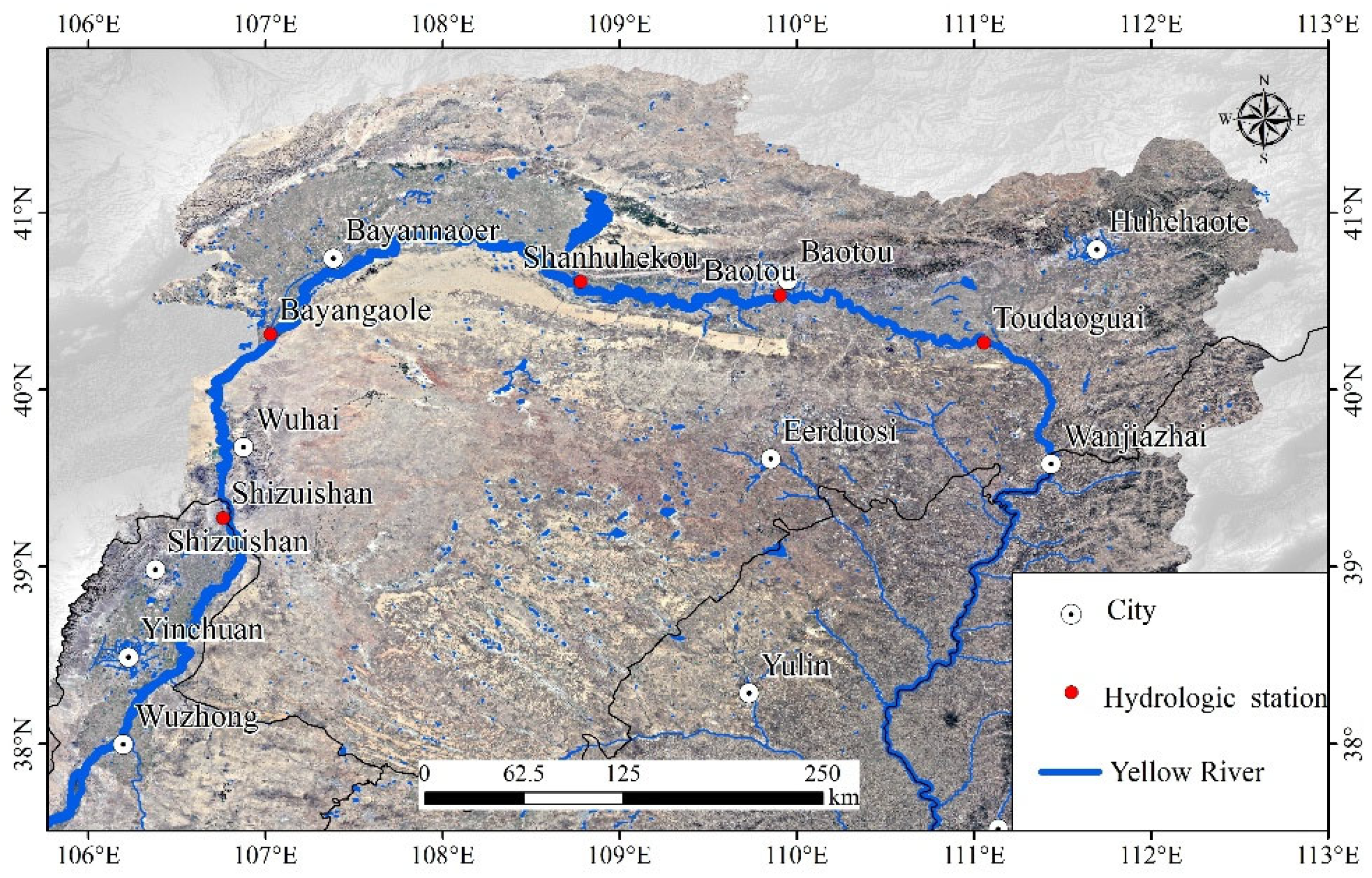
The segment of the Yellow River traversing Inner Mongolia constitutes a critical component of the Yellow River basin, delineating its northern boundary. Situated in the upper reaches of the river, this section represents a notable inflection point in the river’s overall trajectory. Located between 37°35′–41°50′N latitude and 106°10′–112°50′E longitude. The Inner Mongolia section flows through one league, five cities, and seventeen banners. It encompasses five hydrological stations: Shizuishan, Bayan Gaole, Sanhuhekou, Baotou, and Toudaoguai. The hydrological station is capable of acquiring temporal data on ice phenology, the duration of river ice cover, river ice thickness, changes in water storage within the channel, and the spatial distribution of local river ice types for each river segment proximal to the station. This enables the collection of critical information regarding the ice conditions of the Yellow River, thereby offering the most reliable data to support ice prevention efforts. This section spans a total length of 840 km, with an elevation drop of 162.5 m. The mean annual temperature ranges between 4 °C and 6 °C, while the average temperature in January varies from −10 °C to −12 °C. Annual precipitation exhibits a spatial gradient, being higher in the eastern areas and lower in the western regions, with an uneven distribution pattern. The duration of the ice-covered period extends for approximately 4 to 5 months. This region is situated within the mid-temperate continental climate zone and is characterized by typical inland arid and semi-arid climatic features. The segment of the Yellow River situated in Inner Mongolia, characterized by its position in the northernmost high-latitude zone and intricate fluvial dynamics, represents the region exhibiting the most complex and severe ice conditions along the entire river [
28,
29]. The Inner Mongolia segment of the Yellow River exhibits numerous pronounced meanders attributable to the combined effects of river morphology, geographical positioning, and the volume of ice transported from upstream. These factors contribute to a variety of complex ice formations, a wide range of freezing dynamics, and a high incidence of ice jams and ice dams [
30,
31].
Figure 1 shows the study area, the Inner Mongolia reach of the Yellow River. The blue mark highlights the main channel of the Yellow River in Inner Mongolia.
2.2. Types of River Ice
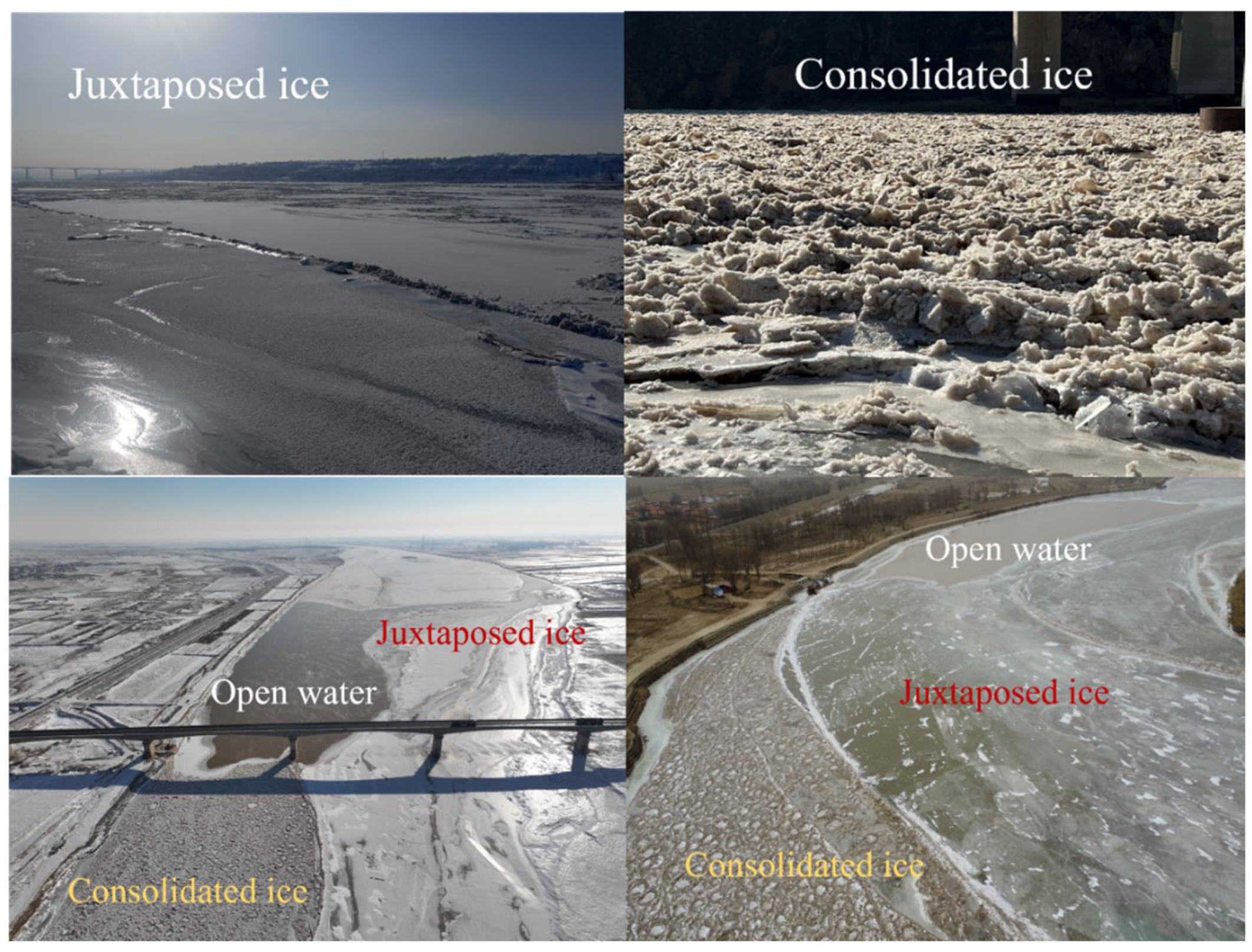
Owing to the intricate characteristics of the Yellow River channel, two distinct forms of ice develop during the winter freezing season. These ice types are commonly classified as juxtaposed ice and consolidated ice, based on their surface properties and morphological features. Juxtaposed ice denotes the ice layer generated through the natural freezing processes occurring along the riverbanks and the surface of the primary channel of the Yellow River, as well as certain ice surfaces produced by the natural freezing of ice floes prior to their accumulation. This type of ice is typically characterized by a relatively smooth and flat surface, with some areas exhibiting features similar to those of lake ice. The formation of juxtaposed ice predominantly takes place in river segments where water flow is relatively tranquil. Prior to the onset of freezing, the development of ice bridges obstructs the movement of frazil ice and ice blocks originating upstream, resulting in their upstream dispersion and the eventual freezing of the affected river section. Under conditions of calm water and absence of wind, a flat ice cover readily develops. This type of ice cover is characterized by a smooth surface, a systematic arrangement of ice blocks, and an initial thickness that is approximately equivalent to that of the drifting ice.
Due to the intricate morphology of the Yellow River channel and its numerous meanders, the accumulation and obstruction of ice floes within the channel result in the compression of ice blocks against one another. This interaction leads to their aggregation and upstream flotation, ultimately causing the river channel to freeze and form an ice surface referred to as consolidated ice. Consolidated ice, alternatively referred to as vertical ice floes, frequently develop in segments of rivers characterized by rapid currents or meandering pathways. When these ice floes become obstructed, they exert pressure against one another, accumulate, and subsequently drift upstream, leading to the freezing of the river segment. The formation of consolidated ice is more prevalent under conditions of high flow velocity and intense wind activity. A distinguishing feature of consolidated ice caps is their highly irregular surface morphology. The initial thickness of these ice caps is strongly influenced by the dimensions of the drifting ice and the angle at which it accumulates. Characterized by jagged, uneven, and irregular surfaces, consolidated ice caps represent a unique form of ice cover that develops in riverine environments within Inner Mongolia during the winter season. Moreover, they constitute the predominant type of ice surface observed in the river sections of this region. The swift current within the consolidated segment of the river facilitates the vertical movement of frazil ice, leading to the formation of ice jams and ice dams that obstruct upstream water flow. This obstruction results in an increased volume of water retained within the channel, thereby elevating the river stage. Consequently, the likelihood of ice-related flood hazards, including dike seepage and inundation, is heightened, imposing greater challenges on ice management and prevention efforts.
Variations in temperature, flow velocity, and riverbed morphology occasionally result in the formation of narrow, open, free-flowing water surfaces in certain sections of the Yellow River. These features are commonly identified as winter open water channels within the Yellow River system. During the winter season, unfrozen open water areas emerge within the Inner Mongolia segment of the Yellow River. The spatial distribution and extent of these open water zones fluctuate in response to variations in topography and ambient temperature. Due to the absence of ice cover, these open waters facilitate the formation of frazil ice and ice blocks, thereby constituting critical focal points for monitoring and implementing ice prevention measures.
Figure 2 shows images of different types of ice on the Yellow River, as well as unfrozen open water areas.
2.3. Remote Sensing Data Source
The analysis of remote sensing data employed imagery obtained from the Sentinel-2 satellite. Sentinel-2 constitutes a critical element of the Copernicus Programme and represents one of the most successful and extensively utilized series of Earth observation optical satellites worldwide. The Sentinel-2 mission comprises two complementary satellites, Sentinel-2A and Sentinel-2B, which operate in tandem to provide a revisit frequency of five days. Each satellite is equipped with a multispectral imager and orbits at an altitude of 786 km. The sensor captures data across 13 spectral bands, ranging from the visible to the shortwave infrared regions, and generates imagery with a swath width of 290 km. High-resolution images, subjected to geometric, radiometric, and atmospheric corrections, are accessible via the Copernicus Open Access Hub (
https://dataspace.copernicus.eu/ accessed on 15 January 2026). At present, Sentinel-2 satellite imagery is predominantly utilized for the observation and analysis of terrestrial surfaces, including vegetation, soil, water bodies, inland waterways, and coastal zones. Additionally, it plays a significant role in the monitoring of natural disasters and the facilitation of related emergency response activities [
32,
33]. This study utilizes high-resolution, cloud-free, and low cloud cover remote sensing images of the Inner Mongolia section of the Yellow River, spanning the entire ice season from 19 December 2023 to 18 March 2024. The analysis employs Level-2A (Bottom of Atmosphere, BOA) image products that have undergone atmospheric and geometric corrections. A set of five images captured simultaneously is sufficient to cover the entire Inner Mongolia segment of the river, resulting in a total selection of 75 remote sensing images. All images were acquired at the same time on each respective day, corresponding to the Sentinel-2 standard overpass time, thereby minimizing variations in illumination conditions. The specifications corresponding to each spectral band of the Sentinel-2 multispectral imagery are detailed in
Table 1.
2.4. Construction of Spectral Feature Vectors for Different Ice Types
Spectral characteristics constitute the fundamental image features for ice analysis. A multi-band spectral feature input vector for classification is constructed by integrating the spectral reflectance values from four Sentinel-2 image bands, specifically encompassing the visible and near-infrared regions. The computation of band indices represents a key approach for discriminating ice from other land cover types and for land feature classification. Accordingly, feature vectors derived from both the Normalized Difference Snow Index (NDSI) and the Normalized Difference Frozen Surface Index (NDFSI) methodologies are employed to distinguish among various ice categories. The Normalized Differential Snow Cover Index (NDSI) [
34,
35] is a widely utilized remote sensing metric for the detection of snow and ice. This index enhances the spectral contrast between exposed ice and other terrestrial surfaces. The formula for its computation is as follows:
In the formula, b3 represents the reflectance in the green light band, and b8 represents the reflectance in the near-infrared band.
The reflectance of juxtaposed ice and open water is very similar in the green and near-infrared bands, but their reflectance in the blue and red bands is opposite. Therefore, by calculating the spectral values in the red and blue bands, the difference between juxtaposed ice and open water can be enhanced. This study introduces the Normalized Difference Frozen Surface Index (NDFSI) [
36,
37] as a metric designed to enhance the spectral distinction between juxtaposed ice and open water. The index is computed using the following formula:
In the formula, b4 is the reflectivity of the red light band and b2 is the reflectivity of the blue light band.
Support Vector Machine (SVM) is a machine learning technique grounded in statistical theory [
38,
39]. It demonstrates strong generalization capabilities and efficient classification performance, particularly when applied to high-dimensional datasets with limited sample sizes. The primary advantage of Support Vector Machines (SVM) in differentiating ice types in the Yellow River is its capability for high-precision classification through adaptation to high-dimensional features. Additionally, SVM offers flexible nonlinear classification and robust generalization performance when working with limited sample sizes. This makes it particularly effective in scenarios characterized by scarce data, complex feature patterns, and significant noise interference, which are common challenges in the ice monitoring of the Yellow River. This research employs SVM as the classification algorithm and develops a classification framework grounded in the associated feature vectors. Utilizing these feature vectors, classification models are established to differentiate between various ice types and open water regions, thereby enabling the identification of ice surface categories during the stable freezing phase of the Yellow River in Inner Mongolia. The research demonstrated that employing SVM as a classification algorithm, in conjunction with multispectral bands and two feature vectors: namely, the Normalized Difference Snow Index (NDSI) and the Normalized Difference Frozen Surface Index (NDFSI) enable effective differentiation of various ice types within the Inner Mongolia segment of the Yellow River. Building upon this foundation, this study systematically identified the various ice types occurring throughout the entire ice-covered period of the Yellow River in Inner Mongolia. It quantified the relative proportions of juxtaposed ice, consolidated ice, and open water areas during the stable ice-sealing phase. Consequently, the research elucidated the temporal dynamics and transformation processes of ice within the Yellow River in this region.
3. Results
3.1. Classification Result Analysis
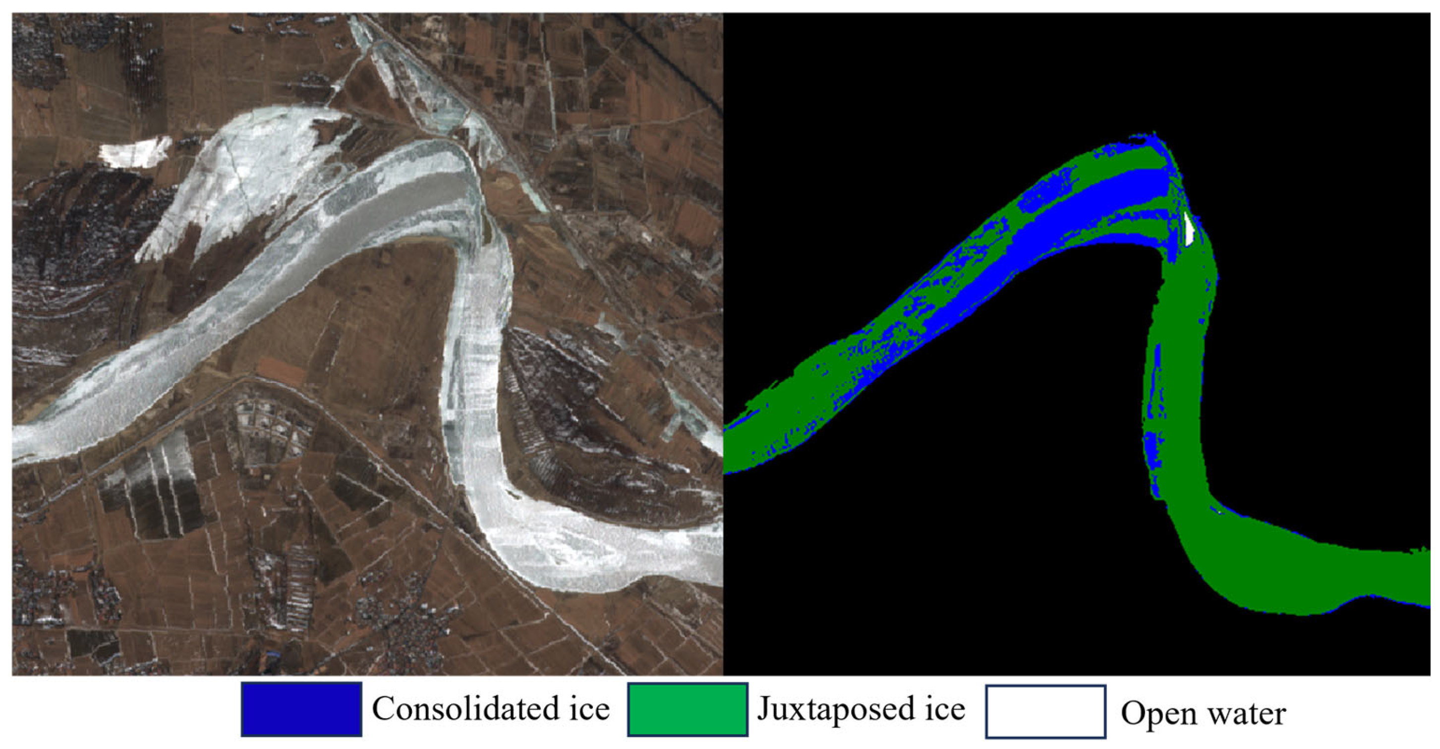
The spatial distribution and extent of juxtaposed ice, consolidated ice, and open water constitute critical information for understanding ice conditions throughout both the ice-covered and ice-melting periods. Consequently, a reduction in the frequency of misidentifying various ice types and classification errors corresponds to an increase in accuracy. To minimize interference from non-river regions, the river channel and floodplain were delineated through an automated extraction technique supplemented by manual refinement prior to conducting the ice type classification experiment. This process yielded a segmented image of the main channel of the main stream of the Yellow River. The juxtaposed ice appears grayish-white or faintly blue in the image, exhibiting a smooth surface texture. In contrast, consolidated ice is characterized by the aggregation of ice blocks, resulting in a rough surface with numerous shadows, low spectral reflectance, significant spatial variability, and a coarse texture. The image depicts irregular white and dark patches, indicative of small ice fragments clustered together. Open water refers to unfrozen, flowing bodies of water that typically exhibit gray or dark hues in true-color imagery. These water bodies demonstrate significant absorption in the shortwave infrared spectrum and possess very low reflectance values. Based on the two types of ice and open water obtained from remote sensing images, a stratified sampling random method is used to ensure the representativeness of the samples. A total of 320 samples were collected from three distinct ice surface types: flat ice, vertical ice, and clear ditch ice. These samples were categorized based on the specific ice type. Within each category, samples were randomly selected to maintain proportional representation consistent with the overall population distribution. High-precision visually interpreted images were employed as ground truth data, while certain on-site drone images were incorporated as validation datasets. The application of the SVM classifier, utilizing multispectral bands alongside the NDSI and NDFSI as feature vectors, demonstrated effective classification performance for the Inner Mongolia segment of the Yellow River. Due to the complexity and numerous bends of the Yellow River in Inner Mongolia, several typical bends were selected as representatives. This section presents the corresponding classification results derived from this analysis.
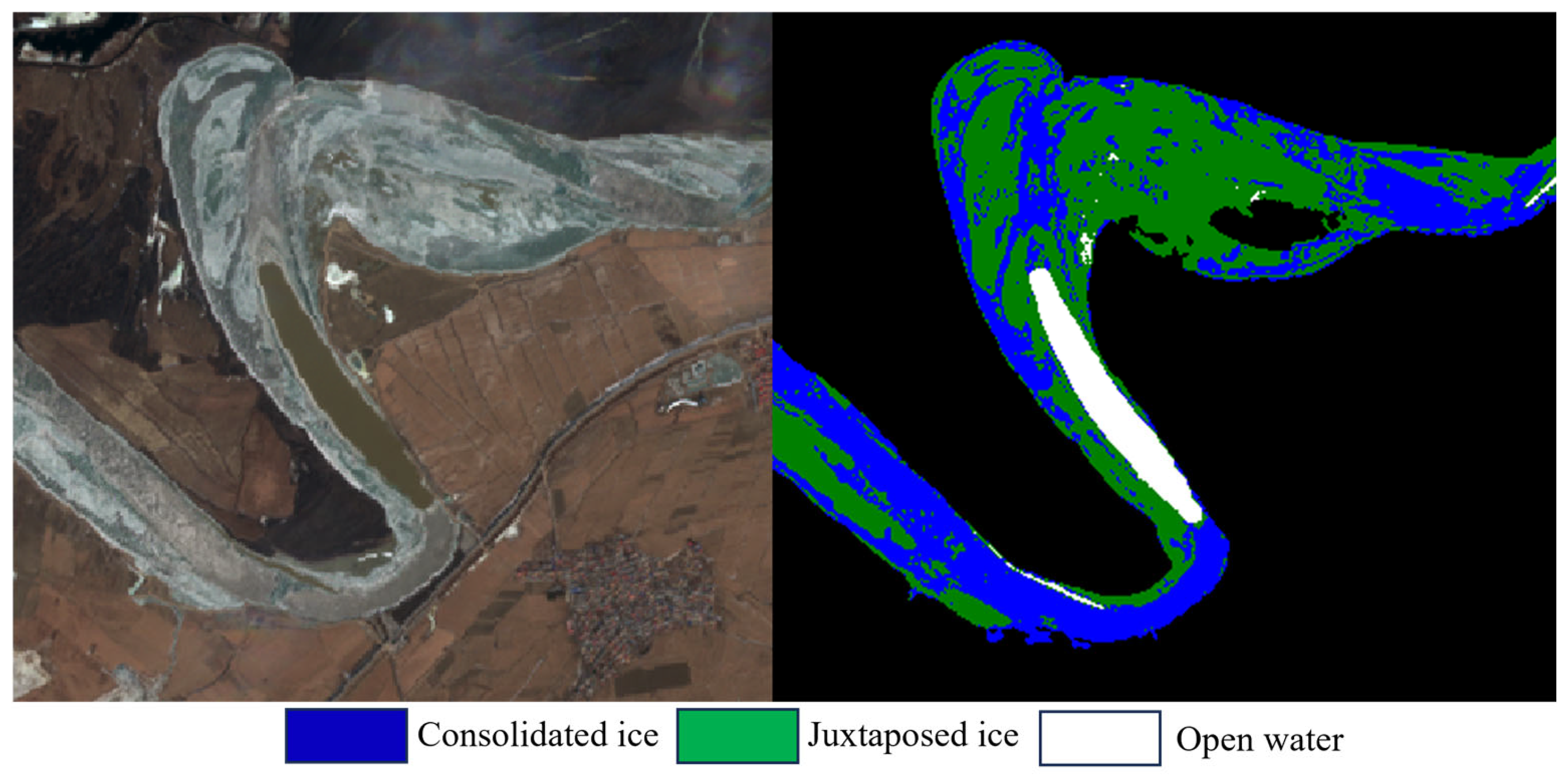
Figure 3 illustrates a meander in the Yellow River located upstream of the Dachengxi Yellow River Bridge in Inner Mongolia. The remote sensing imagery reveals that the majority of ice has congregated at the apex of the bend, resulting in a pronounced ice accumulation phenomenon. Consequently, following the freezing process, consolidated ice formations develop. Owing to the reduced flow velocity and the predominantly natural origin of the ice, the ice along the riverbanks tends to be predominantly flat and level. Downstream of the bend, the augmented flow velocity and the straightening of the river channel resulted in the development of extensive regions of flat, frozen ice. Despite the pronounced bend angle, the constricted width of the river channel inhibited the formation of a substantial open water body. The image on the left represents the original remote sensing data, while the image on the right depicts the results following the classification of ice types. The outcomes demonstrate that this method effectively classifies different ice types within remote sensing imagery. The algorithm demonstrates a clear capability to differentiate between juxtaposed ice and consolidated ice formations, achieving precise discrimination at the pixel level. Furthermore, it effectively represents accumulated regions with high detail, exhibiting a low misclassification rate that is confined primarily to minor boundary areas. By establishing this distinction, it becomes evident that the river channel contains two distinct types of ice. Furthermore, this differentiation allows for a comprehensive assessment of the relative proportions of each ice type across various sections of the river channel, thereby facilitating a more profound understanding of the ice conditions.
To enhance the interpretation of the classification outcomes, an additional river channel containing both types of ice as well as unfrozen open water was chosen for differentiation.
Figure 4 illustrates a curve located near the Baotou South Ring Road and the Baotou South Sea Scenic Area, where juxtaposed ice, consolidated ice, and unfrozen open water channels are observed concurrently. Due to the presence of two consecutive small bends and the narrowness of the river channel, there will be some differences in the river flow velocity. During the ice floe season, some ice will get stuck in the bends and accumulate, resulting in a large amount of vertical ice at the bottom of the bends. As the river channel gradually widens, the proportion of juxtaposed ice increases. Owing to the heterogeneous temperature distribution and the combined influence of the river channel morphology and flow velocity, unfrozen open water zones have developed even at the apex of narrow bends. Given that the formation of various ice types is associated with flow velocity and topographical features, it is evident that the primary current is concentrated in the central region of the river channel, with a tendency to shift towards the right bank. As illustrated in the figure, the algorithm demonstrates high efficacy in delineating open water regions, distinctly highlighting extensive unfrozen water bodies within the river channel. Furthermore, it effectively detects smaller open water areas, exhibiting superior discrimination performance compared to its ability to differentiate among various ice types.
A comprehensive analysis and characterization of the entire Inner Mongolian segment of the Yellow River indicate that elevated temperatures at the upstream portion of this section contribute to an increased presence of open water between Wuhai and the Bayangol hydrological station. Consequently, this thermal condition facilitates a substantial aggregation of ice floes within the river channel, resulting in a heterogeneous distribution of juxtaposed ice, consolidated ice, and open water areas. As the river gradually enters the downstream Baotou section, temperatures gradually decrease, and due to the narrowing of the river channel, a large portion of the ice floes accumulates, forming consolidated ice, thus reducing the proportion of open water. In the segment extending from Baotou to Shisifenzi, the variability in river channel width leads to increased formation of bank ice in the wider areas, thereby producing a comparatively substantial quantity of juxtaposed ice. Additionally, ice floes predominantly congregate within the main channel and at bends characterized by pronounced angular deviations. The river channel extending from Shisifenzi to Laoniuwan downstream is notably constricted, resulting in the majority of the river surface freezing completely during the winter season. The presence of a downstream reservoir further impedes flow, causing a significant accumulation of ice floes upstream of the reservoir. Consequently, this segment of the river exhibits minimal open water, with substantial quantities of two distinct types of ice present. By distinguishing among various ice types, it is evident that, in comparison to the entire river section within Inner Mongolia, the presence of numerous meanders leads to differential ice accumulation during the ice drift period, thereby facilitating the formation of consolidated ice. At these river bends, distinct interfaces between juxtaposed ice and consolidated ice formations, along with well-defined channels, are commonly observed. Computational algorithms were employed to analyze the entire river segment within Inner Mongolia, revealing a predominance of consolidated ice formations. Juxtaposed ice primarily develops in straight or comparatively wide river channels, with bank ice largely consisting of juxtaposed ice types. Once specific adjustments are made to the river image, this method can automatically generate topographic images of different ice types and open water classifications, thus providing effective information support for providing relevant data. By categorizing various types of ice within river channels, it has been demonstrated that employing SVM classifier in conjunction with the NDSI and NDFSI for the analysis of remote sensing imagery enables effective discrimination between different ice types and open water regions. This approach accurately captures the ice conditions across diverse river channel morphologies, including straight segments, bends, and unfrozen water zones, thereby yielding highly satisfactory outcomes.
3.2. Evaluation of Classification Result Accuracy
Classification techniques employed for identifying river ice within river channels using remote sensing imagery are susceptible to both systematic and random errors. Consequently, it is essential to conduct accuracy assessments to quantitatively determine the reliability of the classification results. The classification accuracy evaluation adopts the Confusion Matrix analysis method. The results derived from manual visual interpretation and images captured by unmanned aerial vehicle (UAV) of selected river channels were employed as ground truth data. These were integrated with the spatial distribution patterns of ice types specifically noting that ice accumulations typically occur near bends and bridge piers for validation purposes. Subsequently, these reference data were compared and analyzed against algorithmically generated outcomes to conduct a comprehensive evaluation analysis. Evaluation is conducted using two classification metrics: overall classification accuracy and the kappa coefficient. We conducted separate analyses and statistics on the algorithm’s ability to distinguish between two different types of ice.
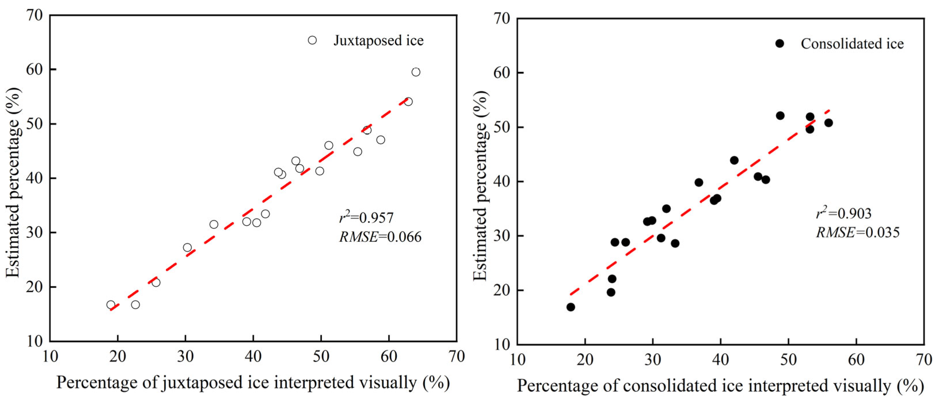
Figure 5 shows the results obtained using this method to differentiate ice types.
Figure 5 illustrates that the application of this classification method to differentiate original remote sensing images and identify ice types effectively discriminates among juxtaposed ice, consolidated ice, and open water, yielding highly satisfactory outcomes. Due to its smooth surface, well-defined boundaries, and tendency to form extensive areas, juxtaposed ice is readily identifiable by the algorithm. The scatter plot illustrating the identification of flat ice indicates that the coefficient of determination can attain a value as high as 95.7%. Moreover, the incidence of misclassification is minimal, enabling an accurate estimation of the proportion of juxtaposed ice. For consolidated ice, the surface is rough and uneven, and some areas where ice accumulates are not clearly visible in the image. Therefore, the ability to distinguish consolidated ice is somewhat different from that of juxtaposed ice. The delineation between juxtaposed ice and consolidated ice formations, as well as the shoreline, is somewhat ambiguous. Various factors have contributed to a reduction in the algorithm’s classification accuracy. Specifically, the coefficient of determination of consolidated ice categorization is 90.3%, with some instances of misclassification, including the erroneous categorization of consolidated ice formations as juxtaposed ones. Nonetheless, the overall performance of the classification process remains highly satisfactory. The algorithm demonstrated an overall accuracy of 94.91% when evaluated across the entire river segment. Additionally, the kappa coefficient, derived from the confusion matrix, was determined to be 0.9144. Based on the foregoing, it is evident that this methodology offers a robust technical approach for distinguishing various ice types within the Yellow River and quantifying their respective proportions. By determining the ice classifications in the Inner Mongolia segment of the Yellow River at different temporal intervals, as well as identifying the unfrozen open water areas during the freezing season, this approach enhances the capacity to predict ice dynamics in the Yellow River. Consequently, it provides novel insights and theoretical foundations for forecasting ice jams and ice dam formations in this river system.
4. Discussion
In the analysis of remote sensing imagery, clear and cloud-free images are typically utilized to ensure the acquisition of more precise data. During winter, image recognition in snow-covered environments differs significantly from that in clear conditions, encountering various problems including spectral ambiguity, environmental interference, and data heterogeneity [
40,
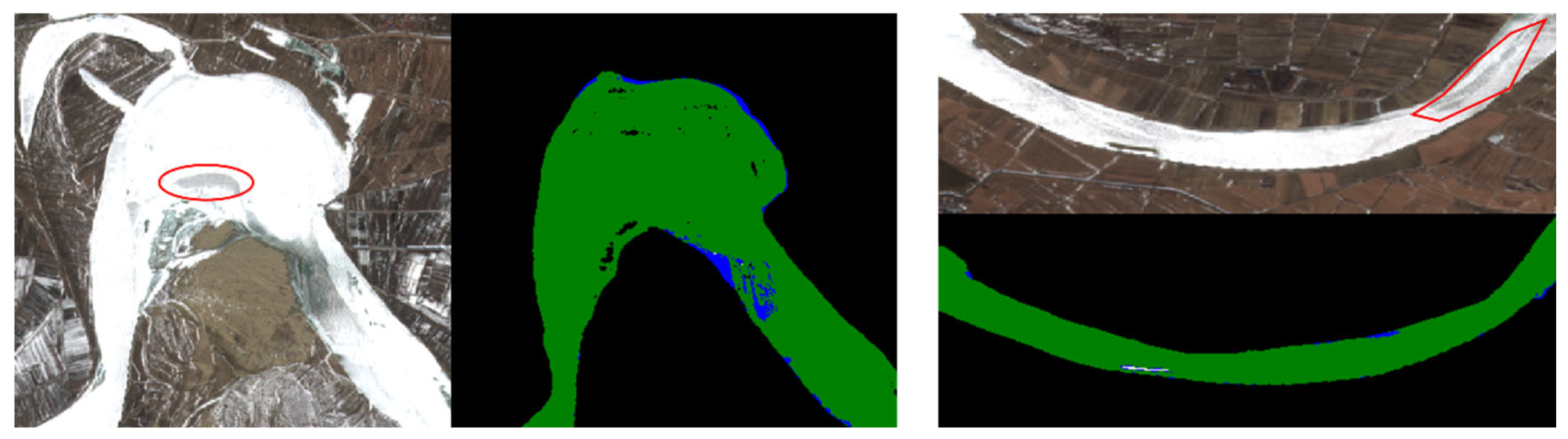
41]. Owing to the climatic conditions and geographical characteristics of the Inner Mongolia segment of the Yellow River, this region generally does not experience significant snow accumulation or extended snow cover on the river channels. However, there are certain periods during which snow accumulation does occur within the river channels. Our analysis of remote sensing imagery revealed that snowfall can lead to the accumulation of snow over certain rivers, causing these water bodies to predominantly appear white. This phenomenon has the potential to introduce inaccuracies in the subsequent analytical procedures. Upon conducting an analysis of snow-covered river channels employing the methodology outlined in this study, potential recognition errors were identified. Specifically, certain consolidated ice seals may be misclassified as juxtaposed ice seals, a misidentification likely attributable to factors such as snow coverage, surface roughness, and indistinct boundary delineations. Parts of the river channel partially covered with snow were selected for analysis.
Figure 6 presents the remote sensing image of this snow-covered river channel alongside the corresponding recognition outcomes. It is evident that when the river channel is snow-covered, it appears white in the remote sensing imagery, and the recognition algorithm predominantly identifies the area as juxtaposed ice. Notably, the algorithm fails to detect the consolidated ice within the red-marked region in the figure, instead misclassifying the consolidated ice as juxtaposed ice. Due to the lack of processing for snow cover recognition, inaccuracies arise in identifying snow-covered river channels, thereby impacting the overall differentiation accuracy of the entire river channel. Owing to the constricted channel characteristics of the Yellow River and its unique attributes, research concerning the classification of ice types beneath snow cover in this region remains limited. Future studies aim to implement remote sensing image identification techniques under snow-covered conditions to the Yellow River, thereby enhancing the scope and depth of research on ice phenomena within this river system.
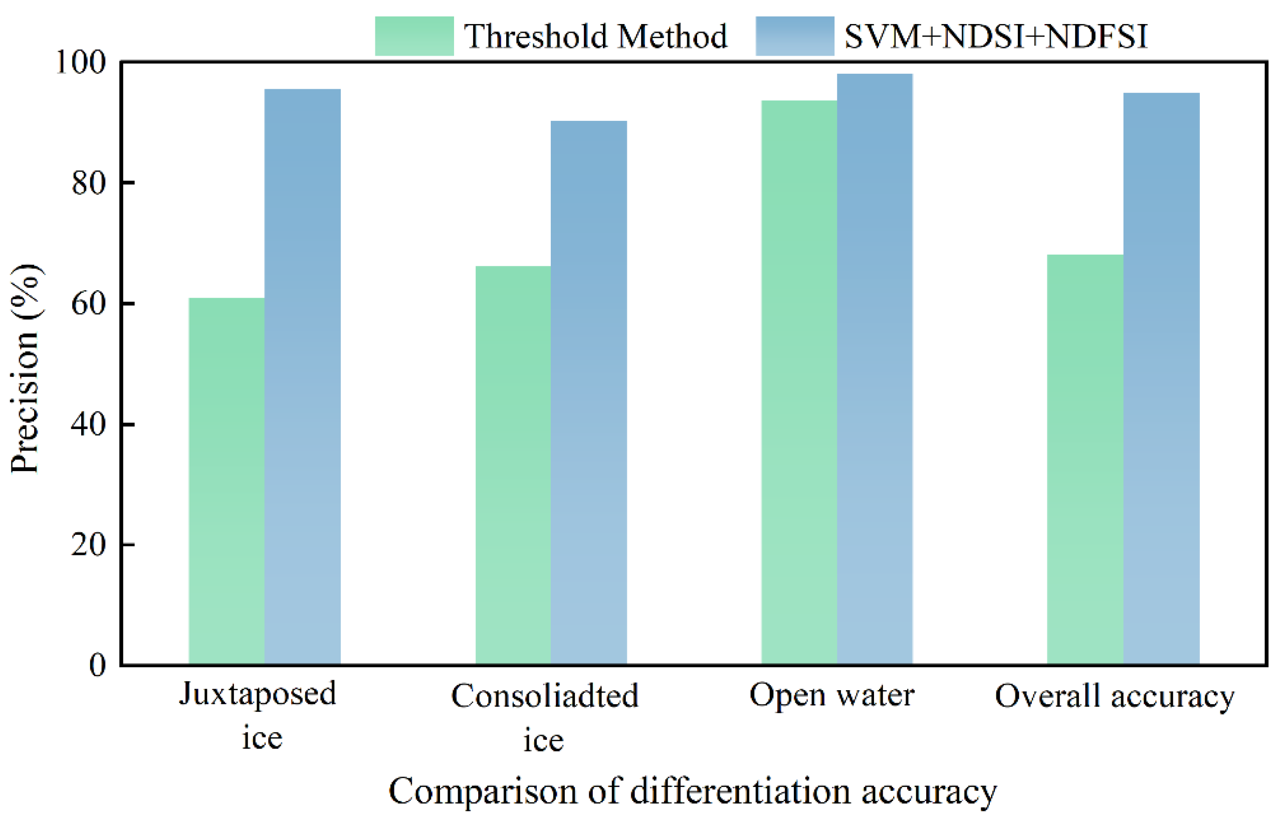
The near-infrared single-wave threshold method represents the most commonly employed algorithm for the classification of river ice in multispectral imagery. Through an analysis of the reflectance characteristics of juxtaposed ice, consolidated ice, and open water within the near-infrared spectral bands, specific threshold values were established to differentiate among these river ice types. In particular, an albedo threshold of 0.35 was determined for the B8 near-infrared band to facilitate this classification. The threshold value below 0.15 is considered as water body, 0.15–0.35 is considered as consolidated ice seal, and greater than 0.35 is considered as juxtaposed ice seal. This method is applied to classify river ice in the Inner Mongolia segment of the Yellow River during the freezing period. Furthermore, the algorithm proposed in this study is subjected to comparative analysis. The analysis indicates that the threshold method achieves a high classification accuracy for water bodies, reaching up to 93.78%; however, a certain degree of misclassification remains present. In contrast, the classification accuracy for ice associated with consolidated and juxtaposed seals is comparatively low, accompanied by a notable misclassification rate. The overall classification accuracy of threshold method is only 68.24%. A comparison between the threshold method and the extraction results of the proposed scheme reveals a prevalent and conspicuous issue wherein juxtaposed ice is frequently misclassified as open water. Conversely, certain open water areas are also incorrectly identified as juxtaposed ice. This pattern of misclassification is evident in multiple instances.
Figure 7 presents a comparison between the proposed algorithm and the threshold method. The results indicate that, relative to the near-infrared single-wavelength threshold approach, the current method substantially enhances the accuracy of ice type classification in the Yellow River. Consequently, further refinement of the algorithm to achieve more precise differentiation between ice types and open water constitutes a primary focus for future research endeavors. Furthermore, future research may involve differentiating among various classifiers, including random forest and convolutional neural networks. By analyzing diverse scenarios, it is possible to determine the type and proportion of ice present in the Yellow River. This approach has the potential to enhance classification accuracy, thereby facilitating more precise identification and monitoring of the types and dynamics of Yellow River ice. Consequently, this would improve both the efficiency and stability of the classification process while maintaining high levels of accuracy. The challenges associated with inaccurate interpretation indicators in remote sensing monitoring of Yellow River ice jams, as well as the limited precision of automatic ice jam interpretation models, constitute the primary research priorities for enhancing the application of remote sensing technology in the future monitoring of Yellow River ice jams.
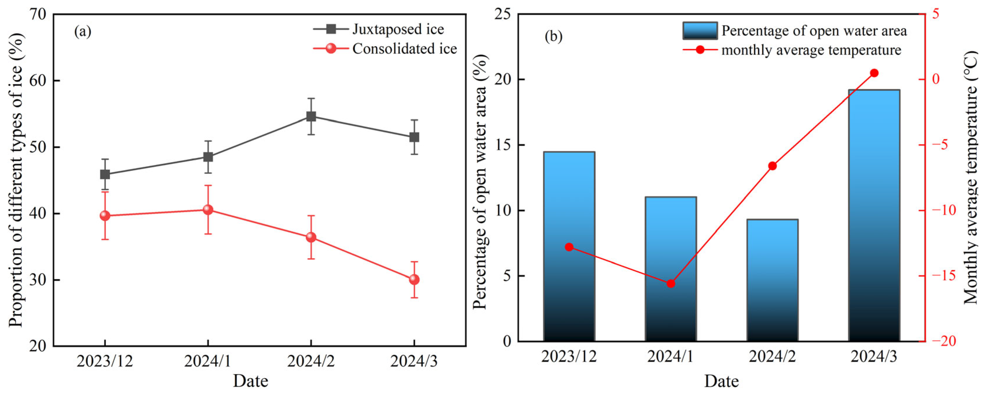
The variations in ice conditions along the Yellow River during the winter season represent a complex and dynamic phenomenon. To elucidate the temporal changes in ice conditions within the Inner Mongolia segment of the Yellow River throughout the entire ice period, remote sensing imagery from the 2023–2024 ice season was utilized for detailed analysis and classification.
Figure 8 illustrates the proportions and temporal transitions of juxtaposed ice, consolidated ice, and open water areas across the entire river section, spanning from the initial ice-floe stage through the stable ice-covered phase to the subsequent ice-free period.
Figure 8a illustrates the variations in different ice types within the Inner Mongolia segment of the Yellow River throughout the 2023–2024 ice season. The data indicate a progressive increase in the proportion of juxtaposed ice, suggesting substantial formation of flat ice along the riverbanks and within low velocity sections of the channel during the initial freezing phase. With further temperature decline, additional open water areas subsequently froze, contributing to the development of new juxtaposed ice. Therefore, the proportion of juxtaposed ice gradually increases, reaching a maximum of 54.6% of the entire river section. During the phases of drift ice and the initial stage of stable ice formation, consolidated ice formation is significantly influenced by multiple factors, including the accumulation of drift ice and the occurrence of ice jams at bends. Consequently, a substantial volume of consolidated ice develops, with its proportion progressively increasing. This proportion eventually reaches levels comparable to, or exceeding, that of juxtaposed ice formation, attaining a maximum value of 40.5%. As temperatures increase and the river shifts from a stable, ice-covered phase to an open-water period, the proportion of consolidated ice will decline. This is primarily because consolidated ice is typically found in areas with high river flow velocities, especially in the river’s center. As a result, consolidated ice will melt first, and due to the strong flow, it will also submerge and vanish beneath the remaining ice layer. Consequently, consolidated ice will steadily decrease during the open-water phase, while changes in juxtaposed ice will occur more gradually, lagging behind the decline of consolidated ice.
Figure 8b shows the proportion of open water in the Inner Mongolia section of the Yellow River. It can be seen that the proportion of open water gradually decreases from the ice-floe period to the stable ice-floe period, indicating that the main factors affecting the open water of the Yellow River are the river flow velocity and temperature, which account for 14.47% of the entire river channel during the ice-floe period. The open water areas are mostly found in bends and areas with high flow velocity, and there are also 9.3% open water areas during the stable freezing period, indicating that the Yellow River channel in Inner Mongolia will not be completely frozen. Although air temperatures rise from January to February, they remain subfreezing; widespread thaw has not yet commenced, and portions of open water refreeze into sheet ice. As temperatures gradually rise and the river transitions from a frozen to an open state, the proportion of open water will significantly increase. This suggests that during the ice-melting phase, the ice in the main channel will melt first, resulting in an increase in the proportion of open water. This paper does not address the specific influence of meteorological factors on the spatiotemporal dynamics of ice. Future research could undertake a detailed investigation of river ice variations in relation to prevailing meteorological conditions. The changes in different types of ice and the proportion of open water areas are key factors in determining how smoothly the Yellow River basin transitions through the winter. Through comprehensive identification of the entire river channel, it has been determined that the Yellow River in Inner Mongolia exhibits a specific distribution of consolidated ice, juxtaposed ice, and open water during the winter season. This method can effectively distinguish different ice types and open water areas, thereby obtaining the whole process of ice change in the Yellow River in Inner Mongolia, and providing good theoretical support for future ice prevention work and ice condition prediction.





 ,
,