


Highlights
What are the main findings?
- InSAR-integrated FLAC3D modeling captures the spatiotemporal evolution of mining-induced surface deformation on the Loess Plateau.
- Mining-induced stress redistribution is quantitatively linked to surface deformation and landslide distribution.
What are the implications of the main findings?
- InSAR-integrated numerical modeling connects surface deformation observations with subsurface structure failure mechanisms.
- Landslide density is strongly correlated with surface deformation, clustering near mined-out areas.
Abstract
Underground coal mining can induce substantial surface deformation and trigger associated geological hazards. However, the quantitative links between mining-induced deformation, stress redistribution, and the spatial pattern of landslide occurrence remain insufficiently understood, particularly in loess-covered mining regions. Taking the Hecaogou Coal Mine in the Zichang mining area of the Loess Plateau, China, as an example, this study uses a coupled framework that integrates multi-temporal Interferometric Synthetic Aperture Radar (InSAR) observations with three-dimensional FLAC3D numerical simulation. We found that surface deformation is primarily concentrated above and adjacent to the mined-out zones, with maximum cumulative deformation of −169.3 mm during March 2017 and December 2023. The stepwise excavation simulations reveal that vertical displacement and vertical compressive stress in the overlying strata increase continuously as mining advances, thereby promoting tensile–shear failure and surface subsidence, with the subsidence magnitude quantitatively increasing from 3.7 mm at 200 m depth to 162 mm at 1000 m depth. A strong agreement between InSAR-derived deformation and simulated deformation fields is demonstrated, confirming the reliability of the modeled deformation process. We also found that the landslide density exhibits a strong spatial correlation with surface deformation, with high-density zones clustering near the mined-out areas. These findings enhance our understanding of how underground coal mining reshapes surface stability and influences the spatial pattern of landslide occurrences in coal mining regions.
1. Introduction
Coal is widely acknowledged as a vital global energy source, playing a crucial role in ensuring energy security and supporting socio-economic stability [1,2,3]. In 2020, China accounted for 49.7% of the world’s coal output, with an annual production of 3764 Mt [4]. However, underground coal mining results in surface deformation and a variety of associated geological hazards [5,6,7], which can further amplify regional social risks through cascading hazard effects [8,9].
Surface deformation in mined-out areas is a direct consequence of the progressive collapse of overlying strata following coal extraction. Usually, surface deformation can persist for several years or even decades without human intervention [10]. Identifying the spatial extent and magnitude of surface deformation is crucial for regional stability assessment, especially for slow deformation, which can gradually reduce hillslope stability and initiate multi-hazard chains [11,12]. Previous studies have demonstrated that time-series Interferometric Synthetic Aperture Radar (InSAR) analysis is an effective approach for identifying the surface deformation in mined-out areas [13]. Indeed, this technique enables large-scale monitoring of surface deformation with sub-centimeter accuracy. However, InSAR observation has inherent limitations in elucidating the intrinsic mechanisms of deformation and quantifying the spatiotemporal evolution process of such deformation.
Surface deformation induced by coal mining is a complex dynamic process involving multi-field coupling [14], with its core mechanism rooted in stress redistribution and progressive failure of overlying strata following mined-out area formation [15]. Numerical simulations offer a robust means to investigate the mechanisms of mining-induced deformation and the progressive failure of overlying strata. For example, particle flow code (PFC) can reflect the development of fissures based on the failure transformation between particles, which provides insights for understanding how fissures initiate, develop, and form a hazard chain [9]. Salmi et al. used the Distinct Element Model (DEM) to explore the influence of mining-induced stresses on shear and compressive failure of weak strata [16]. They emphasized the roles of stress redistribution on hillslope instability and the initiation of landslides. Moreover, FLAC3D has been widely used to explore geological hazards since it can accurately identify the deformation and failure mechanisms in discontinuous rock masses [17,18,19,20]. However, it remains a challenge to cross-verify the simulation results with the actual situation.
Thus, it is essential to integrate InSAR-derived surface deformation data with FLAC3D-based numerical simulations to systematically elucidate the intrinsic linkage between mining-induced disturbances and surface deformation. Taking the Hecaogou mine area in Zichang, Shaanxi, as an example, this study conducted a comparative analysis between surface deformation identified by InSAR (2017–2023) and deformation profiles simulated by the FLAC3D numerical model of the mining area. This integrated approach leverages the extensive coverage and high precision of InSAR observation, while numerical simulations help reveal the underlying causes and mechanisms of disaster development. It provides an effective technical pathway for systematically studying the influence of underground coal mining on surface stability and landslide distribution.
2. Materials and Methods
2.1. Study Area
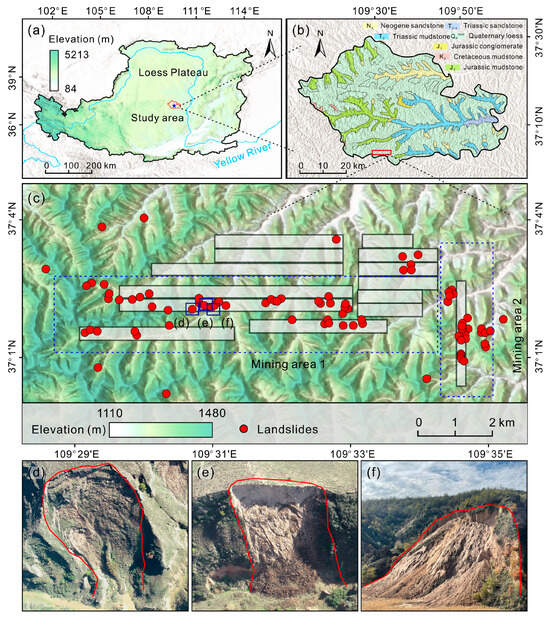
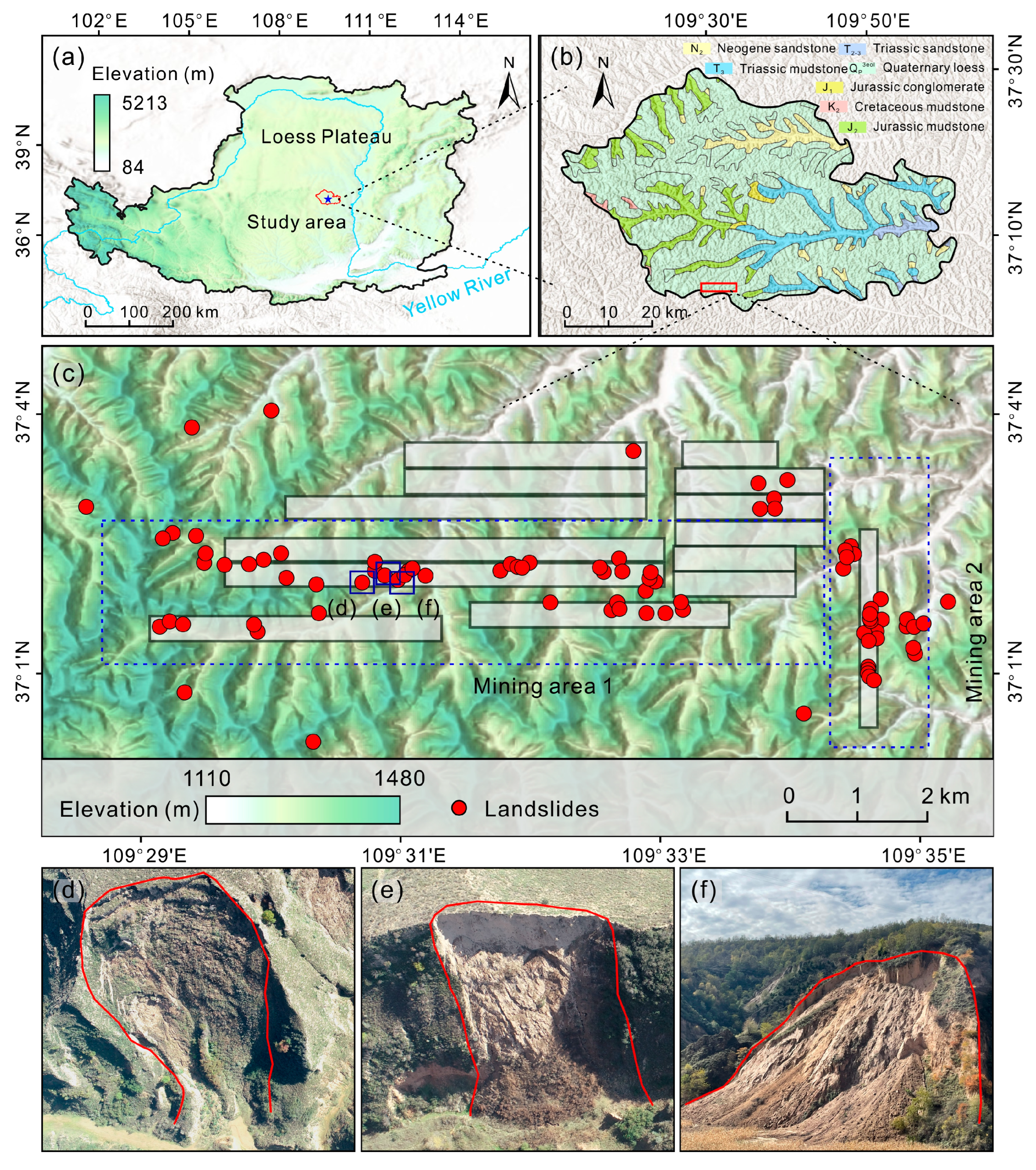
The Hecaogou mine area is located in Zichang City, Shaanxi Province, the central part of the Loess Plateau (Figure 1), which is characterized by a warm temperate continental semi-arid climate. The study area exhibits typical loess hilly and loess ridge landforms. In terms of stratigraphy, the surface is covered by Quaternary eolian loess, including Malan Loess (Q3) and Lishi Loess (Q2), with the thickness varying from 0 to 280 m. The underlying bedrock consists of coal-bearing strata of the Upper Triassic Wayaobao Formation (T3w), with a bedrock thickness ranging from 155 to 250 m. This region belongs to the Carboniferous-Permian coalfield, with the Upper Triassic Wayaobao Formation (T3w) serving as the primary coal-bearing stratum. The exploited coal seam in this area is the No. 5 coal seam. It is a medium-thick seam with an average thickness of 2.19 m (ranging from 0.51 to 2.95 m) and an average burial depth of 299 m. The seam dips gently at 0° to 2°. Its immediate roof consists of 4.1 m of oil shale, which is dark gray, thinly bedded, laminated, and prone to weathering with developed vertical joints. The immediate floor is composed of 5.2 m of silty mudstone, which is also thinly bedded, laminated, and easily weathered and fragmented. Large-scale underground mining in the Hecaogou area has resulted in significant ground deformation and has triggered landslide hazards. The unique engineering-geological context of the region, which is defined by a thick loess layer situated above bedrock, makes it particularly vulnerable to mining-related phenomena such as ground fissures, surface subsidence, and landslides occurring at the loess-bedrock interface. Consequently, this area serves as an important site for studying mining-induced geohazards on the Loess Plateau [3].
Figure 1.
Overview of the study area. (a) Location of the study area and the Loess Plateau. (b) Geological map of Zichang City. (c) Distribution of landslides (red dots), mining areas and mining working panels (rectangles outlined in grey). (d–f) Field photographs of typical landslides. The boundary of each landslide is delineated by a red line.
In this study, a landslide inventory for the Hecaogou mining area was established through visual interpretation of high-resolution optical satellite imagery, comprising a total of 89 landslides. These landslides can be categorized into two primary types: rainfall-subsidence-triggered landslides and shallow landslides triggered by subsidence. It should be noted that both types are fundamentally induced by mining-induced subsidence. The former is triggered by the coupling effect of rainfall under subsidence-dominated slope instability. Previous studies provide that the driving effect of mining-induced subsidence is significantly more critical than that of rainfall during the evolutionary process of landslides in coal mining areas [6,7,8,9,10,11,12,13,14,15]. In our study, we investigated the No. 5 coal seam. This seam is buried at a depth of 220–270 m, has a thickness of 2.42–2.49 m, and has a gentle dip angle of 0–3°. The overlying strata of the coal seam are composed of oil shale and fine-grained sandstone. Under shallow coal seam mining conditions, the interaction between mining-induced stresses and gully topography creates a coupling effect between the geological environment and mining activities. This significantly increases the risk of slope instability and adds complexity to the development mechanisms of geological hazards.
2.2. Surface Deformation Observation Based on InSAR
Small-baseline subset InSAR (SBAS InSAR), an advanced satellite-based Synthetic Aperture Radar (SAR) interferometric technique, provides notable advantages for large-scale, high-resolution surface deformation observation [21,22]. The primary product of the SBAS InSAR analysis is a time series of ground deformation measured along the satellite’s Line-of-Sight (LOS) direction. This method demonstrates exceptional capability in comprehensively characterizing surface deformation fields and is particularly adept at identifying incipient geological hazard processes [23]. Moreover, it minimizes atmospheric delay errors and spatiotemporal decorrelation noise, significantly enhancing surface deformation observation accuracy [24].
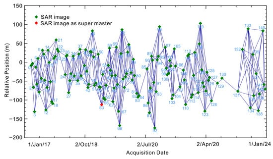
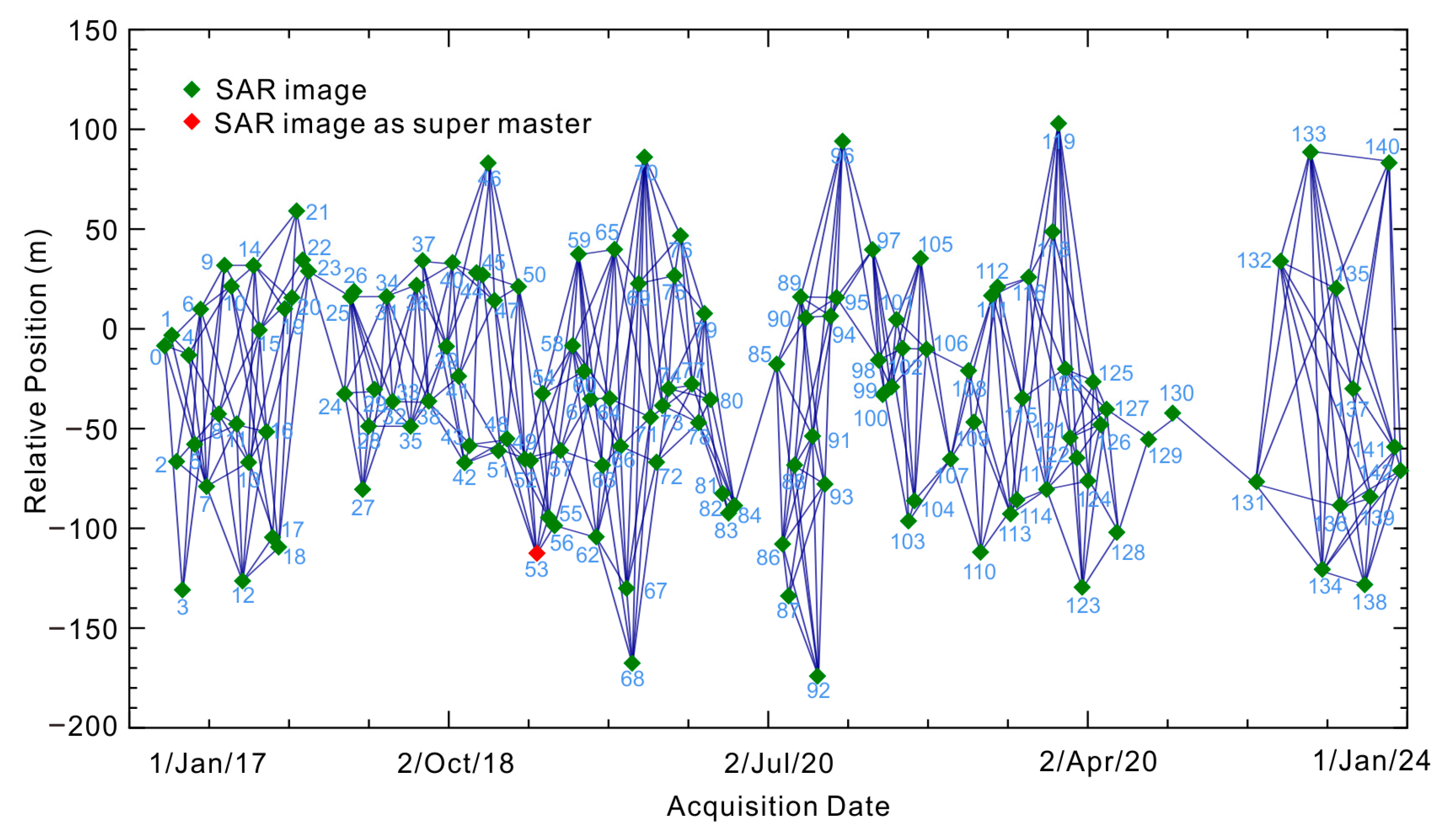
Our study utilized 153 descending-orbit Sentinel-1 SAR images, acquired from the European Space Agency between March 2017 and December 2023, to monitor surface deformation in the Hecaogou mining area. The image obtained on 14 March 2017 was set to the central reference. Interferometric processing involved generating all possible pairs satisfying the temporal constraint, followed by selection of those meeting the spatial baseline criterion for subsequent analysis. In the SBAS InSAR processing, all possible interferometric pairs were generated by applying a temporal baseline threshold of 60 days and a spatial baseline threshold (normal baseline ≤ 5%). A coherence threshold of 0.3 was used for phase unwrapping, while a coherence threshold of 0.2 was applied during the interferogram generation stage. The spatiotemporal baseline configuration of the finally selected interferometric pairs is shown in Figure 2. The data processing incorporated comprehensive error correction strategies, which were applied at key stages of the SBAS InSAR workflow. First, during the generation of differential interferograms for each pair, topographic phases were removed using the 30-m SRTM Digital Elevation Model, while orbital inaccuracies were minimized through precise orbit ephemerides. Subsequently, atmospheric delays were addressed via spatiotemporal filtering techniques applied to the unwrapped interferogram stack. Specifically, the common-mode atmospheric phase screen was estimated and removed by applying a combination of temporal high-pass and spatial low-pass filtering to the time-series phase data. This process separates the temporally correlated (long-wavelength) atmospheric signals from the shorter-wavelength deformation and topographic residual phases. Ultimately, the time-series deformation and average velocity for coherent targets were derived through Singular Value Decomposition (SVD) under the minimum norm criterion of deformation velocity [25,26].
Figure 2.
Spatial and temporal baselines of the selected Sentinel-1 pairs in the period of March 2017 to December 2023.
2.3. Mechanical Simulation of Coal Mining Deformation Based on FLAC3D
2.3.1. Finite Difference Method
This study utilizes the FLAC3D software (version 6.0), based on explicit Lagrangian method, to simulate the coal mining-caused deformation. The explicit Lagrangian framework, originally proposed for geomechanical modeling by Cundall [27], is implemented through the dynamic update of node positions following material deformation, which is expressed as:
where and are the node coordinates at times and , respectively; is the velocity component; is the acceleration component; and is the time step. This algorithm enables adaptive adjustments of the computational grid in response to material deformations [28].
The software employs a hybrid discrete element technique to dynamically model various geological materials and reinforcements [27,28]. It integrates the Mohr-Coulomb constitutive model and the rock-soil consolidation yield criterion, making it suitable for the analysis of rock mass responses under small deformation conditions. The Mohr-Coulomb criterion, formulated by Coulomb [29], is expressed as follows:
where is the shear strength; is cohesion; is the normal stress on the failure plane; and is the internal friction angle. For rock-soil consolidation, the yield criterion is linked to effective stress, following Biot’s theory of poroelasticity [30]. The algorithm dynamically solves the equations of motion, enabling adaptive adjustments of the computational grid in response to material deformations [28]. These equations of motion for three-dimensional geomechanical systems were originally given by Cundall [27]:
where is material density, is the displacement component, is the stress tensor, and is the body force per unit volume (e.g., gravity). By iteratively calculating node movements, strain rates (derived from velocity gradients), and stress fields over time steps, the system reaches mechanical equilibrium.
This approach is particularly effective in analyzing rock mass instability caused by underground excavation as it accurately captures the time-dependent effects during the mining process, providing a more realistic simulation of coal mining operations [31,32].
2.3.2. Model Construction and Parameter Settings
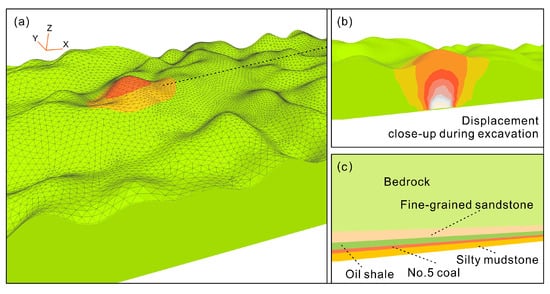
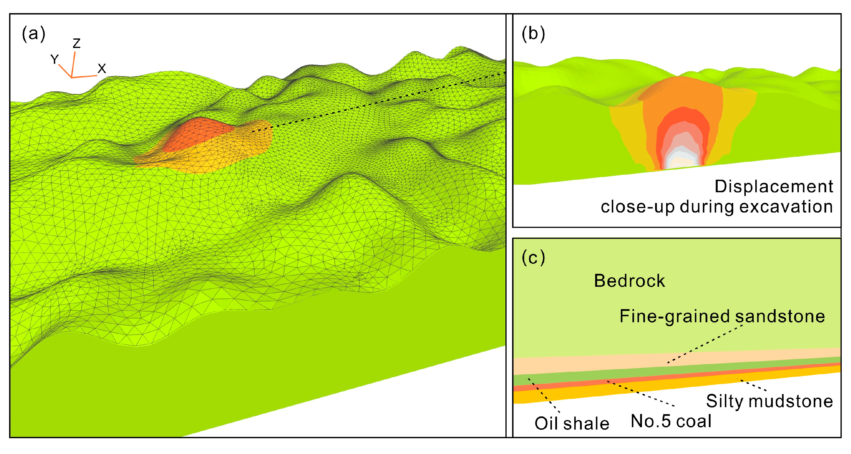
The constructed model has dimensions of 900 m in the X direction, 270 m in the Y direction, and 300 m in the Z direction (Figure 3a). A total of 345,703 nodes and 67,042 elements were generated. The model comprises six rock units, which extend from the surface to the bottom boundary (Figure 3c). From top to bottom, these units are as follows: loess, bedrock, sandstone, oil shale, No. 5 coal seam, and silty mudstone. The thicknesses of these units are 108 m, 175 m, 5.98 m, 4.1 m, 2.24 m, and 5.2 m, respectively [33,34,35,36].
Figure 3.
Numerical simulation model established in FLAC3D. (a) The overall 3D geological model illustrating the topography and stratigraphic structure. (b) Detailed view of the displacement field during the excavation process. (c) The stratigraphic profile.
Lateral constraints are applied to the sides of the model to restrict horizontal displacement. The top boundary is set to a free condition, while the bottom boundary is fixed. The lateral pressure coefficient is set to 1.4 [37]. All layers of the model are characterized by an elastoplastic constitutive model, with the yield criterion based on the Mohr-Coulomb (MC) strength criterion. The MC criterion is one of the most widely used and empirically validated failure criteria for rock and soil masses. It effectively captures the pressure-dependent shear strength and dilatancy behavior typical of the loess and bedrock strata in the study area [27]. To eliminate the influence of initial conditions, the displacement and velocity fields are cleared before excavation, ensuring that the displacements generated in the simulation are solely caused by the coal mining process. The rock layers are considered as a continuous medium, and plastic flow is not taken into account. Material parameters are determined based on the results of coal rock physical and mechanical tests. The specific mechanical parameters for the lithologies and the loess are presented in Table 1 and Table 2, respectively.
Table 1.
Physical and mechanical parameters of coal and rock (modified from Zhang et al. [38]).
Table 2.
Physical and Mechanical Properties of Loess.
3. Results
3.1. The Spatiotemporal Distribution of Surface Deformation in Coal Mined-Out Areas
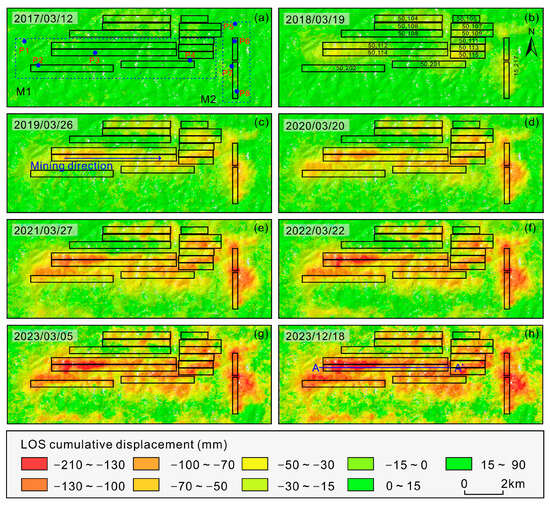
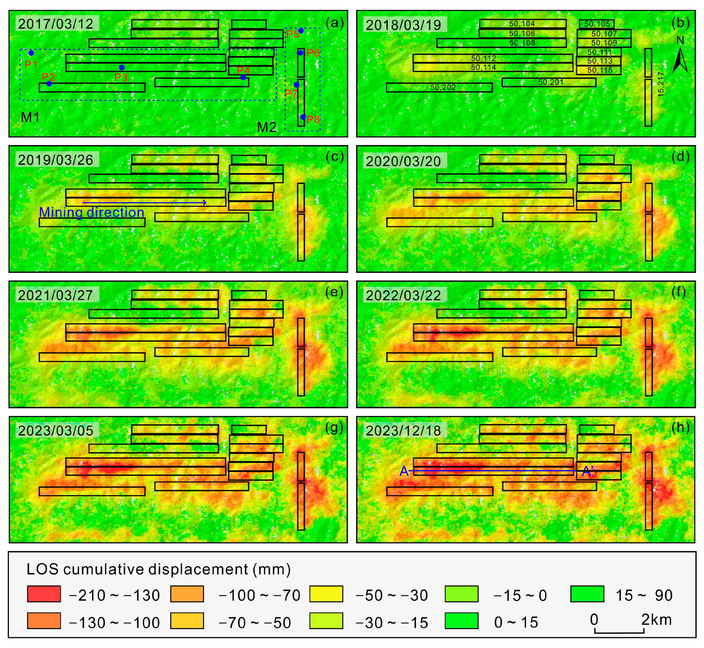
Figure 4 shows the spatio-temporal distribution of cumulative surface deformation in mined-out areas from 17 March 2017 to 28 December 2023. Following the start of mining in October 2017, surface deformation initially occurred around the main working panels, which was characterized by a relatively small magnitude and limited spatial extent. With continued coal excavation, both the magnitude and the spatial extent of deformation gradually increased. From 2018 to 2023, the deformation area expanded from west to east, with the range and magnitude of deformation continually increasing. By December 2023, the cumulative surface deformation reached a maximum of −169.3 mm in mining area 1 (M1). The surface deformation process, characterized by a distinct transition from pre-mining stability to continuous post-mining deformation, exhibited a spatiotemporal evolution that correlated directly with the advancement of mining activities.
Figure 4.
(a–h) Time-series LOS (Line of sight) cumulative deformation in the mining area obtained from SBAS InSAR technology between March 2017 to December 2023. (a) Location of uniformly distributed deformation monitoring points in areas M1 and M2 within the study region. (b) Distribution of the working panels in the mining area. (h) Location of profile AA′.
To further assess the reliability of the observation results, a detailed analysis of the spatiotemporal deformation evolution pattern in mining area 2 (M2) was conducted. Underground coal mining in the M2 area started around 2017 and progressively advanced eastward until 2023. As shown in Figure 4, the surface deformation presents a westward propagation pattern, characterized by progressive annual expansion and increasing magnitude, which is consistent with the deformation characteristics observed in M1. Significant deformation was mainly concentrated within the mining operation area, highlighting a clear spatial correspondence between underground coal mining and surface deformation.
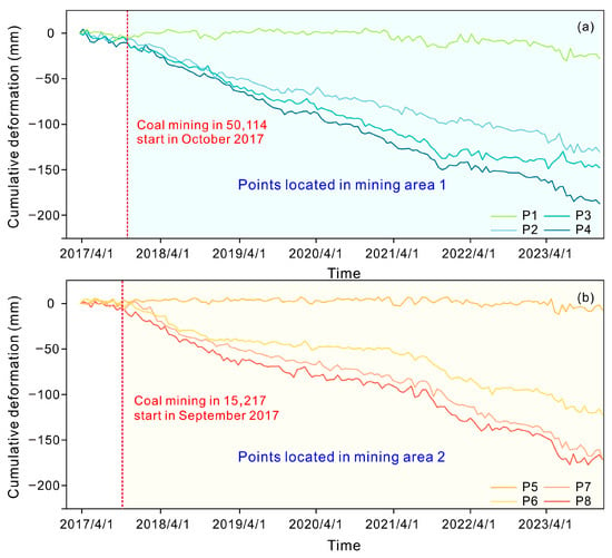
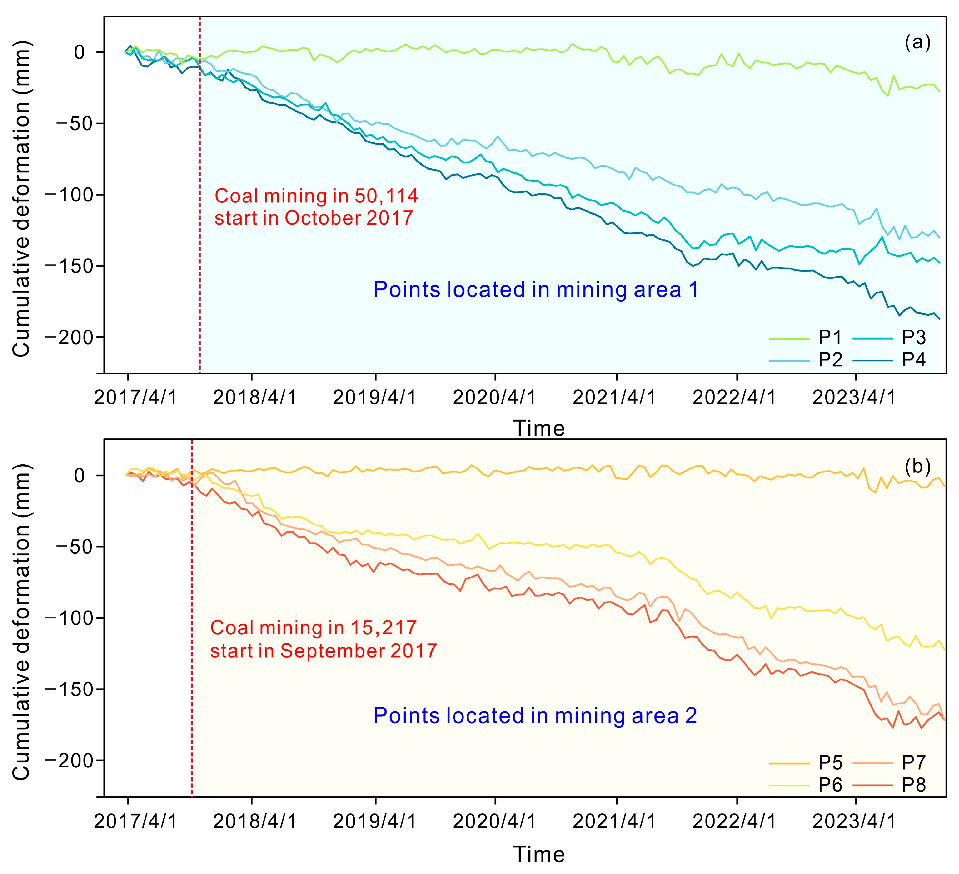
We selected eight representative points that were distributed in M1 and M2 (four in each region), as shown in Figure 4. The results revealed a broadly consistent deformation trend across all monitoring points, indicating that mining activity is the primary driver of the observed surface deformation. As shown in Figure 5, prior to the start of mining, all points remained stable with negligible cumulative deformation (within a stability threshold of ±5 mm). After the initiation of coal excavation, progressive deformation was observed at each point, with the deformation curves showing a uniform and continuous downward trend. The strong consistency between the deformation responses in areas of M1 and M2, characterized by pre-mining stability and sustained post-mining deformation, further validates the reliability of the conclusions drawn from the M1 working panel.
Figure 5.
Cumulative deformation curves of representative points in the mining area 1 (M1) and mining area 2 (M2). (a) Coal mining in face 50,114 started in October 2017. (b) Coal mining in face 15,127 started in September 2017.
3.2. Numerical Modeling of Stress Field Evolution and Mined-Out Area Deformation Caused by Coal Mining
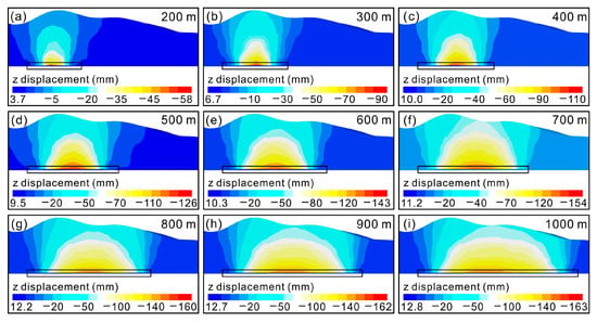
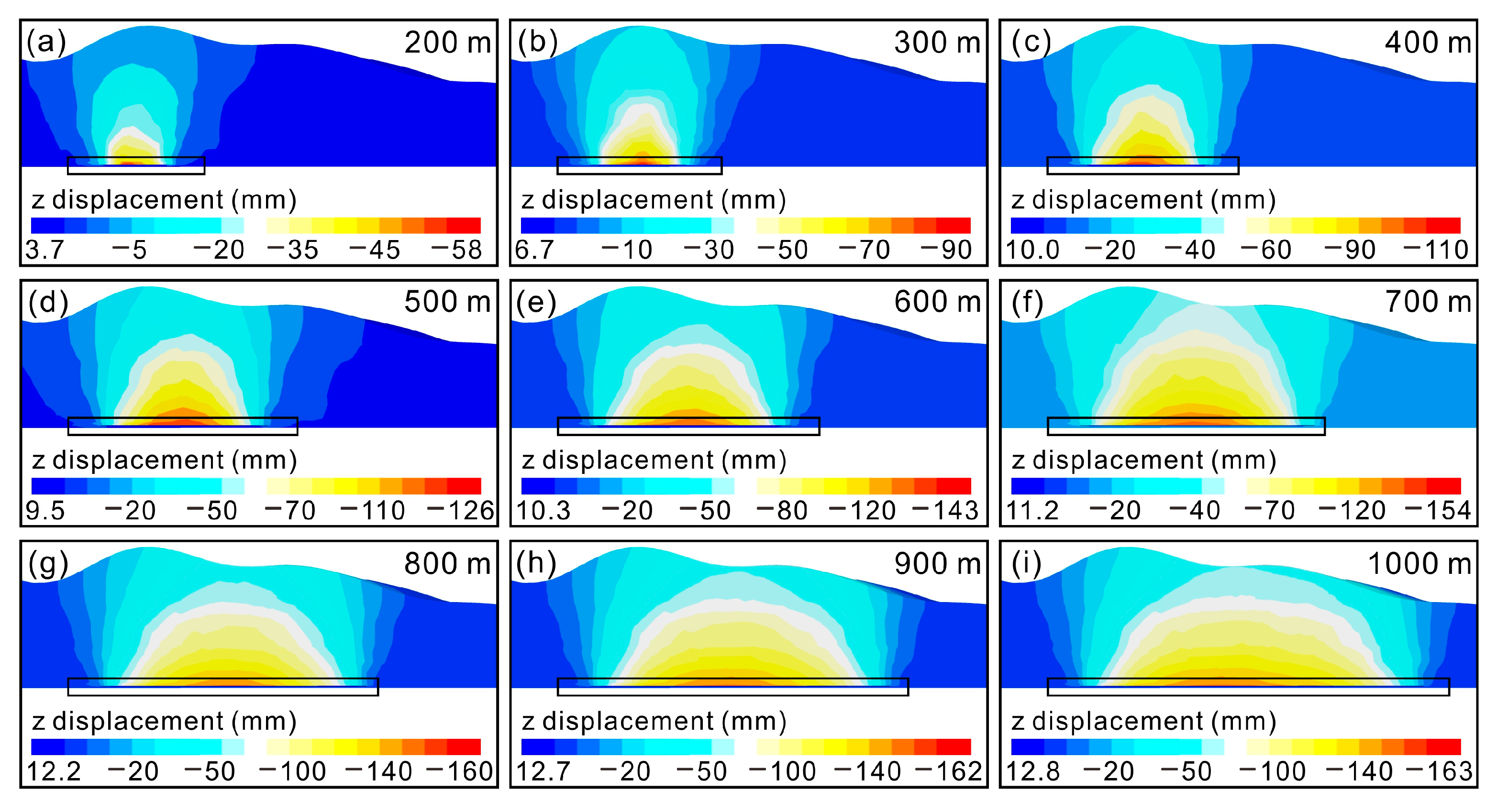
Taking the 50,114 working panel as an example, we analyzed the dynamic evolution of displacement in the Z direction caused by coal mining. Numerical simulations were performed to reproduce the actual excavation process, covering the entire period from mining initiation to a horizontal advance of 1000 m. Particular attention was given to the deformation response of the overlying strata at different excavation distances (200, 300, 400, 500, 600, 700, 800, 900, and 1000 m).
Figure 6 illustrates the FLAC3D simulation results, showing that both the magnitude of Z-direction displacement and the extent of the deformation zone that was continuously increasing. Significant surface deformation was concentrated above the mined-out area, whereas the surrounding unmined regions remained stable or only present slight displacement. At an advanced distance of 200 m (Figure 6a), a distinct displacement zone has formed, with a maximum value of −58 mm. As coal excavation distance advanced from 300 m to 900 m (Figure 6b–h), the displacement field continued to change. The area characterized by significant displacement enlarged gradually, and its spatial distribution became increasingly symmetrical about the central axis above the mined-out area. The region exhibiting the most pronounced displacement consistently occurred directly above the center of the mined-out area, whereas deformation became progressively gentler towards the edges of the mined-out area.
Figure 6.
Numerical simulation diagram of the vertical (Z-direction) displacement field along the 50,114 working panel. (a–i) Distribution of vertical displacement field at different mining advance distances. Color scale: blue represents “uplift” (positive displacement), while red and yellow represent “subsidence” (negative displacement).
At the final advance distance of 1000 m, the vertical displacement reached its maximum magnitude of −163.6 mm. Overall, the displacement field decreased gradually from the center of the mined-out area towards the edges. This spatial evolution, observed from the contour maps, intuitively reflects the strata displacement caused by underground mining advances.
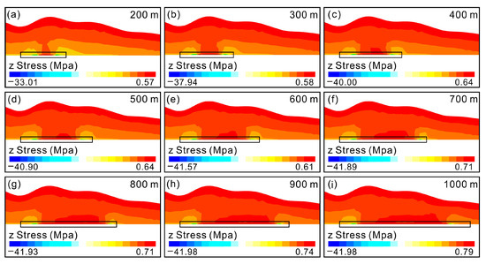
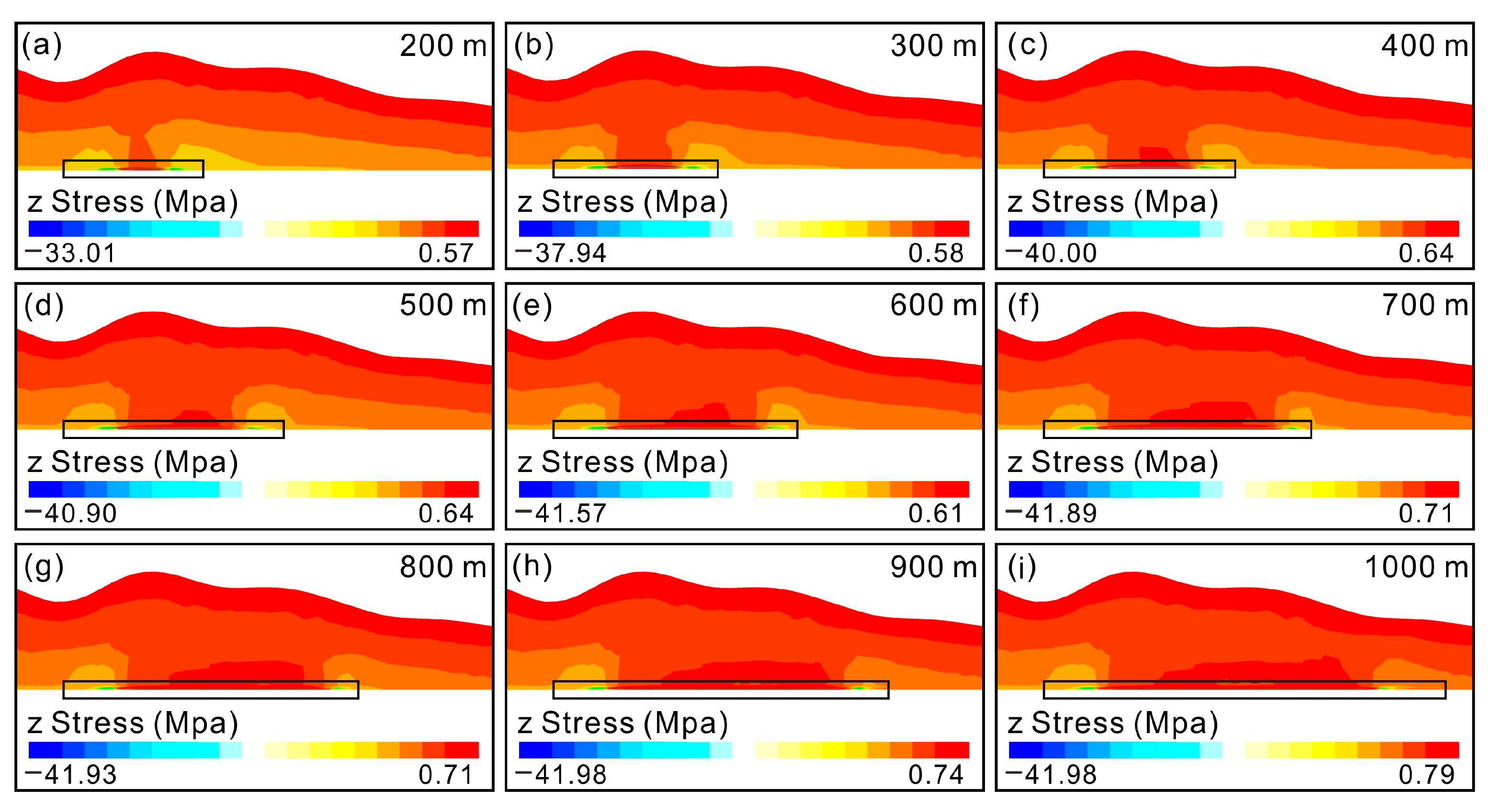
We simulated the dynamic evolution of the mining-induced stress field along the 50,114 working panel. The simulations revealed distinct dynamic characteristics, marked by the continuous expansion of the stress relief zone boundary and the migration of the abutment pressure peak, both of which are closely related to the mining scale. The evolution showed that the magnitude of z-direction stress increased with the expanding extraction area, a trend similar to that of the displacement field. When excavation reached 200 m (Figure 7a), a stress relief zone formed above the goaf, accompanied by a localized tensile stress zone (maximum of 0.57 MPa) ahead of the working panel, while the coal pillars exhibited concentrated compressive stress. At 300 m (Figure 7b), the relief zone expanded, the maximum tensile stress increased to 0.58 MPa, and the pillar compressive stress intensified to −37.94 MPa.
Figure 7.
Numerical simulation diagram of the vertical stress field (Unit: MPa) along the 50,114 working panel. (a–i) Distribution of vertical stress field at different mining advance distances. Color scale: blue represents tensile stress, while red and yellow represent compressive stress.
With continued mining, stress redistribution exhibited a phased pattern. The relief and tensile zones expanded along the strike, while compressive stress concentration in the flanking coal pillars intensified. Under full mining at 1000 m (Figure 7i), the stress field stabilized. A large-scale, low-stress relief zone formed in the goaf, the maximum local tensile stress increased to 0.79 Mpa, and the peak compressive stress in the pillars rose to −41.9 Mpa, reaching its maximum value.
3.3. Cross-Validation of InSAR Observation and FLAC3D Simulation Results for Surface Deformation
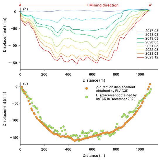
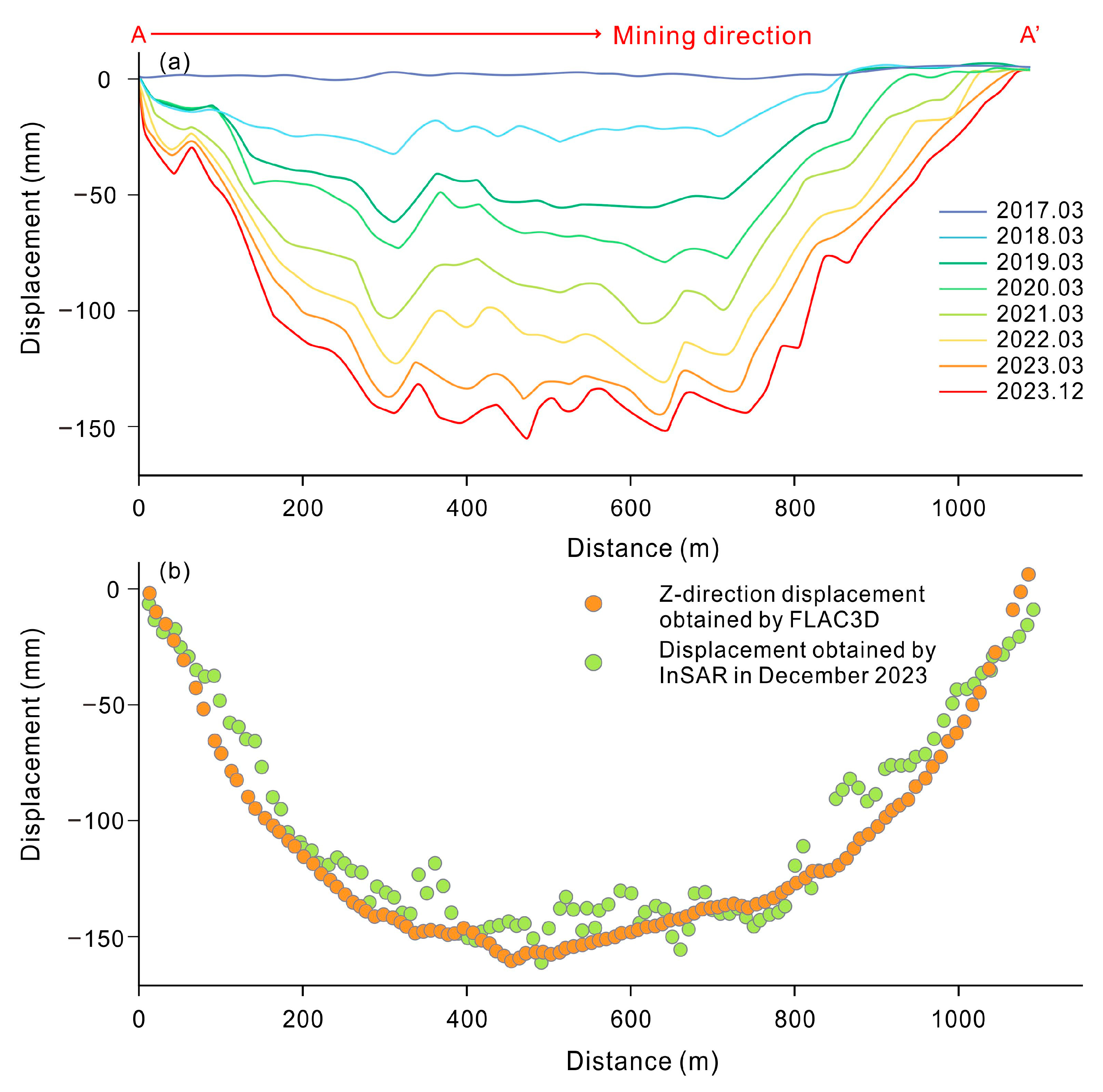
As shown in Figure 8a, the time-series displacement of the 50,114 working panel exhibits a distinct deformation basin. The maximum LOS displacement recorded reached −163.6 mm. The ground deformation phenomenon is directly related to the mining of the 50,114 working panel. Moreover, the cumulative deformation obtained by InSAR was compared with the vertical displacement in Z-direction obtained by FLAC3D in the 50,114-working panel (Figure 8b). It can be observed that the surface vertical displacement curves obtained by the two methods show similar trends. The maximum displacements from SBAS InSAR and the numerical simulation are 161.2 mm and 163.6 mm, respectively. The cross-validation results meet the accuracy requirements for surface deformation monitoring and prove the accuracy and reliability of the numerical simulation model. It can provide a favorable guarantee for the subsequent use of numerical simulation to analyze the stability of the mined-out area and predict the impact of repeated mining on surface deformation in the mining area.
Figure 8.
(a) LOS cumulative displacement along the working panel 50,114. (A-A’ indicates the mining direction.) (b) Cross-validation of InSAR observation and FLAC3D simulation in surface deformation in December 2023.
3.4. Spatial Density Distribution Characteristics of Landslides in Mined-Out Areas
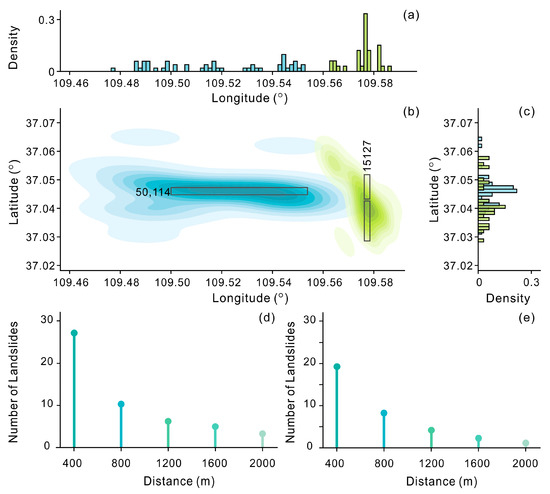
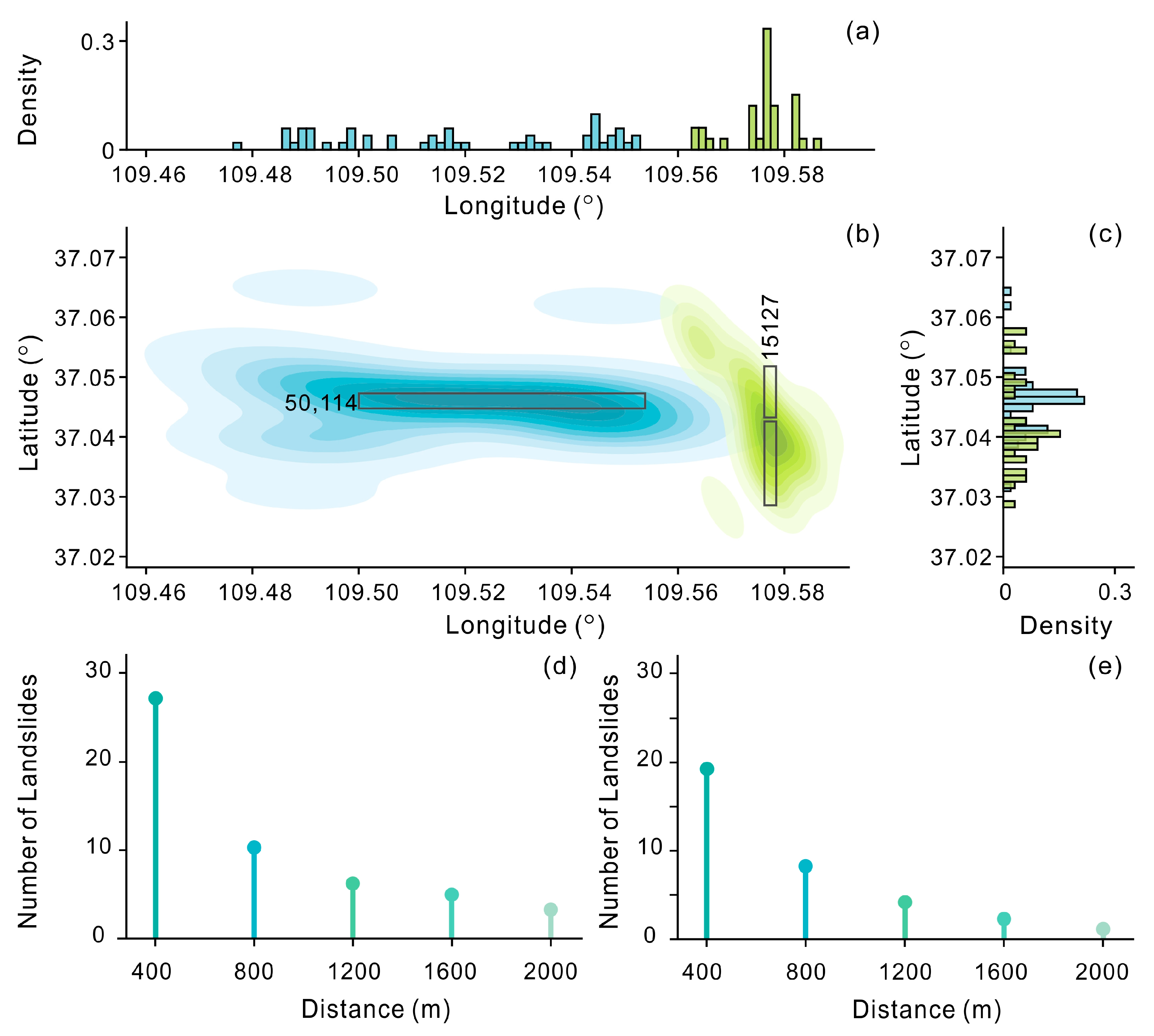
As shown in Figure 9, the spatial density distribution of landslides in the mined-out area reveals a significant spatial coupling between landslide occurrence and underground mining activities. Landslides are not randomly distributed but are strongly concentrated in areas corresponding to specific underground mining panels. The longitude and latitude distribution histograms (Figure 9a,c) and their corresponding landslide density map (Figure 9b) indicate that the peak landslide density is spatially consistent with the regional extent of working panel 50,114. As further validation, a secondary density peak was observed within the area corresponding to working panel 15,127, which supports the causal link between mining operations and landslide occurrence. The relationship between landslide frequency and distance from the mined-out area boundary exhibits a distinct distance-decay pattern, whereby landslide counts decrease markedly with increasing distance from the mining boundary, clearly delineating the spatial extent of mining-induced disturbances. Furthermore, the relationship between landslide frequency and distance from the mined-out area boundary exhibits a clear distance-decay pattern. Landslide counts decrease significantly with increasing distance from the mining boundary. This pattern aligns closely with the spatial gradient of surface deformation revealed in Section 3.1, where deformation magnitude attenuates with distance from the mining panel. This correspondence delineates the spatial extent of mining-induced disturbances: beyond the range of significant deformation, the impact of mining on slope stability diminishes sharply, leading to a reduced landslide risk. In summary, integrated spatial density analysis confirms that high-risk landslide zones are closely aligned with underground mining areas, primarily influenced by mining intensity. This spatial correlation, reflected in the consistency between landslide clusters and the regional extent of working panels such as 50,114 (Figure 4), demonstrates that mining activity is a key controlling factor for both the spatial clustering and the distribution scale of landslides.
Figure 9.
Landslide spatial distribution and density distribution. (a) Longitudinal (east–west) distribution of landslide density. (b) Two-dimensional kernel density estimation (KDE) of landslide points, where the color gradient ranges from light blue (low density) to dark blue (high density) for mining face 50,114, and from light green to dark green for mining face 15,127. (c) Latitudinal (north–south) distribution of landslide density. (d,e) Relationship between landslide frequency and distance from the mining working panels (unit: meters) showing a clear negative correlation between landslide frequency and distance. Subfigure (d) corresponds to working panel 50,114 and subfigure (e) corresponds to panel 15,217.
4. Discussion
Underground mining activity directly and primarily drives surface instability in mining areas [39], serving as the key trigger for subsequent hazards such as landslides, ground fissures, and mining-related disasters [6,7,8,9,10,11,12,13,14,15,16,17,18,19,20,21,22,23,24,25,26,27,28,29,30,31,32,33,34,35,36,37,38,39,40]. Previous studies focused on hillslope stability monitoring in mined-out areas for life safety. GNSS and levelling techniques have monitored deformation in unstable slopes [41,42] but they cannot assess regional stability. Thanks to earth observation advances, the InSAR technique can be used to characterize regional deformation processes and evolution patterns [43].
In addition, researchers have highlighted the importance of numerical simulation for understanding surface deformation mechanisms since surface deformation observations cannot be used to monitor stress field changes during mining activities. For example, the combination of InSAR and FLAC3D has been used to reveal the deformation processes in coal mined-out areas in China [44]. They emphasized the importance of combining surface deformation observations with the mechanical explanation of internal structures to understand deformation processes in mined-out areas. Li et al. developed a numerical model based on UAV imagery and 3D simulation, demonstrating that the integration of multi-source data significantly enhances the accuracy of slope stability analysis [45]. However, systematic research is needed to elucidate the mechanism through which mining-induced stress redistribution leads to surface disasters.
In our study, time-series InSAR data revealed a consistent deformation trend in the study area from 2017 to 2023 during the mining of Panel 50,114, reflecting long-term stress adjustment and ongoing deformation in the overlying strata of the goaf. Notably, the “deformation hysteresis effect” is commonly observed in most mining areas [6,7,8,9,10,11,12,13,14,15,16,17,18,19,20,21,22,23,24,25,26,27,28,29,30,31,32,33,34,35,36,37,38,39,40,41,42,43,44,45,46,47,48]. These deformation characteristics are mainly driven by two factors: first, the continuous extraction of coal seams leads to the collapse of the immediate roof and the gradual movement of the overlying strata, resulting in rapid surface subsidence in the early stage; second, as the goaf is filled with collapsed rock mass, the overlying strata tend to be stable, and the deformation enters a slow convergence stage. The mechanism behind this gradual deformation process and the resulting hysteresis effect needs to be supported by more evidence from numerical simulations [46,47].
Previous studies have demonstrated that the immediate roof strata undergo caving and instability after coal seam extraction, leading to stress redistribution in the overburden [49,50]. Further, mining-induced stresses promote continuous fracture propagation in the overlying rock layers, ultimately resulting in surface deformation. These findings align with the classical “fracture coalescence mechanism” of mining-induced rock mass failure [51,52]. Considering that the surface deformation process is influenced by numerous factors, a combination of physical simulation, numerical modeling, and field detection is needed to reveal the overburden failure mechanisms, which can be addressed in future research [53].
In our study, we examined the surface deformation process and mechanism based on a combination of time-series InSAR data analysis and excavation process simulation. Our results demonstrated that InSAR can identify underground coal mining-induced surface deformation with a sub-centimeter accuracy, and numerical simulations can provide more evidence to reveal the underlying deformation mechanism and support deformation prediction. This study gives insights into the disconnection between surface deformation observation and mechanism analysis in single-method studies. Despite the advancements presented, this study has several limitations that could influence the reliability of its long-term predictions. The numerical simulations employ a simplified constitutive model that does not fully account for time-dependent behaviors such as rock mass creep [54]. This study demonstrates that integrating InSAR with numerical simulations effectively uncovers the spatiotemporal patterns and mechanical mechanisms of mining-induced deformation, offering a robust technical framework for disaster prevention in mining areas. Additionally, conversion errors of LOS displacement [55,56], along with the simplified treatment of time-dependent effects such as rock mass creep [54], may compromise the reliability of long-term predictions. This concern is especially critical for stability evaluations in soft rock formations or high-stress mining areas. Incorporating viscoelastic-plastic constitutive models represents a crucial direction for improving the predictive capabilities of simulations in future research.
5. Conclusions
This study systematically investigated the spatiotemporal evolution of coal mining-induced surface deformation laws and their influence on landslide distribution in mined-out areas by integrating time-series InSAR monitoring with FLAC3D numerical simulation. The surface deformation evolved from an initial state of stability to a phase of continuous deformation with the progress of mining. The maximum displacements from SBAS InSAR and the numerical simulation were 161.2 mm and 163.6 mm, respectively. Observation data and numerical simulations jointly confirmed an interactive relationship between mining activities and surface deformation. Mining-induced stress redistribution in the overlying strata triggers surface deformation, while persistent deformation further alters the mechanical state of rock and soil masses, increasing slope instability risks and ultimately inducing landslides. Furthermore, this study demonstrated that landslide development is directly controlled by mining extent and intensity. Landslide spatial distribution shows a significant correlation with the mining panel. This correlation indicates that topography, geology, and hydrology constituted the permissive background conditions, whereas the mining activity served as the dominant triggering process that catalyzed the observed sequence of deformation and failure. These findings clarify the cascading evolution mechanism between mining-induced surface deformation and landslide distribution, providing both a theoretical foundation and technical support for the early identification and prevention of geological hazards in mining areas. It provides an effective technical framework for studying the coupling effects of underground coal mining on surface stability and landslide distribution.
Author Contributions
Writing—review and editing, H.Q. and D.Y.; supervision, H.Q.; methodology, L.M.; investigation, L.M.; writing—original draft preparation, L.M. and D.Y.; funding acquisition, H.Q. and D.Y. All authors have read and agreed to the published version of the manuscript.
Funding
This work was funded by the National Natural Science Foundation of China (Grant No. 42271078, 42471083), Postdoctoral Research Funding Project of Shaanxi Province (Grant No. 2023BSHYDZZ132).
Data Availability Statement
DEM data is available from USGS (https://earthexplorer.usgs.gov/), accessed on 15 June 2024. Satellite imagery from the European Space Agency’s Sentinel-1 mission, which was accessed via NASA’s Alaska Satellite Facility Distributed Active Archive Center (ASF DAAC) (https://search.asf.alaska.edu/), accessed on 15 June 2024. Supplementary base maps from Google Earth (https://support.google.com/earth/), accessed on 23 October 2024.
Acknowledgments
The authors thank Yuxiao Bai, Jiarui Yang and Kailiang Zhao for their help in the field investigation.
Conflicts of Interest
The authors declare no conflicts of interest.
References
- Yang, G.Y.; Wang, J.H.; Shao, W.W.; Wang, H. The Relationship between China’s Coal Resource Development and Water Resource. Energy Procedia 2015, 75, 2548–2555. [Google Scholar] [CrossRef] [Scilit]
- Zhang, C.L.; Wang, P.Z.; Wang, E.Y.; Chen, D.P.; Li, C. Characteristics of coal resources in China and statistical analysis and preventive measures for coal mine accidents. Int. J. Coal Sci. Technol. 2023, 10, 22. [Google Scholar] [CrossRef] [Scilit] [PubMed]
- Qiu, H.; Cui, Y.; Pei, Y.; Yang, D.; Hu, S.; Wang, X.; Ma, S. Temporal patterns of nonseismically triggered landslides in Shaanxi Province, China. CATENA 2020, 187, 104356. [Google Scholar] [CrossRef] [Scilit]
- International Energy Agency. Key World Energy Statistics 2021; OECD Publishing: Paris, France, 2021. [Google Scholar]
- Li, Z.; Yu, S.C.; Zhu, W.B.; Feng, G.R.; Xu, J.M.; Guo, Y.X.; Qi, T.Y. Dynamic loading induced by the instability of voussoir beam structure during mining below the slope. Int. J. Rock Mech. Min. Sci. 2020, 132, 104343. [Google Scholar] [CrossRef] [Scilit]
- Yang, D.D.; Qiu, H.J.; Ma, S.Y.; Liu, Z.J.; Du, C.; Zhu, Y.R.; Cao, M.M. Slow surface subsidence and its impact on shallow loess landslides in a coal mining area. CATENA 2022, 209, 105830. [Google Scholar] [CrossRef] [Scilit]
- Liu, Y.L.; Yang, T.H.; Zhao, Y.; Ma, K.; Hou, X.A.; Zhao, Q.B.; Li, J.D. Characteristics of strata movement and method for runoff disaster management for shallow multiseam mining in gully regions: A case study. Int. J. Rock Mech. Min. Sci. 2023, 172, 105608. [Google Scholar] [CrossRef] [Scilit]
- Chen, Y.J.; Zhang, J.; Zhou, A.C.; Yin, B. A modeling method for a disaster chain-Taking the coal mining subsidence chain as an example. Hum. Ecol. Risk Assess. 2018, 24, 1388–1408. [Google Scholar] [CrossRef] [Scilit]
- Ma, S.Y.; Qiu, H.J.; Yang, D.D.; Wang, J.D.; Zhu, Y.R.; Tang, B.Z.; Sun, K.; Cao, M.M. Surface multi-hazard effect of underground coal mining. Landslides 2023, 20, 39–52. [Google Scholar] [CrossRef] [Scilit]
- Dudek, M.; Sroka, A.; Tajdus, K.; Misa, R.; Mrochen, D. Assessment and Duration of the Surface Subsidence after the End of Mining Operations. Energies 2022, 15, 8711. [Google Scholar] [CrossRef] [Scilit]
- Chen, L.Q.; Zhao, C.Y.; Li, B.; He, K.; Ren, C.F.; Liu, X.J.; Liu, D.L. Deformation monitoring and failure mode research of mining-induced Jianshanying landslide in karst mountain area, China with ALOS/PALSAR-2 images. Landslides 2021, 18, 2739–2750. [Google Scholar] [CrossRef] [Scilit]
- Qiu, H.J.; Wei, Y.D.; Kamp, U. Liquefaction-Mudflow may Cause the Destruction of Prehistoric Lajia Ruins, China. J. Earth Sci. 2024, 35, 2154–2157. [Google Scholar] [CrossRef] [Scilit]
- Karamvasis, K.; Karathanassi, V. Performance Analysis of Open Source Time Series InSAR Methods for Deformation Monitoring over a Broader Mining Region. Remote Sens. 2020, 12, 1380. [Google Scholar] [CrossRef] [Scilit]
- Ghabraie, B.; Ghabraie, K.; Ren, G.; Smith, J.V. Numerical modelling of multistage caving processes: Insights from multi-seam longwall mining-induced subsidence. Int. J. Numer. Anal. Methods Eng. 2017, 41, 959–975. [Google Scholar] [CrossRef] [Scilit]
- Li, J.; Li, B.; Gao, Y.; Cui, F.P.; He, K.; Li, J.S.; Li, H.W. Mechanism of Overlying Strata Migration and Failure During Underground Mining in the Mountainous Carbonate Areas in Southwestern China. Front. Earth Sci. 2022, 10, 874623. [Google Scholar] [CrossRef] [Scilit]
- Salmi, E.F.; Nazem, M.; Karakus, M. Numerical analysis of a large landslide induced by coal mining subsidence. Eng. Geol. 2017, 217, 141–152. [Google Scholar] [CrossRef] [Scilit]
- Singh, G.S.P.; Singh, U.K. A numerical modeling approach for assessment of progressive caving of strata and performance of hydraulic powered support in longwall workings. Comput. Geotech. 2009, 36, 1142–1156. [Google Scholar] [CrossRef] [Scilit]
- Rezaei, M.; Hossaini, M.F.; Majdi, A. Development of a time-dependent energy model to calculate the mining-induced stress over gates and pillars. J. Rock Mech. Geotech. Eng. 2015, 7, 306–317. [Google Scholar] [CrossRef] [Scilit]
- Bai, Q.S.; Tu, S.H.; Chen, M.; Zhang, C. Numerical modeling of coal wall spall in a longwall face. Int. J. Rock Mech. Min. Sci. 2016, 88, 242–253. [Google Scholar] [CrossRef] [Scilit]
- Behera, B.; Yadav, A.; Singh, G.S.P.; Sharma, S.K. Numerical Modeling Study of the Geo-mechanical Response of Strata in Longwall Operations with Particular Reference to Indian Geo-mining Conditions. Rock Mech. Rock. Eng. 2020, 53, 1827–1856. [Google Scholar] [CrossRef] [Scilit]
- Bamler, R.; Hartl, P. Synthetic aperture radar interferometry. Inverse Probl. 1998, 14, R1. [Google Scholar] [CrossRef] [Scilit]
- Rosen, P.A.; Hensley, S.; Joughin, I.R.; Li, F.K.; Madsen, S.N.; Rodriguez, E.; Goldstein, R.M. Synthetic aperture radar interferometry. Proc. IEEE 2002, 88, 333–382. [Google Scholar] [CrossRef] [Scilit]
- Strozzi, T.; Klimeš, J.; Frey, H.; Caduff, R.; Huggel, C.; Wegmüller, U.; Rapre, A.C. Satellite SAR interferometry for the improved assessment of the state of activity of landslides: A case study from the Cordilleras of Peru. Remote Sens. Environ. 2018, 217, 111–125. [Google Scholar] [CrossRef] [Scilit]
- Chen, Y.; Tong, Y.; Tan, K. Coal mining deformation monitoring using SBAS-InSAR and offset tracking: A case study of Yu County, China. IEEE J. Sel. Top. Appl. Earth Obs. Remote Sens. 2020, 13, 6077–6087. [Google Scholar] [CrossRef] [Scilit]
- Berardino, P.; Fornaro, G.; Lanari, R.; Sansosti, E. A new algorithm for surface deformation monitoring based on small baseline differential SAR interferograms. IEEE Trans. Geosci. Remote. Sens. 2002, 40, 2375–2383. [Google Scholar] [CrossRef] [Scilit]
- Yastika, P.E.; Shimizu, N.; Abidin, H.Z. Monitoring of long-term land subsidence from 2003 to 2017 in coastal area of Semarang, Indonesia by SBAS DInSAR analyses using Envisat-ASAR, ALOS-PALSAR, and Sentinel-1A SAR data. Adv. Space Res. 2019, 63, 1719–1736. [Google Scholar] [CrossRef] [Scilit]
- Cundall, P.A.; Strack, O.D. A discrete numerical model for granular assemblies. Geotechnique 1979, 29, 47–65. [Google Scholar] [CrossRef] [Scilit]
- Li, Y.; Guo, Y.; Zhu, W.; Li, S.; Zhou, H. A modified initial in-situ Stress Inversion Method based onFLAC3D with an engineering application. Open Geosci. 2015, 7, 20150065. [Google Scholar] [CrossRef] [Scilit]
- Coulomb, C.A. Essai sur une application des regles de maximis et minimis a quelques problemes de statique relatifs a l’architecture (essay on maximums and minimums of rules to some static problems relating to architecture). TRID 1973, 7, 343–382. [Google Scholar]
- Biot, M.A. General theory of three-dimensional consolidation. J. Appl. Phys. 1941, 12, 155–164. [Google Scholar] [CrossRef] [Scilit]
- Lin, H.; Liu, T.Y.; Li, J.T.; Cao, P. A Simple Generation Technique of Complex Geotechnical Computational Model. Math. Probl. Eng. 2013, 2013, 863104. [Google Scholar] [CrossRef] [Scilit]
- Li, Y.X.; Yang, K.M.; Zhang, J.H.; Hou, Z.X.; Wang, S.; Ding, X.M. Research on time series InSAR monitoring method for multiple types of surface deformation in mining area. Nat. Hazards 2022, 114, 2479–2508. [Google Scholar] [CrossRef] [Scilit]
- Zhao, J.B. Coal Pillar Width and Roadway Section Design of Gob-side Entry in Hecaogou Coal Mine. Mod. Min. 2022, 38, 59–62. [Google Scholar] [CrossRef]
- Ren, X.L. Study on the Movement and Gas Emission Law of the Compound Roof of Coal Seam and Oil Shale. Master’s Thesis, Xi’an University of Science and Technology, Xi’an, China, 2020. [Google Scholar]
- Song, W.J.; Wang, B.S.; Li, H.; Wang, J.C.; Li, Y.G.; Liu, H. Influence of coal mine mining on the production of oil and gas wells and study on rational coal pillar layout technology. Coal Eng. 2018, 50, 18–21. [Google Scholar]
- Zhao, Z.K. Research on the Collapse Law of Coal Mining in Loess Area of Yan’an. Inn. Mong. Coal Econ. 2020, 4, 5–6. [Google Scholar] [CrossRef]
- Wang, T.; Chang, J.C.; Wang, H.D. A Study of the Deformation Law of the Surrounding Rock of a Laminated Roadway Based on FLAC3D Secondary Development. Appl. Sci. 2023, 13, 6077. [Google Scholar] [CrossRef] [Scilit]
- Zhang, D.; Fu, S.; Li, G. The influence of complex topography on the stress of underlying coal strata. J. Min. Sci. Technol. 2023, 8, 548–559. [Google Scholar] [CrossRef]
- Qiu, H.; Li, Y.; Zhu, Y.; Ye, B.; Yang, D.; Liu, Y.; Wei, Y. Do post-failure landslides become stable? CATENA 2025, 249, 108699. [Google Scholar] [CrossRef] [Scilit]
- Polasková, L.; Tichavsky, R.; Jiránková, E. Exploring mining-induced subsidence effects on Alnus glutinosa (L.) Gaertn. through dendrogeomorphic analysis and mining data. CATENA 2024, 242, 108117. [Google Scholar] [CrossRef] [Scilit]
- Tao, T.Y.; Liu, J.B.; Qu, X.C.; Gao, F. Real-time monitoring rapid ground subsidence using GNSS and Vondrak filter. Acta Geophys. 2019, 67, 133–140. [Google Scholar] [CrossRef] [Scilit]
- Bo, H.Z.; Li, Y.W.; Tan, X.F.; Dong, Z.B.; Zheng, G.D.; Wang, Q.; Yu, K.G. Estimation of Ground Subsidence Deformation Induced by Underground Coal Mining with GNSS-IR. Remote Sens. 2023, 15, 96. [Google Scholar] [CrossRef] [Scilit]
- Du, J.T.; Li, Z.H.; Song, C.; Zhu, W.; Ji, Y.Q.; Zhang, C.L.; Chen, B.; Su, S.R. InSAR-Based Active Landslide Detection and Characterization Along the Upper Reaches of the Yellow River. IEEE J. Sel. Top. Appl. Earth Obs. Remote Sens. 2023, 16, 3819–3830. [Google Scholar] [CrossRef] [Scilit]
- Xu, Z.C.; Xu, W.; Zhu, Z.H.; Zhao, J.Y. Research on monitoring and stability evaluation of ground subsidence in gypsum mine goaf. Front. Environ. Sci. 2023, 10, 1097874. [Google Scholar] [CrossRef] [Scilit]
- Li, J.D.; Yang, T.H.; Deng, W.X.; Du, S.G.; Zhang, Z.R.; Ma, H.T.; Wang, H.; Guo, J.T.; Liu, L.J. Evaluating failure mechanisms of excavation-induced large-scale landslides in Xinjing open-pit coal mine through integrated UAV imagery and 3D simulation. Landslides 2025, 22, 2021–2036. [Google Scholar] [CrossRef] [Scilit]
- Samsonov, S.; d’Oreye, N.; Smets, B. Ground deformation associated with post-mining activity at the French-German border revealed by novel InSAR time series method. Int. J. Appl. Earth Obs. Geoinform. 2013, 23, 142–154. [Google Scholar] [CrossRef] [Scilit]
- Vervoort, A. Surface movement above an underground coal longwall mine after closure. Nat. Hazards Earth Syst. Sci. 2016, 16, 2107–2121. [Google Scholar] [CrossRef] [Scilit]
- Modeste, G.; Doubre, C.; Masson, F. Time evolution of mining-related residual subsidence monitored over a 24-year period using InSAR in southern Alsace, France. Int. J. Appl. Earth Obs. Geoinform. 2021, 102, 102392. [Google Scholar] [CrossRef] [Scilit]
- Jing, L. A review of techniques, advances and outstanding issues in numerical modelling for rock mechanics and rock engineering. Int. J. Rock Mech. Min. Sci. 2003, 40, 283–353. [Google Scholar] [CrossRef] [Scilit]
- Liu, Z.J.; Qiu, H.J.; Ma, S.Y.; Yang, D.D.; Pei, Y.Q.; Du, C.; Sun, H.S.; Hu, S.; Zhu, Y.R. Surface displacement and topographic change analysis of the Changhe landslide on September 14, 2019, China. Landslides 2021, 18, 1471–1483. [Google Scholar] [CrossRef] [Scilit]
- Hoek, E.; Bieniawski, Z. Brittle fracture propagation in rock under compression. Int. J. Fract. 1965, 1, 137–155. [Google Scholar] [CrossRef] [Scilit]
- Crosetto, M.; Monserrat, O.; Cuevas-González, M.; Devanthéry, N.; Crippa, B. Persistent Scatterer Interferometry: A review. ISPRS J. Photogramm. Remote Sens. 2016, 115, 78–89. [Google Scholar] [CrossRef] [Scilit]
- Shi, X.C.; Zhang, J.X. Characteristics of Overburden Failure and Fracture Evolution in Shallow Buried Working Face with Large Mining Height. Sustainability 2021, 13, 13775. [Google Scholar] [CrossRef] [Scilit]
- Gao, Y.; Gao, F.; Ronald, Y.M. Rock creep modeling based on discontinuous deformation analysis. Int. J. Min. Sci. Technol. 2013, 23, 757–761. [Google Scholar] [CrossRef] [Scilit]
- González, P.J.; Fernández, J. Error estimation in multitemporal InSAR deformation time series, with application to Lanzarote, Canary Islands. J. Geophys. Res. Solid Earth 2011, 116, B10404. [Google Scholar] [CrossRef] [Scilit]
- Moretto, S.; Bozzano, F.; Mazzanti, P. The Role of Satellite InSAR for Landslide Forecasting: Limitations and Openings. Remote Sens. 2021, 13, 3735. [Google Scholar] [CrossRef] [Scilit]

Disclaimer/Publisher’s Note: The statements, opinions and data contained in all publications are solely those of the individual author(s) and contributor(s) and not of MDPI and/or the editor(s). MDPI and/or the editor(s) disclaim responsibility for any injury to people or property resulting from any ideas, methods, instructions or products referred to in the content. |
© 2026 by the authors. Licensee MDPI, Basel, Switzerland. This article is an open access article distributed under the terms and conditions of the Creative Commons Attribution (CC BY) license.