


Highlights
What are the main findings?
- PSeq-Net detects bridges through end-to-end quadrilateral sequence generation.
- PSeq-Net improves localization of elongated and boundary-crossing bridges.
What are the implications of the main findings?
- Structured bridge detections can support infrastructure mapping and GIS updating.
- Sparse-global encoding concentrates fine-resolution computation on bridge-relevant regions.
Abstract
Robust bridge detection in ultra-high-resolution remote sensing imagery is important for transportation infrastructure mapping, geographic information system updating, and post-disaster assessment. However, local cropping can interrupt the spatial continuity of long-span bridges, leading to fragmented detections and geometrically inconsistent predictions. This paper proposes a polygon sequence network (PSeq-Net), an end-to-end sparse-global sequence modeling framework for bridge detection in very-high-resolution (VHR) remote sensing imagery. PSeq-Net generates an ordered quadrilateral vertex sequence for each bridge, unifying visual encoding and structured geometric prediction. Hierarchical sparse feature sampling preserves fine-grained evidence in bridge-relevant regions while using compact representations of background areas, enabling efficient processing of 2048 × 2048 inputs. Global context aggregation integrates long-range spatial dependencies, and geometry-aware optimization improves the structural plausibility of predicted bridge shapes. Experiments on the large-scale GLH-Bridge benchmark show that PSeq-Net achieves 37.87% average precision (AP), 73.58% AP50, and 31.38% AP75, outperforming representative oriented and large-scale bridge detectors. Further analyses highlight improved localization of elongated and boundary-crossing bridges, reduced fragmentation, and robustness across diverse scene backgrounds and image resolutions.
1. Introduction
Reliable perception of transportation infrastructure from ultra-high-resolution remote sensing imagery is becoming increasingly important for urban management, transportation network monitoring, post-disaster assessment, and geographic information system (GIS) updating. With the rapid development of satellite and aerial imaging platforms, very-high-resolution (VHR) images with sub-meter spatial resolution are now widely available [1,2,3,4]. These data provide rich visual evidence for large-scale infrastructure interpretation, but also place substantial demands on visual systems. A practical system is expected to process large-format imagery, preserve fine-grained structural details, reason over long-range spatial context, and produce geometrically reliable outputs that can support downstream spatial analysis [5,6].
Among transportation infrastructure objects, bridges are particularly important because they connect road networks across rivers, valleys, railways, highways, and complex urban environments. Missing or inaccurate bridge detections may affect infrastructure inventories, network connectivity analysis, emergency response, and post-disaster accessibility assessment. However, bridge perception in ultra-high-resolution remote sensing imagery is substantially different from the detection of compact objects such as vehicles, ships, airplanes, storage tanks, or buildings. Bridges are often long-span, slender, arbitrarily oriented, and spatially continuous across large image regions. A single bridge may extend over hundreds or even thousands of pixels while remaining narrow. Its appearance is also strongly affected by surrounding roads, water bodies, riverbanks, terrain structures, shadows, and transportation networks. Therefore, bridge detection is not merely a local object localization task but a structural perception problem that requires object-level completeness, contextual reasoning, and geometric reliability.
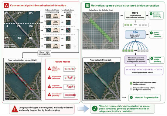
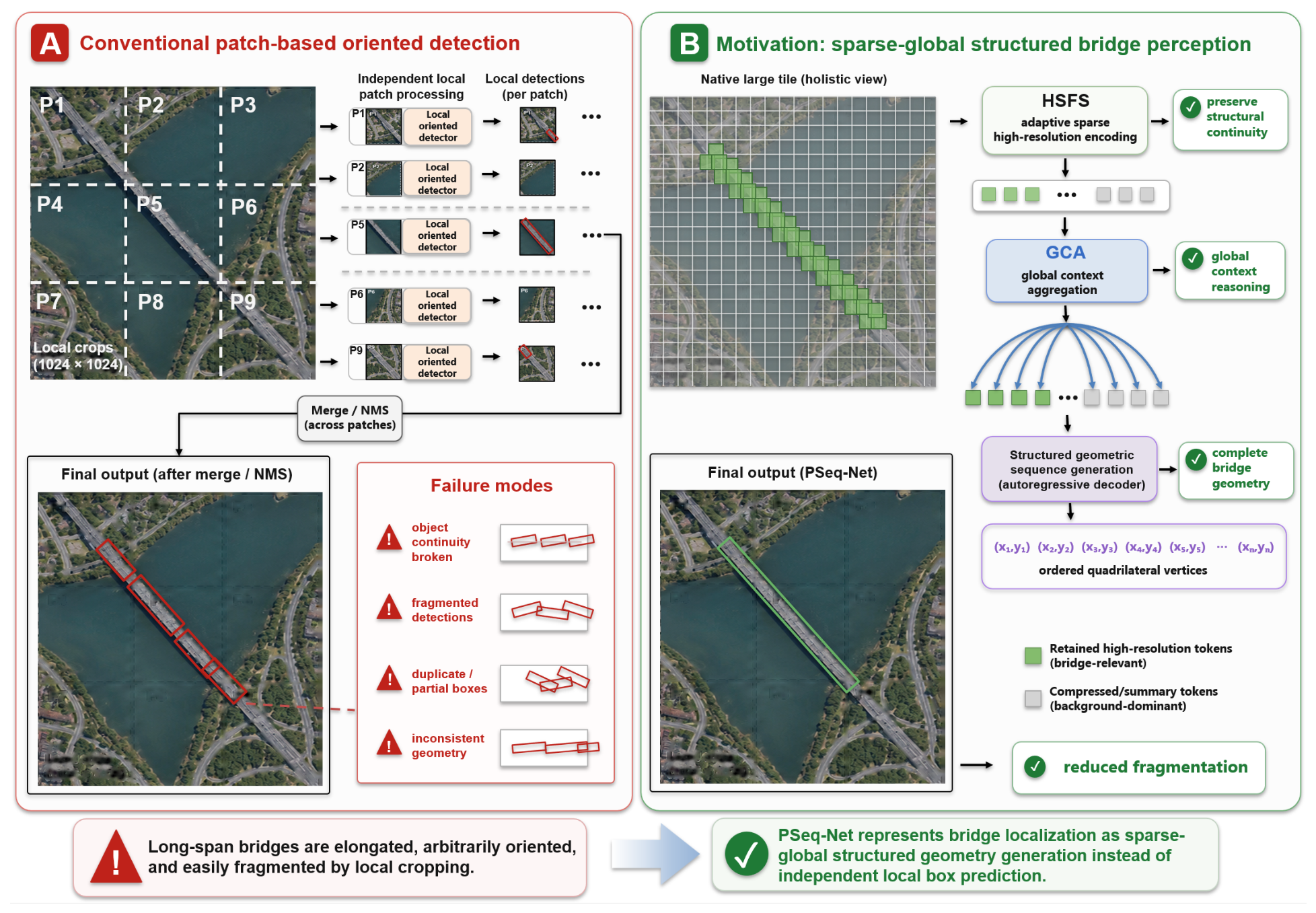
Most existing remote sensing object detection systems still follow a patch-based oriented detection paradigm [6,7,8]. Owing to memory and computational constraints, large VHR images are commonly cropped into fixed-size local patches during training and inference. This strategy makes large-image processing tractable, but it introduces an inherent mismatch between local patch-level perception and the global structural properties of long-span bridges. When a bridge crosses patch boundaries, its structure may be truncated into disconnected local observations, resulting in fragmented detections, duplicate predictions, partial boxes, and geometrically inconsistent outputs. Moreover, conventional anchor-, proposal-, or non-maximum-suppression-based pipelines usually predict local bounding boxes independently and merge them through post-processing. Such a local regression paradigm is not explicitly designed to preserve the structural continuity of elongated infrastructure objects. Figure 1 illustrates this mismatch between conventional patch-based oriented detection and the sparse-global structural perception paradigm pursued in this work.
Figure 1.
Schematic illustration of the motivation for PSeq-Net in long-span bridge perception. (A) Conventional patch-based oriented detection; (B) sparse-global structured bridge perception with PSeq-Net.
Improving detector backbones or adding orientation-aware regression heads alone is insufficient to address this problem. Although oriented object detectors can represent arbitrary object directions, they still largely rely on local feature responses and independent box regression [6,7,8]. For long-span bridges, small local observations may not contain enough information to determine the complete object extent, and post-hoc merging cannot always recover object-level structural integrity. From the perspective of infrastructure perception, the key limitation is not only the lack of orientation modeling but also the lack of a unified framework that jointly considers scalable high-resolution processing, long-range contextual reasoning, and structurally reliable geometric output.
Recent large-scale bridge benchmarks, especially GLH-Bridge [9], provide an opportunity to study this problem under more realistic conditions. The dataset contains large-format VHR images with diverse scene backgrounds and oriented bridge annotations, making it possible to evaluate bridge perception beyond small-patch recognition. More importantly, it enables systematic analysis of challenging cases such as long-span bridges, high-aspect-ratio bridges, boundary-crossing bridges, and complex-background scenes. These characteristics motivate a detection framework that is not only accurate on standard benchmarks but also reliable for infrastructure-level remote sensing applications.
In this paper, we propose PSeq-Net, an end-to-end framework that jointly models bridge geometry and spatial context through sparse-global sequence modeling. The central idea is to preserve detailed evidence in bridge-relevant regions while maintaining contextual connections, allowing the decoder to generate each bridge as an ordered quadrilateral vertex sequence. Sparse-global encoding makes processing a 2048 × 2048 observation window computationally feasible, while geometry-aware learning promotes structurally consistent predictions.
The main contributions of this work are summarized as follows:
- We formulate bridge detection as end-to-end quadrilateral sequence generation, jointly representing the vertices of each bridge instance.
- We design a sparse-global visual encoding and geometry-aware optimization framework for scalable bridge perception. Hierarchical sparse feature sampling preserves bridge-relevant high-resolution evidence, global context aggregation integrates long-range spatial cues, and the geometry-aware objective improves the structural plausibility of generated quadrilateral predictions.
- We conduct comprehensive experiments on the large-scale GLH-Bridge benchmark, including detection accuracy, aspect-ratio and boundary-crossing analyses; fragmentation assessment; cross-scene and cross-resolution robustness; and component ablations. The results demonstrate the effectiveness of PSeq-Net for challenging bridge detection in large remote sensing images.
2. Related Works
2.1. Bridge Detection in Remote Sensing Imagery
Automatic bridge detection is a critical component of remote sensing infrastructure perception, supporting urban management, transportation monitoring, disaster response, and GIS updating. Compared with general object recognition, bridge detection emphasizes structural completeness, geometric reliability, and robustness in complex environments.
Early methods leveraged radar-specific features or multi-source data fusion to detect bridges [10,11,12,13,14]. With the rise of deep learning, approaches based on optical imagery have become dominant. Some methods incorporate auxiliary priors, such as water segmentation [15,16], to improve the detection of water-crossing bridges, while others modify the detection heads of standard detectors (e.g., YOLO) for bridge-specific adaptation [17]. However, these approaches often rely on small-scale datasets or are restricted to specific environments, limiting their generalizability.
The development of large-scale bridge datasets has been essential for evaluating robust perception systems. Early datasets, such as the Bridges Dataset [18] and BridgeDetV1 [15], provided a limited number of instances with either horizontal or oriented annotations. More recently, GLH-Bridge [9] has offered a comprehensive benchmark (see Table 1) with 6000 VHR images, 59,737 bridge instances, large-format coverage, diverse geographic backgrounds, and oriented annotations. This dataset enables systematic evaluation of long-span, high-aspect-ratio, boundary-crossing, and complex-background bridges, providing a practical basis for method development.
Table 1.
Representative bridge datasets in remote sensing.
2.2. Large-Format Remote Sensing Object Detection
Object detection in VHR imagery has evolved from anchor-based to anchor-free and end-to-end frameworks [2,3,22,23,24,25,26]. Oriented detectors [6,7,8,27,28,29,30] address arbitrary object orientation but still rely on local box regression. For long-span infrastructure such as bridges, patch-based cropping and post-hoc merging often fragment the object, highlighting the need for methods that preserve structural continuity across large image regions. Large-scale remote sensing methods such as CGL [31] and HBDNet [9] provide strategies for whole-image inference and contextual guidance, while recent studies further emphasize target characteristics, complex scenarios, and multi-scale representation in remote sensing or UAV object detection [4,26,32]. Nevertheless, structural reliability for elongated objects remains challenging.
2.3. Structured Geometric Modeling and Sequence-Based Detection
Structured geometric modeling represents objects with complex layouts using polygons or coordinate sequences. For long-span bridges, representing geometry as quadrilaterals or sequences of vertices is more precise than axis-aligned or rotated bounding boxes. Sequence-based modeling, exemplified by Pix2Seq [33], treats object detection as autoregressive generation of coordinate tokens, enabling anchor-free, structured output prediction. Transformer-based architectures have also been increasingly explored in remote sensing because of their ability to capture long-range dependencies and learn flexible visual representations [34]. Related remote sensing studies also generate explicit vector geometry: Pix2Poly [35] predicts ordered building-vertex sequences, whereas Line2Poly [36] reconstructs building polygons from detected feature lines. Both target topology-complete building delineation rather than detection-level quadrilateral localization of elongated bridge instances; nevertheless, they illustrate complementary formulations for structured geometric outputs.
Applying existing sequence-based detectors directly to high-resolution bridge imagery is non-trivial. Dense encoding is computationally expensive, and the sparse distribution of bridge instances requires adaptive feature selection. Recent remote sensing and UAV detectors also show that balancing local detail, global context, and computational cost is crucial for high-resolution imagery [26,32]. Complementary work in remote sensing semantic segmentation uses frequency-guided denoising to retain edge structures [37] and wavelet-based spectral-spatial fusion to integrate global layouts with fine details [38]. Moreover, naive autoregressive decoding may produce degenerate geometries. These challenges motivate combining sparse high-resolution evidence, global context aggregation, and geometry-aware sequence optimization for bridge localization.
3. Materials and Methods
3.1. Overview of the Proposed Framework
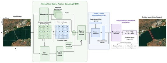
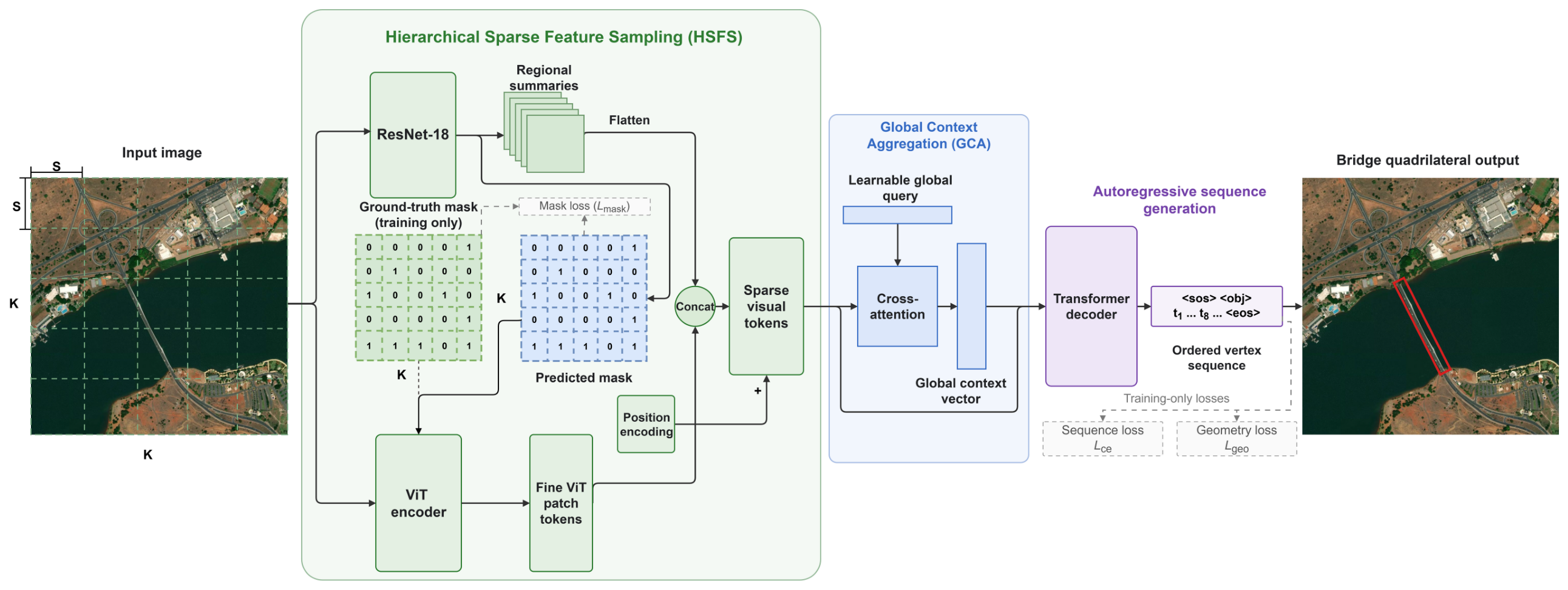
As illustrated in Figure 2, the proposed framework consists of three closely coupled components. First, a hierarchical sparse feature sampling strategy adaptively allocates high-resolution visual encoding to bridge-relevant regions while representing background-dominant areas using compact summary embeddings. This design reduces redundant computation over large-format imagery and supports native 2048 × 2048 input processing. Second, a global context aggregation module integrates information across sparse visual tokens and compact regional embeddings, providing global semantic guidance for long-span bridge interpretation. Third, an autoregressive geometric sequence decoder generates ordered quadrilateral vertex sequences, while a geometry-aware optimization objective improves the structural plausibility of the predicted bridge geometries.
Figure 2.
Overview of the PSeq-Net architecture. Dashed arrows indicate training-only supervision.
From a remote sensing image interpretation perspective, these components address three key requirements of practical bridge detection: computational scalability for ultra-high-resolution images, contextual reasoning for long-span objects, and structurally reliable geometric output for downstream spatial analysis. Therefore, PSeq-Net is not designed as a collection of isolated detection modules but as a sparse-global structural perception framework for robust bridge localization under real-world large-image conditions.
3.2. Structured Bridge Geometry as Sequence Generation
Let denote the input image, with in our experiments. The model predicts a set of bridge instances:
where N is the number of bridge instances and each bridge is represented by an ordered quadrilateral:
This formulation is motivated by the geometric characteristics of bridges in ultra-high-resolution remote sensing imagery. Bridges are often slender, arbitrarily oriented, and spatially continuous across large image regions. Therefore, their practical interpretation requires not only object-level detection but also complete and geometrically consistent localization. Instead of predicting each bridge as an independent local bounding box, PSeq-Net represents bridge localization as a structured sequence generation problem. Under this formulation, the model directly generates the vertex coordinates of bridge quadrilaterals in an ordered sequence.
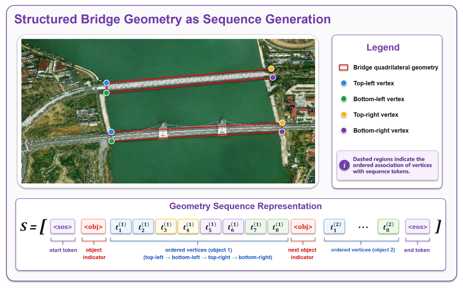
Specifically, each bridge instance is described by four vertices arranged in clockwise order. To reduce vertex-order ambiguity, the first vertex is standardized as the top-left point, followed by the remaining vertices in clockwise order. This canonical ordering provides consistent geometric semantics for sequence learning and avoids multiple equivalent vertex permutations for the same bridge geometry.
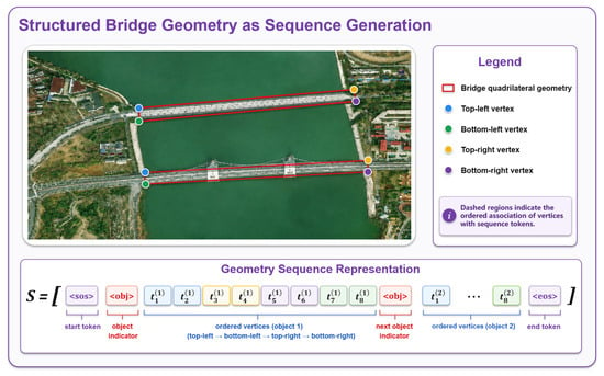
As shown in Figure 3, each bridge instance is encoded as eight consecutive coordinate tokens:
where odd-indexed and even-indexed tokens correspond to the normalized x- and y-coordinates of the four vertices, respectively. For an image containing N bridge instances, all instance sequences are concatenated into a single output sequence:
where and denote the start and end of the sequence, respectively, and is used as an object delimiter.
Figure 3.
Illustration of quadrilateral vertex sequence representation for bridge geometry modeling.
Before tokenization, each coordinate is normalized to according to the image width and height. A normalized coordinate is quantized into a discrete coordinate token:
where V denotes the coordinate vocabulary size. In our implementation, V is set to 2048, matching the native input resolution used by PSeq-Net. This discrete coordinate representation allows the autoregressive decoder to generate bridge geometries with fine-grained localization granularity.
Given the sparse-global visual representation extracted from the input image, bridge localization is formulated as conditional sequence generation:
where denotes the m-th token in the output sequence and represents the previously generated tokens. During training, the target sequence is constructed from ground-truth quadrilateral annotations. When multiple bridge instances appear in the same image, their order is determined according to the spatial position of the first vertex, following a top-to-bottom and left-to-right rule. This deterministic ordering reduces instance-order ambiguity and provides stable supervision for sequence learning.
For each predicted bridge instance i, let denote the position of the token preceding its eight coordinate tokens. The instance confidence is the decoder’s predicted probability of this token at the corresponding decoding step:
This scoring convention is used consistently to rank bridge predictions in all reported AP, AP50, and AP75 evaluations.
This structured sequence formulation provides a compact and coherent output space for bridge geometry. It explicitly models dependencies among vertex coordinates and avoids treating bridge localization as a set of isolated local box predictions. For long-span and high-aspect-ratio bridge instances, such a formulation is better aligned with the need to produce complete, ordered, and geometrically usable bridge representations for downstream spatial analysis.
3.3. Sparse-Global Visual Encoding for Scalable High-Resolution Perception
Dense Transformer encoding of a native 2048 × 2048 image is computationally expensive. For example, using a patch size of 16 × 16 produces (2048/16)2 = 16,384 visual tokens, most of which correspond to background regions in bridge perception scenes. Processing all tokens at high resolution is inefficient and limits the feasibility of end-to-end sequence generation for large-format remote sensing imagery.
To address this issue, PSeq-Net adopts a sparse-global visual encoding strategy consisting of Hierarchical Sparse Feature Sampling (HSFS) and Global Context Aggregation (GCA). HSFS acts as an adaptive computational allocation mechanism that selectively preserves high-resolution tokens in bridge-relevant regions, while GCA compensates for the potential loss of global dependencies caused by sparse tokenization. Together, they provide a scalable visual representation for long-span bridge infrastructure perception.
3.3.1. Hierarchical Sparse Feature Sampling
Given a 2048 × 2048 input image, HSFS first partitions the image into non-overlapping sub-tiles of size , resulting in a grid:
In our implementation, and, thus, . A lightweight convolutional branch is used to extract local summary features and predict a bridge presence mask:
where denotes the local summary embeddings and denotes the predicted bridge presence probabilities.
A sub-tile is predicted as bridge-relevant when its presence probability satisfies . Let denote the ground-truth presence label derived from bridge annotations. During training, a sub-tile is selected if or ; during inference, selection uses only . Selected sub-tiles are divided into ViT patches and encoded by the Transformer, while unselected sub-tiles contribute their convolutional summary embeddings.
This coarse-to-fine allocation combines compact regional summaries with detailed bridge features. Pooling is used in the convolutional summary and presence-prediction branch, whereas selected regions are encoded by the ViT without pooling.
This token allocation strategy preserves fine-grained bridge structures while avoiding dense encoding of large background areas. In practice, the token count is reduced from to fewer than 6000 for most images, substantially lowering memory consumption. More importantly, HSFS reflects an adaptive perception strategy: computation is concentrated on sparse infrastructure-relevant regions rather than distributed uniformly over large background areas. This design is particularly important for ultra-high-resolution bridge scenes, where target regions are sparse but require fine-grained geometric evidence.
3.3.2. Global Context Aggregation
Although HSFS improves computational efficiency, using compact embeddings for bridge-free regions may weaken long-range contextual reasoning, especially for bridges spanning multiple sub-tiles or appearing in complex transportation networks. Therefore, we introduce GCA to aggregate global information from both high-resolution tokens and summary embeddings.
Let
denote the sparse visual token sequence after HSFS, where L is the total number of retained tokens and summary embeddings. GCA uses a learnable global query to perform cross-attention over :
where and are linear projections of . The resulting global context vector is concatenated with the sparse visual tokens and provided to the autoregressive decoder:
3.4. Geometry-Aware Sequence Optimization
Autoregressive coordinate generation may produce geometrically invalid predictions, such as collapsed quadrilaterals, extremely small regions, or inconsistent vertex arrangements. These degenerate predictions are particularly problematic for the detection of slender bridges because high-precision localization is sensitive to small coordinate or angle errors. To improve geometric reliability, we introduce a geometry-aware regularization term into the training objective.
The geometry-aware loss is defined as:
where penalizes quadrilaterals with extremely small areas and suppresses severely distorted vertex configurations. Rather than imposing a strict rectangular prior, this regularizer is designed to prevent degenerate geometric outputs during sequence generation while preserving the flexibility required for arbitrarily oriented bridge instances.
We set and to balance the numerical contributions of the area-collapse penalty and the shape regularizer. These coefficients control the internal balance of , while weights this loss in the total objective.
For a predicted quadrilateral , its polygon area is calculated using the shoelace formula:
where . The area regularization term is defined as:
where is a minimum area threshold used to avoid collapsed quadrilateral predictions.
To reduce severe vertex distortions, we further define a shape consistency term based on adjacent edge directions. Let
denote the k-th edge vector of the predicted quadrilateral. The shape regularization term is formulated as:
where is a tolerance threshold and denotes the cosine similarity between adjacent edges. This term discourages extremely acute or collapsed configurations while avoiding an overly rigid assumption that all bridge quadrilaterals must be perfect rectangles.
In addition to geometry-aware regularization, the bridge presence mask used in HSFS is supervised by a binary mask loss. Let denote the ground-truth bridge presence mask derived from bridge annotations and let denote the predicted mask. We use binary cross-entropy:
where is a small constant for numerical stability.
The final training objective is:
where is the autoregressive sequence cross-entropy loss, and and balance the contributions of geometry-aware regularization and mask supervision, respectively.
Through this objective, PSeq-Net jointly optimizes sequence generation accuracy, sparse region selection, and geometric plausibility. This is important for practical bridge infrastructure perception because the generated output should be not only correctly classified but also structurally credible and spatially useful for downstream remote sensing applications.
3.5. Autoregressive Decoding and Large-Image Inference
During inference, an input image is first processed by the lightweight convolutional branch to obtain the bridge presence mask and local summary embeddings. Based on the predicted mask, bridge-relevant sub-tiles are encoded with high-resolution visual tokens, while background-dominant sub-tiles are represented by compact summary embeddings. The resulting sparse token sequence is augmented with the global context vector and fed into the autoregressive decoder.
The decoder generates coordinate tokens sequentially until the end-of-sequence token is emitted. Each generated coordinate token t is mapped back to image coordinates by:
where denotes the normalized coordinate. The corresponding pixel coordinate is then recovered by multiplying by the image width or height.
For images with resolution no larger than 2048 × 2048, PSeq-Net performs holistic inference in a single forward pass. For larger images, the image is divided into overlapping 2048 × 2048 tiles. Since the model generates structured bridge sequences within each tile, it does not require anchor assignment, proposal filtering, or non-maximum suppression inside the tile-level detection pipeline. Predictions from overlapping tiles are mapped back to the original image coordinate system and post-processed using the following rules.
For two overlapping inference tiles, bridge predictions with polygon IoU greater than zero are considered overlapping candidates. We first check whether either predicted quadrilateral lies entirely within the common area of the two tiles. If so, the prediction with the smaller polygon area is removed. Otherwise, we compare the orientations of their centerlines. If the angular difference is strictly less than , the two predictions are combined by retaining two original vertices at each of the two outer ends, yielding a merged quadrilateral. If the difference is or greater, both predictions are retained without merging. The confidence of a merged prediction is , where and are the original instance confidences defined from the corresponding probabilities.
4. Results
4.1. Experimental Setup
4.1.1. Dataset
We conduct experiments on the GLH-Bridge dataset [9], a large-scale benchmark designed for bridge detection in very-high-resolution remote sensing imagery. The dataset contains 6000 VHR images with spatial sizes ranging from 2048 × 2048 to pixels and provides annotations for 59,737 bridge instances. Each bridge instance is annotated with both horizontal bounding boxes (HBBs) and oriented bounding boxes (OBBs), enabling evaluation under standard oriented object detection protocols.
Following the official experimental protocol, we split the dataset into training and validation sets while ensuring spatial non-overlap between them. This setting reduces geographic leakage and provides a more reliable evaluation of model performance across different remote sensing scenes. The large image size, diverse geographic coverage, and oriented bridge annotations make GLH-Bridge suitable for evaluating not only overall detection accuracy but also the structural reliability of bridge perception under long-span, high-aspect-ratio, boundary-crossing, and complex-background conditions.
4.1.2. Evaluation Metrics
Since PSeq-Net predicts ordered quadrilateral vertex sequences, whereas most competing detectors output oriented bounding boxes, we convert the predicted quadrilaterals into their minimum enclosing oriented bounding boxes for fair evaluation. All methods are evaluated using the same IoU-based matching criterion. We report AP, AP50, and AP75, where AP denotes the average precision over multiple IoU thresholds.
Among these metrics, AP75 is particularly important for bridge infrastructure perception. Due to the slender geometry and extreme aspect ratios of bridges, small localization deviations may cause a significant drop in IoU, a known difficulty in oriented remote sensing object localization [6,8]. Therefore, AP75 provides a stricter measure of high-precision geometric localization than AP50 and better reflects whether the predicted bridge geometry is spatially reliable.
In addition to standard detection metrics, we evaluate structural and practical reliability in subsequent analyses, including performance on long-span bridges, high-aspect-ratio bridges, boundary-crossing bridges, fragmentation rate, cross-scene robustness, cross-resolution robustness, and computational efficiency. These complementary indicators are used to assess whether the proposed framework improves practical bridge infrastructure perception rather than merely increasing benchmark-level AP.
4.1.3. Implementation Details
The proposed PSeq-Net adopts a ViT-Small visual encoder with 12 Transformer layers and an embedding dimension of , followed by a 6-layer autoregressive Transformer decoder. During training and inference, the input image is processed as 2048 × 2048 tiles. In the Hierarchical Sparse Feature Sampling (HSFS) module, each tile is divided into non-overlapping sub-tiles of size , resulting in a grid with . A lightweight ResNet-18 branch is used to generate local summary embeddings and predict bridge presence probabilities for sparse token allocation.
Vertex coordinates are quantized into discrete coordinate levels. The vocabulary consists of Q coordinate tokens and three special tokens, namely , , and , resulting in a vocabulary size of . The model is optimized using AdamW with an initial learning rate of and a batch size of 1. Training is performed for 300 epochs on a single 40GB NVIDIA A100 GPU. The weights for the geometry-aware loss and mask supervision loss are set to and , respectively.
For baseline detectors, we follow their commonly adopted training and inference settings for large remote sensing images unless otherwise specified. High-resolution images are cropped into patches according to the recommended input size of each detector, and large-image inference is performed using sliding windows followed by standard post-processing. For PSeq-Net, images no larger than 2048 × 2048 are processed in a single forward pass. Images larger than 2048 × 2048 are divided into overlapping 2048 × 2048 tiles, and predictions are mapped back to the original image coordinate system for evaluation. This setting allows all methods to be evaluated under practical large-image inference conditions.
4.2. Overall Performance Under Practical Large-Image Detection
4.2.1. Comparison Protocol
To evaluate the overall effectiveness of PSeq-Net under large-image bridge infrastructure perception settings, we compare it with representative oriented object detectors and large-scale remote sensing detection methods on the GLH-Bridge validation set. The compared methods include two-stage oriented detectors, one-stage oriented detectors, and large-format remote sensing detection methods.
For baseline detectors, we follow their commonly adopted training and inference settings for large remote sensing images. During training, high-resolution images are cropped into patches according to the recommended input resolution of each method, such as or . No downsampling or interpolation is applied to the original image content during patch generation. During inference, large validation images are processed using a sliding-window strategy, and predictions from overlapping windows are merged using non-maximum suppression (NMS). Unless otherwise specified, the baseline detectors use ResNet-50 as the backbone.
For PSeq-Net, training is conducted on 2048 × 2048 tiles. During inference, images no larger than 2048 × 2048 are processed in a single forward pass. For larger images, we use overlapping 2048 × 2048 tiles with a stride of 1536 pixels and an overlap of 512 pixels. Within each tile, PSeq-Net directly generates quadrilateral vertex sequences without anchor assignment, region proposal generation, or proposal-level NMS. Predictions from different tiles are mapped back to the original image coordinate system for final evaluation.
Because the methods use different backbone architectures and input sizes, Table 2 compares complete detection configurations. The component ablations in Section 4.4 use a fixed input size within PSeq-Net to examine the contributions of HSFS, GCA, and geometry-aware optimization.
Table 2.
Overall comparison on the GLH-Bridge validation set under the standard OBB evaluation protocol. All results are reported in %. Bold numerical values indicate the best performance.
4.2.2. Quantitative Results
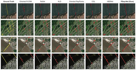
As shown in Table 2, PSeq-Net achieves the best overall performance on the GLH-Bridge validation set, obtaining 37.87% AP, 73.58% AP50, and 31.38% AP75. Compared with the strongest large-scale baseline HBDNet, PSeq-Net improves AP by 2.52 percentage points and AP75 by 2.69 percentage points. The gain in AP75 is particularly meaningful for bridge infrastructure perception because high-IoU localization is highly sensitive to small vertex, angle, and boundary deviations for slender bridge instances [6]. Figure 4 shows qualitative detection results of PSeq-Net on examples from GLH-Bridge.
Figure 4.
Qualitative detection results of PSeq-Net on large-image bridge examples from the GLH-Bridge dataset.
Nevertheless, overall AP does not fully characterize the practical value of an infrastructure perception framework. For long-span bridge objects, the key question is not only whether the detector achieves higher average accuracy but also whether it can preserve structural completeness, reduce fragmented detections, remain robust in complex scenes, and maintain a reasonable computational cost. Therefore, the following sections further analyze PSeq-Net from the perspectives of bridge aspect ratio, boundary-crossing cases, fragmentation behavior, robustness, and the contributions of individual modules.
4.2.3. Performance on Bridges with Different Aspect Ratios
We further evaluate the methods across different aspect-ratio ranges. The aspect ratio is calculated as:
where w and h denote the side lengths of the minimum enclosing oriented bounding box. We divide bridge instances into four groups: , , , and . The results are reported in Table 3.
Table 3.
AP comparison on bridge instances with different aspect ratios. The aspect ratio is calculated from the minimum enclosing oriented bounding box. Results are reported in %. Bold numerical values indicate the best AP within each aspect-ratio group.
Table 3 shows a similar pattern. When the aspect ratio is relatively small, the performance gap between PSeq-Net and existing methods is limited. For bridges with , PSeq-Net improves AP by 1.26 percentage points over HBDNet. However, for highly elongated bridges with , the gain increases to 5.37 percentage points. For extremely slender bridges with , PSeq-Net achieves an AP of 33.42%, outperforming HBDNet by 7.07 percentage points.
The larger performance gains for high-aspect-ratio bridges highlight the effectiveness of PSeq-Net in elongated-object localization. Such instances are sensitive to coordinate and angle deviations because small errors can substantially change IoU. By combining detailed visual evidence, global context, and ordered vertex prediction, PSeq-Net provides a coherent representation of these slender structures.
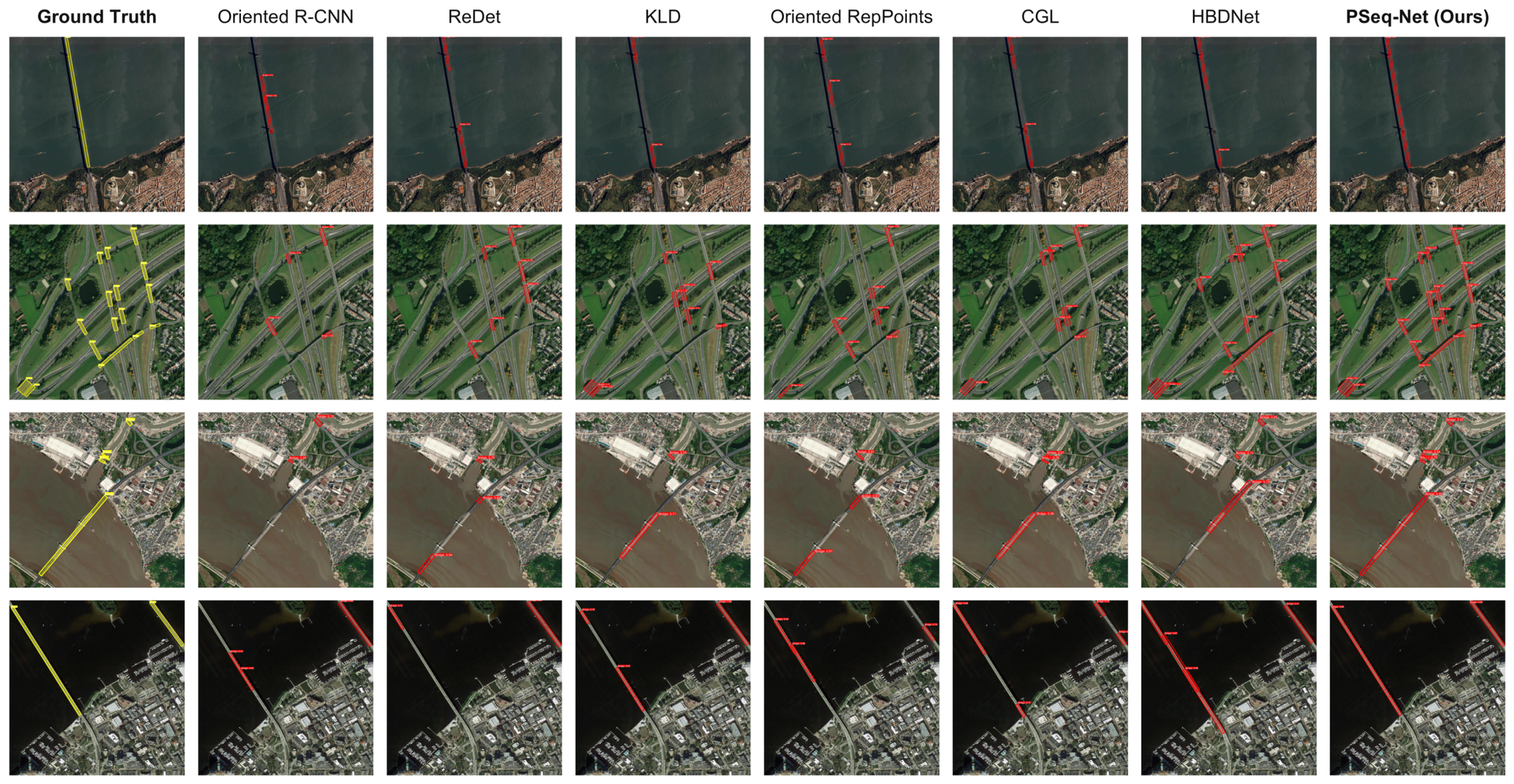
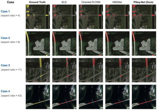
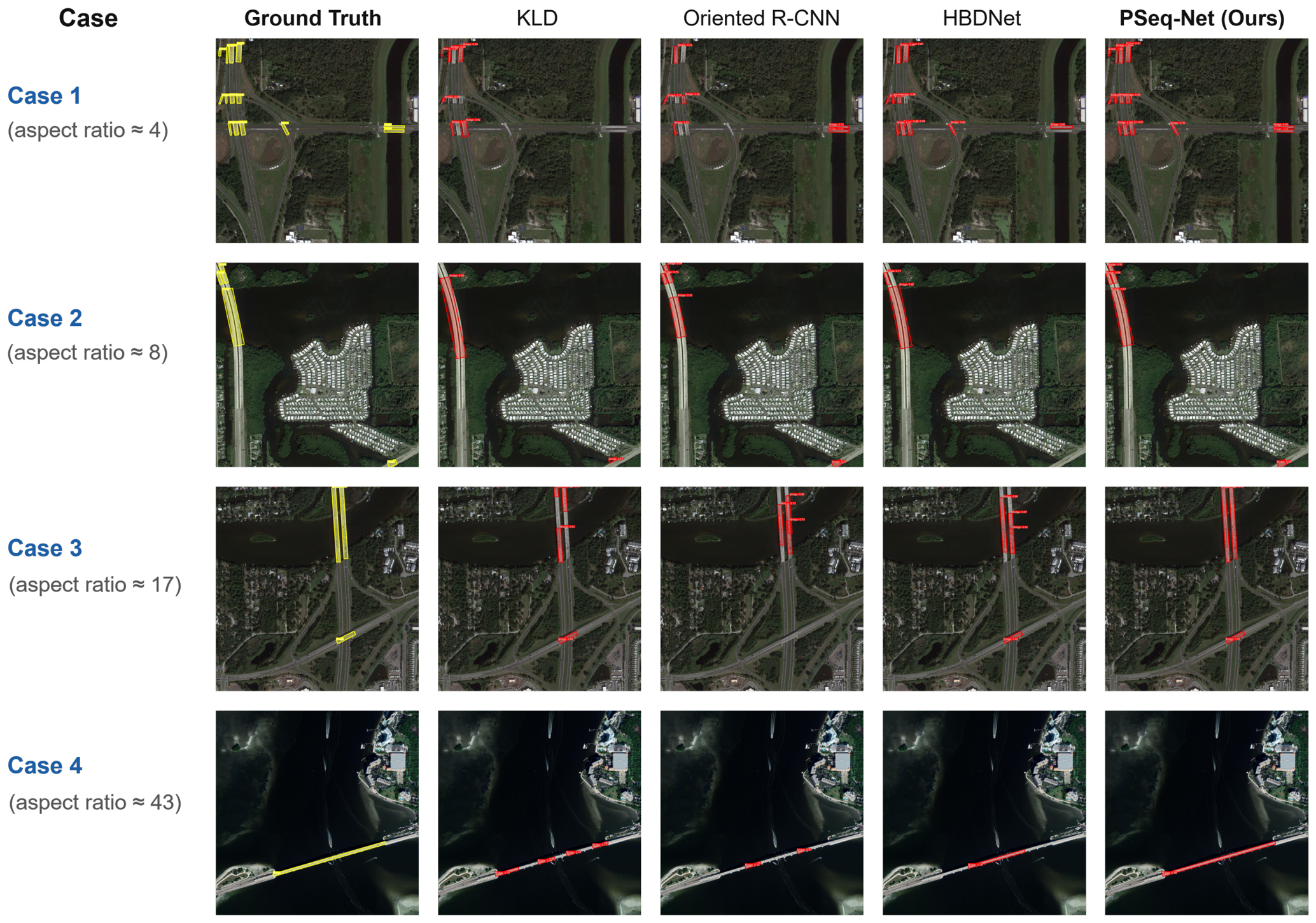
Figure 5 provides qualitative examples that further illustrate the structural reliability of PSeq-Net on long-span and high-aspect-ratio bridge instances. As shown in the figure, conventional oriented detectors often produce fragmented predictions, partial coverage, or angle deviations when bridges are extremely long or slender. In contrast, PSeq-Net produces more complete and geometrically coherent bridge quadrilaterals, which is consistent with the quantitative improvements observed in Table 3.
Figure 5.
Qualitative comparison between PSeq-Net and representative detectors under different bridge aspect ratios.
4.2.4. Computational Efficiency
Table 4 compares the model size, reported computational cost, and inference performance of PSeq-Net, HBDNet, and Oriented R-CNN. Parameters denote all model parameters. FPS is calculated as the number of original validation images divided by the total processing time, from data reading to final output, including preprocessing, tiling, inference, and post-processing. The mean processing times are approximate reciprocals of the rounded FPS values and describe the full pipeline rather than model-forward-only latency.
Table 4.
Model size, computational cost, and full-pipeline inference performance.
PSeq-Net has the lowest reported FLOPs and the highest full-pipeline throughput among the three compared methods. Its parameter count is lower than HBDNet’s but higher than Oriented R-CNN’s. Together with the accuracy results in Table 2, these measurements show a favorable balance between detection performance and computational cost.
4.3. Boundary-Crossing and Fragmentation Analysis
Patch-based inference is one of the most common strategies for processing ultra-high-resolution remote sensing imagery [2]. However, for long-span bridge infrastructure, this strategy may introduce structural discontinuity when a bridge crosses the boundary of cropped patches. From a GIS updating or infrastructure inventory perspective, such fragmented detections are undesirable because one physical bridge may be represented as multiple disconnected objects, increasing manual correction cost and reducing the reliability of downstream spatial analysis. We therefore evaluate model performance on boundary-crossing bridge instances and report a fragmentation rate as a complementary indicator of multiple partial detections, interpreted alongside AP and qualitative examples.
4.3.1. Definition of Boundary-Crossing Bridges
To analyze the influence of patch boundaries, we divide bridge instances into two groups according to their spatial relationship with the sliding-window grid used by patch-based detectors. Given the standard sliding-window inference setting with patch size 1024 × 1024 and stride 768, a bridge instance is defined as a boundary-crossing bridge if its oriented bounding box intersects with at least one internal patch boundary and more than 20% of its area lies on each side of the boundary. Otherwise, it is regarded as a non-boundary bridge. This definition excludes trivial boundary contacts and focuses on cases where patch cropping is likely to split the bridge structure into different local observations.
We compare PSeq-Net with KLD, Oriented R-CNN, and HBDNet. These include representative one-stage and two-stage oriented detectors and the strongest large-scale bridge detection baseline in the main comparison. All methods are evaluated under the same OBB evaluation protocol. This setting allows us to examine whether PSeq-Net improves not only average detection accuracy but also structural reliability under patch-boundary interference.
4.3.2. Fragmentation Rate
In addition to AP and AP75, we use a fragmentation rate as an operational indicator of multiple partial detections. For a ground-truth bridge instance g, let denote the set of predicted boxes whose IoU with g exceeds a loose threshold . The indicator flags an instance when no single prediction reaches , but at least two predictions exceed . Formally, it is defined as:
where = 0.1 and = 0.5 in our implementation. The fragmentation rate is then calculated as:
where denotes the set of ground-truth bridge instances in the evaluated group.
The 20% boundary criterion excludes incidental contacts and focuses on bridges substantially divided by a crop boundary. The loose threshold admits partial predictions, while provides the reference for a sufficiently overlapping single detection.
The fragmentation rate summarizes the specified multiple-prediction pattern and complements the localization accuracy measured by AP.
4.3.3. Quantitative Results
The results are reported in Table 5. For non-boundary bridges, all methods perform relatively well because the complete bridge structure is more likely to be contained within a local patch. In this case, PSeq-Net improves AP over HBDNet by 2.11 percentage points and AP75 by 3.31 percentage points. The fragmentation rate also decreases from 6.91% to 4.82%.
Table 5.
Performance comparison on non-boundary and boundary-crossing bridge instances. Frag. denotes fragmentation rate; lower values are better. Results are reported in %. Bold numerical values indicate the best results. Downward arrows indicate that lower values are better.
For boundary-crossing bridges, the performance gap becomes substantially larger. PSeq-Net improves AP by 6.42 percentage points and AP75 by 7.16 percentage points over HBDNet. This result indicates that the proposed framework is more robust when bridge structures are likely to be split by local image crops. The improvement in AP75 is particularly important because boundary-crossing bridges are more prone to incomplete localization, angle deviation, and local box misalignment.
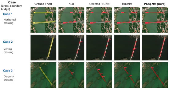
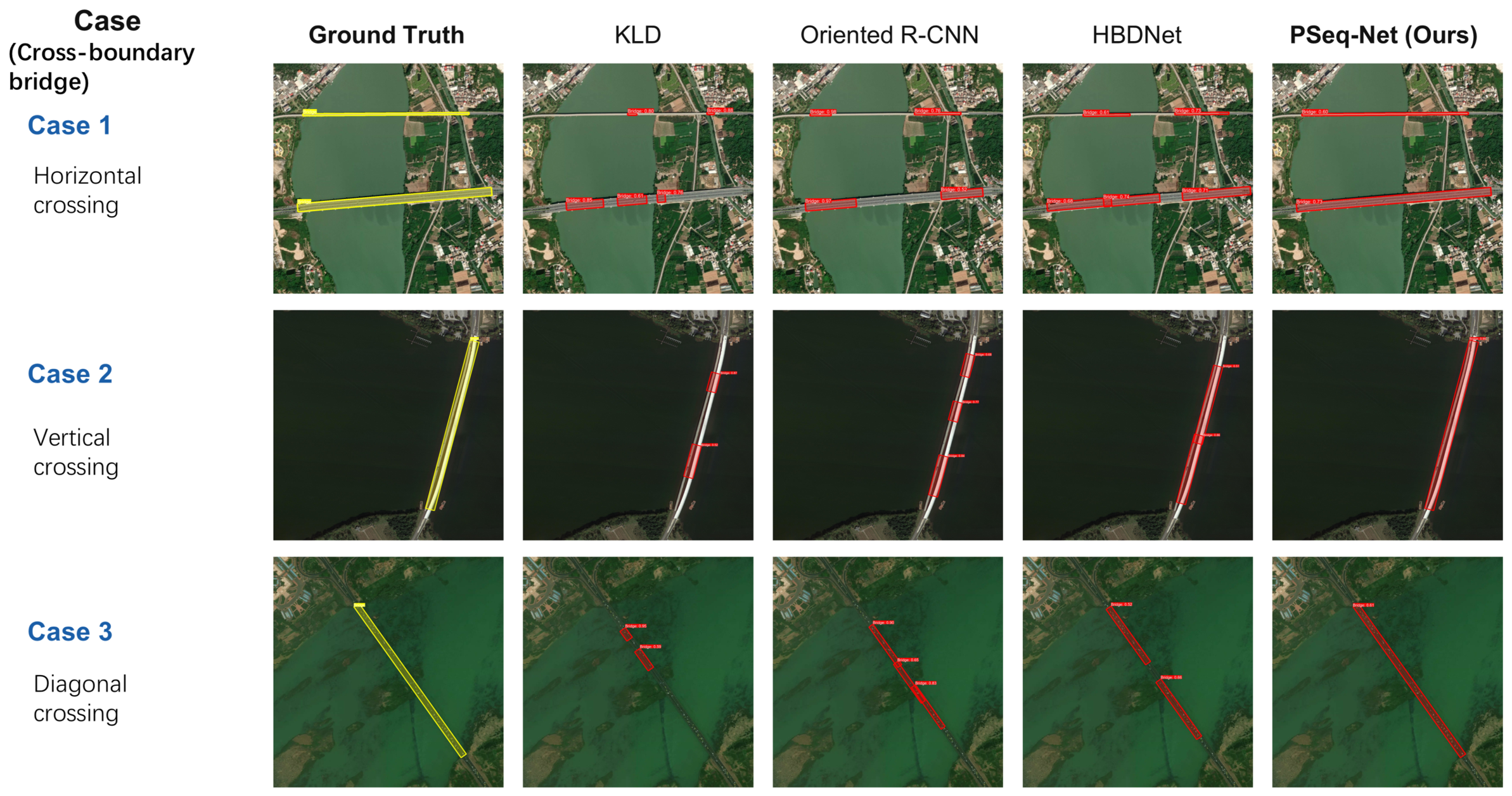
Figure 6 provides qualitative examples that further illustrate the quantitative improvements for boundary-crossing bridge instances.
Figure 6.
Qualitative comparison between PSeq-Net and representative detectors on boundary-crossing bridge instances.
On boundary-crossing bridges, the fragmentation rates are 29.34% for Oriented R-CNN, 24.68% for HBDNet, and 11.42% for PSeq-Net. Together with the higher AP values and qualitative examples, this reduction indicates more coherent localization of bridge instances affected by crop boundaries.
4.4. Ablation Study
To better understand how PSeq-Net supports sparse-global structural perception, we conduct a series of ablation experiments on the GLH-Bridge validation set. Unlike the main comparison, which evaluates overall benchmark performance, this section analyzes the roles of adaptive high-resolution evidence selection, global contextual reasoning, and geometry-aware sequence optimization. These analyses are important for verifying whether the proposed framework improves bridge perception through coordinated system design rather than through a single isolated module.
All ablation variants are trained and evaluated under the same setting unless otherwise specified. The input resolution is fixed to 2048 × 2048, and all results are reported using the same OBB evaluation protocol. We report AP, AP50, AP75, GPU memory consumption, and the average number of visual tokens. AP75 is emphasized because it better reflects high-precision localization reliability for slender and long-span bridge instances.
4.4.1. Component-Wise Ablation
We first analyze the contribution of the three key components in PSeq-Net: Hierarchical Sparse Feature Sampling (HSFS), Global Context Aggregation (GCA), and the geometry-aware optimization objective . The baseline model is a dense Pix2Seq-style detector that encodes all patches in a 2048 × 2048 input with a Transformer encoder and predicts quadrilateral vertex sequences autoregressively.
As shown in Table 6, the dense baseline achieves 32.23% AP but requires 37.6G of GPU memory and processes 16,384 visual tokens for each 2048 × 2048 tile. This confirms that dense Transformer encoding of native 2K inputs is computationally expensive and limits practical scalability for ultra-high-resolution bridge imagery.
Table 6.
Component-wise ablation study on the GLH-Bridge validation set. Mem. denotes inference memory consumption for one 2048 × 2048 tile. Tokens denote the average number of visual tokens used by the encoder. Results are reported in %. Bold numerical values indicate the highest AP for each metric. Check marks indicate enabled components, and crosses indicate disabled components.
This baseline already combines the PSeq-Net visual backbone with a 2048 × 2048 observation window. It provides a common starting point for evaluating the incremental contributions of HSFS, GCA, and geometry-aware optimization.
Introducing HSFS reduces the number of visual tokens from 16,384 to 5742 and lowers memory consumption from 37.6G to 26.8G. However, HSFS alone decreases AP from 32.23% to 30.89%. This result is important because it shows that HSFS should not be interpreted as a standalone accuracy-enhancing module. Instead, HSFS primarily serves as an efficiency-oriented computational allocation mechanism. By replacing background-dominant regions with compact summary embeddings, it reduces redundant high-resolution processing, but may also weaken contextual continuity for bridges spanning multiple sub-regions.
When GCA is added to HSFS, AP increases from 30.89% to 34.67%, and AP75 improves from 23.19% to 27.80%. This improvement supports the role of global context aggregation in recovering high-precision localization after sparse tokenization.
Finally, adding the geometry-aware loss further improves AP to 37.87% and AP75 to 31.38%. The large gain in AP75 indicates that geometry-aware optimization is particularly beneficial for structurally reliable bridge localization. By suppressing degenerate quadrilateral predictions, the model produces more stable and geometrically plausible bridge representations.
4.4.2. Ablation on Sparse-Global Encoding
To further verify whether the performance gain comes from the proposed sparse-global encoding strategy rather than simply reducing the token count, we compare HSFS with several alternative sparse encoding variants. The results are shown in Table 7.
Table 7.
Ablation study on sparse-global visual encoding. GT mask denotes using the ground-truth bridge presence mask for sparse token selection. Pred. mask denotes using the predicted bridge presence mask during inference. Results are reported in %. Bold numerical values indicate the best detection accuracy for each metric.
As shown in Table 7, random sparse sampling performs the worst, indicating that sparse encoding must be guided by bridge-relevant visual evidence rather than performed uniformly or randomly. HSFS with the predicted mask achieves better results than random sparse sampling, but still underperforms dense encoding because some contextual information is compressed into low-dimensional summary embeddings. When the ground-truth mask is used for token selection, the performance improves to 33.46% AP, suggesting that the quality of bridge presence prediction directly affects sparse high-resolution evidence allocation.
Replacing GCA with simple average pooling yields only limited improvement, achieving 32.58% AP. In contrast, HSFS + GCA achieves 34.67% AP and 27.80% AP75, clearly outperforming average pooling. This comparison shows that GCA does more than simply add a global feature vector. Instead, its attention-based aggregation provides a more effective mechanism for integrating long-range dependencies across sparse visual tokens and compact regional embeddings.
4.4.3. Ablation on Geometry-Aware Optimization
We further investigate the effect of different geometry-aware regularization terms. As discussed in Section 3.4, the geometry-aware loss is designed to suppress degenerate quadrilateral predictions rather than impose an overly rigid rectangular prior. We evaluate the area regularization term, the shape consistency term, and their combination.
Table 8 shows that both area and shape regularization contribute to performance improvement. Using only reduces the ratio of collapsed quadrilateral predictions and improves AP75 from 27.80% to 29.03%. Using only further improves AP75 to 29.86%, indicating that suppressing severely distorted vertex configurations helps high-precision localization.
Table 8.
Ablation study on geometry-aware optimization. Deg. denotes the ratio of degenerate quadrilateral predictions, including extremely small, collapsed, or severely distorted quadrilaterals. Lower Deg. is better. Results are reported in %. Bold numerical values indicate the best results. The downward arrow indicates that lower values are better.
The complete geometry-aware loss achieves the best performance, with 37.87% AP and 31.38% AP75. It also reduces the degenerate prediction ratio from 8.46% to 2.63%. This reduction is particularly meaningful for infrastructure perception because geometrically invalid bridge outputs are difficult to use in downstream GIS updating, transportation network analysis, or infrastructure inventory construction. These results show that geometry-aware optimization improves localization and suppresses degenerate quadrilateral predictions.
4.4.4. Sensitivity to Loss Weights
We also analyze the sensitivity of PSeq-Net to the geometry-aware loss weight and the mask supervision weight . The results are reported in Table 9. In this experiment, we vary one parameter while keeping the other fixed.
Table 9.
Sensitivity analysis of the geometry-aware loss weight and mask supervision weight . Results are reported in %. Bold numerical values indicate the best result for each metric among the tested settings.
Table 9 shows measurable differences in detection accuracy across the tested weights. With fixed, increasing from 0 to 0.2 raises AP from 34.67% to 37.87% and AP75 from 27.80% to 31.38%, gains of 3.20 and 3.58 percentage points, respectively. With fixed, increasing from 0 to 0.5 raises AP from 35.94% to 37.87% and AP75 from 29.42% to 31.38%, gains of 1.93 and 1.96 percentage points. Differences between nearby nonzero weights are smaller, with and yielding the highest reported accuracy among the tested settings. The total objective combines sequence prediction, geometric regularization, and supervision of sparse region selection; the sensitivity analysis evaluates their balance to improve detection performance.
4.5. Robustness and Generalization Analysis
Although the main comparison and structural reliability analyses demonstrate the effectiveness of PSeq-Net on the GLH-Bridge validation set, remote sensing detection systems must remain reliable under diverse scene backgrounds and imaging resolutions. This issue is particularly important for bridge infrastructure perception because bridge appearance may vary significantly with terrain, surrounding land cover, sensor resolution, shadows, and complex transportation networks.
We evaluate cross-scene and cross-resolution robustness using HBDNet, the strongest large-scale baseline in the main comparison, as the reference method.
4.5.1. Cross-Scene Robustness
We further evaluate performance under different scene backgrounds. Based on land-cover and contextual characteristics, validation images are divided into four scene types: urban, rural, mountainous, and aquatic scenes. Urban scenes usually contain dense roads, buildings, and overpasses, making bridge-road discrimination difficult. Mountainous scenes often contain shadows, irregular terrain textures, and low-contrast bridge boundaries. Aquatic scenes include bridges crossing rivers, lakes, or coastal areas, where water boundaries and reflections may interfere with detection. Rural scenes are relatively simple but may contain small and low-contrast bridges. Similar complex-background and multi-scale effects are widely reported in remote sensing and UAV object detection [26,32].
The results are shown in Table 10.
Table 10.
Cross-scene robustness analysis on different background types. Results are reported in %. Bold numerical values indicate the best result for each scene type and metric.
As shown in Table 10, PSeq-Net achieves consistent improvements across all scene types. The gains are relatively moderate in rural and aquatic scenes, where bridge structures are often more visually distinguishable. In contrast, larger improvements are observed in urban and mountainous scenes. The AP75 gains are 4.26 percentage points in urban scenes and 4.44 percentage points in mountainous scenes, supporting a localization advantage in these background categories.
4.5.2. Cross-Resolution Robustness
Remote sensing images are often acquired by different sensors or platforms with varying spatial resolutions. A deployable bridge perception model should therefore remain stable when image resolution changes. To evaluate this property, we create different resolution settings by resizing validation images while keeping annotations geometrically consistent. Specifically, we evaluate models under three settings: native resolution, downsampled by a factor of 0.75, and downsampled by a factor of 0.5. The results are shown in Table 11.
Table 11.
Cross-resolution robustness analysis. Images are evaluated under different resolution scaling factors. Results are reported in %. Bold numerical values indicate the best result for each resolution setting and metric.
Table 11 shows that both methods experience performance degradation as image resolution decreases. This is expected because downsampling weakens bridge boundaries, reduces fine-grained texture cues, and makes slender structures less distinguishable from roads, riverbanks, or other linear objects. However, PSeq-Net maintains a consistent advantage under all resolution settings. When the resolution is reduced to , PSeq-Net still improves AP by 3.42 percentage points and AP75 by 3.82 percentage points over HBDNet.
5. Discussion
The results highlight the complementary roles of sparse visual encoding, global context aggregation, and structured geometry prediction. HSFS concentrates fine-resolution computation on bridge-relevant regions, while GCA maintains contextual connections across the visual representation. The ablations show that sparse sampling reduces token count and memory consumption, and that global aggregation and geometry-aware learning recover and improve localization accuracy. Together, these components enable high-resolution bridge detection with coherent geometric outputs.
The improvements for elongated and boundary-crossing bridges are particularly relevant to infrastructure mapping, where incomplete or inconsistent detections can complicate object identification. Ordered quadrilateral vertices provide a compact instance representation that can support bridge inventories and GIS updating. The scene and resolution analyses further demonstrate the value of combining detailed bridge evidence with broader contextual cues in varied remote sensing environments.
Several issues remain open. Bridges extending beyond the observation window still require tiling and geometric merging, and missed regions in the presence mask can reduce access to fine-grained features. Quadrilateral representations are also less suited to curved bridges and complex interchanges. The fragmentation indicator describes prediction patterns rather than pixel-level structural continuity. Results are based on single training runs, with loss weights selected on the validation set used for evaluation; repeated-run evaluation and independent test data would help assess training variability and selection bias.
Future work can investigate more reliable region selection and flexible geometric representations. Adaptive patch reshaping, developed for edge-based remote sensing semantic segmentation [43], offers a potentially relevant direction for exploring more flexible encoding units. Further analyses of tiling and merging, together with evaluation across datasets and sensors and under controlled image degradation and different viewing conditions, would extend the understanding of the framework’s performance.
6. Conclusions
This paper presented PSeq-Net, an end-to-end sparse-global sequence modeling framework for bridge detection in ultra-high-resolution remote sensing imagery. Sparse visual encoding and global context aggregation support ordered quadrilateral vertex prediction, while geometry-aware optimization promotes structurally consistent outputs.
On GLH-Bridge, PSeq-Net achieves 37.87% AP, 73.58% AP50, and 31.38% AP75, improving AP and AP75 over the strongest baseline by 2.52 and 2.69 percentage points, respectively. The aspect-ratio, boundary-crossing, scene, and resolution analyses further demonstrate its effectiveness for challenging bridge localization, while the ablations confirm the complementary benefits of the proposed components.
Future research will explore more reliable sparse region selection, more flexible representations for complex bridge geometries, and broader evaluation across remote sensing datasets and imaging conditions.
Author Contributions
Conceptualization, X.Z., J.L. and Z.S.; methodology, X.Z.; software, X.Z.; validation, X.Z. and H.L.; formal analysis, X.Z. and H.L.; investigation, X.Z. and H.L.; resources, J.L. and Z.S.; data curation, X.Z. and H.L.; writing–original draft preparation, X.Z.; writing–review and editing, H.L., J.L. and Z.S.; visualization, X.Z.; supervision, J.L. and Z.S.; project administration, J.L. and Z.S. All authors have read and agreed to the published version of the manuscript.
Funding
This research received no external funding.
Data Availability Statement
The original data presented in the study are openly available in GLH-Bridge at https://luo-z13.github.io/GLH-Bridge-page/ (accessed on 2 October 2026) and https://huggingface.co/datasets/RGBMark/GLH-Bridge (accessed on 2 October 2026).
Acknowledgments
During the preparation of this manuscript, the authors used Codex (version 26.1007.41230) to assist with language polishing and manuscript formatting. The authors reviewed and edited the output and take full responsibility for the content of this publication.
Conflicts of Interest
The authors declare no conflicts of interest.
References
- Liu, S.; Zheng, Y.; Du, Q.; Bruzzone, L.; Samat, A.; Tong, X.; Jin, Y.; Wang, C. A Shallow-to-Deep Feature Fusion Network for VHR Remote Sensing Image Classification. IEEE Trans. Geosci. Remote Sens. 2022, 60, 5410213. [Google Scholar] [CrossRef] [Scilit]
- Wang, Y.; Bashir, S.M.A.; Khan, M.; Ullah, Q.; Wang, R.; Song, Y.; Guo, Z.; Niu, Y. Remote sensing image super-resolution and object detection: Benchmark and state of the art. Expert Syst. Appl. 2022, 197, 116793. [Google Scholar] [CrossRef] [Scilit]
- Li, Z.; Wang, Y.; Zhang, N.; Zhang, Y.; Zhao, Z.; Xu, D.; Ben, G.; Gao, Y. Deep Learning-Based Object Detection Techniques for Remote Sensing Images: A Survey. Remote Sens. 2022, 14, 2385. [Google Scholar] [CrossRef] [Scilit]
- Wang, J.; Zhao, Z.; Shao, J.; Zou, X.; Zhao, X. Enhanced few-shot object detection for remote sensing images based on target characteristics. Eng. Appl. Artif. Intell. 2025, 148, 110315. [Google Scholar] [CrossRef] [Scilit]
- Sithole, G.; Vosselman, G. Bridge detection in airborne laser scanner data. ISPRS J. Photogramm. Remote Sens. 2006, 61, 33–46. [Google Scholar] [CrossRef] [Scilit]
- Wen, L.; Cheng, Y.; Fang, Y.; Li, X. A comprehensive survey of oriented object detection in remote sensing images. Expert Syst. Appl. 2023, 224, 119960. [Google Scholar] [CrossRef] [Scilit]
- Dong, Z.; Wang, M.; Wang, Y.; Liu, Y.; Feng, Y.; Xu, W. Multi-Oriented Object Detection in High-Resolution Remote Sensing Imagery Based on Convolutional Neural Networks with Adaptive Object Orientation Features. Remote Sens. 2022, 14, 950. [Google Scholar] [CrossRef] [Scilit]
- Xiao, J.; Yao, Y.; Zhou, J.; Guo, H.; Yu, Q.; Wang, Y.F. FDLR-Net: A feature decoupling and localization refinement network for object detection in remote sensing images. Expert Syst. Appl. 2023, 225, 120068. [Google Scholar] [CrossRef] [Scilit]
- Li, Y.; Luo, J.; Zhang, Y.; Tan, Y.; Yu, J.-G.; Bai, S. Learning to Holistically Detect Bridges From Large-Size VHR Remote Sensing Imagery. IEEE Trans. Pattern Anal. Mach. Intell. 2024, 46, 11507–11523. [Google Scholar] [CrossRef] [Scilit] [PubMed]
- Hou, B.; Li, Y.; Jiao, L. Segmentation and Recognition of Bridges in High Resolution SAR Images. In Proceedings of the 2001 CIE International Conference on Radar, Beijing, China, 15–18 October 2001; pp. 479–482. [Google Scholar] [CrossRef] [Scilit]
- Su, F.; Wu, Z.; Lin, X. An Algorithm of Bridge Detection in Remote Sensing Images Based on Fractal. In Proceedings of the International Symposium on Antennas, Propagation and EM Theory (ISAPE), Beijing, China, 28 October–1 November 2003; pp. 600–602. [Google Scholar] [CrossRef] [Scilit]
- Bai, Z.; Yang, J.; Liang, H.; Wang, W. An Optimal Edge Detector for Bridge Target Detection in SAR Images. In Proceedings of the International Conference on Communications, Circuits and Systems (ICCCAS), Hong Kong, China, 27–30 May 2005. [Google Scholar] [CrossRef] [Scilit]
- Chen, L.; Weng, T.; Xing, J.; Pan, Z.; Yuan, Z.; Xing, X.; Zhang, P. A New Deep Learning Network for Automatic Bridge Detection from SAR Images Based on Balanced and Attention Mechanism. Remote Sens. 2020, 12, 441. [Google Scholar] [CrossRef] [Scilit]
- Liu, C.; Yang, J.; Ou, J.; Fan, D. Offshore Bridge Detection in Polarimetric SAR Images Based on Water Network Construction Using Markov Tree. Remote Sens. 2022, 14, 3888. [Google Scholar] [CrossRef] [Scilit]
- Guo, H.; Zhang, R.; Wang, Y.; Yang, W.; Li, H.C.; Xia, G.S. Accurate Bridge Detection in Aerial Images with an Auxiliary Waterbody Extraction Task. IEEE J. Sel. Top. Appl. Earth Obs. Remote Sens. 2021, 14, 9651–9666. [Google Scholar] [CrossRef] [Scilit]
- Wang, Z.; Zhang, Y.; Yu, Y.; Zhang, L.; Min, J.; Lai, G. Prior-Information Auxiliary Module: An Injector to a Deep Learning Bridge Detection Model. IEEE J. Sel. Top. Appl. Earth Obs. Remote Sens. 2021, 14, 6270–6278. [Google Scholar] [CrossRef] [Scilit]
- Qiu, M.; Huang, L.; Tang, B.H. Bridge detection method for HSRRSIs based on YOLOv5 with a decoupled head. Int. J. Digit. Earth 2023, 16, 113–129. [Google Scholar] [CrossRef] [Scilit]
- Nogueira, K.; Cesar, C.; Gama, P.H.T.; Machado, G.L.S.; dos Santos, J.A. A Tool for Bridge Detection in Major Infrastructure Works Using Satellite Images. In Proceedings of the Workshop on Computer Vision (WVC), São Bernardo do Campo, Brazil, 9–11 September 2019; pp. 72–77. [Google Scholar] [CrossRef] [Scilit]
- Li, K.; Wan, G.; Cheng, G.; Meng, L.; Han, J. Object Detection in Optical Remote Sensing Images: A Survey and a New Benchmark. ISPRS J. Photogramm. Remote Sens. 2020, 159, 296–307. [Google Scholar] [CrossRef] [Scilit]
- Sun, X.; Wang, P.; Yan, Z.; Xu, F.; Wang, R.; Diao, W.; Chen, J.; Li, J.; Feng, Y.; Xu, T.; et al. FAIR1M: A Benchmark Dataset for Fine-Grained Object Recognition in High-Resolution Remote Sensing Imagery. ISPRS J. Photogramm. Remote Sens. 2022, 184, 116–130. [Google Scholar] [CrossRef] [Scilit]
- Ding, J.; Xue, N.; Xia, G.-S.; Bai, X.; Yang, W.; Yang, M.Y.; Belongie, S.; Luo, J.; Datcu, M.; Pelillo, M.; et al. Object Detection in Aerial Images: A Large-Scale Benchmark and Challenges. IEEE Trans. Pattern Anal. Mach. Intell. 2022, 44, 7778–7796. [Google Scholar] [CrossRef] [Scilit] [PubMed]
- Ren, S.; He, K.; Girshick, R.; Sun, J. Faster R-CNN: Towards Real-Time Object Detection with Region Proposal Networks. IEEE Trans. Pattern Anal. Mach. Intell. 2017, 39, 1137–1149. [Google Scholar] [CrossRef] [Scilit] [PubMed]
- Redmon, J.; Divvala, S.; Girshick, R.; Farhadi, A. You Only Look Once: Unified, Real-Time Object Detection. In Proceedings of the 2016 IEEE Conference on Computer Vision and Pattern Recognition (CVPR), Las Vegas, NV, USA, 27–30 June 2016; pp. 779–788. [Google Scholar] [CrossRef] [Scilit]
- Carion, N.; Massa, F.; Synnaeve, G.; Usunier, N.; Kirillov, A.; Zagoruyko, S. End-to-End Object Detection with Transformers. In Computer Vision—ECCV 2020; Lecture Notes in Computer Science; Vedaldi, A., Bischof, H., Brox, T., Frahm, J.-M., Eds.; Springer International Publishing: Cham, Switzerland, 2020; Volume 12346, pp. 213–229. [Google Scholar] [CrossRef] [Scilit]
- Zhang, H.; Li, F.; Liu, S.; Zhang, L.; Su, H.; Zhu, J.; Ni, L.M.; Shum, H.-Y. DINO: DETR with Improved DeNoising Anchor Boxes for End-to-End Object Detection. arXiv 2022, arXiv:2203.03605. [Google Scholar] [CrossRef] [Scilit]
- Wang, X.; Peng, L.; Li, X.; He, Y.; U, K. Enhancing remote sensing object detection via selective-perspective-class integration. Eng. Appl. Artif. Intell. 2026, 165, 113416. [Google Scholar] [CrossRef] [Scilit]
- Xie, X.; Cheng, G.; Wang, J.; Yao, X.; Han, J. Oriented R-CNN for Object Detection. In Proceedings of the IEEE International Conference on Computer Vision (ICCV), Montreal, QC, Canada, 10–17 October 2021; pp. 3520–3529. [Google Scholar]
- Han, J.; Ding, J.; Xue, N.; Xia, G.S. ReDet: A Rotation-Equivariant Detector for Aerial Object Detection. In Proceedings of the IEEE Conference on Computer Vision and Pattern Recognition (CVPR), Nashville, TN, USA, 20–25 June 2021; pp. 2786–2795. [Google Scholar]
- Yang, X.; Yan, J.; Feng, Z.; He, T. R3Det: Refined Single-Stage Detector with Feature Refinement for Rotating Object. In Proceedings of the AAAI Conference on Artificial Intelligence (AAAI), Online, 2–9 February 2021; pp. 3163–3171. [Google Scholar]
- Yang, X.; Yang, X.; Yang, J.; Ming, Q.; Wang, W.; Tian, Q.; Yan, J. Learning High-Precision Bounding Box for Rotated Object Detection via Kullback-Leibler Divergence. Adv. Neural Inf. Process. Syst. 2021, 34, 18381–18394. [Google Scholar]
- Chen, X.; Wang, C.; Li, Z.; Liu, M.; Li, Q.; Qi, H.; Ma, D.; Li, Z.; Wang, Y. Coupled Global–Local Object Detection for Large VHR Aerial Images. Knowl.-Based Syst. 2023, 260, 110097. [Google Scholar] [CrossRef] [Scilit]
- Geng, W.; Yi, J.; Li, N.; Ji, C.; Cong, Y.; Cheng, L. RCSD-UAV: An object detection dataset for unmanned aerial vehicles in realistic complex scenarios. Eng. Appl. Artif. Intell. 2025, 151, 110748. [Google Scholar] [CrossRef] [Scilit]
- Chen, T.; Saxena, S.; Li, L.; Fleet, D.J.; Hinton, G. Pix2Seq: A Language Modeling Framework for Object Detection. arXiv 2022, arXiv:2109.10852v2. [Google Scholar] [CrossRef] [Scilit]
- Aleissaee, A.A.; Kumar, A.; Anwer, R.M.; Khan, S.; Cholakkal, H.; Xia, G.S.; Khan, F.S. Transformers in Remote Sensing: A Survey. Remote Sens. 2023, 15, 1860. [Google Scholar] [CrossRef] [Scilit]
- Adimoolam, Y.K.; Poullis, C.; Averkiou, M. Pix2Poly: A Sequence Prediction Method for End-to-End Polygonal Building Footprint Extraction from Remote Sensing Imagery. In Proceedings of the IEEE/CVF Winter Conference on Applications of Computer Vision (WACV), Tucson, AZ, USA, 28 February–4 March 2025; pp. 8473–8482. [Google Scholar]
- Wei, S.; Zhang, T.; Yu, D.; Ji, S.; Zhang, Y.; Gong, J. From Lines to Polygons: Polygonal Building Contour Extraction from High-Resolution Remote Sensing Imagery. ISPRS J. Photogramm. Remote Sens. 2024, 209, 213–232. [Google Scholar] [CrossRef] [Scilit]
- Li, X.; Xu, F.; Zhang, J.; Zhang, H.; Lyu, X.; Liu, F.; Gao, H.; Kaup, A. Frequency-Guided Denoising Network for Semantic Segmentation of Remote Sensing Images. IEEE Trans. Geosci. Remote Sens. 2026, 64, 5400217. [Google Scholar] [CrossRef] [Scilit]
- Li, X.; Xu, F.; Li, J.; Su, Y.; Li, L.; Lyu, X.; Xu, Z.; Kaup, A. Frequency domain-enhanced spectral-spatial fusion transformer for semantic segmentation of remote sensing images. Inf. Fusion 2026, 132, 104248. [Google Scholar] [CrossRef] [Scilit]
- Xia, G.-S.; Bai, X.; Ding, J.; Zhu, Z.; Belongie, S.; Luo, J.; Datcu, M.; Pelillo, M.; Zhang, L. DOTA: A Large-Scale Dataset for Object Detection in Aerial Images. In Proceedings of the IEEE Conference on Computer Vision and Pattern Recognition (CVPR), Salt Lake City, UT, USA, 18–23 June 2018; pp. 3974–3983. [Google Scholar]
- Ding, J.; Xue, N.; Long, Y.; Xia, G.S.; Lu, Q. Learning ROI Transformer for Oriented Object Detection in Aerial Images. In Proceedings of the IEEE Conference on Computer Vision and Pattern Recognition (CVPR), Long Beach, CA, USA, 15–20 June 2019; pp. 2849–2858. [Google Scholar]
- Tian, Z.; Shen, C.; Chen, H.; He, T. FCOS: A Simple and Strong Anchor-Free Object Detector. IEEE Trans. Pattern Anal. Mach. Intell. 2022, 44, 1922–1933. [Google Scholar] [PubMed]
- Li, W.; Chen, Y.; Hu, K.; Zhu, J. Oriented RepPoints for Aerial Object Detection. In Proceedings of the IEEE Conference on Computer Vision and Pattern Recognition (CVPR), New Orleans, LA, USA, 18–24 June 2022; pp. 1829–1838. [Google Scholar]
- Kosarevych, R.; Lutsyk, O.; Rusyn, B.; Pits, N.; Maksymyuk, T.; Volosin, M. Adaptive Patch Reshaping for Edge-Based Semantic Segmentation in Remote Sensing. IEEE Access 2026, 14, 38951–38964. [Google Scholar] [CrossRef] [Scilit]

Disclaimer/Publisher’s Note: The statements, opinions and data contained in all publications are solely those of the individual author(s) and contributor(s) and not of MDPI and/or the editor(s). MDPI and/or the editor(s) disclaim responsibility for any injury to people or property resulting from any ideas, methods, instructions or products referred to in the content. |
© 2026 by the authors. Licensee MDPI, Basel, Switzerland. This article is an open access article distributed under the terms and conditions of the Creative Commons Attribution (CC BY) license.