


Highlights
What are the main findings?
- Three types of large catastrophic landslides in SE Tibet are classified by initiation and disaster-chain processes: (1) rock–ice avalanche → debris flow → landslide dam; (2) debris flow → landslide dam; (3) rock avalanche → landslide dam.
- Occurrence is controlled by four interacting factors: fractured rock and loose deposits, high mountains and narrow valleys, pronounced climatic changes, and frequent strong earthquakes.
What are the implications of the main findings?
- The classification framework supports early warning prioritization and cascade-hazard assessment in high-mountain valleys across the Tibetan Plateau.
- Climate warming and strong earthquakes are expected to increase landslide susceptibility, highlighting the urgency of multi-hazard early warning and proactive mitigation in the region.
Abstract
Large catastrophic landslides in the southeastern Tibetan Plateau are characterized by huge volumes and complex chains that frequently cause river damming and casualties. Based on field surveys, multi-temporal satellite imagery, Unmanned Aerial Vehicle (UAV), Interferometric Synthetic Aperture Radar (InSAR) deformation measurements, and meteorological and seismic records, this study classifies these landslides into three types by their initiation and disaster-chain processes: (1) rock–ice avalanche → debris flow → landslide dam; (2) debris flow → landslide dam; (3) rock avalanche → landslide dam. Representative cases illustrate the material sources, initiation settings, and downstream impacts of each type. The occurrence of such landslides is influenced by the interplay of four groups of factors: fractured rock masses and abundant loose deposits provide the material basis; high mountains and narrow river valleys provide the spatial framework for landslide evolution and promote river blockage; pronounced climatic changes provide the background conditions and may affect slope stability in glaciated areas through glacier retreat; and frequent strong earthquakes can both instantaneously trigger failure and cause cumulative damage that predisposes slopes to subsequent failures. Ongoing climate warming and repeated seismic activity are expected to increase landslide susceptibility, highlighting the urgency of multi-hazard early warning and proactive mitigation. This study supports early warning prioritization and risk governance in high-mountain valleys across the Tibetan Plateau.
1. Introduction
Large landslides in high-mountain regions pose severe threats to life and infrastructure. A recent example is the 26 August 2026 ice–rock avalanche–debris flow chain initiated on the Nepal side of the Himalaya, which caused widespread destruction on both sides of the Nepal–China border. On the Chinese side, Xizang emergency authorities reported 43 deaths and 519 missing as of 18:00 on 5 September 2026 (CGTN, 6 September 2026: https://news.cgtn.com/news/2026-09-06/Death-toll-rises-to-43-after-mudslide-hits-border-port-in-Xizang-1QdYZE1fFYY/p.html). On the Nepalese side, the Ministry of Foreign Affairs daily update (14:00 NPT, 8 September 2026) reported 1357 bodies recovered and about 5300 missing (Nepal MOFA: https://mofa.gov.np/content/1881/daily-update-8-september-bhote-koshi-flood/, accessed on 9 October 2026). Historical parallels include the Elm landslide in the Swiss Alps, the Frank landslide in Turtle Mountain of Canada, the Usoi landslide in the Pamir Mountains in Tajikistan, the Vaiont landslide in the Southern Alps of Italy, the Mayunmarca landslide in the Peruvian Andes, the Yigong landslide in the eastern Nyainqêntanglha Range of China, the Leyte Island landslide in the Philippines, and the Chamoli landslide in the southern Himalayas of India [1,2,3,4,5,6,7,8]. These catastrophic events typically initiate in high-altitude zones and can block rivers either as long-runout debris flows or as direct rock avalanche deposits, triggering extensive downstream disaster chains.
In this study, a “large catastrophic landslide” is defined as a slope failure with total volume ≥ 10 million m3 that results in or has the potential to result in river blockage or cascading downstream hazards. The term “catastrophic” emphasizes disaster-chain evolution rather than confirmed fatalities alone. This definition covers historical events, paleo-landslides, and currently unstable slopes identified through remote sensing.
The initiation and movement of large catastrophic landslides are controlled by a range of factors, including slope gradient and shape, elevation, lithology, geological structure, erosion, groundwater flow, temperature variation, strong earthquakes, rainfall, and human activities [9,10,11,12,13]. Among these, topographic, geomorphological, geological, and hydrogeological conditions primarily govern the distribution and fundamental characteristics of such landslides [14,15]. In contrast, earthquakes, rainfall, and human activities are recognized as the most significant triggers of slope instability [16,17].
The Southeastern Tibetan Plateau of China is prone to large catastrophic landslides. The most destructive event on record in this region is the Yigong landslide, which occurred on 9 April 2000, at approximately 30°10′–30°15′N, 94°55′–95°00′E and triggered a major disaster chain. Over 100 million m3 of landslide deposits completely blocked the Yigong Zangbo River, a major tributary of the Yarlung Zangbo River, and, 62 days later, unleashed a destructive outburst flood affecting tens of thousands of downstream residents [6,18,19,20,21]. Other notable large catastrophic landslides in this area include the Zelongnong, Guxiang, Peilong, and Layue landslides [22,23,24], several of which have shown recent reactivation. These repeated disasters highlight the urgent need for a systematic understanding of landslide characteristics and evolutionary processes in this region.
Identifying and characterizing large catastrophic landslides in the southeastern Tibetan Plateau presents critical challenges. The affected areas are situated in deep-incised valleys and high-elevation glacial catchments, where field access is severely limited by extreme terrain, harsh weather, and the remoteness of source zones. Many initiation areas exceed 4000–6000 m a.s.l. and remain snow- or ice-covered for much of the year, rendering ground-based investigation impractical. Under these conditions, multi-source remote sensing provides reliable and feasible means for systematic hazard assessment. Optical, Unmanned Aerial Vehicle (UAV), and Interferometric Synthetic Aperture Radar (InSAR) remote sensing, respectively, enable regional-scale mapping, high-resolution geomorphic characterization, and quantitative time-series displacement monitoring. These complementary capabilities together provide an effective approach to landslide classification, characterization, and early warning in high-mountain environments.
Previous studies in this region have predominantly focused on individual events, with limited attempts at region-wide synthesis. A systematic classification of large catastrophic landslides based on multi-source remote sensing evidence remains lacking. In this study, we integrate optical satellite imagery, UAV surveys, and InSAR deformation analysis with field investigations, climatic records, and seismic data to systematically classify large catastrophic landslides in the southeastern Tibetan Plateau, characterize their geomorphological and deformation features, and evaluate the principal factors contributing to their occurrence. The findings demonstrate that accurate remote-sensing-based identification and characterization of these landslides, combined with climatic and seismic data, can support hazard assessment and inform disaster prevention and mitigation strategies in high-mountain regions of the southeastern Tibetan Plateau and comparable settings.
2. Geomorphological and Geological Settings
The study area is situated primarily at the eastern termination of the Himalayan orogenic belt, known as the eastern Himalayan syntaxis. This structural feature results from the collision between the Asian and Indian continents and is characterized by intense crustal deformation, rapid uplift and denudation rates, and extensive Cenozoic metamorphism and magmatism [25,26,27,28]. Driven by the Himalayan orogeny and uplift of the Tibetan Plateau, the study area has a high average elevation exceeding 3000 m a.s.l. Namcha Barwa and its counterpart Gyalha Peri represent the region’s highest peaks (Figure 1), reaching 7782 m and 7294 m a.s.l., respectively. Under the dominant influence of rapid tectonic uplift and fluvial incision, the landscape has evolved into narrow, steep-sided valleys and deep gorges, with local relief surpassing 5000 m.
Figure 1.
Geological map of the Southeastern Tibetan Plateau. The locations and magnitudes of the earthquakes are derived from public data provided by the China Earthquake Networks Center and the U.S. Geological Survey.
The Yarlung Zangbo River and its tributaries, Yigong Zangbo and Parlung Zangbo Rivers, constitute the principal drainage system within the study area (Figure 1). The Yarlung Zangbo River is a major transboundary river, flowing primarily eastward in China before making a sharp turn southward at the Yarlung Zangbo Grand Canyon, which curves around Namcha Barwa, and eventually discharging into India. Its mainstream delivers an estimated annual runoff of approximately 165.4 billion cubic meters from China to India [29]. The Yigong Zangbo and Parlung Zangbo Rivers flow southeastward and northwestward, respectively, in nearly opposite directions. They converge at Tongmai Town, Bomi County, at an elevation of 2030 m a.s.l., and subsequently turn southward to join the Yarlung Zangbo River.
Precipitation in the region is dominated by the South Asian summer monsoon, which transports warm, moist air from the Indian Ocean inland during the period from May to September each year. The Yarlung Zangbo Grand Canyon acts as a principal corridor for this low-level moisture influx, channeling monsoonal humidity into the southeastern Tibetan Plateau [30,31]. According to publicly available data from the China Meteorological Administration and the Nyingchi municipal government, mean annual precipitation across the study area spans a broad range from approximately 400 mm to over 2200 mm, with a basin-wide average of roughly 650 mm. Annual precipitation exhibits a pronounced regional gradient tied to proximity to the primary moisture corridor, increasing from the northwestern interior toward the monsoon-fed, low-elevation reaches of the Yarlung Zangbo Grand Canyon and the Motuo basin, where annual totals routinely exceed 2000 mm. Mean annual air temperature generally falls within the 7–16 °C range. Moreover, temperature undergoes considerable diurnal fluctuation and displays strong altitudinal dependence [32].
The study area is one of the most glaciated regions on the Tibetan Plateau, both currently and throughout the Quaternary, due to its high mountain elevations and the abundant precipitation supplied by the South Asian Monsoon [33,34]. Based on a glacier inventory compiled by Ke et al. (2016) using multi-source data from Landsat imagery, SRTM DEM, and SAR observations, there are 6892 glaciers larger than 0.02 km2 in the region, with a total area of 6566 ± 197 km2 [35]. These glaciers belong to the maritime temperate type, with ice temperatures near the melting point, making them highly responsive to climatic shifts. Under rising summer temperatures, glaciers in the area have undergone rapid retreat, with an estimated annual mass loss rate of 0.45% yr−1 [36].
As illustrated in Figure 1, the study area exposes Neo- to Mesoproterozoic, Devonian, Carboniferous–Permian, and Jurassic–Cretaceous strata, together with Jurassic–Early Cretaceous, Late Cretaceous, Paleogene, and Neogene granites. The Neo-/Mesoproterozoic, Devonian, and Carboniferous–Permian strata have undergone extensive metamorphism, comprising gneiss, schist, quartzite, and marble. The Jurassic–Cretaceous strata mainly consist of limestone, sandstone, and conglomerate. Moreover, an ophiolitic mélange belt, marked by an intensely sheared serpentinite mélange containing ultramafic blocks, crops out discontinuously along the Yarlung Zangbo River [37].
Strike-slip and reverse faults are widespread in the region as a consequence of the ongoing India–Asia continental collision. The major fault zones include the Jiali, Milin, and Motuo fault zones. The NW-SE-trending Jiali fault zone is a principal structure within the strike-slip fault system; it controls the development of the Yigong Zangbo and Parlung Zangbo Rivers and is generally regarded as the southern boundary of eastward extrusion of the Tibetan Plateau [38]. According to records from the China Earthquake Networks Center and the U.S. Geological Survey, more than 50 earthquakes (magnitude ≥ 5) have occurred in the study area between 1950 and 2025 (Figure 1). Their spatial distribution shows a clear correlation with the fault system. Among them, the largest events were the 1950 Motuo earthquake (Ms 8.6) and the 2017 Milin earthquake (Ms 6.9). Notably, earthquake swarms have been recorded adjacent to the Yigong Lake—a landslide-dammed lake formed in 1902—and have been attributed to right-lateral strike-slip motion along the Jiali fault zone [39].
3. Data and Methods
3.1. Optical Satellite Imagery Analysis
Multi-source optical satellite imagery acquired between 1961 and 2025 was used to map landslide boundaries and identify geomorphic features for each investigated site. Sources include declassified KH-3 Corona imagery, GF-2 imagery, Digital Globe WV-2, commercial optical imagery from Twenty First Century Aerospace Technology Co., Ltd. (21AT, Beijing, China), and imagery from the National Platform for Common Geospatial Information Services (Ministry of Natural Resources, Beijing, China). Acquisition parameters are summarized in Table 1.
Table 1.
Key satellite imagery used for the representative landslide cases discussed in detail in Section 4.
For each landslide, multi-temporal images were visually examined side-by-side to delineate boundaries and identify morphological indicators, including scarps, tension cracks, depositional fans, and erosion gullies. Interpretation relied on recognizable visual cues such as tonal contrast, textural changes, and topographic breaks. Multi-temporal images were coarsely co-registered by manual visual alignment to a common reference base image for each site. Interpretation focused on qualitative geomorphological evolution, including scarp retreat, crack propagation, and deposit accumulation, rather than precise metric measurement. Interpretation accuracy depends on sensor resolution and topographic relief.
Comparison of images from different periods revealed progressive changes such as scarp retreat, crack propagation, and deposit accumulation over years to decades. Pre- and post-event image comparisons enabled documentation of geomorphological changes associated with large landslide events, including those coinciding with strong earthquakes.
3.2. UAV Surveys
UAV surveys were conducted during field investigations in 2020 and 2023 to obtain high-resolution aerial observations of landslide sites, complementing ground-based observations and satellite imagery. In 2020, flights were carried out using a DJI Mavic 2 Pro equipped with a Hasselblad L1D-20c camera. In 2023, a Zhongce Xintu ZC-15V unmanned aerial system carrying a SHARE 6100 full-frame mapping camera was used for large-scale topographic mapping at higher altitudes and broader coverage.
Flight altitudes ranged from 50 to 150 m above ground level depending on local terrain and mission objectives for the Mavic 2 Pro, yielding a ground sampling distance (GSD) of ~1.3–4 cm; images were processed through a commercial photogrammetric workflow. The ZC-15V system operated at higher altitudes with a 10–20 cm GSD in this study; dense DSMs and DEMs were generated using the TOPRGRID photogrammetric system, including automatic dense matching, filtering, and minor manual editing. For each landslide site, 4–8 ground control points were established during field surveys to ensure geometric accuracy of the UAV-derived orthophotos. Formal RMSE was not computed; accuracy was assessed from GCP residuals and is estimated at the decimeter level for ZC-15V products and centimeter-to-decimeter level for Mavic 2 Pro orthophotos.
Both orthophotos and oblique aerial photographs were acquired to capture detailed views of the landslide terrain, particularly in high-altitude areas inaccessible to field personnel. This approach enabled detailed documentation of initiation zones, transport pathways, and depositional features. Specifically, the UAV-derived data were used to identify rock mass fracturing in the source areas and to document erosion and deposition along the transport channels. They also enabled approximate measurements of the width and height of potential hazard sources and qualitative assessment of river blockage conditions.
3.3. InSAR Deformation Monitoring
Unstable mountain slopes in the study area exhibit deformation magnitudes ranging from slow progressive displacements of a few centimeters per year to sudden failures exceeding several meters. To capture this full range, two complementary SAR approaches were applied depending on deformation magnitude (Table 2). For slow-to-moderate deformations, C-band Sentinel-1 Wide-Swath images acquired from ascending orbit between January 2015 and January 2026 were processed. For large-magnitude displacements exceeding phase coherence limits, L-band ALOS-2/PALSAR-2 images acquired from descending orbit between June 2016 and March 2018 were processed. An external Copernicus 1-arcsec (~30 m) DEM was used for topographic correction in both cases.
Table 2.
SAR data and processing parameters for InSAR deformation monitoring.
3.3.1. SAR Amplitude Offset Tracking
For displacements exceeding ~1 m where phase-based methods lose coherence, two-dimensional ground displacements were derived using an adaptive SAR amplitude-based offset tracking approach. Compared with conventional cross-correlation, this method improves accuracy and computational efficiency in steep, vegetated terrain. The workflow comprises: (1) DEM-assisted co-registration of all SAR images via the range–Doppler equation with iterative residual refinement to correct terrain-induced distortions; (2) graph-theory-based combination and selection of high-quality offset pairs to reduce redundancy while preserving temporal coverage; (3) dense feature matching and SAR offset-tracking computation using adaptive window sizes to derive sub-pixel slant-range and azimuth displacements, with an occlusion-handling module for steep terrain. This method is suitable for mapping large-magnitude, rapid slope movements where interferometric phase is unavailable.
3.3.2. Intermittent Sequential DS-InSAR
For slow progressive deformations within phase coherence limits, a DS-InSAR approach was applied, specifically adapted for high-relief, densely vegetated slopes where conventional PS-InSAR yields sparse measurements. The workflow comprises: (1) subset partitioning of the SAR images with graph-based inter-subset pairing to balance computational load and temporal continuity; (2) coherent pixel identification and phase optimization to recover distributed scatterer phase even in low-coherence scenarios; (3) 3D phase unwrapping of differential interferograms to maximize spatial coverage, followed by atmospheric delay correction and phase unwrapping error correction; (4) sequential least-squares inversion to derive time series of ground deformation. This method enables densely distributed pixels of displacement mapping in vegetated high-mountain environments.
3.4. Field Investigations
Field investigations were conducted in the southeastern Tibetan Plateau between 2020 and 2025. Surveys were carried out at accessible sites, where geometric characteristics, deposit structures, material properties, and geomorphic settings were documented through field measurements and photographic recording. Deposit thickness, boulder size, and dam geometry were measured in situ where terrain permitted. These ground-based observations provide detailed evidence of failure behaviors and post-event geomorphological changes, complementing the remote sensing interpretations.
3.5. Meteorological and Seismic Data Analysis
Meteorological and seismic datasets were compiled to analyze the influence of climatic and seismic factors on landslide occurrence in the study area.
Meteorological data were obtained from the China Meteorological Administration, covering the period 1980–2020. Temperature and precipitation records were collected from Nyingchi and Bomi stations, which are located closest to the investigated landslides (Figure 2). Both Nyingchi and Bomi stations are situated close to the urban or county town settings at ~3000 m and ~2700 m a.s.l., respectively, and are substantially lower than the failure zones at 4000–6000 m a.s.l. Linear regression was applied to examine temperature and precipitation trends. Temperature data, including mean, maximum, and minimum temperatures, were used to examine warming trends and their potential associations with glacier retreat and slope stability. Precipitation data, including annual and maximum daily precipitation, were used to assess climatic conditions relevant to glacier mass balance and landslide initiation.
Figure 2.
Distribution of the large-scale landslides and main unstable mountain slopes in the Southeastern Tibetan Plateau, China.
Earthquake locations and magnitudes of events with magnitude 5 or greater were compiled from the China Earthquake Networks Center and the U.S. Geological Survey, covering the period 1950–2025. Epicentral locations and magnitudes were used to examine the spatial relationship between seismic activity and landslide distribution, and to evaluate the role of historical earthquakes in slope destabilization and preconditioning.
4. Landslide Classification and Characteristics
Based on optical satellite imagery, UAV surveys, and field investigations, each landslide was characterized across source, transport, and deposition zones. Multi-temporal imagery enabled reconstruction of event histories from early instability to present-day conditions. InSAR time-series data from selected unstable slopes captured ongoing deformation, which was used to characterize displacement patterns associated with specific landslide types.
The investigated cases include the Yigong, Guxiang, Peilong, Layue, Sedongpu, Zelongnong, and Long’an landslides, as well as the Benduo, Dabo, Niecun, and Badengze unstable slopes, as shown in Figure 2 and Table 3. Some of these landslides have caused fatalities or displaced populations, with impacts extending across national borders; others exhibit large deformation volumes and remain conditionally reactivable, posing a potential risk of future catastrophic failure.
Table 3.
Description of the large landslides and unstable mountain slopes, whose locations are shown in Figure 2.
The cases presented here draw on two types of data sources. Historical large catastrophic landslides, including Yigong, Guxiang, Peilong, Layue, Sedongpu, Zelongnong, have been documented in previous studies; this work re-examines them through supplementary field investigations and multi-source remote sensing analysis. The Long’an paleo-landslide and the Benduo, Dabo, Niecun, Badengze unstable slopes are new discoveries identified by the authors’ research team in recent years, with ongoing detailed investigations. The contribution of this section lies in the integrated application of multiple remote sensing and data analysis methods to systematically classify and characterize large catastrophic landslides in the region, with the aim of supporting hazard early identification and disaster reduction.
The historical landslides range in volume from tens to hundreds of millions of cubic meters, with the largest initiation volume exceeding 100 million m3. These events have caused fatalities and infrastructure damage, blocked the Yarlung Zangbo River or its tributaries to varying degrees, with some forming dams that impounded water for weeks to months before breaching, and triggered severe disaster chains. Many of these landslides remain conditionally reactivable and could lead to future catastrophic events, posing serious threats to populations and infrastructure along the river.
Furthermore, the unstable mountain slopes listed in Table 3 exhibit extensive structural damage and ongoing deformation, making them prone to failure under certain triggers such as strong earthquakes, intense rainfall, and significant temperature fluctuations. Given their substantial volumes and proximity to the river, potential failure could generate catastrophic landslides and secondary disaster chains.
As indicated in Table 3, these landslides share common characteristics: high-altitude initiation, gigantic volumes, and long runout distances driven by gravitational energy conversion. Their occurrence in deeply incised valleys makes river blockage a frequent outcome, triggering widespread multi-hazard cascades along river systems, as exemplified by the Yigong and Sedongpu landslides [6,18,20]. Based on differences in source-zone conditions, material composition, and evolutionary pathways, the investigated cases are classified into three types: (I) rock–ice avalanche → debris flow → landslide dam; (II) debris flow → landslide dam; and (III) rock avalanche → landslide dam. The investigated cases with their assigned types are listed in Table 3.
4.1. Rock–Ice Avalanche → Debris Flow → Landslide Dam
The landslide disaster chain of rock–ice avalanche, debris flow, and landslide dam primarily occurs in glacial regions of the Southeastern Tibetan Plateau (Figure 3). Initial failures originate at elevations above 4000 m a.s.l. on slopes steeper than 45°. Upon sliding or collapse, the massive rock and ice masses largely lose their original structure and undergo intensive fragmentation due to inter-block collisions and differential movements along joints and other discontinuities. The resulting debris flow, transformed from the rock–ice avalanche, continues to travel along glacial valley channels. Its velocity increases as potential energy converts into kinetic energy during descent from high elevations. Along the flow path, pre-existing loose materials deposited in the channel are eroded and entrained, considerably enlarging the flow volume. Upon exiting the channel, the debris deposits on relatively flat terrain, blocking the Yarlung Zangbo River or its tributaries and rapidly forming a large landslide dam that impounds water upstream. The landslide dam is susceptible to failure through overtopping, internal erosion, or seepage, triggering an outburst flood that extends the zone of catastrophic impact far downstream.
Figure 3.
Evolutionary process of the chain of rock–ice avalanche, debris flow, and landslide dam. Red arrows indicate the mass and debris movement direction.
Typical examples of this disaster chain include the well-known Yigong and Sedongpu landslides. The Yigong landslide is located near the Yigong Zangbo River, while the Sedongpu landslide lies within the Yarlung Zangbo Grand Canyon (Figure 2). Both have triggered severe disasters along the valleys; detailed accounts of their impacts are provided in Table 3.
The 2000 Yigong landslide, a well-documented catastrophic event, has been extensively documented and analyzed [6,18]. The rock avalanche originated near the crest of Zhamunong Gully on 9 April at approximately 20:00. Within minutes, the resulting debris fully blocked the Yigong Zangbo River. On 10 June, the breach of the landslide dam released about 3 Gm3 of impounded water, triggering a megaflood. This outburst caused severe destruction downstream along the Yarlung Zangbo River in China and the Brahmaputra River in India. Notably, historical records indicate that a large rock avalanche had already occurred at this site around 1900, approximately a century prior, which dammed the river for a month and significantly narrowed the channel. This history of recurring instability suggests that the Zhamunong Gully possesses geological, structural, and geomorphological conditions conducive to catastrophic landslides.
In Zhamunong Gully, rock masses near the crest have low stability. These rocks are pervasively fractured, with at least two sets of joints, and are regionally overlain by ice and snow (Figure 4b). Their stability is further compromised by sustained weathering and ongoing climatic changes. The gully’s steep slopes facilitate the rapid downslope movement of rock and debris. Intense erosion by these fast-moving materials has markedly reshaped the middle section of the gully (Figure 4c). In the depositional zone, thick and widely distributed landslide deposits—intermixed with alluvial sediments—have significantly constricted the channel of the Yigong Zangbo River (Figure 4a,d). These geomorphic features, including the fractured source zone, the deeply incised gully, and the steep slopes, are primarily attributable to the major 2000 Yigong landslide [19]. Collectively, these conditions predispose the area to landslide formation and river-damming events. Should another large-scale landslide occur, it would likely completely block the Yigong Zangbo River, reinitiating a catastrophic multi-hazard chain.
Figure 4.
Characteristics of the Yigong landslide and Zhamunong Gully. Yellow arrows indicate the direction of landslide movement. (a) Field photographs taken in October 2020. (b–d) UAV image acquired in November 2020.
Rock–ice-avalanche-induced disaster chains frequently occurred from the Sedongpu Gully, which is located on the western slope of Gyalha Peri. Its landscape has been shaped by glaciation. On 17 and 29 October 2018, two successive rock–ice avalanches that originated at different branches of the Sedongpu Gully induced the Yarlung Zangbo River damming, each damming the river for two days. The runout distances of the debris flows were approximately 8 km, the volumes of the landslide dams were larger than 30 million cubic meters, and the maximum outburst flood flow rates reached 32,000 m3/s [19,20]. These two successive disaster chains carried massive rock blocks into the Yarlung Zangbo River and thereby enlarged the dammed zone (Figure 5a). After the 2018 events, similar disaster chains occurred again on 22 March 2021 [41]. Approximately 50 million m3 of ice–rock masses collapsed at elevations between 6000 m and 6500 m a.s.l., leading to the river being dammed for hours. Compared with the rock–ice avalanche zone in December 2017 (Figure 5b), the steep backwalls in February 2021 (Figure 5c) exhibited not only widespread cracks and fractures but also intense surface deformation. This combination of extensive fissuring and active displacement indicates severe instability, which appears to have preconditioned the subsequent rock–ice avalanche on 22 March 2021, as well as later events.
Figure 5.
Features of the Sedongpu Gully. Yellow arrows indicate the landslide movement direction. (a–c) Satellite images from 21AT, captured in February 2021, December 2017, and February 2021, respectively. (d–f) Photos taken on 15 April 2023. (g) UAV image obtained on 15 April 2023.
Field observations indicate that the Sedongpu Gully is prone to catastrophic landslide disaster chains. Massive moraines and former landslide deposits have accumulated on a relatively gentle slope at an elevation of approximately 3500 m a.s.l., where the glaciers converge. Once a large-scale rock–ice avalanche occurs from higher altitudes, these loose, thick deposits are eroded and incorporated into the new landslide material, substantially increasing the total mass of the final landslide dam, as occurred in the 2018 and 2021 events. Moreover, abundant glacial meltwater flows along the gully (Figure 5d). This meltwater can weaken the dynamic strength of the debris flow due to internal fluidization and basal lubrication and thereby increase the flow mobility. Recurrent debris flows in the Sedongpu Gully have accumulated at the gully mouth and extended into the Yarlung Zangbo River (Figure 5e,f). Consequently, the river has been dammed repeatedly, forming a broad dammed zone that substantially obstructs river flow (Figure 5g). This configuration makes it increasingly likely that an enormous dammed lake will form and a megaflood will be generated in this region.
4.2. Debris Flow → Landslide Dam
The landslide disaster chain involving debris flow and landslide dam also originates from glaciated stream valleys along the Yarlung Zangbo River and its tributaries in the southeastern Tibetan Plateau (Figure 6). It began without a rock or ice avalanche because abundant loose moraines and previous landslide deposits remained in the tunnels of certain gullies that are susceptible to natural triggers, such as earthquakes, intense or prolonged precipitation, and glacier melting. The mobilized debris gains substantial kinetic energy under seismic shaking or hydrodynamic forces, allowing massive debris flows to rush out of the gully mouth and plunge into the main river at high speed. Once a landslide dam forms and subsequently fails, the resulting outburst flood extends catastrophic impacts over a much wider area. Events along this disaster chain occur frequently, sometimes several times a year.
Figure 6.
Evolutionary process of the chain of debris flow and landslide dam. Red arrows indicate the debris movement direction.
Guxiang landslide, or more precisely the recurrent Guxiang landslides, represents the most typical disaster chain of debris flow, landslide dam, and outburst flood in the study area (location shown in Figure 2). This chain of events began in 1953, as documented in the literature [24,40]. A massive debris flow with a total volume of 171 million m3 was mobilized under the combined effects of high temperature and increased rainfall, forming a large landslide dam that created Guxiang Lake along the Parlung Zangbo River—a lake that persists to this day (Figure 7a). This disaster claimed over 100 lives and destroyed numerous buildings, facilities, and vegetation. Since the catastrophic 1953 event, debris flows of varying magnitudes have occurred in the Guxiang Gully almost every year. As a result, the Parlung Zangbo River has been blocked repeatedly, and its channel has been progressively narrowed.
Figure 7.
Features of the Guxiang Gully. Yellow arrows indicate the landslide movement direction. (a,f) Satellite images from 21AT, captured in 2020. (b–d) UAV images obtained in October 2020. (e,h) Satellite images from National Platform for Common Geospatial Information Services, China, captured in 2018 and 2025, respectively. (g) GF-2 image captured in 2022.
Field investigations indicate that the Guxiang Gully remains highly susceptible to recurring catastrophic landslides. In the glacial cirque basin where the disaster chain originates, thick moraine deposits and previous landslide materials with loose structures are widely distributed (Figure 7b). Check dams and pile group obstructions were built on the debris flow transportation zone to retain and reduce the coarse grains; however, the check dam has been buried and failed (Figure 7c). Substantial amounts of debris have been transported through the dams and piles with the assistance of glacial meltwater, leading to rapid accumulation of deposits beyond the gully mouth (Figure 8d). In the deposition zone, the surface topography has been substantially altered by frequent debris flows, and newly constructed check dams have likewise been overtopped or buried (Figure 7e–g). Although the check dam near the G318 Road was maintained after 2022, it was rapidly overtopped by subsequent deposits, underscoring the persistent and severe sediment supply (Figure 7h). Clearly, existing engineering measures in the Guxiang Gully remain ineffective against large debris flow events. Should a major debris flow occur that completely dams the Parlung Zangbo River, the catastrophic disaster chain would likely recur, comparable to the 1953 event or possibly even worse.
Figure 8.
Features of the Zelongnong landslide, glaciers, and gully. Yellow arrows indicate the landslide movement direction. (a) Satellite image from 21AT, captured in October 2018. (b) UAV image obtained in November 2023. (c) Satellite image from Keyhole-3, captured in December 1961. (d) Field photograph taken in October 2020 (Camera facing East).
Zelongnong Gully is located on the western slope of Namcha Barwa and exhibits significant glacial erosion. Glacial horns, arêtes, and moraines are well-developed. Three large rock glaciers, with lengths ranging from 3 to 6 km, are formed at elevations above 3500 m a.s.l. (Figure 8a). The upper reaches are highly fractured and have a loose structure, rendering them highly susceptible to strong external triggers. The glaciers converge at approximately 4000 m a.s.l., depositing massive loose erratics that are prone to transport and accumulation in the convergence zone (Figure 8b).
In 1950, as reported by Zhang et al. (2011), a catastrophic debris-flow-induced hazard chain occurred in Zelongnong Gully, triggered by the Motuo earthquake with a magnitude of 8.6 [23]. Loose moraines transformed into a rapid debris flow that moved downslope toward the lower reaches (Figure 8c). Consequently, the Yarlung Zangbo River was dammed for 48 h, with the backwater rising 45 km upstream. During this period, the rapidly moving debris flow destroyed Zhibai Village, located adjacent to the gully mouth, resulting in 98 fatalities.
After the 1950 catastrophe, similar but much smaller geohazard chains occurred in 1968, 1984, and 2020, which dammed the river for several hours with no mortality [44]. On 10 September 2020, a large number of boulders from the debris flow were deposited at the gully mouth, damaging the Zhibai Bridge (Figure 8d) with a horizontal displacement of approximately 40 cm. This indicates that the height of the debris flow head exceeded 10 m and that the debris possessed substantial kinetic energy. Repeated damming events have substantially narrowed the river channel compared with its state in 1961, with local width reductions exceeding 50%. This channel narrowing elevates the risk of another catastrophic disaster chain, endangering both the new Zhibai Village and other settlements along the Yarlung Zangbo River valley.
4.3. Rock Avalanche → Landslide Dam
Catastrophic landslide disaster chains involving rock avalanches and landslide dams occur on high and steep mountain slopes along both sides of deeply incised river valleys in the southeastern Tibetan Plateau (Figure 9). The rock slopes are fractured and shattered due to faults, joints, slaty cleavage, or highly developed schistosity. During the rock avalanche stage, large-scale rapid mass movement results from sudden rock slope failure. The travel distance is typically limited by the transition from slope to valley floor in the V-shaped valley. The rapidly moving mass, most often consisting of coarse grains, can inflict damage on or destroy traffic infrastructure adjacent to the failed slope over a wide area. Such catastrophes have occurred, as exemplified by the Layue landslide in 1967 [22]. Shortly afterward, the rock avalanche deposits entered the river valley, resulting in the formation of a huge landslide dam and a subsequent catastrophic flood downstream.
Figure 9.
Evolutionary process of the chain of rock avalanche and landslide dam. Red arrows indicate the mass movement direction.
Benduo unstable mountain slope, located on the right side of the Yigong Zangbo River (location shown in Figure 2), is characterized by rock avalanche and landslide dam hazard chain processes. It is a ~1500 m high and ~1100 m wide rock slope, with a mean slope angle of 45° (Figure 10a). This slope has at least six massive erosion gullies, with the largest erosion depth reaching 200 m based on our field investigation. Local failures, such as small rock and debris avalanches, are evident on the slope surface. The rock masses, composed of granite, are highly fractured and contain multiple sets of discontinuities of varying length and orientation (Figure 10b). The slope is affected by the ongoing strike-slip motion of the Jiali fault zone and subsidiary faults, which have shaped the tectonic landscape of the region (Figure 1).
Figure 10.
Features of the Benduo unstable mountain slope. Yellow arrows indicate the landslide movement direction. (a) Satellite image from 21AT, captured in December 2017. (b,c) UAV images obtained in November 2020. (d) Photograph taken in October 2020.
The geomorphic setting further amplifies the hazard potential. A deep and narrow gorge formed by intensive erosion from the Yigong Zangbo River separates the Benduo slope from the opposite valley wall (Figure 10c). The gorge width is approximately 20 m, narrowing to about 15 m in the deposition zones of rock and debris avalanches. The landslide deposits are mainly coarse-grained and either ungraded or poorly graded (Figure 10d), making them resistant to erosion by the Yigong Zangbo River. Consequently, the deposits have accumulated in the river channel, narrowing it substantially. Moreover, the Benduo unstable mountain slope is particularly susceptible to failure, as evidenced by persistent local rock and debris avalanches visible in the satellite and UAV images. Given the high degree of fracturing, these localized failures could coalesce into a large-scale rock avalanche if triggered by a strong earthquake or extreme climatic event in the future.
DS-InSAR time-series analysis was used to derive the Line-of-Sight (LOS) annual average surface deformation rate and cumulative displacement of the Benduo slope from 2015 to 2026, as shown in Figure 11. Two distinct deformation zones were identified, namely the middle to rear section and the leading edge, designated as P1 and P2, respectively. The whole P1 zone covers 1.17 × 0.9 km with an average deformation rate of ~58 mm/y away from the satellite, accumulating 638 mm over the study period, indicating a high risk of large-scale instability. The whole P2 zone covers 0.3 × 0.4 km with an average rate of ~101 mm/y and cumulative displacement of 1114 mm. The P2 time series curve shows sustained deformation with a slight increasing trend, indicating progressive slope destabilization. Given the deformation magnitudes and affected areas, a conservative thickness of 20 m would yield potential failure volumes exceeding 10 million m3 for both zones combined, posing a substantial risk of river blockage and associated downstream hazards.
Figure 11.
Spatial distribution of mean LOS annual surface deformation rate (left) and corresponding time series of LOS cumulative displacement (right) derived from Sentinel-1 ascending-track data (2015–2026). The red dashed line delineates the overall deformation boundary of the Benduo slope. P1 (middle-rear section) and P2 (leading edge) denote the two identified deformation zones. Both P1 and P2 exceed the −60 mm/y threshold, indicating strong downslope movement.
Another example is the Dabo unstable mountain slope, situated in the Grand Canyon near the confluence of the Parlung Zangbo and Yarlung Zangbo Rivers (location shown in Figure 2). It is a ~600 m high and ~1000 m wide rock slope (Figure 12) composed of ophiolite mélange, with a gradient is about 40°. Following the 2017 Ms 6.9 Milin earthquake, the Dabo slope experienced a significant failure event. Since then, it has been dissected by several erosion gullies resulting from relatively small rock avalanches, as revealed by time-series satellite and UAV imagery (Figure 12). As a result, the landslide boundaries have become more evident, rock masses increasingly fractured, and cracks and main scarps well-developed. On the opposite bank of the river, slope failures are also densely distributed. A large rock avalanche on the Dabo slope triggered by a strong earthquake or extreme event could result in river blockage. Such an event would be rapidly followed by outburst flooding and catastrophic consequences, provided the volume of the slope failure is sufficiently large.
Figure 12.
Evolution of the geomorphology in the Dabo unstable mountain slope. Yellow arrows indicate landslide movement direction; yellow circles mark local failures. Blue arrows show river flow direction. (a) Digital Globe (WV-2) image captured in January 2013. (b) Satellite image from 21AT, captured in December 2017. (c) GF-2 image captured in March 2022. (d) UAV images obtained in December 2023.
To quantify deformation associated with the 2017 event, two-dimensional surface displacement in the azimuth and slant-range directions was derived using SAR offset tracking, which captures large-magnitude displacements (>1 m) beyond the capability of standard InSAR phase analysis. As shown in Figure 13, the Dabo slope remained relatively stable during the first two phases from June 2016 to June 2017 and from June 2017 to November 2017, with negligible displacements in both directions. However, massive deformations occurred in the final phase from November 2017 to March 2018, exhibiting a peak slant-range displacement of −9.5 m and an azimuth displacement of 2.9 m within the marked landslide body. This substantial reactivation coincides with the November 2017 Milin earthquake, with an epicentral distance of approximately 10 km, consistent with earthquake-triggered reactivation. Assuming a conservative thickness of 20 m, the total volume of this disaster exceeds 10 million cubic meters. Given this seismic sensitivity in the Southeastern Tibetan Plateau, future co-seismic failure cannot be ruled out; such an event could potentially block the Yarlung Zangbo River, depending on failure volume and material mobility, with possible downstream impacts.
Figure 13.
Cumulative surface displacement derived from ALOS/PALSAR-2 descending tracking in the Dabo slope. (a–c) Range displacement during three periods: June 2016–June 2017, June 2017–November 2017, and November 2017-March 2018. (d–f) Corresponding azimuth displacement. Red arrows indicate the temporal evolution of displacement. The red line highlights the main landslide body.
5. Analysis of Main Causes
The direct influence of human activities is negligible, as the large catastrophic landslides in the southeastern Tibetan Plateau occurred almost entirely in remote, uninhabited areas. Natural causes, by contrast, played a far more significant role. These include geological conditions, geomorphological features, climatic factors, and earthquakes. Together, they controlled the development of slope structures that are inherently prone to failure under certain conditions, and they also influenced the scale of landslides and the resulting disaster chains. Very few of these catastrophic landslides, however, were triggered directly by a single rainfall event or earthquake alone. Instead, geological and geomorphological conditions, together with the effects of climatic and seismic processes, appear to have played a leading role in predisposing the slopes to failure. The following sections examine each of these factors in detail, focusing on fractured rock masses and loose deposits, high mountains and narrow valleys, climatic influences, and seismic activity.
5.1. Fractured Rock Masses and Abundant Loose Deposits
The Southeastern Tibetan Plateau, situated in the eastern Himalayan syntaxis, is the product of the collision and subduction between the Indian and Eurasian continents and still undergoes severe crustal deformation at present [25,28,45]. The most common lithologies include granite, gneiss, schist, quartzite, marble, and ophiolitic mélange. The rock masses were highly faulted and fractured by multiple sets of geological discontinuities under the effects of tectonic plate movement and active fault motion, as shown in Figure 4b and Figure 10b. These discontinuities, including faults and joints, exhibit diverse scales and orientations. They act as planes of weakness and create anisotropy in response to loading and unloading. Consequently, the strength of rock masses is naturally reduced, increasing instability and favoring subsequent catastrophic landslides.
Glaciation at altitudes above 4000 m a.s.l. contributes to rock fragmentation, owing to the abundant precipitation delivered by the South Asian monsoon and the large diurnal temperature variations characteristic of the study area [31,32]. On one hand, glacial movement supplies material for rock–ice avalanches. As glaciers move over fractured bedrock, they pluck and entrain rock fragments, which are subsequently released and incorporated into rock–ice avalanches (Figure 5b,c). On the other hand, high-altitude freeze–thaw cycles further contribute to rock fragmentation through the expansion of freezing water within joints and cracks. Under the combined influence of tectonic deformation, glacial erosion, and weathering, rock masses in the region are subject to progressive fragmentation and destabilization, increasing their susceptibility to failure.
Below 4000 m a.s.l., massive and thick moraines, erratic boulders, and former landslide deposits are loosely deposited in the gullies, which are located in areas with gentle channel gradients (Figure 5d, Figure 7b and Figure 8b). These deposits are naturally prone to large-scale failure and are susceptible to earthquakes, rainfall, and glacier melting. In the Zelongnong Gully, for instance, the 1950 catastrophic event demonstrated how loose moraines and previous deposits in the glacial convergence zone were mobilized by the Ms 8.6 Motuo earthquake, transforming into a catastrophic debris flow that destroyed Zhibai Village and dammed the Yarlung Zangbo River. Field observations indicate that these loose deposits remain in the Zelongnong Gully, characterized by loose structure and steep marginal slopes, making them susceptible to remobilization under strong triggers. Similar conditions exist in the Sedongpu Gully, where thick loose deposits have accumulated and contributed to multiple catastrophic events in recent decades, including those in 2018 and 2021. Thus, these loose deposits pose a high risk of sliding and provide abundant material for the occurrence and intensification of debris flow disaster chains, with the potential for similarly catastrophic events in the future.
5.2. High Mountains and Narrow River Valleys
High mountain ranges belonging to the eastern Himalayas were built along the topographic boundary of the southeastern Tibetan Plateau due to the continental collision between the Indian and Eurasian plates. After the collision about 50 million years ago, intracontinental convergence and crustal deformation continued across Tibet, leading to significant surface uplift of the plateau and the formation of these magnificent ranges [26,28]. The resulting landscapes are characterized by high elevations exceeding 3500 m a.s.l., large relief with drop heights over 1000 m, and steep slopes, all of which are necessary conditions for large catastrophic landslides. The initiation zones of these landslides were mainly distributed in these high-altitude areas. From such elevations, the large vertical drop and steep slopes enable substantial conversion of potential energy into kinetic energy, producing high velocities and long runout distances that reach several kilometers. The Yigong landslide, for instance, originated at approximately 5600 m a.s.l. with a vertical drop of over 3000 m, while the Sedongpu landslide initiated at elevations between 6000 m and 6500 m a.s.l.. Both achieved runout distances of several kilometers, demonstrating how the region’s extreme topography drives catastrophic landslide behavior.
The Yarlung Zangbo Grand Canyon, the deepest in the world, and adjacent narrow-deep valleys were generated between the high mountain ranges following crustal deformation of the southeastern Tibetan Plateau. They generally have a depth exceeding 2000 m and a valley bottom width of less than 500 m. Due to the high magnitude of fluvial incision by the major river and its principal tributaries, the elevated topography along the valleys continues to undergo rapid carving [46,47]. These narrow and deep river valleys are prone to blockage by large landslide deposits, especially those initiated from high altitudes. The height and length of a landslide dam are inversely related to valley width and positively related to valley depth, other conditions being equal. Dam height and length have positive effects on impoundment capacity and dam stability, respectively [48]. Therefore, gigantic landslide dams frequently form in the Yarlung Zangbo Grand Canyon and other narrow-deep valleys along the river basin, with impounded water volumes increasing rapidly after dam formation and elevating the risk of subsequent outburst flood disasters. The 2000 Yigong landslide, for instance, formed a gigantic dam that released 3 Gm3 of impounded water after 62 days, causing catastrophic disasters downstream along major rivers for hundreds of kilometers [6,18]. Given the similarly narrow and deep valley configurations, the Zelongnong, Sedongpu, and Dabo slopes in the same region face analogous risks based on our investigation.
The narrow and deep valleys also confine landslide runout and deposition within limited spaces, amplifying dam height and impoundment potential. Thus, the combination of high-relief mountains and narrow, deeply incised valleys in the southeastern Tibetan Plateau creates optimal topographic conditions for large catastrophic landslides and hazardous landslide dams.
Moreover, high mountain ranges in the southeastern Tibetan Plateau were widely glaciated. Glacial erosion widened and flattened the bottoms of original stream valleys, creating U-shaped valleys at high altitudes. Unlike V-shaped valleys that confine landslide deposits within narrow channels, U-shaped valleys provide broader depositional spaces at the valley floor while maintaining steep sidewalls. This morphology allows large volumes of landslide material to accumulate within the valley rather than being transported away, while the steep sidewalls remain susceptible to failure. Guxiang Gully, where a huge debris flow occurred in 1953 with serious consequences, is a typical U-shaped valley (Figure 7a). Its morphology has facilitated the accumulation of abundant loose deposits and the frequent occurrence of debris flows, sustaining the potential for future catastrophic events.
5.3. Pronounced Climatic Changes
Climate change has been recognized as a profound influence on the occurrence of large-scale catastrophic landslides, particularly in high-altitude mountainous regions. Recent events elsewhere, such as the 2022 Marmolada Glacier disaster in the Italian Alps and the 2023 Dickson Fjord rock–ice avalanche in Greenland, have been directly linked to rising temperatures [49,50], highlighting the growing threat of warming-induced slope instability worldwide.
In the southeastern Tibetan Plateau, where the climatic and topographic conditions resemble those of the European Alps, the climate has changed significantly over recent decades. In the context of global warming, temperatures across the study area have risen markedly in recent decades. Meteorological data from the China Meteorological Administration show that mean temperature, mean maximum temperature, and mean minimum temperature all increased at Nyingchi and Bomi stations during 1980–2020 (Figure 14). The figure reveals an asymmetric warming pattern. Over 1980–2020, linear regression shows that mean minimum temperatures increased at 0.444 °C per decade at Bomi and 0.369 °C per decade at Nyingchi, whereas mean maximum temperatures increased at 0.333 °C and 0.356 °C per decade, indicating an asymmetric warming pattern with minimum temperatures warming much faster than maximum temperatures. This pattern, characterized by warmer nights and reduced intensity of cold periods, is unfavorable for snow accumulation and ice formation and likely contributes to glacier ablation and retreat in the region. The resulting glacier retreat reduces the confining effect on adjacent rock slopes, while increased meltwater during warm seasons can elevate pore-water pressures within fractured rock masses, potentially affecting slope stability.
Figure 14.
Variations in mean temperature, mean maximum temperature, and mean minimum temperature at Nyingchi and Bomi stations in the southeastern Tibetan Plateau from 1980 to 2020. Trend statistics (slope, R2, p) are listed in Table 4.
In addition to rising temperatures, precipitation patterns have also exhibited notable inter-annual variability. The study area lies along a major moisture corridor associated with Southwest Monsoon moisture transport onto the Tibetan Plateau, and precipitation is abundant and concentrated mainly from April to September. Station records for 1980–2020 shown in Figure 15 indicate differing precipitation trends at Nyingchi and Bomi stations. At Nyingchi Station, annual precipitation shows a slight decreasing trend while maximum daily precipitation exhibits a weak increasing trend. At Bomi Station, both annual and maximum daily precipitation show negative tendencies. The directional reductions in annual precipitation, especially at Bomi, may reduce glacier mass input and limit snowpack replenishment, thereby amplifying the sensitivity of local glaciers to warming-driven ablation.
Figure 15.
Annual and maximum daily precipitation at Nyingchi and Bomi stations, 1980–2020. Trend statistics (slope, R2, p) are listed in Table 4.
Linear trend analysis (Table 4) confirms the visual patterns in Figure 14 and Figure 15. All temperature variables show significant warming (p < 0.001), whereas precipitation trends are non-significant (p > 0.05) at both stations. The non-significant precipitation trends primarily reflect the high inter-annual variability of the moisture corridor, which introduces substantial noise into station records and limits statistical power over the decades. It should be noted that both stations (~3000 m and ~2700 m a.s.l.) sit well below the landslide failure zones (>4000 m a.s.l.), mainly capturing the valley conditions that differ substantially from the hydroclimatic environment at high-altitude failure elevations.
Table 4.
Linear trend analysis of temperature and precipitation at Nyingchi and Bomi stations (1980–2020).
In the context of the pronounced climatic changes, glaciers in the study area have undergone rapid retreat [36]. The loss of glacier mass reduces lateral confinement on adjacent rock slopes, while exposing freshly fractured bedrock to further weathering and erosion. At the same time, increased meltwater during warm seasons elevates pore-water pressures within fractured rock masses and loose deposits, further undermining slope stability. Together, these processes may increase the susceptibility of high-altitude slopes to failure, potentially promoting the occurrence of rock–ice avalanches and large-scale debris flows in the region.
5.4. Frequent Strong Earthquakes
The southeastern Tibetan Plateau is seismically active due to the ongoing collision between the Indian and Eurasian plates. More than 50 earthquakes of magnitude 5 or greater have occurred in the study area since 1950, spatially correlated with the major fault systems (Figure 1). Strong ground shaking from these seismic events can directly trigger slope failures by exceeding the shear strength of already fractured rock masses. In addition, earthquakes cause cumulative damage to rock slopes through repeated shaking, progressively reducing their stability and making them more susceptible to subsequent failure under other triggers. These two mechanisms are illustrated through the following case examples.
The 1950 Motuo earthquake, with a magnitude of 8.6, is one of the largest earthquakes ever recorded on land and had a profound impact on slope stability in the region. It triggered widespread landslides and slope failures across a vast area, with the meizoseismal zone reaching intensity XII in the Motuo–Zayu region of the eastern Himalayan syntaxis. Massive rock avalanches and debris flows detached from the mountain slopes of Namcha Barwa and the Yarlung Zangbo Grand Canyon, burying villages and damming the Yarlung Zangbo River at several reaches for hours to days. In the Zelongnong Gully, in particular, a catastrophic ice-rich debris flow destroyed Zhibai Village and dammed the river for 48 h. The gully lies within the intensity-XI isoseismal zone of the 1950 Motuo earthquake, although its estimated distance from the macro-epicenter exceeds 50 km, and the exact location of the 1950 rupture centroid remains debated in the literature. This event highlights the distinctive role of strong earthquakes as triggers. Unlike climatic processes that weaken slopes gradually over decades, a single large earthquake can instantaneously mobilize large volumes of fractured rock and glacial deposits that would otherwise remain stable under normal conditions.
The 2017 Milin earthquake, with a magnitude of 6.9 and a maximum intensity of VIII, further illustrates the role of strong earthquakes in activating slope instability within the Yarlung Zangbo Grand Canyon. Although smaller in magnitude than the 1950 event, this earthquake triggered hundreds of coseismic landslides along the steep walls and formed several landslide dams. Ground shaking was strongly amplified by the high-relief terrain, with ridge-top peak accelerations significantly exceeding those at the valley bottom, leaving the canyon walls fractured and primed for later reactivation. The Dabo unstable mountain slope, situated approximately 10 km from the 2017 Milin earthquake epicenter near the confluence of the Parlung Zangbo and Yarlung Zangbo Rivers, experienced localized rockfalls and persistent deformation following the 2017 Milin earthquake, with fresh scarps and tension cracks indicating continued adjustment of the fractured rock mass (Figure 12 and Figure 13). In the Sedongpu Gully, located approximately 18 km from the 2017 Milin epicenter, the same earthquake destabilized high-altitude glacial and rock deposits, setting the stage for repeated catastrophic rock–ice avalanches and debris flows in 2018 and again in 2021, a post-seismic sequence that has been documented by [41]. These post-seismic failures demonstrate that even a moderately strong earthquake can persistently degrade slope stability within the Grand Canyon, with effects that continue for years after the main shock.
In addition to major earthquakes, much smaller seismic events and earthquake swarms also influence slope stability in the study area. Earthquake swarms have been recorded adjacent to Yigong Lake, a landslide-dammed lake formed around 1902. Detailed analysis of the earthquake catalogue reveals at least ten temporal swarm sequences within this spatial cluster, all characterized as low-magnitude crustal events with low to moderate b-values, occurring periodically without a dominant mainshock [39]. These swarms may have been linked to the progressive weakening of rock masses in Zhamunong Gully, where the catastrophic 2000 Yigong landslide originated. As documented by [51], repeated seismic events can progressively degrade the integrity of fractured rock slopes through cumulative disturbance, following a three-stage failure mode of fracture expansion, joint development, and eventual structural collapse.
6. Discussion
Unlike conventional landslide classifications that focus on single failure modes such as rockslides, rockfalls, or rotational slides, large catastrophic landslides in the southeastern Tibetan Plateau are characterized by large volumes, high mobility, and complex disaster chains that often involve multiple transformation processes. Based on their initiation processes and subsequent evolution, these landslides can be grouped into three types: Type I, rock–ice avalanche → debris flow → landslide dam; Type II, debris flow → landslide dam; and Type III, rock avalanche → landslide dam. Type I involves rock–ice avalanches originating from high-altitude glaciated or partially glaciated catchments, where initial failures transform into debris flows as they travel along long transport channels, entraining additional loose material. Type II initiates from thick loose deposits within glacial valleys, triggered by rainfall or meltwater without a preceding rock avalanche. Type III involves rock avalanches from steep valley walls that may directly block rivers without significant debris flow transformation. In all three types, the confined valley geometry concentrates the failed material and promotes river blockage, resulting in widespread impacts and catastrophic consequences for downstream regions. By linking initiation processes to downstream consequences, this classification provides a practical framework for anticipating hazard sequences, identifying high-risk slopes, and supporting early warning and risk assessment efforts in the region.
Four groups of natural factors were analyzed as critical influences on large catastrophic landslides in the southeastern Tibetan Plateau: fractured rock masses and loose deposits, high mountains and narrow valleys, climatic influences, and seismic activity. Among them, fractured rock masses and abundant loose deposits provide the material basis, serving as the primary source of failed material. High mountains and narrow valleys provide the spatial framework for landslide initiation and evolution, offering the high relief necessary for long-runout movement. The confined valley geometry then concentrates the failed material within limited spaces, creating favorable conditions for river blockage. Climatic changes, particularly asymmetric warming, can contribute to glacier retreat and decreased snow accumulation over recent decades. These changes affect slope stability over longer timescales through the reduction in glacial buttressing, exposure of fractured bedrock, and changes in meltwater infiltration. Seismic activity can trigger failure almost instantaneously, but also causes cumulative damage that prepares slopes for future collapse.
Large catastrophic landslides in this region result from the coupling of multiple natural factors that operate through two distinct pathways: progressive destabilization over decades, and instantaneous triggering by strong earthquakes. The 1950 Motuo earthquake and the 2017 Milin earthquake exemplify how strong seismic events can instantaneously activate slopes that have been progressively weakened, producing disaster chains from initial collapse to river damming and subsequent recurrent failures.
The findings of this study carry direct implications for disaster risk reduction in the southeastern Tibetan Plateau. By linking initiation processes to downstream consequences, the proposed disaster-chain classification allows hazard sequences to be anticipated and monitoring strategies to be tailored to each failure mode. For Type I catchments (rock–ice avalanche → debris flow → landslide dam), where structural failure of ultra-high-altitude ice–rock masses is the primary driver, monitoring should prioritize structural surveillance of fracture development in exposed ice and bedrock, and signs of incipient instability along steep slopes. These structural indicators can be identified and tracked using high-resolution optical satellite imagery and UAV photogrammetry, which also allow assessment of potential blockage points and flow paths along the channel. For Type II events (debris flow → landslide dam), which are closely linked to meltwater infiltration and the abundance of loose deposits in glacial valleys, monitoring should focus on quantifying changes in source-volume availability and channel sedimentation rates to track the accumulation of erodible material. Source-volume changes and sedimentation in depositional zones are detectable through multi-temporal satellite imagery and repeat DEM comparison. InSAR-derived displacement mapping can capture acceleration in movement rates across loose deposit areas, providing an early indication of impending failure. When combined with meteorological records of temperature and precipitation during summer and monsoon seasons, such multi-source observations can support proactive hazard prevention before peak triggering periods. For Type III (rock avalanche → direct river blockage), where slope structure is the primary control and climatic influence is minimal, monitoring should target the structural integrity of steep valley walls, including joint development, potential failure surfaces, and pre-event identification of likely dam sites. Structural deformation can be detected via InSAR time-series for displacement-rate quantification. Optical and UAV data further help identify pre-failure geometries, assess channel constriction, and locate likely dam zones. Across all three types, the region’s high seismicity calls for region-wide earthquake monitoring and seismic hazard assessment, given that strong earthquakes can both instantaneously trigger slope failure and cumulatively precondition slopes for subsequent collapse. In this study, multi-source remote sensing data, including optical imagery, historical Corona photographs, UAV surveys, and InSAR deformation measurements, were integrated to characterize landslide morphology, evolution history, and pre-failure displacement patterns. This multi-source approach supports the development of integrated multi-hazard early warning systems that combine satellite-based deformation detection, meteorological observation, and seismic networks. The downstream impacts of landslide dams further underscore the need for targeted land-use planning in avalanche-prone valleys and emergency preparedness for communities along vulnerable river reaches. Under continued climate warming and repeated seismic activity, the urgency of translating scientific understanding into proactive, on-the-ground disaster risk reduction measures is likely to increase.
Several limitations of this study should be acknowledged. The study area covers a vast region that was largely inaccessible in the past, and our analysis relies on published literature and extensive field investigations. While these efforts provide a comprehensive overview, it is difficult to exclude the possibility that other types of catastrophic landslides exist beyond those documented here. For example, glacial lake outburst floods have not caused major casualties or property losses in this region historically, which further supports their exclusion from the present classification. In addition, the two meteorological stations used are located at ~2700 m and ~3000 m a.s.l., substantially lower than failure zones at 4000–6000 m, and formal significance testing of climate trends was not conducted; the climate analysis is therefore presented as background context rather than quantitative attribution. More detailed analyses of meteorological and seismic influences, such as quantitative threshold modeling or site-specific seismic response, were beyond the scope of this study. Further, post-breach flood routing and downstream impact assessment following landslide dam failure were not addressed, as these require complex hydrodynamic modeling. Despite these limitations, this study provides a systematic reference for understanding large catastrophic landslides in the southeastern Tibetan Plateau and serves as a basis for future disaster risk reduction research, including quantitative hazard assessment, targeted monitoring network design, and numerical modeling of breach flood scenarios in this region.
7. Conclusions
This study systematically investigates the classification, characteristics, and main causes of large catastrophic landslides in the southeastern Tibetan Plateau, based on field investigations, multi-temporal optical satellite imagery, UAV surveys, InSAR deformation measurements, and meteorological and seismic data analysis. The results demonstrate that large catastrophic landslides in this region can be classified into three types according to their initiation and subsequent disaster chain, and their occurrence is controlled by the interplay of geological and topographic conditions, climatic changes, and seismic activity. These factors operate through progressive destabilization over decadal timescales and may also involve instantaneous triggering by strong earthquakes.
Large catastrophic landslides in this region can be classified into three types: rock–ice avalanche → debris flow → landslide dam, debris flow → landslide dam, and rock avalanche → landslide dam. This classification captures the large volumes, high mobility, and cascading disaster chains that distinguish these events. The three types originate from high-altitude slopes or glacial valleys and differ in their material sources and initiation settings, but all result in river blockage due to the confined valley geometry, leading to potentially catastrophic downstream impacts.
The occurrence of these landslides is influenced by four groups of natural factors. Fractured rock masses and loose deposits provide the material basis. High mountains and narrow valleys provide the spatial framework for landslide initiation and evolution, and their confined geometry promotes river blockage. Climatic changes provide the background conditions that may affect slope stability through glacier retreat and increased exposure of fractured bedrock. Strong earthquakes can instantaneously trigger slope failure and also cause cumulative damage that prepares slopes for subsequent failures, prolonging their influence beyond the main shock. Together, these factors demonstrate that large catastrophic landslides in this region result from the convergence of long-term preparatory processes and short-term triggering events, rather than any single cause acting in isolation.
Overall, this study advances the understanding of catastrophic landslide characteristics and classification in high-relief, tectonically active settings, and highlights the importance of integrating geomorphological, structural, climatic, and seismological perspectives for investigating multi-timescale slope failure and river-blocking hazards. By clarifying the cascading pathways and type-specific controlling factors of these events, this work provides a scientific basis for disaster risk reduction, including failure-mode-tailored monitoring strategies, region-wide seismic hazard assessment, and integrated multi-hazard early warning. Given ongoing climate warming and sustained seismic activity, the susceptibility to large catastrophic landslides in this region is likely to increase, underscoring the urgency of translating these insights into proactive, on-the-ground disaster risk reduction measures.
Author Contributions
J.W., Conceptualization, Investigation, Methodology, Writing—Original Draft, Writing—Review & Editing; H.G., Investigation, Data Curation, Formal Analysis, Writing—Review & Editing; B.L., Conceptualization, Funding acquisition, Supervision; Y.G., Investigation, Conceptualization; J.L. and X.D., Investigation. All authors have read and agreed to the published version of the manuscript.
Funding
This research was funded by National Natural Science Foundation of China (Nos. 42407280, U2244226 and U2244227), and the China Geological Survey Project (DD20230600602 and DD202606201301).
Data Availability Statement
The data presented in this study are available on request from the corresponding author.
Acknowledgments
The authors gratefully acknowledge all personnel who participated in the field campaign and contributed to the data collection.
Conflicts of Interest
The authors declare no conflicts of interest.
References
- Heim, A. Bergsturz und Menschenleben; Fretz and Wasmuth: Zurich, Switzerland, 1932; p. 218. [Google Scholar]
- Cruden, D.M.; Hungr, O. The debris of the Frank Slide and theories of rockslide-avalanche mobility. Can. J. Earth Sci. 1986, 23, 425–432. [Google Scholar] [CrossRef] [Scilit]
- Alford, D.; Schuster, R.L. Usoi Landslide Dam and Lake Sarez: An Assessment of Hazard and Risk in the Pamir Mountains, Tajikistan; ISDR Prevention Series; United Nations: Geneva, Switzerland, 2000; Volume 1, p. 113. [Google Scholar]
- Ibañez, J.P.; Hatzor, Y.H. Rapid sliding and friction degradation: Lessons from the catastrophic Vajont landslide. Eng. Geol. 2018, 244, 96–106. [Google Scholar] [CrossRef] [Scilit]
- Hutchinson, J.N.; Kojan, E. The Mayunmarca Landslide of 25th April 1974, Peru; Report Series No. 3124, RMO.RD/SCE; UNESCO: Paris, France, 1975. [Google Scholar]
- Yin, Y.P.; Xing, A.G. Aerodynamic modeling of the Yigong gigantic rock-slide debris avalanche, Tibet, China. Bull. Eng. Geol. Environ. 2012, 71, 149–160. [Google Scholar] [CrossRef] [Scilit]
- Evans, S.G.; Guthrie, R.H.; Roberts, N.J.; Bishop, N.F. The disastrous 17 February 2006 rockslide-debris avalanche on Leyte Island, Philippines: A catastrophic landslide in tropical mountain terrain. Nat. Hazards Earth Syst. Sci. 2007, 7, 89–101. [Google Scholar] [CrossRef] [Scilit]
- Shugar, D.H.; Jacquemart, M.; Shean, D.; Bhushan, S.; Upadhyay, K.; Sattar, A.; Schwanghart, W.; McBride, S.; Van Wyk de Vries, M.; Mergili, M.; et al. A massive rock and ice avalanche caused the 2021 disaster at Chamoli, Indian Himalaya. Science 2021, 373, 300–306. [Google Scholar] [CrossRef] [Scilit] [PubMed]
- Clague, J.J.; Evans, S.G. A review of catastrophic drainage of moraine-dammed lakes in British Columbia. Quat. Sci. Rev. 2000, 19, 1763–1783. [Google Scholar] [CrossRef] [Scilit]
- Guzzetti, F. Landslide fatalities and the evaluation of landslide risk in Italy. Eng. Geol. 2000, 58, 89–107. [Google Scholar] [CrossRef] [Scilit]
- Yin, Y.P.; Wang, F.W.; Sun, P. Landslide hazards triggered by the 2008 Wenchuan earthquake, Sichuan, China. Landslides 2009, 6, 139–152. [Google Scholar] [CrossRef] [Scilit]
- Gariano, S.L.; Guzzetti, F. Landslides in a changing climate. Earth-Sci. Rev. 2016, 162, 227–252. [Google Scholar] [CrossRef] [Scilit]
- Lewkowicz, A.G.; Way, R.G. Extremes of summer climate trigger thousands of thermokarst landslides in a High Arctic environment. Nat. Commun. 2019, 10, 1329. [Google Scholar] [CrossRef] [Scilit] [PubMed]
- Grelle, G.; Revellino, P.; Donnarumma, A.; Guadagno, F.M. Bedding control on landslides: A methodological approach for computer-aided mapping analysis. Nat. Hazards Earth Syst. Sci. 2011, 11, 1395–1409. [Google Scholar] [CrossRef] [Scilit]
- Ilinca, V.; Şandric, I.; Jurchescu, M.; Chiţu, Z. Identifying the role of structural and lithological control of landslides using TOBIA and weight of evidence: Case studies from Romania. Landslides 2022, 19, 2117–2134, Correction in Landslides 2022, 19, 2277. [Google Scholar] [CrossRef] [Scilit]
- Morales, B.; Lizama, E.; Somos-Valenzuela, M.A.; Lillo-Saavedra, M.; Chen, N.; Fustos, I. A comparative machine learning approach to identify landslide triggering factors in northern Chilean Patagonia. Landslides 2021, 18, 2767–2784. [Google Scholar] [CrossRef] [Scilit]
- Ghosh, P.; Bera, S.; Talukdar, S.; Priyadarshi, S.; Melo, R. Dynamics of population exposure to landslides under climate change scenarios. Int. J. Disaster Risk Reduct. 2026, 135, 106041. [Google Scholar] [CrossRef] [Scilit]
- Delaney, K.B.; Evans, S.G. The 2000 Yigong landslide (Tibetan Plateau), rockslide-dammed lake and outburst flood: Review, remote sensing analysis, and process modelling. Geomorphology 2015, 246, 377–393. [Google Scholar] [CrossRef] [Scilit]
- Gao, H.; Gao, Y.; Li, B.; Yin, Y.; Yang, C.; Wan, J.; Zhang, T. The dynamic simulation and potential hazards analysis of the Yigong landslide in Tibet, China. Remote Sens. 2023, 15, 1322. [Google Scholar] [CrossRef] [Scilit]
- Yin, Y.; Li, B.; Gao, Y.; Wang, W.; Zhang, S.; Zhang, N. Geostructures, dynamics and risk mitigation of high-altitude and long-runout rockslides. J. Rock Mech. Geotech. Eng. 2023, 15, 66–101. [Google Scholar] [CrossRef] [Scilit]
- Zhou, B.; Zou, Q.; Jiang, H.; Yang, T.; Zhou, W.; Chen, S.; Zeng, Z. Probability mapping of debris flows triggered by multiple mechanisms in the Himalayas. Int. J. Disaster Risk Reduct. 2025, 122, 105444. [Google Scholar] [CrossRef] [Scilit]
- Shang, Y.; Park, H.D.; Yang, Z.; Yang, J. Distribution of landslides adjacent to the northern side of the Yarlu Tsangpo Grand Canyon in Tibet, China. Environ. Geol. 2005, 48, 721–741. [Google Scholar] [CrossRef] [Scilit]
- Zhang, J.; Shen, X. Debris-flow of Zelongnong Ravine in Tibet. J. Mt. Sci. 2011, 8, 535–543. [Google Scholar] [CrossRef] [Scilit]
- Zhang, T.; Gao, Y.; Li, B.; Yin, Y.; Liu, X.; Gao, H.; Yang, W. Characteristics of rock-ice avalanches and geohazard-chains in the Parlung Zangbo Basin, Tibet, China. Geomorphology 2023, 422, 108549. [Google Scholar] [CrossRef] [Scilit]
- Holt, W.E.; Ni, J.F.; Wallace, T.C.; Haines, A.J. The active tectonics of the eastern Himalayan syntaxis and surrounding regions. J. Geophys. Res. 1991, 96, 14595–14632. [Google Scholar] [CrossRef] [Scilit]
- Schoenbohm, L.M.; Burchfiel, B.C.; Chen, L. Propagation of surface uplift, lower crustal flow, and Cenozoic tectonics of the southeast margin of the Tibetan Plateau. Geology 2006, 34, 813–816. [Google Scholar] [CrossRef] [Scilit]
- Xu, Z.; Ji, S.; Cai, Z.; Zeng, L.; Geng, Q.; Cao, H. Kinematics and dynamics of the Namche Barwa Syntaxis, eastern Himalaya: Constraints from deformation, fabrics and geochronology. Gondwana Res. 2012, 21, 19–36. [Google Scholar] [CrossRef] [Scilit]
- Ding, L.; Spicer, R.A.; Yang, J.; Xu, Q.; Cai, F.; Li, S.; Lai, Q.; Wang, H.; Spicer, T.E.V.; Yue, Y.; et al. Quantifying the rise of the Himalaya orogen and implications for the South Asian monsoon. Geology 2017, 45, 215–218. [Google Scholar] [CrossRef] [Scilit]
- Ray, P.A.; Yang, Y.C.E.; Wi, S.; Khalil, A.; Chatikavanij, V.; Brown, C. Room for improvement: Hydroclimatic challenges to poverty-reducing development of the Brahmaputra River basin. Environ. Sci. Policy 2015, 54, 64–80. [Google Scholar] [CrossRef] [Scilit]
- Turner, A.; Annamalai, H. Climate change and the South Asian summer monsoon. Nat. Clim. Change 2012, 2, 587–595. [Google Scholar] [CrossRef] [Scilit]
- Yuan, X.; Yang, K.; Lu, H.; Wang, Y.; Ma, X. Impacts of moisture transport through and over the Yarlung Tsangpo Grand Canyon on precipitation in the eastern Tibetan Plateau. Atmos. Res. 2023, 282, 106533. [Google Scholar] [CrossRef] [Scilit]
- You, Q.; Kang, S.; Pepin, N.; Yan, Y. Relationship between trends in temperature extremes and elevation in the eastern and central Tibetan Plateau, 1961–2005. Geophys. Res. Lett. 2008, 35, L04704. [Google Scholar] [CrossRef] [Scilit]
- Strasky, S.; Graf, A.A.; Zhao, Z.; Kubik, P.W.; Baur, H.; Schlüchter, C.; Wieler, R. Late glacial ice advances in southeast Tibet. J. Asian Earth Sci. 2009, 34, 458–465. [Google Scholar] [CrossRef] [Scilit]
- Loibl, D.; Lehmkuhl, F.; Grießinger, J. Reconstructing glacier retreat since the Little Ice Age in SE Tibet by glacier mapping and equilibrium line altitude calculation. Geomorphology 2014, 214, 22–39. [Google Scholar] [CrossRef] [Scilit]
- Ke, L.; Ding, X.; Zhang, L.; Hu, J.; Shum, C.; Lu, Z. Compiling a new glacier inventory for southeastern Qinghai-Tibet Plateau from Landsat and PALSAR data. J. Glaciol. 2016, 62, 579–592. [Google Scholar] [CrossRef] [Scilit]
- Xiao, Y.; Ke, C.Q.; Cai, Y.; Shen, X.; Wang, Z.; Nourani, V.; Lhakpa, D. Glacier retreating analysis on the southeastern Tibetan Plateau via multisource remote sensing data. IEEE J. Sel. Top. Appl. Earth Obs. Remote Sens. 2023, 16, 2035–2049. [Google Scholar] [CrossRef] [Scilit]
- Dupuis, C.; Hébert, R.; Dubois-Côté, V.; Guilmette, C.S.; Wang, C.S.; Li, Y.L.; Li, Z.J. The Yarlung Zangbo Suture Zone ophiolitic mélange (southern Tibet): New insights from geochemistry of ultramafic rocks. J. Asian Earth Sci. 2005, 25, 937–960. [Google Scholar] [CrossRef] [Scilit]
- Lee, H.Y.; Chung, S.L.; Wang, J.R.; Wen, D.J.; Lo, C.H.; Yang, T.F.; Zhang, Y.; Xie, Y.; Lee, T.Y.; Wu, G.; et al. Miocene Jiali faulting and its implications for Tibetan tectonic evolution. Earth Planet. Sci. Lett. 2003, 205, 185–194. [Google Scholar] [CrossRef] [Scilit]
- Mukhopadhyay, B.; Dasgupta, S. Earthquake swarms near eastern Himalayan Syntaxis along Jiali Fault in Tibet: A seismotectonic appraisal. Geosci. Front. 2015, 6, 715–722. [Google Scholar] [CrossRef] [Scilit]
- Meng, Z.; Lyu, L.; Xu, M.; Yu, G.; Ma, C.; Wang, Z.; Stoffel, M. Effects of frequent debris flows on barrier lake formation, sedimentation and vegetation disturbance, Palongzangbo River, Tibetan Plateau. Catena 2023, 220, 106697. [Google Scholar] [CrossRef] [Scilit]
- Gao, H.; Yin, Y.; Li, B.; Gao, Y.; Zhang, T.; Liu, X.; Wan, J. Geomorphic evolution of the Sedongpu Basin after catastrophic ice and rock avalanches triggered by the 2017 Ms6.9 Milin earthquake in the Yarlung Zangbo River area, China. Landslides 2023, 20, 2327–2341. [Google Scholar] [CrossRef] [Scilit]
- Zhang, Y.; Yin, Y.; Li, B.; Tie, Y.; Li, C.; Gao, Y.; Wang, M.; Wang, L. Geostructural characteristics and failure mechanism of the Benduo mountain slope in the Yigong Zangbo River, Qinghai–Tibet Plateau, China. Landslides 2025, 22, 2005–2020. [Google Scholar] [CrossRef] [Scilit]
- Wang, M.; Wan, J.; Li, B.; Gao, Y.; Wang, W.; Li, H.; Li, H.; Lin, Q.; Li, J. Seismic-induced dynamic response and instability characteristics of high mountain slopes in the Yarlung Tsangpo Grand Canyon, Tibetan Plateau, China. Bull. Eng. Geol. Environ. 2026, 85, 261. [Google Scholar] [CrossRef] [Scilit]
- Gao, S.; Yin, Y.; Li, B.; Gao, Y.; Zhang, N.; Zhang, T.; Gao, H.; Liu, X. Dynamic characteristics of the long runout rock-ice avalanche at high altitude: A case from the Zelongnong Basin, Eastern Himalayan Syntaxis, China. Acta Geol. Sin. (Engl. Ed.) 2024, 98, 1376–1393. [Google Scholar] [CrossRef] [Scilit]
- Singh, I.; Pandey, A.; Mishra, R.L.; Priyanka, R.S.; Brice, A.; Jayangondaperumal, R.; Srivastava, V. Evidence of the 1950 great Assam earthquake surface break along the Mishmi Thrust at Namche Barwa Himalayan Syntaxis. Geophys. Res. Lett. 2021, 48, e2020GL090893. [Google Scholar] [CrossRef] [Scilit]
- Clark, M.K.; House, M.; Royden, L.; Whipple, K.; Burchfiel, B.; Zhang, X.; Tang, W. Late Cenozoic uplift of southeastern Tibet. Geology 2005, 33, 525–528. [Google Scholar] [CrossRef] [Scilit]
- Royden, L.H.; Burchfiel, B.C.; van der Hilst, R.D. The geological evolution of the Tibetan Plateau. Science 2008, 321, 1054–1058. [Google Scholar] [CrossRef] [Scilit] [PubMed]
- Dong, J.J.; Tung, Y.H.; Chen, C.C.; Liao, J.J.; Pan, Y.W. Discriminant analysis of the geomorphic characteristics and stability of landslide dams. Geomorphology 2009, 110, 162–171. [Google Scholar] [CrossRef] [Scilit]
- Carrer, M.; Dibona, R.; Prendin, A.L.; Brunetti, M. Recent waning snowpack in the Alps is unprecedented in the last six centuries. Nat. Clim. Change 2023, 13, 155–160. [Google Scholar] [CrossRef] [Scilit]
- Svennevig, K.; Hicks, S.P.; Forbriger, T.; Lecocq, T.; Widmer-Schnidrig, R.; Mangeney, A.; Hibert, C.; Korsgaard, N.J.; Lucas, A.; Satriano, C.; et al. A rockslide-generated tsunami in a Greenland fjord rang Earth for 9 days. Science 2024, 385, 1196–1205. [Google Scholar] [CrossRef] [Scilit] [PubMed]
- Wang, M.; Li, B.; Wan, J.; Wang, W.; Gao, Y.; Li, H. Seismic damage evolution at Yigong mountain driven by the repeated earthquake swarms along Jiali Fault in Eastern Himalayan Syntaxis. Landslides 2026, 23, 2063–2082. [Google Scholar] [CrossRef] [Scilit]
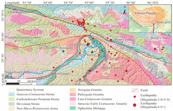
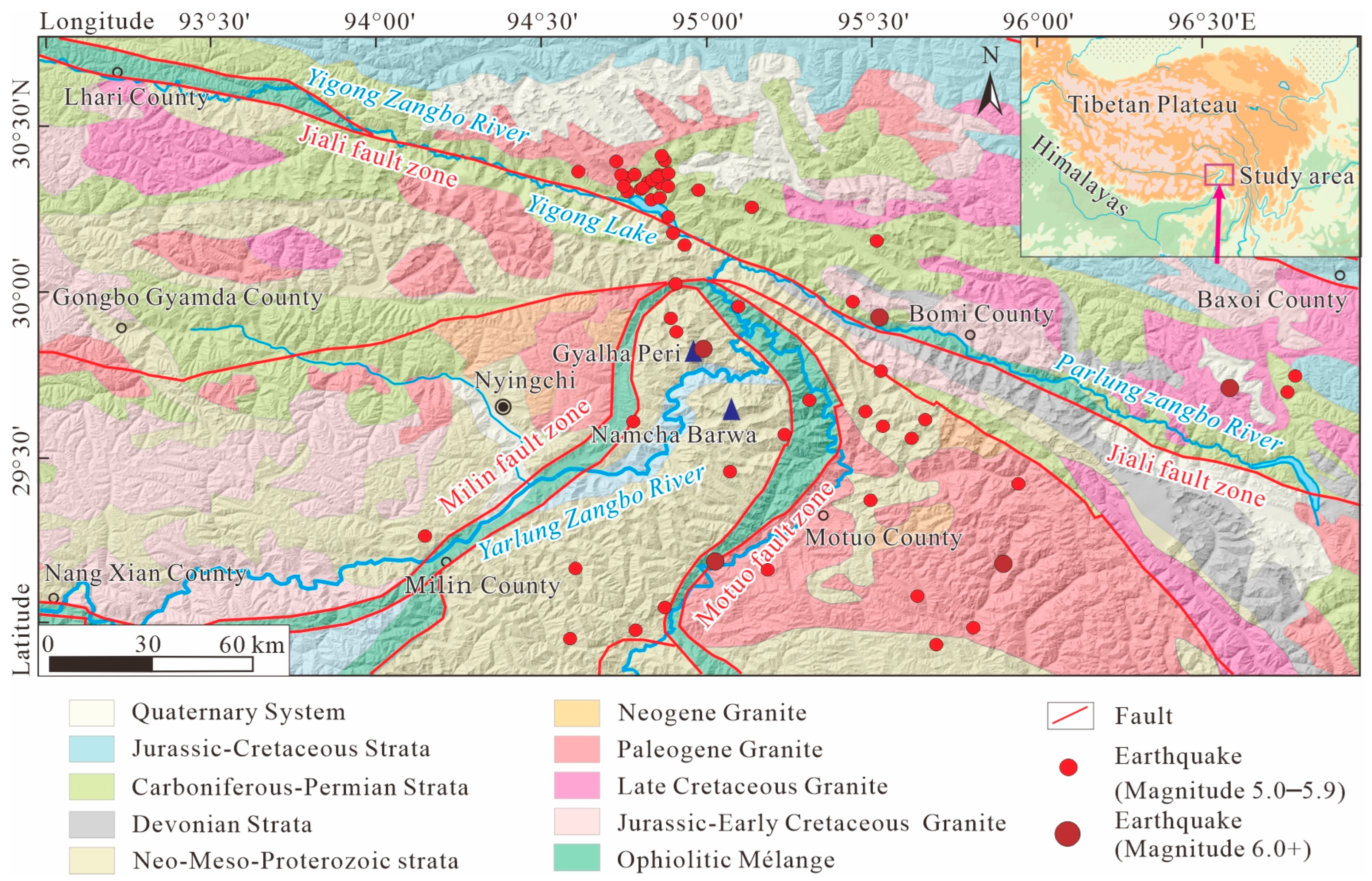
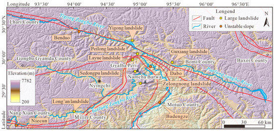
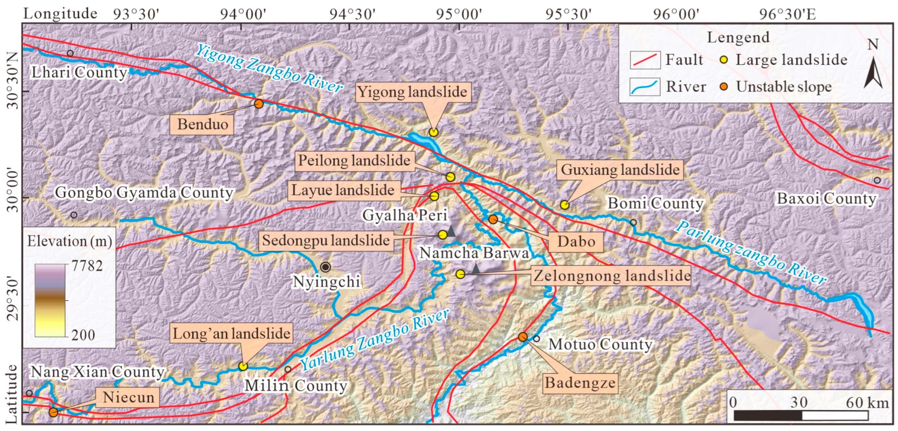
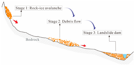
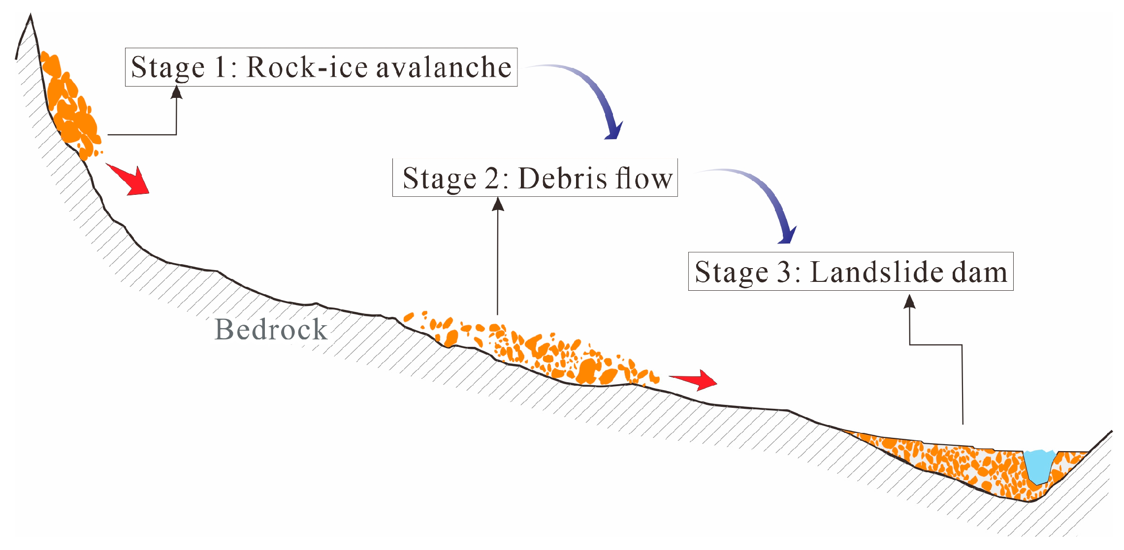
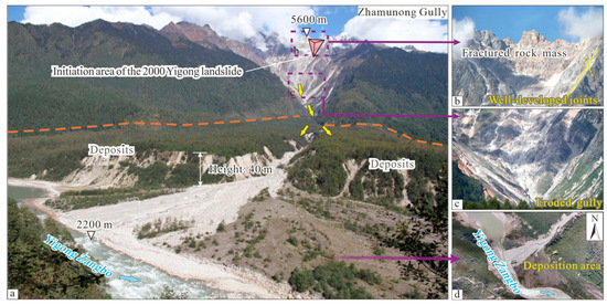
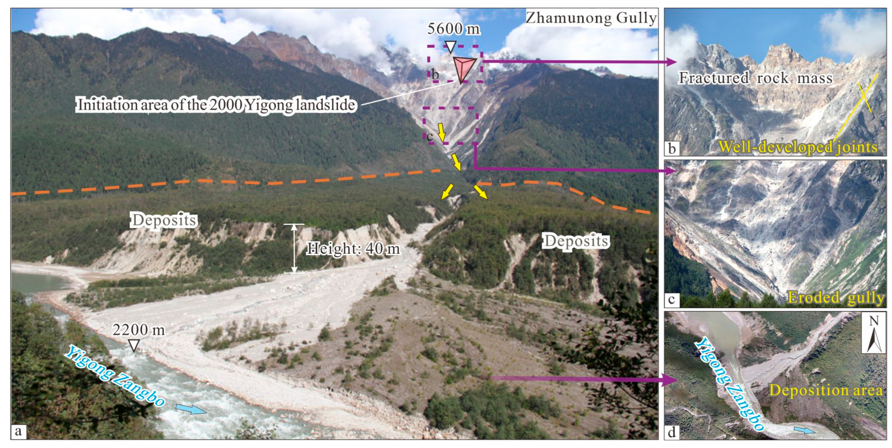
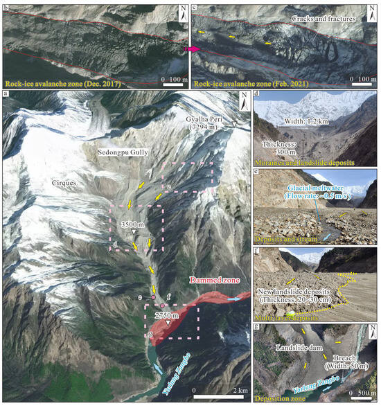
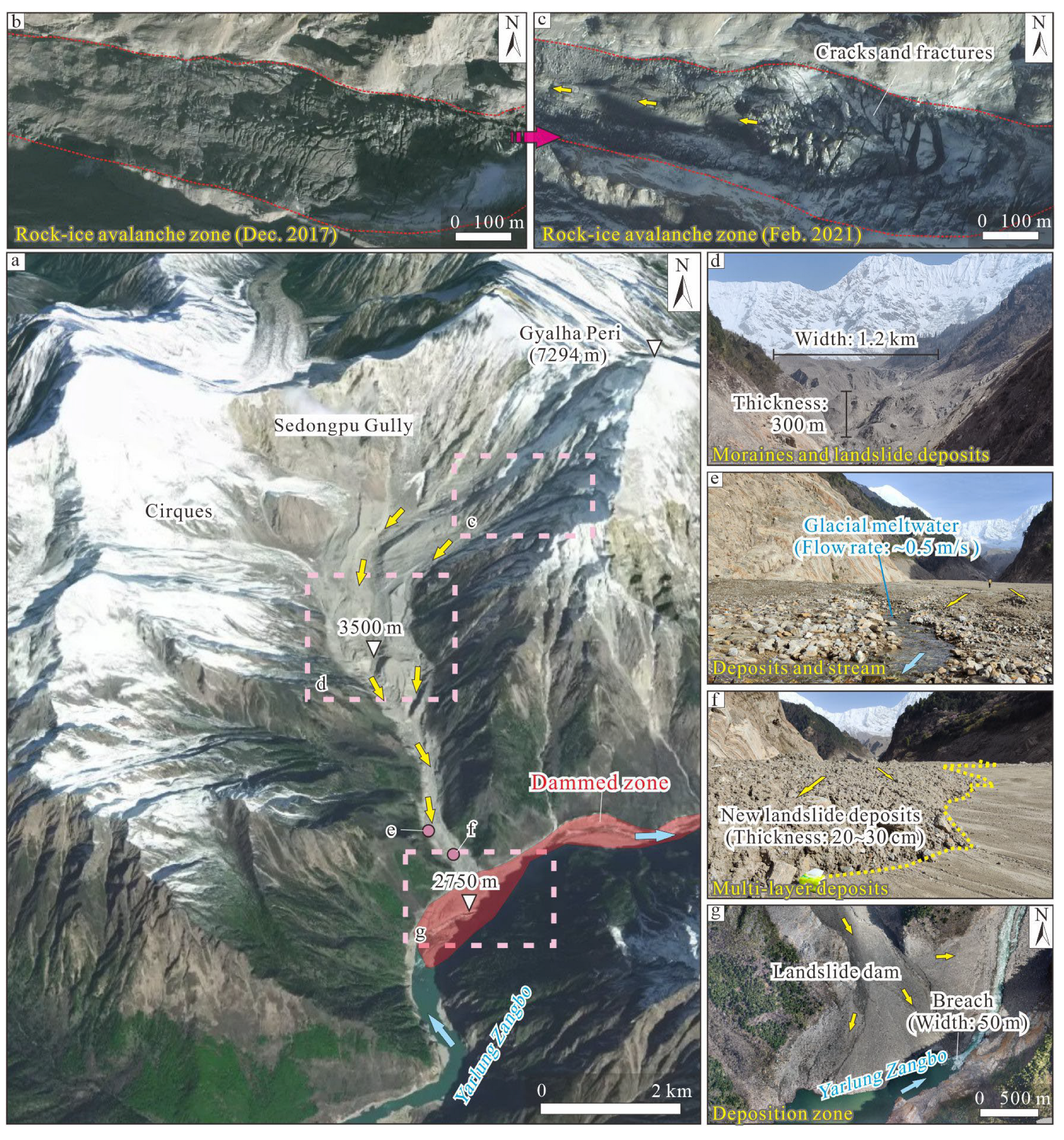
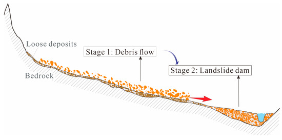
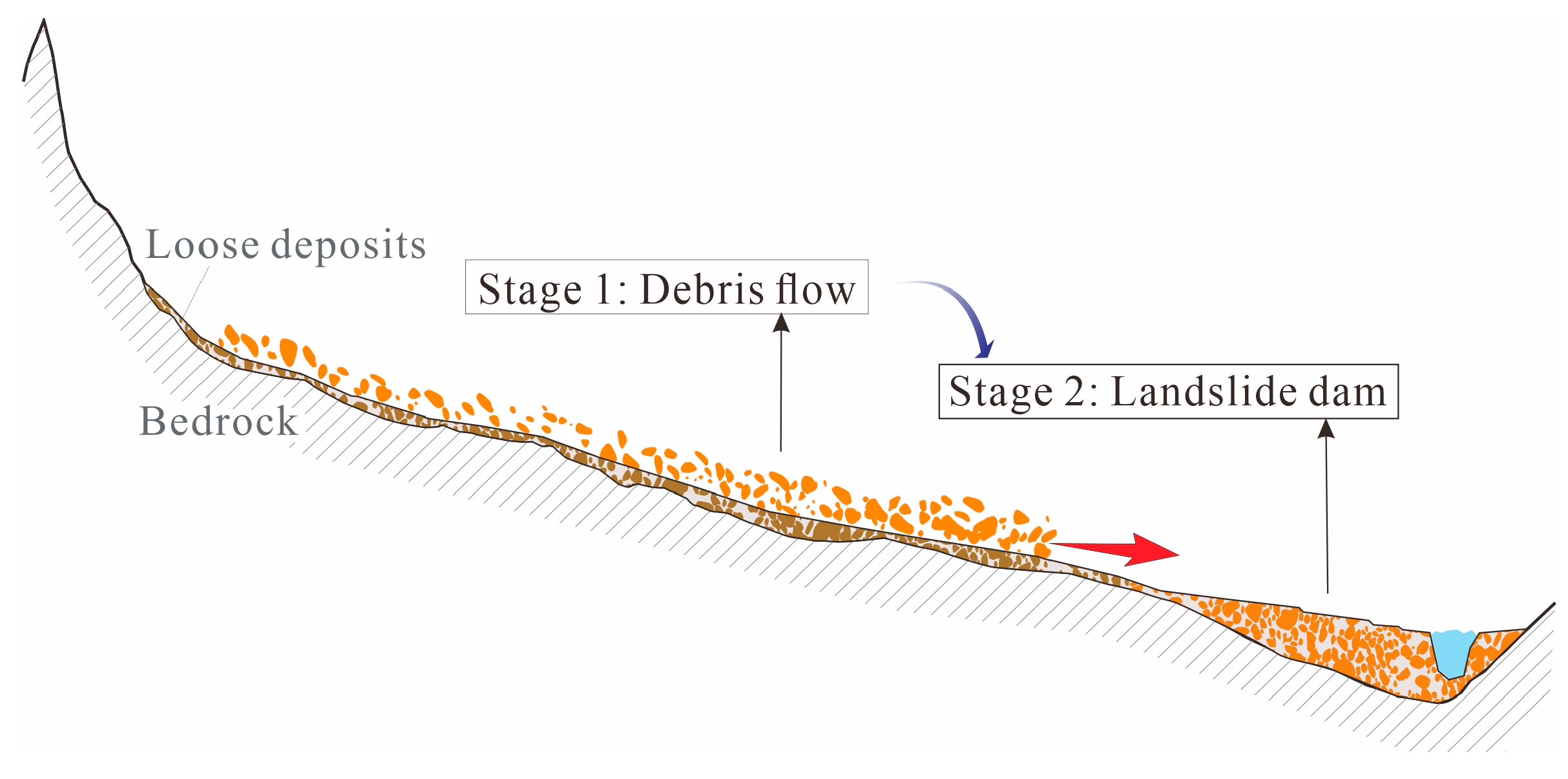
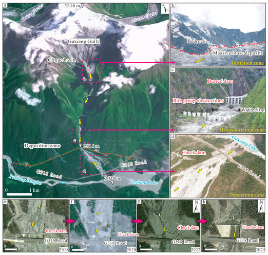
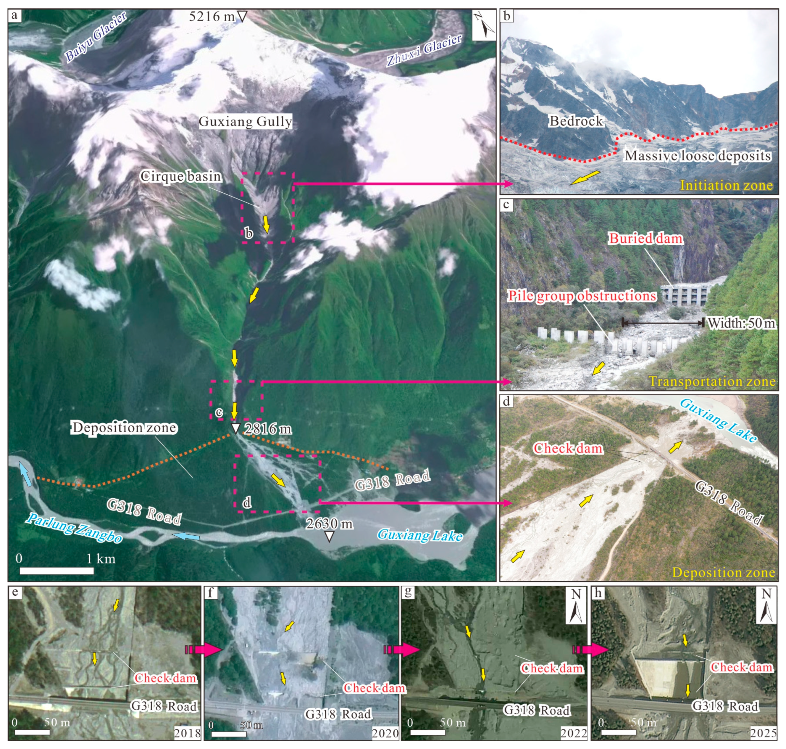
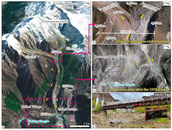
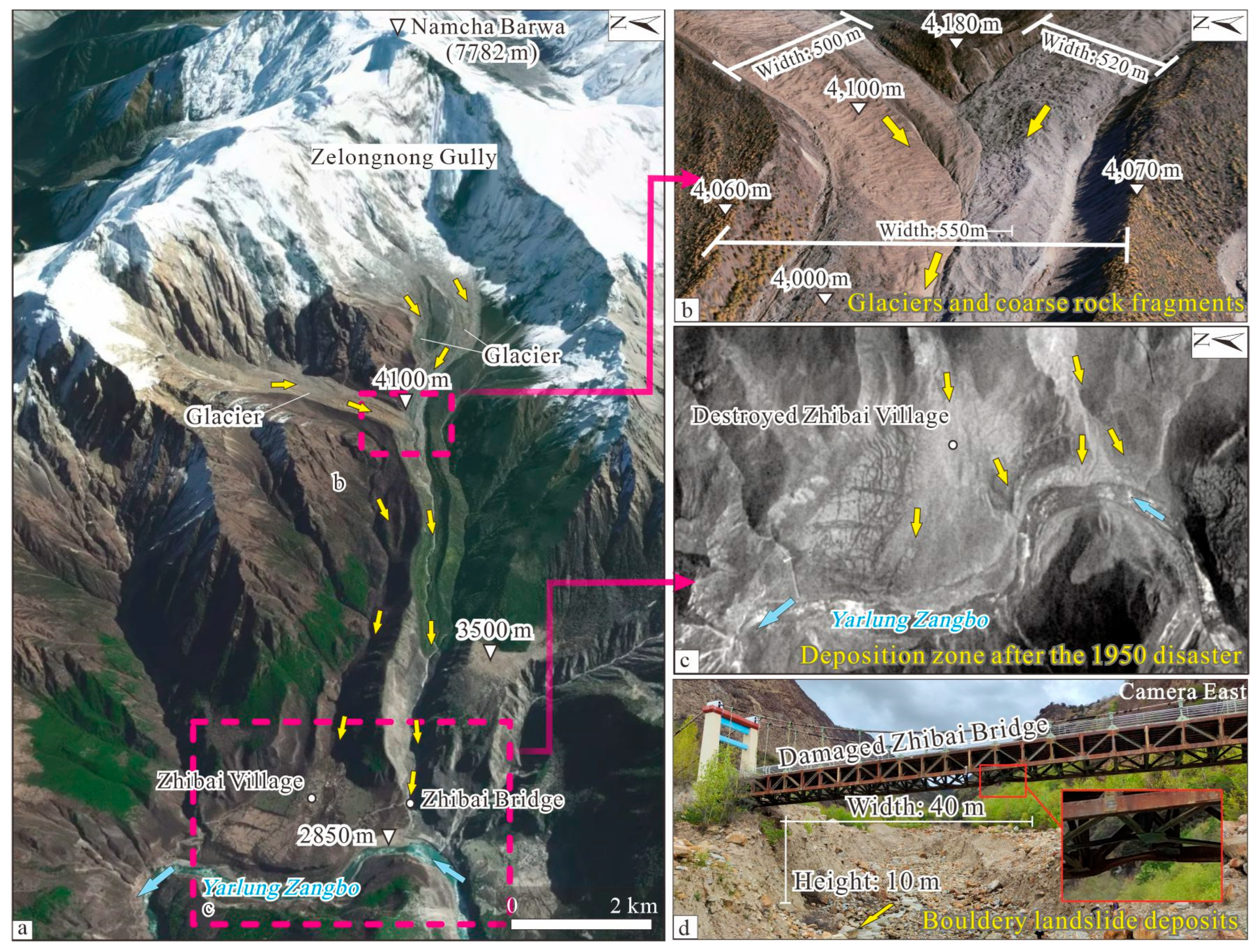
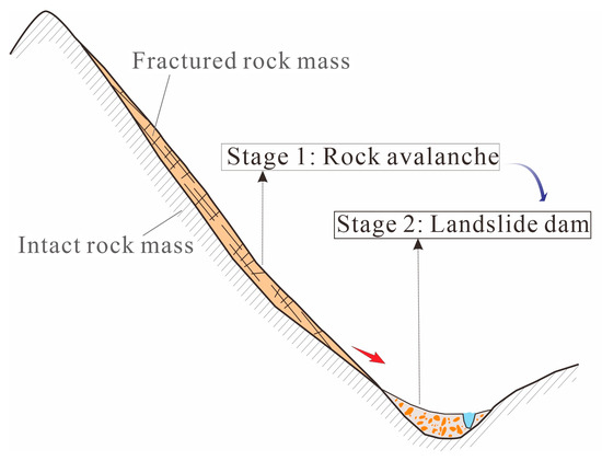
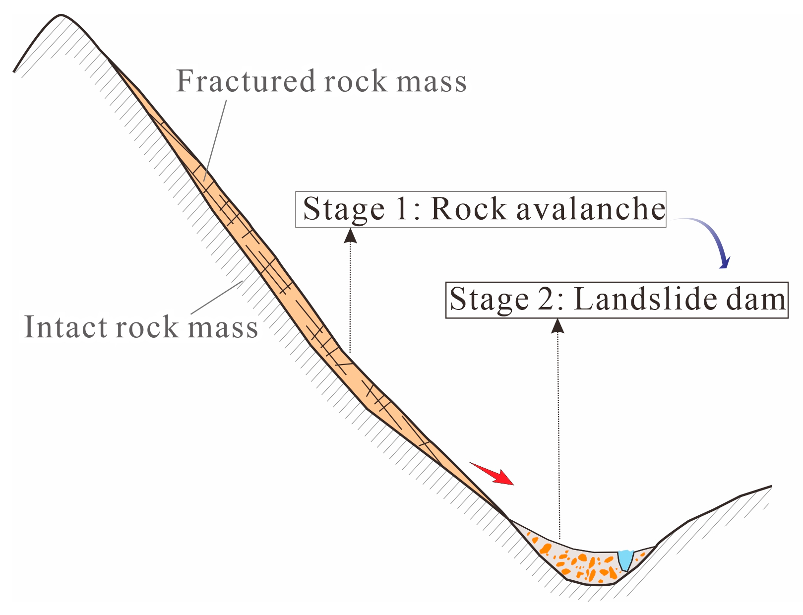
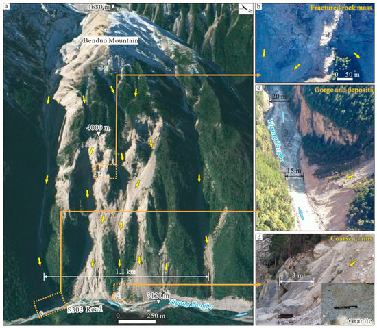
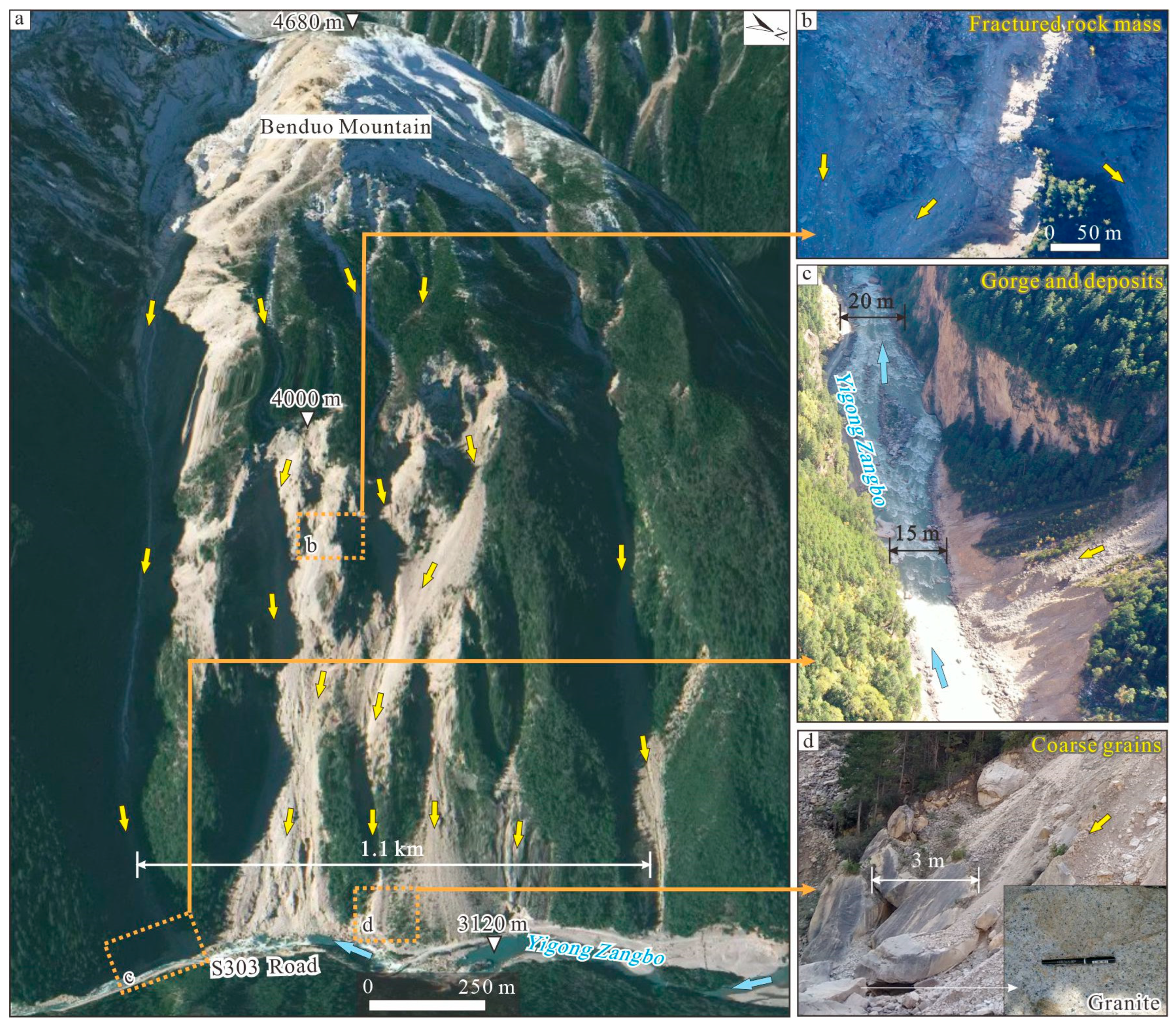
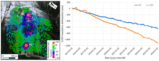
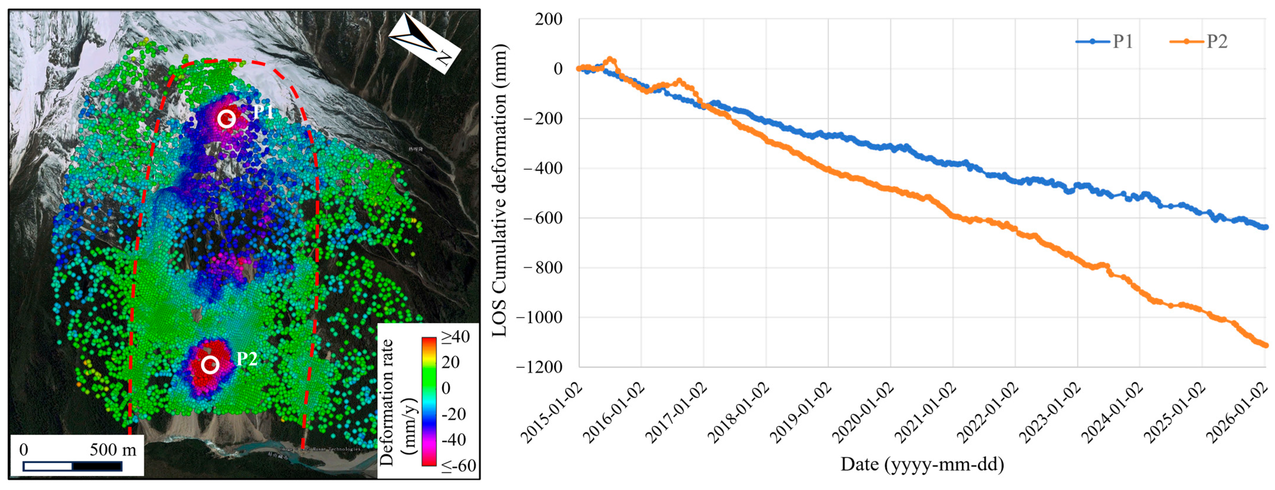
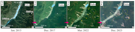
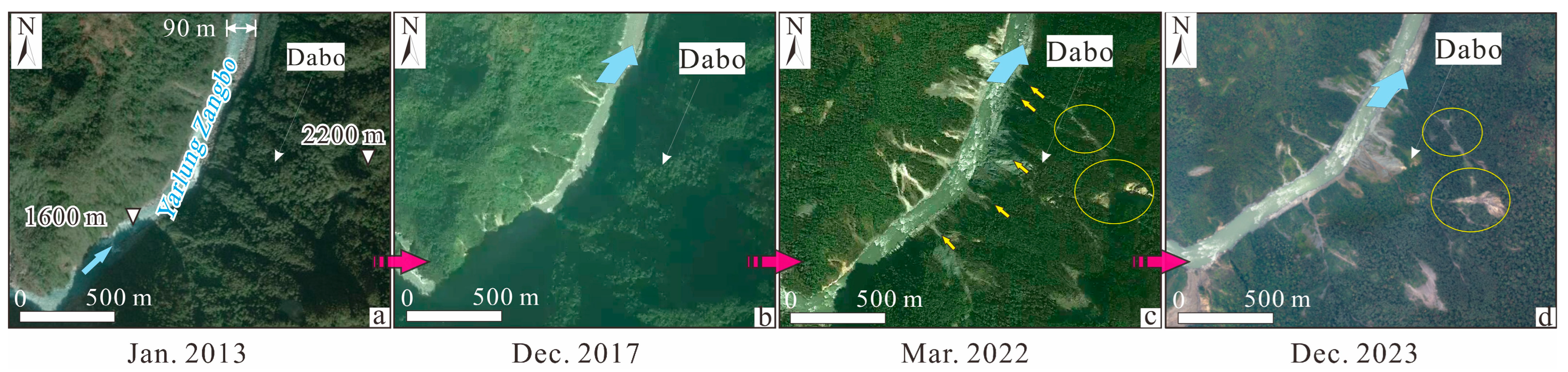
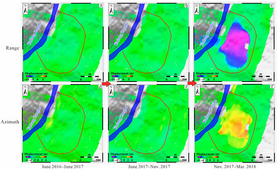
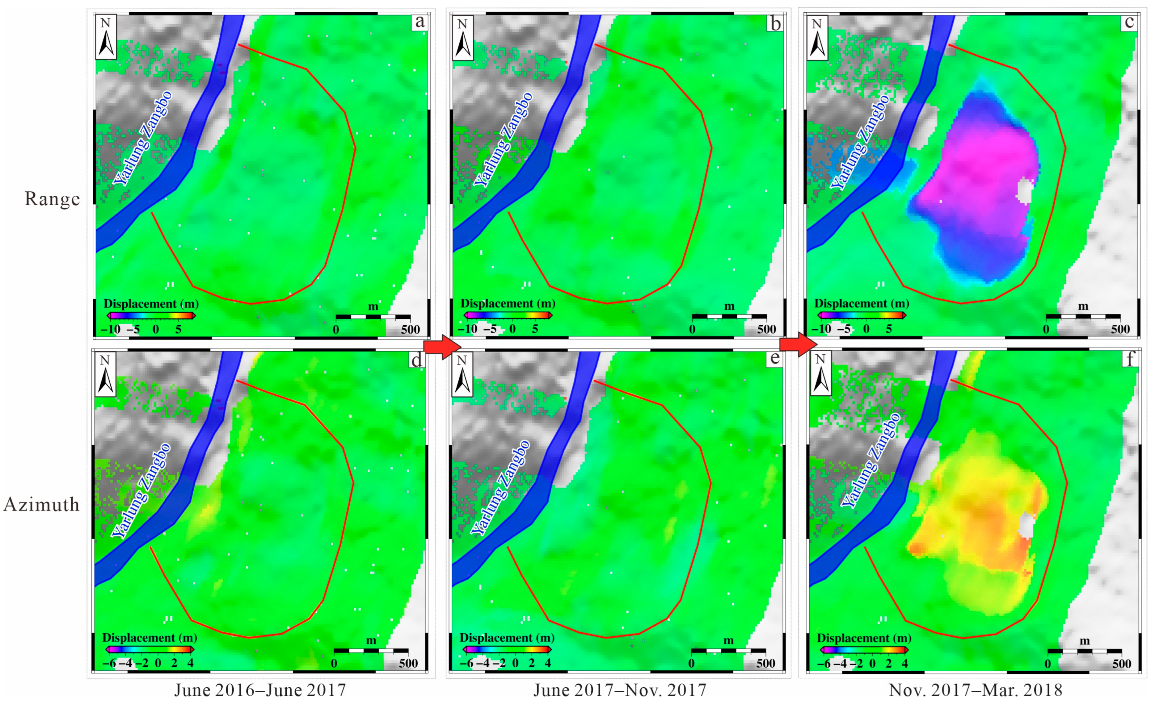
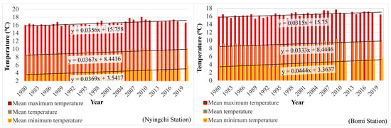
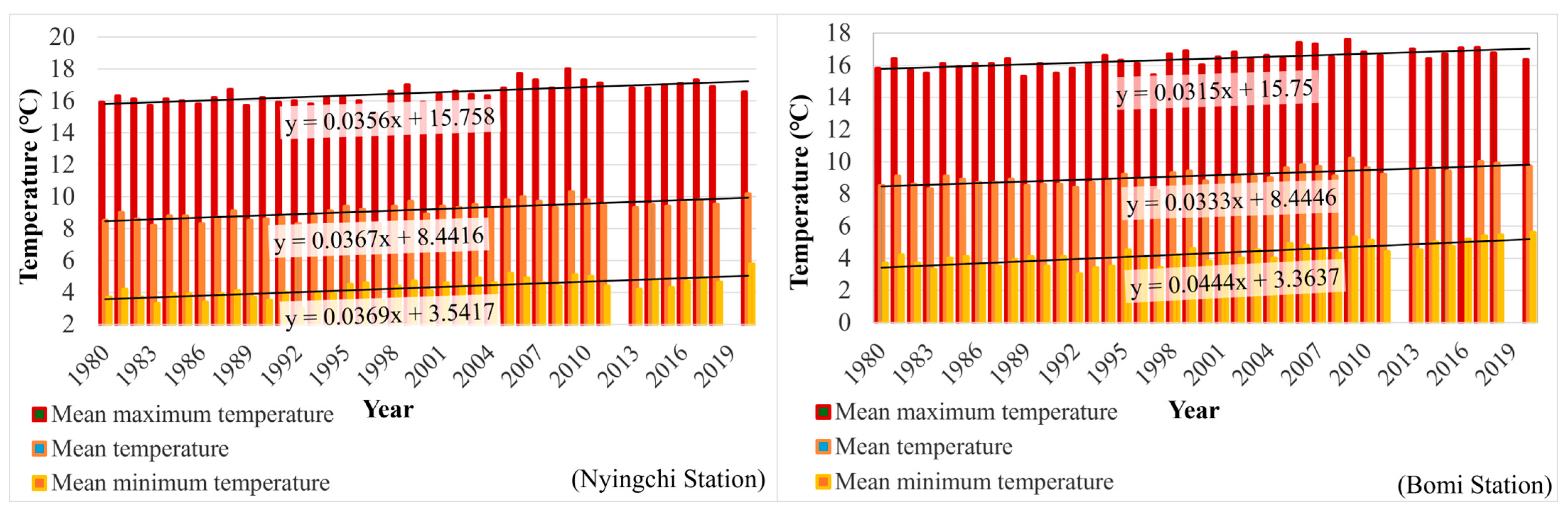
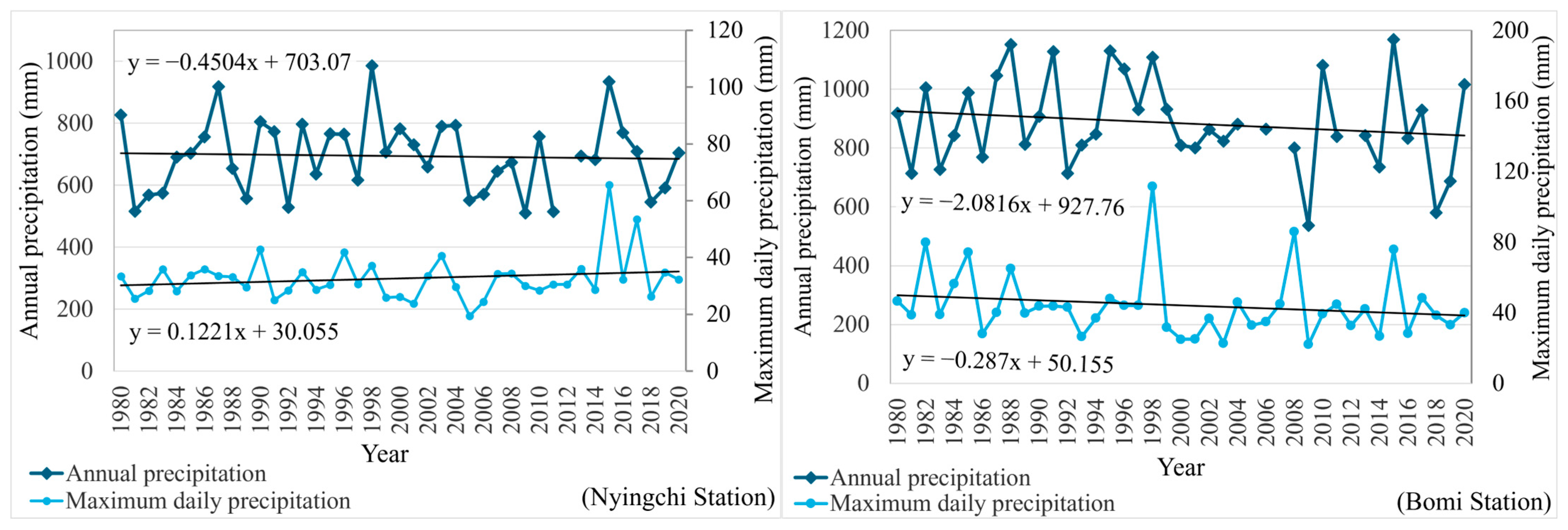

Disclaimer/Publisher’s Note: The statements, opinions and data contained in all publications are solely those of the individual author(s) and contributor(s) and not of MDPI and/or the editor(s). MDPI and/or the editor(s) disclaim responsibility for any injury to people or property resulting from any ideas, methods, instructions or products referred to in the content. |
© 2026 by the authors. Licensee MDPI, Basel, Switzerland. This article is an open access article distributed under the terms and conditions of the Creative Commons Attribution (CC BY) license.