


Highlights
What are the main findings?
- Using PS-InSAR-derived reference points as ground control points (GCPs) improves the consistency of SBAS-InSAR LOS deformation measurements in the study area.
- GeoSTF-Former combines historical InSAR deformation, local spatial neighborhoods, precipitation, elevation, slope, and aspect for pixel-scale prediction of mining-area LOS deformation.
What are the implications of the main findings?
- The combination of SBAS-InSAR constrained by PS-InSAR stable points and multi-source spatiotemporal deep learning breaks through the monitoring limitations of traditional single technologies and can provide a reliable framework support for large-scale, long-period monitoring and pixel-level prediction of surface subsidence in mining areas.
- The GeoSTF-Former model comprehensively fused time-series InSAR images and external factors affecting mining surface subsidence, and it can predict surface subsidence in mining areas with relatively high accuracy and provide support for mine safety management and early warning decision-making.
Abstract
Surface subsidence in mining areas is characterized by extensive spatial coverage, complex evolutionary processes, and diverse influencing factors. Conventional monitoring methods and prediction models can hardly meet the demands of large-area continuous monitoring and accurate prediction. Based on time-series InSAR observations and deep learning models, this study investigates the temporal evolution of surface subsidence in mining areas and evaluates the predictive accuracy of the proposed deep learning model. A total of 71 ascending-track Sentinel-1A single-look complex (SLC) images acquired over an open-pit mining area from 9 June 2021 to 14 January 2026 were selected. The PS-InSAR inversion is first implemented to extract highly coherent stable scatterers with small deformation values. Taken as ground control points (GCPs), these points are utilized for orbital correction and interferogram re-flattening in SBAS-InSAR processing to achieve PS-point-constrained deformation monitoring. Taking time-series InSAR deformation datasets, local spatial deformation features, and environmental factors including rainfall, digital elevation model (DEM), slope, and aspect as joint model inputs, a multi-source spatiotemporal fusion prediction model GeoSTF-Former is established to achieve pixel-scale prediction of surface subsidence in mining areas. Experimental results show that the spatial continuity and temporal stability of SBAS-InSAR deformation results are effectively improved after adopting PS stable-point constraints. Compared with the unconstrained scheme, the average RMSE and MAE of monitoring results decrease by 31.9% and 35.3%, respectively, while the coefficient of determination R2 increases by 0.10. On the test dataset, the GeoSTF-Former model yields an RMSE of 3.08 mm, an MAE of 2.42 mm, and a coefficient of determination R2 of 0.96 at the pixel scale. These results verify that the combination of PS-stable-point-constrained SBAS-InSAR measurements and multi-source spatiotemporal deep learning models can deliver reliable technical support for surface subsidence monitoring and trend forecasting of mining areas.
1. Introduction
The surface in open-pit mining areas is continuously affected by the coupling effects of mining unloading, blasting vibration, rainfall infiltration, groundwater level fluctuation and topographic conditions over a long period, and it is prone to continuous subsidence, slope deformation and even local instability failure [1,2]. With the continuous expansion of open-pit mining scale, the rock structure of stope slopes becomes increasingly complex, and the affected scope of surface deformation continues to expand. Traditional manual inspection and single-point monitoring methods have inherent limitations in coverage and timeliness and cannot accurately characterize the full-scale spatial distribution and long-term dynamic evolution of surface deformation in mining areas. Therefore, carrying out large-scale, long-term and high-precision monitoring and forecasting of mining surface subsidence is of great theoretical significance and engineering practical value for ensuring mine safety production, scientifically evaluating slope stability, and realizing accurate early warning and prevention of geological disasters [3,4].
Traditional ground monitoring technologies, including precise leveling, GNSS and total stations, can acquire high-precision single-point deformation data and meet the accurate monitoring requirements of local key points. However, they generally suffer from discrete monitoring points, limited coverage, heavy field workload and high operating costs. These methods only support sporadic point-based deformation observations, failing to fully capture the continuous spatial deformation characteristics and long-term temporal evolution laws of surface deformation in mining areas, and thus cannot adapt to the large-scale, all-weather and dynamic subsidence monitoring needs of complex open-pit mines [5]. In contrast, time-series Interferometric Synthetic Aperture Radar (InSAR) technology features wide spatial coverage, excellent temporal continuity and high monitoring accuracy, which effectively compensates for the deficiencies of traditional monitoring methods and has become a core technical approach for large-scale surface deformation monitoring in mining areas [6,7]. Among the available time-series InSAR techniques, Small Baseline Subset InSAR (SBAS-InSAR) constructs an interferometric network with short temporal and spatial baselines to retrieve relatively continuous, regional-scale surface deformation time series. It is therefore well suited for large-area subsidence monitoring in mining regions, mountainous terrain, and other areas affected by slow deformation. By contrast, Permanent Scatterer InSAR (PS-InSAR) identifies permanent scatterers with stable phase characteristics, thereby providing a reliable basis for selecting highly stable reference points [8,9,10]. Under the complex surface conditions of mining areas, SBAS-InSAR remains susceptible to the effects of low-coherence regions, residual orbital errors, phase-unwrapping errors, and unstable reference-point selection. In particular, in areas characterized by steep subsidence gradients or complex land-cover conditions, the manual selection of ground control points (GCPs) is inherently subjective and may introduce background fluctuations or localized anomalies into the retrieved deformation field [11,12]. Improving the stability and objectivity of reference-point selection in SBAS-InSAR processing is a key issue in enhancing the accuracy of time-series deformation monitoring in mining areas. PS-InSAR can identify permanent scatterers characterized by high coherence, stable phase behavior, and minimal deformation from long time-series SAR images. Using these permanent scatterers as reference control points during orbital refinement and re-flattening in SBAS-InSAR processing provides strong methodological complementarity [13,14,15]. This approach can improve reference-point selection during orbital refinement and re-flattening and enhance the stability of deformation inversion results under complex surface conditions in mining areas [16,17].
In studies of mining-induced subsidence forecasting, traditional approaches mainly rely on the probability integral method, the Knothe model, the Weibull time function, and statistical regression models [18]. These methods generally require reliable geological mining parameters and empirical assumptions and exhibit limited adaptability to the nonlinear deformation, periodic fluctuations, and local abrupt changes in surface deformation under complex mining conditions [19,20]. With the continued accumulation of time-series InSAR data, data-driven approaches to subsidence forecasting have attracted increasing attention. Among these approaches, deep learning models have demonstrated considerable potential for surface deformation forecasting because of their strong nonlinear representation and automatic feature extraction capabilities [21,22].
To overcome the limitations of traditional prediction models, many scholars have introduced deep learning structures such as convolutional neural networks (CNN), long short-term memory (LSTM), gated recurrent units (GRU), and attention mechanisms into surface subsidence and InSAR time-series deformation prediction tasks [23,24,25]. CNNs are primarily used to extract local spatial features or short-term temporal patterns, whereas LSTMs and GRUs are employed to model long-term temporal dependencies. Attention mechanisms are further used to emphasize critical time steps or important feature sources [26]. Previous studies have shown that hybrid models, such as CNN–LSTM, Attention–LSTM, and CNN–BiGRU–Attention, can jointly exploit local feature extraction, long-range temporal dependency modeling, and attention-based feature weighting, thereby achieving favorable performance in nonlinear subsidence forecasting, mining-induced deformation forecasting, and InSAR time-series forecasting [27]. In recent years, Transformer-based models and their variants have also been introduced into surface deformation forecasting. By using self-attention mechanisms to capture global dependencies among different time steps, these models provide a new technical framework for long-term deformation forecasting and multivariate spatiotemporal forecasting [28].
ConvNeXt is a modern convolutional neural network architecture proposed in recent years. While retaining the computational efficiency of conventional convolutional networks, it incorporates design principles from modern vision architectures such as Transformers and enhances spatial feature representation through large-kernel depthwise convolutions, channel expansion, nonlinear transformations, and residual connections [29,30]. Compared with conventional convolutional modules, ConvNeXt is better suited to extracting broader spatial contextual information from local neighborhoods. For time-series modeling, although conventional recurrent neural networks can process sequential data, their ability to model long sequences is often constrained by gradient propagation and computational efficiency [31]. Temporal Convolutional Networks (TCNs) capture temporal dependencies through one-dimensional causal and dilated convolutions, providing an alternative modeling framework for time-series forecasting [32,33,34]. Causal convolutions ensure that no future information is introduced during forecasting, thereby conforming to the temporal logic of deformation forecasting. Dilated convolutions enlarge the temporal receptive field with relatively few network layers, enabling the model to capture both short-term fluctuations and long-term evolutionary trends [35]. Transformers compute correlations among different tokens through self-attention mechanisms, enabling the modeling of long-range dependencies without relying on recurrent structures [36]. In recent years, attention mechanisms have been widely applied to time-series forecasting, remote sensing image analysis, and multimodal feature fusion. For multi-source deformation forecasting, different types of features cannot be adequately represented by simple linear combinations because complex interactions may exist among local spatial deformation patterns, historical deformation sequences, precipitation, and topographic factors [37].
In summary, substantial progress has been made in time-series InSAR deformation monitoring and deep learning-based deformation forecasting. However, several limitations remain, including insufficient exploitation of the complementarity among different InSAR techniques, inadequate utilization of spatial neighborhood information, limited incorporation of available environmental and topographic information, and relatively simple feature fusion strategies [38]. Some existing models still rely predominantly, or even exclusively, on InSAR deformation time series as input, with insufficient consideration of local spatial deformation patterns and auxiliary factors that are consistently available over the observation period. In this study, historical deformation sequences, local spatial deformation features, precipitation, DEM, slope, and aspect are jointly incorporated into a multi-source spatiotemporal fusion model for deformation forecasting, termed GeoSTF-Former. A ConvNeXt module is incorporated into the spatial branch to extract local spatial deformation patterns, while a TCN module is introduced into the temporal branch to model multiscale temporal dependencies within historical deformation sequences. A Fusion Transformer and an external-factor gating mechanism are further employed to adaptively integrate spatial, temporal, and environmental features, thereby improving the accuracy and stability of surface deformation forecasting in mining areas.
The remainder of this paper is organized as follows. Section 2 describes the experimental data and methodology, including the study area and data sources, the proposed PS-stable-point-constrained SBAS-InSAR deformation monitoring method, the architecture of GeoSTF-Former, and the accuracy evaluation metrics. Section 3 presents the experimental results and analyses, including the comparison of SBAS-InSAR monitoring results with and without PS stable-point constraints, model architecture comparisons, branch-ablation experiments, and external-factor ablation experiments. Section 4 discusses the main findings, limitations, and directions for further improvement. Finally, Section 5 summarizes the main conclusions of this study.
2. Materials and Methods
2.1. Study Area and Data
2.1.1. Study Area
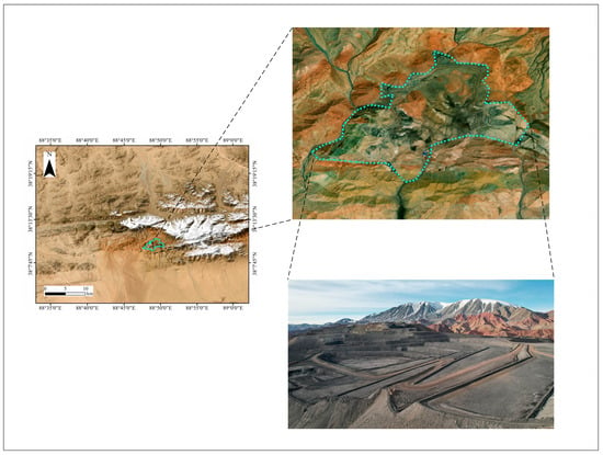
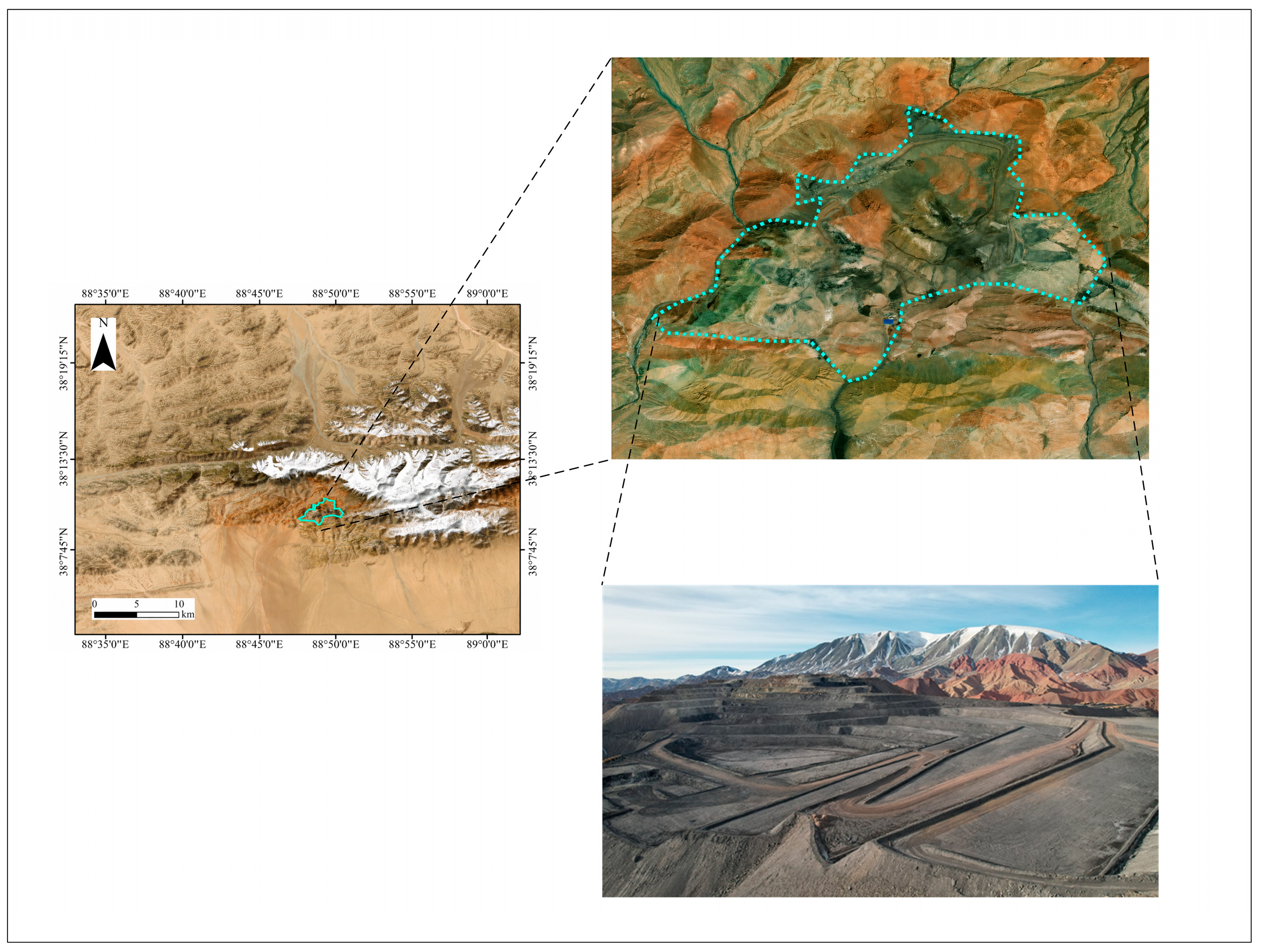
This study focuses on a mining area in Xinjiang, China. The study area is located along the northern margin of the Tibetan Plateau and on the southern foothills of the Altun Mountains, at elevations ranging from 4588 to 5009 m, with a relative relief of 429 m. The landscape is characterized by east–west-trending ridges, with higher elevations in the central part and lower elevations to the north and south. The terrain is deeply dissected, steep, and rugged. July and August constitute the brief annual period of rainfall and snowmelt, and the mean annual precipitation ranges from 50 to 100 mm. The location, topography, and geomorphological characteristics of the study area are shown in Figure 1.
Figure 1.
Topographic and geomorphological map of the study area.
2.1.2. Data Sources
The InSAR dataset used in this study consists of Sentinel-1A SAR images provided by the Alaska Satellite Facility (ASF). A total of 71 Sentinel-1A images acquired between 9 June 2021 and 14 January 2026 were selected. Sentinel-1A has a nominal 12-day repeat cycle. To construct a temporally consistent long-term dataset, every second acquisition was selected in this study, resulting in a 24-day sampling interval. The images were acquired in VV polarization using the Interferometric Wide Swath (IW) mode and covered the IW1, IW2, and IW3 subswaths. Because only ascending-orbit Sentinel-1 observations were available in this study, the InSAR-derived deformation represents displacement along the satellite line of sight (LOS). No decomposition into vertical and horizontal components was performed. Unless otherwise specified, the deformation and deformation velocity reported in this study refer to LOS displacement and LOS deformation velocity, respectively.
The DEM data were primarily used to support differential InSAR processing and to derive topographic features, including elevation, slope, and aspect, which were incorporated into the GeoSTF-Former model as external spatial influencing factors. Topographic conditions provide persistent spatial context for mining-induced deformation by characterizing geomorphic position, slope geometry, and terrain-controlled drainage and exposure conditions. Previous InSAR-based studies have also demonstrated that elevation, slope, and aspect are spatially associated with the distribution and heterogeneity of surface deformation in mining and mountainous areas. Therefore, DEM-derived variables were incorporated as static spatial-context features rather than as direct causal measurements of subsidence [14,39]. This study employed the Shuttle Radar Topography Mission (SRTM) DEM, with a spatial resolution of 30 m and a vertical accuracy of approximately 10–16 m. It should be noted that the spatial resolution of the DEM does not determine the spatial resolution of the InSAR deformation measurements. The InSAR deformation field is derived independently from the SAR time-series observations, whereas the DEM, slope, and aspect are used as auxiliary topographic factors in the prediction model. Although the 30 m SRTM DEM may smooth some fine-scale terrain variations associated with individual mining benches, it can still provide consistent elevation and terrain-gradient information for the model.
Sentinel-1 Precise Orbit Ephemerides (POE) files were used to provide high-accuracy satellite orbital parameters. During SBAS-InSAR processing, the incorporation of precise orbit data reduces long-wavelength phase residuals caused by satellite orbit errors, thereby improving the stability and reliability of the time-series deformation inversion results.
Precipitation was incorporated as a time-varying environmental factor because rainfall infiltration can modify pore-water pressure, effective stress, and the shear strength of fractured or mining-disturbed rock and soil masses, thereby promoting or accelerating surface deformation. Such effects may become more pronounced when rainfall acts together with excavation, stress relief, or blasting disturbances in active mining areas [1,40]. Together with historical InSAR deformation sequences and topographic factors, the precipitation data were used as inputs to the deep learning model to improve its ability to characterize nonlinear variations in surface subsidence. The precipitation data were obtained from the China Meteorological Administration Data Service Centre. Previous studies have demonstrated that mining-induced surface deformation can be effectively predicted using InSAR-derived deformation time series and their spatiotemporal characteristics without explicitly incorporating time-resolved mining-operation variables [6,18,19]. Accordingly, the present study focuses on historical deformation information, local spatial deformation patterns, precipitation, and topographic factors as the main inputs to GeoSTF-Former. Detailed mining-operation parameters, including excavation extent, excavation-front advance, mining intensity, production volume, and blasting activities, are expected to provide additional physical constraints and will be incorporated in subsequent studies to further improve the physical interpretability and predictive capability of the model.
GNSS monitoring data from six points (G1–G6) within the study area were used as external observations to validate the SBAS-InSAR deformation measurements.
GNSS–InSAR temporal alignment. To ensure directional consistency between the GNSS and InSAR measurements, the GNSS displacement vector was first projected onto the Sentinel-1 line-of-sight (LOS) direction according to the satellite imaging geometry:
where denotes the GNSS displacement vector in the local coordinate system and is the unit vector along the Sentinel-1 LOS direction. The sign convention was made consistent with that adopted for the InSAR deformation measurements.
Temporal alignment was performed using the actual acquisition dates of the selected Sentinel-1A images. Because every second Sentinel-1A acquisition was retained in the study dataset, the selected SAR time series had a 24-day sampling interval. For a Sentinel-1 acquisition at time , the two valid GNSS observations at and , immediately before and after , respectively, were used for linear interpolation:
If a GNSS observation was available exactly at a Sentinel-1 acquisition time, the observed GNSS value was used directly. No temporal extrapolation was performed beyond the available GNSS observation period.
2.2. PS-Stable-Point-Constrained SBAS-InSAR Deformation Monitoring
Permanent Scatterer Interferometric Synthetic Aperture Radar (PS-InSAR) is a high-precision surface deformation monitoring technique based on time-series InSAR. It uses multiple SAR images acquired over the same area to identify permanent scatterers (PSs) that exhibit stable electromagnetic scattering characteristics over long time periods, such as buildings, bridges, exposed rock surfaces, and other stable artificial structures. High-precision surface deformation is then retrieved by analyzing the phase variations in these stable scatterers across the multi-temporal SAR images. Small Baseline Subset Interferometric Synthetic Aperture Radar (SBAS-InSAR) is a time-series InSAR technique for deformation monitoring based on differential InSAR (D-InSAR). Its core principle is to construct multiple interferometric pairs from multi-temporal SAR images acquired over the same area using short temporal and perpendicular baselines, thereby forming a small-baseline interferometric network and reducing the effects of temporal and spatial decorrelation. Observation equations are subsequently established using the unwrapped phase measurements, and the surface deformation time series at each acquisition epoch are estimated through least-squares inversion or singular value decomposition (SVD), enabling the retrieval of long-term, slowly varying deformation across the study area.
PS-InSAR and SBAS-InSAR exhibit a certain degree of complementarity in terms of monitoring targets, spatial coverage, and measurement accuracy and stability. In conventional SBAS-InSAR processing, a number of ground control points (GCPs) must be selected during orbital refinement and re-flattening to mitigate the effects of orbital errors, residual flat-earth phase, and long-wavelength phase errors on the deformation inversion results.
In conventional SBAS-InSAR processing, the selection of GCPs follows several basic criteria. First, GCPs should avoid areas containing obvious residual topographic fringes so as to minimize the influence of incompletely removed topographic phase caused by DEM errors. Second, GCPs should be located in relatively stable and non-deforming areas without evident deformation fringes. The unwrapped phase images were used as an important reference, and areas without obvious anomalous phase variations were preferentially selected. Third, isolated-phase regions and areas exhibiting abrupt phase jumps were excluded because poor phase-unwrapping quality or local phase discontinuities may reduce the reliability of orbital refinement. Finally, a sufficient number of GCPs with an appropriate spatial distribution were retained to reduce the influence of coherence differences among individual interferometric pairs and to improve the stability of orbital refinement and deformation inversion. GCPs are manually selected from interferograms or unwrapped phase images, which introduces a degree of subjectivity. Under the complex surface conditions of mining areas, manually selected points may also be affected by low-coherence regions, localized deformation zones, or residual topographic phase, thereby reducing the stability of the SBAS-InSAR results. PS-InSAR processing can identify permanent scatterers characterized by high coherence, stable scattering properties, and relatively small deformation from long time-series SAR images. Compared with manually selected points, these permanent scatterers exhibit greater phase stability and temporal consistency, making them more suitable as reference control points for orbital refinement and re-flattening in SBAS-InSAR processing. In this study, candidate reference points were first obtained through the PS-InSAR inversion. In the first inversion step, the LOS deformation velocity estimation range was set from −100 to 100 mm/year, with a residual-height estimation range from −350 to 350 m. Atmospheric phase components were subsequently mitigated in the second inversion step using temporal high-pass and spatial low-pass filtering, with window sizes of 365 days and 1200 m, respectively. The resulting PSs were then further screened as candidate GCPs according to the phase and deformation characteristics. Specifically, points located in areas with obvious residual topographic fringes, deformation fringes, or abrupt phase discontinuities were excluded, and reference points were preferentially selected from relatively stable regions. A sufficient number of spatially distributed GCPs were retained to improve the robustness of orbital refinement and re-flattening. It should be noted that the atmospheric filtering suppresses regional atmospheric contributions but cannot guarantee complete elimination of residual atmospheric effects.
2.3. GeoSTF-Former Model
Surface subsidence in mining areas exhibits pronounced spatiotemporal coupling characteristics, with spatially correlated subsidence patterns evolving continuously and often nonlinearly over time [19,40]. Temporally, the subsidence process is generally characterized by continuous accumulation, stage-dependent fluctuations, and localized abrupt changes. Spatially, subsidence often manifests as continuous subsidence basins, deformation gradients along basin boundaries, and localized clusters of anomalous deformation. In terms of external environmental conditions, factors such as precipitation, elevation, slope, and aspect can also influence the spatial heterogeneity and stage-dependent variations in surface deformation. Accordingly, this study develops GeoSTF-Former (Geoscience-Oriented Spatial–Temporal–Factor Transformer), a multi-source spatiotemporal fusion model for deformation prediction. Designed for geoscientific applications, the model jointly considers local spatial deformation patterns, historical deformation time series, precipitation, and topographic factors and integrates these multi-source features through a Fusion Transformer.
The historical deformation sequence of the target pixel, a 32 × 32 local spatial neighborhood patch, and external factors—including precipitation, DEM, slope, and aspect—were jointly used as model inputs. Features from these heterogeneous data sources were extracted through the spatial, temporal, and external-factor branches, respectively, and subsequently integrated using the Fusion Transformer. The model ultimately outputs the predicted deformation value of the target pixel at the target epoch.
2.3.1. ConvNeXt-Based Spatial Feature Encoding
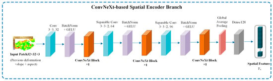
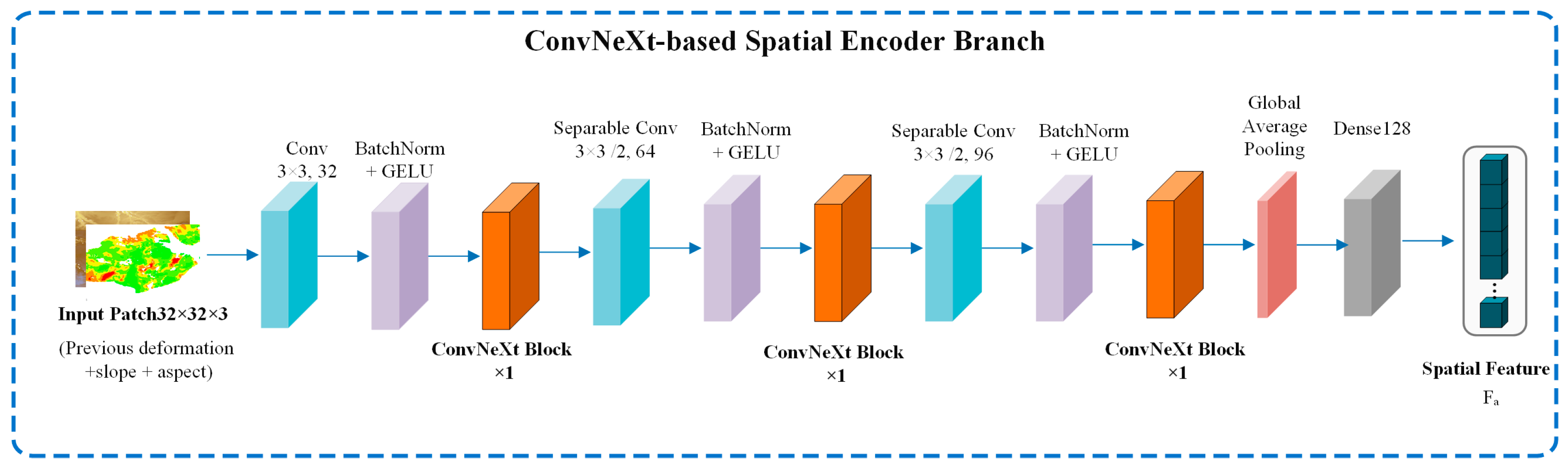
In the spatial branch, a ConvNeXt-style spatial encoding architecture is adopted, as illustrated in Figure 2. Developed from residual convolutional networks, this modern convolutional architecture preserves the advantages of local feature modeling and the training stability provided by residual connections while incorporating large-kernel depthwise separable convolutions, layer normalization, GELU activation functions, and 1 × 1 channel projections. These designs enable the model to achieve stronger spatial feature representation with a relatively small number of parameters.
Figure 2.
ConvNeXt-based spatial feature encoding branch.
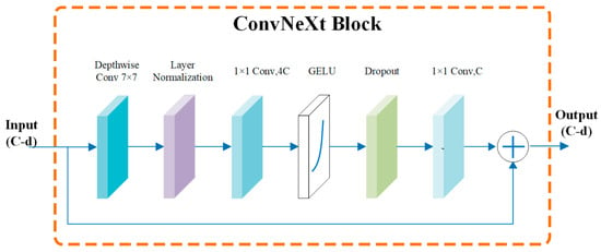
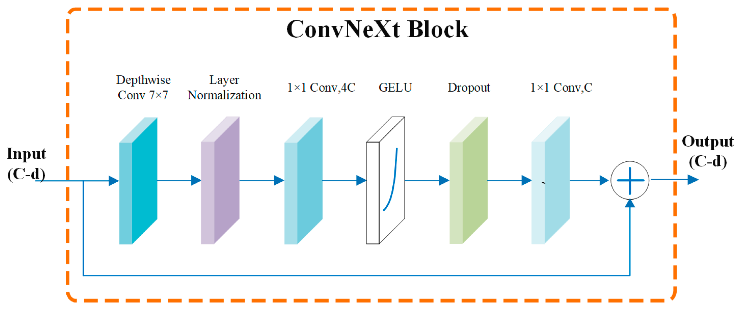
Given an input feature , a typical ConvNeXt block first applies a 7 × 7 depthwise convolution to enlarge the local spatial receptive field, followed by layer normalization. A 1 × 1 convolution is then used to expand the channel dimension, followed by GELU nonlinear activation. Another 1 × 1 convolution projects the features back to the original channel dimension. Finally, the transformed features are added to the input through a residual connection, as illustrated in Figure 3. This process can be expressed by Equation (3):
where and denote the input and output features of the block, respectively; represents a 7 × 7 depthwise convolution; denotes layer normalization; and and represent the two 1 × 1 convolutional mappings. The residual connection preserves the original spatial structural information, while the large-kernel depthwise convolution facilitates the capture of deformation relationships over a broader spatial neighborhood.
Figure 3.
Schematic diagram of the ConvNeXt spatial encoding module.
2.3.2. TCN–Transformer-Based Temporal Feature Encoding
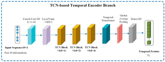
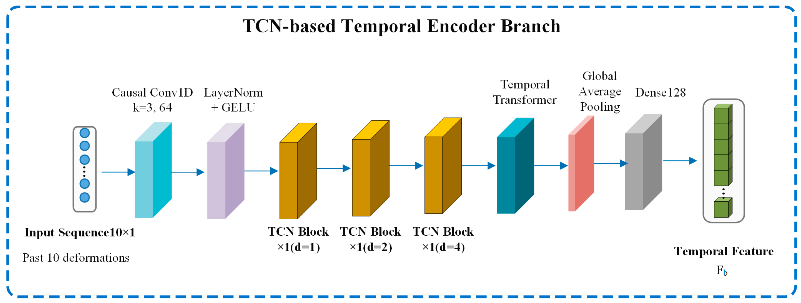
The TCN–Transformer temporal feature encoding branch is designed to extract dynamic evolutionary characteristics from the historical deformation sequence of the target pixel. The branch first employs one-dimensional causal convolution to capture short-term local variation patterns. TCN modules with dilation rates of 1, 2, and 4 are then introduced to enlarge the temporal receptive field and capture subsidence dependencies over adjacent, medium-term, and longer-term time scales. A multi-head self-attention Transformer encoder is subsequently used to adaptively model correlations among different historical epochs and emphasize critical time steps, such as periods of accelerated deformation, abrupt changes, or trend reversals. Finally, global average pooling and a 128-dimensional fully connected projection are applied to generate the Temporal Token, as illustrated in Figure 4.
Figure 4.
TCN–Transformer temporal encoding branch.
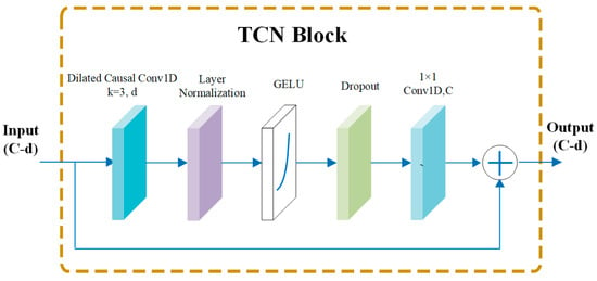
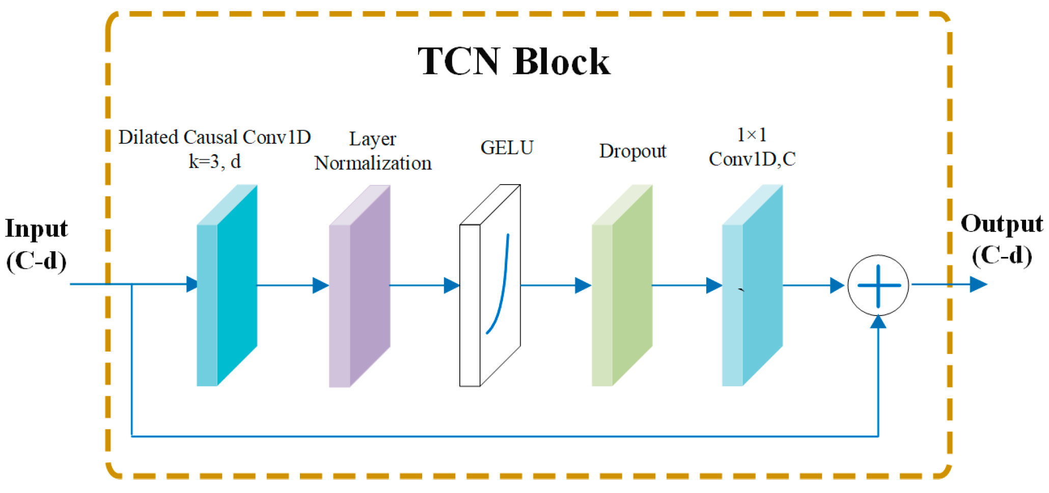
The TCN block consists of dilated causal convolution, layer normalization, GELU activation, dropout, 1 × 1 convolution, and a residual connection, as illustrated in Figure 5. The dilated convolution is used to extract multiscale temporal variation patterns, while the causal convolution ensures that the prediction process conforms to the actual temporal order. The residual connection further improves training stability. By stacking multiple TCN blocks, the model can effectively learn long-term trends and nonlinear variation characteristics from mining-induced subsidence sequences and generate temporal feature representations for the subsequent fusion module.
Figure 5.
TCN module.
2.3.3. External-Factor Encoding
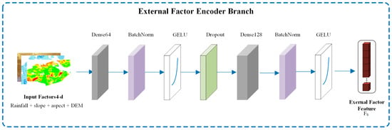
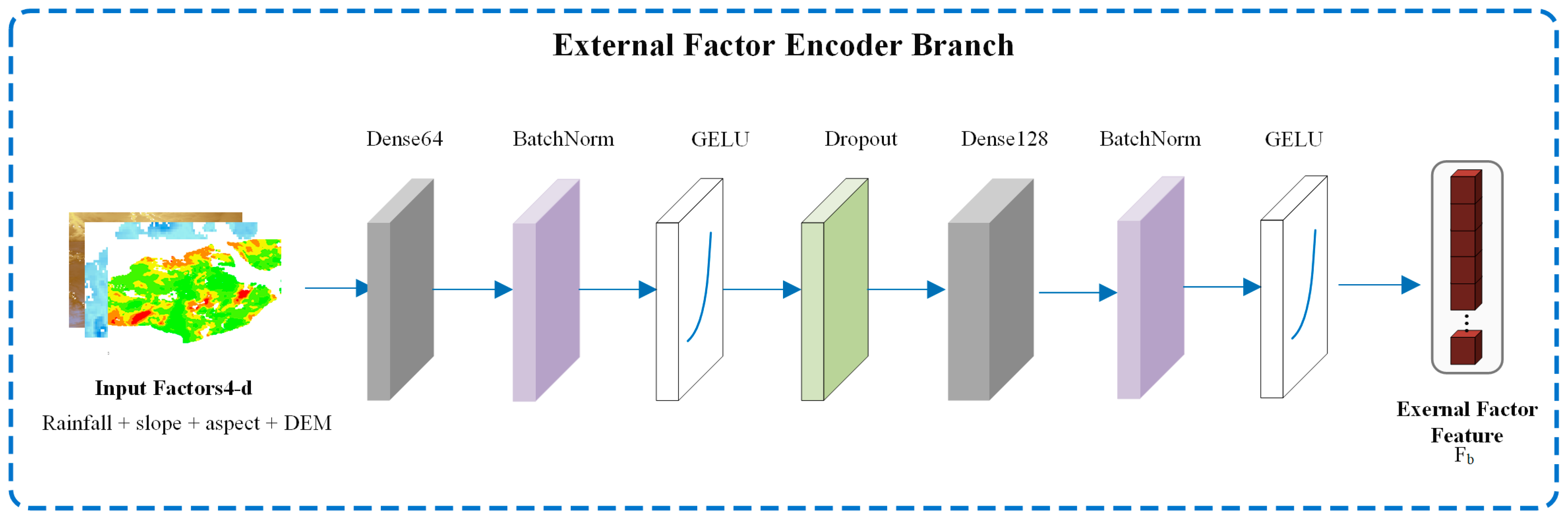
The external-factor branch is designed to incorporate the effects of precipitation and topographic conditions on surface subsidence. In this study, cumulative precipitation for the target period, DEM, slope, and aspect are used as external-factor inputs. The branch first projects the original external factors through a 64-dimensional fully connected layer, combined with batch normalization, GELU activation, and dropout to improve training stability. A subsequent 128-dimensional fully connected layer further extracts high-level external driving features to generate the Factor Token, as illustrated in Figure 6. Through this branch, the model can learn nonlinear interactions among precipitation, elevation, slope, and aspect, thereby providing external constraint information for subsequent cross-modal feature fusion.
Figure 6.
External-factor encoding branch.
2.3.4. Feature Fusion Layer
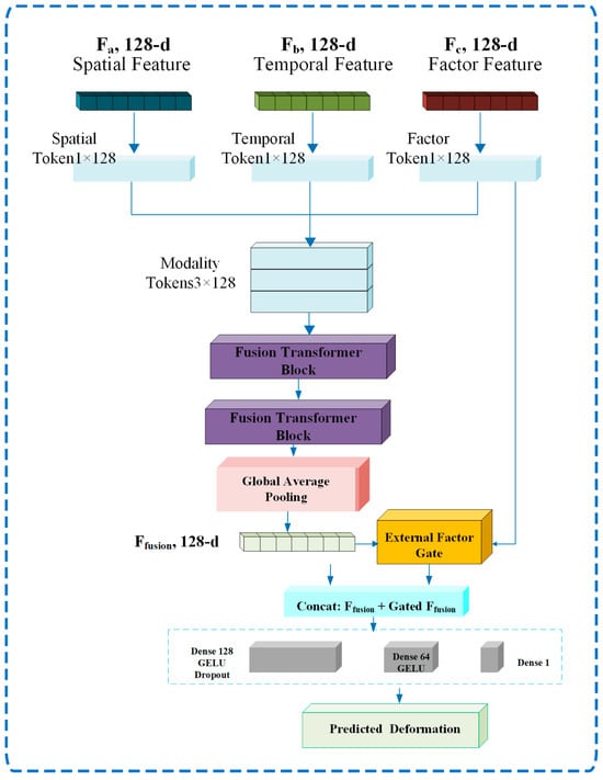
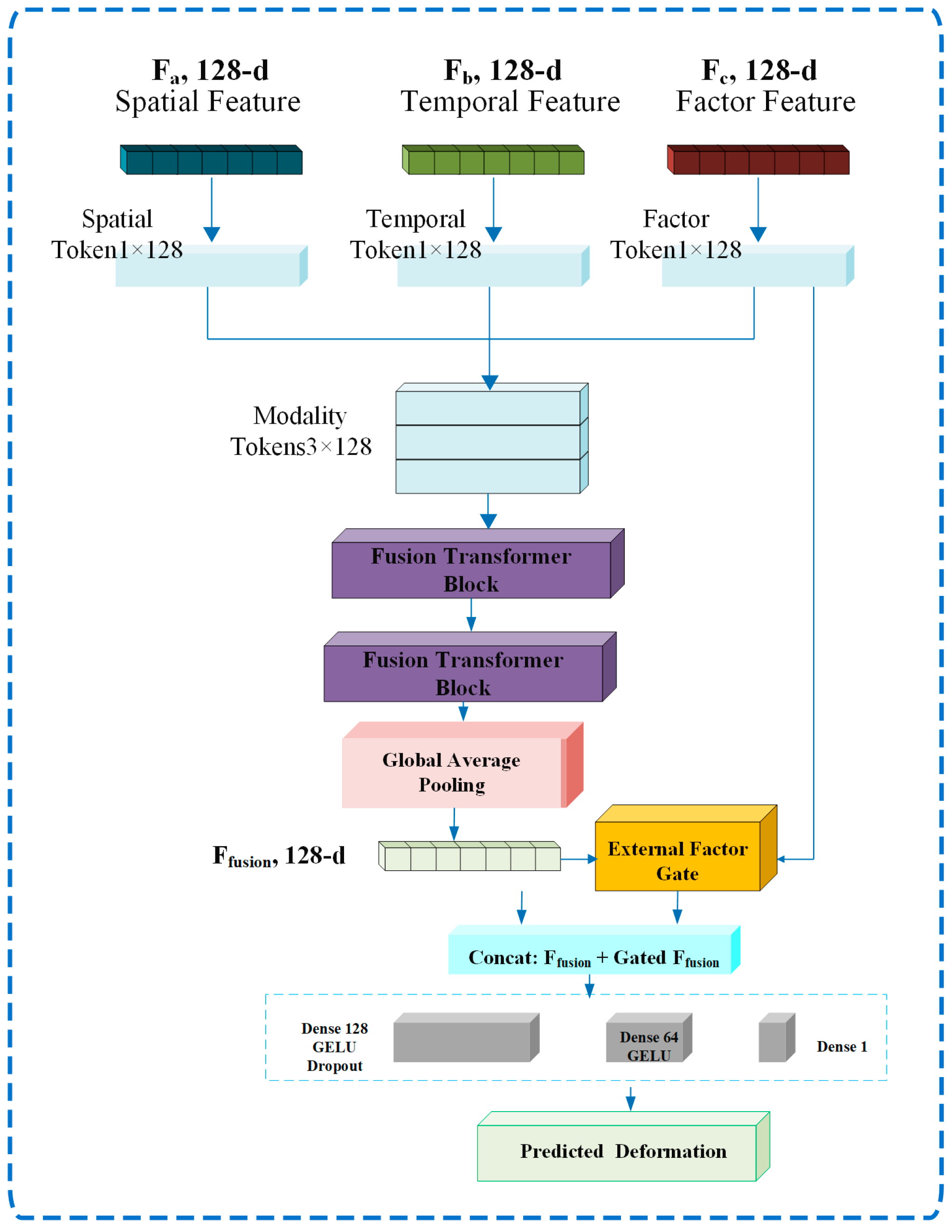
During feature fusion, the 128-dimensional representations output by the spatial, temporal, and external-factor branches are reformulated as the Spatial Token, Temporal Token, and Factor Token, respectively. These tokens are concatenated along the modality dimension to form a 3 × 128 token sequence. Subsequently, a two-layer Fusion Transformer is employed to model the dependencies among the different modalities, enabling spatial structure, temporal evolution, and external driving information to interact fully within a unified feature space.
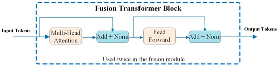
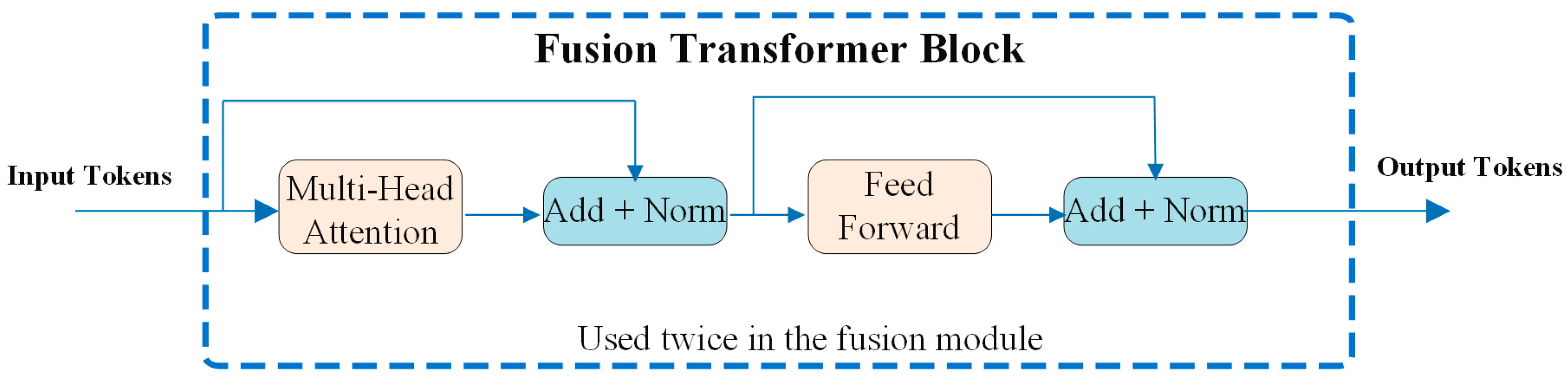
The Fusion Transformer consists of multi-head self-attention, a feed-forward network, residual connections, and layer normalization. The multi-head self-attention mechanism is used to learn the interdependencies and relative contributions among the Spatial Token, Temporal Token, and Factor Token, while the feed-forward network further performs nonlinear feature transformation. Its architecture is illustrated in Figure 7.
Figure 7.
Fusion Transformer.
After cross-modal fusion, global average pooling is applied to obtain a fused feature vector. The external-factor features are then used to generate Sigmoid-based gating weights, which adaptively modulate the fused representation. The fused features and gated features are subsequently fed into the regression head, which consists of a 128-dimensional fully connected layer, dropout, a 64-dimensional fully connected layer, and a linear output layer, to predict the deformation value of the target pixel at the target epoch. Two consecutive Fusion Transformer encoder modules are employed to enable sufficient interaction among the spatial, temporal, and external-factor features. The resulting multimodal feature sequence is then converted into a unified fused feature vector through global average pooling for subsequent regression prediction. The overall architecture is illustrated in Figure 8.
Figure 8.
Architecture of the GeoSTF-Former model.
2.4. Accuracy Evaluation Metrics
To quantitatively evaluate the accuracy of the PS-stable-point-constrained SBAS-InSAR deformation monitoring results and the GeoSTF-Former predictions, the root mean square error (RMSE), mean absolute error (MAE), coefficient of determination () and Pearson correlation coefficient (r) were adopted as the primary evaluation metrics.
Let denote the reference deformation value, denote the predicted or inverted deformation value, denote the mean of the reference deformation values, and denote the number of samples. The corresponding accuracy metrics are defined as follows:
3. Experimental Analysis
3.1. PS-Stable-Point-Constrained SBAS-InSAR Deformation Monitoring
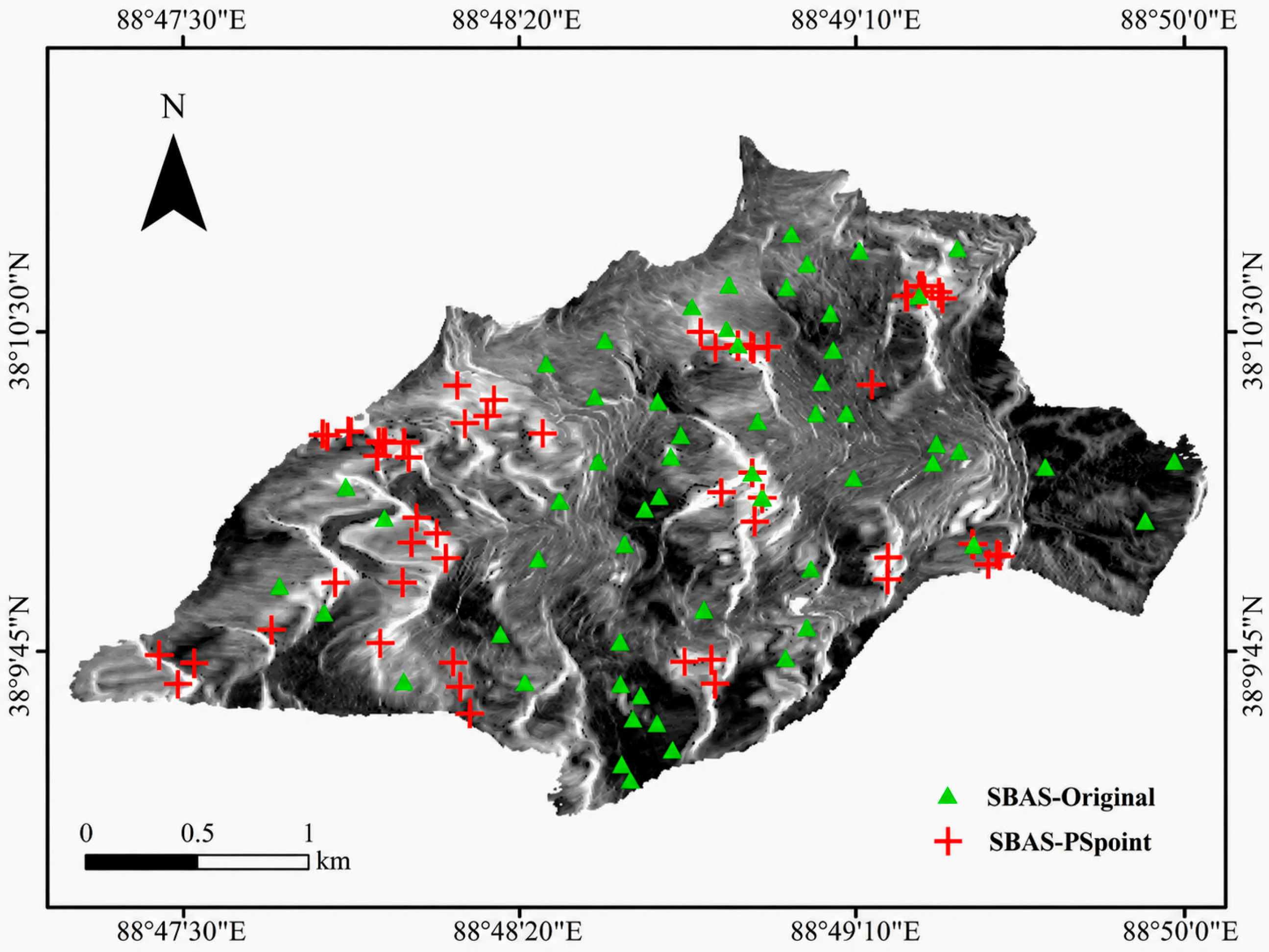
To investigate the influence of PS-InSAR stable-point constraints on SBAS-InSAR deformation inversion results, two comparative SBAS-InSAR experiments were conducted. The first followed the conventional SBAS-InSAR processing workflow, in which the ground control points (GCPs) required for orbital refinement and re-flattening were manually selected with reference to the unwrapped phase images according to explicit selection criteria. Specifically, the GCPs were selected from relatively stable areas without obvious residual topographic fringes, deformation fringes, or abrupt phase jumps. Isolated-phase regions and areas with evident phase discontinuities were excluded, and a sufficient number of GCPs were retained to reduce the influence of coherence differences among interferometric pairs and improve the stability of orbital refinement and deformation inversion. This experiment is denoted as SBAS-Original. In the second experiment, with all other processing parameters kept unchanged, the stable reference points obtained from the initial PS-InSAR inversion were introduced as candidate GCPs; this experiment is denoted as SBAS-PSpoint. The locations of these points are shown in Figure 9.
Figure 9.
Comparison of GCP distributions between conventional SBAS-InSAR and PS-stable-point-constrained SBAS-InSAR.
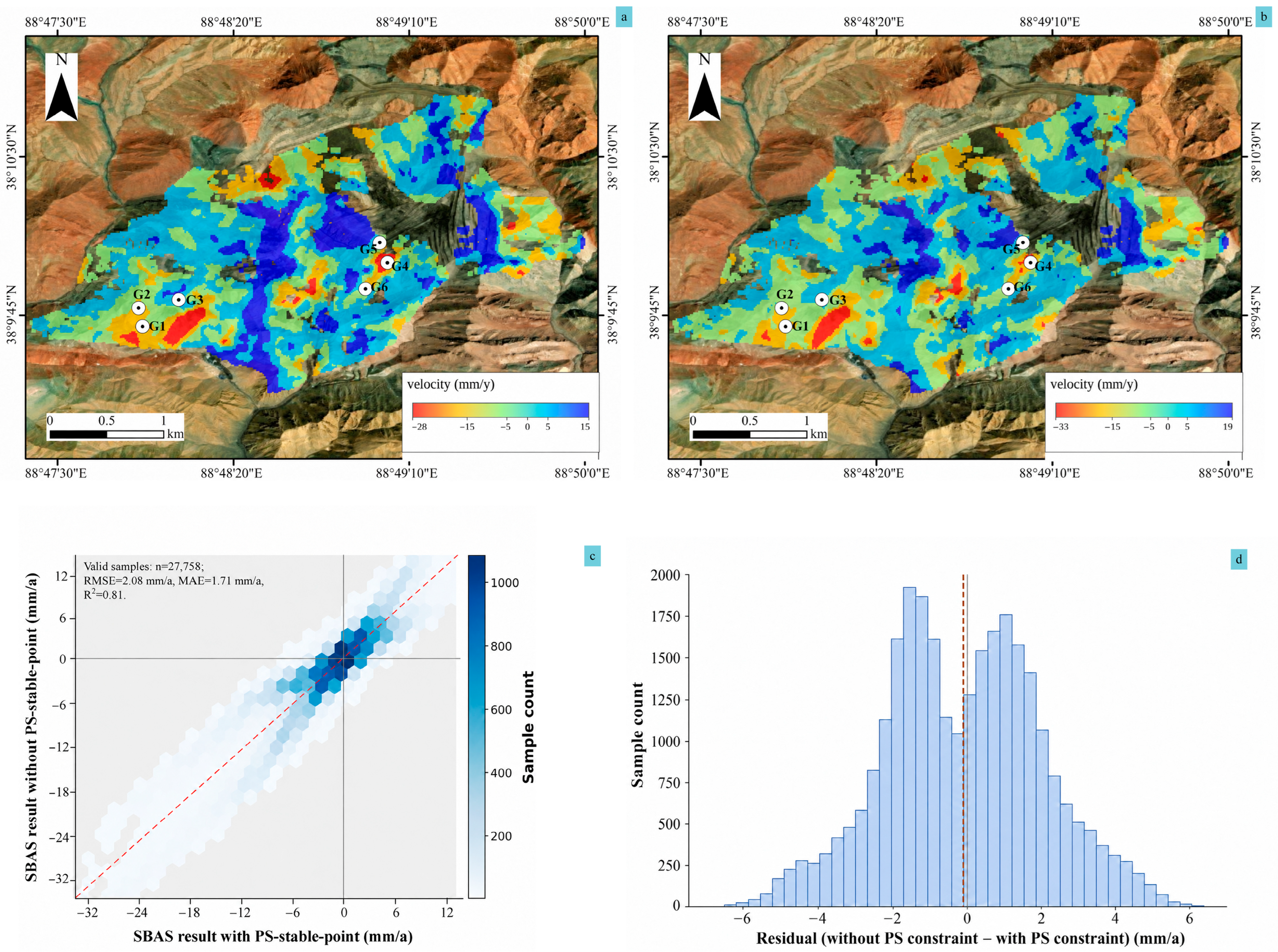
As shown in Figure 9, the GCPs selected in conventional SBAS-InSAR processing differ spatially from those obtained using the PS stable-point constraint. Conventional GCPs are selected primarily through manual interpretation or the software’s default procedure and are therefore susceptible to the effects of local low-coherence areas, strongly deforming zones, and residual topographic phase. In contrast, PS stable points are mainly derived from permanent scatterers that exhibit high coherence, stable phase behavior, and low deformation velocities over long time series, thereby providing greater temporal stability and reference reliability. To evaluate the influence of the PS stable-point constraint on SBAS-InSAR deformation inversion, conventional SBAS-InSAR and PS-stable-point-constrained SBAS-InSAR results were obtained using the same SAR dataset, interferometric-pair configuration, and processing parameters. The mean deformation velocity fields derived from the two methods, together with the spatial distribution of the GNSS monitoring points (G1–G6), are shown in Figure 10.
Figure 10.
Comparison of SBAS-InSAR mean deformation velocity before and after PS stable-point constraint: (a) mean deformation velocity obtained with the PS stable-point constraint; (b) mean deformation velocity obtained without the PS stable-point constraint; (c) pixel-scale comparison of the mean deformation velocities derived from the two methods; and (d) distribution of the velocity differences between the unconstrained results and the PS-constrained results.
At the local scale, the SBAS-InSAR results obtained without the PS stable-point constraint exhibit noticeable spatial fluctuations in some marginal areas, high-gradient deformation zones, and low-coherence regions. Localized anomalous values are also more pronounced, while nominally stable background areas show a certain degree of noise-induced variability. After applying the PS stable-point constraint, the spatial continuity of the deformation field was improved, background fluctuations in stable areas were reduced, and the boundaries of the subsidence zones became more clearly defined. These results indicate that PS stable points can, to some extent, mitigate the effects of residual orbital errors, residual flat-earth phase, and long-wavelength errors on the SBAS-InSAR inversion results. Therefore, under the complex surface conditions of mining areas, incorporating PS stable points into SBAS-InSAR processing can enhance the spatial stability of the retrieved deformation field.
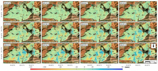
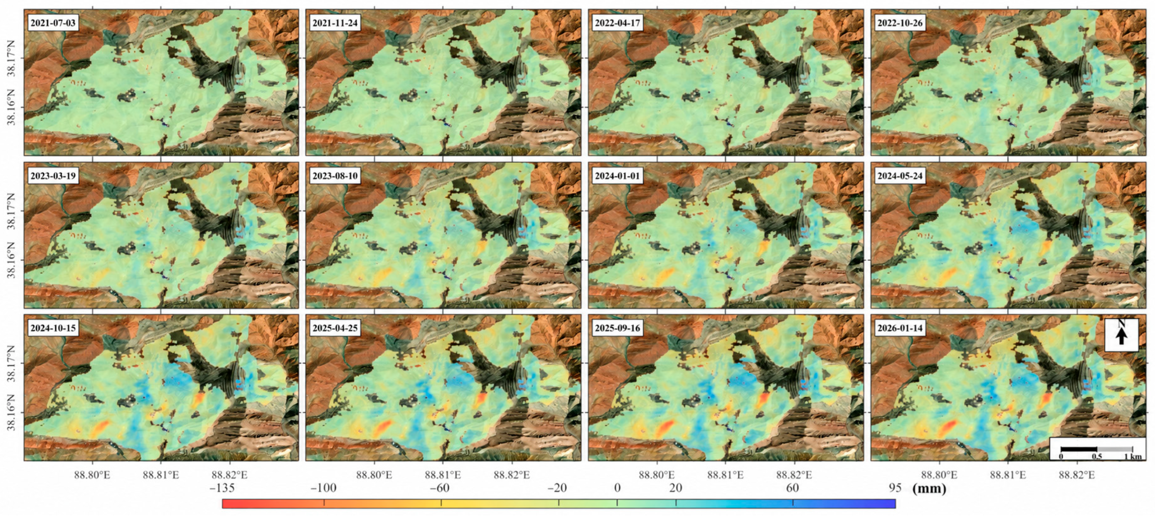
Figure 11 presents the time-series cumulative deformation results for the study area from 2021 to 2026. From the perspective of temporal evolution, surface deformation within the coal mining area generally exhibits a progressive accumulation pattern. The principal subsidence zones show strong spatial persistence across different acquisition epochs, indicating a systematic temporal evolution of surface deformation rather than isolated random fluctuations. Over time, localized subsidence centers gradually intensified, cumulative deformation continued to increase, and the spatial extent of the affected areas showed a tendency to expand. The observed temporal evolution primarily reflects the spatiotemporal characteristics of the InSAR-derived deformation field. Although an overall spatial correspondence can be observed between the major deformation zones and the visibly disturbed mining area, quantitatively attributing individual deformation changes to specific mining processes would require the joint analysis of time-resolved mining-operation parameters. Such information will be incorporated in subsequent studies to further investigate the coupling between mining activities and surface deformation.
Figure 11.
Time-series cumulative deformation results derived from PS-stable-point-constrained SBAS-InSAR.
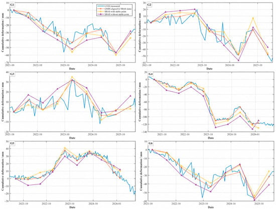
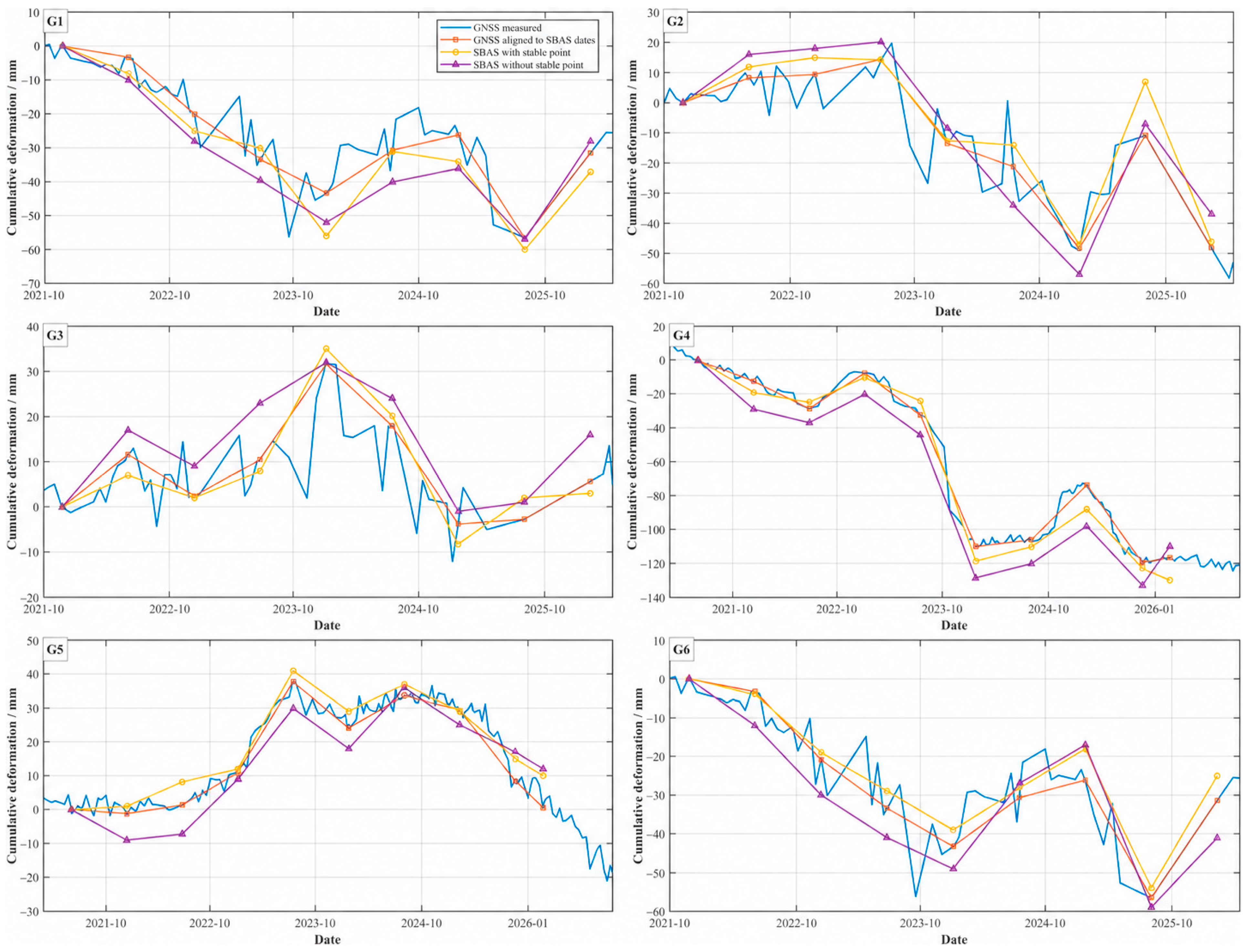
To further evaluate the accuracy of the two SBAS-InSAR monitoring results, six GNSS monitoring points, G1–G6, were selected as external validation data. Following the LOS-projection and temporal alignment protocol described in Section 2.1.2, the GNSS observations were resampled to the actual Sentinel-1 acquisition dates and subsequently compared with the SBAS-InSAR results obtained with and without the PS stable-point constraint. The comparison results are presented in Figure 12.
Figure 12.
Comparison of GNSS observations with the results from the two SBAS-InSAR methods.
As shown in Figure 12, after applying the PS stable-point constraint, the average RMSE, MAE, and R2 across the six monitoring points reached 5.71 mm, 4.62 mm, and 0.91, respectively. Compared with the unconstrained results (RMSE = 8.38 mm, MAE = 7.14 mm, and R2 = 0.81), the RMSE and MAE decreased by 31.9% and 35.3%, respectively, while R2 increased by 0.10. The largest absolute RMSE reduction was observed at G4, which exhibited the largest deformation magnitude: its RMSE decreased from 14.13 mm to 7.89 mm, while its R2 increased from 0.91 to 0.97. These comparisons support improved agreement with GNSS at the evaluated points and provide a better-constrained deformation series for subsequent prediction.
The differences in evaluation metrics among G1–G6 are expected because the six monitoring sites sample different local deformation and observation conditions. Specifically, the point-wise errors can be affected by deformation magnitude and temporal variability, local phase coherence, deformation gradients within an InSAR resolution cell, the representativeness of a point GNSS measurement relative to the corresponding InSAR pixel, and the temporal spacing of the matched observations. These are plausible contributors rather than point-specific diagnoses because their individual error budgets were not independently estimated. In addition, R2 depends on the variance of the reference series; therefore, a monitoring point with a larger displacement range may exhibit a relatively high R2 despite having a larger RMSE. For example, G4 shows the largest deformation magnitude and a relatively large RMSE while still achieving a high R2, indicating good temporal agreement over a broader deformation range.
3.2. Model Architecture Comparison Experiments
Before model training, the samples were partitioned according to the target acquisition epoch rather than by randomly splitting individual pixels. Earlier target epochs were used for training and validation, while subsequent target epochs were held out exclusively for testing. Therefore, samples belonging to the test epochs were not involved in model fitting or model selection. In addition, all normalization parameters were estimated using the training set only and subsequently applied to the validation and test sets. This procedure constitutes a strict temporal hold-out evaluation and reduces the risk of direct information leakage caused by random pixel-level partitioning of spatially correlated InSAR observations.
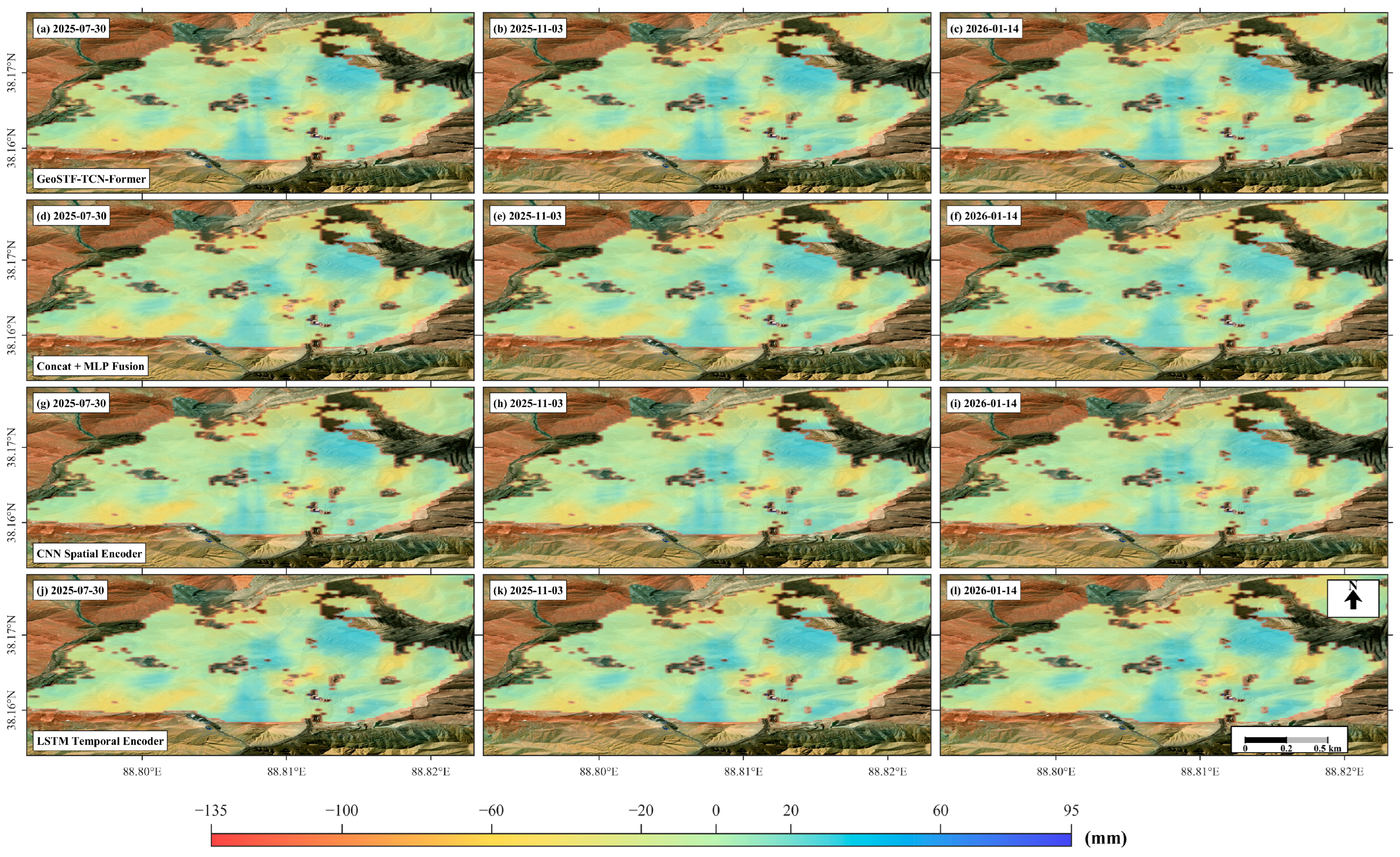
To investigate the effectiveness of the different network components in GeoSTF-Former, three classical baseline architectures—CNN, LSTM, and Concat + MLP—were selected as comparison models. Replacement experiments were conducted to evaluate the model from three perspectives: spatial feature extraction, temporal dependency modeling, and multi-source feature fusion. For spatial encoding, the CNN Spatial Encoder replaces the ConvNeXt spatial encoder with conventional CNN residual blocks to assess the capability of traditional convolutional structures to represent local spatial patterns of subsidence, subsidence basin boundaries, and deformation gradients. For temporal modeling, the LSTM Temporal Encoder replaces the TCN–Transformer temporal branch with a conventional LSTM network to compare recurrent neural networks with the multiscale temporal convolution–attention architecture in modeling historical deformation sequences. For feature fusion, the Concat + MLP Fusion replaces the Fusion Transformer with feature concatenation followed by a multilayer perceptron, thereby evaluating the ability of a simple concatenation-based fusion strategy to represent interactions among spatial, temporal, and external factor features.
The architecture comparisons are reported at two distinct evaluation scales. In the study area pixel-scale evaluation, GeoSTF-Former yielded an RMSE of 3.08 mm, compared with 4.01, 4.81, and 4.52 mm for the CNN Spatial Encoder, LSTM Temporal Encoder, and Concat + MLP Fusion variants, respectively. Figure 13 shows the corresponding spatial predictions. Table 1 separately summarizes evaluation at the six monitoring locations; its values therefore should not be substituted for the pixel-scale metrics. At both scales, the complete model has lower RMSE than the three replacement variants.
Figure 13.
Comparison of spatial prediction results from different structure—replacement models.
Table 1.
Prediction accuracy of the architecture variants at the six monitoring locations.
At the six monitoring locations, Table 1 reports RMSE values of 4.04, 4.43, and 5.69 mm for the CNN Spatial Encoder, LSTM Temporal Encoder, and Concat + MLP Fusion variants, respectively, compared with 2.99 mm for GeoSTF-Former. These differences describe local prediction performance and need not follow the same ranking as errors across the study area pixels. The Fusion Transformer comparison supports a benefit from cross-modal interaction in the evaluated setting, while the differing rankings of RMSE and correlation-related metrics caution against identifying a preferred model from correlation alone.
The replacement experiments support the selected spatial encoder, temporal encoder, and fusion module relative to the tested alternatives. Each comparison changes a specified architectural component within the full framework. However, replacing the complete TCN–Transformer branch with an LSTM does not isolate the TCN from temporal self-attention. The experiments therefore support these component choices at the tested level of replacement, without establishing that every internal operation is independently necessary or that the architecture is optimal in computational cost.
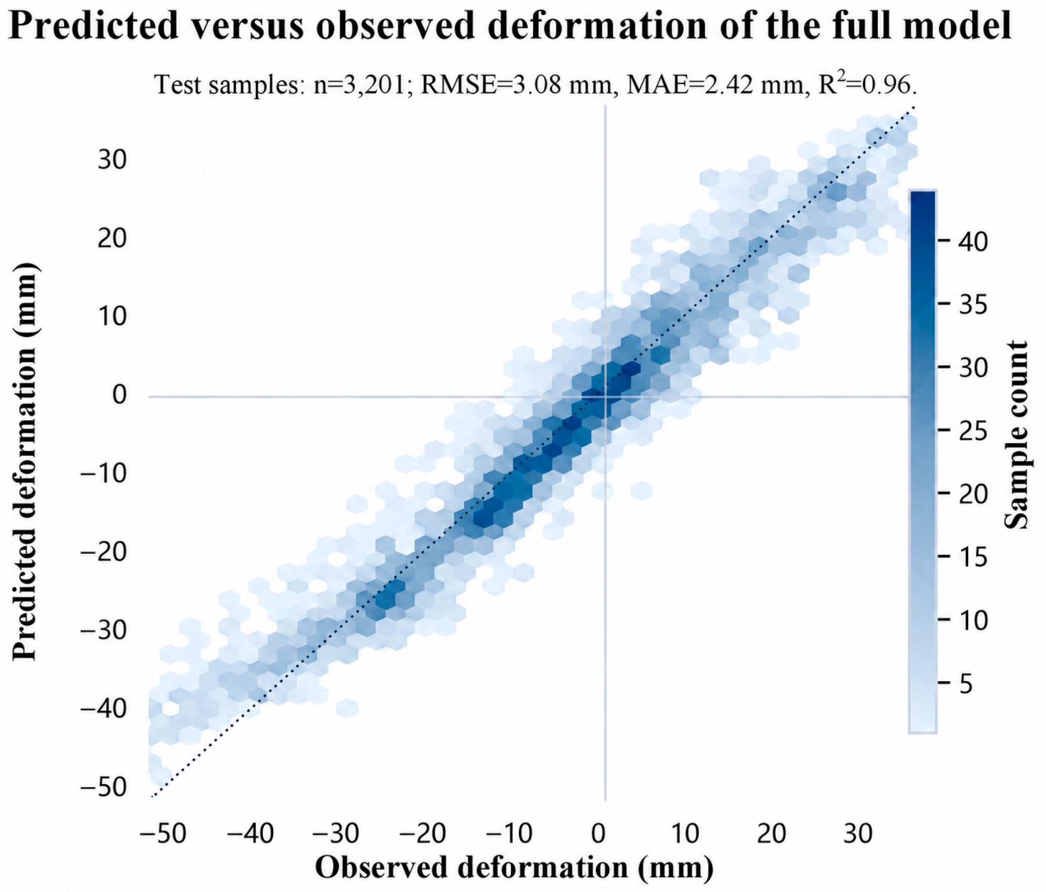
The acquisition on 14 January 2026 is the final epoch of the selected SAR dataset and was used as the common target date for the pixel-by-pixel comparison in Figure 14. This provides an end-of-record assessment against the corresponding SBAS-InSAR deformation field. Selection of this date does not imply that it represents average conditions across the year or that accuracy is unchanged at other dates.
Figure 14.
Scatter plot comparing the GeoSTF-Former full-model predictions with the observations.
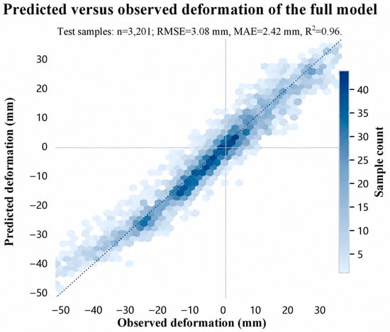
For the pixel-scale test set of 3201 samples at this epoch, GeoSTF-Former achieved an RMSE of 3.08 mm, an MAE of 2.42 mm, and an R2 of 0.96. The predictions lie close to the 1:1 reference line in Figure 14, indicating agreement with the SBAS-InSAR-derived target. These metrics quantify prediction against an InSAR reference, rather than independent geodetic accuracy, and differ from the six-location results in Table 1.
These results indicate that GeoSTF-Former can effectively learn the dominant spatiotemporal evolution patterns of mining-induced subsidence, although further improvement is still needed in areas characterized by abrupt changes along subsidence boundaries and localized anomalies. The full model can accurately preserve the locations, spatial extents, and deformation gradient variations of the major subsidence zones within the study area. The subsidence centers, stable background areas, and local deformation transition zones all exhibit good spatial continuity in the predicted map. This demonstrates that the model not only learns the temporal evolution patterns of the historical deformation sequence at individual pixels but also constrains the predictions by incorporating spatial structural information from the surrounding neighborhood patches.
3.3. Ablation Experiments
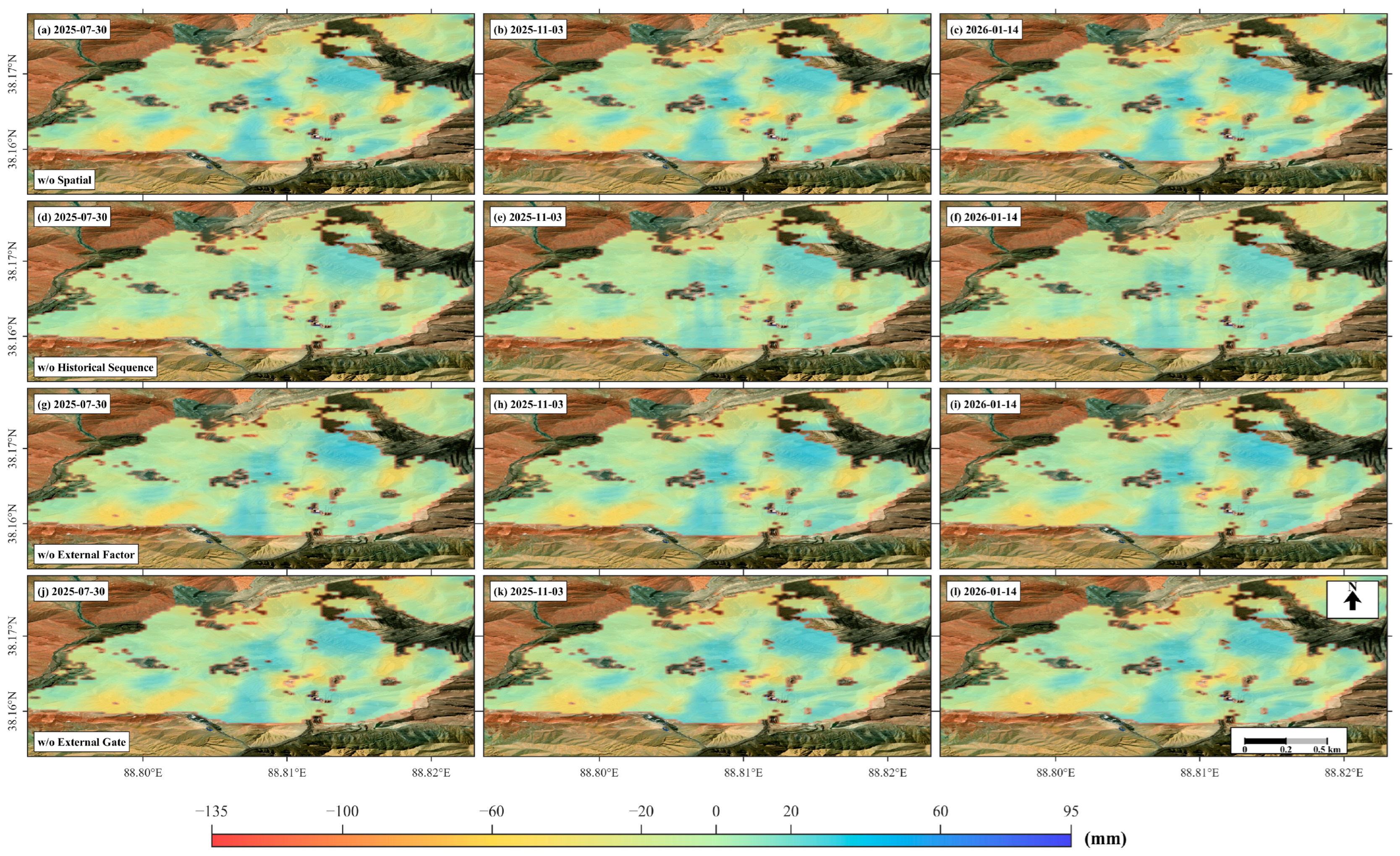
To further investigate the contributions of different input information sources to mining-induced subsidence prediction, four branch-ablation experiments were conducted based on the complete GeoSTF-Former model. The w/o Spatial variant removes the 32 × 32 local spatial neighborhood patch and retains only the historical deformation sequence and external factors, thereby evaluating the role of spatial neighborhood information in constraining subsidence boundaries and maintaining spatial continuity. The w/o Historical-Sequence Branch variant removes the deformation sequences from the preceding 10 epochs and retains only the spatial patch and external factors to examine the contribution of historical InSAR deformation sequences to subsidence-trend prediction. The w/o External Factor Branch variant excludes external factors, including precipitation, DEM, slope, and aspect, and performs prediction using only the spatial patch and historical sequence, thereby evaluating the contribution of external environmental factors. The w/o External Gate variant retains all three input branches and the Fusion Transformer but removes only the external-factor gating mechanism to verify the effectiveness of the gating module in adaptively regulating the fused features. The results of the ablation experiments are presented in Figure 15, and the corresponding accuracy metrics are listed in Table 2.
Figure 15.
Comparison of spatial prediction results from the model input—branch ablation experiments.
Table 2.
Prediction accuracy of the branch and gate ablations at the six monitoring locations.
In the pixel-scale evaluation, removing the external-factor gate, external-factor branch, spatial branch, and historical-sequence branch increased RMSE from 3.08 mm to 3.66, 4.35, 5.89, and 6.32 mm, respectively. Historical deformation therefore produced the largest change among these branch removals at the pixel scale. Table 2 reports the separate six-location evaluation, where the relative ordering differs. The distinction is retained because regional prediction and performance at a small set of monitoring locations emphasize different deformation patterns.
At the six monitoring locations, removing the spatial branch, historical-sequence branch, external-factor branch, and external-factor gate yielded RMSE values of 6.01, 7.06, 5.24, and 7.65 mm, respectively, compared with 2.99 mm for the complete model (Table 2). The external gate produces the largest RMSE change at these locations, whereas the historical-sequence branch produces the largest pixel-scale change. Both evaluations support complementary information from the branches and gate, but their differing rankings preclude a universal ordering of component importance. These comparisons measure performance changes conditional on the remaining model components, rather than additive or independent causal contributions.
3.4. Analysis of External-Factor Ablation Experiments
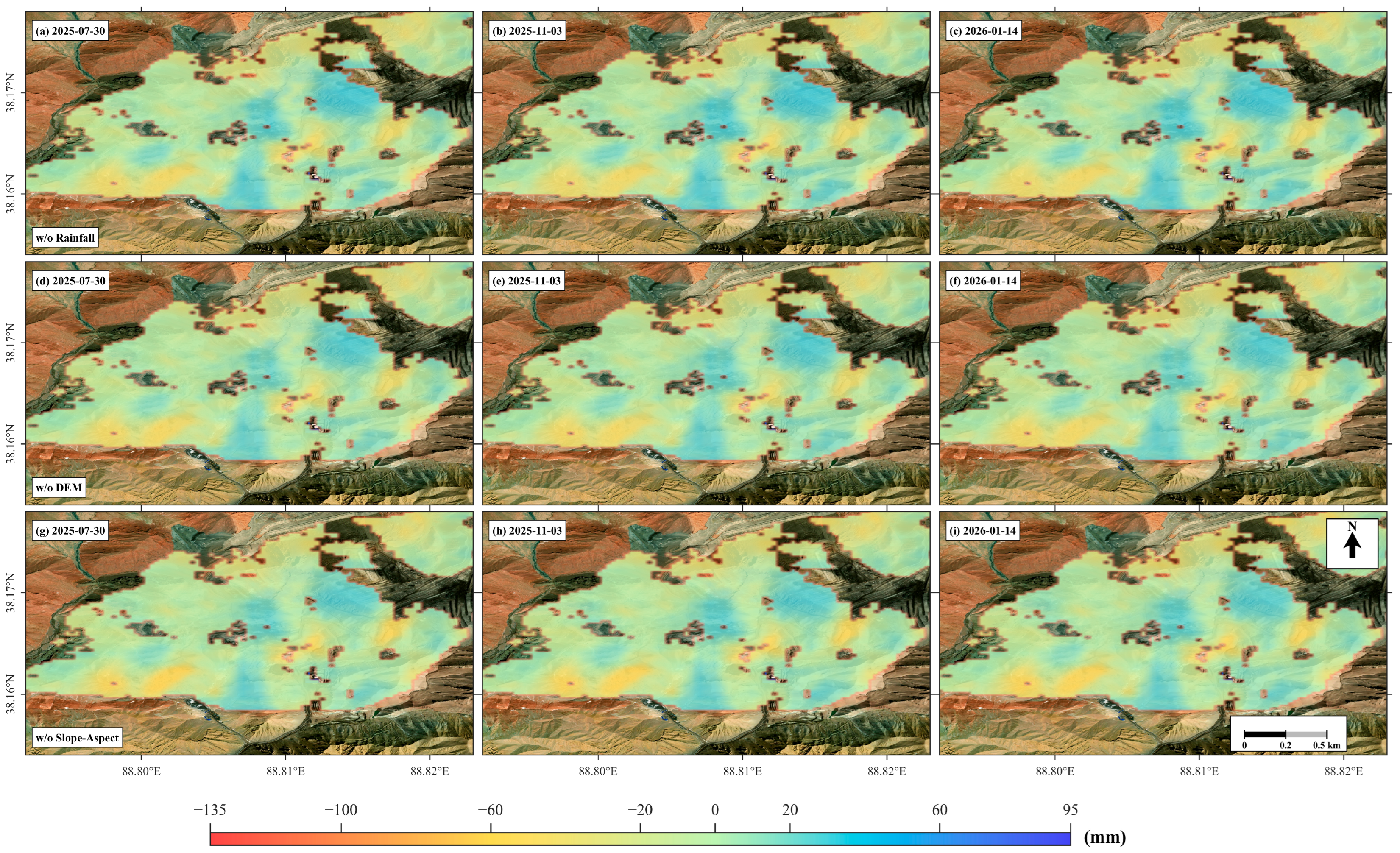
To further distinguish the effects of different external factors on mining-induced subsidence prediction, three external-factor ablation experiments were conducted based on GeoSTF-Former. To avoid interference caused by changes in input dimensionality, each designated variable was masked by replacing it with its mean value calculated from the training set, while the model architecture, spatial patch, historical sequence input, and remaining external factors were kept unchanged. Specifically, w/o Rainfall masks the precipitation factor to assess the contribution of rainfall and episodic hydrological disturbances to subsidence prediction; w/o DEM masks the elevation factor to evaluate the role of topographic elevation in predicting the spatial differentiation of subsidence; and w/o Slope-Aspect simultaneously masks the slope and aspect factors to investigate the influence of terrain-direction constraints on the prediction of local deformation magnitude and spatial distribution.
In the pixel-scale evaluation, masking precipitation, slope–aspect, and DEM increased RMSE from 3.08 mm to 3.87, 4.70, and 5.35 mm, respectively. DEM therefore showed the largest sensitivity among the tested external-factor masks at this scale. A plausible explanation is that the study area has a relative relief of approximately 429 m, so elevation provides a stable large-scale spatial context that helps distinguish different geomorphic positions and deformation regimes. Elevation may also covary with drainage conditions, slope exposure, mining layout, geological setting, and other spatially varying site characteristics. Consequently, the model may use DEM partly as a proxy for broad spatial heterogeneity rather than as a direct physical driver of subsidence. In addition, residual elevation-dependent atmospheric or topographic errors in the InSAR products may contribute to the observed model sensitivity. Therefore, the ablation result should be interpreted as sensitivity to elevation information rather than evidence that elevation is the dominant causal control on mining-induced subsidence [39].
As shown in Figure 16 and Table 3, masking the precipitation, DEM, and slope–aspect factors increased the RMSE to 3.62, 4.24, and 6.63 mm, respectively, indicating that all external factors contribute to improving the model’s predictive performance. Among them, removing the slope–aspect factors resulted in the most pronounced degradation in accuracy, followed by DEM, whereas the precipitation factor had a comparatively smaller influence. Overall, topographic and precipitation information provide effective external constraints for mining-induced subsidence prediction, and the joint incorporation of multiple factors in the complete model yields higher prediction accuracy and stability.
Figure 16.
Comparison of spatial prediction results from external-factor ablation experiments.
Table 3.
Prediction accuracy of external-factor masking at the six monitoring locations.
Taken together, the structure-comparison, branch-ablation, and external-factor ablation experiments show that the complete GeoSTF-Former achieved the lowest RMSE among all evaluated models, demonstrating the strong overall performance of the proposed multi-source spatiotemporal fusion framework for deformation prediction. All ablation variants exhibited higher errors than the complete model, indicating that the performance improvement does not arise from any single architectural component or input variable, but rather from the synergistic modeling of spatial neighborhood information, historical deformation sequences, and external driving factors. The historical deformation sequence governs the temporal evolution of subsidence, while the spatial patch constrains subsidence basin boundaries and local spatial continuity. External factors, including DEM, slope, aspect, and precipitation, provide complementary topographic and environmental information. The Fusion Transformer and external-factor gating mechanism further improve the efficiency of multi-source feature integration. These results verify the rationality and effectiveness of GeoSTF-Former for mining-induced subsidence prediction.
4. Discussion
This study developed a PS-InSAR stable-point-constrained SBAS-InSAR monitoring method and established the GeoSTF-Former multi-source spatiotemporal fusion prediction model, enabling time-series monitoring and pixel-level prediction of mining-induced LOS deformation. The proposed framework improves the consistency of the SBAS-InSAR deformation series and provides a data-driven approach for predicting subsequent LOS displacement fields. However, the interpretation of the predicted deformation should consider the observation geometry, physical meaning of auxiliary variables, and evaluation conditions.
A single ascending LOS observation is one projection of three-dimensional displacement. On pit walls and embankments, vertical and horizontal motion may reinforce or partly cancel in that projection; small LOS movement does not necessarily imply a stable slope. Dividing LOS displacement by the cosine of an incidence angle would require negligible horizontal motion, an assumption not established here. Slope orientation also changes radar visibility: radar-facing slopes may experience foreshortening or layover, whereas slopes facing away may be shadowed. These effects restrict the spatial representativeness of coherent observations and cannot be fully resolved by the prediction model. Combining ascending and descending observations can constrain vertical and east–west motion if north–south motion is negligible; resolving all three components requires additional independent observations or justified constraints [41].
The current inputs mainly comprise historical deformation, precipitation, and topographic factors, while several key variables, including mining intensity, excavation-front advance direction, blasting activities, groundwater level, and lithological structure, have not been incorporated. Consequently, the model remains limited in its ability to explain abrupt localized deformation and anomalous subsidence. In addition, the resolution and completeness of auxiliary variables may affect the representation of local deformation-driving conditions. The 30 m SRTM DEM used in this study may smooth some fine-scale elevation, slope, and aspect variations associated with individual mining benches. This limitation affects the representation of local topographic auxiliary information but does not determine the spatial resolution of the InSAR deformation measurements. In future work, detailed mining-operation records, higher-resolution UAV- or stereo-satellite-derived DEMs, groundwater observations, and additional ground-based monitoring data will be incorporated when available to improve the physical interpretability and fine-scale predictive capability of the model. Mining-operation parameters, such as excavation extent, excavation-front advance, mining intensity, production volume, and blasting activities, are closely related to the evolution of surface deformation in active mining areas. Although previous InSAR-based and data-driven studies have demonstrated that useful deformation prediction can be achieved primarily from historical deformation sequences and associated spatiotemporal information, incorporating explicit mining-operation parameters would provide additional physical constraints for interpreting local deformation changes. In subsequent work, these variables will be jointly incorporated with InSAR deformation, topographic, and environmental information to investigate the quantitative coupling between mining activities and surface response and to further improve the physical interpretability and predictive performance of the model.
GeoSTF-Former was trained and evaluated within one mining area and a limited observation period. Cross-site, cross-sensor, and longer-horizon validation has not been performed. Spatially correlated pixels and overlapping 32 × 32 neighborhoods can make test errors optimistic when training and evaluation samples share nearby terrain. A high R2 does not itself establish spatial independence. The reported results should therefore be interpreted as within-site temporal prediction performance; spatial block validation with buffers that prevent patch overlap, together with testing on independent later acquisition periods, is needed to establish transfer to independent locations and periods.
Operational prediction imposes a further timing constraint: every input must be available when a prediction is issued. The external-factor branch uses cumulative precipitation for the target period. If that total is known only after the period ends, the evaluation is conditional on observed precipitation; an advance forecast would instead require a precipitation forecast or a predictor based on antecedent rainfall. The causal temporal encoder alone cannot prevent leakage through spatial patches, preprocessing, model selection, or future covariates. These distinctions matter when translating the present evaluation into prospective forecasting.
The SBAS-InSAR displacement fields also serve as prediction labels. Residual atmospheric, topographic, and phase-unwrapping errors can therefore propagate into model outputs, and agreement with these labels cannot separate monitoring error from prediction error. The GNSS comparisons in Section 3.1 validate the InSAR monitoring stage at six points; they do not by themselves constitute an independent validation of every predicted pixel. Near deformation boundaries and low-coherence zones, additional ground observations would help distinguish genuine motion from measurement artifacts and model error.
At this high-altitude site, July–August rainfall and snowmelt may supply water to fractures and disturbed materials. Infiltration can alter pore pressure and effective stress, while mining-induced stress relief can increase susceptibility to deformation. Elevation, slope, and aspect can provide broad context for drainage and exposure. However, precipitation is not a measurement of groundwater pressure or snowmelt, and temperature and groundwater observations were not included. These mechanisms therefore provide a plausible interpretation of the covariates rather than proof of specific triggers or measured time lags at this mine.
Seasonality may affect both the physical deformation process and the quality of time-series InSAR observations. Seasonal precipitation and snowmelt, as well as freezing–thawing processes, can generate or modulate ground deformation, whereas changes in near-surface moisture may alter radar scattering properties, interferometric phase, and coherence [42]. In addition, seasonally varying tropospheric conditions can introduce apparent periodic signals into InSAR deformation time series [43]. However, temperature, ground-thermal conditions, groundwater levels, and snowmelt were not independently monitored in this study. Therefore, the observed seasonal fluctuations cannot be attributed to a specific physical mechanism.
Abrupt slope failure presents a different prediction problem from progressive deformation. Rapid acceleration between the available acquisitions may be missed or accompanied by decorrelation and unwrapping failure, leaving unreliable inputs precisely when the deformation regime changes. Missing mining, blasting, groundwater, and lithological information further limits recognition of such transitions. The current results therefore do not establish failure-time prediction or a validated warning threshold. Transfer to mines with different rock masses, excavation practices, terrain, or climates would require local data, model recalibration, and independent evaluation; frequent ground-based monitoring remains necessary for operational assessment of rapidly moving slopes.
5. Conclusions
This study combines PS-derived reference constraints for SBAS-InSAR with GeoSTF-Former to monitor and predict mining-area LOS deformation. The existing monitoring, architecture comparison, and ablation results support the following conclusions:
(1) Using PS-derived reference points for orbital refinement and re-flattening improved agreement between SBAS-InSAR and the six GNSS time series. Mean RMSE, MAE, and R2 reached 5.71 mm, 4.62 mm, and 0.91, respectively, corresponding to RMSE and MAE reductions of 31.9% and 35.3% relative to the conventional reference-point scheme. The improvement supports the usefulness of PS-derived constraints in this area, without implying complete removal of atmospheric or other phase errors.
(2) GeoSTF-Former integrates ConvNeXt spatial encoding, TCN–Transformer temporal encoding, external-factor information, and adaptive fusion. At the target epoch of 14 January 2026, the pixel-scale test set yielded an RMSE of 3.08 mm, an MAE of 2.42 mm, and an R2 of 0.96 against the SBAS-InSAR reference. These values characterize within-site prediction of LOS deformation at the evaluated epoch, rather than vertical-displacement accuracy or performance across all seasons and mining environments.
(3) Architecture replacement, branch removal, and external-factor masking each increased RMSE relative to the complete model at the corresponding evaluation scale. The relative sensitivities differed between the study area pixels and six monitoring locations: DEM masking had the largest external-factor effect at the pixel scale, whereas joint slope–aspect masking had the largest effect at the monitoring locations. The results support complementary inputs and fusion but do not establish independent causal effects or the optimality of every internal component.
(4) Single ascending-track geometry cannot resolve vertical subsidence from horizontal slope movement. The 30 m SRTM inputs represent broad, historical terrain context and do not resolve current mining benches. Future work should combine ascending and descending SAR for vertical and east–west decomposition under appropriate assumptions and add independent directional observations for full three-dimensional motion. Higher-resolution SAR and contemporary DEMs, mining-operation records, groundwater and temperature observations, and validation in contrasting climatic and geotechnical settings would help assess transferability and physical interpretation.
In summary, the proposed PS-constrained SBAS-InSAR monitoring method and the constructed GeoSTF-Former multi-source spatiotemporal fusion prediction model can effectively realize long-term accurate monitoring and short-term dynamic prediction of mining surface subsidence, providing a reliable and feasible technical scheme for refined mining deformation monitoring, subsidence evolution analysis, and geological disaster early warning. For future research, mining activity parameters, dynamic groundwater variation data, and multi-source ground monitoring data can be further incorporated to enrich model input dimensions. This can enhance the model’s interpretability for complex nonlinear subsidence processes and improve its generalization and cross-region applicability.
Author Contributions
Conceptualization, Y.S. and D.L.; methodology, D.L. and Y.S.; software, D.L.; validation, D.L. and L.B.; formal analysis, D.L.; investigation, D.L. and H.W.; resources, H.W.; data curation, D.L. and H.W.; visualization, D.L.; writing—original draft preparation, D.L.; writing—review and editing, Y.S., H.W. and L.B.; supervision, Y.S.; project administration, Y.S. All authors have read and agreed to the published version of the manuscript.
Funding
This research received no external funding.
Data Availability Statement
The Sentinel-1 SAR images used in this study are publicly available from the Alaska Satellite Facility Distributed Active Archive Center (ASF DAAC). The SRTM digital elevation model data are publicly available from the United States Geological Survey, and the precipitation data were obtained from the China Meteorological Administration Data Service Centre. The GNSS observations and mining-area-related auxiliary data are not publicly available because they contain proprietary information provided by the collaborating enterprise. The processed InSAR deformation products and the data supporting the findings of this study are available from the corresponding author upon reasonable request, subject to permission from the data provider.
Acknowledgments
During the preparation of this manuscript, the authors used OpenAI’s ChatGPT (GPT-5.6 Sol) to assist with translating the authors’ original Chinese text into English and with English-language editing. The tool was also used to enhance the resolution of Figure 9, Figure 10 and Figure 14 and to translate the Chinese text and cardinal-direction labels in these figures into English. These graphical adjustments were limited to image resolution, text translation, typography, and visual presentation and did not alter any research data, numerical values, geographic coordinates, spatial deformation patterns, monitoring point locations, legends, scales, color-bar values, model outputs, or other data-bearing elements. The authors reviewed and verified all AI-assisted outputs against the original manuscript, source data, and original figures and take full responsibility for the content of this publication.
Conflicts of Interest
Helong Wang and Lei Bu are employees of China Coal Technology & Engineering Group Nanjing Design & Research Institute Co., Ltd. The company had no role in the study design, data analysis, interpretation of the results, preparation of the manuscript, or the decision to publish the results. The authors declare that there are no other conflicts of interest related to this work.
References
- Lu, Y.; Jin, C.; Wang, Q.; Li, G.; Han, T. Deformation and failure characteristic of open-pit slope subjected to combined effects of mining blasting and rainfall infiltration. Eng. Geol. 2024, 331, 107437. [Google Scholar] [CrossRef] [Scilit]
- Li, G.; Hu, Z.; Wang, D.; Wang, L.; Wang, Y.; Zhao, L.; Jia, H.; Fang, K. Instability mechanisms of slope in open-pit coal mines: From physical and numerical modeling. Int. J. Min. Sci. Technol. 2024, 34, 1509–1528. [Google Scholar] [CrossRef] [Scilit]
- Hu, L.; Tang, X.; Tomás, R.; Li, T.; Zhang, X.; Li, Z.; Yao, J.; Lu, J. Monitoring surface deformation dynamics in the mining subsidence area using LT-1 InSAR interferometry: A case study of Datong, China. Int. J. Appl. Earth Obs. Geoinf. 2024, 131, 103936. [Google Scholar] [CrossRef] [Scilit]
- Xu, J.; Yan, C.; Boota, M.W.; Chen, X.; Li, Z.; Liu, W.; Yan, X. Research on automatic identification of coal mining subsidence area based on InSAR and time series classification. J. Clean. Prod. 2024, 470, 143293. [Google Scholar] [CrossRef] [Scilit]
- Zhu, M.; Yu, X.; Tan, H.; Yuan, J. Integrated high-precision monitoring method for surface subsidence in mining areas using D-InSAR, SBAS, and UAV technologies. Sci. Rep. 2024, 14, 12445. [Google Scholar] [CrossRef] [Scilit] [PubMed]
- Shu, C.; Meng, Z.; Yang, Y.; Wang, Y.; Liu, S.; Zhang, X.; Zhang, Y. Deep learning-based InSAR time-series deformation prediction in coal mine areas. Geo-Spat. Inf. Sci. 2025, 28, 2119–2141. [Google Scholar] [CrossRef] [Scilit]
- Hong, Y.; Chen, P.; Cao, D.; Yao, Y.; Liu, H.; Wu, X.; Sun, S. Refined inversion of 3D surface subsidence in mining areas by integrating SBAS-InSAR and Log-logistic function. Int. J. Remote Sens. 2025, 46, 7943–7969. [Google Scholar] [CrossRef] [Scilit]
- Liu, Z.; Peng, J.; Su, H.; Li, X.; Wang, C.; Peng, Y. InSAR monitoring of large gradient deformation in coalfield and phase unwrapping research. Geod. Geodyn. 2025, 17, 130–144. [Google Scholar] [CrossRef] [Scilit]
- Ghaderpour, E.; Mazzanti, P.; Bozzano, F.; Mugnozza, G.S. Ground deformation monitoring via PS-InSAR time series: An industrial zone in Sacco River Valley, central Italy. Remote Sens. Appl. Soc. Environ. 2024, 34, 101191. [Google Scholar] [CrossRef] [Scilit]
- Ferretti, A.; Prati, C.; Rocca, F. Permanent scatterers in SAR interferometry. IEEE Trans. Geosci. Remote Sens. 2001, 39, 8–20. [Google Scholar] [CrossRef] [Scilit]
- Chen, Y.; Ding, C.; Huang, P.; Yin, B.; Tan, W.; Qi, Y.; Xu, W.; Du, S. Research on time series monitoring of surface deformation in Tongliao urban area based on SBAS-PS-DS-InSAR. Sensors 2024, 24, 1169. [Google Scholar] [CrossRef] [Scilit] [PubMed]
- Wang, Y.; Cui, X.; Che, Y.; Zhao, Y.; Li, P.; Kang, X.; Jiang, Y. Near Real-Time Monitoring of Large Gradient Nonlinear Subsidence in Mining Areas: A Hybrid SBAS-InSAR Method Integrating Robust Sequential Adjustment and Deep Learning. Remote Sens. 2024, 16, 1664. [Google Scholar] [CrossRef] [Scilit]
- Gao, F.; Chen, Y.; Zhang, G.; Wen, Q. Monitoring and analysis of surface subsidence in mining areas of integrated SBAS-InSAR and probability integral method. Environ. Earth Sci. 2026, 85, 202. [Google Scholar] [CrossRef] [Scilit]
- Shang, J.; Wang, M.; Wang, X.; Yang, M.; Wu, Y.; Du, W. Three-dimensional surface deformation field monitoring and influencing factors analysis in mountainous areas based on SBAS-INSAR technology (Tianjin, China). Sci. Rep. 2025, 15, 25702. [Google Scholar] [CrossRef] [Scilit] [PubMed]
- Chen, Y.; Dong, X.; Qi, Y.; Huang, P.; Sun, W.; Xu, W.; Tan, W.; Li, X.; Liu, X. Integration of DInSAR-PS-stacking and SBAS-PS-InSAR methods to monitor mining-related surface subsidence. Remote Sens. 2023, 15, 2691. [Google Scholar] [CrossRef] [Scilit]
- Berardino, P.; Fornaro, G.; Lanari, R.; Sansosti, E. A new algorithm for surface deformation monitoring based on small baseline differential SAR interferograms. IEEE Trans. Geosci. Remote Sens. 2002, 40, 2375–2383. [Google Scholar] [CrossRef] [Scilit]
- Zhang, J.; Gao, J.; Gao, F. Time series land subsidence monitoring and prediction based on SBAS-InSAR and GeoTemporal transformer model. Earth Sci. Inform. 2024, 17, 5899–5911. [Google Scholar] [CrossRef] [Scilit]
- Zhu, M.; Yu, X.; Tan, H.; Yuan, J.; Chen, K.; Xie, S.; Han, Y.; Long, W. High-precision monitoring and prediction of mining area surface subsidence using SBAS-InSAR and CNN-BiGRU-attention model. Sci. Rep. 2024, 14, 28968. [Google Scholar] [CrossRef] [Scilit] [PubMed]
- Xiao, Y.; Tao, Q.; Hu, L.; Liu, R.; Li, X. A deep learning-based combination method of spatio-temporal prediction for regional mining surface subsidence. Sci. Rep. 2024, 14, 19139. [Google Scholar] [CrossRef] [Scilit] [PubMed]
- Wang, Z.; Zhao, Y.; Wang, P.; Wang, X.; Jiang, A.; Zhang, G.; Li, W.; Liu, J. Refined subsidence monitoring and dynamic prediction in narrow and long mining areas based on InSAR and probabilistic integral method. Sci. Rep. 2024, 14, 28009. [Google Scholar] [CrossRef] [Scilit] [PubMed]
- Guo, A.; Sun, Q.; Hu, J.; Zheng, W.; Gui, R.; Yu, Y. MUSEnet: High temporal-frequency estimation of landslide deformation field through joint InSAR and hydrological observations using deep learning. IEEE J. Sel. Top. Appl. Earth Obs. Remote Sens. 2023, 17, 1485–1499. [Google Scholar] [CrossRef] [Scilit]
- Tiwari, A.; Shirzaei, M. A novel machine learning and deep learning semi-supervised approach for automatic detection of InSAR-based deformation hotspots. Int. J. Appl. Earth Obs. Geoinf. 2024, 126, 103611. [Google Scholar] [CrossRef] [Scilit]
- Soni, R.; Alam, M.S.; Vishwakarma, G.K. Prediction of InSAR deformation time-series using improved LSTM deep learning model. Sci. Rep. 2025, 15, 5333. [Google Scholar] [CrossRef] [Scilit] [PubMed]
- Wang, H.; He, W.; Li, Z.; Yokoya, N. Cross-scenario damaged building extraction network: Methodology, application, and efficiency using single-temporal HRRS imagery. ISPRS J. Photogramm. Remote Sens. 2025, 228, 228–248. [Google Scholar] [CrossRef] [Scilit]
- Abdallah, M.; Ding, X.; Younis, S.; Wu, S. A novel lightweight 3D CNN for accurate deformation time series retrieval in MT-InSAR. Sci. Remote Sens. 2025, 11, 100206. [Google Scholar] [CrossRef] [Scilit]
- Yao, S.; Jing, C.; He, X.; He, Y.; Zhang, L. A TDFC-RNNs framework integrated temporal convolutional attention mechanism for InSAR surface deformation prediction: A case study in Beijing Plain. Int. J. Appl. Earth Obs. Geoinf. 2024, 134, 104199. [Google Scholar] [CrossRef] [Scilit]
- Lu, J.; Wang, Y.; Zhu, Y.; Liu, J.; Xu, Y.; Yang, H.; Wang, Y. DACLnet: A dual-attention-mechanism CNN-LSTM network for the accurate prediction of nonlinear InSAR deformation. Remote Sens. 2024, 16, 2474. [Google Scholar] [CrossRef] [Scilit]
- Wang, J.; Fan, X.; Zhang, Z.; Zhang, X.; Nie, W.; Qi, Y.; Zhang, N. Spatiotemporal mechanism-based spacetimeformer network for InSAR deformation prediction and identification of retrogressive thaw slumps in the Chumar river basin. Remote Sens. 2024, 16, 1891. [Google Scholar] [CrossRef] [Scilit]
- Liu, B.; Zhan, C.; Guo, C.; Liu, X.; Ruan, S. Efficient remote sensing image classification using the novel STConvNeXt convolutional network. Sci. Rep. 2025, 15, 8406. [Google Scholar] [CrossRef] [Scilit] [PubMed]
- Guan, F.; Zhao, N.; Fang, Z.; Jiang, L.; Zhang, J.; Yu, Y.; Huang, H. Multi-level representation learning via ConvNeXt-based network for unaligned cross-view matching. Geo-Spat. Inf. Sci. 2025, 28, 2344–2357. [Google Scholar] [CrossRef] [Scilit]
- Liu, Z.; Mao, H.; Wu, C.-Y.; Feichtenhofer, C.; Darrell, T.; Xie, S. A convnet for the 2020s. In Proceedings of the IEEE/CVF Conference on Computer Vision and Pattern Recognition, New Orleans, LA, USA, 19–24 June 2022; pp. 11976–11986. [Google Scholar]
- Bai, S.; Kolter, J.Z.; Koltun, V. An empirical evaluation of generic convolutional and recurrent networks for sequence modeling. arXiv 2018, arXiv:1803.01271. [Google Scholar]
- Gu, S.; Xi, Q.; Wang, J.; Qiu, P.; Li, M. TCN-GAWO: Genetic Algorithm Enhanced Weight Optimization for Temporal Convolutional Network. J. Mech. Des. 2024, 146, 101703. [Google Scholar] [CrossRef] [Scilit]
- Li, J.; Fan, C.; Zhao, K.; Zhang, Z.; Duan, P. Landslide displacement prediction using time series InSAR with combined LSTM and TCN: Application to the Xiao Andong landslide, Yunnan Province, China. Nat. Hazards 2025, 121, 3857–3884. [Google Scholar] [CrossRef] [Scilit]
- Liu, Y.; Chen, T.; Li, J. Prediction of InSAR urban surface time-series deformation using deep neural networks. In Proceedings of the IGARSS 2023-2023 IEEE International Geoscience and Remote Sensing Symposium, Pasadena, CA, USA, 16–21 July 2023; pp. 5206–5209. [Google Scholar]
- Ma, X.; Zhang, X.; Pun, M.-O.; Liu, M. A multilevel multimodal fusion transformer for remote sensing semantic segmentation. IEEE Trans. Geosci. Remote Sens. 2024, 62, 5403215. [Google Scholar] [CrossRef] [Scilit]
- Zhang, Y.; Gao, H.; Zhou, J.; Zhang, C.; Ghamisi, P.; Xu, S.; Li, C.; Zhang, B. A cross-modal feature aggregation and enhancement network for hyperspectral and LiDAR joint classification. Expert Syst. Appl. 2024, 258, 125145. [Google Scholar] [CrossRef] [Scilit]
- Wang, T.; Zhang, Q.; Wu, Z. A deep-learning-facilitated, detection-first strategy for operationally monitoring localized deformation with large-scale InSAR. Remote Sens. 2023, 15, 2310. [Google Scholar] [CrossRef] [Scilit]
- Guo, H.; Wang, Y.; Sun, L.; Cui, J.; Zhang, D.; Yang, X.; Liu, X.; Li, Q.; Li, N.; Zhao, S. Surface Subsidence Monitoring and Interpretable Factor Analysis in Coal Mining Areas of Henan Province Based on SBAS-InSAR. Remote Sens. 2026, 18, 2711. [Google Scholar] [CrossRef] [Scilit]
- Zhang, Z.; Qian, L.; Wu, Y.; Chen, Y.; Sun, Y.; Wan, D. SBAS-InSAR-Based Monitoring and Hierarchical Spatiotemporal Deep Learning for Subsidence Monitoring and Prediction in Active Mining Areas: A Case Study of the Dexing Copper Mine. Remote Sens. 2026, 18, 1810. [Google Scholar] [CrossRef] [Scilit]
- Pawluszek-Filipiak, K.; Borkowski, A. Integration of DInSAR and SBAS Techniques to determine mining-related deformations using sentinel-1 data: The case study of Rydułtowy mine in Poland. Remote Sens. 2020, 12, 242. [Google Scholar] [CrossRef] [Scilit]
- Lohman, R.; Bürgi, P. Soil moisture effects on InSAR-a correction approach and example from a hyper-arid region. Remote Sens. Environ. 2023, 297, 113766. [Google Scholar] [CrossRef] [Scilit]
- Jung, Y.T.; Park, S.-E.; Kim, H.-C. Observation of spatial and temporal patterns of seasonal ground deformation in central Yakutia using time series InSAR data in the freezing season. Remote Sens. Environ. 2023, 293, 113615. [Google Scholar] [CrossRef] [Scilit]

Disclaimer/Publisher’s Note: The statements, opinions and data contained in all publications are solely those of the individual author(s) and contributor(s) and not of MDPI and/or the editor(s). MDPI and/or the editor(s) disclaim responsibility for any injury to people or property resulting from any ideas, methods, instructions or products referred to in the content. |
© 2026 by the authors. Licensee MDPI, Basel, Switzerland. This article is an open access article distributed under the terms and conditions of the Creative Commons Attribution (CC BY) license.